

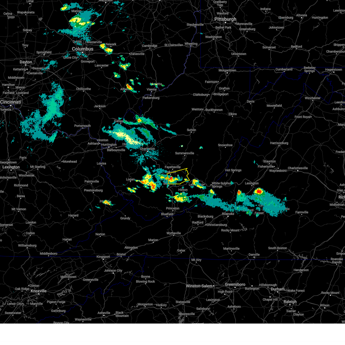
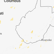
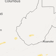
Hail Map for Mount Hope, WV
The Mount Hope, WV area has had 6 reports of on-the-ground hail by trained spotters, and has been under severe weather warnings 9 times during the past 12 months. Doppler radar has detected hail at or near Mount Hope, WV on 19 occasions, including 2 occasions during the past year.
| Name: | Mount Hope, WV |
| Where Located: | 40.4 miles SE of Charleston, WV |
| Map: | Google Map for Mount Hope, WV |
| Population: | 1414 |
| Housing Units: | 737 |
| More Info: | Search Google for Mount Hope, WV |
3
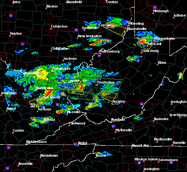
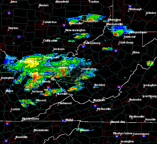
The Top Recent Hail Date for Mount Hope, WV is Monday, April 1, 2024 (4th out of 19)

Hail and Wind Damage Spotted near Mount Hope, WV
| Date / Time | Report Details |
|---|---|
| 4/2/2024 12:22 PM EDT |
 The storms which prompted the warning have weakened below severe limits, and no longer pose an immediate threat to life or property. therefore, the warning will be allowed to expire. a tornado watch remains in effect until 100 pm edt for central, southern and southeastern west virginia. The storms which prompted the warning have weakened below severe limits, and no longer pose an immediate threat to life or property. therefore, the warning will be allowed to expire. a tornado watch remains in effect until 100 pm edt for central, southern and southeastern west virginia.
|
| 4/2/2024 11:50 AM EDT | Tree down blocking sherwood r in raleigh county WV, 1.4 miles NE of Mount Hope, WV |
| 4/2/2024 11:46 AM EDT |
 Svrrlx the national weather service in charleston west virginia has issued a * severe thunderstorm warning for, northeastern mcdowell county in southern west virginia, southeastern mingo county in southern west virginia, raleigh county in southeastern west virginia, wyoming county in southern west virginia, southeastern logan county in southern west virginia, southern fayette county in southeastern west virginia, southern boone county in central west virginia, * until 1230 pm edt. * at 1146 am edt, severe thunderstorms were located along a line extending from mount hope to 7 miles west of dry creek to near r.d. bailey lake, moving southeast at 55 mph (radar indicated). Hazards include 60 mph wind gusts. expect damage to roofs, siding, and trees Svrrlx the national weather service in charleston west virginia has issued a * severe thunderstorm warning for, northeastern mcdowell county in southern west virginia, southeastern mingo county in southern west virginia, raleigh county in southeastern west virginia, wyoming county in southern west virginia, southeastern logan county in southern west virginia, southern fayette county in southeastern west virginia, southern boone county in central west virginia, * until 1230 pm edt. * at 1146 am edt, severe thunderstorms were located along a line extending from mount hope to 7 miles west of dry creek to near r.d. bailey lake, moving southeast at 55 mph (radar indicated). Hazards include 60 mph wind gusts. expect damage to roofs, siding, and trees
|
| 4/1/2024 8:35 PM EDT |
 Svrrlx the national weather service in charleston west virginia has issued a * severe thunderstorm warning for, northeastern raleigh county in southeastern west virginia, southeastern fayette county in southeastern west virginia, * until 900 pm edt. * at 833 pm edt, a severe thunderstorm was located near mount hope, or 9 miles northeast of beckley, moving east at 30 mph (radar indicated). Hazards include 60 mph wind gusts and quarter size hail. Hail damage to vehicles is expected. Expect wind damage to roofs, siding, and trees. Svrrlx the national weather service in charleston west virginia has issued a * severe thunderstorm warning for, northeastern raleigh county in southeastern west virginia, southeastern fayette county in southeastern west virginia, * until 900 pm edt. * at 833 pm edt, a severe thunderstorm was located near mount hope, or 9 miles northeast of beckley, moving east at 30 mph (radar indicated). Hazards include 60 mph wind gusts and quarter size hail. Hail damage to vehicles is expected. Expect wind damage to roofs, siding, and trees.
|
| 7/28/2023 4:09 PM EDT |
 At 409 pm edt, severe thunderstorms were located along a line extending from near ansted to near oak hill to near sophia, moving east at 45 mph (radar indicated). Hazards include 60 mph wind gusts and nickel size hail. Expect damage to roofs, siding, and trees. locations impacted include, beckley, fayetteville, oak hill, mount hope, mabscott, ansted, sophia, crab orchard, dry creek, macarthur, bradley, hawks nest state park, piney view, stanaford, coal city, prosperity, beaver, lester, rhodell, and pax. hail threat, radar indicated max hail size, 0. 88 in wind threat, radar indicated max wind gust, 60 mph. At 409 pm edt, severe thunderstorms were located along a line extending from near ansted to near oak hill to near sophia, moving east at 45 mph (radar indicated). Hazards include 60 mph wind gusts and nickel size hail. Expect damage to roofs, siding, and trees. locations impacted include, beckley, fayetteville, oak hill, mount hope, mabscott, ansted, sophia, crab orchard, dry creek, macarthur, bradley, hawks nest state park, piney view, stanaford, coal city, prosperity, beaver, lester, rhodell, and pax. hail threat, radar indicated max hail size, 0. 88 in wind threat, radar indicated max wind gust, 60 mph.
|
| 7/28/2023 3:52 PM EDT |
 At 352 pm edt, severe thunderstorms were located along a line extending from near smithers to 7 miles southeast of burnwell to 7 miles east of oceana, moving east at 45 mph (radar indicated). Hazards include 60 mph wind gusts and nickel size hail. Expect damage to roofs, siding, and trees. locations impacted include, beckley, fayetteville, oak hill, montgomery, mount hope, mabscott, ansted, sophia, smithers, gauley bridge, crab orchard, dry creek, macarthur, bradley, powellton, hawks nest state park, piney view, stanaford, coal city, and prosperity. hail threat, radar indicated max hail size, 0. 88 in wind threat, radar indicated max wind gust, 60 mph. At 352 pm edt, severe thunderstorms were located along a line extending from near smithers to 7 miles southeast of burnwell to 7 miles east of oceana, moving east at 45 mph (radar indicated). Hazards include 60 mph wind gusts and nickel size hail. Expect damage to roofs, siding, and trees. locations impacted include, beckley, fayetteville, oak hill, montgomery, mount hope, mabscott, ansted, sophia, smithers, gauley bridge, crab orchard, dry creek, macarthur, bradley, powellton, hawks nest state park, piney view, stanaford, coal city, and prosperity. hail threat, radar indicated max hail size, 0. 88 in wind threat, radar indicated max wind gust, 60 mph.
|
| 7/28/2023 3:30 PM EDT |
 At 330 pm edt, severe thunderstorms were located along a line extending from near marmet to 6 miles northeast of wharton to mallory, moving east at 45 mph (radar indicated). Hazards include 60 mph wind gusts and nickel size hail. expect damage to roofs, siding, and trees At 330 pm edt, severe thunderstorms were located along a line extending from near marmet to 6 miles northeast of wharton to mallory, moving east at 45 mph (radar indicated). Hazards include 60 mph wind gusts and nickel size hail. expect damage to roofs, siding, and trees
|
| 7/17/2023 4:24 PM EDT |
 The severe thunderstorm warning for southeastern kanawha and western fayette counties will expire at 430 pm edt, the storm which prompted the warning has weakened below severe limits, and no longer poses an immediate threat to life or property. therefore, the warning will be allowed to expire. however gusty winds and heavy rain are still possible with this thunderstorm. The severe thunderstorm warning for southeastern kanawha and western fayette counties will expire at 430 pm edt, the storm which prompted the warning has weakened below severe limits, and no longer poses an immediate threat to life or property. therefore, the warning will be allowed to expire. however gusty winds and heavy rain are still possible with this thunderstorm.
|
| 7/17/2023 4:06 PM EDT |
 At 406 pm edt, a severe thunderstorm was located over powellton, or 11 miles northwest of fayetteville, moving east at 20 mph (radar indicated). Hazards include 60 mph wind gusts and quarter size hail. Hail damage to vehicles is expected. expect wind damage to roofs, siding, and trees. locations impacted include, oak hill, montgomery, mount hope, ansted, smithers, gauley bridge, pratt, burnwell, powellton, hawks nest state park, handley, leewood and eskdale. hail threat, radar indicated max hail size, 1. 00 in wind threat, radar indicated max wind gust, 60 mph. At 406 pm edt, a severe thunderstorm was located over powellton, or 11 miles northwest of fayetteville, moving east at 20 mph (radar indicated). Hazards include 60 mph wind gusts and quarter size hail. Hail damage to vehicles is expected. expect wind damage to roofs, siding, and trees. locations impacted include, oak hill, montgomery, mount hope, ansted, smithers, gauley bridge, pratt, burnwell, powellton, hawks nest state park, handley, leewood and eskdale. hail threat, radar indicated max hail size, 1. 00 in wind threat, radar indicated max wind gust, 60 mph.
|
| 7/17/2023 3:45 PM EDT |
 At 345 pm edt, a severe thunderstorm was located near glasgow, or 18 miles southeast of charleston, moving east at 20 mph (radar indicated). Hazards include 60 mph wind gusts and quarter size hail. Hail damage to vehicles is expected. Expect wind damage to roofs, siding, and trees. At 345 pm edt, a severe thunderstorm was located near glasgow, or 18 miles southeast of charleston, moving east at 20 mph (radar indicated). Hazards include 60 mph wind gusts and quarter size hail. Hail damage to vehicles is expected. Expect wind damage to roofs, siding, and trees.
|
| 7/12/2022 5:50 PM EDT |
 At 549 pm edt, severe thunderstorms were located along a line extending from near quinwood to 6 miles southwest of babcock state park, moving east at 40 mph (radar indicated). Hazards include 60 mph wind gusts and quarter size hail. Hail damage to vehicles is expected. expect wind damage to roofs, siding, and trees. locations impacted include, babcock state park, mount hope, meadow bridge and thurmond. hail threat, radar indicated max hail size, 1. 00 in wind threat, radar indicated max wind gust, 60 mph. At 549 pm edt, severe thunderstorms were located along a line extending from near quinwood to 6 miles southwest of babcock state park, moving east at 40 mph (radar indicated). Hazards include 60 mph wind gusts and quarter size hail. Hail damage to vehicles is expected. expect wind damage to roofs, siding, and trees. locations impacted include, babcock state park, mount hope, meadow bridge and thurmond. hail threat, radar indicated max hail size, 1. 00 in wind threat, radar indicated max wind gust, 60 mph.
|
| 7/12/2022 5:35 PM EDT |
 At 534 pm edt, severe thunderstorms were located along a line extending from near summersville to 7 miles northwest of mount hope, moving east-southeast at 50 mph (radar indicated). Hazards include 60 mph wind gusts and quarter size hail. Hail damage to vehicles is expected. Expect wind damage to roofs, siding, and trees. At 534 pm edt, severe thunderstorms were located along a line extending from near summersville to 7 miles northwest of mount hope, moving east-southeast at 50 mph (radar indicated). Hazards include 60 mph wind gusts and quarter size hail. Hail damage to vehicles is expected. Expect wind damage to roofs, siding, and trees.
|
| 7/12/2022 5:03 PM EDT |
 At 502 pm edt, severe thunderstorms were located along a line extending from near ansted to near burnwell, moving southeast at 35 mph (law enforcement. many reports of downed trees and power lines have been reported with this line of storms). Hazards include 60 mph wind gusts and penny size hail. expect damage to roofs, siding, and trees At 502 pm edt, severe thunderstorms were located along a line extending from near ansted to near burnwell, moving southeast at 35 mph (law enforcement. many reports of downed trees and power lines have been reported with this line of storms). Hazards include 60 mph wind gusts and penny size hail. expect damage to roofs, siding, and trees
|
| 6/16/2022 11:17 PM EDT |
 At 1116 pm edt, a severe thunderstorm was located over mount hope, or 8 miles south of fayetteville, moving southeast at 15 mph (radar indicated). Hazards include 60 mph wind gusts and quarter size hail. Hail damage to vehicles is expected. Expect wind damage to roofs, siding, and trees. At 1116 pm edt, a severe thunderstorm was located over mount hope, or 8 miles south of fayetteville, moving southeast at 15 mph (radar indicated). Hazards include 60 mph wind gusts and quarter size hail. Hail damage to vehicles is expected. Expect wind damage to roofs, siding, and trees.
|
| 6/13/2022 10:01 PM EDT |
 The national weather service in charleston west virginia has issued a * severe thunderstorm warning for. nicholas county in southeastern west virginia. raleigh county in southeastern west virginia. southwestern webster county in northeastern west virginia. Southeastern logan county in southern west virginia. The national weather service in charleston west virginia has issued a * severe thunderstorm warning for. nicholas county in southeastern west virginia. raleigh county in southeastern west virginia. southwestern webster county in northeastern west virginia. Southeastern logan county in southern west virginia.
|
| 6/13/2022 10:01 PM EDT |
 At 1000 pm edt, severe thunderstorms were located along a line extending from near ansted to near mount hope to near bald knob, moving southeast at 35 mph (radar indicated). Hazards include 60 mph wind gusts and penny size hail. Expect damage to roofs, siding, and trees. locations impacted include, beckley, summersville, fayetteville, babcock state park, oak hill, mount hope, mabscott, ansted, sophia, smithers, gauley bridge, crab orchard, dry creek, macarthur, bradley, powellton, hawks nest state park, piney view, bald knob and stanaford. hail threat, radar indicated max hail size, 0. 75 in wind threat, radar indicated max wind gust, 60 mph. At 1000 pm edt, severe thunderstorms were located along a line extending from near ansted to near mount hope to near bald knob, moving southeast at 35 mph (radar indicated). Hazards include 60 mph wind gusts and penny size hail. Expect damage to roofs, siding, and trees. locations impacted include, beckley, summersville, fayetteville, babcock state park, oak hill, mount hope, mabscott, ansted, sophia, smithers, gauley bridge, crab orchard, dry creek, macarthur, bradley, powellton, hawks nest state park, piney view, bald knob and stanaford. hail threat, radar indicated max hail size, 0. 75 in wind threat, radar indicated max wind gust, 60 mph.
|
| 6/13/2021 8:42 PM EDT |
 The severe thunderstorm warning for central raleigh and southwestern fayette counties will expire at 845 pm edt, the storm which prompted the warning has weakened below severe limits, and no longer poses an immediate threat to life or property. therefore, the warning will be allowed to expire. however heavy rain is still possible with this thunderstorm. a severe thunderstorm watch remains in effect until 1000 pm edt for southeastern west virginia. The severe thunderstorm warning for central raleigh and southwestern fayette counties will expire at 845 pm edt, the storm which prompted the warning has weakened below severe limits, and no longer poses an immediate threat to life or property. therefore, the warning will be allowed to expire. however heavy rain is still possible with this thunderstorm. a severe thunderstorm watch remains in effect until 1000 pm edt for southeastern west virginia.
|
| 6/13/2021 8:19 PM EDT |
 At 819 pm edt, a severe thunderstorm was located over beckley, moving southeast at 30 mph (radar indicated). Hazards include 60 mph wind gusts. Expect damage to roofs, siding, and trees. Locations impacted include, beckley, mount hope, mabscott, sophia, crab orchard, dry creek, macarthur, coal city, bradley, shady spring, prosperity, beaver, daniels, piney view, stanaford, lester, pax, ghent, glen daniel and josephine. At 819 pm edt, a severe thunderstorm was located over beckley, moving southeast at 30 mph (radar indicated). Hazards include 60 mph wind gusts. Expect damage to roofs, siding, and trees. Locations impacted include, beckley, mount hope, mabscott, sophia, crab orchard, dry creek, macarthur, coal city, bradley, shady spring, prosperity, beaver, daniels, piney view, stanaford, lester, pax, ghent, glen daniel and josephine.
|
| 6/13/2021 8:06 PM EDT |
 The severe thunderstorm warning for northeastern raleigh and southwestern fayette counties will expire at 815 pm edt, the storms which prompted the warning have weakened below severe limits, and have exited the warned area. therefore, the warning will be allowed to expire. a severe thunderstorm watch remains in effect until 1000 pm edt for southeastern west virginia. The severe thunderstorm warning for northeastern raleigh and southwestern fayette counties will expire at 815 pm edt, the storms which prompted the warning have weakened below severe limits, and have exited the warned area. therefore, the warning will be allowed to expire. a severe thunderstorm watch remains in effect until 1000 pm edt for southeastern west virginia.
|
| 6/13/2021 7:54 PM EDT |
 At 754 pm edt, a severe thunderstorm was located near bradley, or 10 miles northwest of beckley, moving southeast at 30 mph (radar indicated). Hazards include 60 mph wind gusts and quarter size hail. Hail damage to vehicles is expected. Expect wind damage to roofs, siding, and trees. At 754 pm edt, a severe thunderstorm was located near bradley, or 10 miles northwest of beckley, moving southeast at 30 mph (radar indicated). Hazards include 60 mph wind gusts and quarter size hail. Hail damage to vehicles is expected. Expect wind damage to roofs, siding, and trees.
|
| 6/13/2021 7:48 PM EDT |
 At 747 pm edt, severe thunderstorms were located along a line extending from near neola to bradley, moving south at 20 mph (radar indicated). Hazards include 60 mph wind gusts and quarter size hail. Hail damage to vehicles is expected. expect wind damage to roofs, siding, and trees. Locations impacted include, beckley, fayetteville, oak hill, mount hope, bradley, beaver, piney view, stanaford, daniels, prosperity, macarthur, shady spring, powellton and thurmond. At 747 pm edt, severe thunderstorms were located along a line extending from near neola to bradley, moving south at 20 mph (radar indicated). Hazards include 60 mph wind gusts and quarter size hail. Hail damage to vehicles is expected. expect wind damage to roofs, siding, and trees. Locations impacted include, beckley, fayetteville, oak hill, mount hope, bradley, beaver, piney view, stanaford, daniels, prosperity, macarthur, shady spring, powellton and thurmond.
|
| 6/13/2021 7:26 PM EDT |
 The severe thunderstorm warning for southwestern pocahontas, southern nicholas, northeastern raleigh, southeastern webster and fayette counties will expire at 730 pm edt, the storms which prompted the warning have moved out of the area. therefore, the warning will be allowed to expire. a severe thunderstorm watch remains in effect until 800 pm edt for central, southeastern and northeastern west virginia. a severe thunderstorm watch also remains in effect until 1000 pm edt for southeastern west virginia. remember, a severe thunderstorm warning still remains in effect for portions of fayette, southern nicholas, southern webster, and southeast pocahontas counties. The severe thunderstorm warning for southwestern pocahontas, southern nicholas, northeastern raleigh, southeastern webster and fayette counties will expire at 730 pm edt, the storms which prompted the warning have moved out of the area. therefore, the warning will be allowed to expire. a severe thunderstorm watch remains in effect until 800 pm edt for central, southeastern and northeastern west virginia. a severe thunderstorm watch also remains in effect until 1000 pm edt for southeastern west virginia. remember, a severe thunderstorm warning still remains in effect for portions of fayette, southern nicholas, southern webster, and southeast pocahontas counties.
|
| 6/13/2021 7:24 PM EDT |
 At 724 pm edt, severe thunderstorms were located along a line extending from 7 miles northeast of beartown state park to near oak hill, moving south at 20 mph (radar indicated). Hazards include 60 mph wind gusts and quarter size hail. Hail damage to vehicles is expected. Expect wind damage to roofs, siding, and trees. At 724 pm edt, severe thunderstorms were located along a line extending from 7 miles northeast of beartown state park to near oak hill, moving south at 20 mph (radar indicated). Hazards include 60 mph wind gusts and quarter size hail. Hail damage to vehicles is expected. Expect wind damage to roofs, siding, and trees.
|
| 6/13/2021 7:12 PM EDT |
 At 711 pm edt, severe thunderstorms were located along a line extending from near marlinton to near richwood to near hawks nest state park, moving east at 25 mph (radar indicated). Hazards include 60 mph wind gusts and quarter size hail. Hail damage to vehicles is expected. expect wind damage to roofs, siding, and trees. Locations impacted include, summersville, fayetteville, richwood, marlinton, babcock state park, oak hill, mount hope, ansted, gauley bridge, bradley, craigsville, hawks nest state park, piney view, prosperity, powellton, hillsboro, thurmond, canvas, cranberry mountain nature center and swiss. At 711 pm edt, severe thunderstorms were located along a line extending from near marlinton to near richwood to near hawks nest state park, moving east at 25 mph (radar indicated). Hazards include 60 mph wind gusts and quarter size hail. Hail damage to vehicles is expected. expect wind damage to roofs, siding, and trees. Locations impacted include, summersville, fayetteville, richwood, marlinton, babcock state park, oak hill, mount hope, ansted, gauley bridge, bradley, craigsville, hawks nest state park, piney view, prosperity, powellton, hillsboro, thurmond, canvas, cranberry mountain nature center and swiss.
|
| 6/13/2021 6:49 PM EDT |
 At 649 pm edt, severe thunderstorms were located along a line extending from 11 miles northwest of marlinton to near richwood to near smithers, moving south at 25 mph (radar indicated). Hazards include 60 mph wind gusts and quarter size hail. Hail damage to vehicles is expected. Expect wind damage to roofs, siding, and trees. At 649 pm edt, severe thunderstorms were located along a line extending from 11 miles northwest of marlinton to near richwood to near smithers, moving south at 25 mph (radar indicated). Hazards include 60 mph wind gusts and quarter size hail. Hail damage to vehicles is expected. Expect wind damage to roofs, siding, and trees.
|
| 4/13/2020 2:47 AM EDT |
 At 247 am edt, a line of heavy showers are extending from 6 miles southeast of big otter to mount hope, moving east at 35 mph (radar indicated). Hazards include 60 mph wind gusts. expect damage to roofs, siding, and trees At 247 am edt, a line of heavy showers are extending from 6 miles southeast of big otter to mount hope, moving east at 35 mph (radar indicated). Hazards include 60 mph wind gusts. expect damage to roofs, siding, and trees
|
| 4/13/2020 2:30 AM EDT |
 At 228 am edt, a line of heavy showers was extending from near glen to 8 miles west of bradley, moving northeast at 35 mph (radar indicated). Hazards include 60 mph wind gusts. Expect damage to roofs, siding, and trees. Locations impacted include, beckley, fayetteville, babcock state park, oak hill, montgomery, mount hope, ansted, smithers, gauley bridge, bradley, powellton, hawks nest state park, piney view, stanaford, prosperity, burnwell, handley, pax, thurmond and swiss. At 228 am edt, a line of heavy showers was extending from near glen to 8 miles west of bradley, moving northeast at 35 mph (radar indicated). Hazards include 60 mph wind gusts. Expect damage to roofs, siding, and trees. Locations impacted include, beckley, fayetteville, babcock state park, oak hill, montgomery, mount hope, ansted, smithers, gauley bridge, bradley, powellton, hawks nest state park, piney view, stanaford, prosperity, burnwell, handley, pax, thurmond and swiss.
|
| 4/13/2020 2:06 AM EDT |
 At 204 am edt, a line of heavy showers were extending from chesapeake to near oceana, moving northeast at 30 mph (radar indicated). Hazards include 60 mph wind gusts. expect damage to roofs, siding, and trees At 204 am edt, a line of heavy showers were extending from chesapeake to near oceana, moving northeast at 30 mph (radar indicated). Hazards include 60 mph wind gusts. expect damage to roofs, siding, and trees
|
| 4/9/2020 2:11 AM EDT |
 At 210 am edt, a severe thunderstorm was located near oak hill, or near fayetteville, moving southeast at 35 mph (radar indicated). Hazards include 70 mph wind gusts and quarter size hail. Hail damage to vehicles is expected. expect considerable tree damage. Wind damage is also likely to mobile homes, roofs, and outbuildings. At 210 am edt, a severe thunderstorm was located near oak hill, or near fayetteville, moving southeast at 35 mph (radar indicated). Hazards include 70 mph wind gusts and quarter size hail. Hail damage to vehicles is expected. expect considerable tree damage. Wind damage is also likely to mobile homes, roofs, and outbuildings.
|
| 4/9/2020 2:10 AM EDT |
 At 209 am edt, severe thunderstorms were located along a line extending from 7 miles east of sutton to 6 miles southeast of summersville to 8 miles north of bingham to piney view, moving southeast at 55 mph (radar indicated). Hazards include 70 mph wind gusts and quarter size hail. Hail damage to vehicles is expected. expect considerable tree damage. wind damage is also likely to mobile homes, roofs, and outbuildings. Locations impacted include, beckley, summersville, fayetteville, sutton, babcock state park, oak hill, mount hope, mabscott, ansted, sophia, gassaway, gauley bridge, piney view, coal city, birch river, prosperity, crab orchard, dry creek, macarthur and bradley. At 209 am edt, severe thunderstorms were located along a line extending from 7 miles east of sutton to 6 miles southeast of summersville to 8 miles north of bingham to piney view, moving southeast at 55 mph (radar indicated). Hazards include 70 mph wind gusts and quarter size hail. Hail damage to vehicles is expected. expect considerable tree damage. wind damage is also likely to mobile homes, roofs, and outbuildings. Locations impacted include, beckley, summersville, fayetteville, sutton, babcock state park, oak hill, mount hope, mabscott, ansted, sophia, gassaway, gauley bridge, piney view, coal city, birch river, prosperity, crab orchard, dry creek, macarthur and bradley.
|
| 4/9/2020 2:02 AM EDT |
 At 201 am edt, severe thunderstorms were located along a line extending from near gassaway to near summersville to 10 miles northeast of ansted to 7 miles northwest of bradley, moving east at 55 mph (radar indicated). Hazards include 70 mph wind gusts and quarter size hail. Hail damage to vehicles is expected. expect considerable tree damage. wind damage is also likely to mobile homes, roofs, and outbuildings. Locations impacted include, beckley, summersville, fayetteville, sutton, clay, babcock state park, oak hill, montgomery, mount hope, mabscott, ansted, sophia, gassaway, smithers, gauley bridge, piney view, coal city, birch river, prosperity and burnwell. At 201 am edt, severe thunderstorms were located along a line extending from near gassaway to near summersville to 10 miles northeast of ansted to 7 miles northwest of bradley, moving east at 55 mph (radar indicated). Hazards include 70 mph wind gusts and quarter size hail. Hail damage to vehicles is expected. expect considerable tree damage. wind damage is also likely to mobile homes, roofs, and outbuildings. Locations impacted include, beckley, summersville, fayetteville, sutton, clay, babcock state park, oak hill, montgomery, mount hope, mabscott, ansted, sophia, gassaway, smithers, gauley bridge, piney view, coal city, birch river, prosperity and burnwell.
|
| 4/9/2020 1:46 AM EDT |
 At 146 am edt, severe thunderstorms were located along a line extending from near arnoldsburg to near glen to 6 miles north of gauley bridge to 7 miles northeast of bald knob, moving east at 60 mph (radar indicated). Hazards include 70 mph wind gusts and quarter size hail. Hail damage to vehicles is expected. expect considerable tree damage. wind damage is also likely to mobile homes, roofs, and outbuildings. Locations impacted include, beckley, summersville, madison, fayetteville, sutton, clay, babcock state park, oak hill, montgomery, chesapeake, marmet, mount hope, mabscott, ansted, sophia, belle, clendenin, cedar grove, east bank and gassaway. At 146 am edt, severe thunderstorms were located along a line extending from near arnoldsburg to near glen to 6 miles north of gauley bridge to 7 miles northeast of bald knob, moving east at 60 mph (radar indicated). Hazards include 70 mph wind gusts and quarter size hail. Hail damage to vehicles is expected. expect considerable tree damage. wind damage is also likely to mobile homes, roofs, and outbuildings. Locations impacted include, beckley, summersville, madison, fayetteville, sutton, clay, babcock state park, oak hill, montgomery, chesapeake, marmet, mount hope, mabscott, ansted, sophia, belle, clendenin, cedar grove, east bank and gassaway.
|
| 4/9/2020 1:23 AM EDT |
 At 122 am edt, severe thunderstorms were located along a line extending from 6 miles south of spencer to marmet to near chesapeake to near logan, moving southeast at 85 mph (radar indicated). Hazards include 70 mph wind gusts and quarter size hail. Hail damage to vehicles is expected. expect considerable tree damage. Wind damage is also likely to mobile homes, roofs, and outbuildings. At 122 am edt, severe thunderstorms were located along a line extending from 6 miles south of spencer to marmet to near chesapeake to near logan, moving southeast at 85 mph (radar indicated). Hazards include 70 mph wind gusts and quarter size hail. Hail damage to vehicles is expected. expect considerable tree damage. Wind damage is also likely to mobile homes, roofs, and outbuildings.
|
| 4/8/2020 2:16 PM EDT |
 At 215 pm edt, a severe thunderstorm was located over piney view, or near beckley, moving southeast at 35 mph (radar indicated). Hazards include 60 mph wind gusts and quarter size hail. Hail damage to vehicles is expected. Expect wind damage to roofs, siding, and trees. At 215 pm edt, a severe thunderstorm was located over piney view, or near beckley, moving southeast at 35 mph (radar indicated). Hazards include 60 mph wind gusts and quarter size hail. Hail damage to vehicles is expected. Expect wind damage to roofs, siding, and trees.
|
| 4/8/2020 2:06 PM EDT |
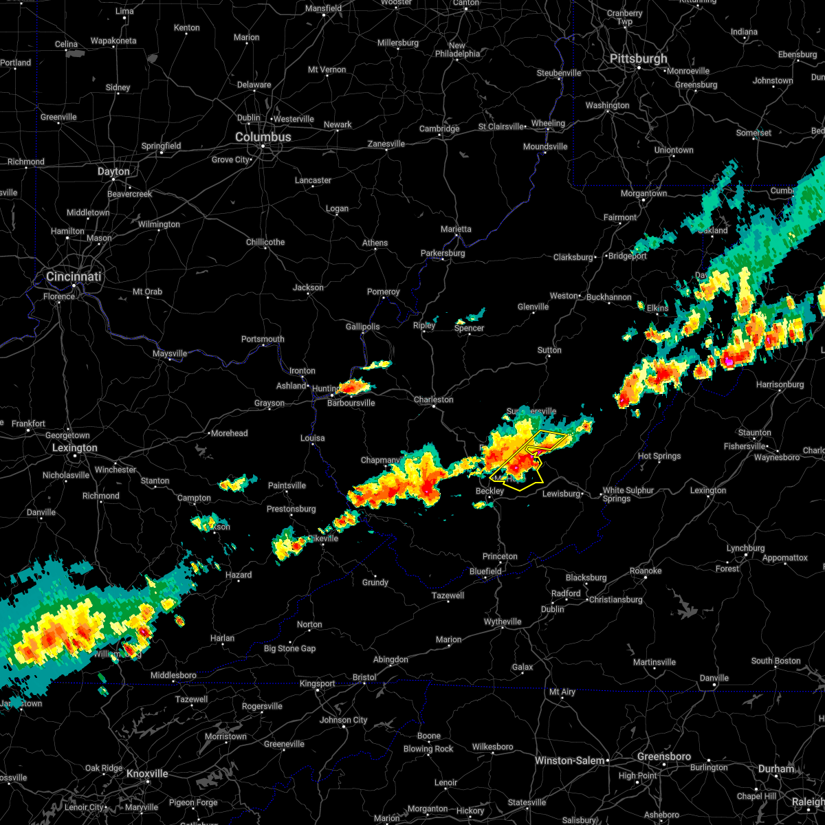
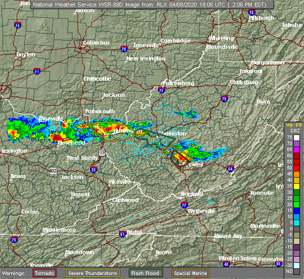 At 206 pm edt, a severe thunderstorm capable of producing a tornado was located over mount hope, or 9 miles north of beckley, moving southeast at 35 mph (radar indicated rotation). Hazards include tornado and half dollar size hail. Flying debris will be dangerous to those caught without shelter. mobile homes will be damaged or destroyed. damage to roofs, windows, and vehicles will occur. tree damage is likely. this dangerous storm will be near, piney view, bradley and prosperity around 210 pm edt. beckley around 215 pm edt. Other locations impacted by this tornadic thunderstorm include pax. At 206 pm edt, a severe thunderstorm capable of producing a tornado was located over mount hope, or 9 miles north of beckley, moving southeast at 35 mph (radar indicated rotation). Hazards include tornado and half dollar size hail. Flying debris will be dangerous to those caught without shelter. mobile homes will be damaged or destroyed. damage to roofs, windows, and vehicles will occur. tree damage is likely. this dangerous storm will be near, piney view, bradley and prosperity around 210 pm edt. beckley around 215 pm edt. Other locations impacted by this tornadic thunderstorm include pax.
|
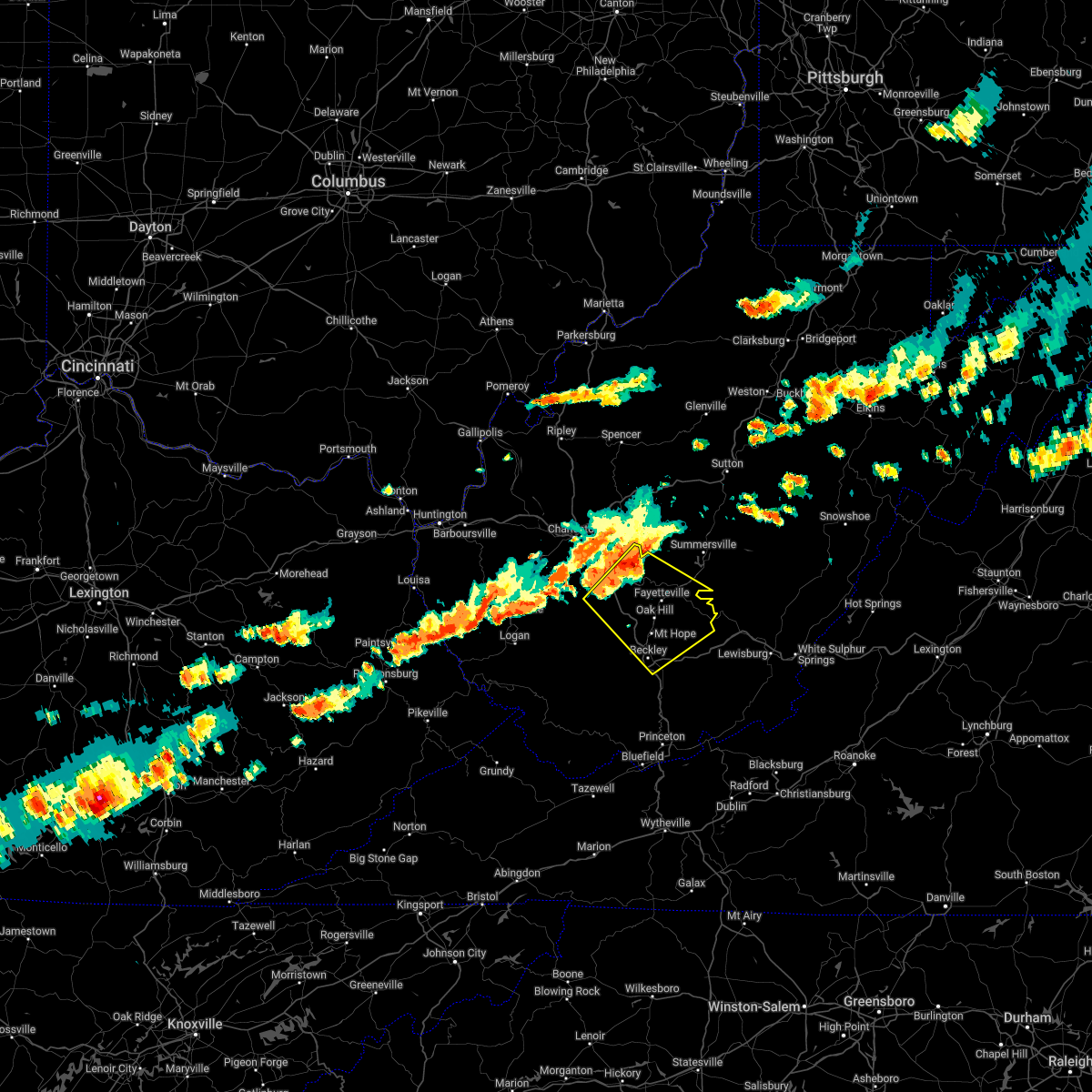
| 4/8/2020 1:54 PM EDT |
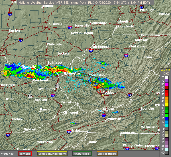 At 153 pm edt, a severe thunderstorm capable of producing a tornado was located near burnwell, or 11 miles west of fayetteville, moving southeast at 35 mph (radar indicated rotation). Hazards include tornado and half dollar size hail. Flying debris will be dangerous to those caught without shelter. mobile homes will be damaged or destroyed. damage to roofs, windows, and vehicles will occur. tree damage is likely. this dangerous storm will be near, oak hill around 205 pm edt. mount hope, piney view and bradley around 210 pm edt. beckley and prosperity around 215 pm edt. Other locations impacted by this tornadic thunderstorm include pax and artie. At 153 pm edt, a severe thunderstorm capable of producing a tornado was located near burnwell, or 11 miles west of fayetteville, moving southeast at 35 mph (radar indicated rotation). Hazards include tornado and half dollar size hail. Flying debris will be dangerous to those caught without shelter. mobile homes will be damaged or destroyed. damage to roofs, windows, and vehicles will occur. tree damage is likely. this dangerous storm will be near, oak hill around 205 pm edt. mount hope, piney view and bradley around 210 pm edt. beckley and prosperity around 215 pm edt. Other locations impacted by this tornadic thunderstorm include pax and artie.
|
| 4/8/2020 1:39 PM EDT |
 At 139 pm edt, a severe thunderstorm was located near burnwell, or 17 miles west of fayetteville, moving southeast at 40 mph (radar indicated). Hazards include 60 mph wind gusts and half dollar size hail. Hail damage to vehicles is expected. Expect wind damage to roofs, siding, and trees. At 139 pm edt, a severe thunderstorm was located near burnwell, or 17 miles west of fayetteville, moving southeast at 40 mph (radar indicated). Hazards include 60 mph wind gusts and half dollar size hail. Hail damage to vehicles is expected. Expect wind damage to roofs, siding, and trees.
|
| 1/11/2020 8:57 PM EST |
 The national weather service in charleston west virginia has issued a * severe thunderstorm warning for. southwestern randolph county in northeastern west virginia. nicholas county in southeastern west virginia. webster county in northeastern west virginia. Fayette county in southeastern west virginia. The national weather service in charleston west virginia has issued a * severe thunderstorm warning for. southwestern randolph county in northeastern west virginia. nicholas county in southeastern west virginia. webster county in northeastern west virginia. Fayette county in southeastern west virginia.
|
| 10/31/2019 1:51 PM EDT |
 At 150 pm edt, severe thunderstorms were located along a line extending from 8 miles northwest of amma to near burnwell, moving northeast at 65 mph (radar indicated). Hazards include 60 mph wind gusts. expect damage to roofs, siding, and trees At 150 pm edt, severe thunderstorms were located along a line extending from 8 miles northwest of amma to near burnwell, moving northeast at 65 mph (radar indicated). Hazards include 60 mph wind gusts. expect damage to roofs, siding, and trees
|
| 8/9/2019 2:41 PM EDT |
 The severe thunderstorm warning for north central raleigh and southwestern fayette counties will expire at 245 pm edt, the storm which prompted the warning has weakened below severe limits, and no longer poses an immediate threat to life or property. therefore, the warning will be allowed to expire. however gusty winds and heavy rain are still possible with this thunderstorm. to report severe weather, contact your nearest law enforcement agency. they will relay your report to the national weather service charleston west virginia. The severe thunderstorm warning for north central raleigh and southwestern fayette counties will expire at 245 pm edt, the storm which prompted the warning has weakened below severe limits, and no longer poses an immediate threat to life or property. therefore, the warning will be allowed to expire. however gusty winds and heavy rain are still possible with this thunderstorm. to report severe weather, contact your nearest law enforcement agency. they will relay your report to the national weather service charleston west virginia.
|
| 8/9/2019 2:35 PM EDT |
 At 235 pm edt, a severe thunderstorm was located near mount hope, or 10 miles northwest of beckley, moving southeast at 30 mph (radar indicated). Hazards include 60 mph wind gusts and nickel size hail. Expect damage to roofs, siding, and trees. Locations impacted include, oak hill, mount hope, bradley, piney view, pax and thurmond. At 235 pm edt, a severe thunderstorm was located near mount hope, or 10 miles northwest of beckley, moving southeast at 30 mph (radar indicated). Hazards include 60 mph wind gusts and nickel size hail. Expect damage to roofs, siding, and trees. Locations impacted include, oak hill, mount hope, bradley, piney view, pax and thurmond.
|
| 8/9/2019 2:22 PM EDT |
 At 222 pm edt, a severe thunderstorm was located near burnwell, or 12 miles west of fayetteville, moving east at 30 mph (radar indicated). Hazards include 60 mph wind gusts and nickel size hail. expect damage to roofs, siding, and trees At 222 pm edt, a severe thunderstorm was located near burnwell, or 12 miles west of fayetteville, moving east at 30 mph (radar indicated). Hazards include 60 mph wind gusts and nickel size hail. expect damage to roofs, siding, and trees
|
| 5/29/2019 4:23 PM EDT |
 The severe thunderstorm warning for raleigh, southeastern wyoming and southern fayette counties will expire at 430 pm edt, the storm which prompted the warning has weakened below severe limits, and has exited the warned area. therefore, the warning will be allowed to expire. however gusty winds are still possible with this thunderstorm. a severe thunderstorm watch remains in effect until 700 pm edt for southern and southeastern west virginia. The severe thunderstorm warning for raleigh, southeastern wyoming and southern fayette counties will expire at 430 pm edt, the storm which prompted the warning has weakened below severe limits, and has exited the warned area. therefore, the warning will be allowed to expire. however gusty winds are still possible with this thunderstorm. a severe thunderstorm watch remains in effect until 700 pm edt for southern and southeastern west virginia.
|
| 5/29/2019 4:01 PM EDT |
 At 341 pm edt, a severe thunderstorm was located 10 miles southeast of bald knob, or 14 miles west of beckley, moving east at 50 mph (radar indicated). Hazards include 70 mph wind gusts and quarter size hail. Hail damage to vehicles is expected. expect considerable tree damage. Wind damage is also likely to mobile homes, roofs, and outbuildings. At 341 pm edt, a severe thunderstorm was located 10 miles southeast of bald knob, or 14 miles west of beckley, moving east at 50 mph (radar indicated). Hazards include 70 mph wind gusts and quarter size hail. Hail damage to vehicles is expected. expect considerable tree damage. Wind damage is also likely to mobile homes, roofs, and outbuildings.
|
| 5/29/2019 3:42 PM EDT |
 At 341 pm edt, a severe thunderstorm was located 10 miles southeast of bald knob, or 14 miles west of beckley, moving east at 50 mph (radar indicated). Hazards include 70 mph wind gusts and quarter size hail. Hail damage to vehicles is expected. expect considerable tree damage. Wind damage is also likely to mobile homes, roofs, and outbuildings. At 341 pm edt, a severe thunderstorm was located 10 miles southeast of bald knob, or 14 miles west of beckley, moving east at 50 mph (radar indicated). Hazards include 70 mph wind gusts and quarter size hail. Hail damage to vehicles is expected. expect considerable tree damage. Wind damage is also likely to mobile homes, roofs, and outbuildings.
|
| 4/14/2019 9:21 PM EDT |
 The severe thunderstorm warning for eastern raleigh and southeastern fayette counties will expire at 930 pm edt, the storms which prompted the warning have moved out of the area. therefore, the warning will be allowed to expire. a severe thunderstorm watch remains in effect until 200 am edt for southeastern west virginia. The severe thunderstorm warning for eastern raleigh and southeastern fayette counties will expire at 930 pm edt, the storms which prompted the warning have moved out of the area. therefore, the warning will be allowed to expire. a severe thunderstorm watch remains in effect until 200 am edt for southeastern west virginia.
|
| 4/14/2019 9:07 PM EDT |
 At 907 pm edt, severe thunderstorms were located along a line extending from near babcock state park to near camp creek state park, moving east at 30 mph (radar indicated). Hazards include 60 mph wind gusts. Expect damage to roofs, siding, and trees. Locations impacted include, beckley, fayetteville, babcock state park, oak hill, mount hope, bradley, shady spring, prosperity, beaver, daniels, piney view, stanaford, macarthur, meadow bridge, thurmond and ghent. At 907 pm edt, severe thunderstorms were located along a line extending from near babcock state park to near camp creek state park, moving east at 30 mph (radar indicated). Hazards include 60 mph wind gusts. Expect damage to roofs, siding, and trees. Locations impacted include, beckley, fayetteville, babcock state park, oak hill, mount hope, bradley, shady spring, prosperity, beaver, daniels, piney view, stanaford, macarthur, meadow bridge, thurmond and ghent.
|
| 4/14/2019 8:40 PM EDT |
 At 840 pm edt, severe thunderstorms were located along a line extending from near fayetteville to near mullens, moving east at 30 mph (radar indicated). Hazards include 60 mph wind gusts. expect damage to roofs, siding, and trees At 840 pm edt, severe thunderstorms were located along a line extending from near fayetteville to near mullens, moving east at 30 mph (radar indicated). Hazards include 60 mph wind gusts. expect damage to roofs, siding, and trees
|
| 4/14/2019 8:17 PM EDT |
 At 817 pm edt, severe thunderstorms were located along a line extending from near fayetteville to 6 miles west of sophia, moving east at 20 mph (radar indicated). Hazards include 60 mph wind gusts and penny size hail. Expect damage to roofs, siding, and trees. Locations impacted include, beckley, fayetteville, babcock state park, oak hill, mount hope, mabscott, oceana, sophia, crab orchard, dry creek, macarthur, bradley, shady spring, powellton, beaver, piney view, stanaford, coal city, prosperity and burnwell. At 817 pm edt, severe thunderstorms were located along a line extending from near fayetteville to 6 miles west of sophia, moving east at 20 mph (radar indicated). Hazards include 60 mph wind gusts and penny size hail. Expect damage to roofs, siding, and trees. Locations impacted include, beckley, fayetteville, babcock state park, oak hill, mount hope, mabscott, oceana, sophia, crab orchard, dry creek, macarthur, bradley, shady spring, powellton, beaver, piney view, stanaford, coal city, prosperity and burnwell.
|
| 4/14/2019 7:47 PM EDT |
 At 746 pm edt, severe thunderstorms were located along a line extending from near burnwell to 6 miles northeast of oceana, moving east at 30 mph (radar indicated). Hazards include 60 mph wind gusts and penny size hail. expect damage to roofs, siding, and trees At 746 pm edt, severe thunderstorms were located along a line extending from near burnwell to 6 miles northeast of oceana, moving east at 30 mph (radar indicated). Hazards include 60 mph wind gusts and penny size hail. expect damage to roofs, siding, and trees
|
| 3/27/2017 5:27 PM EDT |
 At 526 pm edt, a severe thunderstorm was located near mount hope, or 8 miles northeast of beckley, moving east at 30 mph. this storm produced quarter-sized hail as it crossed i-77 north of beckley near 515 pm (radar indicated). Hazards include 60 mph wind gusts and quarter size hail. Hail damage to vehicles is expected. expect wind damage to roofs, siding, and trees. locations impacted include, beckley, rainelle, babcock state park, oak hill, mount hope, bradley, prosperity, piney view, stanaford, meadow bridge and thurmond. this includes the following highways, west virginia turnpike near mile marker 57. Interstate 64 in west virginia between mile markers 124 and 128. At 526 pm edt, a severe thunderstorm was located near mount hope, or 8 miles northeast of beckley, moving east at 30 mph. this storm produced quarter-sized hail as it crossed i-77 north of beckley near 515 pm (radar indicated). Hazards include 60 mph wind gusts and quarter size hail. Hail damage to vehicles is expected. expect wind damage to roofs, siding, and trees. locations impacted include, beckley, rainelle, babcock state park, oak hill, mount hope, bradley, prosperity, piney view, stanaford, meadow bridge and thurmond. this includes the following highways, west virginia turnpike near mile marker 57. Interstate 64 in west virginia between mile markers 124 and 128.
|
| 3/27/2017 5:14 PM EDT | Quarter sized hail reported 3.2 miles NNE of Mount Hope, WV |
| 3/27/2017 5:14 PM EDT | Quarter sized hail reported 2.8 miles NNE of Mount Hope, WV, 1 inch hail and wind blew gutters off house |
| 3/27/2017 5:14 PM EDT |
 At 513 pm edt, a severe thunderstorm was located over bradley, or near beckley, moving east at 30 mph (radar indicated). Hazards include 60 mph wind gusts and quarter size hail. Hail damage to vehicles is expected. Expect wind damage to roofs, siding, and trees. At 513 pm edt, a severe thunderstorm was located over bradley, or near beckley, moving east at 30 mph (radar indicated). Hazards include 60 mph wind gusts and quarter size hail. Hail damage to vehicles is expected. Expect wind damage to roofs, siding, and trees.
|
| 3/27/2017 5:06 PM EDT |
 At 505 pm edt, a severe thunderstorm was located 7 miles west of prosperity, or 9 miles northwest of beckley, moving east at 30 mph (radar indicated). Hazards include 60 mph wind gusts and quarter size hail. Hail damage to vehicles is expected. expect wind damage to roofs, siding, and trees. locations impacted include, beckley, oak hill, mount hope, mabscott, dry creek, bradley, prosperity, piney view, stanaford, macarthur, pax, glen daniel and artie. this includes the following highways, west virginia turnpike between mile markers 42 and 61. Interstate 64 in west virginia near mile marker 126. At 505 pm edt, a severe thunderstorm was located 7 miles west of prosperity, or 9 miles northwest of beckley, moving east at 30 mph (radar indicated). Hazards include 60 mph wind gusts and quarter size hail. Hail damage to vehicles is expected. expect wind damage to roofs, siding, and trees. locations impacted include, beckley, oak hill, mount hope, mabscott, dry creek, bradley, prosperity, piney view, stanaford, macarthur, pax, glen daniel and artie. this includes the following highways, west virginia turnpike between mile markers 42 and 61. Interstate 64 in west virginia near mile marker 126.
|
| 3/27/2017 4:51 PM EDT |
 At 451 pm edt, a severe thunderstorm was located 9 miles east of bald knob, or 15 miles west of beckley, moving east at 30 mph (radar indicated). Hazards include 60 mph wind gusts and quarter size hail. Hail damage to vehicles is expected. Expect wind damage to roofs, siding, and trees. At 451 pm edt, a severe thunderstorm was located 9 miles east of bald knob, or 15 miles west of beckley, moving east at 30 mph (radar indicated). Hazards include 60 mph wind gusts and quarter size hail. Hail damage to vehicles is expected. Expect wind damage to roofs, siding, and trees.
|
| 3/1/2017 10:44 AM EST |
 At 1043 am est, severe thunderstorms were located along a line extending from 6 miles west of holly river state to near pineville, moving east at 65 mph (radar indicated). Hazards include 70 mph wind gusts. Expect considerable tree damage. Damage is likely to mobile homes, roofs, and outbuildings. At 1043 am est, severe thunderstorms were located along a line extending from 6 miles west of holly river state to near pineville, moving east at 65 mph (radar indicated). Hazards include 70 mph wind gusts. Expect considerable tree damage. Damage is likely to mobile homes, roofs, and outbuildings.
|
| 3/1/2017 10:35 AM EST |
 At 1034 am est, severe thunderstorms were located along a line extending from 6 miles northeast of ansted to near hanover, moving east at 70 mph (radar indicated). Hazards include 70 mph wind gusts. Expect considerable tree damage. damage is likely to mobile homes, roofs, and outbuildings. locations impacted include, beckley, fayetteville, pineville, babcock state park, oak hill, montgomery, mullens, mount hope, mabscott, ansted, oceana, sophia, smithers, man, gauley bridge, piney view, coal city, prosperity, mallory and crab orchard. this includes the following highways, west virginia turnpike between mile markers 30 and 66. Interstate 64 in west virginia between mile markers 120 and 135. At 1034 am est, severe thunderstorms were located along a line extending from 6 miles northeast of ansted to near hanover, moving east at 70 mph (radar indicated). Hazards include 70 mph wind gusts. Expect considerable tree damage. damage is likely to mobile homes, roofs, and outbuildings. locations impacted include, beckley, fayetteville, pineville, babcock state park, oak hill, montgomery, mullens, mount hope, mabscott, ansted, oceana, sophia, smithers, man, gauley bridge, piney view, coal city, prosperity, mallory and crab orchard. this includes the following highways, west virginia turnpike between mile markers 30 and 66. Interstate 64 in west virginia between mile markers 120 and 135.
|
| 3/1/2017 10:18 AM EST |
 At 1017 am est, severe thunderstorms were located along a line extending from near pratt to near hinch, moving east at 70 mph (radar indicated). Hazards include 70 mph wind gusts. Expect considerable tree damage. Damage is likely to mobile homes, roofs, and outbuildings. At 1017 am est, severe thunderstorms were located along a line extending from near pratt to near hinch, moving east at 70 mph (radar indicated). Hazards include 70 mph wind gusts. Expect considerable tree damage. Damage is likely to mobile homes, roofs, and outbuildings.
|
| 7/8/2016 4:00 PM EDT |
 At 359 pm edt, severe thunderstorms were located along a line extending from near piney view to near camp creek, moving east at 45 mph (radar indicated). Hazards include 60 mph wind gusts. Expect damage to roofs. siding. and trees. Locations impacted include, beckley, oak hill, mount hope, mabscott, daniels, shady spring, prosperity, piney view, macarthur, bradley, stanaford, beaver, meadow bridge, pax, thurmond and ghent. At 359 pm edt, severe thunderstorms were located along a line extending from near piney view to near camp creek, moving east at 45 mph (radar indicated). Hazards include 60 mph wind gusts. Expect damage to roofs. siding. and trees. Locations impacted include, beckley, oak hill, mount hope, mabscott, daniels, shady spring, prosperity, piney view, macarthur, bradley, stanaford, beaver, meadow bridge, pax, thurmond and ghent.
|
| 7/8/2016 3:35 PM EDT |
 At 334 pm edt, severe thunderstorms were located along a line extending from 11 miles northwest of dry creek to near mullens, moving east at 45 mph (radar indicated). Hazards include 60 mph wind gusts. Expect damage to roofs. siding. And trees. At 334 pm edt, severe thunderstorms were located along a line extending from 11 miles northwest of dry creek to near mullens, moving east at 45 mph (radar indicated). Hazards include 60 mph wind gusts. Expect damage to roofs. siding. And trees.
|
| 6/23/2016 3:04 PM EDT |
 At 304 pm edt, a severe thunderstorm was located over mount hope, or 9 miles south of fayetteville, moving southeast at 45 mph (radar indicated). Hazards include ping pong ball size hail and 60 mph wind gusts. People and animals outdoors will be injured. expect hail damage to roofs, siding, windows, and vehicles. expect wind damage to roofs, siding, and trees. locations impacted include, piney view and thurmond. A tornado watch remains in effect until 1000 pm edt for southeastern west virginia. At 304 pm edt, a severe thunderstorm was located over mount hope, or 9 miles south of fayetteville, moving southeast at 45 mph (radar indicated). Hazards include ping pong ball size hail and 60 mph wind gusts. People and animals outdoors will be injured. expect hail damage to roofs, siding, windows, and vehicles. expect wind damage to roofs, siding, and trees. locations impacted include, piney view and thurmond. A tornado watch remains in effect until 1000 pm edt for southeastern west virginia.
|
| 6/23/2016 2:57 PM EDT |
 At 256 pm edt, a severe thunderstorm was located over mount hope, or 8 miles southwest of fayetteville, moving southeast at 45 mph (radar indicated). Hazards include golf ball size hail and 60 mph wind gusts. People and animals outdoors will be injured. expect hail damage to roofs, siding, windows, and vehicles. expect wind damage to roofs, siding, and trees. Locations impacted include, oak hill, mount hope, bradley, piney view, stanaford and thurmond. At 256 pm edt, a severe thunderstorm was located over mount hope, or 8 miles southwest of fayetteville, moving southeast at 45 mph (radar indicated). Hazards include golf ball size hail and 60 mph wind gusts. People and animals outdoors will be injured. expect hail damage to roofs, siding, windows, and vehicles. expect wind damage to roofs, siding, and trees. Locations impacted include, oak hill, mount hope, bradley, piney view, stanaford and thurmond.
|
| 6/23/2016 2:42 PM EDT |
 At 242 pm edt, a severe thunderstorm was located near burnwell, or 13 miles west of fayetteville, moving southeast at 45 mph (radar indicated). Hazards include 60 mph wind gusts and quarter size hail. Hail damage to vehicles is expected. Expect wind damage to roofs, siding, and trees. At 242 pm edt, a severe thunderstorm was located near burnwell, or 13 miles west of fayetteville, moving southeast at 45 mph (radar indicated). Hazards include 60 mph wind gusts and quarter size hail. Hail damage to vehicles is expected. Expect wind damage to roofs, siding, and trees.
|
| 6/23/2016 8:57 AM EDT | The severe thunderstorm warning for northeastern buchanan, raleigh, mingo, mcdowell, southwestern fayette, southeastern boone, logan, wyoming and south central kanawha counties will expire at 900 am edt, the storms which prompted the warning weakened below severe limits and exited the warned area. therefore, the warning will be allowed to expire. |
| 6/23/2016 8:57 AM EDT | The severe thunderstorm warning for northeastern buchanan, raleigh, mingo, mcdowell, southwestern fayette, southeastern boone, logan, wyoming and south central kanawha counties will expire at 900 am edt, the storms which prompted the warning weakened below severe limits and exited the warned area. therefore, the warning will be allowed to expire. |
| 6/23/2016 8:27 AM EDT |
 At 827 am edt, severe thunderstorms were located along a line extending from near hinton to mallory, moving south at 45 mph (radar indicated). Hazards include 60 mph wind gusts. Expect damage to roofs. siding. And trees. At 827 am edt, severe thunderstorms were located along a line extending from near hinton to mallory, moving south at 45 mph (radar indicated). Hazards include 60 mph wind gusts. Expect damage to roofs. siding. And trees.
|
| 6/23/2016 8:10 AM EDT |
 At 809 am edt, severe thunderstorms were located along a line extending from near burnwell to oppy, moving southeast at 50 mph (radar indicated). Hazards include 60 mph wind gusts. Expect damage to roofs. siding. and trees. locations impacted include, beckley, welch, logan, pineville, oak hill, mullens, mount hope, mabscott, oceana, sophia, gary, war, man, delbarton, northfork, shady spring, r. d. Bailey lake, wharton, holden and daniels. At 809 am edt, severe thunderstorms were located along a line extending from near burnwell to oppy, moving southeast at 50 mph (radar indicated). Hazards include 60 mph wind gusts. Expect damage to roofs. siding. and trees. locations impacted include, beckley, welch, logan, pineville, oak hill, mullens, mount hope, mabscott, oceana, sophia, gary, war, man, delbarton, northfork, shady spring, r. d. Bailey lake, wharton, holden and daniels.
|
| 6/23/2016 7:47 AM EDT |
 At 746 am edt, severe thunderstorms were located along a line extending from 8 miles south of chesapeake to coalpoint, moving southeast at 45 mph (radar indicated). Hazards include 60 mph wind gusts. Expect damage to roofs. siding. And trees. At 746 am edt, severe thunderstorms were located along a line extending from 8 miles south of chesapeake to coalpoint, moving southeast at 45 mph (radar indicated). Hazards include 60 mph wind gusts. Expect damage to roofs. siding. And trees.
|
| 5/1/2016 6:44 PM EDT |
 At 643 pm edt, a severe thunderstorm was located near burnwell, or 10 miles west of fayetteville, moving east at 30 mph (radar indicated). Hazards include 60 mph wind gusts and half dollar size hail. Hail damage to vehicles is expected. expect wind damage to roofs, siding, and trees. Locations impacted include, fayetteville, oak hill, mount hope and powellton. At 643 pm edt, a severe thunderstorm was located near burnwell, or 10 miles west of fayetteville, moving east at 30 mph (radar indicated). Hazards include 60 mph wind gusts and half dollar size hail. Hail damage to vehicles is expected. expect wind damage to roofs, siding, and trees. Locations impacted include, fayetteville, oak hill, mount hope and powellton.
|
| 5/1/2016 6:30 PM EDT |
 At 630 pm edt, a severe thunderstorm was located over burnwell, or 17 miles west of fayetteville, moving east at 30 mph (radar indicated). Hazards include 60 mph wind gusts and half dollar size hail. Hail damage to vehicles is expected. expect wind damage to roofs, siding, and trees. Locations impacted include, fayetteville, oak hill, mount hope, burnwell, powellton, bradley, piney view, pax, eskdale, leewood and dawes. At 630 pm edt, a severe thunderstorm was located over burnwell, or 17 miles west of fayetteville, moving east at 30 mph (radar indicated). Hazards include 60 mph wind gusts and half dollar size hail. Hail damage to vehicles is expected. expect wind damage to roofs, siding, and trees. Locations impacted include, fayetteville, oak hill, mount hope, burnwell, powellton, bradley, piney view, pax, eskdale, leewood and dawes.
|
| 5/1/2016 6:17 PM EDT |
 At 617 pm edt, a severe thunderstorm was located 9 miles west of burnwell, or 13 miles east of madison, moving east at 30 mph (radar indicated). Hazards include 60 mph wind gusts and half dollar size hail. Hail damage to vehicles is expected. Expect wind damage to roofs, siding, and trees. At 617 pm edt, a severe thunderstorm was located 9 miles west of burnwell, or 13 miles east of madison, moving east at 30 mph (radar indicated). Hazards include 60 mph wind gusts and half dollar size hail. Hail damage to vehicles is expected. Expect wind damage to roofs, siding, and trees.
|
| 7/14/2015 7:14 PM EDT |
 At 712 pm edt, doppler radar indicated a line of severe thunderstorms capable of producing damaging winds in excess of 60 mph. these storms were located along a line extending from near oak hill to bald knob to odds, moving south at 65 mph. locations impacted include, beckley, williamson, fayetteville, logan, rainelle, babcock state park, oak hill, mount hope, mabscott, oceana, chapmanville, man, delbarton, prosperity, wharton, bald knob, holden, south williamson, aflex and dry creek. At 712 pm edt, doppler radar indicated a line of severe thunderstorms capable of producing damaging winds in excess of 60 mph. these storms were located along a line extending from near oak hill to bald knob to odds, moving south at 65 mph. locations impacted include, beckley, williamson, fayetteville, logan, rainelle, babcock state park, oak hill, mount hope, mabscott, oceana, chapmanville, man, delbarton, prosperity, wharton, bald knob, holden, south williamson, aflex and dry creek.
|
| 7/14/2015 6:35 PM EDT |
 At 634 pm edt, doppler radar indicated a line of severe thunderstorms capable of producing damaging winds in excess of 60 mph. these storms were located along a line extending from near gauley bridge to near madison to blaine, and moving southeast at 30 mph. At 634 pm edt, doppler radar indicated a line of severe thunderstorms capable of producing damaging winds in excess of 60 mph. these storms were located along a line extending from near gauley bridge to near madison to blaine, and moving southeast at 30 mph.
|
| 7/14/2015 6:25 PM EDT |
 At 624 pm edt, doppler radar indicated a line of severe thunderstorms capable of producing damaging winds in excess of 60 mph. these storms were located along a line extending from near chesapeake to near ranger to near webbville, moving southeast at 35 mph. locations impacted include, madison, louisa, blaine, yatesville lake state park, oak hill, chesapeake, marmet, mount hope, belle, chapmanville, east bank, fort gay, wharton, ulysses, kiahsville, charley, east lynn lake, chief logan state, powellton and spurlockville. At 624 pm edt, doppler radar indicated a line of severe thunderstorms capable of producing damaging winds in excess of 60 mph. these storms were located along a line extending from near chesapeake to near ranger to near webbville, moving southeast at 35 mph. locations impacted include, madison, louisa, blaine, yatesville lake state park, oak hill, chesapeake, marmet, mount hope, belle, chapmanville, east bank, fort gay, wharton, ulysses, kiahsville, charley, east lynn lake, chief logan state, powellton and spurlockville.
|
| 7/14/2015 5:43 PM EDT |
 At 542 pm edt, doppler radar indicated a line of severe thunderstorms capable of producing damaging winds in excess of 70 mph. these storms were located along a line extending from near culloden to near catlettsburg to carter caves state park, and moving southeast at 60 mph. At 542 pm edt, doppler radar indicated a line of severe thunderstorms capable of producing damaging winds in excess of 70 mph. these storms were located along a line extending from near culloden to near catlettsburg to carter caves state park, and moving southeast at 60 mph.
|
| 7/13/2015 9:19 PM EDT | Trees down near twilight lane and maple fork road in mount hope. time estimated from rada in fayette county WV, 0.4 miles SSW of Mount Hope, WV |
| 7/13/2015 5:48 PM EDT | Trees and power lines down near twilight mane and maple fork road. time estimated from rada in fayette county WV, 0.4 miles SSW of Mount Hope, WV |
| 7/13/2015 5:46 PM EDT |
 At 545 pm edt, doppler radar indicated a line of severe thunderstorms capable of producing damaging winds in excess of 60 mph. these storms were located along a line extending from near bradley to near mullens to near war, moving southeast at 40 mph. locations impacted include, beckley, fayetteville, welch, pineville, oak hill, mullens, mount hope, mabscott, sophia, gary, war, northfork, shady spring, prosperity, dry creek, twin falls state park, daniels, macarthur, crab orchard and bradley. At 545 pm edt, doppler radar indicated a line of severe thunderstorms capable of producing damaging winds in excess of 60 mph. these storms were located along a line extending from near bradley to near mullens to near war, moving southeast at 40 mph. locations impacted include, beckley, fayetteville, welch, pineville, oak hill, mullens, mount hope, mabscott, sophia, gary, war, northfork, shady spring, prosperity, dry creek, twin falls state park, daniels, macarthur, crab orchard and bradley.
|
| 7/13/2015 5:05 PM EDT |
 At 505 pm edt, doppler radar indicated a line of severe thunderstorms capable of producing damaging winds in excess of 60 mph. these storms were located along a line extending from 9 miles south of chesapeake to near amherstdale-robinette to majestic, and moving southeast at 40 mph. At 505 pm edt, doppler radar indicated a line of severe thunderstorms capable of producing damaging winds in excess of 60 mph. these storms were located along a line extending from 9 miles south of chesapeake to near amherstdale-robinette to majestic, and moving southeast at 40 mph.
|
| 6/22/2012 5:20 PM EDT | Quarter sized hail reported 0.4 miles SSW of Mount Hope, WV |
| 9/4/2011 3:10 PM EDT | Quarter sized hail reported 0.4 miles SSW of Mount Hope, WV |
| 8/25/2011 2:05 PM EDT | Quarter sized hail reported 3.6 miles NNW of Mount Hope, WV, hail was brief |
| 1/1/0001 12:00 AM | Half Dollar sized hail reported 1.1 miles SSE of Mount Hope, WV |
| 1/1/0001 12:00 AM | Trees dow in raleigh county WV, 1.1 miles SSE of Mount Hope, WV |
Hail Maps for Mount Hope, WV


Connect with Interactive Hail Maps