

Hail Map for Mullan, ID
The Mullan, ID area has had 1 report of on-the-ground hail by trained spotters, and has been under severe weather warnings 0 times during the past 12 months. Doppler radar has detected hail at or near Mullan, ID on 2 occasions.
| Name: | Mullan, ID |
| Where Located: | 76.4 miles E of Spokane, WA |
| Map: | Google Map for Mullan, ID |
| Population: | 692 |
| Housing Units: | 434 |
| More Info: | Search Google for Mullan, ID |
0
The Top Recent Hail Date for Mullan, ID is Thursday, August 25, 2022 (2nd out of 2)

Hail and Wind Damage Spotted near Mullan, ID
| Date / Time | Report Details |
|---|---|
| 8/25/2022 1:29 PM PDT | At 129 pm pdt, a severe thunderstorm was located over wallace, moving east at 15 mph (radar indicated). Hazards include quarter size hail. damage to vehicles is expected |
| 6/8/2016 3:48 PM PDT | Quarter sized hail reported 15.1 miles N of Mullan, ID, quarter sized hail covers the ground. estimated 45 mph winds. report from spotters neighbor. |
| 6/8/2016 3:29 PM PDT |
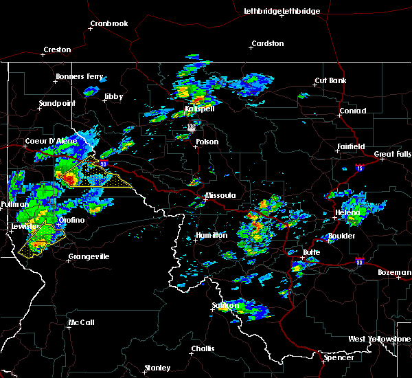 At 329 pm pdt, doppler radar indicated a severe thunderstorm capable of producing large hail up to ping pong ball size and damaging winds in excess of 60 mph. this storm was located 17 miles south of wallace, moving northeast at 45 mph. locations impacted include, mullan, lookout pass, avery, huckleberry campground, turner flat campground, conrad crossing campground and tin can campground. At 329 pm pdt, doppler radar indicated a severe thunderstorm capable of producing large hail up to ping pong ball size and damaging winds in excess of 60 mph. this storm was located 17 miles south of wallace, moving northeast at 45 mph. locations impacted include, mullan, lookout pass, avery, huckleberry campground, turner flat campground, conrad crossing campground and tin can campground.
|
| 6/8/2016 3:14 PM PDT |
 At 314 pm pdt, doppler radar indicated a severe thunderstorm capable of producing large hail up to ping pong ball size and damaging winds in excess of 60 mph. this storm was located 19 miles north of bovill, or 20 miles southeast of st. maries, and moving northeast at 45 mph. At 314 pm pdt, doppler radar indicated a severe thunderstorm capable of producing large hail up to ping pong ball size and damaging winds in excess of 60 mph. this storm was located 19 miles north of bovill, or 20 miles southeast of st. maries, and moving northeast at 45 mph.
|
Hail Maps for Mullan, ID


Connect with Interactive Hail Maps