| 9/7/2022 6:41 PM MDT |
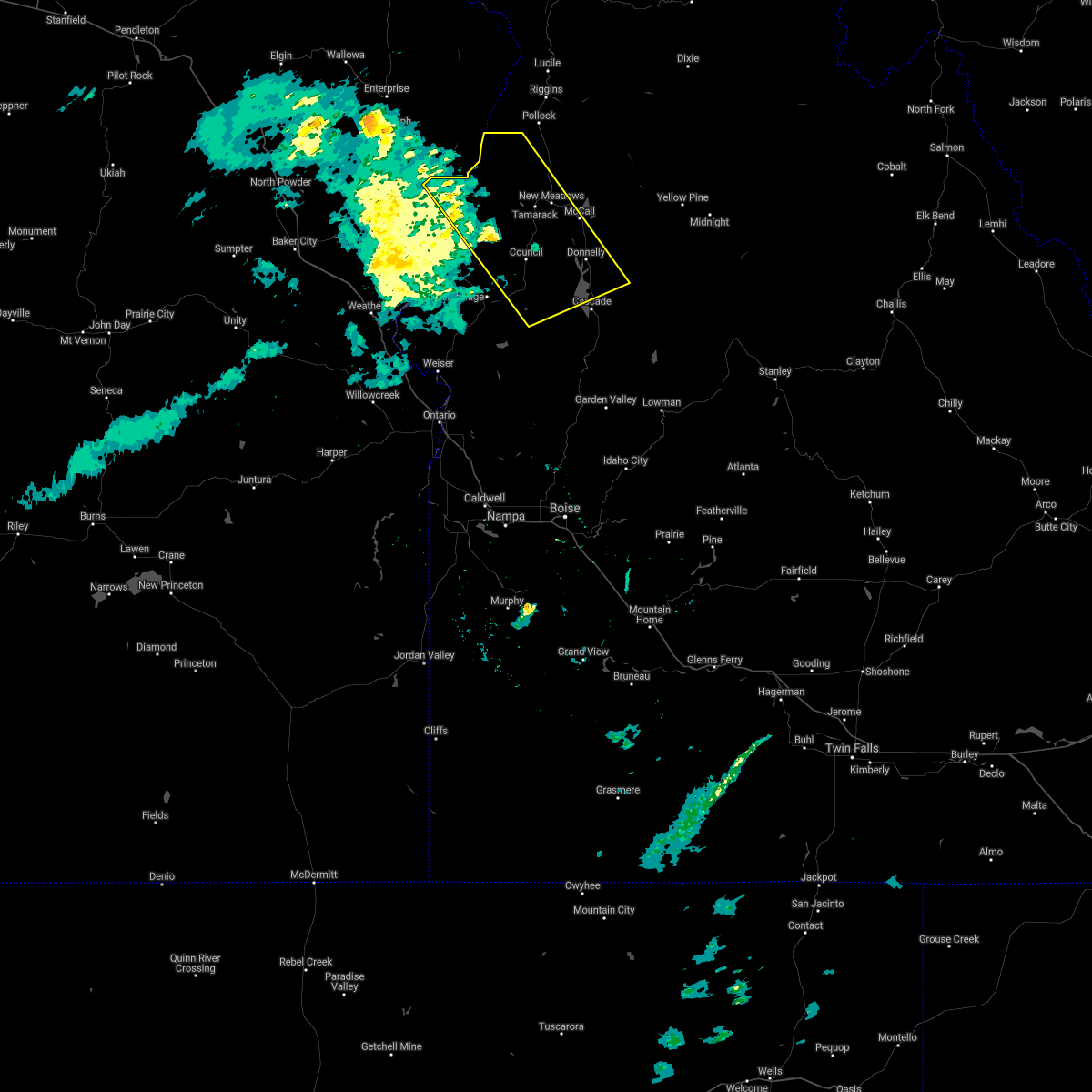
 At 640 pm mdt/540 pm pdt/, severe thunderstorms were located along a line extending from richland to near homedale, moving east-northeast at 55 mph (radar indicated). Hazards include 70 mph wind gusts. Expect considerable tree damage. damage is likely to mobile homes, roofs, and outbuildings. severe thunderstorms will be near, halfway, richland and carson around 550 pm pdt. cambridge around 650 pm mdt. oxbow dam and brownlee dam around 600 pm pdt. goodrich and brownlee reservoir around 700 pm mdt. emmett, eagle, council and bear around 710 pm mdt. sweet, horseshoe bend, montour and lost valley reservoir around 720 pm mdt. mccall, gardena, ola and new meadows around 730 pm mdt. thunderstorm damage threat, considerable hail threat, radar indicated max hail size, <. 75 in wind threat, radar indicated max wind gust, 70 mph. At 640 pm mdt/540 pm pdt/, severe thunderstorms were located along a line extending from richland to near homedale, moving east-northeast at 55 mph (radar indicated). Hazards include 70 mph wind gusts. Expect considerable tree damage. damage is likely to mobile homes, roofs, and outbuildings. severe thunderstorms will be near, halfway, richland and carson around 550 pm pdt. cambridge around 650 pm mdt. oxbow dam and brownlee dam around 600 pm pdt. goodrich and brownlee reservoir around 700 pm mdt. emmett, eagle, council and bear around 710 pm mdt. sweet, horseshoe bend, montour and lost valley reservoir around 720 pm mdt. mccall, gardena, ola and new meadows around 730 pm mdt. thunderstorm damage threat, considerable hail threat, radar indicated max hail size, <. 75 in wind threat, radar indicated max wind gust, 70 mph.
|
| 9/7/2022 6:41 PM MDT |
 At 640 pm mdt/540 pm pdt/, severe thunderstorms were located along a line extending from richland to near homedale, moving east-northeast at 55 mph (radar indicated). Hazards include 70 mph wind gusts. Expect considerable tree damage. damage is likely to mobile homes, roofs, and outbuildings. severe thunderstorms will be near, halfway, richland and carson around 550 pm pdt. cambridge around 650 pm mdt. oxbow dam and brownlee dam around 600 pm pdt. goodrich and brownlee reservoir around 700 pm mdt. emmett, eagle, council and bear around 710 pm mdt. sweet, horseshoe bend, montour and lost valley reservoir around 720 pm mdt. mccall, gardena, ola and new meadows around 730 pm mdt. thunderstorm damage threat, considerable hail threat, radar indicated max hail size, <. 75 in wind threat, radar indicated max wind gust, 70 mph. At 640 pm mdt/540 pm pdt/, severe thunderstorms were located along a line extending from richland to near homedale, moving east-northeast at 55 mph (radar indicated). Hazards include 70 mph wind gusts. Expect considerable tree damage. damage is likely to mobile homes, roofs, and outbuildings. severe thunderstorms will be near, halfway, richland and carson around 550 pm pdt. cambridge around 650 pm mdt. oxbow dam and brownlee dam around 600 pm pdt. goodrich and brownlee reservoir around 700 pm mdt. emmett, eagle, council and bear around 710 pm mdt. sweet, horseshoe bend, montour and lost valley reservoir around 720 pm mdt. mccall, gardena, ola and new meadows around 730 pm mdt. thunderstorm damage threat, considerable hail threat, radar indicated max hail size, <. 75 in wind threat, radar indicated max wind gust, 70 mph.
|
| 8/17/2020 6:51 PM MDT |
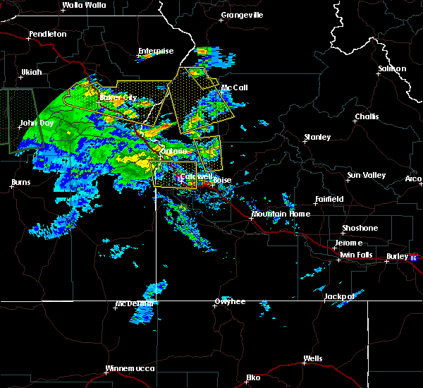
 At 649 pm mdt/549 pm pdt/, severe thunderstorms were located along a line extending from lake fork campground to indian valley, moving northeast at 25 mph (mesonet observations). Hazards include 65 mph wind gusts. Expect damage to roofs, siding, and trees. severe thunderstorms will be near, goodrich, indian valley, and mesa around 650 pm mdt. council, and bear around 710 pm mdt. cuprum, and glendale around 720 pm mdt. Mccall, new meadows, tamarack ski area and cascade reservoir around 730 pm mdt. At 649 pm mdt/549 pm pdt/, severe thunderstorms were located along a line extending from lake fork campground to indian valley, moving northeast at 25 mph (mesonet observations). Hazards include 65 mph wind gusts. Expect damage to roofs, siding, and trees. severe thunderstorms will be near, goodrich, indian valley, and mesa around 650 pm mdt. council, and bear around 710 pm mdt. cuprum, and glendale around 720 pm mdt. Mccall, new meadows, tamarack ski area and cascade reservoir around 730 pm mdt.
|
| 8/17/2020 6:51 PM MDT |
 At 649 pm mdt/549 pm pdt/, severe thunderstorms were located along a line extending from lake fork campground to indian valley, moving northeast at 25 mph (mesonet observations). Hazards include 65 mph wind gusts. Expect damage to roofs, siding, and trees. severe thunderstorms will be near, goodrich, indian valley, and mesa around 650 pm mdt. council, and bear around 710 pm mdt. cuprum, and glendale around 720 pm mdt. Mccall, new meadows, tamarack ski area and cascade reservoir around 730 pm mdt. At 649 pm mdt/549 pm pdt/, severe thunderstorms were located along a line extending from lake fork campground to indian valley, moving northeast at 25 mph (mesonet observations). Hazards include 65 mph wind gusts. Expect damage to roofs, siding, and trees. severe thunderstorms will be near, goodrich, indian valley, and mesa around 650 pm mdt. council, and bear around 710 pm mdt. cuprum, and glendale around 720 pm mdt. Mccall, new meadows, tamarack ski area and cascade reservoir around 730 pm mdt.
|
| 5/25/2018 9:19 PM MDT |
 At 919 pm mdt, severe thunderstorms were located along a line extending from near brownlee guard station to new meadows, moving north at 25 mph (radar indicated). Hazards include 60 mph wind gusts and quarter size hail. Hail damage to vehicles is expected. expect wind damage to roofs, siding, and trees. these severe storms will be near, new meadows, meadows, tamarack and lost valley reservoir around 920 pm mdt. price valley guard station around 930 pm mdt. Summers point, pollock mountain, lafferty campground and black lake around 940 pm mdt. At 919 pm mdt, severe thunderstorms were located along a line extending from near brownlee guard station to new meadows, moving north at 25 mph (radar indicated). Hazards include 60 mph wind gusts and quarter size hail. Hail damage to vehicles is expected. expect wind damage to roofs, siding, and trees. these severe storms will be near, new meadows, meadows, tamarack and lost valley reservoir around 920 pm mdt. price valley guard station around 930 pm mdt. Summers point, pollock mountain, lafferty campground and black lake around 940 pm mdt.
|
| 5/25/2018 8:41 PM MDT |
 At 841 pm mdt, a severe thunderstorm was located over goodrich, or 26 miles southwest of mccall, moving north at 35 mph (radar indicated). Hazards include 60 mph wind gusts and quarter size hail. Hail damage to vehicles is expected. expect wind damage to roofs, siding, and trees. this severe thunderstorm will be near, mccall, pyramid point, fruitvale and glendale around 900 pm mdt. new meadows, summers point, tamarack and meadows around 910 pm mdt. lafferty campground, lost valley reservoir and price valley guard station around 920 pm mdt. bear around 930 pm mdt. Cuprum, black lake and pollock mountain around 940 pm mdt. At 841 pm mdt, a severe thunderstorm was located over goodrich, or 26 miles southwest of mccall, moving north at 35 mph (radar indicated). Hazards include 60 mph wind gusts and quarter size hail. Hail damage to vehicles is expected. expect wind damage to roofs, siding, and trees. this severe thunderstorm will be near, mccall, pyramid point, fruitvale and glendale around 900 pm mdt. new meadows, summers point, tamarack and meadows around 910 pm mdt. lafferty campground, lost valley reservoir and price valley guard station around 920 pm mdt. bear around 930 pm mdt. Cuprum, black lake and pollock mountain around 940 pm mdt.
|
| 5/25/2018 7:48 PM MDT |
Golf Ball sized hail reported 1.3 miles S of New Meadows, ID, spotter reported golf ball sized hail in new meadows.
|


Connect with Interactive Hail Maps