

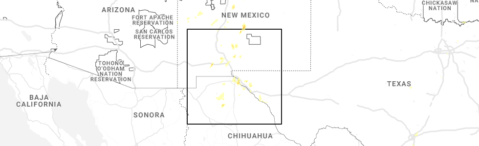
Hail Map for Organ, NM
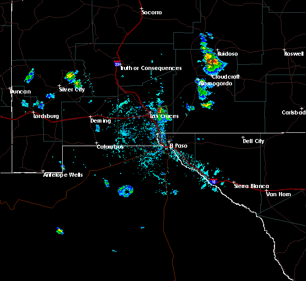
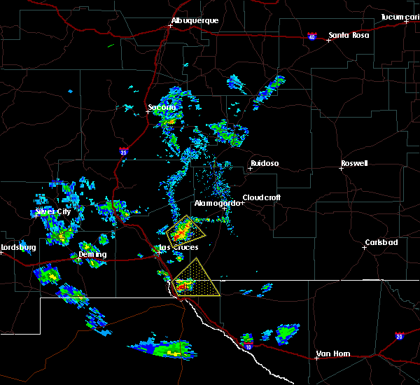
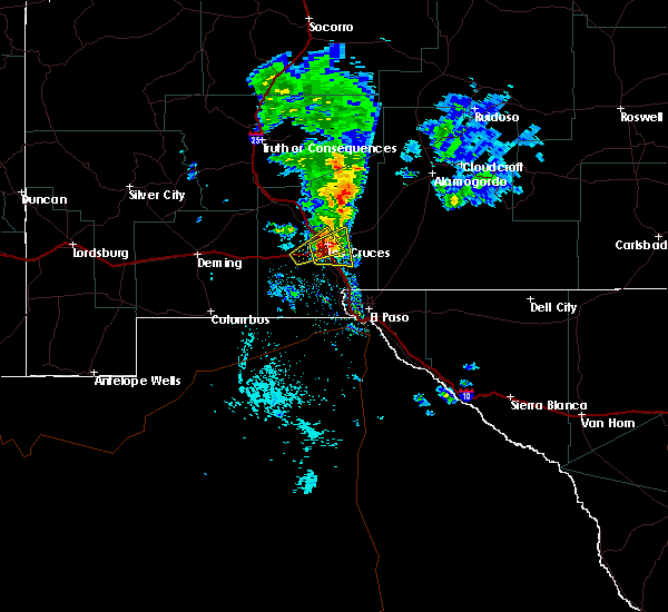
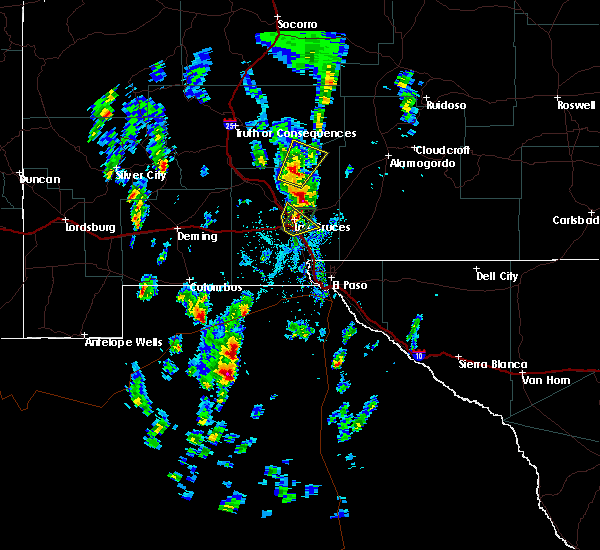
The Organ, NM area has had 0 reports of on-the-ground hail by trained spotters, and has been under severe weather warnings 3 times during the past 12 months. Doppler radar has detected hail at or near Organ, NM on 17 occasions, including 1 occasion during the past year.
| Name: | Organ, NM |
| Where Located: | 46.5 miles N of El Paso, TX |
| Map: | Google Map for Organ, NM |
| Population: | 323 |
| Housing Units: | 195 |
| More Info: | Search Google for Organ, NM |
0
The Top Recent Hail Date for Organ, NM is Tuesday, June 6, 2023 (16th out of 17)
Hail and Wind Damage Spotted near Organ, NM
| Date / Time | Report Details |
|---|---|
| 10/2/2023 6:17 PM MDT |
 At 617 pm mdt, a severe thunderstorm was located 7 miles northeast of organ, moving northeast at 35 mph (radar indicated). Hazards include 60 mph wind gusts. Expect damage to roofs, siding, and trees. locations impacted include, white sands missile range headquarters, organ, east mesa, portions of jornada experimental range, aguirre springs, and portions of organ mountains desert peaks national monument. this includes highway 70 in new mexico between mile markers 158 and 176. hail threat, radar indicated max hail size, <. 75 in wind threat, radar indicated max wind gust, 60 mph. At 617 pm mdt, a severe thunderstorm was located 7 miles northeast of organ, moving northeast at 35 mph (radar indicated). Hazards include 60 mph wind gusts. Expect damage to roofs, siding, and trees. locations impacted include, white sands missile range headquarters, organ, east mesa, portions of jornada experimental range, aguirre springs, and portions of organ mountains desert peaks national monument. this includes highway 70 in new mexico between mile markers 158 and 176. hail threat, radar indicated max hail size, <. 75 in wind threat, radar indicated max wind gust, 60 mph.
|
| 10/2/2023 5:54 PM MDT |
 At 553 pm mdt, a severe thunderstorm was located near talavera, moving northeast at 35 mph (radar indicated). Hazards include 60 mph wind gusts. expect damage to roofs, siding, and trees At 553 pm mdt, a severe thunderstorm was located near talavera, moving northeast at 35 mph (radar indicated). Hazards include 60 mph wind gusts. expect damage to roofs, siding, and trees
|
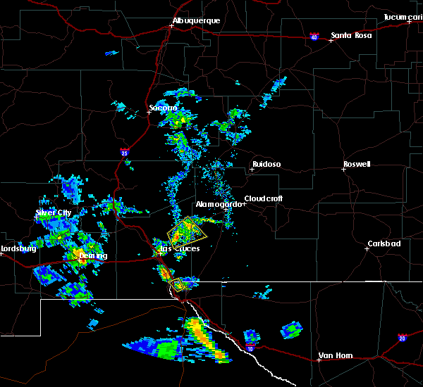
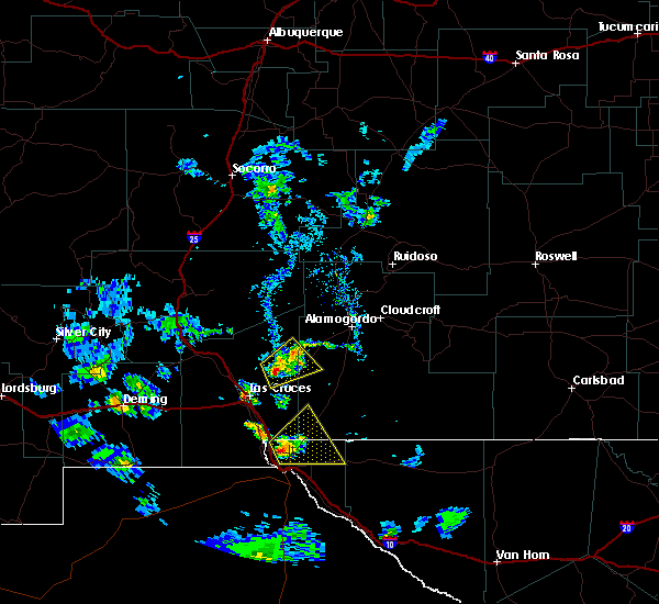
| 6/6/2023 6:05 PM MDT |
 At 605 pm mdt, a severe thunderstorm was located 5 miles northeast of las cruces, moving northeast at 20 mph (radar indicated). Hazards include 60 mph wind gusts and quarter size hail. Hail damage to vehicles is expected. Expect wind damage to roofs, siding, and trees. At 605 pm mdt, a severe thunderstorm was located 5 miles northeast of las cruces, moving northeast at 20 mph (radar indicated). Hazards include 60 mph wind gusts and quarter size hail. Hail damage to vehicles is expected. Expect wind damage to roofs, siding, and trees.
|
| 8/27/2021 6:28 PM MDT |
 At 627 pm mdt, a severe thunderstorm was located near organ, moving southwest at 5 mph (radar indicated). Hazards include quarter size hail. damage to vehicles is expected At 627 pm mdt, a severe thunderstorm was located near organ, moving southwest at 5 mph (radar indicated). Hazards include quarter size hail. damage to vehicles is expected
|
| 7/11/2021 7:06 PM MDT |
 At 706 pm mdt, a severe thunderstorm was located over jornada range, moving south at 20 mph (radar indicated). Hazards include 70 mph wind gusts and ping pong ball size hail. People and animals outdoors will be injured. expect hail damage to roofs, siding, windows, and vehicles. expect considerable tree damage. Wind damage is also likely to mobile homes, roofs, and outbuildings. At 706 pm mdt, a severe thunderstorm was located over jornada range, moving south at 20 mph (radar indicated). Hazards include 70 mph wind gusts and ping pong ball size hail. People and animals outdoors will be injured. expect hail damage to roofs, siding, windows, and vehicles. expect considerable tree damage. Wind damage is also likely to mobile homes, roofs, and outbuildings.
|
| 7/11/2021 6:50 PM MDT | Mesonet station wsm05 san agustin pass 1.6 e organ (wsmr in dona ana county NM, 1.9 miles W of Organ, NM |
| 7/11/2021 6:28 PM MDT |
 At 628 pm mdt, severe thunderstorms were located along a line extending from 9 miles northeast of white sands missile range headquarters to 8 miles north of organ to near jornada range, moving south at 25 mph (radar indicated). Hazards include ping pong ball size hail and 60 mph wind gusts. People and animals outdoors will be injured. expect hail damage to roofs, siding, windows, and vehicles. Expect wind damage to roofs, siding, and trees. At 628 pm mdt, severe thunderstorms were located along a line extending from 9 miles northeast of white sands missile range headquarters to 8 miles north of organ to near jornada range, moving south at 25 mph (radar indicated). Hazards include ping pong ball size hail and 60 mph wind gusts. People and animals outdoors will be injured. expect hail damage to roofs, siding, windows, and vehicles. Expect wind damage to roofs, siding, and trees.
|
| 7/11/2021 5:41 PM MDT |
 At 541 pm mdt, a severe thunderstorm was located over organ, moving south at 15 mph (radar indicated). Hazards include 60 mph wind gusts and half dollar size hail. Hail damage to vehicles is expected. expect wind damage to roofs, siding, and trees. locations impacted include, las cruces, organ, talavera, east mesa, northeast las cruces, dripping springs, aguirre springs, portions of organ mountains desert peaks national monument and soledad canyon. this includes the following highways, interstate 25 in new mexico between mile markers 1 and 2. Highway 70 in new mexico between mile markers 151 and 166. At 541 pm mdt, a severe thunderstorm was located over organ, moving south at 15 mph (radar indicated). Hazards include 60 mph wind gusts and half dollar size hail. Hail damage to vehicles is expected. expect wind damage to roofs, siding, and trees. locations impacted include, las cruces, organ, talavera, east mesa, northeast las cruces, dripping springs, aguirre springs, portions of organ mountains desert peaks national monument and soledad canyon. this includes the following highways, interstate 25 in new mexico between mile markers 1 and 2. Highway 70 in new mexico between mile markers 151 and 166.
|
| 7/11/2021 5:21 PM MDT |
 At 521 pm mdt, a severe thunderstorm was located near organ, moving south at 20 mph (radar indicated). Hazards include golf ball size hail and 60 mph wind gusts. People and animals outdoors will be injured. expect hail damage to roofs, siding, windows, and vehicles. Expect wind damage to roofs, siding, and trees. At 521 pm mdt, a severe thunderstorm was located near organ, moving south at 20 mph (radar indicated). Hazards include golf ball size hail and 60 mph wind gusts. People and animals outdoors will be injured. expect hail damage to roofs, siding, windows, and vehicles. Expect wind damage to roofs, siding, and trees.
|
| 7/31/2020 6:45 PM MDT |
 At 644 pm mdt, a severe thunderstorm was located near the organ mountains staying stationary (radar indicated). Hazards include 60 mph wind gusts and quarter size hail. Hail damage to vehicles is expected. Expect wind damage to roofs, siding, and trees. At 644 pm mdt, a severe thunderstorm was located near the organ mountains staying stationary (radar indicated). Hazards include 60 mph wind gusts and quarter size hail. Hail damage to vehicles is expected. Expect wind damage to roofs, siding, and trees.
|
| 7/31/2020 5:59 PM MDT |
 At 558 pm mdt, a severe thunderstorm was located near organ, moving south at 10 mph (radar indicated). Hazards include 60 mph wind gusts and quarter size hail. Hail damage to vehicles is expected. Expect wind damage to roofs, siding, and trees. At 558 pm mdt, a severe thunderstorm was located near organ, moving south at 10 mph (radar indicated). Hazards include 60 mph wind gusts and quarter size hail. Hail damage to vehicles is expected. Expect wind damage to roofs, siding, and trees.
|
| 7/31/2020 5:30 PM MDT | Elev 5902 ft wmsr in dona ana county NM, 1.9 miles W of Organ, NM |
| 3/18/2020 11:15 PM MDT | Storm damage reported in dona ana county NM, 9.9 miles S of Organ, NM |
| 3/18/2020 10:43 PM MDT |
 At 1041 pm mdt, severe thunderstorms were approaching the las cruces area and surrounding locations, moving northeast at 50 mph (radar indicated). Hazards include 60 mph wind gusts and penny size hail. expect damage to roofs, siding, and trees At 1041 pm mdt, severe thunderstorms were approaching the las cruces area and surrounding locations, moving northeast at 50 mph (radar indicated). Hazards include 60 mph wind gusts and penny size hail. expect damage to roofs, siding, and trees
|
| 6/4/2019 3:47 PM MDT |
 At 346 pm mdt, a severe thunderstorm was located 6 miles northeast of dona ana, moving northeast at 20 mph (radar indicated). Hazards include 60 mph wind gusts and quarter size hail. Hail damage to vehicles is expected. expect wind damage to roofs, siding, and trees. Locations impacted include, leasburg, las cruces, jornada range, dona ana, nmsu main campus, mesilla, fairacres, organ, east mesa, picacho, portions of jornada experimental range, hill, northeast las cruces, dripping springs, aguirre springs and portions of organ mountains desert peaks national monument. At 346 pm mdt, a severe thunderstorm was located 6 miles northeast of dona ana, moving northeast at 20 mph (radar indicated). Hazards include 60 mph wind gusts and quarter size hail. Hail damage to vehicles is expected. expect wind damage to roofs, siding, and trees. Locations impacted include, leasburg, las cruces, jornada range, dona ana, nmsu main campus, mesilla, fairacres, organ, east mesa, picacho, portions of jornada experimental range, hill, northeast las cruces, dripping springs, aguirre springs and portions of organ mountains desert peaks national monument.
|
| 6/4/2019 3:23 PM MDT |
 At 323 pm mdt, a severe thunderstorm was located near dona ana, moving northeast at 10 mph (radar indicated). Hazards include 60 mph wind gusts and quarter size hail. Hail damage to vehicles is expected. Expect wind damage to roofs, siding, and trees. At 323 pm mdt, a severe thunderstorm was located near dona ana, moving northeast at 10 mph (radar indicated). Hazards include 60 mph wind gusts and quarter size hail. Hail damage to vehicles is expected. Expect wind damage to roofs, siding, and trees.
|
| 5/21/2018 5:29 PM MDT |
 At 529 pm mdt, a severe thunderstorm was located 6 miles southwest of white sands main post, or 14 miles east of las cruces, moving northeast at 55 mph (radar indicated). Hazards include 60 mph wind gusts and quarter size hail. Hail damage to vehicles is expected. Expect wind damage to roofs, siding, and trees. At 529 pm mdt, a severe thunderstorm was located 6 miles southwest of white sands main post, or 14 miles east of las cruces, moving northeast at 55 mph (radar indicated). Hazards include 60 mph wind gusts and quarter size hail. Hail damage to vehicles is expected. Expect wind damage to roofs, siding, and trees.
|
| 8/13/2017 4:26 PM MDT |
 The severe thunderstorm warning for east central dona ana county will expire at 430 pm mdt, the storm which prompted the warning has weakened below severe limits, and no longer poses an immediate threat to life or property. therefore the warning will be allowed to expire. however gusty winds are still possible with this thunderstorm. The severe thunderstorm warning for east central dona ana county will expire at 430 pm mdt, the storm which prompted the warning has weakened below severe limits, and no longer poses an immediate threat to life or property. therefore the warning will be allowed to expire. however gusty winds are still possible with this thunderstorm.
|
| 8/13/2017 4:03 PM MDT |
 At 402 pm mdt, a severe thunderstorm was located near east mesa, or 7 miles northeast of las cruces, moving east at 20 mph (radar indicated). Hazards include 60 mph wind gusts and quarter size hail. Hail damage to vehicles is expected. expect wind damage to roofs, siding, and trees. Locations impacted include, east mesa, dona ana, organ, talavera, dripping springs, soledad canyon, aguirre springs and twin peaks. At 402 pm mdt, a severe thunderstorm was located near east mesa, or 7 miles northeast of las cruces, moving east at 20 mph (radar indicated). Hazards include 60 mph wind gusts and quarter size hail. Hail damage to vehicles is expected. expect wind damage to roofs, siding, and trees. Locations impacted include, east mesa, dona ana, organ, talavera, dripping springs, soledad canyon, aguirre springs and twin peaks.
|
| 8/13/2017 3:46 PM MDT |
 At 346 pm mdt, a severe thunderstorm was located over east mesa, or 4 miles north of las cruces, moving east at 20 mph (radar indicated). Hazards include quarter size hail. damage to vehicles is expected At 346 pm mdt, a severe thunderstorm was located over east mesa, or 4 miles north of las cruces, moving east at 20 mph (radar indicated). Hazards include quarter size hail. damage to vehicles is expected
|
| 6/19/2017 7:42 PM MDT |
 The severe thunderstorm warning for east central dona ana county will expire at 745 pm mdt, the storm which prompted the warning has weakened below severe limits, and no longer pose an immediate threat to life or property. therefore, the warning will be allowed to expire. however heavy rain is still possible with this thunderstorm. The severe thunderstorm warning for east central dona ana county will expire at 745 pm mdt, the storm which prompted the warning has weakened below severe limits, and no longer pose an immediate threat to life or property. therefore, the warning will be allowed to expire. however heavy rain is still possible with this thunderstorm.
|
| 6/19/2017 7:10 PM MDT | Thunderstorm wind gust measured at san augustin pass in dona ana county NM, 2.5 miles W of Organ, NM |
| 6/19/2017 7:02 PM MDT |
 At 701 pm mdt, a severe thunderstorm was located near organ, or 13 miles east of las cruces, moving west at 15 mph (radar indicated). Hazards include quarter size hail. damage to vehicles is expected At 701 pm mdt, a severe thunderstorm was located near organ, or 13 miles east of las cruces, moving west at 15 mph (radar indicated). Hazards include quarter size hail. damage to vehicles is expected
|
| 5/30/2017 8:11 PM MDT |
 The severe thunderstorm warning for west central otero and east central dona ana counties will expire at 815 pm mdt, the storm which prompted the warning has weakened below severe limits, and no longer pose an immediate threat to life or property. therefore, the warning will be allowed to expire. however, heavy rain is still possible with this thunderstorm. The severe thunderstorm warning for west central otero and east central dona ana counties will expire at 815 pm mdt, the storm which prompted the warning has weakened below severe limits, and no longer pose an immediate threat to life or property. therefore, the warning will be allowed to expire. however, heavy rain is still possible with this thunderstorm.
|
| 5/30/2017 7:51 PM MDT |
 At 748 pm mdt, a severe thunderstorm was located 8 miles northeast of organ, or 21 miles northeast of las cruces, and is nearly stationary (radar indicated). Hazards include 60 mph wind gusts and quarter size hail. Hail damage to vehicles is expected. expect wind damage to roofs, siding, and trees. This severe thunderstorm will remain over mainly rural areas of west central otero and east central dona ana counties. At 748 pm mdt, a severe thunderstorm was located 8 miles northeast of organ, or 21 miles northeast of las cruces, and is nearly stationary (radar indicated). Hazards include 60 mph wind gusts and quarter size hail. Hail damage to vehicles is expected. expect wind damage to roofs, siding, and trees. This severe thunderstorm will remain over mainly rural areas of west central otero and east central dona ana counties.
|
| 5/30/2017 7:37 PM MDT |
 At 736 pm mdt, a severe thunderstorm was located 7 miles northeast of organ, or 20 miles northeast of las cruces, and is nearly stationary (radar indicated). Hazards include 60 mph wind gusts and quarter size hail. Hail damage to vehicles is expected. expect wind damage to roofs, siding, and trees. This severe thunderstorm will remain over mainly rural areas of west central otero and east central dona ana counties. At 736 pm mdt, a severe thunderstorm was located 7 miles northeast of organ, or 20 miles northeast of las cruces, and is nearly stationary (radar indicated). Hazards include 60 mph wind gusts and quarter size hail. Hail damage to vehicles is expected. expect wind damage to roofs, siding, and trees. This severe thunderstorm will remain over mainly rural areas of west central otero and east central dona ana counties.
|
| 1/14/2017 6:29 PM MST |
 At 628 pm mst, a severe thunderstorm was moving toward white sands missile range headquarters, moving northeast at 45 mph (radar indicated). Hazards include 70 mph wind gusts and quarter size hail. Hail damage to vehicles is expected. expect considerable tree damage. Wind damage is also likely to mobile homes, roofs, and outbuildings. At 628 pm mst, a severe thunderstorm was moving toward white sands missile range headquarters, moving northeast at 45 mph (radar indicated). Hazards include 70 mph wind gusts and quarter size hail. Hail damage to vehicles is expected. expect considerable tree damage. Wind damage is also likely to mobile homes, roofs, and outbuildings.
|
| 1/14/2017 6:07 PM MST |
 At 606 pm mst, a severe thunderstorm was located over las cruces. moving northeast at 40 mph (public). Hazards include 60 mph wind gusts and quarter size hail. Hail damage to vehicles is expected. Expect wind damage to roofs, siding, and trees. At 606 pm mst, a severe thunderstorm was located over las cruces. moving northeast at 40 mph (public). Hazards include 60 mph wind gusts and quarter size hail. Hail damage to vehicles is expected. Expect wind damage to roofs, siding, and trees.
|
| 11/4/2016 9:43 PM MDT |
 At 943 pm mdt, a severe thunderstorm was located near talavera, or 5 miles east of las cruces, moving east at 20 mph (radar indicated). Hazards include half dollar size hail. Damage to vehicles is expected. Locations impacted include, las cruces, talavera, organ, nmsu main campus, mesilla, northeast las cruces, east mesa, san pablo, soledad canyon, and dripping springs. At 943 pm mdt, a severe thunderstorm was located near talavera, or 5 miles east of las cruces, moving east at 20 mph (radar indicated). Hazards include half dollar size hail. Damage to vehicles is expected. Locations impacted include, las cruces, talavera, organ, nmsu main campus, mesilla, northeast las cruces, east mesa, san pablo, soledad canyon, and dripping springs.
|
| 11/4/2016 9:27 PM MDT |
 At 926 pm mdt, a severe thunderstorm was located over nmsu main campus, or near las cruces, moving east at 20 mph (radar indicated). Hazards include quarter size hail. damage to vehicles is expected At 926 pm mdt, a severe thunderstorm was located over nmsu main campus, or near las cruces, moving east at 20 mph (radar indicated). Hazards include quarter size hail. damage to vehicles is expected
|
| 11/4/2016 7:39 PM MDT |
 At 738 pm mdt, a severe thunderstorm was located 6 miles northwest of organ, or 9 miles south of jornada range, moving east at 35 mph (radar indicated). Hazards include 60 mph wind gusts and half dollar size hail. Hail damage to vehicles is expected. Expect wind damage to roofs, siding, and trees. At 738 pm mdt, a severe thunderstorm was located 6 miles northwest of organ, or 9 miles south of jornada range, moving east at 35 mph (radar indicated). Hazards include 60 mph wind gusts and half dollar size hail. Hail damage to vehicles is expected. Expect wind damage to roofs, siding, and trees.
|
| 8/27/2016 6:13 PM MDT |
 At 612 pm mdt, a severe thunderstorm was located near dona ana, or 5 miles northwest of las cruces, moving east at 25 mph (radar indicated). Hazards include 60 mph wind gusts and quarter size hail. Hail damage to vehicles is expected. Expect wind damage to roofs, siding, and trees. At 612 pm mdt, a severe thunderstorm was located near dona ana, or 5 miles northwest of las cruces, moving east at 25 mph (radar indicated). Hazards include 60 mph wind gusts and quarter size hail. Hail damage to vehicles is expected. Expect wind damage to roofs, siding, and trees.
|
| 10/21/2015 1:54 PM MDT |
 At 153 pm mdt, a severe thunderstorm was located just west of organ, moving northeast at 25 mph. another severe storm was located just east of jornada range headquarters (trained weather spotters). Hazards include quarter size hail. Damage to vehicles is expected. Locations impacted include, organ, jornada range. At 153 pm mdt, a severe thunderstorm was located just west of organ, moving northeast at 25 mph. another severe storm was located just east of jornada range headquarters (trained weather spotters). Hazards include quarter size hail. Damage to vehicles is expected. Locations impacted include, organ, jornada range.
|
| 10/21/2015 1:37 PM MDT |
 At 134 pm mdt, a severe thunderstorm was located near las cruces, moving northeast at 20 mph. another storm was located just north of jornada range, moving northeast at 20 mph (trained weather spotters). Hazards include golf ball size hail. People and animals outdoors will be injured. Expect damage to roofs, siding, windows and vehicles. At 134 pm mdt, a severe thunderstorm was located near las cruces, moving northeast at 20 mph. another storm was located just north of jornada range, moving northeast at 20 mph (trained weather spotters). Hazards include golf ball size hail. People and animals outdoors will be injured. Expect damage to roofs, siding, windows and vehicles.
|
| 10/3/2015 2:41 PM MDT | At 238 pm mdt, a severe thunderstorm was located 10 miles south of white sands national monument, moving northeast at 55 mph (public web report). Hazards include at 211 pm mdt...quarter size hail was reported off elks drive in las cruces. People and animals outdoors will be injured. expect hail damage to roofs, siding, windows and vehicles. expect considerable tree damage. wind damage is also likely to mobile homes, roofs and outbuildings. Locations impacted include, las cruces, talavera, organ, white sands main post, east mesa, soledad canyon, twin peaks, dripping springs, aguirre springs. |
| 10/3/2015 2:06 PM MDT |
 At 206 pm mdt, a severe thunderstorm was located near organ, or 10 miles northeast of las cruces, moving northeast at 30 mph (radar indicated). Hazards include golf ball size hail and 70 mph wind gusts. People and animals outdoors will be injured. expect hail damage to roofs, siding, windows and vehicles. expect considerable tree damage. Wind damage is also likely to mobile homes, roofs and outbuildings. At 206 pm mdt, a severe thunderstorm was located near organ, or 10 miles northeast of las cruces, moving northeast at 30 mph (radar indicated). Hazards include golf ball size hail and 70 mph wind gusts. People and animals outdoors will be injured. expect hail damage to roofs, siding, windows and vehicles. expect considerable tree damage. Wind damage is also likely to mobile homes, roofs and outbuildings.
|
| 10/3/2015 1:53 PM MDT |
 At 152 pm mdt, a severe thunderstorm was located near organ, or 16 miles northeast of las cruces, moving northeast at 25 mph (broadcast media). Hazards include at 150 pm...quarter size hail was reported in west las cruces. Hail damage to vehicles is expected. expect wind damage to roofs, siding and trees. Locations impacted include, las cruces, mesilla, talavera, nmsu main campus, dona ana, fairacres, organ, corralitos, east mesa, twin peaks, aguirre springs, soledad canyon, dripping springs. At 152 pm mdt, a severe thunderstorm was located near organ, or 16 miles northeast of las cruces, moving northeast at 25 mph (broadcast media). Hazards include at 150 pm...quarter size hail was reported in west las cruces. Hail damage to vehicles is expected. expect wind damage to roofs, siding and trees. Locations impacted include, las cruces, mesilla, talavera, nmsu main campus, dona ana, fairacres, organ, corralitos, east mesa, twin peaks, aguirre springs, soledad canyon, dripping springs.
|
| 10/3/2015 1:33 PM MDT |
 At 133 pm mdt, a severe thunderstorm was located over las cruces, moving northeast at 55 mph (radar indicated). Hazards include 60 mph wind gusts and quarter size hail. Hail damage to vehicles is expected. Expect wind damage to roofs, siding and trees. At 133 pm mdt, a severe thunderstorm was located over las cruces, moving northeast at 55 mph (radar indicated). Hazards include 60 mph wind gusts and quarter size hail. Hail damage to vehicles is expected. Expect wind damage to roofs, siding and trees.
|
| 7/10/2015 3:37 PM MDT |
 The severe thunderstorm warning for central dona ana county will expire at 345 pm mdt, the storm which prompted the warning has weakened below severe limits and exited the warned area. therefore the warning will be allowed to expire. however heavy rain is still possible with this thunderstorm as well as other thunderstorms in the area. The severe thunderstorm warning for central dona ana county will expire at 345 pm mdt, the storm which prompted the warning has weakened below severe limits and exited the warned area. therefore the warning will be allowed to expire. however heavy rain is still possible with this thunderstorm as well as other thunderstorms in the area.
|
| 7/10/2015 3:19 PM MDT |
 At 318 pm mdt, a severe thunderstorm was located 5 miles northwest of organ, or 11 miles northeast of las cruces, moving northeast at 20 mph (radar indicated). Hazards include 60 mph wind gusts and nickel size hail. Expect damage to roofs. siding and trees. Locations impacted include, las cruces, organ, east mesa, and aguirre springs. At 318 pm mdt, a severe thunderstorm was located 5 miles northwest of organ, or 11 miles northeast of las cruces, moving northeast at 20 mph (radar indicated). Hazards include 60 mph wind gusts and nickel size hail. Expect damage to roofs. siding and trees. Locations impacted include, las cruces, organ, east mesa, and aguirre springs.
|
| 7/10/2015 2:58 PM MDT |
 At 258 pm mdt, a severe thunderstorm was located near dona ana, or 6 miles north of las cruces, moving northeast at 20 mph (radar indicated). Hazards include 60 mph wind gusts and nickel size hail. Expect damage to roofs. Siding and trees. At 258 pm mdt, a severe thunderstorm was located near dona ana, or 6 miles north of las cruces, moving northeast at 20 mph (radar indicated). Hazards include 60 mph wind gusts and nickel size hail. Expect damage to roofs. Siding and trees.
|
| 7/7/2015 4:12 PM MDT |
 At 412 pm mdt, a severe thunderstorm was located 7 miles southeast of jornada range, moving east at 15 mph (radar indicated). Hazards include 60 mph wind gusts. Expect damage to roofs. siding and trees. Locations impacted include, organ, jornada range. At 412 pm mdt, a severe thunderstorm was located 7 miles southeast of jornada range, moving east at 15 mph (radar indicated). Hazards include 60 mph wind gusts. Expect damage to roofs. siding and trees. Locations impacted include, organ, jornada range.
|
| 7/7/2015 3:43 PM MDT |
 At 343 pm mdt, a severe thunderstorm was located near radium springs, or near leasburg, moving east at 20 mph (radar indicated). Hazards include 60 mph wind gusts and penny size hail. Expect damage to roofs. Siding and trees. At 343 pm mdt, a severe thunderstorm was located near radium springs, or near leasburg, moving east at 20 mph (radar indicated). Hazards include 60 mph wind gusts and penny size hail. Expect damage to roofs. Siding and trees.
|
| 5/30/2015 6:00 PM MDT | At 548 pm mdt, a severe thunderstorm was reported, producing quarter size hail, and damaging winds in excess of 60 mph. this storm was located 12 miles east of leasburg, moving southeast at 5 mph. radar indicates this storm continues to pulse between strong and severe. locations impacted include, leasburg, las cruces, chaparral, anthony, east mesa, talavera, berino, san miguel, san miguel in dona ana county, fairacres, lookout peak, twin peaks, aguirre springs, soledad canyon,. |
| 5/30/2015 6:00 PM MDT | At 548 pm mdt, a severe thunderstorm was reported, producing quarter size hail, and damaging winds in excess of 60 mph. this storm was located 12 miles east of leasburg, moving southeast at 5 mph. radar indicates this storm continues to pulse between strong and severe. locations impacted include, leasburg, las cruces, chaparral, anthony, east mesa, talavera, berino, san miguel, san miguel in dona ana county, fairacres, lookout peak, twin peaks, aguirre springs, soledad canyon,. |
| 5/30/2015 5:23 PM MDT | At 516 pm mdt, national weather service meteorologists detected a severe thunderstorm capable of producing quarter size hail, and damaging winds in excess of 60 mph. this storm was located 11 miles northeast of leasburg, moving southeast at 5 mph. |
| 5/30/2015 5:23 PM MDT | At 516 pm mdt, national weather service meteorologists detected a severe thunderstorm capable of producing quarter size hail, and damaging winds in excess of 60 mph. this storm was located 11 miles northeast of leasburg, moving southeast at 5 mph. |
| 7/1/2014 6:15 PM MDT | Elev 5902 ft wmsr in dona ana county NM, 1.9 miles W of Organ, NM |
| 7/1/2014 6:10 PM MDT | Storm damage reported in dona ana county NM, 1.9 miles W of Organ, NM |
Hail Maps for Organ, NM


Connect with Interactive Hail Maps