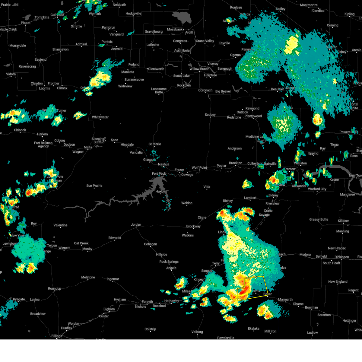
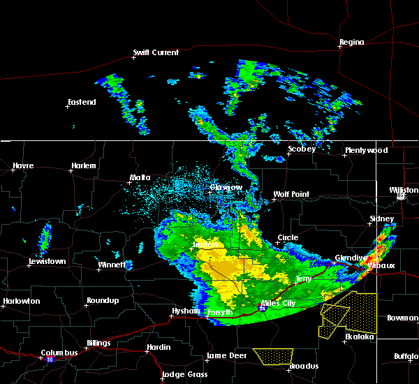
| 6/26/2023 4:53 PM MDT |
 The severe thunderstorm warning for northwestern fallon county will expire at 500 pm mdt, the storm which prompted the warning has weakened below severe limits, and no longer poses an immediate threat to life or property. therefore, the warning will be allowed to expire. however heavy rain is still possible with this thunderstorm. The severe thunderstorm warning for northwestern fallon county will expire at 500 pm mdt, the storm which prompted the warning has weakened below severe limits, and no longer poses an immediate threat to life or property. therefore, the warning will be allowed to expire. however heavy rain is still possible with this thunderstorm.
|
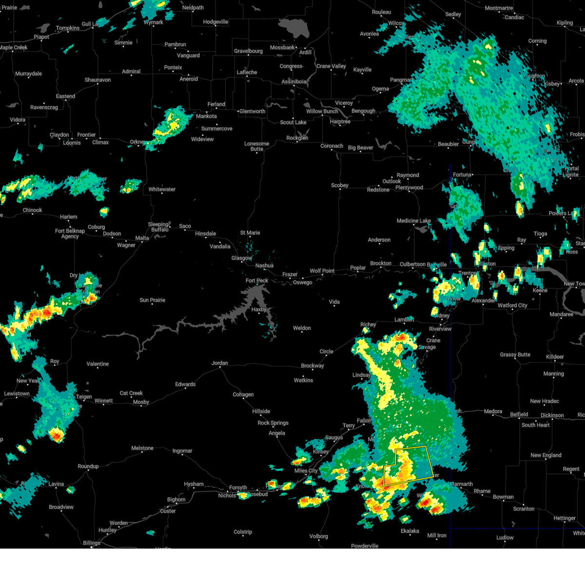
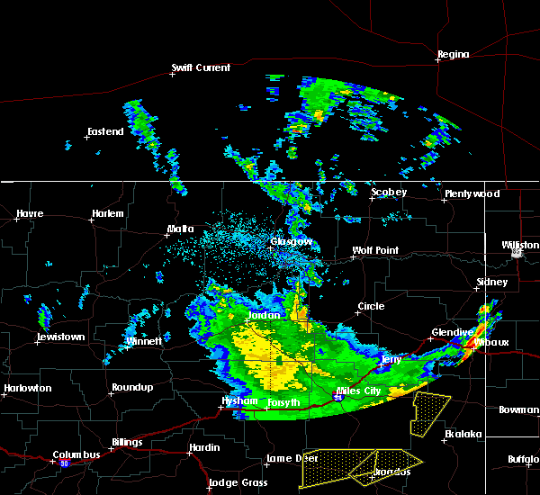
| 6/26/2023 4:33 PM MDT |
 At 432 pm mdt, a severe thunderstorm was located 17 miles northwest of baker, moving east at 40 mph (radar indicated). Hazards include torrential rain, 60 mph wind gusts and quarter size hail. Hail damage to vehicles is expected. expect wind damage to roofs, siding, and trees. Expect ponding of water on roads. At 432 pm mdt, a severe thunderstorm was located 17 miles northwest of baker, moving east at 40 mph (radar indicated). Hazards include torrential rain, 60 mph wind gusts and quarter size hail. Hail damage to vehicles is expected. expect wind damage to roofs, siding, and trees. Expect ponding of water on roads.
|
| 6/19/2023 8:29 PM MDT |
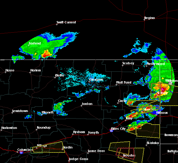
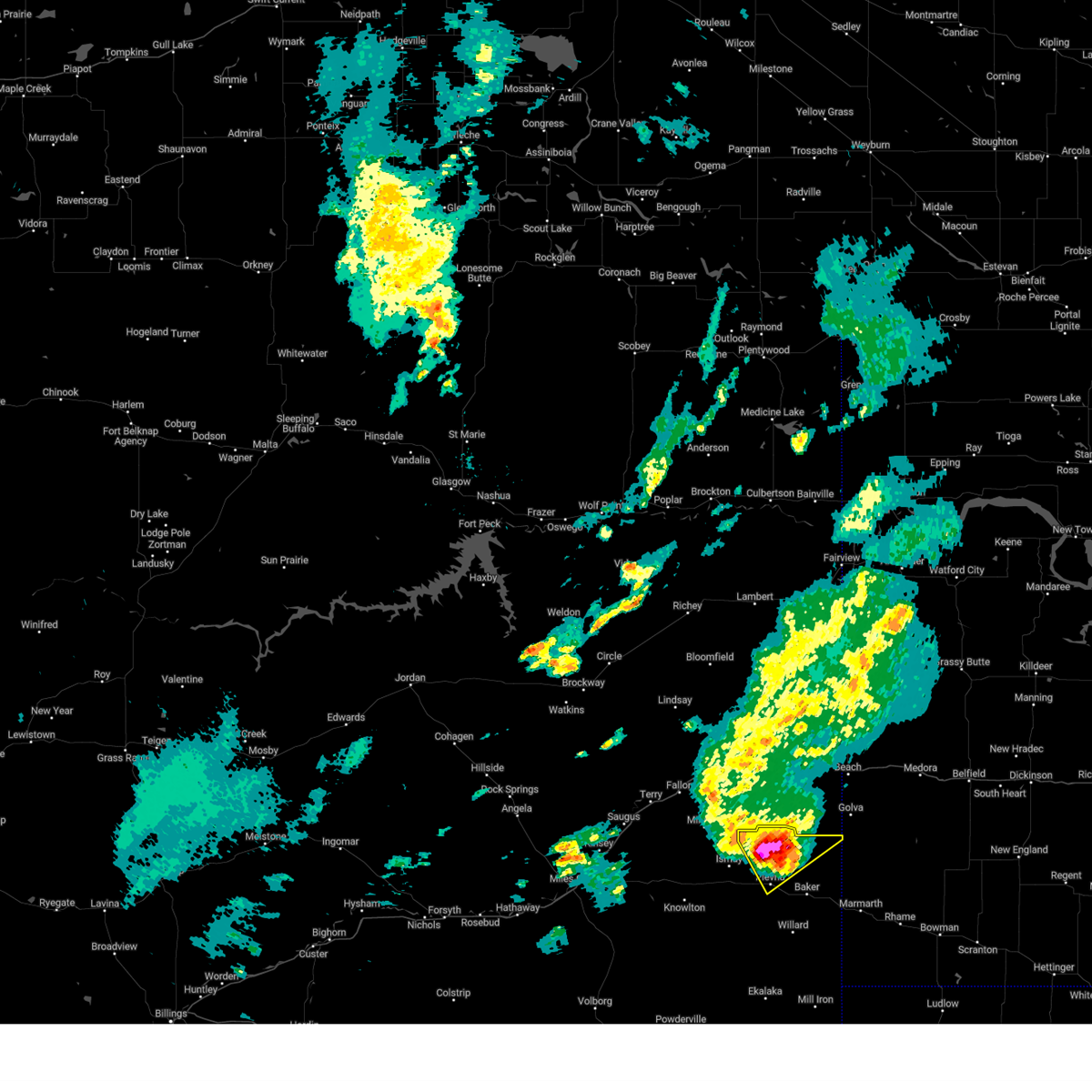 At 826 pm mdt, a severe thunderstorm was located 17 miles northwest of baker, moving northeast at 40 mph. this is a destructive storm for northern fallon county (radar indicated. golf ball hail and gusts to 80 mph reported in westmore with this storm). Hazards include 80 mph wind gusts and golf ball size hail. Flying debris will be dangerous to those caught without shelter. mobile homes will be heavily damaged. expect considerable damage to roofs, windows, and vehicles. extensive tree damage and power outages are likely. locations impacted include, mainly rural areas of northern fallon county north of plevna. thunderstorm damage threat, destructive hail threat, observed max hail size, 1. 75 in wind threat, observed max wind gust, 80 mph. At 826 pm mdt, a severe thunderstorm was located 17 miles northwest of baker, moving northeast at 40 mph. this is a destructive storm for northern fallon county (radar indicated. golf ball hail and gusts to 80 mph reported in westmore with this storm). Hazards include 80 mph wind gusts and golf ball size hail. Flying debris will be dangerous to those caught without shelter. mobile homes will be heavily damaged. expect considerable damage to roofs, windows, and vehicles. extensive tree damage and power outages are likely. locations impacted include, mainly rural areas of northern fallon county north of plevna. thunderstorm damage threat, destructive hail threat, observed max hail size, 1. 75 in wind threat, observed max wind gust, 80 mph.
|
| 6/19/2023 8:15 PM MDT |
Golf Ball sized hail reported 6.6 miles SE of Plevna, MT
|
| 6/19/2023 8:15 PM MDT |
Storm damage reported in fallon county MT, 6.6 miles SE of Plevna, MT
|
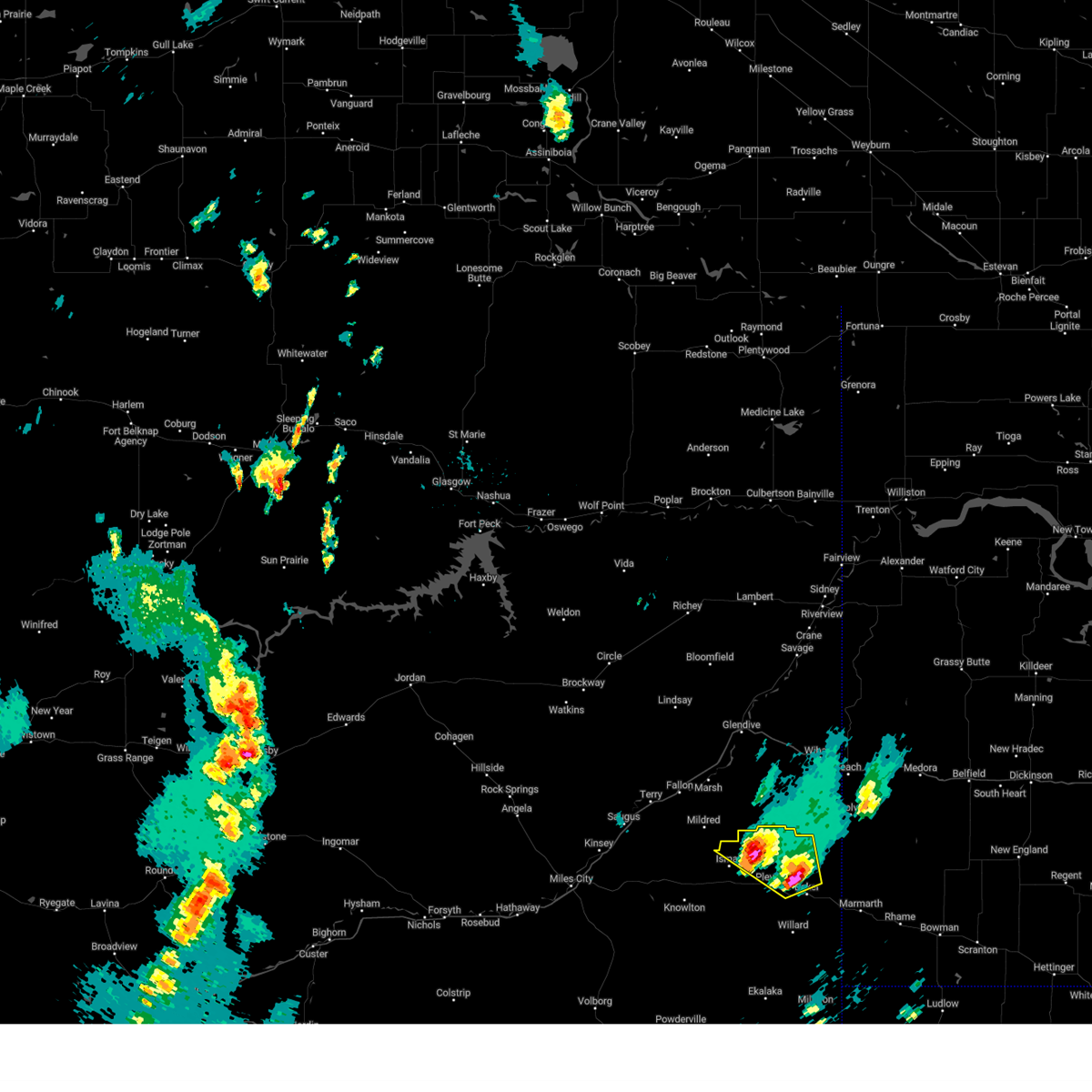
| 6/19/2023 8:12 PM MDT |
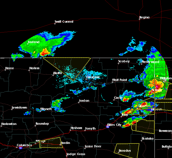
 At 810 pm mdt, a severe thunderstorm was located 20 miles northwest of baker, moving northeast at 50 mph. this is a destructive storm for plevna, ismay and westmore (radar indicated. wind gusts to 83 mph have been reported with this storm). Hazards include 80 mph wind gusts and ping pong ball size hail. Flying debris will be dangerous to those caught without shelter. mobile homes will be heavily damaged. expect considerable damage to roofs, windows, and vehicles. extensive tree damage and power outages are likely. locations impacted include, plevna, ismay and westmore. thunderstorm damage threat, destructive hail threat, radar indicated max hail size, 1. 50 in wind threat, observed max wind gust, 80 mph. At 810 pm mdt, a severe thunderstorm was located 20 miles northwest of baker, moving northeast at 50 mph. this is a destructive storm for plevna, ismay and westmore (radar indicated. wind gusts to 83 mph have been reported with this storm). Hazards include 80 mph wind gusts and ping pong ball size hail. Flying debris will be dangerous to those caught without shelter. mobile homes will be heavily damaged. expect considerable damage to roofs, windows, and vehicles. extensive tree damage and power outages are likely. locations impacted include, plevna, ismay and westmore. thunderstorm damage threat, destructive hail threat, radar indicated max hail size, 1. 50 in wind threat, observed max wind gust, 80 mph.
|
| 6/19/2023 7:43 PM MDT |
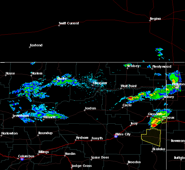
 At 741 pm mdt, a severe thunderstorm was located 31 miles south of terry or near locate, moving northeast at 40 mph. this is a destructive storm for northeast custer and northwest fallon counties (radar indicated). Hazards include 85 mph wind gusts and golf ball size hail. Flying debris will be dangerous to those caught without shelter. mobile homes will be heavily damaged. expect considerable damage to roofs, windows, and vehicles. Extensive tree damage and power outages are likely. At 741 pm mdt, a severe thunderstorm was located 31 miles south of terry or near locate, moving northeast at 40 mph. this is a destructive storm for northeast custer and northwest fallon counties (radar indicated). Hazards include 85 mph wind gusts and golf ball size hail. Flying debris will be dangerous to those caught without shelter. mobile homes will be heavily damaged. expect considerable damage to roofs, windows, and vehicles. Extensive tree damage and power outages are likely.
|
| 5/27/2023 5:01 PM MDT |
 At 500 pm mdt, a severe thunderstorm was located near baker, moving northwest at 10 mph (radar indicated). Hazards include 60 mph wind gusts and half dollar size hail. Hail damage to vehicles is expected. Expect wind damage to roofs, siding, and trees. At 500 pm mdt, a severe thunderstorm was located near baker, moving northwest at 10 mph (radar indicated). Hazards include 60 mph wind gusts and half dollar size hail. Hail damage to vehicles is expected. Expect wind damage to roofs, siding, and trees.
|
| 7/10/2022 12:38 AM MDT |
 At 1237 am mdt, a severe thunderstorm was located 14 miles southwest of carlyle, or 14 miles north of baker, moving east at 50 mph (trained weather spotters). Hazards include 70 mph wind gusts and quarter size hail. Hail damage to vehicles, considerable tree damage. wind damage is also likely to mobile homes, roofs, and outbuildings. locations impacted include, baker, plevna, ollie and westmore. thunderstorm damage threat, considerable hail threat, radar indicated max hail size, 1. 00 in wind threat, radar indicated max wind gust, 70 mph. At 1237 am mdt, a severe thunderstorm was located 14 miles southwest of carlyle, or 14 miles north of baker, moving east at 50 mph (trained weather spotters). Hazards include 70 mph wind gusts and quarter size hail. Hail damage to vehicles, considerable tree damage. wind damage is also likely to mobile homes, roofs, and outbuildings. locations impacted include, baker, plevna, ollie and westmore. thunderstorm damage threat, considerable hail threat, radar indicated max hail size, 1. 00 in wind threat, radar indicated max wind gust, 70 mph.
|
| 7/10/2022 12:35 AM MDT |
Storm damage reported in fallon county MT, 0.4 miles NNE of Plevna, MT
|
| 7/9/2022 11:59 PM MDT |
 At 1158 pm mdt, a severe thunderstorm was located 18 miles south of terry, moving east at 50 mph (trained weather spotters). Hazards include 70 mph wind gusts and half dollar size hail. Hail damage to vehicles, considerable tree damage. Wind damage is also likely to mobile homes, roofs, and outbuildings. At 1158 pm mdt, a severe thunderstorm was located 18 miles south of terry, moving east at 50 mph (trained weather spotters). Hazards include 70 mph wind gusts and half dollar size hail. Hail damage to vehicles, considerable tree damage. Wind damage is also likely to mobile homes, roofs, and outbuildings.
|
| 7/5/2022 6:30 AM MDT |
 At 630 am mdt, a severe thunderstorm was located 25 miles northeast of volborg, or 31 miles west of ekalaka, moving east at 45 mph (radar indicated). Hazards include quarter size hail. Damage to vehicles is expected. locations impacted include, baker, plevna, ollie, westmore, medicine rocks state park and willard. hail threat, radar indicated max hail size, 1. 00 in wind threat, radar indicated max wind gust, <50 mph. At 630 am mdt, a severe thunderstorm was located 25 miles northeast of volborg, or 31 miles west of ekalaka, moving east at 45 mph (radar indicated). Hazards include quarter size hail. Damage to vehicles is expected. locations impacted include, baker, plevna, ollie, westmore, medicine rocks state park and willard. hail threat, radar indicated max hail size, 1. 00 in wind threat, radar indicated max wind gust, <50 mph.
|
| 7/5/2022 6:04 AM MDT |
 At 604 am mdt, a severe thunderstorm was located 8 miles north of volborg, or 32 miles south of miles city, moving east at 45 mph (radar indicated). Hazards include 60 mph wind gusts and quarter size hail. Hail damage to vehicles is expected. Expect wind damage to roofs, siding, and trees. At 604 am mdt, a severe thunderstorm was located 8 miles north of volborg, or 32 miles south of miles city, moving east at 45 mph (radar indicated). Hazards include 60 mph wind gusts and quarter size hail. Hail damage to vehicles is expected. Expect wind damage to roofs, siding, and trees.
|
| 7/5/2022 3:43 AM MDT |
 At 342 am mdt, a severe thunderstorm was located 16 miles west of baker, moving east at 30 mph (radar indicated). Hazards include golf ball size hail and 60 mph wind gusts, along with very heavy rain. People and animals outdoors will be injured. expect hail damage to roofs, siding, windows, and vehicles. Expect wind damage to roofs, siding, and trees. At 342 am mdt, a severe thunderstorm was located 16 miles west of baker, moving east at 30 mph (radar indicated). Hazards include golf ball size hail and 60 mph wind gusts, along with very heavy rain. People and animals outdoors will be injured. expect hail damage to roofs, siding, windows, and vehicles. Expect wind damage to roofs, siding, and trees.
|
| 7/5/2022 2:47 AM MDT |
 At 246 am mdt, a severe thunderstorm was located 20 miles northwest of baker, moving east at 25 mph (radar indicated). Hazards include golf ball size hail and 60 mph wind gusts, along with very heavy rain. People and animals outdoors will be injured. expect hail damage to roofs, siding, windows, and vehicles. Expect wind damage to roofs, siding, and trees. At 246 am mdt, a severe thunderstorm was located 20 miles northwest of baker, moving east at 25 mph (radar indicated). Hazards include golf ball size hail and 60 mph wind gusts, along with very heavy rain. People and animals outdoors will be injured. expect hail damage to roofs, siding, windows, and vehicles. Expect wind damage to roofs, siding, and trees.
|
| 7/3/2022 10:11 PM MDT |
 The severe thunderstorm warning for western fallon, east central custer and northwestern carter counties will expire at 1015 pm mdt, the storm which prompted the warning has weakened below severe limits, and no longer poses an immediate threat to life or property. therefore, the warning will be allowed to expire. however gusty winds and heavy rain are still possible with this thunderstorm. a severe thunderstorm watch remains in effect until 1100 pm mdt for southeastern montana. to report severe weather, contact your nearest law enforcement agency. they will relay your report to the national weather service billings. The severe thunderstorm warning for western fallon, east central custer and northwestern carter counties will expire at 1015 pm mdt, the storm which prompted the warning has weakened below severe limits, and no longer poses an immediate threat to life or property. therefore, the warning will be allowed to expire. however gusty winds and heavy rain are still possible with this thunderstorm. a severe thunderstorm watch remains in effect until 1100 pm mdt for southeastern montana. to report severe weather, contact your nearest law enforcement agency. they will relay your report to the national weather service billings.
|
| 7/3/2022 9:58 PM MDT |
 At 957 pm mdt, a severe thunderstorm was located 14 miles west of baker, moving east at 30 mph (radar indicated). Hazards include 60 mph wind gusts. Expect damage to roofs, siding, and trees. locations impacted include, plevna, ismay, westmore, knowlton, medicine rocks state park and willard. hail threat, radar indicated max hail size, <. 75 in wind threat, radar indicated max wind gust, 60 mph. At 957 pm mdt, a severe thunderstorm was located 14 miles west of baker, moving east at 30 mph (radar indicated). Hazards include 60 mph wind gusts. Expect damage to roofs, siding, and trees. locations impacted include, plevna, ismay, westmore, knowlton, medicine rocks state park and willard. hail threat, radar indicated max hail size, <. 75 in wind threat, radar indicated max wind gust, 60 mph.
|
| 7/3/2022 9:41 PM MDT |
 At 941 pm mdt, a severe thunderstorm was located 26 miles west of baker, moving east at 45 mph (radar indicated). Hazards include 60 mph wind gusts and quarter size hail. Hail damage to vehicles is expected. Expect wind damage to roofs, siding, and trees. At 941 pm mdt, a severe thunderstorm was located 26 miles west of baker, moving east at 45 mph (radar indicated). Hazards include 60 mph wind gusts and quarter size hail. Hail damage to vehicles is expected. Expect wind damage to roofs, siding, and trees.
|
| 7/7/2020 7:17 PM MDT |
 At 715 pm mdt, severe thunderstorms were located along a line extending from 24 miles west of baker to 21 miles southwest of ridgeway, moving east at 30 mph. these storms has a history of producing hail up to ping pong size, and the southern extent remains most favorable for large hail (trained weather spotters. at 630 pm mdt, quarter size hail was reported 14 miles south southeast of broadus). Hazards include ping pong ball size hail and 60 mph wind gusts. People and animals outdoors will be injured. expect hail damage to roofs, siding, windows, and vehicles. expect wind damage to roofs, siding, and trees. Locations impacted include, ekalaka, ridgeway, plevna, hammond, medicine rocks state park, belltower, albion, westmore, boyes and willard. At 715 pm mdt, severe thunderstorms were located along a line extending from 24 miles west of baker to 21 miles southwest of ridgeway, moving east at 30 mph. these storms has a history of producing hail up to ping pong size, and the southern extent remains most favorable for large hail (trained weather spotters. at 630 pm mdt, quarter size hail was reported 14 miles south southeast of broadus). Hazards include ping pong ball size hail and 60 mph wind gusts. People and animals outdoors will be injured. expect hail damage to roofs, siding, windows, and vehicles. expect wind damage to roofs, siding, and trees. Locations impacted include, ekalaka, ridgeway, plevna, hammond, medicine rocks state park, belltower, albion, westmore, boyes and willard.
|
| 7/7/2020 6:42 PM MDT |
 At 641 pm mdt, severe thunderstorms were located along a line extending from 35 miles northwest of ekalaka to 11 miles southeast of broadus, moving east at 30 mph. the southern portion of these storms contains good rotation (trained weather spotters. at 610 pm mdt, ping pong size hail was reported 10 miles west of broadus). Hazards include ping pong ball size hail and 60 mph wind gusts. People and animals outdoors will be injured. expect hail damage to roofs, siding, windows, and vehicles. Expect wind damage to roofs, siding, and trees. At 641 pm mdt, severe thunderstorms were located along a line extending from 35 miles northwest of ekalaka to 11 miles southeast of broadus, moving east at 30 mph. the southern portion of these storms contains good rotation (trained weather spotters. at 610 pm mdt, ping pong size hail was reported 10 miles west of broadus). Hazards include ping pong ball size hail and 60 mph wind gusts. People and animals outdoors will be injured. expect hail damage to roofs, siding, windows, and vehicles. Expect wind damage to roofs, siding, and trees.
|
| 7/6/2020 6:00 PM MDT |
Golf Ball sized hail reported 2.6 miles NNW of Plevna, MT
|
| 7/6/2020 5:59 PM MDT |
 At 558 pm mdt, a severe thunderstorm was located 10 miles west of baker, moving northeast at 50 mph (radar indicated). Hazards include 60 mph wind gusts and quarter size hail. Hail damage to vehicles is expected. Expect wind damage to roofs, siding, and trees. At 558 pm mdt, a severe thunderstorm was located 10 miles west of baker, moving northeast at 50 mph (radar indicated). Hazards include 60 mph wind gusts and quarter size hail. Hail damage to vehicles is expected. Expect wind damage to roofs, siding, and trees.
|
| 7/6/2020 5:34 PM MDT |
 At 533 pm mdt, a severe thunderstorm was located 24 miles northwest of ekalaka, moving northeast at 40 mph (trained weather spotters. at 525 pm mdt, quarter size hail was reported 17 miles southeast of mizpah). Hazards include 60 mph wind gusts and quarter size hail. Hail damage to vehicles is expected. expect wind damage to roofs, siding, and trees. Locations impacted include, plevna, willard and westmore. At 533 pm mdt, a severe thunderstorm was located 24 miles northwest of ekalaka, moving northeast at 40 mph (trained weather spotters. at 525 pm mdt, quarter size hail was reported 17 miles southeast of mizpah). Hazards include 60 mph wind gusts and quarter size hail. Hail damage to vehicles is expected. expect wind damage to roofs, siding, and trees. Locations impacted include, plevna, willard and westmore.
|
| 7/6/2020 5:13 PM MDT |
 At 512 pm mdt, a severe thunderstorm was located 25 miles northwest of ekalaka, moving northeast at 40 mph (radar indicated). Hazards include 60 mph wind gusts and half dollar size hail. Hail damage to vehicles is expected. Expect wind damage to roofs, siding, and trees. At 512 pm mdt, a severe thunderstorm was located 25 miles northwest of ekalaka, moving northeast at 40 mph (radar indicated). Hazards include 60 mph wind gusts and half dollar size hail. Hail damage to vehicles is expected. Expect wind damage to roofs, siding, and trees.
|
| 5/31/2020 6:43 PM MDT |
 At 642 pm mdt, severe thunderstorms were located along a line extending from 22 miles northwest of baker to 25 miles northwest of ekalaka, moving east at 30 mph (radar indicated). Hazards include 60 mph wind gusts and quarter size hail. Hail damage to vehicles is expected. Expect wind damage to roofs, siding, and trees. At 642 pm mdt, severe thunderstorms were located along a line extending from 22 miles northwest of baker to 25 miles northwest of ekalaka, moving east at 30 mph (radar indicated). Hazards include 60 mph wind gusts and quarter size hail. Hail damage to vehicles is expected. Expect wind damage to roofs, siding, and trees.
|
|
|
| 5/20/2020 7:41 PM MDT |
 At 741 pm mdt, severe thunderstorms were located along a line extending from 24 miles southwest of hillside to 25 miles west of baker, moving east at 60 mph (radar indicated). Hazards include 70 mph wind gusts and penny size hail. Expect considerable tree damage. damage is likely to mobile homes, roofs, and outbuildings. Locations impacted include, baker, plevna, ismay, ollie, locate, rock springs, angela, westmore, matthews recreation area and knowlton. At 741 pm mdt, severe thunderstorms were located along a line extending from 24 miles southwest of hillside to 25 miles west of baker, moving east at 60 mph (radar indicated). Hazards include 70 mph wind gusts and penny size hail. Expect considerable tree damage. damage is likely to mobile homes, roofs, and outbuildings. Locations impacted include, baker, plevna, ismay, ollie, locate, rock springs, angela, westmore, matthews recreation area and knowlton.
|
| 5/20/2020 7:24 PM MDT |
 At 724 pm mdt, severe thunderstorms were located along a line extending from 14 miles north of forsyth to 22 miles northwest of ekalaka, moving north at 60 mph (weather station. at the miles city airport, a 66 mph gust was reported at 720 pm). Hazards include 70 mph wind gusts and quarter size hail. Hail damage to vehicles is expected. expect considerable tree damage. Wind damage is also likely to mobile homes, roofs, and outbuildings. At 724 pm mdt, severe thunderstorms were located along a line extending from 14 miles north of forsyth to 22 miles northwest of ekalaka, moving north at 60 mph (weather station. at the miles city airport, a 66 mph gust was reported at 720 pm). Hazards include 70 mph wind gusts and quarter size hail. Hail damage to vehicles is expected. expect considerable tree damage. Wind damage is also likely to mobile homes, roofs, and outbuildings.
|
| 7/30/2019 8:05 PM MDT |
 At 805 pm mdt, a severe thunderstorm was located 23 miles west of baker, moving southeast at 25 mph (radar indicated). Hazards include 60 mph wind gusts and quarter size hail. Hail damage to vehicles is expected. expect wind damage to roofs, siding, and trees. Locations impacted include, plevna, ismay and westmore. At 805 pm mdt, a severe thunderstorm was located 23 miles west of baker, moving southeast at 25 mph (radar indicated). Hazards include 60 mph wind gusts and quarter size hail. Hail damage to vehicles is expected. expect wind damage to roofs, siding, and trees. Locations impacted include, plevna, ismay and westmore.
|
| 7/30/2019 7:34 PM MDT |
 At 734 pm mdt, a severe thunderstorm was located 19 miles southeast of fallon, or 22 miles southeast of terry, moving southeast at 25 mph (radar indicated). Hazards include 60 mph wind gusts and quarter size hail. Hail damage to vehicles is expected. Expect wind damage to roofs, siding, and trees. At 734 pm mdt, a severe thunderstorm was located 19 miles southeast of fallon, or 22 miles southeast of terry, moving southeast at 25 mph (radar indicated). Hazards include 60 mph wind gusts and quarter size hail. Hail damage to vehicles is expected. Expect wind damage to roofs, siding, and trees.
|
| 7/14/2019 10:27 PM MDT |
 At 1027 pm mdt, severe thunderstorms were located along a line extending from 20 miles southeast of fallon to 19 miles west of ekalaka, moving east at 45 mph (radar indicated). Hazards include 70 mph wind gusts. winds up to 70 mph have been reported with this storm. Expect considerable tree damage. Damage is likely to mobile homes, roofs, and outbuildings. At 1027 pm mdt, severe thunderstorms were located along a line extending from 20 miles southeast of fallon to 19 miles west of ekalaka, moving east at 45 mph (radar indicated). Hazards include 70 mph wind gusts. winds up to 70 mph have been reported with this storm. Expect considerable tree damage. Damage is likely to mobile homes, roofs, and outbuildings.
|
| 7/14/2019 10:15 PM MDT |
 At 1014 pm mdt, severe thunderstorms were located along a line extending from 12 miles southeast of glendive to 22 miles northwest of ekalaka, moving east at 55 mph (radar indicated). Hazards include 70 mph wind gusts. wind gusts of 69 mph were reported at 927 pm at the miles city airport. Expect considerable tree damage. damage is likely to mobile homes, roofs, and outbuildings. Locations impacted include, baker, plevna, ismay, ollie, locate, westmore, mizpah, knowlton and willard. At 1014 pm mdt, severe thunderstorms were located along a line extending from 12 miles southeast of glendive to 22 miles northwest of ekalaka, moving east at 55 mph (radar indicated). Hazards include 70 mph wind gusts. wind gusts of 69 mph were reported at 927 pm at the miles city airport. Expect considerable tree damage. damage is likely to mobile homes, roofs, and outbuildings. Locations impacted include, baker, plevna, ismay, ollie, locate, westmore, mizpah, knowlton and willard.
|
| 7/14/2019 9:33 PM MDT |
 At 932 pm mdt, severe thunderstorms were located along a line extending from 10 miles north of terry to 15 miles north of volborg, moving east at 55 mph (radar indicated). Hazards include 70 mph wind gusts. winds of 69 mph were reported at the miles city airport at 927 pm. Expect considerable tree damage. Damage is likely to mobile homes, roofs, and outbuildings. At 932 pm mdt, severe thunderstorms were located along a line extending from 10 miles north of terry to 15 miles north of volborg, moving east at 55 mph (radar indicated). Hazards include 70 mph wind gusts. winds of 69 mph were reported at the miles city airport at 927 pm. Expect considerable tree damage. Damage is likely to mobile homes, roofs, and outbuildings.
|
| 7/8/2019 9:07 PM MDT |
 The severe thunderstorm warning for central fallon, southeastern custer and northwestern carter counties will expire at 915 pm mdt, the storms which prompted the warning have weakened below severe limits, and have exited the warned area. therefore, the warning will be allowed to expire. a severe thunderstorm watch remains in effect until 1100 pm mdt for southeastern montana. The severe thunderstorm warning for central fallon, southeastern custer and northwestern carter counties will expire at 915 pm mdt, the storms which prompted the warning have weakened below severe limits, and have exited the warned area. therefore, the warning will be allowed to expire. a severe thunderstorm watch remains in effect until 1100 pm mdt for southeastern montana.
|
| 7/8/2019 8:52 PM MDT |
 At 850 pm mdt, severe thunderstorms were located along a line extending from 6 miles northeast of ekalaka to 36 miles northeast of volborg, moving north at 45 mph (radar indicated). Hazards include 60 mph wind gusts and quarter size hail. Hail damage to vehicles is expected. expect wind damage to roofs, siding, and trees. Locations impacted include, ekalaka, plevna, medicine rocks state park and willard. At 850 pm mdt, severe thunderstorms were located along a line extending from 6 miles northeast of ekalaka to 36 miles northeast of volborg, moving north at 45 mph (radar indicated). Hazards include 60 mph wind gusts and quarter size hail. Hail damage to vehicles is expected. expect wind damage to roofs, siding, and trees. Locations impacted include, ekalaka, plevna, medicine rocks state park and willard.
|
| 7/8/2019 8:14 PM MDT |
 At 813 pm mdt, severe thunderstorms were located along a line extending from ekalaka to 28 miles northwest of ridgeway, moving northwest at 30 mph (radar indicated). Hazards include two inch hail and 60 mph wind gusts. People and animals outdoors will be injured. expect hail damage to roofs, siding, windows, and vehicles. Expect wind damage to roofs, siding, and trees. At 813 pm mdt, severe thunderstorms were located along a line extending from ekalaka to 28 miles northwest of ridgeway, moving northwest at 30 mph (radar indicated). Hazards include two inch hail and 60 mph wind gusts. People and animals outdoors will be injured. expect hail damage to roofs, siding, windows, and vehicles. Expect wind damage to roofs, siding, and trees.
|
| 7/2/2019 4:43 PM MDT |
 At 443 pm mdt, a severe thunderstorm was located near baker, moving northeast at 30 mph (radar indicated). Hazards include 60 mph wind gusts and quarter size hail. Hail damage to vehicles is expected. expect wind damage to roofs, siding, and trees. Locations impacted include, baker, plevna and ollie. At 443 pm mdt, a severe thunderstorm was located near baker, moving northeast at 30 mph (radar indicated). Hazards include 60 mph wind gusts and quarter size hail. Hail damage to vehicles is expected. expect wind damage to roofs, siding, and trees. Locations impacted include, baker, plevna and ollie.
|
| 7/2/2019 4:20 PM MDT |
 At 419 pm mdt, a severe thunderstorm was located 7 miles west of baker, moving northeast at 30 mph (radar indicated). Hazards include 60 mph wind gusts and quarter size hail. Hail damage to vehicles is expected. Expect wind damage to roofs, siding, and trees. At 419 pm mdt, a severe thunderstorm was located 7 miles west of baker, moving northeast at 30 mph (radar indicated). Hazards include 60 mph wind gusts and quarter size hail. Hail damage to vehicles is expected. Expect wind damage to roofs, siding, and trees.
|
| 8/3/2018 8:31 PM MDT |
 At 827 pm mdt, a line of severe winds associated with thunderstorms was located along a line extending from 11 miles west of baker to near ekalaka and alzada, moving east at 45 mph (radar indicated). Hazards include 60 mph wind gusts. Expect damage to roofs, siding, and trees. Locations impacted include, baker, broadus, ekalaka, ridgeway, biddle, alzada, plevna, ismay, locate, westmore, boyes, mill iron, medicine rocks state park, capitol, knowlton, ollie, willard, webster, hammond and belltower. At 827 pm mdt, a line of severe winds associated with thunderstorms was located along a line extending from 11 miles west of baker to near ekalaka and alzada, moving east at 45 mph (radar indicated). Hazards include 60 mph wind gusts. Expect damage to roofs, siding, and trees. Locations impacted include, baker, broadus, ekalaka, ridgeway, biddle, alzada, plevna, ismay, locate, westmore, boyes, mill iron, medicine rocks state park, capitol, knowlton, ollie, willard, webster, hammond and belltower.
|
| 8/3/2018 7:28 PM MDT |
 At 725 pm mdt, a line of severe winds associated with thunderstorms was located from 10 miles east of miles city south to the wyoming border, moving east at 45 mph (radar indicated). Hazards include 60 mph wind gusts. expect damage to roofs, siding, and trees At 725 pm mdt, a line of severe winds associated with thunderstorms was located from 10 miles east of miles city south to the wyoming border, moving east at 45 mph (radar indicated). Hazards include 60 mph wind gusts. expect damage to roofs, siding, and trees
|
| 7/2/2018 11:59 PM MDT |
 At 1157 pm mdt, a severe thunderstorm was located 9 miles northwest of baker, moving northeast at 40 mph (radar indicated). Hazards include 60 mph wind gusts and half dollar size hail. Hail damage to vehicles is expected. expect wind damage to roofs, siding, and trees. Locations impacted include, baker, plevna, ollie and westmore. At 1157 pm mdt, a severe thunderstorm was located 9 miles northwest of baker, moving northeast at 40 mph (radar indicated). Hazards include 60 mph wind gusts and half dollar size hail. Hail damage to vehicles is expected. expect wind damage to roofs, siding, and trees. Locations impacted include, baker, plevna, ollie and westmore.
|
| 7/2/2018 11:53 PM MDT |
Ping Pong Ball sized hail reported 0.4 miles NNE of Plevna, MT
|
| 7/2/2018 11:24 PM MDT |
 At 1122 pm mdt, a severe thunderstorm was located 30 miles west of baker, moving east at 45 mph (radar indicated. this storm has a history of large hail and severe winds). Hazards include 60 mph wind gusts and half dollar size hail. hail damage to vehicles is possible along with wind damage to roofs, siding, and trees At 1122 pm mdt, a severe thunderstorm was located 30 miles west of baker, moving east at 45 mph (radar indicated. this storm has a history of large hail and severe winds). Hazards include 60 mph wind gusts and half dollar size hail. hail damage to vehicles is possible along with wind damage to roofs, siding, and trees
|
| 7/10/2017 7:18 PM MDT |
 At 716 pm mdt, a line of damaging winds associated with thunderstorms were located along a line extending from 17 miles west of carlyle to 7 miles northwest of ekalaka, moving east at 45 mph (trained weather spotters). Hazards include 60 mph wind gusts. Expect damage to roofs, siding, and trees. Locations impacted include, baker, plevna, ollie, webster, medicine rocks state park, westmore and willard. At 716 pm mdt, a line of damaging winds associated with thunderstorms were located along a line extending from 17 miles west of carlyle to 7 miles northwest of ekalaka, moving east at 45 mph (trained weather spotters). Hazards include 60 mph wind gusts. Expect damage to roofs, siding, and trees. Locations impacted include, baker, plevna, ollie, webster, medicine rocks state park, westmore and willard.
|
| 7/10/2017 6:32 PM MDT |
 At 630 pm mdt, an area of damaging wind preceding associated with thunderstorms over custer ocunty were located along a line extending from 13 miles south of terry to 12 miles northeast of volborg, moving east at 45 mph (trained weather spotters). Hazards include 60 to 70 mph wind gusts. expect damage to roofs, siding, and trees At 630 pm mdt, an area of damaging wind preceding associated with thunderstorms over custer ocunty were located along a line extending from 13 miles south of terry to 12 miles northeast of volborg, moving east at 45 mph (trained weather spotters). Hazards include 60 to 70 mph wind gusts. expect damage to roofs, siding, and trees
|
| 8/9/2016 9:43 PM MDT |
 At 943 pm mdt, a severe thunderstorm was located 17 miles west of baker, moving east at 35 mph (radar indicated). Hazards include 60 mph wind gusts and quarter size hail. Hail damage to vehicles is expected. Expect wind damage to roofs, siding, and trees. At 943 pm mdt, a severe thunderstorm was located 17 miles west of baker, moving east at 35 mph (radar indicated). Hazards include 60 mph wind gusts and quarter size hail. Hail damage to vehicles is expected. Expect wind damage to roofs, siding, and trees.
|
| 7/22/2016 5:52 PM MDT |
Half Dollar sized hail reported 6.6 miles SE of Plevna, MT
|
| 7/10/2016 3:11 PM MDT |
 At 311 pm mdt, a severe thunderstorm was located near baker, moving east at 25 mph (trained weather spotters). Hazards include two inch hail and 70 mph wind gusts. People and animals outdoors will be injured. expect hail damage to roofs, siding, windows, and vehicles. expect considerable tree damage. wind damage is also likely to mobile homes, roofs, and outbuildings. Locations impacted include, baker, plevna, ollie, willard and webster. At 311 pm mdt, a severe thunderstorm was located near baker, moving east at 25 mph (trained weather spotters). Hazards include two inch hail and 70 mph wind gusts. People and animals outdoors will be injured. expect hail damage to roofs, siding, windows, and vehicles. expect considerable tree damage. wind damage is also likely to mobile homes, roofs, and outbuildings. Locations impacted include, baker, plevna, ollie, willard and webster.
|
| 7/10/2016 2:38 PM MDT |
Golf Ball sized hail reported 2.6 miles NNW of Plevna, MT
|
| 7/10/2016 2:38 PM MDT |
 At 237 pm mdt, a severe thunderstorm was located 9 miles southwest of baker, moving east at 30 mph (trained weather spotters). Hazards include two inch hail and 70 mph wind gusts. People and animals outdoors will be injured. expect hail damage to roofs, siding, windows, and vehicles. expect considerable tree damage. Wind damage is also likely to mobile homes, roofs, and outbuildings. At 237 pm mdt, a severe thunderstorm was located 9 miles southwest of baker, moving east at 30 mph (trained weather spotters). Hazards include two inch hail and 70 mph wind gusts. People and animals outdoors will be injured. expect hail damage to roofs, siding, windows, and vehicles. expect considerable tree damage. Wind damage is also likely to mobile homes, roofs, and outbuildings.
|
| 7/10/2016 2:30 PM MDT |
Golf Ball sized hail reported 6.7 miles N of Plevna, MT, trees are stripped of their leaves and broken windows in home.
|
|
|
| 7/10/2016 2:06 PM MDT |
 At 206 pm mdt, a severe thunderstorm was located 23 miles west of baker, moving northeast at 25 mph (radar indicated). Hazards include 60 mph wind gusts and quarter size hail. Hail damage to vehicles is expected. Expect wind damage to roofs, siding, and trees. At 206 pm mdt, a severe thunderstorm was located 23 miles west of baker, moving northeast at 25 mph (radar indicated). Hazards include 60 mph wind gusts and quarter size hail. Hail damage to vehicles is expected. Expect wind damage to roofs, siding, and trees.
|
| 7/9/2016 10:25 PM MDT |
 At 1023 pm mdt, a severe thunderstorm was located 9 miles northwest of baker, moving northeast at 30 mph (radar indicated). Hazards include 60 mph wind gusts and quarter size hail. Hail damage to vehicles is expected. expect wind damage to roofs, siding, and trees. locations impacted include, baker, plevna and ollie. radar has indicated weak rotation southwest of baker. A brief tornado could be possible. At 1023 pm mdt, a severe thunderstorm was located 9 miles northwest of baker, moving northeast at 30 mph (radar indicated). Hazards include 60 mph wind gusts and quarter size hail. Hail damage to vehicles is expected. expect wind damage to roofs, siding, and trees. locations impacted include, baker, plevna and ollie. radar has indicated weak rotation southwest of baker. A brief tornado could be possible.
|
| 7/9/2016 9:58 PM MDT |
 At 957 pm mdt, a severe thunderstorm was located 17 miles west of baker, moving northeast at 25 mph (radar indicated). Hazards include 60 mph wind gusts and quarter size hail. Hail damage to vehicles is expected. expect wind damage to roofs, siding, and trees. Locations impacted include, baker, plevna, westmore and ollie. At 957 pm mdt, a severe thunderstorm was located 17 miles west of baker, moving northeast at 25 mph (radar indicated). Hazards include 60 mph wind gusts and quarter size hail. Hail damage to vehicles is expected. expect wind damage to roofs, siding, and trees. Locations impacted include, baker, plevna, westmore and ollie.
|
| 7/9/2016 9:33 PM MDT |
 At 933 pm mdt, a severe thunderstorm was located 24 miles west of baker, moving northeast at 30 mph (radar indicated). Hazards include 60 mph wind gusts and quarter size hail. Hail damage to vehicles is expected. Expect wind damage to roofs, siding, and trees. At 933 pm mdt, a severe thunderstorm was located 24 miles west of baker, moving northeast at 30 mph (radar indicated). Hazards include 60 mph wind gusts and quarter size hail. Hail damage to vehicles is expected. Expect wind damage to roofs, siding, and trees.
|
| 6/17/2016 1:25 AM MDT |
At 125 am mdt, a severe thunderstorm was located 9 miles southwest of baker, moving northeast at 45 mph (radar indicated). Hazards include 60 mph wind gusts and quarter size hail. Hail damage to vehicles is expected. Expect wind damage to roofs, siding, and trees.
|
| 6/11/2016 6:58 PM MDT |
 At 658 pm mdt, a severe thunderstorm was located over baker, moving north at 40 mph (radar indicated). Hazards include 70 mph wind gusts and quarter size hail. Hail damage to vehicles is expected. expect considerable tree damage. Wind damage is also likely to mobile homes, roofs, and outbuildings. At 658 pm mdt, a severe thunderstorm was located over baker, moving north at 40 mph (radar indicated). Hazards include 70 mph wind gusts and quarter size hail. Hail damage to vehicles is expected. expect considerable tree damage. Wind damage is also likely to mobile homes, roofs, and outbuildings.
|
| 6/9/2016 9:11 PM MDT |
The severe thunderstorm warning for fallon and east central custer counties will expire at 915 pm mdt. the storm which prompted the warning has weakened below severe limits and exited the warned area. therefore the warning will be allowed to expire. However gusty winds are still possible with this thunderstorm.
|
| 6/9/2016 8:45 PM MDT |
 At 843 pm mdt, a severe thunderstorm was located west of baker, moving east at 40 mph (measured 70 mph wind gust at the baker airport). Hazards include 60 to 70 mph wind gusts and dime size hail...along with frequent lightning and very heavy rain. Expect considerable tree damage. damage is likely to mobile homes, roofs, and outbuildings. Locations impacted include, baker, plevna, ismay, westmore and willard. At 843 pm mdt, a severe thunderstorm was located west of baker, moving east at 40 mph (measured 70 mph wind gust at the baker airport). Hazards include 60 to 70 mph wind gusts and dime size hail...along with frequent lightning and very heavy rain. Expect considerable tree damage. damage is likely to mobile homes, roofs, and outbuildings. Locations impacted include, baker, plevna, ismay, westmore and willard.
|
| 6/9/2016 8:17 PM MDT |
 At 816 pm mdt, a severe thunderstorm was located 35 miles west of baker, moving east at 40 mph (radar indicated). Hazards include 60 mph wind gusts and quarter size hail...along with very heavy rain and frequent lightning. Hail damage to vehicles is expected. Expect wind damage to roofs, siding, and trees. At 816 pm mdt, a severe thunderstorm was located 35 miles west of baker, moving east at 40 mph (radar indicated). Hazards include 60 mph wind gusts and quarter size hail...along with very heavy rain and frequent lightning. Hail damage to vehicles is expected. Expect wind damage to roofs, siding, and trees.
|
| 9/5/2015 9:40 PM MDT |
 At 939 pm mdt, a severe thunderstorm was located near baker, moving northeast at 45 mph (trained weather spotters). Hazards include golf ball size hail and 60 mph wind gusts. People and animals outdoors will be injured. expect hail damage to roofs, siding, windows and vehicles. expect wind damage to roofs, siding and trees. Locations impacted include, baker, plevna and ollie. At 939 pm mdt, a severe thunderstorm was located near baker, moving northeast at 45 mph (trained weather spotters). Hazards include golf ball size hail and 60 mph wind gusts. People and animals outdoors will be injured. expect hail damage to roofs, siding, windows and vehicles. expect wind damage to roofs, siding and trees. Locations impacted include, baker, plevna and ollie.
|
| 9/5/2015 9:12 PM MDT |
 At 911 pm mdt, a severe thunderstorm was located 16 miles southwest of baker, moving northeast at 45 mph (trained weather spotters). Hazards include golf ball size hail and 60 mph wind gusts. People and animals outdoors will be injured. Expect hail damage to roofs, siding, windows and vehicles. At 911 pm mdt, a severe thunderstorm was located 16 miles southwest of baker, moving northeast at 45 mph (trained weather spotters). Hazards include golf ball size hail and 60 mph wind gusts. People and animals outdoors will be injured. Expect hail damage to roofs, siding, windows and vehicles.
|
| 9/5/2015 8:51 PM MDT |
 At 850 pm mdt, a severe thunderstorm was located 19 miles northwest of ekalaka, moving north at 35 mph (radar indicated). Hazards include 60 mph wind gusts and quarter size hail. Hail damage to vehicles is expected. Expect wind damage to roofs, siding and trees. At 850 pm mdt, a severe thunderstorm was located 19 miles northwest of ekalaka, moving north at 35 mph (radar indicated). Hazards include 60 mph wind gusts and quarter size hail. Hail damage to vehicles is expected. Expect wind damage to roofs, siding and trees.
|
| 7/27/2015 9:10 PM MDT |
 The severe thunderstorm warning for fallon and east central custer counties will expire at 915 pm mdt, the storms which prompted the warning have weakened below severe limits, and exited the warned area. therefore the warning will be allowed to expire. The severe thunderstorm warning for fallon and east central custer counties will expire at 915 pm mdt, the storms which prompted the warning have weakened below severe limits, and exited the warned area. therefore the warning will be allowed to expire.
|
| 7/27/2015 8:47 PM MDT |
 At 846 pm mdt, severe thunderstorm winds were located along a line extending from near ismay to near webster, moving northeast at 50 mph (gusts to 66 mph recorded in baker). Hazards include 70 mph wind gusts. Expect considerable tree damage. damage is likely to mobile homes, roofs and outbuildings. Locations impacted include, baker, plevna, ismay, westmore, ollie, willard and webster. At 846 pm mdt, severe thunderstorm winds were located along a line extending from near ismay to near webster, moving northeast at 50 mph (gusts to 66 mph recorded in baker). Hazards include 70 mph wind gusts. Expect considerable tree damage. damage is likely to mobile homes, roofs and outbuildings. Locations impacted include, baker, plevna, ismay, westmore, ollie, willard and webster.
|
| 7/27/2015 8:22 PM MDT |
 At 821 pm mdt, severe thunderstorms were located along a line extending from 17 miles southeast of mildred to 9 miles southwest of marmarth, moving northeast at 50 mph (at 820 pm wind gusts to 66 mph were recorded at the baker airport). Hazards include 70 mph wind gusts. Expect considerable tree damage. Damage is likely to mobile homes, roofs and outbuildings. At 821 pm mdt, severe thunderstorms were located along a line extending from 17 miles southeast of mildred to 9 miles southwest of marmarth, moving northeast at 50 mph (at 820 pm wind gusts to 66 mph were recorded at the baker airport). Hazards include 70 mph wind gusts. Expect considerable tree damage. Damage is likely to mobile homes, roofs and outbuildings.
|
| 7/1/2015 8:12 PM MDT |
The severe thunderstorm warning for southeastern fallon and northeastern carter counties will expire at 815 pm mdt, the storm which prompted the warning has weakened below severe limits, and no longer poses an immediate threat to life or property. therefore the warning will be allowed to expire.
|
| 7/1/2015 7:50 PM MDT |
Storm damage reported in fallon county MT, 6.7 miles N of Plevna, MT
|
| 7/1/2015 7:46 PM MDT |
 At 744 pm mdt, a severe thunderstorm was located 10 miles southwest of baker, moving southeast at 35 mph (radar indicated). Hazards include 60 mph wind gusts and quarter size hail. Hail damage to vehicles is expected. expect wind damage to roofs, siding and trees. Locations impacted include, baker, ekalaka, plevna, willard, webster and medicine rocks state park. At 744 pm mdt, a severe thunderstorm was located 10 miles southwest of baker, moving southeast at 35 mph (radar indicated). Hazards include 60 mph wind gusts and quarter size hail. Hail damage to vehicles is expected. expect wind damage to roofs, siding and trees. Locations impacted include, baker, ekalaka, plevna, willard, webster and medicine rocks state park.
|
| 7/1/2015 7:20 PM MDT |
 At 719 pm mdt, a severe thunderstorm was located 16 miles west of baker, moving southeast at 35 mph (radar indicated). Hazards include 60 mph wind gusts and quarter size hail. Hail damage to vehicles is expected. Expect wind damage to roofs, siding and trees. At 719 pm mdt, a severe thunderstorm was located 16 miles west of baker, moving southeast at 35 mph (radar indicated). Hazards include 60 mph wind gusts and quarter size hail. Hail damage to vehicles is expected. Expect wind damage to roofs, siding and trees.
|
| 6/21/2015 9:43 PM MDT |
 At 941 pm mdt, a severe thunderstorm was located 10 miles southwest of marmarth, or 12 miles southeast of baker, moving east at 45 mph (trained weather spotters. at 939 pm...70 mph wind gusts were reported in baker). Hazards include 70 mph wind gusts and quarter size hail. Hail damage to vehicles is expected. expect considerable tree damage. wind damage is also likely to mobile homes, roofs and outbuildings. locations impacted include, baker, plevna, willard, medicine rocks state park and webster. A tornado watch remains in effect until 1000 pm mdt for southeastern montana. At 941 pm mdt, a severe thunderstorm was located 10 miles southwest of marmarth, or 12 miles southeast of baker, moving east at 45 mph (trained weather spotters. at 939 pm...70 mph wind gusts were reported in baker). Hazards include 70 mph wind gusts and quarter size hail. Hail damage to vehicles is expected. expect considerable tree damage. wind damage is also likely to mobile homes, roofs and outbuildings. locations impacted include, baker, plevna, willard, medicine rocks state park and webster. A tornado watch remains in effect until 1000 pm mdt for southeastern montana.
|
| 6/21/2015 9:33 PM MDT |
 At 932 pm mdt, a severe thunderstorm was located 12 miles southeast of baker, moving east at 50 mph (radar indicated). Hazards include 60 mph wind gusts and quarter size hail. Hail damage to vehicles is expected. expect wind damage to roofs, siding and trees. locations impacted include, baker, plevna, willard, medicine rocks state park and webster. A tornado watch remains in effect until 1000 pm mdt for southeastern montana. At 932 pm mdt, a severe thunderstorm was located 12 miles southeast of baker, moving east at 50 mph (radar indicated). Hazards include 60 mph wind gusts and quarter size hail. Hail damage to vehicles is expected. expect wind damage to roofs, siding and trees. locations impacted include, baker, plevna, willard, medicine rocks state park and webster. A tornado watch remains in effect until 1000 pm mdt for southeastern montana.
|
| 6/21/2015 9:13 PM MDT |
 At 913 pm mdt, a severe thunderstorm was located 14 miles southwest of baker, moving east at 55 mph (radar indicated). Hazards include 60 mph wind gusts and quarter size hail. Hail damage to vehicles is expected. Expect wind damage to roofs, siding and trees. At 913 pm mdt, a severe thunderstorm was located 14 miles southwest of baker, moving east at 55 mph (radar indicated). Hazards include 60 mph wind gusts and quarter size hail. Hail damage to vehicles is expected. Expect wind damage to roofs, siding and trees.
|
| 6/21/2015 9:06 PM MDT |
 At 906 pm mdt, a severe thunderstorm was located 19 miles southwest of baker, moving east at 50 mph (radar indicated). Hazards include 70 mph wind gusts and ping pong ball size hail. People and animals outdoors will be injured. expect hail damage to roofs, siding, windows and vehicles. expect considerable tree damage. wind damage is also likely to mobile homes, roofs and outbuildings. locations impacted include, baker, ekalaka, plevna, westmore, ollie, mill iron, willard, webster and medicine rocks state park. A tornado watch remains in effect until 1000 pm mdt for southeastern montana. At 906 pm mdt, a severe thunderstorm was located 19 miles southwest of baker, moving east at 50 mph (radar indicated). Hazards include 70 mph wind gusts and ping pong ball size hail. People and animals outdoors will be injured. expect hail damage to roofs, siding, windows and vehicles. expect considerable tree damage. wind damage is also likely to mobile homes, roofs and outbuildings. locations impacted include, baker, ekalaka, plevna, westmore, ollie, mill iron, willard, webster and medicine rocks state park. A tornado watch remains in effect until 1000 pm mdt for southeastern montana.
|
| 6/21/2015 8:40 PM MDT |
 At 839 pm mdt, severe thunderstorms were located along a line extending from 13 miles south of mildred to 26 miles east of volborg, moving east at 50 mph (radar indicated. at 810 pm mdt...60 mph wind gusts were reported at miles city. a camper was blown over by the winds 4 miles southwest of miles city at 802 pm mdt). Hazards include golf ball size hail and 70 mph wind gusts. People and animals outdoors will be injured. expect hail damage to roofs, siding, windows and vehicles. expect considerable tree damage. wind damage is also likely to mobile homes, roofs and outbuildings. locations impacted include, baker, ekalaka, volborg, plevna, ismay, westmore, ollie, webster, knowlton, locate, mill iron, willard, mizpah and medicine rocks state park. A tornado watch remains in effect until 1000 pm mdt for southeastern montana. At 839 pm mdt, severe thunderstorms were located along a line extending from 13 miles south of mildred to 26 miles east of volborg, moving east at 50 mph (radar indicated. at 810 pm mdt...60 mph wind gusts were reported at miles city. a camper was blown over by the winds 4 miles southwest of miles city at 802 pm mdt). Hazards include golf ball size hail and 70 mph wind gusts. People and animals outdoors will be injured. expect hail damage to roofs, siding, windows and vehicles. expect considerable tree damage. wind damage is also likely to mobile homes, roofs and outbuildings. locations impacted include, baker, ekalaka, volborg, plevna, ismay, westmore, ollie, webster, knowlton, locate, mill iron, willard, mizpah and medicine rocks state park. A tornado watch remains in effect until 1000 pm mdt for southeastern montana.
|
| 6/21/2015 8:22 PM MDT |
 At 821 pm mdt, severe thunderstorms were located along a line extending from 21 miles southwest of mildred to 14 miles northeast of volborg, moving east at 50 mph (radar indicated). Hazards include golf ball size hail and 70 mph wind gusts. People and animals outdoors will be injured. expect hail damage to roofs, siding, windows and vehicles. expect considerable tree damage. Wind damage is also likely to mobile homes, roofs and outbuildings. At 821 pm mdt, severe thunderstorms were located along a line extending from 21 miles southwest of mildred to 14 miles northeast of volborg, moving east at 50 mph (radar indicated). Hazards include golf ball size hail and 70 mph wind gusts. People and animals outdoors will be injured. expect hail damage to roofs, siding, windows and vehicles. expect considerable tree damage. Wind damage is also likely to mobile homes, roofs and outbuildings.
|
|
|
| 6/21/2015 4:31 PM MDT |
 At 430 pm mdt, a severe thunderstorm was located 9 miles southwest of baker, moving east at 30 mph. this is a very dangerous storm (trained weather spotters). Hazards include baseball size hail and 70 mph wind gusts. People and animals outdoors will be severely injured. Expect shattered windows, extensive damage to roofs, siding and vehicles. At 430 pm mdt, a severe thunderstorm was located 9 miles southwest of baker, moving east at 30 mph. this is a very dangerous storm (trained weather spotters). Hazards include baseball size hail and 70 mph wind gusts. People and animals outdoors will be severely injured. Expect shattered windows, extensive damage to roofs, siding and vehicles.
|
| 6/21/2015 4:14 PM MDT |
 At 410 pm mdt, a severe thunderstorm was located 20 miles west of baker, moving east at 30 mph. this is a very dangerous storm (trained weather spotters. at 355 pm mdt...trained weather spotters reported baseball size hail and 70 mph wind gusts 7 miles south-southwest of ismay). Hazards include baseball size hail and 70 mph wind gusts. People and animals outdoors will be severely injured. expect shattered windows, extensive damage to roofs, siding and vehicles. locations impacted include, baker, plevna, westmore and willard. A tornado watch remains in effect until 1000 pm mdt for southeastern montana. At 410 pm mdt, a severe thunderstorm was located 20 miles west of baker, moving east at 30 mph. this is a very dangerous storm (trained weather spotters. at 355 pm mdt...trained weather spotters reported baseball size hail and 70 mph wind gusts 7 miles south-southwest of ismay). Hazards include baseball size hail and 70 mph wind gusts. People and animals outdoors will be severely injured. expect shattered windows, extensive damage to roofs, siding and vehicles. locations impacted include, baker, plevna, westmore and willard. A tornado watch remains in effect until 1000 pm mdt for southeastern montana.
|
| 6/21/2015 3:47 PM MDT |
 At 344 pm mdt, a severe thunderstorm was located 16 miles south of mildred, or 29 miles southeast of terry, moving east at 30 mph (trained weather spotters. at 335 pm mdt...tennis ball size hail was reported 11 miles southwest of mildred in prairie county). Hazards include tennis ball size hail and 60 mph wind gusts. People and animals outdoors will be injured. expect hail damage to roofs, siding, windows and vehicles. Expect wind damage to roofs, siding and trees. At 344 pm mdt, a severe thunderstorm was located 16 miles south of mildred, or 29 miles southeast of terry, moving east at 30 mph (trained weather spotters. at 335 pm mdt...tennis ball size hail was reported 11 miles southwest of mildred in prairie county). Hazards include tennis ball size hail and 60 mph wind gusts. People and animals outdoors will be injured. expect hail damage to roofs, siding, windows and vehicles. Expect wind damage to roofs, siding and trees.
|
| 6/19/2015 5:05 PM MDT |
 At 503 pm mdt, a severe thunderstorm was located near baker, moving southeast at 45 mph (public. at 430pm...60 mph winds were reported four miles east of ismay). Hazards include 60 mph wind gusts and quarter size hail. Hail damage to vehicles is expected. Expect wind damage to roofs, siding and trees. At 503 pm mdt, a severe thunderstorm was located near baker, moving southeast at 45 mph (public. at 430pm...60 mph winds were reported four miles east of ismay). Hazards include 60 mph wind gusts and quarter size hail. Hail damage to vehicles is expected. Expect wind damage to roofs, siding and trees.
|
| 6/19/2015 4:47 PM MDT |
 At 446 pm mdt, a severe thunderstorm was located 18 miles west of baker, moving east at 30 mph (radar indicated). Hazards include 60 mph wind gusts and quarter size hail. Hail damage to vehicles is expected. expect wind damage to roofs, siding and trees. locations impacted include, baker, plevna, westmore and ollie. A tornado watch remains in effect until 1000 pm mdt for southeastern montana. At 446 pm mdt, a severe thunderstorm was located 18 miles west of baker, moving east at 30 mph (radar indicated). Hazards include 60 mph wind gusts and quarter size hail. Hail damage to vehicles is expected. expect wind damage to roofs, siding and trees. locations impacted include, baker, plevna, westmore and ollie. A tornado watch remains in effect until 1000 pm mdt for southeastern montana.
|
| 6/19/2015 4:20 PM MDT |
 At 419 pm mdt, a severe thunderstorm was located 11 miles south of mildred, or 28 miles southeast of terry, moving east at 45 mph (radar indicated). Hazards include 60 mph wind gusts and quarter size hail. Hail damage to vehicles is expected. Expect wind damage to roofs, siding and trees. At 419 pm mdt, a severe thunderstorm was located 11 miles south of mildred, or 28 miles southeast of terry, moving east at 45 mph (radar indicated). Hazards include 60 mph wind gusts and quarter size hail. Hail damage to vehicles is expected. Expect wind damage to roofs, siding and trees.
|
| 7/22/2014 5:05 PM MDT |
Storm damage reported in fallon county MT, 1.8 miles N of Plevna, MT
|
| 8/28/2013 9:51 PM MDT |
Quarter sized hail reported 16.2 miles S of Plevna, MT
|
| 8/5/2013 6:15 PM MDT |
Storm damage reported in fallon county MT, 1.9 miles NNE of Plevna, MT
|
| 7/8/2013 8:00 PM MDT |
Very strong winds broke off tree limbs in fallon county MT, 6.7 miles N of Plevna, MT
|
| 1/1/0001 12:00 AM |
Storm damage reported in fallon county MT, 7.2 miles SW of Plevna, MT
|


Connect with Interactive Hail Maps