

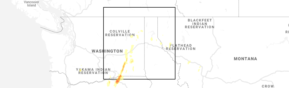
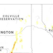
Hail Map for Reardan, WA
The Reardan, WA area has had 0 reports of on-the-ground hail by trained spotters, and has been under severe weather warnings 0 times during the past 12 months. Doppler radar has detected hail at or near Reardan, WA on 2 occasions.
| Name: | Reardan, WA |
| Where Located: | 21.8 miles W of Spokane, WA |
| Map: | Google Map for Reardan, WA |
| Population: | 571 |
| Housing Units: | 255 |
| More Info: | Search Google for Reardan, WA |
0
The Top Recent Hail Date for Reardan, WA is Saturday, May 30, 2020 (2nd out of 2)
Hail and Wind Damage Spotted near Reardan, WA
| Date / Time | Report Details |
|---|---|
| 5/30/2020 7:25 PM PDT |
 At 723 pm pdt, severe thunderstorms were located along a line extending from 31 miles north of ritzville to near davenport to near medical lake to near fairchild afb, moving northeast at 50 mph (radar indicated). Hazards include 60 mph wind gusts and quarter size hail. expect wind damage to roofs, siding, and trees At 723 pm pdt, severe thunderstorms were located along a line extending from 31 miles north of ritzville to near davenport to near medical lake to near fairchild afb, moving northeast at 50 mph (radar indicated). Hazards include 60 mph wind gusts and quarter size hail. expect wind damage to roofs, siding, and trees
|
| 5/30/2020 7:09 PM PDT |
 At 706 pm pdt, severe thunderstorms were located along a line extending from 23 miles north of ritzville to 14 miles southeast of davenport to 7 miles south of medical lake to 14 miles southeast of cheney, moving northeast at 50 mph (radar indicated). Hazards include 70 mph wind gusts and quarter size hail. Expect considerable tree damage. wind damage is also likely to mobile homes, roofs, and outbuildings. Locations impacted include, spokane, cheney, airway heights, medical lake, davenport, fairchild afb, odessa, reardan, harrington, spangle, mohler, amber, gravelles, tyler, mondovi, lamona, rocklyn, valleyford, eleanor and bluestem. At 706 pm pdt, severe thunderstorms were located along a line extending from 23 miles north of ritzville to 14 miles southeast of davenport to 7 miles south of medical lake to 14 miles southeast of cheney, moving northeast at 50 mph (radar indicated). Hazards include 70 mph wind gusts and quarter size hail. Expect considerable tree damage. wind damage is also likely to mobile homes, roofs, and outbuildings. Locations impacted include, spokane, cheney, airway heights, medical lake, davenport, fairchild afb, odessa, reardan, harrington, spangle, mohler, amber, gravelles, tyler, mondovi, lamona, rocklyn, valleyford, eleanor and bluestem.
|
| 5/30/2020 6:53 PM PDT |
 At 652 pm pdt, severe thunderstorms were located along a line extending from 11 miles northeast of ritzville to 24 miles southwest of medical lake to 16 miles southwest of cheney to 20 miles north of colfax, moving northeast at 50 mph (radar indicated). Hazards include 70 mph wind gusts and quarter size hail. Hail damage to vehicles is expected. expect considerable tree damage. Wind damage is also likely to mobile homes, roofs, and outbuildings. At 652 pm pdt, severe thunderstorms were located along a line extending from 11 miles northeast of ritzville to 24 miles southwest of medical lake to 16 miles southwest of cheney to 20 miles north of colfax, moving northeast at 50 mph (radar indicated). Hazards include 70 mph wind gusts and quarter size hail. Hail damage to vehicles is expected. expect considerable tree damage. Wind damage is also likely to mobile homes, roofs, and outbuildings.
|
| 5/4/2016 11:13 PM PDT | The severe thunderstorm warning for eastern lincoln and southern spokane counties will expire at 1115 pm pdt, the gust front which prompted the warning has moved out of the area. therefore the warning will be allowed to expire. however heavy rain is still possible with thunderstorms behind this gust front. a severe thunderstorm warning remains in effect for northern spokane county, extreme northern lincoln county and southern stevens and pend orielle counties until 1145 pm. |
| 5/4/2016 10:26 PM PDT |
 At 1024 pm pdt, doppler radar indicated a strong gust front with a line of severe thunderstorms capable of producing damaging winds in excess of 60 mph. these storms were located along a line extending from 16 miles south of davenport to 13 miles southeast of cheney, and moving north at 35 mph. At 1024 pm pdt, doppler radar indicated a strong gust front with a line of severe thunderstorms capable of producing damaging winds in excess of 60 mph. these storms were located along a line extending from 16 miles south of davenport to 13 miles southeast of cheney, and moving north at 35 mph.
|
| 5/29/2015 8:04 PM PDT | At 755 pm pdt, winds gusted to 53 mph at the national weather service office, just to the west of downtown spokane. winds of this strength can produce damage, and with the recent heavy rains in the area, soft ground could allow for trees to topple. these winds will move east across the interstate 90 corridor as well. locations impacted include, spokane, airway heights, nine mile falls, deer park, millwood, town and country, fairwood, suncrest, chattaroy, mead, dishman, country homes, fairchild afb, trentwood, reardan, opportunity, ford, deep creek, colbert and tum tum. |
| 5/29/2015 7:41 PM PDT | At 737 pm pdt, doppler radar indicated a severe thunderstorm capable of producing damaging winds of around 55 mph. hail to the size of dimes are likely. this storm was located 8 miles west of suncrest, or 18 miles northwest of spokane, and moving east at 25 mph. |
| 8/25/2013 8:40 PM PDT | Greenhouse destroyed on property. debris was spread about 75 feet from where the greenhouse originally was se in lincoln county WA, 7 miles S of Reardan, WA |
Hail Maps for Reardan, WA

Connect with Interactive Hail Maps