

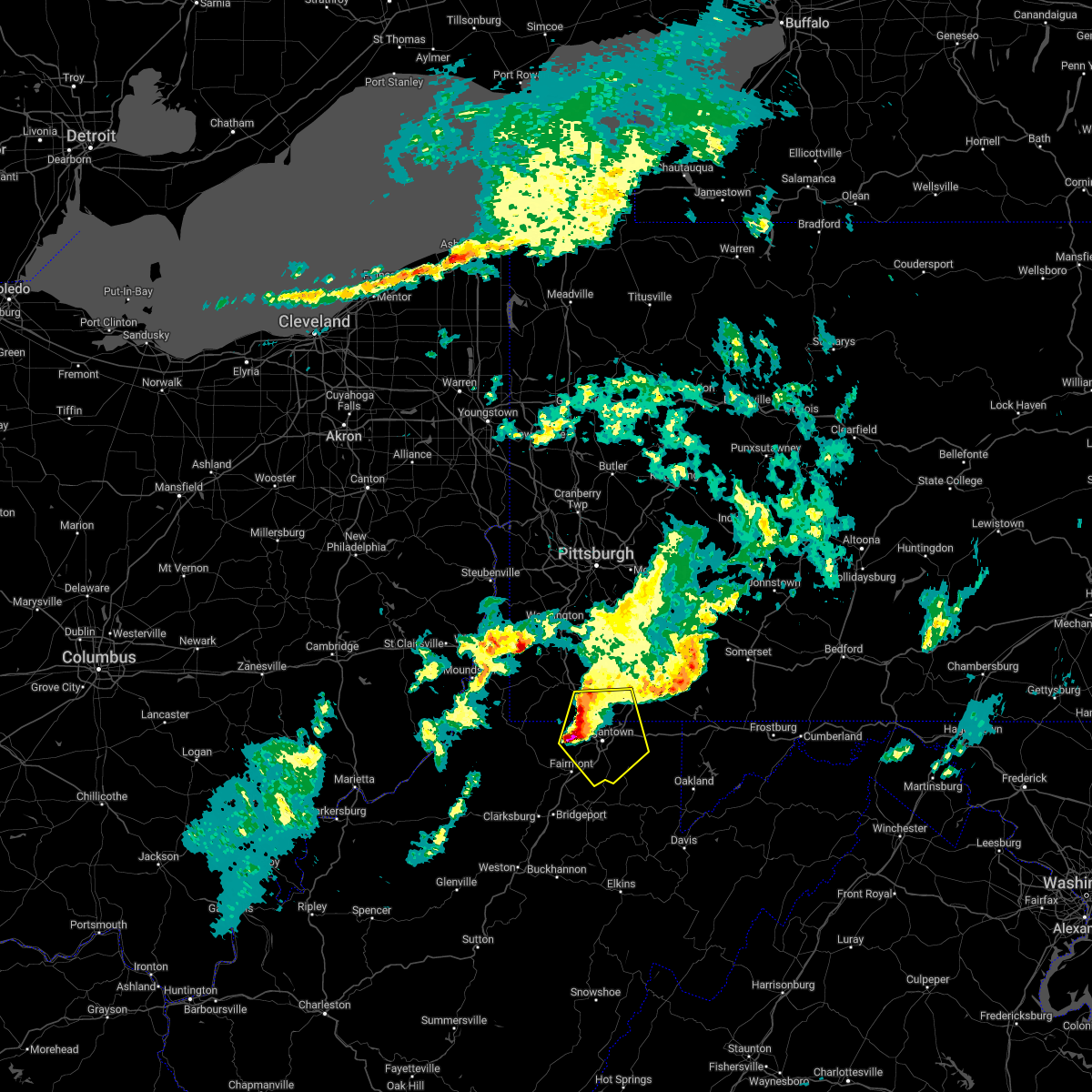
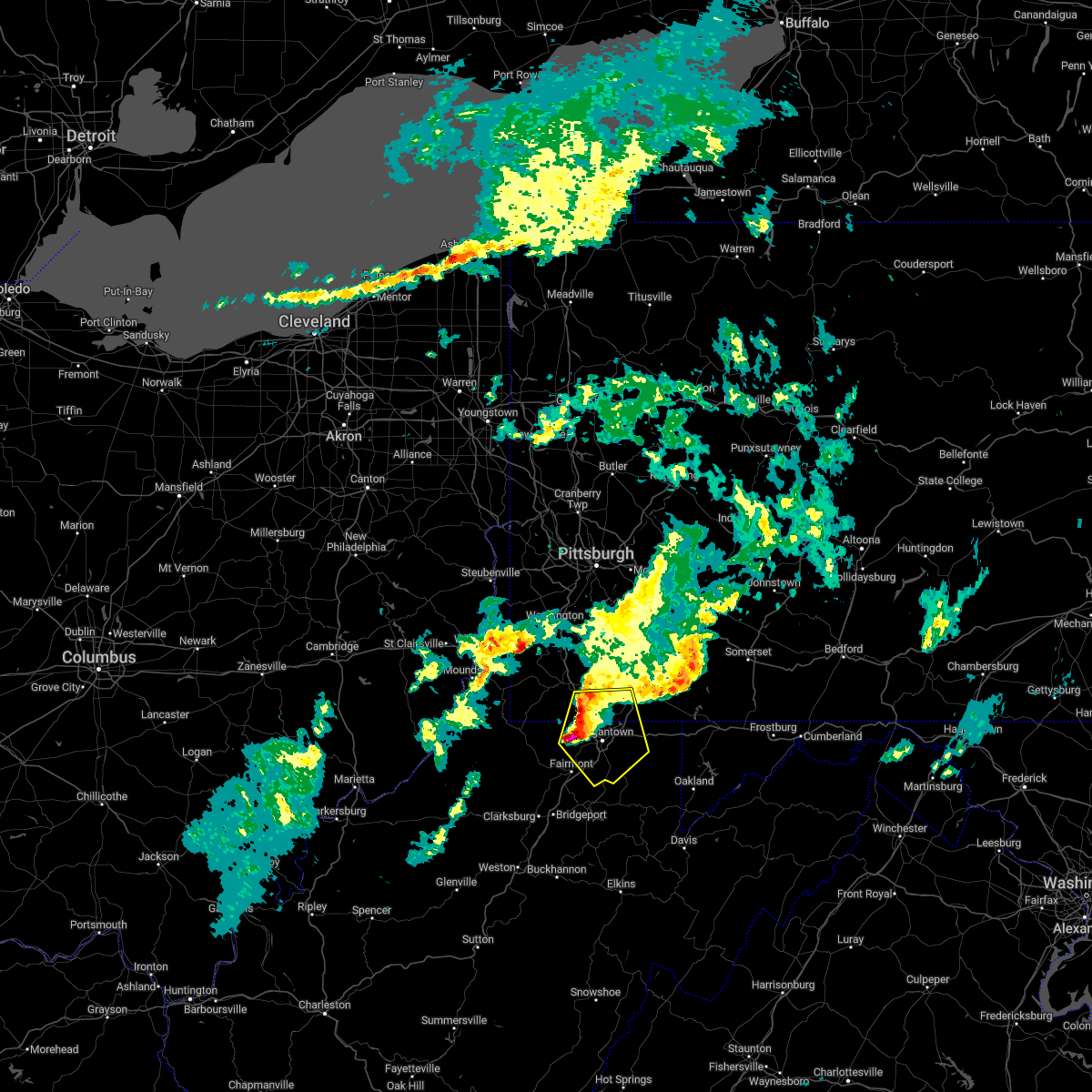
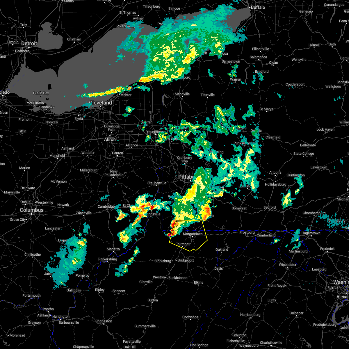
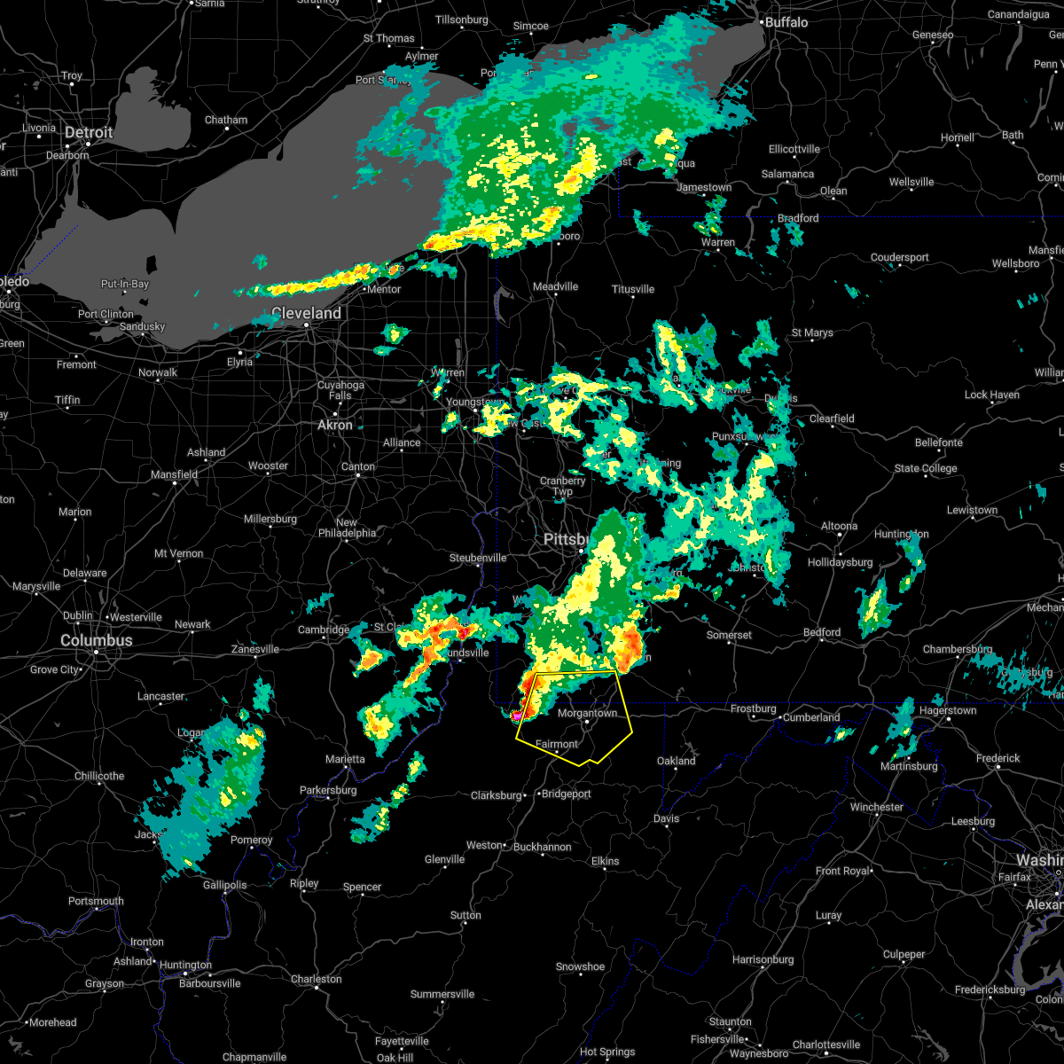
Hail Map for Reedsville, WV
The Reedsville, WV area has had 3 reports of on-the-ground hail by trained spotters, and has been under severe weather warnings 32 times during the past 12 months. Doppler radar has detected hail at or near Reedsville, WV on 24 occasions, including 1 occasion during the past year.
| Name: | Reedsville, WV |
| Where Located: | 40.7 miles N of Elkins, WV |
| Map: | Google Map for Reedsville, WV |
| Population: | 593 |
| Housing Units: | 281 |
| More Info: | Search Google for Reedsville, WV |
5
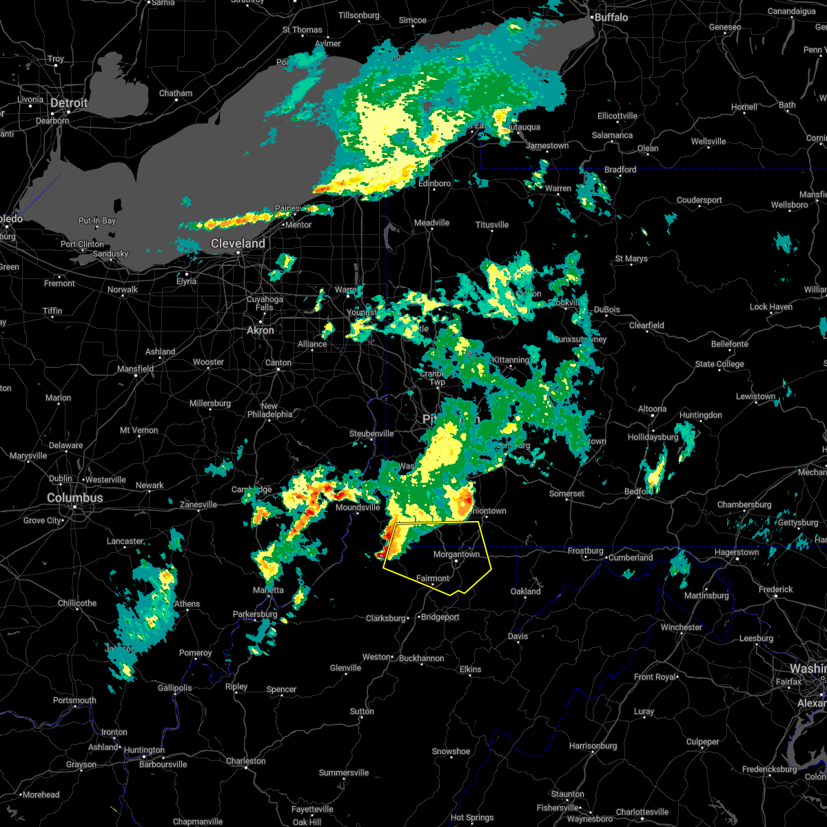
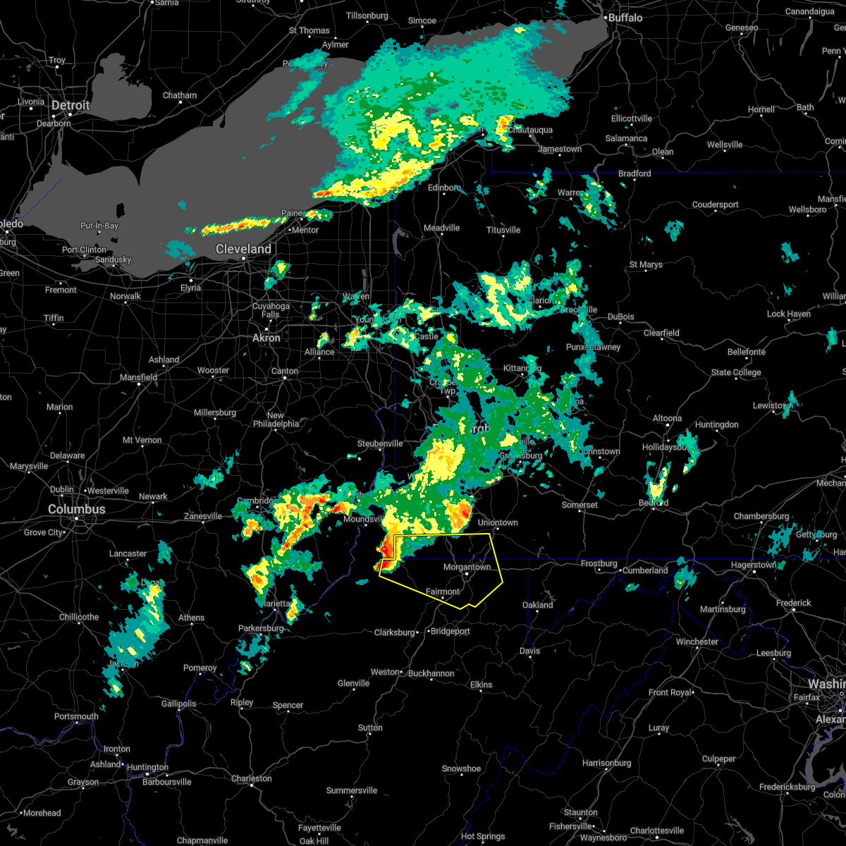
The Top Recent Hail Date for Reedsville, WV is Monday, August 7, 2023 (3rd out of 24)

Hail and Wind Damage Spotted near Reedsville, WV
| Date / Time | Report Details |
|---|---|
| 4/15/2024 11:43 AM EDT |
 At 1143 am edt, a severe thunderstorm was located near kingwood, moving east at 45 mph (radar indicated). Hazards include quarter size hail. Minor damage to vehicles is possible. Locations impacted include, kingwood, terra alta, reedsville, masontown, albright, gladesville, and hutton. At 1143 am edt, a severe thunderstorm was located near kingwood, moving east at 45 mph (radar indicated). Hazards include quarter size hail. Minor damage to vehicles is possible. Locations impacted include, kingwood, terra alta, reedsville, masontown, albright, gladesville, and hutton.
|
| 4/15/2024 11:43 AM EDT |
 the severe thunderstorm warning has been cancelled and is no longer in effect the severe thunderstorm warning has been cancelled and is no longer in effect
|
| 4/15/2024 11:34 AM EDT |
 Svrpbz the national weather service in pittsburgh has issued a * severe thunderstorm warning for, southeastern monongalia county in northern west virginia, central preston county in northeastern west virginia, * until noon edt. * at 1134 am edt, a severe thunderstorm was located 7 miles south of brookhaven, or 9 miles south of morgantown, moving east at 45 mph (radar indicated). Hazards include quarter size hail. minor damage to vehicles is possible Svrpbz the national weather service in pittsburgh has issued a * severe thunderstorm warning for, southeastern monongalia county in northern west virginia, central preston county in northeastern west virginia, * until noon edt. * at 1134 am edt, a severe thunderstorm was located 7 miles south of brookhaven, or 9 miles south of morgantown, moving east at 45 mph (radar indicated). Hazards include quarter size hail. minor damage to vehicles is possible
|
| 8/25/2023 3:21 AM EDT |
 At 321 am edt, severe thunderstorms were located along a line extending from 6 miles southwest of friendsville to near winfield, moving east at 45 mph (radar indicated). Hazards include 60 mph wind gusts. Expect damage to trees and power lines, resulting in some power outages. locations impacted include, fairmont, kingwood, winfield, fairview, newburg, rivesville, grant town, reedsville, masontown, albright, valley point, booth, everettville, baxter, cranesville, mccurdyville, crown, gladesville, browns chapel, and georgetown. hail threat, radar indicated max hail size, <. 75 in wind threat, radar indicated max wind gust, 60 mph. At 321 am edt, severe thunderstorms were located along a line extending from 6 miles southwest of friendsville to near winfield, moving east at 45 mph (radar indicated). Hazards include 60 mph wind gusts. Expect damage to trees and power lines, resulting in some power outages. locations impacted include, fairmont, kingwood, winfield, fairview, newburg, rivesville, grant town, reedsville, masontown, albright, valley point, booth, everettville, baxter, cranesville, mccurdyville, crown, gladesville, browns chapel, and georgetown. hail threat, radar indicated max hail size, <. 75 in wind threat, radar indicated max wind gust, 60 mph.
|
| 8/25/2023 3:14 AM EDT |
 At 314 am edt, severe thunderstorms were located along a line extending from 7 miles southwest of friendsville to winfield, moving southeast at 35 mph (radar indicated). Hazards include 60 mph wind gusts and quarter size hail. Minor hail damage to vehicles is possible. expect wind damage to trees and power lines, resulting in some power outages. locations impacted include, morgantown, fairmont, westover, kingwood, star city, winfield, granville, fairview, newburg, brookhaven, cassville, rivesville, grant town, reedsville, masontown, albright, brandonville, bruceton mills, valley point, and booth. hail threat, radar indicated max hail size, 1. 00 in wind threat, radar indicated max wind gust, 60 mph. At 314 am edt, severe thunderstorms were located along a line extending from 7 miles southwest of friendsville to winfield, moving southeast at 35 mph (radar indicated). Hazards include 60 mph wind gusts and quarter size hail. Minor hail damage to vehicles is possible. expect wind damage to trees and power lines, resulting in some power outages. locations impacted include, morgantown, fairmont, westover, kingwood, star city, winfield, granville, fairview, newburg, brookhaven, cassville, rivesville, grant town, reedsville, masontown, albright, brandonville, bruceton mills, valley point, and booth. hail threat, radar indicated max hail size, 1. 00 in wind threat, radar indicated max wind gust, 60 mph.
|
| 8/25/2023 3:06 AM EDT |
 At 306 am edt, severe thunderstorms were located along a line extending from 7 miles west of friendsville to near grafton, moving southeast at 45 mph (radar indicated). Hazards include 60 mph wind gusts and quarter size hail. Minor hail damage to vehicles is possible. expect wind damage to trees and power lines, resulting in some power outages. locations impacted include, morgantown, fairmont, westover, kingwood, star city, winfield, granville, fairview, newburg, brookhaven, cassville, rivesville, grant town, reedsville, masontown, albright, brandonville, bruceton mills, valley point, and booth. hail threat, radar indicated max hail size, 1. 00 in wind threat, radar indicated max wind gust, 60 mph. At 306 am edt, severe thunderstorms were located along a line extending from 7 miles west of friendsville to near grafton, moving southeast at 45 mph (radar indicated). Hazards include 60 mph wind gusts and quarter size hail. Minor hail damage to vehicles is possible. expect wind damage to trees and power lines, resulting in some power outages. locations impacted include, morgantown, fairmont, westover, kingwood, star city, winfield, granville, fairview, newburg, brookhaven, cassville, rivesville, grant town, reedsville, masontown, albright, brandonville, bruceton mills, valley point, and booth. hail threat, radar indicated max hail size, 1. 00 in wind threat, radar indicated max wind gust, 60 mph.
|
| 8/25/2023 2:56 AM EDT |
 At 255 am edt, severe thunderstorms were located along a line extending from near farmington to near pleasant valley, moving southeast at 45 mph (radar indicated). Hazards include 60 mph wind gusts and quarter size hail. Minor hail damage to vehicles is possible. expect wind damage to trees and power lines, resulting in some power outages. locations impacted include, morgantown, fairmont, westover, kingwood, star city, winfield, farmington, point marion, granville, fairview, newburg, brookhaven, cassville, fairchance, rivesville, grant town, reedsville, masontown, albright, and markleysburg. hail threat, radar indicated max hail size, 1. 00 in wind threat, radar indicated max wind gust, 60 mph. At 255 am edt, severe thunderstorms were located along a line extending from near farmington to near pleasant valley, moving southeast at 45 mph (radar indicated). Hazards include 60 mph wind gusts and quarter size hail. Minor hail damage to vehicles is possible. expect wind damage to trees and power lines, resulting in some power outages. locations impacted include, morgantown, fairmont, westover, kingwood, star city, winfield, farmington, point marion, granville, fairview, newburg, brookhaven, cassville, fairchance, rivesville, grant town, reedsville, masontown, albright, and markleysburg. hail threat, radar indicated max hail size, 1. 00 in wind threat, radar indicated max wind gust, 60 mph.
|
| 8/25/2023 2:42 AM EDT |
 At 242 am edt, severe thunderstorms were located along a line extending from near uniontown to mannington, moving southeast at 45 mph (radar indicated). Hazards include 60 mph wind gusts and quarter size hail. Minor hail damage to vehicles is possible. Expect wind damage to trees and power lines, resulting in some power outages. At 242 am edt, severe thunderstorms were located along a line extending from near uniontown to mannington, moving southeast at 45 mph (radar indicated). Hazards include 60 mph wind gusts and quarter size hail. Minor hail damage to vehicles is possible. Expect wind damage to trees and power lines, resulting in some power outages.
|
| 8/12/2023 9:49 PM EDT |
 At 948 pm edt, a severe thunderstorm was located 9 miles east of brookhaven, or 10 miles north of kingwood, moving southeast at 45 mph (radar indicated). Hazards include 60 mph wind gusts and nickel size hail. Expect damage to trees and power lines, resulting in some power outages. locations impacted include, morgantown, westover, kingwood, farmington, granville, brookhaven, fairchance, smithfield, reedsville, masontown, tunnelton, brandonville, bruceton mills, valley point, booth, everettville, laurel run, clifton mills, cheat lake, and gladesville. hail threat, radar indicated max hail size, 0. 88 in wind threat, radar indicated max wind gust, 60 mph. At 948 pm edt, a severe thunderstorm was located 9 miles east of brookhaven, or 10 miles north of kingwood, moving southeast at 45 mph (radar indicated). Hazards include 60 mph wind gusts and nickel size hail. Expect damage to trees and power lines, resulting in some power outages. locations impacted include, morgantown, westover, kingwood, farmington, granville, brookhaven, fairchance, smithfield, reedsville, masontown, tunnelton, brandonville, bruceton mills, valley point, booth, everettville, laurel run, clifton mills, cheat lake, and gladesville. hail threat, radar indicated max hail size, 0. 88 in wind threat, radar indicated max wind gust, 60 mph.
|
| 8/12/2023 9:36 PM EDT |
 At 936 pm edt, a severe thunderstorm was located near point marion, or near morgantown, moving southeast at 45 mph (radar indicated). Hazards include 60 mph wind gusts and quarter size hail. Minor hail damage to vehicles is possible. expect wind damage to trees and power lines, resulting in some power outages. locations impacted include, morgantown, westover, kingwood, star city, farmington, point marion, granville, brookhaven, cassville, fairchance, smithfield, reedsville, masontown, bobtown, tunnelton, greensboro, brandonville, mount morris, bruceton mills, and valley point. hail threat, radar indicated max hail size, 1. 00 in wind threat, radar indicated max wind gust, 60 mph. At 936 pm edt, a severe thunderstorm was located near point marion, or near morgantown, moving southeast at 45 mph (radar indicated). Hazards include 60 mph wind gusts and quarter size hail. Minor hail damage to vehicles is possible. expect wind damage to trees and power lines, resulting in some power outages. locations impacted include, morgantown, westover, kingwood, star city, farmington, point marion, granville, brookhaven, cassville, fairchance, smithfield, reedsville, masontown, bobtown, tunnelton, greensboro, brandonville, mount morris, bruceton mills, and valley point. hail threat, radar indicated max hail size, 1. 00 in wind threat, radar indicated max wind gust, 60 mph.
|
| 8/12/2023 9:18 PM EDT |
 At 918 pm edt, a severe thunderstorm was located 7 miles north of cassville, or 9 miles southeast of waynesburg, moving southeast at 45 mph (radar indicated). Hazards include golf ball size hail and 60 mph wind gusts. People and animals outdoors will be injured. expect hail damage to roofs, siding, windows, and vehicles. Expect wind damage to trees and power lines, resulting in some power outages. At 918 pm edt, a severe thunderstorm was located 7 miles north of cassville, or 9 miles southeast of waynesburg, moving southeast at 45 mph (radar indicated). Hazards include golf ball size hail and 60 mph wind gusts. People and animals outdoors will be injured. expect hail damage to roofs, siding, windows, and vehicles. Expect wind damage to trees and power lines, resulting in some power outages.
|
| 8/7/2023 2:23 PM EDT |
 At 223 pm edt, a severe thunderstorm was located over barrackville, or near fairmont, moving northeast at 45 mph (radar indicated). Hazards include 60 mph wind gusts and quarter size hail. Minor hail damage to vehicles is possible. Expect wind damage to trees and power lines, resulting in some power outages. At 223 pm edt, a severe thunderstorm was located over barrackville, or near fairmont, moving northeast at 45 mph (radar indicated). Hazards include 60 mph wind gusts and quarter size hail. Minor hail damage to vehicles is possible. Expect wind damage to trees and power lines, resulting in some power outages.
|
| 8/7/2023 2:20 PM EDT |
 The severe thunderstorm warning for southern fayette and central preston counties will expire at 230 pm edt, the storm which prompted the warning has weakened below severe limits, and has exited the warned area. therefore, the warning will be allowed to expire. however, gusty winds and heavy rain are still possible with this thunderstorm. a tornado watch remains in effect until 600 pm edt for southwestern pennsylvania, and northeastern west virginia. The severe thunderstorm warning for southern fayette and central preston counties will expire at 230 pm edt, the storm which prompted the warning has weakened below severe limits, and has exited the warned area. therefore, the warning will be allowed to expire. however, gusty winds and heavy rain are still possible with this thunderstorm. a tornado watch remains in effect until 600 pm edt for southwestern pennsylvania, and northeastern west virginia.
|
| 8/7/2023 2:12 PM EDT | Tree down on gladesville road. public report remarks time of even in preston county WV, 2.8 miles NE of Reedsville, WV |
| 8/7/2023 2:06 PM EDT |
 At 205 pm edt, a severe thunderstorm was located near kingwood, moving northeast at 45 mph (radar indicated). Hazards include 60 mph wind gusts. Expect damage to trees and power lines, resulting in some power outages. locations impacted include, kingwood, terra alta, rowlesburg, newburg, reedsville, masontown, albright, tunnelton, brandonville, bruceton mills, valley point, clifton mills, gladesville, and laurel run. hail threat, radar indicated max hail size, <. 75 in wind threat, radar indicated max wind gust, 60 mph. At 205 pm edt, a severe thunderstorm was located near kingwood, moving northeast at 45 mph (radar indicated). Hazards include 60 mph wind gusts. Expect damage to trees and power lines, resulting in some power outages. locations impacted include, kingwood, terra alta, rowlesburg, newburg, reedsville, masontown, albright, tunnelton, brandonville, bruceton mills, valley point, clifton mills, gladesville, and laurel run. hail threat, radar indicated max hail size, <. 75 in wind threat, radar indicated max wind gust, 60 mph.
|
| 8/7/2023 1:54 PM EDT | Photos show snapped and uprooted trees in the area. time estimated based on rada in preston county WV, 5.2 miles NE of Reedsville, WV |
| 8/7/2023 1:40 PM EDT |
 At 140 pm edt, a severe thunderstorm was located near winfield, or near grafton, moving northeast at 40 mph (radar indicated). Hazards include 60 mph wind gusts. expect damage to trees and power lines, resulting in some power outages At 140 pm edt, a severe thunderstorm was located near winfield, or near grafton, moving northeast at 40 mph (radar indicated). Hazards include 60 mph wind gusts. expect damage to trees and power lines, resulting in some power outages
|
| 8/7/2023 1:22 PM EDT |
 At 122 pm edt, a severe thunderstorm was located 8 miles east of brookhaven, or 11 miles north of kingwood, moving east at 30 mph (radar indicated). Hazards include 60 mph wind gusts and half dollar size hail. Minor hail damage to vehicles is possible. expect wind damage to trees and power lines, resulting in some power outages. locations impacted include, kingwood, terra alta, farmington, brookhaven, reedsville, masontown, albright, tunnelton, markleysburg, brandonville, bruceton mills, valley point, laurel run, hazelton, cranesville, clifton mills, cheat lake, and gladesville. hail threat, radar indicated max hail size, 1. 25 in wind threat, radar indicated max wind gust, 60 mph. At 122 pm edt, a severe thunderstorm was located 8 miles east of brookhaven, or 11 miles north of kingwood, moving east at 30 mph (radar indicated). Hazards include 60 mph wind gusts and half dollar size hail. Minor hail damage to vehicles is possible. expect wind damage to trees and power lines, resulting in some power outages. locations impacted include, kingwood, terra alta, farmington, brookhaven, reedsville, masontown, albright, tunnelton, markleysburg, brandonville, bruceton mills, valley point, laurel run, hazelton, cranesville, clifton mills, cheat lake, and gladesville. hail threat, radar indicated max hail size, 1. 25 in wind threat, radar indicated max wind gust, 60 mph.
|
| 8/7/2023 1:13 PM EDT |
 At 113 pm edt, a severe thunderstorm was located near brookhaven, or near morgantown, moving northeast at 50 mph (radar indicated). Hazards include 60 mph wind gusts and quarter size hail. Minor hail damage to vehicles is possible. expect wind damage to trees and power lines, resulting in some power outages. locations impacted include, morgantown, westover, kingwood, star city, terra alta, farmington, point marion, granville, newburg, brookhaven, fairchance, smithfield, reedsville, masontown, albright, tunnelton, markleysburg, brandonville, chalkhill, and bruceton mills. hail threat, radar indicated max hail size, 1. 00 in wind threat, radar indicated max wind gust, 60 mph. At 113 pm edt, a severe thunderstorm was located near brookhaven, or near morgantown, moving northeast at 50 mph (radar indicated). Hazards include 60 mph wind gusts and quarter size hail. Minor hail damage to vehicles is possible. expect wind damage to trees and power lines, resulting in some power outages. locations impacted include, morgantown, westover, kingwood, star city, terra alta, farmington, point marion, granville, newburg, brookhaven, fairchance, smithfield, reedsville, masontown, albright, tunnelton, markleysburg, brandonville, chalkhill, and bruceton mills. hail threat, radar indicated max hail size, 1. 00 in wind threat, radar indicated max wind gust, 60 mph.
|
| 8/7/2023 1:11 PM EDT | Trees down on gladesville road in preston county WV, 5.2 miles NE of Reedsville, WV |
| 8/7/2023 1:10 PM EDT | Multiple trees down in preston county WV, 1.4 miles NE of Reedsville, WV |
| 8/7/2023 1:09 PM EDT | Trees down in preston county WV, 0.2 miles NNE of Reedsville, WV |
| 8/7/2023 1:07 PM EDT | Tree and power lines donw on q road and m roa in preston county WV, 1.9 miles NE of Reedsville, WV |
| 8/7/2023 12:57 PM EDT |
 At 1257 pm edt, a severe thunderstorm was located near winfield, or near fairmont, moving east at 30 mph (radar indicated). Hazards include 60 mph wind gusts. expect damage to trees and power lines, resulting in some power outages At 1257 pm edt, a severe thunderstorm was located near winfield, or near fairmont, moving east at 30 mph (radar indicated). Hazards include 60 mph wind gusts. expect damage to trees and power lines, resulting in some power outages
|
| 6/26/2023 6:59 PM EDT |
 At 659 pm edt, a severe thunderstorm was located near kingwood, moving east at 25 mph (radar indicated). Hazards include 60 mph wind gusts and nickel size hail. expect damage to trees and power lines, resulting in some power outages At 659 pm edt, a severe thunderstorm was located near kingwood, moving east at 25 mph (radar indicated). Hazards include 60 mph wind gusts and nickel size hail. expect damage to trees and power lines, resulting in some power outages
|
| 9/25/2022 10:09 AM EDT |
 At 1009 am edt, a severe thunderstorm was located over star city, moving east at 55 mph (radar indicated). Hazards include 60 mph wind gusts and quarter size hail. Minor hail damage to vehicles is possible. expect wind damage to trees and power lines, resulting in some power outages. locations impacted include, morgantown, westover, star city, point marion, granville, brookhaven, cassville, fairchance, rivesville, smithfield, reedsville, and masontown. hail threat, radar indicated max hail size, 1. 00 in wind threat, radar indicated max wind gust, 60 mph. At 1009 am edt, a severe thunderstorm was located over star city, moving east at 55 mph (radar indicated). Hazards include 60 mph wind gusts and quarter size hail. Minor hail damage to vehicles is possible. expect wind damage to trees and power lines, resulting in some power outages. locations impacted include, morgantown, westover, star city, point marion, granville, brookhaven, cassville, fairchance, rivesville, smithfield, reedsville, and masontown. hail threat, radar indicated max hail size, 1. 00 in wind threat, radar indicated max wind gust, 60 mph.
|
| 9/25/2022 9:56 AM EDT |
 At 956 am edt, a severe thunderstorm was located near fairview, or 12 miles northeast of mannington, moving east at 55 mph (radar indicated). Hazards include 60 mph wind gusts and quarter size hail. Minor hail damage to vehicles is possible. expect wind damage to trees and power lines, resulting in some power outages. locations impacted include, morgantown, fairmont, westover, mannington, star city, pleasant valley, winfield, barrackville, point marion, granville, fairview, and brookhaven. hail threat, radar indicated max hail size, 1. 00 in wind threat, radar indicated max wind gust, 60 mph. At 956 am edt, a severe thunderstorm was located near fairview, or 12 miles northeast of mannington, moving east at 55 mph (radar indicated). Hazards include 60 mph wind gusts and quarter size hail. Minor hail damage to vehicles is possible. expect wind damage to trees and power lines, resulting in some power outages. locations impacted include, morgantown, fairmont, westover, mannington, star city, pleasant valley, winfield, barrackville, point marion, granville, fairview, and brookhaven. hail threat, radar indicated max hail size, 1. 00 in wind threat, radar indicated max wind gust, 60 mph.
|
| 9/25/2022 9:47 AM EDT |
 At 947 am edt, a severe thunderstorm was located near hundred, or 10 miles north of mannington, moving east at 55 mph (radar indicated). Hazards include 60 mph wind gusts and quarter size hail. Minor hail damage to vehicles is possible. expect wind damage to trees and power lines, resulting in some power outages. locations impacted include, morgantown, fairmont, westover, mannington, star city, pleasant valley, winfield, barrackville, point marion, granville, fairview, and hundred. hail threat, radar indicated max hail size, 1. 00 in wind threat, radar indicated max wind gust, 60 mph. At 947 am edt, a severe thunderstorm was located near hundred, or 10 miles north of mannington, moving east at 55 mph (radar indicated). Hazards include 60 mph wind gusts and quarter size hail. Minor hail damage to vehicles is possible. expect wind damage to trees and power lines, resulting in some power outages. locations impacted include, morgantown, fairmont, westover, mannington, star city, pleasant valley, winfield, barrackville, point marion, granville, fairview, and hundred. hail threat, radar indicated max hail size, 1. 00 in wind threat, radar indicated max wind gust, 60 mph.
|
| 9/25/2022 9:40 AM EDT |
 At 940 am edt, a severe thunderstorm was located over hundred, or 13 miles northwest of mannington, moving east at 55 mph (radar indicated). Hazards include 60 mph wind gusts and quarter size hail. Minor hail damage to vehicles is possible. Expect wind damage to trees and power lines, resulting in some power outages. At 940 am edt, a severe thunderstorm was located over hundred, or 13 miles northwest of mannington, moving east at 55 mph (radar indicated). Hazards include 60 mph wind gusts and quarter size hail. Minor hail damage to vehicles is possible. Expect wind damage to trees and power lines, resulting in some power outages.
|
| 7/23/2022 4:00 PM EDT |
 At 400 pm edt, a severe thunderstorm was located 8 miles south of farmington, or 15 miles north of kingwood, moving east at 50 mph (radar indicated). Hazards include 60 mph wind gusts and quarter size hail. Minor hail damage to vehicles is possible. expect wind damage to trees and power lines, resulting in some power outages. locations impacted include, morgantown, uniontown, connellsville, kingwood, terra alta, rowlesburg, winfield, south connellsville, farmington, newburg, seven springs, and brookhaven. hail threat, radar indicated max hail size, 1. 00 in wind threat, radar indicated max wind gust, 60 mph. At 400 pm edt, a severe thunderstorm was located 8 miles south of farmington, or 15 miles north of kingwood, moving east at 50 mph (radar indicated). Hazards include 60 mph wind gusts and quarter size hail. Minor hail damage to vehicles is possible. expect wind damage to trees and power lines, resulting in some power outages. locations impacted include, morgantown, uniontown, connellsville, kingwood, terra alta, rowlesburg, winfield, south connellsville, farmington, newburg, seven springs, and brookhaven. hail threat, radar indicated max hail size, 1. 00 in wind threat, radar indicated max wind gust, 60 mph.
|
| 7/23/2022 3:37 PM EDT |
 At 337 pm edt, a severe thunderstorm was located over morgantown, moving east at 50 mph (radar indicated). Hazards include 60 mph wind gusts and quarter size hail. Minor hail damage to vehicles is possible. Expect wind damage to trees and power lines, resulting in some power outages. At 337 pm edt, a severe thunderstorm was located over morgantown, moving east at 50 mph (radar indicated). Hazards include 60 mph wind gusts and quarter size hail. Minor hail damage to vehicles is possible. Expect wind damage to trees and power lines, resulting in some power outages.
|
| 7/12/2022 2:24 PM EDT |
 At 224 pm edt, a severe thunderstorm was located near deer park, or near mountain lake park, moving east at 60 mph (radar indicated). Hazards include golf ball size hail and 60 mph wind gusts. People and animals outdoors will be injured. expect hail damage to roofs, siding, windows, and vehicles. expect wind damage to trees and power lines, resulting in some power outages. locations impacted include, kingwood, terra alta, rowlesburg, newburg, reedsville, masontown, albright, tunnelton, valley point, elgon, cranesville, and silver lake. thunderstorm damage threat, considerable hail threat, radar indicated max hail size, 1. 75 in wind threat, radar indicated max wind gust, 60 mph. At 224 pm edt, a severe thunderstorm was located near deer park, or near mountain lake park, moving east at 60 mph (radar indicated). Hazards include golf ball size hail and 60 mph wind gusts. People and animals outdoors will be injured. expect hail damage to roofs, siding, windows, and vehicles. expect wind damage to trees and power lines, resulting in some power outages. locations impacted include, kingwood, terra alta, rowlesburg, newburg, reedsville, masontown, albright, tunnelton, valley point, elgon, cranesville, and silver lake. thunderstorm damage threat, considerable hail threat, radar indicated max hail size, 1. 75 in wind threat, radar indicated max wind gust, 60 mph.
|
| 7/12/2022 2:14 PM EDT |
 At 213 pm edt, a severe thunderstorm was located over terra alta, moving east at 60 mph (radar indicated). Hazards include 60 mph wind gusts and quarter size hail. Minor hail damage to vehicles is possible. expect wind damage to trees and power lines, resulting in some power outages. locations impacted include, fairmont, kingwood, terra alta, rowlesburg, pleasant valley, winfield, monongah, newburg, brookhaven, reedsville, masontown, and albright. hail threat, radar indicated max hail size, 1. 00 in wind threat, radar indicated max wind gust, 60 mph. At 213 pm edt, a severe thunderstorm was located over terra alta, moving east at 60 mph (radar indicated). Hazards include 60 mph wind gusts and quarter size hail. Minor hail damage to vehicles is possible. expect wind damage to trees and power lines, resulting in some power outages. locations impacted include, fairmont, kingwood, terra alta, rowlesburg, pleasant valley, winfield, monongah, newburg, brookhaven, reedsville, masontown, and albright. hail threat, radar indicated max hail size, 1. 00 in wind threat, radar indicated max wind gust, 60 mph.
|
| 7/12/2022 1:57 PM EDT |
 At 157 pm edt, a severe thunderstorm was located near newburg, or 9 miles west of kingwood, moving east at 60 mph (radar indicated). Hazards include 60 mph wind gusts and quarter size hail. Minor hail damage to vehicles is possible. Expect wind damage to trees and power lines, resulting in some power outages. At 157 pm edt, a severe thunderstorm was located near newburg, or 9 miles west of kingwood, moving east at 60 mph (radar indicated). Hazards include 60 mph wind gusts and quarter size hail. Minor hail damage to vehicles is possible. Expect wind damage to trees and power lines, resulting in some power outages.
|
| 6/22/2022 7:57 PM EDT |
 At 757 pm edt, severe thunderstorms were located along a line extending from 8 miles northeast of terra alta to near pleasant valley, moving southeast at 30 mph (radar indicated). Hazards include 60 mph wind gusts. expect damage to trees and power lines, resulting in some power outages At 757 pm edt, severe thunderstorms were located along a line extending from 8 miles northeast of terra alta to near pleasant valley, moving southeast at 30 mph (radar indicated). Hazards include 60 mph wind gusts. expect damage to trees and power lines, resulting in some power outages
|
| 6/22/2022 7:48 PM EDT |
 At 748 pm edt, severe thunderstorms were located along a line extending from 6 miles southwest of friendsville to near cassville, moving southeast at 45 mph (radar indicated). Hazards include 60 mph wind gusts. Expect damage to trees and power lines, resulting in some power outages. locations impacted include, morgantown, fairmont, westover, star city, pleasant valley, winfield, barrackville, monongah, granville, brookhaven, cassville, and rivesville. hail threat, radar indicated max hail size, <. 75 in wind threat, radar indicated max wind gust, 60 mph. At 748 pm edt, severe thunderstorms were located along a line extending from 6 miles southwest of friendsville to near cassville, moving southeast at 45 mph (radar indicated). Hazards include 60 mph wind gusts. Expect damage to trees and power lines, resulting in some power outages. locations impacted include, morgantown, fairmont, westover, star city, pleasant valley, winfield, barrackville, monongah, granville, brookhaven, cassville, and rivesville. hail threat, radar indicated max hail size, <. 75 in wind threat, radar indicated max wind gust, 60 mph.
|
| 6/22/2022 7:32 PM EDT |
 At 731 pm edt, severe thunderstorms were located along a line extending from 9 miles southwest of farmington to 6 miles north of fairview, moving southeast at 45 mph (radar indicated). Hazards include 60 mph wind gusts. Expect damage to trees and power lines, resulting in some power outages. locations impacted include, morgantown, fairmont, westover, mannington, star city, pleasant valley, winfield, barrackville, monongah, granville, fairview, and brookhaven. hail threat, radar indicated max hail size, <. 75 in wind threat, radar indicated max wind gust, 60 mph. At 731 pm edt, severe thunderstorms were located along a line extending from 9 miles southwest of farmington to 6 miles north of fairview, moving southeast at 45 mph (radar indicated). Hazards include 60 mph wind gusts. Expect damage to trees and power lines, resulting in some power outages. locations impacted include, morgantown, fairmont, westover, mannington, star city, pleasant valley, winfield, barrackville, monongah, granville, fairview, and brookhaven. hail threat, radar indicated max hail size, <. 75 in wind threat, radar indicated max wind gust, 60 mph.
|
| 6/22/2022 7:23 PM EDT |
 At 723 pm edt, a severe thunderstorm was located over kingwood, moving southeast at 25 mph (radar indicated). Hazards include 60 mph wind gusts. Expect damage to trees and power lines, resulting in some power outages. locations impacted include, kingwood, terra alta, thomas, rowlesburg, newburg, reedsville, masontown, albright, tunnelton, hannahsville, valley point, and elgon. hail threat, radar indicated max hail size, <. 75 in wind threat, radar indicated max wind gust, 60 mph. At 723 pm edt, a severe thunderstorm was located over kingwood, moving southeast at 25 mph (radar indicated). Hazards include 60 mph wind gusts. Expect damage to trees and power lines, resulting in some power outages. locations impacted include, kingwood, terra alta, thomas, rowlesburg, newburg, reedsville, masontown, albright, tunnelton, hannahsville, valley point, and elgon. hail threat, radar indicated max hail size, <. 75 in wind threat, radar indicated max wind gust, 60 mph.
|
| 6/22/2022 7:22 PM EDT |
 At 722 pm edt, severe thunderstorms were located along a line extending from 8 miles southwest of farmington to 7 miles northeast of hundred, moving southeast at 40 mph (radar indicated). Hazards include 60 mph wind gusts. expect damage to trees and power lines, resulting in some power outages At 722 pm edt, severe thunderstorms were located along a line extending from 8 miles southwest of farmington to 7 miles northeast of hundred, moving southeast at 40 mph (radar indicated). Hazards include 60 mph wind gusts. expect damage to trees and power lines, resulting in some power outages
|
| 6/22/2022 7:15 PM EDT |
 At 715 pm edt, a cluster of severe thunderstorms was centered near kingwood, moving southeast at 25 mph (radar indicated). Hazards include 60 mph wind gusts. expect damage to trees and power lines, resulting in some power outages At 715 pm edt, a cluster of severe thunderstorms was centered near kingwood, moving southeast at 25 mph (radar indicated). Hazards include 60 mph wind gusts. expect damage to trees and power lines, resulting in some power outages
|
| 6/8/2022 9:45 PM EDT |
 At 944 pm edt, a severe thunderstorm was located 8 miles north of kingwood, moving east at 35 mph (radar indicated). Hazards include quarter size hail. minor damage to vehicles is possible At 944 pm edt, a severe thunderstorm was located 8 miles north of kingwood, moving east at 35 mph (radar indicated). Hazards include quarter size hail. minor damage to vehicles is possible
|
| 6/8/2022 9:33 PM EDT |
 At 932 pm edt, a severe thunderstorm was located over brookhaven, or near morgantown, moving east at 30 mph (radar indicated). Hazards include 60 mph wind gusts and half dollar size hail. Minor hail damage to vehicles is possible. expect wind damage to trees and power lines, resulting in some power outages. locations impacted include, morgantown, kingwood, brookhaven, reedsville, masontown, cheat lake, and browns chapel. hail threat, observed max hail size, 1. 25 in wind threat, radar indicated max wind gust, 60 mph. At 932 pm edt, a severe thunderstorm was located over brookhaven, or near morgantown, moving east at 30 mph (radar indicated). Hazards include 60 mph wind gusts and half dollar size hail. Minor hail damage to vehicles is possible. expect wind damage to trees and power lines, resulting in some power outages. locations impacted include, morgantown, kingwood, brookhaven, reedsville, masontown, cheat lake, and browns chapel. hail threat, observed max hail size, 1. 25 in wind threat, radar indicated max wind gust, 60 mph.
|
| 6/8/2022 9:18 PM EDT |
 At 917 pm edt, a severe thunderstorm was located near westover, moving east at 30 mph (radar indicated). Hazards include two inch hail and 60 mph wind gusts. People and animals outdoors will be injured. expect hail damage to roofs, siding, windows, and vehicles. expect wind damage to trees and power lines, resulting in some power outages. locations impacted include, morgantown, fairmont, westover, kingwood, star city, winfield, barrackville, granville, brookhaven, rivesville, grant town, and reedsville. thunderstorm damage threat, considerable hail threat, observed max hail size, 2. 00 in wind threat, radar indicated max wind gust, 60 mph. At 917 pm edt, a severe thunderstorm was located near westover, moving east at 30 mph (radar indicated). Hazards include two inch hail and 60 mph wind gusts. People and animals outdoors will be injured. expect hail damage to roofs, siding, windows, and vehicles. expect wind damage to trees and power lines, resulting in some power outages. locations impacted include, morgantown, fairmont, westover, kingwood, star city, winfield, barrackville, granville, brookhaven, rivesville, grant town, and reedsville. thunderstorm damage threat, considerable hail threat, observed max hail size, 2. 00 in wind threat, radar indicated max wind gust, 60 mph.
|
| 6/8/2022 9:10 PM EDT |
 At 910 pm edt, a severe thunderstorm was located near winfield, or near westover, moving east at 30 mph (radar indicated). Hazards include 60 mph wind gusts and quarter size hail. Minor hail damage to vehicles is possible. Expect wind damage to trees and power lines, resulting in some power outages. At 910 pm edt, a severe thunderstorm was located near winfield, or near westover, moving east at 30 mph (radar indicated). Hazards include 60 mph wind gusts and quarter size hail. Minor hail damage to vehicles is possible. Expect wind damage to trees and power lines, resulting in some power outages.
|
| 6/8/2022 8:55 PM EDT | Quarter sized hail reported 0.2 miles NNE of Reedsville, WV |
| 6/8/2022 8:51 PM EDT |
 At 851 pm edt, a severe thunderstorm was located near brookhaven, or 8 miles southeast of morgantown, moving east at 30 mph (radar indicated). Hazards include golf ball size hail and 60 mph wind gusts. People and animals outdoors will be injured. expect hail damage to roofs, siding, windows, and vehicles. expect wind damage to trees and power lines, resulting in some power outages. locations impacted include, morgantown, kingwood, brookhaven, reedsville, masontown, albright, valley point, laurel run, gladesville, browns chapel, and cheat lake. thunderstorm damage threat, considerable hail threat, radar indicated max hail size, 1. 75 in wind threat, radar indicated max wind gust, 60 mph. At 851 pm edt, a severe thunderstorm was located near brookhaven, or 8 miles southeast of morgantown, moving east at 30 mph (radar indicated). Hazards include golf ball size hail and 60 mph wind gusts. People and animals outdoors will be injured. expect hail damage to roofs, siding, windows, and vehicles. expect wind damage to trees and power lines, resulting in some power outages. locations impacted include, morgantown, kingwood, brookhaven, reedsville, masontown, albright, valley point, laurel run, gladesville, browns chapel, and cheat lake. thunderstorm damage threat, considerable hail threat, radar indicated max hail size, 1. 75 in wind threat, radar indicated max wind gust, 60 mph.
|
| 6/8/2022 8:44 PM EDT |
 At 844 pm edt, a severe thunderstorm was located near brookhaven, or 8 miles south of westover, moving east at 30 mph (radar indicated). Hazards include 60 mph wind gusts and quarter size hail. Minor hail damage to vehicles is possible. Expect wind damage to trees and power lines, resulting in some power outages. At 844 pm edt, a severe thunderstorm was located near brookhaven, or 8 miles south of westover, moving east at 30 mph (radar indicated). Hazards include 60 mph wind gusts and quarter size hail. Minor hail damage to vehicles is possible. Expect wind damage to trees and power lines, resulting in some power outages.
|
| 5/3/2022 8:27 PM EDT |
 The severe thunderstorm warning for southeastern greene, southwestern fayette, eastern monongalia and northwestern preston counties will expire at 830 pm edt, the storm which prompted the warning has weakened below severe limits and is starting to exit the warned area. therefore, the warning will be allowed to expire. however, gusty winds and heavy rain are still possible with this thunderstorm. a tornado watch remains in effect until 900 pm edt for southwestern pennsylvania, and northern and northeastern west virginia. The severe thunderstorm warning for southeastern greene, southwestern fayette, eastern monongalia and northwestern preston counties will expire at 830 pm edt, the storm which prompted the warning has weakened below severe limits and is starting to exit the warned area. therefore, the warning will be allowed to expire. however, gusty winds and heavy rain are still possible with this thunderstorm. a tornado watch remains in effect until 900 pm edt for southwestern pennsylvania, and northern and northeastern west virginia.
|
| 5/3/2022 8:11 PM EDT |
 At 811 pm edt, a severe thunderstorm was located near brookhaven, or 9 miles northwest of kingwood, moving east at 45 mph (radar indicated). Hazards include 60 mph wind gusts. Expect damage to trees and power lines, resulting in some power outages. locations impacted include, morgantown, westover, kingwood, star city, point marion, granville, brookhaven, reedsville, masontown, bobtown, albright, and greensboro. hail threat, radar indicated max hail size, <. 75 in wind threat, radar indicated max wind gust, 60 mph. At 811 pm edt, a severe thunderstorm was located near brookhaven, or 9 miles northwest of kingwood, moving east at 45 mph (radar indicated). Hazards include 60 mph wind gusts. Expect damage to trees and power lines, resulting in some power outages. locations impacted include, morgantown, westover, kingwood, star city, point marion, granville, brookhaven, reedsville, masontown, bobtown, albright, and greensboro. hail threat, radar indicated max hail size, <. 75 in wind threat, radar indicated max wind gust, 60 mph.
|
| 5/3/2022 7:56 PM EDT |
 At 756 pm edt, a severe thunderstorm was located near westover, moving east at 50 mph (radar indicated). Hazards include 60 mph wind gusts. expect damage to trees and power lines, resulting in some power outages At 756 pm edt, a severe thunderstorm was located near westover, moving east at 50 mph (radar indicated). Hazards include 60 mph wind gusts. expect damage to trees and power lines, resulting in some power outages
|
| 5/1/2022 8:32 PM EDT |
 At 832 pm edt, a severe thunderstorm was located 10 miles west of friendsville, or 13 miles north of kingwood, moving east at 50 mph (radar indicated). Hazards include 60 mph wind gusts and quarter size hail. Minor hail damage to vehicles is possible. expect wind damage to trees and power lines, resulting in some power outages. locations impacted include, morgantown, uniontown, connellsville, westover, kingwood, star city, south connellsville, farmington, fairdale, point marion, granville, and seven springs. hail threat, radar indicated max hail size, 1. 00 in wind threat, radar indicated max wind gust, 60 mph. At 832 pm edt, a severe thunderstorm was located 10 miles west of friendsville, or 13 miles north of kingwood, moving east at 50 mph (radar indicated). Hazards include 60 mph wind gusts and quarter size hail. Minor hail damage to vehicles is possible. expect wind damage to trees and power lines, resulting in some power outages. locations impacted include, morgantown, uniontown, connellsville, westover, kingwood, star city, south connellsville, farmington, fairdale, point marion, granville, and seven springs. hail threat, radar indicated max hail size, 1. 00 in wind threat, radar indicated max wind gust, 60 mph.
|
| 5/1/2022 8:15 PM EDT |
 At 815 pm edt, a severe thunderstorm was located over brookhaven, or near morgantown, moving east at 50 mph (radar indicated). Hazards include 60 mph wind gusts and nickel size hail. expect damage to trees and power lines, resulting in some power outages At 815 pm edt, a severe thunderstorm was located over brookhaven, or near morgantown, moving east at 50 mph (radar indicated). Hazards include 60 mph wind gusts and nickel size hail. expect damage to trees and power lines, resulting in some power outages
|
| 7/29/2021 9:21 PM EDT |
 At 921 pm edt, a severe thunderstorm was located near kingwood, moving southeast at 35 mph (radar). Hazards include wind gusts to 60 mph and quarter-size hail. Minor hail damage to vehicles is possible. expect wind damage to trees and power lines, resulting in some power outages. locations impacted include, morgantown, westover, kingwood, star city, terra alta, rowlesburg, granville, brookhaven, reedsville, masontown, albright, tunnelton, this includes the following highways, interstate 68 in west virginia between mile markers 1 and 13. Interstate 79 in west virginia between mile markers 143 and 153. At 921 pm edt, a severe thunderstorm was located near kingwood, moving southeast at 35 mph (radar). Hazards include wind gusts to 60 mph and quarter-size hail. Minor hail damage to vehicles is possible. expect wind damage to trees and power lines, resulting in some power outages. locations impacted include, morgantown, westover, kingwood, star city, terra alta, rowlesburg, granville, brookhaven, reedsville, masontown, albright, tunnelton, this includes the following highways, interstate 68 in west virginia between mile markers 1 and 13. Interstate 79 in west virginia between mile markers 143 and 153.
|
| 7/29/2021 9:03 PM EDT |
 At 903 pm edt, a severe thunderstorm was located near brookhaven, or 8 miles west of kingwood, moving southeast at 35 mph (radar). Hazards include wind gusts to 60 mph and quarter-size hail. Minor hail damage to vehicles is possible. expect wind damage to trees and power lines, resulting in some power outages. locations impacted include, morgantown, westover, kingwood, star city, terra alta, rowlesburg, granville, brookhaven, reedsville, masontown, albright, tunnelton, this includes the following highways, interstate 68 in west virginia between mile markers 1 and 13. Interstate 79 in west virginia between mile markers 143 and 153. At 903 pm edt, a severe thunderstorm was located near brookhaven, or 8 miles west of kingwood, moving southeast at 35 mph (radar). Hazards include wind gusts to 60 mph and quarter-size hail. Minor hail damage to vehicles is possible. expect wind damage to trees and power lines, resulting in some power outages. locations impacted include, morgantown, westover, kingwood, star city, terra alta, rowlesburg, granville, brookhaven, reedsville, masontown, albright, tunnelton, this includes the following highways, interstate 68 in west virginia between mile markers 1 and 13. Interstate 79 in west virginia between mile markers 143 and 153.
|
| 7/29/2021 8:51 PM EDT |
 At 851 pm edt, a severe thunderstorm was located near brookhaven, or near morgantown, moving southeast at 35 mph (radar). Hazards include wind gusts to 60 mph and quarter-size hail. Minor hail damage to vehicles is possible. Expect wind damage to trees and power lines, resulting in some power outages. At 851 pm edt, a severe thunderstorm was located near brookhaven, or near morgantown, moving southeast at 35 mph (radar). Hazards include wind gusts to 60 mph and quarter-size hail. Minor hail damage to vehicles is possible. Expect wind damage to trees and power lines, resulting in some power outages.
|
| 6/21/2021 6:18 PM EDT |
 At 617 pm edt, a severe thunderstorm was located over brookhaven, or near morgantown, moving east at 55 mph (radar). Hazards include wind gusts to 60 mph. Expect damage to trees and power lines, resulting in some power outages. locations impacted include, morgantown, westover, kingwood, star city, granville, brookhaven, cassville, reedsville, masontown, albright, brandonville, bruceton mills, this includes the following highways, interstate 68 in west virginia between mile markers 1 and 24. Interstate 79 in west virginia between mile markers 143 and 156. At 617 pm edt, a severe thunderstorm was located over brookhaven, or near morgantown, moving east at 55 mph (radar). Hazards include wind gusts to 60 mph. Expect damage to trees and power lines, resulting in some power outages. locations impacted include, morgantown, westover, kingwood, star city, granville, brookhaven, cassville, reedsville, masontown, albright, brandonville, bruceton mills, this includes the following highways, interstate 68 in west virginia between mile markers 1 and 24. Interstate 79 in west virginia between mile markers 143 and 156.
|
| 6/21/2021 6:07 PM EDT |
 At 607 pm edt, a severe thunderstorm was located near westover, moving east at 50 mph (radar). Hazards include wind gusts to 60 mph. expect damage to trees and power lines, resulting in some power outages At 607 pm edt, a severe thunderstorm was located near westover, moving east at 50 mph (radar). Hazards include wind gusts to 60 mph. expect damage to trees and power lines, resulting in some power outages
|
| 6/21/2021 2:08 PM EDT |
 At 207 pm edt, a severe thunderstorm was located near newburg, or near kingwood, moving northeast at 45 mph (radar). Hazards include wind gusts to 60 mph. expect damage to trees and power lines, resulting in some power outages At 207 pm edt, a severe thunderstorm was located near newburg, or near kingwood, moving northeast at 45 mph (radar). Hazards include wind gusts to 60 mph. expect damage to trees and power lines, resulting in some power outages
|
| 6/14/2021 7:05 PM EDT |
 At 705 pm edt, severe thunderstorms were located along a line extending from near kingwood to near grafton, moving southeast at 45 mph (emergency management). Hazards include wind gusts to 60 mph and quarter-size hail. Minor hail damage to vehicles is possible. expect wind damage to trees and power lines, resulting in some power outages. Locations impacted include, kingwood, terra alta, rowlesburg, newburg, reedsville, masontown, albright, tunnelton, hannahsville, elgon, lead mine, pifer moutain,. At 705 pm edt, severe thunderstorms were located along a line extending from near kingwood to near grafton, moving southeast at 45 mph (emergency management). Hazards include wind gusts to 60 mph and quarter-size hail. Minor hail damage to vehicles is possible. expect wind damage to trees and power lines, resulting in some power outages. Locations impacted include, kingwood, terra alta, rowlesburg, newburg, reedsville, masontown, albright, tunnelton, hannahsville, elgon, lead mine, pifer moutain,.
|
| 6/14/2021 6:51 PM EDT |
 At 651 pm edt, severe thunderstorms were located along a line extending from brookhaven to near winfield, moving southeast at 45 mph (emergency management). Hazards include wind gusts to 60 mph and quarter-size hail. Minor hail damage to vehicles is possible. Expect wind damage to trees and power lines, resulting in some power outages. At 651 pm edt, severe thunderstorms were located along a line extending from brookhaven to near winfield, moving southeast at 45 mph (emergency management). Hazards include wind gusts to 60 mph and quarter-size hail. Minor hail damage to vehicles is possible. Expect wind damage to trees and power lines, resulting in some power outages.
|
| 6/13/2021 1:26 PM EDT |
 At 125 pm edt, a severe thunderstorm was located over kingwood, moving southeast at 20 mph (radar). Hazards include wind gusts to 60 mph and quarter-size hail. Minor hail damage to vehicles is possible. Expect wind damage to trees and power lines, resulting in some power outages. At 125 pm edt, a severe thunderstorm was located over kingwood, moving southeast at 20 mph (radar). Hazards include wind gusts to 60 mph and quarter-size hail. Minor hail damage to vehicles is possible. Expect wind damage to trees and power lines, resulting in some power outages.
|
| 6/13/2021 1:17 PM EDT |
 At 117 pm edt, a severe thunderstorm was located near kingwood, and is nearly stationary (radar). Hazards include wind gusts to 60 mph and quarter-size hail. Minor hail damage to vehicles is possible. expect wind damage to trees and power lines, resulting in some power outages. Locations impacted include, kingwood, terra alta, rowlesburg, reedsville, masontown, albright, tunnelton, hutton,. At 117 pm edt, a severe thunderstorm was located near kingwood, and is nearly stationary (radar). Hazards include wind gusts to 60 mph and quarter-size hail. Minor hail damage to vehicles is possible. expect wind damage to trees and power lines, resulting in some power outages. Locations impacted include, kingwood, terra alta, rowlesburg, reedsville, masontown, albright, tunnelton, hutton,.
|
| 6/13/2021 1:06 PM EDT |
 At 105 pm edt, a severe thunderstorm was located near kingwood, moving southeast at 25 mph (radar). Hazards include wind gusts to 60 mph and quarter-size hail. Minor hail damage to vehicles is possible. Expect wind damage to trees and power lines, resulting in some power outages. At 105 pm edt, a severe thunderstorm was located near kingwood, moving southeast at 25 mph (radar). Hazards include wind gusts to 60 mph and quarter-size hail. Minor hail damage to vehicles is possible. Expect wind damage to trees and power lines, resulting in some power outages.
|
| 5/26/2021 3:40 PM EDT |
 At 340 pm edt, a severe thunderstorm was located near brookhaven, or 9 miles east of morgantown, moving east at 40 mph (radar). Hazards include wind gusts to 60 mph. Expect damage to trees and power lines, resulting in some power outages. Locations impacted include, morgantown, brookhaven, reedsville, masontown, brandonville, bruceton mills, valley point, laurel run, hazelton, cranesville, clifton mills, cheat lake, this includes interstate 68 in west virginia between mile markers 5 and 6, and between mile markers 11 and 31. At 340 pm edt, a severe thunderstorm was located near brookhaven, or 9 miles east of morgantown, moving east at 40 mph (radar). Hazards include wind gusts to 60 mph. Expect damage to trees and power lines, resulting in some power outages. Locations impacted include, morgantown, brookhaven, reedsville, masontown, brandonville, bruceton mills, valley point, laurel run, hazelton, cranesville, clifton mills, cheat lake, this includes interstate 68 in west virginia between mile markers 5 and 6, and between mile markers 11 and 31.
|
| 5/26/2021 3:29 PM EDT |
 At 328 pm edt, a severe thunderstorm was located near brookhaven, or near morgantown, moving east at 40 mph (radar). Hazards include wind gusts to 60 mph. Expect damage to trees and power lines, resulting in some power outages. locations impacted include, morgantown, brookhaven, reedsville, masontown, brandonville, bruceton mills, valley point, laurel run, hazelton, cranesville, clifton mills, browns chapel, this includes the following highways, interstate 68 in west virginia between mile markers 1 and 6, and between mile markers 12 and 31. Interstate 79 in west virginia between mile markers 145 and 150. At 328 pm edt, a severe thunderstorm was located near brookhaven, or near morgantown, moving east at 40 mph (radar). Hazards include wind gusts to 60 mph. Expect damage to trees and power lines, resulting in some power outages. locations impacted include, morgantown, brookhaven, reedsville, masontown, brandonville, bruceton mills, valley point, laurel run, hazelton, cranesville, clifton mills, browns chapel, this includes the following highways, interstate 68 in west virginia between mile markers 1 and 6, and between mile markers 12 and 31. Interstate 79 in west virginia between mile markers 145 and 150.
|
| 5/26/2021 3:21 PM EDT |
 At 320 pm edt, a severe thunderstorm was located near winfield, or near fairmont, moving east at 40 mph (radar). Hazards include wind gusts to 60 mph. expect damage to trees and power lines, resulting in some power outages At 320 pm edt, a severe thunderstorm was located near winfield, or near fairmont, moving east at 40 mph (radar). Hazards include wind gusts to 60 mph. expect damage to trees and power lines, resulting in some power outages
|
| 5/4/2021 12:10 PM EDT |
 The severe thunderstorm warning for southeastern monongalia, northwestern preston and eastern marion counties will expire at 1215 pm edt, the storm which prompted the warning has weakened below severe limits, and no longer poses an immediate threat to life or property. therefore, the warning will be allowed to expire. however heavy rain is still possible with this thunderstorm. The severe thunderstorm warning for southeastern monongalia, northwestern preston and eastern marion counties will expire at 1215 pm edt, the storm which prompted the warning has weakened below severe limits, and no longer poses an immediate threat to life or property. therefore, the warning will be allowed to expire. however heavy rain is still possible with this thunderstorm.
|
| 5/4/2021 12:00 PM EDT |
 At 1200 pm edt, a severe thunderstorm was located near brookhaven, or 7 miles south of westover, moving east at 30 mph (radar). Hazards include wind gusts to 60 mph and quarter-size hail. Minor hail damage to vehicles is possible. expect wind damage to trees and power lines, resulting in some power outages. locations impacted include, morgantown, kingwood, newburg, brookhaven, reedsville, masontown, tunnelton, booth, gladesville, browns chapel, laurel run, cheat lake, this includes the following highways, interstate 68 in west virginia between mile markers 1 and 4. Interstate 79 in west virginia between mile markers 143 and 151. At 1200 pm edt, a severe thunderstorm was located near brookhaven, or 7 miles south of westover, moving east at 30 mph (radar). Hazards include wind gusts to 60 mph and quarter-size hail. Minor hail damage to vehicles is possible. expect wind damage to trees and power lines, resulting in some power outages. locations impacted include, morgantown, kingwood, newburg, brookhaven, reedsville, masontown, tunnelton, booth, gladesville, browns chapel, laurel run, cheat lake, this includes the following highways, interstate 68 in west virginia between mile markers 1 and 4. Interstate 79 in west virginia between mile markers 143 and 151.
|
| 5/4/2021 11:47 AM EDT |
 At 1147 am edt, a severe thunderstorm was located over winfield, or near fairmont, moving east at 30 mph (radar). Hazards include wind gusts to 60 mph and quarter-size hail. Minor hail damage to vehicles is possible. Expect wind damage to trees and power lines, resulting in some power outages. At 1147 am edt, a severe thunderstorm was located over winfield, or near fairmont, moving east at 30 mph (radar). Hazards include wind gusts to 60 mph and quarter-size hail. Minor hail damage to vehicles is possible. Expect wind damage to trees and power lines, resulting in some power outages.
|
| 11/15/2020 3:55 PM EST |
 The severe thunderstorm warning for southeastern fayette, eastern monongalia, northwestern tucker, preston and southeastern marion counties will expire at 400 pm est, the storms which prompted the warning have moved out of the area. therefore, the warning will be allowed to expire. however gusty winds are still possible with these thunderstorms. remember, a severe thunderstorm warning still remains in effect for eastern preston, fayette and tucker counties until 430 pm est. The severe thunderstorm warning for southeastern fayette, eastern monongalia, northwestern tucker, preston and southeastern marion counties will expire at 400 pm est, the storms which prompted the warning have moved out of the area. therefore, the warning will be allowed to expire. however gusty winds are still possible with these thunderstorms. remember, a severe thunderstorm warning still remains in effect for eastern preston, fayette and tucker counties until 430 pm est.
|
| 11/15/2020 3:37 PM EST |
 At 337 pm est, severe thunderstorms were located along a line extending from near farmington to near newburg, moving east at 55 mph (law enforcement). Hazards include wind gusts to 60 mph. Expect damage to trees and power lines, resulting in some power outages. locations impacted include, morgantown, uniontown, connellsville, westover, kingwood, terra alta, rowlesburg, south connellsville, farmington, point marion, newburg, seven springs, this includes the following highways, interstate 68 in west virginia between mile markers 1 and 31. Interstate 79 in west virginia between mile markers 143 and 150. At 337 pm est, severe thunderstorms were located along a line extending from near farmington to near newburg, moving east at 55 mph (law enforcement). Hazards include wind gusts to 60 mph. Expect damage to trees and power lines, resulting in some power outages. locations impacted include, morgantown, uniontown, connellsville, westover, kingwood, terra alta, rowlesburg, south connellsville, farmington, point marion, newburg, seven springs, this includes the following highways, interstate 68 in west virginia between mile markers 1 and 31. Interstate 79 in west virginia between mile markers 143 and 150.
|
| 11/15/2020 3:16 PM EST |
 At 315 pm est, severe thunderstorms were located along a line extending from near masontown to near bridgeport, moving east at 55 mph (radar). Hazards include wind gusts to 60 mph. expect damage to trees and power lines, resulting in some power outages At 315 pm est, severe thunderstorms were located along a line extending from near masontown to near bridgeport, moving east at 55 mph (radar). Hazards include wind gusts to 60 mph. expect damage to trees and power lines, resulting in some power outages
|
| 8/27/2020 9:26 PM EDT |
 The severe thunderstorm warning for northwestern garrett, southeastern greene, southern fayette, northeastern monongalia and northern preston counties will expire at 930 pm edt, the storms which prompted the warning have weakened and the warning will be allowed to expire. The severe thunderstorm warning for northwestern garrett, southeastern greene, southern fayette, northeastern monongalia and northern preston counties will expire at 930 pm edt, the storms which prompted the warning have weakened and the warning will be allowed to expire.
|
| 8/27/2020 8:57 PM EDT |
 At 842 pm edt, severe thunderstorms were located along a line extending from 6 miles south of jefferson boro to near farmington, moving south at 25 mph (radar). Hazards include wind gusts to 60 mph. expect damage to trees and power lines, resulting in some power outages At 842 pm edt, severe thunderstorms were located along a line extending from 6 miles south of jefferson boro to near farmington, moving south at 25 mph (radar). Hazards include wind gusts to 60 mph. expect damage to trees and power lines, resulting in some power outages
|
| 8/27/2020 8:42 PM EDT |
 At 842 pm edt, severe thunderstorms were located along a line extending from 6 miles south of jefferson boro to near farmington, moving south at 25 mph (radar). Hazards include wind gusts to 60 mph. expect damage to trees and power lines, resulting in some power outages At 842 pm edt, severe thunderstorms were located along a line extending from 6 miles south of jefferson boro to near farmington, moving south at 25 mph (radar). Hazards include wind gusts to 60 mph. expect damage to trees and power lines, resulting in some power outages
|
| 8/25/2020 4:56 PM EDT |
 The severe thunderstorm warning for eastern monongalia, preston and marion counties will expire at 500 pm edt, the storm which prompted the warning has weakened below severe limits, and no longer poses an immediate threat to life or property. therefore, the warning will be allowed to expire. however gusty winds are still possible with this thunderstorm. a severe thunderstorm watch remains in effect until 1100 pm edt for western maryland, and northern and northeastern west virginia. The severe thunderstorm warning for eastern monongalia, preston and marion counties will expire at 500 pm edt, the storm which prompted the warning has weakened below severe limits, and no longer poses an immediate threat to life or property. therefore, the warning will be allowed to expire. however gusty winds are still possible with this thunderstorm. a severe thunderstorm watch remains in effect until 1100 pm edt for western maryland, and northern and northeastern west virginia.
|
| 8/25/2020 4:46 PM EDT |
 At 445 pm edt, a severe thunderstorm was located near brookhaven, or 9 miles southeast of morgantown, moving southeast at 40 mph (radar). Hazards include wind gusts to 60 mph. Expect damage to trees and power lines, resulting in some power outages. locations impacted include, morgantown, fairmont, westover, kingwood, mannington, star city, terra alta, rowlesburg, pleasant valley, winfield, barrackville, monongah, this includes the following highways, interstate 68 in west virginia between mile markers 1 and 31. Interstate 79 in west virginia between mile markers 130 and 158. At 445 pm edt, a severe thunderstorm was located near brookhaven, or 9 miles southeast of morgantown, moving southeast at 40 mph (radar). Hazards include wind gusts to 60 mph. Expect damage to trees and power lines, resulting in some power outages. locations impacted include, morgantown, fairmont, westover, kingwood, mannington, star city, terra alta, rowlesburg, pleasant valley, winfield, barrackville, monongah, this includes the following highways, interstate 68 in west virginia between mile markers 1 and 31. Interstate 79 in west virginia between mile markers 130 and 158.
|
| 8/25/2020 4:32 PM EDT |
 At 431 pm edt, a severe thunderstorm was located near westover, moving southeast at 40 mph (radar). Hazards include wind gusts to 60 mph and quarter-size hail. Minor hail damage to vehicles is possible. expect wind damage to trees and power lines, resulting in some power outages. locations impacted include, morgantown, fairmont, westover, kingwood, mannington, star city, terra alta, rowlesburg, pleasant valley, winfield, barrackville, point marion, this includes the following highways, interstate 68 in west virginia between mile markers 1 and 31. interstate 79 in pennsylvania between mile markers 0 and 6. Interstate 79 in west virginia between mile markers 130 and 160. At 431 pm edt, a severe thunderstorm was located near westover, moving southeast at 40 mph (radar). Hazards include wind gusts to 60 mph and quarter-size hail. Minor hail damage to vehicles is possible. expect wind damage to trees and power lines, resulting in some power outages. locations impacted include, morgantown, fairmont, westover, kingwood, mannington, star city, terra alta, rowlesburg, pleasant valley, winfield, barrackville, point marion, this includes the following highways, interstate 68 in west virginia between mile markers 1 and 31. interstate 79 in pennsylvania between mile markers 0 and 6. Interstate 79 in west virginia between mile markers 130 and 160.
|
| 8/25/2020 4:20 PM EDT |
 At 420 pm edt, a severe thunderstorm was located near cassville, or 10 miles north of fairmont, moving southeast at 40 mph (radar). Hazards include wind gusts to 60 mph and quarter-size hail. Minor hail damage to vehicles is possible. Expect wind damage to trees and power lines, resulting in some power outages. At 420 pm edt, a severe thunderstorm was located near cassville, or 10 miles north of fairmont, moving southeast at 40 mph (radar). Hazards include wind gusts to 60 mph and quarter-size hail. Minor hail damage to vehicles is possible. Expect wind damage to trees and power lines, resulting in some power outages.
|
| 7/10/2020 5:33 PM EDT |
 At 533 pm edt, severe thunderstorms were located along a line extending from near cassville to near westover to near winfield, moving east at 35 mph (radar). Hazards include wind gusts to 60 mph. expect damage to trees and power lines, resulting in some power outages At 533 pm edt, severe thunderstorms were located along a line extending from near cassville to near westover to near winfield, moving east at 35 mph (radar). Hazards include wind gusts to 60 mph. expect damage to trees and power lines, resulting in some power outages
|
| 4/13/2020 4:17 AM EDT |
 At 414 am edt, the back end of severe showers and isolated thunderstorms was located along a line extending from 9 miles west of friendsville to near philippi, moving northeast at 60 mph (radar). Hazards include wind gusts to 60 mph in advance of that line. Expect damage to trees and power lines, resulting in some power outages. locations impacted include, kingwood, mountain lake park, oakland, parsons, terra alta, davis, thomas, rowlesburg, bittinger, grantsville, loch lynn heights, friendsville, this includes the following highways, interstate 68 in maryland between mile markers 1 and 29. Interstate 68 in west virginia between mile markers 17 and 32. At 414 am edt, the back end of severe showers and isolated thunderstorms was located along a line extending from 9 miles west of friendsville to near philippi, moving northeast at 60 mph (radar). Hazards include wind gusts to 60 mph in advance of that line. Expect damage to trees and power lines, resulting in some power outages. locations impacted include, kingwood, mountain lake park, oakland, parsons, terra alta, davis, thomas, rowlesburg, bittinger, grantsville, loch lynn heights, friendsville, this includes the following highways, interstate 68 in maryland between mile markers 1 and 29. Interstate 68 in west virginia between mile markers 17 and 32.
|
| 4/13/2020 3:57 AM EDT |
 At 356 am edt, the back end of severe showers and isolated thunderstorms were located along a line extending from 6 miles northwest of newburg to near belington, moving northeast at 65 mph (radar). Hazards include wind gusts to 65 mph. expect damage to trees and power lines, resulting in some power outages At 356 am edt, the back end of severe showers and isolated thunderstorms were located along a line extending from 6 miles northwest of newburg to near belington, moving northeast at 65 mph (radar). Hazards include wind gusts to 65 mph. expect damage to trees and power lines, resulting in some power outages
|
| 4/8/2020 3:11 AM EDT |
 The severe thunderstorm warning for garrett and preston counties will expire at 315 am edt, the storm that prompted the warning has weakened below severe limits and no longer pose an immediate threat to life and property. therefore, the warning will be allowed to expire. a severe thunderstorm watch remains in effect until 600 am edt for western maryland, and northern and northeastern west virginia. The severe thunderstorm warning for garrett and preston counties will expire at 315 am edt, the storm that prompted the warning has weakened below severe limits and no longer pose an immediate threat to life and property. therefore, the warning will be allowed to expire. a severe thunderstorm watch remains in effect until 600 am edt for western maryland, and northern and northeastern west virginia.
|
| 4/8/2020 2:57 AM EDT |
 The national weather service in pittsburgh has issued a * severe thunderstorm warning for. eastern monongalia county in northern west virginia. west central preston county in northeastern west virginia. northeastern marion county in northern west virginia. Until 345 am edt. The national weather service in pittsburgh has issued a * severe thunderstorm warning for. eastern monongalia county in northern west virginia. west central preston county in northeastern west virginia. northeastern marion county in northern west virginia. Until 345 am edt.
|
| 4/8/2020 2:32 AM EDT |
 At 232 am edt, a severe thunderstorm was located near grantsville, or near frostburg, moving east at 55 mph (radar). Hazards include wind gusts to 60 mph and quarter-size hail. Minor hail damage to vehicles is possible. Expect wind damage to trees and power lines, resulting in some power outages. At 232 am edt, a severe thunderstorm was located near grantsville, or near frostburg, moving east at 55 mph (radar). Hazards include wind gusts to 60 mph and quarter-size hail. Minor hail damage to vehicles is possible. Expect wind damage to trees and power lines, resulting in some power outages.
|
| 1/11/2020 5:53 PM EST |
 The severe thunderstorm warning for southeastern monongalia, southwestern preston and southeastern marion counties will expire at 600 pm est, the storm that prompted the warning has weakened below severe limits and no longer pose an immediate threat to life and property. therefore, the warning will be allowed to expire. however gusty winds are still possible with this thunderstorm. The severe thunderstorm warning for southeastern monongalia, southwestern preston and southeastern marion counties will expire at 600 pm est, the storm that prompted the warning has weakened below severe limits and no longer pose an immediate threat to life and property. therefore, the warning will be allowed to expire. however gusty winds are still possible with this thunderstorm.
|
| 1/11/2020 5:44 PM EST |
 At 544 pm est, a severe thunderstorm was located over pleasant valley, or over fairmont, moving east at 50 mph (radar). Hazards include wind gusts to 60 mph. Expect damage to trees and power lines, resulting in some power outages. locations impacted include, fairmont, pleasant valley, winfield, barrackville, monongah, newburg, brookhaven, rivesville, grant town, reedsville, masontown, farmington, this includes the following highways, interstate 68 in west virginia between mile markers 1 and 3. Interstate 79 in west virginia between mile markers 130 and 150. At 544 pm est, a severe thunderstorm was located over pleasant valley, or over fairmont, moving east at 50 mph (radar). Hazards include wind gusts to 60 mph. Expect damage to trees and power lines, resulting in some power outages. locations impacted include, fairmont, pleasant valley, winfield, barrackville, monongah, newburg, brookhaven, rivesville, grant town, reedsville, masontown, farmington, this includes the following highways, interstate 68 in west virginia between mile markers 1 and 3. Interstate 79 in west virginia between mile markers 130 and 150.
|
| 1/11/2020 5:31 PM EST |
 At 530 pm est, a severe thunderstorm was located near lumberport, or near mannington, moving east at 50 mph (radar). Hazards include wind gusts to 60 mph. expect damage to trees and power lines, resulting in some power outages At 530 pm est, a severe thunderstorm was located near lumberport, or near mannington, moving east at 50 mph (radar). Hazards include wind gusts to 60 mph. expect damage to trees and power lines, resulting in some power outages
|
| 8/20/2019 10:50 PM EDT |
 A severe thunderstorm warning remains in effect until 1100 pm edt for southeastern greene. southwestern fayette. monongalia. northwestern preston and marion counties. at 1049 pm edt, a severe thunderstorm was located near cassville, or 8 miles northwest of star city, moving northeast at 45 mph. hazard. Wind gusts to 60 mph. A severe thunderstorm warning remains in effect until 1100 pm edt for southeastern greene. southwestern fayette. monongalia. northwestern preston and marion counties. at 1049 pm edt, a severe thunderstorm was located near cassville, or 8 miles northwest of star city, moving northeast at 45 mph. hazard. Wind gusts to 60 mph.
|
| 8/20/2019 10:50 PM EDT |
 At 1049 pm edt, a severe thunderstorm was located near cassville, or 8 miles northwest of star city, moving northeast at 45 mph (radar). Hazards include wind gusts to 60 mph. Expect damage to trees and power lines, resulting in some power outages. locations impacted include, morgantown, fairmont, westover, kingwood, mannington, star city, pleasant valley, winfield, barrackville, point marion, monongah, granville, this includes the following highways, interstate 68 in west virginia between mile markers 1 and 15. interstate 79 in pennsylvania between mile markers 0 and 3. Interstate 79 in west virginia between mile markers 130 and 160. At 1049 pm edt, a severe thunderstorm was located near cassville, or 8 miles northwest of star city, moving northeast at 45 mph (radar). Hazards include wind gusts to 60 mph. Expect damage to trees and power lines, resulting in some power outages. locations impacted include, morgantown, fairmont, westover, kingwood, mannington, star city, pleasant valley, winfield, barrackville, point marion, monongah, granville, this includes the following highways, interstate 68 in west virginia between mile markers 1 and 15. interstate 79 in pennsylvania between mile markers 0 and 3. Interstate 79 in west virginia between mile markers 130 and 160.
|
| 8/20/2019 10:39 PM EDT |
 At 1039 pm edt, a severe thunderstorm was located 8 miles northeast of mannington, moving northeast at 45 mph (radar). Hazards include wind gusts to 60 mph. Expect damage to trees and power lines, resulting in some power outages. locations impacted include, morgantown, fairmont, westover, kingwood, mannington, star city, pleasant valley, winfield, barrackville, point marion, monongah, granville, this includes the following highways, interstate 68 in west virginia between mile markers 1 and 15. interstate 79 in pennsylvania between mile markers 0 and 3. Interstate 79 in west virginia between mile markers 130 and 160. At 1039 pm edt, a severe thunderstorm was located 8 miles northeast of mannington, moving northeast at 45 mph (radar). Hazards include wind gusts to 60 mph. Expect damage to trees and power lines, resulting in some power outages. locations impacted include, morgantown, fairmont, westover, kingwood, mannington, star city, pleasant valley, winfield, barrackville, point marion, monongah, granville, this includes the following highways, interstate 68 in west virginia between mile markers 1 and 15. interstate 79 in pennsylvania between mile markers 0 and 3. Interstate 79 in west virginia between mile markers 130 and 160.
|
| 8/20/2019 10:18 PM EDT |
 The national weather service in pittsburgh has issued a * severe thunderstorm warning for. southeastern greene county in southwestern pennsylvania. southwestern fayette county in southwestern pennsylvania. monongalia county in northern west virginia. Eastern wetzel county in northern west virginia. The national weather service in pittsburgh has issued a * severe thunderstorm warning for. southeastern greene county in southwestern pennsylvania. southwestern fayette county in southwestern pennsylvania. monongalia county in northern west virginia. Eastern wetzel county in northern west virginia.
|
| 4/14/2019 9:16 PM EDT |
 At 916 pm edt, a severe thunderstorm was located near newburg, or 7 miles west of rowlesburg, moving northeast at 60 mph (radar). Hazards include quarter-size hail. Minor damage to vehicles is possible. locations impacted include, kingwood, terra alta, rowlesburg, newburg, reedsville, masontown, albright, tunnelton, brandonville, hannahsville, bruceton mills, valley point, this includes interstate 68 in west virginia between mile markers 23 and 31. A tornado watch remains in effect until 300 am edt for northeastern west virginia. At 916 pm edt, a severe thunderstorm was located near newburg, or 7 miles west of rowlesburg, moving northeast at 60 mph (radar). Hazards include quarter-size hail. Minor damage to vehicles is possible. locations impacted include, kingwood, terra alta, rowlesburg, newburg, reedsville, masontown, albright, tunnelton, brandonville, hannahsville, bruceton mills, valley point, this includes interstate 68 in west virginia between mile markers 23 and 31. A tornado watch remains in effect until 300 am edt for northeastern west virginia.
|
| 4/14/2019 9:08 PM EDT |
 At 908 pm edt, a severe thunderstorm was located 8 miles northeast of philippi, moving northeast at 60 mph (radar). Hazards include wind gusts to 60 mph and quarter-size hail. Minor hail damage to vehicles is possible. Expect wind damage to trees and power lines, resulting in some power outages. At 908 pm edt, a severe thunderstorm was located 8 miles northeast of philippi, moving northeast at 60 mph (radar). Hazards include wind gusts to 60 mph and quarter-size hail. Minor hail damage to vehicles is possible. Expect wind damage to trees and power lines, resulting in some power outages.
|
| 8/13/2018 3:45 PM EDT |
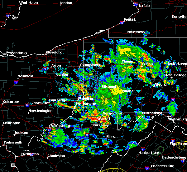 At 345 pm edt, a severe thunderstorm was located near newburg, or 11 miles northeast of grafton, moving southeast at 10 mph (radar). Hazards include wind gusts to 60 mph and quarter-size hail. Hail damage to vehicles. Damage to trees and power lines. At 345 pm edt, a severe thunderstorm was located near newburg, or 11 miles northeast of grafton, moving southeast at 10 mph (radar). Hazards include wind gusts to 60 mph and quarter-size hail. Hail damage to vehicles. Damage to trees and power lines.
|
| 5/10/2018 3:01 PM EDT |
 At 257 pm edt, a severe thunderstorm was located near newburg, or 7 miles northeast of grafton, moving east at 25 mph (radar). Hazards include wind gusts to 60 mph and quarter-size hail. Minor hail damage to vehicles is possible. expect wind damage to trees and power lines, resulting in some power outages. Locations impacted include, kingwood, rowlesburg, newburg, reedsville, albright, tunnelton, gladesville, fellowsville, browns chapel, israel,. At 257 pm edt, a severe thunderstorm was located near newburg, or 7 miles northeast of grafton, moving east at 25 mph (radar). Hazards include wind gusts to 60 mph and quarter-size hail. Minor hail damage to vehicles is possible. expect wind damage to trees and power lines, resulting in some power outages. Locations impacted include, kingwood, rowlesburg, newburg, reedsville, albright, tunnelton, gladesville, fellowsville, browns chapel, israel,.
|
| 5/10/2018 2:58 PM EDT |
 A severe thunderstorm warning remains in effect until 330 pm edt for southeastern monongalia and southwestern preston counties. at 255 pm edt, a severe thunderstorm was located near newburg, or near grafton, moving east at 25 mph. hazard. wind gusts to 60 mph and quarter-size hail. source. Radar. A severe thunderstorm warning remains in effect until 330 pm edt for southeastern monongalia and southwestern preston counties. at 255 pm edt, a severe thunderstorm was located near newburg, or near grafton, moving east at 25 mph. hazard. wind gusts to 60 mph and quarter-size hail. source. Radar.
|
| 5/10/2018 2:42 PM EDT |
 At 242 pm edt, a severe thunderstorm was located near winfield, or near grafton, moving east at 25 mph (radar). Hazards include wind gusts to 60 mph and quarter-size hail. Minor hail damage to vehicles is possible. Expect wind damage to trees and power lines, resulting in some power outages. At 242 pm edt, a severe thunderstorm was located near winfield, or near grafton, moving east at 25 mph (radar). Hazards include wind gusts to 60 mph and quarter-size hail. Minor hail damage to vehicles is possible. Expect wind damage to trees and power lines, resulting in some power outages.
|
| 6/23/2017 8:56 PM EDT |
 At 855 pm edt, a severe thunderstorm was located over newburg, or 7 miles east of grafton, moving east at 40 mph (radar). Hazards include 60 mph wind gusts. expect damage to trees and power lines, resulting in some power outages At 855 pm edt, a severe thunderstorm was located over newburg, or 7 miles east of grafton, moving east at 40 mph (radar). Hazards include 60 mph wind gusts. expect damage to trees and power lines, resulting in some power outages
|
| 6/23/2017 7:54 PM EDT |
 The tornado warning for southeastern monongalia, central preston and southeastern marion counties will expire at 800 pm edt, the storm which prompted the warning has weakened below severe limits and no longer appears capable of producing a tornado. therefore, the warning will be allowed to expire. a severe thunderstorm watch remains in effect until 1000 pm edt for northeastern west virginia. The tornado warning for southeastern monongalia, central preston and southeastern marion counties will expire at 800 pm edt, the storm which prompted the warning has weakened below severe limits and no longer appears capable of producing a tornado. therefore, the warning will be allowed to expire. a severe thunderstorm watch remains in effect until 1000 pm edt for northeastern west virginia.
|
| 6/23/2017 7:40 PM EDT |
 At 740 pm edt, a severe thunderstorm capable of producing a tornado was located near winfield, or 8 miles east of fairmont, moving east at 45 mph (radar indicated rotation). Hazards include tornado. Flying debris will be dangerous to those caught without shelter. mobile homes will be damaged or destroyed. damage to roofs, windows, and vehicles will occur. tree damage is likely. this dangerous storm will be near, kingwood around 800 pm edt. other locations impacted by this tornadic thunderstorm include valley point, masontown, brandonville, gladesville, albright, reedsville, browns chapel, bruceton mills and laurel run. this includes the following highways, interstate 68 in west virginia near mile marker 19, and between mile markers 22 and 25. Interstate 79 in west virginia between mile markers 140 and 147. At 740 pm edt, a severe thunderstorm capable of producing a tornado was located near winfield, or 8 miles east of fairmont, moving east at 45 mph (radar indicated rotation). Hazards include tornado. Flying debris will be dangerous to those caught without shelter. mobile homes will be damaged or destroyed. damage to roofs, windows, and vehicles will occur. tree damage is likely. this dangerous storm will be near, kingwood around 800 pm edt. other locations impacted by this tornadic thunderstorm include valley point, masontown, brandonville, gladesville, albright, reedsville, browns chapel, bruceton mills and laurel run. this includes the following highways, interstate 68 in west virginia near mile marker 19, and between mile markers 22 and 25. Interstate 79 in west virginia between mile markers 140 and 147.
|
| 6/23/2017 7:20 PM EDT |
 At 720 pm edt, a severe thunderstorm capable of producing a tornado was located over monongah, or near fairmont, moving east at 60 mph (radar indicated rotation). Hazards include tornado. Flying debris will be dangerous to those caught without shelter. mobile homes will be damaged or destroyed. damage to roofs, windows, and vehicles will occur. tree damage is likely. this dangerous storm will be near, fairmont around 725 pm edt. winfield around 730 pm edt. brookhaven around 740 pm edt. kingwood around 750 pm edt. other locations impacted by this tornadic thunderstorm include rivesville, valley point, booth, everettville, laurel run, brandonville, grant town, albright, baxter and reedsville. this includes the following highways, interstate 68 in west virginia between mile markers 1 and 6, and between mile markers 16 and 25. interstate 79 in west virginia between mile markers 130 and 151. Please report severe weather by calling 412-262-1988, posting to the nws pittsburgh facebook page, or using twitter @nwspittsburgh. At 720 pm edt, a severe thunderstorm capable of producing a tornado was located over monongah, or near fairmont, moving east at 60 mph (radar indicated rotation). Hazards include tornado. Flying debris will be dangerous to those caught without shelter. mobile homes will be damaged or destroyed. damage to roofs, windows, and vehicles will occur. tree damage is likely. this dangerous storm will be near, fairmont around 725 pm edt. winfield around 730 pm edt. brookhaven around 740 pm edt. kingwood around 750 pm edt. other locations impacted by this tornadic thunderstorm include rivesville, valley point, booth, everettville, laurel run, brandonville, grant town, albright, baxter and reedsville. this includes the following highways, interstate 68 in west virginia between mile markers 1 and 6, and between mile markers 16 and 25. interstate 79 in west virginia between mile markers 130 and 151. Please report severe weather by calling 412-262-1988, posting to the nws pittsburgh facebook page, or using twitter @nwspittsburgh.
|
| 6/23/2017 6:23 PM EDT |
 At 622 pm edt, severe thunderstorms were located along a line extending from near seven springs to near ursina to 7 miles north of kingwood, moving east at 40 mph (radar). Hazards include 60 mph wind gusts. Expect damage to trees and power lines, resulting in some power outages. locations impacted include, farmington, friendsville, reedsville, masontown, markleysburg, brandonville, chalkhill, bruceton mills, ohiopyle, mill run, valley point, laurel run, this includes the following highways, interstate 68 in maryland between mile markers 1 and 11. Interstate 68 in west virginia between mile markers 16 and 32. At 622 pm edt, severe thunderstorms were located along a line extending from near seven springs to near ursina to 7 miles north of kingwood, moving east at 40 mph (radar). Hazards include 60 mph wind gusts. Expect damage to trees and power lines, resulting in some power outages. locations impacted include, farmington, friendsville, reedsville, masontown, markleysburg, brandonville, chalkhill, bruceton mills, ohiopyle, mill run, valley point, laurel run, this includes the following highways, interstate 68 in maryland between mile markers 1 and 11. Interstate 68 in west virginia between mile markers 16 and 32.
|
| 6/23/2017 6:02 PM EDT |
 At 601 pm edt, severe thunderstorms were located along a line extending from near south connellsville to near farmington to near brookhaven, moving east at 50 mph (radar). Hazards include 60 mph wind gusts. Expect damage to trees and power lines, resulting in some power outages. locations impacted include, morgantown, uniontown, westover, south connellsville, farmington, friendsville, brookhaven, fairchance, dunbar, smithfield, reedsville, masontown, this includes the following highways, interstate 68 in maryland between mile markers 1 and 11. interstate 68 in west virginia between mile markers 1 and 32. Interstate 79 in west virginia between mile markers 142 and 150. At 601 pm edt, severe thunderstorms were located along a line extending from near south connellsville to near farmington to near brookhaven, moving east at 50 mph (radar). Hazards include 60 mph wind gusts. Expect damage to trees and power lines, resulting in some power outages. locations impacted include, morgantown, uniontown, westover, south connellsville, farmington, friendsville, brookhaven, fairchance, dunbar, smithfield, reedsville, masontown, this includes the following highways, interstate 68 in maryland between mile markers 1 and 11. interstate 68 in west virginia between mile markers 1 and 32. Interstate 79 in west virginia between mile markers 142 and 150.
|
| 6/23/2017 5:29 PM EDT |
 At 528 pm edt, severe thunderstorms were located along a line extending from near waynesburg to near cassville to mannington, moving east at 50 mph (radar). Hazards include 60 mph wind gusts. expect damage to trees and power lines, resulting in some power outages At 528 pm edt, severe thunderstorms were located along a line extending from near waynesburg to near cassville to mannington, moving east at 50 mph (radar). Hazards include 60 mph wind gusts. expect damage to trees and power lines, resulting in some power outages
|
| 5/5/2017 7:26 PM EDT |
 The severe thunderstorm warning for west central garrett, south central fayette and northern preston counties will expire at 730 pm edt, the storm that prompted the warning has weakened below severe limits. therefore, the warning will be allowed to expire. The severe thunderstorm warning for west central garrett, south central fayette and northern preston counties will expire at 730 pm edt, the storm that prompted the warning has weakened below severe limits. therefore, the warning will be allowed to expire.
|
| 5/5/2017 7:06 PM EDT |
 At 705 pm edt, a severe thunderstorm was located near kingwood, moving north at 35 mph (radar). Hazards include ping pong ball-size hail. People and animals outdoors will be injured. expect damage to roofs, siding, windows, and vehicles. Locations impacted include, kingwood, newburg, reedsville, masontown, albright, tunnelton, brandonville, bruceton mills, valley point, laurel run, hazelton, cranesville, this includes interstate 68 in west virginia between mile markers 17 and 30. At 705 pm edt, a severe thunderstorm was located near kingwood, moving north at 35 mph (radar). Hazards include ping pong ball-size hail. People and animals outdoors will be injured. expect damage to roofs, siding, windows, and vehicles. Locations impacted include, kingwood, newburg, reedsville, masontown, albright, tunnelton, brandonville, bruceton mills, valley point, laurel run, hazelton, cranesville, this includes interstate 68 in west virginia between mile markers 17 and 30.
|
| 5/5/2017 6:51 PM EDT |
 At 650 pm edt, a severe thunderstorm was located near newburg, or 7 miles west of rowlesburg, moving northeast at 25 mph (radar). Hazards include quarter-size hail. minor damage to vehicles is possible At 650 pm edt, a severe thunderstorm was located near newburg, or 7 miles west of rowlesburg, moving northeast at 25 mph (radar). Hazards include quarter-size hail. minor damage to vehicles is possible
|
| 4/20/2017 4:35 PM EDT |
 At 434 pm edt, a severe thunderstorm was located over newburg, or 8 miles west of rowlesburg, moving northeast at 45 mph (radar). Hazards include 60 mph wind gusts and quarter-size hail. Hail damage to vehicles is expected. Expect wind damage to trees and power lines, resulting in some power outages. At 434 pm edt, a severe thunderstorm was located over newburg, or 8 miles west of rowlesburg, moving northeast at 45 mph (radar). Hazards include 60 mph wind gusts and quarter-size hail. Hail damage to vehicles is expected. Expect wind damage to trees and power lines, resulting in some power outages.
|
| 3/1/2017 11:11 AM EST |
 At 1110 am est, severe thunderstorms were located along a line extending from 7 miles east of point marion to near philippi, moving east at 65 mph (radar). Hazards include 60 mph wind gusts. expect damage to trees and power lines, resulting in some power outages At 1110 am est, severe thunderstorms were located along a line extending from 7 miles east of point marion to near philippi, moving east at 65 mph (radar). Hazards include 60 mph wind gusts. expect damage to trees and power lines, resulting in some power outages
|
| 3/1/2017 5:02 AM EST |
 At 501 am est, a severe thunderstorm was located over winfield, or near fairmont, moving east at 75 mph (radar). Hazards include 60 mph wind gusts and quarter-size hail. Hail damage to vehicles is expected. Expect wind damage to trees and power lines, resulting in some power outages. At 501 am est, a severe thunderstorm was located over winfield, or near fairmont, moving east at 75 mph (radar). Hazards include 60 mph wind gusts and quarter-size hail. Hail damage to vehicles is expected. Expect wind damage to trees and power lines, resulting in some power outages.
|
| 2/12/2017 8:46 PM EST |
 At 846 pm est, severe thunderstorms were located along a line extending from 7 miles northwest of ursina to near mannington, moving east at 50 mph (radar). Hazards include 60 mph wind gusts. expect damage to trees and power lines, resulting in some power outages At 846 pm est, severe thunderstorms were located along a line extending from 7 miles northwest of ursina to near mannington, moving east at 50 mph (radar). Hazards include 60 mph wind gusts. expect damage to trees and power lines, resulting in some power outages
|
| 10/20/2016 8:34 PM EDT |
 At 833 pm edt, a severe thunderstorm was located near kingwood, moving northeast at 40 mph (radar indicated). Hazards include 60 mph wind gusts and penny size hail. Expect damage to trees and power lines. resulting in some power outages. locations impacted include, kingwood, terra alta, rowlesburg, farmington, friendsville, accident, brookhaven, reedsville, masontown, albright, tunnelton and markleysburg. this includes the following highways, interstate 68 in maryland between mile markers 1 and 7. interstate 68 in west virginia between mile markers 14 and 32. Please report severe weather by calling 412-262- 1988, posting to the nws pittsburgh facebook page, or using twitter @nwspittsburgh. At 833 pm edt, a severe thunderstorm was located near kingwood, moving northeast at 40 mph (radar indicated). Hazards include 60 mph wind gusts and penny size hail. Expect damage to trees and power lines. resulting in some power outages. locations impacted include, kingwood, terra alta, rowlesburg, farmington, friendsville, accident, brookhaven, reedsville, masontown, albright, tunnelton and markleysburg. this includes the following highways, interstate 68 in maryland between mile markers 1 and 7. interstate 68 in west virginia between mile markers 14 and 32. Please report severe weather by calling 412-262- 1988, posting to the nws pittsburgh facebook page, or using twitter @nwspittsburgh.
|
| 10/20/2016 8:15 PM EDT |
 At 815 pm edt, a severe thunderstorm was located near newburg, or 9 miles west of kingwood, moving northeast at 40 mph (radar indicated). Hazards include 60 mph wind gusts and nickel size hail. Expect damage to trees and power lines. Resulting in some power outages. At 815 pm edt, a severe thunderstorm was located near newburg, or 9 miles west of kingwood, moving northeast at 40 mph (radar indicated). Hazards include 60 mph wind gusts and nickel size hail. Expect damage to trees and power lines. Resulting in some power outages.
|
| 8/16/2016 7:00 PM EDT |
 At 700 pm edt, severe thunderstorms were located along a line extending from near fairdale to near morgantown to near winfield, moving east at 45 mph (radar indicated). Hazards include 60 mph wind gusts. Expect damage to trees and power lines. Resulting in some power outages. At 700 pm edt, severe thunderstorms were located along a line extending from near fairdale to near morgantown to near winfield, moving east at 45 mph (radar indicated). Hazards include 60 mph wind gusts. Expect damage to trees and power lines. Resulting in some power outages.
|
| 8/15/2016 3:14 PM EDT |
 At 313 pm edt, a severe thunderstorm was located near kingwood, moving east at 35 mph (radar indicated). Hazards include 60 mph wind gusts and quarter size hail. Hail damage to vehicles is expected. expect wind damage to trees and power lines, resulting in some power outages. locations impacted include, kingwood, terra alta, reedsville, albright, tunnelton and cranesville. Please report severe weather by calling 4 1 2, 2 6 2, 1 9 8 8, posting to the nws pittsburgh facebook page, or using twitter @nwspittsburgh. At 313 pm edt, a severe thunderstorm was located near kingwood, moving east at 35 mph (radar indicated). Hazards include 60 mph wind gusts and quarter size hail. Hail damage to vehicles is expected. expect wind damage to trees and power lines, resulting in some power outages. locations impacted include, kingwood, terra alta, reedsville, albright, tunnelton and cranesville. Please report severe weather by calling 4 1 2, 2 6 2, 1 9 8 8, posting to the nws pittsburgh facebook page, or using twitter @nwspittsburgh.
|
| 8/15/2016 2:57 PM EDT |
 At 256 pm edt, a severe thunderstorm was located over newburg, or 7 miles northeast of grafton, moving east at 35 mph (radar indicated). Hazards include 60 mph wind gusts and quarter size hail. Hail damage to vehicles is expected. Expect wind damage to trees and power lines, resulting in some power outages. At 256 pm edt, a severe thunderstorm was located over newburg, or 7 miles northeast of grafton, moving east at 35 mph (radar indicated). Hazards include 60 mph wind gusts and quarter size hail. Hail damage to vehicles is expected. Expect wind damage to trees and power lines, resulting in some power outages.
|
| 7/25/2016 2:15 PM EDT |
 At 214 pm edt, severe thunderstorms were located along a line extending from 9 miles northeast of kingwood to near newburg, moving east at 15 mph (radar indicated). Hazards include 60 mph wind gusts and penny size hail. Expect damage to trees and power lines. Resulting in some power outages. At 214 pm edt, severe thunderstorms were located along a line extending from 9 miles northeast of kingwood to near newburg, moving east at 15 mph (radar indicated). Hazards include 60 mph wind gusts and penny size hail. Expect damage to trees and power lines. Resulting in some power outages.
|
| 6/16/2016 5:30 PM EDT |
 At 529 pm edt, severe thunderstorms were located along a line extending from near ursina to near kingwood, moving southeast at 40 mph (radar indicated). Hazards include 60 mph wind gusts and quarter size hail. Hail damage to vehicles is expected. expect wind damage to trees and power lines, resulting in some power outages. locations impacted include, kingwood, oakland, terra alta, rowlesburg, bittinger, grantsville, friendsville, newburg, accident, reedsville, albright, tunnelton, markleysburg, brandonville, hazelton, selbysport, piney grove, israel, hutton and keysers ridge. this includes the following highways, interstate 68 in maryland between mile markers 1 and 24. interstate 68 in west virginia between mile markers 24 and 32. Please report severe weather by calling 4 1 2, 2 6 2, 1 9 8 8, posting to the nws pittsburgh facebook page, or using twitter @nwspittsburgh. At 529 pm edt, severe thunderstorms were located along a line extending from near ursina to near kingwood, moving southeast at 40 mph (radar indicated). Hazards include 60 mph wind gusts and quarter size hail. Hail damage to vehicles is expected. expect wind damage to trees and power lines, resulting in some power outages. locations impacted include, kingwood, oakland, terra alta, rowlesburg, bittinger, grantsville, friendsville, newburg, accident, reedsville, albright, tunnelton, markleysburg, brandonville, hazelton, selbysport, piney grove, israel, hutton and keysers ridge. this includes the following highways, interstate 68 in maryland between mile markers 1 and 24. interstate 68 in west virginia between mile markers 24 and 32. Please report severe weather by calling 4 1 2, 2 6 2, 1 9 8 8, posting to the nws pittsburgh facebook page, or using twitter @nwspittsburgh.
|
| 6/16/2016 5:15 PM EDT | Tree down in reedsville in preston county WV, 2.2 miles N of Reedsville, WV |
| 6/16/2016 5:10 PM EDT |
 The tornado warning for northwestern preston and eastern monongalia counties will expire at 515 pm edt, the tornado threat has diminished and the tornado warning has been cancelled. however, large hail and damaging winds remain likely and a severe thunderstorm warning remains in effect for the area. a severe thunderstorm watch remains in effect until 1000 pm edt for northeastern and northern west virginia. The tornado warning for northwestern preston and eastern monongalia counties will expire at 515 pm edt, the tornado threat has diminished and the tornado warning has been cancelled. however, large hail and damaging winds remain likely and a severe thunderstorm warning remains in effect for the area. a severe thunderstorm watch remains in effect until 1000 pm edt for northeastern and northern west virginia.
|
| 6/16/2016 5:09 PM EDT |
 At 509 pm edt, severe thunderstorms were located along a line extending from near seven springs to 8 miles northeast of brookhaven to near bridgeport, moving east at 45 mph (radar indicated). Hazards include 60 mph wind gusts and quarter size hail. Hail damage to vehicles is expected. expect wind damage to trees and power lines, resulting in some power outages. locations impacted include, morgantown, fairmont, uniontown, connellsville, westover, kingwood, oakland, star city, terra alta, rowlesburg, bittinger, pleasant valley, winfield, south connellsville, farmington, barrackville, point marion, monongah, granville and grantsville. this includes the following highways, interstate 68 in maryland between mile markers 1 and 24. interstate 68 in west virginia between mile markers 1 and 32. interstate 79 in west virginia between mile markers 131 and 154. Please report severe weather by calling 4 1 2, 2 6 2, 1 9 8 8, posting to the nws pittsburgh facebook page, or using twitter @nwspittsburgh. At 509 pm edt, severe thunderstorms were located along a line extending from near seven springs to 8 miles northeast of brookhaven to near bridgeport, moving east at 45 mph (radar indicated). Hazards include 60 mph wind gusts and quarter size hail. Hail damage to vehicles is expected. expect wind damage to trees and power lines, resulting in some power outages. locations impacted include, morgantown, fairmont, uniontown, connellsville, westover, kingwood, oakland, star city, terra alta, rowlesburg, bittinger, pleasant valley, winfield, south connellsville, farmington, barrackville, point marion, monongah, granville and grantsville. this includes the following highways, interstate 68 in maryland between mile markers 1 and 24. interstate 68 in west virginia between mile markers 1 and 32. interstate 79 in west virginia between mile markers 131 and 154. Please report severe weather by calling 4 1 2, 2 6 2, 1 9 8 8, posting to the nws pittsburgh facebook page, or using twitter @nwspittsburgh.
|
| 6/16/2016 5:03 PM EDT |
 At 502 pm edt, a severe thunderstorm capable of producing a tornado was located near morgantown, moving southeast at 35 mph (radar indicated rotation). Hazards include tornado. Damage to roofs. windows. and vehicles will occur. tree damage is likely. this tornadic thunderstorm will remain over mainly rural areas of northwestern preston and eastern monongalia counties, including the following locations: booth, browns chapel, gladesville, masontown, reedsville and cheat lake. this includes the following highways, interstate 68 in west virginia between mile markers 1 and 8. interstate 79 in west virginia between mile markers 145 and 152. Please report severe weather by calling 4 1 2, 2 6 2, 1 9 8 8, posting to the nws pittsburgh facebook page, or using twitter @nwspittsburgh. At 502 pm edt, a severe thunderstorm capable of producing a tornado was located near morgantown, moving southeast at 35 mph (radar indicated rotation). Hazards include tornado. Damage to roofs. windows. and vehicles will occur. tree damage is likely. this tornadic thunderstorm will remain over mainly rural areas of northwestern preston and eastern monongalia counties, including the following locations: booth, browns chapel, gladesville, masontown, reedsville and cheat lake. this includes the following highways, interstate 68 in west virginia between mile markers 1 and 8. interstate 79 in west virginia between mile markers 145 and 152. Please report severe weather by calling 4 1 2, 2 6 2, 1 9 8 8, posting to the nws pittsburgh facebook page, or using twitter @nwspittsburgh.
|
| 6/16/2016 4:47 PM EDT |
 At 447 pm edt, a severe thunderstorm capable of producing a tornado was located over cassville, or near star city, moving southeast at 35 mph (radar indicated rotation). Hazards include tornado. Flying debris will be dangerous to those caught without shelter. mobile homes will be damaged or destroyed. damage to roofs, windows, and vehicles will occur. tree damage is likely. this dangerous storm will be near, morgantown, westover, star city and granville around 455 pm edt. brookhaven around 505 pm edt. other locations impacted by this tornadic thunderstorm include browns chapel, core, booth, georgetown, gladesville, masontown, osage. everettville, reedsville and cheat lake. this includes the following highways, interstate 68 in west virginia between mile markers 1 and 8. interstate 79 in west virginia between mile markers 145 and 159. Please report severe weather by calling 4 1 2, 2 6 2, 1 9 8 8, posting to the nws pittsburgh facebook page, or using twitter @nwspittsburgh. At 447 pm edt, a severe thunderstorm capable of producing a tornado was located over cassville, or near star city, moving southeast at 35 mph (radar indicated rotation). Hazards include tornado. Flying debris will be dangerous to those caught without shelter. mobile homes will be damaged or destroyed. damage to roofs, windows, and vehicles will occur. tree damage is likely. this dangerous storm will be near, morgantown, westover, star city and granville around 455 pm edt. brookhaven around 505 pm edt. other locations impacted by this tornadic thunderstorm include browns chapel, core, booth, georgetown, gladesville, masontown, osage. everettville, reedsville and cheat lake. this includes the following highways, interstate 68 in west virginia between mile markers 1 and 8. interstate 79 in west virginia between mile markers 145 and 159. Please report severe weather by calling 4 1 2, 2 6 2, 1 9 8 8, posting to the nws pittsburgh facebook page, or using twitter @nwspittsburgh.
|
| 6/16/2016 4:43 PM EDT |
 At 442 pm edt, severe thunderstorms were located along a line extending from near perryopolis to cassville to near salem, moving east at 45 mph (radar indicated). Hazards include 60 mph wind gusts and quarter size hail. Hail damage to vehicles is expected. Expect wind damage to trees and power lines, resulting in some power outages. At 442 pm edt, severe thunderstorms were located along a line extending from near perryopolis to cassville to near salem, moving east at 45 mph (radar indicated). Hazards include 60 mph wind gusts and quarter size hail. Hail damage to vehicles is expected. Expect wind damage to trees and power lines, resulting in some power outages.
|
| 5/1/2016 7:29 PM EDT |
 At 725 pm edt, a severe thunderstorm was located near kingwood, moving east at 30 mph (trained weather spotters reported half dollar sized hail at reedsville at 724 pm). Hazards include 60 mph wind gusts and half dollar size hail. Hail damage to vehicles is expected. Expect wind damage to trees and power lines, resulting in some power outages. At 725 pm edt, a severe thunderstorm was located near kingwood, moving east at 30 mph (trained weather spotters reported half dollar sized hail at reedsville at 724 pm). Hazards include 60 mph wind gusts and half dollar size hail. Hail damage to vehicles is expected. Expect wind damage to trees and power lines, resulting in some power outages.
|
| 5/1/2016 7:27 PM EDT | Quarter sized hail reported 1.8 miles WNW of Reedsville, WV |
| 5/1/2016 7:24 PM EDT | Half Dollar sized hail reported 0.2 miles NNE of Reedsville, WV |
| 5/1/2016 7:12 PM EDT |
 At 711 pm edt, a severe thunderstorm was located near brookhaven, or 7 miles southeast of morgantown, moving east at 35 mph (radar indicated). Hazards include ping pong ball size hail and 60 mph wind gusts. People and animals outdoors will be injured. expect hail damage to roofs, siding, windows, and vehicles. expect wind damage to trees and power lines, resulting in some power outages. locations impacted include, morgantown, westover, kingwood, star city, terra alta, granville, brookhaven, reedsville, masontown, albright, tunnelton, bruceton mills, hazelton, valley point, laurel run, browns chapel, booth, gladesville, osage and cheat lake. this includes the following highways, interstate 68 in west virginia between mile markers 1 and 9, between mile markers 11 and 25, and between mile markers 27 and 30. interstate 79 in west virginia between mile markers 144 and 156. Please report severe weather by calling 4 1 2, 2 6 2, 1 9 8 8, posting to the nws pittsburgh facebook page, or using twitter @nwspittsburgh. At 711 pm edt, a severe thunderstorm was located near brookhaven, or 7 miles southeast of morgantown, moving east at 35 mph (radar indicated). Hazards include ping pong ball size hail and 60 mph wind gusts. People and animals outdoors will be injured. expect hail damage to roofs, siding, windows, and vehicles. expect wind damage to trees and power lines, resulting in some power outages. locations impacted include, morgantown, westover, kingwood, star city, terra alta, granville, brookhaven, reedsville, masontown, albright, tunnelton, bruceton mills, hazelton, valley point, laurel run, browns chapel, booth, gladesville, osage and cheat lake. this includes the following highways, interstate 68 in west virginia between mile markers 1 and 9, between mile markers 11 and 25, and between mile markers 27 and 30. interstate 79 in west virginia between mile markers 144 and 156. Please report severe weather by calling 4 1 2, 2 6 2, 1 9 8 8, posting to the nws pittsburgh facebook page, or using twitter @nwspittsburgh.
|
| 5/1/2016 6:45 PM EDT |
 At 644 pm edt, a severe thunderstorm was located near barrackville, or near fairmont, moving east at 35 mph (radar indicated). Hazards include ping pong ball size hail and 60 mph wind gusts. People and animals outdoors will be injured. expect hail damage to roofs, siding, windows, and vehicles. Expect wind damage to trees and power lines, resulting in some power outages. At 644 pm edt, a severe thunderstorm was located near barrackville, or near fairmont, moving east at 35 mph (radar indicated). Hazards include ping pong ball size hail and 60 mph wind gusts. People and animals outdoors will be injured. expect hail damage to roofs, siding, windows, and vehicles. Expect wind damage to trees and power lines, resulting in some power outages.
|
| 7/9/2015 2:07 PM EDT |
 At 206 pm edt, severe thunderstorms were located along a line extending from near brownsville to near uniontown to 6 miles northwest of newburg to near bridgeport, moving east at 45 mph (radar indicated). Hazards include 60 mph wind gusts. Expect damage to trees and some power outages locations impacted include, morgantown, fairmont, uniontown, connellsville, westover, kingwood, terra alta, rowlesburg, california, mount pleasant, scottdale, pleasant valley, brownsville, winfield, south connellsville, farmington, perryopolis, point marion, newburg and seven springs. A tornado watch remains in effect until 900 pm edt for western maryland, southwestern pennsylvania and northern west virginia. At 206 pm edt, severe thunderstorms were located along a line extending from near brownsville to near uniontown to 6 miles northwest of newburg to near bridgeport, moving east at 45 mph (radar indicated). Hazards include 60 mph wind gusts. Expect damage to trees and some power outages locations impacted include, morgantown, fairmont, uniontown, connellsville, westover, kingwood, terra alta, rowlesburg, california, mount pleasant, scottdale, pleasant valley, brownsville, winfield, south connellsville, farmington, perryopolis, point marion, newburg and seven springs. A tornado watch remains in effect until 900 pm edt for western maryland, southwestern pennsylvania and northern west virginia.
|
| 7/9/2015 1:44 PM EDT |
 At 143 pm edt, severe thunderstorms were located along a line extending from 6 miles west of fredericktown-millsboro to near fairdale to monongah to near salem, moving east at 45 mph (radar indicated). Hazards include 60 mph wind gusts. expect damage to trees and some power outages At 143 pm edt, severe thunderstorms were located along a line extending from 6 miles west of fredericktown-millsboro to near fairdale to monongah to near salem, moving east at 45 mph (radar indicated). Hazards include 60 mph wind gusts. expect damage to trees and some power outages
|
| 6/12/2015 8:37 PM EDT |
 A severe thunderstorm warning remains in effect until 915 pm edt for garrett. southeastern fayette. preston and southeastern monongalia counties. at 837 pm edt. severe thunderstorms were located along a line extending from near farmington to 8 miles southwest of friendsville to newburg. Moving east at 45 mph. A severe thunderstorm warning remains in effect until 915 pm edt for garrett. southeastern fayette. preston and southeastern monongalia counties. at 837 pm edt. severe thunderstorms were located along a line extending from near farmington to 8 miles southwest of friendsville to newburg. Moving east at 45 mph.
|
| 6/12/2015 8:37 PM EDT |
 At 837 pm edt, severe thunderstorms were located along a line extending from near farmington to 8 miles southwest of friendsville to newburg, moving east at 45 mph (radar indicated). Hazards include 60 mph wind gusts. Expect damage to roofs. siding and trees. Locations impacted include, kingwood, mountain lake park, oakland, terra alta, rowlesburg, bittinger, farmington, grantsville, loch lynn heights, friendsville, deer park, newburg, accident, kitzmiller, reedsville, masontown, albright, tunnelton, markleysburg and brandonville. At 837 pm edt, severe thunderstorms were located along a line extending from near farmington to 8 miles southwest of friendsville to newburg, moving east at 45 mph (radar indicated). Hazards include 60 mph wind gusts. Expect damage to roofs. siding and trees. Locations impacted include, kingwood, mountain lake park, oakland, terra alta, rowlesburg, bittinger, farmington, grantsville, loch lynn heights, friendsville, deer park, newburg, accident, kitzmiller, reedsville, masontown, albright, tunnelton, markleysburg and brandonville.
|
| 6/12/2015 8:19 PM EDT |
 At 818 pm edt, severe thunderstorms were located along a line extending from 7 miles southeast of masontown to near brookhaven to near grafton, moving east at 40 mph (radar indicated). Hazards include 60 mph wind gusts. Expect damage to roofs. Siding and trees. At 818 pm edt, severe thunderstorms were located along a line extending from 7 miles southeast of masontown to near brookhaven to near grafton, moving east at 40 mph (radar indicated). Hazards include 60 mph wind gusts. Expect damage to roofs. Siding and trees.
|
| 6/8/2015 2:20 PM EDT |
 At 220 pm edt, a severe thunderstorm was located near kingwood, moving east at 35 mph (radar indicated). Hazards include 60 mph wind gusts. Expect damage to roofs. Siding and trees. At 220 pm edt, a severe thunderstorm was located near kingwood, moving east at 35 mph (radar indicated). Hazards include 60 mph wind gusts. Expect damage to roofs. Siding and trees.
|
| 7/7/2013 12:35 PM EDT | Large tree limbs down on dogtown rd in preston county WV, 2.2 miles N of Reedsville, WV |
| 6/29/2012 8:05 PM EDT | Trees down and a garage destroye in preston county WV, 0.2 miles NNE of Reedsville, WV |
Hail Maps for Reedsville, WV


Connect with Interactive Hail Maps