

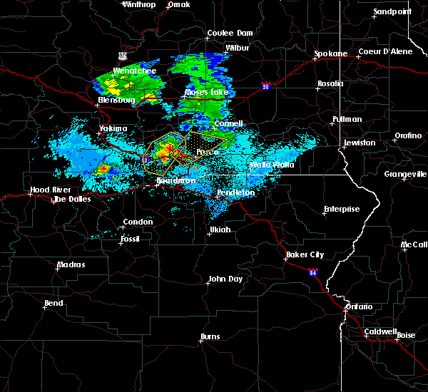
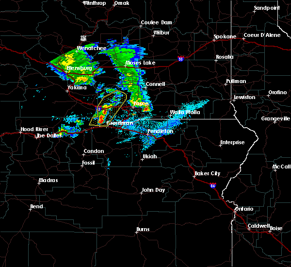
Hail Map for Richland, WA
The Richland, WA area has had 0 reports of on-the-ground hail by trained spotters, and has been under severe weather warnings 0 times during the past 12 months. Doppler radar has detected hail at or near Richland, WA on 2 occasions.
| Name: | Richland, WA |
| Where Located: | 47.6 miles WNW of Walla Walla, WA |
| Map: | Google Map for Richland, WA |
| Population: | 48058 |
| Housing Units: | 20876 |
| More Info: | Search Google for Richland, WA |
0
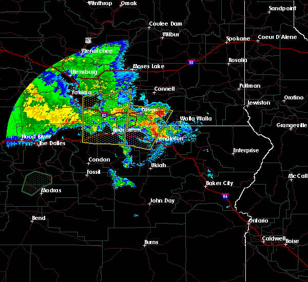
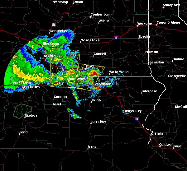
The Top Recent Hail Date for Richland, WA is Tuesday, May 28, 2019 (2nd out of 2)

Hail and Wind Damage Spotted near Richland, WA
| Date / Time | Report Details |
|---|---|
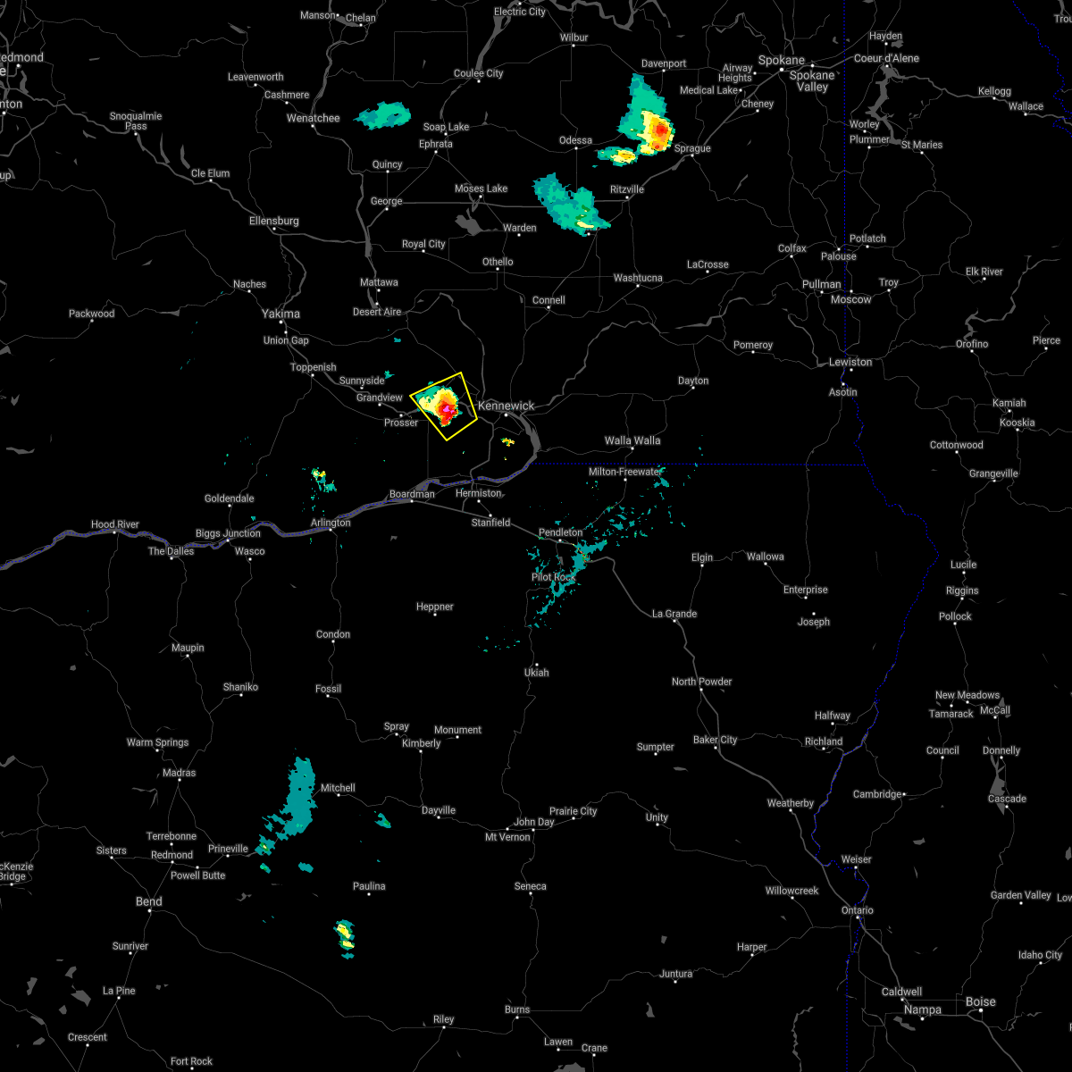
| 5/30/2020 5:32 PM PDT |
 At 531 pm pdt, severe thunderstorms were located along a line extending from near eltopia to 8 miles east of milton-freewater, moving northeast at 45 mph (radar indicated). Hazards include 70 mph wind gusts and ping pong ball size hail. People and animals outdoors will be injured. expect hail damage to roofs, siding, windows, and vehicles. expect considerable tree damage. wind damage is also likely to mobile homes, roofs, and outbuildings. Locations impacted include, kennewick, pasco, walla walla, connell, dayton, college place, waitsburg, mesa, prescott, kahlotus, starbuck, huntsville, snake river, pleasant view, touchet, ayer, dixie, umapine, wallula and delaney. At 531 pm pdt, severe thunderstorms were located along a line extending from near eltopia to 8 miles east of milton-freewater, moving northeast at 45 mph (radar indicated). Hazards include 70 mph wind gusts and ping pong ball size hail. People and animals outdoors will be injured. expect hail damage to roofs, siding, windows, and vehicles. expect considerable tree damage. wind damage is also likely to mobile homes, roofs, and outbuildings. Locations impacted include, kennewick, pasco, walla walla, connell, dayton, college place, waitsburg, mesa, prescott, kahlotus, starbuck, huntsville, snake river, pleasant view, touchet, ayer, dixie, umapine, wallula and delaney.
|
| 5/30/2020 5:10 PM PDT |
 At 508 pm pdt, severe thunderstorms were located along a line extending from island view to umatilla reservation, moving northeast at 55 mph (radar indicated). Hazards include 70 mph wind gusts and quarter size hail. Hail damage to vehicles is expected. expect considerable tree damage. Wind damage is also likely to mobile homes, roofs, and outbuildings. At 508 pm pdt, severe thunderstorms were located along a line extending from island view to umatilla reservation, moving northeast at 55 mph (radar indicated). Hazards include 70 mph wind gusts and quarter size hail. Hail damage to vehicles is expected. expect considerable tree damage. Wind damage is also likely to mobile homes, roofs, and outbuildings.
|
| 5/30/2020 5:05 PM PDT |
 At 503 pm pdt, an area of strong to severe thunderstorms were located along a line extending from yakama reservation to 6 miles northwest of benton city, moving north at 50 to 60 mph (radar indicated). Hazards include 60 mph wind gusts and small hail. in addition, significant blowing dust may occur near freshly plowed fields, resulting in rapidly decreasing visibilities. Expect damage to roofs, siding, and trees. Locations impacted include, richland, sunnyside, prosser, grandview, toppenish, granger, benton city, zillah, mabton, hanford reservation and satus. At 503 pm pdt, an area of strong to severe thunderstorms were located along a line extending from yakama reservation to 6 miles northwest of benton city, moving north at 50 to 60 mph (radar indicated). Hazards include 60 mph wind gusts and small hail. in addition, significant blowing dust may occur near freshly plowed fields, resulting in rapidly decreasing visibilities. Expect damage to roofs, siding, and trees. Locations impacted include, richland, sunnyside, prosser, grandview, toppenish, granger, benton city, zillah, mabton, hanford reservation and satus.
|
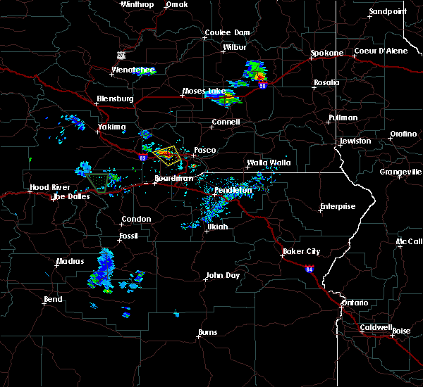
| 5/30/2020 4:48 PM PDT |
 At 447 pm pdt, a severe thunderstorm was located over burbank, or 7 miles southeast of pasco, moving north at 45 mph (radar indicated). Hazards include two inch hail and 70 mph wind gusts. People and animals outdoors will be injured. expect hail damage to roofs, siding, windows, and vehicles. expect considerable tree damage. wind damage is also likely to mobile homes, roofs, and outbuildings. blowing dust being reported with this storm and could greatly reduce visibility. Locations impacted include, kennewick, pasco, richland, hermiston, pendleton, west richland, umatilla, stanfield, echo, west pasco, plymouth, wallula, badger, burbank, holdman, island view, rieth, touchet, finley and eureka. At 447 pm pdt, a severe thunderstorm was located over burbank, or 7 miles southeast of pasco, moving north at 45 mph (radar indicated). Hazards include two inch hail and 70 mph wind gusts. People and animals outdoors will be injured. expect hail damage to roofs, siding, windows, and vehicles. expect considerable tree damage. wind damage is also likely to mobile homes, roofs, and outbuildings. blowing dust being reported with this storm and could greatly reduce visibility. Locations impacted include, kennewick, pasco, richland, hermiston, pendleton, west richland, umatilla, stanfield, echo, west pasco, plymouth, wallula, badger, burbank, holdman, island view, rieth, touchet, finley and eureka.
|
| 5/30/2020 4:45 PM PDT |
 At 443 pm pdt, an area of severe thunderstorms were located along a line extending from near roosevelt to 11 miles north of paterson, moving north at 45 to 55 mph (radar indicated and spotter verified with several reports of winds in excess of 60 mph and significant blowing dust). Hazards include 70 mph wind gusts and quarter size hail, as well as blowing dust leading to near zero visibilities. Hail damage to vehicles is expected. expect considerable tree damage. Wind damage is also likely to mobile homes, roofs, and outbuildings. At 443 pm pdt, an area of severe thunderstorms were located along a line extending from near roosevelt to 11 miles north of paterson, moving north at 45 to 55 mph (radar indicated and spotter verified with several reports of winds in excess of 60 mph and significant blowing dust). Hazards include 70 mph wind gusts and quarter size hail, as well as blowing dust leading to near zero visibilities. Hail damage to vehicles is expected. expect considerable tree damage. Wind damage is also likely to mobile homes, roofs, and outbuildings.
|
| 5/30/2020 4:10 PM PDT |
 At 408 pm pdt, a severe thunderstorm was located near echo, or 10 miles southeast of hermiston, moving north at 45 mph (radar indicated). Hazards include two inch hail and 70 mph wind gusts. People and animals outdoors will be injured. expect hail damage to roofs, siding, windows, and vehicles. expect considerable tree damage. Wind damage is also likely to mobile homes, roofs, and outbuildings. At 408 pm pdt, a severe thunderstorm was located near echo, or 10 miles southeast of hermiston, moving north at 45 mph (radar indicated). Hazards include two inch hail and 70 mph wind gusts. People and animals outdoors will be injured. expect hail damage to roofs, siding, windows, and vehicles. expect considerable tree damage. Wind damage is also likely to mobile homes, roofs, and outbuildings.
|
| 5/28/2019 7:58 PM PDT |
 The severe thunderstorm warning for central benton county will expire at 800 pm pdt, the storm which prompted the warning has weakened below severe limits, and has exited the warned area. therefore, the warning will be allowed to expire. The severe thunderstorm warning for central benton county will expire at 800 pm pdt, the storm which prompted the warning has weakened below severe limits, and has exited the warned area. therefore, the warning will be allowed to expire.
|
| 5/28/2019 7:35 PM PDT |
 At 735 pm pdt, a severe thunderstorm was located over benton city, or 10 miles west of richland, moving southeast at 10 mph (radar indicated). Hazards include quarter size hail. damage to vehicles is expected At 735 pm pdt, a severe thunderstorm was located over benton city, or 10 miles west of richland, moving southeast at 10 mph (radar indicated). Hazards include quarter size hail. damage to vehicles is expected
|
| 4/5/2019 5:00 PM PDT | Mesonet station h300a hanford 300 area. outflow wind gusts from nearby thunderstorm in benton county WA, 5.7 miles S of Richland, WA |
| 6/26/2017 5:45 PM PDT | Storm damage reported in benton county WA, 6 miles SSE of Richland, WA |
| 5/4/2017 9:25 PM PDT |
 At 925 pm pdt, doppler radar indicated a severe thunderstorm capable of producing quarter size hail and damaging winds in excess of 60 mph. this storm was located over richland, and moving northeast at 40 mph. At 925 pm pdt, doppler radar indicated a severe thunderstorm capable of producing quarter size hail and damaging winds in excess of 60 mph. this storm was located over richland, and moving northeast at 40 mph.
|
| 5/4/2017 9:15 PM PDT |
 At 914 pm pdt, doppler radar indicated a severe thunderstorm capable of producing quarter size hail and damaging winds in excess of 60 mph. this storm was located 8 miles northwest of benton city, or 10 miles northeast of prosser, moving northeast at 35 mph. locations impacted include, richland, prosser, west richland, grandview, benton city and hanford reservation. At 914 pm pdt, doppler radar indicated a severe thunderstorm capable of producing quarter size hail and damaging winds in excess of 60 mph. this storm was located 8 miles northwest of benton city, or 10 miles northeast of prosser, moving northeast at 35 mph. locations impacted include, richland, prosser, west richland, grandview, benton city and hanford reservation.
|
| 5/4/2017 8:54 PM PDT |
 At 854 pm pdt, doppler radar indicated a severe thunderstorm capable of producing quarter size hail and damaging winds in excess of 60 mph. this storm was located over prosser, and moving northeast at 35 mph. At 854 pm pdt, doppler radar indicated a severe thunderstorm capable of producing quarter size hail and damaging winds in excess of 60 mph. this storm was located over prosser, and moving northeast at 35 mph.
|
| 5/4/2016 8:09 PM PDT |
 At 805 pm pdt, trained weather spotters reported severe thunderstorms producing damaging winds in excess of 60 mph. these storms were located along a line extending from near plymouth to near walla walla, moving north at 30 mph. these winds will push into the tri- cities area around 830 pm. locations impacted include, kennewick, pasco, richland, walla walla, prosser, connell, dayton, west richland, grandview, college place, benton city, waitsburg, mesa, prescott, kahlotus, starbuck, turner, snake river, eltopia and garrett. At 805 pm pdt, trained weather spotters reported severe thunderstorms producing damaging winds in excess of 60 mph. these storms were located along a line extending from near plymouth to near walla walla, moving north at 30 mph. these winds will push into the tri- cities area around 830 pm. locations impacted include, kennewick, pasco, richland, walla walla, prosser, connell, dayton, west richland, grandview, college place, benton city, waitsburg, mesa, prescott, kahlotus, starbuck, turner, snake river, eltopia and garrett.
|
| 5/4/2016 7:46 PM PDT |
 At 741 pm pdt, trained weather spotters reported severe thunderstorms producing damaging winds in excess of 60 mph. these storms are located over northern umatilla and morrow counties. the winds will push across the washington border and the lower columbia basin and the foothills of washington over the next hour. locations impacted include, kennewick, pasco, richland, walla walla, hermiston, pendleton, prosser, connell, boardman, dayton, meacham, west richland, grandview, college place, milton-freewater, umatilla, benton city, stanfield, irrigon and pilot rock. At 741 pm pdt, trained weather spotters reported severe thunderstorms producing damaging winds in excess of 60 mph. these storms are located over northern umatilla and morrow counties. the winds will push across the washington border and the lower columbia basin and the foothills of washington over the next hour. locations impacted include, kennewick, pasco, richland, walla walla, hermiston, pendleton, prosser, connell, boardman, dayton, meacham, west richland, grandview, college place, milton-freewater, umatilla, benton city, stanfield, irrigon and pilot rock.
|
| 5/4/2016 7:20 PM PDT |
 At 719 pm pdt, the public reported a line of severe thunderstorms producing damaging winds in excess of 60 mph. these storms were located along a line extending from 9 miles northeast of ione to umatilla reservation, and moving north at 30 mph. At 719 pm pdt, the public reported a line of severe thunderstorms producing damaging winds in excess of 60 mph. these storms were located along a line extending from 9 miles northeast of ione to umatilla reservation, and moving north at 30 mph.
|
| 11/17/2015 3:14 PM PST | Storm damage reported in benton county WA, 0.8 miles S of Richland, WA |
| 6/28/2015 10:32 PM PDT |
 At 1030 pm pdt, doppler radar indicated a severe thunderstorm capable of producing damaging winds in excess of 60 mph. this storm was located along a line from southern benton county to southern walla walla county, moving north at 45 mph. locations impacted include, kennewick, pasco, richland, walla walla, hermiston, pendleton, sunnyside, prosser, boardman, dayton, meacham, west richland, grandview, college place, milton-freewater, umatilla, benton city, mabton, stanfield and irrigon. At 1030 pm pdt, doppler radar indicated a severe thunderstorm capable of producing damaging winds in excess of 60 mph. this storm was located along a line from southern benton county to southern walla walla county, moving north at 45 mph. locations impacted include, kennewick, pasco, richland, walla walla, hermiston, pendleton, sunnyside, prosser, boardman, dayton, meacham, west richland, grandview, college place, milton-freewater, umatilla, benton city, mabton, stanfield and irrigon.
|
| 6/28/2015 9:51 PM PDT |
 At 949 pm pdt, doppler radar indicated a severe thunderstorm capable of producing damaging winds in excess of 60 mph. this storm was located 17 miles northwest of ukiah, or 18 miles east of heppner, and moving north at 40 mph. At 949 pm pdt, doppler radar indicated a severe thunderstorm capable of producing damaging winds in excess of 60 mph. this storm was located 17 miles northwest of ukiah, or 18 miles east of heppner, and moving north at 40 mph.
|
| 9/15/2013 6:53 PM PDT | Weather station recorded sustained winds 45 mph gusting to 60 mp in franklin county WA, 5.8 miles SSW of Richland, WA |
| 9/15/2013 6:45 PM PDT | Hanford mesonet in franklin county WA, 10.1 miles SSW of Richland, WA |
| 9/15/2013 6:45 PM PDT | At in benton county WA, 11.1 miles SSE of Richland, WA |
| 9/15/2013 6:45 PM PDT | At in benton county WA, 11.1 miles SSE of Richland, WA |
| 9/15/2013 6:33 PM PDT | 4 inch tree limbs down from estimated wind gusts to 50 mph. blowing dust restricting visibilit in benton county WA, 0.8 miles S of Richland, WA |
| 9/15/2013 6:30 PM PDT | Hanford mesonet in benton county WA, 5.7 miles S of Richland, WA |
| 9/5/2013 6:00 PM PDT | Few power lines down and limbs on powerlines. power out until friday morning for some customers in the count in benton county WA, 0.8 miles S of Richland, WA |
| 8/25/2013 6:25 PM PDT | Estimated wind gusts to 60 mph...also heavy rain and pea sized hai in benton county WA, 0.8 miles S of Richland, WA |
| 8/25/2013 6:15 PM PDT | Storm damage reported in benton county WA, 6 miles SSE of Richland, WA |
| 8/25/2013 6:15 PM PDT | Storm damage reported in benton county WA, 12.6 miles S of Richland, WA |
| 8/9/2013 9:15 PM PDT | Hanford mesonet site hanford fast flux test reported a wind gust of 58 mph. the site reported wind gusts of 47 mph or more for one hou in benton county WA, 11.1 miles SSE of Richland, WA |
| 8/9/2013 9:15 PM PDT | Hanford mesonet site hanford 300 area reported a wind gust of 58 mph. wind gusts of 45 mph or greater occured for 45 minute in benton county WA, 5.7 miles S of Richland, WA |
| 4/23/2012 10:00 PM PDT | Storm damage reported in franklin county WA, 11.3 miles SW of Richland, WA |
| 1/1/0001 12:00 AM | Richland airport recorded wind gust to 59 mp in benton county WA, 0.8 miles S of Richland, WA |
Hail Maps for Richland, WA


Connect with Interactive Hail Maps