

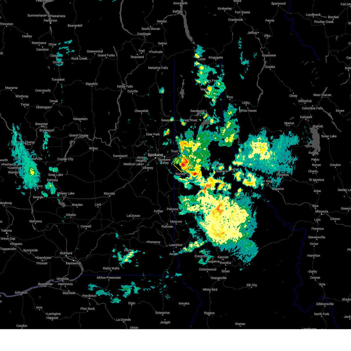
Hail Map for Rockford Bay, ID
The Rockford Bay, ID area has had 0 reports of on-the-ground hail by trained spotters, and has been under severe weather warnings 11 times during the past 12 months. Doppler radar has detected hail at or near Rockford Bay, ID on 4 occasions, including 1 occasion during the past year.
| Name: | Rockford Bay, ID |
| Where Located: | 26.9 miles ESE of Spokane, WA |
| Map: | Google Map for Rockford Bay, ID |
| Population: | 184 |
| Housing Units: | 455 |
| More Info: | Search Google for Rockford Bay, ID |
5
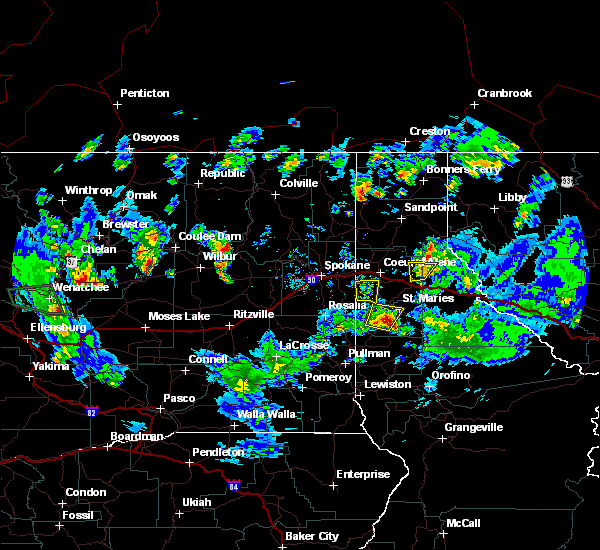
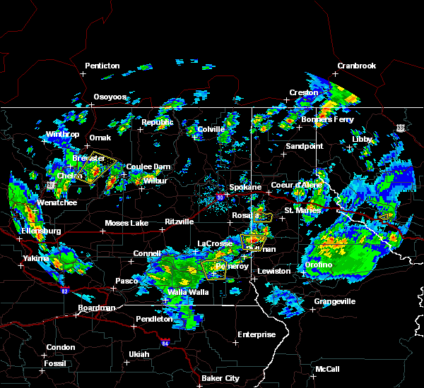
The Top Recent Hail Date for Rockford Bay, ID is Thursday, June 8, 2023 (1st out of 4)

Hail and Wind Damage Spotted near Rockford Bay, ID
| Date / Time | Report Details |
|---|---|
| 6/8/2023 4:57 PM PDT |
 The severe thunderstorm warning for northwestern benewah, southwestern kootenai and eastern spokane counties will expire at 500 pm pdt, the storms which prompted the warning have moved out of the area. therefore, the warning will be allowed to expire. however, gusty winds are still possible with these thunderstorms. The severe thunderstorm warning for northwestern benewah, southwestern kootenai and eastern spokane counties will expire at 500 pm pdt, the storms which prompted the warning have moved out of the area. therefore, the warning will be allowed to expire. however, gusty winds are still possible with these thunderstorms.
|
| 6/8/2023 4:34 PM PDT |
 At 433 pm pdt, severe thunderstorms were located along a line extending from near chattaroy to 9 miles west of plummer, moving west at 15 mph (trained weather spotters reported damage in greenacres at 426 pm). Hazards include 60 mph wind gusts and nickel size hail. Expect damage to roofs, siding, and trees. locations impacted include, spokane, spokane valley, post falls, liberty lake, nine mile falls, millwood, plummer, hauser, otis orchards-east farms, fairwood, otis orchards, green acres, trentwood, country homes, town and country, chattaroy, dishman, mead, fairfield, and rockford. this includes the following highways, interstate 90 in washington between mile markers 277 and 299. interstate 90 in idaho between mile markers 0 and 5. u. s. highway 95 in idaho between mile markers 391 and 420. u. s. highway 2 in washington between mile markers 282 and 305. u. s. highway 195 in washington between mile markers 75 and 95. u. s. highway 395 in washington between mile markers 165 and 177. hail threat, radar indicated max hail size, 0. 88 in wind threat, radar indicated max wind gust, 60 mph. At 433 pm pdt, severe thunderstorms were located along a line extending from near chattaroy to 9 miles west of plummer, moving west at 15 mph (trained weather spotters reported damage in greenacres at 426 pm). Hazards include 60 mph wind gusts and nickel size hail. Expect damage to roofs, siding, and trees. locations impacted include, spokane, spokane valley, post falls, liberty lake, nine mile falls, millwood, plummer, hauser, otis orchards-east farms, fairwood, otis orchards, green acres, trentwood, country homes, town and country, chattaroy, dishman, mead, fairfield, and rockford. this includes the following highways, interstate 90 in washington between mile markers 277 and 299. interstate 90 in idaho between mile markers 0 and 5. u. s. highway 95 in idaho between mile markers 391 and 420. u. s. highway 2 in washington between mile markers 282 and 305. u. s. highway 195 in washington between mile markers 75 and 95. u. s. highway 395 in washington between mile markers 165 and 177. hail threat, radar indicated max hail size, 0. 88 in wind threat, radar indicated max wind gust, 60 mph.
|
| 6/8/2023 4:25 PM PDT |
 At 423 pm pdt, severe thunderstorms were located along a line extending from 6 miles east of chattaroy to 7 miles west of plummer, moving west at 20 mph (trained weather spotters reported downed tree limbs and highway signs near lake coeur d`alene earlier with these storms). Hazards include 60 mph wind gusts and nickel size hail. Expect damage to roofs, siding, and trees. locations impacted include, spokane, spokane valley, post falls, rathdrum, liberty lake, nine mile falls, millwood, plummer, hauser, harrison, otis orchards-east farms, fairwood, otis orchards, green acres, trentwood, country homes, town and country, chattaroy, dishman, and mead. this includes the following highways, interstate 90 in washington between mile markers 277 and 299. interstate 90 in idaho between mile markers 0 and 8. u. s. highway 95 in idaho between mile markers 390 and 425. u. s. highway 2 in washington between mile markers 282 and 305. u. s. highway 195 in washington between mile markers 75 and 95. u. s. highway 395 in washington between mile markers 165 and 177. hail threat, radar indicated max hail size, 0. 88 in wind threat, radar indicated max wind gust, 60 mph. At 423 pm pdt, severe thunderstorms were located along a line extending from 6 miles east of chattaroy to 7 miles west of plummer, moving west at 20 mph (trained weather spotters reported downed tree limbs and highway signs near lake coeur d`alene earlier with these storms). Hazards include 60 mph wind gusts and nickel size hail. Expect damage to roofs, siding, and trees. locations impacted include, spokane, spokane valley, post falls, rathdrum, liberty lake, nine mile falls, millwood, plummer, hauser, harrison, otis orchards-east farms, fairwood, otis orchards, green acres, trentwood, country homes, town and country, chattaroy, dishman, and mead. this includes the following highways, interstate 90 in washington between mile markers 277 and 299. interstate 90 in idaho between mile markers 0 and 8. u. s. highway 95 in idaho between mile markers 390 and 425. u. s. highway 2 in washington between mile markers 282 and 305. u. s. highway 195 in washington between mile markers 75 and 95. u. s. highway 395 in washington between mile markers 165 and 177. hail threat, radar indicated max hail size, 0. 88 in wind threat, radar indicated max wind gust, 60 mph.
|
| 6/8/2023 4:10 PM PDT |
 At 409 pm pdt, severe thunderstorms were located along a line extending from near hauser to 6 miles west of harrison, moving west at 15 mph (radar indicated). Hazards include 60 mph wind gusts and nickel size hail. expect damage to roofs, siding, and trees At 409 pm pdt, severe thunderstorms were located along a line extending from near hauser to 6 miles west of harrison, moving west at 15 mph (radar indicated). Hazards include 60 mph wind gusts and nickel size hail. expect damage to roofs, siding, and trees
|
| 6/8/2023 3:53 PM PDT |
 At 353 pm pdt, a severe thunderstorm was located 8 miles south of coeur d`alene, moving west at 25 mph (radar indicated). Hazards include ping pong ball size hail and 60 mph wind gusts. People and animals outdoors will be injured. expect hail damage to roofs, siding, windows, and vehicles. expect wind damage to roofs, siding, and trees. locations impacted include, coeur d`alene. this includes u. s. highway 95 in idaho between mile markers 414 and 427. hail threat, radar indicated max hail size, 1. 50 in wind threat, radar indicated max wind gust, 60 mph. At 353 pm pdt, a severe thunderstorm was located 8 miles south of coeur d`alene, moving west at 25 mph (radar indicated). Hazards include ping pong ball size hail and 60 mph wind gusts. People and animals outdoors will be injured. expect hail damage to roofs, siding, windows, and vehicles. expect wind damage to roofs, siding, and trees. locations impacted include, coeur d`alene. this includes u. s. highway 95 in idaho between mile markers 414 and 427. hail threat, radar indicated max hail size, 1. 50 in wind threat, radar indicated max wind gust, 60 mph.
|
| 6/8/2023 3:42 PM PDT |
 At 342 pm pdt, a severe thunderstorm was located 7 miles south of coeur d`alene, moving west at 25 mph (law enforcement reported quarter size hail at mile marker 32 on interstate 90 at 322 pm). Hazards include 60 mph wind gusts and quarter size hail. Hail damage to vehicles is expected. expect wind damage to roofs, siding, and trees. locations impacted include, coeur d`alene, post falls, harrison, fernan lake village, huetter, beauty creek campground, and wolf creek campground. this includes the following highways, interstate 90 in idaho between mile markers 10 and 23. u. s. highway 95 in idaho between mile markers 414 and 431. hail threat, observed max hail size, 1. 00 in wind threat, radar indicated max wind gust, 60 mph. At 342 pm pdt, a severe thunderstorm was located 7 miles south of coeur d`alene, moving west at 25 mph (law enforcement reported quarter size hail at mile marker 32 on interstate 90 at 322 pm). Hazards include 60 mph wind gusts and quarter size hail. Hail damage to vehicles is expected. expect wind damage to roofs, siding, and trees. locations impacted include, coeur d`alene, post falls, harrison, fernan lake village, huetter, beauty creek campground, and wolf creek campground. this includes the following highways, interstate 90 in idaho between mile markers 10 and 23. u. s. highway 95 in idaho between mile markers 414 and 431. hail threat, observed max hail size, 1. 00 in wind threat, radar indicated max wind gust, 60 mph.
|
| 6/8/2023 3:28 PM PDT |
 At 328 pm pdt, a severe thunderstorm was located near fourth of july pass, or 9 miles southeast of coeur d`alene, moving west at 25 mph (radar indicated). Hazards include 60 mph wind gusts and quarter size hail. Hail damage to vehicles is expected. Expect wind damage to roofs, siding, and trees. At 328 pm pdt, a severe thunderstorm was located near fourth of july pass, or 9 miles southeast of coeur d`alene, moving west at 25 mph (radar indicated). Hazards include 60 mph wind gusts and quarter size hail. Hail damage to vehicles is expected. Expect wind damage to roofs, siding, and trees.
|
| 8/11/2022 5:40 PM PDT |
 At 539 pm pdt, a severe thunderstorm was located over liberty lake, or 7 miles southwest of post falls, moving north at 35 mph (broadcast media reported on social media of numerous trees down and multiple power outages in the rockford area). Hazards include golf ball size hail and 70 mph wind gusts. People and animals outdoors will be injured. expect hail damage to roofs, siding, windows, and vehicles. expect considerable tree damage. Wind damage is also likely to mobile homes, roofs, and outbuildings. At 539 pm pdt, a severe thunderstorm was located over liberty lake, or 7 miles southwest of post falls, moving north at 35 mph (broadcast media reported on social media of numerous trees down and multiple power outages in the rockford area). Hazards include golf ball size hail and 70 mph wind gusts. People and animals outdoors will be injured. expect hail damage to roofs, siding, windows, and vehicles. expect considerable tree damage. Wind damage is also likely to mobile homes, roofs, and outbuildings.
|
| 8/11/2022 5:31 PM PDT |
 At 529 pm pdt, a severe thunderstorm was located near liberty lake, or 10 miles south of post falls, moving northeast at 40 mph (public. at 5 pm, numerous power outages were reported near rockford). Hazards include tennis ball size hail and 70 mph wind gusts. People and animals outdoors will be injured. expect hail damage to roofs, siding, windows, and vehicles. expect considerable tree damage. wind damage is also likely to mobile homes, roofs, and outbuildings. locations impacted include, coeur d`alene, post falls, liberty lake, otis orchards-east farms, otis orchards, green acres, rockford, worley, fernan lake village, huetter and state line. this includes the following highways, interstate 90 in washington between mile markers 295 and 299. interstate 90 in idaho between mile markers 0 and 17. u. s. highway 95 in idaho between mile markers 402 and 431. thunderstorm damage threat, considerable hail threat, radar indicated max hail size, 2. 50 in wind threat, radar indicated max wind gust, 70 mph. At 529 pm pdt, a severe thunderstorm was located near liberty lake, or 10 miles south of post falls, moving northeast at 40 mph (public. at 5 pm, numerous power outages were reported near rockford). Hazards include tennis ball size hail and 70 mph wind gusts. People and animals outdoors will be injured. expect hail damage to roofs, siding, windows, and vehicles. expect considerable tree damage. wind damage is also likely to mobile homes, roofs, and outbuildings. locations impacted include, coeur d`alene, post falls, liberty lake, otis orchards-east farms, otis orchards, green acres, rockford, worley, fernan lake village, huetter and state line. this includes the following highways, interstate 90 in washington between mile markers 295 and 299. interstate 90 in idaho between mile markers 0 and 17. u. s. highway 95 in idaho between mile markers 402 and 431. thunderstorm damage threat, considerable hail threat, radar indicated max hail size, 2. 50 in wind threat, radar indicated max wind gust, 70 mph.
|
| 8/11/2022 5:21 PM PDT |
 At 519 pm pdt, a severe thunderstorm was located 11 miles south of liberty lake, or 14 miles southeast of spokane valley, moving north at 30 mph (radar indicated). Hazards include tennis ball size hail and 60 mph wind gusts. People and animals outdoors will be injured. expect hail damage to roofs, siding, windows, and vehicles. expect wind damage to roofs, siding, and trees. locations impacted include, spokane valley, coeur d`alene, post falls, liberty lake, green acres, otis orchards-east farms, otis orchards, trentwood, fairfield, rockford, worley, fernan lake village, huetter, state line and mica. this includes the following highways, interstate 90 in washington between mile markers 293 and 299. interstate 90 in idaho between mile markers 0 and 17. u. s. highway 95 in idaho between mile markers 402 and 431. thunderstorm damage threat, considerable hail threat, radar indicated max hail size, 2. 50 in wind threat, radar indicated max wind gust, 60 mph. At 519 pm pdt, a severe thunderstorm was located 11 miles south of liberty lake, or 14 miles southeast of spokane valley, moving north at 30 mph (radar indicated). Hazards include tennis ball size hail and 60 mph wind gusts. People and animals outdoors will be injured. expect hail damage to roofs, siding, windows, and vehicles. expect wind damage to roofs, siding, and trees. locations impacted include, spokane valley, coeur d`alene, post falls, liberty lake, green acres, otis orchards-east farms, otis orchards, trentwood, fairfield, rockford, worley, fernan lake village, huetter, state line and mica. this includes the following highways, interstate 90 in washington between mile markers 293 and 299. interstate 90 in idaho between mile markers 0 and 17. u. s. highway 95 in idaho between mile markers 402 and 431. thunderstorm damage threat, considerable hail threat, radar indicated max hail size, 2. 50 in wind threat, radar indicated max wind gust, 60 mph.
|
| 8/11/2022 5:07 PM PDT |
 At 507 pm pdt, a severe thunderstorm was located 11 miles northwest of plummer, or 18 miles south of spokane valley, moving northeast at 40 mph (radar indicated). Hazards include golf ball size hail and 60 mph wind gusts. People and animals outdoors will be injured. expect hail damage to roofs, siding, windows, and vehicles. Expect wind damage to roofs, siding, and trees. At 507 pm pdt, a severe thunderstorm was located 11 miles northwest of plummer, or 18 miles south of spokane valley, moving northeast at 40 mph (radar indicated). Hazards include golf ball size hail and 60 mph wind gusts. People and animals outdoors will be injured. expect hail damage to roofs, siding, windows, and vehicles. Expect wind damage to roofs, siding, and trees.
|
| 8/10/2019 5:22 PM PDT |
 The severe thunderstorm warning for southwestern kootenai county will expire at 530 pm pdt, the storm which prompted the warning has weakened below severe limits, and no longer poses an immediate threat to life or property. therefore, the warning will be allowed to expire. The severe thunderstorm warning for southwestern kootenai county will expire at 530 pm pdt, the storm which prompted the warning has weakened below severe limits, and no longer poses an immediate threat to life or property. therefore, the warning will be allowed to expire.
|
| 8/10/2019 4:44 PM PDT |
 At 443 pm pdt, a severe thunderstorm was located near harrison, or 17 miles south of coeur d`alene, moving north at 15 mph (radar indicated). Hazards include quarter size hail. Damage to vehicles is expected. This severe thunderstorm will remain over mainly rural areas of southwestern kootenai county. At 443 pm pdt, a severe thunderstorm was located near harrison, or 17 miles south of coeur d`alene, moving north at 15 mph (radar indicated). Hazards include quarter size hail. Damage to vehicles is expected. This severe thunderstorm will remain over mainly rural areas of southwestern kootenai county.
|
| 7/22/2016 4:52 PM PDT |
 At 452 pm pdt, doppler radar indicated a severe thunderstorm capable of producing quarter size hail. this storm was located 9 miles southeast of liberty lake, or 10 miles south of post falls, and moving east at 15 mph. At 452 pm pdt, doppler radar indicated a severe thunderstorm capable of producing quarter size hail. this storm was located 9 miles southeast of liberty lake, or 10 miles south of post falls, and moving east at 15 mph.
|
| 5/29/2015 8:46 PM PDT | At 841 pm pdt, weather service personnel measured a 53 mph wind gust at the weather office in airway heights. a trained weather spotter reported a dissipating funnel cloud near peone prairie. this storm was moving east at 30 mph. this severe storm will be near, post falls around 850 pm pdt. rathdrum around 855 pm pdt. hayden and dalton gardens around 905 pm pdt. coeur d`alene and hayden lake around 910 pm pdt. other locations impacted by this severe thunderstorm include mica, elk, newman lake, fernan lake village, laclede, mount spokane, opportunity, huetter, veradale and chilco. |
| 5/29/2015 8:46 PM PDT | At 841 pm pdt, weather service personnel measured a 53 mph wind gust at the weather office in airway heights. a trained weather spotter reported a dissipating funnel cloud near peone prairie. this storm was moving east at 30 mph. this severe storm will be near, post falls around 850 pm pdt. rathdrum around 855 pm pdt. hayden and dalton gardens around 905 pm pdt. coeur d`alene and hayden lake around 910 pm pdt. other locations impacted by this severe thunderstorm include mica, elk, newman lake, fernan lake village, laclede, mount spokane, opportunity, huetter, veradale and chilco. |
| 5/29/2015 8:31 PM PDT | At 827 pm pdt, doppler radar indicated a severe thunderstorm capable of producing damaging winds around 55 mph. this storm was located near trentwood, or 15 miles west of post falls, and moving east at 35 mph. small hail is also possible with this line of storms. * this severe thunderstorm will be near, liberty lake and otis orchards around 835 pm pdt. otis orchards-east farms around 840 pm pdt. hauser around 845 pm pdt. post falls around 850 pm pdt. rathdrum around 855 pm pdt. hayden, dalton gardens and hayden lake around 905 pm pdt. coeur d`alene around 910 pm pdt. other locations impacted by this severe thunderstorm include mica, elk, newman lake, fernan lake village, laclede, mount spokane, opportunity, huetter, veradale and chilco. |
| 5/29/2015 8:31 PM PDT | At 827 pm pdt, doppler radar indicated a severe thunderstorm capable of producing damaging winds around 55 mph. this storm was located near trentwood, or 15 miles west of post falls, and moving east at 35 mph. small hail is also possible with this line of storms. * this severe thunderstorm will be near, liberty lake and otis orchards around 835 pm pdt. otis orchards-east farms around 840 pm pdt. hauser around 845 pm pdt. post falls around 850 pm pdt. rathdrum around 855 pm pdt. hayden, dalton gardens and hayden lake around 905 pm pdt. coeur d`alene around 910 pm pdt. other locations impacted by this severe thunderstorm include mica, elk, newman lake, fernan lake village, laclede, mount spokane, opportunity, huetter, veradale and chilco. |
Hail Maps for Rockford Bay, ID


Connect with Interactive Hail Maps