

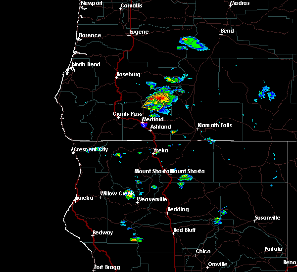
Hail Map for Trail, OR
The Trail, OR area has had 2 reports of on-the-ground hail by trained spotters, and has been under severe weather warnings 0 times during the past 12 months. Doppler radar has detected hail at or near Trail, OR on 4 occasions.
| Name: | Trail, OR |
| Where Located: | 23.3 miles N of Medford, OR |
| Map: | Google Map for Trail, OR |
| Population: | 702 |
| Housing Units: | 373 |
| More Info: | Search Google for Trail, OR |
0
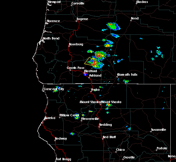
The Top Recent Hail Date for Trail, OR is Tuesday, August 2, 2022 (2nd out of 4)

Hail and Wind Damage Spotted near Trail, OR
| Date / Time | Report Details |
|---|---|
| 6/11/2020 6:23 PM PDT |
 At 623 pm pdt, a severe thunderstorm was located over rogue elk park, or 22 miles north of medford, moving north at 35 mph (radar indicated). Hazards include 60 mph wind gusts and quarter size hail. Hail damage to vehicles is expected. Expect wind damage to roofs, siding, and trees. At 623 pm pdt, a severe thunderstorm was located over rogue elk park, or 22 miles north of medford, moving north at 35 mph (radar indicated). Hazards include 60 mph wind gusts and quarter size hail. Hail damage to vehicles is expected. Expect wind damage to roofs, siding, and trees.
|
| 8/9/2017 7:26 PM PDT |
 At 725 pm pdt, a severe thunderstorm was located over joseph stewart state park, or 25 miles northeast of medford, moving west at 10 mph (radar indicated). Hazards include quarter size hail. Damage to vehicles is expected. locations impacted include, casey state park, lost creek lake, joseph stewart state park and rogue elk park. This includes, highway 62 in oregon between mile markers 24 and 40. At 725 pm pdt, a severe thunderstorm was located over joseph stewart state park, or 25 miles northeast of medford, moving west at 10 mph (radar indicated). Hazards include quarter size hail. Damage to vehicles is expected. locations impacted include, casey state park, lost creek lake, joseph stewart state park and rogue elk park. This includes, highway 62 in oregon between mile markers 24 and 40.
|
| 8/9/2017 7:12 PM PDT |
 At 712 pm pdt, a severe thunderstorm was located over joseph stewart state park, or 25 miles northeast of medford, moving west at 20 mph (radar indicated). Hazards include quarter size hail. damage to vehicles is expected At 712 pm pdt, a severe thunderstorm was located over joseph stewart state park, or 25 miles northeast of medford, moving west at 20 mph (radar indicated). Hazards include quarter size hail. damage to vehicles is expected
|
| 5/4/2017 9:16 PM PDT | Downed trees reported near the road. not sure when this occurred so left time as is. location near lost creek lake and highway 6 in jackson county OR, 9.3 miles W of Trail, OR |
| 5/4/2017 7:20 PM PDT | Quarter sized hail reported 5.2 miles W of Trail, OR, report from social media. time estimated based on radar. |
| 5/4/2017 7:00 PM PDT | Quarter sized hail reported 5.7 miles W of Trail, OR, public sent in a picture of quarter size hail occurring at casey state recreational site near trail. this hail fell around 7:00 pm. |
| 5/4/2017 6:15 PM PDT |
 At 614 pm pdt, a severe thunderstorm was located over rogue elk park near trail, or 22 miles north of medford, moving northeast at 20 mph (radar indicated). Hazards include 60 mph wind gusts and quarter size hail. Hail damage to vehicles is possible. Wind damage to roofs, siding, and trees is possible. At 614 pm pdt, a severe thunderstorm was located over rogue elk park near trail, or 22 miles north of medford, moving northeast at 20 mph (radar indicated). Hazards include 60 mph wind gusts and quarter size hail. Hail damage to vehicles is possible. Wind damage to roofs, siding, and trees is possible.
|
| 6/6/2016 5:24 PM PDT |
 The severe thunderstorm warning for northeastern jackson county will expire at 530 pm pdt, the storm which prompted the warning has weakened below severe limits, and no longer poses an immediate threat to life or property. therefore the warning will be allowed to expire. however heavy rain and lightning is still occurring with this thunderstorm. remember, a severe thunderstorm warning still remains in effect for the area between prospect and union creek in northeastern jackson county until 545 pm pdt. The severe thunderstorm warning for northeastern jackson county will expire at 530 pm pdt, the storm which prompted the warning has weakened below severe limits, and no longer poses an immediate threat to life or property. therefore the warning will be allowed to expire. however heavy rain and lightning is still occurring with this thunderstorm. remember, a severe thunderstorm warning still remains in effect for the area between prospect and union creek in northeastern jackson county until 545 pm pdt.
|
| 6/6/2016 4:55 PM PDT |
 At 454 pm pdt, doppler radar indicated a severe thunderstorm capable of producing quarter size hail and damaging winds in excess of 60 mph. this storm was located near joseph stewart state park, or 26 miles southwest of crater lake, and moving west at 15 mph. At 454 pm pdt, doppler radar indicated a severe thunderstorm capable of producing quarter size hail and damaging winds in excess of 60 mph. this storm was located near joseph stewart state park, or 26 miles southwest of crater lake, and moving west at 15 mph.
|
Hail Maps for Trail, OR


Connect with Interactive Hail Maps