

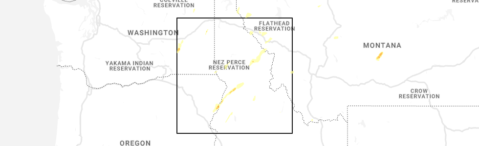
Hail Map for Winchester, ID
The Winchester, ID area has had 2 reports of on-the-ground hail by trained spotters, and has been under severe weather warnings 0 times during the past 12 months. Doppler radar has detected hail at or near Winchester, ID on 5 occasions.
| Name: | Winchester, ID |
| Where Located: | 32.6 miles NW of Grangeville, ID |
| Map: | Google Map for Winchester, ID |
| Population: | 340 |
| Housing Units: | 167 |
| More Info: | Search Google for Winchester, ID |
0
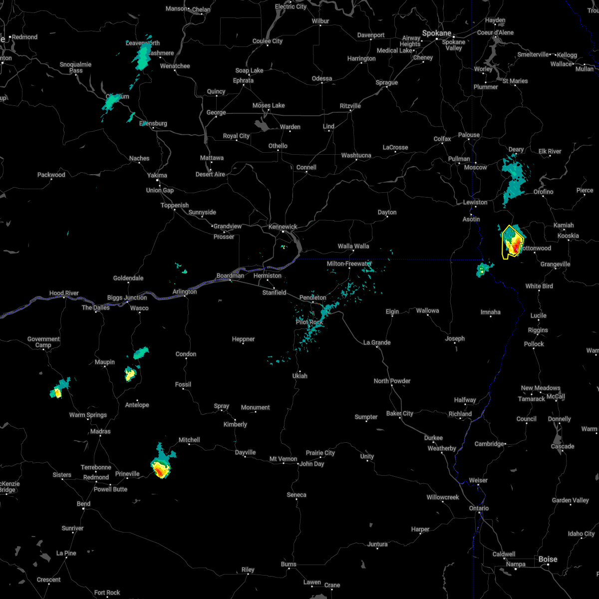
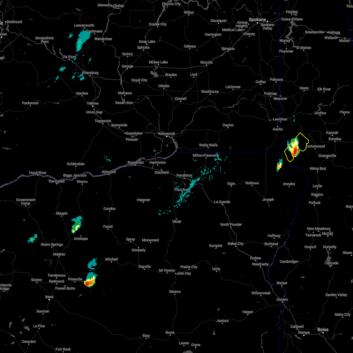
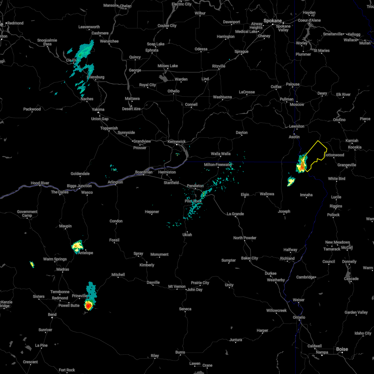
The Top Recent Hail Date for Winchester, ID is Friday, August 12, 2022 (5th out of 5)
Hail and Wind Damage Spotted near Winchester, ID
| Date / Time | Report Details |
|---|---|
| 8/24/2022 7:13 PM PDT | At 712 pm pdt, a severe thunderstorm was located 11 miles south of winchester, or 24 miles south of lapwai, moving northeast at 30 mph (radar indicated). Hazards include quarter size hail. Damage to vehicles is expected. locations impacted include, winchester. this includes u. s. highway 95 in idaho between mile markers 274 and 280. hail threat, radar indicated max hail size, 1. 00 in wind threat, radar indicated max wind gust, <50 mph. |
| 8/24/2022 6:45 PM PDT | At 643 pm pdt, a severe thunderstorm was located 17 miles east of paradise, or 33 miles south of lewiston, moving northeast at 30 mph (radar indicated). Hazards include 60 mph wind gusts and quarter size hail. Hail damage to vehicles is expected. Expect wind damage to roofs, siding, and trees. |
| 8/12/2022 12:52 PM PDT |
 At 1252 pm pdt, severe thunderstorms were located along a line extending from 8 miles east of culdesac to 14 miles south of craigmont, moving northeast at 45 mph (radar indicated). Hazards include 60 mph wind gusts and half dollar size hail. Hail damage to vehicles is expected. Expect wind damage to roofs, siding, and trees. At 1252 pm pdt, severe thunderstorms were located along a line extending from 8 miles east of culdesac to 14 miles south of craigmont, moving northeast at 45 mph (radar indicated). Hazards include 60 mph wind gusts and half dollar size hail. Hail damage to vehicles is expected. Expect wind damage to roofs, siding, and trees.
|
| 8/11/2022 3:36 PM PDT |
 The severe thunderstorm warning for central nez perce and west central lewis counties will expire at 345 pm pdt, the storm which prompted the warning has weakened below severe limits, and has exited the warned area. therefore, the warning will be allowed to expire. The severe thunderstorm warning for central nez perce and west central lewis counties will expire at 345 pm pdt, the storm which prompted the warning has weakened below severe limits, and has exited the warned area. therefore, the warning will be allowed to expire.
|
| 8/11/2022 3:16 PM PDT |
 At 315 pm pdt, a severe thunderstorm was located near winchester, or 13 miles south of lapwai, moving northeast at 20 mph (radar indicated). Hazards include 60 mph wind gusts and quarter size hail. Hail damage to vehicles is expected. expect wind damage to roofs, siding, and trees. locations impacted include, culdesac, winchester, reubens and waha. this includes u. s. highway 95 in idaho between mile markers 279 and 294. hail threat, radar indicated max hail size, 1. 00 in wind threat, radar indicated max wind gust, 60 mph. At 315 pm pdt, a severe thunderstorm was located near winchester, or 13 miles south of lapwai, moving northeast at 20 mph (radar indicated). Hazards include 60 mph wind gusts and quarter size hail. Hail damage to vehicles is expected. expect wind damage to roofs, siding, and trees. locations impacted include, culdesac, winchester, reubens and waha. this includes u. s. highway 95 in idaho between mile markers 279 and 294. hail threat, radar indicated max hail size, 1. 00 in wind threat, radar indicated max wind gust, 60 mph.
|
| 8/11/2022 3:00 PM PDT |
 At 300 pm pdt, a severe thunderstorm was located 10 miles southwest of winchester, or 17 miles south of lapwai, moving northeast at 20 mph (radar indicated). Hazards include 60 mph wind gusts and half dollar size hail. Hail damage to vehicles is expected. Expect wind damage to roofs, siding, and trees. At 300 pm pdt, a severe thunderstorm was located 10 miles southwest of winchester, or 17 miles south of lapwai, moving northeast at 20 mph (radar indicated). Hazards include 60 mph wind gusts and half dollar size hail. Hail damage to vehicles is expected. Expect wind damage to roofs, siding, and trees.
|
| 7/6/2022 6:45 PM PDT |
 At 645 pm pdt, a severe thunderstorm was located 9 miles south of craigmont, or 23 miles northwest of grangeville, moving northeast at 25 mph (radar indicated). Hazards include two inch hail and 70 mph wind gusts. People and animals outdoors will be injured. expect hail damage to roofs, siding, windows, and vehicles. expect considerable tree damage. wind damage is also likely to mobile homes, roofs, and outbuildings. locations impacted include, winchester. thunderstorm damage threat, considerable hail threat, radar indicated max hail size, 2. 00 in wind threat, radar indicated max wind gust, 70 mph. At 645 pm pdt, a severe thunderstorm was located 9 miles south of craigmont, or 23 miles northwest of grangeville, moving northeast at 25 mph (radar indicated). Hazards include two inch hail and 70 mph wind gusts. People and animals outdoors will be injured. expect hail damage to roofs, siding, windows, and vehicles. expect considerable tree damage. wind damage is also likely to mobile homes, roofs, and outbuildings. locations impacted include, winchester. thunderstorm damage threat, considerable hail threat, radar indicated max hail size, 2. 00 in wind threat, radar indicated max wind gust, 70 mph.
|
| 7/6/2022 6:28 PM PDT |
 At 627 pm pdt, a severe thunderstorm was located 11 miles southwest of winchester, or 22 miles south of lapwai, moving northeast at 30 mph (radar indicated). Hazards include golf ball size hail and 70 mph wind gusts. People and animals outdoors will be injured. expect hail damage to roofs, siding, windows, and vehicles. expect considerable tree damage. wind damage is also likely to mobile homes, roofs, and outbuildings. locations impacted include, winchester. thunderstorm damage threat, considerable hail threat, radar indicated max hail size, 1. 75 in wind threat, radar indicated max wind gust, 70 mph. At 627 pm pdt, a severe thunderstorm was located 11 miles southwest of winchester, or 22 miles south of lapwai, moving northeast at 30 mph (radar indicated). Hazards include golf ball size hail and 70 mph wind gusts. People and animals outdoors will be injured. expect hail damage to roofs, siding, windows, and vehicles. expect considerable tree damage. wind damage is also likely to mobile homes, roofs, and outbuildings. locations impacted include, winchester. thunderstorm damage threat, considerable hail threat, radar indicated max hail size, 1. 75 in wind threat, radar indicated max wind gust, 70 mph.
|
| 7/6/2022 6:08 PM PDT |
 At 608 pm pdt, a severe thunderstorm was located 16 miles east of paradise, or 29 miles south of lewiston, moving northeast at 30 mph (radar indicated). Hazards include 60 mph wind gusts and half dollar size hail. Hail damage to vehicles is expected. Expect wind damage to roofs, siding, and trees. At 608 pm pdt, a severe thunderstorm was located 16 miles east of paradise, or 29 miles south of lewiston, moving northeast at 30 mph (radar indicated). Hazards include 60 mph wind gusts and half dollar size hail. Hail damage to vehicles is expected. Expect wind damage to roofs, siding, and trees.
|
| 8/17/2020 6:25 PM PDT |
 At 622 pm pdt, a severe thunderstorm was located 19 miles northeast of enterprise, moving northeast at 35 mph. the thunderstorms are looking to enter nez perce county by 6:45pm. brief heavy downpours and wind gusts up to 50 mph are possible (doppler radar indicated). Hazards include 50 mph wind gusts and penny size hail. expect damage to roofs, siding, and trees At 622 pm pdt, a severe thunderstorm was located 19 miles northeast of enterprise, moving northeast at 35 mph. the thunderstorms are looking to enter nez perce county by 6:45pm. brief heavy downpours and wind gusts up to 50 mph are possible (doppler radar indicated). Hazards include 50 mph wind gusts and penny size hail. expect damage to roofs, siding, and trees
|
| 6/8/2016 3:15 PM PDT |
 At 315 pm pdt, doppler radar indicated a severe thunderstorm capable of producing quarter size hail and damaging winds in excess of 60 mph. this storm was located 10 miles south of winchester, or 21 miles south of lapwai, and moving northeast at 40 mph. At 315 pm pdt, doppler radar indicated a severe thunderstorm capable of producing quarter size hail and damaging winds in excess of 60 mph. this storm was located 10 miles south of winchester, or 21 miles south of lapwai, and moving northeast at 40 mph.
|
| 6/8/2016 2:40 PM PDT | Quarter sized hail reported 0.2 miles W of Winchester, ID, quarter sized hail reported via facebook. |
| 6/8/2016 2:19 PM PDT |
 At 219 pm pdt, doppler radar indicated a severe thunderstorm capable of producing large hail up to ping pong ball size and damaging winds in excess of 60 mph. this storm was located over craigmont, or 18 miles southeast of lapwai, moving northeast at 45 mph. locations impacted include, craigmont, winchester, peck, reubens and mohler. At 219 pm pdt, doppler radar indicated a severe thunderstorm capable of producing large hail up to ping pong ball size and damaging winds in excess of 60 mph. this storm was located over craigmont, or 18 miles southeast of lapwai, moving northeast at 45 mph. locations impacted include, craigmont, winchester, peck, reubens and mohler.
|
| 6/8/2016 2:12 PM PDT |
 At 212 pm pdt, doppler radar indicated a severe thunderstorm capable of producing quarter size hail and damaging winds in excess of 60 mph. this storm was located near winchester, or 18 miles southeast of lapwai, and moving northeast at 35 mph. At 212 pm pdt, doppler radar indicated a severe thunderstorm capable of producing quarter size hail and damaging winds in excess of 60 mph. this storm was located near winchester, or 18 miles southeast of lapwai, and moving northeast at 35 mph.
|
| 6/1/2015 5:33 PM PDT | At 532 pm pdt, doppler radar indicated a severe thunderstorm capable of producing quarter size hail and damaging winds to 60 mph. this storm was located 8 miles west of winchester, or 13 miles south of lapwai, and moving northeast at 20 mph. |
| 9/15/2013 11:03 PM PDT | The wind gust was measured at the mission creek raws station and likely occurred during the previous hou in lewis county ID, 3.8 miles SE of Winchester, ID |
| 3/20/2013 2:49 PM PDT | Reported at raws station crki1 in nez perce county ID, 19.6 miles NE of Winchester, ID |
| 7/17/2012 7:30 PM PDT | Gust reported at corral creek raws. occurred between 701-801pm in lewis county ID, 4.1 miles SSE of Winchester, ID |
| 7/17/2012 7:30 PM PDT | Gust reported at mission creek raws. occurred between 701-801 pm pd in lewis county ID, 4.1 miles SSE of Winchester, ID |
| 6/12/2012 2:06 PM PDT | Half Dollar sized hail reported 4.1 miles SSE of Winchester, ID |
Hail Maps for Winchester, ID


Connect with Interactive Hail Maps