

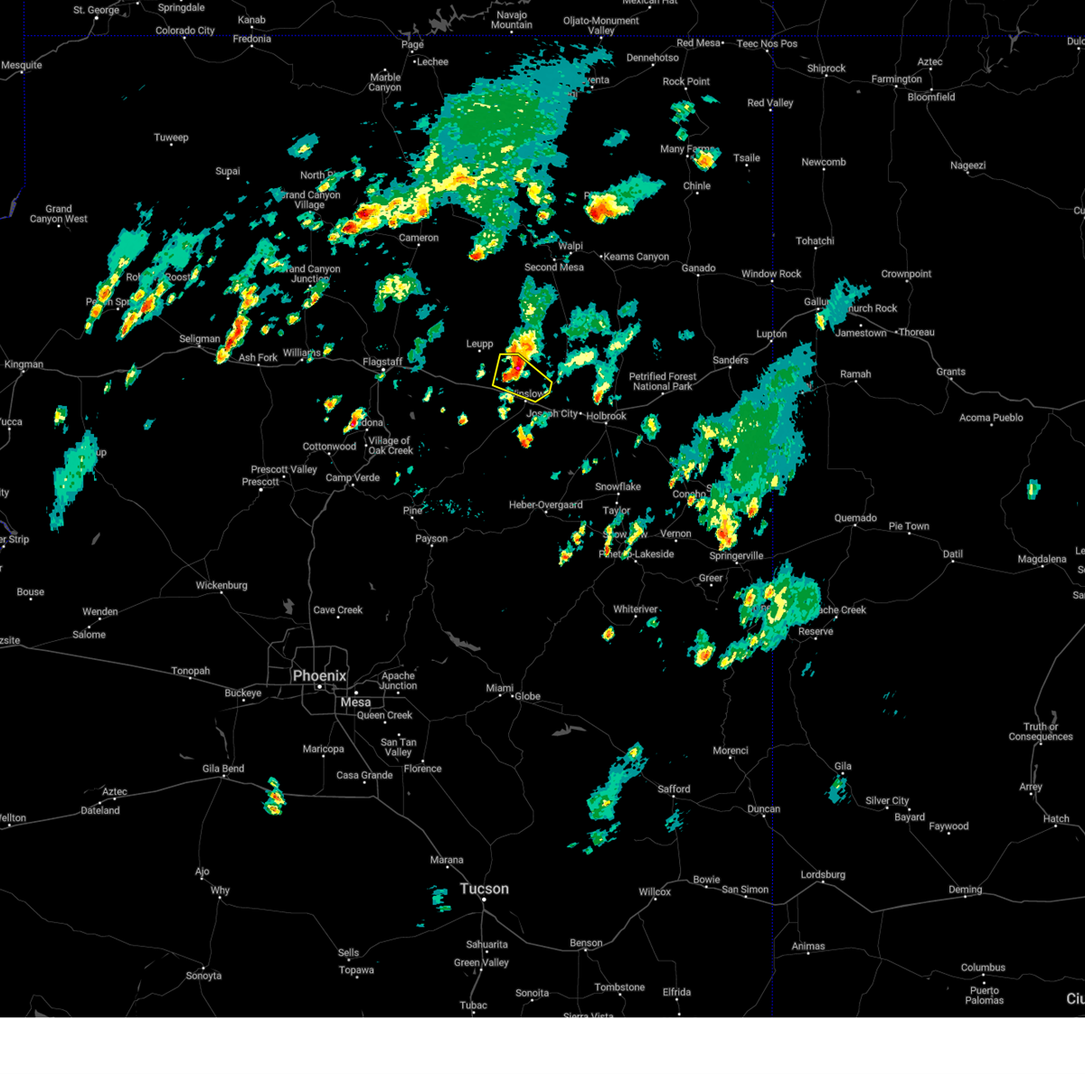
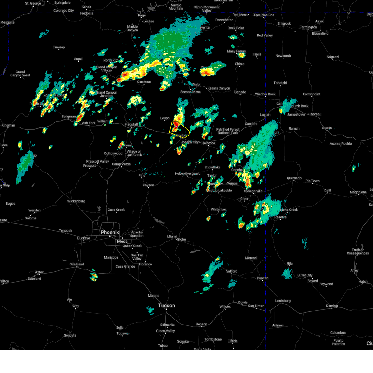
Hail Map for Winslow, AZ
The Winslow, AZ area has had 5 reports of on-the-ground hail by trained spotters, and has been under severe weather warnings 5 times during the past 12 months. Doppler radar has detected hail at or near Winslow, AZ on 16 occasions, including 1 occasion during the past year.
| Name: | Winslow, AZ |
| Where Located: | 54.9 miles ESE of Flagstaff, AZ |
| Map: | Google Map for Winslow, AZ |
| Population: | 9655 |
| Housing Units: | 3362 |
| More Info: | Search Google for Winslow, AZ |
1
The Top Recent Hail Date for Winslow, AZ is Wednesday, August 16, 2023 (5th out of 16)

Hail and Wind Damage Spotted near Winslow, AZ
| Date / Time | Report Details |
|---|---|
| 8/10/2023 5:27 PM MST |
 The severe thunderstorm warning areas north of winslow in navajo and coconino counties will expire at 530 pm mst, the storm which prompted the warning has weakened below severe limits, and no longer poses an immediate threat to life or property. therefore, the warning will be allowed to expire. however, small hail, gusty winds, and heavy rain are still possible with this thunderstorm. to report severe weather, contact your nearest law enforcement agency and have them relay your report to the national weather service in flagstaff. The severe thunderstorm warning areas north of winslow in navajo and coconino counties will expire at 530 pm mst, the storm which prompted the warning has weakened below severe limits, and no longer poses an immediate threat to life or property. therefore, the warning will be allowed to expire. however, small hail, gusty winds, and heavy rain are still possible with this thunderstorm. to report severe weather, contact your nearest law enforcement agency and have them relay your report to the national weather service in flagstaff.
|
| 8/10/2023 5:10 PM MST |
 At 509 pm mst, a severe thunderstorm was located 8 miles south of bird springs, or 12 miles north of winslow, moving east at 20 mph (radar indicated). Hazards include 60 mph wind gusts and quarter size hail. Hail damage to vehicles is expected. expect wind damage to roofs, siding, and trees. locations impacted include, homolovi state park, bushman acres, bird springs, and homolovi state park campground. this includes the following highways, state route 87 between mile markers 347 and 355. state route 99 between mile markers 56 and 60. hail threat, radar indicated max hail size, 1. 00 in wind threat, radar indicated max wind gust, 60 mph. At 509 pm mst, a severe thunderstorm was located 8 miles south of bird springs, or 12 miles north of winslow, moving east at 20 mph (radar indicated). Hazards include 60 mph wind gusts and quarter size hail. Hail damage to vehicles is expected. expect wind damage to roofs, siding, and trees. locations impacted include, homolovi state park, bushman acres, bird springs, and homolovi state park campground. this includes the following highways, state route 87 between mile markers 347 and 355. state route 99 between mile markers 56 and 60. hail threat, radar indicated max hail size, 1. 00 in wind threat, radar indicated max wind gust, 60 mph.
|
| 8/10/2023 4:50 PM MST |
 At 450 pm mst, a severe thunderstorm was located 7 miles southeast of leupp, or 15 miles northwest of winslow, moving southeast at 20 mph (radar indicated). Hazards include 60 mph wind gusts and half dollar size hail. Hail damage to vehicles is expected. Expect wind damage to roofs, siding, and trees. At 450 pm mst, a severe thunderstorm was located 7 miles southeast of leupp, or 15 miles northwest of winslow, moving southeast at 20 mph (radar indicated). Hazards include 60 mph wind gusts and half dollar size hail. Hail damage to vehicles is expected. Expect wind damage to roofs, siding, and trees.
|
| 7/31/2023 2:08 PM MST |
 The severe thunderstorm warning for navajo and coconino counties will expire at 215 pm mst, the storm which prompted the warning has weakened below severe limits, and no longer poses an immediate threat to life or property. therefore, the warning will be allowed to expire. The severe thunderstorm warning for navajo and coconino counties will expire at 215 pm mst, the storm which prompted the warning has weakened below severe limits, and no longer poses an immediate threat to life or property. therefore, the warning will be allowed to expire.
|
| 7/31/2023 1:48 PM MST |
 At 148 pm mst, a severe thunderstorm was located 12 miles southwest of winslow, moving north at 10 mph (radar indicated). Hazards include 60 mph wind gusts and quarter size hail. Hail damage to vehicles is expected. Expect wind damage to roofs, siding, and trees. At 148 pm mst, a severe thunderstorm was located 12 miles southwest of winslow, moving north at 10 mph (radar indicated). Hazards include 60 mph wind gusts and quarter size hail. Hail damage to vehicles is expected. Expect wind damage to roofs, siding, and trees.
|
| 5/9/2020 6:11 PM MST |
 At 605 pm mst/705 pm mdt/, a cluster of thunderstorms producing severe wind gusts and dense blowing dust was located 8 miles west of winslow. these storms are slowly moving east and southeast at 5 to 10 mph (winslow airport reporting 60 mph winds and blowing dust). Hazards include 60 mph wind gusts. expect damage to roofs, siding, and trees At 605 pm mst/705 pm mdt/, a cluster of thunderstorms producing severe wind gusts and dense blowing dust was located 8 miles west of winslow. these storms are slowly moving east and southeast at 5 to 10 mph (winslow airport reporting 60 mph winds and blowing dust). Hazards include 60 mph wind gusts. expect damage to roofs, siding, and trees
|
| 6/22/2019 3:35 PM MST | Asos station kinw winslow airport - gust front from decaying storm in navajo county AZ, 1 miles SE of Winslow, AZ |
| 9/1/2018 5:31 PM MST |
 At 530 pm mst, severe thunderstorms were located along a line extending from 7 miles southwest of indian wells to 6 miles east of winslow, moving southeast at 35 mph (radar indicated). Hazards include 60 mph wind gusts and half dollar size hail. Hail damage to vehicles is expected. Expect wind damage to roofs, siding, and trees. At 530 pm mst, severe thunderstorms were located along a line extending from 7 miles southwest of indian wells to 6 miles east of winslow, moving southeast at 35 mph (radar indicated). Hazards include 60 mph wind gusts and half dollar size hail. Hail damage to vehicles is expected. Expect wind damage to roofs, siding, and trees.
|
| 9/1/2018 6:06 PM MDT |
 At 506 pm mst, a severe thunderstorm was located 15 miles north of winslow, moving east at 20 mph (radar indicated). Hazards include 60 mph wind gusts and half dollar size hail. Hail damage to vehicles is expected. expect wind damage to roofs, siding, and trees. locations impacted include, winslow, dilkon, cedar springs, castle butte and homolovi state park campground. this includes the following highways, business interstate 40 between mile markers 252 and 257. interstate 40 between mile markers 246 and 269. state route 87 between mile markers 338 and 382. State route 99 between mile markers 35 and 53. At 506 pm mst, a severe thunderstorm was located 15 miles north of winslow, moving east at 20 mph (radar indicated). Hazards include 60 mph wind gusts and half dollar size hail. Hail damage to vehicles is expected. expect wind damage to roofs, siding, and trees. locations impacted include, winslow, dilkon, cedar springs, castle butte and homolovi state park campground. this includes the following highways, business interstate 40 between mile markers 252 and 257. interstate 40 between mile markers 246 and 269. state route 87 between mile markers 338 and 382. State route 99 between mile markers 35 and 53.
|
| 9/1/2018 5:47 PM MDT |
 At 447 pm mst, a severe thunderstorm was located 13 miles east of leupp, or 15 miles north of winslow, moving east at 20 mph (radar indicated). Hazards include 60 mph wind gusts and half dollar size hail. Hail damage to vehicles is expected. Expect wind damage to roofs, siding, and trees. At 447 pm mst, a severe thunderstorm was located 13 miles east of leupp, or 15 miles north of winslow, moving east at 20 mph (radar indicated). Hazards include 60 mph wind gusts and half dollar size hail. Hail damage to vehicles is expected. Expect wind damage to roofs, siding, and trees.
|
| 9/1/2018 9:26 AM MDT |
 The severe thunderstorm warning for navajo and coconino counties will expire at 830 am mst, the storm which prompted the warning has weakened below severe limits, and no longer poses an immediate threat to life or property. therefore, the warning will be allowed to expire. however, heavy rain is still possible with this thunderstorm. to report severe weather, contact your nearest law enforcement agency. they will relay your report to the national weather service flagstaff. The severe thunderstorm warning for navajo and coconino counties will expire at 830 am mst, the storm which prompted the warning has weakened below severe limits, and no longer poses an immediate threat to life or property. therefore, the warning will be allowed to expire. however, heavy rain is still possible with this thunderstorm. to report severe weather, contact your nearest law enforcement agency. they will relay your report to the national weather service flagstaff.
|
| 9/1/2018 9:11 AM MDT |
 At 810 am mst, a severe thunderstorm was located 12 miles northeast of winslow, moving east at 35 mph (radar indicated). Hazards include 60 mph wind gusts and nickel size hail. Expect damage to roofs, siding, and trees. locations impacted include, winslow and homolovi state park campground. this includes the following highways, business interstate 40 near mile marker 252. interstate 40 between mile markers 247 and 254. state route 87 between mile markers 348 and 368. State route 99 between mile markers 58 and 67. At 810 am mst, a severe thunderstorm was located 12 miles northeast of winslow, moving east at 35 mph (radar indicated). Hazards include 60 mph wind gusts and nickel size hail. Expect damage to roofs, siding, and trees. locations impacted include, winslow and homolovi state park campground. this includes the following highways, business interstate 40 near mile marker 252. interstate 40 between mile markers 247 and 254. state route 87 between mile markers 348 and 368. State route 99 between mile markers 58 and 67.
|
| 9/1/2018 8:53 AM MDT |
 At 752 am mst, a severe thunderstorm was located near winslow, moving northeast at 30 mph (radar indicated). Hazards include 60 mph wind gusts and half dollar size hail. Hail damage to vehicles is expected. Expect wind damage to roofs, siding, and trees. At 752 am mst, a severe thunderstorm was located near winslow, moving northeast at 30 mph (radar indicated). Hazards include 60 mph wind gusts and half dollar size hail. Hail damage to vehicles is expected. Expect wind damage to roofs, siding, and trees.
|
| 7/24/2018 1:53 PM MST |
 The severe thunderstorm warning for navajo and coconino counties will expire at 200 pm mst, the storm which prompted the warning has weakened below severe limits, and no longer pose an immediate threat to life or property. therefore the warning will be allowed to expire. however heavy rain is still possible with this thunderstorm. The severe thunderstorm warning for navajo and coconino counties will expire at 200 pm mst, the storm which prompted the warning has weakened below severe limits, and no longer pose an immediate threat to life or property. therefore the warning will be allowed to expire. however heavy rain is still possible with this thunderstorm.
|
| 7/24/2018 1:45 PM MST |
 At 144 pm mst, a severe thunderstorm was located over winslow, moving northeast at 10 mph (radar indicated. winslow airport reported winds up to 56 mph with this storm). Hazards include 60 mph wind gusts and penny size hail. Expect damage to roofs, siding, and trees. locations impacted include, winslow and homolovi state park campground. this includes the following highways, business interstate 40 between mile markers 252 and 257. interstate 40 between mile markers 250 and 262. state route 87 between mile markers 335 and 348. State route 99 between mile markers 37 and 42. At 144 pm mst, a severe thunderstorm was located over winslow, moving northeast at 10 mph (radar indicated. winslow airport reported winds up to 56 mph with this storm). Hazards include 60 mph wind gusts and penny size hail. Expect damage to roofs, siding, and trees. locations impacted include, winslow and homolovi state park campground. this includes the following highways, business interstate 40 between mile markers 252 and 257. interstate 40 between mile markers 250 and 262. state route 87 between mile markers 335 and 348. State route 99 between mile markers 37 and 42.
|
| 7/24/2018 1:28 PM MST |
 At 128 pm mst, a severe thunderstorm was located over winslow, moving northeast at 15 mph (radar indicated). Hazards include 60 mph wind gusts and penny size hail. expect damage to roofs, siding, and trees At 128 pm mst, a severe thunderstorm was located over winslow, moving northeast at 15 mph (radar indicated). Hazards include 60 mph wind gusts and penny size hail. expect damage to roofs, siding, and trees
|
| 8/31/2015 1:33 PM MST |
 At 132 pm mst, doppler radar indicated a severe thunderstorm capable of producing quarter size hail and damaging winds in excess of 60 mph. this storm was located 7 miles east of meteor crater along i-40, or 10 miles west of winslow, and moving northeast at 15 mph. At 132 pm mst, doppler radar indicated a severe thunderstorm capable of producing quarter size hail and damaging winds in excess of 60 mph. this storm was located 7 miles east of meteor crater along i-40, or 10 miles west of winslow, and moving northeast at 15 mph.
|
| 8/30/2015 12:52 PM MST |
 At 1251 pm mst, doppler radar indicated a line of severe thunderstorms capable of producing quarter size hail, destructive winds in excess of 70 mph and flooding. these storms were located along a line extending from near winslow to 18 miles southeast of meteor crater, and moving northeast at 20 mph. At 1251 pm mst, doppler radar indicated a line of severe thunderstorms capable of producing quarter size hail, destructive winds in excess of 70 mph and flooding. these storms were located along a line extending from near winslow to 18 miles southeast of meteor crater, and moving northeast at 20 mph.
|
| 8/11/2015 7:54 PM MST |
 The severe thunderstorm warning for eastern coconino and west central navajo counties will expire at 800 pm mst, the storms which prompted the warning have weakened below severe limits, and no longer poses an immediate threat to life or property. therefore the warning will be allowed to expire. however gusty winds and heavy rain are still possible with these thunderstorms. The severe thunderstorm warning for eastern coconino and west central navajo counties will expire at 800 pm mst, the storms which prompted the warning have weakened below severe limits, and no longer poses an immediate threat to life or property. therefore the warning will be allowed to expire. however gusty winds and heavy rain are still possible with these thunderstorms.
|
| 8/11/2015 7:11 PM MST |
 At 711 pm mst, doppler radar indicated a line of severe thunderstorms capable of producing quarter size hail and destructive winds in excess of 70 mph. these storms were located along a line extending from 16 miles north of aripine to 13 miles north of forest lakes, and moving northwest at 20 mph. At 711 pm mst, doppler radar indicated a line of severe thunderstorms capable of producing quarter size hail and destructive winds in excess of 70 mph. these storms were located along a line extending from 16 miles north of aripine to 13 miles north of forest lakes, and moving northwest at 20 mph.
|
| 7/7/2015 3:23 PM MST |
 The severe thunderstorm warning for east central coconino and southwestern navajo counties will expire at 330 pm mst, the storm which prompted the warning has weakened below severe limits, and no longer poses an immediate threat to life or property. therefore the warning will be allowed to expire. The severe thunderstorm warning for east central coconino and southwestern navajo counties will expire at 330 pm mst, the storm which prompted the warning has weakened below severe limits, and no longer poses an immediate threat to life or property. therefore the warning will be allowed to expire.
|
| 7/7/2015 3:00 PM MST |
 At 259 pm mst, doppler radar indicated a severe thunderstorm capable of producing quarter size hail and damaging winds in excess of 60 mph. this storm was located over meteor crater, or 17 miles west of winslow, and moving northeast at 25 mph. At 259 pm mst, doppler radar indicated a severe thunderstorm capable of producing quarter size hail and damaging winds in excess of 60 mph. this storm was located over meteor crater, or 17 miles west of winslow, and moving northeast at 25 mph.
|
| 6/13/2015 1:25 PM MST | Quarter sized hail reported 1 miles SE of Winslow, AZ, 1 inch hail on the far west side of winslow along with some street flooding. |
| 6/13/2015 1:25 PM MST | Half Dollar sized hail reported 1 miles SE of Winslow, AZ, 1 to 1.25 inch hail covered the ground on the far west side of winslow. hail size estimated from picture sent in by the spotter. |
| 6/5/2015 9:23 PM MST | Tennis Ball sized hail reported 12 miles SE of Winslow, AZ |
| 8/23/2013 12:45 PM MST | Quarter sized hail reported 25.5 miles ESE of Winslow, AZ, one inch diameter hail covered i-40 at mile marker 227. |
| 9/15/2011 1:00 PM MDT | Hen Egg sized hail reported 30.8 miles SW of Winslow, AZ |
Hail Maps for Winslow, AZ


Connect with Interactive Hail Maps