

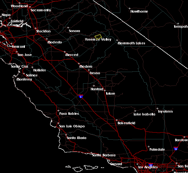
Hail Map for Yosemite Valley, CA
The Yosemite Valley, CA area has had 0 reports of on-the-ground hail by trained spotters, and has been under severe weather warnings 0 times during the past 12 months. Doppler radar has detected hail at or near Yosemite Valley, CA on 2 occasions.
| Name: | Yosemite Valley, CA |
| Where Located: | 69.9 miles N of Fresno, CA |
| Map: | Google Map for Yosemite Valley, CA |
| Population: | 1035 |
| Housing Units: | 323 |
| More Info: | Search Google for Yosemite Valley, CA |
0
The Top Recent Hail Date for Yosemite Valley, CA is Wednesday, September 13, 2017 (2nd out of 2)

Hail and Wind Damage Spotted near Yosemite Valley, CA
| Date / Time | Report Details |
|---|---|
| 7/28/2021 5:00 PM PDT | Tree blew down in gusty thunderstorm winds and crushed 3 unoccupied tent cabins at curry villag in mariposa county CA, 4.2 miles ENE of Yosemite Valley, CA |
| 9/13/2017 6:21 PM PDT |
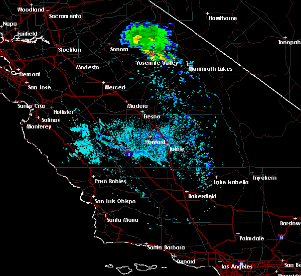
 The severe thunderstorm warning for northeastern mariposa and south central tuolumne counties will expire at 630 pm pdt, the storm which prompted the warning has weakened below severe limits, and no longer poses an immediate threat to life or property. therefore the warning will be allowed to expire. The severe thunderstorm warning for northeastern mariposa and south central tuolumne counties will expire at 630 pm pdt, the storm which prompted the warning has weakened below severe limits, and no longer poses an immediate threat to life or property. therefore the warning will be allowed to expire.
|
| 9/13/2017 6:03 PM PDT |
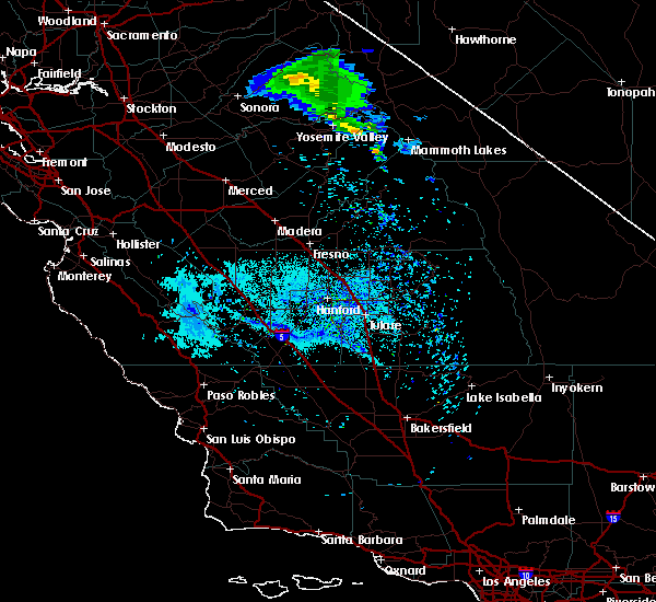
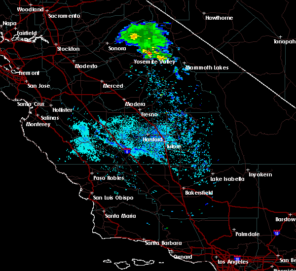 At 559 pm pdt, a severe thunderstorm was located over north pines campground, moving southeast at 10 mph (radar indicated). Hazards include quarter size hail. storm is starting to weaken as it approaches yosemite valley. however it could reintensify as it moves across the valley. Damage to vehicles is expected. Locations impacted include, sunrise high sierra camp, little yosemite valley campground, porcupine flat campground, morraine dome campground, may lake high sierra camp, camp 4 campground, north pines campground, little yosemite valley ranger station, yosemite valley visitor center, lower pines campground, upper pines campground, yosemite creek campground, yosemite glacier point, yosemite valley and snow flat. At 559 pm pdt, a severe thunderstorm was located over north pines campground, moving southeast at 10 mph (radar indicated). Hazards include quarter size hail. storm is starting to weaken as it approaches yosemite valley. however it could reintensify as it moves across the valley. Damage to vehicles is expected. Locations impacted include, sunrise high sierra camp, little yosemite valley campground, porcupine flat campground, morraine dome campground, may lake high sierra camp, camp 4 campground, north pines campground, little yosemite valley ranger station, yosemite valley visitor center, lower pines campground, upper pines campground, yosemite creek campground, yosemite glacier point, yosemite valley and snow flat.
|
| 9/13/2017 5:48 PM PDT |
 At 547 pm pdt, a severe thunderstorm was located over porcupine flat campground, moving southeast at 10 mph (radar indicated). Hazards include quarter size hail. Damage to vehicles is expected. Minor flooding and possible rockslides. At 547 pm pdt, a severe thunderstorm was located over porcupine flat campground, moving southeast at 10 mph (radar indicated). Hazards include quarter size hail. Damage to vehicles is expected. Minor flooding and possible rockslides.
|
| 8/18/2017 5:52 PM PDT |
 The severe thunderstorm warning for northeastern mariposa county will expire at 600 pm pdt, the severe thunderstorm which prompted the warning has weakened. therefore, the warning will be allowed to expire. The severe thunderstorm warning for northeastern mariposa county will expire at 600 pm pdt, the severe thunderstorm which prompted the warning has weakened. therefore, the warning will be allowed to expire.
|
| 8/18/2017 5:34 PM PDT |
 At 533 pm pdt, a severe thunderstorm was located over little yosemite valley campground, and is nearly stationary (radar indicated). Hazards include 50 mph wind gusts and nickel size hail. Expect damage to roofs, siding, and trees. Locations impacted include, little yosemite valley campground, little yosemite valley ranger station, morraine dome campground, camp 4 campground, north pines campground, lower pines campground, upper pines campground, yosemite glacier point and yosemite valley. At 533 pm pdt, a severe thunderstorm was located over little yosemite valley campground, and is nearly stationary (radar indicated). Hazards include 50 mph wind gusts and nickel size hail. Expect damage to roofs, siding, and trees. Locations impacted include, little yosemite valley campground, little yosemite valley ranger station, morraine dome campground, camp 4 campground, north pines campground, lower pines campground, upper pines campground, yosemite glacier point and yosemite valley.
|
| 8/18/2017 5:09 PM PDT |
 At 508 pm pdt, a severe thunderstorm was located over little yosemite valley campground, and is nearly stationary (radar indicated). Hazards include quarter size hail. damage to vehicles dudleyis expected At 508 pm pdt, a severe thunderstorm was located over little yosemite valley campground, and is nearly stationary (radar indicated). Hazards include quarter size hail. damage to vehicles dudleyis expected
|
Hail Maps for Yosemite Valley, CA
Connect with Interactive Hail Maps