

Hail Map for Tuesday, January 3, 2023

Number of Impacted Households on 1/3/2023
0
Impacted by 1" or Larger Hail
0
Impacted by 1.75" or Larger Hail
0
Impacted by 2.5" or Larger Hail
Square Miles of Populated Area Impacted on 1/3/2023
0
Impacted by 1" or Larger Hail
0
Impacted by 1.75" or Larger Hail
0
Impacted by 2.5" or Larger Hail

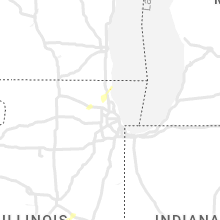


Cities Most Affected by Hail Storms of 1/3/2023
| Hail Size | Demographics of Zip Codes Affected | ||||||
|---|---|---|---|---|---|---|---|
| City | Count | Average | Largest | Pop Density | House Value | Income | Age |
| Laurel, MS | 1 | 1.75 | 1.75 | 95 | $65k | $30.7k | 39.5 |
| Natchez, MS | 1 | 1.75 | 1.75 | 69 | $61k | $25.2k | 41.3 |
Hail and Wind Damage Spotted on 1/3/2023
Filter by Report Type:Hail ReportsWind Reports
States Impacted
Ohio, Mississippi, Kentucky, Arkansas, Alabama, Tennessee, Georgia, Illinois, North Carolina, Louisiana, VirginiaOhio
| Local Time | Report Details |
|---|---|
| 7:06 AM EST | Small tree reported down on fay road. time estimated from rada in clermont county OH, 18.4 miles ENE of Cincinnati, OH |
| 7:07 AM EST | Tree blocking road on 774. time estimated from rada in clermont county OH, 28.7 miles ESE of Cincinnati, OH |
| 8:10 AM EST | Tree down on duck run road. time estimated from rada in scioto county OH, 76.1 miles S of Columbus, OH |
Mississippi
| Local Time | Report Details |
|---|---|
| 6:07 AM CST | Numerous stockade fences damaged or blown over in the braybourne subdivision just west of goodman road and cedar hill roa in desoto county MS, 21 miles SE of Memphis, TN |
| 6:38 AM CST | Measured at a private farm weather statio in bolivar county MS, 94.1 miles SSW of Memphis, TN |
| 6:49 AM CST | A traffic light was damaged at ms hwy 8 and chrisman av in bolivar county MS, 96.3 miles NE of Bastrop, LA |
| 9:04 AM CST | Minor damage to a couple of homes and tree damag in union county MS, 65.5 miles SE of Memphis, TN |
| 9:07 AM CST | Trees down across road which took the powerline ou in calhoun county MS, 44.8 miles NW of Starkville, MS |
| 9:38 AM CST | Multiple trees down at whispering pines golf course. time is radar estimate in alcorn county MS, 54.5 miles W of Florence, AL |
| 10:06 AM CST | Roof damage to home off ramey r in itawamba county MS, 49.8 miles WSW of Florence, AL |
| 10:06 AM CST | Numerous powerlines... trees and single damage to homes in the houston community center are in itawamba county MS, 52.5 miles WSW of Florence, AL |
| 10:08 AM CST | Tree fallen on one house and shingle damage to another house on dickerson r in itawamba county MS, 52.5 miles WSW of Florence, AL |
| 10:26 AM CST | Multiple structures damaged and trees down in golden. time is radar estimate in tishomingo county MS, 36.3 miles SW of Florence, AL |
| 10:32 AM CST | Pictures on social media show a tree that knocked down power lines on highway in webster county MS, 27.2 miles WNW of Starkville, MS |
| 4:15 PM CST | Quarter sized hail reported near Natchez, MS, 73 miles SW of Jackson, MS, quarter size hail reported about 10 miles ne of natchez in jefferson co. |
| 5:03 PM CST | Half Dollar sized hail reported near Natchez, MS, 91.3 miles SW of Jackson, MS, report via social media. |
| 5:06 PM CST | Golf Ball sized hail reported near Natchez, MS, 89.1 miles SW of Jackson, MS, reported near natchez. |
| 5:06 PM CST | Quarter sized hail reported near Natchez, MS, 88.6 miles SW of Jackson, MS |
| 5:22 PM CST | Tree fell on vehicle at intersection of monroe rd and moselle seminary r in jones county MS, 71.1 miles SE of Jackson, MS |
| 5:45 PM CST | Wind damage reported to transformer at substatio in marion county MS, 75.9 miles SSE of Jackson, MS |
| 6:15 PM CST | Half Dollar sized hail reported near Carthage, MS, 47 miles ENE of Jackson, MS, hail reported just near walnut grove. |
| 7:11 PM CST | Half Dollar sized hail reported near Ackerman, MS, 20.6 miles WSW of Starkville, MS, hail reported north of ackerman. |
| 7:30 PM CST | Corrects previous tstm wnd dmg report from 5 s glade. 5 inch tree limbs snapped and trash cans displace in jones county MS, 79.6 miles SE of Jackson, MS |
| 7:30 PM CST | Quarter sized hail reported near Laurel, MS, 73.7 miles SE of Jackson, MS, report via social media. |
| 7:38 PM CST | 5 inch tree limbs snapped and trash cans displace in jones county MS, 79.6 miles SE of Jackson, MS |
| 7:44 PM CST | Quarter sized hail reported near Laurel, MS, 76.3 miles SE of Jackson, MS, hail reported on lower myrick rd near hwy 15 south of laurel. |
| 7:57 PM CST | Quarter sized hail reported near Roxie, MS, 75.8 miles SW of Jackson, MS |
| 10:20 PM CST | Quarter sized hail reported near Louisville, MS, 32 miles SSW of Starkville, MS, reported between noxapater and center ridge along ms hwy 15. |
| 10:35 PM CST | Quarter sized hail reported near Laurel, MS, 70.3 miles SE of Jackson, MS, report via social media. |
| 10:43 PM CST | Quarter sized hail reported near Columbus, MS, 24 miles ENE of Starkville, MS, nickel to quarter size hail south of columbus afb. report via social media. |
| 10:45 PM CST | Quarter sized hail reported near Laurel, MS, 70.1 miles ESE of Jackson, MS, quarter size hail near shady grove. report via social media. |
| 10:45 PM CST | Golf Ball sized hail reported near Laurel, MS, 67.8 miles ESE of Jackson, MS, several roofs in the moss community were damaged and leaking due to large hail. exact hail size was not provided. |
| 10:46 PM CST | Power lines downed along ms hwy 50 near tabernacle r in lowndes county MS, 27.6 miles E of Starkville, MS |
| 11:04 PM CST | Half Dollar sized hail reported near Heidelberg, MS, 72.6 miles ESE of Jackson, MS, larger than quarter size hail reported outside of heidelberg. report via social media. |
| 11:20 PM CST | Trees and power lines downed near the harmony communit in clarke county MS, 83.5 miles ESE of Jackson, MS |
| 11:20 PM CST | Quarter sized hail reported near Quitman, MS, 83.4 miles ESE of Jackson, MS, reported in the elwood community... report via social media. |
Kentucky
| Local Time | Report Details |
|---|---|
| 7:40 AM EST | Trees down on tanner road and sonora roa in larue county KY, 31.1 miles S of Louisville, KY |
Arkansas
| Local Time | Report Details |
|---|---|
| 7:20 AM CST | Trees were reported down in the are in chicot county AR, 58.1 miles NE of Bastrop, LA |
| 7:34 AM CST | Corrects previous flash flood report from 3 s jennie. trees and powerlines were reported down around the count in chicot county AR, 46.9 miles NE of Bastrop, LA |
| 7:45 AM CST | Trees and powerlines were reported down in the are in chicot county AR, 45.3 miles NE of Bastrop, LA |
Alabama
| Local Time | Report Details |
|---|---|
| 10:45 AM CST | Trees down in southern colbert co. near jones rd and hwy 24 in colbert county AL, 21 miles SW of Florence, AL |
| 10:45 AM CST | Trees and powerlines down on hwy 24 in franklin county AL, 25.8 miles SW of Florence, AL |
| 10:50 AM CST | Wind damage to chicken houses and trees down... causing roof damag in franklin county AL, 21.1 miles SSW of Florence, AL |
| 11:04 AM CST | Multiple trees dow in lauderdale county AL, 19.5 miles ENE of Florence, AL |
| 11:11 AM CST | Power pole knocked down and multiple trees and limbs dow in lauderdale county AL, 23.5 miles ENE of Florence, AL |
| 11:20 AM CST | Property damage: trailer destroyed and front door ripped from the house. possible tornad in marengo county AL, 39.4 miles NW of Camden, AL |
| 11:22 AM CST | Several reports of tree damage along cr 1 nw of al 4 in marengo county AL, 41.1 miles NW of Camden, AL |
| 11:25 AM CST | Tree damage reported by gallion vfd. possible tornad in marengo county AL, 41 miles NW of Camden, AL |
| 11:30 AM CST | Cedars in the roadway. possible tornad in hale county AL, 42.3 miles NNW of Camden, AL |
| 11:40 AM CST | Trees and powerlines dow in limestone county AL, 43 miles E of Florence, AL |
| 11:50 AM CST | Tree down on powerline in limestone county AL, 45.2 miles E of Florence, AL |
| 12:04 PM CST | Barn down due to wind damage (time estimated based on radar in madison county AL, 50.9 miles E of Florence, AL |
| 12:08 PM CST | Broken windows... siding... and shutters as well as downed trees (time estimated based on radar in madison county AL, 53.8 miles E of Florence, AL |
| 12:10 PM CST | Tin torn from roofs... trees and power lines down. possible tornad in perry county AL, 47.5 miles N of Camden, AL |
| 12:16 PM CST | Tree down (time estimated based on radar in morgan county AL, 56.1 miles ESE of Florence, AL |
| 12:30 PM CST | Tree down on power lines at the intersection of wilhite rd and coyote hollow pvt d in morgan county AL, 54.5 miles N of Birmingham, AL |
| 12:34 PM CST | Report of a few trees down on i-65 roughly 5 miles n of cullma in cullman county AL, 49.8 miles N of Birmingham, AL |
| 12:42 PM CST | A few pieces of tin blown off chicken hous in cullman county AL, 50.4 miles N of Birmingham, AL |
| 1:15 PM CST | Trees down between joffre and old kingston. trailer park damaged in old kingston. possible tornad in autauga county AL, 55.9 miles NE of Camden, AL |
| 1:30 PM CST | Social media report of several boat houses and trees damaged along smith lake at sheltered cove road and lone oak roa in walker county AL, 39.3 miles NNW of Birmingham, AL |
| 1:40 PM CST | Tree and structural damage at lay lake near lay dam. possible tornad in chilton county AL, 41.5 miles SSE of Birmingham, AL |
| 1:55 PM CST | Tree on a house in the 400 block of lightwood road. multiple power lines down. possible tornad in elmore county AL, 48.9 miles W of Auburn, AL |
| 2:00 PM CST | Trees down and structural damage along lightwood road at jordan lake in the slapout community. possible tornad in elmore county AL, 49.6 miles W of Auburn, AL |
| 2:00 PM CST | Tree down on odens mill roa in talladega county AL, 37.3 miles SE of Birmingham, AL |
| 2:05 PM CST | Trees down at cemetery on fort williams driv in talladega county AL, 40.5 miles SE of Birmingham, AL |
| 2:10 PM CST | Tree across roadway at intersection of grier road and loboe road per seman fd. possible tornad in elmore county AL, 38.7 miles WNW of Auburn, AL |
| 2:24 PM CST | Trees down across highway 84... two miles west of the highway 84/highway 43 intersectio in clarke county AL, 37.1 miles WSW of Camden, AL |
| 2:28 PM CST | Damage to awning at clarke prep school on old highway 43 and downed trees nearb in clarke county AL, 33.5 miles WSW of Camden, AL |
| 2:30 PM CST | Trees down along floral creek roa in clarke county AL, 31.4 miles WSW of Camden, AL |
| 2:35 PM CST | Trees down in the 3400 block of clay county road 7. possible tornad in clay county AL, 48.6 miles ESE of Birmingham, AL |
| 2:42 PM CST | Quarter sized hail reported near Montgomery, AL, 48.3 miles WSW of Auburn, AL, dime to quarter size hail reported in waka parking lot. |
| 2:49 PM CST | Trees down along idaho rd near little heflin school. possible tornad in clay county AL, 53.5 miles ESE of Birmingham, AL |
| 3:19 PM CST | Power lines down along cr 113 near clay/randolph county line. possible tornad in randolph county AL, 52.6 miles N of Auburn, AL |
| 3:19 PM CST | Several homes with damage along cr 235... cr 236... cr 237 in the clackville community. possible tornad in chambers county AL, 33.4 miles N of Auburn, AL |
| 3:44 PM CST | Tree down on power lines in rock mill in randolph county AL, 39.5 miles NNE of Auburn, AL |
| 3:11 AM CST | Trees down in green acres subdivisio in montgomery county AL, 48 miles WSW of Auburn, AL |
| 3:13 AM CST | Tree on house on heritage oak court. possible tornad in montgomery county AL, 44.8 miles WSW of Auburn, AL |
| 3:13 AM CST | Trees down along bell road near eastwood glen. possible tornad in montgomery county AL, 45 miles WSW of Auburn, AL |
| 3:13 AM CST | Damage to field at buddy watson park. possible tornad in montgomery county AL, 43.9 miles WSW of Auburn, AL |
| 3:13 AM CST | Corrects previous tstm wnd dmg report from 1 s auburn univ montgomery. roof off home near gloucester mews. possible tornad in montgomery county AL, 44.5 miles WSW of Auburn, AL |
| 5:27 AM CST | Tree down near county road 114. also... power outages reported in new brockto in coffee county AL, 79.3 miles SSW of Auburn, AL |
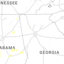
Tennessee
| Local Time | Report Details |
|---|---|
| 10:45 AM CST | Corrects previous tstm wnd dmg report from unionville. thunderstorm winds destroyed shed at a residence near unionvill in bedford county TN, 39.2 miles SSE of Nashville, TN |
| 10:59 AM CST | Corrects previous tstm wnd dmg report from 5 nnw bell buckle. tspotter report of downed trees along the railroad tracks south of fosterville near bell buckle road at fo in rutherford county TN, 40.9 miles SSE of Nashville, TN |
| 11:00 AM CST | Tspotter report of downed trees along the railroad tracks in fosterville. a roof was also torn off of a hay shed near the intersection of fosterville and bell buckle ro in rutherford county TN, 40.9 miles SSE of Nashville, TN |
| 11:15 AM CST | Thunderstorm winds destroyed shed at a residence near unionvill in bedford county TN, 39.2 miles SSE of Nashville, TN |
| 12:22 PM CST | Corrects previous tstm wnd dmg report from 1 n crossville. thunderstorm wind damage reported on tabor loop north of crossville. damage included a tree that fell onto a in cumberland county TN, 62.7 miles W of Knoxville, TN |
| 12:30 PM CST | Thunderstorm wind damage reported in crossville. damage included an uprooted tree... a torn roof off of a building... and shingle damage to a residenc in cumberland county TN, 62.7 miles W of Knoxville, TN |
| 2:32 PM EST | Corrects previous non-tstm wnd gst report from 4 se chattanooga. measured at the asos station kcha lovell field from thunderstorm winds. in addition... public report of in hamilton county TN, 6.3 miles E of Chattanooga, TN |
| 2:50 PM EST | Several trees down across the count in bradley county TN, 25.6 miles ENE of Chattanooga, TN |
| 2:55 PM EST | Several trees dow in mcminn county TN, 49.3 miles NE of Chattanooga, TN |
| 3:00 PM EST | Trees and powerlines down on ellistown r in knox county TN, 9.3 miles NE of Knoxville, TN |
| 3:06 PM EST | Numerous trees down across the count in monroe county TN, 39.1 miles SW of Knoxville, TN |
| 3:10 PM EST | Several trees down across the count in polk county TN, 38.3 miles ENE of Chattanooga, TN |
| 3:10 PM EST | Trees down on smith school r in knox county TN, 13 miles E of Knoxville, TN |
| 3:20 PM EST | Several trees dow in monroe county TN, 46.1 miles SSW of Knoxville, TN |
| 3:25 PM EST | Numerous shingles blown off roof... and trees dow in jefferson county TN, 26.5 miles ENE of Knoxville, TN |
| 3:40 PM EST | Large tree down with property damage to structure and fence. reported by trained spotte in hawkins county TN, 46.5 miles WSW of Bristol, TN |
| 4:15 PM EST | Trees down leading to power outage in sullivan county TN, 17.8 miles WSW of Bristol, TN |
| 11:51 PM CST | Quarter sized hail reported near Hohenwald, TN, 48 miles N of Florence, AL, quarter size hail reported on buffalo road south of hohenwald. |
Georgia
| Local Time | Report Details |
|---|---|
| 2:31 PM EST | Tree down on white oak gap r in dade county GA, 17.4 miles SW of Chattanooga, TN |
| 2:45 PM EST | Tree down on cloverdale rd and morgan r in dade county GA, 25.8 miles SSW of Chattanooga, TN |
| 4:36 PM EST | Tree down at akes station r in polk county GA, 55.9 miles WNW of Atlanta, GA |
| 4:57 PM EST | Tree down on wilson r in polk county GA, 42 miles WNW of Atlanta, GA |
| 5:00 PM EST | Tree down on yarbrough r in polk county GA, 46.7 miles WNW of Atlanta, GA |
| 5:12 PM EST | Tree down on a house off of brock stree in carroll county GA, 42 miles WSW of Atlanta, GA |
| 5:12 PM EST | Several trees down along five notch roa in carroll county GA, 40.8 miles WSW of Atlanta, GA |
| 7:00 PM EST | Tree down at beaumont heights and williamson r in bibb county GA, 76.3 miles SSE of Atlanta, GA |
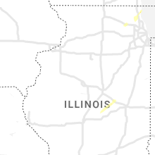
Illinois
| Local Time | Report Details |
|---|---|
| 2:14 PM CST | Quarter sized hail reported near Elgin, IL, 34.8 miles WNW of Chicago, IL, most hailstones were half an inch or less in diameter... but photos show that the largest hailstones were roughly one inch in diameter. |
| 2:53 PM CST | Quarter sized hail reported near Waukegan, IL, 33.9 miles NNW of Chicago, IL, photos shared showing hailstones approximately one inch in diameter in waukegan. time and location estimated from radar. |
| 5:17 PM CST | Ping Pong Ball sized hail reported near Farmer City, IL, 54.2 miles NNW of Mattoon, IL, delayed report. picture of hail just under golf ball size shared on social media. time estimated from radar. |
| 5:59 PM CST | Power lines blown down. possible tornado damage. time estimated from rada in ford county IL, 65.5 miles N of Mattoon, IL |
North Carolina
| Local Time | Report Details |
|---|---|
| 3:54 PM EST | Vehicle hit by fallen tree near intersection of airport road and love rd. no injuries reported after ems visited the scene. also one other report of a tree and powerlin in cherokee county NC, 53.1 miles S of Knoxville, TN |
| 4:59 PM EST | Trees down near beaver dam roa in watauga county NC, 29.2 miles SE of Bristol, TN |
| 5:03 PM EST | Tree down in the area of long ridge road and watauga river roa in watauga county NC, 33 miles SE of Bristol, TN |
| 5:04 PM EST | Tree down near intersection of highway 421 and 32 in watauga county NC, 34.5 miles SE of Bristol, TN |
| 5:10 PM EST | Tree down in the area of howards creek road and joe j miller roa in watauga county NC, 38.3 miles SE of Bristol, TN |
| 5:15 PM EST | Tree down in the area of elk creek road and old 421 sout in watauga county NC, 44 miles SE of Bristol, TN |
| 5:15 PM EST | Tree down in the area of old highway 421 and parkway schoo in watauga county NC, 44.5 miles SE of Bristol, TN |
| 6:00 PM EST | Tree down in the area of 233 university circle in boone... n in watauga county NC, 40.9 miles SE of Bristol, TN |
| 6:54 PM EST | Tree down on powerline at 282 blume rd in mooresvill in iredell county NC, 24.7 miles N of Charlotte, NC |
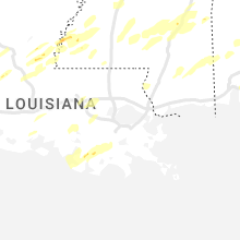
Louisiana
| Local Time | Report Details |
|---|---|
| 2:58 PM CST | Quarter sized hail reported near Jonesville, LA, 78.8 miles N of Lafayette, LA, dime to quarter hail. |
| 3:15 PM CST | Quarter sized hail reported near Monterey, LA, 84.8 miles N of Lafayette, LA, occurred near monterey... report via social media. |
| 4:32 PM CST | Quarter sized hail reported near Oakdale, LA, 56.4 miles NW of Lafayette, LA, 1" hail picture posted on social media. |
| 9:53 PM CST | Power lines down and roof damage near the intersection of fornea rd and jones creek rd. time estimated by rada in washington county LA, 66.2 miles NNE of New Orleans, LA |
| 11:47 PM CST | Half Dollar sized hail reported near Baton Rouge, LA, 56.5 miles ENE of Lafayette, LA, broadcast media report relayed via social media of hail estimated between quarter to half-dollar sized near essen & jefferson highway. |
Virginia
| Local Time | Report Details |
|---|---|
| 4:50 PM EST | 4 to 5 trees snapped and power poles downed along lake drive in saltvill in smyth county VA, 31.5 miles NE of Bristol, TN |
| 7:05 PM EST | Tree downed by thunderstorm winds... on blackberry road... blocking both lane in henry county VA, 36.1 miles S of Roanoke, VA |
Connect with Interactive Hail Maps