

Hail Map Boston, MA and Providence, RI, July 18, 2012
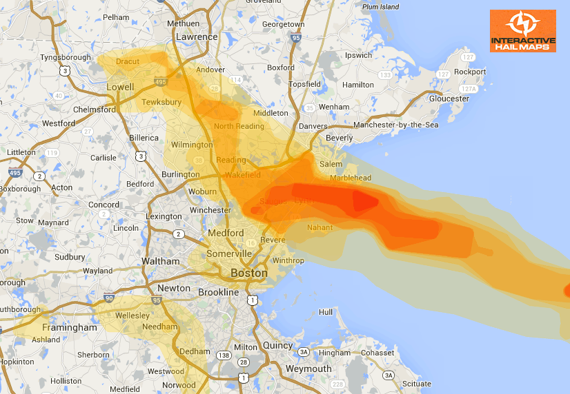
Here is a map for the hail that fell near Boston, MA and Providence, RI on July 18, 2012. The large hail fell north of Boston in Lynn and mostly North of Providence. Click on the map for a larger view. Use Interactive Hail Maps to locate hail storms throughout the US. Zero in by zooming all the way to street view.
Cities Most Affected by Hail Storms of 7/18/2012
| Hail Size | Demographics of Zip Codes Affected | ||||||
|---|---|---|---|---|---|---|---|
| City | Count | Average | Largest | Pop Density | House Value | Income | Age |
| Malden, MA | 2 | 1.75 | 1.75 | 11913 | $176k | $45.7k | 36.3 |
| Lexington, NE | 2 | 1.75 | 1.75 | 46 | $64k | $38.3k | 30.8 |
| Dighton, MA | 2 | 1.75 | 1.75 | 246 | $158k | $60.4k | 39.9 |
| Rehoboth, MA | 1 | 2.00 | 2.00 | 239 | $196k | $65.3k | 43.5 |
| Janesville, WI | 1 | 2.00 | 2.00 | 266 | $0k | $0.0k | 37.7 |
| Providence, RI | 1 | 2.00 | 2.00 | 4619 | $110k | $14.1k | 27.4 |
| Cove, OR | 1 | 2.00 | 2.00 | 6 | $132k | $41.3k | 48.4 |
| Cumberland, RI | 1 | 2.00 | 2.00 | 1318 | $145k | $54.7k | 42.6 |
| Thompson, CT | 1 | 1.75 | 1.75 | 159 | $122k | $49.1k | 42.1 |
| Eastford, CT | 1 | 1.75 | 1.75 | 35 | $144k | $55.6k | 44.8 |
| Putnam, CT | 1 | 1.75 | 1.75 | 456 | $107k | $42.9k | 39.9 |
| Dauphin, PA | 1 | 1.75 | 1.75 | 103 | $110k | $53.4k | 46.0 |
| La Grande, OR | 1 | 1.75 | 1.75 | 57 | $96k | $33.6k | 35.5 |
| Mount Pleasant, PA | 1 | 1.75 | 1.75 | 290 | $79k | $32.5k | 46.1 |
| Stoneham, MA | 1 | 1.75 | 1.75 | 3617 | $242k | $56.6k | 44.3 |
| Hazel, KY | 1 | 1.75 | 1.75 | 35 | $61k | $28.3k | 43.5 |
| Dover, PA | 1 | 1.75 | 1.75 | 414 | $108k | $45.9k | 41.0 |
| Pascoag, RI | 1 | 1.75 | 1.75 | 224 | $131k | $50.5k | 42.2 |
| Uxbridge, MA | 1 | 1.75 | 1.75 | 448 | $166k | $62.2k | 41.2 |
| Ridgeway, IA | 1 | 1.75 | 1.75 | 13 | $74k | $37.4k | 40.9 |
| Framingham, MA | 1 | 1.75 | 1.75 | 1832 | $220k | $70.6k | 43.3 |
| Smithfield, RI | 1 | 1.75 | 1.75 | 532 | $141k | $55.5k | 37.4 |
Connect with Interactive Hail Maps