

Hail Map for Castle Rock, Colorado July 30, 2012
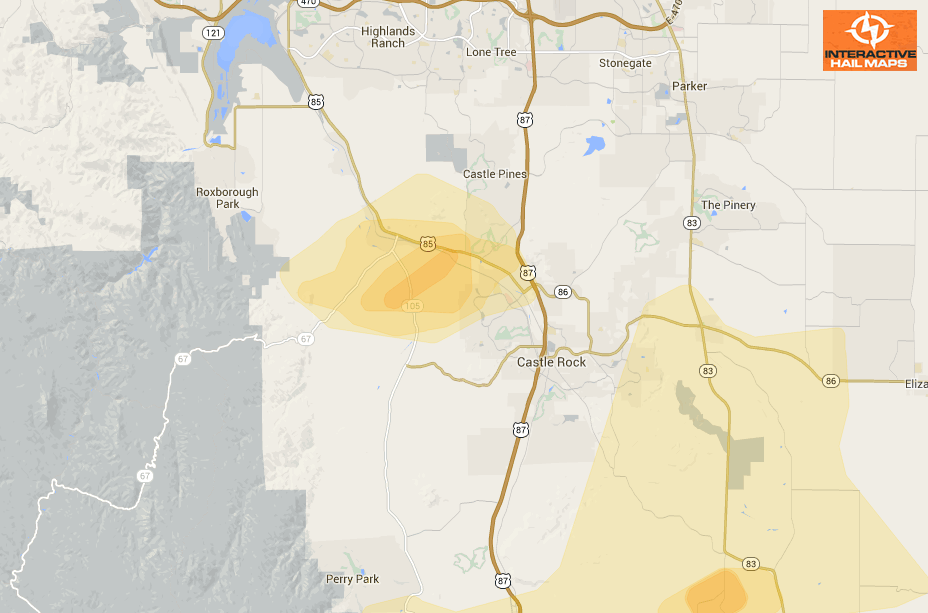
Here is a map of the radar indicated hail around Castle Rock, Colorado on July 30, 2012. The most intense large hail hit just west of the city. Use Interactive Hail Maps to pinpoint hail storms nationwide. Scroll day to day and zoom all the way to street view to see the exact neighborhoods affected.
Cities Most Affected by Hail Storms of 7/30/2012
| Hail Size | Demographics of Zip Codes Affected | ||||||
|---|---|---|---|---|---|---|---|
| City | Count | Average | Largest | Pop Density | House Value | Income | Age |
| Maribel, WI | 1 | 2.00 | 2.00 | 48 | $113k | $56.8k | 44.0 |
| Sobieski, WI | 1 | 2.00 | 2.00 | 155 | $146k | $64.5k | 39.9 |
| Slocomb, AL | 1 | 1.75 | 1.75 | 58 | $61k | $27.8k | 40.2 |
| Cicero, IN | 1 | 1.75 | 1.75 | 218 | $116k | $56.7k | 41.0 |
| Andalusia, AL | 1 | 1.75 | 1.75 | 40 | $62k | $27.9k | 39.9 |
| Greenleaf, WI | 1 | 1.75 | 1.75 | 50 | $120k | $52.6k | 38.6 |
| Wrightstown, WI | 1 | 1.75 | 1.75 | 707 | $117k | $53.2k | 33.1 |
| Martinsville, IN | 1 | 1.75 | 1.75 | 160 | $115k | $45.8k | 40.4 |
Connect with Interactive Hail Maps