

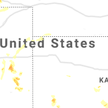
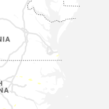
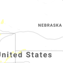
Hail Map for Friday, August 23, 2019

Number of Impacted Households on 8/23/2019
0
Impacted by 1" or Larger Hail
0
Impacted by 1.75" or Larger Hail
0
Impacted by 2.5" or Larger Hail
Square Miles of Populated Area Impacted on 8/23/2019
0
Impacted by 1" or Larger Hail
0
Impacted by 1.75" or Larger Hail
0
Impacted by 2.5" or Larger Hail


Cities Most Affected by Hail Storms of 8/23/2019
| Hail Size | Demographics of Zip Codes Affected | ||||||
|---|---|---|---|---|---|---|---|
| City | Count | Average | Largest | Pop Density | House Value | Income | Age |
| Strasburg, CO | 2 | 2.13 | 2.50 | 21 | $179k | $52.4k | 38.7 |
| Satanta, KS | 1 | 1.75 | 1.75 | 2 | $62k | $37.0k | 35.3 |
| Cheyenne, WY | 1 | 1.75 | 1.75 | 26 | $135k | $54.6k | 42.7 |
| Laverne, OK | 1 | 1.75 | 1.75 | 1 | $40k | $34.0k | 40.0 |
| Lakin, KS | 1 | 1.75 | 1.75 | 1 | $80k | $41.7k | 35.4 |
| Bennett, CO | 1 | 1.75 | 1.75 | 16 | $141k | $55.3k | 40.3 |
| Colorado Springs, CO | 1 | 1.75 | 1.75 | 3 | $112k | $40.8k | 38.5 |
Hail and Wind Damage Spotted on 8/23/2019
Filter by Report Type:Hail ReportsWind Reports
States Impacted
South Carolina, Alabama, Georgia, Virginia, Colorado, North Carolina, Wyoming, Arizona, Kansas, Texas, Oklahoma, Nebraska, New Mexico, North DakotaSouth Carolina
| Local Time | Report Details |
|---|---|
| 3:09 PM EDT | Schp reported tree in roadway peach orchard rd at commonwealth ct. time estimate in sumter county SC, 61.8 miles NNW of Charleston, SC |
| 3:10 PM EDT | Orangeburg dispatch reported a tree down at till rd and four holes rd. time estimate in orangeburg county SC, 45.6 miles WNW of Charleston, SC |
| 3:44 PM EDT | Scdot in sumter reported tree down near mayesville. exact location unknown. time estimate in sumter county SC, 55.9 miles NNW of Charleston, SC |
| 3:55 PM EDT | Several trees down off hwy 417 simpsonville hwy just off i-38 in greenville county SC, 18.9 miles ESE of Greenville, SC |
| 3:55 PM EDT | Schp reports tree down on i-95 at mile marker 100 southbound. time estimate in clarendon county SC, 32.9 miles NW of Charleston, SC |
| 3:58 PM EDT | Skywarn spotter reported winds estimated 65-70 mph. also dime size hail reporte in orangeburg county SC, 39.1 miles WNW of Charleston, SC |
| 3:58 PM EDT | Trained spotter reported tree down at 7881 charleston hwy (us hwy 178) south of bowman. time estimate in orangeburg county SC, 39.3 miles WNW of Charleston, SC |
| 3:59 PM EDT | Trained spotter reported tree down on ebenezer rd at cow castle creek. time estimate in orangeburg county SC, 36.5 miles WNW of Charleston, SC |
| 3:59 PM EDT | Trained spotter reported a tree down on holstein rd about one quarter mile west of ebenezer rd. time estimate in orangeburg county SC, 36.5 miles WNW of Charleston, SC |
| 4:06 PM EDT | Scdot office in sumter reported a tree down on plowden mill rd. exact location not known. time estimate in sumter county SC, 47.9 miles NNW of Charleston, SC |
| 4:20 PM EDT | Scdot office in clarendon co reported a tree down on us hwy 301 in turbeville. time estimate in clarendon county SC, 47.8 miles N of Charleston, SC |
| 4:20 PM EDT | Schp reported trees down on i-95 southbound between mile markers 139 and 141. time estimate in sumter county SC, 53.3 miles N of Charleston, SC |
| 4:51 PM EDT | Trees down adjacent to intersection of us 521 and boyd road in williamsburg county SC, 29.6 miles NE of Charleston, SC |
| 5:40 PM EDT | 911 call center reported multiple downed trees and power- lines with at least one downed tree on a home. time estimated by rada in cherokee county SC, 47.2 miles WSW of Charlotte, NC |
| 6:35 PM EDT | 911 call center reported several downed trees near clover... sc. time estimated by rada in york county SC, 23.5 miles WSW of Charlotte, NC |
| 6:45 PM EDT | Newberry dispatch reported numerous trees down in pomaria and vicinit in newberry county SC, 62.9 miles NNE of Augusta, GA |
Alabama
| Local Time | Report Details |
|---|---|
| 2:28 PM CDT | A few trees were blown down near ashland. the trees damaged a swimming pool and hom in clay county AL, 49.9 miles NNW of Auburn, AL |
| 3:45 PM CDT | Tree or limb fell causing minor roof damage to a residence near ford city. small hail also reported. time estimated from rada in colbert county AL, 8.3 miles E of Florence, AL |
| 4:45 PM CDT | Trees were blown down and damaged a few vehicle in jefferson county AL, 7.8 miles SSE of Birmingham, AL |
Georgia
| Local Time | Report Details |
|---|---|
| 3:47 PM EDT | Powerline low and blowing across twin bridges roa in bartow county GA, 50.9 miles SSE of Chattanooga, TN |
| 3:47 PM EDT | Multiple trees down to the north of mt. pisgah road... including davis ridge road... donna lane... and brock circl in catoosa county GA, 14.8 miles SE of Chattanooga, TN |
| 3:47 PM EDT | Tree down along colbert hollow roa in catoosa county GA, 19.8 miles SSE of Chattanooga, TN |
| 3:47 PM EDT | Multiple trees down along poplar springs road and talley roa in catoosa county GA, 12.7 miles SSE of Chattanooga, TN |
| 3:49 PM EDT | Tree reported down in road at the intersection of erwin hill road and plainview roa in gordon county GA, 50.2 miles SSE of Chattanooga, TN |
| 3:50 PM EDT | Multiple powerlines down and a tree down near the intersection of old dixie hwy and woody r in bartow county GA, 50.5 miles SSE of Chattanooga, TN |
| 3:50 PM EDT | Tree reported down across outer lane of i-75 north of exit 30 in bartow county GA, 50.4 miles SSE of Chattanooga, TN |
| 4:07 PM EDT | Tree down near intersection of wilbanks road and lake roa in catoosa county GA, 19.1 miles SE of Chattanooga, TN |
| 4:25 PM EDT | Tree reported down in road at the intersection of erwin hill road and plainview roa in gordon county GA, 50.2 miles SSE of Chattanooga, TN |
| 6:33 PM EDT | Tree reported down across the street near cocorahs observer's hom in clarke county GA, 61.5 miles E of Atlanta, GA |
| 6:43 PM EDT | Tree down along s milledge ave near peabody s in clarke county GA, 59.2 miles ENE of Atlanta, GA |
| 6:43 PM EDT | Tree on powerlines reported on the 700 block of whitehall road. tree down near snapfinger dr and sorenson ridge just to the eas in clarke county GA, 60.2 miles E of Atlanta, GA |
| 6:43 PM EDT | Trees reported on powerlines at us 78 and timber creek drive and along the 1000 block of beaverdam rd just to the nort in clarke county GA, 64 miles ENE of Atlanta, GA |
| 6:43 PM EDT | Tree down at the intersection of barber street and north chase stree in clarke county GA, 59.7 miles ENE of Atlanta, GA |
Virginia
| Local Time | Report Details |
|---|---|
| 3:54 PM EDT | Large tree down in the 1000 block of phoebe pond road. time estimated from rada in appomattox county VA, 54.3 miles E of Roanoke, VA |
| 4:00 PM EDT | Corrects previous tstm wnd dmg report from 3 nne evergreen. tree down on power lines in the 1500 block of morning star road. time estimated from rada in appomattox county VA, 62 miles W of Richmond, VA |
| 4:35 PM EDT | Trees downed along us-360 and va-49 near crewe. report time estimated based on rada in nottoway county VA, 32.4 miles SW of Richmond, VA |
| 5:10 PM EDT | Trees downed between mile marker 44 and 45 on i-8 in dinwiddie county VA, 34.8 miles S of Richmond, VA |
| 5:55 PM EDT | Tree down blocking one lane of club house road near its intersection with island court. time estimated from rada in henry county VA, 42.3 miles S of Roanoke, VA |
| 6:00 PM EDT | Tree down on power lines in the 1500 block of morning star road. time estimated from rada in appomattox county VA, 62 miles W of Richmond, VA |
| 6:56 PM EDT | Tree blocking multiple lanes of traffic on memorial drive just north of intersection with central boulevard. time estimated from rada in city of danville county VA, 55.4 miles SSE of Roanoke, VA |
Colorado
| Local Time | Report Details |
|---|---|
| 3:10 PM MDT | Tennis Ball sized hail reported near Strasburg, CO, 36.3 miles E of Denver, CO |
| 3:21 PM MDT | Golf Ball sized hail reported near Bennett, CO, 31 miles E of Denver, CO |
| 3:24 PM MDT | Golf Ball sized hail reported near Strasburg, CO, 33.1 miles E of Denver, CO |
| 4:42 PM MDT | Quarter sized hail reported near Holly, CO, 75.8 miles W of Garden City, KS |
| 5:22 PM MDT | Quarter sized hail reported near Lamar, CO, 94.4 miles W of Garden City, KS |
| 5:25 PM MDT | Golf Ball sized hail reported near Colorado Springs, CO, 24 miles NNE of Pueblo, CO, pic via social media. time estimated by radar. |
| 5:52 PM MDT | Quarter sized hail reported near Eaton, CO, 59.2 miles NNE of Denver, CO |
| 6:10 PM MDT | Quarter sized hail reported near Wild Horse, CO, 83.3 miles S of Yuma, CO |
| 6:15 PM MDT | Half Dollar sized hail reported near Lamar, CO, 98.5 miles W of Garden City, KS, pic via social media. |
North Carolina
| Local Time | Report Details |
|---|---|
| 5:25 PM EDT | Trees downed along us-17 just sse of windsor. time is radar estimate in bertie county NC, 71.7 miles SW of Virginia Beach, VA |
| 5:49 PM EDT | Quarter sized hail reported near Newton, NC, 39 miles NW of Charlotte, NC, public reported marble to quarter sized hail with wind gusts to 50 mph. |
| 6:48 PM EDT | Tree blown down damaging power lines along bryan street. time estimated from rada in rockingham county NC, 55.3 miles S of Roanoke, VA |
Wyoming
| Local Time | Report Details |
|---|---|
| 4:30 PM MDT | Quarter sized hail reported near Cheyenne, WY, 39.4 miles ESE of Laramie, WY, mostly marbles and nickels with a few quarters mixed in. duration 5 minutes. |
| 4:37 PM MDT | Ping Pong Ball sized hail reported near Cheyenne, WY, 41.6 miles E of Laramie, WY |
| 4:42 PM MDT | Quarter sized hail reported near Cheyenne, WY, 41.7 miles E of Laramie, WY |
| 4:43 PM MDT | Quarter sized hail reported near Sheridan, WY, 83.6 miles WNW of Gillette, WY |
| 4:44 PM MDT | Quarter sized hail reported near Cheyenne, WY, 41.7 miles E of Laramie, WY |
| 4:45 PM MDT | Half Dollar sized hail reported near Cheyenne, WY, 41.7 miles E of Laramie, WY, reports of half dollar sized hail |
| 4:45 PM MDT | Half Dollar sized hail reported near Cheyenne, WY, 39.6 miles E of Laramie, WY, hail fell for duration of 10 minutes. |
| 4:59 PM MDT | Ping Pong Ball sized hail reported near Sheridan, WY, 83.2 miles WNW of Gillette, WY, viewer sent video of ping-pong ball sized hail to media. |
| 5:05 PM MDT | Golf Ball sized hail reported near Cheyenne, WY, 41.7 miles E of Laramie, WY |
Arizona
| Local Time | Report Details |
|---|---|
| 4:41 PM MST | Corrects previous non-tstm wnd gst report from 7 n pirtleville. asos station kdug bisbee douglas intl a in cochise county AZ, 8.8 miles N of Douglas, AZ |
| 6:09 PM MST | Asos station kfhu libby field/sierra vista muni a in cochise county AZ, 49.8 miles WNW of Douglas, AZ |
| 6:12 PM MST | Asos station kalk pioneer airfiel in cochise county AZ, 53.3 miles SE of Tucson, AZ |
Kansas
| Local Time | Report Details |
|---|---|
| 7:09 PM CDT | Quarter sized hail reported near Kismet, KS, 52 miles S of Garden City, KS |
| 7:10 PM CDT | Golf Ball sized hail reported near Satanta, KS, 28.5 miles S of Garden City, KS |
| 7:13 PM CDT | Golf Ball sized hail reported near Lakin, KS, 18.6 miles W of Garden City, KS |
| 7:15 PM CDT | Storm damage reported in haskell county KS, 28.5 miles S of Garden City, KS |
| 7:25 PM CDT | Two to three inch diameter limbs were blown from an elm tre in grant county KS, 23.5 miles SW of Garden City, KS |
Texas
| Local Time | Report Details |
|---|---|
| 7:44 PM CDT | Via the west texas mesonet in crane county TX, 30.3 miles S of Odessa, TX |
| 8:15 PM CDT | Storm damage reported in moore county TX, 46.1 miles NNW of Amarillo, TX |
| 8:53 PM CDT | Storm damage reported in hutchinson county TX, 48.7 miles NNE of Amarillo, TX |
| 9:40 PM CDT | One inch tree limbs broken. shingles blown of in ochiltree county TX, 65.9 miles W of Woodward, OK |
| 9:43 PM CDT | Report send via twitter of debris... and power lines across highway 23 and county road c blocking the road for traffi in lipscomb county TX, 63.1 miles W of Woodward, OK |
| 9:58 PM CDT | Storm damage reported in oldham county TX, 52.5 miles W of Amarillo, TX |
| 11:17 PM CDT | Quarter sized hail reported near Canadian, TX, 80.6 miles SW of Woodward, OK |
Oklahoma
| Local Time | Report Details |
|---|---|
| 8:10 PM CDT | Trained spotters reported that barn was destroyed with damage to a house 6 miles east of beave in beaver county OK, 62.4 miles WNW of Woodward, OK |
| 8:15 PM CDT | Storm damage reported in beaver county OK, 67.8 miles WNW of Woodward, OK |
| 8:21 PM CDT | Ping Pong Ball sized hail reported near Beaver, OK, 67.5 miles WNW of Woodward, OK |
| 9:20 PM CDT | Golf Ball sized hail reported near Laverne, OK, 42.1 miles WNW of Woodward, OK |
| 9:20 PM CDT | Storm damage reported in beaver county OK, 49.3 miles WNW of Woodward, OK |
Nebraska
| Local Time | Report Details |
|---|---|
| 8:44 PM MDT | Personal weather station recorded 58 mph wind gust in northeast potte in cheyenne county NE, 47.5 miles SSE of Scottsbluff, NE |
| 9:08 PM MDT | Quarter sized hail reported near Benkelman, NE, 51.7 miles NNW of Colby, KS |
New Mexico
| Local Time | Report Details |
|---|---|
| 8:58 PM MDT | K4mr awo in roosevelt county NM, 60.7 miles S of Tucumcari, NM |
North Dakota
| Local Time | Report Details |
|---|---|
| 6:40 AM CDT | Quarter sized hail reported near Sherwood, ND, 52.3 miles NNW of Minot, ND |
Connect with Interactive Hail Maps