

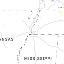
Hail Map for Monday, August 3, 2020

Number of Impacted Households on 8/3/2020
0
Impacted by 1" or Larger Hail
0
Impacted by 1.75" or Larger Hail
0
Impacted by 2.5" or Larger Hail
Square Miles of Populated Area Impacted on 8/3/2020
0
Impacted by 1" or Larger Hail
0
Impacted by 1.75" or Larger Hail
0
Impacted by 2.5" or Larger Hail


Cities Most Affected by Hail Storms of 8/3/2020
| Hail Size | Demographics of Zip Codes Affected | ||||||
|---|---|---|---|---|---|---|---|
| City | Count | Average | Largest | Pop Density | House Value | Income | Age |
| Calhoun, GA | 2 | 2.50 | 2.50 | 266 | $86k | $40.3k | 34.5 |
| Buena Vista, NM | 1 | 2.00 | 2.00 | 0 | $113k | $33.8k | 45.9 |
Hail and Wind Damage Spotted on 8/3/2020
Filter by Report Type:Hail ReportsWind Reports
States Impacted
Alabama, Georgia, Virginia, Maryland, District of Columbia, New Mexico, Kentucky, Tennessee, New Jersey, New York, Wyoming, Montana, Ohio, North Carolina, ConnecticutAlabama
| Local Time | Report Details |
|---|---|
| 10:28 AM CDT | Quarter sized hail reported near Cedar Bluff, AL, 59.4 miles SSW of Chattanooga, TN, quarter-sized hail reported in the cedar bluff area. |
| 10:32 AM CDT | Quarter sized hail reported near Gaylesville, AL, 55.2 miles SSW of Chattanooga, TN, quarter-sized hail gaylesville to broomtown. |
| 10:42 AM CDT | A few trees were blown dow in cherokee county AL, 54.6 miles SSW of Chattanooga, TN |
| 11:50 AM CDT | Tree and metal shed blown dow in calhoun county AL, 66.3 miles ENE of Birmingham, AL |
| 11:50 AM CDT | Quarter sized hail reported near Anniston, AL, 65.5 miles ENE of Birmingham, AL, quarter-size hail reported in white plains along choccolocco road. |
Georgia
| Local Time | Report Details |
|---|---|
| 12:12 PM EDT | Quarter sized hail reported near Menlo, GA, 38 miles SSW of Chattanooga, TN, quarter-sized hail reported along the al/ga line. |
| 1:16 PM EDT | Half Dollar sized hail reported near Dawsonville, GA, 50.3 miles NNE of Atlanta, GA, quarter- to half dollar-sized hail reported near the intersection of plainville rd and old calhoun rd. |
| 1:22 PM EDT | Roof damage to several homes along bowdoin lane... including shingles and insulation pulled off in gordon county GA, 49 miles SSE of Chattanooga, TN |
| 1:27 PM EDT | A couple trees downed and roof damage to a structure on hensley rd se in gordon county GA, 47.7 miles SSE of Chattanooga, TN |
| 1:30 PM EDT | Trees reported snapped/uprooted between hwy 124 and hog mountain r in gwinnett county GA, 37.3 miles NE of Atlanta, GA |
| 1:30 PM EDT | Multiple trees down along charmin circle roa in gordon county GA, 47 miles SSE of Chattanooga, TN |
| 1:38 PM EDT | Tennis Ball sized hail reported near Calhoun, GA, 49.9 miles SSE of Chattanooga, TN, tennis ball-sized hail reported at sonora drive se... leaving dents in cars. |
| 1:40 PM EDT | Tennis Ball sized hail reported near Calhoun, GA, 50 miles SE of Chattanooga, TN, tennis ball-sized hail reported on fairmount highway near cash road. |
| 2:10 PM EDT | Several trees downed in south fulton. old fairburn road and lakeside blv in fulton county GA, 10.1 miles SW of Atlanta, GA |
| 2:10 PM EDT | A few trees and power lines downed on tilley r in pickens county GA, 52.6 miles N of Atlanta, GA |
| 2:10 PM EDT | 7-10 trees taken down near intersection of hwy 136 and old post trai in pickens county GA, 54.8 miles N of Atlanta, GA |
| 2:15 PM EDT | A few trees and power lines downed on antioch church r in pickens county GA, 53.1 miles N of Atlanta, GA |
| 2:15 PM EDT | Trees and power lines down along wolf fork roa in rabun county GA, 47.3 miles W of Greenville, SC |
| 2:30 PM EDT | Metal awning above boats sustained damage at the aqualand marin in hall county GA, 39.8 miles NE of Atlanta, GA |
| 2:39 PM EDT | Numerous trees down along mcswain dr... old mill dr... and bailey mill road near lake lanie in forsyth county GA, 40.7 miles NNE of Atlanta, GA |
| 2:40 PM EDT | Boat dock turned loose... boat dock forced on top of another boat dock... numerous trees down... and quarter-sized hail reported on/near the 9000 block of ponderosa tra in forsyth county GA, 41.3 miles NE of Atlanta, GA |
| 2:40 PM EDT | Quarter sized hail reported near Gainesville, GA, 43.1 miles NE of Atlanta, GA, quarter-sized hail reported in oscarville on hwy 369... 1.25 miles from the lake lanier bridge. |
| 2:42 PM EDT | Tree downed onto a bath house off of vanns tavern rd near vanns tavern par in forsyth county GA, 41.3 miles NE of Atlanta, GA |
| 2:42 PM EDT | Tree downed over the road on donaldson drive near blairsville circle in dekalb county GA, 10.4 miles NNE of Atlanta, GA |
| 2:45 PM EDT | Tree down on powerlines along kayron drive and reed lane causing road closur in fulton county GA, 11.9 miles N of Atlanta, GA |
| 2:50 PM EDT | Tree blocking all lanes at cannady court and treadwick driv in fulton county GA, 15.7 miles NNE of Atlanta, GA |
| 2:52 PM EDT | Tree downed onto the road at spalding drive and old dominion drive in fulton county GA, 16.2 miles NNE of Atlanta, GA |
| 3:05 PM EDT | Metal roofing ripped from the strip mall at the intersection of hwy 53 east and hwy 400. metal was blown into large power lines behind the building and severed the line in dawson county GA, 46.7 miles NNE of Atlanta, GA |
| 3:07 PM EDT | Trees downed on s hicks circle in conyers and along honey creek roa in rockdale county GA, 21.9 miles ESE of Atlanta, GA |
| 3:50 PM EDT | Trees reported down on powerlines along hwy 36... north of barnesville. time estimated from rada in lamar county GA, 44.2 miles SSE of Atlanta, GA |
| 4:15 PM EDT | Tree down on powerline along yancy stree in muscogee county GA, 33.2 miles E of Auburn, AL |
| 4:15 PM EDT | Large tree down along grant roa in muscogee county GA, 33.6 miles ESE of Auburn, AL |
| 4:15 PM EDT | Large tree down on house along yates driv in muscogee county GA, 33.8 miles ESE of Auburn, AL |
| 4:28 PM EDT | Several trees down along high shoals roa in oconee county GA, 53.2 miles E of Atlanta, GA |
| 4:28 PM EDT | Several trees down along the 2300 block of high shoals roa in morgan county GA, 51.4 miles E of Atlanta, GA |
| 6:34 PM EDT | Trees down on highway 43 at amity woodlawn r in lincoln county GA, 32.8 miles WNW of Augusta, GA |
Virginia
| Local Time | Report Details |
|---|---|
| 1:14 PM EDT | Tree down at the intersection of swain and chatham rd in halifax county VA, 61.7 miles ESE of Roanoke, VA |
| 1:31 PM EDT | Tree down across plantation driv in pittsylvania county VA, 45.2 miles SSE of Roanoke, VA |
| 1:40 PM EDT | Tree down at the intersection of soapstone road and chestnut knob roa in henry county VA, 45 miles S of Roanoke, VA |
| 1:48 PM EDT | Tree down at 92 east river bend d in spotsylvania county VA, 57.2 miles N of Richmond, VA |
| 1:52 PM EDT | Multiple reports of trees down at the intersection of trustlow rd and poplar r in stafford county VA, 61.4 miles N of Richmond, VA |
| 1:55 PM EDT | Tree on power line in the 500 block of dillons fork roa in henry county VA, 39.4 miles S of Roanoke, VA |
| 2:18 PM EDT | Tree down at the intersection of hope rd and somerset l in stafford county VA, 65.4 miles NNE of Richmond, VA |
| 3:13 PM EDT | Tree down at the intersection of muscoe place and comorn road in king george county VA, 58.9 miles NNE of Richmond, VA |
| 3:20 PM EDT | Tree down on us-17 tidewater trail near the spotsylvania/caroline county lin in spotsylvania county VA, 52.9 miles NNE of Richmond, VA |
| 3:22 PM EDT | Tree down at the intersection of massaponax church rd and smith station r in spotsylvania county VA, 48.5 miles N of Richmond, VA |
| 3:22 PM EDT | Tree down at 5979 partlow r in spotsylvania county VA, 48.1 miles N of Richmond, VA |
| 3:25 PM EDT | Tree down at the intersection of muscoe place and comorn road in king george county VA, 58.9 miles NNE of Richmond, VA |
| 3:27 PM EDT | Tree down at the intersection of caledon rd and garcia ct in king george county VA, 59.2 miles NNE of Richmond, VA |
| 3:31 PM EDT | Tree down near 120 river r in stafford county VA, 56.6 miles N of Richmond, VA |
| 3:34 PM EDT | Tree down near 729 walnut d in stafford county VA, 59.1 miles NNE of Richmond, VA |
| 4:12 PM EDT | A tree fell onto a car in the 4000 block of us-522 zachary taylor highwa in orange county VA, 60.9 miles NNW of Richmond, VA |
| 4:27 PM EDT | Tree down at the intersection of massaponax church rd and smith station r in spotsylvania county VA, 48.5 miles N of Richmond, VA |
| 4:43 PM EDT | Trees and wires down near annandale and merrifield... including near the intersection of whispering lane and watkins trail... and on va-699 prosperity avenue near us-50 in fairfax county VA, 43.3 miles SW of Baltimore, MD |
| 4:49 PM EDT | Tree down in the 11300 block of homeland roa in culpeper county VA, 69.3 miles NNW of Richmond, VA |
Maryland
| Local Time | Report Details |
|---|---|
| 3:22 PM EDT | Tree down in the 1300 block of saunders marina place in charles county MD, 68.3 miles NE of Richmond, VA |
| 3:32 PM EDT | Tree down in the 1300 block of saunders marina place in charles county MD, 68.3 miles NE of Richmond, VA |
| 3:40 PM EDT | Tree down in the 8000 block of kentucky avenue in charles county MD, 58.5 miles SSW of Baltimore, MD |
| 3:43 PM EDT | Powerlines down near the intersection of bayside road and bailey drive in st. marys county MD, 68.5 miles S of Baltimore, MD |
| 3:47 PM EDT | Tree down in the 8000 block of kentucky avenue in charles county MD, 58.5 miles SSW of Baltimore, MD |
| 3:55 PM EDT | Tree down near the intersection of hampshire circle and gray wolf court in charles county MD, 50 miles SSW of Baltimore, MD |
| 4:14 PM EDT | Trees down in the area of md-382 croom road and molly berry roa in prince georges county MD, 39.5 miles SSW of Baltimore, MD |
| 4:15 PM EDT | Tree down on us-301 crain hgwy at dyson rd in prince georges county MD, 41.4 miles SSW of Baltimore, MD |
District of Columbia
| Local Time | Report Details |
|---|---|
| 4:36 PM EDT | A few trees and large branches were blown down in dc... including in the 3300 block of alabama avenue southeast... near the intersection of 12th street northwest and ka in district of columb county DC, 34.3 miles SW of Baltimore, MD |
New Mexico
| Local Time | Report Details |
|---|---|
| 3:56 PM MDT | Hen Egg sized hail reported near Buena Vista, NM, 39 miles SSE of Taos, NM |
| 6:36 PM MDT | Krtn aso in colfax county NM, 63.6 miles ENE of Taos, NM |
Kentucky
| Local Time | Report Details |
|---|---|
| 6:29 PM EDT | Tree down covering the roa in boyle county KY, 47.5 miles ESE of Louisville, KY |
| 6:31 PM EDT | Tree down on mitchellsburg knob roa in boyle county KY, 49.8 miles ESE of Louisville, KY |
| 6:45 PM EDT | Mercer county dispatch reported a tree down on us 127 at 2118 danville roa in mercer county KY, 45.8 miles W of Irvine, KY |
| 6:52 PM EDT | Tree uprooted and covering us 6 in boyle county KY, 44.3 miles W of Irvine, KY |
| 8:30 PM EDT | 2 trees knocked down on route in bracken county KY, 37.4 miles SE of Cincinnati, OH |
Tennessee
| Local Time | Report Details |
|---|---|
| 6:00 PM CDT | Photo showed a tree blown down onto a house on central pike east of tulip grove road in hermitage in davidson county TN, 10.5 miles E of Nashville, TN |
New Jersey
| Local Time | Report Details |
|---|---|
| 7:01 PM EDT | Downed power lines near mantua boulevard in sewell. time estimated from rada in gloucester county NJ, 85.4 miles ENE of Baltimore, MD |
| 7:10 PM EDT | Wires dow in camden county NJ, 77.8 miles SW of Brooklyn, NY |
| 7:18 PM EDT | Downed trees and wires near cotswold lane in cherry hill. time estimated from rada in camden county NJ, 76.4 miles SW of Brooklyn, NY |
| 7:20 PM EDT | Trees down on burnt mills rd. and walt whitman blv in camden county NJ, 76 miles SW of Brooklyn, NY |
| 7:33 PM EDT | Nws employee estimated 60 mph winds along with some minor tree damag in burlington county NJ, 68.1 miles SW of Brooklyn, NY |
| 7:35 PM EDT | Siding blown off building in mount laure in burlington county NJ, 70.4 miles SW of Brooklyn, NY |
| 7:37 PM EDT | Downed power lines near lacey road in roosevelt city. time estimated from rada in ocean county NJ, 55.5 miles SSW of Brooklyn, NY |
| 7:50 PM EDT | Downed trees and wires near morningside street and 10th avenue near pine lake. time estimated from rada in ocean county NJ, 49.6 miles SSW of Brooklyn, NY |
| 7:51 PM EDT | Kmjx aso in ocean county NJ, 54.9 miles SSW of Brooklyn, NY |
| 7:51 PM EDT | Kmjx aso in ocean county NJ, 54.9 miles SSW of Brooklyn, NY |
| 7:54 PM EDT | Downed trees and wires near ward avenue in crosswicks. time estimated from rada in burlington county NJ, 51.1 miles SW of Brooklyn, NY |
| 7:55 PM EDT | Njwxnet statio in ocean county NJ, 55.1 miles SSW of Brooklyn, NY |
| 7:59 PM EDT | Spotter reports 58 mph winds... penny size hail... and power outages. time estimated from rada in ocean county NJ, 52.3 miles SSW of Brooklyn, NY |
| 8:10 PM EDT | Downed trees and wires near hendrickson drive in west windsor. time estimated from rada in mercer county NJ, 42 miles SW of Brooklyn, NY |
| 8:11 PM EDT | Downed tree and wires on nj route 37 both directions at cr 39 (mule road) in toms river townshi in ocean county NJ, 52.4 miles SSW of Brooklyn, NY |
| 8:15 PM EDT | Trees down in branchbur in somerset county NJ, 38.4 miles WSW of Brooklyn, NY |
| 8:15 PM EDT | Tree down in monro in middlesex county NJ, 34.6 miles SW of Brooklyn, NY |
| 8:16 PM EDT | Downed tree on nj route 33 westbound ramp to nj route 18 in neptune township... n in monmouth county NJ, 34 miles S of Brooklyn, NY |
| 8:17 PM EDT | Storm damage reported in somerset county NJ, 40.9 miles WSW of Brooklyn, NY |
| 8:18 PM EDT | Storm damage reported in anz451 county NJ, 45.1 miles S of Brooklyn, NY |
| 8:18 PM EDT | Storm damage reported in anz451 county NJ, 45.1 miles S of Brooklyn, NY |
| 8:19 PM EDT | Weatherflow senso in ocean county NJ, 47.2 miles S of Brooklyn, NY |
| 8:19 PM EDT | Downed trees and wires near corlies avenue in neptune city. time estimated from rada in monmouth county NJ, 33.4 miles S of Brooklyn, NY |
| 8:30 PM EDT | Trees down in bedminste in somerset county NJ, 34.7 miles W of Brooklyn, NY |
| 8:31 PM EDT | Downed trees and wires near heathcliff road in rumson. time estimated from rada in monmouth county NJ, 23.6 miles S of Brooklyn, NY |
| 8:32 PM EDT | Downed trees and wires near hartshorne lane in rumson. time estimated from rada in monmouth county NJ, 22.3 miles S of Brooklyn, NY |
| 8:45 PM EDT | Downed trees and wires near hill road and lincoln avenue in iselin. time estimated from rada in middlesex county NJ, 18 miles WSW of Brooklyn, NY |
| 8:47 PM EDT | Downed tree on cooper lane near tiger brook park in chester. time estimated from rada in morris county NJ, 37.1 miles W of Brooklyn, NY |
| 9:11 PM EDT | Downed trees and wires near minnehaha boulevard in lake hiawatha. time estimated from rada in morris county NJ, 24.2 miles WNW of Brooklyn, NY |
New York
| Local Time | Report Details |
|---|---|
| 7:15 PM EDT | Tree down across mendon center road near carolina d in monroe county NY, 68.6 miles E of Buffalo, NY |
| 7:25 PM EDT | Tree down in backyard in monroe county NY, 69.1 miles ENE of Buffalo, NY |
| 7:30 PM EDT | Tree down in yard on south lincoln road in monroe county NY, 67.6 miles W of Syracuse, NY |
| 7:39 PM EDT | Tree on house on chelsea way in monroe county NY, 65.9 miles W of Syracuse, NY |
| 8:50 PM EDT | A marine thunderstorm wind gust of 55 knots was reported at the ny harbor entrance buoy in anz355 county NY, 27 miles SE of Brooklyn, NY |
| 9:13 PM EDT | A thunderstorm wind gust of 58 mph was reported at great south bay mesonet station in suffolk county NY, 31.1 miles E of Brooklyn, NY |
| 9:14 PM EDT | A 40 foot white birch was bent over to just above the ground with debris everywhere with police on scene in nassau county NY, 23.3 miles E of Brooklyn, NY |
| 9:40 PM EDT | A marine thunderstorm wind gust of 51 knots was reported at bayville mesonet station in nassau county NY, 23.7 miles NE of Brooklyn, NY |
Wyoming
| Local Time | Report Details |
|---|---|
| 5:36 PM MDT | Storm damage reported in campbell county WY, 25.3 miles S of Gillette, WY |
Montana
| Local Time | Report Details |
|---|---|
| 6:44 PM MDT | Storm damage reported in park county MT, 28.3 miles E of Bozeman, MT |
| 6:55 PM MDT | Storm damage reported in park county MT, 28.3 miles E of Bozeman, MT |
| 7:15 PM MDT | Quarter sized hail reported near Bozeman, MT, 6.2 miles W of Bozeman, MT |
| 8:28 PM MDT | Storm damage reported in stillwater county MT, 30.9 miles WSW of Billings, MT |
| 8:35 PM MDT | Storm damage reported in stillwater county MT, 30.9 miles WSW of Billings, MT |
| 9:15 PM MDT | Storm damage reported in yellowstone county MT, 2.8 miles NW of Billings, MT |
| 9:20 PM MDT | Cottonwood tree downed on parked car in billings height in yellowstone county MT, 3.4 miles NNE of Billings, MT |
| 9:45 PM MDT | Power lines down both at this location and on the west end of tow in yellowstone county MT, 0.7 miles WSW of Billings, MT |
Ohio
| Local Time | Report Details |
|---|---|
| 9:02 PM EDT | Tree downed on to car on state route 73. no injuries. time est by rada in scioto county OH, 68.1 miles E of Cincinnati, OH |
North Carolina
| Local Time | Report Details |
|---|---|
| 9:42 PM EDT | Emergency manager report of a downed tree on power lines at the intersection of deer hill drive and myrtle grove roa in new hanover county NC, 9.4 miles SSE of Wilmington, NC |
Connecticut
| Local Time | Report Details |
|---|---|
| 9:43 PM EDT | Downed street light and power cables from a fallen branch on barret avenue with road closure at turner road and barrett avenue in fairfield county CT, 31.9 miles NE of Brooklyn, NY |
| 9:45 PM EDT | A large branch reported down in greenwich in back yard at elm street and mason stree in fairfield county CT, 30 miles NE of Brooklyn, NY |
| 9:45 PM EDT | Large branch reported down at hubbard avenue near west north steet in fairfield county CT, 31.9 miles NE of Brooklyn, NY |
| 9:53 PM EDT | Large tree limb down and blocking the road on highland place in greenwich with time estimated by radar in fairfield county CT, 30 miles NE of Brooklyn, NY |
Connect with Interactive Hail Maps