

Hail Map for Wednesday, February 23, 2011

Number of Impacted Households on 2/23/2011
0
Impacted by 1" or Larger Hail
0
Impacted by 1.75" or Larger Hail
0
Impacted by 2.5" or Larger Hail
Square Miles of Populated Area Impacted on 2/23/2011
0
Impacted by 1" or Larger Hail
0
Impacted by 1.75" or Larger Hail
0
Impacted by 2.5" or Larger Hail


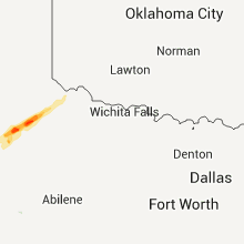
Cities Most Affected by Hail Storms of 2/23/2011
| Hail Size | Demographics of Zip Codes Affected | ||||||
|---|---|---|---|---|---|---|---|
| City | Count | Average | Largest | Pop Density | House Value | Income | Age |
Hail and Wind Damage Spotted on 2/23/2011
Filter by Report Type:Hail ReportsWind Reports
Texas
| Local Time | Report Details |
|---|---|
| 9:00 AM UTC | Quarter sized hail reported near Tahoka, TX, 29.3 miles S of Lubbock, TX |
Arkansas
| Local Time | Report Details |
|---|---|
| 11:35 AM UTC | Trees down across highway 82 at the columbia and union county line in columbia county AR, 68.9 miles SE of Nashville, AR |
Connect with Interactive Hail Maps