

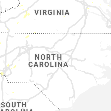
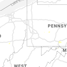
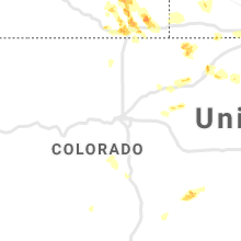
Hail Map for Tuesday, July 21, 2020

Number of Impacted Households on 7/21/2020
0
Impacted by 1" or Larger Hail
0
Impacted by 1.75" or Larger Hail
0
Impacted by 2.5" or Larger Hail
Square Miles of Populated Area Impacted on 7/21/2020
0
Impacted by 1" or Larger Hail
0
Impacted by 1.75" or Larger Hail
0
Impacted by 2.5" or Larger Hail


Cities Most Affected by Hail Storms of 7/21/2020
| Hail Size | Demographics of Zip Codes Affected | ||||||
|---|---|---|---|---|---|---|---|
| City | Count | Average | Largest | Pop Density | House Value | Income | Age |
| Cheyenne, WY | 4 | 2.13 | 2.50 | 26 | $135k | $54.6k | 42.7 |
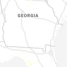
| Blairsville, GA | 1 | 1.75 | 1.75 | 94 | $111k | $31.6k | 50.7 |
Hail and Wind Damage Spotted on 7/21/2020
Filter by Report Type:Hail ReportsWind Reports
States Impacted
Illinois, Virginia, Georgia, Pennsylvania, Indiana, Florida, North Carolina, Missouri, South Carolina, West Virginia, Mississippi, Ohio, Nevada, Tennessee, Wyoming, Colorado, Alabama, Texas, Kentucky, Minnesota, Maryland, New JerseyIllinois
| Local Time | Report Details |
|---|---|
| 11:01 AM CDT | Multiple trees and tree branches down in town. one tree smashed the park pavilio in piatt county IL, 46.2 miles NNW of Mattoon, IL |
| 11:30 AM CDT | Barn blown down in champaign county IL, 53.3 miles N of Mattoon, IL |
| 11:34 AM CDT | Numerous tree branches down... leaning power poles... power out in tow in champaign county IL, 53.3 miles N of Mattoon, IL |
| 11:35 AM CDT | Storm damage reported in champaign county IL, 57.8 miles NNE of Mattoon, IL |
| 1:43 PM CDT | Numerous tree branches down... leaning power poles... power out in tow in champaign county IL, 53.3 miles N of Mattoon, IL |
| 2:36 PM CDT | Numerous trees blown down around town. one tree fell onto a hous in pike county IL, 73.9 miles SE of Kahoka, MO |
| 3:13 PM CDT | Several trees blown down in town as well as some power outage in greene county IL, 47.7 miles NNW of Saint Louis, MO |
| 3:15 PM CDT | 12in tree limb fell on homeowners deck... damaging i in greene county IL, 48.8 miles NNW of Saint Louis, MO |
| 3:20 PM CDT | A couple trees down on the west side of tow in jackson county IL, 33.5 miles NNE of Cape Girardeau, MO |
| 3:27 PM CDT | Several trees down on powerlines in the city. also... pea to marble size hail reporte in jackson county IL, 34.1 miles NNE of Cape Girardeau, MO |
| 3:32 PM CDT | Quarter sized hail reported near Pleasant Plains, IL, 59.4 miles SSW of Peoria, IL |
| 3:48 PM CDT | Numerous trees down around town... some blocking roads. also... a couple of sheds were damage in macoupin county IL, 60 miles N of Saint Louis, MO |
| 4:00 PM CDT | Trees downe in macoupin county IL, 65.1 miles NNE of Saint Louis, MO |
| 4:07 PM CDT | Storm damage reported in sangamon county IL, 70 miles NNE of Saint Louis, MO |
| 4:08 PM CDT | Reports of debris and power outage in sangamon county IL, 70 miles NNE of Saint Louis, MO |
| 4:08 PM CDT | Reports of debris and power outage in sangamon county IL, 70.6 miles NNE of Saint Louis, MO |
| 4:18 PM CDT | Power poles dow in sangamon county IL, 65 miles W of Mattoon, IL |
| 4:20 PM CDT | Numerous trees dow in sangamon county IL, 64.8 miles W of Mattoon, IL |
| 4:25 PM CDT | Approx 4 inch tree limbs down into power lines in tovey. winds est to 60 mph by emergency manage in christian county IL, 58.4 miles W of Mattoon, IL |
| 4:27 PM CDT | Approx 4 inch tree limbs down into power lines in kincaid. winds est to 60 mph by emergency manage in christian county IL, 55.8 miles W of Mattoon, IL |
| 4:34 PM CDT | Approx 4 inch tree limbs down into power lines in edinburgh. old power pole snapped on west side of town. winds est to 60 mph by emergency manage in christian county IL, 55.5 miles WNW of Mattoon, IL |
| 4:45 PM CDT | Approx 4 inch tree limbs down into power lines in stonington. winds est to 60 mph by emergency manage in christian county IL, 44.8 miles WNW of Mattoon, IL |
| 5:10 PM CDT | Storm damage reported in macon county IL, 33.5 miles NW of Mattoon, IL |
| 5:54 PM CDT | Report of tree taking down power line on southside drive... blocking roa in coles county IL, 9.4 miles NNE of Mattoon, IL |
Virginia
| Local Time | Report Details |
|---|---|
| 12:25 PM EDT | A couple of trees brought down by thunderstorm wind in grayson county VA, 62.5 miles E of Bristol, TN |
| 1:45 PM EDT | A few trees down north of broadwa in rockingham county VA, 51.3 miles ESE of Elkins, WV |
| 1:50 PM EDT | Thunderstorm winds brought down two trees on catawba valley road. one tree on the 3700 block fell on a hom in roanoke county VA, 10.3 miles NW of Roanoke, VA |
| 1:50 PM EDT | Two trees down north of harrisonburg toward linvill in rockingham county VA, 60.2 miles ESE of Elkins, WV |
| 2:55 PM EDT | A tree and multiple limbs down on poor farm roa in floyd county VA, 27.1 miles SW of Roanoke, VA |
| 3:40 PM EDT | A few trees downed or snapped off in the clover hill area in rockingham county VA, 54.8 miles SE of Elkins, WV |
| 3:50 PM EDT | Tree and power line damage in and near dayto in rockingham county VA, 60.4 miles SE of Elkins, WV |
| 3:55 PM EDT | Siding removed from home and wooden playset overturned in rockingham county VA, 60.9 miles SE of Elkins, WV |
| 3:57 PM EDT | Trees and wires down on ruby driv in rockingham county VA, 61.3 miles SE of Elkins, WV |
| 3:59 PM EDT | 20 ft tall cherry tree blown down in rockingham county VA, 64.3 miles SE of Elkins, WV |
| 4:03 PM EDT | Several trees downed in purcell park in rockingham county VA, 61.8 miles ESE of Elkins, WV |
| 4:03 PM EDT | Tree and power line damage in harrisonburg... including trees and wires down on valley stree in rockingham county VA, 62.3 miles ESE of Elkins, WV |
| 4:05 PM EDT | Tree down blocking dickerson mill roa in bedford county VA, 21.8 miles E of Roanoke, VA |
| 4:07 PM EDT | Thunderstorm winds brought down trees on dickerson mill road. from wset-t in bedford county VA, 22.2 miles E of Roanoke, VA |
| 4:10 PM EDT | Thunderstorm winds brought down several trees down around the town of bedfor in bedford county VA, 24.1 miles E of Roanoke, VA |
| 4:56 PM EDT | Downed tree at 475 bacon hollow r in greene county VA, 72.2 miles NW of Richmond, VA |
| 5:20 PM EDT | Trees down on 9000 block of spring hill rd in city of staunton county VA, 66.3 miles SE of Elkins, WV |
| 5:37 PM EDT | Spotter reported wind gust was strong enough to destroy a horse shed and also brough numerous trees down on propert in madison county VA, 64 miles NNW of Richmond, VA |
| 5:39 PM EDT | Multiple trees and power lines down along moonlight mountain rd. one tree fell onto a vehicl in madison county VA, 67.4 miles NNW of Richmond, VA |
| 5:49 PM EDT | Trees down in the area of crimora in augusta county VA, 77.1 miles NW of Richmond, VA |
| 6:09 PM EDT | Tree in roadway on craftown rd near wedo lan in fairfax county VA, 53.7 miles SW of Baltimore, MD |
| 6:14 PM EDT | Tree down on va-643 henderson rd just east of va-647 hampton r in fairfax county VA, 54.3 miles SW of Baltimore, MD |
| 6:15 PM EDT | Several trees down in the mattaponi area in addition to tree limbs down on a vehicle. report via social media. time estimated from radar dat in king and queen county VA, 47.9 miles E of Richmond, VA |
| 6:49 PM EDT | Tree in roadway on post oak rd near margo rd in spotsylvania county VA, 45.4 miles N of Richmond, VA |
| 7:04 PM EDT | Downed tree at the intersection of rt 1 and hope r in stafford county VA, 63 miles N of Richmond, VA |
| 7:04 PM EDT | Downed tree at the intersection of rt 1 and hope r in stafford county VA, 63 miles N of Richmond, VA |
| 7:09 PM EDT | Reports of downed trees on va-606. post oak rd close in spotsylvania county VA, 46 miles N of Richmond, VA |
| 10:01 PM EDT | Tree blown down on summit road near the intersection with idlewood terrace. time estimated from rada in city of danville county VA, 54.8 miles SSE of Roanoke, VA |
| 10:03 PM EDT | Tree blown down on arnett boulevard. time estimated from rada in city of danville county VA, 54.6 miles SSE of Roanoke, VA |
| 10:06 PM EDT | Large tree blown onto power lines on third avenue... partially blocking the road. time estimated from rada in city of danville county VA, 54.9 miles SE of Roanoke, VA |
| 10:40 PM EDT | Tree down at va 156 south and hare road. time estimated from rada in henrico county VA, 23.2 miles ESE of Richmond, VA |
| 10:40 PM EDT | Tree down at at highway 5 east and curles neck road. time estimated from rada in henrico county VA, 20.2 miles ESE of Richmond, VA |
| 10:47 PM EDT | A large tree branch was blown down near the intersection of summerdean ave and estes st. time estimated from rada in roanoke county VA, 5.4 miles N of Roanoke, VA |
Georgia
| Local Time | Report Details |
|---|---|
| 12:48 PM EDT | Ping Pong Ball sized hail reported near Blairsville, GA, 74 miles W of Greenville, SC, public reported accumulating 1.50 inch hail at a location off sullivan trail road... lasting more than five minutes. |
| 12:55 PM EDT | Quarter sized hail reported near Blairsville, GA, 75.2 miles S of Knoxville, TN, public reported quarter size hail at a location on allison circle... lasting 3-5 minutes. hail caused damage to camper ac unit. |
| 12:55 PM EDT | Quarter sized hail reported near Blairsville, GA, 73.4 miles W of Greenville, SC, public reported quarter size hail at a location on allison circle... lasting 3-5 minutes. hail caused damage to camper ac unit. |
| 12:56 PM EDT | Golf Ball sized hail reported near Blairsville, GA, 74.6 miles W of Greenville, SC, public reported golf ball size hail fell for 3 to 4 mintues near lake trahlyta. |
| 1:25 PM EDT | Public reported one tree down on clayton road and another down on marie driv in white county GA, 65.4 miles W of Greenville, SC |
| 3:15 PM EDT | Minor roof damage caused by strong winds to a home on livingston ct near winder in barrow county GA, 37.3 miles ENE of Atlanta, GA |
| 3:40 PM EDT | Reports of multiple trees down in the area around winder... including one down on a home on hickeria way... ne of tow in barrow county GA, 44.7 miles ENE of Atlanta, GA |
| 3:58 PM EDT | Tree down off hwy 441 near old athens dr in jackson county GA, 60.3 miles ENE of Atlanta, GA |
| 3:58 PM EDT | Several trees were downed from a microburst just west of sharpsburg in coweta county GA, 31.8 miles SSW of Atlanta, GA |
| 4:02 PM EDT | Several small trees down north of sandy springs... blocking the roadway near spalding dr and preachtree dunwoody rd in fulton county GA, 14.8 miles N of Atlanta, GA |
| 4:15 PM EDT | 3 trees dow in fulton county GA, 6.1 miles S of Atlanta, GA |
| 4:20 PM EDT | Ping Pong Ball sized hail reported near Dalton, GA, 31.8 miles SE of Chattanooga, TN |
| 4:20 PM EDT | A couple trees reported down south of commerc in jackson county GA, 59.7 miles ENE of Atlanta, GA |
| 4:30 PM EDT | A couple trees were reported down in the vacinity of writes mill rd and carlan rd in southeastern banks county in banks county GA, 58 miles SW of Greenville, SC |
| 4:45 PM EDT | Large tree blown down in northern marietta reported by local media in cobb county GA, 20.9 miles NNW of Atlanta, GA |
| 7:00 PM EDT | Multiple trees down. some shingles halfway peeled on roo in chattooga county GA, 37.7 miles SSW of Chattanooga, TN |
Pennsylvania
| Local Time | Report Details |
|---|---|
| 1:17 PM EDT | Trees on wires... wires on road... telephone poles leaning. reported at 1200 block cooney roa in cambria county PA, 46.1 miles WSW of State College, PA |
| 1:40 PM EDT | Tree down reported at the intersection of johnstown road and baird lan in blair county PA, 43.6 miles SW of State College, PA |
| 2:55 PM EDT | Tress down on wires reported at 32 veil rd... windber... p in cambria county PA, 62 miles ESE of Pittsburgh, PA |
| 3:07 PM EDT | Several trees down on road reported at 941 church dr... windber... p in somerset county PA, 62.8 miles ESE of Pittsburgh, PA |
| 3:07 PM EDT | Multiple trees down blocking road. reported at patrica lane and camp driv in somerset county PA, 62.1 miles ESE of Pittsburgh, PA |
| 5:20 PM EDT | Multiple trees down in mcconnellsbur in fulton county PA, 60 miles S of State College, PA |
| 5:53 PM EDT | Wires down on north franklin stree in franklin county PA, 59.1 miles S of State College, PA |
| 5:54 PM EDT | Numerous reports of trees down and roofs blown off of buildings in chambersbur in franklin county PA, 59.8 miles S of State College, PA |
| 5:56 PM EDT | *** 1 inj *** tree fell on a golfer at chambersburg country clu in franklin county PA, 59.3 miles SSE of State College, PA |
| 6:00 PM EDT | Roof blown off of a building in the 1600 block of lincoln way eas in franklin county PA, 61.7 miles SSE of State College, PA |
| 7:00 PM EDT | Tree down at the intersection of myers road and jefferson road in codorus townshi in york county PA, 33.3 miles NNW of Baltimore, MD |
| 7:02 PM EDT | Tree down at the intersection of ambau road and jefferson roa in york county PA, 41 miles NNW of Baltimore, MD |
| 7:08 PM EDT | Tree down on the 11900 block of pine stree in york county PA, 37.9 miles N of Baltimore, MD |
Indiana
| Local Time | Report Details |
|---|---|
| 1:33 PM EDT | Tree down in oxford along state road 352 near state road 55. time estimated by rada in benton county IN, 77.7 miles NW of Indianapolis, IN |
| 2:06 PM EDT | Multiple tree limbs down. location approximat in tippecanoe county IN, 63.3 miles NW of Indianapolis, IN |
| 2:11 PM EDT | Large metal doors were blown off of the toyota tsusho america inc plant at 5440 haggerty lane. employee told tv media that if not for the tornado warning and their resu in tippecanoe county IN, 55.1 miles NW of Indianapolis, IN |
| 2:12 PM EDT | Multiple trees down with power outages reporte in tippecanoe county IN, 53.4 miles NW of Indianapolis, IN |
| 2:51 PM EDT | Corrects previous tstm wnd gst report from 1 s grissom afb. corrects previous tstm wnd gst report from 1 s grissom af in miami county IN, 60.9 miles N of Indianapolis, IN |
| 2:53 PM EDT | Numerous portions of trees and branches down. utility pole dow in howard county IN, 49.3 miles N of Indianapolis, IN |
| 3:15 PM EDT | Utility poles down at w. main st. and fremont s in miami county IN, 56 miles WSW of Fort Wayne, IN |
| 3:20 PM EDT | Tree on house. also multiple trees and limbs down across wabas in wabash county IN, 42.2 miles WSW of Fort Wayne, IN |
| 3:30 PM EDT | Spotter relayed report of power lines dow in grant county IN, 46.2 miles SW of Fort Wayne, IN |
| 3:45 PM EDT | Spotter relayed report of a tree fallen on power line in grant county IN, 46.2 miles SSW of Fort Wayne, IN |
| 3:45 PM EDT | A tree blocked the road and took power lines dow in huntington county IN, 34.6 miles SW of Fort Wayne, IN |
| 7:45 PM EDT | Several trees up to 4 inches in diameter were blown down across the roadway. location is approximat in monroe county IN, 39.8 miles SSW of Indianapolis, IN |
| 8:45 PM EDT | Several trees were blown down in this vicinit in parke county IN, 56.4 miles W of Indianapolis, IN |
| 8:46 PM EDT | Tree blown dow in putnam county IN, 38.6 miles WSW of Indianapolis, IN |
| 8:46 PM EDT | Corrects previous tstm wnd dmg report from cloverdale. a tree was blown dow in clay county IN, 60.5 miles WSW of Indianapolis, IN |
| 8:59 PM EDT | Trees were blown dow in clay county IN, 51.9 miles WSW of Indianapolis, IN |
| 9:20 PM EDT | Sporadic power lines down across town. a measured 50 mph gust was made near this location. time estimated from rada in putnam county IN, 38.7 miles WSW of Indianapolis, IN |
Florida
| Local Time | Report Details |
|---|---|
| 1:53 PM EDT | Wind gust was measured at the tyrone mal in pinellas county FL, 22.6 miles NNW of Bradenton, FL |
| 5:00 PM EDT | Tree on powerline... sparked a fir in dixie county FL, 86.3 miles WSW of Jacksonville, FL |
| 6:15 PM EDT | Spotter estimated 60 mph gusts 1 mile south of perr in taylor county FL, 48 miles ESE of Tallahassee, FL |
| 6:15 PM EDT | Numerous trees down in taylor count in taylor county FL, 47.3 miles ESE of Tallahassee, FL |
| 6:53 PM EDT | Tree down along south salt roa in jefferson county FL, 28 miles ESE of Tallahassee, FL |
| 6:57 PM EDT | Tree down near the intersection of old lloyd road and taylor roa in jefferson county FL, 19 miles ENE of Tallahassee, FL |
| 7:00 PM EDT | Tree down along st augustine roa in jefferson county FL, 16.4 miles E of Tallahassee, FL |
| 7:00 PM EDT | Tree down on i-10 near mile marker 22 in jefferson county FL, 25.2 miles E of Tallahassee, FL |
| 7:05 PM EDT | Fallen trees or limbs resulted in a power outage along highway 98 near lighthouse road as reported by the duke energy outage websit in wakulla county FL, 17.8 miles SSE of Tallahassee, FL |
| 7:05 PM EDT | Fallen trees or limbs resulted in a power outage along woodville highway near commerce blvd as reported on the duke energy outage websit in wakulla county FL, 13.4 miles SSE of Tallahassee, FL |
| 7:05 PM EDT | Fallen trees or limbs resulted in a power outage along highway 267 just west of woodville highway as reported by the duke energy outage websit in wakulla county FL, 14.7 miles S of Tallahassee, FL |
| 7:06 PM EDT | Tree down near the intersection of spring creek highway and brown donaldson roa in wakulla county FL, 20 miles S of Tallahassee, FL |
| 7:12 PM EDT | Numerous trees and power lines down across wakulla count in wakulla county FL, 18.9 miles SSW of Tallahassee, FL |
| 7:21 PM EDT | Several trees down blocking roadways in leon count in leon county FL, 4.8 miles SSE of Tallahassee, FL |
North Carolina
| Local Time | Report Details |
|---|---|
| 2:15 PM EDT | 911 call center reported trees and power lines down on edgewater rd in jackson county NC, 46.2 miles NW of Greenville, SC |
| 3:00 PM EDT | 911 call center reported trees and power lines down near hendersonville and flat rock in henderson county NC, 34.8 miles NNE of Greenville, SC |
| 5:00 PM EDT | 911 call center reported trees and power lines down in ellenboro in rutherford county NC, 52.7 miles W of Charlotte, NC |
| 5:00 PM EDT | 911 call center reported trees and power lines down in cliffside in rutherford county NC, 52.8 miles W of Charlotte, NC |
| 5:00 PM EDT | Quarter sized hail reported near Morganton, NC, 61.5 miles NW of Charlotte, NC, trained spotter reported quarter (1.00") size hail on johns river loop |
| 5:00 PM EDT | Trained spotter reported trees down along nc-18 & us-64 in chesterfield nc us in burke county NC, 61.6 miles NW of Charlotte, NC |
| 5:10 PM EDT | Emergency mngr reported thunderstorm wind damage to mobile home on lee bess rd in lincoln county NC, 39.3 miles WNW of Charlotte, NC |
| 5:13 PM EDT | Several trees snapped at their trunks. time estimated from rada in wilkes county NC, 68.1 miles ESE of Bristol, TN |
| 5:15 PM EDT | Quarter sized hail reported near Morganton, NC, 61.6 miles SSE of Bristol, TN, trained spotter reported quarter (1.00") size hail on piedmont rd |
| 5:15 PM EDT | Quarter sized hail reported near Morganton, NC, 58.1 miles NW of Charlotte, NC, trained spotter reported quarter (1.00") size hail on e t camp rd |
| 5:15 PM EDT | 911 call center reported trees down on w sugar creek r in mecklenburg county NC, 5.7 miles NNE of Charlotte, NC |
| 5:30 PM EDT | Quarter sized hail reported near Valdese, NC, 54.6 miles NW of Charlotte, NC, trained spotter reported quarter (1.00") size hail on jacumin rd in valdese... nc |
| 5:30 PM EDT | 911 call center reported trees and power lines down on triplett r in iredell county NC, 29 miles N of Charlotte, NC |
| 6:00 PM EDT | 911 call center reported power lines down on commonwealth av in mecklenburg county NC, 2.3 miles ESE of Charlotte, NC |
| 6:00 PM EDT | 911 call center reported power lines down on wickersham rd in mecklenburg county NC, 4.3 miles S of Charlotte, NC |
| 6:10 PM EDT | 911 call center reported power lines down on mt pleasant rd in cabarrus county NC, 26.4 miles ENE of Charlotte, NC |
| 6:30 PM EDT | 911 call center reported trees and power lines down on triplett r in iredell county NC, 29 miles N of Charlotte, NC |
| 7:00 PM EDT | Fire dept/rescue reported trees down on bandys cross r in catawba county NC, 32.6 miles NNW of Charlotte, NC |
| 7:10 PM EDT | 911 call center reported trees down on belwood d in gaston county NC, 10.9 miles W of Charlotte, NC |
| 7:15 PM EDT | 911 call center reported trees down on forbes r in gaston county NC, 19.4 miles W of Charlotte, NC |
| 7:20 PM EDT | 911 call center reported power lines down on tuckaseegee r in mecklenburg county NC, 4.8 miles WNW of Charlotte, NC |
| 7:25 PM EDT | Quarter sized hail reported near Charlotte, NC, 9.4 miles SW of Charlotte, NC |
| 7:30 PM EDT | 911 call center reported power lines down on w hampton av in mecklenburg county NC, 2.4 miles SSE of Charlotte, NC |
| 7:30 PM EDT | 911 call center reported trees down on ardmore r in mecklenburg county NC, 2 miles SW of Charlotte, NC |
| 7:30 PM EDT | 911 call center reported trees down on hollis r in mecklenburg county NC, 2.9 miles SW of Charlotte, NC |
| 7:40 PM EDT | 911 call center reported power lines down on kenilworth av in mecklenburg county NC, 1.7 miles SSW of Charlotte, NC |
| 7:40 PM EDT | 911 call center reported trees down on patton av in mecklenburg county NC, 2 miles NNW of Charlotte, NC |
| 7:40 PM EDT | 911 call center reported power lines down on south blvd in mecklenburg county NC, 4.3 miles SSW of Charlotte, NC |
| 7:40 PM EDT | 911 call center reported power lines down on university d in mecklenburg county NC, 3.5 miles SSW of Charlotte, NC |
| 7:40 PM EDT | 911 call center reported power lines down on mill haven lan in mecklenburg county NC, 5.3 miles N of Charlotte, NC |
| 7:45 PM EDT | 911 call center reported power lines down on sewickley d in mecklenburg county NC, 3.2 miles SSW of Charlotte, NC |
| 7:45 PM EDT | 911 call center reported power lines down on elmhurst r in mecklenburg county NC, 2 miles SW of Charlotte, NC |
| 8:34 PM EDT | Thunderstorm winds blew down a couple of trees near the intersection of mayo mountain road and business highway 22 in rockingham county NC, 58 miles S of Roanoke, VA |
Missouri
| Local Time | Report Details |
|---|---|
| 2:10 PM CDT | Two large tree limbs blown down at oregon trail and woodstream. via faceboo in st. charles county MO, 23.7 miles WNW of Saint Louis, MO |
| 2:20 PM CDT | Quarter sized hail reported near Saint Charles, MO, 21.8 miles NW of Saint Louis, MO, at i-370 and elm street. |
| 5:50 PM CDT | Large tree limb snapped from tre in jefferson county MO, 31.3 miles SSW of Saint Louis, MO |
| 6:27 PM CDT | Quarter sized hail reported near Hillsboro, MO, 31.5 miles SW of Saint Louis, MO, time estimated from radar. |
| 11:40 PM CDT | Multiple trees down in park hills and elvins... including some over power lines. lots of tree debris on west elvins boulevard. time estimated from rada in st. francois county MO, 56.3 miles ENE of Salem, MO |
South Carolina
| Local Time | Report Details |
|---|---|
| 3:40 PM EDT | Schp reported trees down at hwy 414 and tigerville road. time estimated by rada in greenville county SC, 21 miles NE of Greenville, SC |
| 4:00 PM EDT | 911 call center reported power lines down on dukeland dr in greenville county SC, 11.6 miles ENE of Greenville, SC |
| 4:15 PM EDT | Schp reported tree down at edwards mill and old mill road. time estimated by rada in greenville county SC, 17.1 miles ENE of Greenville, SC |
| 4:55 PM EDT | 911 call center reported power lines down on mud creek r in spartanburg county SC, 38.2 miles ENE of Greenville, SC |
| 5:00 PM EDT | 911 call center reported trees down on flat rock r in anderson county SC, 28.5 miles S of Greenville, SC |
| 5:55 PM EDT | 911 call center reported power lines down on mud creek r in spartanburg county SC, 38.2 miles ENE of Greenville, SC |
| 6:10 PM EDT | 911 call center reported trees and power lines down on california r in york county SC, 29.3 miles WSW of Charlotte, NC |
| 6:10 PM EDT | 911 call center reported trees down on church and cemetery s in york county SC, 27.9 miles SW of Charlotte, NC |
West Virginia
| Local Time | Report Details |
|---|---|
| 4:23 PM EDT | Report of a downed tree near the 1300 block of bethel rd in paw pa in hampshire county WV, 84.6 miles ENE of Elkins, WV |
| 4:23 PM EDT | Report of a downed tree near the 1300 block of bethel rd in paw pa in morgan county WV, 82.6 miles SSW of State College, PA |
| 5:01 PM EDT | Trees down at river rd and grape hill dr in morgan county WV, 82.6 miles SSW of State College, PA |
| 5:15 PM EDT | Downed tree reported near the 9000 block of nw pik in hampshire county WV, 73.9 miles ENE of Elkins, WV |
| 5:20 PM EDT | Trees down along u.s. route 50 in augusta in hampshire county WV, 75.1 miles ENE of Elkins, WV |
| 7:30 PM EDT | Tree damage reported at multiple locations near gandeeville. tweet included photo of downed tree over pool. pool damage appeared to be minimal. crews were still working in roane county WV, 27.7 miles NNE of Charleston, WV |
Mississippi
| Local Time | Report Details |
|---|---|
| 3:35 PM CDT | Large tree down on home and roof damage to outbuildings near the intersection of highways 9 and 334. an additional 15-20 trees down nearb in pontotoc county MS, 55.2 miles NNW of Starkville, MS |
Ohio
| Local Time | Report Details |
|---|---|
| 4:38 PM EDT | A tree was downed in the 700 block of murlin avenu in mercer county OH, 45.9 miles SE of Fort Wayne, IN |
Nevada
| Local Time | Report Details |
|---|---|
| 1:39 PM PDT | Mesonet station rbtn2 red butte raw in lander county NV, 71.3 miles SSE of Winnemucca, NV |
| 5:32 PM PDT | Mesonet station tmbn2 timber mt in nye county NV, 68.4 miles SSW of Ely, NV |
Tennessee
| Local Time | Report Details |
|---|---|
| 5:07 PM EDT | Several trees dow in mcminn county TN, 43.3 miles ENE of Chattanooga, TN |
| 5:08 PM EDT | Several trees down and very wind in mcminn county TN, 48.1 miles SW of Knoxville, TN |
| 7:01 PM CDT | Trees and power lines on the corner of horseshoe dr and vine s in bedford county TN, 49.2 miles SSE of Nashville, TN |
| 7:01 PM CDT | A tree split and fell on a home on ridgeway av in bedford county TN, 50 miles SSE of Nashville, TN |
| 9:06 PM EDT | Several trees down across the count in scott county TN, 51 miles NW of Knoxville, TN |
Wyoming
| Local Time | Report Details |
|---|---|
| 3:30 PM MDT | Quarter sized hail reported near Buford, WY, 21.7 miles SE of Laramie, WY, hail covered interstate 80. time based on radar. |
| 4:35 PM MDT | Ping Pong Ball sized hail reported near Laramie, WY, 14.9 miles SE of Laramie, WY, via facebook. |
| 5:43 PM MDT | Quarter sized hail reported near Chugwater, WY, 52.3 miles NE of Laramie, WY |
| 6:44 PM MDT | Quarter sized hail reported near Cheyenne, WY, 38.1 miles E of Laramie, WY |
| 7:10 PM MDT | Quarter sized hail reported near Cheyenne, WY, 54.1 miles E of Laramie, WY |
| 7:45 PM MDT | Golf Ball sized hail reported near Cheyenne, WY, 39.4 miles ESE of Laramie, WY |
| 7:45 PM MDT | Tennis Ball sized hail reported near Cheyenne, WY, 40.6 miles ESE of Laramie, WY, hail size was 1 inch to 2.5 inches. |
| 7:48 PM MDT | Golf Ball sized hail reported near Cheyenne, WY, 41.8 miles ESE of Laramie, WY, fell from 748 pm to 752 pm. |
| 7:48 PM MDT | Quarter sized hail reported near Burns, WY, 60.8 miles ESE of Laramie, WY |
| 7:50 PM MDT | Tennis Ball sized hail reported near Cheyenne, WY, 40.6 miles ESE of Laramie, WY |
| 7:56 PM MDT | Ping Pong Ball sized hail reported near Cheyenne, WY, 43.1 miles ESE of Laramie, WY |
Colorado
| Local Time | Report Details |
|---|---|
| 3:38 PM MDT | Quarter sized hail reported near Manitou Springs, CO, 43.3 miles NNW of Pueblo, CO |
| 9:44 PM MDT | Quarter sized hail reported near Sterling, CO, 26.3 miles NNW of Yuma, CO, l375. |
Alabama
| Local Time | Report Details |
|---|---|
| 4:48 PM CDT | A tree was knocked down on highway 11 north just outside of red bay. time estimate in franklin county AL, 34.9 miles SW of Florence, AL |
| 4:58 PM CDT | One or more trees downed in southern cherokee county. time estimated for this are in cherokee county AL, 69.8 miles WNW of Atlanta, GA |
| 4:59 PM CDT | Trees down in phil campbel in franklin county AL, 31.1 miles S of Florence, AL |
| 4:59 PM CDT | Trees down in belgree in franklin county AL, 24.5 miles SSW of Florence, AL |
| 4:59 PM CDT | Trees down blocking cr 2 in franklin county AL, 28 miles S of Florence, AL |
| 5:06 PM CDT | Power lines were knocked down onto the road at mill road at church street. time estimated by rada in madison county AL, 53.1 miles E of Florence, AL |
| 5:15 PM CDT | Several locations with one or more trees downed across southern cherokee county... some affecting roadways. time estimated for this area of the count in cherokee county AL, 68.5 miles SSW of Chattanooga, TN |
| 5:29 PM CDT | Several locations with one or more trees blown down in central/northern cherokee county. time estimated for this part of the count in cherokee county AL, 64.6 miles SSW of Chattanooga, TN |
| 5:32 PM CDT | A large tree was knocked onto a home damaging two rooms in the sand rock community. time estimated by rada in dekalb county AL, 60.5 miles SSW of Chattanooga, TN |
| 5:36 PM CDT | Tree downed onto a home. no injuries. time estimate in cherokee county AL, 63.2 miles SSW of Chattanooga, TN |
| 5:50 PM CDT | Numerous trees down and/or uprooted near dundee road and highway 231/431. one of the uprooted trees knocked down a power line and snapped a street light pole. trees dow in madison county AL, 63.3 miles E of Florence, AL |
| 6:10 PM CDT | Trees down in shiloh. time estimate in dekalb county AL, 51.8 miles SW of Chattanooga, TN |
| 6:10 PM CDT | Trees down on cr 46 near cr 20. time estimate in dekalb county AL, 62.6 miles SW of Chattanooga, TN |
| 6:25 PM CDT | A tree was knocked down at powell city hall at the intersection of cr 47 and al highway 3 in dekalb county AL, 48.9 miles SW of Chattanooga, TN |
Texas
| Local Time | Report Details |
|---|---|
| 4:55 PM CDT | Storm damage reported in armstrong county TX, 48.5 miles ESE of Amarillo, TX |
Kentucky
| Local Time | Report Details |
|---|---|
| 5:11 PM CDT | Tree dow in logan county KY, 34.7 miles N of Nashville, TN |
| 6:17 PM CDT | Small area of corn blown down...most of field not affecte in butler county KY, 67 miles N of Nashville, TN |
| 6:30 PM CDT | Social media report of one tree down across newman way near nashville roa in warren county KY, 58.1 miles NNE of Nashville, TN |
Minnesota
| Local Time | Report Details |
|---|---|
| 5:51 PM CDT | Report of a barn with a tin roof taken off. passed along that other barns in the area were possibly damage in houston county MN, 8.5 miles SSW of La Crosse, WI |
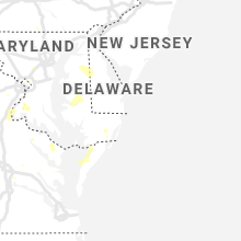
Maryland
| Local Time | Report Details |
|---|---|
| 7:39 PM EDT | Downed trees on md-224 riverside rd at smith point rd causing road closur in charles county MD, 66.1 miles NNE of Richmond, VA |
| 7:50 PM EDT | Quarter sized hail reported near La Plata, MD, 56.1 miles SSW of Baltimore, MD |
| 7:54 PM EDT | Trees down on pomfret rd and bumpy oak rd causing road closure in charles county MD, 54 miles SSW of Baltimore, MD |
| 8:04 PM EDT | Tree down on md-732 dorsey run rd near brock bridge r in anne arundel county MD, 15.6 miles SW of Baltimore, MD |
| 9:45 PM EDT | Trained spotter reports 2 large trees down near his home along with many smaller trees blown over. spotter also reports constant cloud to ground lightnin in talbot county MD, 50.9 miles SE of Baltimore, MD |
| 9:53 PM EDT | Dispatch reports numerous trees down around the town of preston. time estimated from rada in caroline county MD, 51.7 miles WNW of Ocean City, MD |
| 9:54 PM EDT | Dispatch reports a tree into a house on marsh creek road west of preston. time estimated from rada in caroline county MD, 53.4 miles SE of Baltimore, MD |
| 10:23 PM EDT | Two trees reported down between sudlersville and crumpton. time estimated from rada in queen anne's county MD, 40.2 miles E of Baltimore, MD |
New Jersey
| Local Time | Report Details |
|---|---|
| 11:20 PM EDT | Njwxnet measured wind gus in cumberland county NJ, 62.6 miles N of Ocean City, MD |
Connect with Interactive Hail Maps