

Hail Map for Tuesday, July 26, 2022

Number of Impacted Households on 7/26/2022
0
Impacted by 1" or Larger Hail
0
Impacted by 1.75" or Larger Hail
0
Impacted by 2.5" or Larger Hail
Square Miles of Populated Area Impacted on 7/26/2022
0
Impacted by 1" or Larger Hail
0
Impacted by 1.75" or Larger Hail
0
Impacted by 2.5" or Larger Hail


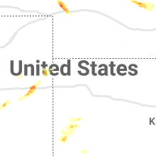


Cities Most Affected by Hail Storms of 7/26/2022
| Hail Size | Demographics of Zip Codes Affected | ||||||
|---|---|---|---|---|---|---|---|
| City | Count | Average | Largest | Pop Density | House Value | Income | Age |
| Giltner, NE | 3 | 1.83 | 2.00 | 5 | $75k | $43.5k | 41.1 |
| Phillips, NE | 1 | 1.75 | 1.75 | 11 | $81k | $41.8k | 44.2 |
Hail and Wind Damage Spotted on 7/26/2022
Filter by Report Type:Hail ReportsWind Reports
States Impacted
North Carolina, Tennessee, Missouri, Florida, Virginia, South Carolina, Nebraska, Colorado, MinnesotaNorth Carolina
| Local Time | Report Details |
|---|---|
| 1:41 PM EDT | Two trees down blocking the roa in chatham county NC, 47.6 miles WSW of Raleigh, NC |
| 2:21 PM EDT | Multiple trees were reported down on utility company equipment causing power outages just west of rocky mount-wilson regional airpor in nash county NC, 39.9 miles E of Raleigh, NC |
| 2:24 PM EDT | Major tree fell on power pole... snapped power pole and lots of power outage in orange county NC, 23.9 miles WNW of Raleigh, NC |
| 2:39 PM EDT | Trees reported down on powerlines on ebenezer church road near umpstead state par in wake county NC, 7.6 miles NW of Raleigh, NC |
| 2:40 PM EDT | A tree was blown over onto a car. no report of injurie in mecklenburg county NC, 13.6 miles N of Charlotte, NC |
| 2:45 PM EDT | Trees and power lines down near the polkville fire departmen in cleveland county NC, 47.3 miles WNW of Charlotte, NC |
| 2:45 PM EDT | Downed tree reported in gibsonville... n in guilford county NC, 55.1 miles WNW of Raleigh, NC |
| 2:56 PM EDT | Tree down along sanford st and vance street in baily n in nash county NC, 29.4 miles E of Raleigh, NC |
| 3:17 PM EDT | Multiple trees were reported down on utility company equipment causing 2k power outages near auburn... n in wake county NC, 7.3 miles SE of Raleigh, NC |
| 4:18 PM EDT | Peak wind gust measured at the duck pie in dare county NC, 43.9 miles SSE of Virginia Beach, VA |
| 4:18 PM EDT | Peak wind gust of 56 knots measured at the duck pie in amz150 county NC, 44.1 miles SSE of Virginia Beach, VA |
Tennessee
| Local Time | Report Details |
|---|---|
| 1:10 PM CDT | Corrects previous tstm wnd dmg report from 10 n cumberland city. trees reported down in indian mound. one on red top road. another report of a limb on a power line. tim in stewart county TN, 54.4 miles ENE of Mc Kenzie, TN |
| 1:12 PM CDT | Corrects previous tstm wnd dmg report from 5 nnw clarksville. report of trees down on tiny town road. time estimated via rada in montgomery county TN, 46.3 miles NW of Nashville, TN |
| 1:23 PM CDT | Corrects previous tstm wnd dmg report from 2 nne clarksville. report of trees down on needmore road. time estimated via rada in montgomery county TN, 42.3 miles NW of Nashville, TN |
| 1:26 PM CDT | Corrects previous tstm wnd dmg report from 7 ene clarksville. report of trees down on guthrie highway. time estimated via rada in montgomery county TN, 40.3 miles NW of Nashville, TN |
| 1:36 PM CDT | Report of trees down. also numerous reports of trees down through the county. time estimated via rada in montgomery county TN, 40.3 miles NW of Nashville, TN |
| 1:42 PM CDT | Report of trees down. time estimated via rada in montgomery county TN, 42.3 miles NW of Nashville, TN |
| 1:46 PM CDT | Trees down reported in indian mound. one one red top road. another report of a limb on a power line. time estimated via rada in stewart county TN, 54.4 miles ENE of Mc Kenzie, TN |
| 1:50 PM CDT | Trees reported down throughout the count in montgomery county TN, 41.8 miles NW of Nashville, TN |
| 2:20 PM CDT | Corrects previous tstm wnd dmg report from springfield. smokey barn news reports several trees and power lines down across the county with some roads blocke in robertson county TN, 23.6 miles NNW of Nashville, TN |
| 2:24 PM CDT | Twitter report of significant damage portland high school baseball field. dugout destroyed... outfield fence down... and damage to indoor facility. in addition damage r in sumner county TN, 31.6 miles NNE of Nashville, TN |
| 2:30 PM CDT | Corrects previous tstm wnd dmg report from 1 ssw greenbrier. large healthy oak tree down oak hill golf course and fairways drive. time estimated via rada in robertson county TN, 16.1 miles N of Nashville, TN |
| 2:30 PM CDT | Smokey barn news reports several trees and power lines down across the county with some roads blocke in robertson county TN, 23.6 miles NNW of Nashville, TN |
| 2:52 PM CDT | Large healthy oak tree down oak hill golf course and fairways drive. time estimated via rada in robertson county TN, 16.1 miles N of Nashville, TN |
Missouri
| Local Time | Report Details |
|---|---|
| 1:45 PM CDT | The ripley county sheriff reported trees down from thunderstorm winds about 5 miles southeast of doniphan occurring at 145 p in ripley county MO, 84.1 miles SW of Cape Girardeau, MO |
| 2:05 PM CDT | Tree was snapped in clarkton. nearby mesonet measured 36 mph wind gus in dunklin county MO, 63.3 miles SSW of Cape Girardeau, MO |
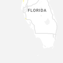
Florida
| Local Time | Report Details |
|---|---|
| 3:15 PM EDT | Asos station ktpa tamp in hillsborough county FL, 32.8 miles N of Bradenton, FL |
| 4:29 PM EDT | Asos station kbkv brooksvill in hernando county FL, 65.4 miles W of Orlando, FL |
| 9:00 PM EDT | A few trees and at least one power line were down in the perry are in taylor county FL, 47.3 miles ESE of Tallahassee, FL |
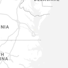
Virginia
| Local Time | Report Details |
|---|---|
| 3:33 PM EDT | Tree reported down on a vehicle along bennetts pasture rd. time estimated via rada in city of suffolk county VA, 25.3 miles WNW of Virginia Beach, VA |
| 3:38 PM EDT | Five helicopters on their side and roof damage near norfolk naval air statio in city of norfolk county VA, 19.3 miles NW of Virginia Beach, VA |
| 3:44 PM EDT | Trees down on maryland avenue. time estimated from rada in city of norfolk county VA, 15.1 miles WNW of Virginia Beach, VA |
| 3:47 PM EDT | Tree down on deer haven driv in henry county VA, 35.3 miles SSE of Roanoke, VA |
| 3:52 PM EDT | Multiple trees knocked down across the central portion of new kent county. time estimated from rada in new kent county VA, 36.9 miles E of Richmond, VA |
| 4:34 PM EDT | Tree down near intersection of mitchell road and cox roa in henry county VA, 47 miles S of Roanoke, VA |
| 4:37 PM EDT | Tree down on west witt roa in pittsylvania county VA, 50.6 miles SE of Roanoke, VA |
| 4:57 PM EDT | Tree down on lp bailey memorial highwa in halifax county VA, 57.1 miles ESE of Roanoke, VA |
| 5:04 PM EDT | Tree down near intersection of tom fork and witcher roa in pittsylvania county VA, 59.2 miles SE of Roanoke, VA |
| 5:07 PM EDT | Tree down on crystal hill roa in halifax county VA, 63 miles ESE of Roanoke, VA |
| 5:07 PM EDT | Tree down near intersection of dudley road and lp bailey memorial highwa in halifax county VA, 63.7 miles ESE of Roanoke, VA |
| 5:09 PM EDT | Tree down on winns creek r in halifax county VA, 65.4 miles ESE of Roanoke, VA |
| 5:11 PM EDT | Tree down on tobacco hill roa in charlotte county VA, 70 miles N of Raleigh, NC |
| 5:14 PM EDT | Corrects previous tstm wnd dmg report from 3 sw abilene. tree and powerline down on abilene roa in charlotte county VA, 58.2 miles WSW of Richmond, VA |
| 5:14 PM EDT | Corrects previous tstm wnd dmg report from 3 sw abilene. tree and powerline down on abilene roa in charlotte county VA, 58.2 miles WSW of Richmond, VA |
| 5:26 PM EDT | Tree down on garden roa in charlotte county VA, 70.4 miles SW of Richmond, VA |
South Carolina
| Local Time | Report Details |
|---|---|
| 4:10 PM EDT | Trees down in spartanburg county at 2 locations. time and location estimated from rada in spartanburg county SC, 38.9 miles E of Greenville, SC |
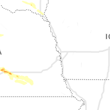
Nebraska
| Local Time | Report Details |
|---|---|
| 4:19 PM MDT | Damage to tree limbs and a flag pole. time estimated by rada in keith county NE, 53.8 miles W of North Platte, NE |
| 4:44 PM MDT | Storm damage reported in keith county NE, 52.6 miles W of North Platte, NE |
| 5:44 PM CDT | Quarter sized hail reported near Mason City, NE, 51.9 miles WNW of Grand Island, NE |
| 4:44 PM MDT | Ping Pong Ball sized hail reported near Ogallala, NE, 46.8 miles W of North Platte, NE |
| 4:45 PM MDT | Blowing in excess of 60 mph in keith county NE, 55.1 miles W of North Platte, NE |
| 6:10 PM CDT | Quarter sized hail reported near Alda, NE, 6.5 miles WSW of Grand Island, NE |
| 6:15 PM CDT | Quarter sized hail reported near Grand Island, NE, 4.8 miles WSW of Grand Island, NE |
| 6:19 PM CDT | Ping Pong Ball sized hail reported near Grand Island, NE, 3.8 miles S of Grand Island, NE, report from the far south side of grand island. |
| 6:40 PM CDT | Golf Ball sized hail reported near Phillips, NE, 8.1 miles SE of Grand Island, NE, spotter reported half dollar size hail here at 636pm... now up to golf ball size. |
| 6:45 PM CDT | Golf Ball sized hail reported near Giltner, NE, 12.7 miles SSE of Grand Island, NE |
| 6:50 PM CDT | Hen Egg sized hail reported near Giltner, NE, 14.6 miles SE of Grand Island, NE, stones 2 inches in diameter found in town. |
| 6:56 PM CDT | Golf Ball sized hail reported near Giltner, NE, 15.3 miles SE of Grand Island, NE, golfball size hail reported in and just east of giltner. |
| 7:49 PM CDT | Quarter sized hail reported near Grafton, NE, 38.8 miles ESE of Grand Island, NE, a few quarter size stones... most were smaller. |
Colorado
| Local Time | Report Details |
|---|---|
| 4:45 PM MDT | Half Dollar sized hail reported near Vona, CO, 56.5 miles S of Yuma, CO, delayed report via phone of half dollar hail at 4:45 (mdt) 2 miles east of vona... co. size and timing are estimated. |
| 4:50 PM MDT | Quarter sized hail reported near Stratton, CO, 62.1 miles S of Yuma, CO, estimated time of report. |
| 5:04 PM MDT | Large tree limbs down. time and location estimate in arapahoe county CO, 11.8 miles ESE of Denver, CO |
| 5:06 PM MDT | Report from mping: 3-inch tree limbs broken; power poles broke in arapahoe county CO, 14.2 miles ESE of Denver, CO |
| 5:09 PM MDT | Quarter sized hail reported near Aurora, CO, 14.9 miles SE of Denver, CO, most stones pea to half inch diameter. time estimated. |
| 5:09 PM MDT | Report from a personal weather station. also recorded up to quarter size hail. wind-driven hail caused minor damage to windows... siding... and a hot tub cover. the tim in arapahoe county CO, 14.9 miles SE of Denver, CO |
| 5:09 PM MDT | Quarter sized hail reported near Aurora, CO, 16.1 miles ESE of Denver, CO, time and location estimated. |
| 5:10 PM MDT | Nickel sized hail reported. time and location estimate in arapahoe county CO, 12.8 miles ESE of Denver, CO |
| 5:11 PM MDT | Mesonet station beyc2 buckeye. time estimate in larimer county CO, 44.9 miles SE of Laramie, WY |
| 5:19 PM MDT | Storm damage reported in arapahoe county CO, 17.9 miles ESE of Denver, CO |
| 5:24 PM MDT | Quarter sized hail reported near Aurora, CO, 20 miles ESE of Denver, CO, report from mping: quarter (1.00 in.). delayed report. time estimated by radar. |
| 5:30 PM MDT | 3 to 4 inch tree branches down and scattered around the area... expanding about 1 mile from this locatio in pueblo county CO, 3.2 miles W of Pueblo, CO |
| 7:47 PM MDT | 2 barn structures were destroye in el paso county CO, 40 miles NNE of Pueblo, CO |
Minnesota
| Local Time | Report Details |
|---|---|
| 7:15 PM CDT | Quarter sized hail reported near South Haven, MN, 54.9 miles NW of Minneapolis, MN, report received via office email. |
| 8:15 PM CDT | Fire dept reported two power poles down on cr-15 near golf course. time estimated by rada in mcleod county MN, 54.5 miles W of Minneapolis, MN |
Connect with Interactive Hail Maps