

Hail Map for Saturday, March 2, 2019

Number of Impacted Households on 3/2/2019
0
Impacted by 1" or Larger Hail
0
Impacted by 1.75" or Larger Hail
0
Impacted by 2.5" or Larger Hail
Square Miles of Populated Area Impacted on 3/2/2019
0
Impacted by 1" or Larger Hail
0
Impacted by 1.75" or Larger Hail
0
Impacted by 2.5" or Larger Hail

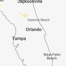

Cities Most Affected by Hail Storms of 3/2/2019
| Hail Size | Demographics of Zip Codes Affected | ||||||
|---|---|---|---|---|---|---|---|
| City | Count | Average | Largest | Pop Density | House Value | Income | Age |
Hail and Wind Damage Spotted on 3/2/2019
Filter by Report Type:Hail ReportsWind Reports
States Impacted
FloridaFlorida
| Local Time | Report Details |
|---|---|
| 7:25 AM EST | Debris covering springhill road for at least 2 miles south of the airport. also reported twisted and broken tree in leon county FL, 7.7 miles SW of Tallahassee, FL |
| 2:51 PM EST | 911 call center passed on a report of powerlines down on ne 55th blvd east of gainesville. time estimated using radar dat in alachua county FL, 57.8 miles SW of Jacksonville, FL |
| 5:12 PM EST | Trees down on state road 11 west of bunnel in flagler county FL, 63.1 miles N of Orlando, FL |
Connect with Interactive Hail Maps