

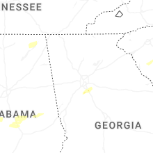
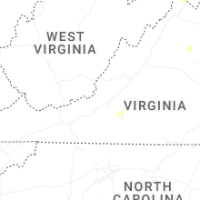
Hail Map for Saturday, May 3, 2025

Number of Impacted Households on 5/3/2025
0
Impacted by 1" or Larger Hail
0
Impacted by 1.75" or Larger Hail
0
Impacted by 2.5" or Larger Hail
Square Miles of Populated Area Impacted on 5/3/2025
0
Impacted by 1" or Larger Hail
0
Impacted by 1.75" or Larger Hail
0
Impacted by 2.5" or Larger Hail

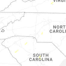
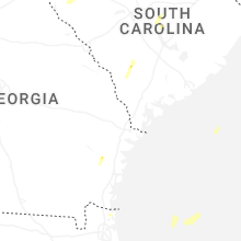
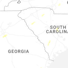
Cities Most Affected by Hail Storms of 5/3/2025
| Hail Size | Demographics of Zip Codes Affected | ||||||
|---|---|---|---|---|---|---|---|
| City | Count | Average | Largest | Pop Density | House Value | Income | Age |
| Lutherville Timonium, MD | 1 | 1.75 | 1.75 | 1854 | $189k | $65.3k | 47.7 |
| Fallston, MD | 1 | 1.75 | 1.75 | 505 | $205k | $79.1k | 44.9 |
Hail and Wind Damage Spotted on 5/3/2025
Filter by Report Type:Hail ReportsWind Reports
States Impacted
New York, Massachusetts, New Hampshire, South Carolina, Nevada, Connecticut, North Carolina, Virginia, Maryland, Alabama, West Virginia, New Jersey, Georgia, Florida, Texas, Pennsylvania, UtahNew York
| Local Time | Report Details |
|---|---|
| 1:08 PM EDT | Quarter sized hail reported near Coxsackie, NY, 31.9 miles SSE of Schenectady, NY, image shows hail approximately quarter sized in coxsackie. time estimated from radar. |
| 1:46 PM EDT | Multiple trees and powerlines dow in orange county NY, 52.8 miles NW of Brooklyn, NY |
| 10:30 PM UTC | Trees and powerlines dow in westchester county NY, 37.6 miles NNE of Brooklyn, NY |
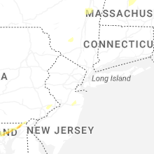
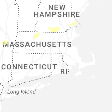
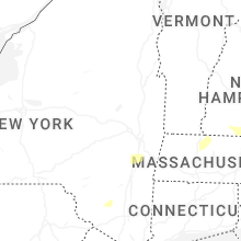
Massachusetts
| Local Time | Report Details |
|---|---|
| 1:50 PM EDT | Downed trees blocking a roadway in lanesboroug in berkshire county MA, 40.8 miles ESE of Schenectady, NY |
| 3:15 PM EDT | Tree and powerline wires downed near chestnut hill rd in montague. relayed by amateur radi in franklin county MA, 72.9 miles NW of Providence, RI |
| 3:25 PM EDT | 2 trees down on wires on state road. relayed via amateur radi in worcester county MA, 62.2 miles NW of Providence, RI |
| 3:25 PM EDT | 2 trees downed on powerline wires on state road in phillipston. relayed by amateur radi in worcester county MA, 63.9 miles NW of Providence, RI |
| 3:30 PM EDT | Law enforcement reports a tree down on wires blocking river roa in worcester county MA, 60.4 miles NNW of Providence, RI |
| 3:35 PM EDT | Tree down in area of otter river road blocking southbound lane. relayed via amateur radi in worcester county MA, 67.3 miles NNW of Providence, RI |
| 3:50 PM EDT | Trees down on powerlines in the area of kelton street. relayed via amateur radi in worcester county MA, 60 miles NNW of Providence, RI |
| 3:57 PM EDT | Barnes/westfield airpor in hampden county MA, 71.5 miles WNW of Providence, RI |
| 3:58 PM EDT | Tree down on hastings road. relayed via amateur radi in worcester county MA, 61 miles NNW of Providence, RI |
| 4:15 PM EDT | Large tree blocking delmore street. report relayed via amateur radi in hampden county MA, 61.6 miles WNW of Providence, RI |
| 4:15 PM EDT | Tree down on house near providence street. relayed via amateur radi in hampden county MA, 61.6 miles WNW of Providence, RI |
| 4:15 PM EDT | Large tree blocking delmore street. report relayed via amateur radi in hampden county MA, 61.6 miles WNW of Providence, RI |
| 4:15 PM EDT | Tree down on house near providence street. relayed via amateur radi in hampden county MA, 61.6 miles WNW of Providence, RI |
| 4:15 PM EDT | Large tree blocking delmore street. report relayed via amateur radi in hampden county MA, 61.6 miles WNW of Providence, RI |
| 4:15 PM EDT | Tree down on house near providence street. relayed via amateur radi in hampden county MA, 61.6 miles WNW of Providence, RI |
| 4:15 PM EDT | Pictures show a large tree down on two cars in springfield. relayed via amateur radi in hampden county MA, 62.7 miles WNW of Providence, RI |
| 4:15 PM EDT | Photos showing a large tree and power lines down across larkspur st in springfield. relayed via amateur radi in hampden county MA, 60.9 miles WNW of Providence, RI |
| 4:20 PM EDT | Utility pole down near fernwood ave. relayed via amateur radi in hampden county MA, 64.5 miles WNW of Providence, RI |
| 4:20 PM EDT | Wires down on beachwood terrace. relayed via amateur radi in hampden county MA, 64.5 miles WNW of Providence, RI |
| 4:22 PM EDT | Tree and multiple power lines reported down on mount dumplin rd in palmer. time estimated by radar. relayed via amateur radi in hampden county MA, 53.3 miles WNW of Providence, RI |
| 8:23 PM UTC | Tree downed on wires near michael sears rd in belchertown. relayed by amateur radi in hampshire county MA, 57 miles WNW of Providence, RI |
| 4:23 PM EDT | Trees downed on wires on several sections of north liberty st in belchertown. relayed by amateur radi in hampshire county MA, 57.2 miles WNW of Providence, RI |
| 4:25 PM EDT | Trees and wires reported down on a car and shed in palmer. time estimated by radar. relayed via amateur radi in hampden county MA, 53.5 miles WNW of Providence, RI |
| 4:27 PM EDT | Telephone pole reported down in the road. time estimated by radar. relayed via amateur radi in hampshire county MA, 53.4 miles NW of Providence, RI |
| 4:27 PM EDT | Power lines reported down on cars in ware. time estimated by radar. relayed via amateur radi in hampshire county MA, 55.6 miles WNW of Providence, RI |
| 4:30 PM EDT | Wires down on south main st in palmer. time estimated by radar. relayed via amateur radi in hampden county MA, 51.9 miles WNW of Providence, RI |
| 4:30 PM EDT | Large tree... wires... and transformer reported down on throndike st at elizabeth st. time estimated by radar. relayed via amateur radi in hampden county MA, 54 miles WNW of Providence, RI |
| 4:30 PM EDT | Trees reported down. time estimated by radar. relayed via amateur radi in hampshire county MA, 55.1 miles NW of Providence, RI |
| 4:33 PM EDT | Roof collapse reported on cherry st in ware. time estimated by radar. relayed via amateur radi in hampshire county MA, 51.7 miles NW of Providence, RI |
| 4:35 PM EDT | Trees and wires reported down on lyons rd in west brookfield. time estimated by radar. relayed via amateur radi in worcester county MA, 51.3 miles NW of Providence, RI |
| 4:35 PM EDT | Trees and wires reported down in west brookfield. time estimated by radar. relayed via amateur radi in worcester county MA, 50.1 miles NW of Providence, RI |
| 4:37 PM EDT | Trees and wires reported down on kennedy rd in west brookfield. time estimated by radar. relayed via amateur radi in worcester county MA, 51.7 miles NW of Providence, RI |
| 8:40 PM UTC | Several trees and powerlines downed in town... including coldbrook rd at old turnpike rd. relayed by amateur radi in worcester county MA, 50.5 miles NW of Providence, RI |
| 4:40 PM EDT | 2 trees downed on scott rd in oakham. relayed by amateur radi in worcester county MA, 50.8 miles NW of Providence, RI |
| 4:40 PM EDT | 2 trees down near scott road. relayed via amateur radi in worcester county MA, 48.9 miles NW of Providence, RI |
| 4:43 PM EDT | Tree down near gould rd. relayed by amateur radi in worcester county MA, 37 miles NW of Providence, RI |
| 8:45 PM UTC | Tree down on turkey hill dr in paxton. relayed via amateur radio. time estimated by rada in worcester county MA, 44.6 miles NW of Providence, RI |
| 4:47 PM EDT | Tree down on wirs near church street. relayed via amateur radi in worcester county MA, 41.3 miles NW of Providence, RI |
| 4:50 PM EDT | Tree reported down on power lines in worcester. time estimated by radar. relayed via amateur radi in worcester county MA, 38.4 miles NW of Providence, RI |
| 4:50 PM EDT | Large tree branch reported down on power lines in worcester. time estimated by radar. relayed via amateur radi in worcester county MA, 39.3 miles NW of Providence, RI |
| 4:50 PM EDT | Trees reported down on wires in holden. time estimated by radar and relayed via amateur radi in worcester county MA, 44.8 miles NNW of Providence, RI |
| 4:53 PM EDT | Storm damage reported in worcester county MA, 41.6 miles NNW of Providence, RI |
| 4:55 PM EDT | Large tree branch reported down on wires on burncoat st in worcester. time estimated by radar. relayed via amateur radi in worcester county MA, 37.6 miles NNW of Providence, RI |
| 4:55 PM EDT | Worcester regional airpor in worcester county MA, 38.8 miles NW of Providence, RI |
| 9:00 PM UTC | Tree and wires downed on damon rd. relayed by amateur radi in worcester county MA, 43.6 miles NNW of Providence, RI |
| 5:08 PM EDT | A trained weather spotter reported 2 trees downed on a truck in bolton. time estimated by radar. no injurie in worcester county MA, 42.9 miles NNW of Providence, RI |
| 9:30 PM UTC | Tree down on a car on corner of shawsheen and arlington streets in tewksbury. relayed by amateur radi in middlesex county MA, 53.9 miles N of Providence, RI |
| 1:25 AM UTC | Tree down on a car occupied by an individual on main st in bolton. relayed by amateur radi in worcester county MA, 42.9 miles NNW of Providence, RI |
New Hampshire
| Local Time | Report Details |
|---|---|
| 2:08 PM EDT | Half Dollar sized hail reported near East Kingston, NH, 62.7 miles SW of Portland, ME, reported by amateur radio... time estimated by radar. |
| 2:15 PM EDT | Corrects previous tstm wnd dmg report from 2 nw hampton falls. reported by amateur radio... multiple 10-12 inch diameter trees down on nason rd. time estimated by radar in rockingham county NH, 59.6 miles SSW of Portland, ME |
| 2:16 PM EDT | Large pine tree blocking one lane on nh rt 101. additional estimated 15 to 20 trees down off the side of nh rt 101. time estimated by rada in rockingham county NH, 58 miles SSW of Portland, ME |
| 2:20 PM EDT | Half Dollar sized hail reported near North Hampton, NH, 55.9 miles SSW of Portland, ME, reported by weather spotter... time estimated by radar. |
| 3:35 PM EDT | Quarter sized hail reported near Jaffrey, NH, 76.1 miles NNW of Providence, RI, reported by weather spotter... time estimated by radar. |
| 3:39 PM EDT | Reported by amateur radio... multiple 10-12 inch diameter trees down on nason rd. time estimated by rada in rockingham county NH, 59.6 miles SSW of Portland, ME |
| 3:40 PM EDT | Measured off of kestrel. time estimated by rada in cheshire county NH, 76.1 miles NNW of Providence, RI |
| 3:40 PM EDT | Reported by weather spotter... time estimated by rada in cheshire county NH, 76.1 miles NNW of Providence, RI |
| 4:08 PM EDT | Quarter sized hail reported near Greenville, NH, 66.1 miles NNW of Providence, RI, reported by amateur radio... time estimated by radar. |
| 4:09 PM EDT | Half Dollar sized hail reported near Brookline, NH, 67.2 miles N of Providence, RI, reported by amateur radio... time estimated by radar. |
South Carolina
| Local Time | Report Details |
|---|---|
| 2:32 PM EDT | Home along lake greenwood near waterloo sustained damage to siding... patio furniture... bent flag poles and multiple tree limbs dow in laurens county SC, 45.5 miles SE of Greenville, SC |
| 6:16 PM EDT | Quarter sized hail reported near Olar, SC, 54.8 miles ESE of Augusta, GA, facebook post with a video of hail falling on low country hwy between olar and ehrhardt. additional photo showed a hailstone that was approximately quarter size. time p |
| 1:37 AM UTC | Power outage along hwy 137 north of six mile attributed to fallen trees/limb in pickens county SC, 11.9 miles W of Greenville, SC |
| 9:40 PM EDT | Power outage attributed to fallen trees/limbs near keowee springs golf cours in pickens county SC, 15.5 miles W of Greenville, SC |
| 2:14 AM UTC | Trees down at kennedy dr and daisy d in greenville county SC, 11.6 miles E of Greenville, SC |
| 10:22 PM EDT | Power outage attributed to fallen trees/limbs on douglas d in greenville county SC, 12.6 miles E of Greenville, SC |
| 10:28 PM EDT | Severe wind gust observed by nws employe in greenville county SC, 17.8 miles E of Greenville, SC |
| 2:53 AM UTC | Power outage due to fallen trees/limbs near junction of lightwood knot rd and cunningham rd. time estimated from rada in spartanburg county SC, 28.5 miles E of Greenville, SC |
| 5:20 AM UTC | Kershaw county fire reported a few downed trees and a flipped storage shed near boonetown road and old georgetown roa in kershaw county SC, 56.4 miles SSE of Charlotte, NC |
| 8:41 AM UTC | North myrtle beach asos (kcre) reported 50 kt wind gus in horry county SC, 52.8 miles WSW of Wilmington, NC |
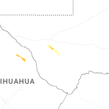
Nevada
| Local Time | Report Details |
|---|---|
| 11:45 AM PDT | Buster jangle y sensor a01ab measured a gust of 65 mph from a nearby thunderstor in nye county NV, 79.4 miles NW of Las Vegas, NV |
Connecticut
| Local Time | Report Details |
|---|---|
| 3:13 PM EDT | Multiple downed trees blocking a roadwa in litchfield county CT, 75.7 miles NNE of Brooklyn, NY |
| 3:25 PM EDT | Trees downed on route 4 just west of goshe in litchfield county CT, 77 miles SSE of Schenectady, NY |
| 3:34 PM EDT | Wires downe in litchfield county CT, 81.2 miles SSE of Schenectady, NY |
| 3:45 PM EDT | Trees downed on maple hollow roa in litchfield county CT, 82.3 miles SE of Schenectady, NY |
| 3:45 PM EDT | Trees downed on route 202 at east cotton hill roa in litchfield county CT, 82.3 miles SE of Schenectady, NY |
| 3:45 PM EDT | Trees downed on route 4 in litchfield county CT, 78.1 miles SE of Schenectady, NY |
| 3:49 PM EDT | Trees downed at ct route 181 and goose green roa in litchfield county CT, 79.4 miles SE of Schenectady, NY |
| 3:56 PM EDT | Bradley intl airpor in hartford county CT, 65.9 miles W of Providence, RI |
| 4:10 PM EDT | Multiple trees down on power lines on buttles road. relayed via amateur radi in hartford county CT, 71.1 miles W of Providence, RI |
| 4:10 PM EDT | Tree down on a car near hatchet hill roa in hartford county CT, 71.1 miles W of Providence, RI |
| 4:10 PM EDT | Tree down on holcomb streeet at barndoor hill road. relayed by amateur radi in hartford county CT, 72.2 miles W of Providence, RI |
| 6:43 PM EDT | Tree limbs and powerlines dow in fairfield county CT, 47.4 miles NNE of Brooklyn, NY |
North Carolina
| Local Time | Report Details |
|---|---|
| 3:15 PM EDT | Two trees down at old beatty ford rd and emmanuel church r in rowan county NC, 32.1 miles NE of Charlotte, NC |
| 3:35 PM EDT | Thunderstorm winds blew down several trees near the intersection of highway 65 and easley roa in stokes county NC, 69.5 miles S of Roanoke, VA |
| 4:35 PM EDT | Thunderstorm winds blew down one tree near the 200 block of bald hill loop just south of highway 70 in rockingham county NC, 62.2 miles S of Roanoke, VA |
| 4:44 PM EDT | Tree down on utility equipmen in mecklenburg county NC, 10.5 miles WSW of Charlotte, NC |
| 4:54 PM EDT | Trees down on utility equipmen in mecklenburg county NC, 5.1 miles SW of Charlotte, NC |
| 5:15 PM EDT | Tree down on utility equipmen in cabarrus county NC, 13.2 miles NNE of Charlotte, NC |
| 5:20 PM EDT | Trees down at tennessee st and pennsylvania av in cabarrus county NC, 20.8 miles NE of Charlotte, NC |
| 11:21 PM EDT | Trees down at youngblood rd and mckee rd... and west to catawba river on adjacent roadway in mecklenburg county NC, 14.7 miles SW of Charlotte, NC |
| 1:00 AM EDT | Trees down near junction of cattlemans rd and mtn view rd. time estimate in iredell county NC, 51.5 miles N of Charlotte, NC |
| 1:00 AM EDT | Power outage attributed to fallen trees/limbs between univ city blvd and e wt harris blv in mecklenburg county NC, 6.9 miles NE of Charlotte, NC |
| 1:05 AM EDT | Large tree blocking roadway...shiloh rd at doodle dr. time estimated from radar and ob in iredell county NC, 35.7 miles N of Charlotte, NC |
| 5:33 AM UTC | Power outage attributed to fallen trees/limbs around long bow rd. time estimated from rada in rowan county NC, 42.5 miles NNE of Charlotte, NC |
Virginia
| Local Time | Report Details |
|---|---|
| 3:16 PM EDT | Tree down on gleedsville road at emerald park driv in loudoun county VA, 54.6 miles WSW of Baltimore, MD |
| 3:31 PM EDT | Thunderstorm winds blew down one power line near the intersection of dry pond highway and creasy chapel roa in patrick county VA, 51.5 miles SSW of Roanoke, VA |
| 5:04 PM EDT | Tree down at the intersection of leeds manor rd & crest hill rd in fauquier county VA, 82.2 miles WSW of Baltimore, MD |
| 5:21 PM EDT | Thunderstorm winds blew down one tree along the 3300 block of brookside road close to the intersection with medical center roa in pittsylvania county VA, 43 miles SSE of Roanoke, VA |
Maryland
| Local Time | Report Details |
|---|---|
| 3:51 PM EDT | Quarter sized hail reported near Germantown, MD, 33.4 miles W of Baltimore, MD |
| 3:54 PM EDT | Trees and wires down in the 8000 block of rocky roa in montgomery county MD, 30.3 miles W of Baltimore, MD |
| 4:13 PM EDT | Ping Pong Ball sized hail reported near Glenwood, MD, 21.5 miles W of Baltimore, MD |
| 4:26 PM EDT | Multiple large tree branches snappe in howard county MD, 16.1 miles WNW of Baltimore, MD |
| 4:34 PM EDT | Tree down on a car in the 6700 block of baltimore national pik in baltimore county MD, 8.6 miles W of Baltimore, MD |
| 4:48 PM EDT | Quarter sized hail reported near Owings Mills, MD, 11.5 miles NW of Baltimore, MD |
| 4:51 PM EDT | Quarter sized hail reported near Owings Mills, MD, 12.7 miles NW of Baltimore, MD |
| 4:56 PM EDT | Golf Ball sized hail reported near Lutherville Timonium, MD, 10.5 miles NNW of Baltimore, MD |
| 5:18 PM EDT | Golf Ball sized hail reported near Fallston, MD, 18.4 miles NE of Baltimore, MD |
| 5:22 PM EDT | Tree down at the 1700 block of canal rd in washington county MD, 61.7 miles W of Baltimore, MD |
| 5:26 PM EDT | Tree down at the intersection of mt briar rd and marble quarry rd in washington county MD, 58.5 miles WNW of Baltimore, MD |
| 5:26 PM EDT | Tree down at the intersection of laurel bush rd and rt 924 in harford county MD, 20.8 miles NE of Baltimore, MD |
| 5:33 PM EDT | Tree down at the 1700 block of south fountain green rd in harford county MD, 23.2 miles NE of Baltimore, MD |
| 5:33 PM EDT | Tree down at the 1100 block of mcphail rd in harford county MD, 21.6 miles NE of Baltimore, MD |
| 5:35 PM EDT | Ping Pong Ball sized hail reported near Bel Air, MD, 21.4 miles NE of Baltimore, MD |
| 5:36 PM EDT | Half Dollar sized hail reported near Bel Air, MD, 22.2 miles NE of Baltimore, MD |
| 5:51 PM EDT | Tree down at main st and wolfsville rd in frederick county MD, 53.6 miles WNW of Baltimore, MD |
| 5:51 PM EDT | Tree down at gambrill park rd and high knob rd in frederick county MD, 49.3 miles WNW of Baltimore, MD |
| 6:10 PM EDT | Ping Pong Ball sized hail reported near Port Deposit, MD, 37.6 miles NE of Baltimore, MD |
| 6:12 PM EDT | Quarter sized hail reported near Port Deposit, MD, 39.3 miles NE of Baltimore, MD |
| 6:15 PM EDT | Ping Pong Ball sized hail reported near Elkton, MD, 45.6 miles NE of Baltimore, MD |
| 6:34 PM EDT | Quarter sized hail reported near Elkton, MD, 49 miles NE of Baltimore, MD |
| 6:35 PM EDT | Tree down in providence blocking the roadwa in cecil county MD, 44.3 miles NE of Baltimore, MD |
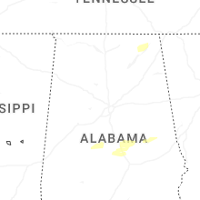
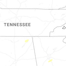
Alabama
| Local Time | Report Details |
|---|---|
| 3:00 PM CDT | Tree reported down over the roadway by ema at 147 county road 10 paint rock... a in jackson county AL, 60.9 miles WSW of Chattanooga, TN |
| 3:30 PM CDT | Tree reported down on powerlines by ema at county road 245 at county road 33 hytop a in jackson county AL, 45 miles WSW of Chattanooga, TN |
| 3:48 PM CDT | Tree reported down by ema at till davis road at county road 67 langston... a in jackson county AL, 56.9 miles SW of Chattanooga, TN |
| 3:48 PM CDT | Tree reported down by ema at 9277 cr 67 langston... a in jackson county AL, 56 miles SW of Chattanooga, TN |
| 3:48 PM CDT | Tree limb reported down on a house by ema at 3358 cr 60 in jackson county a in jackson county AL, 36.3 miles SW of Chattanooga, TN |
| 8:48 PM UTC | Report of tree down block the road way by ema at county road 82 and county road 30 in scottsboro... a in jackson county AL, 56.5 miles WSW of Chattanooga, TN |
| 8:55 PM UTC | A flag pole and tree were knocked down at the rosalie fire station on highway 7 in jackson county AL, 34.5 miles SW of Chattanooga, TN |
| 3:58 PM CDT | Tree reported down by ema at the alabama welcome center on i-5 in dekalb county AL, 27.2 miles SSW of Chattanooga, TN |
| 3:58 PM CDT | Several trees reported down by ema in the sulpher springs area along hwy 1 in dekalb county AL, 28.1 miles SSW of Chattanooga, TN |
| 8:59 PM UTC | Quarter sized hail reported near Scottsboro, AL, 47.5 miles WSW of Chattanooga, TN, report from mping: quarter (1.00 in.). |
| 9:01 PM UTC | A tree was knocked down blocking one lane at 1132 cr 31 in jackson county AL, 22.2 miles SW of Chattanooga, TN |
| 9:25 PM UTC | A tree was knocked down blocking both lanes about 1/2 mile from cr 30 along cr 82. time estimated by rada in jackson county AL, 56.2 miles WSW of Chattanooga, TN |
| 9:31 PM UTC | Several trees down north of gaylesville... including cr 41 and cr 772... cr 826... cr 114... cr 81 at cr 77... and hwy 3 in cherokee county AL, 53.2 miles SSW of Chattanooga, TN |
| 4:50 PM CDT | Half Dollar sized hail reported near Fruitdale, AL, 51 miles NNW of Mobile, AL, photo of nearly half dollar sized hail in fruitdale... al. photo via social media. |
| 5:11 PM CDT | Trees down across possum trot rd and cove rd north of jacksonville and across main st and e 3rd st in oxfor in calhoun county AL, 67.3 miles ENE of Birmingham, AL |
| 5:24 PM CDT | Trees down on coaling rd in sylacauga and trees and power lines down on canal st in childersbur in talladega county AL, 40.8 miles SE of Birmingham, AL |
| 11:04 PM UTC | Tree down at weoka rd and nobles r in elmore county AL, 42.2 miles W of Auburn, AL |
| 11:23 PM UTC | Multiple trees down on davis circle near west lafayette st and pear tree l in tallapoosa county AL, 25.4 miles NW of Auburn, AL |
| 11:38 PM UTC | Tree down at buttston rd and germanys ferry r in tallapoosa county AL, 26.2 miles NNW of Auburn, AL |
West Virginia
| Local Time | Report Details |
|---|---|
| 4:47 PM EDT | Tree down at the 1100 block of brucetown rd in jefferson county WV, 75.1 miles W of Baltimore, MD |
| 4:49 PM EDT | Half Dollar sized hail reported near Martinsburg, WV, 72.2 miles W of Baltimore, MD |
| 5:09 PM EDT | Tree down at the intersection of flowings springs rd & old country club rd in jefferson county WV, 66 miles W of Baltimore, MD |
| 5:22 PM EDT | Tree fell down on a vehicle at the locust hill golf course subdivision causing multiple injuries in jefferson county WV, 69.2 miles W of Baltimore, MD |
New Jersey
| Local Time | Report Details |
|---|---|
| 5:31 PM EDT | Numerous wires down. time estimated from kdix rada in hunterdon county NJ, 47.4 miles WSW of Brooklyn, NY |
| 5:45 PM EDT | Numerous reports of wires down. time estimated from kdix rada in hunterdon county NJ, 41.9 miles W of Brooklyn, NY |
| 5:51 PM EDT | Numerous wires down. time estimated from kdix rada in hunterdon county NJ, 48.1 miles WSW of Brooklyn, NY |
| 6:58 PM EDT | Quarter sized hail reported near Freehold, NJ, 34.1 miles SSW of Brooklyn, NY, report from mping: quarter (1.00 in.). |
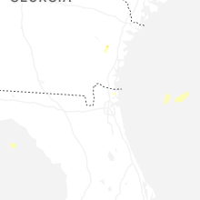
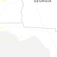
Georgia
| Local Time | Report Details |
|---|---|
| 5:35 PM EDT | Report of trees down on the roadway at trion teloga rd and bryant r in chattooga county GA, 34.5 miles S of Chattanooga, TN |
| 5:40 PM EDT | Several trees down on the roads in summervill in chattooga county GA, 38.4 miles S of Chattanooga, TN |
| 5:47 PM EDT | Tree down blocking both lanes at harrisburg road and olympic lan in chattooga county GA, 34.4 miles S of Chattanooga, TN |
| 5:53 PM EDT | Tree down blocking trion teloga road just passed the hawk ridge road intersectio in chattooga county GA, 35.8 miles S of Chattanooga, TN |
| 6:10 PM EDT | One large tree down near the intersection of sonya drive and rauschenberg road n in whitfield county GA, 22.3 miles ESE of Chattanooga, TN |
| 6:31 PM EDT | Mesonet station naog1 armuche in walker county GA, 25.3 miles SSE of Chattanooga, TN |
| 7:05 PM EDT | Mesonet station cohg1 4 n conasauga lak in murray county GA, 37.9 miles ESE of Chattanooga, TN |
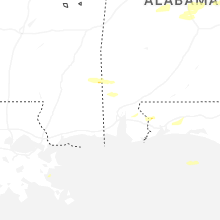
Florida
| Local Time | Report Details |
|---|---|
| 5:09 PM CDT | Ping Pong Ball sized hail reported near Molino, FL, 43.7 miles E of Mobile, AL, photo of nearly ping pong ball size hail taken near the molino/cantonment fl area. photo via social media. |
| 5:09 PM CDT | Half Dollar sized hail reported near Molino, FL, 43.7 miles E of Mobile, AL, photos of quarter to half dollar sized hail in molino... fl. photos via social media. |
Texas
| Local Time | Report Details |
|---|---|
| 6:41 PM CDT | Quarter sized hail reported near Fort Davis, TX, 22.6 miles NNW of Alpine, TX |
| 6:42 PM CDT | Quarter sized hail reported near Fort Davis, TX, 22.6 miles NNW of Alpine, TX, report of hail up to quarter size covering the roadway along state highway 17. |
Pennsylvania
| Local Time | Report Details |
|---|---|
| 7:44 PM EDT | Downed tree on rose valley rd / yale av / manchester av southbound between creek rd and school ln. time estimated from rada in delaware county PA, 77.5 miles ENE of Baltimore, MD |
| 7:56 PM EDT | Tree dow in philadelphia county PA, 78.1 miles SW of Brooklyn, NY |
| 8:27 PM EDT | Multiple trees down in abington township including a tree into a house. time estimated from rada in montgomery county PA, 71.8 miles SW of Brooklyn, NY |
| 8:27 PM EDT | Quarter sized hail reported near Philadelphia, PA, 71.3 miles SW of Brooklyn, NY, report from mping: quarter (1.00 in.). |
Utah
| Local Time | Report Details |
|---|---|
| 12:53 AM UTC | Asos station kbce bryce canyon airpor in garfield county UT, 64.2 miles S of Monroe, UT |
| 8:20 PM MDT | Mesonet station pc476 mineral mountain in beaver county UT, 42.1 miles WSW of Monroe, UT |
| 4:45 AM UTC | Mesonet station dpg19 fish spring in juab county UT, 94.5 miles ENE of Ely, NV |
Connect with Interactive Hail Maps