

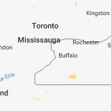
Hail Map for Saturday, October 6, 2018

Number of Impacted Households on 10/6/2018
0
Impacted by 1" or Larger Hail
0
Impacted by 1.75" or Larger Hail
0
Impacted by 2.5" or Larger Hail
Square Miles of Populated Area Impacted on 10/6/2018
0
Impacted by 1" or Larger Hail
0
Impacted by 1.75" or Larger Hail
0
Impacted by 2.5" or Larger Hail


Cities Most Affected by Hail Storms of 10/6/2018
| Hail Size | Demographics of Zip Codes Affected | ||||||
|---|---|---|---|---|---|---|---|
| City | Count | Average | Largest | Pop Density | House Value | Income | Age |
Hail and Wind Damage Spotted on 10/6/2018
Filter by Report Type:Hail ReportsWind Reports
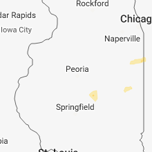
Illinois
| Local Time | Report Details |
|---|---|
| 12:23 PM CDT | Limbs and wires reported down in the cit in de witt county IL, 44.5 miles SSE of Peoria, IL |
| 12:36 PM CDT | Small limbs reported covering roadway on us-51 in wapell in de witt county IL, 46.4 miles SE of Peoria, IL |
| 1:45 PM CDT | Reports of power out in rossville and locations northward to hoopesto in vermilion county IL, 72.4 miles NNE of Mattoon, IL |
Indiana
| Local Time | Report Details |
|---|---|
| 4:23 PM EDT | 911 center reports large tree limb down near county road 550 east. time estimated from rada in tippecanoe county IN, 56.7 miles NW of Indianapolis, IN |
| 4:28 PM EDT | Large healthy tree snapped near bas in tippecanoe county IN, 56.6 miles NW of Indianapolis, IN |
| 5:00 PM EDT | 30 foot tall healthy tree blown over. time estimated from rada in howard county IN, 51 miles NNW of Indianapolis, IN |
| 6:12 PM EDT | 12 inch tree snapped. report relayed via nws chat. no word on health/condition of tre in allen county IN, 5.3 miles SW of Fort Wayne, IN |
New York
| Local Time | Report Details |
|---|---|
| 4:39 PM EDT | Quarter sized hail reported near Friendship, NY, 59.4 miles SE of Buffalo, NY |
| 4:40 PM EDT | Quarter sized hail reported near Friendship, NY, 59.9 miles SE of Buffalo, NY |
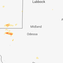
Oklahoma
| Local Time | Report Details |
|---|---|
| 4:45 PM CDT | Quarter sized hail reported near Healdton, OK, 62.1 miles ENE of Wichita Falls, TX |
| 6:33 PM CDT | Numerous trees down and power outages in town. car port severely damage in delaware county OK, 74.7 miles ENE of Tulsa, OK |
| 6:35 PM CDT | Storm damage reported in delaware county OK, 74.7 miles ENE of Tulsa, OK |
| 7:00 PM CDT | Multiple trees snapped and roof damage to a hom in mayes county OK, 44.9 miles E of Tulsa, OK |
| 7:05 PM CDT | Storm damage reported in jefferson county OK, 55.8 miles ENE of Wichita Falls, TX |
| 8:35 PM CDT | Measured at ardmore airpor in carter county OK, 52.7 miles W of Atoka, OK |
Pennsylvania
| Local Time | Report Details |
|---|---|
| 5:50 PM EDT | Large branch took several wires down at route 173 and 322 intersectio in crawford county PA, 74.7 miles N of Pittsburgh, PA |
| 6:40 PM EDT | Multiple trees reported down north of oil cit in venango county PA, 74.9 miles NNE of Pittsburgh, PA |
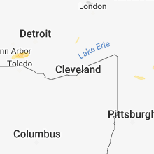
Ohio
| Local Time | Report Details |
|---|---|
| 5:53 PM EDT | One tree and several other branches dow in seneca county OH, 84.1 miles WSW of Cleveland, OH |
| 5:53 PM EDT | Multiple trees dow in seneca county OH, 83.1 miles WSW of Cleveland, OH |
| 6:38 PM EDT | Power lines down in willshire. power out in village. large tree dow in van wert county OH, 27.7 miles SE of Fort Wayne, IN |
Michigan
| Local Time | Report Details |
|---|---|
| 6:05 PM EDT | Lenawee county central dispatch reports numerous trees down in areas east of adria in lenawee county MI, 72.2 miles S of Flint, MI |
| 6:23 PM EDT | Monroe county central dispatch reports several power lines downed around the dundee are in monroe county MI, 69.8 miles S of Flint, MI |
| 6:33 PM EDT | Healthy tree downed... approximately a foot in diamete in monroe county MI, 69.6 miles S of Flint, MI |
| 6:42 PM EDT | Half Dollar sized hail reported near Carleton, MI, 67.3 miles SSE of Flint, MI, photos of hail larger than a quarter received via twitter. |
Connect with Interactive Hail Maps