

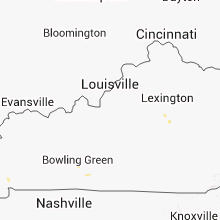
Hail Map for Wednesday, September 11, 2013

Number of Impacted Households on 9/11/2013
0
Impacted by 1" or Larger Hail
0
Impacted by 1.75" or Larger Hail
0
Impacted by 2.5" or Larger Hail
Square Miles of Populated Area Impacted on 9/11/2013
0
Impacted by 1" or Larger Hail
0
Impacted by 1.75" or Larger Hail
0
Impacted by 2.5" or Larger Hail


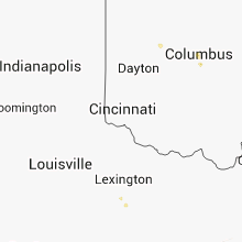


Cities Most Affected by Hail Storms of 9/11/2013
| Hail Size | Demographics of Zip Codes Affected | ||||||
|---|---|---|---|---|---|---|---|
| City | Count | Average | Largest | Pop Density | House Value | Income | Age |
| Kingsley, PA | 1 | 1.75 | 1.75 | 39 | $94k | $34.9k | 45.5 |
| Bolingbrook, IL | 1 | 1.75 | 1.75 | 3348 | $133k | $64.2k | 32.8 |
| Unadilla, NY | 1 | 1.75 | 1.75 | 55 | $71k | $36.2k | 45.7 |
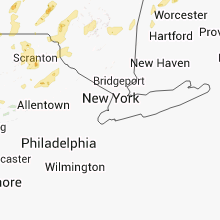
Hail and Wind Damage Spotted on 9/11/2013
Filter by Report Type:Hail ReportsWind Reports
States Impacted
Pennsylvania, New York, Florida, Ohio, Maine, Illinois, Minnesota, Vermont, Arkansas, Kentucky, Texas, Michigan, Indiana, New Hampshire, West Virginia, MassachusettsPennsylvania
| Local Time | Report Details |
|---|---|
| 2:30 PM EDT | Trees on wires in renovo in clinton county PA, 37.5 miles N of State College, PA |
| 3:12 PM EDT | Golf Ball sized hail reported near Kingsley, PA, 24.7 miles NNW of Scranton, PA, reported in brooklyn township along state route 167. also... wires down on an occupied vehicle at the intersection of sr-167 and sr-2024 |
| 3:40 PM EDT | Trees down in allegheny county PA, 12.1 miles NE of Pittsburgh, PA |
| 4:10 PM EDT | Tree down and skirting blown in in lycoming county PA, 58.7 miles WSW of Scranton, PA |
| 4:10 PM EDT | Quarter sized hail reported near Muncy, PA, 58.7 miles WSW of Scranton, PA |
| 4:20 PM EDT | Tree down near mansfield in tioga county PA, 78.5 miles WNW of Scranton, PA |
| 4:30 PM EDT | Trees and wires dow in lycoming county PA, 56.8 miles WSW of Scranton, PA |
| 4:41 PM EDT | Quarter sized hail reported near Clarks Summit, PA, 4.9 miles NNW of Scranton, PA, also trees reported down |
| 4:50 PM EDT | Multiple reports of large trees down along the side of interstate 8 in lackawanna county PA, 5.7 miles NNW of Scranton, PA |
| 4:53 PM EDT | Trees and wires down in cambria county PA, 43.6 miles WSW of State College, PA |
| 5:05 PM EDT | Trees down in cambria county PA, 35 miles WSW of State College, PA |
| 5:14 PM EDT | Quarter sized hail reported near Ransom, PA, 8.4 miles W of Scranton, PA |
| 5:30 PM EDT | Dog kennel damaged and shingles off of a roof in dauphin county PA, 63.1 miles ESE of State College, PA |
| 5:40 PM EDT | Quarter sized hail reported near Shinglehouse, PA, 72.3 miles SSE of Buffalo, NY |
| 6:15 PM EDT | Half Dollar sized hail reported near Scranton, PA, 0.8 miles SW of Scranton, PA |
| 7:15 PM EDT | Quarter sized hail reported near Mahanoy City, PA, 48.4 miles SSW of Scranton, PA |
| 7:26 PM EDT | Trees down in potter county PA, 79.5 miles SE of Buffalo, NY |
| 7:27 PM EDT | Trees dow in mckean county PA, 73.1 miles SSE of Buffalo, NY |
| 7:30 PM EDT | Trees down in mckean county PA, 72.7 miles SSE of Buffalo, NY |
| 7:56 PM EDT | Trees down along rte 11 in cumberland county PA, 53.4 miles SSE of State College, PA |
| 8:00 PM EDT | Trees and wires down on barbertown road in potter county PA, 72.3 miles SSE of Buffalo, NY |
New York
| Local Time | Report Details |
|---|---|
| 2:39 PM EDT | Two trees down on abbott hill road in the town of concor in erie county NY, 22.4 miles SSE of Buffalo, NY |
| 3:10 PM EDT | Quarter sized hail reported near Harpursville, NY, 52.5 miles N of Scranton, PA |
| 3:32 PM EDT | Numerous tree limbs down spotter said they were not rotted in chenango county NY, 57 miles N of Scranton, PA |
| 3:35 PM EDT | Quarter sized hail reported near Afton, NY, 57 miles N of Scranton, PA |
| 3:37 PM EDT | Quarter sized hail reported near Harpursville, NY, 49.7 miles N of Scranton, PA |
| 3:43 PM EDT | Quarter sized hail reported near Sidney, NY, 63.5 miles NNE of Scranton, PA, nickel to quarter sized hail reported |
| 3:50 PM EDT | Golf Ball sized hail reported near Unadilla, NY, 65.2 miles SE of Syracuse, NY |
| 4:55 PM EDT | Report of tree down on wires and car relayed by local media in essex county NY, 37.9 miles SSW of Burlington, VT |
| 5:15 PM EDT | Large tree down across oak st. public report to local media. time estimated via radar in clinton county NY, 37.4 miles NNW of Burlington, VT |
| 5:15 PM EDT | Hooper road in endwell was closed due to wires down across roa in broome county NY, 52.4 miles NNW of Scranton, PA |
| 5:15 PM EDT | Trees down in town in franklin county NY, 52.7 miles ENE of Ogdensburg, NY |
| 5:25 PM EDT | Trees down in schoharie county NY, 34.5 miles W of Schenectady, NY |
| 5:25 PM EDT | Trees down. time estimated by rada in schoharie county NY, 34.5 miles W of Schenectady, NY |
| 5:30 PM EDT | Trees down in town. also a public report of trees uprooted near the intersections of rt 122 and 30 in franklin county NY, 60.7 miles ENE of Ogdensburg, NY |
| 5:35 PM EDT | Trees down. time estimated by rada in schoharie county NY, 26.1 miles W of Schenectady, NY |
| 5:40 PM EDT | Tree down in franklin county NY, 53.8 miles NW of Burlington, VT |
| 5:52 PM EDT | Half Dollar sized hail reported near Johnstown, NY, 33 miles NW of Schenectady, NY |
| 5:54 PM EDT | Trees and wires dow in oswego county NY, 22.2 miles NE of Syracuse, NY |
| 5:55 PM EDT | Trees and wires dow in oswego county NY, 18.8 miles NE of Syracuse, NY |
| 6:00 PM EDT | Quarter sized hail reported near Caroga Lake, NY, 35.5 miles NW of Schenectady, NY |
| 6:00 PM EDT | Quarter sized hail reported near Gloversville, NY, 31.4 miles NW of Schenectady, NY, 1 inch and larger hail covered ground |
| 6:00 PM EDT | Numerous trees down and power poles in fulton county NY, 31.4 miles NW of Schenectady, NY |
| 6:00 PM EDT | Trees and wires down intersection of routes 28 and 8 at poland-cold brook line. time estimated from rada in herkimer county NY, 56.4 miles ENE of Syracuse, NY |
| 6:00 PM EDT | Wires down on route 28. time estimated from rada in herkimer county NY, 56.4 miles ENE of Syracuse, NY |
| 6:10 PM EDT | Multiple trees down in greene county NY, 42.2 miles SW of Schenectady, NY |
| 6:22 PM EDT | Tree down - kenwood ave in albany county NY, 14.4 miles SSE of Schenectady, NY |
| 6:35 PM EDT | Storm damage reported in saratoga county NY, 19.6 miles NE of Schenectady, NY |
| 6:35 PM EDT | Trees down route 9p area in saratoga county NY, 18.5 miles NE of Schenectady, NY |
| 6:35 PM EDT | Trees down union ave in saratoga county NY, 19.6 miles NNE of Schenectady, NY |
| 6:35 PM EDT | Large trees down along route 9p and power poles snapped in saratoga county NY, 19.6 miles NE of Schenectady, NY |
| 6:47 PM EDT | Multiple downed trees and powerline in cattaraugus county NY, 43.3 miles SSE of Buffalo, NY |
| 6:47 PM EDT | Rte 242 closed in franklinville due to downed trees and live wires blocking roadwa in cattaraugus county NY, 43.3 miles SSE of Buffalo, NY |
| 6:55 PM EDT | Potter and west mountain road in warren county NY, 40.2 miles NNE of Schenectady, NY |
| 7:00 PM EDT | Widespread trees and wires down across mainly southern part of county. time estimated from rada in washington county NY, 37.3 miles NE of Schenectady, NY |
| 7:05 PM EDT | Trees down. time estimated from radar in washington county NY, 47.1 miles NNE of Schenectady, NY |
| 7:06 PM EDT | Trees and branches down across hidden hills dr near dixon rd in warren county NY, 40.2 miles NNE of Schenectady, NY |
| 7:10 PM EDT | Trees down. time estimated from rada in washington county NY, 46.7 miles NE of Schenectady, NY |
| 7:13 PM EDT | Tree down in warren county NY, 40.2 miles NNE of Schenectady, NY |
| 7:15 PM EDT | Trees down. many roads closed. time estimated from rada in washington county NY, 53.7 miles NE of Schenectady, NY |
| 7:20 PM EDT | Trees down. many roads close in washington county NY, 53.7 miles NE of Schenectady, NY |
| 7:20 PM EDT | Trees down. many roads closed. time estimated from rada in washington county NY, 53.7 miles NE of Schenectady, NY |
| 7:33 PM EDT | Trees and wires down on state route 19 in willin in allegany county NY, 77.9 miles SE of Buffalo, NY |
| 7:50 PM EDT | Trees down on creighton road in franklin county NY, 57.6 miles E of Ogdensburg, NY |
| 8:00 PM EDT | Trees and powerlines down on route 11 near muzzey and town line roads in franklin county NY, 59 miles WNW of Burlington, VT |
| 8:27 PM EDT | Ping Pong Ball sized hail reported near Moira, NY, 46.6 miles E of Ogdensburg, NY |
| 9:12 PM EDT | Tree down in st. lawrence county NY, 14.5 miles E of Ogdensburg, NY |
| 11:15 PM EDT | Multiple powerlines down in erie county NY, 6.5 miles N of Buffalo, NY |
Florida
| Local Time | Report Details |
|---|---|
| 2:40 PM EDT | Columbia county dispatch reports a powerline downed by thunderstorm wind gusts along northeast washington street near the intersection of northeast webster avenue. time in columbia county FL, 58.5 miles W of Jacksonville, FL |
| 2:45 PM EDT | Columbia county dispatch reports a tree downed by thunderstorm wind gusts in lake city along u.s. 90 near northwest commons loop. time of damage based on radar dat in columbia county FL, 60.9 miles W of Jacksonville, FL |
Ohio
| Local Time | Report Details |
|---|---|
| 3:28 PM EDT | One tree downed near the intersection of newell and north streets. time estimated from rada in logan county OH, 44.3 miles WNW of Columbus, OH |
| 3:28 PM EDT | One tree downed on west columbus street. another tree downed on the 300 block of west baird street. time estimated from rada in logan county OH, 44.8 miles WNW of Columbus, OH |
| 5:30 PM EDT | Quarter sized hail reported near Westerville, OH, 9.9 miles NNE of Columbus, OH |
| 5:58 PM EDT | Quarter sized hail reported near Columbus, OH, 3.1 miles ENE of Columbus, OH |
Maine
| Local Time | Report Details |
|---|---|
| 4:00 PM EDT | Numerous trees blown down. time is estimated from rada in piscataquis county ME, 62.2 miles WSW of Caribou, ME |
| 4:20 PM EDT | Trees down all around deputy trapped unable to move vehicle along rte 11 in oxbo in aroostook county ME, 37.9 miles SW of Caribou, ME |
| 4:30 PM EDT | Widespread tree down along rte 1 in aroostook county ME, 39.7 miles SSW of Caribou, ME |
| 4:35 PM EDT | Many trees down along rte 1 in littleto in aroostook county ME, 44.2 miles S of Caribou, ME |
| 4:50 PM EDT | Trees down on power lines at the houlton littleton town line in aroostook county ME, 44.2 miles S of Caribou, ME |
| 4:50 PM EDT | Trees down in aroostook county ME, 38.8 miles SSE of Caribou, ME |
| 4:55 PM EDT | Many trees donw 5 miles south of bridgewater along rte in aroostook county ME, 35.4 miles SSE of Caribou, ME |
| 5:00 PM EDT | Multiple trees down on cherry street. power outages. time is estimated based on rada in aroostook county ME, 38.8 miles SSE of Caribou, ME |
| 5:10 PM EDT | Quarter sized hail reported near Houlton, ME, 56.6 miles S of Caribou, ME, quarter sized hail |
| 5:20 PM EDT | Trees donw on power lines...power outages in aroostook county ME, 51 miles S of Caribou, ME |
| 7:05 PM EDT | Trees down in penobscot county ME, 52.9 miles NNE of Bangor, ME |
| 7:20 PM EDT | Tree down on fish street in fryeburg in oxford county ME, 43.9 miles NW of Portland, ME |
| 7:25 PM EDT | Trees down in penobscot county ME, 55 miles NNE of Bangor, ME |
| 7:45 PM EDT | Large braches down in oxford county ME, 40.7 miles NNW of Portland, ME |
| 8:25 PM EDT | Trees down at the intersection of routes 126 and 215 in lincoln county ME, 52.9 miles SW of Bangor, ME |
| 8:25 PM EDT | Trees down on plains road and maxwell roads in litchfiel in kennebec county ME, 35.5 miles NNE of Portland, ME |
| 8:25 PM EDT | Trees down on narrows pond roa in kennebec county ME, 46.7 miles NNE of Portland, ME |
| 8:45 PM EDT | Trees down at the intersection of routes 126 and 215 in lincoln county ME, 52.9 miles SW of Bangor, ME |
| 9:00 PM EDT | 100 ft by 200 ft area of trees down on east side of alford lake in knox county ME, 41.4 miles SSW of Bangor, ME |
| 9:00 PM EDT | Quarter sized hail reported near Windham, ME, 11.9 miles NW of Portland, ME, quarter size hail on shady lane in north windham |
| 9:10 PM EDT | Several trees down in camden on washington street. 30 inch diameter and 24 inch diameter trees and limbs down on roof and truck and power line in knox county ME, 43.4 miles SSW of Bangor, ME |
| 9:10 PM EDT | Several branches down 8 inches to 18 inches in diamete in knox county ME, 44.1 miles SSW of Bangor, ME |
| 9:10 PM EDT | Several branches down 8 inches to 18 inches in diamete in knox county ME, 44.2 miles SSW of Bangor, ME |
| 9:15 PM EDT | Ping Pong Ball sized hail reported near Windham, ME, 11.9 miles NW of Portland, ME |
| 9:25 PM EDT | Large branches down along with pea size hail in york county ME, 28.9 miles WNW of Portland, ME |
| 9:30 PM EDT | Trees down all over islebor in waldo county ME, 34.5 miles S of Bangor, ME |
| 9:55 PM EDT | Trees down in oxford county ME, 43.9 miles NW of Portland, ME |
| 9:55 PM EDT | Trees down in york county ME, 34.1 miles W of Portland, ME |
| 10:05 PM EDT | Trees down in sagadahoc county ME, 26.3 miles NE of Portland, ME |
| 10:20 PM EDT | Winds downed large limb in york county ME, 22.2 miles SW of Portland, ME |
| 10:25 PM EDT | Large tree down on libby av in cumberland county ME, 4.7 miles W of Portland, ME |
| 10:30 PM EDT | Quarter sized hail reported near Portland, ME, 0.2 miles WNW of Portland, ME |
| 10:35 PM EDT | Trees down on island av in cumberland county ME, 3.4 miles ENE of Portland, ME |
| 10:35 PM EDT | Wind downed wires on lambert street in portlan in cumberland county ME, 4.7 miles NNW of Portland, ME |
| 10:41 PM EDT | Measured at peabbles cove in cumberland county ME, 7.4 miles SSE of Portland, ME |
| 10:41 PM EDT | Measured at peabbles cove. fence blown ove in cumberland county ME, 6.6 miles SSE of Portland, ME |
| 10:41 PM EDT | Measured at peabbles cove in cumberland county ME, 6.6 miles SSE of Portland, ME |
| 10:41 PM EDT | Measured at peabbles cove in cumberland county ME, 7.1 miles SSE of Portland, ME |
| 10:41 PM EDT | Fence blown over in backyard at peabbles cov in cumberland county ME, 7.4 miles SSE of Portland, ME |
| 10:41 PM EDT | Fence blown over in backyard at peabbles cove. measured gust 62 mp in cumberland county ME, 6.6 miles SSE of Portland, ME |
| 10:41 PM EDT | Fence blown over in backyard at peabbles cove. measured gust 62 mp in cumberland county ME, 7.1 miles SSE of Portland, ME |
Illinois
| Local Time | Report Details |
|---|---|
| 3:10 PM CDT | Quarter sized hail reported near Bolingbrook, IL, 26.4 miles WSW of Chicago, IL, hail broke a picture window at 401 salem square. |
| 3:10 PM CDT | Quarter sized hail reported near Naperville, IL, 29 miles WSW of Chicago, IL, 954 winners cup court in south naperville. |
| 3:12 PM CDT | Quarter sized hail reported near Bolingbrook, IL, 26.4 miles WSW of Chicago, IL, quarter sized hail covering the ground. |
| 3:15 PM CDT | Half Dollar sized hail reported near Bolingbrook, IL, 26.4 miles WSW of Chicago, IL, boughton rd and weber rd |
| 3:18 PM CDT | Quarter sized hail reported near Bolingbrook, IL, 26.4 miles WSW of Chicago, IL, quarter size hail near boughton and weber roads. |
| 3:20 PM CDT | Quarter sized hail reported near Bolingbrook, IL, 26.4 miles WSW of Chicago, IL, hail broke a picture window at 401 salem square. corrected time based off radar. |
| 3:23 PM CDT | Quarter sized hail reported near Romeoville, IL, 28.6 miles SW of Chicago, IL, parkway and rt 53 |
| 3:23 PM CDT | Golf Ball sized hail reported near Bolingbrook, IL, 26.4 miles WSW of Chicago, IL, boughton and route 53. |
| 3:27 PM CDT | Power lines downed in dupage county IL, 22.4 miles SW of Chicago, IL |
| 3:30 PM CDT | Large tree limbs down on main street east of downtown and west of arche in cook county IL, 22 miles SW of Chicago, IL |
| 3:42 PM CDT | Trees and power lines downed in cook county IL, 16 miles SW of Chicago, IL |
Minnesota
| Local Time | Report Details |
|---|---|
| 3:13 PM CDT | Storm damage reported in lake of the woods county MN, 32.8 miles ENE of Roseau, MN |
| 3:30 PM CDT | Ping Pong Ball sized hail reported near Williams, MN, 37.4 miles E of Roseau, MN, branches also coming off |
| 3:30 PM CDT | Quarter sized hail reported near Williams, MN, 37.3 miles E of Roseau, MN, also saw wall cloud |
| 3:50 PM CDT | Quarter sized hail reported near Williams, MN, 43.9 miles ESE of Roseau, MN, hail covered the ground about an inch deep. |
Vermont
| Local Time | Report Details |
|---|---|
| 4:20 PM EDT | Report of tree down on burpee rd north of rt 116. also numerous trees down just west of tow in addison county VT, 24.1 miles SSE of Burlington, VT |
| 5:15 PM EDT | Quarter sized hail reported near Salisbury, VT, 38.1 miles S of Burlington, VT, coop observer reported quarter size hail. time estimated by radar |
| 5:25 PM EDT | Half Dollar sized hail reported near Alburgh, VT, 34.4 miles N of Burlington, VT, golf ball size hail. time estimated from radar |
| 5:40 PM EDT | Trees down. also pontoon boat flipped over and boat dock damaged in missisquoi bay. time estimated from radar in franklin county VT, 35.2 miles N of Burlington, VT |
| 5:45 PM EDT | Half Dollar sized hail reported near Bethel, VT, 53.2 miles SSE of Burlington, VT, public reported hail up to the size of walnuts. |
| 6:10 PM EDT | State police report trees down across town. spotter also reported pea size hai in orange county VT, 63.4 miles ESE of Burlington, VT |
| 6:10 PM EDT | Spotter relayed scanner report of trees down around halls lake in orange county VT, 63.4 miles ESE of Burlington, VT |
| 6:20 PM EDT | Public reports 2 willow trees blown down in orleans county VT, 55 miles ENE of Burlington, VT |
| 6:41 PM EDT | Trees down around town. report from vt state police. time estimated by radar in orleans county VT, 59.7 miles ENE of Burlington, VT |
| 6:45 PM EDT | Trees down around town. report from vermont state police. time estimated from radar in orleans county VT, 60.8 miles ENE of Burlington, VT |
| 6:50 PM EDT | Trees down around town. report from vt state police. time estimated from radar in essex county VT, 69.9 miles ENE of Burlington, VT |
| 6:50 PM EDT | Trees down around town. report from vt state police. time estimated from radar in orleans county VT, 66.4 miles ENE of Burlington, VT |
| 6:52 PM EDT | Trees down around town. report from vt state police. time estimated by radar in caledonia county VT, 65.2 miles ENE of Burlington, VT |
| 6:54 PM EDT | Powerlines reported downed in essex county VT, 66.5 miles ENE of Burlington, VT |
| 7:14 PM EDT | Large tree uprooted. another tree snapped. time estimated from rada in bennington county VT, 43.9 miles ENE of Schenectady, NY |
| 7:23 PM EDT | Tree reported down by public on a local media social media page in rutland county VT, 53.5 miles NE of Schenectady, NY |
| 7:38 PM EDT | Trees and powerlines down in rutland county VT, 60.5 miles S of Burlington, VT |
| 8:00 PM EDT | Powerlines down. estimated wind gusts to 60 mph. dime-sized hail in windsor county VT, 67.1 miles SSE of Burlington, VT |
| 8:00 PM EDT | Trees down in windsor county VT, 75.1 miles ENE of Schenectady, NY |
| 8:00 PM EDT | Several trees down in windsor county VT, 81 miles ENE of Schenectady, NY |
| 8:06 PM EDT | Trees down in windsor county VT, 74.7 miles ENE of Schenectady, NY |
| 8:12 PM EDT | Trees down on i91 at mile marker 62 in windsor county VT, 74.5 miles SSE of Burlington, VT |
| 8:14 PM EDT | Public reported a tree down in windsor county VT, 46.4 miles SSE of Burlington, VT |
| 8:18 PM EDT | Trees down in windsor county VT, 71.2 miles SE of Burlington, VT |
| 8:18 PM EDT | Trees and power lines down in royalton and south royalton in windsor county VT, 56 miles SE of Burlington, VT |
| 8:18 PM EDT | Trees down on i91 at mile marker 67 in windsor county VT, 72.5 miles SE of Burlington, VT |
| 8:24 PM EDT | Trees power lines down on flint road in orange county VT, 43.5 miles SE of Burlington, VT |
| 8:24 PM EDT | Trees down on i91 at mile marker 71 in windsor county VT, 71.5 miles SE of Burlington, VT |
| 8:26 PM EDT | Numerous trees down across central and southern orange county in orange county VT, 46.4 miles SE of Burlington, VT |
| 8:30 PM EDT | Trees down on i91 at mile marker 73 in windsor county VT, 69.9 miles SE of Burlington, VT |
| 8:55 PM EDT | Trees down on upper road in washington county VT, 41.9 miles ESE of Burlington, VT |
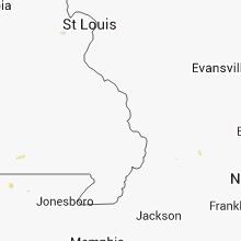
Arkansas
| Local Time | Report Details |
|---|---|
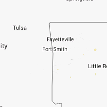
| 3:30 PM CDT | Tree reported down on highway 10 west of danvill in yell county AR, 59.6 miles ESE of Fort Smith, AR |
| 3:35 PM CDT | Multiple trees down due to straight line wind damage from danville northwest through corinth and belleville. also a home was reported to be missing half of the roo in yell county AR, 62.7 miles ESE of Fort Smith, AR |
| 3:50 PM CDT | Tree reported down on powerlines on center valley roa in pope county AR, 63.4 miles NW of Little Rock, AR |
| 5:30 PM CDT | Numerous trees and power lines down along campbell and hinson roads in the parkers chapel community. a tree fell through a mobile home causing significant damag in union county AR, 53.6 miles WNW of Bastrop, LA |
Kentucky
| Local Time | Report Details |
|---|---|
| 4:38 PM EDT | Several trees down...damage to vehicles in lincoln county KY, 51 miles SW of Irvine, KY |
| 4:00 PM CDT | Several trees and limbs down near oak grove on darnell roa in christian county KY, 50.2 miles NW of Nashville, TN |
| 4:45 PM CDT | Several trees down and a healthy one foot diameter tree limb down along route 139 north and south of cadiz. minor street flooding reported as wel in trigg county KY, 64 miles NE of Mc Kenzie, TN |
| 4:45 PM CDT | Two trees down across will jackson road. a trampoline was also blown on a house roo in trigg county KY, 64 miles NE of Mc Kenzie, TN |
| 6:17 PM EDT | Several trees down in the bent creek subdivisio in hardin county KY, 19.2 miles SSW of Louisville, KY |
Texas
| Local Time | Report Details |
|---|---|
| 3:40 PM CDT | Tree on house in longview on oakdale avenue in gregg county TX, 59.1 miles W of Shreveport, LA |
| 5:15 PM CDT | Trees down across southern part of the county south of interstate 30 in franklin county TX, 92.8 miles WNW of Shreveport, LA |
Michigan
| Local Time | Report Details |
|---|---|
| 4:50 PM EDT | Calhoun county dispatch indicates that there are many trees and power lines down in the albion are in calhoun county MI, 68.2 miles SE of Grand Rapids, MI |
| 4:53 PM EDT | Reports of trees and powerlines down in st. joseph county MI, 65.7 miles NNW of Fort Wayne, IN |
| 4:57 PM EDT | Tree down on garage in st. joseph county MI, 67 miles S of Grand Rapids, MI |
| 5:00 PM EDT | Jackson county dispatch indicates that numerous trees are down over the western portion of the count in jackson county MI, 69.7 miles SW of Flint, MI |
| 5:16 PM EDT | Quarter sized hail reported near Parma, MI, 62 miles SW of Flint, MI |
| 5:30 PM EDT | 12 inch diameter tree down. also dime-sized hail. time estimated from rada in genesee county MI, 8.8 miles SSE of Flint, MI |
| 5:31 PM EDT | Two 10 inch diameter trees reported down over baseline road. one tree was dead. the healthy tree was snapped off about a foot above the groun in jackson county MI, 54.3 miles SW of Flint, MI |
| 5:31 PM EDT | Quarter sized hail reported near Leslie, MI, 54.3 miles SW of Flint, MI, the quarter size hail fell for 6 minutes. |
| 5:47 PM EDT | Tree across road in branch county MI, 52.7 miles N of Fort Wayne, IN |
| 5:50 PM EDT | Ingham county dispatch indicates several trees down in the stockbridge are in ingham county MI, 46.2 miles SSW of Flint, MI |
| 5:56 PM EDT | Tree across road in branch county MI, 52.9 miles N of Fort Wayne, IN |
| 6:00 PM EDT | Utility pole down at woodward and rapi in oakland county MI, 32 miles SE of Flint, MI |
| 6:05 PM EDT | Utility pole down at woodward and rapid. corrected for tim in oakland county MI, 32 miles SE of Flint, MI |
| 6:05 PM EDT | Trees down. time estimated from radar in oakland county MI, 29.3 miles SE of Flint, MI |
| 6:05 PM EDT | Trees down. time estimated from rada in livingston county MI, 41.3 miles SSW of Flint, MI |
| 6:11 PM EDT | Trees down. time estimated from rada in oakland county MI, 32 miles ESE of Flint, MI |
| 6:15 PM EDT | Trees down between unadilla and hamburg. time estimated from rada in livingston county MI, 41 miles SSW of Flint, MI |
| 6:15 PM EDT | Tree down at rochester and lakeville south of leonard. time estimated from rada in oakland county MI, 30.4 miles ESE of Flint, MI |
| 6:23 PM EDT | 12 inch diameter tree limbs down on 24 mile between shelby and dequindre roads. radar estimated tim in macomb county MI, 38.3 miles SE of Flint, MI |
| 6:30 PM EDT | Trees and wires down in commerce township - time estimated by rada in oakland county MI, 30.7 miles SSE of Flint, MI |
| 6:30 PM EDT | Trees down at chilson and grand river. time estimated from rada in livingston county MI, 30.5 miles SSW of Flint, MI |
| 6:30 PM EDT | 3 inch diameter tree down/ heavy rain...1 inch. time is radar indicate in oakland county MI, 28.8 miles SSE of Flint, MI |
| 6:53 PM EDT | Trees uprooted and numerous large limbs dow in wayne county MI, 40.9 miles SSE of Flint, MI |
| 6:54 PM EDT | Branch 10 inches in diameter and 20 feet long blocking road. time estimated by rada in oakland county MI, 45.7 miles SE of Flint, MI |
| 6:55 PM EDT | Powerlines down in wayne county MI, 41.6 miles SSE of Flint, MI |
| 7:00 PM EDT | Billboard reported down in oakland county MI, 41.1 miles SSE of Flint, MI |
| 7:00 PM EDT | Trees down damaging a car. trees also down on wire in wayne county MI, 44.5 miles SSE of Flint, MI |
| 7:09 PM EDT | Kmtc asos gusted above 39 mph from 701 pm through 717 p in macomb county MI, 51.1 miles ESE of Flint, MI |
| 7:09 PM EDT | Kmtc observation gusted through 713 p in macomb county MI, 51.1 miles ESE of Flint, MI |
| 7:24 PM EDT | Tree down at the intersection of lowrie and marquette dr. radar estimated tim in wayne county MI, 65.8 miles SSE of Flint, MI |
| 7:30 PM EDT | Dispatch reports trees and wires down. branches down on car. time estimated from rada in st. clair county MI, 64.6 miles ESE of Flint, MI |
| 7:30 PM EDT | 12 to 18 inch diameter tree limbs dow in st. clair county MI, 64.5 miles ESE of Flint, MI |
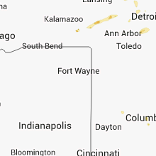
Indiana
| Local Time | Report Details |
|---|---|
| 4:00 PM CDT | Several trees and limbs down near oak grove on darnell roa in gallatin county IN, 29.7 miles WSW of Evansville, IN |
| 6:05 PM EDT | 15-19ft tall trees down and powerlines down in lagrange county IN, 47.5 miles NNW of Fort Wayne, IN |
| 6:07 PM EDT | Tri lakes fire reports roof off 1 bulding and hampton inn damaged in lagrange county IN, 50.3 miles NNW of Fort Wayne, IN |
| 6:26 PM EDT | Concentrated area of uprooted trees on southeast side of golden lake in steuben county IN, 36.3 miles N of Fort Wayne, IN |
| 6:27 PM EDT | Trees and powerlines down around pleasant lake in steuben county IN, 36.3 miles N of Fort Wayne, IN |
New Hampshire
| Local Time | Report Details |
|---|---|
| 5:10 PM EDT | Large branches and wires down in coos county NH, 80.1 miles NW of Portland, ME |
| 5:10 PM EDT | Wires down on us 2. trees down on stag hollow r in coos county NH, 77.7 miles NW of Portland, ME |
| 5:40 PM EDT | Trees and power lines down in coos county NH, 82.6 miles E of Burlington, VT |
| 5:45 PM EDT | Trees down in grafton county NH, 73.2 miles ESE of Burlington, VT |
| 5:55 PM EDT | Trees down in grafton county NH, 76.6 miles E of Burlington, VT |
| 6:12 PM EDT | Trees down in grafton county NH, 65 miles ESE of Burlington, VT |
| 6:35 PM EDT | Trees down on the kancamangus and trees on wires on church road in lincoln in grafton county NH, 75.6 miles WNW of Portland, ME |
| 7:20 PM EDT | Branches down on wires in coos county NH, 82.4 miles ENE of Burlington, VT |
| 7:45 PM EDT | Trees down in grafton county NH, 76.1 miles ESE of Burlington, VT |
| 8:05 PM EDT | Quarter sized hail reported near North Woodstock, NH, 75 miles WNW of Portland, ME |
| 8:11 PM EDT | Tree down on house on old claremont road in sullivan county NH, 82.5 miles ENE of Schenectady, NY |
| 8:25 PM EDT | Trees down and poles snapped on route 12 in sullivan county NH, 81.9 miles SSE of Burlington, VT |
| 9:00 PM EDT | Lakes region dispatch. trees and wires down in alexandri in grafton county NH, 77 miles W of Portland, ME |
| 9:00 PM EDT | Tree and wires down on pine avenue in cheshire county NH, 83.8 miles E of Schenectady, NY |
| 9:00 PM EDT | Lakes region dispatch. trees and wires dow in grafton county NH, 72.1 miles W of Portland, ME |
| 9:00 PM EDT | Trees and wires down. route 25 closed in rumney. lakes region dispatch in grafton county NH, 78.5 miles W of Portland, ME |
| 9:20 PM EDT | Lakes region dispatch. trees and wires dow in carroll county NH, 57.6 miles W of Portland, ME |
| 9:20 PM EDT | Lakes region dispatch. trees and wires down in sandwic in carroll county NH, 58.4 miles W of Portland, ME |
| 9:30 PM EDT | Lakes region dispatch. trees and wires dow in grafton county NH, 77.9 miles W of Portland, ME |
| 9:30 PM EDT | Tree down on house in merrimack county NH, 66.1 miles WSW of Portland, ME |
| 9:35 PM EDT | Trees down in merrimack county NH, 64.1 miles WSW of Portland, ME |
| 9:40 PM EDT | Trees down in merrimack county NH, 58.6 miles WSW of Portland, ME |
| 9:45 PM EDT | Many trees down sherman farm in east conway in carroll county NH, 45.6 miles WNW of Portland, ME |
| 10:00 PM EDT | Many trees down sherman farm in carroll county NH, 45.1 miles NW of Portland, ME |
West Virginia
| Local Time | Report Details |
|---|---|
| 6:55 PM EDT | Trees down on east cove avenue in ohio county WV, 44.9 miles SW of Pittsburgh, PA |
| 6:59 PM EDT | Trees down on castleman run road in ohio county WV, 34.1 miles SW of Pittsburgh, PA |
Massachusetts
| Local Time | Report Details |
|---|---|
| 8:13 PM EDT | Large limb down on west st off the side of the roa in franklin county MA, 56.6 miles ESE of Schenectady, NY |
| 8:30 PM EDT | Large tree down blocking route 112 south of the worthington lin in hampden county MA, 67.5 miles SE of Schenectady, NY |
| 8:30 PM EDT | Tree down on ireland stree in hampshire county MA, 58.2 miles ESE of Schenectady, NY |
| 8:49 PM EDT | Tree down on brattleboro roa in franklin county MA, 71.5 miles E of Schenectady, NY |
| 9:10 PM EDT | Tree down on route 202 in hampshire county MA, 72.1 miles WNW of Providence, RI |
| 9:10 PM EDT | Tree down on wires on north king street in hampshire county MA, 72.4 miles ESE of Schenectady, NY |
Connect with Interactive Hail Maps