

Hail Map for Sunday, September 12, 2021

Number of Impacted Households on 9/12/2021
0
Impacted by 1" or Larger Hail
0
Impacted by 1.75" or Larger Hail
0
Impacted by 2.5" or Larger Hail
Square Miles of Populated Area Impacted on 9/12/2021
0
Impacted by 1" or Larger Hail
0
Impacted by 1.75" or Larger Hail
0
Impacted by 2.5" or Larger Hail


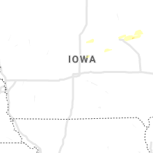


Cities Most Affected by Hail Storms of 9/12/2021
| Hail Size | Demographics of Zip Codes Affected | ||||||
|---|---|---|---|---|---|---|---|
| City | Count | Average | Largest | Pop Density | House Value | Income | Age |
| Chesaning, MI | 3 | 1.83 | 2.00 | 94 | $93k | $42.4k | 42.1 |
| Ithaca, MI | 2 | 2.38 | 2.50 | 50 | $77k | $38.5k | 41.0 |
| Breckenridge, MI | 1 | 2.25 | 2.25 | 45 | $71k | $38.3k | 40.1 |
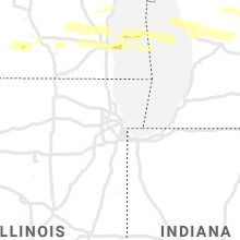
Hail and Wind Damage Spotted on 9/12/2021
Filter by Report Type:Hail ReportsWind Reports
New York
| Local Time | Report Details |
|---|---|
| 11:48 AM EDT | Multiple trees dow in chautauqua county NY, 38.4 miles SW of Buffalo, NY |
| 11:48 PM EDT | Corrects previous tstm wnd dmg report from fredonia. multiple trees dow in chautauqua county NY, 38.4 miles SW of Buffalo, NY |
| 11:55 PM EDT | Tree down on mobile home in sinclairvill in chautauqua county NY, 47.4 miles SSW of Buffalo, NY |
| 12:14 AM EDT | Tree down on powerlin in cattaraugus county NY, 44 miles S of Buffalo, NY |
| 12:22 AM EDT | Trees down on roadwa in cattaraugus county NY, 50 miles S of Buffalo, NY |
| 12:26 AM EDT | Tree down on wire in south buffalo. time estimated from radar. source is erie co dispatc in erie county NY, 4.3 miles SE of Buffalo, NY |
Michigan
| Local Time | Report Details |
|---|---|
| 4:04 PM EDT | Quarter sized hail reported near Hesperia, MI, 45.6 miles NNW of Grand Rapids, MI, photo relayed from wzzm tv. location approximate. time estimated from radar. |
| 4:45 PM EDT | One mile wide area with trees down and signs ripped off some building in isabella county MI, 55 miles NE of Grand Rapids, MI |
| 5:00 PM EDT | Pockets of trees down. relayed via social media time approximat in gratiot county MI, 54.1 miles WNW of Flint, MI |
| 5:00 PM EDT | Quarter sized hail reported near Breckenridge, MI, 46.5 miles WNW of Flint, MI, relayed via social media. time estimated. |
| 5:01 PM EDT | Half Dollar sized hail reported near Saint Louis, MI, 54.2 miles WNW of Flint, MI |
| 5:10 PM EDT | Hen Egg sized hail reported near Breckenridge, MI, 45.7 miles WNW of Flint, MI, location approximate. social media photos from south of breckenridge. |
| 5:12 PM EDT | Hen Egg sized hail reported near Ithaca, MI, 45.9 miles WNW of Flint, MI, photos from social media. |
| 5:15 PM EDT | Tennis Ball sized hail reported near Ithaca, MI, 42.9 miles WNW of Flint, MI, several measured hailstones between 2 and 2.5 inches. in the sickles area near fillmore road and ransom road. dented vehicles. |
| 5:22 PM EDT | Hen Egg sized hail reported near Chesaning, MI, 30.9 miles WNW of Flint, MI, public relayed social media photos of 2 inch hail. |
| 5:34 PM EDT | Golf Ball sized hail reported near Chesaning, MI, 28.1 miles WNW of Flint, MI, public relayed social media photos of estimated golf ball sized hail. |
| 5:38 PM EDT | Quarter sized hail reported near Burt, MI, 20.9 miles NW of Flint, MI, public relays video on social media of estimated quarter sized hail. |
| 5:40 PM EDT | Golf Ball sized hail reported near Chesaning, MI, 24.9 miles WNW of Flint, MI, golf ball sized hail relayed by fire dept/rescue. confirmed by photos. |
| 5:44 PM EDT | Quarter sized hail reported near Montrose, MI, 17 miles NW of Flint, MI, quarter sized hail reported by public. |
| 6:11 PM EDT | Dispatch reports power line down in cliffor in lapeer county MI, 32.9 miles NE of Flint, MI |
| 6:35 PM EDT | Quarter sized hail reported near Muskegon, MI, 34.9 miles WNW of Grand Rapids, MI, photo relayed from wzzm tv. location approximate. time estimated from radar. |
| 6:51 PM EDT | Quarter sized hail reported near Grant, MI, 26.7 miles NNW of Grand Rapids, MI, photo relayed from wzzm tv. location approximate. time estimated from radar. |
| 6:53 PM EDT | Quarter sized hail reported near Muskegon, MI, 29.6 miles NW of Grand Rapids, MI, photo relayed from wzzm tv. location approximate. |
| 7:15 PM EDT | Quarter sized hail reported near Mcbrides, MI, 41.1 miles NE of Grand Rapids, MI, location approximate. actually 1 nw of mcbride. |
| 7:22 PM EDT | Quarter sized hail reported near Edmore, MI, 41.6 miles NE of Grand Rapids, MI, from social media. |
| 7:45 PM EDT | Corrected magnitude...observed via weatherflow station on bishop rd in alicia in saginaw county MI, 25 miles NW of Flint, MI |
| 8:12 PM EDT | Dispatch reports trees and power lines down near chesanin in saginaw county MI, 24.9 miles WNW of Flint, MI |
| 8:29 PM EDT | Dispatch reports trees and power lines down... mainly along bray roa in tuscola county MI, 15.9 miles N of Flint, MI |
| 8:42 PM EDT | Dispatch reports numerous trees and power lines down in columbiaville vicinit in lapeer county MI, 16.8 miles ENE of Flint, MI |
| 8:44 PM EDT | Trained spotter reports large tree limbs blocking lanes at intersection of columbiaville rd and m-2 in lapeer county MI, 22.7 miles ENE of Flint, MI |
| 9:12 PM EDT | Dispatch reports numerous trees and power lines down in yal in st. clair county MI, 45.6 miles E of Flint, MI |
| 9:24 PM EDT | Dispatch reports numerous trees and power lines down in the marysville vicinit in st. clair county MI, 61.5 miles E of Flint, MI |
Wisconsin
| Local Time | Report Details |
|---|---|
| 4:10 PM CDT | Quarter sized hail reported near Germantown, WI, 65 miles E of Madison, WI, time estimated from radar. |
| 4:10 PM CDT | Quarter sized hail reported near Menomonee Falls, WI, 63 miles E of Madison, WI, time estimated from radar. |
Colorado
| Local Time | Report Details |
|---|---|
| 4:57 PM MDT | Mesonet statio in kit carson county CO, 43.6 miles SSW of Yuma, CO |
| 6:16 PM MDT | Public report of 50-60 mph wind in cheyenne county CO, 91.8 miles ENE of Pueblo, CO |
Wyoming
| Local Time | Report Details |
|---|---|
| 11:07 PM MDT | Kriw riverton airport. weak showers in the upper wind river basin produced this severe outflo in fremont county WY, 5.5 miles NW of Riverton, WY |
| 3:56 AM MDT | Mesonet station wy15 14.5 e sinclair (wydot in carbon county WY, 71.3 miles WNW of Laramie, WY |
| 4:02 AM MDT | Mesonet station wy15 14.5 e sinclair (wydot in carbon county WY, 71.3 miles WNW of Laramie, WY |
Massachusetts
| Local Time | Report Details |
|---|---|
| 3:30 AM EDT | Large tree limb downed blocking part of ash st in danvers. relayed by amateur radi in essex county MA, 56.3 miles NNE of Providence, RI |
| 3:38 AM EDT | Photo from aj burnett wcvb on twitter of a large tree limb downed on fowler st in danvers which damaged a pickup truck. time estimate in essex county MA, 56.3 miles NNE of Providence, RI |
Connect with Interactive Hail Maps