

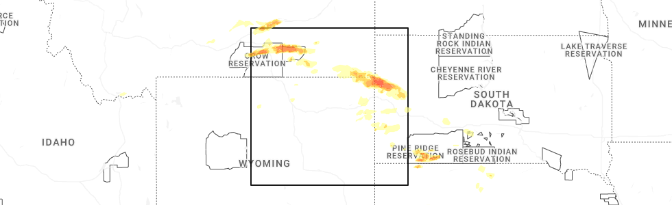
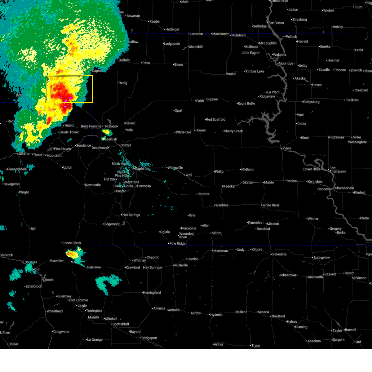
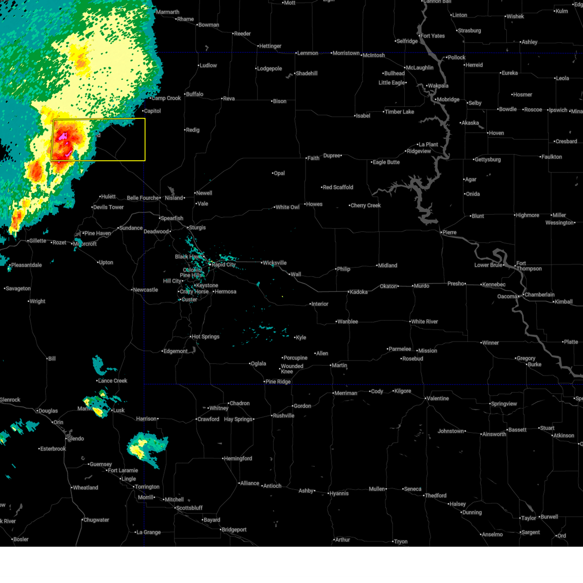
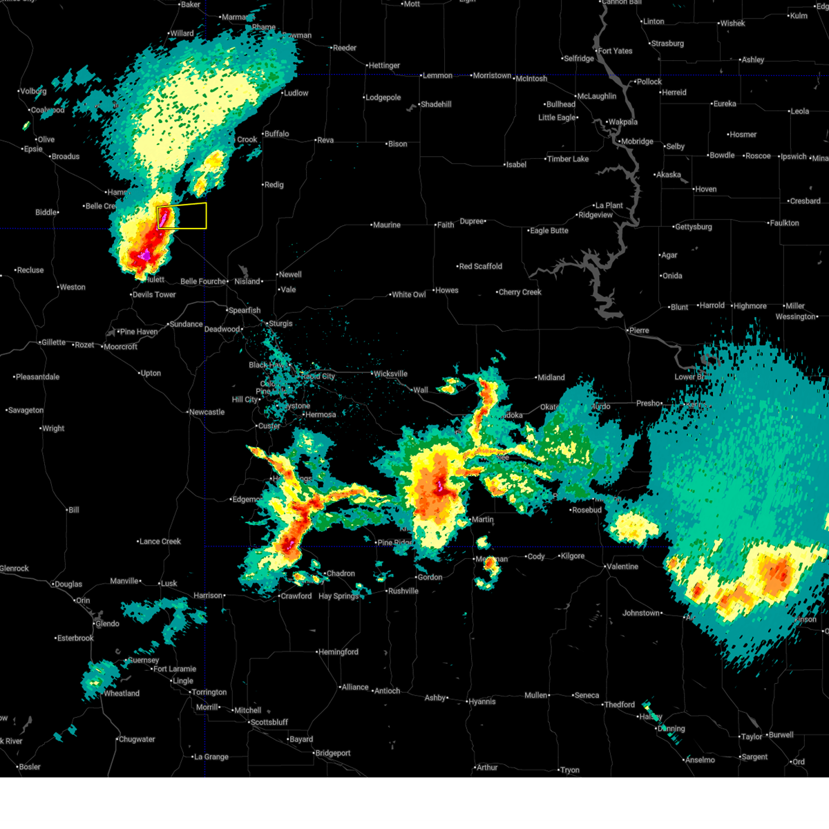
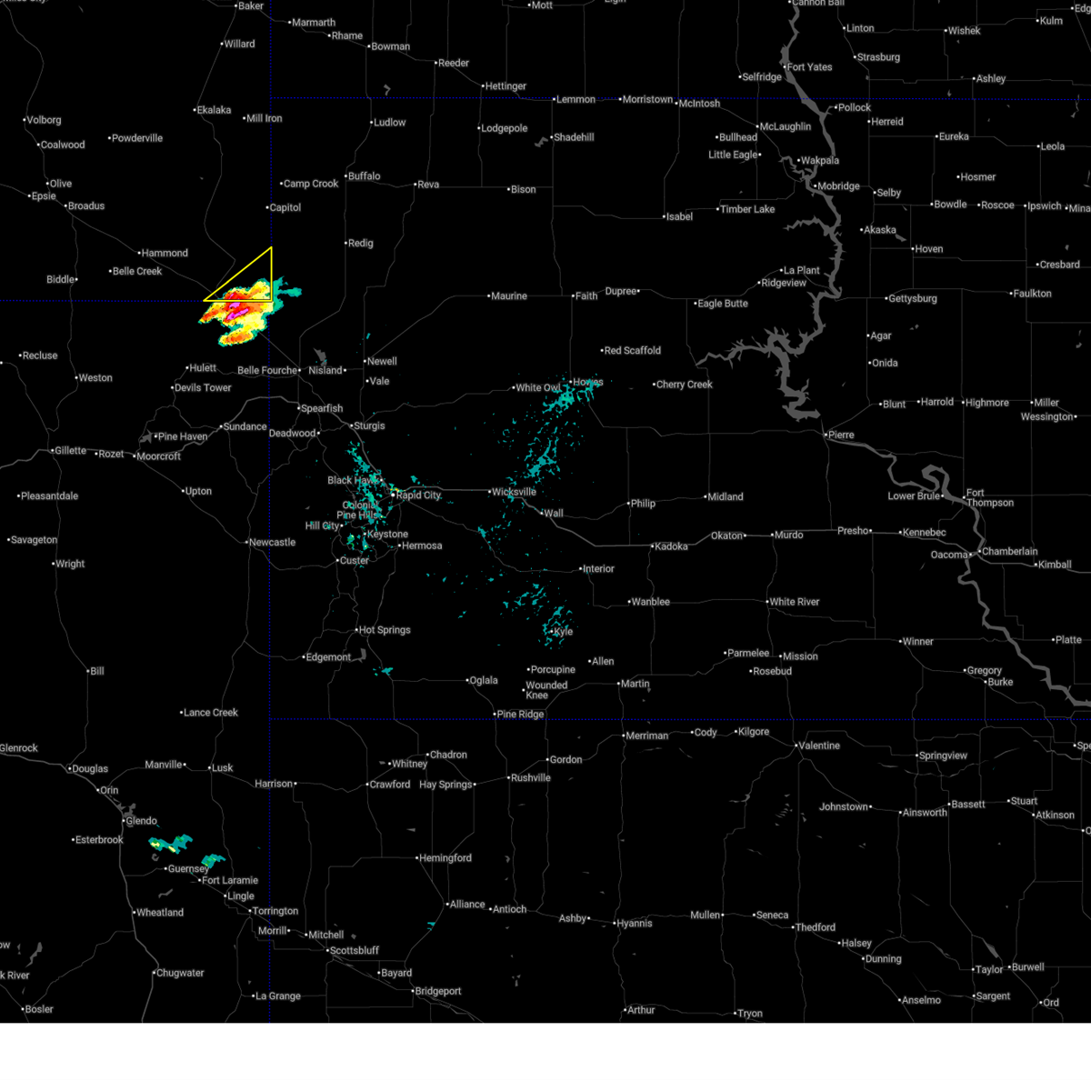
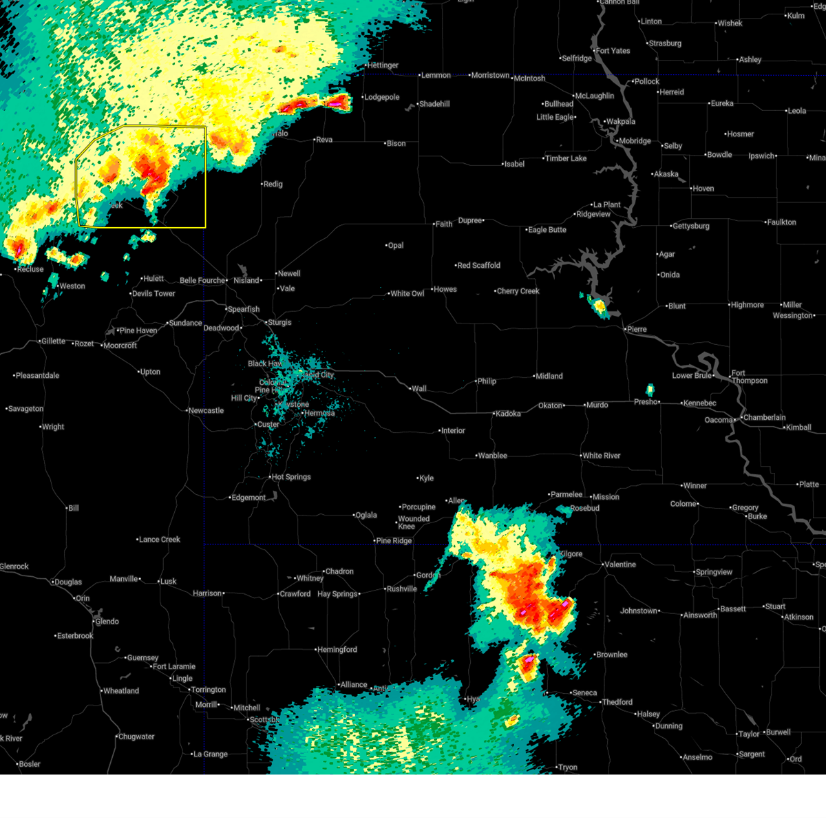
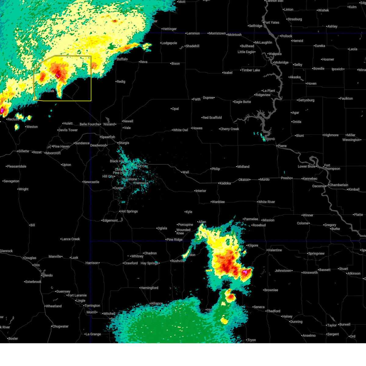
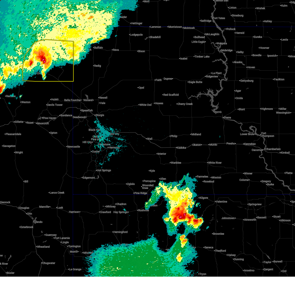
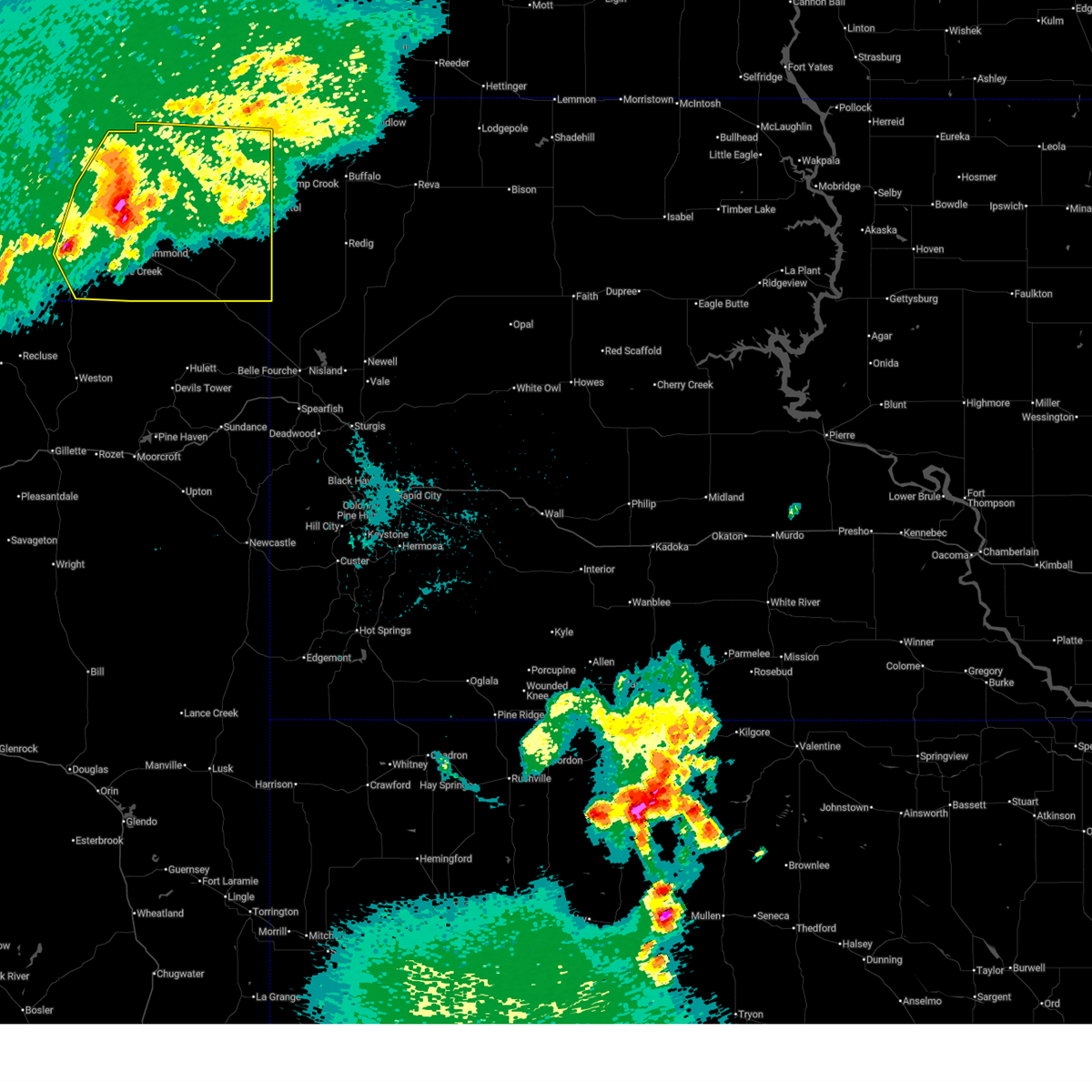
Hail Map for Alzada, MT
The Alzada, MT area has had 37 reports of on-the-ground hail by trained spotters, and has been under severe weather warnings 17 times during the past 12 months. Doppler radar has detected hail at or near Alzada, MT on 50 occasions, including 3 occasions during the past year.
| Name: | Alzada, MT |
| Where Located: | 73.6 miles NE of Gillette, WY |
| Map: | Google Map for Alzada, MT |
| Population: | 29 |
| Housing Units: | 21 |
| More Info: | Search Google for Alzada, MT |
2
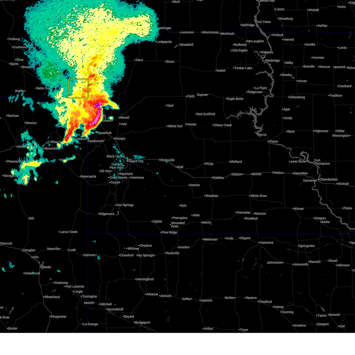
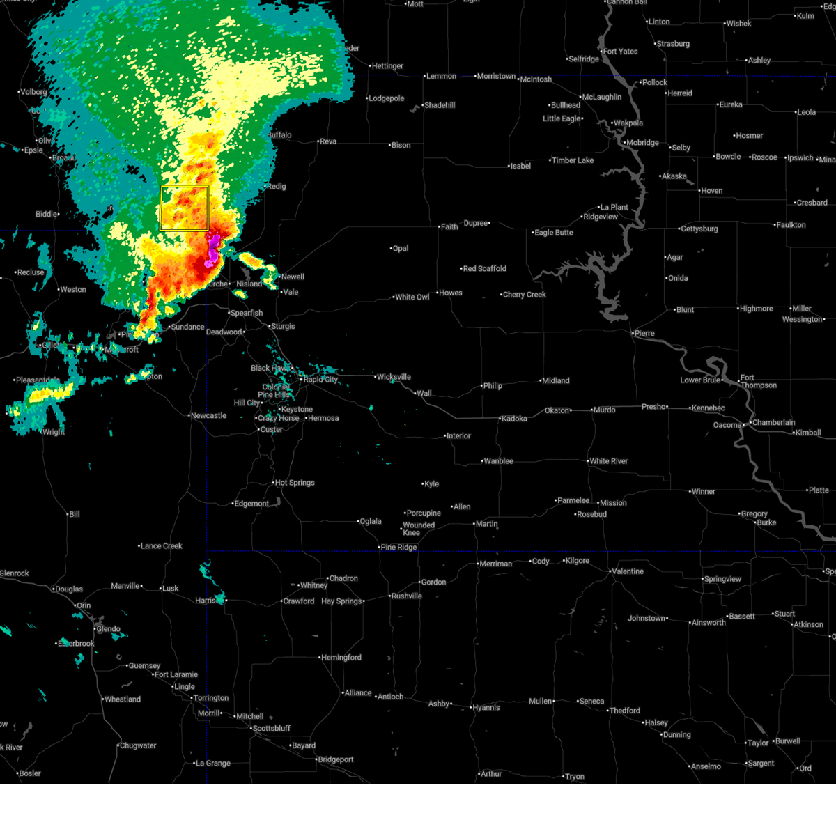
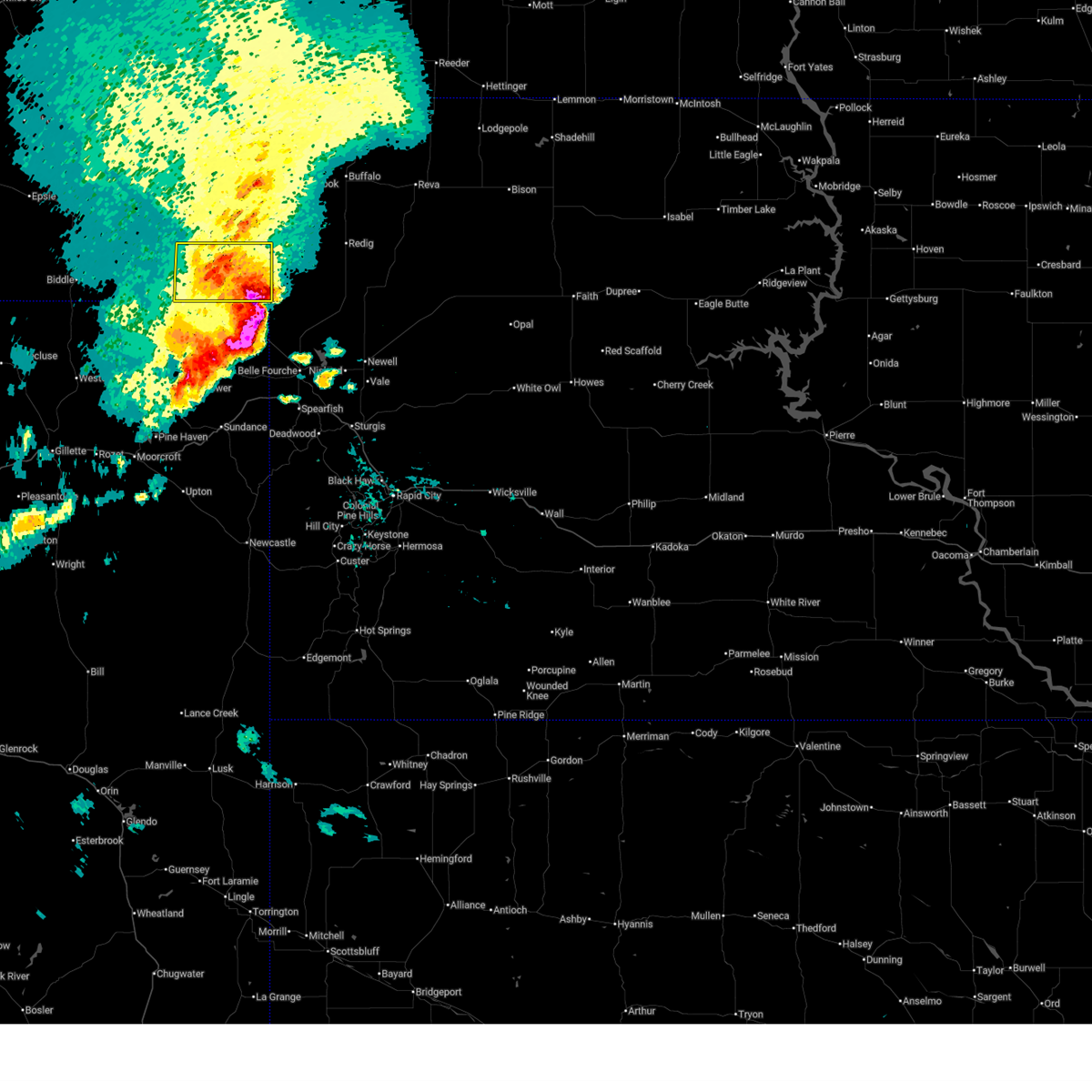
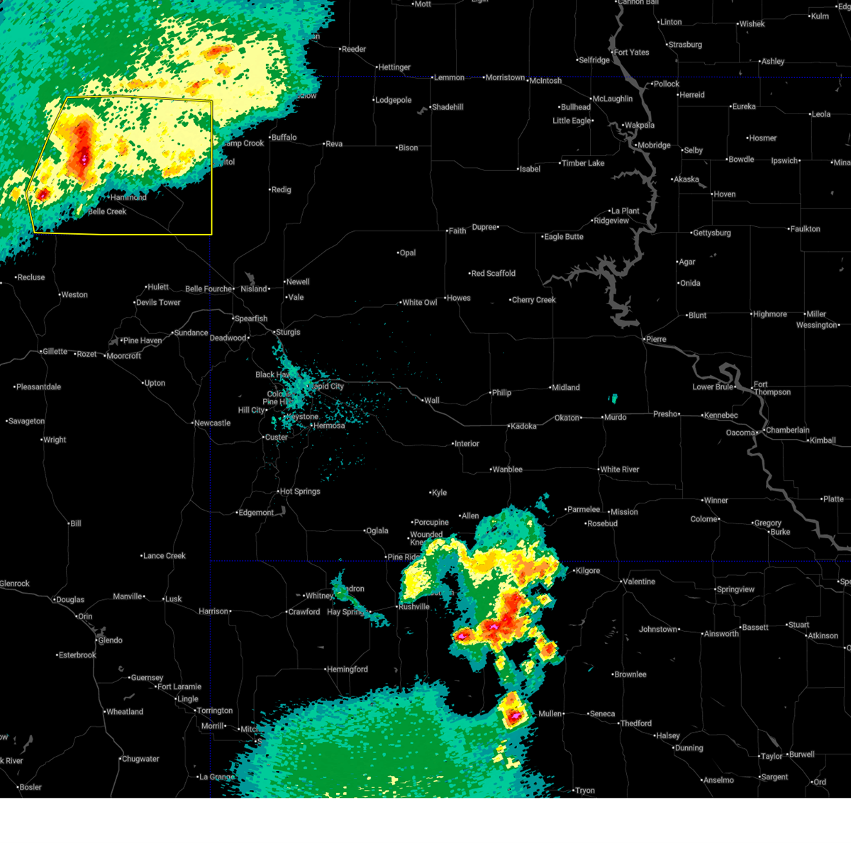
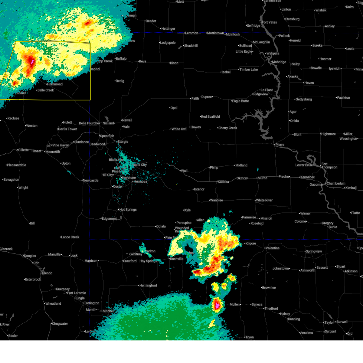
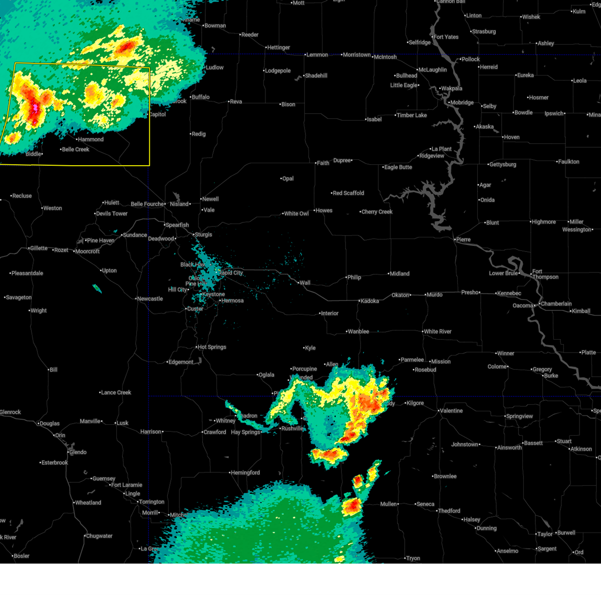
The Top Recent Hail Date for Alzada, MT is Saturday, July 5, 2025 (6th out of 50)
Hail and Wind Damage Spotted near Alzada, MT
| Date / Time | Report Details |
|---|---|
| 7/5/2025 7:42 PM MDT |
 the severe thunderstorm warning has been cancelled and is no longer in effect the severe thunderstorm warning has been cancelled and is no longer in effect
|
| 7/5/2025 7:27 PM MDT |
 At 727 pm mdt, a severe thunderstorm was located 20 miles east of alzada, moving east at 40 mph (at 7:15 a gust to 70 mph was measured at alzada). Hazards include 70 mph wind gusts and half dollar size hail. Hail damage to vehicles is expected. expect considerable tree damage. wind damage is also likely to mobile homes, roofs, and outbuildings. Locations impacted include, alzada and albion. At 727 pm mdt, a severe thunderstorm was located 20 miles east of alzada, moving east at 40 mph (at 7:15 a gust to 70 mph was measured at alzada). Hazards include 70 mph wind gusts and half dollar size hail. Hail damage to vehicles is expected. expect considerable tree damage. wind damage is also likely to mobile homes, roofs, and outbuildings. Locations impacted include, alzada and albion.
|
| 7/5/2025 7:15 PM MDT | Storm damage reported in carter county MT, 2.6 miles WNW of Alzada, MT |
| 7/5/2025 7:14 PM MDT |
 Svrbyz the national weather service in billings has issued a * severe thunderstorm warning for, southeastern carter county in southeastern montana, * until 800 pm mdt. * at 714 pm mdt, a severe thunderstorm was located 12 miles east of alzada, or 62 miles south of ekalaka, moving east at 40 mph (radar indicated). Hazards include 60 mph wind gusts and half dollar size hail. Hail damage to vehicles is expected. Expect wind damage to roofs, siding, and trees. Svrbyz the national weather service in billings has issued a * severe thunderstorm warning for, southeastern carter county in southeastern montana, * until 800 pm mdt. * at 714 pm mdt, a severe thunderstorm was located 12 miles east of alzada, or 62 miles south of ekalaka, moving east at 40 mph (radar indicated). Hazards include 60 mph wind gusts and half dollar size hail. Hail damage to vehicles is expected. Expect wind damage to roofs, siding, and trees.
|
| 7/5/2025 6:46 PM MDT |
 the severe thunderstorm warning has been cancelled and is no longer in effect the severe thunderstorm warning has been cancelled and is no longer in effect
|
| 7/5/2025 6:46 PM MDT |
 At 646 pm mdt, a severe thunderstorm was located 11 miles north of alzada, or 49 miles south of ekalaka, moving east at 45 mph (radar indicated). Hazards include ping pong ball size hail and 60 mph wind gusts. People and animals outdoors will be injured. expect hail damage to roofs, siding, windows, and vehicles. expect wind damage to roofs, siding, and trees. Locations impacted include, alzada, albion and hammond. At 646 pm mdt, a severe thunderstorm was located 11 miles north of alzada, or 49 miles south of ekalaka, moving east at 45 mph (radar indicated). Hazards include ping pong ball size hail and 60 mph wind gusts. People and animals outdoors will be injured. expect hail damage to roofs, siding, windows, and vehicles. expect wind damage to roofs, siding, and trees. Locations impacted include, alzada, albion and hammond.
|
| 7/5/2025 6:13 PM MDT |
 Svrbyz the national weather service in billings has issued a * severe thunderstorm warning for, southern carter county in southeastern montana, southeastern powder river county in southeastern montana, * until 715 pm mdt. * at 613 pm mdt, a severe thunderstorm was located 22 miles east of biddle, or 30 miles southeast of broadus, moving east at 45 mph (radar indicated). Hazards include 60 mph wind gusts and quarter size hail. Hail damage to vehicles is expected. Expect wind damage to roofs, siding, and trees. Svrbyz the national weather service in billings has issued a * severe thunderstorm warning for, southern carter county in southeastern montana, southeastern powder river county in southeastern montana, * until 715 pm mdt. * at 613 pm mdt, a severe thunderstorm was located 22 miles east of biddle, or 30 miles southeast of broadus, moving east at 45 mph (radar indicated). Hazards include 60 mph wind gusts and quarter size hail. Hail damage to vehicles is expected. Expect wind damage to roofs, siding, and trees.
|
| 6/28/2025 11:05 PM MDT |
 Svrbyz the national weather service in billings has issued a * severe thunderstorm warning for, southeastern carter county in southeastern montana, * until 1145 pm mdt. * at 1105 pm mdt, a severe thunderstorm was located near alzada, or 57 miles southeast of broadus, moving east at 35 mph (radar indicated). Hazards include 60 mph wind gusts and quarter size hail. Hail damage to vehicles is expected. Expect wind damage to roofs, siding, and trees. Svrbyz the national weather service in billings has issued a * severe thunderstorm warning for, southeastern carter county in southeastern montana, * until 1145 pm mdt. * at 1105 pm mdt, a severe thunderstorm was located near alzada, or 57 miles southeast of broadus, moving east at 35 mph (radar indicated). Hazards include 60 mph wind gusts and quarter size hail. Hail damage to vehicles is expected. Expect wind damage to roofs, siding, and trees.
|
| 6/28/2025 2:23 PM MDT |
 Svrbyz the national weather service in billings has issued a * severe thunderstorm warning for, southeastern carter county in southeastern montana, * until 330 pm mdt. * at 223 pm mdt, a severe thunderstorm was located 9 miles east of alzada, moving northeast at 30 mph (radar indicated). Hazards include 60 mph wind gusts and quarter size hail. Hail damage to vehicles is expected. Expect wind damage to roofs, siding, and trees. Svrbyz the national weather service in billings has issued a * severe thunderstorm warning for, southeastern carter county in southeastern montana, * until 330 pm mdt. * at 223 pm mdt, a severe thunderstorm was located 9 miles east of alzada, moving northeast at 30 mph (radar indicated). Hazards include 60 mph wind gusts and quarter size hail. Hail damage to vehicles is expected. Expect wind damage to roofs, siding, and trees.
|
| 6/13/2025 11:39 PM MDT |
 the severe thunderstorm warning has been cancelled and is no longer in effect the severe thunderstorm warning has been cancelled and is no longer in effect
|
| 6/13/2025 11:24 PM MDT |
 At 1124 pm mdt, a severe thunderstorm was located 12 miles southwest of ridgeway, or 36 miles east of broadus, moving southeast at 45 mph (radar indicated). Hazards include 60 mph wind gusts and quarter size hail. Hail damage to vehicles is expected. expect wind damage to roofs, siding, and trees. Locations impacted include, ridgeway, alzada, albion, hammond, boyes, ridge, capitol and belle creek. At 1124 pm mdt, a severe thunderstorm was located 12 miles southwest of ridgeway, or 36 miles east of broadus, moving southeast at 45 mph (radar indicated). Hazards include 60 mph wind gusts and quarter size hail. Hail damage to vehicles is expected. expect wind damage to roofs, siding, and trees. Locations impacted include, ridgeway, alzada, albion, hammond, boyes, ridge, capitol and belle creek.
|
| 6/13/2025 11:17 PM MDT |
 At 1117 pm mdt, a severe thunderstorm was located 14 miles southwest of ridgeway, or 31 miles east of broadus, moving southeast at 45 mph (radar indicated). Hazards include ping pong ball size hail and 60 mph wind gusts. People and animals outdoors will be injured. expect hail damage to roofs, siding, windows, and vehicles. expect wind damage to roofs, siding, and trees. Locations impacted include, ridgeway, alzada, hammond, albion, belltower, boyes, ridge, belle creek and capitol. At 1117 pm mdt, a severe thunderstorm was located 14 miles southwest of ridgeway, or 31 miles east of broadus, moving southeast at 45 mph (radar indicated). Hazards include ping pong ball size hail and 60 mph wind gusts. People and animals outdoors will be injured. expect hail damage to roofs, siding, windows, and vehicles. expect wind damage to roofs, siding, and trees. Locations impacted include, ridgeway, alzada, hammond, albion, belltower, boyes, ridge, belle creek and capitol.
|
| 6/13/2025 11:03 PM MDT |
 the severe thunderstorm warning has been cancelled and is no longer in effect the severe thunderstorm warning has been cancelled and is no longer in effect
|
| 6/13/2025 11:03 PM MDT |
 At 1103 pm mdt, a severe thunderstorm was located 16 miles west of ridgeway, or 29 miles east of broadus, moving east at 40 mph (radar indicated). Hazards include ping pong ball size hail and 60 mph wind gusts. People and animals outdoors will be injured. expect hail damage to roofs, siding, windows, and vehicles. expect wind damage to roofs, siding, and trees. Locations impacted include, ridgeway, alzada, biddle, hammond, boyes, belltower, albion, ridge, belle creek, powderville and capitol. At 1103 pm mdt, a severe thunderstorm was located 16 miles west of ridgeway, or 29 miles east of broadus, moving east at 40 mph (radar indicated). Hazards include ping pong ball size hail and 60 mph wind gusts. People and animals outdoors will be injured. expect hail damage to roofs, siding, windows, and vehicles. expect wind damage to roofs, siding, and trees. Locations impacted include, ridgeway, alzada, biddle, hammond, boyes, belltower, albion, ridge, belle creek, powderville and capitol.
|
| 6/13/2025 10:53 PM MDT |
 At 1053 pm mdt, a severe thunderstorm was located 21 miles west of ridgeway, or 23 miles east of broadus, moving east at 40 mph (radar indicated). Hazards include ping pong ball size hail and 60 mph wind gusts. People and animals outdoors will be injured. expect hail damage to roofs, siding, windows, and vehicles. expect wind damage to roofs, siding, and trees. Locations impacted include, broadus, ridgeway, alzada, biddle, hammond, boyes, belle creek, ridge, belltower, powderville, albion and capitol. At 1053 pm mdt, a severe thunderstorm was located 21 miles west of ridgeway, or 23 miles east of broadus, moving east at 40 mph (radar indicated). Hazards include ping pong ball size hail and 60 mph wind gusts. People and animals outdoors will be injured. expect hail damage to roofs, siding, windows, and vehicles. expect wind damage to roofs, siding, and trees. Locations impacted include, broadus, ridgeway, alzada, biddle, hammond, boyes, belle creek, ridge, belltower, powderville, albion and capitol.
|
| 6/13/2025 10:49 PM MDT |
 At 1049 pm mdt, a severe thunderstorm was located 20 miles east of broadus, moving east at 40 mph (radar indicated). Hazards include 60 mph wind gusts and half dollar size hail. Hail damage to vehicles is expected. expect wind damage to roofs, siding, and trees. Locations impacted include, broadus, ridgeway, alzada, biddle, hammond, boyes, belle creek, ridge, belltower, powderville, albion and capitol. At 1049 pm mdt, a severe thunderstorm was located 20 miles east of broadus, moving east at 40 mph (radar indicated). Hazards include 60 mph wind gusts and half dollar size hail. Hail damage to vehicles is expected. expect wind damage to roofs, siding, and trees. Locations impacted include, broadus, ridgeway, alzada, biddle, hammond, boyes, belle creek, ridge, belltower, powderville, albion and capitol.
|
| 6/13/2025 10:42 PM MDT |
 At 1042 pm mdt, a severe thunderstorm was located 16 miles east of broadus, moving east at 40 mph (radar indicated). Hazards include 60 mph wind gusts and half dollar size hail. Hail damage to vehicles is expected. expect wind damage to roofs, siding, and trees. Locations impacted include, broadus, ridgeway, biddle, alzada, hammond, boyes, belle creek, ridge, powderville, belltower, albion, olive, capitol and moorhead. At 1042 pm mdt, a severe thunderstorm was located 16 miles east of broadus, moving east at 40 mph (radar indicated). Hazards include 60 mph wind gusts and half dollar size hail. Hail damage to vehicles is expected. expect wind damage to roofs, siding, and trees. Locations impacted include, broadus, ridgeway, biddle, alzada, hammond, boyes, belle creek, ridge, powderville, belltower, albion, olive, capitol and moorhead.
|
| 6/13/2025 10:24 PM MDT |
 Svrbyz the national weather service in billings has issued a * severe thunderstorm warning for, carter county in southeastern montana, south central custer county in southeastern montana, powder river county in southeastern montana, * until 1145 pm mdt. * at 1024 pm mdt, a severe thunderstorm was located near broadus, moving east at 40 mph (radar indicated). Hazards include ping pong ball size hail and 60 mph wind gusts. People and animals outdoors will be injured. expect hail damage to roofs, siding, windows, and vehicles. Expect wind damage to roofs, siding, and trees. Svrbyz the national weather service in billings has issued a * severe thunderstorm warning for, carter county in southeastern montana, south central custer county in southeastern montana, powder river county in southeastern montana, * until 1145 pm mdt. * at 1024 pm mdt, a severe thunderstorm was located near broadus, moving east at 40 mph (radar indicated). Hazards include ping pong ball size hail and 60 mph wind gusts. People and animals outdoors will be injured. expect hail damage to roofs, siding, windows, and vehicles. Expect wind damage to roofs, siding, and trees.
|
| 8/11/2024 12:45 PM MDT | Mesonet station mtm33 8.2 sw capitol (mt-meso in carter county MT, 25.2 miles SSW of Alzada, MT |
| 7/13/2024 9:37 PM MDT |
 The storm which prompted the warning has moved out of the area. therefore, the warning will be allowed to expire. The storm which prompted the warning has moved out of the area. therefore, the warning will be allowed to expire.
|
| 7/13/2024 9:10 PM MDT |
 At 908 pm mdt, a severe thunderstorm was located 9 miles east of ridgeway, or 31 miles southeast of ekalaka, moving southeast at 45 mph (trained weather spotters. a 70 mph wind gust was reported in ridgeway at 8:58 pm mdt). Hazards include 70 mph wind gusts and half dollar size hail. Hail damage to vehicles is expected. expect considerable tree damage. wind damage is also likely to mobile homes, roofs, and outbuildings. Locations impacted include, alzada, ridgeway, belltower, capitol, albion, and mill iron. At 908 pm mdt, a severe thunderstorm was located 9 miles east of ridgeway, or 31 miles southeast of ekalaka, moving southeast at 45 mph (trained weather spotters. a 70 mph wind gust was reported in ridgeway at 8:58 pm mdt). Hazards include 70 mph wind gusts and half dollar size hail. Hail damage to vehicles is expected. expect considerable tree damage. wind damage is also likely to mobile homes, roofs, and outbuildings. Locations impacted include, alzada, ridgeway, belltower, capitol, albion, and mill iron.
|
| 7/13/2024 8:44 PM MDT |
 Svrbyz the national weather service in billings has issued a * severe thunderstorm warning for, carter county in southeastern montana, * until 945 pm mdt. * at 842 pm mdt, a severe thunderstorm was located 11 miles south of ekalaka, moving southeast at 45 mph (radar indicated). Hazards include 70 mph wind gusts and ping pong ball size hail. People and animals outdoors will be injured. expect hail damage to roofs, siding, windows, and vehicles. expect considerable tree damage. Wind damage is also likely to mobile homes, roofs, and outbuildings. Svrbyz the national weather service in billings has issued a * severe thunderstorm warning for, carter county in southeastern montana, * until 945 pm mdt. * at 842 pm mdt, a severe thunderstorm was located 11 miles south of ekalaka, moving southeast at 45 mph (radar indicated). Hazards include 70 mph wind gusts and ping pong ball size hail. People and animals outdoors will be injured. expect hail damage to roofs, siding, windows, and vehicles. expect considerable tree damage. Wind damage is also likely to mobile homes, roofs, and outbuildings.
|
| 6/10/2024 1:07 PM MDT |
 The storm which prompted the warning has weakened below severe limits, and no longer poses an immediate threat to life or property. therefore, the warning will be allowed to expire. however, small hail, gusty winds and heavy rain are still possible with this line of thunderstorms. a severe thunderstorm watch remains in effect until 800 pm mdt for southeastern montana. The storm which prompted the warning has weakened below severe limits, and no longer poses an immediate threat to life or property. therefore, the warning will be allowed to expire. however, small hail, gusty winds and heavy rain are still possible with this line of thunderstorms. a severe thunderstorm watch remains in effect until 800 pm mdt for southeastern montana.
|
| 6/10/2024 1:00 PM MDT |
 At 100 pm mdt, a severe thunderstorm was located 8 miles north of alzada, or 42 miles northwest of belle fourche, moving east at 40 mph (radar indicated). Hazards include 60 mph wind gusts and quarter size hail. Hail damage to vehicles is expected. expect wind damage to roofs, siding, and trees. Locations impacted include, alzada and albion. At 100 pm mdt, a severe thunderstorm was located 8 miles north of alzada, or 42 miles northwest of belle fourche, moving east at 40 mph (radar indicated). Hazards include 60 mph wind gusts and quarter size hail. Hail damage to vehicles is expected. expect wind damage to roofs, siding, and trees. Locations impacted include, alzada and albion.
|
| 6/10/2024 12:46 PM MDT |
 At 1246 pm mdt, a severe thunderstorm was located 12 miles northwest of alzada, or 44 miles southeast of broadus, moving east at 40 mph (radar indicated). Hazards include 60 mph wind gusts and quarter size hail. Hail damage to vehicles is expected. expect wind damage to roofs, siding, and trees. Locations impacted include, alzada and albion. At 1246 pm mdt, a severe thunderstorm was located 12 miles northwest of alzada, or 44 miles southeast of broadus, moving east at 40 mph (radar indicated). Hazards include 60 mph wind gusts and quarter size hail. Hail damage to vehicles is expected. expect wind damage to roofs, siding, and trees. Locations impacted include, alzada and albion.
|
| 6/10/2024 12:31 PM MDT |
 Svrbyz the national weather service in billings has issued a * severe thunderstorm warning for, southern carter county in southeastern montana, * until 115 pm mdt. * at 1231 pm mdt, a severe thunderstorm was located 16 miles northeast of lightning flat, or 35 miles southeast of broadus, moving east at 40 mph (radar indicated). Hazards include 60 mph wind gusts and half dollar size hail. Hail damage to vehicles is expected. Expect wind damage to roofs, siding, and trees. Svrbyz the national weather service in billings has issued a * severe thunderstorm warning for, southern carter county in southeastern montana, * until 115 pm mdt. * at 1231 pm mdt, a severe thunderstorm was located 16 miles northeast of lightning flat, or 35 miles southeast of broadus, moving east at 40 mph (radar indicated). Hazards include 60 mph wind gusts and half dollar size hail. Hail damage to vehicles is expected. Expect wind damage to roofs, siding, and trees.
|
| 5/29/2024 3:11 PM MDT |
 The storm which prompted the warning has weakened below severe limits, and no longer poses an immediate threat to life or property. therefore, the warning will be allowed to expire. however, small hail and gusty winds are still possible with this thunderstorm. a severe thunderstorm watch remains in effect until 900 pm mdt for southeastern montana. The storm which prompted the warning has weakened below severe limits, and no longer poses an immediate threat to life or property. therefore, the warning will be allowed to expire. however, small hail and gusty winds are still possible with this thunderstorm. a severe thunderstorm watch remains in effect until 900 pm mdt for southeastern montana.
|
| 5/29/2024 2:45 PM MDT |
 At 244 pm mdt, a severe thunderstorm was located 18 miles northeast of lightning flat, or 31 miles southeast of broadus, moving northeast at 35 mph (radar indicated). Hazards include 60 mph wind gusts and quarter size hail. Hail damage to vehicles is expected. expect wind damage to roofs, siding, and trees. Locations impacted include, alzada, hammond, and ridge. At 244 pm mdt, a severe thunderstorm was located 18 miles northeast of lightning flat, or 31 miles southeast of broadus, moving northeast at 35 mph (radar indicated). Hazards include 60 mph wind gusts and quarter size hail. Hail damage to vehicles is expected. expect wind damage to roofs, siding, and trees. Locations impacted include, alzada, hammond, and ridge.
|
| 5/29/2024 2:19 PM MDT |
 Svrbyz the national weather service in billings has issued a * severe thunderstorm warning for, southwestern carter county in southeastern montana, southeastern powder river county in southeastern montana, * until 315 pm mdt. * at 218 pm mdt, a severe thunderstorm was located near lightning flat, or 32 miles southeast of broadus, moving northeast at 35 mph (radar indicated). Hazards include 60 mph wind gusts and quarter size hail. Hail damage to vehicles is expected. Expect wind damage to roofs, siding, and trees. Svrbyz the national weather service in billings has issued a * severe thunderstorm warning for, southwestern carter county in southeastern montana, southeastern powder river county in southeastern montana, * until 315 pm mdt. * at 218 pm mdt, a severe thunderstorm was located near lightning flat, or 32 miles southeast of broadus, moving northeast at 35 mph (radar indicated). Hazards include 60 mph wind gusts and quarter size hail. Hail damage to vehicles is expected. Expect wind damage to roofs, siding, and trees.
|
| 6/23/2023 6:57 PM MDT |
 The severe thunderstorm warning for southeastern carter county will expire at 700 pm mdt, the storms which prompted the warning have moved out of the area. therefore, the warning will be allowed to expire. a tornado watch remains in effect until 900 pm mdt for southeastern montana. The severe thunderstorm warning for southeastern carter county will expire at 700 pm mdt, the storms which prompted the warning have moved out of the area. therefore, the warning will be allowed to expire. a tornado watch remains in effect until 900 pm mdt for southeastern montana.
|
| 6/23/2023 6:43 PM MDT |
 At 643 pm mdt, severe thunderstorms were located along a line extending from 12 miles southeast of ekalaka to 11 miles west of camp crook to 12 miles northwest of gustave, moving northeast at 45 mph (radar indicated). Hazards include 60 mph wind gusts and penny size hail. Expect damage to roofs, siding, and trees. locations impacted include, alzada, belltower, capitol and albion. hail threat, radar indicated max hail size, 0. 75 in wind threat, radar indicated max wind gust, 60 mph. At 643 pm mdt, severe thunderstorms were located along a line extending from 12 miles southeast of ekalaka to 11 miles west of camp crook to 12 miles northwest of gustave, moving northeast at 45 mph (radar indicated). Hazards include 60 mph wind gusts and penny size hail. Expect damage to roofs, siding, and trees. locations impacted include, alzada, belltower, capitol and albion. hail threat, radar indicated max hail size, 0. 75 in wind threat, radar indicated max wind gust, 60 mph.
|
| 6/23/2023 6:13 PM MDT |
 At 612 pm mdt, severe thunderstorms were located along a line extending from 24 miles south of ekalaka to 7 miles south of ridgeway to 11 miles northwest of alzada, moving northeast at 45 mph (radar indicated). Hazards include 60 mph wind gusts and nickel size hail. Expect damage to roofs, siding, and trees. locations impacted include, alzada, ridgeway, belltower, capitol and albion. hail threat, radar indicated max hail size, 0. 88 in wind threat, radar indicated max wind gust, 60 mph. At 612 pm mdt, severe thunderstorms were located along a line extending from 24 miles south of ekalaka to 7 miles south of ridgeway to 11 miles northwest of alzada, moving northeast at 45 mph (radar indicated). Hazards include 60 mph wind gusts and nickel size hail. Expect damage to roofs, siding, and trees. locations impacted include, alzada, ridgeway, belltower, capitol and albion. hail threat, radar indicated max hail size, 0. 88 in wind threat, radar indicated max wind gust, 60 mph.
|
| 6/23/2023 5:50 PM MDT |
 At 550 pm mdt, severe thunderstorms were located along a line extending from 21 miles west of ridgeway to 22 miles northwest of alzada to 12 miles east of lightning flat, moving northeast at 40 mph (radar indicated). Hazards include 60 mph wind gusts and nickel size hail. expect damage to roofs, siding, and trees At 550 pm mdt, severe thunderstorms were located along a line extending from 21 miles west of ridgeway to 22 miles northwest of alzada to 12 miles east of lightning flat, moving northeast at 40 mph (radar indicated). Hazards include 60 mph wind gusts and nickel size hail. expect damage to roofs, siding, and trees
|
| 5/26/2023 5:33 PM MDT | Quarter sized hail reported 27.8 miles E of Alzada, MT |
| 5/7/2023 5:23 PM MDT |
 The severe thunderstorm warning for south central carter county will expire at 530 pm mdt, the storm which prompted the warning has weakened below severe limits, and no longer poses an immediate threat to life or property. therefore, the warning will be allowed to expire. however, gusty winds and heavy rain are still possible with this thunderstorm. The severe thunderstorm warning for south central carter county will expire at 530 pm mdt, the storm which prompted the warning has weakened below severe limits, and no longer poses an immediate threat to life or property. therefore, the warning will be allowed to expire. however, gusty winds and heavy rain are still possible with this thunderstorm.
|
| 5/7/2023 5:09 PM MDT |
 At 507 pm mdt, a severe thunderstorm was located near alzada, or 37 miles northwest of belle fourche, moving northeast at 15 mph (radar indicated). Hazards include 60 mph wind gusts and penny size hail. Possible damage to roofs, siding, and trees. hail may cover ground and lead to slick roads. locations impacted include, alzada and us-212 in alzada area. hail threat, observed max hail size, 0. 75 in wind threat, radar indicated max wind gust, 60 mph. At 507 pm mdt, a severe thunderstorm was located near alzada, or 37 miles northwest of belle fourche, moving northeast at 15 mph (radar indicated). Hazards include 60 mph wind gusts and penny size hail. Possible damage to roofs, siding, and trees. hail may cover ground and lead to slick roads. locations impacted include, alzada and us-212 in alzada area. hail threat, observed max hail size, 0. 75 in wind threat, radar indicated max wind gust, 60 mph.
|
| 5/7/2023 4:50 PM MDT |
 At 450 pm mdt, a severe thunderstorm was located just west of alzada, or 39 miles northwest of belle fourche, moving northeast at 15 mph (radar indicated). Hazards include 60 mph wind gusts and half dollar size hail. Hail damage to vehicles is expected. Expect wind damage to roofs, siding, and trees. At 450 pm mdt, a severe thunderstorm was located just west of alzada, or 39 miles northwest of belle fourche, moving northeast at 15 mph (radar indicated). Hazards include 60 mph wind gusts and half dollar size hail. Hail damage to vehicles is expected. Expect wind damage to roofs, siding, and trees.
|
| 7/10/2022 9:07 PM MDT |
 The severe thunderstorm warning for southeastern carter county will expire at 915 pm mdt, the storm which prompted the warning is moving quickly out of the area. therefore, the warning will be allowed to expire at 9. 15 pm mdt. however gusty winds of 35 to 50 mph may linger a bit longer. to report severe weather, contact your nearest law enforcement agency. they will relay your report to the national weather service billings. The severe thunderstorm warning for southeastern carter county will expire at 915 pm mdt, the storm which prompted the warning is moving quickly out of the area. therefore, the warning will be allowed to expire at 9. 15 pm mdt. however gusty winds of 35 to 50 mph may linger a bit longer. to report severe weather, contact your nearest law enforcement agency. they will relay your report to the national weather service billings.
|
| 7/10/2022 8:46 PM MDT | Storm damage reported in carter county MT, 2.6 miles WNW of Alzada, MT |
| 7/10/2022 8:41 PM MDT |
 At 840 pm mdt, a severe thunderstorm was located 7 miles north of alzada, or 42 miles northwest of belle fourche, moving east at 50 mph (radar indicated. at 822 pm mdt quarter size hail was reported north of ridge with this storm). Hazards include 60 mph wind gusts and quarter size hail. Hail damage to vehicles is expected. expect wind damage to roofs, siding, and trees. this severe thunderstorm will remain over mainly rural areas of southeastern carter county, including the following locations, albion. hail threat, observed max hail size, 1. 00 in wind threat, radar indicated max wind gust, 60 mph. At 840 pm mdt, a severe thunderstorm was located 7 miles north of alzada, or 42 miles northwest of belle fourche, moving east at 50 mph (radar indicated. at 822 pm mdt quarter size hail was reported north of ridge with this storm). Hazards include 60 mph wind gusts and quarter size hail. Hail damage to vehicles is expected. expect wind damage to roofs, siding, and trees. this severe thunderstorm will remain over mainly rural areas of southeastern carter county, including the following locations, albion. hail threat, observed max hail size, 1. 00 in wind threat, radar indicated max wind gust, 60 mph.
|
| 7/10/2022 8:30 PM MDT | Quarter sized hail reported 25.8 miles ESE of Alzada, MT, heavy rain and gusty winds. |
| 7/10/2022 8:24 PM MDT |
 At 823 pm mdt, a severe thunderstorm was located 17 miles northeast of lightning flat, or 37 miles southeast of broadus, moving east at 50 mph (radar indicated). Hazards include 60 mph wind gusts and half dollar size hail. Hail damage to vehicles is expected. expect wind damage to roofs, siding, and trees. this severe thunderstorm will remain over mainly rural areas of southern carter county, including the following locations, albion, boyes, alzada, hammond and ridge. hail threat, radar indicated max hail size, 1. 25 in wind threat, radar indicated max wind gust, 60 mph. At 823 pm mdt, a severe thunderstorm was located 17 miles northeast of lightning flat, or 37 miles southeast of broadus, moving east at 50 mph (radar indicated). Hazards include 60 mph wind gusts and half dollar size hail. Hail damage to vehicles is expected. expect wind damage to roofs, siding, and trees. this severe thunderstorm will remain over mainly rural areas of southern carter county, including the following locations, albion, boyes, alzada, hammond and ridge. hail threat, radar indicated max hail size, 1. 25 in wind threat, radar indicated max wind gust, 60 mph.
|
| 7/10/2022 8:09 PM MDT |
 At 808 pm mdt, a severe thunderstorm was located 12 miles north of lightning flat, or 26 miles southeast of broadus, moving east at 50 mph (radar indicated). Hazards include ping pong ball size hail and 60 mph wind gusts. People and animals outdoors will be injured. expect hail amd wind damage to roofs, siding, windows, and vehicles. this severe thunderstorm will remain over mainly rural areas of southern carter and southeastern powder river counties, including the following locations, albion, boyes, belle creek, alzada, hammond and ridge. this replaces the warning previously in effect for this area. hail threat, radar indicated max hail size, 1. 50 in wind threat, radar indicated max wind gust, 60 mph. At 808 pm mdt, a severe thunderstorm was located 12 miles north of lightning flat, or 26 miles southeast of broadus, moving east at 50 mph (radar indicated). Hazards include ping pong ball size hail and 60 mph wind gusts. People and animals outdoors will be injured. expect hail amd wind damage to roofs, siding, windows, and vehicles. this severe thunderstorm will remain over mainly rural areas of southern carter and southeastern powder river counties, including the following locations, albion, boyes, belle creek, alzada, hammond and ridge. this replaces the warning previously in effect for this area. hail threat, radar indicated max hail size, 1. 50 in wind threat, radar indicated max wind gust, 60 mph.
|
| 7/5/2022 7:35 AM MDT |
 At 735 am mdt, severe thunderstorms were located along a line extending from 6 miles northeast of rhame to 16 miles west of ladner to 11 miles southwest of camp crook to 14 miles north of alzada, moving southeast at 35 mph (radar indicated). Hazards include 60 mph wind gusts and quarter size hail. Hail damage to vehicles is expected. Expect wind damage to roofs, siding, and trees. At 735 am mdt, severe thunderstorms were located along a line extending from 6 miles northeast of rhame to 16 miles west of ladner to 11 miles southwest of camp crook to 14 miles north of alzada, moving southeast at 35 mph (radar indicated). Hazards include 60 mph wind gusts and quarter size hail. Hail damage to vehicles is expected. Expect wind damage to roofs, siding, and trees.
|
| 6/29/2022 4:50 PM MDT |
 The severe thunderstorm warning for southern carter and southeastern powder river counties will expire at 500 pm mdt, the storm which prompted the warning has weakened below severe limits, and has exited the warned area. therefore, the warning will be allowed to expire. The severe thunderstorm warning for southern carter and southeastern powder river counties will expire at 500 pm mdt, the storm which prompted the warning has weakened below severe limits, and has exited the warned area. therefore, the warning will be allowed to expire.
|
| 6/29/2022 4:29 PM MDT |
 At 427 pm mdt, a severe thunderstorm was located 19 miles northwest of alzada, or 38 miles southeast of broadus, moving northeast at 30 mph (radar indicated. observed, hail to 0.88 inches (nickel sized) and gusts to 60 mph have been reported in ridge). Hazards include 60 mph wind gusts and quarter size hail. Hail damage to vehicles is expected. expect wind damage to roofs, siding, and trees. locations impacted include, alzada, capitol, albion, belle creek, hammond and ridge. hail threat, radar indicated max hail size, 1. 00 in wind threat, radar indicated max wind gust, 60 mph. At 427 pm mdt, a severe thunderstorm was located 19 miles northwest of alzada, or 38 miles southeast of broadus, moving northeast at 30 mph (radar indicated. observed, hail to 0.88 inches (nickel sized) and gusts to 60 mph have been reported in ridge). Hazards include 60 mph wind gusts and quarter size hail. Hail damage to vehicles is expected. expect wind damage to roofs, siding, and trees. locations impacted include, alzada, capitol, albion, belle creek, hammond and ridge. hail threat, radar indicated max hail size, 1. 00 in wind threat, radar indicated max wind gust, 60 mph.
|
| 6/29/2022 4:18 PM MDT | Estimate wind gust in carter county MT, 29.7 miles E of Alzada, MT |
| 6/29/2022 3:53 PM MDT |
 At 352 pm mdt, a severe thunderstorm was located 9 miles north of lightning flat, or 29 miles southeast of broadus, moving east at 30 mph (radar indicated). Hazards include 60 mph wind gusts and quarter size hail. Hail damage to vehicles is expected. Expect wind damage to roofs, siding, and trees. At 352 pm mdt, a severe thunderstorm was located 9 miles north of lightning flat, or 29 miles southeast of broadus, moving east at 30 mph (radar indicated). Hazards include 60 mph wind gusts and quarter size hail. Hail damage to vehicles is expected. Expect wind damage to roofs, siding, and trees.
|
| 6/19/2022 6:13 PM MDT |
 At 613 pm mdt, a severe thunderstorm was located 9 miles northwest of alzada, or 45 miles northwest of belle fourche, moving northeast at 40 mph (radar indicated). Hazards include ping pong ball size hail and 60 mph wind gusts. People and animals outdoors will be injured. expect hail damage to roofs, siding, windows, and vehicles. Expect wind damage to roofs, siding, and trees. At 613 pm mdt, a severe thunderstorm was located 9 miles northwest of alzada, or 45 miles northwest of belle fourche, moving northeast at 40 mph (radar indicated). Hazards include ping pong ball size hail and 60 mph wind gusts. People and animals outdoors will be injured. expect hail damage to roofs, siding, windows, and vehicles. Expect wind damage to roofs, siding, and trees.
|
| 6/19/2022 6:09 PM MDT | Hen Egg sized hail reported 8.2 miles SE of Alzada, MT |
| 6/19/2022 6:09 PM MDT | Tennis Ball sized hail reported 8.2 miles SE of Alzada, MT |
| 6/19/2022 6:01 PM MDT |
 At 600 pm mdt, a severe thunderstorm capable of producing a tornado was located 9 miles northwest of alzada, or 46 miles northwest of belle fourche, moving northeast at 50 mph (radar indicated rotation). Hazards include tornado and ping pong ball size hail. Flying debris will be dangerous to those caught without shelter. mobile homes will be damaged or destroyed. damage to roofs, windows, and vehicles will occur. tree damage is likely. Locations impacted include, alzada. At 600 pm mdt, a severe thunderstorm capable of producing a tornado was located 9 miles northwest of alzada, or 46 miles northwest of belle fourche, moving northeast at 50 mph (radar indicated rotation). Hazards include tornado and ping pong ball size hail. Flying debris will be dangerous to those caught without shelter. mobile homes will be damaged or destroyed. damage to roofs, windows, and vehicles will occur. tree damage is likely. Locations impacted include, alzada.
|
| 6/19/2022 5:54 PM MDT |
 At 553 pm mdt, a severe thunderstorm was located 18 miles northwest of alzada, or 38 miles southeast of broadus, moving northeast at 45 mph (radar indicated). Hazards include two inch hail and 60 mph wind gusts. People and animals outdoors will be injured. expect hail damage to roofs, siding, windows, and vehicles. expect wind damage to roofs, siding, and trees. Locations impacted include, alzada and albion. At 553 pm mdt, a severe thunderstorm was located 18 miles northwest of alzada, or 38 miles southeast of broadus, moving northeast at 45 mph (radar indicated). Hazards include two inch hail and 60 mph wind gusts. People and animals outdoors will be injured. expect hail damage to roofs, siding, windows, and vehicles. expect wind damage to roofs, siding, and trees. Locations impacted include, alzada and albion.
|
| 6/19/2022 5:48 PM MDT |
 At 547 pm mdt, a severe thunderstorm capable of producing a tornado was located 13 miles east of lightning flat, or 42 miles southeast of broadus, moving northeast at 50 mph (radar indicated rotation). Hazards include tornado and hail up to two inches in diameter. Flying debris will be dangerous to those caught without shelter. mobile homes will be damaged or destroyed. damage to roofs, windows, and vehicles will occur. tree damage is likely. This tornadic thunderstorm will remain over mainly rural areas of southeastern carter county, including the following locations, albion. At 547 pm mdt, a severe thunderstorm capable of producing a tornado was located 13 miles east of lightning flat, or 42 miles southeast of broadus, moving northeast at 50 mph (radar indicated rotation). Hazards include tornado and hail up to two inches in diameter. Flying debris will be dangerous to those caught without shelter. mobile homes will be damaged or destroyed. damage to roofs, windows, and vehicles will occur. tree damage is likely. This tornadic thunderstorm will remain over mainly rural areas of southeastern carter county, including the following locations, albion.
|
| 6/19/2022 5:28 PM MDT |
 At 528 pm mdt, a severe thunderstorm was located near lightning flat, or 34 miles southeast of broadus, moving northeast at 45 mph (radar indicated). Hazards include two inch hail and 60 mph wind gusts. People and animals outdoors will be injured. expect hail damage to roofs, siding, windows, and vehicles. Expect wind damage to roofs, siding, and trees. At 528 pm mdt, a severe thunderstorm was located near lightning flat, or 34 miles southeast of broadus, moving northeast at 45 mph (radar indicated). Hazards include two inch hail and 60 mph wind gusts. People and animals outdoors will be injured. expect hail damage to roofs, siding, windows, and vehicles. Expect wind damage to roofs, siding, and trees.
|
| 6/12/2022 3:48 PM MDT |
 At 346 pm mdt, a severe thunderstorm was located near lightning flat, or 36 miles southeast of broadus, moving east at 50 mph. the strongest portion of this storm is south of the montana wyoming border (radar indicated). Hazards include 60 mph wind gusts and quarter size hail. Hail damage to vehicles is expected. expect wind damage to roofs, siding, and trees. locations impacted include, alzada and ridge. hail threat, radar indicated max hail size, 1. 00 in wind threat, radar indicated max wind gust, 60 mph. At 346 pm mdt, a severe thunderstorm was located near lightning flat, or 36 miles southeast of broadus, moving east at 50 mph. the strongest portion of this storm is south of the montana wyoming border (radar indicated). Hazards include 60 mph wind gusts and quarter size hail. Hail damage to vehicles is expected. expect wind damage to roofs, siding, and trees. locations impacted include, alzada and ridge. hail threat, radar indicated max hail size, 1. 00 in wind threat, radar indicated max wind gust, 60 mph.
|
| 6/12/2022 3:13 PM MDT |
 At 311 pm mdt, a severe thunderstorm was located 13 miles southwest of biddle, or 31 miles south of broadus, moving east at 50 mph (radar indicated). Hazards include ping pong ball size hail and 60 mph wind gusts. People and animals outdoors will be injured. expect hail damage to roofs, siding, windows, and vehicles. Expect wind damage to roofs, siding, and trees. At 311 pm mdt, a severe thunderstorm was located 13 miles southwest of biddle, or 31 miles south of broadus, moving east at 50 mph (radar indicated). Hazards include ping pong ball size hail and 60 mph wind gusts. People and animals outdoors will be injured. expect hail damage to roofs, siding, windows, and vehicles. Expect wind damage to roofs, siding, and trees.
|
| 6/11/2022 7:10 PM MDT |
 At 709 pm mdt, a severe thunderstorm was located 7 miles northeast of lightning flat, or 35 miles southeast of broadus, moving east southeast at 45 mph (radar indicated). Hazards include 60 mph wind gusts and quarter size hail, along with brief heavy rain. Hail damage to vehicles is expected. expect wind damage to roofs, siding, and trees. locations impacted include, alzada and ridge. hail threat, radar indicated max hail size, 1. 00 in wind threat, radar indicated max wind gust, 60 mph. At 709 pm mdt, a severe thunderstorm was located 7 miles northeast of lightning flat, or 35 miles southeast of broadus, moving east southeast at 45 mph (radar indicated). Hazards include 60 mph wind gusts and quarter size hail, along with brief heavy rain. Hail damage to vehicles is expected. expect wind damage to roofs, siding, and trees. locations impacted include, alzada and ridge. hail threat, radar indicated max hail size, 1. 00 in wind threat, radar indicated max wind gust, 60 mph.
|
| 6/11/2022 6:44 PM MDT |
 At 643 pm mdt, a severe thunderstorm was located near biddle, or 19 miles south of broadus, moving east southeast at 50 mph (radar indicated). Hazards include golf ball size hail and 60 mph wind gusts, along with very heavy rain. People and animals outdoors will be injured. expect hail damage to roofs, siding, windows, and vehicles. Expect wind damage to roofs, siding, and trees. At 643 pm mdt, a severe thunderstorm was located near biddle, or 19 miles south of broadus, moving east southeast at 50 mph (radar indicated). Hazards include golf ball size hail and 60 mph wind gusts, along with very heavy rain. People and animals outdoors will be injured. expect hail damage to roofs, siding, windows, and vehicles. Expect wind damage to roofs, siding, and trees.
|
| 5/28/2022 5:13 PM MDT |
 At 512 pm mdt, severe thunderstorms were located along a line extending from 17 miles northwest of alzada to 14 miles west of gustave to antelope butte, moving northeast at 80 mph (radar indicated). Hazards include 60 mph wind gusts. a gust to 70 mph was reported just south of alzada in wyoming with this line of storms. expect damage to roofs, siding, and trees At 512 pm mdt, severe thunderstorms were located along a line extending from 17 miles northwest of alzada to 14 miles west of gustave to antelope butte, moving northeast at 80 mph (radar indicated). Hazards include 60 mph wind gusts. a gust to 70 mph was reported just south of alzada in wyoming with this line of storms. expect damage to roofs, siding, and trees
|
| 5/28/2022 4:53 PM MDT |
 At 452 pm mdt, severe thunderstorms were located along a line extending from near lightning flat to near alzada to 9 miles east of colony, moving northeast at 45 mph (radar indicated. this line of storms has a history of producing damaging winds across far northeast wyoming over the past hour). Hazards include 60 mph wind gusts and penny size hail. Expect damage to roofs, siding, and trees. locations impacted include, alzada, capitol, albion and ridge. hail threat, radar indicated max hail size, 0. 75 in wind threat, radar indicated max wind gust, 60 mph. At 452 pm mdt, severe thunderstorms were located along a line extending from near lightning flat to near alzada to 9 miles east of colony, moving northeast at 45 mph (radar indicated. this line of storms has a history of producing damaging winds across far northeast wyoming over the past hour). Hazards include 60 mph wind gusts and penny size hail. Expect damage to roofs, siding, and trees. locations impacted include, alzada, capitol, albion and ridge. hail threat, radar indicated max hail size, 0. 75 in wind threat, radar indicated max wind gust, 60 mph.
|
| 5/28/2022 4:28 PM MDT |
 At 426 pm mdt, severe thunderstorms were located along a line extending from 7 miles east of rockypoint to 10 miles north of hulett to near aladdin, moving northeast at 65 mph (radar indicated. storms have a history of producing strong winds over northeast wyoming over the past hour). Hazards include 60 mph wind gusts and quarter size hail. Hail damage to vehicles is expected. Expect wind damage to roofs, siding, and trees. At 426 pm mdt, severe thunderstorms were located along a line extending from 7 miles east of rockypoint to 10 miles north of hulett to near aladdin, moving northeast at 65 mph (radar indicated. storms have a history of producing strong winds over northeast wyoming over the past hour). Hazards include 60 mph wind gusts and quarter size hail. Hail damage to vehicles is expected. Expect wind damage to roofs, siding, and trees.
|
| 7/22/2021 4:07 PM MDT |
 The severe thunderstorm warning for southeastern carter county will expire at 415 pm mdt, the storm which prompted the warning has weakened below severe limits, and has exited the warned area. therefore, the warning will be allowed to expire. however gusty winds are still possible with this thunderstorm. The severe thunderstorm warning for southeastern carter county will expire at 415 pm mdt, the storm which prompted the warning has weakened below severe limits, and has exited the warned area. therefore, the warning will be allowed to expire. however gusty winds are still possible with this thunderstorm.
|
| 7/22/2021 3:52 PM MDT |
 At 352 pm mdt, a severe thunderstorm was located 7 miles southwest of gustave, or 37 miles southwest of buffalo, moving east at 30 mph (radar indicated). Hazards include 60 mph wind gusts and quarter size hail. Hail damage to vehicles is expected. expect wind damage to roofs, siding, and trees. Locations impacted include, albion. At 352 pm mdt, a severe thunderstorm was located 7 miles southwest of gustave, or 37 miles southwest of buffalo, moving east at 30 mph (radar indicated). Hazards include 60 mph wind gusts and quarter size hail. Hail damage to vehicles is expected. expect wind damage to roofs, siding, and trees. Locations impacted include, albion.
|
| 7/22/2021 3:51 PM MDT | Storm damage reported in carter county MT, 2.6 miles WNW of Alzada, MT |
| 7/22/2021 3:34 PM MDT |
 At 333 pm mdt, a severe thunderstorm was located 12 miles southwest of gustave, or 39 miles northwest of belle fourche, moving east at 50 mph (radar indicated. a gust to 73 mph was observed at the alzada dot weather station). Hazards include 70 mph wind gusts and quarter size hail. Hail damage to vehicles is expected. expect considerable tree damage. wind damage is also likely to mobile homes, roofs, and outbuildings. Locations impacted include, alzada and albion. At 333 pm mdt, a severe thunderstorm was located 12 miles southwest of gustave, or 39 miles northwest of belle fourche, moving east at 50 mph (radar indicated. a gust to 73 mph was observed at the alzada dot weather station). Hazards include 70 mph wind gusts and quarter size hail. Hail damage to vehicles is expected. expect considerable tree damage. wind damage is also likely to mobile homes, roofs, and outbuildings. Locations impacted include, alzada and albion.
|
| 7/22/2021 3:28 PM MDT |
 At 328 pm mdt, a severe thunderstorm was located 11 miles northeast of alzada, or 41 miles northwest of belle fourche, moving east at 50 mph (radar indicated). Hazards include 60 mph wind gusts and quarter size hail. Hail damage to vehicles is expected. Expect wind damage to roofs, siding, and trees. At 328 pm mdt, a severe thunderstorm was located 11 miles northeast of alzada, or 41 miles northwest of belle fourche, moving east at 50 mph (radar indicated). Hazards include 60 mph wind gusts and quarter size hail. Hail damage to vehicles is expected. Expect wind damage to roofs, siding, and trees.
|
| 7/22/2021 3:21 PM MDT | Storm damage reported in carter county MT, 2.6 miles WNW of Alzada, MT |
| 7/13/2021 6:55 PM MDT |
 At 636 pm mdt, a severe thunderstorm was located 7 miles southeast of biddle, or 31 miles south of broadus, moving southeast at 30 mph (radar indicated). Hazards include 60 mph wind gusts and quarter size hail. Hail damage to vehicles is expected. Expect wind damage to roofs, siding, and trees. At 636 pm mdt, a severe thunderstorm was located 7 miles southeast of biddle, or 31 miles south of broadus, moving southeast at 30 mph (radar indicated). Hazards include 60 mph wind gusts and quarter size hail. Hail damage to vehicles is expected. Expect wind damage to roofs, siding, and trees.
|
| 7/13/2021 6:37 PM MDT |
 At 636 pm mdt, a severe thunderstorm was located 7 miles southeast of biddle, or 31 miles south of broadus, moving southeast at 30 mph (radar indicated). Hazards include 60 mph wind gusts and quarter size hail. Hail damage to vehicles is expected. Expect wind damage to roofs, siding, and trees. At 636 pm mdt, a severe thunderstorm was located 7 miles southeast of biddle, or 31 miles south of broadus, moving southeast at 30 mph (radar indicated). Hazards include 60 mph wind gusts and quarter size hail. Hail damage to vehicles is expected. Expect wind damage to roofs, siding, and trees.
|
| 7/2/2021 5:45 PM MDT | Storm damage reported in carter county MT, 20.2 miles S of Alzada, MT |
| 8/6/2020 7:25 PM MDT |
 The severe thunderstorm warning for southeastern carter county will expire at 730 pm mdt, the storms which prompted the warning have weakened below severe limits, and no longer pose an immediate threat to life or property. therefore, the warning will be allowed to expire. however gusty winds are still possible with these thunderstorms. The severe thunderstorm warning for southeastern carter county will expire at 730 pm mdt, the storms which prompted the warning have weakened below severe limits, and no longer pose an immediate threat to life or property. therefore, the warning will be allowed to expire. however gusty winds are still possible with these thunderstorms.
|
| 8/6/2020 7:03 PM MDT |
 At 703 pm mdt, severe thunderstorms were located along a line extending from 16 miles northeast of ridgeway to 10 miles west of alzada, moving east at 20 mph (radar indicated). Hazards include 60 mph wind gusts and penny size hail. Expect damage to roofs, siding, and trees. Locations impacted include, alzada, ridgeway, belltower, capitol and albion. At 703 pm mdt, severe thunderstorms were located along a line extending from 16 miles northeast of ridgeway to 10 miles west of alzada, moving east at 20 mph (radar indicated). Hazards include 60 mph wind gusts and penny size hail. Expect damage to roofs, siding, and trees. Locations impacted include, alzada, ridgeway, belltower, capitol and albion.
|
| 8/6/2020 7:00 PM MDT | Storm damage reported in carter county MT, 0.7 miles SSW of Alzada, MT |
| 8/6/2020 6:14 PM MDT |
 At 613 pm mdt, severe thunderstorms were located along a line extending from 15 miles southwest of ekalaka to near lightning flat, moving east at 20 mph (radar indicated). Hazards include 60 mph wind gusts and quarter size hail. Hail damage to vehicles is expected. Expect wind damage to roofs, siding, and trees. At 613 pm mdt, severe thunderstorms were located along a line extending from 15 miles southwest of ekalaka to near lightning flat, moving east at 20 mph (radar indicated). Hazards include 60 mph wind gusts and quarter size hail. Hail damage to vehicles is expected. Expect wind damage to roofs, siding, and trees.
|
| 7/19/2020 7:36 PM MDT |
 At 735 pm mdt, a severe thunderstorm was located over alzada, or 34 miles northwest of belle fourche, moving northeast at 25 mph (radar indicated). Hazards include 60 mph wind gusts and half dollar size hail. Hail damage to vehicles is expected. Expect wind damage to roofs, siding, and trees. At 735 pm mdt, a severe thunderstorm was located over alzada, or 34 miles northwest of belle fourche, moving northeast at 25 mph (radar indicated). Hazards include 60 mph wind gusts and half dollar size hail. Hail damage to vehicles is expected. Expect wind damage to roofs, siding, and trees.
|
| 7/10/2020 2:24 PM MDT | Quarter sized hail reported 12.7 miles ESE of Alzada, MT |
| 7/6/2020 6:02 PM MDT |
 At 602 pm mdt, a severe thunderstorm was located near alzada, or 43 miles northwest of belle fourche, moving east at 30 mph (radar indicated). Hazards include 60 mph wind gusts and quarter size hail. Hail damage to vehicles is expected. Expect wind damage to roofs, siding, and trees. At 602 pm mdt, a severe thunderstorm was located near alzada, or 43 miles northwest of belle fourche, moving east at 30 mph (radar indicated). Hazards include 60 mph wind gusts and quarter size hail. Hail damage to vehicles is expected. Expect wind damage to roofs, siding, and trees.
|
| 7/5/2020 8:28 PM MDT | Quarter sized hail reported 3 miles SE of Alzada, MT |
| 6/6/2020 6:54 PM MDT |
 The severe thunderstorm warning for carter county will expire at 700 pm mdt, the storm which prompted the warning has weakened below severe limits, and no longer poses an immediate threat to life or property. therefore, the warning will be allowed to expire. a severe thunderstorm watch remains in effect until midnight mdt for southeastern montana. The severe thunderstorm warning for carter county will expire at 700 pm mdt, the storm which prompted the warning has weakened below severe limits, and no longer poses an immediate threat to life or property. therefore, the warning will be allowed to expire. a severe thunderstorm watch remains in effect until midnight mdt for southeastern montana.
|
| 6/6/2020 6:35 PM MDT |
 At 634 pm mdt, a severe thunderstorm was located near ridgeway, or 34 miles south of ekalaka, moving northeast at 55 mph (radar indicated). Hazards include 70 mph wind gusts and dime size hail. Expect considerable tree damage. damage is likely to mobile homes, roofs, and outbuildings. Locations impacted include, alzada, ridgeway, belltower, capitol and albion. At 634 pm mdt, a severe thunderstorm was located near ridgeway, or 34 miles south of ekalaka, moving northeast at 55 mph (radar indicated). Hazards include 70 mph wind gusts and dime size hail. Expect considerable tree damage. damage is likely to mobile homes, roofs, and outbuildings. Locations impacted include, alzada, ridgeway, belltower, capitol and albion.
|
| 6/6/2020 6:18 PM MDT | Storm damage reported in carter county MT, 0.7 miles SSW of Alzada, MT |
| 6/6/2020 6:05 PM MDT |
 At 604 pm mdt, a severe thunderstorm was located 11 miles northeast of lightning flat, or 36 miles southeast of broadus, moving northeast at 55 mph (radar indicated). Hazards include 70 mph wind gusts and dime size hail. Expect considerable tree damage. Damage is likely to mobile homes, roofs, and outbuildings. At 604 pm mdt, a severe thunderstorm was located 11 miles northeast of lightning flat, or 36 miles southeast of broadus, moving northeast at 55 mph (radar indicated). Hazards include 70 mph wind gusts and dime size hail. Expect considerable tree damage. Damage is likely to mobile homes, roofs, and outbuildings.
|
| 6/4/2020 4:38 PM MDT |
 The severe thunderstorm warning for southwestern carter county will expire at 445 pm mdt, the storm which prompted the warning has moved out of the area. therefore, the warning will be allowed to expire. a severe thunderstorm watch remains in effect until 1000 pm mdt for southeastern montana. The severe thunderstorm warning for southwestern carter county will expire at 445 pm mdt, the storm which prompted the warning has moved out of the area. therefore, the warning will be allowed to expire. a severe thunderstorm watch remains in effect until 1000 pm mdt for southeastern montana.
|
| 6/4/2020 4:18 PM MDT |
 At 417 pm mdt, a severe thunderstorm was located 9 miles northeast of lightning flat, or 36 miles southeast of broadus, moving southeast at 40 mph (radar indicated). Hazards include ping pong ball size hail and 60 mph wind gusts. People and animals outdoors will be injured. expect hail damage to roofs, siding, windows, and vehicles. expect wind damage to roofs, siding, and trees. Locations impacted include, boyes, hammond and ridge. At 417 pm mdt, a severe thunderstorm was located 9 miles northeast of lightning flat, or 36 miles southeast of broadus, moving southeast at 40 mph (radar indicated). Hazards include ping pong ball size hail and 60 mph wind gusts. People and animals outdoors will be injured. expect hail damage to roofs, siding, windows, and vehicles. expect wind damage to roofs, siding, and trees. Locations impacted include, boyes, hammond and ridge.
|
| 6/4/2020 4:08 PM MDT | Quarter sized hail reported 28.1 miles E of Alzada, MT, quarter size hail and heavy rain northeast of ridge. |
| 6/4/2020 3:49 PM MDT |
 At 349 pm mdt, a severe thunderstorm was located near biddle, or 20 miles southeast of broadus, moving southeast at 40 mph (radar indicated). Hazards include 60 mph wind gusts and quarter size hail. Hail damage to vehicles is expected. Expect wind damage to roofs, siding, and trees. At 349 pm mdt, a severe thunderstorm was located near biddle, or 20 miles southeast of broadus, moving southeast at 40 mph (radar indicated). Hazards include 60 mph wind gusts and quarter size hail. Hail damage to vehicles is expected. Expect wind damage to roofs, siding, and trees.
|
| 5/20/2020 6:19 PM MDT | Storm damage reported in carter county MT, 20.2 miles S of Alzada, MT |
| 5/3/2020 7:25 PM MDT | Quarter sized hail reported 11.1 miles SSW of Alzada, MT |
| 5/3/2020 6:05 PM MDT | Ping Pong Ball sized hail reported 25.1 miles S of Alzada, MT |
| 5/3/2020 5:50 PM MDT | Golf Ball sized hail reported 25.4 miles SSE of Alzada, MT |
| 8/14/2019 8:53 PM MDT |
 The severe thunderstorm warning for southwestern carter county will expire at 900 pm mdt, the storm which prompted the warning has moved out of the area. therefore, the warning will be allowed to expire. The severe thunderstorm warning for southwestern carter county will expire at 900 pm mdt, the storm which prompted the warning has moved out of the area. therefore, the warning will be allowed to expire.
|
| 8/14/2019 8:21 PM MDT |
 At 820 pm mdt, a severe thunderstorm was located 16 miles northeast of lightning flat, or 38 miles southeast of broadus, moving southeast at 35 mph (trained weather spotters. at 812 pm mdt, a spotter reported ping pong size hail 2 miles northeast of hammond). Hazards include ping pong ball size hail and 60 mph wind gusts. People and animals outdoors will be injured. expect hail damage to roofs, siding, windows, and vehicles. expect wind damage to roofs, siding, and trees. Locations impacted include, alzada. At 820 pm mdt, a severe thunderstorm was located 16 miles northeast of lightning flat, or 38 miles southeast of broadus, moving southeast at 35 mph (trained weather spotters. at 812 pm mdt, a spotter reported ping pong size hail 2 miles northeast of hammond). Hazards include ping pong ball size hail and 60 mph wind gusts. People and animals outdoors will be injured. expect hail damage to roofs, siding, windows, and vehicles. expect wind damage to roofs, siding, and trees. Locations impacted include, alzada.
|
| 8/14/2019 7:58 PM MDT |
 At 756 pm mdt, a severe thunderstorm was located 21 miles north of lightning flat, or 25 miles southeast of broadus, moving southeast at 35 mph (trained weather spotters. at 750 pm mdt, a spotter reported half dollar size hail 19 miles east southeast of broadus). Hazards include 60 mph wind gusts and half dollar size hail. Hail damage to vehicles is expected. Expect wind damage to roofs, siding, and trees. At 756 pm mdt, a severe thunderstorm was located 21 miles north of lightning flat, or 25 miles southeast of broadus, moving southeast at 35 mph (trained weather spotters. at 750 pm mdt, a spotter reported half dollar size hail 19 miles east southeast of broadus). Hazards include 60 mph wind gusts and half dollar size hail. Hail damage to vehicles is expected. Expect wind damage to roofs, siding, and trees.
|
| 7/20/2019 12:28 AM MDT |
 The severe thunderstorm warning for southeastern carter county will expire at 1230 am mdt, the storm which prompted the warning has moved out of the area. therefore, the warning will be allowed to expire. The severe thunderstorm warning for southeastern carter county will expire at 1230 am mdt, the storm which prompted the warning has moved out of the area. therefore, the warning will be allowed to expire.
|
| 7/20/2019 12:10 AM MDT |
 At 1210 am mdt, a severe thunderstorm was located 11 miles east of alzada, or 31 miles northwest of belle fourche, moving east at 40 mph (radar indicated). Hazards include 60 mph wind gusts and quarter size hail. Hail damage to vehicles is expected. expect wind damage to roofs, siding, and trees. This severe thunderstorm will remain over mainly rural areas of southeastern carter county. At 1210 am mdt, a severe thunderstorm was located 11 miles east of alzada, or 31 miles northwest of belle fourche, moving east at 40 mph (radar indicated). Hazards include 60 mph wind gusts and quarter size hail. Hail damage to vehicles is expected. expect wind damage to roofs, siding, and trees. This severe thunderstorm will remain over mainly rural areas of southeastern carter county.
|
| 7/19/2019 11:48 PM MDT |
 At 1148 pm mdt, a severe thunderstorm was located near alzada, or 40 miles northwest of belle fourche, moving east at 45 mph (radar indicated). Hazards include 60 mph wind gusts and quarter size hail. Hail damage to vehicles is expected. Expect wind damage to roofs, siding, and trees. At 1148 pm mdt, a severe thunderstorm was located near alzada, or 40 miles northwest of belle fourche, moving east at 45 mph (radar indicated). Hazards include 60 mph wind gusts and quarter size hail. Hail damage to vehicles is expected. Expect wind damage to roofs, siding, and trees.
|
| 7/19/2019 10:45 PM MDT |
 At 1044 pm mdt, a severe thunderstorm was located 10 miles southwest of gustave, or 37 miles north of belle fourche, moving east at 35 mph (radar indicated). Hazards include ping pong ball size hail and 60 mph wind gusts. People and animals outdoors will be injured. expect hail damage to roofs, siding, windows, and vehicles. expect wind damage to roofs, siding, and trees. Locations impacted include, alzada, capitol and albion. At 1044 pm mdt, a severe thunderstorm was located 10 miles southwest of gustave, or 37 miles north of belle fourche, moving east at 35 mph (radar indicated). Hazards include ping pong ball size hail and 60 mph wind gusts. People and animals outdoors will be injured. expect hail damage to roofs, siding, windows, and vehicles. expect wind damage to roofs, siding, and trees. Locations impacted include, alzada, capitol and albion.
|
| 7/19/2019 10:28 PM MDT |
 At 1028 pm mdt, a severe thunderstorm was located 11 miles northeast of alzada, or 40 miles northwest of belle fourche, moving east at 40 mph (radar indicated). Hazards include 60 mph wind gusts and half dollar size hail. Hail damage to vehicles is expected. Expect wind damage to roofs, siding, and trees. At 1028 pm mdt, a severe thunderstorm was located 11 miles northeast of alzada, or 40 miles northwest of belle fourche, moving east at 40 mph (radar indicated). Hazards include 60 mph wind gusts and half dollar size hail. Hail damage to vehicles is expected. Expect wind damage to roofs, siding, and trees.
|
| 7/2/2019 4:44 PM MDT |
 At 443 pm mdt, a severe thunderstorm was located 13 miles south of ridgeway, or 41 miles south of ekalaka, moving northeast at 35 mph (radar indicated). Hazards include 70 mph wind gusts and quarter size hail. Hail damage to vehicles is expected. expect considerable tree damage. Wind damage is also likely to mobile homes, roofs, and outbuildings. At 443 pm mdt, a severe thunderstorm was located 13 miles south of ridgeway, or 41 miles south of ekalaka, moving northeast at 35 mph (radar indicated). Hazards include 70 mph wind gusts and quarter size hail. Hail damage to vehicles is expected. expect considerable tree damage. Wind damage is also likely to mobile homes, roofs, and outbuildings.
|
| 7/2/2019 4:12 PM MDT | Storm damage reported in carter county MT, 20.8 miles ESE of Alzada, MT |
| 7/2/2019 4:11 PM MDT |
 At 409 pm mdt, a severe thunderstorm was located 18 miles northwest of alzada, or 38 miles southeast of broadus, moving east at 35 mph. a tornado warning is also in effect for southwest carter county. this is a very dangerous storm (radar indicated. this storm has a history of producing winds up to 80 mph). Hazards include 80 mph wind gusts and quarter size hail. Flying debris will be dangerous to those caught without shelter. mobile homes will be heavily damaged. expect considerable damage to roofs, windows, and vehicles. extensive tree damage and power outages are likely. Locations impacted include, alzada, ridgeway, albion, boyes, hammond and ridge. At 409 pm mdt, a severe thunderstorm was located 18 miles northwest of alzada, or 38 miles southeast of broadus, moving east at 35 mph. a tornado warning is also in effect for southwest carter county. this is a very dangerous storm (radar indicated. this storm has a history of producing winds up to 80 mph). Hazards include 80 mph wind gusts and quarter size hail. Flying debris will be dangerous to those caught without shelter. mobile homes will be heavily damaged. expect considerable damage to roofs, windows, and vehicles. extensive tree damage and power outages are likely. Locations impacted include, alzada, ridgeway, albion, boyes, hammond and ridge.
|
| 7/2/2019 3:51 PM MDT |
 At 350 pm mdt, a severe thunderstorm was located 13 miles northeast of lightning flat, or 30 miles southeast of broadus, moving east at 35 mph. this is a very dangerous storm (radar indicated). Hazards include 80 mph wind gusts and quarter size hail. Flying debris will be dangerous to those caught without shelter. mobile homes will be heavily damaged. expect considerable damage to roofs, windows, and vehicles. extensive tree damage and power outages are likely. Locations impacted include, alzada, albion, boyes, belle creek, hammond and ridge. At 350 pm mdt, a severe thunderstorm was located 13 miles northeast of lightning flat, or 30 miles southeast of broadus, moving east at 35 mph. this is a very dangerous storm (radar indicated). Hazards include 80 mph wind gusts and quarter size hail. Flying debris will be dangerous to those caught without shelter. mobile homes will be heavily damaged. expect considerable damage to roofs, windows, and vehicles. extensive tree damage and power outages are likely. Locations impacted include, alzada, albion, boyes, belle creek, hammond and ridge.
|
| 7/2/2019 3:44 PM MDT |
 At 343 pm mdt, a severe thunderstorm was located 11 miles north of lightning flat, or 28 miles southeast of broadus, moving east at 35 mph. this is a very dangerous storm (radar indicated. has a history of producing up to 80 mph winds near biddle). Hazards include 80 mph wind gusts and quarter size hail. Flying debris will be dangerous to those caught without shelter. mobile homes will be heavily damaged. expect considerable damage to roofs, windows, and vehicles. Extensive tree damage and power outages are likely. At 343 pm mdt, a severe thunderstorm was located 11 miles north of lightning flat, or 28 miles southeast of broadus, moving east at 35 mph. this is a very dangerous storm (radar indicated. has a history of producing up to 80 mph winds near biddle). Hazards include 80 mph wind gusts and quarter size hail. Flying debris will be dangerous to those caught without shelter. mobile homes will be heavily damaged. expect considerable damage to roofs, windows, and vehicles. Extensive tree damage and power outages are likely.
|
| 6/26/2019 10:27 PM MDT |
 The severe thunderstorm warning for southeastern carter county will expire at 1030 pm mdt, the storms which prompted the warning have weakened and are moving eastward into south dakota. therefore, the warning will be allowed to expire. however gusty winds and heavy rain are still possible with these thunderstorms in carter county through 11 pm. The severe thunderstorm warning for southeastern carter county will expire at 1030 pm mdt, the storms which prompted the warning have weakened and are moving eastward into south dakota. therefore, the warning will be allowed to expire. however gusty winds and heavy rain are still possible with these thunderstorms in carter county through 11 pm.
|
| 6/26/2019 10:11 PM MDT |
 At 1010 pm mdt, severe thunderstorms were located along a line extending from 8 miles north of ridgeway to near alzada, moving east at 30 mph (radar indicated). Hazards include 70 mph wind gusts and quarter size hail, along with very heavy rainfall. localized flash flooding is possible. Hail damage to vehicles is expected. expect considerable tree damage. wind damage is also likely to mobile homes, roofs, and outbuildings. Locations impacted include, alzada, ridgeway, belltower, capitol and albion. At 1010 pm mdt, severe thunderstorms were located along a line extending from 8 miles north of ridgeway to near alzada, moving east at 30 mph (radar indicated). Hazards include 70 mph wind gusts and quarter size hail, along with very heavy rainfall. localized flash flooding is possible. Hail damage to vehicles is expected. expect considerable tree damage. wind damage is also likely to mobile homes, roofs, and outbuildings. Locations impacted include, alzada, ridgeway, belltower, capitol and albion.
|
| 6/26/2019 9:40 PM MDT |
 At 938 pm mdt, severe thunderstorms were located along a line extending from 12 miles northwest of ridgeway to 13 miles east of lightning flat, moving east at 30 mph (radar indicated). Hazards include wind gusts up to 70 mph and quarter size hail, along with very heavy rainfall. Hail damage to vehicles is expected. expect considerable tree damage. wind damage is also likely to mobile homes, roofs, and outbuildings. Locations impacted include, alzada, ridgeway, hammond, belltower, capitol, albion, boyes and ridge. At 938 pm mdt, severe thunderstorms were located along a line extending from 12 miles northwest of ridgeway to 13 miles east of lightning flat, moving east at 30 mph (radar indicated). Hazards include wind gusts up to 70 mph and quarter size hail, along with very heavy rainfall. Hail damage to vehicles is expected. expect considerable tree damage. wind damage is also likely to mobile homes, roofs, and outbuildings. Locations impacted include, alzada, ridgeway, hammond, belltower, capitol, albion, boyes and ridge.
|
| 6/26/2019 9:21 PM MDT |
 At 918 pm mdt, severe thunderstorms were located along a line extending from 21 miles west of ridgeway to near lightning flat, moving east at 30 mph (radar indicated. a spotter on highway 212 reported wind gusts as high as 70 mph). Hazards include 70 mph wind gusts and quarter size hail, along with very heavy rainfall. localized flash flooding is possible. Hail damage to vehicles is expected. expect considerable tree damage. Wind damage is also likely to mobile homes, roofs, and outbuildings. At 918 pm mdt, severe thunderstorms were located along a line extending from 21 miles west of ridgeway to near lightning flat, moving east at 30 mph (radar indicated. a spotter on highway 212 reported wind gusts as high as 70 mph). Hazards include 70 mph wind gusts and quarter size hail, along with very heavy rainfall. localized flash flooding is possible. Hail damage to vehicles is expected. expect considerable tree damage. Wind damage is also likely to mobile homes, roofs, and outbuildings.
|
| 6/7/2019 6:45 PM MDT | Storm damage reported in carter county MT, 20.2 miles S of Alzada, MT |
| 6/7/2019 5:02 PM MDT |
 At 502 pm mdt, severe thunderstorms were located along a line extending from 19 miles northeast of lightning flat to 15 miles west of alzada, moving northeast at 35 mph (radar indicated). Hazards include golf ball size hail and 60 mph wind gusts. People and animals outdoors will be injured. expect hail damage to roofs, siding, windows, and vehicles. Expect wind damage to roofs, siding, and trees. At 502 pm mdt, severe thunderstorms were located along a line extending from 19 miles northeast of lightning flat to 15 miles west of alzada, moving northeast at 35 mph (radar indicated). Hazards include golf ball size hail and 60 mph wind gusts. People and animals outdoors will be injured. expect hail damage to roofs, siding, windows, and vehicles. Expect wind damage to roofs, siding, and trees.
|
| 5/26/2019 4:37 PM MDT |
 At 436 pm mdt, a severe thunderstorm was located near alzada, or 40 miles northwest of belle fourche, moving north at 25 mph. this storm will cross highway 212 near and west of alzada (radar indicated). Hazards include ping pong ball size hail and 60 mph wind gusts, along with heavy rain and frequent lightning. People and animals outdoors will be injured. expect hail damage to roofs, siding, windows, and vehicles. Expect wind damage to roofs, siding, and trees. At 436 pm mdt, a severe thunderstorm was located near alzada, or 40 miles northwest of belle fourche, moving north at 25 mph. this storm will cross highway 212 near and west of alzada (radar indicated). Hazards include ping pong ball size hail and 60 mph wind gusts, along with heavy rain and frequent lightning. People and animals outdoors will be injured. expect hail damage to roofs, siding, windows, and vehicles. Expect wind damage to roofs, siding, and trees.
|
| 5/26/2019 3:51 PM MDT | Hen Egg sized hail reported 2.6 miles WNW of Alzada, MT |
| 5/26/2019 3:48 PM MDT |
 At 345 pm mdt, a severe thunderstorm was located 7 miles east of alzada, or 31 miles northwest of belle fourche, moving north at 20 mph (public reported). Hazards include ping pong ball size hail was reported with this storm along the montana wyoming border. wind gusts to 60 mph are also possible, along with heavy rain and frequent lightning. People and animals outdoors will be injured. expect damage to roofs, siding, windows, and vehicles. Locations impacted include, alzada and albion. At 345 pm mdt, a severe thunderstorm was located 7 miles east of alzada, or 31 miles northwest of belle fourche, moving north at 20 mph (public reported). Hazards include ping pong ball size hail was reported with this storm along the montana wyoming border. wind gusts to 60 mph are also possible, along with heavy rain and frequent lightning. People and animals outdoors will be injured. expect damage to roofs, siding, windows, and vehicles. Locations impacted include, alzada and albion.
|
| 5/26/2019 3:31 PM MDT |
 At 331 pm mdt, a severe thunderstorm was located 7 miles southeast of alzada, or 29 miles northwest of belle fourche, moving north at 30 mph (radar indicated). Hazards include golf ball size hail and 60 mph wind gusts, along with heavy rainfall. People and animals outdoors will be injured. expect hail damage to roofs, siding, windows, and vehicles. Expect wind damage to roofs, siding, and trees. At 331 pm mdt, a severe thunderstorm was located 7 miles southeast of alzada, or 29 miles northwest of belle fourche, moving north at 30 mph (radar indicated). Hazards include golf ball size hail and 60 mph wind gusts, along with heavy rainfall. People and animals outdoors will be injured. expect hail damage to roofs, siding, windows, and vehicles. Expect wind damage to roofs, siding, and trees.
|
| 9/19/2018 12:13 AM MDT |
 The severe thunderstorm warning for southeastern carter county will expire at 1215 am mdt, the storm which prompted the warning will move out of the area shortly. therefore, the warning will be allowed to expire. The severe thunderstorm warning for southeastern carter county will expire at 1215 am mdt, the storm which prompted the warning will move out of the area shortly. therefore, the warning will be allowed to expire.
|
| 9/18/2018 11:47 PM MDT |
 At 1146 pm mdt, a severe thunderstorm was located near alzada, or 37 miles northwest of belle fourche, moving east at 35 mph (radar indicated). Hazards include 60 mph wind gusts and quarter size hail. Hail damage to vehicles is expected. Locations impacted include, alzada, and highway 212 in the alzada vicinity. At 1146 pm mdt, a severe thunderstorm was located near alzada, or 37 miles northwest of belle fourche, moving east at 35 mph (radar indicated). Hazards include 60 mph wind gusts and quarter size hail. Hail damage to vehicles is expected. Locations impacted include, alzada, and highway 212 in the alzada vicinity.
|
| 9/18/2018 11:17 PM MDT |
 At 1115 pm mdt, a severe thunderstorm was located 15 miles west of alzada, or 41 miles southeast of broadus, moving east at 30 mph (radar indicated). Hazards include 60 mph wind gusts and quarter size hail. hail damage to vehicles is expected At 1115 pm mdt, a severe thunderstorm was located 15 miles west of alzada, or 41 miles southeast of broadus, moving east at 30 mph (radar indicated). Hazards include 60 mph wind gusts and quarter size hail. hail damage to vehicles is expected
|
| 8/3/2018 8:31 PM MDT |
 At 827 pm mdt, a line of severe winds associated with thunderstorms was located along a line extending from 11 miles west of baker to near ekalaka and alzada, moving east at 45 mph (radar indicated). Hazards include 60 mph wind gusts. Expect damage to roofs, siding, and trees. Locations impacted include, baker, broadus, ekalaka, ridgeway, biddle, alzada, plevna, ismay, locate, westmore, boyes, mill iron, medicine rocks state park, capitol, knowlton, ollie, willard, webster, hammond and belltower. At 827 pm mdt, a line of severe winds associated with thunderstorms was located along a line extending from 11 miles west of baker to near ekalaka and alzada, moving east at 45 mph (radar indicated). Hazards include 60 mph wind gusts. Expect damage to roofs, siding, and trees. Locations impacted include, baker, broadus, ekalaka, ridgeway, biddle, alzada, plevna, ismay, locate, westmore, boyes, mill iron, medicine rocks state park, capitol, knowlton, ollie, willard, webster, hammond and belltower.
|
| 8/3/2018 8:30 PM MDT | Storm damage reported in carter county MT, 20.2 miles S of Alzada, MT |
| 8/3/2018 7:28 PM MDT |
 At 725 pm mdt, a line of severe winds associated with thunderstorms was located from 10 miles east of miles city south to the wyoming border, moving east at 45 mph (radar indicated). Hazards include 60 mph wind gusts. expect damage to roofs, siding, and trees At 725 pm mdt, a line of severe winds associated with thunderstorms was located from 10 miles east of miles city south to the wyoming border, moving east at 45 mph (radar indicated). Hazards include 60 mph wind gusts. expect damage to roofs, siding, and trees
|
| 7/27/2018 3:12 PM MDT |
 The severe thunderstorm warning for south central carter county will expire at 315 pm mdt, the storm which prompted the warning has moved out of the area. therefore, the warning will be allowed to expire. The severe thunderstorm warning for south central carter county will expire at 315 pm mdt, the storm which prompted the warning has moved out of the area. therefore, the warning will be allowed to expire.
|
| 7/27/2018 3:00 PM MDT | Quarter sized hail reported 0.7 miles SSW of Alzada, MT |
| 7/27/2018 2:59 PM MDT |
 At 259 pm mdt, a severe thunderstorm was located over alzada, or 36 miles northwest of belle fourche, moving southeast at 20 mph (radar indicated). Hazards include golf ball size hail and 60 mph wind gusts. People and animals outdoors will be injured. expect hail damage to roofs, siding, windows, and vehicles. expect wind damage to roofs, siding, and trees. Locations impacted include, alzada. At 259 pm mdt, a severe thunderstorm was located over alzada, or 36 miles northwest of belle fourche, moving southeast at 20 mph (radar indicated). Hazards include golf ball size hail and 60 mph wind gusts. People and animals outdoors will be injured. expect hail damage to roofs, siding, windows, and vehicles. expect wind damage to roofs, siding, and trees. Locations impacted include, alzada.
|
| 7/27/2018 2:44 PM MDT |
 At 243 pm mdt, a severe thunderstorm was located near alzada, or 43 miles northwest of belle fourche, moving southeast at 25 mph (radar indicated). Hazards include 60 mph wind gusts and quarter size hail. Hail damage to vehicles is expected. Expect wind damage to roofs, siding, and trees. At 243 pm mdt, a severe thunderstorm was located near alzada, or 43 miles northwest of belle fourche, moving southeast at 25 mph (radar indicated). Hazards include 60 mph wind gusts and quarter size hail. Hail damage to vehicles is expected. Expect wind damage to roofs, siding, and trees.
|
| 7/21/2018 4:42 PM MDT |
 At 441 pm mdt, a severe thunderstorm was located 10 miles north of alzada, or 45 miles northwest of belle fourche, moving east at 30 mph (radar indicated). Hazards include 60 mph wind gusts and half dollar size hail. Hail damage to vehicles is expected. Expect wind damage to roofs, siding, and trees. At 441 pm mdt, a severe thunderstorm was located 10 miles north of alzada, or 45 miles northwest of belle fourche, moving east at 30 mph (radar indicated). Hazards include 60 mph wind gusts and half dollar size hail. Hail damage to vehicles is expected. Expect wind damage to roofs, siding, and trees.
|
| 7/21/2018 4:26 PM MDT |
 At 425 pm mdt, a severe thunderstorm was located 12 miles northwest of alzada, or 45 miles southeast of broadus, moving east at 35 mph (radar indicated). Hazards include ping pong ball size hail and 60 mph wind gusts. People and animals outdoors will be injured. expect hail damage to roofs, siding, windows, and vehicles. Expect wind damage to roofs, siding, and trees. At 425 pm mdt, a severe thunderstorm was located 12 miles northwest of alzada, or 45 miles southeast of broadus, moving east at 35 mph (radar indicated). Hazards include ping pong ball size hail and 60 mph wind gusts. People and animals outdoors will be injured. expect hail damage to roofs, siding, windows, and vehicles. Expect wind damage to roofs, siding, and trees.
|
| 7/21/2018 4:21 PM MDT |
 At 420 pm mdt, a severe thunderstorm was located 10 miles northwest of alzada, or 46 miles southeast of broadus, moving east at 30 mph (radar indicated). Hazards include golf ball size hail and 60 mph wind gusts. People and animals outdoors will be injured. expect hail damage to roofs, siding, windows, and vehicles. expect wind damage to roofs, siding, and trees. locations impacted include, alzada. This storm has a history of producing over 1 inch diameter hail. At 420 pm mdt, a severe thunderstorm was located 10 miles northwest of alzada, or 46 miles southeast of broadus, moving east at 30 mph (radar indicated). Hazards include golf ball size hail and 60 mph wind gusts. People and animals outdoors will be injured. expect hail damage to roofs, siding, windows, and vehicles. expect wind damage to roofs, siding, and trees. locations impacted include, alzada. This storm has a history of producing over 1 inch diameter hail.
|
| 7/21/2018 4:05 PM MDT |
 At 403 pm mdt, a severe thunderstorm was located 14 miles northeast of lightning flat, or 39 miles southeast of broadus, moving east at 30 mph (radar indicated. at 4pm mdt quarter size hail was reported in ridge). Hazards include golf ball size hail and 60 mph wind gusts. People and animals outdoors will be injured. expect hail damage to roofs, siding, windows, and vehicles. expect wind damage to roofs, siding, and trees. Locations impacted include, alzada, albion, hammond and ridge. At 403 pm mdt, a severe thunderstorm was located 14 miles northeast of lightning flat, or 39 miles southeast of broadus, moving east at 30 mph (radar indicated. at 4pm mdt quarter size hail was reported in ridge). Hazards include golf ball size hail and 60 mph wind gusts. People and animals outdoors will be injured. expect hail damage to roofs, siding, windows, and vehicles. expect wind damage to roofs, siding, and trees. Locations impacted include, alzada, albion, hammond and ridge.
|
| 7/21/2018 4:00 PM MDT | Quarter sized hail reported 28.1 miles E of Alzada, MT |
| 7/21/2018 3:49 PM MDT |
 At 347 pm mdt, a severe thunderstorm was located near lightning flat, or 35 miles southeast of broadus, moving east at 30 mph (radar indicated). Hazards include 60 mph wind gusts and half dollar size hail. Hail damage to vehicles is expected. Expect wind damage to roofs, siding, and trees. At 347 pm mdt, a severe thunderstorm was located near lightning flat, or 35 miles southeast of broadus, moving east at 30 mph (radar indicated). Hazards include 60 mph wind gusts and half dollar size hail. Hail damage to vehicles is expected. Expect wind damage to roofs, siding, and trees.
|
| 7/7/2018 8:56 PM MDT |
 At 856 pm mdt, a severe thunderstorm was located 9 miles northeast of alzada, or 36 miles northwest of belle fourche, moving east at 40 mph (trained weather spotters). Hazards include 60 mph wind gusts and quarter size hail. Hail damage to vehicles is expected. expect wind damage to roofs, siding, and trees. Locations impacted include, alzada and albion. At 856 pm mdt, a severe thunderstorm was located 9 miles northeast of alzada, or 36 miles northwest of belle fourche, moving east at 40 mph (trained weather spotters). Hazards include 60 mph wind gusts and quarter size hail. Hail damage to vehicles is expected. expect wind damage to roofs, siding, and trees. Locations impacted include, alzada and albion.
|
| 7/7/2018 8:38 PM MDT | Quarter sized hail reported 12.7 miles ESE of Alzada, MT |
| 7/7/2018 8:36 PM MDT |
 At 835 pm mdt, a severe thunderstorm was located 9 miles northwest of alzada, or 46 miles northwest of belle fourche, moving east at 40 mph (radar indicated). Hazards include 60 mph wind gusts and quarter size hail. Hail damage to vehicles is expected. expect wind damage to roofs, siding, and trees. Locations impacted include, alzada and albion. At 835 pm mdt, a severe thunderstorm was located 9 miles northwest of alzada, or 46 miles northwest of belle fourche, moving east at 40 mph (radar indicated). Hazards include 60 mph wind gusts and quarter size hail. Hail damage to vehicles is expected. expect wind damage to roofs, siding, and trees. Locations impacted include, alzada and albion.
|
| 7/7/2018 8:11 PM MDT |
 At 810 pm mdt, a severe thunderstorm was located 14 miles northeast of lightning flat, or 38 miles southeast of broadus, moving east at 40 mph (trained weather spotters). Hazards include 60 mph wind gusts and half dollar size hail. Hail damage to vehicles is expected. Expect wind damage to roofs, siding, and trees. At 810 pm mdt, a severe thunderstorm was located 14 miles northeast of lightning flat, or 38 miles southeast of broadus, moving east at 40 mph (trained weather spotters). Hazards include 60 mph wind gusts and half dollar size hail. Hail damage to vehicles is expected. Expect wind damage to roofs, siding, and trees.
|
| 6/7/2018 9:10 PM MDT |
 The severe thunderstorm warning for southeastern carter county will expire at 915 pm mdt, the storm which prompted the warning has moved out of the area. therefore, the warning will be allowed to expire. a severe thunderstorm watch remains in effect until 1100 pm mdt for southeastern montana. The severe thunderstorm warning for southeastern carter county will expire at 915 pm mdt, the storm which prompted the warning has moved out of the area. therefore, the warning will be allowed to expire. a severe thunderstorm watch remains in effect until 1100 pm mdt for southeastern montana.
|
| 6/7/2018 8:45 PM MDT |
 At 810 pm mdt, a severe thunderstorm was located near ridgeway, or 30 miles south of ekalaka, moving east at 35 mph (radar indicated). Hazards include 60 mph wind gusts and quarter size hail, along with heavy rainfall. Hail damage to vehicles is expected. Expect wind damage to roofs, siding, and trees. At 810 pm mdt, a severe thunderstorm was located near ridgeway, or 30 miles south of ekalaka, moving east at 35 mph (radar indicated). Hazards include 60 mph wind gusts and quarter size hail, along with heavy rainfall. Hail damage to vehicles is expected. Expect wind damage to roofs, siding, and trees.
|
| 6/7/2018 8:12 PM MDT |
 At 810 pm mdt, a severe thunderstorm was located near ridgeway, or 30 miles south of ekalaka, moving east at 35 mph (radar indicated). Hazards include 60 mph wind gusts and quarter size hail, along with heavy rainfall. Hail damage to vehicles is expected. Expect wind damage to roofs, siding, and trees. At 810 pm mdt, a severe thunderstorm was located near ridgeway, or 30 miles south of ekalaka, moving east at 35 mph (radar indicated). Hazards include 60 mph wind gusts and quarter size hail, along with heavy rainfall. Hail damage to vehicles is expected. Expect wind damage to roofs, siding, and trees.
|
| 6/7/2018 8:05 PM MDT | Quarter sized hail reported 26.3 miles SSE of Alzada, MT, strong winds heavy rainfall |
| 7/18/2017 5:49 PM MDT | Storm damage reported in carter county MT, 20.2 miles S of Alzada, MT |
| 7/18/2017 5:30 PM MDT | Storm damage reported in carter county MT, 17.3 miles S of Alzada, MT |
| 7/18/2017 5:28 PM MDT | Wind damage: extensive crop damage... broken windows in home from wind driven large hai in carter county MT, 26.3 miles SSE of Alzada, MT |
| 7/18/2017 5:28 PM MDT | Wind damage: extensive crop damage... broken windows in home from wind driven large hai in carter county MT, 26.3 miles SSE of Alzada, MT |
| 7/18/2017 5:28 PM MDT | Half Dollar sized hail reported 26.3 miles SSE of Alzada, MT, wind damage: extensive crop damage... broken windows in home from wind driven large hail. |
| 5/15/2017 7:26 PM MDT |
 The severe thunderstorm warning for southeastern carter county will expire at 730 pm mdt, the storm which prompted the warning has weakened below severe limits, and no longer poses an immediate threat to life or property. therefore the warning will be allowed to expire. however small hail and heavy rain are still possible with this thunderstorm. a severe thunderstorm watch remains in effect until midnight mdt for southeastern montana. The severe thunderstorm warning for southeastern carter county will expire at 730 pm mdt, the storm which prompted the warning has weakened below severe limits, and no longer poses an immediate threat to life or property. therefore the warning will be allowed to expire. however small hail and heavy rain are still possible with this thunderstorm. a severe thunderstorm watch remains in effect until midnight mdt for southeastern montana.
|
| 5/15/2017 7:01 PM MDT |
 At 700 pm mdt, a severe thunderstorm was located over alzada, or 35 miles northwest of belle fourche, moving east at 35 mph (radar indicated). Hazards include ping pong ball size hail and 60 mph wind gusts. People and animals outdoors will be injured. expect hail damage to roofs, siding, windows, and vehicles. expect wind damage to roofs, siding, and trees. Locations impacted include, alzada and albion. At 700 pm mdt, a severe thunderstorm was located over alzada, or 35 miles northwest of belle fourche, moving east at 35 mph (radar indicated). Hazards include ping pong ball size hail and 60 mph wind gusts. People and animals outdoors will be injured. expect hail damage to roofs, siding, windows, and vehicles. expect wind damage to roofs, siding, and trees. Locations impacted include, alzada and albion.
|
| 5/15/2017 6:55 PM MDT | Quarter sized hail reported 0.2 miles W of Alzada, MT |
| 5/15/2017 6:30 PM MDT |
 At 628 pm mdt, a severe thunderstorm was located 13 miles west of alzada, or 43 miles north of sundance, moving east at 35 mph (radar indicated). Hazards include ping pong ball size hail and 60 mph wind gusts. People and animals outdoors will be injured. expect hail damage to roofs, siding, windows, and vehicles. Expect wind damage to roofs, siding, and trees. At 628 pm mdt, a severe thunderstorm was located 13 miles west of alzada, or 43 miles north of sundance, moving east at 35 mph (radar indicated). Hazards include ping pong ball size hail and 60 mph wind gusts. People and animals outdoors will be injured. expect hail damage to roofs, siding, windows, and vehicles. Expect wind damage to roofs, siding, and trees.
|
| 6/24/2015 11:37 AM MDT |
 At 1136 am mdt, a severe thunderstorm was located 11 miles east of lightning flat, or 40 miles southeast of broadus, moving east at 30 mph (radar indicated. at 1118 am mdt...nickel size hail was reported in ridge). Hazards include 60 mph wind gusts and quarter size hail. Hail damage to vehicles is expected. expect wind damage to roofs, siding and trees. Locations impacted include, alzada and albion. At 1136 am mdt, a severe thunderstorm was located 11 miles east of lightning flat, or 40 miles southeast of broadus, moving east at 30 mph (radar indicated. at 1118 am mdt...nickel size hail was reported in ridge). Hazards include 60 mph wind gusts and quarter size hail. Hail damage to vehicles is expected. expect wind damage to roofs, siding and trees. Locations impacted include, alzada and albion.
|
| 6/24/2015 11:18 AM MDT |
 At 1117 am mdt, a severe thunderstorm was located near lightning flat, or 33 miles southeast of broadus, moving east at 30 mph (radar indicated). Hazards include 60 mph wind gusts and quarter size hail. Hail damage to vehicles is expected. Expect wind damage to roofs, siding and trees. At 1117 am mdt, a severe thunderstorm was located near lightning flat, or 33 miles southeast of broadus, moving east at 30 mph (radar indicated). Hazards include 60 mph wind gusts and quarter size hail. Hail damage to vehicles is expected. Expect wind damage to roofs, siding and trees.
|
| 6/21/2015 10:48 PM MDT |
 At 1047 pm mdt, a severe thunderstorm was located 10 miles northeast of alzada, or 34 miles northwest of belle fourche, moving east at 30 mph (radar indicated). Hazards include 60 mph wind gusts...quarter size hail and heavy rainfall. Hail damage to vehicles is expected. expect wind damage to roofs, siding and trees. Locations impacted include, alzada and albion. At 1047 pm mdt, a severe thunderstorm was located 10 miles northeast of alzada, or 34 miles northwest of belle fourche, moving east at 30 mph (radar indicated). Hazards include 60 mph wind gusts...quarter size hail and heavy rainfall. Hail damage to vehicles is expected. expect wind damage to roofs, siding and trees. Locations impacted include, alzada and albion.
|
| 6/21/2015 10:36 PM MDT |
 At 1035 pm mdt, a severe thunderstorm was located near alzada, or 39 miles northwest of belle fourche, moving east at 25 mph (radar indicated). Hazards include 60 mph wind gusts and quarter size hail. Hail damage to vehicles is expected. Expect wind damage to roofs, siding and trees. At 1035 pm mdt, a severe thunderstorm was located near alzada, or 39 miles northwest of belle fourche, moving east at 25 mph (radar indicated). Hazards include 60 mph wind gusts and quarter size hail. Hail damage to vehicles is expected. Expect wind damage to roofs, siding and trees.
|
| 6/19/2015 7:59 PM MDT |
 At 757 pm mdt, a severe thunderstorm was located over ridgeway, or 26 miles south of ekalaka, moving east at 25 mph (radar indicated). Hazards include 60 mph wind gusts and half dollar size hail. Hail damage to vehicles is expected. expect wind damage to roofs, siding and trees. locations impacted include, ridgeway, alzada, capitol, hammond, albion and ridge. A tornado watch remains in effect until 1000 pm mdt for southeastern montana. At 757 pm mdt, a severe thunderstorm was located over ridgeway, or 26 miles south of ekalaka, moving east at 25 mph (radar indicated). Hazards include 60 mph wind gusts and half dollar size hail. Hail damage to vehicles is expected. expect wind damage to roofs, siding and trees. locations impacted include, ridgeway, alzada, capitol, hammond, albion and ridge. A tornado watch remains in effect until 1000 pm mdt for southeastern montana.
|
| 6/19/2015 7:45 PM MDT |
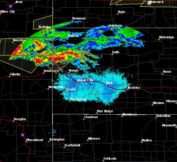 At 744 pm mdt, a severe thunderstorm was located 15 miles north of lightning flat, or 24 miles southeast of broadus, moving east at 60 mph (radar indicated). Hazards include 60 mph wind gusts and half dollar size hail. Hail damage to vehicles is expected. expect wind damage to roofs, siding and trees. locations impacted include, ridgeway, alzada, biddle, capitol, boyes, belle creek, hammond, albion and ridge. A tornado watch remains in effect until 1000 pm mdt for southeastern montana. At 744 pm mdt, a severe thunderstorm was located 15 miles north of lightning flat, or 24 miles southeast of broadus, moving east at 60 mph (radar indicated). Hazards include 60 mph wind gusts and half dollar size hail. Hail damage to vehicles is expected. expect wind damage to roofs, siding and trees. locations impacted include, ridgeway, alzada, biddle, capitol, boyes, belle creek, hammond, albion and ridge. A tornado watch remains in effect until 1000 pm mdt for southeastern montana.
|
| 6/19/2015 7:20 PM MDT |
 At 716 pm mdt, a severe thunderstorm was located 12 miles southwest of broadus, moving east at 50 mph. a second severe thunderstorm was located 25 miles east of broadus and was moving east at 40 mph. these are very dangerous storms (radar indicated). Hazards include 80 mph wind gusts and two inch hail. Flying debris will be dangerous to those caught without shelter. mobile homes will be heavily damaged. expect considerable damage to roofs, windows and vehicles. Extensive tree damage and power outages are likely. At 716 pm mdt, a severe thunderstorm was located 12 miles southwest of broadus, moving east at 50 mph. a second severe thunderstorm was located 25 miles east of broadus and was moving east at 40 mph. these are very dangerous storms (radar indicated). Hazards include 80 mph wind gusts and two inch hail. Flying debris will be dangerous to those caught without shelter. mobile homes will be heavily damaged. expect considerable damage to roofs, windows and vehicles. Extensive tree damage and power outages are likely.
|
| 6/19/2015 6:50 PM MDT | Baseball sized hail reported 0.2 miles W of Alzada, MT |
| 6/19/2015 6:41 PM MDT |
 At 640 pm mdt, a severe thunderstorm capable of producing a tornado was located near alzada, or 36 miles northwest of belle fourche, moving southeast at 40 mph (radar indicated rotation). Hazards include tornado and baseball size hail. Flying debris will be dangerous to those caught without shelter. mobile homes will be damaged or destroyed. damage to roofs, windows and vehicles will occur. tree damage is likely. Locations impacted include, alzada and albion. At 640 pm mdt, a severe thunderstorm capable of producing a tornado was located near alzada, or 36 miles northwest of belle fourche, moving southeast at 40 mph (radar indicated rotation). Hazards include tornado and baseball size hail. Flying debris will be dangerous to those caught without shelter. mobile homes will be damaged or destroyed. damage to roofs, windows and vehicles will occur. tree damage is likely. Locations impacted include, alzada and albion.
|
| 6/19/2015 6:23 PM MDT |
 At 623 pm mdt, a severe thunderstorm capable of producing a tornado was located 7 miles northwest of alzada, or 44 miles northwest of belle fourche, moving southeast at 45 mph (radar indicated rotation). Hazards include tornado and baseball size hail. Flying debris will be dangerous to those caught without shelter. mobile homes will be damaged or destroyed. damage to roofs, windows and vehicles will occur. Tree damage is likely. At 623 pm mdt, a severe thunderstorm capable of producing a tornado was located 7 miles northwest of alzada, or 44 miles northwest of belle fourche, moving southeast at 45 mph (radar indicated rotation). Hazards include tornado and baseball size hail. Flying debris will be dangerous to those caught without shelter. mobile homes will be damaged or destroyed. damage to roofs, windows and vehicles will occur. Tree damage is likely.
|
| 6/19/2015 6:10 PM MDT |
 At 607 pm mdt, a severe thunderstorm was located 20 miles southwest of ridgeway, or 34 miles southeast of broadus, moving southeast at 25 mph. this is a very dangerous storm (public. at 545 pm...softball sized hail hail was reported two miles north of hammond). Hazards include softball size hail and 70 mph wind gusts. People and animals outdoors will be severely injured. expect shattered windows, extensive damage to roofs, siding and vehicles. locations impacted include, ridgeway, alzada, capitol, boyes, hammond, albion and ridge. A tornado watch remains in effect until 1000 pm mdt for southeastern montana. At 607 pm mdt, a severe thunderstorm was located 20 miles southwest of ridgeway, or 34 miles southeast of broadus, moving southeast at 25 mph. this is a very dangerous storm (public. at 545 pm...softball sized hail hail was reported two miles north of hammond). Hazards include softball size hail and 70 mph wind gusts. People and animals outdoors will be severely injured. expect shattered windows, extensive damage to roofs, siding and vehicles. locations impacted include, ridgeway, alzada, capitol, boyes, hammond, albion and ridge. A tornado watch remains in effect until 1000 pm mdt for southeastern montana.
|
| 6/19/2015 5:39 PM MDT |
 At 538 pm mdt, a severe thunderstorm was located 23 miles southwest of ridgeway, or 23 miles east of broadus, moving southeast at 25 mph (radar indicated). Hazards include golf ball size hail and 70 mph wind gusts. People and animals outdoors will be injured. expect hail damage to roofs, siding, windows and vehicles. expect considerable tree damage. Wind damage is also likely to mobile homes, roofs and outbuildings. At 538 pm mdt, a severe thunderstorm was located 23 miles southwest of ridgeway, or 23 miles east of broadus, moving southeast at 25 mph (radar indicated). Hazards include golf ball size hail and 70 mph wind gusts. People and animals outdoors will be injured. expect hail damage to roofs, siding, windows and vehicles. expect considerable tree damage. Wind damage is also likely to mobile homes, roofs and outbuildings.
|
| 6/19/2015 1:12 AM MDT | At 110 am mdt, a severe thunderstorm was located 11 miles north of alzada, or 45 miles northwest of belle fourche, moving east at 35 mph (radar indicated). Hazards include 70 mph wind gusts and quarter size hail. Hail damage to vehicles is expected. expect considerable tree damage. Wind damage is also likely to mobile homes, roofs and outbuildings. |
| 6/19/2015 12:58 AM MDT | At 1257 am mdt, a severe thunderstorm was located 13 miles northwest of alzada, or 44 miles southeast of broadus, moving east at 60 mph (radar indicated). Hazards include 70 mph wind gusts and quarter size hail. Hail damage to vehicles is expected. expect considerable tree damage. wind damage is also likely to mobile homes, roofs and outbuildings. Locations impacted include, alzada, ridgeway and hammond. |
| 6/19/2015 12:43 AM MDT | At 1242 am mdt, a severe thunderstorm was located 16 miles northeast of lightning flat, or 30 miles southeast of broadus, moving east at 40 mph (radar indicated). Hazards include 70 mph wind gusts and quarter size hail. Hail damage to vehicles is expected. expect considerable tree damage. wind damage is also likely to mobile homes, roofs and outbuildings. Locations impacted include, ridgeway, alzada, hammond, boyes, belle creek and ridge. |
| 6/19/2015 12:10 AM MDT | At 1209 am mdt, a severe thunderstorm was located near biddle, or 18 miles south of broadus, moving east at 60 mph (radar indicated). Hazards include 70 mph wind gusts and quarter size hail. Hail damage to vehicles is expected. expect considerable tree damage. Wind damage is also likely to mobile homes, roofs and outbuildings. |
| 8/21/2014 7:20 PM MDT | Storm damage reported in carter county MT, 20.2 miles S of Alzada, MT |
| 7/24/2014 6:22 PM MDT | Quarter sized hail reported 0.7 miles SSW of Alzada, MT, wind gusts estimated 60 mph |
| 7/24/2014 6:10 PM MDT | Storm damage reported in carter county MT, 3 miles SE of Alzada, MT |
| 7/22/2014 5:30 PM MDT | Carter county dispatch reported an rv and vehicle blown off highway 212 between mile markers 138-139. no injuries reporte in carter county MT, 1.8 miles WNW of Alzada, MT |
| 6/4/2014 5:00 PM MDT | Storm damage reported in crook county WY, 16.5 miles NW of Alzada, MT |
| 6/4/2014 4:00 PM MDT | Quarter sized hail reported 24.9 miles E of Alzada, MT |
| 6/4/2014 3:23 PM MDT | Golf Ball sized hail reported 15.9 miles WSW of Alzada, MT |
| 8/5/2013 7:15 PM MDT | Quarter sized hail reported 17.3 miles S of Alzada, MT |
| 8/5/2013 7:15 PM MDT | Golf Ball sized hail reported 15.1 miles SSW of Alzada, MT |
| 8/5/2013 7:15 PM MDT | Tennis Ball sized hail reported 17 miles SSW of Alzada, MT, broken windows in house. |
| 8/5/2013 7:00 PM MDT | Hen Egg sized hail reported 25.4 miles SSE of Alzada, MT, hen egg hail stripped siding and screens from house. |
| 8/5/2013 6:55 PM MDT | Golf Ball sized hail reported 25.6 miles SSW of Alzada, MT |
| 7/22/2013 5:30 PM MDT | Quarter sized hail reported 15.1 miles SSW of Alzada, MT, lots of pea sized hail with larger stones up to the size of quarters. very heavy rainfall too. |
| 7/7/2013 3:42 PM MDT | Tea Cup sized hail reported 25.8 miles ESE of Alzada, MT, majority of hail was quarter size |
| 7/7/2013 3:22 PM MDT | Golf Ball sized hail reported 25.8 miles ESE of Alzada, MT |
| 1/1/0001 12:00 AM | Quarter sized hail reported 14 miles E of Alzada, MT, 50-60 mph winds driving quarter size hail and heavy rains. |
| 1/1/0001 12:00 AM | Marble size hail als in crook county WY, 15 miles NW of Alzada, MT |
| 1/1/0001 12:00 AM | Quarter sized hail reported 28.1 miles E of Alzada, MT |
| 1/1/0001 12:00 AM | Quarter sized hail reported 0.7 miles SSW of Alzada, MT, 50 mph wind...extensive 1/4 to 1/2 in hail...heavy rain |
| 1/1/0001 12:00 AM | Storm damage reported in carter county MT, 10.9 miles SSW of Alzada, MT |
| 1/1/0001 12:00 AM | Golf Ball sized hail reported 17.4 miles ESE of Alzada, MT, spotter reports golfball size hail on hwy 212 west of alzada. |
| 1/1/0001 12:00 AM | Golf Ball sized hail reported 15 miles E of Alzada, MT, spotter reports golfball size hail on hwy 212 west of alzada. |
| 1/1/0001 12:00 AM | Tennis Ball sized hail reported 27 miles ESE of Alzada, MT |
| 1/1/0001 12:00 AM | Quarter sized hail reported 28.1 miles E of Alzada, MT |
| 1/1/0001 12:00 AM | Ping Pong Ball sized hail reported 29.7 miles E of Alzada, MT, up to ping pong ball size hail |
Hail Maps for Alzada, MT
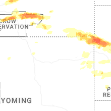
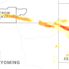


Connect with Interactive Hail Maps