

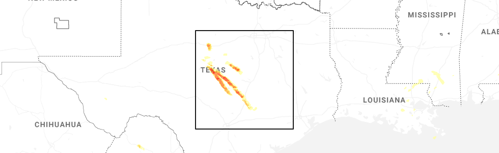
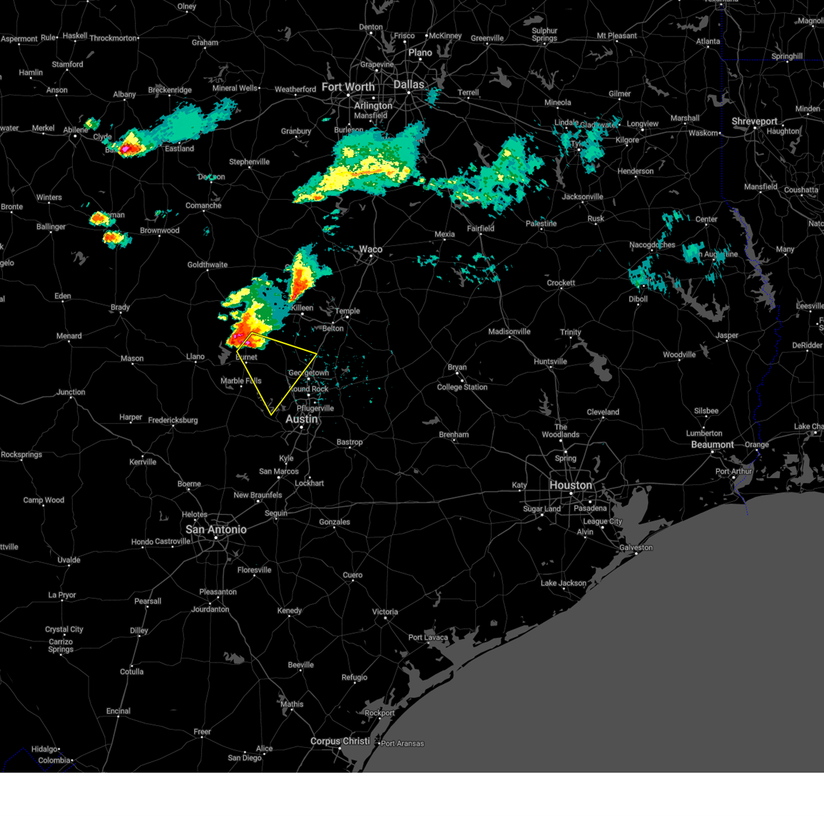
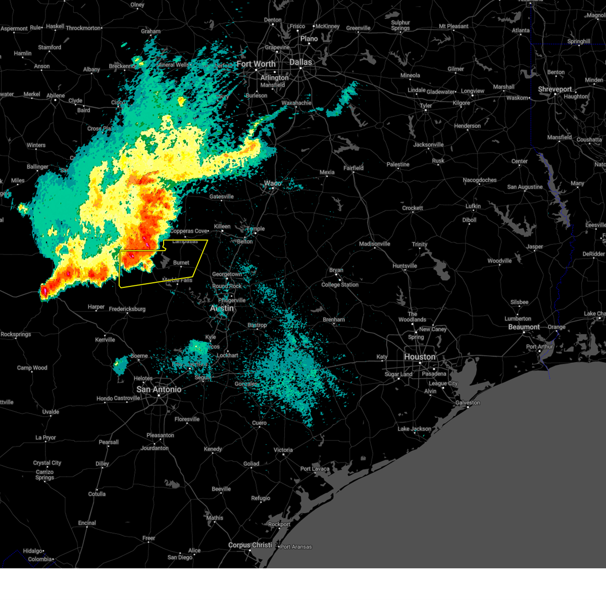
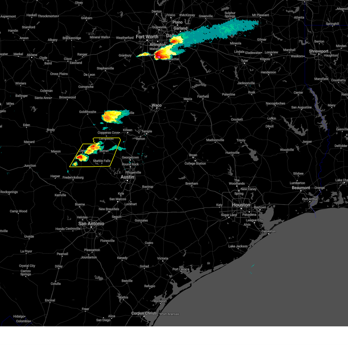
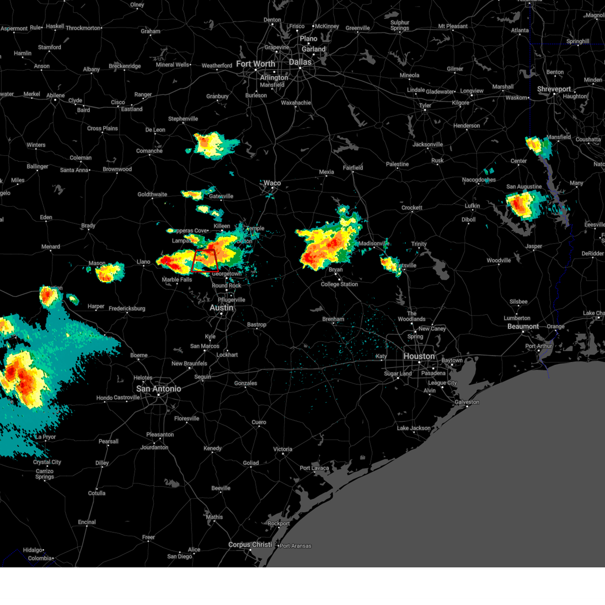
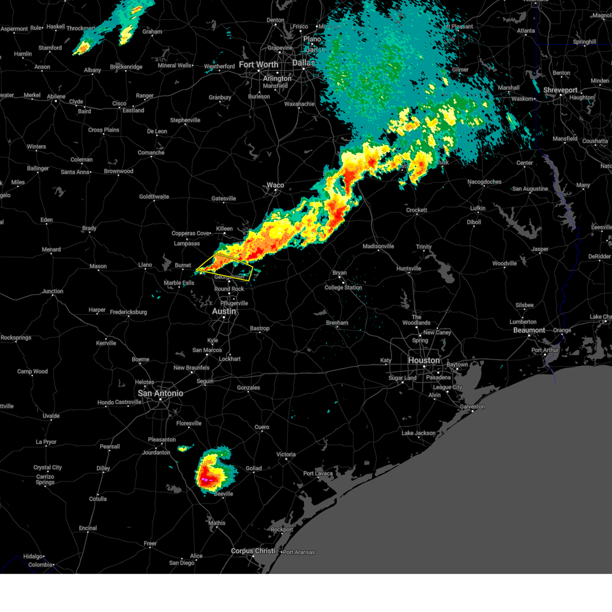
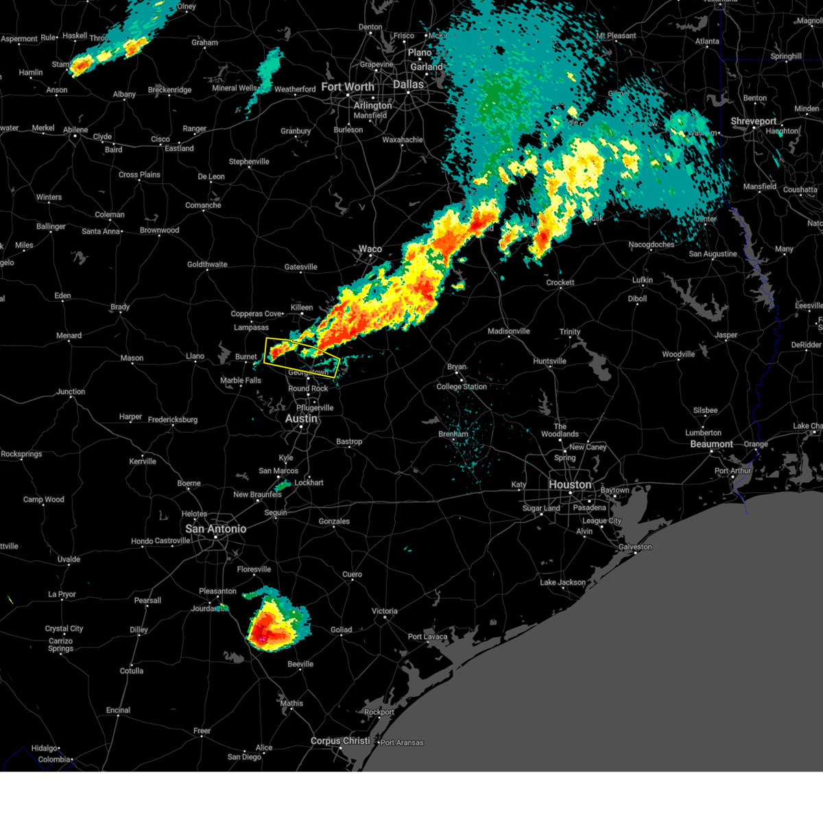
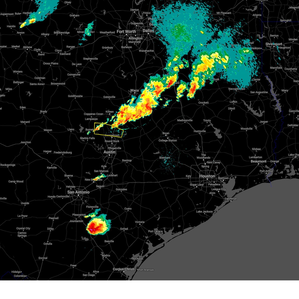
Hail Map for Bertram, TX
The Bertram, TX area has had 11 reports of on-the-ground hail by trained spotters, and has been under severe weather warnings 32 times during the past 12 months. Doppler radar has detected hail at or near Bertram, TX on 49 occasions, including 5 occasions during the past year.
| Name: | Bertram, TX |
| Where Located: | 32.4 miles SW of Killeen, TX |
| Map: | Google Map for Bertram, TX |
| Population: | 1353 |
| Housing Units: | 553 |
| More Info: | Search Google for Bertram, TX |
2
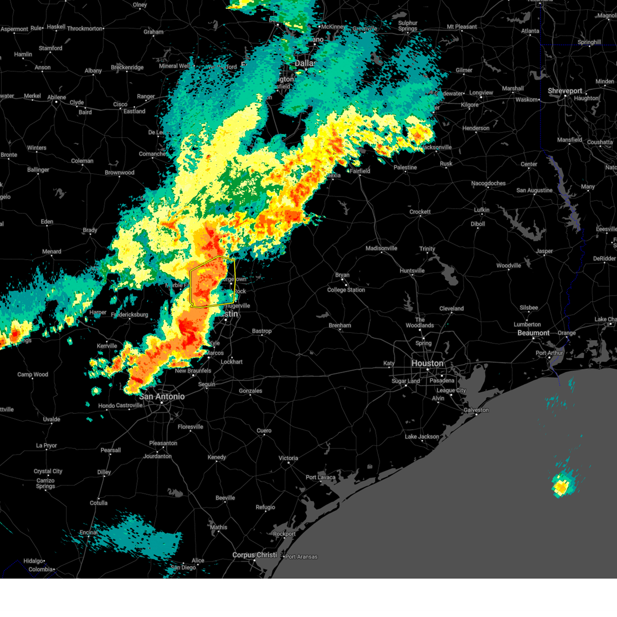
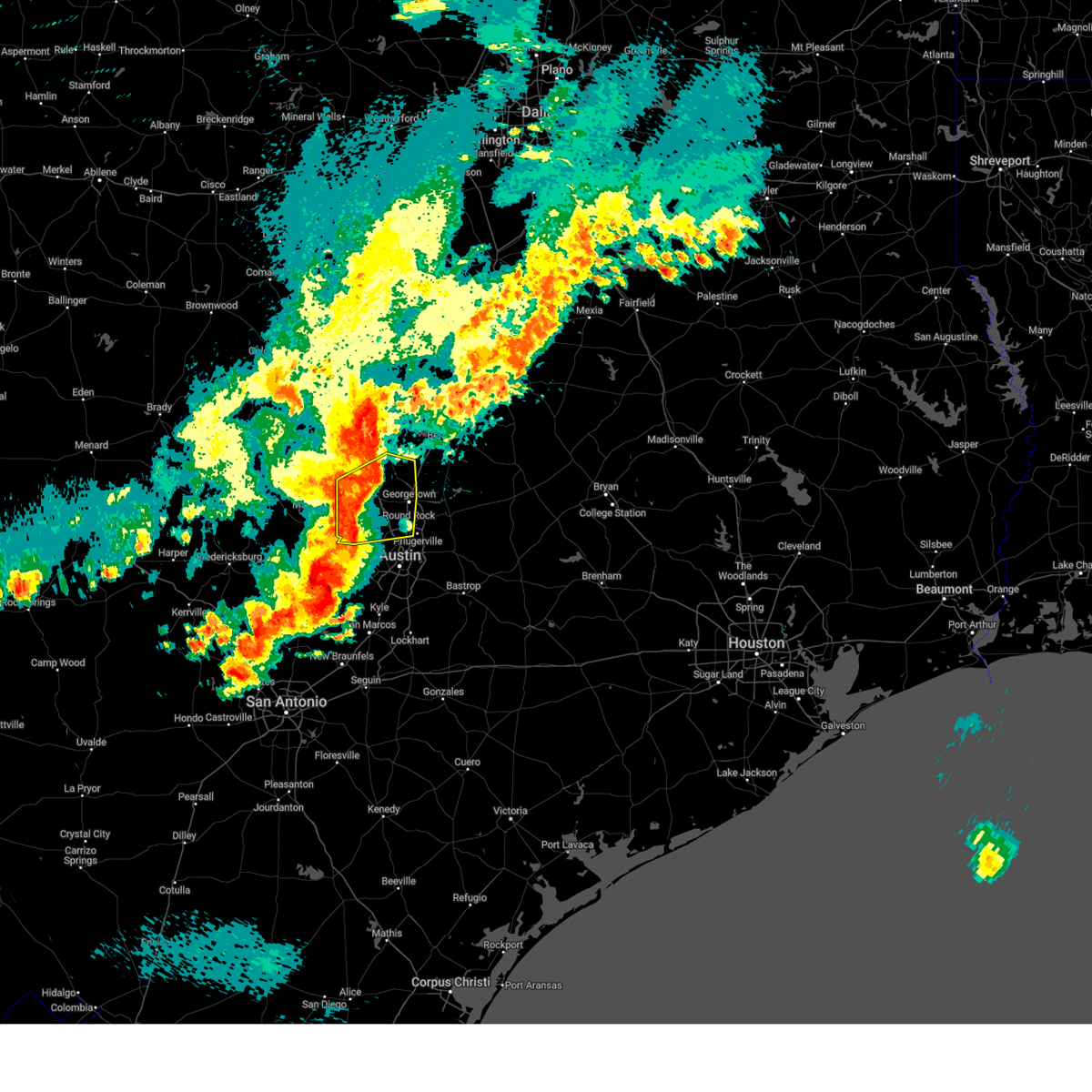
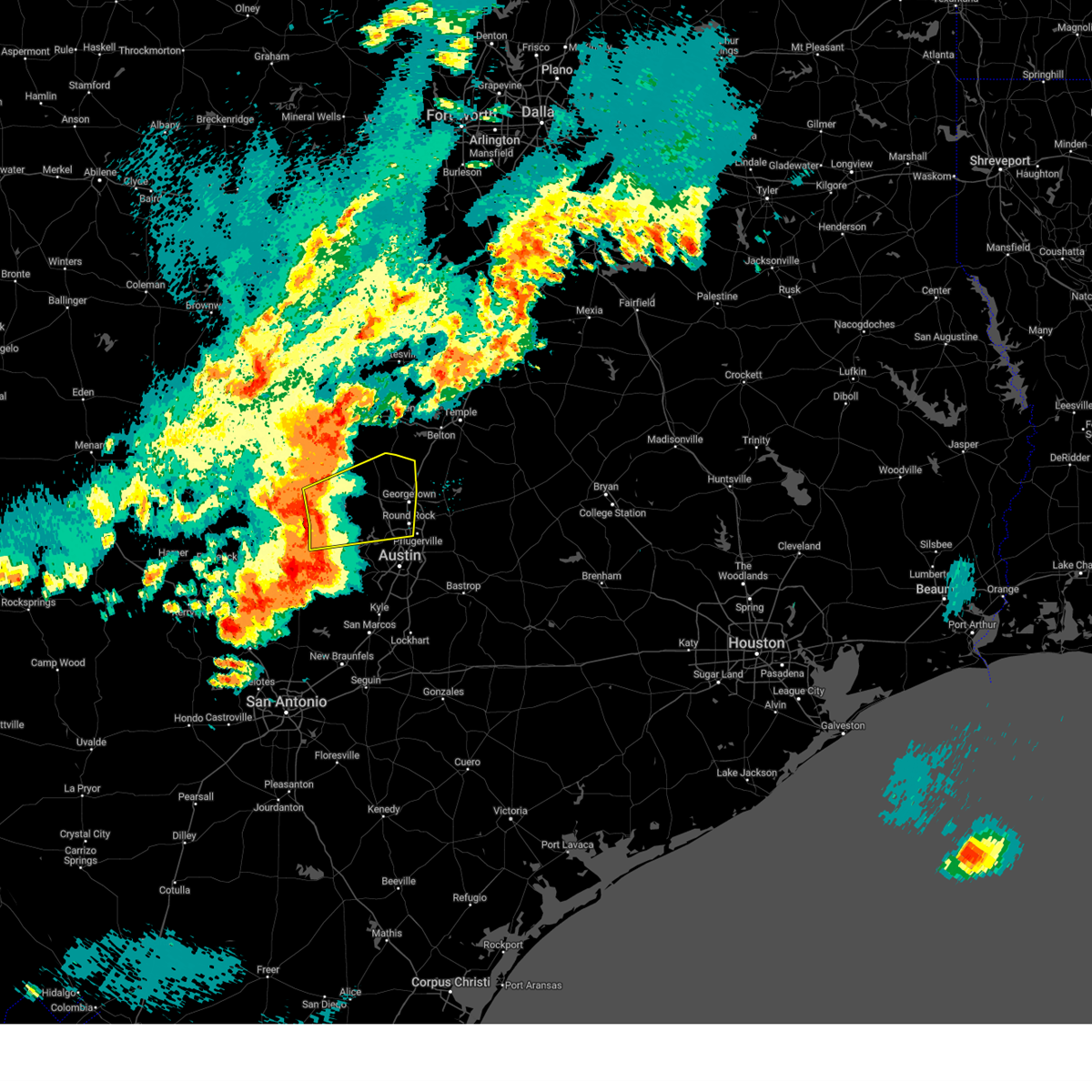
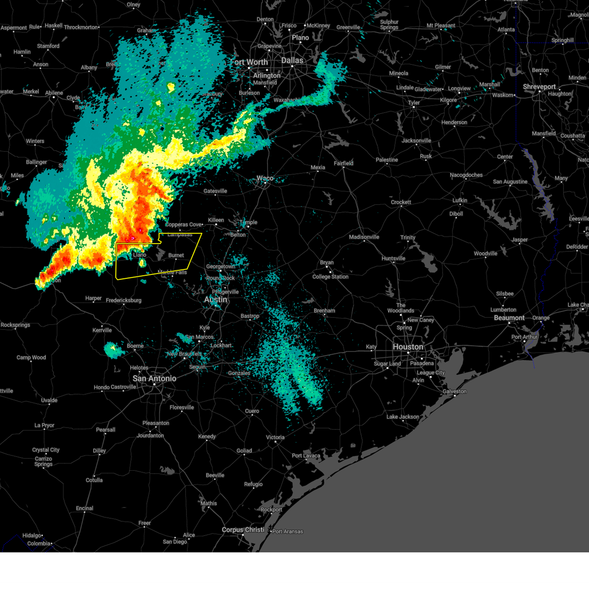
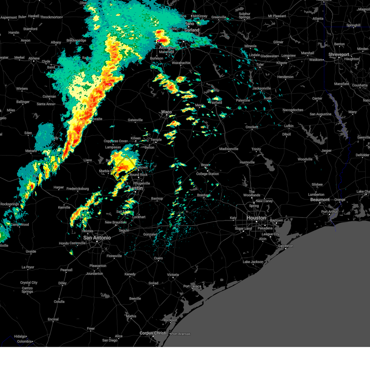
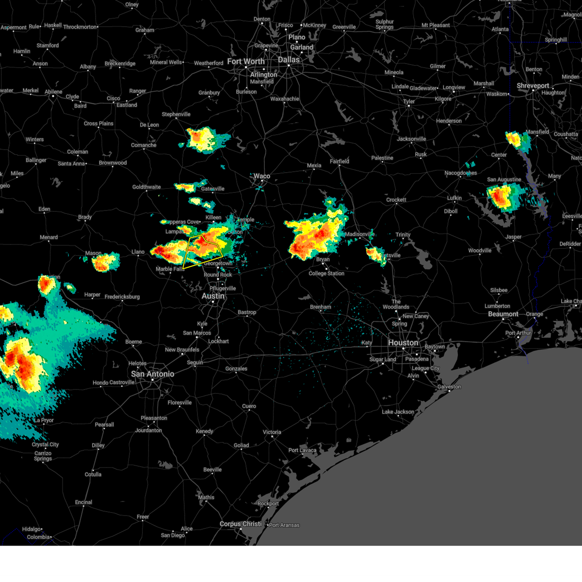
The Top Recent Hail Date for Bertram, TX is Wednesday, May 28, 2025 (3rd out of 49)
Hail and Wind Damage Spotted near Bertram, TX
| Date / Time | Report Details |
|---|---|
| 5/28/2025 5:45 PM CDT | Mesonet station bfxt2 balcones flying x. time estimated by rada in burnet county TX, 7.8 miles N of Bertram, TX |
| 5/28/2025 5:43 PM CDT |
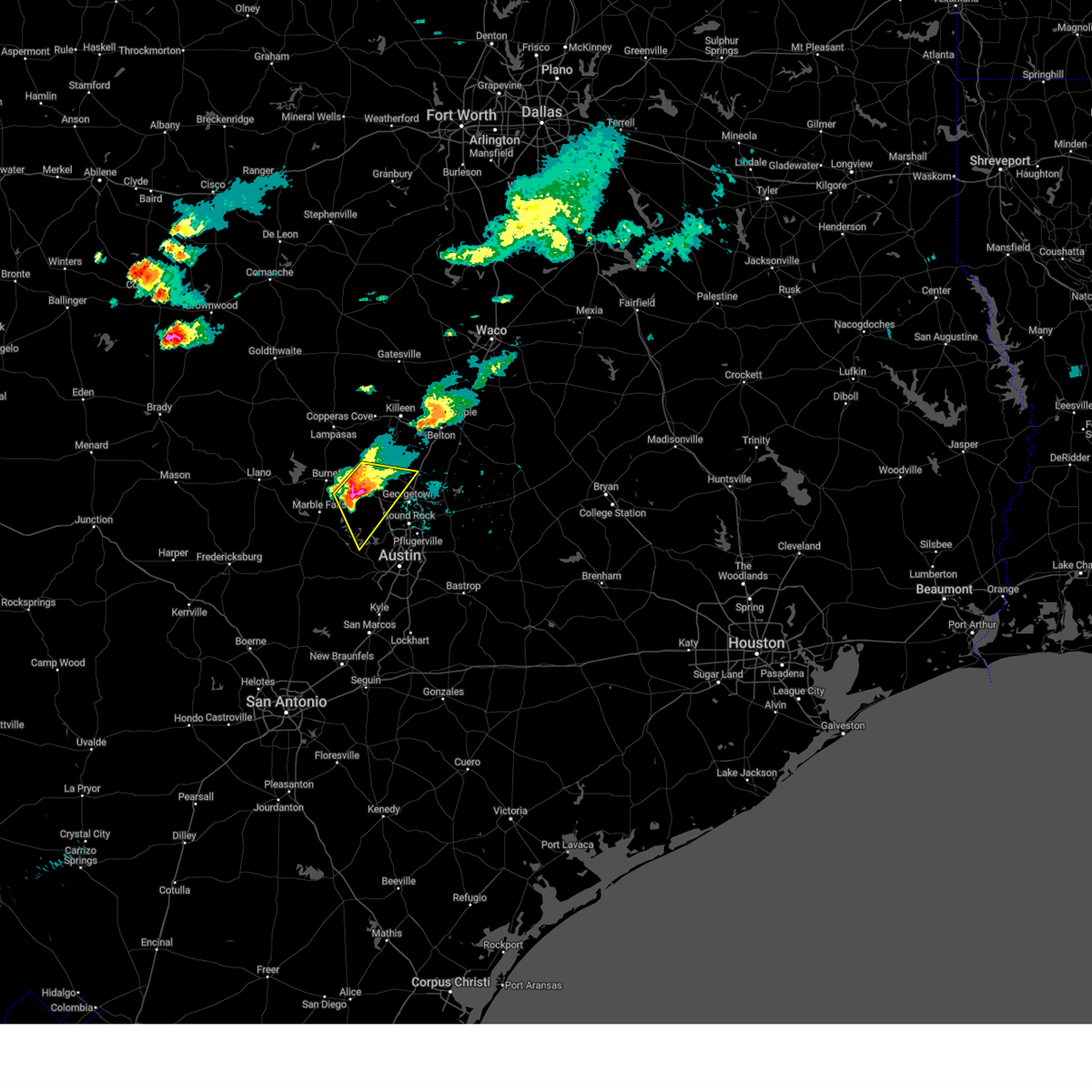 At 542 pm cdt, a severe thunderstorm was located near liberty hill, or near bertram, moving southeast at 30 mph. this is a destructive storm for bertram to liberty hill to leander (radar indicated). Hazards include baseball size hail and 60 mph wind gusts. People and animals outdoors will be severely injured. expect shattered windows, extensive damage to roofs, siding, and vehicles. Locations impacted include, cedar park, georgetown, bertram, leander, lakeway, lago vista, liberty hill, florence, oatmeal, sun city, mahomet, andice, jonestown, briarcliff, point venture, and seward junction. At 542 pm cdt, a severe thunderstorm was located near liberty hill, or near bertram, moving southeast at 30 mph. this is a destructive storm for bertram to liberty hill to leander (radar indicated). Hazards include baseball size hail and 60 mph wind gusts. People and animals outdoors will be severely injured. expect shattered windows, extensive damage to roofs, siding, and vehicles. Locations impacted include, cedar park, georgetown, bertram, leander, lakeway, lago vista, liberty hill, florence, oatmeal, sun city, mahomet, andice, jonestown, briarcliff, point venture, and seward junction.
|
| 5/28/2025 5:33 PM CDT |
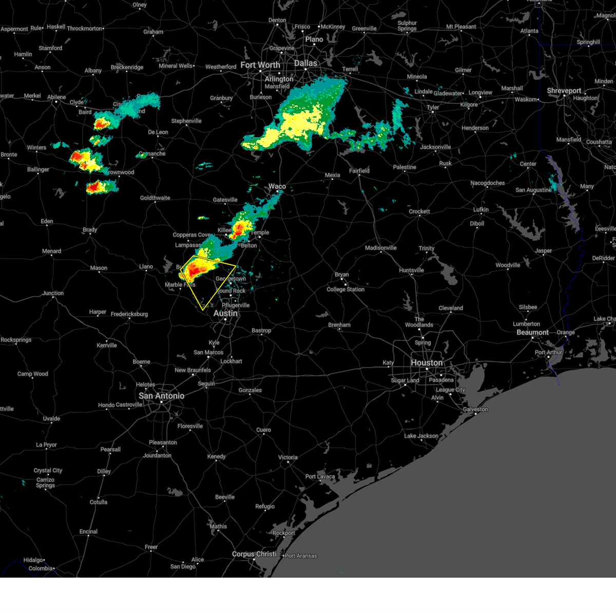 At 531 pm cdt, a severe thunderstorm was located over bertram, moving southeast at 30 mph. this is a destructive storm for bertram to liberty hill to leander (radar indicated). Hazards include baseball size hail and 60 mph wind gusts. People and animals outdoors will be severely injured. expect shattered windows, extensive damage to roofs, siding, and vehicles. Locations impacted include, cedar park, georgetown, burnet, bertram, leander, lakeway, lago vista, liberty hill, florence, oatmeal, sun city, mahomet, joppa, andice, shady grove, jonestown, briarcliff, point venture, and seward junction. At 531 pm cdt, a severe thunderstorm was located over bertram, moving southeast at 30 mph. this is a destructive storm for bertram to liberty hill to leander (radar indicated). Hazards include baseball size hail and 60 mph wind gusts. People and animals outdoors will be severely injured. expect shattered windows, extensive damage to roofs, siding, and vehicles. Locations impacted include, cedar park, georgetown, burnet, bertram, leander, lakeway, lago vista, liberty hill, florence, oatmeal, sun city, mahomet, joppa, andice, shady grove, jonestown, briarcliff, point venture, and seward junction.
|
| 5/28/2025 5:30 PM CDT | Half Dollar sized hail reported 0.3 miles E of Bertram, TX, county emergency manager relayed a report of quarter to half dollar size hail in bertram. |
| 5/28/2025 5:26 PM CDT |
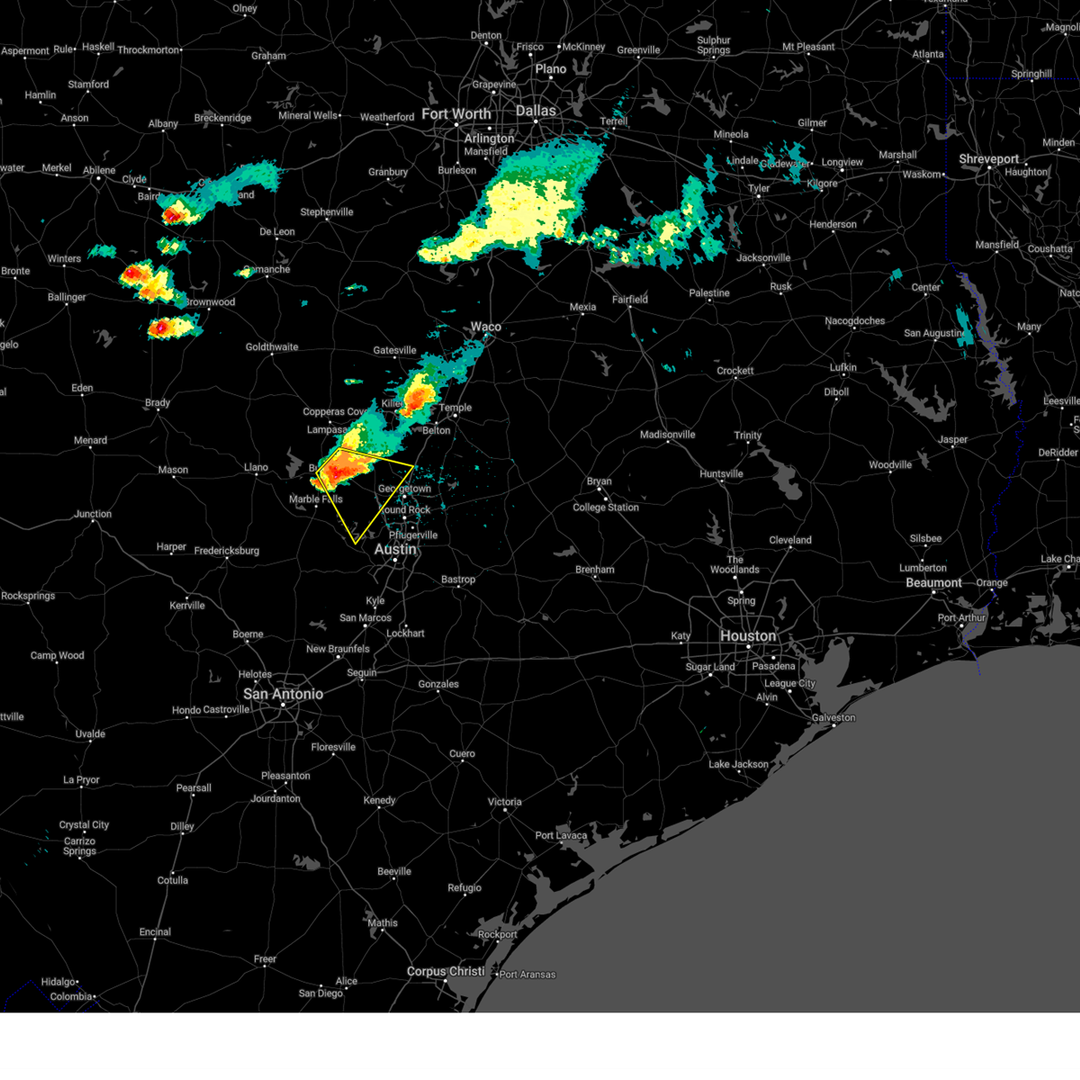 At 525 pm cdt, a severe thunderstorm was located over bertram, moving southeast at 30 mph (radar indicated). Hazards include golf ball size hail and 60 mph wind gusts. People and animals outdoors will be injured. expect hail damage to roofs, siding, windows, and vehicles. expect wind damage to roofs, siding, and trees. Locations impacted include, cedar park, georgetown, burnet, bertram, leander, lakeway, lago vista, liberty hill, florence, oatmeal, sun city, mahomet, joppa, andice, shady grove, jonestown, briarcliff, point venture, and seward junction. At 525 pm cdt, a severe thunderstorm was located over bertram, moving southeast at 30 mph (radar indicated). Hazards include golf ball size hail and 60 mph wind gusts. People and animals outdoors will be injured. expect hail damage to roofs, siding, windows, and vehicles. expect wind damage to roofs, siding, and trees. Locations impacted include, cedar park, georgetown, burnet, bertram, leander, lakeway, lago vista, liberty hill, florence, oatmeal, sun city, mahomet, joppa, andice, shady grove, jonestown, briarcliff, point venture, and seward junction.
|
| 5/28/2025 5:04 PM CDT |
 Svrewx the national weather service in austin san antonio has issued a * severe thunderstorm warning for, northwestern williamson county in south central texas, northwestern travis county in south central texas, central burnet county in south central texas, * until 600 pm cdt. * at 504 pm cdt, a severe thunderstorm was located near lake victor, or 8 miles northeast of burnet, moving southeast at 30 mph (radar indicated). Hazards include golf ball size hail and 60 mph wind gusts. People and animals outdoors will be injured. expect hail damage to roofs, siding, windows, and vehicles. Expect wind damage to roofs, siding, and trees. Svrewx the national weather service in austin san antonio has issued a * severe thunderstorm warning for, northwestern williamson county in south central texas, northwestern travis county in south central texas, central burnet county in south central texas, * until 600 pm cdt. * at 504 pm cdt, a severe thunderstorm was located near lake victor, or 8 miles northeast of burnet, moving southeast at 30 mph (radar indicated). Hazards include golf ball size hail and 60 mph wind gusts. People and animals outdoors will be injured. expect hail damage to roofs, siding, windows, and vehicles. Expect wind damage to roofs, siding, and trees.
|
| 5/26/2025 8:33 PM CDT |
 At 833 pm cdt, severe thunderstorms were located along a line extending from near sun city to near liberty hill to near hudson bend, moving east at 35 mph. these are destructive storms for florence (radar indicated). Hazards include 80 mph wind gusts and penny size hail. Flying debris will be dangerous to those caught without shelter. mobile homes will be heavily damaged. expect considerable damage to roofs, windows, and vehicles. extensive tree damage and power outages are likely. Locations impacted include, austin, round rock, cedar park, georgetown, pflugerville, bertram, anderson mill, serenada, windemere, leander, lago vista, hudson bend, liberty hill, florence, spicewood, georgetown dam, andice, oatmeal, sun city, and mahomet. At 833 pm cdt, severe thunderstorms were located along a line extending from near sun city to near liberty hill to near hudson bend, moving east at 35 mph. these are destructive storms for florence (radar indicated). Hazards include 80 mph wind gusts and penny size hail. Flying debris will be dangerous to those caught without shelter. mobile homes will be heavily damaged. expect considerable damage to roofs, windows, and vehicles. extensive tree damage and power outages are likely. Locations impacted include, austin, round rock, cedar park, georgetown, pflugerville, bertram, anderson mill, serenada, windemere, leander, lago vista, hudson bend, liberty hill, florence, spicewood, georgetown dam, andice, oatmeal, sun city, and mahomet.
|
| 5/26/2025 8:24 PM CDT |
 At 824 pm cdt, severe thunderstorms were located along a line extending from near andice to 7 miles southwest of liberty hill to lago vista, moving east at 55 mph (radar indicated). Hazards include 60 mph wind gusts and penny size hail. Expect damage to roofs, siding, and trees. Locations impacted include, austin, round rock, cedar park, georgetown, pflugerville, bertram, anderson mill, serenada, windemere, leander, lago vista, hudson bend, liberty hill, florence, spicewood, georgetown dam, andice, oatmeal, sun city, and mahomet. At 824 pm cdt, severe thunderstorms were located along a line extending from near andice to 7 miles southwest of liberty hill to lago vista, moving east at 55 mph (radar indicated). Hazards include 60 mph wind gusts and penny size hail. Expect damage to roofs, siding, and trees. Locations impacted include, austin, round rock, cedar park, georgetown, pflugerville, bertram, anderson mill, serenada, windemere, leander, lago vista, hudson bend, liberty hill, florence, spicewood, georgetown dam, andice, oatmeal, sun city, and mahomet.
|
| 5/26/2025 8:24 PM CDT |
 the severe thunderstorm warning has been cancelled and is no longer in effect the severe thunderstorm warning has been cancelled and is no longer in effect
|
| 5/26/2025 8:00 PM CDT |
 Svrewx the national weather service in austin san antonio has issued a * severe thunderstorm warning for, western williamson county in south central texas, northwestern travis county in south central texas, northeastern blanco county in south central texas, southern burnet county in south central texas, * until 845 pm cdt. * at 800 pm cdt, severe thunderstorms were located along a line extending from near burnet to near smithwick to near cypress mill, moving east at 35 mph (radar indicated). Hazards include 60 mph wind gusts and penny size hail. expect damage to roofs, siding, and trees Svrewx the national weather service in austin san antonio has issued a * severe thunderstorm warning for, western williamson county in south central texas, northwestern travis county in south central texas, northeastern blanco county in south central texas, southern burnet county in south central texas, * until 845 pm cdt. * at 800 pm cdt, severe thunderstorms were located along a line extending from near burnet to near smithwick to near cypress mill, moving east at 35 mph (radar indicated). Hazards include 60 mph wind gusts and penny size hail. expect damage to roofs, siding, and trees
|
| 5/23/2025 12:09 AM CDT |
 At 1208 am cdt, severe thunderstorms were located along a line extending from near castell to near bluffton to 12 miles northeast of bend, moving southeast at 25 mph (radar indicated). Hazards include golf ball size hail and 60 mph wind gusts. People and animals outdoors will be injured. expect hail damage to roofs, siding, windows, and vehicles. expect wind damage to roofs, siding, and trees. Locations impacted include, burnet, kingsland, llano, bertram, buchanan dam, gainesville, granite shoals, buchanan lake village, highland haven, castell, field creek, inks lake state park, watson, bluffton, lake victor, baby head, stolz, joppa, oxford, and shady grove. At 1208 am cdt, severe thunderstorms were located along a line extending from near castell to near bluffton to 12 miles northeast of bend, moving southeast at 25 mph (radar indicated). Hazards include golf ball size hail and 60 mph wind gusts. People and animals outdoors will be injured. expect hail damage to roofs, siding, windows, and vehicles. expect wind damage to roofs, siding, and trees. Locations impacted include, burnet, kingsland, llano, bertram, buchanan dam, gainesville, granite shoals, buchanan lake village, highland haven, castell, field creek, inks lake state park, watson, bluffton, lake victor, baby head, stolz, joppa, oxford, and shady grove.
|
| 5/22/2025 11:57 PM CDT |
 At 1156 pm cdt, severe thunderstorms were located along a line extending from 6 miles southwest of valley spring to near tow to 13 miles southwest of evant, moving southeast at 35 mph (radar indicated). Hazards include 60 mph wind gusts and quarter size hail. Hail damage to vehicles is expected. expect wind damage to roofs, siding, and trees. Locations impacted include, burnet, kingsland, llano, bertram, buchanan dam, gainesville, granite shoals, buchanan lake village, highland haven, castell, field creek, inks lake state park, watson, bluffton, lake victor, baby head, stolz, joppa, oxford, and shady grove. At 1156 pm cdt, severe thunderstorms were located along a line extending from 6 miles southwest of valley spring to near tow to 13 miles southwest of evant, moving southeast at 35 mph (radar indicated). Hazards include 60 mph wind gusts and quarter size hail. Hail damage to vehicles is expected. expect wind damage to roofs, siding, and trees. Locations impacted include, burnet, kingsland, llano, bertram, buchanan dam, gainesville, granite shoals, buchanan lake village, highland haven, castell, field creek, inks lake state park, watson, bluffton, lake victor, baby head, stolz, joppa, oxford, and shady grove.
|
| 5/22/2025 11:29 PM CDT |
 Svrewx the national weather service in austin san antonio has issued a * severe thunderstorm warning for, llano county in south central texas, burnet county in south central texas, * until 1230 am cdt. * at 1129 pm cdt, severe thunderstorms were located along a line extending from near fredonia to near cherokee to near goldthwaite, moving southeast at 35 mph (radar indicated). Hazards include 60 mph wind gusts and quarter size hail. Hail damage to vehicles is expected. Expect wind damage to roofs, siding, and trees. Svrewx the national weather service in austin san antonio has issued a * severe thunderstorm warning for, llano county in south central texas, burnet county in south central texas, * until 1230 am cdt. * at 1129 pm cdt, severe thunderstorms were located along a line extending from near fredonia to near cherokee to near goldthwaite, moving southeast at 35 mph (radar indicated). Hazards include 60 mph wind gusts and quarter size hail. Hail damage to vehicles is expected. Expect wind damage to roofs, siding, and trees.
|
| 5/16/2025 8:48 PM CDT | Quarter sized hail reported 0.3 miles W of Bertram, TX, storm spotter reported quarter size hail beneath water tower. |
| 5/16/2025 8:44 PM CDT | At 844 pm cdt, a severe thunderstorm was located over liberty hill, or 9 miles northwest of cedar park, moving east at 40 mph (radar indicated). Hazards include 70 mph wind gusts and quarter size hail. Hail damage to vehicles is expected. expect considerable tree damage. wind damage is also likely to mobile homes, roofs, and outbuildings. Locations impacted include, round rock, cedar park, georgetown, taylor, bertram, serenada, leander, hutto, liberty hill, jarrell, florence, weir, georgetown dam, briggs, sun city, mahomet, joppa, andice, theon, and walburg. |
| 5/16/2025 8:28 PM CDT | At 828 pm cdt, severe thunderstorms were located along a line extending from near watson to mahomet to near oatmeal, moving east at 35 mph (radar indicated). Hazards include two inch hail and 70 mph wind gusts. People and animals outdoors will be injured. expect hail damage to roofs, siding, windows, and vehicles. expect considerable tree damage. wind damage is also likely to mobile homes, roofs, and outbuildings. Locations impacted include, round rock, cedar park, georgetown, taylor, burnet, marble falls, bertram, serenada, leander, hutto, liberty hill, jarrell, florence, weir, georgetown dam, watson, lake victor, joppa, andice, and shady grove. |
| 5/16/2025 8:24 PM CDT | Quarter sized hail reported 5.8 miles ENE of Bertram, TX, person called in report. estimated at 1 inch. |
| 5/16/2025 8:21 PM CDT |
 At 820 pm cdt, severe thunderstorms were located along a line extending from sunnylane to near joppa to near burnet, moving east at 30 mph (radar indicated). Hazards include two inch hail and 60 mph wind gusts. People and animals outdoors will be injured. expect hail damage to roofs, siding, windows, and vehicles. expect wind damage to roofs, siding, and trees. Locations impacted include, round rock, cedar park, georgetown, taylor, burnet, marble falls, bertram, serenada, leander, hutto, liberty hill, jarrell, florence, weir, georgetown dam, watson, lake victor, joppa, andice, and shady grove. At 820 pm cdt, severe thunderstorms were located along a line extending from sunnylane to near joppa to near burnet, moving east at 30 mph (radar indicated). Hazards include two inch hail and 60 mph wind gusts. People and animals outdoors will be injured. expect hail damage to roofs, siding, windows, and vehicles. expect wind damage to roofs, siding, and trees. Locations impacted include, round rock, cedar park, georgetown, taylor, burnet, marble falls, bertram, serenada, leander, hutto, liberty hill, jarrell, florence, weir, georgetown dam, watson, lake victor, joppa, andice, and shady grove.
|
| 5/16/2025 8:12 PM CDT | Svrewx the national weather service in austin san antonio has issued a * severe thunderstorm warning for, williamson county in south central texas, north central travis county in south central texas, burnet county in south central texas, * until 915 pm cdt. * at 811 pm cdt, severe thunderstorms were located along a line extending from near lake victor to near shady grove to near burnet, moving east at 30 mph (radar indicated). Hazards include two inch hail and 60 mph wind gusts. People and animals outdoors will be injured. expect hail damage to roofs, siding, windows, and vehicles. Expect wind damage to roofs, siding, and trees. |
| 5/16/2025 8:08 PM CDT | the severe thunderstorm warning has been cancelled and is no longer in effect |
| 5/16/2025 8:08 PM CDT | At 807 pm cdt, severe thunderstorms were located along a line extending from near lake victor to shady grove to near longhorn cavern state park, moving east at 30 mph (radar indicated). Hazards include two inch hail and 60 mph wind gusts. People and animals outdoors will be injured. expect hail damage to roofs, siding, windows, and vehicles. expect wind damage to roofs, siding, and trees. Locations impacted include, burnet, marble falls, bertram, granite shoals, meadowlakes, highland haven, inks lake state park, watson, oatmeal, lake victor, sunnylane, longhorn cavern state park, joppa, smithwick, shady grove, and briggs. |
| 5/16/2025 7:56 PM CDT | At 756 pm cdt, severe thunderstorms were located along a line extending from 6 miles northeast of buchanan lake village to near burnet to near kingsland, moving east at 25 mph (radar indicated). Hazards include two inch hail and 60 mph wind gusts. People and animals outdoors will be injured. expect hail damage to roofs, siding, windows, and vehicles. expect wind damage to roofs, siding, and trees. Locations impacted include, burnet, marble falls, kingsland, bertram, buchanan dam, granite shoals, horseshoe bay, meadowlakes, buchanan lake village, highland haven, inks lake state park, watson, oatmeal, lake victor, sunnylane, longhorn cavern state park, joppa, smithwick, tow, and shady grove. |
| 5/16/2025 7:29 PM CDT | At 729 pm cdt, severe thunderstorms were located along a line extending from 7 miles east of tow to buchanan lake village to near llano, moving northeast at 25 mph (radar indicated). Hazards include ping pong ball size hail and 60 mph wind gusts. People and animals outdoors will be injured. expect hail damage to roofs, siding, windows, and vehicles. expect wind damage to roofs, siding, and trees. Locations impacted include, burnet, marble falls, kingsland, llano, bertram, buchanan dam, gainesville, granite shoals, horseshoe bay, meadowlakes, buchanan lake village, highland haven, inks lake state park, watson, bluffton, lake victor, baby head, stolz, joppa, and oxford. |
| 5/16/2025 7:11 PM CDT |
 Svrewx the national weather service in austin san antonio has issued a * severe thunderstorm warning for, llano county in south central texas, burnet county in south central texas, * until 815 pm cdt. * at 711 pm cdt, severe thunderstorms were located along a line extending from buchanan lake village to stolz to near llano to prairie mountain, moving northeast at 30 mph (radar indicated). Hazards include 60 mph wind gusts and quarter size hail. Hail damage to vehicles is expected. Expect wind damage to roofs, siding, and trees. Svrewx the national weather service in austin san antonio has issued a * severe thunderstorm warning for, llano county in south central texas, burnet county in south central texas, * until 815 pm cdt. * at 711 pm cdt, severe thunderstorms were located along a line extending from buchanan lake village to stolz to near llano to prairie mountain, moving northeast at 30 mph (radar indicated). Hazards include 60 mph wind gusts and quarter size hail. Hail damage to vehicles is expected. Expect wind damage to roofs, siding, and trees.
|
| 5/6/2025 8:52 AM CDT |
 At 851 am cdt, a severe thunderstorm was located near smithwick, or 11 miles south of bertram, moving northeast at 35 mph (radar indicated). Hazards include 60 mph wind gusts and quarter size hail. Hail damage to vehicles is expected. expect wind damage to roofs, siding, and trees. this severe storm will be near, liberty hill around 905 am cdt. georgetown around 915 am cdt. andice around 920 am cdt. Other locations impacted by this severe thunderstorm include seward junction. At 851 am cdt, a severe thunderstorm was located near smithwick, or 11 miles south of bertram, moving northeast at 35 mph (radar indicated). Hazards include 60 mph wind gusts and quarter size hail. Hail damage to vehicles is expected. expect wind damage to roofs, siding, and trees. this severe storm will be near, liberty hill around 905 am cdt. georgetown around 915 am cdt. andice around 920 am cdt. Other locations impacted by this severe thunderstorm include seward junction.
|
| 5/6/2025 8:34 AM CDT |
 At 834 am cdt, a severe thunderstorm was located near smithwick, or near marble falls, moving northeast at 40 mph (radar indicated). Hazards include 60 mph wind gusts and quarter size hail. Hail damage to vehicles is expected. expect wind damage to roofs, siding, and trees. this severe storm will be near, oatmeal around 845 am cdt. bertram around 850 am cdt. liberty hill around 855 am cdt. andice around 905 am cdt. florence around 910 am cdt. Other locations impacted by this severe thunderstorm include theon, seward junction, cottonwood shores, walburg, and schwertner. At 834 am cdt, a severe thunderstorm was located near smithwick, or near marble falls, moving northeast at 40 mph (radar indicated). Hazards include 60 mph wind gusts and quarter size hail. Hail damage to vehicles is expected. expect wind damage to roofs, siding, and trees. this severe storm will be near, oatmeal around 845 am cdt. bertram around 850 am cdt. liberty hill around 855 am cdt. andice around 905 am cdt. florence around 910 am cdt. Other locations impacted by this severe thunderstorm include theon, seward junction, cottonwood shores, walburg, and schwertner.
|
| 5/6/2025 8:34 AM CDT |
 the severe thunderstorm warning has been cancelled and is no longer in effect the severe thunderstorm warning has been cancelled and is no longer in effect
|
| 5/6/2025 8:25 AM CDT |
 Svrewx the national weather service in austin san antonio has issued a * severe thunderstorm warning for, northwestern williamson county in south central texas, northwestern travis county in south central texas, northeastern blanco county in south central texas, central burnet county in south central texas, * until 915 am cdt. * at 825 am cdt, a severe thunderstorm was located near marble falls, moving northeast at 55 mph (radar indicated). Hazards include golf ball size hail and 60 mph wind gusts. People and animals outdoors will be injured. expect hail damage to roofs, siding, windows, and vehicles. expect wind damage to roofs, siding, and trees. this severe thunderstorm will be near, smithwick around 830 am cdt. oatmeal around 835 am cdt. bertram and liberty hill around 840 am cdt. andice around 850 am cdt. florence around 855 am cdt. Other locations impacted by this severe thunderstorm include theon, seward junction, cottonwood shores, walburg, and schwertner. Svrewx the national weather service in austin san antonio has issued a * severe thunderstorm warning for, northwestern williamson county in south central texas, northwestern travis county in south central texas, northeastern blanco county in south central texas, central burnet county in south central texas, * until 915 am cdt. * at 825 am cdt, a severe thunderstorm was located near marble falls, moving northeast at 55 mph (radar indicated). Hazards include golf ball size hail and 60 mph wind gusts. People and animals outdoors will be injured. expect hail damage to roofs, siding, windows, and vehicles. expect wind damage to roofs, siding, and trees. this severe thunderstorm will be near, smithwick around 830 am cdt. oatmeal around 835 am cdt. bertram and liberty hill around 840 am cdt. andice around 850 am cdt. florence around 855 am cdt. Other locations impacted by this severe thunderstorm include theon, seward junction, cottonwood shores, walburg, and schwertner.
|
| 5/1/2025 6:12 PM CDT | At 612 pm cdt, a severe thunderstorm was located over briggs, or 10 miles northeast of bertram, moving south at 5 mph (radar indicated). Hazards include 60 mph wind gusts and quarter size hail. Hail damage to vehicles is expected. expect wind damage to roofs, siding, and trees. Locations impacted include, bertram, florence, mahomet, joppa, andice, oatmeal, and briggs. |
| 5/1/2025 5:52 PM CDT |
 the tornado warning has been cancelled and is no longer in effect the tornado warning has been cancelled and is no longer in effect
|
| 5/1/2025 5:52 PM CDT |
 Svrewx the national weather service in austin san antonio has issued a * severe thunderstorm warning for, northwestern williamson county in south central texas, northeastern burnet county in south central texas, * until 645 pm cdt. * at 551 pm cdt, a severe thunderstorm was located over briggs, or 12 miles northeast of bertram, moving south at 5 mph (radar indicated). Hazards include 60 mph wind gusts and half dollar size hail. Hail damage to vehicles is expected. Expect wind damage to roofs, siding, and trees. Svrewx the national weather service in austin san antonio has issued a * severe thunderstorm warning for, northwestern williamson county in south central texas, northeastern burnet county in south central texas, * until 645 pm cdt. * at 551 pm cdt, a severe thunderstorm was located over briggs, or 12 miles northeast of bertram, moving south at 5 mph (radar indicated). Hazards include 60 mph wind gusts and half dollar size hail. Hail damage to vehicles is expected. Expect wind damage to roofs, siding, and trees.
|
| 5/1/2025 5:38 PM CDT |
 Torewx the national weather service in austin san antonio has issued a * tornado warning for, northwestern williamson county in south central texas, northeastern burnet county in south central texas, * until 630 pm cdt. * at 538 pm cdt, a severe thunderstorm capable of producing a tornado was located over briggs, or 11 miles northeast of bertram, moving south at 5 mph (radar indicated rotation). Hazards include tornado and ping pong ball size hail. Flying debris will be dangerous to those caught without shelter. mobile homes will be damaged or destroyed. damage to roofs, windows, and vehicles will occur. Tree damage is likely. Torewx the national weather service in austin san antonio has issued a * tornado warning for, northwestern williamson county in south central texas, northeastern burnet county in south central texas, * until 630 pm cdt. * at 538 pm cdt, a severe thunderstorm capable of producing a tornado was located over briggs, or 11 miles northeast of bertram, moving south at 5 mph (radar indicated rotation). Hazards include tornado and ping pong ball size hail. Flying debris will be dangerous to those caught without shelter. mobile homes will be damaged or destroyed. damage to roofs, windows, and vehicles will occur. Tree damage is likely.
|
| 5/1/2025 5:00 PM CDT |
 Svrewx the national weather service in austin san antonio has issued a * severe thunderstorm warning for, central burnet county in south central texas, * until 545 pm cdt. * at 500 pm cdt, a severe thunderstorm was located near buchanan lake village, or near buchanan dam, moving southeast at 25 mph (radar indicated). Hazards include 60 mph wind gusts and half dollar size hail. Hail damage to vehicles is expected. Expect wind damage to roofs, siding, and trees. Svrewx the national weather service in austin san antonio has issued a * severe thunderstorm warning for, central burnet county in south central texas, * until 545 pm cdt. * at 500 pm cdt, a severe thunderstorm was located near buchanan lake village, or near buchanan dam, moving southeast at 25 mph (radar indicated). Hazards include 60 mph wind gusts and half dollar size hail. Hail damage to vehicles is expected. Expect wind damage to roofs, siding, and trees.
|
| 4/30/2025 8:14 PM CDT |
 At 814 pm cdt, a severe thunderstorm was located over florence, or 9 miles northwest of serenada, moving east at 25 mph (radar indicated). Hazards include 60 mph wind gusts and quarter size hail. Hail damage to vehicles is expected. expect wind damage to roofs, siding, and trees. Locations impacted include, georgetown, granger, bertram, serenada, bartlett, jarrell, florence, weir, sun city, mahomet, andice, theon, walburg, and schwertner. At 814 pm cdt, a severe thunderstorm was located over florence, or 9 miles northwest of serenada, moving east at 25 mph (radar indicated). Hazards include 60 mph wind gusts and quarter size hail. Hail damage to vehicles is expected. expect wind damage to roofs, siding, and trees. Locations impacted include, georgetown, granger, bertram, serenada, bartlett, jarrell, florence, weir, sun city, mahomet, andice, theon, walburg, and schwertner.
|
| 4/30/2025 7:54 PM CDT |
 At 753 pm cdt, a severe thunderstorm was located over mahomet, or 9 miles northeast of bertram, moving east at 25 mph (radar indicated). Hazards include 60 mph wind gusts and half dollar size hail. Hail damage to vehicles is expected. expect wind damage to roofs, siding, and trees. Locations impacted include, georgetown, granger, bertram, serenada, bartlett, jarrell, florence, weir, watson, briggs, sun city, mahomet, joppa, andice, theon, walburg, and schwertner. At 753 pm cdt, a severe thunderstorm was located over mahomet, or 9 miles northeast of bertram, moving east at 25 mph (radar indicated). Hazards include 60 mph wind gusts and half dollar size hail. Hail damage to vehicles is expected. expect wind damage to roofs, siding, and trees. Locations impacted include, georgetown, granger, bertram, serenada, bartlett, jarrell, florence, weir, watson, briggs, sun city, mahomet, joppa, andice, theon, walburg, and schwertner.
|
| 4/30/2025 7:44 PM CDT |
 Svrewx the national weather service in austin san antonio has issued a * severe thunderstorm warning for, northwestern williamson county in south central texas, northeastern burnet county in south central texas, * until 845 pm cdt. * at 743 pm cdt, a pair of severe thunderstorms was located over joppa, or near bertram, moving east at 25 mph (radar indicated). Hazards include 60 mph wind gusts and quarter size hail. Hail damage to vehicles is expected. Expect wind damage to roofs, siding, and trees. Svrewx the national weather service in austin san antonio has issued a * severe thunderstorm warning for, northwestern williamson county in south central texas, northeastern burnet county in south central texas, * until 845 pm cdt. * at 743 pm cdt, a pair of severe thunderstorms was located over joppa, or near bertram, moving east at 25 mph (radar indicated). Hazards include 60 mph wind gusts and quarter size hail. Hail damage to vehicles is expected. Expect wind damage to roofs, siding, and trees.
|
| 5/31/2024 4:28 AM CDT |
 The storms which prompted the warning have weakened below severe limits, and no longer pose an immediate threat to life or property. therefore, the warning will be allowed to expire. however gusty winds and heavy rain are still possible with these thunderstorms. a severe thunderstorm watch remains in effect until 700 am cdt for south central texas. The storms which prompted the warning have weakened below severe limits, and no longer pose an immediate threat to life or property. therefore, the warning will be allowed to expire. however gusty winds and heavy rain are still possible with these thunderstorms. a severe thunderstorm watch remains in effect until 700 am cdt for south central texas.
|
| 5/31/2024 4:14 AM CDT |
 At 414 am cdt, severe thunderstorms were located along a line extending from near longhorn cavern state park to near eckert, moving southeast at 40 mph (radar indicated). Hazards include 60 mph wind gusts. Expect damage to roofs, siding, and trees. Locations impacted include, burnet, marble falls, kingsland, llano, bertram, round mountain, buchanan dam, gainesville, granite shoals, horseshoe bay, meadowlakes, buchanan lake village, highland haven, inks lake state park, blowout, bluffton, rocky creek, stolz, joppa, and crabapple. At 414 am cdt, severe thunderstorms were located along a line extending from near longhorn cavern state park to near eckert, moving southeast at 40 mph (radar indicated). Hazards include 60 mph wind gusts. Expect damage to roofs, siding, and trees. Locations impacted include, burnet, marble falls, kingsland, llano, bertram, round mountain, buchanan dam, gainesville, granite shoals, horseshoe bay, meadowlakes, buchanan lake village, highland haven, inks lake state park, blowout, bluffton, rocky creek, stolz, joppa, and crabapple.
|
| 5/31/2024 3:31 AM CDT |
 Svrewx the national weather service in austin san antonio has issued a * severe thunderstorm warning for, northwestern blanco county in south central texas, northeastern gillespie county in south central texas, llano county in south central texas, southern burnet county in south central texas, * until 430 am cdt. * at 330 am cdt, severe thunderstorms were located along a line extending from near valley spring to near hilda, moving southeast at 35 mph (radar indicated). Hazards include 60 mph wind gusts. expect damage to roofs, siding, and trees Svrewx the national weather service in austin san antonio has issued a * severe thunderstorm warning for, northwestern blanco county in south central texas, northeastern gillespie county in south central texas, llano county in south central texas, southern burnet county in south central texas, * until 430 am cdt. * at 330 am cdt, severe thunderstorms were located along a line extending from near valley spring to near hilda, moving southeast at 35 mph (radar indicated). Hazards include 60 mph wind gusts. expect damage to roofs, siding, and trees
|
| 5/27/2024 6:56 PM CDT |
 the severe thunderstorm warning has been cancelled and is no longer in effect the severe thunderstorm warning has been cancelled and is no longer in effect
|
| 5/27/2024 6:42 PM CDT |
 Svrewx the national weather service in austin san antonio has issued a * severe thunderstorm warning for, northwestern travis county in south central texas, southwestern burnet county in south central texas, * until 715 pm cdt. * at 642 pm cdt, a severe thunderstorm was located over marble falls, moving northeast at 30 mph (radar indicated). Hazards include 60 mph wind gusts and quarter size hail. Hail damage to vehicles is expected. Expect wind damage to roofs, siding, and trees. Svrewx the national weather service in austin san antonio has issued a * severe thunderstorm warning for, northwestern travis county in south central texas, southwestern burnet county in south central texas, * until 715 pm cdt. * at 642 pm cdt, a severe thunderstorm was located over marble falls, moving northeast at 30 mph (radar indicated). Hazards include 60 mph wind gusts and quarter size hail. Hail damage to vehicles is expected. Expect wind damage to roofs, siding, and trees.
|
| 5/9/2024 8:08 PM CDT |
 At 808 pm cdt, a severe thunderstorm was located over briggs, or 12 miles northeast of bertram, moving south at 25 mph (radar indicated). Hazards include two inch hail and 60 mph wind gusts. People and animals outdoors will be injured. expect hail damage to roofs, siding, windows, and vehicles. expect wind damage to roofs, siding, and trees. Locations impacted include, georgetown, bertram, liberty hill, florence, mahomet, watson, joppa, andice, and briggs. At 808 pm cdt, a severe thunderstorm was located over briggs, or 12 miles northeast of bertram, moving south at 25 mph (radar indicated). Hazards include two inch hail and 60 mph wind gusts. People and animals outdoors will be injured. expect hail damage to roofs, siding, windows, and vehicles. expect wind damage to roofs, siding, and trees. Locations impacted include, georgetown, bertram, liberty hill, florence, mahomet, watson, joppa, andice, and briggs.
|
| 5/9/2024 8:00 PM CDT |
 Svrewx the national weather service in austin san antonio has issued a * severe thunderstorm warning for, northwestern williamson county in south central texas, northeastern burnet county in south central texas, * until 900 pm cdt. * at 759 pm cdt, a severe thunderstorm was located near watson, or 12 miles south of copperas cove, moving south at 20 mph (radar indicated). Hazards include ping pong ball size hail and 60 mph wind gusts. People and animals outdoors will be injured. expect hail damage to roofs, siding, windows, and vehicles. Expect wind damage to roofs, siding, and trees. Svrewx the national weather service in austin san antonio has issued a * severe thunderstorm warning for, northwestern williamson county in south central texas, northeastern burnet county in south central texas, * until 900 pm cdt. * at 759 pm cdt, a severe thunderstorm was located near watson, or 12 miles south of copperas cove, moving south at 20 mph (radar indicated). Hazards include ping pong ball size hail and 60 mph wind gusts. People and animals outdoors will be injured. expect hail damage to roofs, siding, windows, and vehicles. Expect wind damage to roofs, siding, and trees.
|
| 4/9/2024 8:03 PM CDT |
 At 803 pm cdt, a severe thunderstorm was located near lago vista, or 11 miles west of cedar park, moving east at 40 mph (radar indicated). Hazards include ping pong ball size hail and 60 mph wind gusts. People and animals outdoors will be injured. expect hail damage to roofs, siding, windows, and vehicles. expect wind damage to roofs, siding, and trees. Locations impacted include, austin, round rock, cedar park, georgetown, bertram, anderson mill, leander, lago vista, hudson bend, liberty hill, oatmeal, smithwick, jonestown, volente, brushy creek, jollyville, and seward junction. At 803 pm cdt, a severe thunderstorm was located near lago vista, or 11 miles west of cedar park, moving east at 40 mph (radar indicated). Hazards include ping pong ball size hail and 60 mph wind gusts. People and animals outdoors will be injured. expect hail damage to roofs, siding, windows, and vehicles. expect wind damage to roofs, siding, and trees. Locations impacted include, austin, round rock, cedar park, georgetown, bertram, anderson mill, leander, lago vista, hudson bend, liberty hill, oatmeal, smithwick, jonestown, volente, brushy creek, jollyville, and seward junction.
|
| 4/9/2024 7:59 PM CDT |
 At 758 pm cdt, a severe thunderstorm was located near smithwick, or 12 miles east of marble falls, moving east at 30 mph. this is a destructive storm for northwestern travis county (radar indicated). Hazards include three inch hail and 60 mph wind gusts. People and animals outdoors will be severely injured. expect shattered windows, extensive damage to roofs, siding, and vehicles. Locations impacted include, austin, round rock, cedar park, georgetown, bertram, anderson mill, leander, lago vista, hudson bend, liberty hill, oatmeal, smithwick, jonestown, volente, brushy creek, jollyville, and seward junction. At 758 pm cdt, a severe thunderstorm was located near smithwick, or 12 miles east of marble falls, moving east at 30 mph. this is a destructive storm for northwestern travis county (radar indicated). Hazards include three inch hail and 60 mph wind gusts. People and animals outdoors will be severely injured. expect shattered windows, extensive damage to roofs, siding, and vehicles. Locations impacted include, austin, round rock, cedar park, georgetown, bertram, anderson mill, leander, lago vista, hudson bend, liberty hill, oatmeal, smithwick, jonestown, volente, brushy creek, jollyville, and seward junction.
|
| 4/9/2024 7:49 PM CDT |
 At 748 pm cdt, a severe thunderstorm was located over smithwick, or 9 miles east of marble falls, moving east at 40 mph. this is a destructive storm for southern burnet and northwestern travis county! (radar indicated). Hazards include softball size hail and 60 mph wind gusts. People and animals outdoors will be severely injured. expect shattered windows, extensive damage to roofs, siding, and vehicles. Locations impacted include, austin, round rock, cedar park, georgetown, burnet, marble falls, bertram, anderson mill, leander, lago vista, hudson bend, liberty hill, spicewood, oatmeal, smithwick, jonestown, briarcliff, volente, jollyville, and seward junction. At 748 pm cdt, a severe thunderstorm was located over smithwick, or 9 miles east of marble falls, moving east at 40 mph. this is a destructive storm for southern burnet and northwestern travis county! (radar indicated). Hazards include softball size hail and 60 mph wind gusts. People and animals outdoors will be severely injured. expect shattered windows, extensive damage to roofs, siding, and vehicles. Locations impacted include, austin, round rock, cedar park, georgetown, burnet, marble falls, bertram, anderson mill, leander, lago vista, hudson bend, liberty hill, spicewood, oatmeal, smithwick, jonestown, briarcliff, volente, jollyville, and seward junction.
|
| 4/9/2024 7:43 PM CDT |
 Svrewx the national weather service in austin san antonio has issued a * severe thunderstorm warning for, southwestern williamson county in south central texas, northwestern travis county in south central texas, south central burnet county in south central texas, * until 830 pm cdt. * at 742 pm cdt, a severe thunderstorm was located over smithwick, or near marble falls, moving east at 40 mph. this is a destructive storm for southern burnet and northwestern travis county (emergency management in burnet county). Hazards include three inch hail and 60 mph wind gusts. People and animals outdoors will be severely injured. Expect shattered windows, extensive damage to roofs, siding, and vehicles. Svrewx the national weather service in austin san antonio has issued a * severe thunderstorm warning for, southwestern williamson county in south central texas, northwestern travis county in south central texas, south central burnet county in south central texas, * until 830 pm cdt. * at 742 pm cdt, a severe thunderstorm was located over smithwick, or near marble falls, moving east at 40 mph. this is a destructive storm for southern burnet and northwestern travis county (emergency management in burnet county). Hazards include three inch hail and 60 mph wind gusts. People and animals outdoors will be severely injured. Expect shattered windows, extensive damage to roofs, siding, and vehicles.
|
| 4/9/2024 10:43 AM CDT |
 The storm which prompted the warning has weakened below severe limits, and no longer poses an immediate threat to life or property. therefore, the warning will be allowed to expire. however small hail, gusty winds and heavy rain are still possible with this thunderstorm. a tornado watch remains in effect until 500 pm cdt for south central texas. The storm which prompted the warning has weakened below severe limits, and no longer poses an immediate threat to life or property. therefore, the warning will be allowed to expire. however small hail, gusty winds and heavy rain are still possible with this thunderstorm. a tornado watch remains in effect until 500 pm cdt for south central texas.
|
| 4/9/2024 10:32 AM CDT |
 At 1031 am cdt, a severe thunderstorm was located over joppa, or near bertram, moving northeast at 25 mph (radar indicated). Hazards include quarter size hail. Damage to vehicles is expected. Locations impacted include, bertram, mahomet, watson, joppa, oatmeal, briggs, and shady grove. At 1031 am cdt, a severe thunderstorm was located over joppa, or near bertram, moving northeast at 25 mph (radar indicated). Hazards include quarter size hail. Damage to vehicles is expected. Locations impacted include, bertram, mahomet, watson, joppa, oatmeal, briggs, and shady grove.
|
| 4/9/2024 10:29 AM CDT |
 The storm which prompted the warning has weakened below severe limits, and no longer appears capable of producing a tornado. therefore, the warning will be allowed to expire. however small hail, gusty winds and heavy rain are still possible with this thunderstorm. a tornado watch remains in effect until 500 pm cdt for south central texas. The storm which prompted the warning has weakened below severe limits, and no longer appears capable of producing a tornado. therefore, the warning will be allowed to expire. however small hail, gusty winds and heavy rain are still possible with this thunderstorm. a tornado watch remains in effect until 500 pm cdt for south central texas.
|
| 4/9/2024 10:08 AM CDT |
 At 1007 am cdt, a severe thunderstorm capable of producing a tornado was located near oatmeal, or near burnet, moving northeast at 25 mph (radar indicated rotation). Hazards include tornado. Flying debris will be dangerous to those caught without shelter. mobile homes will be damaged or destroyed. damage to roofs, windows, and vehicles will occur. tree damage is likely. Locations impacted include, burnet, marble falls, bertram, liberty hill, joppa, smithwick, oatmeal, and shady grove. At 1007 am cdt, a severe thunderstorm capable of producing a tornado was located near oatmeal, or near burnet, moving northeast at 25 mph (radar indicated rotation). Hazards include tornado. Flying debris will be dangerous to those caught without shelter. mobile homes will be damaged or destroyed. damage to roofs, windows, and vehicles will occur. tree damage is likely. Locations impacted include, burnet, marble falls, bertram, liberty hill, joppa, smithwick, oatmeal, and shady grove.
|
| 4/9/2024 9:59 AM CDT |
 Torewx the national weather service in austin san antonio has issued a * tornado warning for, west central williamson county in south central texas, central burnet county in south central texas, * until 1030 am cdt. * at 958 am cdt, a severe thunderstorm capable of producing a tornado was located near marble falls, moving northeast at 25 mph (radar indicated rotation). Hazards include tornado. Flying debris will be dangerous to those caught without shelter. mobile homes will be damaged or destroyed. damage to roofs, windows, and vehicles will occur. Tree damage is likely. Torewx the national weather service in austin san antonio has issued a * tornado warning for, west central williamson county in south central texas, central burnet county in south central texas, * until 1030 am cdt. * at 958 am cdt, a severe thunderstorm capable of producing a tornado was located near marble falls, moving northeast at 25 mph (radar indicated rotation). Hazards include tornado. Flying debris will be dangerous to those caught without shelter. mobile homes will be damaged or destroyed. damage to roofs, windows, and vehicles will occur. Tree damage is likely.
|
| 4/9/2024 9:50 AM CDT |
 Svrewx the national weather service in austin san antonio has issued a * severe thunderstorm warning for, burnet county in south central texas, * until 1045 am cdt. * at 950 am cdt, a severe thunderstorm was located over longhorn cavern state park, or near burnet, moving northeast at 25 mph (radar indicated). Hazards include 60 mph wind gusts and nickel size hail. expect damage to roofs, siding, and trees Svrewx the national weather service in austin san antonio has issued a * severe thunderstorm warning for, burnet county in south central texas, * until 1045 am cdt. * at 950 am cdt, a severe thunderstorm was located over longhorn cavern state park, or near burnet, moving northeast at 25 mph (radar indicated). Hazards include 60 mph wind gusts and nickel size hail. expect damage to roofs, siding, and trees
|
| 1/23/2024 5:58 AM CST |
 The severe thunderstorm warning for central burnet county will expire at 600 am cst, the storm which prompted the warning has weakened below severe limits, and no longer poses an immediate threat to life or property. therefore, the warning will be allowed to expire. however, small hail and heavy rain are still possible with this thunderstorm. The severe thunderstorm warning for central burnet county will expire at 600 am cst, the storm which prompted the warning has weakened below severe limits, and no longer poses an immediate threat to life or property. therefore, the warning will be allowed to expire. however, small hail and heavy rain are still possible with this thunderstorm.
|
| 1/23/2024 5:38 AM CST |
 At 537 am cst, a severe thunderstorm was located near burnet, moving northeast at 30 mph (radar indicated). Hazards include quarter size hail. Damage to vehicles is expected. locations impacted include, burnet, bertram, lake victor, mahomet, sunnylane, joppa, oatmeal, and shady grove. hail threat, radar indicated max hail size, 1. 00 in wind threat, radar indicated max wind gust, <50 mph. At 537 am cst, a severe thunderstorm was located near burnet, moving northeast at 30 mph (radar indicated). Hazards include quarter size hail. Damage to vehicles is expected. locations impacted include, burnet, bertram, lake victor, mahomet, sunnylane, joppa, oatmeal, and shady grove. hail threat, radar indicated max hail size, 1. 00 in wind threat, radar indicated max wind gust, <50 mph.
|
| 1/23/2024 5:17 AM CST |
 At 516 am cst, a severe thunderstorm was located near marble falls, moving northeast at 30 mph (radar indicated). Hazards include quarter size hail. Damage to vehicles is expected. locations impacted include, burnet, marble falls, bertram, granite shoals, meadowlakes, oatmeal, lake victor, mahomet, sunnylane, longhorn cavern state park, joppa, shady grove, inks lake state park, cottonwood shores and u. s. highway 281. hail threat, radar indicated max hail size, 1. 00 in wind threat, radar indicated max wind gust, <50 mph. At 516 am cst, a severe thunderstorm was located near marble falls, moving northeast at 30 mph (radar indicated). Hazards include quarter size hail. Damage to vehicles is expected. locations impacted include, burnet, marble falls, bertram, granite shoals, meadowlakes, oatmeal, lake victor, mahomet, sunnylane, longhorn cavern state park, joppa, shady grove, inks lake state park, cottonwood shores and u. s. highway 281. hail threat, radar indicated max hail size, 1. 00 in wind threat, radar indicated max wind gust, <50 mph.
|
| 1/23/2024 5:05 AM CST |
 At 505 am cst, a severe thunderstorm was located over granite shoals, or near marble falls, moving northeast at 30 mph (radar indicated). Hazards include quarter size hail. Damage to vehicles is expected. locations impacted include, burnet, marble falls, kingsland, bertram, granite shoals, horseshoe bay, meadowlakes, highland haven, inks lake state park, oatmeal, lake victor, mahomet, sunnylane, longhorn cavern state park, joppa, shady grove, cottonwood shores, and sunrise beach village. hail threat, radar indicated max hail size, 1. 00 in wind threat, radar indicated max wind gust, <50 mph. At 505 am cst, a severe thunderstorm was located over granite shoals, or near marble falls, moving northeast at 30 mph (radar indicated). Hazards include quarter size hail. Damage to vehicles is expected. locations impacted include, burnet, marble falls, kingsland, bertram, granite shoals, horseshoe bay, meadowlakes, highland haven, inks lake state park, oatmeal, lake victor, mahomet, sunnylane, longhorn cavern state park, joppa, shady grove, cottonwood shores, and sunrise beach village. hail threat, radar indicated max hail size, 1. 00 in wind threat, radar indicated max wind gust, <50 mph.
|
| 1/23/2024 4:57 AM CST |
 At 457 am cst, a severe thunderstorm was located over horseshoe bay, or near marble falls, moving northeast at 30 mph (radar indicated). Hazards include quarter size hail. damage to vehicles is expected At 457 am cst, a severe thunderstorm was located over horseshoe bay, or near marble falls, moving northeast at 30 mph (radar indicated). Hazards include quarter size hail. damage to vehicles is expected
|
| 9/16/2023 11:08 AM CDT |
 At 1107 am cdt, severe thunderstorms were located along a line extending from near kempner to joppa to oatmeal, moving southeast at 35 mph (radar indicated). Hazards include 60 mph wind gusts. Expect damage to roofs, siding, and trees. locations impacted include, georgetown, bertram, serenada, leander, liberty hill, florence, georgetown dam, watson, briggs, sun city, mahomet, sunnylane, joppa, andice, shady grove, and seward junction. hail threat, radar indicated max hail size, <. 75 in wind threat, radar indicated max wind gust, 60 mph. At 1107 am cdt, severe thunderstorms were located along a line extending from near kempner to joppa to oatmeal, moving southeast at 35 mph (radar indicated). Hazards include 60 mph wind gusts. Expect damage to roofs, siding, and trees. locations impacted include, georgetown, bertram, serenada, leander, liberty hill, florence, georgetown dam, watson, briggs, sun city, mahomet, sunnylane, joppa, andice, shady grove, and seward junction. hail threat, radar indicated max hail size, <. 75 in wind threat, radar indicated max wind gust, 60 mph.
|
| 9/16/2023 10:53 AM CDT |
 At 1052 am cdt, severe thunderstorms were located along a line extending from 6 miles southwest of kempner to near sunnylane to burnet, moving southeast at 35 mph (radar indicated). Hazards include 60 mph wind gusts. expect damage to roofs, siding, and trees At 1052 am cdt, severe thunderstorms were located along a line extending from 6 miles southwest of kempner to near sunnylane to burnet, moving southeast at 35 mph (radar indicated). Hazards include 60 mph wind gusts. expect damage to roofs, siding, and trees
|
| 6/21/2023 6:55 PM CDT |
 At 654 pm cdt, severe thunderstorms were located along a line extending from buchanan dam to near spicewood to near canyon lake, moving east at 35 mph (radar indicated). Hazards include 60 mph wind gusts and quarter size hail. Hail damage to vehicles is expected. expect wind damage to roofs, siding, and trees. locations impacted include, burnet, marble falls, kingsland, dripping springs, wimberley, blanco, bertram, round mountain, buchanan dam, canyon lake dam, leander, canyon lake, gainesville, lakeway, lago vista, bee cave, granite shoals, horseshoe bay, hudson bend and the hills. hail threat, radar indicated max hail size, 1. 00 in wind threat, radar indicated max wind gust, 60 mph. At 654 pm cdt, severe thunderstorms were located along a line extending from buchanan dam to near spicewood to near canyon lake, moving east at 35 mph (radar indicated). Hazards include 60 mph wind gusts and quarter size hail. Hail damage to vehicles is expected. expect wind damage to roofs, siding, and trees. locations impacted include, burnet, marble falls, kingsland, dripping springs, wimberley, blanco, bertram, round mountain, buchanan dam, canyon lake dam, leander, canyon lake, gainesville, lakeway, lago vista, bee cave, granite shoals, horseshoe bay, hudson bend and the hills. hail threat, radar indicated max hail size, 1. 00 in wind threat, radar indicated max wind gust, 60 mph.
|
| 6/21/2023 6:30 PM CDT |
 At 630 pm cdt, severe thunderstorms were located along a line extending from near baby head to near round mountain to near kreutzberg, moving east at 30 mph (radar indicated). Hazards include 60 mph wind gusts and quarter size hail. Hail damage to vehicles is expected. Expect wind damage to roofs, siding, and trees. At 630 pm cdt, severe thunderstorms were located along a line extending from near baby head to near round mountain to near kreutzberg, moving east at 30 mph (radar indicated). Hazards include 60 mph wind gusts and quarter size hail. Hail damage to vehicles is expected. Expect wind damage to roofs, siding, and trees.
|
| 6/16/2023 8:29 PM CDT |
 At 829 pm cdt, a severe thunderstorm was located near burnet, moving southeast at 15 mph (radar indicated). Hazards include 60 mph wind gusts and quarter size hail. Hail damage to vehicles is expected. expect wind damage to roofs, siding, and trees. locations impacted include, burnet, bertram, buchanan lake village, joppa, shady grove, lake victor and tow. hail threat, radar indicated max hail size, 1. 00 in wind threat, radar indicated max wind gust, 60 mph. At 829 pm cdt, a severe thunderstorm was located near burnet, moving southeast at 15 mph (radar indicated). Hazards include 60 mph wind gusts and quarter size hail. Hail damage to vehicles is expected. expect wind damage to roofs, siding, and trees. locations impacted include, burnet, bertram, buchanan lake village, joppa, shady grove, lake victor and tow. hail threat, radar indicated max hail size, 1. 00 in wind threat, radar indicated max wind gust, 60 mph.
|
| 6/16/2023 8:07 PM CDT |
 At 807 pm cdt, a severe thunderstorm was located 7 miles northwest of burnet, moving southeast at 15 mph (radar indicated). Hazards include golf ball size hail and 60 mph wind gusts. People and animals outdoors will be injured. expect hail damage to roofs, siding, windows, and vehicles. Expect wind damage to roofs, siding, and trees. At 807 pm cdt, a severe thunderstorm was located 7 miles northwest of burnet, moving southeast at 15 mph (radar indicated). Hazards include golf ball size hail and 60 mph wind gusts. People and animals outdoors will be injured. expect hail damage to roofs, siding, windows, and vehicles. Expect wind damage to roofs, siding, and trees.
|
| 6/15/2023 7:38 PM CDT |
 At 738 pm cdt, a severe thunderstorm was located near oatmeal, or near bertram, moving east at 40 mph (public). Hazards include half dollar size hail. Damage to vehicles is expected. locations impacted include, burnet, bertram and oatmeal. hail threat, observed max hail size, 1. 25 in wind threat, radar indicated max wind gust, <50 mph. At 738 pm cdt, a severe thunderstorm was located near oatmeal, or near bertram, moving east at 40 mph (public). Hazards include half dollar size hail. Damage to vehicles is expected. locations impacted include, burnet, bertram and oatmeal. hail threat, observed max hail size, 1. 25 in wind threat, radar indicated max wind gust, <50 mph.
|
| 6/15/2023 7:24 PM CDT |
 At 724 pm cdt, a severe thunderstorm was located over inks lake state park, or near buchanan dam, moving southeast at 35 mph (radar indicated). Hazards include quarter size hail. damage to vehicles is expected At 724 pm cdt, a severe thunderstorm was located over inks lake state park, or near buchanan dam, moving southeast at 35 mph (radar indicated). Hazards include quarter size hail. damage to vehicles is expected
|
| 5/5/2023 9:17 PM CDT |
 At 917 pm cdt, a severe thunderstorm was located over oatmeal, or near bertram, moving east at 10 mph (radar indicated). Hazards include 60 mph wind gusts and quarter size hail. Hail damage to vehicles is expected. expect wind damage to roofs, siding, and trees. locations impacted include, burnet, bertram, lake victor, mahomet, joppa, oatmeal and shady grove. hail threat, radar indicated max hail size, 1. 00 in wind threat, radar indicated max wind gust, 60 mph. At 917 pm cdt, a severe thunderstorm was located over oatmeal, or near bertram, moving east at 10 mph (radar indicated). Hazards include 60 mph wind gusts and quarter size hail. Hail damage to vehicles is expected. expect wind damage to roofs, siding, and trees. locations impacted include, burnet, bertram, lake victor, mahomet, joppa, oatmeal and shady grove. hail threat, radar indicated max hail size, 1. 00 in wind threat, radar indicated max wind gust, 60 mph.
|
| 5/5/2023 9:02 PM CDT | Quarter sized hail reported 2.7 miles ESE of Bertram, TX |
| 5/5/2023 9:00 PM CDT |
 At 900 pm cdt, a severe thunderstorm was located over oatmeal, or near bertram, moving east at 10 mph (radar indicated). Hazards include 60 mph wind gusts and quarter size hail. Hail damage to vehicles is expected. expect wind damage to roofs, siding, and trees. locations impacted include, burnet, bertram, lake victor, mahomet, joppa, oatmeal and shady grove. hail threat, radar indicated max hail size, 1. 00 in wind threat, radar indicated max wind gust, 60 mph. At 900 pm cdt, a severe thunderstorm was located over oatmeal, or near bertram, moving east at 10 mph (radar indicated). Hazards include 60 mph wind gusts and quarter size hail. Hail damage to vehicles is expected. expect wind damage to roofs, siding, and trees. locations impacted include, burnet, bertram, lake victor, mahomet, joppa, oatmeal and shady grove. hail threat, radar indicated max hail size, 1. 00 in wind threat, radar indicated max wind gust, 60 mph.
|
| 5/5/2023 8:39 PM CDT |
 At 839 pm cdt, a severe thunderstorm was located near oatmeal, or near burnet, moving east at 10 mph (radar indicated). Hazards include 60 mph wind gusts and quarter size hail. Hail damage to vehicles is expected. Expect wind damage to roofs, siding, and trees. At 839 pm cdt, a severe thunderstorm was located near oatmeal, or near burnet, moving east at 10 mph (radar indicated). Hazards include 60 mph wind gusts and quarter size hail. Hail damage to vehicles is expected. Expect wind damage to roofs, siding, and trees.
|
| 5/5/2023 7:22 PM CDT |
 At 722 pm cdt, a severe thunderstorm was located over inks lake state park, or near buchanan dam, moving east at 10 mph (radar indicated). Hazards include ping pong ball size hail and 60 mph wind gusts. People and animals outdoors will be injured. expect hail damage to roofs, siding, windows, and vehicles. expect wind damage to roofs, siding, and trees. locations impacted include, burnet, marble falls, kingsland, bertram, granite shoals, meadowlakes, highland haven, inks lake state park, spicewood, oatmeal, longhorn cavern state park, joppa, smithwick, shady grove and cottonwood shores. hail threat, radar indicated max hail size, 1. 50 in wind threat, radar indicated max wind gust, 60 mph. At 722 pm cdt, a severe thunderstorm was located over inks lake state park, or near buchanan dam, moving east at 10 mph (radar indicated). Hazards include ping pong ball size hail and 60 mph wind gusts. People and animals outdoors will be injured. expect hail damage to roofs, siding, windows, and vehicles. expect wind damage to roofs, siding, and trees. locations impacted include, burnet, marble falls, kingsland, bertram, granite shoals, meadowlakes, highland haven, inks lake state park, spicewood, oatmeal, longhorn cavern state park, joppa, smithwick, shady grove and cottonwood shores. hail threat, radar indicated max hail size, 1. 50 in wind threat, radar indicated max wind gust, 60 mph.
|
| 5/5/2023 6:59 PM CDT |
 At 658 pm cdt, a severe thunderstorm was located over burnet, moving southeast at 15 mph (radar indicated). Hazards include golf ball size hail and 60 mph wind gusts. People and animals outdoors will be injured. expect hail damage to roofs, siding, windows, and vehicles. expect wind damage to roofs, siding, and trees. locations impacted include, burnet, marble falls, kingsland, bertram, granite shoals, meadowlakes, highland haven, inks lake state park, spicewood, oatmeal, longhorn cavern state park, joppa, smithwick, shady grove, cottonwood shores, state highway 29 and u. s. Highway 281. At 658 pm cdt, a severe thunderstorm was located over burnet, moving southeast at 15 mph (radar indicated). Hazards include golf ball size hail and 60 mph wind gusts. People and animals outdoors will be injured. expect hail damage to roofs, siding, windows, and vehicles. expect wind damage to roofs, siding, and trees. locations impacted include, burnet, marble falls, kingsland, bertram, granite shoals, meadowlakes, highland haven, inks lake state park, spicewood, oatmeal, longhorn cavern state park, joppa, smithwick, shady grove, cottonwood shores, state highway 29 and u. s. Highway 281.
|
| 5/5/2023 6:40 PM CDT |
 At 640 pm cdt, a severe thunderstorm was located over burnet, moving southeast at 20 mph (radar indicated). Hazards include two inch hail and 60 mph wind gusts. People and animals outdoors will be injured. expect hail damage to roofs, siding, windows, and vehicles. Expect wind damage to roofs, siding, and trees. At 640 pm cdt, a severe thunderstorm was located over burnet, moving southeast at 20 mph (radar indicated). Hazards include two inch hail and 60 mph wind gusts. People and animals outdoors will be injured. expect hail damage to roofs, siding, windows, and vehicles. Expect wind damage to roofs, siding, and trees.
|
| 4/28/2023 4:13 PM CDT |
 At 413 pm cdt, severe thunderstorms were located along a line extending from 6 miles west of salado to marble falls, moving southeast at 30 mph (radar indicated). Hazards include 60 mph wind gusts and quarter size hail. Hail damage to vehicles is expected. Expect wind damage to roofs, siding, and trees. At 413 pm cdt, severe thunderstorms were located along a line extending from 6 miles west of salado to marble falls, moving southeast at 30 mph (radar indicated). Hazards include 60 mph wind gusts and quarter size hail. Hail damage to vehicles is expected. Expect wind damage to roofs, siding, and trees.
|
| 4/28/2023 3:58 PM CDT |
 At 358 pm cdt, severe thunderstorms were located along a line extending from near harker heights to highland haven, moving east at 45 mph (public. at 3:45 pm, half dollar size hail was observed in burnet. additionally, 60 to 65 mph winds were also estimated). Hazards include 70 mph wind gusts and half dollar size hail. Hail damage to vehicles is expected. expect considerable tree damage. wind damage is also likely to mobile homes, roofs, and outbuildings. locations impacted include, georgetown, burnet, marble falls, kingsland, bertram, leander, granite shoals, liberty hill, jarrell, florence, highland haven, inks lake state park, watson, oatmeal, briggs, sun city, mahomet, longhorn cavern state park, joppa and andice. thunderstorm damage threat, considerable hail threat, observed max hail size, 1. 25 in wind threat, observed max wind gust, 70 mph. At 358 pm cdt, severe thunderstorms were located along a line extending from near harker heights to highland haven, moving east at 45 mph (public. at 3:45 pm, half dollar size hail was observed in burnet. additionally, 60 to 65 mph winds were also estimated). Hazards include 70 mph wind gusts and half dollar size hail. Hail damage to vehicles is expected. expect considerable tree damage. wind damage is also likely to mobile homes, roofs, and outbuildings. locations impacted include, georgetown, burnet, marble falls, kingsland, bertram, leander, granite shoals, liberty hill, jarrell, florence, highland haven, inks lake state park, watson, oatmeal, briggs, sun city, mahomet, longhorn cavern state park, joppa and andice. thunderstorm damage threat, considerable hail threat, observed max hail size, 1. 25 in wind threat, observed max wind gust, 70 mph.
|
| 4/28/2023 3:44 PM CDT |
 At 343 pm cdt, severe thunderstorms were located along a line extending from near kempner to near gainesville, moving east at 45 mph (radar indicated). Hazards include golf ball size hail and 60 mph wind gusts. People and animals outdoors will be injured. expect hail damage to roofs, siding, windows, and vehicles. expect wind damage to roofs, siding, and trees. locations impacted include, georgetown, burnet, marble falls, kingsland, llano, bertram, buchanan dam, leander, gainesville, granite shoals, liberty hill, jarrell, florence, buchanan lake village, highland haven, inks lake state park, watson, bluffton, lake victor and stolz. thunderstorm damage threat, considerable hail threat, radar indicated max hail size, 1. 75 in wind threat, radar indicated max wind gust, 60 mph. At 343 pm cdt, severe thunderstorms were located along a line extending from near kempner to near gainesville, moving east at 45 mph (radar indicated). Hazards include golf ball size hail and 60 mph wind gusts. People and animals outdoors will be injured. expect hail damage to roofs, siding, windows, and vehicles. expect wind damage to roofs, siding, and trees. locations impacted include, georgetown, burnet, marble falls, kingsland, llano, bertram, buchanan dam, leander, gainesville, granite shoals, liberty hill, jarrell, florence, buchanan lake village, highland haven, inks lake state park, watson, bluffton, lake victor and stolz. thunderstorm damage threat, considerable hail threat, radar indicated max hail size, 1. 75 in wind threat, radar indicated max wind gust, 60 mph.
|
| 4/28/2023 3:27 PM CDT |
 At 327 pm cdt, severe thunderstorms were located along a line extending from near sunnylane to oxford, moving east at 45 mph (radar indicated). Hazards include golf ball size hail and 60 mph wind gusts. People and animals outdoors will be injured. expect hail damage to roofs, siding, windows, and vehicles. expect wind damage to roofs, siding, and trees. locations impacted include, georgetown, burnet, marble falls, kingsland, llano, bertram, buchanan dam, leander, gainesville, granite shoals, liberty hill, jarrell, florence, buchanan lake village, highland haven, inks lake state park, watson, bluffton, lake victor and baby head. thunderstorm damage threat, considerable hail threat, radar indicated max hail size, 1. 75 in wind threat, radar indicated max wind gust, 60 mph. At 327 pm cdt, severe thunderstorms were located along a line extending from near sunnylane to oxford, moving east at 45 mph (radar indicated). Hazards include golf ball size hail and 60 mph wind gusts. People and animals outdoors will be injured. expect hail damage to roofs, siding, windows, and vehicles. expect wind damage to roofs, siding, and trees. locations impacted include, georgetown, burnet, marble falls, kingsland, llano, bertram, buchanan dam, leander, gainesville, granite shoals, liberty hill, jarrell, florence, buchanan lake village, highland haven, inks lake state park, watson, bluffton, lake victor and baby head. thunderstorm damage threat, considerable hail threat, radar indicated max hail size, 1. 75 in wind threat, radar indicated max wind gust, 60 mph.
|
| 4/28/2023 3:18 PM CDT |
 At 318 pm cdt, severe thunderstorms were located along a line extending from near lampasas to near oxford, moving east at 45 mph (radar indicated). Hazards include 60 mph wind gusts and quarter size hail. Hail damage to vehicles is expected. Expect wind damage to roofs, siding, and trees. At 318 pm cdt, severe thunderstorms were located along a line extending from near lampasas to near oxford, moving east at 45 mph (radar indicated). Hazards include 60 mph wind gusts and quarter size hail. Hail damage to vehicles is expected. Expect wind damage to roofs, siding, and trees.
|
| 4/20/2023 6:56 PM CDT |
 At 656 pm cdt, severe thunderstorms were located along a line extending from near florence to near andice to near oatmeal to near marble falls, moving southeast at 35 mph (radar indicated). Hazards include 60 mph wind gusts and half dollar size hail. Hail damage to vehicles is expected. Expect wind damage to roofs, siding, and trees. At 656 pm cdt, severe thunderstorms were located along a line extending from near florence to near andice to near oatmeal to near marble falls, moving southeast at 35 mph (radar indicated). Hazards include 60 mph wind gusts and half dollar size hail. Hail damage to vehicles is expected. Expect wind damage to roofs, siding, and trees.
|
| 4/20/2023 6:31 PM CDT |
 At 631 pm cdt, severe thunderstorms were located along a line extending from serenada to near liberty hill to near burnet, moving southeast at 25 mph (radar indicated). Hazards include ping pong ball size hail. People and animals outdoors will be injured. expect damage to roofs, siding, windows, and vehicles. locations impacted include, round rock, georgetown, burnet, bertram, serenada, leander, bartlett, liberty hill, jarrell, florence, weir, georgetown dam, watson, joppa, andice, shady grove, oatmeal, briggs, sun city and mahomet. hail threat, observed max hail size, 1. 50 in wind threat, radar indicated max wind gust, <50 mph. At 631 pm cdt, severe thunderstorms were located along a line extending from serenada to near liberty hill to near burnet, moving southeast at 25 mph (radar indicated). Hazards include ping pong ball size hail. People and animals outdoors will be injured. expect damage to roofs, siding, windows, and vehicles. locations impacted include, round rock, georgetown, burnet, bertram, serenada, leander, bartlett, liberty hill, jarrell, florence, weir, georgetown dam, watson, joppa, andice, shady grove, oatmeal, briggs, sun city and mahomet. hail threat, observed max hail size, 1. 50 in wind threat, radar indicated max wind gust, <50 mph.
|
| 4/20/2023 6:25 PM CDT |
 At 623 pm cdt, severe thunderstorms were located along a line extending from sun city to near bertram to near burnet, moving southeast at 25 mph (trained weather spotters. quarter size hail was reported in burnet at 620 pm cdt). Hazards include quarter size hail. damage to vehicles is expected At 623 pm cdt, severe thunderstorms were located along a line extending from sun city to near bertram to near burnet, moving southeast at 25 mph (trained weather spotters. quarter size hail was reported in burnet at 620 pm cdt). Hazards include quarter size hail. damage to vehicles is expected
|
| 4/20/2023 6:08 PM CDT |
 At 608 pm cdt, severe thunderstorms were located along a line extending from near burnet to near oatmeal to near mahomet, moving east at 20 mph (radar indicated). Hazards include quarter size hail. damage to vehicles is expected At 608 pm cdt, severe thunderstorms were located along a line extending from near burnet to near oatmeal to near mahomet, moving east at 20 mph (radar indicated). Hazards include quarter size hail. damage to vehicles is expected
|
| 3/2/2023 6:51 PM CST |
 At 650 pm cst, severe thunderstorms were located along a line extending from near kempner to bertram to near flugrath, moving east at 55 mph (radar indicated). Hazards include 70 mph wind gusts and penny size hail. Expect considerable tree damage. damage is likely to mobile homes, roofs, and outbuildings. severe thunderstorms will be near, bertram, oatmeal, joppa and shady grove around 655 pm cst. leander, liberty hill and mahomet around 700 pm cst. payton and andice around 705 pm cst. florence, sun city, henly and georgetown dam around 710 pm cst. serenada around 715 pm cst. dripping springs, jarrell, weir and driftwood around 720 pm cst. bear creek around 725 pm cst. granger, bartlett and shady hollow around 730 pm cst. other locations impacted by these severe thunderstorms include mountain city, laneport, garfield, creedmoor, maha, wells branch, waterloo, manchaca, schwertner and mckinney falls state park. thunderstorm damage threat, considerable hail threat, radar indicated max hail size, 0. 75 in wind threat, observed max wind gust, 70 mph. At 650 pm cst, severe thunderstorms were located along a line extending from near kempner to bertram to near flugrath, moving east at 55 mph (radar indicated). Hazards include 70 mph wind gusts and penny size hail. Expect considerable tree damage. damage is likely to mobile homes, roofs, and outbuildings. severe thunderstorms will be near, bertram, oatmeal, joppa and shady grove around 655 pm cst. leander, liberty hill and mahomet around 700 pm cst. payton and andice around 705 pm cst. florence, sun city, henly and georgetown dam around 710 pm cst. serenada around 715 pm cst. dripping springs, jarrell, weir and driftwood around 720 pm cst. bear creek around 725 pm cst. granger, bartlett and shady hollow around 730 pm cst. other locations impacted by these severe thunderstorms include mountain city, laneport, garfield, creedmoor, maha, wells branch, waterloo, manchaca, schwertner and mckinney falls state park. thunderstorm damage threat, considerable hail threat, radar indicated max hail size, 0. 75 in wind threat, observed max wind gust, 70 mph.
|
| 3/2/2023 6:44 PM CST |
 At 643 pm cst, severe thunderstorms were located along a line extending from near watson to near oatmeal to near round mountain, moving east at 55 mph (at 640 pm burnet airport reported a 62 mph wind gust). Hazards include 70 mph wind gusts and quarter size hail. Hail damage to vehicles is expected. expect considerable tree damage. wind damage is also likely to mobile homes, roofs, and outbuildings. these severe storms will be near, bertram, oatmeal, watson and shady grove around 650 pm cst. spicewood around 700 pm cst. other locations impacted by these severe thunderstorms include sunrise beach village, cottonwood shores and lbj national historical park. thunderstorm damage threat, considerable hail threat, radar indicated max hail size, 1. 00 in wind threat, observed max wind gust, 70 mph. At 643 pm cst, severe thunderstorms were located along a line extending from near watson to near oatmeal to near round mountain, moving east at 55 mph (at 640 pm burnet airport reported a 62 mph wind gust). Hazards include 70 mph wind gusts and quarter size hail. Hail damage to vehicles is expected. expect considerable tree damage. wind damage is also likely to mobile homes, roofs, and outbuildings. these severe storms will be near, bertram, oatmeal, watson and shady grove around 650 pm cst. spicewood around 700 pm cst. other locations impacted by these severe thunderstorms include sunrise beach village, cottonwood shores and lbj national historical park. thunderstorm damage threat, considerable hail threat, radar indicated max hail size, 1. 00 in wind threat, observed max wind gust, 70 mph.
|
| 3/2/2023 6:30 PM CST |
 At 630 pm cst, severe thunderstorms were located along a line extending from near lampasas to longhorn cavern state park to near sandy, moving east at 55 mph (radar indicated). Hazards include 70 mph wind gusts and quarter size hail. Hail damage to vehicles is expected. expect considerable tree damage. wind damage is also likely to mobile homes, roofs, and outbuildings. these severe storms will be near, burnet, sunnylane and lake victor around 635 pm cst. round mountain, oatmeal and watson around 645 pm cst. bertram, cypress mill, pedernales falls state park, shady grove and joppa around 650 pm cst. spicewood and mahomet around 700 pm cst. other locations impacted by these severe thunderstorms include sunrise beach village, cottonwood shores and lbj national historical park. thunderstorm damage threat, considerable hail threat, radar indicated max hail size, 1. 00 in wind threat, radar indicated max wind gust, 70 mph. At 630 pm cst, severe thunderstorms were located along a line extending from near lampasas to longhorn cavern state park to near sandy, moving east at 55 mph (radar indicated). Hazards include 70 mph wind gusts and quarter size hail. Hail damage to vehicles is expected. expect considerable tree damage. wind damage is also likely to mobile homes, roofs, and outbuildings. these severe storms will be near, burnet, sunnylane and lake victor around 635 pm cst. round mountain, oatmeal and watson around 645 pm cst. bertram, cypress mill, pedernales falls state park, shady grove and joppa around 650 pm cst. spicewood and mahomet around 700 pm cst. other locations impacted by these severe thunderstorms include sunrise beach village, cottonwood shores and lbj national historical park. thunderstorm damage threat, considerable hail threat, radar indicated max hail size, 1. 00 in wind threat, radar indicated max wind gust, 70 mph.
|
| 3/2/2023 6:09 PM CST |
 At 608 pm cst, severe thunderstorms were located along a line extending from near tow to near oxford to fredericksburg, moving east at 50 mph (radar indicated). Hazards include 60 mph wind gusts and quarter size hail. Hail damage to vehicles is expected. expect wind damage to roofs, siding, and trees. severe thunderstorms will be near, gainesville, buchanan lake village, tow and bluffton around 615 pm cst. kingsland, granite shoals, horseshoe bay, highland haven and lbj state park around 625 pm cst. marble falls, meadowlakes, lake victor, rocky creek, hye and longhorn cavern state park around 630 pm cst. burnet, sunnylane and sandy around 635 pm cst. johnson city, smithwick and shady grove around 640 pm cst. watson, oatmeal and joppa around 645 pm cst. briggs, pedernales falls state park, cypress mill and mahomet around 650 pm cst. other locations impacted by these severe thunderstorms include sunrise beach village, cottonwood shores and lbj national historical park. hail threat, radar indicated max hail size, 1. 00 in wind threat, radar indicated max wind gust, 60 mph. At 608 pm cst, severe thunderstorms were located along a line extending from near tow to near oxford to fredericksburg, moving east at 50 mph (radar indicated). Hazards include 60 mph wind gusts and quarter size hail. Hail damage to vehicles is expected. expect wind damage to roofs, siding, and trees. severe thunderstorms will be near, gainesville, buchanan lake village, tow and bluffton around 615 pm cst. kingsland, granite shoals, horseshoe bay, highland haven and lbj state park around 625 pm cst. marble falls, meadowlakes, lake victor, rocky creek, hye and longhorn cavern state park around 630 pm cst. burnet, sunnylane and sandy around 635 pm cst. johnson city, smithwick and shady grove around 640 pm cst. watson, oatmeal and joppa around 645 pm cst. briggs, pedernales falls state park, cypress mill and mahomet around 650 pm cst. other locations impacted by these severe thunderstorms include sunrise beach village, cottonwood shores and lbj national historical park. hail threat, radar indicated max hail size, 1. 00 in wind threat, radar indicated max wind gust, 60 mph.
|
| 10/28/2022 6:47 AM CDT |
 At 646 am cdt, a severe thunderstorm was located near burnet, moving east at 35 mph (radar indicated). Hazards include 60 mph wind gusts and quarter size hail. Hail damage to vehicles is expected. expect wind damage to roofs, siding, and trees. locations impacted include, burnet, marble falls, bertram, lago vista, granite shoals, horseshoe bay, meadowlakes, highland haven, inks lake state park, watson, oatmeal, longhorn cavern state park, joppa, smithwick, shady grove, spicewood, cottonwood shores and sunrise beach village. hail threat, radar indicated max hail size, 1. 00 in wind threat, radar indicated max wind gust, 60 mph. At 646 am cdt, a severe thunderstorm was located near burnet, moving east at 35 mph (radar indicated). Hazards include 60 mph wind gusts and quarter size hail. Hail damage to vehicles is expected. expect wind damage to roofs, siding, and trees. locations impacted include, burnet, marble falls, bertram, lago vista, granite shoals, horseshoe bay, meadowlakes, highland haven, inks lake state park, watson, oatmeal, longhorn cavern state park, joppa, smithwick, shady grove, spicewood, cottonwood shores and sunrise beach village. hail threat, radar indicated max hail size, 1. 00 in wind threat, radar indicated max wind gust, 60 mph.
|
| 10/28/2022 6:30 AM CDT |
 At 630 am cdt, a severe thunderstorm was located near highland haven, or near kingsland, moving east at 35 mph (radar indicated). Hazards include 60 mph wind gusts and quarter size hail. Hail damage to vehicles is expected. Expect wind damage to roofs, siding, and trees. At 630 am cdt, a severe thunderstorm was located near highland haven, or near kingsland, moving east at 35 mph (radar indicated). Hazards include 60 mph wind gusts and quarter size hail. Hail damage to vehicles is expected. Expect wind damage to roofs, siding, and trees.
|
| 10/24/2022 8:34 PM CDT |
 At 833 pm cdt, a severe thunderstorm was located near florence, or 14 miles south of killeen, moving east at 60 mph (radar indicated). Hazards include 70 mph wind gusts and penny size hail. Expect considerable tree damage. damage is likely to mobile homes, roofs, and outbuildings. Locations impacted include, georgetown, burnet, bertram, serenada, jarrell, florence, weir, georgetown dam, watson, briggs, sun city, mahomet, sunnylane, joppa, andice, shady grove, theon, walburg and schwertner. At 833 pm cdt, a severe thunderstorm was located near florence, or 14 miles south of killeen, moving east at 60 mph (radar indicated). Hazards include 70 mph wind gusts and penny size hail. Expect considerable tree damage. damage is likely to mobile homes, roofs, and outbuildings. Locations impacted include, georgetown, burnet, bertram, serenada, jarrell, florence, weir, georgetown dam, watson, briggs, sun city, mahomet, sunnylane, joppa, andice, shady grove, theon, walburg and schwertner.
|
| 10/24/2022 8:10 PM CDT |
 At 810 pm cdt, a severe thunderstorm was located over lake victor, or 10 miles south of lampasas, moving east at 40 mph (radar indicated). Hazards include 70 mph wind gusts and penny size hail. Expect considerable tree damage. Damage is likely to mobile homes, roofs, and outbuildings. At 810 pm cdt, a severe thunderstorm was located over lake victor, or 10 miles south of lampasas, moving east at 40 mph (radar indicated). Hazards include 70 mph wind gusts and penny size hail. Expect considerable tree damage. Damage is likely to mobile homes, roofs, and outbuildings.
|
| 5/24/2022 9:40 PM CDT |
 The severe thunderstorm warning for northwestern williamson and burnet counties will expire at 945 pm cdt, the storm which prompted the warning has weakened below severe limits, and no longer poses an immediate threat to life or property. therefore, the warning will be allowed to expire. however small hail, gusty winds and heavy rain are still possible with this thunderstorm. a severe thunderstorm watch remains in effect until 300 am cdt for south central texas. The severe thunderstorm warning for northwestern williamson and burnet counties will expire at 945 pm cdt, the storm which prompted the warning has weakened below severe limits, and no longer poses an immediate threat to life or property. therefore, the warning will be allowed to expire. however small hail, gusty winds and heavy rain are still possible with this thunderstorm. a severe thunderstorm watch remains in effect until 300 am cdt for south central texas.
|
| 5/24/2022 9:31 PM CDT |
 At 931 pm cdt, a severe thunderstorm was located over briggs, or 13 miles northeast of bertram, moving east at 50 mph (radar indicated). Hazards include 70 mph wind gusts and quarter size hail. Hail damage to vehicles is expected. expect considerable tree damage. wind damage is also likely to mobile homes, roofs, and outbuildings. locations impacted include, georgetown, burnet, marble falls, kingsland, bertram, serenada, buchanan dam, leander, liberty hill, florence, inks lake state park, georgetown dam, watson, oatmeal, briggs, sun city, lake victor, mahomet, sunnylane and longhorn cavern state park. thunderstorm damage threat, considerable hail threat, radar indicated max hail size, 1. 00 in wind threat, radar indicated max wind gust, 70 mph. At 931 pm cdt, a severe thunderstorm was located over briggs, or 13 miles northeast of bertram, moving east at 50 mph (radar indicated). Hazards include 70 mph wind gusts and quarter size hail. Hail damage to vehicles is expected. expect considerable tree damage. wind damage is also likely to mobile homes, roofs, and outbuildings. locations impacted include, georgetown, burnet, marble falls, kingsland, bertram, serenada, buchanan dam, leander, liberty hill, florence, inks lake state park, georgetown dam, watson, oatmeal, briggs, sun city, lake victor, mahomet, sunnylane and longhorn cavern state park. thunderstorm damage threat, considerable hail threat, radar indicated max hail size, 1. 00 in wind threat, radar indicated max wind gust, 70 mph.
|
| 5/24/2022 9:11 PM CDT |
 At 911 pm cdt, a severe thunderstorm was located over lake victor, or 9 miles north of burnet, moving east at 45 mph (radar indicated). Hazards include 70 mph wind gusts and quarter size hail. Hail damage to vehicles is expected. expect considerable tree damage. wind damage is also likely to mobile homes, roofs, and outbuildings. locations impacted include, georgetown, burnet, marble falls, kingsland, bertram, serenada, buchanan dam, leander, liberty hill, florence, inks lake state park, georgetown dam, watson, oatmeal, briggs, sun city, lake victor, mahomet, sunnylane and longhorn cavern state park. thunderstorm damage threat, considerable hail threat, radar indicated max hail size, 1. 00 in wind threat, radar indicated max wind gust, 70 mph. At 911 pm cdt, a severe thunderstorm was located over lake victor, or 9 miles north of burnet, moving east at 45 mph (radar indicated). Hazards include 70 mph wind gusts and quarter size hail. Hail damage to vehicles is expected. expect considerable tree damage. wind damage is also likely to mobile homes, roofs, and outbuildings. locations impacted include, georgetown, burnet, marble falls, kingsland, bertram, serenada, buchanan dam, leander, liberty hill, florence, inks lake state park, georgetown dam, watson, oatmeal, briggs, sun city, lake victor, mahomet, sunnylane and longhorn cavern state park. thunderstorm damage threat, considerable hail threat, radar indicated max hail size, 1. 00 in wind threat, radar indicated max wind gust, 70 mph.
|
| 5/24/2022 8:49 PM CDT |
 At 848 pm cdt, a severe thunderstorm was located over bluffton, or 7 miles northwest of buchanan dam, moving east at 50 mph (radar indicated). Hazards include 70 mph wind gusts and quarter size hail. Hail damage to vehicles is expected. expect considerable tree damage. Wind damage is also likely to mobile homes, roofs, and outbuildings. At 848 pm cdt, a severe thunderstorm was located over bluffton, or 7 miles northwest of buchanan dam, moving east at 50 mph (radar indicated). Hazards include 70 mph wind gusts and quarter size hail. Hail damage to vehicles is expected. expect considerable tree damage. Wind damage is also likely to mobile homes, roofs, and outbuildings.
|
| 5/5/2022 4:28 PM CDT |
 At 428 pm cdt, a severe thunderstorm was located over joppa, or near bertram, moving east at 25 mph (radar indicated). Hazards include 60 mph wind gusts and quarter size hail. Hail damage to vehicles is expected. expect wind damage to roofs, siding, and trees. locations impacted include, georgetown, burnet, bertram, florence, mahomet, joppa, andice, sun city, shady grove and briggs. hail threat, radar indicated max hail size, 1. 00 in wind threat, radar indicated max wind gust, 60 mph. At 428 pm cdt, a severe thunderstorm was located over joppa, or near bertram, moving east at 25 mph (radar indicated). Hazards include 60 mph wind gusts and quarter size hail. Hail damage to vehicles is expected. expect wind damage to roofs, siding, and trees. locations impacted include, georgetown, burnet, bertram, florence, mahomet, joppa, andice, sun city, shady grove and briggs. hail threat, radar indicated max hail size, 1. 00 in wind threat, radar indicated max wind gust, 60 mph.
|
| 5/5/2022 4:08 PM CDT |
 At 408 pm cdt, a severe thunderstorm was located near shady grove, or near burnet, moving east at 30 mph (radar indicated). Hazards include 60 mph wind gusts and half dollar size hail. Hail damage to vehicles is expected. expect wind damage to roofs, siding, and trees. locations impacted include, georgetown, burnet, bertram, florence, mahomet, sunnylane, joppa, watson, andice, briggs, sun city and shady grove. hail threat, radar indicated max hail size, 1. 25 in wind threat, radar indicated max wind gust, 60 mph. At 408 pm cdt, a severe thunderstorm was located near shady grove, or near burnet, moving east at 30 mph (radar indicated). Hazards include 60 mph wind gusts and half dollar size hail. Hail damage to vehicles is expected. expect wind damage to roofs, siding, and trees. locations impacted include, georgetown, burnet, bertram, florence, mahomet, sunnylane, joppa, watson, andice, briggs, sun city and shady grove. hail threat, radar indicated max hail size, 1. 25 in wind threat, radar indicated max wind gust, 60 mph.
|
| 5/5/2022 3:54 PM CDT |
 At 354 pm cdt, a severe thunderstorm was located near burnet, moving east at 30 mph (radar indicated). Hazards include 60 mph wind gusts and quarter size hail. Hail damage to vehicles is expected. Expect wind damage to roofs, siding, and trees. At 354 pm cdt, a severe thunderstorm was located near burnet, moving east at 30 mph (radar indicated). Hazards include 60 mph wind gusts and quarter size hail. Hail damage to vehicles is expected. Expect wind damage to roofs, siding, and trees.
|
| 6/2/2021 9:17 PM CDT |
 At 917 pm cdt, severe thunderstorms were located along a line extending from oatmeal to near smithwick to near spicewood, moving east at 25 mph (radar indicated). Hazards include 60 mph wind gusts and quarter size hail. Hail damage to vehicles is expected. Expect wind damage to roofs, siding, and trees. At 917 pm cdt, severe thunderstorms were located along a line extending from oatmeal to near smithwick to near spicewood, moving east at 25 mph (radar indicated). Hazards include 60 mph wind gusts and quarter size hail. Hail damage to vehicles is expected. Expect wind damage to roofs, siding, and trees.
|
| 5/28/2021 6:29 PM CDT |
 At 628 pm cdt, severe thunderstorms were located along a line extending from near liberty hill to lago vista to near cypress mill, moving southeast at 30 mph (radar indicated). Hazards include tennis ball size hail and 70 mph wind gusts. People and animals outdoors will be injured. expect hail damage to roofs, siding, windows, and vehicles. expect considerable tree damage. wind damage is also likely to mobile homes, roofs, and outbuildings. Locations impacted include, austin, round rock, cedar park, georgetown, pflugerville, taylor, burnet, marble falls, granger, bertram, round mountain, tanglewood forest, serenada, anderson mill, austin bergstrom int airport, windemere, leander, hutto, lakeway and manor. At 628 pm cdt, severe thunderstorms were located along a line extending from near liberty hill to lago vista to near cypress mill, moving southeast at 30 mph (radar indicated). Hazards include tennis ball size hail and 70 mph wind gusts. People and animals outdoors will be injured. expect hail damage to roofs, siding, windows, and vehicles. expect considerable tree damage. wind damage is also likely to mobile homes, roofs, and outbuildings. Locations impacted include, austin, round rock, cedar park, georgetown, pflugerville, taylor, burnet, marble falls, granger, bertram, round mountain, tanglewood forest, serenada, anderson mill, austin bergstrom int airport, windemere, leander, hutto, lakeway and manor.
|
| 5/28/2021 6:12 PM CDT |
 At 611 pm cdt, severe thunderstorms were located along a line extending from bertram to near smithwick to near round mountain, moving southeast at 35 mph (radar indicated). Hazards include 70 mph wind gusts and ping pong ball size hail. People and animals outdoors will be injured. expect hail damage to roofs, siding, windows, and vehicles. expect considerable tree damage. Wind damage is also likely to mobile homes, roofs, and outbuildings. At 611 pm cdt, severe thunderstorms were located along a line extending from bertram to near smithwick to near round mountain, moving southeast at 35 mph (radar indicated). Hazards include 70 mph wind gusts and ping pong ball size hail. People and animals outdoors will be injured. expect hail damage to roofs, siding, windows, and vehicles. expect considerable tree damage. Wind damage is also likely to mobile homes, roofs, and outbuildings.
|
| 5/28/2021 5:58 PM CDT |
 At 558 pm cdt, severe thunderstorms were located along a line extending from near oatmeal to 6 miles northwest of smithwick to near longhorn cavern state park, moving southeast at 30 mph (radar indicated). Hazards include 70 mph wind gusts and ping pong ball size hail. People and animals outdoors will be injured. expect hail damage to roofs, siding, windows, and vehicles. expect considerable tree damage. wind damage is also likely to mobile homes, roofs, and outbuildings. Locations impacted include, burnet, marble falls, kingsland, llano, bertram, buchanan dam, granite shoals, meadowlakes, buchanan lake village, highland haven, inks lake state park, spicewood, watson, bluffton, lake victor, stolz, joppa, shady grove, lone grove and oatmeal. At 558 pm cdt, severe thunderstorms were located along a line extending from near oatmeal to 6 miles northwest of smithwick to near longhorn cavern state park, moving southeast at 30 mph (radar indicated). Hazards include 70 mph wind gusts and ping pong ball size hail. People and animals outdoors will be injured. expect hail damage to roofs, siding, windows, and vehicles. expect considerable tree damage. wind damage is also likely to mobile homes, roofs, and outbuildings. Locations impacted include, burnet, marble falls, kingsland, llano, bertram, buchanan dam, granite shoals, meadowlakes, buchanan lake village, highland haven, inks lake state park, spicewood, watson, bluffton, lake victor, stolz, joppa, shady grove, lone grove and oatmeal.
|
| 5/28/2021 5:41 PM CDT |
 At 540 pm cdt, severe thunderstorms were located along a line extending from near lake victor to near burnet to near buchanan dam, moving southeast at 25 mph (radar indicated). Hazards include ping pong ball size hail and 60 mph wind gusts. People and animals outdoors will be injured. expect hail damage to roofs, siding, windows, and vehicles. expect wind damage to roofs, siding, and trees. Locations impacted include, burnet, marble falls, kingsland, llano, bertram, buchanan dam, granite shoals, meadowlakes, buchanan lake village, highland haven, inks lake state park, spicewood, watson, bluffton, lake victor, stolz, joppa, shady grove, lone grove and oatmeal. At 540 pm cdt, severe thunderstorms were located along a line extending from near lake victor to near burnet to near buchanan dam, moving southeast at 25 mph (radar indicated). Hazards include ping pong ball size hail and 60 mph wind gusts. People and animals outdoors will be injured. expect hail damage to roofs, siding, windows, and vehicles. expect wind damage to roofs, siding, and trees. Locations impacted include, burnet, marble falls, kingsland, llano, bertram, buchanan dam, granite shoals, meadowlakes, buchanan lake village, highland haven, inks lake state park, spicewood, watson, bluffton, lake victor, stolz, joppa, shady grove, lone grove and oatmeal.
|
| 5/28/2021 5:28 PM CDT |
 At 526 pm cdt, severe thunderstorms were located along a line extending from 6 miles east of buchanan lake village to near buchanan dam to near stolz, moving east at 20 mph (radar indicated). Hazards include two inch hail. People and animals outdoors will be injured. Expect damage to roofs, siding, windows, and vehicles. At 526 pm cdt, severe thunderstorms were located along a line extending from 6 miles east of buchanan lake village to near buchanan dam to near stolz, moving east at 20 mph (radar indicated). Hazards include two inch hail. People and animals outdoors will be injured. Expect damage to roofs, siding, windows, and vehicles.
|
| 5/28/2021 5:04 PM CDT |
 At 503 pm cdt, a severe thunderstorm was located over buchanan lake village, or 8 miles north of buchanan dam, moving southeast at 20 mph. this is a very dangerous storm (radar indicated). Hazards include baseball size hail and 60 mph wind gusts. People and animals outdoors will be severely injured. expect shattered windows, extensive damage to roofs, siding, and vehicles. Locations impacted include, burnet, bertram, buchanan lake village, lake victor, sunnylane, joppa, watson, bluffton, briggs, tow and shady grove. At 503 pm cdt, a severe thunderstorm was located over buchanan lake village, or 8 miles north of buchanan dam, moving southeast at 20 mph. this is a very dangerous storm (radar indicated). Hazards include baseball size hail and 60 mph wind gusts. People and animals outdoors will be severely injured. expect shattered windows, extensive damage to roofs, siding, and vehicles. Locations impacted include, burnet, bertram, buchanan lake village, lake victor, sunnylane, joppa, watson, bluffton, briggs, tow and shady grove.
|
| 5/28/2021 4:52 PM CDT |
 At 451 pm cdt, a severe thunderstorm was located near tow, or 12 miles north of buchanan dam, moving east at 35 mph (radar indicated). Hazards include tennis ball size hail and 60 mph wind gusts. People and animals outdoors will be injured. expect hail damage to roofs, siding, windows, and vehicles. expect wind damage to roofs, siding, and trees. Locations impacted include, burnet, bertram, buchanan lake village, lake victor, baby head, sunnylane, joppa, watson, bluffton, briggs, tow and shady grove. At 451 pm cdt, a severe thunderstorm was located near tow, or 12 miles north of buchanan dam, moving east at 35 mph (radar indicated). Hazards include tennis ball size hail and 60 mph wind gusts. People and animals outdoors will be injured. expect hail damage to roofs, siding, windows, and vehicles. expect wind damage to roofs, siding, and trees. Locations impacted include, burnet, bertram, buchanan lake village, lake victor, baby head, sunnylane, joppa, watson, bluffton, briggs, tow and shady grove.
|
| 5/28/2021 4:38 PM CDT |
 At 437 pm cdt, a severe thunderstorm was located near tow, or 15 miles northwest of buchanan dam, moving east at 35 mph (radar indicated). Hazards include two inch hail and 60 mph wind gusts. People and animals outdoors will be injured. expect hail damage to roofs, siding, windows, and vehicles. Expect wind damage to roofs, siding, and trees. At 437 pm cdt, a severe thunderstorm was located near tow, or 15 miles northwest of buchanan dam, moving east at 35 mph (radar indicated). Hazards include two inch hail and 60 mph wind gusts. People and animals outdoors will be injured. expect hail damage to roofs, siding, windows, and vehicles. Expect wind damage to roofs, siding, and trees.
|
| 5/3/2021 10:08 PM CDT |
 At 1008 pm cdt, a severe thunderstorm was located near gainesville, or 7 miles west of kingsland, moving east at 25 mph (radar indicated). Hazards include 60 mph wind gusts and quarter size hail. Hail damage to vehicles is expected. Expect wind damage to roofs, siding, and trees. At 1008 pm cdt, a severe thunderstorm was located near gainesville, or 7 miles west of kingsland, moving east at 25 mph (radar indicated). Hazards include 60 mph wind gusts and quarter size hail. Hail damage to vehicles is expected. Expect wind damage to roofs, siding, and trees.
|
| 5/3/2021 9:56 PM CDT |
 The severe thunderstorm warning for northwestern williamson, northwestern travis, east central llano and burnet counties will expire at 1000 pm cdt, the storm which prompted the warning has moved out of the area. therefore, the warning will be allowed to expire. a severe thunderstorm watch remains in effect until 1100 pm cdt for south central texas. The severe thunderstorm warning for northwestern williamson, northwestern travis, east central llano and burnet counties will expire at 1000 pm cdt, the storm which prompted the warning has moved out of the area. therefore, the warning will be allowed to expire. a severe thunderstorm watch remains in effect until 1100 pm cdt for south central texas.
|
| 5/3/2021 9:20 PM CDT |
 At 920 pm cdt, a severe thunderstorm was located near inks lake state park, or near buchanan dam, moving east at 35 mph (radar indicated). Hazards include ping pong ball size hail and 60 mph wind gusts. People and animals outdoors will be injured. expect hail damage to roofs, siding, windows, and vehicles. expect wind damage to roofs, siding, and trees. Locations impacted include, burnet, marble falls, kingsland, bertram, buchanan dam, granite shoals, horseshoe bay, meadowlakes, highland haven, inks lake state park, watson, oatmeal, briggs, lake victor, mahomet, sunnylane, longhorn cavern state park, joppa, smithwick and shady grove. At 920 pm cdt, a severe thunderstorm was located near inks lake state park, or near buchanan dam, moving east at 35 mph (radar indicated). Hazards include ping pong ball size hail and 60 mph wind gusts. People and animals outdoors will be injured. expect hail damage to roofs, siding, windows, and vehicles. expect wind damage to roofs, siding, and trees. Locations impacted include, burnet, marble falls, kingsland, bertram, buchanan dam, granite shoals, horseshoe bay, meadowlakes, highland haven, inks lake state park, watson, oatmeal, briggs, lake victor, mahomet, sunnylane, longhorn cavern state park, joppa, smithwick and shady grove.
|
| 5/3/2021 9:16 PM CDT |
 At 915 pm cdt, a cluster of severe thunderstorms were located near sunnylane, or near lampasas, and near buchanan dam, moving east at 30 mph (radar indicated). Hazards include ping pong ball size hail and 60 mph wind gusts. People and animals outdoors will be injured. expect hail damage to roofs, siding, windows, and vehicles. Expect wind damage to roofs, siding, and trees. At 915 pm cdt, a cluster of severe thunderstorms were located near sunnylane, or near lampasas, and near buchanan dam, moving east at 30 mph (radar indicated). Hazards include ping pong ball size hail and 60 mph wind gusts. People and animals outdoors will be injured. expect hail damage to roofs, siding, windows, and vehicles. Expect wind damage to roofs, siding, and trees.
|
| 5/3/2021 8:58 PM CDT |
 The national weather service in austin san antonio has issued a * severe thunderstorm warning for. northwestern williamson county in south central texas. northwestern travis county in south central texas. northeastern blanco county in south central texas. Southeastern llano county in south central texas. The national weather service in austin san antonio has issued a * severe thunderstorm warning for. northwestern williamson county in south central texas. northwestern travis county in south central texas. northeastern blanco county in south central texas. Southeastern llano county in south central texas.
|
| 4/15/2021 3:52 PM CDT | Baseball sized hail reported 0.7 miles SSW of Bertram, TX |
| 4/15/2021 3:36 PM CDT |
 At 336 pm cdt, severe thunderstorms were located along a line extending from near kempner to near joppa to near burnet, moving east at 50 mph (public). Hazards include tennis ball size hail and 60 mph wind gusts. People and animals outdoors will be injured. expect hail damage to roofs, siding, windows, and vehicles. expect wind damage to roofs, siding, and trees. Locations impacted include, round rock, georgetown, burnet, bertram, serenada, leander, bartlett, liberty hill, jarrell, florence, weir, georgetown dam, watson, oatmeal, briggs, sun city, mahomet, joppa, andice and shady grove. At 336 pm cdt, severe thunderstorms were located along a line extending from near kempner to near joppa to near burnet, moving east at 50 mph (public). Hazards include tennis ball size hail and 60 mph wind gusts. People and animals outdoors will be injured. expect hail damage to roofs, siding, windows, and vehicles. expect wind damage to roofs, siding, and trees. Locations impacted include, round rock, georgetown, burnet, bertram, serenada, leander, bartlett, liberty hill, jarrell, florence, weir, georgetown dam, watson, oatmeal, briggs, sun city, mahomet, joppa, andice and shady grove.
|
| 4/15/2021 3:30 PM CDT |
 At 330 pm cdt, severe thunderstorms were located along a line extending from near kempner to near joppa to near burnet, moving east at 50 mph (radar indicated). Hazards include two inch hail and 60 mph wind gusts. People and animals outdoors will be injured. expect hail damage to roofs, siding, windows, and vehicles. expect wind damage to roofs, siding, and trees. Locations impacted include, round rock, georgetown, burnet, bertram, serenada, leander, bartlett, liberty hill, jarrell, florence, weir, georgetown dam, watson, lake victor, joppa, andice, shady grove, oatmeal, briggs and sun city. At 330 pm cdt, severe thunderstorms were located along a line extending from near kempner to near joppa to near burnet, moving east at 50 mph (radar indicated). Hazards include two inch hail and 60 mph wind gusts. People and animals outdoors will be injured. expect hail damage to roofs, siding, windows, and vehicles. expect wind damage to roofs, siding, and trees. Locations impacted include, round rock, georgetown, burnet, bertram, serenada, leander, bartlett, liberty hill, jarrell, florence, weir, georgetown dam, watson, lake victor, joppa, andice, shady grove, oatmeal, briggs and sun city.
|
| 4/15/2021 3:21 PM CDT |
 At 320 pm cdt, severe thunderstorms were located along a line extending from near lampasas to lake victor to inks lake state park, moving east at 50 mph (radar indicated). Hazards include 60 mph wind gusts and half dollar size hail. Hail damage to vehicles is expected. Expect wind damage to roofs, siding, and trees. At 320 pm cdt, severe thunderstorms were located along a line extending from near lampasas to lake victor to inks lake state park, moving east at 50 mph (radar indicated). Hazards include 60 mph wind gusts and half dollar size hail. Hail damage to vehicles is expected. Expect wind damage to roofs, siding, and trees.
|
| 4/15/2021 1:52 PM CDT |
 At 151 pm cdt, a severe thunderstorm was located near oatmeal, or 7 miles southwest of bertram, moving east at 40 mph (radar indicated). Hazards include 60 mph wind gusts and quarter size hail. Hail damage to vehicles is expected. Expect wind damage to roofs, siding, and trees. At 151 pm cdt, a severe thunderstorm was located near oatmeal, or 7 miles southwest of bertram, moving east at 40 mph (radar indicated). Hazards include 60 mph wind gusts and quarter size hail. Hail damage to vehicles is expected. Expect wind damage to roofs, siding, and trees.
|
| 4/15/2021 1:33 PM CDT |
 At 132 pm cdt, a severe thunderstorm was located over granite shoals, or near marble falls, moving east at 35 mph (radar indicated). Hazards include ping pong ball size hail and 60 mph wind gusts. People and animals outdoors will be injured. expect hail damage to roofs, siding, windows, and vehicles. expect wind damage to roofs, siding, and trees. Locations impacted include, burnet, marble falls, kingsland, bertram, gainesville, lago vista, granite shoals, horseshoe bay, meadowlakes, highland haven, spicewood, oatmeal, longhorn cavern state park, smithwick, cottonwood shores and sunrise beach village. At 132 pm cdt, a severe thunderstorm was located over granite shoals, or near marble falls, moving east at 35 mph (radar indicated). Hazards include ping pong ball size hail and 60 mph wind gusts. People and animals outdoors will be injured. expect hail damage to roofs, siding, windows, and vehicles. expect wind damage to roofs, siding, and trees. Locations impacted include, burnet, marble falls, kingsland, bertram, gainesville, lago vista, granite shoals, horseshoe bay, meadowlakes, highland haven, spicewood, oatmeal, longhorn cavern state park, smithwick, cottonwood shores and sunrise beach village.
|
| 4/15/2021 1:07 PM CDT |
 At 106 pm cdt, a severe thunderstorm was located near oxford, or 11 miles southwest of kingsland, moving east at 35 mph (radar indicated). Hazards include ping pong ball size hail and 60 mph wind gusts. People and animals outdoors will be injured. expect hail damage to roofs, siding, windows, and vehicles. Expect wind damage to roofs, siding, and trees. At 106 pm cdt, a severe thunderstorm was located near oxford, or 11 miles southwest of kingsland, moving east at 35 mph (radar indicated). Hazards include ping pong ball size hail and 60 mph wind gusts. People and animals outdoors will be injured. expect hail damage to roofs, siding, windows, and vehicles. Expect wind damage to roofs, siding, and trees.
|
| 3/22/2021 10:05 PM CDT | Golf Ball sized hail reported 0.3 miles W of Bertram, TX, golf ball hail broke through a skylight. report forwarded via media outlet social media. |
| 3/22/2021 9:58 PM CDT | Reports of multiple power lines down. damage to two buildings and debris blocking the road on sh 29. time estimated via rada in burnet county TX, 0.3 miles W of Bertram, TX |
| 3/22/2021 9:58 PM CDT |
 At 957 pm cdt, a severe thunderstorm was located near bertram, moving east at 65 mph (radar indicated). Hazards include golf ball size hail and 60 mph wind gusts. People and animals outdoors will be injured. expect hail damage to roofs, siding, windows, and vehicles. Expect wind damage to roofs, siding, and trees. At 957 pm cdt, a severe thunderstorm was located near bertram, moving east at 65 mph (radar indicated). Hazards include golf ball size hail and 60 mph wind gusts. People and animals outdoors will be injured. expect hail damage to roofs, siding, windows, and vehicles. Expect wind damage to roofs, siding, and trees.
|
| 3/22/2021 9:44 PM CDT |
 At 943 pm cdt, a severe thunderstorm was located over shady grove, or near bertram, moving east at 45 mph (radar indicated). Hazards include ping pong ball size hail and 60 mph wind gusts. People and animals outdoors will be injured. expect hail damage to roofs, siding, windows, and vehicles. expect wind damage to roofs, siding, and trees. Locations impacted include, burnet, bertram, jarrell, florence, lake victor, mahomet, sunnylane, joppa, watson, andice, briggs and shady grove. At 943 pm cdt, a severe thunderstorm was located over shady grove, or near bertram, moving east at 45 mph (radar indicated). Hazards include ping pong ball size hail and 60 mph wind gusts. People and animals outdoors will be injured. expect hail damage to roofs, siding, windows, and vehicles. expect wind damage to roofs, siding, and trees. Locations impacted include, burnet, bertram, jarrell, florence, lake victor, mahomet, sunnylane, joppa, watson, andice, briggs and shady grove.
|
| 3/22/2021 9:29 PM CDT |
 At 928 pm cdt, a severe thunderstorm was located near burnet, moving east at 40 mph (radar indicated). Hazards include two inch hail and 60 mph wind gusts. People and animals outdoors will be injured. expect hail damage to roofs, siding, windows, and vehicles. expect wind damage to roofs, siding, and trees. Locations impacted include, burnet, bertram, buchanan dam, jarrell, florence, buchanan lake village, inks lake state park, watson, briggs, lake victor, mahomet, sunnylane, joppa, andice and shady grove. At 928 pm cdt, a severe thunderstorm was located near burnet, moving east at 40 mph (radar indicated). Hazards include two inch hail and 60 mph wind gusts. People and animals outdoors will be injured. expect hail damage to roofs, siding, windows, and vehicles. expect wind damage to roofs, siding, and trees. Locations impacted include, burnet, bertram, buchanan dam, jarrell, florence, buchanan lake village, inks lake state park, watson, briggs, lake victor, mahomet, sunnylane, joppa, andice and shady grove.
|
| 3/22/2021 9:14 PM CDT |
 At 914 pm cdt, a severe thunderstorm was located over buchanan lake village, or near buchanan dam, moving east at 45 mph (radar indicated). Hazards include golf ball size hail and 60 mph wind gusts. People and animals outdoors will be injured. expect hail damage to roofs, siding, windows, and vehicles. Expect wind damage to roofs, siding, and trees. At 914 pm cdt, a severe thunderstorm was located over buchanan lake village, or near buchanan dam, moving east at 45 mph (radar indicated). Hazards include golf ball size hail and 60 mph wind gusts. People and animals outdoors will be injured. expect hail damage to roofs, siding, windows, and vehicles. Expect wind damage to roofs, siding, and trees.
|
| 8/22/2020 5:27 AM CDT |
 At 527 am cdt, severe thunderstorms were located along a line extending from near longhorn cavern state park to near oatmeal, moving south at 30 mph. a 60 mph wind gust was measured at burnet (radar indicated). Hazards include 60 mph wind gusts. expect damage to roofs, siding, and trees At 527 am cdt, severe thunderstorms were located along a line extending from near longhorn cavern state park to near oatmeal, moving south at 30 mph. a 60 mph wind gust was measured at burnet (radar indicated). Hazards include 60 mph wind gusts. expect damage to roofs, siding, and trees
|
| 5/27/2020 6:44 PM CDT |
 At 643 pm cdt, severe thunderstorms were located along a line extending from near lake victor to near kingsland, moving southeast at 35 mph (radar indicated). Hazards include 60 mph wind gusts and quarter size hail. Hail damage to vehicles is expected. Expect wind damage to roofs, siding, and trees. At 643 pm cdt, severe thunderstorms were located along a line extending from near lake victor to near kingsland, moving southeast at 35 mph (radar indicated). Hazards include 60 mph wind gusts and quarter size hail. Hail damage to vehicles is expected. Expect wind damage to roofs, siding, and trees.
|
| 5/27/2020 6:30 PM CDT |
 At 630 pm cdt, severe thunderstorms were located along a line extending from near lake victor to near stolz, moving southeast at 35 mph (radar indicated). Hazards include golf ball size hail and 60 mph wind gusts. People and animals outdoors will be injured. expect hail damage to roofs, siding, windows, and vehicles. expect wind damage to roofs, siding, and trees. Locations impacted include, burnet, marble falls, kingsland, bertram, buchanan dam, gainesville, granite shoals, buchanan lake village, highland haven, inks lake state park, watson, bluffton, oatmeal, briggs, lake victor, mahomet, sunnylane, longhorn cavern state park, joppa and shady grove. At 630 pm cdt, severe thunderstorms were located along a line extending from near lake victor to near stolz, moving southeast at 35 mph (radar indicated). Hazards include golf ball size hail and 60 mph wind gusts. People and animals outdoors will be injured. expect hail damage to roofs, siding, windows, and vehicles. expect wind damage to roofs, siding, and trees. Locations impacted include, burnet, marble falls, kingsland, bertram, buchanan dam, gainesville, granite shoals, buchanan lake village, highland haven, inks lake state park, watson, bluffton, oatmeal, briggs, lake victor, mahomet, sunnylane, longhorn cavern state park, joppa and shady grove.
|
| 5/27/2020 5:59 PM CDT |
 At 559 pm cdt, severe thunderstorms were located along a line extending from near sunnylane to near longhorn cavern state park, moving east at 35 mph (radar indicated). Hazards include golf ball size hail and 60 mph wind gusts. People and animals outdoors will be injured. expect hail damage to roofs, siding, windows, and vehicles. expect wind damage to roofs, siding, and trees. Locations impacted include, burnet, marble falls, kingsland, bertram, buchanan dam, gainesville, granite shoals, buchanan lake village, highland haven, inks lake state park, watson, bluffton, lake victor, baby head, stolz, joppa, shady grove, lone grove, oatmeal and briggs. At 559 pm cdt, severe thunderstorms were located along a line extending from near sunnylane to near longhorn cavern state park, moving east at 35 mph (radar indicated). Hazards include golf ball size hail and 60 mph wind gusts. People and animals outdoors will be injured. expect hail damage to roofs, siding, windows, and vehicles. expect wind damage to roofs, siding, and trees. Locations impacted include, burnet, marble falls, kingsland, bertram, buchanan dam, gainesville, granite shoals, buchanan lake village, highland haven, inks lake state park, watson, bluffton, lake victor, baby head, stolz, joppa, shady grove, lone grove, oatmeal and briggs.
|
| 5/27/2020 5:53 PM CDT |
 At 553 pm cdt, severe thunderstorms were located along a line extending from near sunnylane to longhorn cavern state park, moving east at 35 mph (radar indicated). Hazards include 60 mph wind gusts and quarter size hail. Hail damage to vehicles is expected. Expect wind damage to roofs, siding, and trees. At 553 pm cdt, severe thunderstorms were located along a line extending from near sunnylane to longhorn cavern state park, moving east at 35 mph (radar indicated). Hazards include 60 mph wind gusts and quarter size hail. Hail damage to vehicles is expected. Expect wind damage to roofs, siding, and trees.
|
| 5/15/2020 11:08 PM CDT |
 At 1107 pm cdt, severe thunderstorms were located along a line extending from lake victor to near fischer to near windcrest to near lacoste, moving east at 30 mph (radar indicated). Hazards include 60 mph wind gusts and quarter size hail. Hail damage to vehicles is expected. expect wind damage to roofs, siding, and trees. Locations impacted include, san antonio, austin, new braunfels, cedar park, san marcos, schertz, cibolo, universal city, live oak, selma, burnet, marble falls, kingsland, dripping springs, wimberley, blanco, bertram, round mountain, san antonio int airport and randolph afb. At 1107 pm cdt, severe thunderstorms were located along a line extending from lake victor to near fischer to near windcrest to near lacoste, moving east at 30 mph (radar indicated). Hazards include 60 mph wind gusts and quarter size hail. Hail damage to vehicles is expected. expect wind damage to roofs, siding, and trees. Locations impacted include, san antonio, austin, new braunfels, cedar park, san marcos, schertz, cibolo, universal city, live oak, selma, burnet, marble falls, kingsland, dripping springs, wimberley, blanco, bertram, round mountain, san antonio int airport and randolph afb.
|
| 5/15/2020 10:31 PM CDT |
 At 1031 pm cdt, severe thunderstorms were located along a line extending from 6 miles north of tow to near twin sisters to cross mountain to quihi, moving east at 30 mph (radar indicated). Hazards include 60 mph wind gusts and quarter size hail. Hail damage to vehicles is expected. Expect wind damage to roofs, siding, and trees. At 1031 pm cdt, severe thunderstorms were located along a line extending from 6 miles north of tow to near twin sisters to cross mountain to quihi, moving east at 30 mph (radar indicated). Hazards include 60 mph wind gusts and quarter size hail. Hail damage to vehicles is expected. Expect wind damage to roofs, siding, and trees.
|
| 4/29/2020 5:28 AM CDT |
 The severe thunderstorm warning for williamson, central caldwell, central hays, travis, blanco, northeastern gillespie, llano, bastrop, lee, central fayette and burnet counties will expire at 530 am cdt, the storms which prompted the warning have weakened below severe limits, and no longer pose an immediate threat to life or property. therefore, the warning will be allowed to expire. however small hail, gusty winds and heavy rain are still possible with these thunderstorms. a severe thunderstorm watch remains in effect until 900 am cdt for south central texas. to report severe weather, contact your nearest law enforcement agency. they will relay your report to the national weather service austin san antonio. The severe thunderstorm warning for williamson, central caldwell, central hays, travis, blanco, northeastern gillespie, llano, bastrop, lee, central fayette and burnet counties will expire at 530 am cdt, the storms which prompted the warning have weakened below severe limits, and no longer pose an immediate threat to life or property. therefore, the warning will be allowed to expire. however small hail, gusty winds and heavy rain are still possible with these thunderstorms. a severe thunderstorm watch remains in effect until 900 am cdt for south central texas. to report severe weather, contact your nearest law enforcement agency. they will relay your report to the national weather service austin san antonio.
|
| 4/29/2020 5:05 AM CDT |
 At 505 am cdt, severe thunderstorms were located along a line extending from near field creek to near horseshoe bay to near austin bergstrom int airport to bastrop to 8 miles south of lake somerville state park & trailway, moving south at 40 mph (radar indicated). Hazards include 60 mph wind gusts and nickel size hail. Expect damage to roofs, siding, and trees. Locations impacted include, austin, round rock, cedar park, georgetown, pflugerville, kyle, taylor, buda, lockhart, elgin, bastrop, burnet, marble falls, kingsland, giddings, la grange, smithville, llano, dripping springs and granger. At 505 am cdt, severe thunderstorms were located along a line extending from near field creek to near horseshoe bay to near austin bergstrom int airport to bastrop to 8 miles south of lake somerville state park & trailway, moving south at 40 mph (radar indicated). Hazards include 60 mph wind gusts and nickel size hail. Expect damage to roofs, siding, and trees. Locations impacted include, austin, round rock, cedar park, georgetown, pflugerville, kyle, taylor, buda, lockhart, elgin, bastrop, burnet, marble falls, kingsland, giddings, la grange, smithville, llano, dripping springs and granger.
|
| 4/29/2020 4:35 AM CDT |
 At 435 am cdt, severe thunderstorms were located along a line extending from tow to pflugerville to near elgin to near caldwell, moving south at 40 mph (radar indicated). Hazards include 60 mph wind gusts and quarter size hail. Hail damage to vehicles is expected. Expect wind damage to roofs, siding, and trees. At 435 am cdt, severe thunderstorms were located along a line extending from tow to pflugerville to near elgin to near caldwell, moving south at 40 mph (radar indicated). Hazards include 60 mph wind gusts and quarter size hail. Hail damage to vehicles is expected. Expect wind damage to roofs, siding, and trees.
|
| 4/29/2020 4:23 AM CDT |
 At 423 am cdt, severe thunderstorms were located along a line extending from rockdale to near taylor to near bend, moving south at 35 mph (radar indicated). Hazards include 60 mph wind gusts and quarter size hail. Hail damage to vehicles is expected. expect wind damage to roofs, siding, and trees. Locations impacted include, round rock, cedar park, georgetown, pflugerville, taylor, burnet, granger, bertram, lexington, serenada, windemere, buchanan dam, leander, hutto, bartlett, liberty hill, jarrell, florence, thrall and buchanan lake village. At 423 am cdt, severe thunderstorms were located along a line extending from rockdale to near taylor to near bend, moving south at 35 mph (radar indicated). Hazards include 60 mph wind gusts and quarter size hail. Hail damage to vehicles is expected. expect wind damage to roofs, siding, and trees. Locations impacted include, round rock, cedar park, georgetown, pflugerville, taylor, burnet, granger, bertram, lexington, serenada, windemere, buchanan dam, leander, hutto, bartlett, liberty hill, jarrell, florence, thrall and buchanan lake village.
|
| 4/29/2020 3:54 AM CDT |
 At 353 am cdt, severe thunderstorms were located along a line extending from near rogers to salado to 13 miles southwest of evant, moving southeast at 35 mph (radar indicated). Hazards include 70 mph wind gusts and ping pong ball size hail. People and animals outdoors will be injured. expect hail damage to roofs, siding, windows, and vehicles. expect considerable tree damage. Wind damage is also likely to mobile homes, roofs, and outbuildings. At 353 am cdt, severe thunderstorms were located along a line extending from near rogers to salado to 13 miles southwest of evant, moving southeast at 35 mph (radar indicated). Hazards include 70 mph wind gusts and ping pong ball size hail. People and animals outdoors will be injured. expect hail damage to roofs, siding, windows, and vehicles. expect considerable tree damage. Wind damage is also likely to mobile homes, roofs, and outbuildings.
|
| 4/12/2020 5:47 AM CDT |
 At 547 am cdt, a severe thunderstorm was located over joppa, or near bertram, moving northeast at 45 mph (radar indicated). Hazards include 60 mph wind gusts. Expect damage to roofs, siding, and trees. Locations impacted include, bertram, joppa, oatmeal, shady grove and mahomet. At 547 am cdt, a severe thunderstorm was located over joppa, or near bertram, moving northeast at 45 mph (radar indicated). Hazards include 60 mph wind gusts. Expect damage to roofs, siding, and trees. Locations impacted include, bertram, joppa, oatmeal, shady grove and mahomet.
|
| 4/12/2020 5:34 AM CDT |
 At 534 am cdt, a severe thunderstorm was located near burnet, moving northeast at 45 mph (radar indicated). Hazards include 60 mph wind gusts. expect damage to roofs, siding, and trees At 534 am cdt, a severe thunderstorm was located near burnet, moving northeast at 45 mph (radar indicated). Hazards include 60 mph wind gusts. expect damage to roofs, siding, and trees
|
| 4/9/2020 2:23 PM CDT |
 At 222 pm cdt, severe thunderstorms were located along a line extending from near fort hood to near mahomet to near marble falls, moving east at 40 mph (radar indicated). Hazards include 60 mph wind gusts. expect damage to roofs, siding, and trees At 222 pm cdt, severe thunderstorms were located along a line extending from near fort hood to near mahomet to near marble falls, moving east at 40 mph (radar indicated). Hazards include 60 mph wind gusts. expect damage to roofs, siding, and trees
|
| 1/10/2020 5:32 PM CST |
 At 532 pm cst, a severe thunderstorm was located near lake victor, or 9 miles north of burnet, moving northeast at 40 mph (radar indicated). Hazards include 60 mph wind gusts and quarter size hail. Hail damage to vehicles is expected. expect wind damage to roofs, siding, and trees. Locations impacted include, burnet, marble falls, kingsland, bertram, buchanan dam, gainesville, granite shoals, horseshoe bay, meadowlakes, buchanan lake village, highland haven, inks lake state park, watson, oatmeal, briggs, lake victor, mahomet, sunnylane, longhorn cavern state park and joppa. At 532 pm cst, a severe thunderstorm was located near lake victor, or 9 miles north of burnet, moving northeast at 40 mph (radar indicated). Hazards include 60 mph wind gusts and quarter size hail. Hail damage to vehicles is expected. expect wind damage to roofs, siding, and trees. Locations impacted include, burnet, marble falls, kingsland, bertram, buchanan dam, gainesville, granite shoals, horseshoe bay, meadowlakes, buchanan lake village, highland haven, inks lake state park, watson, oatmeal, briggs, lake victor, mahomet, sunnylane, longhorn cavern state park and joppa.
|
| 1/10/2020 5:07 PM CST |
 At 507 pm cst, a severe thunderstorm was located over stolz, or near buchanan dam, moving northeast at 50 mph (radar indicated). Hazards include 60 mph wind gusts and quarter size hail. Hail damage to vehicles is expected. Expect wind damage to roofs, siding, and trees. At 507 pm cst, a severe thunderstorm was located over stolz, or near buchanan dam, moving northeast at 50 mph (radar indicated). Hazards include 60 mph wind gusts and quarter size hail. Hail damage to vehicles is expected. Expect wind damage to roofs, siding, and trees.
|
| 6/9/2019 6:38 PM CDT |
 At 636 pm cdt, a severe squall line capable of producing both tornadoes and extensive straight line wind damage was located 7 miles east of smithwick, or 10 miles south of bertram, moving south at 30 mph. straight line wind damage and additional tornadoes may extend as far west as 5 miles west of spicewood through 715 pm cdt (radar indicated rotation). Hazards include tornado. Flying debris will be dangerous to those caught without shelter. mobile homes will be damaged or destroyed. damage to roofs, windows, and vehicles will occur. tree damage is likely. Locations impacted include, austin, cedar park, bertram, anderson mill, leander, lago vista, hudson bend, liberty hill, spicewood, oatmeal, smithwick, jonestown, briarcliff, volente and seward junction. At 636 pm cdt, a severe squall line capable of producing both tornadoes and extensive straight line wind damage was located 7 miles east of smithwick, or 10 miles south of bertram, moving south at 30 mph. straight line wind damage and additional tornadoes may extend as far west as 5 miles west of spicewood through 715 pm cdt (radar indicated rotation). Hazards include tornado. Flying debris will be dangerous to those caught without shelter. mobile homes will be damaged or destroyed. damage to roofs, windows, and vehicles will occur. tree damage is likely. Locations impacted include, austin, cedar park, bertram, anderson mill, leander, lago vista, hudson bend, liberty hill, spicewood, oatmeal, smithwick, jonestown, briarcliff, volente and seward junction.
|
| 6/9/2019 6:27 PM CDT |
 At 624 pm cdt, a funnel cloud was located near liberty hill, or near bertram, moving south at 30 mph (law enforcement confirmed tornado). Hazards include damaging tornado. Flying debris will be dangerous to those caught without shelter. mobile homes will be damaged or destroyed. damage to roofs, windows, and vehicles will occur. Tree damage is likely. At 624 pm cdt, a funnel cloud was located near liberty hill, or near bertram, moving south at 30 mph (law enforcement confirmed tornado). Hazards include damaging tornado. Flying debris will be dangerous to those caught without shelter. mobile homes will be damaged or destroyed. damage to roofs, windows, and vehicles will occur. Tree damage is likely.
|
| 6/9/2019 6:01 PM CDT |
 At 601 pm cdt, a severe thunderstorm was located over stolz, or near buchanan dam, moving southeast at 20 mph (radar indicated). Hazards include ping pong ball size hail and 60 mph wind gusts. People and animals outdoors will be injured. expect hail damage to roofs, siding, windows, and vehicles. expect wind damage to roofs, siding, and trees. Locations impacted include, burnet, marble falls, kingsland, bertram, buchanan dam, gainesville, granite shoals, horseshoe bay, buchanan lake village, highland haven, inks lake state park, lone grove, bluffton, baby head, stolz, longhorn cavern state park, tow and sunrise beach village. At 601 pm cdt, a severe thunderstorm was located over stolz, or near buchanan dam, moving southeast at 20 mph (radar indicated). Hazards include ping pong ball size hail and 60 mph wind gusts. People and animals outdoors will be injured. expect hail damage to roofs, siding, windows, and vehicles. expect wind damage to roofs, siding, and trees. Locations impacted include, burnet, marble falls, kingsland, bertram, buchanan dam, gainesville, granite shoals, horseshoe bay, buchanan lake village, highland haven, inks lake state park, lone grove, bluffton, baby head, stolz, longhorn cavern state park, tow and sunrise beach village.
|
| 6/9/2019 5:53 PM CDT |
 At 552 pm cdt, a severe thunderstorm was located over mahomet, or 9 miles northeast of bertram, moving south at 35 mph. inside this severe thunderstorm warning area, a tornado warning is in effect for a portion of this storm through 630 pm (radar indicated). Hazards include 60 mph wind gusts and quarter size hail. Hail damage to vehicles is expected. expect wind damage to roofs, siding, and trees. Locations impacted include, georgetown, burnet, bertram, serenada, liberty hill, jarrell, florence, weir, georgetown dam, watson, oatmeal, briggs, sun city, lake victor, mahomet, sunnylane, joppa, andice, shady grove and theon. At 552 pm cdt, a severe thunderstorm was located over mahomet, or 9 miles northeast of bertram, moving south at 35 mph. inside this severe thunderstorm warning area, a tornado warning is in effect for a portion of this storm through 630 pm (radar indicated). Hazards include 60 mph wind gusts and quarter size hail. Hail damage to vehicles is expected. expect wind damage to roofs, siding, and trees. Locations impacted include, georgetown, burnet, bertram, serenada, liberty hill, jarrell, florence, weir, georgetown dam, watson, oatmeal, briggs, sun city, lake victor, mahomet, sunnylane, joppa, andice, shady grove and theon.
|
| 6/9/2019 5:47 PM CDT |
 At 546 pm cdt, a severe thunderstorm capable of producing a tornado was located near briggs, or 13 miles south of copperas cove, moving south at 45 mph (radar indicated rotation). Hazards include tornado and quarter size hail. Flying debris will be dangerous to those caught without shelter. mobile homes will be damaged or destroyed. damage to roofs, windows, and vehicles will occur. tree damage is likely. Locations impacted include, georgetown, bertram, serenada, liberty hill, florence, georgetown dam, watson, briggs, sun city, mahomet, joppa, andice and seward junction. At 546 pm cdt, a severe thunderstorm capable of producing a tornado was located near briggs, or 13 miles south of copperas cove, moving south at 45 mph (radar indicated rotation). Hazards include tornado and quarter size hail. Flying debris will be dangerous to those caught without shelter. mobile homes will be damaged or destroyed. damage to roofs, windows, and vehicles will occur. tree damage is likely. Locations impacted include, georgetown, bertram, serenada, liberty hill, florence, georgetown dam, watson, briggs, sun city, mahomet, joppa, andice and seward junction.
|
| 6/9/2019 5:38 PM CDT |
 The national weather service in austin san antonio has issued a * tornado warning for. northwestern williamson county in south central texas. northeastern burnet county in south central texas. until 630 pm cdt. At 528 pm cdt, a confirmed tornado was located just northwest of. The national weather service in austin san antonio has issued a * tornado warning for. northwestern williamson county in south central texas. northeastern burnet county in south central texas. until 630 pm cdt. At 528 pm cdt, a confirmed tornado was located just northwest of.
|
| 6/9/2019 5:34 PM CDT |
 At 533 pm cdt, a severe thunderstorm was located over tow, or 7 miles northwest of buchanan dam, moving southeast at 25 mph (radar indicated). Hazards include golf ball size hail and 60 mph wind gusts. People and animals outdoors will be injured. expect hail damage to roofs, siding, windows, and vehicles. expect wind damage to roofs, siding, and trees. Locations impacted include, burnet, marble falls, kingsland, bertram, buchanan dam, gainesville, granite shoals, horseshoe bay, buchanan lake village, highland haven, inks lake state park, lone grove, bluffton, baby head, stolz, longhorn cavern state park, tow and sunrise beach village. At 533 pm cdt, a severe thunderstorm was located over tow, or 7 miles northwest of buchanan dam, moving southeast at 25 mph (radar indicated). Hazards include golf ball size hail and 60 mph wind gusts. People and animals outdoors will be injured. expect hail damage to roofs, siding, windows, and vehicles. expect wind damage to roofs, siding, and trees. Locations impacted include, burnet, marble falls, kingsland, bertram, buchanan dam, gainesville, granite shoals, horseshoe bay, buchanan lake village, highland haven, inks lake state park, lone grove, bluffton, baby head, stolz, longhorn cavern state park, tow and sunrise beach village.
|
| 6/9/2019 5:30 PM CDT |
 At 529 pm cdt, a severe thunderstorm was located over kempner, or near copperas cove, moving south at 35 mph (radar indicated). Hazards include 60 mph wind gusts and quarter size hail. Hail damage to vehicles is expected. Expect wind damage to roofs, siding, and trees. At 529 pm cdt, a severe thunderstorm was located over kempner, or near copperas cove, moving south at 35 mph (radar indicated). Hazards include 60 mph wind gusts and quarter size hail. Hail damage to vehicles is expected. Expect wind damage to roofs, siding, and trees.
|
| 6/9/2019 5:25 PM CDT |
 At 525 pm cdt, a severe thunderstorm was located near tow, or 11 miles northwest of buchanan dam, moving southeast at 20 mph (radar indicated). Hazards include 60 mph wind gusts and quarter size hail. Hail damage to vehicles is expected. Expect wind damage to roofs, siding, and trees. At 525 pm cdt, a severe thunderstorm was located near tow, or 11 miles northwest of buchanan dam, moving southeast at 20 mph (radar indicated). Hazards include 60 mph wind gusts and quarter size hail. Hail damage to vehicles is expected. Expect wind damage to roofs, siding, and trees.
|
| 6/6/2019 1:53 AM CDT |
 At 153 am cdt, severe thunderstorms were located along a line extending from 6 miles northeast of briggs to near mahomet to near liberty hill, moving east at 40 mph (radar indicated). Hazards include 60 mph wind gusts. Expect damage to roofs, siding, and trees. Locations impacted include, georgetown, bertram, serenada, leander, liberty hill, jarrell, florence, georgetown dam, watson, briggs, sun city, mahomet, joppa, andice, shady grove, theon, walburg and seward junction. At 153 am cdt, severe thunderstorms were located along a line extending from 6 miles northeast of briggs to near mahomet to near liberty hill, moving east at 40 mph (radar indicated). Hazards include 60 mph wind gusts. Expect damage to roofs, siding, and trees. Locations impacted include, georgetown, bertram, serenada, leander, liberty hill, jarrell, florence, georgetown dam, watson, briggs, sun city, mahomet, joppa, andice, shady grove, theon, walburg and seward junction.
|
| 6/6/2019 1:20 AM CDT |
 At 120 am cdt, severe thunderstorms were located along a line extending from near lampasas to 6 miles northwest of burnet to inks lake state park, moving east at 40 mph (radar indicated). Hazards include 60 mph wind gusts. expect damage to roofs, siding, and trees At 120 am cdt, severe thunderstorms were located along a line extending from near lampasas to 6 miles northwest of burnet to inks lake state park, moving east at 40 mph (radar indicated). Hazards include 60 mph wind gusts. expect damage to roofs, siding, and trees
|
| 4/17/2019 11:41 PM CDT |
 The severe thunderstorm warning for western williamson, northwestern travis, southeastern llano and burnet counties will expire at 1145 pm cdt, the storms which prompted the warning have weakened below severe limits, and no longer pose an immediate threat to life or property. therefore, the warning will be allowed to expire. frequent lightning and wind gusts over 40 mph will still be possible with this line of storms. a severe thunderstorm watch remains in effect until 200 am cdt for south central texas. The severe thunderstorm warning for western williamson, northwestern travis, southeastern llano and burnet counties will expire at 1145 pm cdt, the storms which prompted the warning have weakened below severe limits, and no longer pose an immediate threat to life or property. therefore, the warning will be allowed to expire. frequent lightning and wind gusts over 40 mph will still be possible with this line of storms. a severe thunderstorm watch remains in effect until 200 am cdt for south central texas.
|
| 4/17/2019 11:17 PM CDT |
 At 1115 pm cdt, severe thunderstorms were located along a line extending from near briggs to spicewood, moving east at 40 mph. this line of storms may produce a brief tornado with rotating winds noted on radar 4 miles west of andice (radar indicated). Hazards include 60 mph wind gusts and penny size hail. Expect damage to roofs, siding, and trees. Locations impacted include, cedar park, georgetown, burnet, marble falls, kingsland, bertram, buchanan dam, leander, lago vista, granite shoals, horseshoe bay, meadowlakes, liberty hill, florence, highland haven, inks lake state park, spicewood, watson, lake victor and joppa. At 1115 pm cdt, severe thunderstorms were located along a line extending from near briggs to spicewood, moving east at 40 mph. this line of storms may produce a brief tornado with rotating winds noted on radar 4 miles west of andice (radar indicated). Hazards include 60 mph wind gusts and penny size hail. Expect damage to roofs, siding, and trees. Locations impacted include, cedar park, georgetown, burnet, marble falls, kingsland, bertram, buchanan dam, leander, lago vista, granite shoals, horseshoe bay, meadowlakes, liberty hill, florence, highland haven, inks lake state park, spicewood, watson, lake victor and joppa.
|
| 4/17/2019 10:51 PM CDT |
 At 1050 pm cdt, severe thunderstorms were located along a line extending from near lampasas to near horseshoe bay, moving east at 40 mph (radar indicated). Hazards include 60 mph wind gusts and penny size hail. expect damage to roofs, siding, and trees At 1050 pm cdt, severe thunderstorms were located along a line extending from near lampasas to near horseshoe bay, moving east at 40 mph (radar indicated). Hazards include 60 mph wind gusts and penny size hail. expect damage to roofs, siding, and trees
|
| 5/15/2018 6:55 PM CDT |
 The severe thunderstorm warning for west central williamson, northwestern travis and south central burnet counties will expire at 700 pm cdt, the storm which prompted the warning has weakened below severe limits, and has exited the warned area. therefore, the warning will be allowed to expire. however small hail, gusty winds and heavy rain are still possible with this thunderstorm. to report severe weather, contact your nearest law enforcement agency. they will relay your report to the national weather service austin san antonio. The severe thunderstorm warning for west central williamson, northwestern travis and south central burnet counties will expire at 700 pm cdt, the storm which prompted the warning has weakened below severe limits, and has exited the warned area. therefore, the warning will be allowed to expire. however small hail, gusty winds and heavy rain are still possible with this thunderstorm. to report severe weather, contact your nearest law enforcement agency. they will relay your report to the national weather service austin san antonio.
|
| 5/15/2018 6:39 PM CDT |
 At 639 pm cdt, a severe thunderstorm was located near oatmeal, or 7 miles south of bertram, moving southeast at 30 mph (radar indicated). Hazards include 60 mph wind gusts and quarter size hail. Hail damage to vehicles is expected. expect wind damage to roofs, siding, and trees. Locations impacted include, round rock, cedar park, burnet, bertram, leander, liberty hill, smithwick, oatmeal, seward junction and brushy creek. At 639 pm cdt, a severe thunderstorm was located near oatmeal, or 7 miles south of bertram, moving southeast at 30 mph (radar indicated). Hazards include 60 mph wind gusts and quarter size hail. Hail damage to vehicles is expected. expect wind damage to roofs, siding, and trees. Locations impacted include, round rock, cedar park, burnet, bertram, leander, liberty hill, smithwick, oatmeal, seward junction and brushy creek.
|
| 5/15/2018 6:28 PM CDT |
 At 628 pm cdt, a severe thunderstorm was located over bertram, moving south at 20 mph (radar indicated). Hazards include 60 mph wind gusts and quarter size hail. Hail damage to vehicles is expected. expect wind damage to roofs, siding, and trees. Locations impacted include, round rock, cedar park, burnet, bertram, leander, liberty hill, oatmeal, joppa, smithwick, shady grove, mahomet, seward junction and brushy creek. At 628 pm cdt, a severe thunderstorm was located over bertram, moving south at 20 mph (radar indicated). Hazards include 60 mph wind gusts and quarter size hail. Hail damage to vehicles is expected. expect wind damage to roofs, siding, and trees. Locations impacted include, round rock, cedar park, burnet, bertram, leander, liberty hill, oatmeal, joppa, smithwick, shady grove, mahomet, seward junction and brushy creek.
|
| 5/15/2018 6:21 PM CDT | Barns damaged by strong winds near bertra in burnet county TX, 2.2 miles SSE of Bertram, TX |
| 5/15/2018 6:11 PM CDT |
 At 611 pm cdt, severe thunderstorms were located along a line extending from joppa to near burnet, moving southeast at 25 mph (radar indicated). Hazards include 60 mph wind gusts and quarter size hail. Hail damage to vehicles is expected. Expect wind damage to roofs, siding, and trees. At 611 pm cdt, severe thunderstorms were located along a line extending from joppa to near burnet, moving southeast at 25 mph (radar indicated). Hazards include 60 mph wind gusts and quarter size hail. Hail damage to vehicles is expected. Expect wind damage to roofs, siding, and trees.
|
| 5/15/2018 5:34 PM CDT |
 At 533 pm cdt, a severe thunderstorm was located near watson, or 9 miles southwest of copperas cove, moving south at 20 mph (radar indicated). Hazards include golf ball size hail and 70 mph wind gusts. People and animals outdoors will be injured. expect hail damage to roofs, siding, windows, and vehicles. expect considerable tree damage. wind damage is also likely to mobile homes, roofs, and outbuildings. Locations impacted include, georgetown, burnet, bertram, serenada, liberty hill, florence, georgetown dam, watson, oatmeal, briggs, sun city, mahomet, sunnylane, joppa, andice, shady grove and seward junction. At 533 pm cdt, a severe thunderstorm was located near watson, or 9 miles southwest of copperas cove, moving south at 20 mph (radar indicated). Hazards include golf ball size hail and 70 mph wind gusts. People and animals outdoors will be injured. expect hail damage to roofs, siding, windows, and vehicles. expect considerable tree damage. wind damage is also likely to mobile homes, roofs, and outbuildings. Locations impacted include, georgetown, burnet, bertram, serenada, liberty hill, florence, georgetown dam, watson, oatmeal, briggs, sun city, mahomet, sunnylane, joppa, andice, shady grove and seward junction.
|
| 5/15/2018 5:26 PM CDT |
 At 525 pm cdt, a severe thunderstorm was located over watson, or 12 miles southeast of lampasas, moving south at 30 mph (radar indicated). Hazards include tennis ball size hail and 70 mph wind gusts. People and animals outdoors will be injured. expect hail damage to roofs, siding, windows, and vehicles. expect considerable tree damage. wind damage is also likely to mobile homes, roofs, and outbuildings. Locations impacted include, georgetown, burnet, bertram, serenada, liberty hill, florence, georgetown dam, watson, oatmeal, briggs, sun city, mahomet, sunnylane, joppa, andice, shady grove and seward junction. At 525 pm cdt, a severe thunderstorm was located over watson, or 12 miles southeast of lampasas, moving south at 30 mph (radar indicated). Hazards include tennis ball size hail and 70 mph wind gusts. People and animals outdoors will be injured. expect hail damage to roofs, siding, windows, and vehicles. expect considerable tree damage. wind damage is also likely to mobile homes, roofs, and outbuildings. Locations impacted include, georgetown, burnet, bertram, serenada, liberty hill, florence, georgetown dam, watson, oatmeal, briggs, sun city, mahomet, sunnylane, joppa, andice, shady grove and seward junction.
|
| 5/15/2018 5:05 PM CDT |
 At 504 pm cdt, a severe thunderstorm was located near kempner, or 7 miles west of copperas cove, moving south at 30 mph (radar indicated). Hazards include golf ball size hail and 70 mph wind gusts. People and animals outdoors will be injured. expect hail damage to roofs, siding, windows, and vehicles. expect considerable tree damage. Wind damage is also likely to mobile homes, roofs, and outbuildings. At 504 pm cdt, a severe thunderstorm was located near kempner, or 7 miles west of copperas cove, moving south at 30 mph (radar indicated). Hazards include golf ball size hail and 70 mph wind gusts. People and animals outdoors will be injured. expect hail damage to roofs, siding, windows, and vehicles. expect considerable tree damage. Wind damage is also likely to mobile homes, roofs, and outbuildings.
|
| 4/13/2018 9:42 PM CDT |
 At 941 pm cdt, a severe thunderstorm was located over smithwick, or 7 miles east of marble falls, moving east at 60 mph. quarter sized hail was reported in downtown marble falls associated with this storm (public). Hazards include 60 mph wind gusts and quarter size hail. Hail damage to vehicles is expected. expect wind damage to roofs, siding, and trees. Locations impacted include, round rock, cedar park, georgetown, marble falls, bertram, serenada, leander, lago vista, meadowlakes, liberty hill, florence, spicewood, georgetown dam, oatmeal, sun city, smithwick, andice, jonestown, seward junction and brushy creek. At 941 pm cdt, a severe thunderstorm was located over smithwick, or 7 miles east of marble falls, moving east at 60 mph. quarter sized hail was reported in downtown marble falls associated with this storm (public). Hazards include 60 mph wind gusts and quarter size hail. Hail damage to vehicles is expected. expect wind damage to roofs, siding, and trees. Locations impacted include, round rock, cedar park, georgetown, marble falls, bertram, serenada, leander, lago vista, meadowlakes, liberty hill, florence, spicewood, georgetown dam, oatmeal, sun city, smithwick, andice, jonestown, seward junction and brushy creek.
|
| 4/13/2018 9:34 PM CDT |
 At 934 pm cdt, a severe thunderstorm was located over marble falls, moving east at 60 mph (radar indicated). Hazards include 60 mph wind gusts and quarter size hail. Hail damage to vehicles is expected. Expect wind damage to roofs, siding, and trees. At 934 pm cdt, a severe thunderstorm was located over marble falls, moving east at 60 mph (radar indicated). Hazards include 60 mph wind gusts and quarter size hail. Hail damage to vehicles is expected. Expect wind damage to roofs, siding, and trees.
|
| 5/28/2017 5:21 PM CDT |
 At 455 pm cdt, a severe thunderstorm was located 9 miles east of bertram. another severe thunderstorm was located 2 miles southeast of burnet. both of these storms are moving northeast at 15 mph (radar indicated). Hazards include 60 mph wind gusts and quarter size hail. Hail damage to vehicles is expected. Expect wind damage to roofs, siding, and trees. At 455 pm cdt, a severe thunderstorm was located 9 miles east of bertram. another severe thunderstorm was located 2 miles southeast of burnet. both of these storms are moving northeast at 15 mph (radar indicated). Hazards include 60 mph wind gusts and quarter size hail. Hail damage to vehicles is expected. Expect wind damage to roofs, siding, and trees.
|
| 5/28/2017 4:57 PM CDT |
 At 455 pm cdt, a severe thunderstorm was located 9 miles east of bertram. another severe thunderstorm was located 2 miles southeast of burnet. both of these storms are moving northeast at 15 mph (radar indicated). Hazards include 60 mph wind gusts and quarter size hail. Hail damage to vehicles is expected. Expect wind damage to roofs, siding, and trees. At 455 pm cdt, a severe thunderstorm was located 9 miles east of bertram. another severe thunderstorm was located 2 miles southeast of burnet. both of these storms are moving northeast at 15 mph (radar indicated). Hazards include 60 mph wind gusts and quarter size hail. Hail damage to vehicles is expected. Expect wind damage to roofs, siding, and trees.
|
| 4/2/2017 9:32 AM CDT | At 931 am cdt, severe thunderstorms were located along a line extending from liberty hill to near uhland, moving northeast at 40 mph (radar indicated). Hazards include 60 mph wind gusts and nickel size hail. expect damage to roofs, siding, and trees |
| 4/27/2016 1:23 AM CDT |
 At 122 am cdt, severe thunderstorms were located along a line extending from near llano to near crabapple to near tivydale, moving east at 50 to 55 mph (radar indicated). Hazards include 60 mph wind gusts and quarter size hail. Hail damage to vehicles is expected. Expect wind damage to roofs, siding, and trees. At 122 am cdt, severe thunderstorms were located along a line extending from near llano to near crabapple to near tivydale, moving east at 50 to 55 mph (radar indicated). Hazards include 60 mph wind gusts and quarter size hail. Hail damage to vehicles is expected. Expect wind damage to roofs, siding, and trees.
|
| 3/18/2016 5:05 PM CDT |
 At 505 pm cdt, a severe thunderstorm was located over burnet, moving southeast at 40 mph (radar indicated). Hazards include 60 mph wind gusts and quarter size hail. Hail damage to vehicles is expected. expect wind damage to roofs, siding, and trees. Locations impacted include, burnet, bertram, shady grove and oatmeal. At 505 pm cdt, a severe thunderstorm was located over burnet, moving southeast at 40 mph (radar indicated). Hazards include 60 mph wind gusts and quarter size hail. Hail damage to vehicles is expected. expect wind damage to roofs, siding, and trees. Locations impacted include, burnet, bertram, shady grove and oatmeal.
|
| 3/18/2016 4:42 PM CDT |
 At 441 pm cdt, a severe thunderstorm was located 7 miles northeast of tow, or 10 miles northeast of buchanan dam, moving east at 25 mph (radar indicated). Hazards include 60 mph wind gusts and quarter size hail. Hail damage to vehicles is expected. Expect wind damage to roofs, siding, and trees. At 441 pm cdt, a severe thunderstorm was located 7 miles northeast of tow, or 10 miles northeast of buchanan dam, moving east at 25 mph (radar indicated). Hazards include 60 mph wind gusts and quarter size hail. Hail damage to vehicles is expected. Expect wind damage to roofs, siding, and trees.
|
| 5/29/2015 12:12 AM CDT | At 1211 am cdt, severe thunderstorms were located along a line extending from near copperas cove to near pedernales falls state park to boerne, moving east at 35 mph (radar indicated). Hazards include 60 mph wind gusts. Expect damage to roofs. siding and trees. Locations impacted include, boerne, kingsland, marble falls, burnet, comfort, blanco, bertram, round mountain, buchanan dam, fair oaks ranch, granite shoals, horseshoe bay, meadowlakes, johnson city, highland haven, sandy, flugrath, spicewood, blowout and waring. |
| 5/28/2015 11:42 PM CDT | At 1140 pm cdt, severe thunderstorms were located along a line extending from 7 miles west of lampasas to near sandy to near bandera, moving east at 45 mph. the strongest winds near 70 mph will be located in far northern kendall and southern blanco counties over the next 30 minutes (radar indicated). Hazards include 60 mph to isolated 70 mph wind gusts and penny size hail. Expect damage to roofs. siding and trees. Locations impacted include, boerne, kingsland, marble falls, burnet, comfort, blanco, bertram, round mountain, buchanan dam, fair oaks ranch, granite shoals, horseshoe bay, meadowlakes, johnson city, highland haven, sandy, flugrath, spicewood, blowout and waring. |
| 5/28/2015 11:16 PM CDT | At 1114 pm cdt, severe thunderstorms were located along a line extending from near tow to near eckert to near camp verde, moving east at 40 mph. * an observed wind gust of 61 mph occurred in llano in association with this severe line of thunderstorms. these strong winds and heavy rainfall will continue east (radar indicated). Hazards include 60 mph wind gusts and penny size hail. Expect damage to roofs. Siding and trees. |
| 4/27/2015 1:05 AM CDT | At 103 am cdt, severe thunderstorms were located along a line extending from near watson to near canyon lake to near fair oaks ranch to near lacoste to near yancey, and are nearly stationary. these are very dangerous storms (radar indicated). Hazards include 80 mph wind gusts and penny size hail. the strongest winds will impact medina, bexar and comal counties. Flying debris will be dangerous to those caught without shelter. mobile homes will be heavily damaged. expect considerable damage to roofs, windows and vehicles. extensive tree damage and power outages are likely. locations impacted include, san antonio, austin, round rock, new braunfels, cedar park, georgetown, pflugerville, san marcos, seguin, universal city, taylor, boerne, hondo, kingsland, marble falls, burnet, castroville, comfort, wimberley and dripping springs. 0. 75in. |
| 4/27/2015 12:44 AM CDT | At 1243 am cdt, severe thunderstorms were located along a line extending from near lake victor to near guadalupe river state park to near pipe creek to quihi to 9 miles southeast of sabinal, moving east at 45 mph (radar indicated). Hazards include 70 mph wind gusts and penny size hail. Expect considerable tree damage. Damage is likely to mobile homes, roofs and outbuildings. |
| 4/27/2015 12:09 AM CDT | At 1208 am cdt, severe thunderstorms were located along a line extending from near baby head to eckert to near cypress creek to 6 miles west of camp verde, moving east at 45 mph (radar indicated). Hazards include 70 mph wind gusts and quarter size hail. Hail damage to vehicles is expected. expect considerable tree damage. wind damage is also likely to mobile homes, roofs and outbuildings. locations impacted include, medina, kerrville, fredericksburg, boerne, kingsland, marble falls, burnet, llano, comfort, blanco, bertram, round mountain, buchanan dam, gainesville, granite shoals, horseshoe bay, ingram, meadowlakes, johnson city and stonewall. 1. 00in. |
| 4/26/2015 11:49 PM CDT | At 1148 pm cdt, severe thunderstorms were located along a line extending from near valley spring to near hilltop to near kerrville to 9 miles northwest of medina, moving east at 50 mph (radar indicated). Hazards include 70 mph wind gusts and quarter size hail. Hail damage to vehicles is expected. expect considerable tree damage. Wind damage is also likely to mobile homes, roofs and outbuildings. |
| 6/12/2014 9:10 PM CDT | Numerous trees down and damge to a home. off of highway 1174 near jopp in burnet county TX, 4.8 miles S of Bertram, TX |
| 5/8/2014 2:40 PM CDT | Tree limbs down from thunderstorm wind gusts in burnet county TX, 12 miles SW of Bertram, TX |
| 5/7/2012 6:50 PM CDT | Two oak trees 75 apart blown down in opposite directions in burnet county TX, 4.4 miles ENE of Bertram, TX |
| 1/1/0001 12:00 AM | Quarter sized hail reported 8.9 miles SSW of Bertram, TX |
| 1/1/0001 12:00 AM | Quarter sized hail reported 1.4 miles SSE of Bertram, TX |
| 1/1/0001 12:00 AM | Quarter sized hail reported 0.3 miles E of Bertram, TX |
| 1/1/0001 12:00 AM | Baseball sized hail reported 11.5 miles SSW of Bertram, TX |
| 1/1/0001 12:00 AM | Quarter sized hail reported 4.9 miles N of Bertram, TX, large hail near oatmeal along with an inch of rainfall in less than 30 miniutes. |
Hail Maps for Bertram, TX
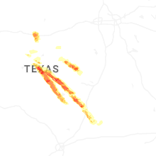
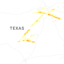

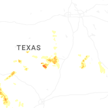


Connect with Interactive Hail Maps