

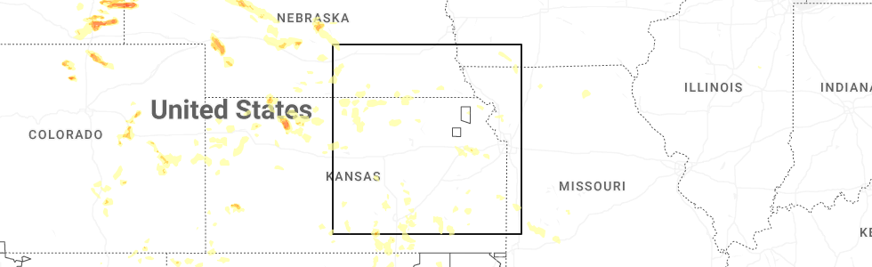
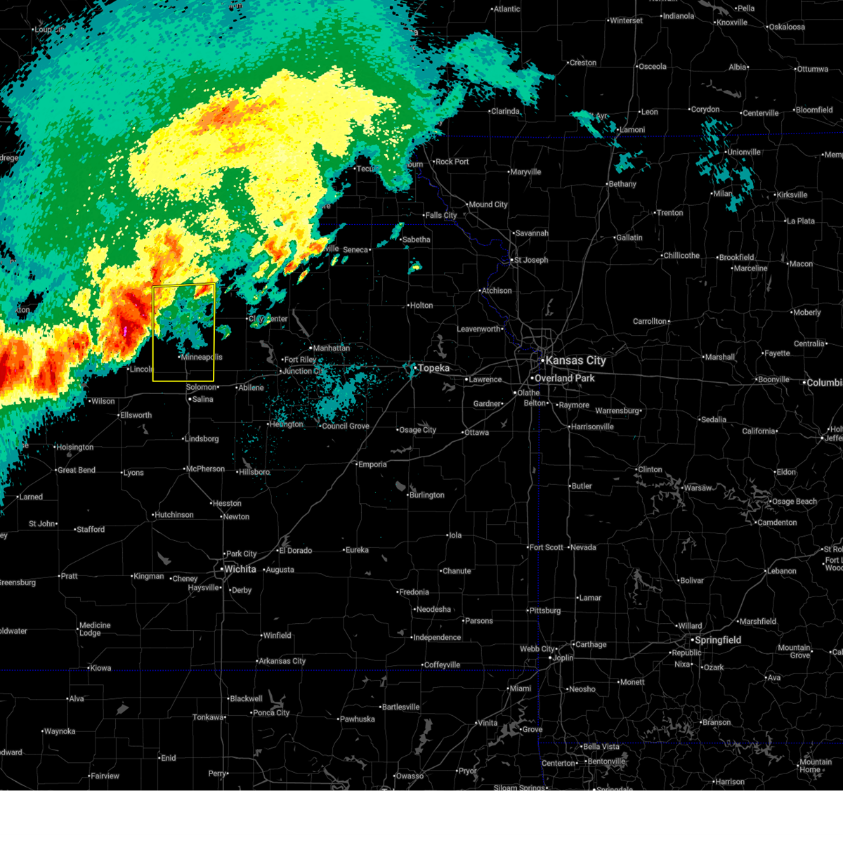
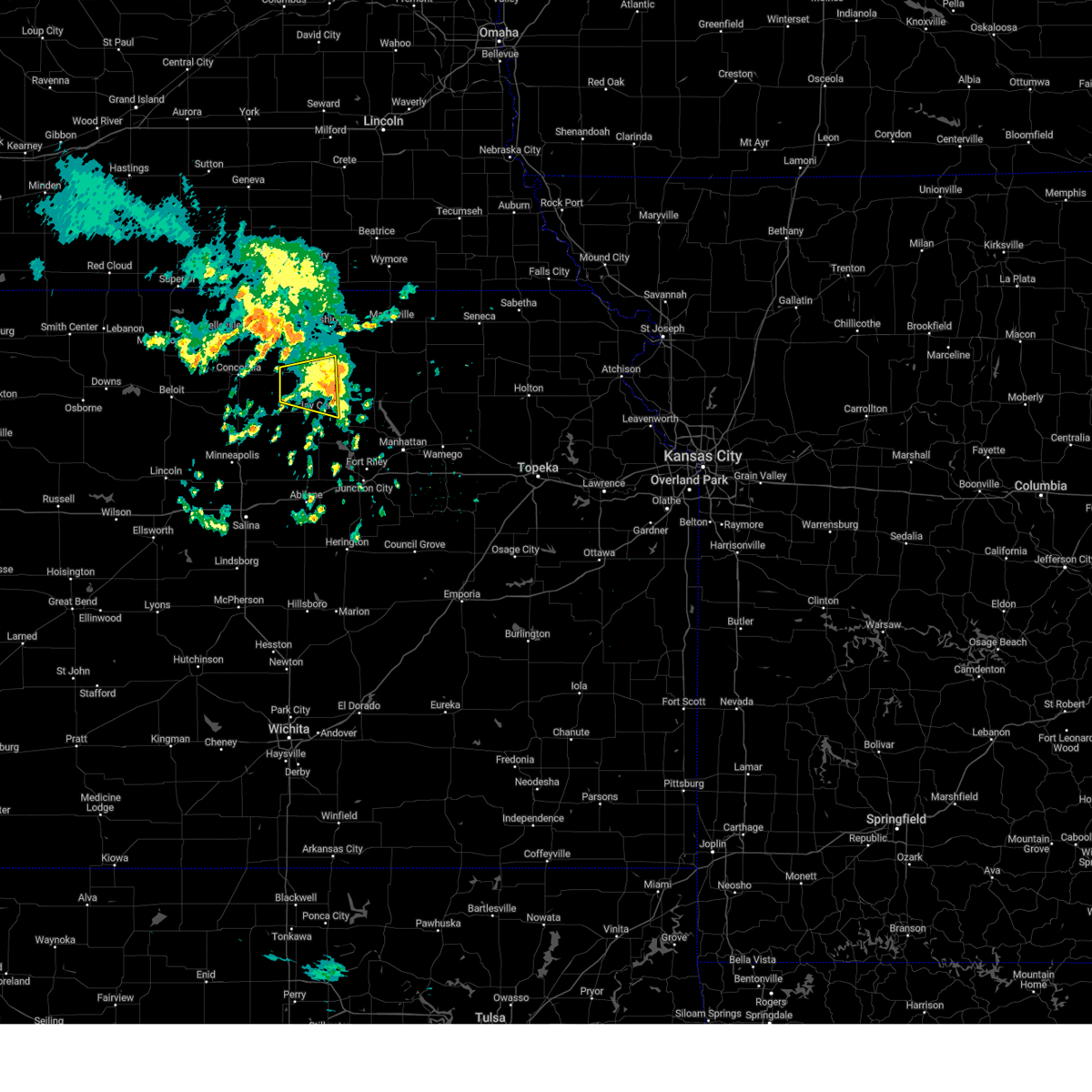
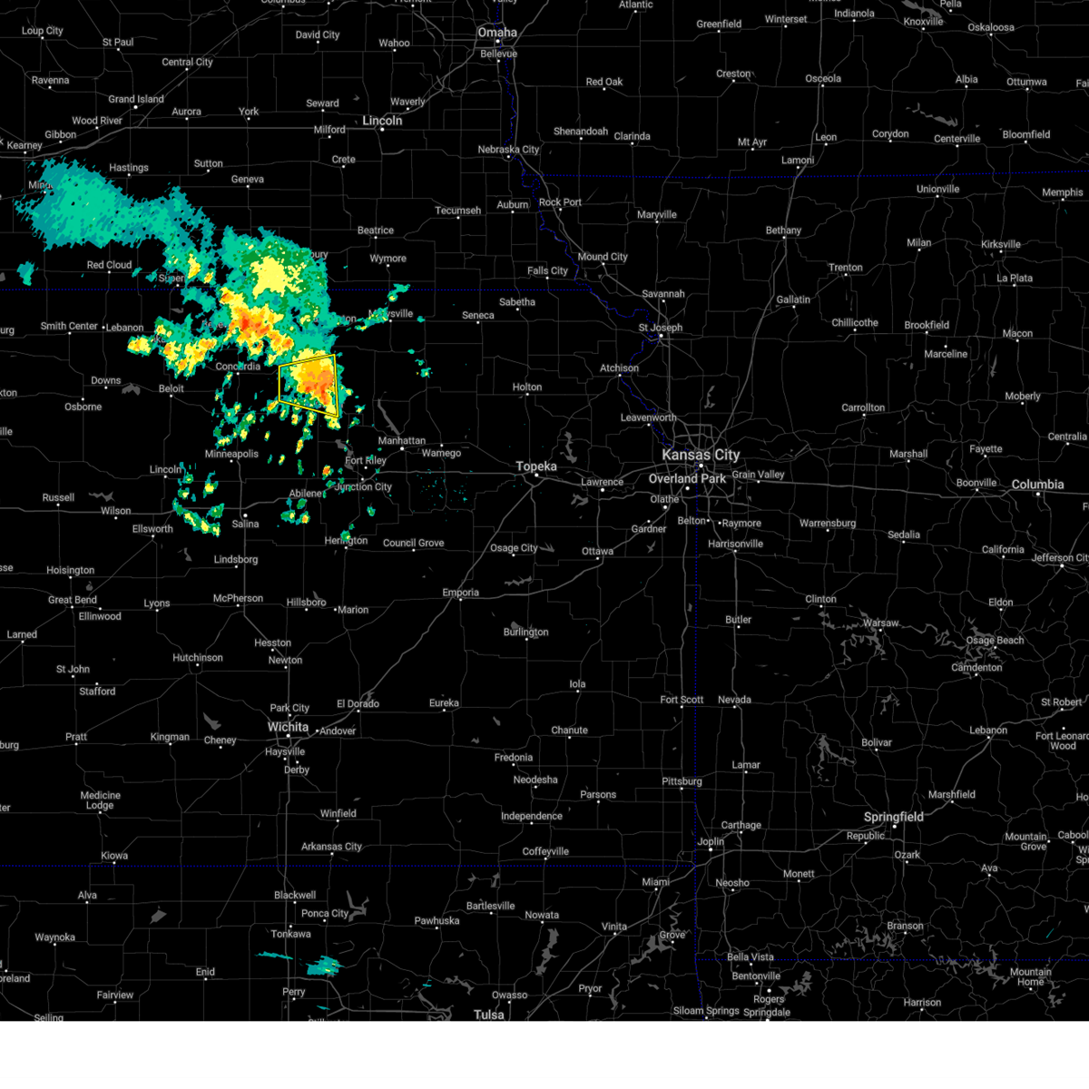
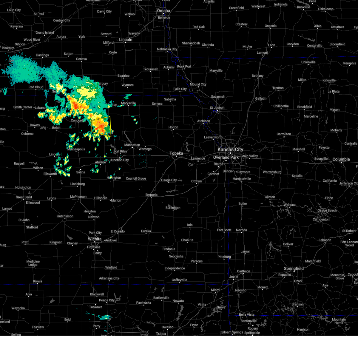
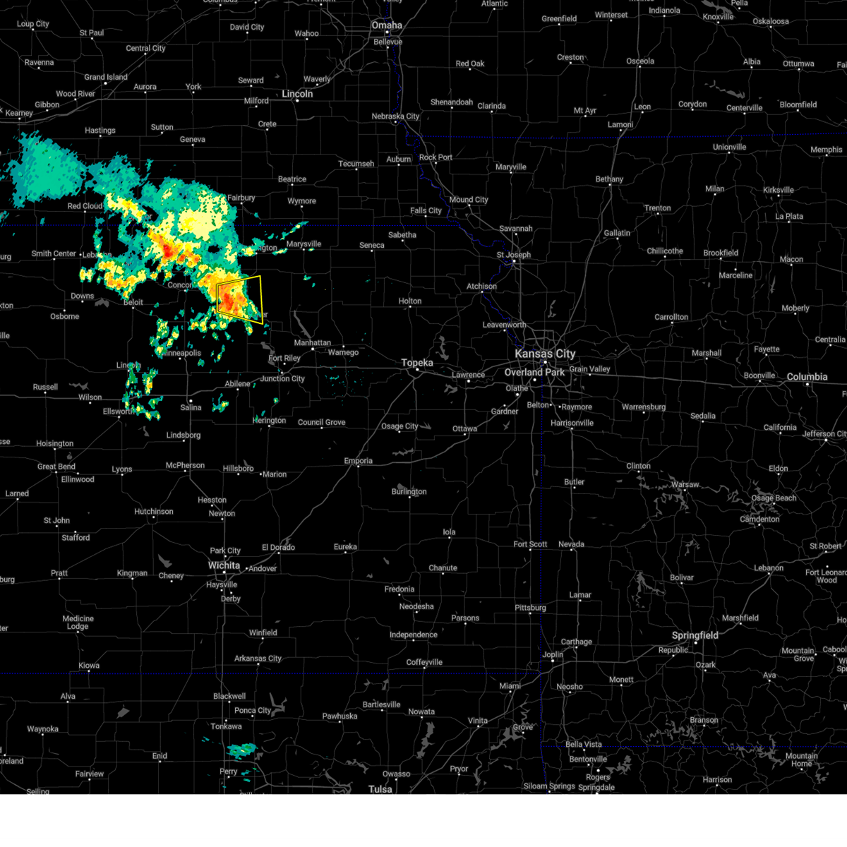
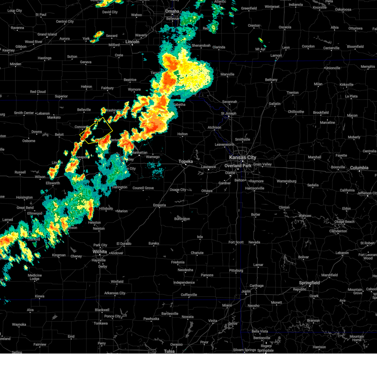
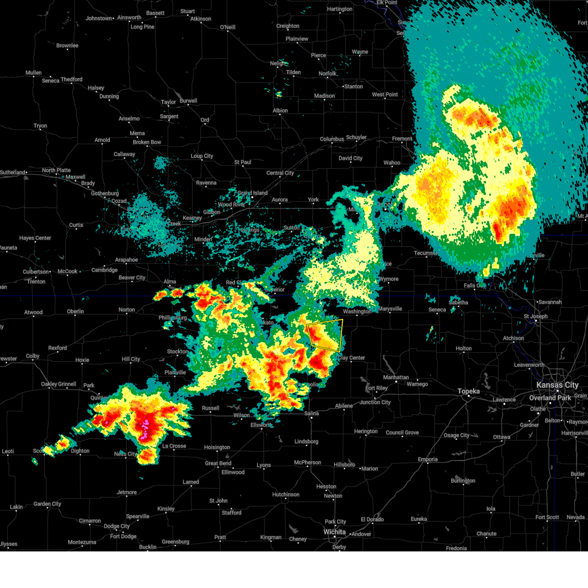
Hail Map for Clyde, KS
The Clyde, KS area has had 26 reports of on-the-ground hail by trained spotters, and has been under severe weather warnings 11 times during the past 12 months. Doppler radar has detected hail at or near Clyde, KS on 107 occasions, including 4 occasions during the past year.
| Name: | Clyde, KS |
| Where Located: | 53.1 miles WNW of Manhattan, KS |
| Map: | Google Map for Clyde, KS |
| Population: | 716 |
| Housing Units: | 370 |
| More Info: | Search Google for Clyde, KS |
0
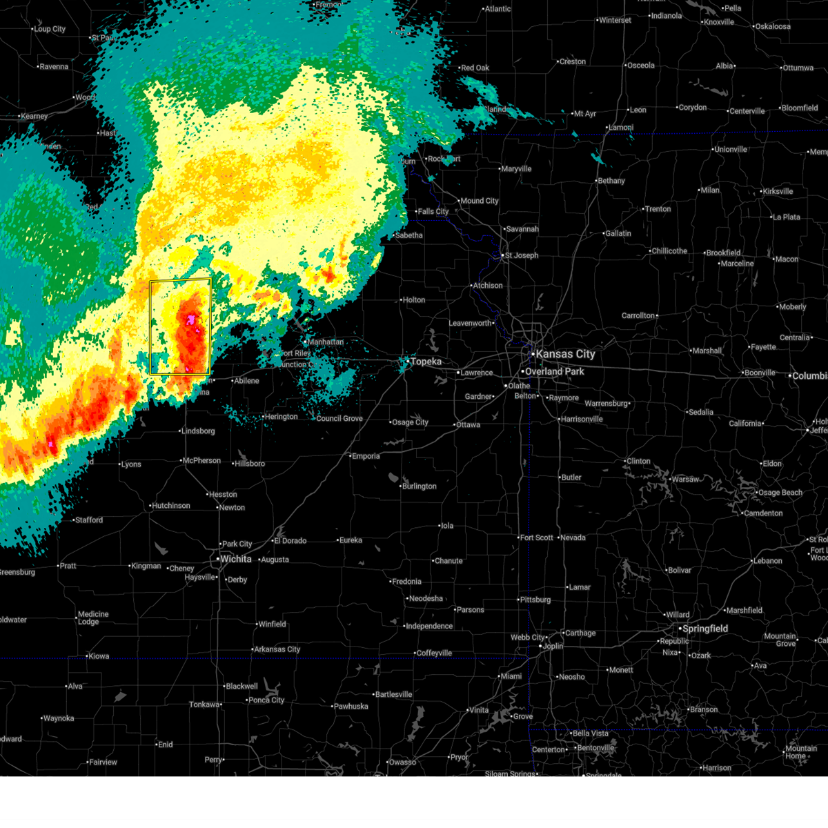
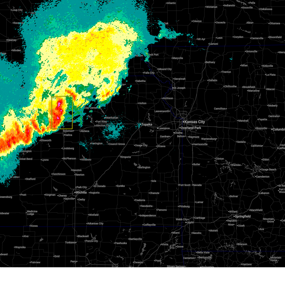
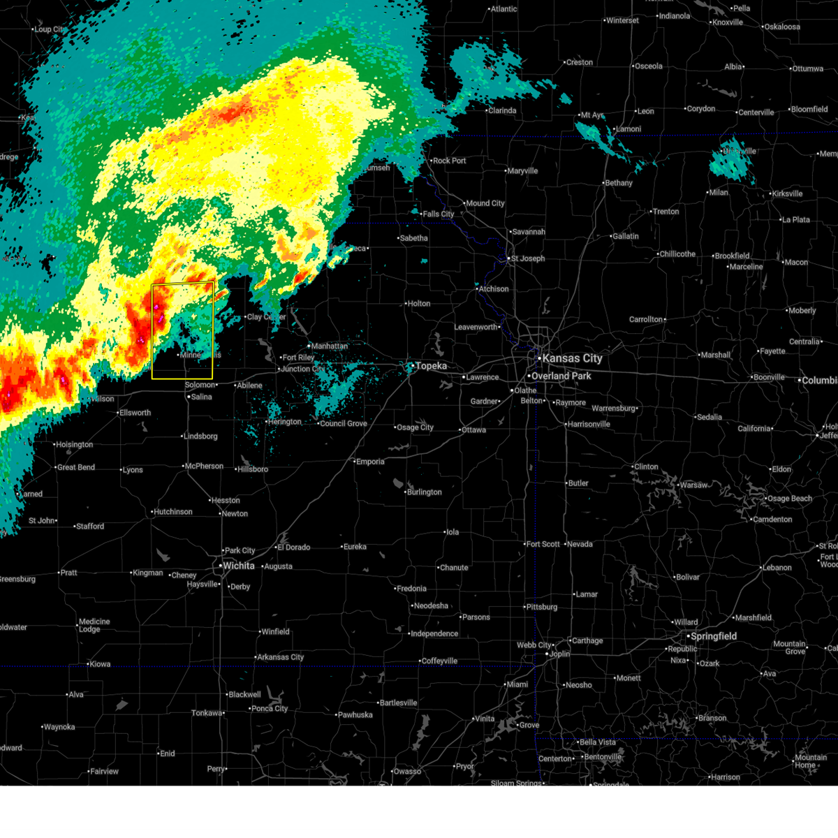
The Top Recent Hail Date for Clyde, KS is Sunday, June 29, 2025 (73rd out of 107)
Hail and Wind Damage Spotted near Clyde, KS
| Date / Time | Report Details |
|---|---|
| 6/17/2025 2:24 AM CDT |
 The storms which prompted the warning have moved out of the area. therefore, the warning will be allowed to expire. a severe thunderstorm watch remains in effect until 700 am cdt for north central kansas. remember, a severe thunderstorm warning still remains in effect for eastern areas of ottawa and cloud counties. The storms which prompted the warning have moved out of the area. therefore, the warning will be allowed to expire. a severe thunderstorm watch remains in effect until 700 am cdt for north central kansas. remember, a severe thunderstorm warning still remains in effect for eastern areas of ottawa and cloud counties.
|
| 6/17/2025 1:51 AM CDT |
 At 151 am cdt, severe thunderstorms were located along a line extending from 5 miles southwest of minneapolis to 7 miles northeast of delphos to near concordia, moving east at 30 mph (radar indicated). Hazards include 70 mph wind gusts and ping pong ball size hail. People and animals outdoors will be injured. expect hail damage to roofs, siding, windows, and vehicles. expect considerable tree damage. wind damage is also likely to mobile homes, roofs, and outbuildings. Locations impacted include, concordia, minneapolis, clyde, bennington, miltonvale, glasco, delphos, tescott, culver, wells, aurora, niles, and ada. At 151 am cdt, severe thunderstorms were located along a line extending from 5 miles southwest of minneapolis to 7 miles northeast of delphos to near concordia, moving east at 30 mph (radar indicated). Hazards include 70 mph wind gusts and ping pong ball size hail. People and animals outdoors will be injured. expect hail damage to roofs, siding, windows, and vehicles. expect considerable tree damage. wind damage is also likely to mobile homes, roofs, and outbuildings. Locations impacted include, concordia, minneapolis, clyde, bennington, miltonvale, glasco, delphos, tescott, culver, wells, aurora, niles, and ada.
|
| 6/17/2025 1:33 AM CDT |
 At 133 am cdt, severe thunderstorms were located along a line extending from near ada to glasco to 5 miles southeast of jamestown, moving east at 20 mph (radar indicated). Hazards include 70 mph wind gusts and quarter size hail. Hail damage to vehicles is expected. expect considerable tree damage. wind damage is also likely to mobile homes, roofs, and outbuildings. Locations impacted include, concordia, minneapolis, clyde, bennington, miltonvale, glasco, delphos, tescott, culver, wells, aurora, niles, and ada. At 133 am cdt, severe thunderstorms were located along a line extending from near ada to glasco to 5 miles southeast of jamestown, moving east at 20 mph (radar indicated). Hazards include 70 mph wind gusts and quarter size hail. Hail damage to vehicles is expected. expect considerable tree damage. wind damage is also likely to mobile homes, roofs, and outbuildings. Locations impacted include, concordia, minneapolis, clyde, bennington, miltonvale, glasco, delphos, tescott, culver, wells, aurora, niles, and ada.
|
| 6/17/2025 1:19 AM CDT |
 Svrtop the national weather service in topeka has issued a * severe thunderstorm warning for, ottawa county in north central kansas, cloud county in north central kansas, * until 230 am cdt. * at 118 am cdt, a severe thunderstorm was located over simpson, or 10 miles east of beloit, moving east at 30 mph (radar indicated). Hazards include 60 mph wind gusts and quarter size hail. Hail damage to vehicles is expected. Expect wind damage to roofs, siding, and trees. Svrtop the national weather service in topeka has issued a * severe thunderstorm warning for, ottawa county in north central kansas, cloud county in north central kansas, * until 230 am cdt. * at 118 am cdt, a severe thunderstorm was located over simpson, or 10 miles east of beloit, moving east at 30 mph (radar indicated). Hazards include 60 mph wind gusts and quarter size hail. Hail damage to vehicles is expected. Expect wind damage to roofs, siding, and trees.
|
| 8/24/2024 3:46 AM CDT |
 the severe thunderstorm warning has been cancelled and is no longer in effect the severe thunderstorm warning has been cancelled and is no longer in effect
|
| 8/24/2024 3:40 AM CDT |
 The storm which prompted the warning has weakened below severe limits, and no longer poses an immediate threat to life or property. therefore, the warning will be allowed to expire. however, gusty winds to around 50 mph are still possible with this thunderstorm. The storm which prompted the warning has weakened below severe limits, and no longer poses an immediate threat to life or property. therefore, the warning will be allowed to expire. however, gusty winds to around 50 mph are still possible with this thunderstorm.
|
| 8/24/2024 3:33 AM CDT |
 At 333 am cdt, a severe thunderstorm was located 4 miles northeast of morganville, moving east at 25 mph (public. at approximately 207 am, a public weather station reported 67 mph wind gust 6 miles south southwest of clyde). Hazards include 60 mph wind gusts and nickel size hail. Expect damage to roofs, siding, and trees. Locations impacted include, clay center, clyde, clifton, morganville, palmer, and vining. At 333 am cdt, a severe thunderstorm was located 4 miles northeast of morganville, moving east at 25 mph (public. at approximately 207 am, a public weather station reported 67 mph wind gust 6 miles south southwest of clyde). Hazards include 60 mph wind gusts and nickel size hail. Expect damage to roofs, siding, and trees. Locations impacted include, clay center, clyde, clifton, morganville, palmer, and vining.
|
| 8/24/2024 3:32 AM CDT |
 Svrtop the national weather service in topeka has issued a * severe thunderstorm warning for, southwestern washington county in north central kansas, northern clay county in north central kansas, east central cloud county in north central kansas, * until 400 am cdt. * at 330 am cdt, a severe thunderstorm was located near morganville, moving east at 25 mph (public. at approximately 207 am, a public weather station reported 67 mph wind gust 6 miles south southwest of clyde). Hazards include 60 mph wind gusts and nickel size hail. expect damage to roofs, siding, and trees Svrtop the national weather service in topeka has issued a * severe thunderstorm warning for, southwestern washington county in north central kansas, northern clay county in north central kansas, east central cloud county in north central kansas, * until 400 am cdt. * at 330 am cdt, a severe thunderstorm was located near morganville, moving east at 25 mph (public. at approximately 207 am, a public weather station reported 67 mph wind gust 6 miles south southwest of clyde). Hazards include 60 mph wind gusts and nickel size hail. expect damage to roofs, siding, and trees
|
| 8/24/2024 3:18 AM CDT |
 Svrtop the national weather service in topeka has issued a * severe thunderstorm warning for, southwestern washington county in north central kansas, northern clay county in north central kansas, east central cloud county in north central kansas, * until 345 am cdt. * at 318 am cdt, a severe thunderstorm was located near vining, moving east at 25 mph (radar indicated). Hazards include 60 mph wind gusts and nickel size hail. expect damage to roofs, siding, and trees Svrtop the national weather service in topeka has issued a * severe thunderstorm warning for, southwestern washington county in north central kansas, northern clay county in north central kansas, east central cloud county in north central kansas, * until 345 am cdt. * at 318 am cdt, a severe thunderstorm was located near vining, moving east at 25 mph (radar indicated). Hazards include 60 mph wind gusts and nickel size hail. expect damage to roofs, siding, and trees
|
| 8/14/2024 8:05 PM CDT |
 Svrtop the national weather service in topeka has issued a * severe thunderstorm warning for, southwestern washington county in north central kansas, northwestern clay county in north central kansas, eastern cloud county in north central kansas, * until 900 pm cdt. * at 805 pm cdt, a severe thunderstorm was located near aurora, moving northeast at 35 mph (radar indicated). Hazards include 60 mph wind gusts. expect damage to roofs, siding, and trees Svrtop the national weather service in topeka has issued a * severe thunderstorm warning for, southwestern washington county in north central kansas, northwestern clay county in north central kansas, eastern cloud county in north central kansas, * until 900 pm cdt. * at 805 pm cdt, a severe thunderstorm was located near aurora, moving northeast at 35 mph (radar indicated). Hazards include 60 mph wind gusts. expect damage to roofs, siding, and trees
|
| 7/31/2024 6:57 PM CDT |
 Svrtop the national weather service in topeka has issued a * severe thunderstorm warning for, southeastern republic county in north central kansas, southwestern washington county in north central kansas, northwestern clay county in north central kansas, northeastern cloud county in north central kansas, * until 730 pm cdt. * at 656 pm cdt, a severe thunderstorm was located 7 miles west of clyde, moving east at 35 mph (radar indicated). Hazards include 60 mph wind gusts and quarter size hail. Hail damage to vehicles is expected. Expect wind damage to roofs, siding, and trees. Svrtop the national weather service in topeka has issued a * severe thunderstorm warning for, southeastern republic county in north central kansas, southwestern washington county in north central kansas, northwestern clay county in north central kansas, northeastern cloud county in north central kansas, * until 730 pm cdt. * at 656 pm cdt, a severe thunderstorm was located 7 miles west of clyde, moving east at 35 mph (radar indicated). Hazards include 60 mph wind gusts and quarter size hail. Hail damage to vehicles is expected. Expect wind damage to roofs, siding, and trees.
|
| 6/26/2024 2:35 AM CDT |
 the severe thunderstorm warning has been cancelled and is no longer in effect the severe thunderstorm warning has been cancelled and is no longer in effect
|
| 6/26/2024 2:35 AM CDT |
 At 234 am cdt, severe thunderstorms were located along a line extending from oneida to 7 miles north of olsburg to 4 miles southwest of miltonvale, moving southeast at 45 mph (radar indicated). Hazards include 60 mph wind gusts and nickel size hail. Expect damage to roofs, siding, and trees. Locations impacted include, concordia, clay center, sabetha, seneca, blue rapids, blaine, frankfort, clyde, waterville, clifton, miltonvale, centralia, linn, axtell, wetmore, greenleaf, beattie, morganville, bern, and barnes. At 234 am cdt, severe thunderstorms were located along a line extending from oneida to 7 miles north of olsburg to 4 miles southwest of miltonvale, moving southeast at 45 mph (radar indicated). Hazards include 60 mph wind gusts and nickel size hail. Expect damage to roofs, siding, and trees. Locations impacted include, concordia, clay center, sabetha, seneca, blue rapids, blaine, frankfort, clyde, waterville, clifton, miltonvale, centralia, linn, axtell, wetmore, greenleaf, beattie, morganville, bern, and barnes.
|
| 6/26/2024 2:19 AM CDT |
 At 218 am cdt, severe thunderstorms were located along a line extending from 6 miles northeast of bern to 7 miles northeast of glasco, moving southeast at 40 mph (radar indicated). Hazards include 60 mph wind gusts and nickel size hail. Expect damage to roofs, siding, and trees. Locations impacted include, concordia, marysville, washington, blue rapids, frankfort, clyde, hanover, waterville, clifton, linn, axtell, greenleaf, jamestown, beattie, barnes, summerfield, cuba, morrowville, norway, and vermillion. At 218 am cdt, severe thunderstorms were located along a line extending from 6 miles northeast of bern to 7 miles northeast of glasco, moving southeast at 40 mph (radar indicated). Hazards include 60 mph wind gusts and nickel size hail. Expect damage to roofs, siding, and trees. Locations impacted include, concordia, marysville, washington, blue rapids, frankfort, clyde, hanover, waterville, clifton, linn, axtell, greenleaf, jamestown, beattie, barnes, summerfield, cuba, morrowville, norway, and vermillion.
|
| 6/26/2024 2:15 AM CDT |
 Svrtop the national weather service in topeka has issued a * severe thunderstorm warning for, northwestern riley county in northeastern kansas, northwestern ottawa county in north central kansas, northern pottawatomie county in northeastern kansas, nemaha county in northeastern kansas, western brown county in northeastern kansas, southern washington county in north central kansas, northern clay county in north central kansas, cloud county in north central kansas, marshall county in northeastern kansas, * until 300 am cdt. * at 214 am cdt, severe thunderstorms were located along a line extending from near pawnee city to 4 miles north of waterville to 5 miles southwest of concordia, moving southeast at 40 mph (radar indicated). Hazards include 60 mph wind gusts and nickel size hail. expect damage to roofs, siding, and trees Svrtop the national weather service in topeka has issued a * severe thunderstorm warning for, northwestern riley county in northeastern kansas, northwestern ottawa county in north central kansas, northern pottawatomie county in northeastern kansas, nemaha county in northeastern kansas, western brown county in northeastern kansas, southern washington county in north central kansas, northern clay county in north central kansas, cloud county in north central kansas, marshall county in northeastern kansas, * until 300 am cdt. * at 214 am cdt, severe thunderstorms were located along a line extending from near pawnee city to 4 miles north of waterville to 5 miles southwest of concordia, moving southeast at 40 mph (radar indicated). Hazards include 60 mph wind gusts and nickel size hail. expect damage to roofs, siding, and trees
|
| 6/26/2024 1:48 AM CDT |
 Svrtop the national weather service in topeka has issued a * severe thunderstorm warning for, republic county in north central kansas, washington county in north central kansas, northern cloud county in north central kansas, marshall county in northeastern kansas, * until 230 am cdt. * at 148 am cdt, severe thunderstorms were located along a line extending from near johnson to near courtland, moving southeast at 35 mph (radar indicated). Hazards include 60 mph wind gusts and nickel size hail. expect damage to roofs, siding, and trees Svrtop the national weather service in topeka has issued a * severe thunderstorm warning for, republic county in north central kansas, washington county in north central kansas, northern cloud county in north central kansas, marshall county in northeastern kansas, * until 230 am cdt. * at 148 am cdt, severe thunderstorms were located along a line extending from near johnson to near courtland, moving southeast at 35 mph (radar indicated). Hazards include 60 mph wind gusts and nickel size hail. expect damage to roofs, siding, and trees
|
| 6/7/2024 11:30 PM CDT |
 the severe thunderstorm warning has been cancelled and is no longer in effect the severe thunderstorm warning has been cancelled and is no longer in effect
|
| 6/7/2024 11:13 PM CDT |
 Svrtop the national weather service in topeka has issued a * severe thunderstorm warning for, southeastern republic county in north central kansas, southern washington county in north central kansas, north central clay county in north central kansas, northeastern cloud county in north central kansas, * until 1145 pm cdt. * at 1112 pm cdt, severe thunderstorms were located along a line extending from 4 miles southeast of narka to 6 miles south of belleville, moving southeast at 35 mph (mesonet. at 1053 pm cdt the kansas mesonet site near belleville reported a 61 mph wind gust). Hazards include 60 mph wind gusts and nickel size hail. expect damage to roofs, siding, and trees Svrtop the national weather service in topeka has issued a * severe thunderstorm warning for, southeastern republic county in north central kansas, southern washington county in north central kansas, north central clay county in north central kansas, northeastern cloud county in north central kansas, * until 1145 pm cdt. * at 1112 pm cdt, severe thunderstorms were located along a line extending from 4 miles southeast of narka to 6 miles south of belleville, moving southeast at 35 mph (mesonet. at 1053 pm cdt the kansas mesonet site near belleville reported a 61 mph wind gust). Hazards include 60 mph wind gusts and nickel size hail. expect damage to roofs, siding, and trees
|
| 6/4/2024 3:30 PM CDT |
 At 330 pm cdt, a severe thunderstorm was located 5 miles southwest of vining, moving east at 25 mph (radar indicated). Hazards include 60 mph wind gusts. Expect damage to roofs, siding, and trees. Locations impacted include, clyde, clifton, morganville, and vining. At 330 pm cdt, a severe thunderstorm was located 5 miles southwest of vining, moving east at 25 mph (radar indicated). Hazards include 60 mph wind gusts. Expect damage to roofs, siding, and trees. Locations impacted include, clyde, clifton, morganville, and vining.
|
| 6/4/2024 3:21 PM CDT |
 At 320 pm cdt, a severe thunderstorm was located 6 miles northeast of aurora, moving east at 25 mph (radar indicated). Hazards include 60 mph wind gusts and penny size hail. Expect damage to roofs, siding, and trees. Locations impacted include, clyde, clifton, morganville, and vining. At 320 pm cdt, a severe thunderstorm was located 6 miles northeast of aurora, moving east at 25 mph (radar indicated). Hazards include 60 mph wind gusts and penny size hail. Expect damage to roofs, siding, and trees. Locations impacted include, clyde, clifton, morganville, and vining.
|
| 6/4/2024 3:08 PM CDT |
 Svrtop the national weather service in topeka has issued a * severe thunderstorm warning for, southwestern washington county in north central kansas, northwestern clay county in north central kansas, eastern cloud county in north central kansas, * until 400 pm cdt. * at 308 pm cdt, a severe thunderstorm was located near aurora, moving east at 25 mph (radar indicated). Hazards include 60 mph wind gusts and nickel size hail. expect damage to roofs, siding, and trees Svrtop the national weather service in topeka has issued a * severe thunderstorm warning for, southwestern washington county in north central kansas, northwestern clay county in north central kansas, eastern cloud county in north central kansas, * until 400 pm cdt. * at 308 pm cdt, a severe thunderstorm was located near aurora, moving east at 25 mph (radar indicated). Hazards include 60 mph wind gusts and nickel size hail. expect damage to roofs, siding, and trees
|
| 5/25/2024 9:45 PM CDT |
 the severe thunderstorm warning has been cancelled and is no longer in effect the severe thunderstorm warning has been cancelled and is no longer in effect
|
| 5/25/2024 9:37 PM CDT |
 At 936 pm cdt, a severe thunderstorm was located 5 miles west of concordia, moving east at 35 mph (radar indicated). Hazards include 60 mph wind gusts and quarter size hail. Hail damage to vehicles is expected. expect wind damage to roofs, siding, and trees. Locations impacted include, concordia, clyde, jamestown, and agenda. At 936 pm cdt, a severe thunderstorm was located 5 miles west of concordia, moving east at 35 mph (radar indicated). Hazards include 60 mph wind gusts and quarter size hail. Hail damage to vehicles is expected. expect wind damage to roofs, siding, and trees. Locations impacted include, concordia, clyde, jamestown, and agenda.
|
| 5/25/2024 9:13 PM CDT |
 Svrtop the national weather service in topeka has issued a * severe thunderstorm warning for, southern republic county in north central kansas, cloud county in north central kansas, * until 1000 pm cdt. * at 912 pm cdt, a severe thunderstorm was located 4 miles west of scottsville, moving east at 40 mph (radar indicated). Hazards include ping pong ball size hail and 60 mph wind gusts. People and animals outdoors will be injured. expect hail damage to roofs, siding, windows, and vehicles. Expect wind damage to roofs, siding, and trees. Svrtop the national weather service in topeka has issued a * severe thunderstorm warning for, southern republic county in north central kansas, cloud county in north central kansas, * until 1000 pm cdt. * at 912 pm cdt, a severe thunderstorm was located 4 miles west of scottsville, moving east at 40 mph (radar indicated). Hazards include ping pong ball size hail and 60 mph wind gusts. People and animals outdoors will be injured. expect hail damage to roofs, siding, windows, and vehicles. Expect wind damage to roofs, siding, and trees.
|
| 5/6/2024 8:39 PM CDT |
 The storms which prompted the warning have weakened below severe limits, and no longer pose an immediate threat to life or property. therefore, the warning will be allowed to expire. however, small hail is still possible with these thunderstorms. a tornado watch remains in effect until 1100 pm cdt for north central kansas. The storms which prompted the warning have weakened below severe limits, and no longer pose an immediate threat to life or property. therefore, the warning will be allowed to expire. however, small hail is still possible with these thunderstorms. a tornado watch remains in effect until 1100 pm cdt for north central kansas.
|
| 5/6/2024 8:22 PM CDT |
 Svrtop the national weather service in topeka has issued a * severe thunderstorm warning for, central ottawa county in north central kansas, southwestern washington county in north central kansas, eastern cloud county in north central kansas, * until 845 pm cdt. * at 822 pm cdt, severe thunderstorms were located along a line extending from 6 miles northeast of concordia to 3 miles northeast of delphos to 4 miles south of tescott, moving northeast at 45 mph (radar indicated). Hazards include quarter size hail. damage to vehicles is expected Svrtop the national weather service in topeka has issued a * severe thunderstorm warning for, central ottawa county in north central kansas, southwestern washington county in north central kansas, eastern cloud county in north central kansas, * until 845 pm cdt. * at 822 pm cdt, severe thunderstorms were located along a line extending from 6 miles northeast of concordia to 3 miles northeast of delphos to 4 miles south of tescott, moving northeast at 45 mph (radar indicated). Hazards include quarter size hail. damage to vehicles is expected
|
| 5/6/2024 7:56 PM CDT |
 Svrtop the national weather service in topeka has issued a * severe thunderstorm warning for, western ottawa county in north central kansas, southeastern republic county in north central kansas, cloud county in north central kansas, * until 830 pm cdt. * at 756 pm cdt, severe thunderstorms were located along a line extending from 8 miles north of concordia to near glasco to near kanopolis, moving northeast at 40 mph (radar indicated). Hazards include 60 mph wind gusts and quarter size hail. Hail damage to vehicles is expected. Expect wind damage to roofs, siding, and trees. Svrtop the national weather service in topeka has issued a * severe thunderstorm warning for, western ottawa county in north central kansas, southeastern republic county in north central kansas, cloud county in north central kansas, * until 830 pm cdt. * at 756 pm cdt, severe thunderstorms were located along a line extending from 8 miles north of concordia to near glasco to near kanopolis, moving northeast at 40 mph (radar indicated). Hazards include 60 mph wind gusts and quarter size hail. Hail damage to vehicles is expected. Expect wind damage to roofs, siding, and trees.
|
| 5/6/2024 5:59 PM CDT |
 Tortop the national weather service in topeka has issued a * tornado warning for, southwestern washington county in north central kansas, northwestern clay county in north central kansas, eastern cloud county in north central kansas, * until 630 pm cdt. * at 558 pm cdt, a severe thunderstorm capable of producing a tornado was located 4 miles northeast of miltonvale, moving northeast at 45 mph (radar indicated rotation). Hazards include tornado. Flying debris will be dangerous to those caught without shelter. mobile homes will be damaged or destroyed. damage to roofs, windows, and vehicles will occur. Tree damage is likely. Tortop the national weather service in topeka has issued a * tornado warning for, southwestern washington county in north central kansas, northwestern clay county in north central kansas, eastern cloud county in north central kansas, * until 630 pm cdt. * at 558 pm cdt, a severe thunderstorm capable of producing a tornado was located 4 miles northeast of miltonvale, moving northeast at 45 mph (radar indicated rotation). Hazards include tornado. Flying debris will be dangerous to those caught without shelter. mobile homes will be damaged or destroyed. damage to roofs, windows, and vehicles will occur. Tree damage is likely.
|
| 4/17/2024 11:29 PM CDT | Half Dollar sized hail reported 0.1 miles NE of Clyde, KS |
| 4/17/2024 11:12 PM CDT |
 Svrtop the national weather service in topeka has issued a * severe thunderstorm warning for, southeastern republic county in north central kansas, southwestern washington county in north central kansas, northeastern cloud county in north central kansas, * until midnight cdt. * at 1111 pm cdt, a severe thunderstorm was located near agenda, moving east at 35 mph (radar indicated). Hazards include 60 mph wind gusts and half dollar size hail. Hail damage to vehicles is expected. Expect wind damage to roofs, siding, and trees. Svrtop the national weather service in topeka has issued a * severe thunderstorm warning for, southeastern republic county in north central kansas, southwestern washington county in north central kansas, northeastern cloud county in north central kansas, * until midnight cdt. * at 1111 pm cdt, a severe thunderstorm was located near agenda, moving east at 35 mph (radar indicated). Hazards include 60 mph wind gusts and half dollar size hail. Hail damage to vehicles is expected. Expect wind damage to roofs, siding, and trees.
|
| 4/6/2024 5:10 PM CDT |
 Svrtop the national weather service in topeka has issued a * severe thunderstorm warning for, northern dickinson county in central kansas, eastern ottawa county in north central kansas, eastern republic county in north central kansas, washington county in north central kansas, clay county in north central kansas, eastern cloud county in north central kansas, * until 545 pm cdt. * at 510 pm cdt, severe thunderstorms were located along a line extending from near munden to 5 miles south of vining to 4 miles southeast of new cambria, moving northeast at 55 mph (radar indicated). Hazards include 70 mph wind gusts and quarter size hail. Hail damage to vehicles is expected. expect considerable tree damage. Wind damage is also likely to mobile homes, roofs, and outbuildings. Svrtop the national weather service in topeka has issued a * severe thunderstorm warning for, northern dickinson county in central kansas, eastern ottawa county in north central kansas, eastern republic county in north central kansas, washington county in north central kansas, clay county in north central kansas, eastern cloud county in north central kansas, * until 545 pm cdt. * at 510 pm cdt, severe thunderstorms were located along a line extending from near munden to 5 miles south of vining to 4 miles southeast of new cambria, moving northeast at 55 mph (radar indicated). Hazards include 70 mph wind gusts and quarter size hail. Hail damage to vehicles is expected. expect considerable tree damage. Wind damage is also likely to mobile homes, roofs, and outbuildings.
|
| 4/6/2024 4:51 PM CDT |
 At 451 pm cdt, severe thunderstorms were located along a line extending from deshler to 7 miles southwest of vining to near assaria, moving north at 55 mph (radar indicated). Hazards include 70 mph wind gusts and quarter size hail. Hail damage to vehicles is expected. expect considerable tree damage. wind damage is also likely to mobile homes, roofs, and outbuildings. Locations impacted include, concordia, belleville, clyde, clifton, miltonvale, scandia, cuba, norway, wells, republic, munden, manchester, narka, longford, agenda, aurora, vining, oak hill, niles, and talmage. At 451 pm cdt, severe thunderstorms were located along a line extending from deshler to 7 miles southwest of vining to near assaria, moving north at 55 mph (radar indicated). Hazards include 70 mph wind gusts and quarter size hail. Hail damage to vehicles is expected. expect considerable tree damage. wind damage is also likely to mobile homes, roofs, and outbuildings. Locations impacted include, concordia, belleville, clyde, clifton, miltonvale, scandia, cuba, norway, wells, republic, munden, manchester, narka, longford, agenda, aurora, vining, oak hill, niles, and talmage.
|
| 4/6/2024 4:41 PM CDT |
 Svrtop the national weather service in topeka has issued a * severe thunderstorm warning for, northwestern dickinson county in central kansas, ottawa county in north central kansas, republic county in north central kansas, southwestern washington county in north central kansas, western clay county in north central kansas, cloud county in north central kansas, * until 515 pm cdt. * at 440 pm cdt, severe thunderstorms were located along a line extending from byron to near miltonvale to 4 miles southeast of lindsborg, moving north at 55 mph (radar indicated). Hazards include 70 mph wind gusts and nickel size hail. Expect considerable tree damage. Damage is likely to mobile homes, roofs, and outbuildings. Svrtop the national weather service in topeka has issued a * severe thunderstorm warning for, northwestern dickinson county in central kansas, ottawa county in north central kansas, republic county in north central kansas, southwestern washington county in north central kansas, western clay county in north central kansas, cloud county in north central kansas, * until 515 pm cdt. * at 440 pm cdt, severe thunderstorms were located along a line extending from byron to near miltonvale to 4 miles southeast of lindsborg, moving north at 55 mph (radar indicated). Hazards include 70 mph wind gusts and nickel size hail. Expect considerable tree damage. Damage is likely to mobile homes, roofs, and outbuildings.
|
| 4/6/2024 4:26 PM CDT |
 At 425 pm cdt, severe thunderstorms were located along a line extending from near courtland to 6 miles northeast of delphos to 3 miles northwest of mcpherson, moving northeast at 55 mph (radar indicated). Hazards include 70 mph wind gusts and quarter size hail. Hail damage to vehicles is expected. expect considerable tree damage. wind damage is also likely to mobile homes, roofs, and outbuildings. Locations impacted include, concordia, minneapolis, belleville, clyde, bennington, miltonvale, glasco, scandia, delphos, jamestown, courtland, cuba, norway, culver, wells, republic, munden, narka, agenda, and aurora. At 425 pm cdt, severe thunderstorms were located along a line extending from near courtland to 6 miles northeast of delphos to 3 miles northwest of mcpherson, moving northeast at 55 mph (radar indicated). Hazards include 70 mph wind gusts and quarter size hail. Hail damage to vehicles is expected. expect considerable tree damage. wind damage is also likely to mobile homes, roofs, and outbuildings. Locations impacted include, concordia, minneapolis, belleville, clyde, bennington, miltonvale, glasco, scandia, delphos, jamestown, courtland, cuba, norway, culver, wells, republic, munden, narka, agenda, and aurora.
|
| 4/6/2024 4:14 PM CDT |
 Svrtop the national weather service in topeka has issued a * severe thunderstorm warning for, ottawa county in north central kansas, republic county in north central kansas, cloud county in north central kansas, * until 445 pm cdt. * at 413 pm cdt, severe thunderstorms were located along a line extending from 4 miles east of randall to 4 miles south of delphos to near inman, moving northeast at 55 mph (radar indicated). Hazards include 70 mph wind gusts. Expect considerable tree damage. Damage is likely to mobile homes, roofs, and outbuildings. Svrtop the national weather service in topeka has issued a * severe thunderstorm warning for, ottawa county in north central kansas, republic county in north central kansas, cloud county in north central kansas, * until 445 pm cdt. * at 413 pm cdt, severe thunderstorms were located along a line extending from 4 miles east of randall to 4 miles south of delphos to near inman, moving northeast at 55 mph (radar indicated). Hazards include 70 mph wind gusts. Expect considerable tree damage. Damage is likely to mobile homes, roofs, and outbuildings.
|
| 3/14/2024 12:11 AM CDT |
 The storms which prompted the warning have moved out of the area. therefore, the warning will be allowed to expire. a severe thunderstorm watch remains in effect until 100 am cdt for north central kansas. remember, a severe thunderstorm warning still remains in effect for portions of washington and clay counties until 1230 am cdt. The storms which prompted the warning have moved out of the area. therefore, the warning will be allowed to expire. a severe thunderstorm watch remains in effect until 100 am cdt for north central kansas. remember, a severe thunderstorm warning still remains in effect for portions of washington and clay counties until 1230 am cdt.
|
| 3/13/2024 11:57 PM CDT |
 At 1157 pm cdt, severe thunderstorms were located along a line extending from 3 miles northeast of clyde to near manchester, moving northeast at 30 mph (radar indicated). Hazards include 60 mph wind gusts and quarter size hail. Hail damage to vehicles is expected. expect wind damage to roofs, siding, and trees. Locations impacted include, clyde, clifton, morganville, manchester, longford, vining, oak hill, and idana. At 1157 pm cdt, severe thunderstorms were located along a line extending from 3 miles northeast of clyde to near manchester, moving northeast at 30 mph (radar indicated). Hazards include 60 mph wind gusts and quarter size hail. Hail damage to vehicles is expected. expect wind damage to roofs, siding, and trees. Locations impacted include, clyde, clifton, morganville, manchester, longford, vining, oak hill, and idana.
|
| 3/13/2024 11:57 PM CDT |
 the severe thunderstorm warning has been cancelled and is no longer in effect the severe thunderstorm warning has been cancelled and is no longer in effect
|
| 3/13/2024 11:50 PM CDT |
 At 1149 pm cdt, severe thunderstorms were located along a line extending from clyde to near manchester, moving northeast at 30 mph (radar indicated). Hazards include 60 mph wind gusts and quarter size hail. Hail damage to vehicles is expected. expect wind damage to roofs, siding, and trees. Locations impacted include, clyde, clifton, miltonvale, morganville, manchester, longford, aurora, vining, oak hill, talmage, and idana. At 1149 pm cdt, severe thunderstorms were located along a line extending from clyde to near manchester, moving northeast at 30 mph (radar indicated). Hazards include 60 mph wind gusts and quarter size hail. Hail damage to vehicles is expected. expect wind damage to roofs, siding, and trees. Locations impacted include, clyde, clifton, miltonvale, morganville, manchester, longford, aurora, vining, oak hill, talmage, and idana.
|
| 3/13/2024 11:38 PM CDT |
 Svrtop the national weather service in topeka has issued a * severe thunderstorm warning for, northwestern dickinson county in central kansas, eastern ottawa county in north central kansas, southwestern washington county in north central kansas, western clay county in north central kansas, eastern cloud county in north central kansas, * until 1215 am cdt. * at 1136 pm cdt, severe thunderstorms were located along a line extending from 3 miles northwest of miltonvale to near niles, moving east at 25 mph (public. at 1130 pm cdt the public reported 55 to 60 mph winds 3 miles north of minneapolis on highway 81). Hazards include 60 mph wind gusts and quarter size hail. Hail damage to vehicles could occur. Expect wind damage to roofs, siding, and trees. Svrtop the national weather service in topeka has issued a * severe thunderstorm warning for, northwestern dickinson county in central kansas, eastern ottawa county in north central kansas, southwestern washington county in north central kansas, western clay county in north central kansas, eastern cloud county in north central kansas, * until 1215 am cdt. * at 1136 pm cdt, severe thunderstorms were located along a line extending from 3 miles northwest of miltonvale to near niles, moving east at 25 mph (public. at 1130 pm cdt the public reported 55 to 60 mph winds 3 miles north of minneapolis on highway 81). Hazards include 60 mph wind gusts and quarter size hail. Hail damage to vehicles could occur. Expect wind damage to roofs, siding, and trees.
|
| 9/16/2023 4:42 PM CDT |
 At 442 pm cdt, a severe thunderstorm was located near clyde, moving south at 25 mph (radar indicated). Hazards include 60 mph wind gusts and quarter size hail. Hail damage to vehicles is expected. Expect wind damage to roofs, siding, and trees. At 442 pm cdt, a severe thunderstorm was located near clyde, moving south at 25 mph (radar indicated). Hazards include 60 mph wind gusts and quarter size hail. Hail damage to vehicles is expected. Expect wind damage to roofs, siding, and trees.
|
| 8/10/2023 10:13 PM CDT |
 At 1012 pm cdt, a severe thunderstorm was located 5 miles west of clyde, moving southeast at 30 mph (radar indicated). Hazards include 60 mph wind gusts and quarter size hail. Hail damage to vehicles is expected. expect wind damage to roofs, siding, and trees. locations impacted include, concordia, clyde, agenda and aurora. hail threat, radar indicated max hail size, 1. 00 in wind threat, radar indicated max wind gust, 60 mph. At 1012 pm cdt, a severe thunderstorm was located 5 miles west of clyde, moving southeast at 30 mph (radar indicated). Hazards include 60 mph wind gusts and quarter size hail. Hail damage to vehicles is expected. expect wind damage to roofs, siding, and trees. locations impacted include, concordia, clyde, agenda and aurora. hail threat, radar indicated max hail size, 1. 00 in wind threat, radar indicated max wind gust, 60 mph.
|
| 8/10/2023 9:54 PM CDT |
 At 954 pm cdt, a severe thunderstorm was located 6 miles north of concordia, moving southeast at 35 mph (radar indicated). Hazards include ping pong ball size hail and 60 mph wind gusts. People and animals outdoors will be injured. expect hail damage to roofs, siding, windows, and vehicles. Expect wind damage to roofs, siding, and trees. At 954 pm cdt, a severe thunderstorm was located 6 miles north of concordia, moving southeast at 35 mph (radar indicated). Hazards include ping pong ball size hail and 60 mph wind gusts. People and animals outdoors will be injured. expect hail damage to roofs, siding, windows, and vehicles. Expect wind damage to roofs, siding, and trees.
|
| 7/28/2023 6:51 PM CDT |
 The severe thunderstorm warning for southeastern republic, southwestern washington and central cloud counties will expire at 700 pm cdt, the storms which prompted the warning have weakened below severe limits, and no longer pose an immediate threat to life or property. therefore, the warning will be allowed to expire. however gusty winds are still possible with these thunderstorms. The severe thunderstorm warning for southeastern republic, southwestern washington and central cloud counties will expire at 700 pm cdt, the storms which prompted the warning have weakened below severe limits, and no longer pose an immediate threat to life or property. therefore, the warning will be allowed to expire. however gusty winds are still possible with these thunderstorms.
|
| 7/28/2023 6:46 PM CDT |
 At 645 pm cdt, severe thunderstorms were located along a line extending from 6 miles south of morrowville to 3 miles southwest of agenda to 6 miles southwest of concordia, moving east at 25 mph (trained weather spotters. at 635 pm, trained spotters reported wind gusts of 55 mph near aurora). Hazards include 60 mph wind gusts and quarter size hail. Hail damage to vehicles is expected. expect wind damage to roofs, siding, and trees. locations impacted include, concordia, clyde, clifton, palmer, agenda and vining. hail threat, radar indicated max hail size, 1. 00 in wind threat, observed max wind gust, 60 mph. At 645 pm cdt, severe thunderstorms were located along a line extending from 6 miles south of morrowville to 3 miles southwest of agenda to 6 miles southwest of concordia, moving east at 25 mph (trained weather spotters. at 635 pm, trained spotters reported wind gusts of 55 mph near aurora). Hazards include 60 mph wind gusts and quarter size hail. Hail damage to vehicles is expected. expect wind damage to roofs, siding, and trees. locations impacted include, concordia, clyde, clifton, palmer, agenda and vining. hail threat, radar indicated max hail size, 1. 00 in wind threat, observed max wind gust, 60 mph.
|
| 7/28/2023 6:36 PM CDT |
 At 636 pm cdt, severe thunderstorms were located along a line extending from 7 miles south of haddam to 6 miles southwest of agenda to 6 miles south of jamestown, moving east at 25 mph (radar indicated). Hazards include 60 mph wind gusts and quarter size hail. Hail damage to vehicles is expected. expect wind damage to roofs, siding, and trees. locations impacted include, concordia, clyde, clifton, palmer, agenda and vining. hail threat, radar indicated max hail size, 1. 00 in wind threat, radar indicated max wind gust, 60 mph. At 636 pm cdt, severe thunderstorms were located along a line extending from 7 miles south of haddam to 6 miles southwest of agenda to 6 miles south of jamestown, moving east at 25 mph (radar indicated). Hazards include 60 mph wind gusts and quarter size hail. Hail damage to vehicles is expected. expect wind damage to roofs, siding, and trees. locations impacted include, concordia, clyde, clifton, palmer, agenda and vining. hail threat, radar indicated max hail size, 1. 00 in wind threat, radar indicated max wind gust, 60 mph.
|
| 7/28/2023 6:21 PM CDT |
 At 619 pm cdt, severe thunderstorms were located along a line extending from 3 miles northeast of agenda to 4 miles north of concordia to 3 miles south of scottsville, moving east at 25 mph (trained weather spotters. at 616 pm, trained spotter reported 69 mph wind gust 1 mile north of clyde). Hazards include 70 mph wind gusts and half dollar size hail. Hail damage to vehicles is expected. expect considerable tree damage. wind damage is also likely to mobile homes, roofs, and outbuildings. locations impacted include, concordia, clyde, clifton, jamestown, cuba, norway, palmer, agenda and vining. thunderstorm damage threat, considerable hail threat, radar indicated max hail size, 1. 25 in wind threat, observed max wind gust, 70 mph. At 619 pm cdt, severe thunderstorms were located along a line extending from 3 miles northeast of agenda to 4 miles north of concordia to 3 miles south of scottsville, moving east at 25 mph (trained weather spotters. at 616 pm, trained spotter reported 69 mph wind gust 1 mile north of clyde). Hazards include 70 mph wind gusts and half dollar size hail. Hail damage to vehicles is expected. expect considerable tree damage. wind damage is also likely to mobile homes, roofs, and outbuildings. locations impacted include, concordia, clyde, clifton, jamestown, cuba, norway, palmer, agenda and vining. thunderstorm damage threat, considerable hail threat, radar indicated max hail size, 1. 25 in wind threat, observed max wind gust, 70 mph.
|
| 7/28/2023 6:16 PM CDT | Storm damage reported in cloud county KS, 0.9 miles SE of Clyde, KS |
| 7/28/2023 6:14 PM CDT | Large tree limbs dow in cloud county KS, 0.1 miles NE of Clyde, KS |
| 7/28/2023 6:14 PM CDT |
 At 614 pm cdt, severe thunderstorms were located along a line extending from near agenda to 3 miles north of concordia to 3 miles south of scottsville, moving east at 25 mph (radar indicated). Hazards include 70 mph wind gusts and half dollar size hail. Hail damage to vehicles is expected. expect considerable tree damage. Wind damage is also likely to mobile homes, roofs, and outbuildings. At 614 pm cdt, severe thunderstorms were located along a line extending from near agenda to 3 miles north of concordia to 3 miles south of scottsville, moving east at 25 mph (radar indicated). Hazards include 70 mph wind gusts and half dollar size hail. Hail damage to vehicles is expected. expect considerable tree damage. Wind damage is also likely to mobile homes, roofs, and outbuildings.
|
| 7/28/2023 6:10 PM CDT | Storm damage reported in cloud county KS, 0.6 miles E of Clyde, KS |
| 7/22/2023 4:13 PM CDT |
 The severe thunderstorm warning for central republic, northwestern clay, southwestern washington and northeastern cloud counties will expire at 415 pm cdt, the storm which prompted the warning has moved out of republic, clay and washington counties. therefore, the warning will be allowed to expire for these areas. a new severe thunderstorm warning has been issued in cloud county. a severe thunderstorm watch remains in effect until 1100 pm cdt for north central kansas. The severe thunderstorm warning for central republic, northwestern clay, southwestern washington and northeastern cloud counties will expire at 415 pm cdt, the storm which prompted the warning has moved out of republic, clay and washington counties. therefore, the warning will be allowed to expire for these areas. a new severe thunderstorm warning has been issued in cloud county. a severe thunderstorm watch remains in effect until 1100 pm cdt for north central kansas.
|
| 7/22/2023 4:03 PM CDT |
 At 402 pm cdt, a severe thunderstorm was located 7 miles northeast of concordia, moving south at 25 mph (radar indicated). Hazards include 60 mph wind gusts and quarter size hail. Hail damage to vehicles is expected. expect wind damage to roofs, siding, and trees. locations impacted include, concordia, belleville, clyde, clifton, cuba, munden, agenda and vining. hail threat, radar indicated max hail size, 1. 00 in wind threat, radar indicated max wind gust, 60 mph. At 402 pm cdt, a severe thunderstorm was located 7 miles northeast of concordia, moving south at 25 mph (radar indicated). Hazards include 60 mph wind gusts and quarter size hail. Hail damage to vehicles is expected. expect wind damage to roofs, siding, and trees. locations impacted include, concordia, belleville, clyde, clifton, cuba, munden, agenda and vining. hail threat, radar indicated max hail size, 1. 00 in wind threat, radar indicated max wind gust, 60 mph.
|
| 7/22/2023 3:44 PM CDT |
 At 343 pm cdt, a severe thunderstorm was located 5 miles southeast of belleville, moving southeast at 30 mph (law enforcement reported tree damage in belleville around 3:32 pm. winds were estimated at 60 mph). Hazards include 60 mph wind gusts and quarter size hail. Hail damage to vehicles is expected. Expect wind damage to roofs, siding, and trees. At 343 pm cdt, a severe thunderstorm was located 5 miles southeast of belleville, moving southeast at 30 mph (law enforcement reported tree damage in belleville around 3:32 pm. winds were estimated at 60 mph). Hazards include 60 mph wind gusts and quarter size hail. Hail damage to vehicles is expected. Expect wind damage to roofs, siding, and trees.
|
| 6/29/2023 6:00 AM CDT |
 At 600 am cdt, a severe thunderstorm was located near agenda, moving east at 50 mph (radar indicated). Hazards include golf ball size hail and 70 mph wind gusts. People and animals outdoors will be injured. expect hail damage to roofs, siding, windows, and vehicles. expect considerable tree damage. wind damage is also likely to mobile homes, roofs, and outbuildings. locations impacted include, belleville, clyde, scandia, cuba, norway, munden, narka and agenda. thunderstorm damage threat, considerable hail threat, radar indicated max hail size, 1. 75 in wind threat, radar indicated max wind gust, 70 mph. At 600 am cdt, a severe thunderstorm was located near agenda, moving east at 50 mph (radar indicated). Hazards include golf ball size hail and 70 mph wind gusts. People and animals outdoors will be injured. expect hail damage to roofs, siding, windows, and vehicles. expect considerable tree damage. wind damage is also likely to mobile homes, roofs, and outbuildings. locations impacted include, belleville, clyde, scandia, cuba, norway, munden, narka and agenda. thunderstorm damage threat, considerable hail threat, radar indicated max hail size, 1. 75 in wind threat, radar indicated max wind gust, 70 mph.
|
| 6/29/2023 5:39 AM CDT |
 At 538 am cdt, a severe thunderstorm was located near courtland, moving east at 50 mph (radar indicated). Hazards include golf ball size hail and 70 mph wind gusts. People and animals outdoors will be injured. expect hail damage to roofs, siding, windows, and vehicles. expect considerable tree damage. wind damage is also likely to mobile homes, roofs, and outbuildings. locations impacted include, belleville, clyde, scandia, jamestown, courtland, cuba, norway, republic, munden, narka and agenda. thunderstorm damage threat, considerable hail threat, radar indicated max hail size, 1. 75 in wind threat, radar indicated max wind gust, 70 mph. At 538 am cdt, a severe thunderstorm was located near courtland, moving east at 50 mph (radar indicated). Hazards include golf ball size hail and 70 mph wind gusts. People and animals outdoors will be injured. expect hail damage to roofs, siding, windows, and vehicles. expect considerable tree damage. wind damage is also likely to mobile homes, roofs, and outbuildings. locations impacted include, belleville, clyde, scandia, jamestown, courtland, cuba, norway, republic, munden, narka and agenda. thunderstorm damage threat, considerable hail threat, radar indicated max hail size, 1. 75 in wind threat, radar indicated max wind gust, 70 mph.
|
| 6/29/2023 5:26 AM CDT |
 At 526 am cdt, a severe thunderstorm was located near montrose, moving east at 50 mph (radar indicated). Hazards include golf ball size hail and 60 mph wind gusts. People and animals outdoors will be injured. expect hail damage to roofs, siding, windows, and vehicles. Expect wind damage to roofs, siding, and trees. At 526 am cdt, a severe thunderstorm was located near montrose, moving east at 50 mph (radar indicated). Hazards include golf ball size hail and 60 mph wind gusts. People and animals outdoors will be injured. expect hail damage to roofs, siding, windows, and vehicles. Expect wind damage to roofs, siding, and trees.
|
| 5/9/2023 2:07 PM CDT |
 The severe thunderstorm warning for northern dickinson, southeastern ottawa, clay, southwestern washington and northeastern cloud counties will expire at 215 pm cdt, the storms which prompted the warning have moved out of the area. therefore, the warning will be allowed to expire. a severe thunderstorm watch remains in effect until 600 pm cdt for central, north central, northeastern and east central kansas. remember, a severe thunderstorm warning still remains in effect for portions of dickinson, clay, and washington counties until 245 pm cdt. The severe thunderstorm warning for northern dickinson, southeastern ottawa, clay, southwestern washington and northeastern cloud counties will expire at 215 pm cdt, the storms which prompted the warning have moved out of the area. therefore, the warning will be allowed to expire. a severe thunderstorm watch remains in effect until 600 pm cdt for central, north central, northeastern and east central kansas. remember, a severe thunderstorm warning still remains in effect for portions of dickinson, clay, and washington counties until 245 pm cdt.
|
| 5/9/2023 1:55 PM CDT |
 At 155 pm cdt, severe thunderstorms were located along a line extending from 7 miles south of barnes to 5 miles west of junction city, moving east at 35 mph (trained weather spotters). Hazards include 70 mph wind gusts and ping pong ball size hail. People and animals outdoors will be injured. expect hail damage to roofs, siding, windows, and vehicles. expect considerable tree damage. wind damage is also likely to mobile homes, roofs, and outbuildings. locations impacted include, clay center, chapman, wakefield, clyde, bennington, clifton, linn, greenleaf, morganville, green, palmer, manchester, longford, vining, oak hill, talmage, idana and moonlight. this includes interstate 70 between mile markers 280 and 289. thunderstorm damage threat, considerable hail threat, radar indicated max hail size, 1. 50 in wind threat, observed max wind gust, 70 mph. At 155 pm cdt, severe thunderstorms were located along a line extending from 7 miles south of barnes to 5 miles west of junction city, moving east at 35 mph (trained weather spotters). Hazards include 70 mph wind gusts and ping pong ball size hail. People and animals outdoors will be injured. expect hail damage to roofs, siding, windows, and vehicles. expect considerable tree damage. wind damage is also likely to mobile homes, roofs, and outbuildings. locations impacted include, clay center, chapman, wakefield, clyde, bennington, clifton, linn, greenleaf, morganville, green, palmer, manchester, longford, vining, oak hill, talmage, idana and moonlight. this includes interstate 70 between mile markers 280 and 289. thunderstorm damage threat, considerable hail threat, radar indicated max hail size, 1. 50 in wind threat, observed max wind gust, 70 mph.
|
| 5/9/2023 1:38 PM CDT |
 At 138 pm cdt, severe thunderstorms were located along a line extending from near palmer to 3 miles north of moonlight, moving east at 40 mph (trained weather spotters). Hazards include golf ball size hail and 70 mph wind gusts. People and animals outdoors will be injured. expect hail damage to roofs, siding, windows, and vehicles. expect considerable tree damage. wind damage is also likely to mobile homes, roofs, and outbuildings. locations impacted include, clay center, chapman, wakefield, clyde, bennington, clifton, miltonvale, linn, greenleaf, morganville, green, wells, palmer, manchester, longford, agenda, aurora, vining, oak hill and talmage. this includes interstate 70 between mile markers 280 and 289. thunderstorm damage threat, considerable hail threat, radar indicated max hail size, 1. 75 in wind threat, observed max wind gust, 70 mph. At 138 pm cdt, severe thunderstorms were located along a line extending from near palmer to 3 miles north of moonlight, moving east at 40 mph (trained weather spotters). Hazards include golf ball size hail and 70 mph wind gusts. People and animals outdoors will be injured. expect hail damage to roofs, siding, windows, and vehicles. expect considerable tree damage. wind damage is also likely to mobile homes, roofs, and outbuildings. locations impacted include, clay center, chapman, wakefield, clyde, bennington, clifton, miltonvale, linn, greenleaf, morganville, green, wells, palmer, manchester, longford, agenda, aurora, vining, oak hill and talmage. this includes interstate 70 between mile markers 280 and 289. thunderstorm damage threat, considerable hail threat, radar indicated max hail size, 1. 75 in wind threat, observed max wind gust, 70 mph.
|
| 5/9/2023 1:08 PM CDT |
 At 107 pm cdt, severe thunderstorms were located along a line extending from 4 miles south of agenda to 5 miles southeast of wells, moving east at 35 mph (trained weather spotters). Hazards include two inch hail and 70 mph wind gusts. People and animals outdoors will be injured. expect hail damage to roofs, siding, windows, and vehicles. expect considerable tree damage. Wind damage is also likely to mobile homes, roofs, and outbuildings. At 107 pm cdt, severe thunderstorms were located along a line extending from 4 miles south of agenda to 5 miles southeast of wells, moving east at 35 mph (trained weather spotters). Hazards include two inch hail and 70 mph wind gusts. People and animals outdoors will be injured. expect hail damage to roofs, siding, windows, and vehicles. expect considerable tree damage. Wind damage is also likely to mobile homes, roofs, and outbuildings.
|
| 5/9/2023 12:52 PM CDT |
 At 1252 pm cdt, severe thunderstorms were located along a line extending from belleville to 4 miles northeast of minneapolis, moving east at 35 mph (trained weather spotters). Hazards include two inch hail and 70 mph wind gusts. People and animals outdoors will be injured. expect hail damage to roofs, siding, windows, and vehicles. expect considerable tree damage. wind damage is also likely to mobile homes, roofs, and outbuildings. locations impacted include, concordia, minneapolis, belleville, clyde, miltonvale, glasco, scandia, delphos, jamestown, courtland, cuba, norway, wells, munden, agenda, aurora and ada. thunderstorm damage threat, considerable hail threat, radar indicated max hail size, 2. 00 in wind threat, radar indicated max wind gust, 70 mph. At 1252 pm cdt, severe thunderstorms were located along a line extending from belleville to 4 miles northeast of minneapolis, moving east at 35 mph (trained weather spotters). Hazards include two inch hail and 70 mph wind gusts. People and animals outdoors will be injured. expect hail damage to roofs, siding, windows, and vehicles. expect considerable tree damage. wind damage is also likely to mobile homes, roofs, and outbuildings. locations impacted include, concordia, minneapolis, belleville, clyde, miltonvale, glasco, scandia, delphos, jamestown, courtland, cuba, norway, wells, munden, agenda, aurora and ada. thunderstorm damage threat, considerable hail threat, radar indicated max hail size, 2. 00 in wind threat, radar indicated max wind gust, 70 mph.
|
| 5/9/2023 12:40 PM CDT |
 At 1240 pm cdt, severe thunderstorms were located along a line extending from near cuba to 4 miles northwest of minneapolis, moving east at 45 mph (trained weather spotters). Hazards include tennis ball size hail and 70 mph wind gusts. People and animals outdoors will be injured. expect hail damage to roofs, siding, windows, and vehicles. expect considerable tree damage. wind damage is also likely to mobile homes, roofs, and outbuildings. locations impacted include, concordia, minneapolis, belleville, clyde, miltonvale, glasco, scandia, delphos, jamestown, courtland, cuba, norway, wells, munden, agenda, aurora and ada. thunderstorm damage threat, considerable hail threat, radar indicated max hail size, 2. 50 in wind threat, radar indicated max wind gust, 70 mph. At 1240 pm cdt, severe thunderstorms were located along a line extending from near cuba to 4 miles northwest of minneapolis, moving east at 45 mph (trained weather spotters). Hazards include tennis ball size hail and 70 mph wind gusts. People and animals outdoors will be injured. expect hail damage to roofs, siding, windows, and vehicles. expect considerable tree damage. wind damage is also likely to mobile homes, roofs, and outbuildings. locations impacted include, concordia, minneapolis, belleville, clyde, miltonvale, glasco, scandia, delphos, jamestown, courtland, cuba, norway, wells, munden, agenda, aurora and ada. thunderstorm damage threat, considerable hail threat, radar indicated max hail size, 2. 50 in wind threat, radar indicated max wind gust, 70 mph.
|
| 5/9/2023 12:28 PM CDT |
 At 1228 pm cdt, severe thunderstorms were located along a line extending from belleville to near ada, moving east at 50 mph (radar indicated). Hazards include two inch hail and 70 mph wind gusts. People and animals outdoors will be injured. expect hail damage to roofs, siding, windows, and vehicles. expect considerable tree damage. Wind damage is also likely to mobile homes, roofs, and outbuildings. At 1228 pm cdt, severe thunderstorms were located along a line extending from belleville to near ada, moving east at 50 mph (radar indicated). Hazards include two inch hail and 70 mph wind gusts. People and animals outdoors will be injured. expect hail damage to roofs, siding, windows, and vehicles. expect considerable tree damage. Wind damage is also likely to mobile homes, roofs, and outbuildings.
|
| 5/7/2023 9:23 PM CDT |
 At 922 pm cdt, severe thunderstorms were located along a line extending from munden to 3 miles north of aurora, moving east at 50 mph (trained weather spotters). Hazards include 60 mph wind gusts and quarter size hail. Hail damage to vehicles is expected. Expect wind damage to roofs, siding, and trees. At 922 pm cdt, severe thunderstorms were located along a line extending from munden to 3 miles north of aurora, moving east at 50 mph (trained weather spotters). Hazards include 60 mph wind gusts and quarter size hail. Hail damage to vehicles is expected. Expect wind damage to roofs, siding, and trees.
|
| 5/7/2023 7:39 PM CDT | Quarter sized hail reported 0.1 miles NE of Clyde, KS, pea to quarter size hail. |
| 5/7/2023 7:38 PM CDT |
 At 737 pm cdt, a severe thunderstorm was located near clifton, moving northeast at 30 mph (radar indicated). Hazards include 60 mph wind gusts and half dollar size hail. Hail damage to vehicles is expected. Expect wind damage to roofs, siding, and trees. At 737 pm cdt, a severe thunderstorm was located near clifton, moving northeast at 30 mph (radar indicated). Hazards include 60 mph wind gusts and half dollar size hail. Hail damage to vehicles is expected. Expect wind damage to roofs, siding, and trees.
|
| 4/20/2023 2:05 AM CDT |
 At 205 am cdt, severe thunderstorms were located along a line extending from 5 miles east of agenda to near idana to 4 miles west of talmage, moving northeast at 55 mph (trained weather spotters reported 60 mph winds in clyde). Hazards include 60 mph wind gusts and quarter size hail. Hail damage to vehicles is expected. expect wind damage to roofs, siding, and trees. locations impacted include, concordia, clay center, minneapolis, belleville, washington, wakefield, clyde, bennington, clifton, miltonvale, linn, delphos, greenleaf, tescott, morganville, cuba, morrowville, green, culver and wells. hail threat, radar indicated max hail size, 1. 00 in wind threat, radar indicated max wind gust, 60 mph. At 205 am cdt, severe thunderstorms were located along a line extending from 5 miles east of agenda to near idana to 4 miles west of talmage, moving northeast at 55 mph (trained weather spotters reported 60 mph winds in clyde). Hazards include 60 mph wind gusts and quarter size hail. Hail damage to vehicles is expected. expect wind damage to roofs, siding, and trees. locations impacted include, concordia, clay center, minneapolis, belleville, washington, wakefield, clyde, bennington, clifton, miltonvale, linn, delphos, greenleaf, tescott, morganville, cuba, morrowville, green, culver and wells. hail threat, radar indicated max hail size, 1. 00 in wind threat, radar indicated max wind gust, 60 mph.
|
| 4/20/2023 2:03 AM CDT | Storm damage reported in cloud county KS, 0.1 miles NE of Clyde, KS |
| 4/20/2023 1:56 AM CDT |
 At 155 am cdt, severe thunderstorms were located along a line extending from 4 miles northwest of clyde to 4 miles west of talmage, moving northeast at 60 mph (trained weather spotters reported 65 mph winds and quarter size hail in glasco). Hazards include 60 mph wind gusts and quarter size hail. Hail damage to vehicles is expected. Expect wind damage to roofs, siding, and trees. At 155 am cdt, severe thunderstorms were located along a line extending from 4 miles northwest of clyde to 4 miles west of talmage, moving northeast at 60 mph (trained weather spotters reported 65 mph winds and quarter size hail in glasco). Hazards include 60 mph wind gusts and quarter size hail. Hail damage to vehicles is expected. Expect wind damage to roofs, siding, and trees.
|
| 4/20/2023 1:40 AM CDT |
 At 140 am cdt, severe thunderstorms were located along a line extending from 5 miles southwest of chester to 5 miles south of clyde, moving east at 50 mph (trained weather spotters). Hazards include 60 mph wind gusts and quarter size hail. Hail damage to vehicles is expected. expect wind damage to roofs, siding, and trees. locations impacted include, concordia, belleville, clyde, scandia, jamestown, courtland, cuba, norway, republic, munden, narka, agenda and aurora. hail threat, radar indicated max hail size, 1. 00 in wind threat, radar indicated max wind gust, 60 mph. At 140 am cdt, severe thunderstorms were located along a line extending from 5 miles southwest of chester to 5 miles south of clyde, moving east at 50 mph (trained weather spotters). Hazards include 60 mph wind gusts and quarter size hail. Hail damage to vehicles is expected. expect wind damage to roofs, siding, and trees. locations impacted include, concordia, belleville, clyde, scandia, jamestown, courtland, cuba, norway, republic, munden, narka, agenda and aurora. hail threat, radar indicated max hail size, 1. 00 in wind threat, radar indicated max wind gust, 60 mph.
|
| 4/20/2023 1:28 AM CDT |
 At 128 am cdt, severe thunderstorms were located along a line extending from near republic to 4 miles northwest of aurora, moving east at 50 mph (radar indicated). Hazards include 60 mph wind gusts and quarter size hail. Hail damage to vehicles is expected. Expect wind damage to roofs, siding, and trees. At 128 am cdt, severe thunderstorms were located along a line extending from near republic to 4 miles northwest of aurora, moving east at 50 mph (radar indicated). Hazards include 60 mph wind gusts and quarter size hail. Hail damage to vehicles is expected. Expect wind damage to roofs, siding, and trees.
|
| 4/14/2023 9:20 PM CDT |
 At 919 pm cdt, severe thunderstorms were located along a line extending from palmer to 6 miles northeast of wells, moving northeast at 25 mph (radar indicated). Hazards include 60 mph wind gusts and penny size hail. Expect damage to roofs, siding, and trees. locations impacted include, clay center, clyde, clifton, miltonvale, linn, greenleaf, morganville, barnes, palmer, aurora, vining, oak hill and idana. hail threat, radar indicated max hail size, 0. 75 in wind threat, radar indicated max wind gust, 60 mph. At 919 pm cdt, severe thunderstorms were located along a line extending from palmer to 6 miles northeast of wells, moving northeast at 25 mph (radar indicated). Hazards include 60 mph wind gusts and penny size hail. Expect damage to roofs, siding, and trees. locations impacted include, clay center, clyde, clifton, miltonvale, linn, greenleaf, morganville, barnes, palmer, aurora, vining, oak hill and idana. hail threat, radar indicated max hail size, 0. 75 in wind threat, radar indicated max wind gust, 60 mph.
|
| 4/14/2023 8:55 PM CDT |
 At 855 pm cdt, severe thunderstorms were located along a line extending from 5 miles west of palmer to 7 miles north of minneapolis, moving northeast at 35 mph (radar indicated). Hazards include 60 mph wind gusts and penny size hail. expect damage to roofs, siding, and trees At 855 pm cdt, severe thunderstorms were located along a line extending from 5 miles west of palmer to 7 miles north of minneapolis, moving northeast at 35 mph (radar indicated). Hazards include 60 mph wind gusts and penny size hail. expect damage to roofs, siding, and trees
|
| 6/7/2022 10:45 PM CDT |
 At 1042 pm cdt, severe thunderstorms were located along a line extending from 4 miles west of greenleaf to aurora to 4 miles north of glasco, moving southeast at 45 mph (radar indicated. at 1031 pm a 73 mph wind gust was measured at the concordia airport). Hazards include 70 mph wind gusts and half dollar size hail. Hail damage to vehicles is expected. expect considerable tree damage. wind damage is also likely to mobile homes, roofs, and outbuildings. locations impacted include, concordia, clyde, clifton, miltonvale, glasco, linn, delphos, greenleaf, jamestown, morganville, cuba, morrowville, palmer, haddam, agenda, aurora, vining and idana. thunderstorm damage threat, considerable hail threat, radar indicated max hail size, 1. 25 in wind threat, observed max wind gust, 70 mph. At 1042 pm cdt, severe thunderstorms were located along a line extending from 4 miles west of greenleaf to aurora to 4 miles north of glasco, moving southeast at 45 mph (radar indicated. at 1031 pm a 73 mph wind gust was measured at the concordia airport). Hazards include 70 mph wind gusts and half dollar size hail. Hail damage to vehicles is expected. expect considerable tree damage. wind damage is also likely to mobile homes, roofs, and outbuildings. locations impacted include, concordia, clyde, clifton, miltonvale, glasco, linn, delphos, greenleaf, jamestown, morganville, cuba, morrowville, palmer, haddam, agenda, aurora, vining and idana. thunderstorm damage threat, considerable hail threat, radar indicated max hail size, 1. 25 in wind threat, observed max wind gust, 70 mph.
|
| 6/7/2022 10:32 PM CDT |
 At 1031 pm cdt, severe thunderstorms were located along a line extending from near morrowville to 3 miles east of concordia to near scottsville, moving southeast at 50 mph (radar indicated). Hazards include 70 mph wind gusts and half dollar size hail. Hail damage to vehicles is expected. expect considerable tree damage. wind damage is also likely to mobile homes, roofs, and outbuildings. locations impacted include, concordia, clyde, clifton, miltonvale, glasco, linn, delphos, greenleaf, jamestown, morganville, cuba, morrowville, palmer, haddam, agenda, aurora, vining and idana. thunderstorm damage threat, considerable hail threat, radar indicated max hail size, 1. 25 in wind threat, radar indicated max wind gust, 70 mph. At 1031 pm cdt, severe thunderstorms were located along a line extending from near morrowville to 3 miles east of concordia to near scottsville, moving southeast at 50 mph (radar indicated). Hazards include 70 mph wind gusts and half dollar size hail. Hail damage to vehicles is expected. expect considerable tree damage. wind damage is also likely to mobile homes, roofs, and outbuildings. locations impacted include, concordia, clyde, clifton, miltonvale, glasco, linn, delphos, greenleaf, jamestown, morganville, cuba, morrowville, palmer, haddam, agenda, aurora, vining and idana. thunderstorm damage threat, considerable hail threat, radar indicated max hail size, 1. 25 in wind threat, radar indicated max wind gust, 70 mph.
|
| 6/7/2022 10:15 PM CDT |
 At 1015 pm cdt, severe thunderstorms were located along a line extending from 3 miles east of mahaska to 3 miles northeast of norway to near randall, moving southeast at 45 mph (radar indicated). Hazards include 70 mph wind gusts and half dollar size hail. Hail damage to vehicles is expected. expect considerable tree damage. Wind damage is also likely to mobile homes, roofs, and outbuildings. At 1015 pm cdt, severe thunderstorms were located along a line extending from 3 miles east of mahaska to 3 miles northeast of norway to near randall, moving southeast at 45 mph (radar indicated). Hazards include 70 mph wind gusts and half dollar size hail. Hail damage to vehicles is expected. expect considerable tree damage. Wind damage is also likely to mobile homes, roofs, and outbuildings.
|
| 5/12/2022 6:29 PM CDT |
 At 629 pm cdt, severe thunderstorms were located along a line extending from 5 miles west of agenda to 8 miles west of aurora, moving north at 20 mph (radar indicated). Hazards include 60 mph wind gusts and quarter size hail. Hail damage to vehicles is expected. Expect wind damage to roofs, siding, and trees. At 629 pm cdt, severe thunderstorms were located along a line extending from 5 miles west of agenda to 8 miles west of aurora, moving north at 20 mph (radar indicated). Hazards include 60 mph wind gusts and quarter size hail. Hail damage to vehicles is expected. Expect wind damage to roofs, siding, and trees.
|
| 5/12/2022 6:03 PM CDT |
 At 602 pm cdt, a severe thunderstorm was located 6 miles northeast of glasco, moving northeast at 35 mph (radar indicated). Hazards include ping pong ball size hail and 60 mph wind gusts. People and animals outdoors will be injured. expect hail damage to roofs, siding, windows, and vehicles. expect wind damage to roofs, siding, and trees. locations impacted include, concordia, belleville, clyde, cuba, agenda and aurora. hail threat, radar indicated max hail size, 1. 50 in wind threat, radar indicated max wind gust, 60 mph. At 602 pm cdt, a severe thunderstorm was located 6 miles northeast of glasco, moving northeast at 35 mph (radar indicated). Hazards include ping pong ball size hail and 60 mph wind gusts. People and animals outdoors will be injured. expect hail damage to roofs, siding, windows, and vehicles. expect wind damage to roofs, siding, and trees. locations impacted include, concordia, belleville, clyde, cuba, agenda and aurora. hail threat, radar indicated max hail size, 1. 50 in wind threat, radar indicated max wind gust, 60 mph.
|
| 5/12/2022 5:52 PM CDT |
 At 552 pm cdt, a severe thunderstorm was located over concordia, moving northeast at 35 mph. another severe thunderstorm was located near glasco, moving northeast at 35mph (radar indicated). Hazards include 60 mph wind gusts and quarter size hail. Hail damage to vehicles is expected. expect wind damage to roofs, siding, and trees. locations impacted include, concordia, belleville, clyde, cuba, agenda and aurora. hail threat, radar indicated max hail size, 1. 00 in wind threat, radar indicated max wind gust, 60 mph. At 552 pm cdt, a severe thunderstorm was located over concordia, moving northeast at 35 mph. another severe thunderstorm was located near glasco, moving northeast at 35mph (radar indicated). Hazards include 60 mph wind gusts and quarter size hail. Hail damage to vehicles is expected. expect wind damage to roofs, siding, and trees. locations impacted include, concordia, belleville, clyde, cuba, agenda and aurora. hail threat, radar indicated max hail size, 1. 00 in wind threat, radar indicated max wind gust, 60 mph.
|
| 5/12/2022 5:47 PM CDT |
 At 547 pm cdt, a severe thunderstorm was located near concordia, moving northeast at 35 mph (radar indicated). Hazards include 60 mph wind gusts and quarter size hail. Hail damage to vehicles is expected. Expect wind damage to roofs, siding, and trees. At 547 pm cdt, a severe thunderstorm was located near concordia, moving northeast at 35 mph (radar indicated). Hazards include 60 mph wind gusts and quarter size hail. Hail damage to vehicles is expected. Expect wind damage to roofs, siding, and trees.
|
| 4/29/2022 6:18 PM CDT |
 At 618 pm cdt, a severe thunderstorm was located near agenda, moving northeast at 25 mph (radar indicated). Hazards include two inch hail and 60 mph wind gusts. People and animals outdoors will be injured. expect hail damage to roofs, siding, windows, and vehicles. expect wind damage to roofs, siding, and trees. locations impacted include, clyde, cuba and agenda. thunderstorm damage threat, considerable hail threat, radar indicated max hail size, 2. 00 in wind threat, radar indicated max wind gust, 60 mph. At 618 pm cdt, a severe thunderstorm was located near agenda, moving northeast at 25 mph (radar indicated). Hazards include two inch hail and 60 mph wind gusts. People and animals outdoors will be injured. expect hail damage to roofs, siding, windows, and vehicles. expect wind damage to roofs, siding, and trees. locations impacted include, clyde, cuba and agenda. thunderstorm damage threat, considerable hail threat, radar indicated max hail size, 2. 00 in wind threat, radar indicated max wind gust, 60 mph.
|
| 4/29/2022 6:15 PM CDT |
 At 615 pm cdt, a severe thunderstorm capable of producing a tornado was located near agenda, moving northeast at 35 mph (weather spotters reported funnel cloud near clyde). Hazards include tornado and hail up to two inches in diameter. Flying debris will be dangerous to those caught without shelter. mobile homes will be damaged or destroyed. damage to roofs, windows, and vehicles will occur. Tree damage is likely. At 615 pm cdt, a severe thunderstorm capable of producing a tornado was located near agenda, moving northeast at 35 mph (weather spotters reported funnel cloud near clyde). Hazards include tornado and hail up to two inches in diameter. Flying debris will be dangerous to those caught without shelter. mobile homes will be damaged or destroyed. damage to roofs, windows, and vehicles will occur. Tree damage is likely.
|
| 4/29/2022 5:58 PM CDT |
 At 556 pm cdt, a severe thunderstorm was located 6 miles east of concordia, moving northeast at 25 mph (public. at 5:55pm, golf ball size hail and 60mph winds were reported in concordia). Hazards include two inch hail and 60 mph wind gusts. People and animals outdoors will be injured. expect hail damage to roofs, siding, windows, and vehicles. Expect wind damage to roofs, siding, and trees. At 556 pm cdt, a severe thunderstorm was located 6 miles east of concordia, moving northeast at 25 mph (public. at 5:55pm, golf ball size hail and 60mph winds were reported in concordia). Hazards include two inch hail and 60 mph wind gusts. People and animals outdoors will be injured. expect hail damage to roofs, siding, windows, and vehicles. Expect wind damage to roofs, siding, and trees.
|
| 4/12/2022 8:07 PM CDT | Quarter sized hail reported 1 miles NE of Clyde, KS, also had 50 mph wind gust. |
| 4/12/2022 8:06 PM CDT | Quarter sized hail reported 5.3 miles ESE of Clyde, KS, report from mping: quarter (1.00 in.). |
| 4/12/2022 7:58 PM CDT |
 At 757 pm cdt, severe thunderstorms were located along a line extending from near hollenberg to clifton, moving east at 35 mph (radar indicated). Hazards include 70 mph wind gusts and ping pong ball size hail. People and animals outdoors will be injured. expect hail damage to roofs, siding, windows, and vehicles. expect considerable tree damage. Wind damage is also likely to mobile homes, roofs, and outbuildings. At 757 pm cdt, severe thunderstorms were located along a line extending from near hollenberg to clifton, moving east at 35 mph (radar indicated). Hazards include 70 mph wind gusts and ping pong ball size hail. People and animals outdoors will be injured. expect hail damage to roofs, siding, windows, and vehicles. expect considerable tree damage. Wind damage is also likely to mobile homes, roofs, and outbuildings.
|
| 4/12/2022 7:54 PM CDT |
 At 754 pm cdt, severe thunderstorms were located along a line extending from near hollenberg to 3 miles northeast of clifton, moving east at 40 mph (radar indicated). Hazards include 70 mph wind gusts and ping pong ball size hail. People and animals outdoors will be injured. expect hail damage to roofs, siding, windows, and vehicles. expect considerable tree damage. wind damage is also likely to mobile homes, roofs, and outbuildings. locations impacted include, washington, clyde, hanover, linn, greenleaf, morrowville, palmer, haddam, agenda and hollenberg. thunderstorm damage threat, considerable hail threat, radar indicated max hail size, 1. 50 in wind threat, radar indicated max wind gust, 70 mph. At 754 pm cdt, severe thunderstorms were located along a line extending from near hollenberg to 3 miles northeast of clifton, moving east at 40 mph (radar indicated). Hazards include 70 mph wind gusts and ping pong ball size hail. People and animals outdoors will be injured. expect hail damage to roofs, siding, windows, and vehicles. expect considerable tree damage. wind damage is also likely to mobile homes, roofs, and outbuildings. locations impacted include, washington, clyde, hanover, linn, greenleaf, morrowville, palmer, haddam, agenda and hollenberg. thunderstorm damage threat, considerable hail threat, radar indicated max hail size, 1. 50 in wind threat, radar indicated max wind gust, 70 mph.
|
| 4/12/2022 7:52 PM CDT |
 At 751 pm cdt, severe thunderstorms were located along a line extending from near clifton to 5 miles northwest of wells, moving east at 35 mph (trained weather spotters reported ping-pong ball size hail west of clyde). Hazards include ping pong ball size hail and 60 mph wind gusts. People and animals outdoors will be injured. expect hail damage to roofs, siding, windows, and vehicles. expect wind damage to roofs, siding, and trees. locations impacted include, clay center, clyde, clifton, miltonvale, morganville, aurora, vining and idana. hail threat, radar indicated max hail size, 1. 50 in wind threat, radar indicated max wind gust, 60 mph. At 751 pm cdt, severe thunderstorms were located along a line extending from near clifton to 5 miles northwest of wells, moving east at 35 mph (trained weather spotters reported ping-pong ball size hail west of clyde). Hazards include ping pong ball size hail and 60 mph wind gusts. People and animals outdoors will be injured. expect hail damage to roofs, siding, windows, and vehicles. expect wind damage to roofs, siding, and trees. locations impacted include, clay center, clyde, clifton, miltonvale, morganville, aurora, vining and idana. hail threat, radar indicated max hail size, 1. 50 in wind threat, radar indicated max wind gust, 60 mph.
|
| 4/12/2022 7:51 PM CDT | Ping Pong Ball sized hail reported 2.6 miles ESE of Clyde, KS |
| 4/12/2022 7:45 PM CDT |
 At 745 pm cdt, severe thunderstorms were located along a line extending from 4 miles west of hollenberg to near clifton, moving east at 40 mph (trained weather spotters reported quarter size hail east of cuba). Hazards include 60 mph wind gusts and quarter size hail. Hail damage to vehicles is expected. expect wind damage to roofs, siding, and trees. locations impacted include, washington, clyde, hanover, linn, greenleaf, morrowville, palmer, haddam, agenda and hollenberg. hail threat, radar indicated max hail size, 1. 00 in wind threat, radar indicated max wind gust, 60 mph. At 745 pm cdt, severe thunderstorms were located along a line extending from 4 miles west of hollenberg to near clifton, moving east at 40 mph (trained weather spotters reported quarter size hail east of cuba). Hazards include 60 mph wind gusts and quarter size hail. Hail damage to vehicles is expected. expect wind damage to roofs, siding, and trees. locations impacted include, washington, clyde, hanover, linn, greenleaf, morrowville, palmer, haddam, agenda and hollenberg. hail threat, radar indicated max hail size, 1. 00 in wind threat, radar indicated max wind gust, 60 mph.
|
| 4/12/2022 7:40 PM CDT |
 At 740 pm cdt, severe thunderstorms were located along a line extending from 6 miles west of hollenberg to near vining, moving east at 40 mph (radar indicated). Hazards include 60 mph wind gusts and quarter size hail. Hail damage to vehicles is expected. expect wind damage to roofs, siding, and trees. locations impacted include, washington, clyde, hanover, linn, greenleaf, cuba, morrowville, palmer, haddam, mahaska, agenda and hollenberg. hail threat, radar indicated max hail size, 1. 00 in wind threat, radar indicated max wind gust, 60 mph. At 740 pm cdt, severe thunderstorms were located along a line extending from 6 miles west of hollenberg to near vining, moving east at 40 mph (radar indicated). Hazards include 60 mph wind gusts and quarter size hail. Hail damage to vehicles is expected. expect wind damage to roofs, siding, and trees. locations impacted include, washington, clyde, hanover, linn, greenleaf, cuba, morrowville, palmer, haddam, mahaska, agenda and hollenberg. hail threat, radar indicated max hail size, 1. 00 in wind threat, radar indicated max wind gust, 60 mph.
|
| 4/12/2022 7:36 PM CDT |
 At 736 pm cdt, severe thunderstorms were located along a line extending from near clyde to 5 miles northwest of minneapolis, moving east at 35 mph (radar indicated). Hazards include 60 mph wind gusts and quarter size hail. Hail damage to vehicles is expected. Expect wind damage to roofs, siding, and trees. At 736 pm cdt, severe thunderstorms were located along a line extending from near clyde to 5 miles northwest of minneapolis, moving east at 35 mph (radar indicated). Hazards include 60 mph wind gusts and quarter size hail. Hail damage to vehicles is expected. Expect wind damage to roofs, siding, and trees.
|
| 4/12/2022 7:14 PM CDT |
 At 713 pm cdt, severe thunderstorms were located along a line extending from 3 miles northwest of mahaska to 4 miles northeast of concordia, moving east at 45 mph (radar indicated). Hazards include 60 mph wind gusts and quarter size hail. Hail damage to vehicles is expected. Expect wind damage to roofs, siding, and trees. At 713 pm cdt, severe thunderstorms were located along a line extending from 3 miles northwest of mahaska to 4 miles northeast of concordia, moving east at 45 mph (radar indicated). Hazards include 60 mph wind gusts and quarter size hail. Hail damage to vehicles is expected. Expect wind damage to roofs, siding, and trees.
|
| 12/15/2021 3:05 PM CST |
 At 302 pm cst, severe thunderstorms were located along a line extending from 6 miles north of fairbury to 4 miles northeast of morrowville to near manchester, moving northeast at 60 mph. these are destructive storms! (trained weather spotters. reports of tree damage have been reported about 2 miles east of agenda at 302 pm). Hazards include 80 mph wind gusts. Flying debris will be dangerous to those caught without shelter. mobile homes will be heavily damaged. expect considerable damage to roofs, windows, and vehicles. extensive tree damage and power outages are likely. locations impacted include, clay center, washington, wakefield, clyde, hanover, bennington, clifton, miltonvale, linn, greenleaf, morganville, barnes, morrowville, green, wells, palmer, haddam, manchester, mahaska and longford. thunderstorm damage threat, destructive hail threat, radar indicated max hail size, <. 75 in wind threat, observed max wind gust, 80 mph. At 302 pm cst, severe thunderstorms were located along a line extending from 6 miles north of fairbury to 4 miles northeast of morrowville to near manchester, moving northeast at 60 mph. these are destructive storms! (trained weather spotters. reports of tree damage have been reported about 2 miles east of agenda at 302 pm). Hazards include 80 mph wind gusts. Flying debris will be dangerous to those caught without shelter. mobile homes will be heavily damaged. expect considerable damage to roofs, windows, and vehicles. extensive tree damage and power outages are likely. locations impacted include, clay center, washington, wakefield, clyde, hanover, bennington, clifton, miltonvale, linn, greenleaf, morganville, barnes, morrowville, green, wells, palmer, haddam, manchester, mahaska and longford. thunderstorm damage threat, destructive hail threat, radar indicated max hail size, <. 75 in wind threat, observed max wind gust, 80 mph.
|
| 12/15/2021 2:56 PM CST | Pea sized hail... 8in diameter tree down... 0 visibility from blowing dust and dir in cloud county KS, 0.1 miles NE of Clyde, KS |
| 12/15/2021 2:42 PM CST |
 At 240 pm cst, severe thunderstorms were located along a line extending from 5 miles north of hubbell to near agenda to 4 miles east of culver, moving northeast at 60 mph. these are destructive storms! (trained weather spotters). Hazards include 80 mph wind gusts. Flying debris will be dangerous to those caught without shelter. mobile homes will be heavily damaged. expect considerable damage to roofs, windows, and vehicles. Extensive tree damage and power outages are likely. At 240 pm cst, severe thunderstorms were located along a line extending from 5 miles north of hubbell to near agenda to 4 miles east of culver, moving northeast at 60 mph. these are destructive storms! (trained weather spotters). Hazards include 80 mph wind gusts. Flying debris will be dangerous to those caught without shelter. mobile homes will be heavily damaged. expect considerable damage to roofs, windows, and vehicles. Extensive tree damage and power outages are likely.
|
| 12/15/2021 2:35 PM CST |
 At 233 pm cst, severe thunderstorms were located along a line extending from 5 miles north of chester to 3 miles northwest of munden to near bennington, moving east at 55 mph. these are destructive storms! (trained weather spotters. spotters reported 84 mph wind gusts as well as damage near courtland at 228 pm). Hazards include 80 mph wind gusts. Flying debris will be dangerous to those caught without shelter. mobile homes will be heavily damaged. expect considerable damage to roofs, windows, and vehicles. extensive tree damage and power outages are likely. locations impacted include, concordia, minneapolis, belleville, clyde, bennington, miltonvale, glasco, scandia, delphos, tescott, jamestown, cuba, norway, culver, wells, republic, munden, narka, agenda and aurora. thunderstorm damage threat, destructive hail threat, radar indicated max hail size, <. 75 in wind threat, radar indicated max wind gust, 80 mph. At 233 pm cst, severe thunderstorms were located along a line extending from 5 miles north of chester to 3 miles northwest of munden to near bennington, moving east at 55 mph. these are destructive storms! (trained weather spotters. spotters reported 84 mph wind gusts as well as damage near courtland at 228 pm). Hazards include 80 mph wind gusts. Flying debris will be dangerous to those caught without shelter. mobile homes will be heavily damaged. expect considerable damage to roofs, windows, and vehicles. extensive tree damage and power outages are likely. locations impacted include, concordia, minneapolis, belleville, clyde, bennington, miltonvale, glasco, scandia, delphos, tescott, jamestown, cuba, norway, culver, wells, republic, munden, narka, agenda and aurora. thunderstorm damage threat, destructive hail threat, radar indicated max hail size, <. 75 in wind threat, radar indicated max wind gust, 80 mph.
|
| 12/15/2021 2:22 PM CST |
 At 221 pm cst, severe thunderstorms were located along a line extending from 3 miles northwest of byron to near republic to culver, moving east at 55 mph (radar indicated). Hazards include 70 mph wind gusts. Expect considerable tree damage. damage is likely to mobile homes, roofs, and outbuildings. locations impacted include, concordia, minneapolis, belleville, clyde, bennington, miltonvale, glasco, scandia, delphos, tescott, jamestown, courtland, cuba, norway, culver, wells, republic, munden, narka and agenda. thunderstorm damage threat, considerable hail threat, radar indicated max hail size, <. 75 in wind threat, radar indicated max wind gust, 70 mph. At 221 pm cst, severe thunderstorms were located along a line extending from 3 miles northwest of byron to near republic to culver, moving east at 55 mph (radar indicated). Hazards include 70 mph wind gusts. Expect considerable tree damage. damage is likely to mobile homes, roofs, and outbuildings. locations impacted include, concordia, minneapolis, belleville, clyde, bennington, miltonvale, glasco, scandia, delphos, tescott, jamestown, courtland, cuba, norway, culver, wells, republic, munden, narka and agenda. thunderstorm damage threat, considerable hail threat, radar indicated max hail size, <. 75 in wind threat, radar indicated max wind gust, 70 mph.
|
| 12/15/2021 1:57 PM CST |
 At 154 pm cst, severe thunderstorms were located along a line extending from 3 miles southwest of lawrence to near mankato to 9 miles south of lincoln, moving east at 55 mph. these are destructive storms! (radar indicated). Hazards include 80 mph wind gusts. Flying debris will be dangerous to those caught without shelter. mobile homes will be heavily damaged. expect considerable damage to roofs, windows, and vehicles. Extensive tree damage and power outages are likely. At 154 pm cst, severe thunderstorms were located along a line extending from 3 miles southwest of lawrence to near mankato to 9 miles south of lincoln, moving east at 55 mph. these are destructive storms! (radar indicated). Hazards include 80 mph wind gusts. Flying debris will be dangerous to those caught without shelter. mobile homes will be heavily damaged. expect considerable damage to roofs, windows, and vehicles. Extensive tree damage and power outages are likely.
|
| 8/20/2021 4:40 AM CDT |
 The severe thunderstorm warning for southeastern republic and northeastern cloud counties will expire at 445 am cdt, the storm which prompted the warning has weakened below severe limits, and no longer poses an immediate threat to life or property. therefore, the warning will be allowed to expire. however gusty winds are still possible with this thunderstorm. The severe thunderstorm warning for southeastern republic and northeastern cloud counties will expire at 445 am cdt, the storm which prompted the warning has weakened below severe limits, and no longer poses an immediate threat to life or property. therefore, the warning will be allowed to expire. however gusty winds are still possible with this thunderstorm.
|
| 8/20/2021 4:32 AM CDT |
 At 431 am cdt, a severe thunderstorm was located 6 miles northeast of concordia, moving northeast at 15 mph (trained weather spotters. at 411 am cdt concordia municipal airport recorded a 60 mph wind gust). Hazards include 60 mph wind gusts. Expect damage to roofs, siding, and trees. locations impacted include, concordia, clyde, agenda and aurora. hail threat, radar indicated max hail size, <. 75 in wind threat, observed max wind gust, 60 mph. At 431 am cdt, a severe thunderstorm was located 6 miles northeast of concordia, moving northeast at 15 mph (trained weather spotters. at 411 am cdt concordia municipal airport recorded a 60 mph wind gust). Hazards include 60 mph wind gusts. Expect damage to roofs, siding, and trees. locations impacted include, concordia, clyde, agenda and aurora. hail threat, radar indicated max hail size, <. 75 in wind threat, observed max wind gust, 60 mph.
|
| 8/20/2021 4:16 AM CDT |
 At 415 am cdt, a severe thunderstorm was located near concordia, moving northeast at 15 mph (trained weather spotters. at 411 am cdt concordia municipal airport recorded a 60 mph wind gust). Hazards include 60 mph wind gusts. expect damage to roofs, siding, and trees At 415 am cdt, a severe thunderstorm was located near concordia, moving northeast at 15 mph (trained weather spotters. at 411 am cdt concordia municipal airport recorded a 60 mph wind gust). Hazards include 60 mph wind gusts. expect damage to roofs, siding, and trees
|
| 8/7/2021 9:11 PM CDT |
 The severe thunderstorm warning for ottawa and southern cloud counties will expire at 915 pm cdt, the storms which prompted the warning have moved out of the area. therefore, the warning will be allowed to expire. however gusty winds are still possible with these thunderstorms. a severe thunderstorm watch remains in effect until 100 am cdt for central and north central kansas. remember, a severe thunderstorm warning still remains in effect for southeast ottawa county until 1000 pm cdt. The severe thunderstorm warning for ottawa and southern cloud counties will expire at 915 pm cdt, the storms which prompted the warning have moved out of the area. therefore, the warning will be allowed to expire. however gusty winds are still possible with these thunderstorms. a severe thunderstorm watch remains in effect until 100 am cdt for central and north central kansas. remember, a severe thunderstorm warning still remains in effect for southeast ottawa county until 1000 pm cdt.
|
| 8/7/2021 9:00 PM CDT |
 At 859 pm cdt, severe thunderstorms were located along a line extending from 5 miles southwest of clyde to 4 miles southwest of bennington, moving east at 50 mph (radar indicated). Hazards include 60 mph wind gusts. Expect damage to roofs, siding, and trees. locations impacted include, minneapolis, clyde, bennington, miltonvale, delphos, tescott, culver, wells, aurora and niles. hail threat, radar indicated max hail size, <. 75 in wind threat, radar indicated max wind gust, 60 mph. At 859 pm cdt, severe thunderstorms were located along a line extending from 5 miles southwest of clyde to 4 miles southwest of bennington, moving east at 50 mph (radar indicated). Hazards include 60 mph wind gusts. Expect damage to roofs, siding, and trees. locations impacted include, minneapolis, clyde, bennington, miltonvale, delphos, tescott, culver, wells, aurora and niles. hail threat, radar indicated max hail size, <. 75 in wind threat, radar indicated max wind gust, 60 mph.
|
| 8/7/2021 8:42 PM CDT |
 At 842 pm cdt, severe thunderstorms were located along a line extending from 7 miles south of concordia to 6 miles south of tescott, moving northeast at 50 mph (radar indicated). Hazards include 60 mph wind gusts. expect damage to roofs, siding, and trees At 842 pm cdt, severe thunderstorms were located along a line extending from 7 miles south of concordia to 6 miles south of tescott, moving northeast at 50 mph (radar indicated). Hazards include 60 mph wind gusts. expect damage to roofs, siding, and trees
|
| 8/7/2021 8:36 PM CDT |
 At 835 pm cdt, a severe thunderstorm was located over scandia, moving northeast at 45 mph (radar indicated). Hazards include 60 mph wind gusts. Expect damage to roofs, siding, and trees. locations impacted include, concordia, belleville, clyde, scandia, jamestown, courtland, cuba, norway, republic, munden, narka and agenda. hail threat, radar indicated max hail size, <. 75 in wind threat, radar indicated max wind gust, 60 mph. At 835 pm cdt, a severe thunderstorm was located over scandia, moving northeast at 45 mph (radar indicated). Hazards include 60 mph wind gusts. Expect damage to roofs, siding, and trees. locations impacted include, concordia, belleville, clyde, scandia, jamestown, courtland, cuba, norway, republic, munden, narka and agenda. hail threat, radar indicated max hail size, <. 75 in wind threat, radar indicated max wind gust, 60 mph.
|
| 8/7/2021 8:19 PM CDT |
 At 819 pm cdt, a severe thunderstorm was located 4 miles northeast of randall, moving northeast at 45 mph (radar indicated). Hazards include 60 mph wind gusts and quarter size hail. Hail damage to vehicles is expected. Expect wind damage to roofs, siding, and trees. At 819 pm cdt, a severe thunderstorm was located 4 miles northeast of randall, moving northeast at 45 mph (radar indicated). Hazards include 60 mph wind gusts and quarter size hail. Hail damage to vehicles is expected. Expect wind damage to roofs, siding, and trees.
|
| 7/10/2021 4:52 AM CDT |
 At 450 am cdt, severe thunderstorms were located along a line extending from 4 miles south of agenda to 6 miles west of miltonvale, moving east at 40 mph (at 438 am, 61 mph winds were reported at the concordia airport). Hazards include 60 mph wind gusts and nickel size hail. Expect damage to roofs, siding, and trees. Locations impacted include, concordia, clyde, miltonvale and aurora. At 450 am cdt, severe thunderstorms were located along a line extending from 4 miles south of agenda to 6 miles west of miltonvale, moving east at 40 mph (at 438 am, 61 mph winds were reported at the concordia airport). Hazards include 60 mph wind gusts and nickel size hail. Expect damage to roofs, siding, and trees. Locations impacted include, concordia, clyde, miltonvale and aurora.
|
| 7/10/2021 4:44 AM CDT |
 At 443 am cdt, a severe thunderstorm was located 4 miles east of concordia, moving east at 50 mph (at 438 am, 61 mph winds were reported at the concordia airport). Hazards include 60 mph wind gusts and nickel size hail. Expect damage to roofs, siding, and trees. Locations impacted include, concordia, belleville, clyde, miltonvale, glasco, scandia, cuba, norway, agenda and aurora. At 443 am cdt, a severe thunderstorm was located 4 miles east of concordia, moving east at 50 mph (at 438 am, 61 mph winds were reported at the concordia airport). Hazards include 60 mph wind gusts and nickel size hail. Expect damage to roofs, siding, and trees. Locations impacted include, concordia, belleville, clyde, miltonvale, glasco, scandia, cuba, norway, agenda and aurora.
|
| 7/10/2021 4:42 AM CDT |
 At 441 am cdt, a severe thunderstorm was located near concordia, moving east at 50 mph (at 436 am, 55 mph winds were measured at concordia airport). Hazards include 60 mph wind gusts and nickel size hail. Expect damage to roofs, siding, and trees. Locations impacted include, concordia, belleville, clyde, miltonvale, glasco, scandia, cuba, norway, agenda and aurora. At 441 am cdt, a severe thunderstorm was located near concordia, moving east at 50 mph (at 436 am, 55 mph winds were measured at concordia airport). Hazards include 60 mph wind gusts and nickel size hail. Expect damage to roofs, siding, and trees. Locations impacted include, concordia, belleville, clyde, miltonvale, glasco, scandia, cuba, norway, agenda and aurora.
|
| 7/10/2021 4:25 AM CDT |
 At 419 am cdt, a severe thunderstorm was located near randall, moving east at 40 mph (radar indicated). Hazards include 60 mph wind gusts and nickel size hail. expect damage to roofs, siding, and trees At 419 am cdt, a severe thunderstorm was located near randall, moving east at 40 mph (radar indicated). Hazards include 60 mph wind gusts and nickel size hail. expect damage to roofs, siding, and trees
|
| 7/10/2021 12:48 AM CDT |
 At 1248 am cdt, severe thunderstorms were located along a line extending from 4 miles east of morganville to 3 miles east of miltonvale, moving east at 60 mph (radar indicated). Hazards include 70 mph wind gusts and penny size hail. Expect considerable tree damage. damage is likely to mobile homes, roofs, and outbuildings. Locations impacted include, clyde and aurora. At 1248 am cdt, severe thunderstorms were located along a line extending from 4 miles east of morganville to 3 miles east of miltonvale, moving east at 60 mph (radar indicated). Hazards include 70 mph wind gusts and penny size hail. Expect considerable tree damage. damage is likely to mobile homes, roofs, and outbuildings. Locations impacted include, clyde and aurora.
|
| 7/10/2021 12:22 AM CDT |
 At 1222 am cdt, severe thunderstorms were located along a line extending from 5 miles northwest of clyde to 8 miles northeast of glasco, moving southeast at 60 mph (radar indicated). Hazards include 70 mph wind gusts and penny size hail. Expect considerable tree damage. damage is likely to mobile homes, roofs, and outbuildings. Locations impacted include, concordia, clyde, jamestown and aurora. At 1222 am cdt, severe thunderstorms were located along a line extending from 5 miles northwest of clyde to 8 miles northeast of glasco, moving southeast at 60 mph (radar indicated). Hazards include 70 mph wind gusts and penny size hail. Expect considerable tree damage. damage is likely to mobile homes, roofs, and outbuildings. Locations impacted include, concordia, clyde, jamestown and aurora.
|
| 7/10/2021 12:00 AM CDT |
 At 1200 am cdt, severe thunderstorms were located along a line extending from near scandia to 3 miles northeast of cawker city, moving east at 55 mph (radar indicated). Hazards include 60 mph wind gusts and penny size hail. expect damage to roofs, siding, and trees At 1200 am cdt, severe thunderstorms were located along a line extending from near scandia to 3 miles northeast of cawker city, moving east at 55 mph (radar indicated). Hazards include 60 mph wind gusts and penny size hail. expect damage to roofs, siding, and trees
|
| 6/19/2021 11:52 PM CDT |
 At 1151 pm cdt, severe thunderstorms were located along a line extending from 3 miles southeast of byron to 8 miles south of concordia, moving east at 35 mph (radar indicated). Hazards include 60 mph wind gusts. Expect damage to roofs, siding, and trees. Locations impacted include, concordia, belleville, clyde, scandia, jamestown, cuba, norway, republic, munden, narka, agenda and aurora. At 1151 pm cdt, severe thunderstorms were located along a line extending from 3 miles southeast of byron to 8 miles south of concordia, moving east at 35 mph (radar indicated). Hazards include 60 mph wind gusts. Expect damage to roofs, siding, and trees. Locations impacted include, concordia, belleville, clyde, scandia, jamestown, cuba, norway, republic, munden, narka, agenda and aurora.
|
| 6/19/2021 11:36 PM CDT |
 At 1135 pm cdt, severe thunderstorms were located along a line extending from 3 miles west of deshler to near delphos, moving east at 55 mph (trained weather spotters). Hazards include 70 mph wind gusts. Expect considerable tree damage. damage is likely to mobile homes, roofs, and outbuildings. Locations impacted include, concordia, belleville, clyde, miltonvale, glasco, scandia, jamestown, cuba, norway, republic, munden, narka, agenda and aurora. At 1135 pm cdt, severe thunderstorms were located along a line extending from 3 miles west of deshler to near delphos, moving east at 55 mph (trained weather spotters). Hazards include 70 mph wind gusts. Expect considerable tree damage. damage is likely to mobile homes, roofs, and outbuildings. Locations impacted include, concordia, belleville, clyde, miltonvale, glasco, scandia, jamestown, cuba, norway, republic, munden, narka, agenda and aurora.
|
| 6/19/2021 11:14 PM CDT |
 At 1113 pm cdt, severe thunderstorms were located along a line extending from 3 miles northwest of superior to 4 miles northwest of barnard, moving northeast at 45 mph. these are very dangerous storms (trained weather spotters). Hazards include 80 mph wind gusts. Flying debris will be dangerous to those caught without shelter. mobile homes will be heavily damaged. expect considerable damage to roofs, windows, and vehicles. Extensive tree damage and power outages are likely. At 1113 pm cdt, severe thunderstorms were located along a line extending from 3 miles northwest of superior to 4 miles northwest of barnard, moving northeast at 45 mph. these are very dangerous storms (trained weather spotters). Hazards include 80 mph wind gusts. Flying debris will be dangerous to those caught without shelter. mobile homes will be heavily damaged. expect considerable damage to roofs, windows, and vehicles. Extensive tree damage and power outages are likely.
|
| 5/27/2021 1:56 AM CDT |
 At 155 am cdt, severe thunderstorms were located along a line extending from 5 miles north of clifton to near vining to 5 miles east of aurora, moving east at 45 mph (radar indicated). Hazards include 60 mph wind gusts and nickel size hail. Expect damage to roofs, siding, and trees. these severe storms will be near, clifton around 200 am cdt. Other locations in the path of these severe thunderstorms include palmer, morganville, clay center and green. At 155 am cdt, severe thunderstorms were located along a line extending from 5 miles north of clifton to near vining to 5 miles east of aurora, moving east at 45 mph (radar indicated). Hazards include 60 mph wind gusts and nickel size hail. Expect damage to roofs, siding, and trees. these severe storms will be near, clifton around 200 am cdt. Other locations in the path of these severe thunderstorms include palmer, morganville, clay center and green.
|
| 5/27/2021 1:41 AM CDT |
 At 140 am cdt, severe thunderstorms were located along a line extending from 4 miles southwest of agenda to 5 miles north of aurora to 9 miles northeast of delphos, moving east at 45 mph (radar indicated). Hazards include 60 mph wind gusts and nickel size hail. Expect damage to roofs, siding, and trees. severe thunderstorms will be near, clyde around 150 am cdt. clifton, miltonvale and vining around 155 am cdt. Other locations in the path of these severe thunderstorms include morganville, palmer, clay center, idana and green. At 140 am cdt, severe thunderstorms were located along a line extending from 4 miles southwest of agenda to 5 miles north of aurora to 9 miles northeast of delphos, moving east at 45 mph (radar indicated). Hazards include 60 mph wind gusts and nickel size hail. Expect damage to roofs, siding, and trees. severe thunderstorms will be near, clyde around 150 am cdt. clifton, miltonvale and vining around 155 am cdt. Other locations in the path of these severe thunderstorms include morganville, palmer, clay center, idana and green.
|
| 10/11/2020 10:11 PM CDT |
 The severe thunderstorm warning for republic, western washington and northeastern cloud counties will expire at 1015 pm cdt, the storms which prompted the warning have weakened below severe limits, and no longer pose an immediate threat to life or property. therefore, the warning will be allowed to expire. however gusty winds from 50 to 55 mph are still possible with these thunderstorms. The severe thunderstorm warning for republic, western washington and northeastern cloud counties will expire at 1015 pm cdt, the storms which prompted the warning have weakened below severe limits, and no longer pose an immediate threat to life or property. therefore, the warning will be allowed to expire. however gusty winds from 50 to 55 mph are still possible with these thunderstorms.
|
| 10/11/2020 9:52 PM CDT |
 At 951 pm cdt, severe thunderstorms were located along a line extending from 5 miles east of gilead to near concordia, moving east at 45 mph (radar indicated). Hazards include 60 mph wind gusts and penny size hail. Expect damage to roofs, siding, and trees. Locations impacted include, concordia, belleville, clyde, clifton, cuba, morrowville, haddam, munden, narka, mahaska, agenda and vining. At 951 pm cdt, severe thunderstorms were located along a line extending from 5 miles east of gilead to near concordia, moving east at 45 mph (radar indicated). Hazards include 60 mph wind gusts and penny size hail. Expect damage to roofs, siding, and trees. Locations impacted include, concordia, belleville, clyde, clifton, cuba, morrowville, haddam, munden, narka, mahaska, agenda and vining.
|
| 10/11/2020 9:34 PM CDT |
 At 933 pm cdt, severe thunderstorms were located along a line extending from near hebron to near jamestown, moving east at 45 mph (radar indicated). Hazards include 60 mph wind gusts. expect damage to roofs, siding, and trees At 933 pm cdt, severe thunderstorms were located along a line extending from near hebron to near jamestown, moving east at 45 mph (radar indicated). Hazards include 60 mph wind gusts. expect damage to roofs, siding, and trees
|
| 8/16/2020 8:49 PM CDT |
 At 848 pm cdt, severe thunderstorms were located along a line extending from 6 miles southeast of blue rapids to 4 miles west of morganville to 6 miles northeast of concordia, moving south-southeast at 50 mph (radar indicated). Hazards include 60 mph wind gusts and quarter size hail. Hail damage to vehicles is expected. expect wind damage to roofs, siding, and trees. Locations impacted include, clay center, marysville, blue rapids, westmoreland, blaine, wakefield, riley, clyde, waterville, clifton, leonardville, linn, greenleaf, olsburg, morganville, randolph, barnes, green, palmer and vining. At 848 pm cdt, severe thunderstorms were located along a line extending from 6 miles southeast of blue rapids to 4 miles west of morganville to 6 miles northeast of concordia, moving south-southeast at 50 mph (radar indicated). Hazards include 60 mph wind gusts and quarter size hail. Hail damage to vehicles is expected. expect wind damage to roofs, siding, and trees. Locations impacted include, clay center, marysville, blue rapids, westmoreland, blaine, wakefield, riley, clyde, waterville, clifton, leonardville, linn, greenleaf, olsburg, morganville, randolph, barnes, green, palmer and vining.
|
| 8/16/2020 8:37 PM CDT |
 At 836 pm cdt, severe thunderstorms were located along a line extending from 7 miles southwest of barnes to 5 miles south of clyde to 4 miles northwest of concordia, moving south at 60 mph (trained weather spotters). Hazards include 60 mph wind gusts and quarter size hail. Hail damage to vehicles is expected. expect wind damage to roofs, siding, and trees. Locations impacted include, washington, clyde, linn, greenleaf and palmer. At 836 pm cdt, severe thunderstorms were located along a line extending from 7 miles southwest of barnes to 5 miles south of clyde to 4 miles northwest of concordia, moving south at 60 mph (trained weather spotters). Hazards include 60 mph wind gusts and quarter size hail. Hail damage to vehicles is expected. expect wind damage to roofs, siding, and trees. Locations impacted include, washington, clyde, linn, greenleaf and palmer.
|
| 8/16/2020 8:26 PM CDT |
 At 825 pm cdt, severe thunderstorms were located along a line extending from 3 miles south of marysville to 6 miles east of agenda to 5 miles southeast of belleville, moving south-southeast at 50 mph (radar indicated). Hazards include 60 mph wind gusts and quarter size hail. Hail damage to vehicles is expected. Expect wind damage to roofs, siding, and trees. At 825 pm cdt, severe thunderstorms were located along a line extending from 3 miles south of marysville to 6 miles east of agenda to 5 miles southeast of belleville, moving south-southeast at 50 mph (radar indicated). Hazards include 60 mph wind gusts and quarter size hail. Hail damage to vehicles is expected. Expect wind damage to roofs, siding, and trees.
|
| 8/16/2020 8:22 PM CDT |
 At 821 pm cdt, severe thunderstorms were located along a line extending from 6 miles north of barnes to 3 miles east of agenda to near belleville, moving south at 60 mph (trained weather spotters in mahaska at 610 pm cdt). Hazards include 60 mph wind gusts and quarter size hail. Hail damage to vehicles is expected. expect wind damage to roofs, siding, and trees. Locations impacted include, belleville, washington, clyde, linn, greenleaf, cuba, morrowville, palmer, haddam, munden, narka, mahaska, agenda and hollenberg. At 821 pm cdt, severe thunderstorms were located along a line extending from 6 miles north of barnes to 3 miles east of agenda to near belleville, moving south at 60 mph (trained weather spotters in mahaska at 610 pm cdt). Hazards include 60 mph wind gusts and quarter size hail. Hail damage to vehicles is expected. expect wind damage to roofs, siding, and trees. Locations impacted include, belleville, washington, clyde, linn, greenleaf, cuba, morrowville, palmer, haddam, munden, narka, mahaska, agenda and hollenberg.
|
| 8/16/2020 8:07 PM CDT |
 At 807 pm cdt, severe thunderstorms were located along a line extending from 4 miles southwest of hanover to near munden to near byron, moving south at 50 mph (radar indicated). Hazards include 60 mph wind gusts and quarter size hail. Hail damage to vehicles is expected. expect wind damage to roofs, siding, and trees. Locations impacted include, concordia, belleville, washington, clyde, clifton, linn, scandia, greenleaf, jamestown, courtland, cuba, morrowville, norway, republic, palmer, haddam, munden, narka, mahaska and agenda. At 807 pm cdt, severe thunderstorms were located along a line extending from 4 miles southwest of hanover to near munden to near byron, moving south at 50 mph (radar indicated). Hazards include 60 mph wind gusts and quarter size hail. Hail damage to vehicles is expected. expect wind damage to roofs, siding, and trees. Locations impacted include, concordia, belleville, washington, clyde, clifton, linn, scandia, greenleaf, jamestown, courtland, cuba, morrowville, norway, republic, palmer, haddam, munden, narka, mahaska and agenda.
|
| 8/16/2020 7:50 PM CDT |
 At 749 pm cdt, severe thunderstorms were located along a line extending from 6 miles northeast of fairbury to 3 miles southeast of hebron to 5 miles south of edgar, moving south at 50 mph (radar indicated). Hazards include 60 mph wind gusts and half dollar size hail. Hail damage to vehicles is expected. Expect wind damage to roofs, siding, and trees. At 749 pm cdt, severe thunderstorms were located along a line extending from 6 miles northeast of fairbury to 3 miles southeast of hebron to 5 miles south of edgar, moving south at 50 mph (radar indicated). Hazards include 60 mph wind gusts and half dollar size hail. Hail damage to vehicles is expected. Expect wind damage to roofs, siding, and trees.
|
| 7/20/2020 2:31 AM CDT |
 At 230 am cdt, a severe thunderstorm was located 6 miles north of clifton, moving northeast at 30 mph (radar indicated). Hazards include 60 mph wind gusts. Expect damage to roofs, siding, and trees. Locations impacted include, clyde, clifton, linn, palmer, agenda and vining. At 230 am cdt, a severe thunderstorm was located 6 miles north of clifton, moving northeast at 30 mph (radar indicated). Hazards include 60 mph wind gusts. Expect damage to roofs, siding, and trees. Locations impacted include, clyde, clifton, linn, palmer, agenda and vining.
|
| 7/20/2020 2:14 AM CDT |
 At 212 am cdt, a severe thunderstorm was located near clyde, moving northeast at 30 mph (radar indicated). Hazards include 60 mph wind gusts and quarter size hail. Hail damage to vehicles is expected. Expect wind damage to roofs, siding, and trees. At 212 am cdt, a severe thunderstorm was located near clyde, moving northeast at 30 mph (radar indicated). Hazards include 60 mph wind gusts and quarter size hail. Hail damage to vehicles is expected. Expect wind damage to roofs, siding, and trees.
|
| 7/9/2020 1:24 AM CDT |
 At 124 am cdt, severe thunderstorms were located along a line extending from 3 miles south of oketo to near randolph to near tescott, moving southeast at 55 mph (radar indicated). Hazards include 60 mph wind gusts and penny size hail. Expect damage to roofs, siding, and trees. Locations impacted include, clay center, washington, clyde, hanover, clifton, miltonvale, glasco, linn, delphos, greenleaf, morganville, barnes, morrowville, green, palmer, aurora, vining, oak hill, hollenberg and idana. At 124 am cdt, severe thunderstorms were located along a line extending from 3 miles south of oketo to near randolph to near tescott, moving southeast at 55 mph (radar indicated). Hazards include 60 mph wind gusts and penny size hail. Expect damage to roofs, siding, and trees. Locations impacted include, clay center, washington, clyde, hanover, clifton, miltonvale, glasco, linn, delphos, greenleaf, morganville, barnes, morrowville, green, palmer, aurora, vining, oak hill, hollenberg and idana.
|
| 7/9/2020 1:13 AM CDT |
 At 112 am cdt, severe thunderstorms were located along a line extending from 4 miles northeast of bremen to 4 miles north of green to 4 miles south of delphos, moving southeast at 45 mph (trained weather spotters in glasco reported 65 mph winds at 1240 am cdt). Hazards include 60 mph wind gusts and penny size hail. Expect damage to roofs, siding, and trees. Locations impacted include, clay center, washington, clyde, hanover, clifton, miltonvale, glasco, linn, delphos, greenleaf, morganville, barnes, morrowville, green, palmer, haddam, agenda, aurora, vining and oak hill. At 112 am cdt, severe thunderstorms were located along a line extending from 4 miles northeast of bremen to 4 miles north of green to 4 miles south of delphos, moving southeast at 45 mph (trained weather spotters in glasco reported 65 mph winds at 1240 am cdt). Hazards include 60 mph wind gusts and penny size hail. Expect damage to roofs, siding, and trees. Locations impacted include, clay center, washington, clyde, hanover, clifton, miltonvale, glasco, linn, delphos, greenleaf, morganville, barnes, morrowville, green, palmer, haddam, agenda, aurora, vining and oak hill.
|
| 7/9/2020 1:10 AM CDT |
 At 109 am cdt, severe thunderstorms were located along a line extending from 4 miles north of bremen to 5 miles north of green to 4 miles southwest of delphos, moving southeast at 45 mph (automated weather station at 103 am cdt). Hazards include 60 mph wind gusts and penny size hail. Expect damage to roofs, siding, and trees. Locations impacted include, clay center, washington, clyde, hanover, clifton, miltonvale, glasco, linn, delphos, greenleaf, morganville, barnes, morrowville, green, palmer, haddam, agenda, aurora, vining and oak hill. At 109 am cdt, severe thunderstorms were located along a line extending from 4 miles north of bremen to 5 miles north of green to 4 miles southwest of delphos, moving southeast at 45 mph (automated weather station at 103 am cdt). Hazards include 60 mph wind gusts and penny size hail. Expect damage to roofs, siding, and trees. Locations impacted include, clay center, washington, clyde, hanover, clifton, miltonvale, glasco, linn, delphos, greenleaf, morganville, barnes, morrowville, green, palmer, haddam, agenda, aurora, vining and oak hill.
|
| 7/9/2020 1:01 AM CDT |
 At 101 am cdt, severe thunderstorms were located along a line extending from 5 miles southwest of odell to 6 miles northeast of morganville to 6 miles north of ada, moving southeast at 45 mph (radar indicated). Hazards include 60 mph wind gusts and penny size hail. Expect damage to roofs, siding, and trees. Locations impacted include, clay center, washington, clyde, hanover, clifton, miltonvale, glasco, linn, delphos, greenleaf, morganville, barnes, morrowville, green, palmer, haddam, agenda, aurora, vining and oak hill. At 101 am cdt, severe thunderstorms were located along a line extending from 5 miles southwest of odell to 6 miles northeast of morganville to 6 miles north of ada, moving southeast at 45 mph (radar indicated). Hazards include 60 mph wind gusts and penny size hail. Expect damage to roofs, siding, and trees. Locations impacted include, clay center, washington, clyde, hanover, clifton, miltonvale, glasco, linn, delphos, greenleaf, morganville, barnes, morrowville, green, palmer, haddam, agenda, aurora, vining and oak hill.
|
| 7/9/2020 12:45 AM CDT |
 At 1244 am cdt, severe thunderstorms were located along a line extending from 9 miles east of mahaska to 3 miles northwest of vining to 5 miles northeast of delphos, moving southeast at 50 mph (radar indicated). Hazards include 70 mph wind gusts and penny size hail. Expect considerable tree damage. Damage is likely to mobile homes, roofs, and outbuildings. At 1244 am cdt, severe thunderstorms were located along a line extending from 9 miles east of mahaska to 3 miles northwest of vining to 5 miles northeast of delphos, moving southeast at 50 mph (radar indicated). Hazards include 70 mph wind gusts and penny size hail. Expect considerable tree damage. Damage is likely to mobile homes, roofs, and outbuildings.
|
| 7/9/2020 12:23 AM CDT |
 At 1222 am cdt, severe thunderstorms were located along a line extending from near chester to 4 miles south of belleville to 6 miles southeast of jamestown, moving southeast at 45 mph (radar indicated). Hazards include 70 mph wind gusts and penny size hail. Expect considerable tree damage. damage is likely to mobile homes, roofs, and outbuildings. Locations impacted include, concordia, belleville, clyde, clifton, miltonvale, glasco, cuba, morrowville, palmer, haddam, munden, narka, mahaska, agenda, aurora and vining. At 1222 am cdt, severe thunderstorms were located along a line extending from near chester to 4 miles south of belleville to 6 miles southeast of jamestown, moving southeast at 45 mph (radar indicated). Hazards include 70 mph wind gusts and penny size hail. Expect considerable tree damage. damage is likely to mobile homes, roofs, and outbuildings. Locations impacted include, concordia, belleville, clyde, clifton, miltonvale, glasco, cuba, morrowville, palmer, haddam, munden, narka, mahaska, agenda, aurora and vining.
|
| 7/9/2020 12:04 AM CDT |
 At 1204 am cdt, severe thunderstorms were located along a line extending from near ruskin to 4 miles south of republic to near randall, moving southeast at 55 mph (radar indicated). Hazards include 70 mph wind gusts and penny size hail. Expect considerable tree damage. Damage is likely to mobile homes, roofs, and outbuildings. At 1204 am cdt, severe thunderstorms were located along a line extending from near ruskin to 4 miles south of republic to near randall, moving southeast at 55 mph (radar indicated). Hazards include 70 mph wind gusts and penny size hail. Expect considerable tree damage. Damage is likely to mobile homes, roofs, and outbuildings.
|
| 7/2/2020 11:30 PM CDT |
 At 1130 pm cdt, severe thunderstorms were located along a line extending from near agenda to 6 miles west of morganville to 5 miles north of gypsum, moving east at 35 mph (radar indicated). Hazards include 60 mph wind gusts. Expect damage to roofs, siding, and trees. locations impacted include, abilene, clay center, solomon, enterprise, clyde, clifton, miltonvale, morganville, palmer, manchester, longford, vining, carlton, oak hill, niles, talmage, idana and moonlight. This includes interstate 70 between mile markers 267 and 281. At 1130 pm cdt, severe thunderstorms were located along a line extending from near agenda to 6 miles west of morganville to 5 miles north of gypsum, moving east at 35 mph (radar indicated). Hazards include 60 mph wind gusts. Expect damage to roofs, siding, and trees. locations impacted include, abilene, clay center, solomon, enterprise, clyde, clifton, miltonvale, morganville, palmer, manchester, longford, vining, carlton, oak hill, niles, talmage, idana and moonlight. This includes interstate 70 between mile markers 267 and 281.
|
| 7/2/2020 11:21 PM CDT |
 At 1120 pm cdt, severe thunderstorms were located along a line extending from near chester to 5 miles east of aurora to 4 miles east of salina, moving east at 35 mph (trained weather spotters. a 66 mph wind gust was reported at the salina airport at 1105 pm). Hazards include 60 mph wind gusts. expect damage to roofs, siding, and trees At 1120 pm cdt, severe thunderstorms were located along a line extending from near chester to 5 miles east of aurora to 4 miles east of salina, moving east at 35 mph (trained weather spotters. a 66 mph wind gust was reported at the salina airport at 1105 pm). Hazards include 60 mph wind gusts. expect damage to roofs, siding, and trees
|
| 6/26/2020 10:53 PM CDT |
 At 1049 pm cdt, a severe thunderstorm was located 6 miles southwest of vining, moving southeast at 15 mph (law enforcement reported police vehicle blown off the road 3 west-southwest of clyde at 1033 pm cdt). Hazards include 70 mph wind gusts. Hail damage to vehicles is expected. expect considerable tree damage. wind damage is also likely to mobile homes, roofs, and outbuildings. Locations impacted include, clay center, clyde, clifton, morganville, vining and idana. At 1049 pm cdt, a severe thunderstorm was located 6 miles southwest of vining, moving southeast at 15 mph (law enforcement reported police vehicle blown off the road 3 west-southwest of clyde at 1033 pm cdt). Hazards include 70 mph wind gusts. Hail damage to vehicles is expected. expect considerable tree damage. wind damage is also likely to mobile homes, roofs, and outbuildings. Locations impacted include, clay center, clyde, clifton, morganville, vining and idana.
|
| 6/26/2020 10:44 PM CDT |
 At 1043 pm cdt, a severe thunderstorm was located 5 miles south of clyde, moving southeast at 20 mph (radar indicated). Hazards include 70 mph wind gusts and quarter size hail. Hail damage to vehicles is expected. expect considerable tree damage. wind damage is also likely to mobile homes, roofs, and outbuildings. Locations impacted include, clay center, clyde, clifton, morganville, vining and idana. At 1043 pm cdt, a severe thunderstorm was located 5 miles south of clyde, moving southeast at 20 mph (radar indicated). Hazards include 70 mph wind gusts and quarter size hail. Hail damage to vehicles is expected. expect considerable tree damage. wind damage is also likely to mobile homes, roofs, and outbuildings. Locations impacted include, clay center, clyde, clifton, morganville, vining and idana.
|
| 6/26/2020 10:31 PM CDT |
 At 1029 pm cdt, a severe thunderstorm was located over vining, moving southeast at 25 mph (trained weather spotter reported 3 to 4 inch diameter tree limbs down 3 west-northwest of clyde at 1020 pm cdt). Hazards include 60 mph wind gusts. Hail damage to vehicles is expected. expect wind damage to roofs, siding, and trees. Locations impacted include, clay center, clyde, clifton, morganville, palmer, vining and idana. At 1029 pm cdt, a severe thunderstorm was located over vining, moving southeast at 25 mph (trained weather spotter reported 3 to 4 inch diameter tree limbs down 3 west-northwest of clyde at 1020 pm cdt). Hazards include 60 mph wind gusts. Hail damage to vehicles is expected. expect wind damage to roofs, siding, and trees. Locations impacted include, clay center, clyde, clifton, morganville, palmer, vining and idana.
|
| 6/26/2020 10:27 PM CDT |
 At 1026 pm cdt, a severe thunderstorm was located over vining, moving southeast at 25 mph (radar indicated). Hazards include 60 mph wind gusts and quarter size hail. Hail damage to vehicles is expected. Expect wind damage to roofs, siding, and trees. At 1026 pm cdt, a severe thunderstorm was located over vining, moving southeast at 25 mph (radar indicated). Hazards include 60 mph wind gusts and quarter size hail. Hail damage to vehicles is expected. Expect wind damage to roofs, siding, and trees.
|
| 6/26/2020 10:23 PM CDT |
 At 1022 pm cdt, a severe thunderstorm was located near clyde, moving southeast at 25 mph (radar indicated). Hazards include 60 mph wind gusts and quarter size hail. Hail damage to vehicles is expected. expect wind damage to roofs, siding, and trees. Locations impacted include, clyde, clifton, linn, palmer and vining. At 1022 pm cdt, a severe thunderstorm was located near clyde, moving southeast at 25 mph (radar indicated). Hazards include 60 mph wind gusts and quarter size hail. Hail damage to vehicles is expected. expect wind damage to roofs, siding, and trees. Locations impacted include, clyde, clifton, linn, palmer and vining.
|
| 6/26/2020 10:20 PM CDT | 3 to 4 inch diameter limbs dow in cloud county KS, 2.6 miles ESE of Clyde, KS |
| 6/26/2020 10:16 PM CDT |
 At 1016 pm cdt, a severe thunderstorm was located over clyde, moving southeast at 25 mph (radar indicated). Hazards include 60 mph wind gusts and half dollar size hail. Hail damage to vehicles is expected. expect wind damage to roofs, siding, and trees. Locations impacted include, clyde, clifton, linn, palmer, agenda and vining. At 1016 pm cdt, a severe thunderstorm was located over clyde, moving southeast at 25 mph (radar indicated). Hazards include 60 mph wind gusts and half dollar size hail. Hail damage to vehicles is expected. expect wind damage to roofs, siding, and trees. Locations impacted include, clyde, clifton, linn, palmer, agenda and vining.
|
| 6/26/2020 10:15 PM CDT | Tree down on s. grant street... multiple limbs down around tow in cloud county KS, 0.1 miles NE of Clyde, KS |
| 6/26/2020 10:10 PM CDT |
 At 1009 pm cdt, a severe thunderstorm was located near agenda, moving southeast at 25 mph (radar indicated). Hazards include 60 mph wind gusts and half dollar size hail. Hail damage to vehicles is expected. expect wind damage to roofs, siding, and trees. Locations impacted include, clyde, clifton, linn, cuba, palmer, agenda and vining. At 1009 pm cdt, a severe thunderstorm was located near agenda, moving southeast at 25 mph (radar indicated). Hazards include 60 mph wind gusts and half dollar size hail. Hail damage to vehicles is expected. expect wind damage to roofs, siding, and trees. Locations impacted include, clyde, clifton, linn, cuba, palmer, agenda and vining.
|
| 6/26/2020 10:06 PM CDT |
 At 1005 pm cdt, a severe thunderstorm was located near agenda, moving southeast at 20 mph (radar indicated). Hazards include golf ball size hail and 60 mph wind gusts. People and animals outdoors will be injured. expect hail damage to roofs, siding, windows, and vehicles. expect wind damage to roofs, siding, and trees. Locations impacted include, clyde, clifton, linn, cuba, palmer, agenda and vining. At 1005 pm cdt, a severe thunderstorm was located near agenda, moving southeast at 20 mph (radar indicated). Hazards include golf ball size hail and 60 mph wind gusts. People and animals outdoors will be injured. expect hail damage to roofs, siding, windows, and vehicles. expect wind damage to roofs, siding, and trees. Locations impacted include, clyde, clifton, linn, cuba, palmer, agenda and vining.
|
| 6/26/2020 9:49 PM CDT |
 At 948 pm cdt, a severe thunderstorm was located near agenda, moving southeast at 25 mph (radar indicated). Hazards include golf ball size hail and 60 mph wind gusts. People and animals outdoors will be injured. expect hail damage to roofs, siding, windows, and vehicles. Expect wind damage to roofs, siding, and trees. At 948 pm cdt, a severe thunderstorm was located near agenda, moving southeast at 25 mph (radar indicated). Hazards include golf ball size hail and 60 mph wind gusts. People and animals outdoors will be injured. expect hail damage to roofs, siding, windows, and vehicles. Expect wind damage to roofs, siding, and trees.
|
| 6/18/2020 7:22 PM CDT |
 At 722 pm cdt, a severe thunderstorm was located over clyde, moving east at 30 mph (radar indicated). Hazards include 60 mph wind gusts and penny size hail. Expect damage to roofs, siding, and trees. Locations impacted include, clyde, clifton, agenda and vining. At 722 pm cdt, a severe thunderstorm was located over clyde, moving east at 30 mph (radar indicated). Hazards include 60 mph wind gusts and penny size hail. Expect damage to roofs, siding, and trees. Locations impacted include, clyde, clifton, agenda and vining.
|
| 6/18/2020 7:11 PM CDT |
 At 711 pm cdt, a severe thunderstorm was located 6 miles west of clyde, moving east at 25 mph (radar indicated). Hazards include 60 mph wind gusts and penny size hail. expect damage to roofs, siding, and trees At 711 pm cdt, a severe thunderstorm was located 6 miles west of clyde, moving east at 25 mph (radar indicated). Hazards include 60 mph wind gusts and penny size hail. expect damage to roofs, siding, and trees
|
| 6/5/2020 12:18 AM CDT |
 At 1218 am cdt, severe thunderstorms were located along a line extending from 5 miles west of hollenberg to 3 miles northwest of vining, moving east at 45 mph (radar indicated). Hazards include 60 mph wind gusts and quarter size hail. Hail damage to vehicles is expected. expect wind damage to roofs, siding, and trees. Locations impacted include, washington, clyde, hanover, linn, greenleaf, cuba, morrowville, palmer, haddam, narka, mahaska, agenda and hollenberg. At 1218 am cdt, severe thunderstorms were located along a line extending from 5 miles west of hollenberg to 3 miles northwest of vining, moving east at 45 mph (radar indicated). Hazards include 60 mph wind gusts and quarter size hail. Hail damage to vehicles is expected. expect wind damage to roofs, siding, and trees. Locations impacted include, washington, clyde, hanover, linn, greenleaf, cuba, morrowville, palmer, haddam, narka, mahaska, agenda and hollenberg.
|
| 6/5/2020 12:09 AM CDT |
 At 1208 am cdt, severe thunderstorms were located along a line extending from 6 miles east of mahaska to 4 miles west of clyde, moving east at 45 mph (radar indicated). Hazards include 60 mph wind gusts and nickel size hail. Expect damage to roofs, siding, and trees. Locations impacted include, belleville, washington, clyde, hanover, linn, greenleaf, cuba, morrowville, palmer, haddam, munden, narka, mahaska, agenda and hollenberg. At 1208 am cdt, severe thunderstorms were located along a line extending from 6 miles east of mahaska to 4 miles west of clyde, moving east at 45 mph (radar indicated). Hazards include 60 mph wind gusts and nickel size hail. Expect damage to roofs, siding, and trees. Locations impacted include, belleville, washington, clyde, hanover, linn, greenleaf, cuba, morrowville, palmer, haddam, munden, narka, mahaska, agenda and hollenberg.
|
| 6/4/2020 11:55 PM CDT |
 At 1154 pm cdt, severe thunderstorms were located along a line extending from 5 miles northeast of mahaska to 8 miles northeast of concordia, moving east at 55 mph (radar indicated). Hazards include 60 mph wind gusts and nickel size hail. expect damage to roofs, siding, and trees At 1154 pm cdt, severe thunderstorms were located along a line extending from 5 miles northeast of mahaska to 8 miles northeast of concordia, moving east at 55 mph (radar indicated). Hazards include 60 mph wind gusts and nickel size hail. expect damage to roofs, siding, and trees
|
| 6/4/2020 12:02 AM CDT |
 At 1201 am cdt, severe thunderstorms were located along a line extending from near baileyville to 6 miles north of olsburg to near longford, moving southeast at 55 mph (radar indicated). Hazards include 70 mph wind gusts and nickel size hail. Expect considerable tree damage. damage is likely to mobile homes, roofs, and outbuildings. Locations impacted include, clay center, marysville, washington, blue rapids, clyde, hanover, waterville, clifton, miltonvale, leonardville, linn, greenleaf, beattie, morganville, randolph, barnes, morrowville, green, palmer and oketo. At 1201 am cdt, severe thunderstorms were located along a line extending from near baileyville to 6 miles north of olsburg to near longford, moving southeast at 55 mph (radar indicated). Hazards include 70 mph wind gusts and nickel size hail. Expect considerable tree damage. damage is likely to mobile homes, roofs, and outbuildings. Locations impacted include, clay center, marysville, washington, blue rapids, clyde, hanover, waterville, clifton, miltonvale, leonardville, linn, greenleaf, beattie, morganville, randolph, barnes, morrowville, green, palmer and oketo.
|
| 6/3/2020 11:48 PM CDT |
 At 1147 pm cdt, severe thunderstorms were located along a line extending from 5 miles southeast of oketo to 8 miles southeast of linn to 6 miles north of wells, moving east at 55 mph (spotter reported 60 mph wind gusts 5 miles south of clyde at 1140 pm cdt). Hazards include 70 mph wind gusts and nickel size hail. Expect considerable tree damage. damage is likely to mobile homes, roofs, and outbuildings. Locations impacted include, concordia, clay center, marysville, washington, blue rapids, clyde, hanover, waterville, clifton, miltonvale, glasco, leonardville, linn, greenleaf, beattie, morganville, randolph, barnes, cuba and morrowville. At 1147 pm cdt, severe thunderstorms were located along a line extending from 5 miles southeast of oketo to 8 miles southeast of linn to 6 miles north of wells, moving east at 55 mph (spotter reported 60 mph wind gusts 5 miles south of clyde at 1140 pm cdt). Hazards include 70 mph wind gusts and nickel size hail. Expect considerable tree damage. damage is likely to mobile homes, roofs, and outbuildings. Locations impacted include, concordia, clay center, marysville, washington, blue rapids, clyde, hanover, waterville, clifton, miltonvale, glasco, leonardville, linn, greenleaf, beattie, morganville, randolph, barnes, cuba and morrowville.
|
| 6/3/2020 11:42 PM CDT | Storm damage reported in cloud county KS, 4.9 miles N of Clyde, KS |
| 6/3/2020 11:32 PM CDT |
 At 1131 pm cdt, severe thunderstorms were located along a line extending from 5 miles northwest of fairbury to 5 miles southwest of agenda to 3 miles east of glasco, moving east at 35 mph (emergency management). Hazards include 70 mph wind gusts and quarter size hail. Hail damage to vehicles is expected. expect considerable tree damage. wind damage is also likely to mobile homes, roofs, and outbuildings. Locations impacted include, concordia, belleville, glasco, jamestown, cuba, norway, munden, narka and agenda. At 1131 pm cdt, severe thunderstorms were located along a line extending from 5 miles northwest of fairbury to 5 miles southwest of agenda to 3 miles east of glasco, moving east at 35 mph (emergency management). Hazards include 70 mph wind gusts and quarter size hail. Hail damage to vehicles is expected. expect considerable tree damage. wind damage is also likely to mobile homes, roofs, and outbuildings. Locations impacted include, concordia, belleville, glasco, jamestown, cuba, norway, munden, narka and agenda.
|
| 6/3/2020 11:28 PM CDT |
 At 1127 pm cdt, severe thunderstorms were located along a line extending from 4 miles northeast of bremen to 4 miles west of palmer to 3 miles west of delphos, moving east at 55 mph (radar indicated). Hazards include 70 mph wind gusts and quarter size hail. Hail damage to vehicles is expected. expect considerable tree damage. Wind damage is also likely to mobile homes, roofs, and outbuildings. At 1127 pm cdt, severe thunderstorms were located along a line extending from 4 miles northeast of bremen to 4 miles west of palmer to 3 miles west of delphos, moving east at 55 mph (radar indicated). Hazards include 70 mph wind gusts and quarter size hail. Hail damage to vehicles is expected. expect considerable tree damage. Wind damage is also likely to mobile homes, roofs, and outbuildings.
|
| 6/3/2020 11:11 PM CDT |
 At 1111 pm cdt, severe thunderstorms were located along a line extending from 3 miles west of alexandria to 4 miles southeast of norway to near asherville, moving east at 35 mph (emergency management reported 60 mph wind gusts in deshler, nebraska at 1103 pm cdt). Hazards include 70 mph wind gusts and quarter size hail. Hail damage to vehicles is expected. expect considerable tree damage. wind damage is also likely to mobile homes, roofs, and outbuildings. Locations impacted include, concordia, belleville, glasco, scandia, jamestown, courtland, cuba, norway, republic, munden, narka and agenda. At 1111 pm cdt, severe thunderstorms were located along a line extending from 3 miles west of alexandria to 4 miles southeast of norway to near asherville, moving east at 35 mph (emergency management reported 60 mph wind gusts in deshler, nebraska at 1103 pm cdt). Hazards include 70 mph wind gusts and quarter size hail. Hail damage to vehicles is expected. expect considerable tree damage. wind damage is also likely to mobile homes, roofs, and outbuildings. Locations impacted include, concordia, belleville, glasco, scandia, jamestown, courtland, cuba, norway, republic, munden, narka and agenda.
|
| 6/3/2020 11:07 PM CDT |
 At 1105 pm cdt, severe thunderstorms were located along a line extending from 4 miles southeast of belvidere to 3 miles southeast of norway to 3 miles southwest of asherville, moving southeast at 45 mph (emergency management reported 60 mph wind gusts in deshler, nebraska at 1103 pm cdt). Hazards include 60 mph wind gusts and quarter size hail. Hail damage to vehicles is expected. expect wind damage to roofs, siding, and trees. Locations impacted include, concordia, belleville, glasco, scandia, jamestown, courtland, cuba, norway, republic, munden, narka and agenda. At 1105 pm cdt, severe thunderstorms were located along a line extending from 4 miles southeast of belvidere to 3 miles southeast of norway to 3 miles southwest of asherville, moving southeast at 45 mph (emergency management reported 60 mph wind gusts in deshler, nebraska at 1103 pm cdt). Hazards include 60 mph wind gusts and quarter size hail. Hail damage to vehicles is expected. expect wind damage to roofs, siding, and trees. Locations impacted include, concordia, belleville, glasco, scandia, jamestown, courtland, cuba, norway, republic, munden, narka and agenda.
|
| 6/3/2020 10:41 PM CDT |
 At 1041 pm cdt, severe thunderstorms were located along a line extending from 4 miles southeast of edgar to near montrose to near cawker city, moving east at 35 mph (radar indicated). Hazards include 60 mph wind gusts and quarter size hail. Hail damage to vehicles is expected. Expect wind damage to roofs, siding, and trees. At 1041 pm cdt, severe thunderstorms were located along a line extending from 4 miles southeast of edgar to near montrose to near cawker city, moving east at 35 mph (radar indicated). Hazards include 60 mph wind gusts and quarter size hail. Hail damage to vehicles is expected. Expect wind damage to roofs, siding, and trees.
|
| 9/24/2019 6:25 PM CDT | Quarter sized hail reported 5.3 miles ESE of Clyde, KS |
| 9/24/2019 6:24 PM CDT |
 At 624 pm cdt, a severe thunderstorm was located near clyde, moving east at 25 mph (radar indicated). Hazards include two inch hail and 60 mph wind gusts. People and animals outdoors will be injured. expect hail damage to roofs, siding, windows, and vehicles. expect wind damage to roofs, siding, and trees. Locations impacted include, clyde, clifton and vining. At 624 pm cdt, a severe thunderstorm was located near clyde, moving east at 25 mph (radar indicated). Hazards include two inch hail and 60 mph wind gusts. People and animals outdoors will be injured. expect hail damage to roofs, siding, windows, and vehicles. expect wind damage to roofs, siding, and trees. Locations impacted include, clyde, clifton and vining.
|
| 9/24/2019 6:19 PM CDT | Quarter sized hail reported 5.3 miles ESE of Clyde, KS, report from mping: quarter (1.00 in.). |
| 9/24/2019 6:16 PM CDT |
 At 616 pm cdt, a severe thunderstorm was located 5 miles west of clyde, moving east at 25 mph (radar indicated). Hazards include golf ball size hail and 60 mph wind gusts. People and animals outdoors will be injured. expect hail damage to roofs, siding, windows, and vehicles. expect wind damage to roofs, siding, and trees. Locations impacted include, clyde, clifton and vining. At 616 pm cdt, a severe thunderstorm was located 5 miles west of clyde, moving east at 25 mph (radar indicated). Hazards include golf ball size hail and 60 mph wind gusts. People and animals outdoors will be injured. expect hail damage to roofs, siding, windows, and vehicles. expect wind damage to roofs, siding, and trees. Locations impacted include, clyde, clifton and vining.
|
| 9/24/2019 6:12 PM CDT |
 At 612 pm cdt, a severe thunderstorm was located 6 miles east of concordia, moving east at 25 mph (radar indicated). Hazards include ping pong ball size hail and 60 mph wind gusts. People and animals outdoors will be injured. expect hail damage to roofs, siding, windows, and vehicles. Expect wind damage to roofs, siding, and trees. At 612 pm cdt, a severe thunderstorm was located 6 miles east of concordia, moving east at 25 mph (radar indicated). Hazards include ping pong ball size hail and 60 mph wind gusts. People and animals outdoors will be injured. expect hail damage to roofs, siding, windows, and vehicles. Expect wind damage to roofs, siding, and trees.
|
| 9/24/2019 6:08 PM CDT | Quarter sized hail reported 2.6 miles ESE of Clyde, KS |
| 9/24/2019 6:01 PM CDT |
 At 601 pm cdt, a severe thunderstorm was located 4 miles southeast of agenda, moving east at 15 mph (radar indicated). Hazards include ping pong ball size hail and 60 mph wind gusts. People and animals outdoors will be injured. expect hail damage to roofs, siding, windows, and vehicles. expect wind damage to roofs, siding, and trees. Locations impacted include, clyde, clifton, palmer and agenda. At 601 pm cdt, a severe thunderstorm was located 4 miles southeast of agenda, moving east at 15 mph (radar indicated). Hazards include ping pong ball size hail and 60 mph wind gusts. People and animals outdoors will be injured. expect hail damage to roofs, siding, windows, and vehicles. expect wind damage to roofs, siding, and trees. Locations impacted include, clyde, clifton, palmer and agenda.
|
| 9/24/2019 5:47 PM CDT |
 At 547 pm cdt, a severe thunderstorm was located near agenda, moving east at 20 mph (radar indicated). Hazards include golf ball size hail and 60 mph wind gusts. People and animals outdoors will be injured. expect hail damage to roofs, siding, windows, and vehicles. expect wind damage to roofs, siding, and trees. Locations impacted include, clyde, clifton, palmer and agenda. At 547 pm cdt, a severe thunderstorm was located near agenda, moving east at 20 mph (radar indicated). Hazards include golf ball size hail and 60 mph wind gusts. People and animals outdoors will be injured. expect hail damage to roofs, siding, windows, and vehicles. expect wind damage to roofs, siding, and trees. Locations impacted include, clyde, clifton, palmer and agenda.
|
| 9/24/2019 5:41 PM CDT |
 At 541 pm cdt, a severe thunderstorm was located near agenda, moving northeast at 20 mph (radar indicated). Hazards include 60 mph wind gusts and half dollar size hail. Hail damage to vehicles is expected. expect wind damage to roofs, siding, and trees. Locations impacted include, clyde, clifton, palmer and agenda. At 541 pm cdt, a severe thunderstorm was located near agenda, moving northeast at 20 mph (radar indicated). Hazards include 60 mph wind gusts and half dollar size hail. Hail damage to vehicles is expected. expect wind damage to roofs, siding, and trees. Locations impacted include, clyde, clifton, palmer and agenda.
|
| 9/24/2019 5:31 PM CDT |
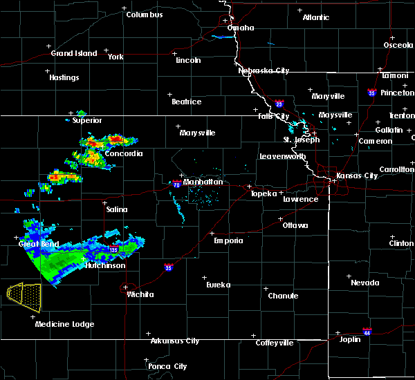 At 530 pm cdt, a severe thunderstorm was located near agenda, moving northeast at 20 mph (radar indicated). Hazards include 60 mph wind gusts and half dollar size hail. Hail damage to vehicles is expected. Expect wind damage to roofs, siding, and trees. At 530 pm cdt, a severe thunderstorm was located near agenda, moving northeast at 20 mph (radar indicated). Hazards include 60 mph wind gusts and half dollar size hail. Hail damage to vehicles is expected. Expect wind damage to roofs, siding, and trees.
|
| 9/21/2019 9:41 PM CDT |
 At 941 pm cdt, severe thunderstorms were located along a line extending from near morrowville to 3 miles northeast of clifton to 4 miles north of ada, moving east at 35 mph (radar indicated). Hazards include 60 mph wind gusts and penny size hail. Expect damage to roofs, siding, and trees. Locations impacted include, concordia, clyde, clifton, miltonvale, glasco, delphos, morganville, morrowville, agenda, aurora and vining. At 941 pm cdt, severe thunderstorms were located along a line extending from near morrowville to 3 miles northeast of clifton to 4 miles north of ada, moving east at 35 mph (radar indicated). Hazards include 60 mph wind gusts and penny size hail. Expect damage to roofs, siding, and trees. Locations impacted include, concordia, clyde, clifton, miltonvale, glasco, delphos, morganville, morrowville, agenda, aurora and vining.
|
| 9/21/2019 9:08 PM CDT |
 At 908 pm cdt, severe thunderstorms were located along a line extending from 3 miles southwest of cuba to 4 miles north of aurora to 5 miles north of lincoln, moving east at 40 mph (radar indicated). Hazards include 60 mph wind gusts and penny size hail. expect damage to roofs, siding, and trees At 908 pm cdt, severe thunderstorms were located along a line extending from 3 miles southwest of cuba to 4 miles north of aurora to 5 miles north of lincoln, moving east at 40 mph (radar indicated). Hazards include 60 mph wind gusts and penny size hail. expect damage to roofs, siding, and trees
|
| 8/29/2019 10:27 PM CDT |
 At 1026 pm cdt, severe thunderstorms were located along a line extending from near agenda to 4 miles southwest of miltonvale to 5 miles south of delphos, moving southeast at 40 mph (radar indicated. an automated weather station in concordia reported a wind gust of 58 mph). Hazards include 60 mph wind gusts. Expect damage to roofs, siding, and trees. Locations impacted include, concordia, minneapolis, belleville, clyde, bennington, clifton, miltonvale, glasco, delphos, tescott, morganville, culver, wells, palmer, manchester, longford, agenda, aurora, vining and oak hill. At 1026 pm cdt, severe thunderstorms were located along a line extending from near agenda to 4 miles southwest of miltonvale to 5 miles south of delphos, moving southeast at 40 mph (radar indicated. an automated weather station in concordia reported a wind gust of 58 mph). Hazards include 60 mph wind gusts. Expect damage to roofs, siding, and trees. Locations impacted include, concordia, minneapolis, belleville, clyde, bennington, clifton, miltonvale, glasco, delphos, tescott, morganville, culver, wells, palmer, manchester, longford, agenda, aurora, vining and oak hill.
|
| 8/29/2019 10:00 PM CDT |
 At 959 pm cdt, severe thunderstorms were located along a line extending from near belleville to 8 miles northeast of glasco to 5 miles southwest of asherville, moving southeast at 40 mph (radar indicated. a 60 mph wind gust was recently reported in jewell). Hazards include 60 mph wind gusts. expect damage to roofs, siding, and trees At 959 pm cdt, severe thunderstorms were located along a line extending from near belleville to 8 miles northeast of glasco to 5 miles southwest of asherville, moving southeast at 40 mph (radar indicated. a 60 mph wind gust was recently reported in jewell). Hazards include 60 mph wind gusts. expect damage to roofs, siding, and trees
|
| 8/17/2019 12:26 AM CDT |
 At 1226 am cdt, a severe thunderstorm was located near vining, moving east at 25 mph (radar indicated). Hazards include ping pong ball size hail. People and animals outdoors will be injured. expect damage to roofs, siding, windows, and vehicles. Locations impacted include, washington, clyde, linn, greenleaf, cuba, morrowville, palmer, haddam and agenda. At 1226 am cdt, a severe thunderstorm was located near vining, moving east at 25 mph (radar indicated). Hazards include ping pong ball size hail. People and animals outdoors will be injured. expect damage to roofs, siding, windows, and vehicles. Locations impacted include, washington, clyde, linn, greenleaf, cuba, morrowville, palmer, haddam and agenda.
|
| 8/16/2019 11:55 PM CDT |
 At 1155 pm cdt, a severe thunderstorm was located 5 miles east of agenda, moving east at 20 mph (radar indicated). Hazards include quarter size hail. damage to vehicles is expected At 1155 pm cdt, a severe thunderstorm was located 5 miles east of agenda, moving east at 20 mph (radar indicated). Hazards include quarter size hail. damage to vehicles is expected
|
| 8/12/2019 1:35 AM CDT |
 At 134 am cdt, severe thunderstorms were located along a line extending from near narka to 7 miles southeast of delphos, moving east at 40 mph (radar indicated). Hazards include 60 mph wind gusts. a 50 mph wind gust was recently reported at concordia. Expect damage to roofs, siding, and trees. Locations impacted include, concordia, belleville, clyde, miltonvale, cuba, haddam, munden, agenda and aurora. At 134 am cdt, severe thunderstorms were located along a line extending from near narka to 7 miles southeast of delphos, moving east at 40 mph (radar indicated). Hazards include 60 mph wind gusts. a 50 mph wind gust was recently reported at concordia. Expect damage to roofs, siding, and trees. Locations impacted include, concordia, belleville, clyde, miltonvale, cuba, haddam, munden, agenda and aurora.
|
| 8/12/2019 1:32 AM CDT |
 At 132 am cdt, severe thunderstorms were located along a line extending from near narka to near agenda to 4 miles northeast of delphos, moving east at 50 mph (radar indicated). Hazards include 60 mph wind gusts. expect damage to roofs, siding, and trees At 132 am cdt, severe thunderstorms were located along a line extending from near narka to near agenda to 4 miles northeast of delphos, moving east at 50 mph (radar indicated). Hazards include 60 mph wind gusts. expect damage to roofs, siding, and trees
|
| 8/12/2019 1:03 AM CDT |
 At 103 am cdt, severe thunderstorms were located along a line extending from near byron to 6 miles southwest of simpson, moving east at 40 mph (radar indicated). Hazards include 60 mph wind gusts. expect damage to roofs, siding, and trees At 103 am cdt, severe thunderstorms were located along a line extending from near byron to 6 miles southwest of simpson, moving east at 40 mph (radar indicated). Hazards include 60 mph wind gusts. expect damage to roofs, siding, and trees
|
| 8/7/2019 4:10 AM CDT |
 At 409 am cdt, severe thunderstorms were located along a line extending from near chester to 4 miles northwest of belleville to near courtland, moving southeast at 55 mph (radar indicated). Hazards include 60 mph wind gusts. Expect damage to roofs, siding, and trees. Locations impacted include, belleville, clyde, scandia, jamestown, courtland, cuba, norway, republic, haddam, munden, narka, mahaska and agenda. At 409 am cdt, severe thunderstorms were located along a line extending from near chester to 4 miles northwest of belleville to near courtland, moving southeast at 55 mph (radar indicated). Hazards include 60 mph wind gusts. Expect damage to roofs, siding, and trees. Locations impacted include, belleville, clyde, scandia, jamestown, courtland, cuba, norway, republic, haddam, munden, narka, mahaska and agenda.
|
| 8/7/2019 4:02 AM CDT |
 At 401 am cdt, severe thunderstorms were located along a line extending from near hebron to 3 miles southeast of byron to 5 miles east of lovewell state park, moving southeast at 60 mph (radar indicated). Hazards include 70 mph wind gusts and penny size hail. Expect considerable tree damage. damage is likely to mobile homes, roofs, and outbuildings. Locations impacted include, belleville, clyde, scandia, jamestown, courtland, cuba, norway, republic, haddam, munden, narka, mahaska and agenda. At 401 am cdt, severe thunderstorms were located along a line extending from near hebron to 3 miles southeast of byron to 5 miles east of lovewell state park, moving southeast at 60 mph (radar indicated). Hazards include 70 mph wind gusts and penny size hail. Expect considerable tree damage. damage is likely to mobile homes, roofs, and outbuildings. Locations impacted include, belleville, clyde, scandia, jamestown, courtland, cuba, norway, republic, haddam, munden, narka, mahaska and agenda.
|
| 8/7/2019 3:51 AM CDT |
 At 350 am cdt, severe thunderstorms were located along a line extending from near carleton to 4 miles southeast of ruskin to near superior, moving southeast at 60 mph (radar indicated). Hazards include 70 mph wind gusts and quarter size hail. Hail damage to vehicles is expected. expect considerable tree damage. Wind damage is also likely to mobile homes, roofs, and outbuildings. At 350 am cdt, severe thunderstorms were located along a line extending from near carleton to 4 miles southeast of ruskin to near superior, moving southeast at 60 mph (radar indicated). Hazards include 70 mph wind gusts and quarter size hail. Hail damage to vehicles is expected. expect considerable tree damage. Wind damage is also likely to mobile homes, roofs, and outbuildings.
|
| 7/10/2019 6:07 AM CDT |
 At 606 am cdt, severe thunderstorms were located along a line extending from near hanover to 8 miles southeast of linn to 5 miles south of idana, moving east at 45 mph (trained weather spotters. at 603 am cdt...trained spotters reported estimated 60 mph wind gusts and 2 inch diameter hail 2 miles west northwest of linn). Hazards include two inch hail and 60 mph wind gusts. People and animals outdoors will be injured. expect hail damage to roofs, siding, windows, and vehicles. expect wind damage to roofs, siding, and trees. Locations impacted include, concordia, clay center, marysville, washington, blue rapids, wakefield, riley, clyde, hanover, waterville, clifton, miltonvale, milford, leonardville, linn, greenleaf, olsburg, beattie, morganville and randolph. At 606 am cdt, severe thunderstorms were located along a line extending from near hanover to 8 miles southeast of linn to 5 miles south of idana, moving east at 45 mph (trained weather spotters. at 603 am cdt...trained spotters reported estimated 60 mph wind gusts and 2 inch diameter hail 2 miles west northwest of linn). Hazards include two inch hail and 60 mph wind gusts. People and animals outdoors will be injured. expect hail damage to roofs, siding, windows, and vehicles. expect wind damage to roofs, siding, and trees. Locations impacted include, concordia, clay center, marysville, washington, blue rapids, wakefield, riley, clyde, hanover, waterville, clifton, miltonvale, milford, leonardville, linn, greenleaf, olsburg, beattie, morganville and randolph.
|
| 7/10/2019 6:01 AM CDT |
 At 600 am cdt, severe thunderstorms were located along a line extending from 5 miles northeast of washington to 3 miles east of palmer to 4 miles north of oak hill, moving east at 45 mph (trained weather spotters. at 551 am cdt...trained spotters reported a 6 inch tree limb down with estimated 60 mph wind gusts, 5 miles south of clyde). Hazards include 60 mph wind gusts and quarter size hail. Hail damage to vehicles is expected. expect wind damage to roofs, siding, and trees. Locations impacted include, concordia, clay center, marysville, belleville, washington, blue rapids, wakefield, riley, clyde, hanover, waterville, clifton, miltonvale, milford, leonardville, linn, scandia, greenleaf, jamestown and olsburg. At 600 am cdt, severe thunderstorms were located along a line extending from 5 miles northeast of washington to 3 miles east of palmer to 4 miles north of oak hill, moving east at 45 mph (trained weather spotters. at 551 am cdt...trained spotters reported a 6 inch tree limb down with estimated 60 mph wind gusts, 5 miles south of clyde). Hazards include 60 mph wind gusts and quarter size hail. Hail damage to vehicles is expected. expect wind damage to roofs, siding, and trees. Locations impacted include, concordia, clay center, marysville, belleville, washington, blue rapids, wakefield, riley, clyde, hanover, waterville, clifton, miltonvale, milford, leonardville, linn, scandia, greenleaf, jamestown and olsburg.
|
| 7/10/2019 5:53 AM CDT |
 At 552 am cdt, severe thunderstorms were located along a line extending from 6 miles north of washington to near palmer to near miltonvale, moving east at 45 mph (radar indicated). Hazards include 60 mph wind gusts and quarter size hail. Hail damage to vehicles is expected. Expect wind damage to roofs, siding, and trees. At 552 am cdt, severe thunderstorms were located along a line extending from 6 miles north of washington to near palmer to near miltonvale, moving east at 45 mph (radar indicated). Hazards include 60 mph wind gusts and quarter size hail. Hail damage to vehicles is expected. Expect wind damage to roofs, siding, and trees.
|
| 7/10/2019 5:37 AM CDT |
 At 537 am cdt, severe thunderstorms were located along a line extending from near mahaska to agenda to 5 miles west of aurora, moving east at 45 mph (law enforcement. at 535 am cdt...law enforcement in belleville were estimating 60 mph wind gusts). Hazards include 60 mph wind gusts and half dollar size hail. Hail damage to vehicles is expected. expect wind damage to roofs, siding, and trees. Locations impacted include, concordia, belleville, washington, clyde, scandia, jamestown, cuba, morrowville, norway, haddam, munden, narka, mahaska, agenda, aurora and hollenberg. At 537 am cdt, severe thunderstorms were located along a line extending from near mahaska to agenda to 5 miles west of aurora, moving east at 45 mph (law enforcement. at 535 am cdt...law enforcement in belleville were estimating 60 mph wind gusts). Hazards include 60 mph wind gusts and half dollar size hail. Hail damage to vehicles is expected. expect wind damage to roofs, siding, and trees. Locations impacted include, concordia, belleville, washington, clyde, scandia, jamestown, cuba, morrowville, norway, haddam, munden, narka, mahaska, agenda, aurora and hollenberg.
|
| 7/10/2019 5:32 AM CDT |
 At 532 am cdt, severe thunderstorms were located along a line extending from near narka to 3 miles west of agenda to 6 miles south of concordia, moving east at 45 mph (radar indicated). Hazards include 60 mph wind gusts and half dollar size hail. Hail damage to vehicles is expected. expect wind damage to roofs, siding, and trees. Locations impacted include, concordia, belleville, washington, clyde, scandia, jamestown, cuba, morrowville, norway, haddam, munden, narka, mahaska, agenda, aurora and hollenberg. At 532 am cdt, severe thunderstorms were located along a line extending from near narka to 3 miles west of agenda to 6 miles south of concordia, moving east at 45 mph (radar indicated). Hazards include 60 mph wind gusts and half dollar size hail. Hail damage to vehicles is expected. expect wind damage to roofs, siding, and trees. Locations impacted include, concordia, belleville, washington, clyde, scandia, jamestown, cuba, morrowville, norway, haddam, munden, narka, mahaska, agenda, aurora and hollenberg.
|
| 7/10/2019 5:11 AM CDT |
 At 510 am cdt, severe thunderstorms were located along a line extending from near hubbell to near scandia to 4 miles south of randall, moving east at 45 mph (trained weather spotters). Hazards include 60 mph wind gusts and half dollar size hail. Hail damage to vehicles is expected. Expect wind damage to roofs, siding, and trees. At 510 am cdt, severe thunderstorms were located along a line extending from near hubbell to near scandia to 4 miles south of randall, moving east at 45 mph (trained weather spotters). Hazards include 60 mph wind gusts and half dollar size hail. Hail damage to vehicles is expected. Expect wind damage to roofs, siding, and trees.
|
| 6/25/2019 9:03 PM CDT |
 At 902 pm cdt, severe thunderstorms were located along a line extending from 5 miles north of green to near idana to 4 miles southwest of delphos, moving southeast at 35 mph (trained weather spotters. half-dollar size hail was reported 6 miles south of jamestown and 60 mph wind gusts were reported near clyde). Hazards include 60 mph wind gusts and half dollar size hail. Hail damage to vehicles is expected. expect wind damage to roofs, siding, and trees. Locations impacted include, concordia, clay center, clyde, clifton, miltonvale, glasco, delphos, jamestown, morganville, green, palmer, aurora, vining, oak hill, idana and ada. At 902 pm cdt, severe thunderstorms were located along a line extending from 5 miles north of green to near idana to 4 miles southwest of delphos, moving southeast at 35 mph (trained weather spotters. half-dollar size hail was reported 6 miles south of jamestown and 60 mph wind gusts were reported near clyde). Hazards include 60 mph wind gusts and half dollar size hail. Hail damage to vehicles is expected. expect wind damage to roofs, siding, and trees. Locations impacted include, concordia, clay center, clyde, clifton, miltonvale, glasco, delphos, jamestown, morganville, green, palmer, aurora, vining, oak hill, idana and ada.
|
| 6/25/2019 8:49 PM CDT |
 At 848 pm cdt, severe thunderstorms were located along a line extending from near palmer to 6 miles northeast of miltonvale to 3 miles southeast of glasco, moving southeast at 35 mph (trained weather spotters. at 840 pm 60 mph wind gusts were reported near clyde). Hazards include 60 mph wind gusts and half dollar size hail. Hail damage to vehicles is expected. expect wind damage to roofs, siding, and trees. Locations impacted include, concordia, clay center, clyde, clifton, miltonvale, glasco, delphos, jamestown, morganville, green, palmer, agenda, aurora, vining, oak hill, idana and ada. At 848 pm cdt, severe thunderstorms were located along a line extending from near palmer to 6 miles northeast of miltonvale to 3 miles southeast of glasco, moving southeast at 35 mph (trained weather spotters. at 840 pm 60 mph wind gusts were reported near clyde). Hazards include 60 mph wind gusts and half dollar size hail. Hail damage to vehicles is expected. expect wind damage to roofs, siding, and trees. Locations impacted include, concordia, clay center, clyde, clifton, miltonvale, glasco, delphos, jamestown, morganville, green, palmer, agenda, aurora, vining, oak hill, idana and ada.
|
| 1/1/0001 12:00 AM | Spotter confident in 60 mph wind in cloud county KS, 2.6 miles ESE of Clyde, KS |
| 6/25/2019 8:29 PM CDT |
 At 829 pm cdt, severe thunderstorms were located along a line extending from 6 miles northeast of agenda to 6 miles west of clyde to 4 miles northeast of asherville, moving southeast at 35 mph (radar indicated). Hazards include 60 mph wind gusts and half dollar size hail. Hail damage to vehicles is expected. Expect wind damage to roofs, siding, and trees. At 829 pm cdt, severe thunderstorms were located along a line extending from 6 miles northeast of agenda to 6 miles west of clyde to 4 miles northeast of asherville, moving southeast at 35 mph (radar indicated). Hazards include 60 mph wind gusts and half dollar size hail. Hail damage to vehicles is expected. Expect wind damage to roofs, siding, and trees.
|
| 6/21/2019 7:21 AM CDT |
 The severe thunderstorm warning for washington, northwestern clay and northeastern cloud counties will expire at 730 am cdt, the storms which prompted the warning have moved out of the area. therefore, the warning will be allowed to expire. however gusty winds are still possible with these thunderstorms. a severe thunderstorm watch remains in effect until 1000 am cdt for north central kansas. The severe thunderstorm warning for washington, northwestern clay and northeastern cloud counties will expire at 730 am cdt, the storms which prompted the warning have moved out of the area. therefore, the warning will be allowed to expire. however gusty winds are still possible with these thunderstorms. a severe thunderstorm watch remains in effect until 1000 am cdt for north central kansas.
|
| 6/21/2019 7:11 AM CDT |
 At 711 am cdt, severe thunderstorms were located along a line extending from 4 miles south of odell to 5 miles south of hanover to near linn, moving east at 50 mph (radar indicated). Hazards include 60 mph wind gusts and penny size hail. Expect damage to roofs, siding, and trees. Locations impacted include, concordia, washington, clyde, clifton, linn, morrowville, palmer, haddam, vining and hollenberg. At 711 am cdt, severe thunderstorms were located along a line extending from 4 miles south of odell to 5 miles south of hanover to near linn, moving east at 50 mph (radar indicated). Hazards include 60 mph wind gusts and penny size hail. Expect damage to roofs, siding, and trees. Locations impacted include, concordia, washington, clyde, clifton, linn, morrowville, palmer, haddam, vining and hollenberg.
|
| 6/21/2019 6:48 AM CDT |
 At 648 am cdt, severe thunderstorms were located along a line extending from 3 miles northwest of morrowville to 6 miles east of agenda to 3 miles west of clyde, moving east at 50 mph (radar indicated). Hazards include 60 mph wind gusts and penny size hail. Expect damage to roofs, siding, and trees. Locations impacted include, concordia, washington, clyde, clifton, linn, cuba, morrowville, norway, palmer, haddam, narka, mahaska, agenda, vining and hollenberg. At 648 am cdt, severe thunderstorms were located along a line extending from 3 miles northwest of morrowville to 6 miles east of agenda to 3 miles west of clyde, moving east at 50 mph (radar indicated). Hazards include 60 mph wind gusts and penny size hail. Expect damage to roofs, siding, and trees. Locations impacted include, concordia, washington, clyde, clifton, linn, cuba, morrowville, norway, palmer, haddam, narka, mahaska, agenda, vining and hollenberg.
|
| 6/21/2019 6:27 AM CDT |
 At 627 am cdt, severe thunderstorms were located along a line extending from 3 miles southwest of hubbell to near belleville to norway, moving east at 45 mph (radar indicated). Hazards include 60 mph wind gusts and penny size hail. expect damage to roofs, siding, and trees At 627 am cdt, severe thunderstorms were located along a line extending from 3 miles southwest of hubbell to near belleville to norway, moving east at 45 mph (radar indicated). Hazards include 60 mph wind gusts and penny size hail. expect damage to roofs, siding, and trees
|
| 5/27/2019 1:54 AM CDT |
 At 154 am cdt, severe thunderstorms were located along a line extending from 5 miles east of jamestown to near longford to 4 miles west of durham, moving northeast at 60 mph (radar indicated). Hazards include 70 mph wind gusts and nickel size hail. Expect considerable tree damage. damage is likely to mobile homes, roofs, and outbuildings. these severe storms will be near, concordia, longford and oak hill around 200 am cdt. idana around 205 am cdt. This includes interstate 70 between mile markers 267 and 280. At 154 am cdt, severe thunderstorms were located along a line extending from 5 miles east of jamestown to near longford to 4 miles west of durham, moving northeast at 60 mph (radar indicated). Hazards include 70 mph wind gusts and nickel size hail. Expect considerable tree damage. damage is likely to mobile homes, roofs, and outbuildings. these severe storms will be near, concordia, longford and oak hill around 200 am cdt. idana around 205 am cdt. This includes interstate 70 between mile markers 267 and 280.
|
| 5/27/2019 1:44 AM CDT |
 At 144 am cdt, severe thunderstorms were located along a line extending from 3 miles southeast of scottsville to 5 miles southeast of wells to canton, moving northeast at 55 mph. these are very dangerous storms (radar indicated. these storms have the history of producing 70 to 80 mph winds). Hazards include 80 mph wind gusts and nickel size hail. Flying debris will be dangerous to those caught without shelter. mobile homes will be heavily damaged. expect considerable damage to roofs, windows, and vehicles. extensive tree damage and power outages are likely. these severe storms will be near, jamestown and manchester around 150 am cdt. concordia and longford around 155 am cdt. oak hill around 200 am cdt. idana around 205 am cdt. This includes interstate 70 between mile markers 267 and 280. At 144 am cdt, severe thunderstorms were located along a line extending from 3 miles southeast of scottsville to 5 miles southeast of wells to canton, moving northeast at 55 mph. these are very dangerous storms (radar indicated. these storms have the history of producing 70 to 80 mph winds). Hazards include 80 mph wind gusts and nickel size hail. Flying debris will be dangerous to those caught without shelter. mobile homes will be heavily damaged. expect considerable damage to roofs, windows, and vehicles. extensive tree damage and power outages are likely. these severe storms will be near, jamestown and manchester around 150 am cdt. concordia and longford around 155 am cdt. oak hill around 200 am cdt. idana around 205 am cdt. This includes interstate 70 between mile markers 267 and 280.
|
| 5/27/2019 1:35 AM CDT |
 At 135 am cdt, severe thunderstorms were located along a line extending from 6 miles southwest of simpson to 4 miles southwest of bennington to 5 miles south of mcpherson, moving northeast at 60 mph. these are very dangerous storms (76 mph winds were measured in salina at 132 am). Hazards include 80 mph wind gusts and nickel size hail. Flying debris will be dangerous to those caught without shelter. mobile homes will be heavily damaged. expect considerable damage to roofs, windows, and vehicles. extensive tree damage and power outages are likely. locations impacted include, abilene, concordia, solomon, enterprise, clyde, miltonvale, glasco, jamestown, wells, manchester, longford, aurora, carlton, oak hill, talmage and idana. This includes interstate 70 between mile markers 267 and 280. At 135 am cdt, severe thunderstorms were located along a line extending from 6 miles southwest of simpson to 4 miles southwest of bennington to 5 miles south of mcpherson, moving northeast at 60 mph. these are very dangerous storms (76 mph winds were measured in salina at 132 am). Hazards include 80 mph wind gusts and nickel size hail. Flying debris will be dangerous to those caught without shelter. mobile homes will be heavily damaged. expect considerable damage to roofs, windows, and vehicles. extensive tree damage and power outages are likely. locations impacted include, abilene, concordia, solomon, enterprise, clyde, miltonvale, glasco, jamestown, wells, manchester, longford, aurora, carlton, oak hill, talmage and idana. This includes interstate 70 between mile markers 267 and 280.
|
| 5/27/2019 1:28 AM CDT |
 At 127 am cdt, severe thunderstorms were located along a line extending from 5 miles northwest of barnard to near culver to near inman, moving northeast at 60 mph (trained weather spotters reported 70 mph winds in culver at 127 am). Hazards include 70 mph wind gusts and nickel size hail. Expect considerable tree damage. damage is likely to mobile homes, roofs, and outbuildings. locations impacted include, abilene, concordia, solomon, enterprise, clyde, miltonvale, glasco, jamestown, wells, manchester, longford, aurora, carlton, oak hill, talmage and idana. This includes interstate 70 between mile markers 267 and 280. At 127 am cdt, severe thunderstorms were located along a line extending from 5 miles northwest of barnard to near culver to near inman, moving northeast at 60 mph (trained weather spotters reported 70 mph winds in culver at 127 am). Hazards include 70 mph wind gusts and nickel size hail. Expect considerable tree damage. damage is likely to mobile homes, roofs, and outbuildings. locations impacted include, abilene, concordia, solomon, enterprise, clyde, miltonvale, glasco, jamestown, wells, manchester, longford, aurora, carlton, oak hill, talmage and idana. This includes interstate 70 between mile markers 267 and 280.
|
| 5/27/2019 1:22 AM CDT |
 At 121 am cdt, severe thunderstorms were located along a line extending from 6 miles west of barnard to 5 miles southwest of culver to 3 miles south of inman, moving northeast at 60 mph (radar indicated). Hazards include 70 mph wind gusts and nickel size hail. Expect considerable tree damage. Damage is likely to mobile homes, roofs, and outbuildings. At 121 am cdt, severe thunderstorms were located along a line extending from 6 miles west of barnard to 5 miles southwest of culver to 3 miles south of inman, moving northeast at 60 mph (radar indicated). Hazards include 70 mph wind gusts and nickel size hail. Expect considerable tree damage. Damage is likely to mobile homes, roofs, and outbuildings.
|
| 5/24/2019 3:21 AM CDT |
 At 320 am cdt, severe thunderstorms were located along a line extending from 8 miles north of morrowville to near linn to 6 miles east of longford, moving northeast at 60 mph (radar indicated). Hazards include 60 mph wind gusts and quarter size hail. Hail damage to vehicles is expected. expect wind damage to roofs, siding, and trees. Locations impacted include, clay center, washington, clyde, clifton, linn, greenleaf, morganville, morrowville, green, palmer, haddam, longford, vining, oak hill, hollenberg and idana. At 320 am cdt, severe thunderstorms were located along a line extending from 8 miles north of morrowville to near linn to 6 miles east of longford, moving northeast at 60 mph (radar indicated). Hazards include 60 mph wind gusts and quarter size hail. Hail damage to vehicles is expected. expect wind damage to roofs, siding, and trees. Locations impacted include, clay center, washington, clyde, clifton, linn, greenleaf, morganville, morrowville, green, palmer, haddam, longford, vining, oak hill, hollenberg and idana.
|
| 5/24/2019 2:56 AM CDT |
 At 256 am cdt, severe thunderstorms were located along a line extending from 3 miles west of cuba to 7 miles southwest of miltonvale to 3 miles northeast of bennington, moving northeast at 50 mph (radar indicated). Hazards include 60 mph wind gusts and quarter size hail. Hail damage to vehicles is expected. Expect wind damage to roofs, siding, and trees. At 256 am cdt, severe thunderstorms were located along a line extending from 3 miles west of cuba to 7 miles southwest of miltonvale to 3 miles northeast of bennington, moving northeast at 50 mph (radar indicated). Hazards include 60 mph wind gusts and quarter size hail. Hail damage to vehicles is expected. Expect wind damage to roofs, siding, and trees.
|
| 5/24/2019 2:53 AM CDT |
 At 252 am cdt, severe thunderstorms were located along a line extending from 4 miles southeast of belleville to 9 miles east of delphos to near bennington, moving northeast at 50 mph (radar indicated). Hazards include 60 mph wind gusts and quarter size hail. Hail damage to vehicles is expected. expect wind damage to roofs, siding, and trees. Locations impacted include, concordia, minneapolis, clyde, bennington, miltonvale, cuba, wells, agenda, aurora and niles. At 252 am cdt, severe thunderstorms were located along a line extending from 4 miles southeast of belleville to 9 miles east of delphos to near bennington, moving northeast at 50 mph (radar indicated). Hazards include 60 mph wind gusts and quarter size hail. Hail damage to vehicles is expected. expect wind damage to roofs, siding, and trees. Locations impacted include, concordia, minneapolis, clyde, bennington, miltonvale, cuba, wells, agenda, aurora and niles.
|
| 5/24/2019 2:37 AM CDT |
 At 236 am cdt, severe thunderstorms were located along a line extending from near norway to near ada to 8 miles northwest of brookville, moving northeast at 55 mph (radar indicated). Hazards include 60 mph wind gusts and half dollar size hail. Hail damage to vehicles is expected. expect wind damage to roofs, siding, and trees. Locations impacted include, concordia, minneapolis, clyde, bennington, miltonvale, glasco, delphos, tescott, jamestown, cuba, norway, culver, wells, agenda, aurora, niles and ada. At 236 am cdt, severe thunderstorms were located along a line extending from near norway to near ada to 8 miles northwest of brookville, moving northeast at 55 mph (radar indicated). Hazards include 60 mph wind gusts and half dollar size hail. Hail damage to vehicles is expected. expect wind damage to roofs, siding, and trees. Locations impacted include, concordia, minneapolis, clyde, bennington, miltonvale, glasco, delphos, tescott, jamestown, cuba, norway, culver, wells, agenda, aurora, niles and ada.
|
| 5/24/2019 2:17 AM CDT |
 At 215 am cdt, severe thunderstorms were located along a line extending from 4 miles north of beloit to near lincoln to near ellsworth, moving northeast at 50 mph (radar indicated). Hazards include 60 mph wind gusts and quarter size hail. Hail damage to vehicles is expected. Expect wind damage to roofs, siding, and trees. At 215 am cdt, severe thunderstorms were located along a line extending from 4 miles north of beloit to near lincoln to near ellsworth, moving northeast at 50 mph (radar indicated). Hazards include 60 mph wind gusts and quarter size hail. Hail damage to vehicles is expected. Expect wind damage to roofs, siding, and trees.
|
| 5/23/2019 8:25 PM CDT |
 The severe thunderstorm warning for north central ottawa, southern republic, southwestern washington, northwestern clay and cloud counties will expire at 830 pm cdt, the storm which prompted the warning has weakened below severe limits, and no longer poses an immediate threat to life or property. therefore, the warning will be allowed to expire. however heavy rain is still possible with this thunderstorm. a tornado watch remains in effect until midnight cdt for north central kansas. a severe thunderstorm watch remains in effect until midnight cdt for north central kansas. remember, a severe thunderstorm warning still remains in effect for eastern washington county. The severe thunderstorm warning for north central ottawa, southern republic, southwestern washington, northwestern clay and cloud counties will expire at 830 pm cdt, the storm which prompted the warning has weakened below severe limits, and no longer poses an immediate threat to life or property. therefore, the warning will be allowed to expire. however heavy rain is still possible with this thunderstorm. a tornado watch remains in effect until midnight cdt for north central kansas. a severe thunderstorm watch remains in effect until midnight cdt for north central kansas. remember, a severe thunderstorm warning still remains in effect for eastern washington county.
|
| 5/23/2019 7:40 PM CDT |
 At 740 pm cdt, a severe thunderstorm was located 8 miles northeast of delphos, moving northeast at 50 mph (radar indicated). Hazards include 60 mph wind gusts and half dollar size hail. Hail damage to vehicles is expected. Expect wind damage to roofs, siding, and trees. At 740 pm cdt, a severe thunderstorm was located 8 miles northeast of delphos, moving northeast at 50 mph (radar indicated). Hazards include 60 mph wind gusts and half dollar size hail. Hail damage to vehicles is expected. Expect wind damage to roofs, siding, and trees.
|
| 5/18/2019 12:10 AM CDT |
 At 1200 am cdt, severe thunderstorms were located along a line extending from gilead to 7 miles north of morrowville to 5 miles northwest of linn to 3 miles southwest of palmer to 7 miles southwest of vining, moving northeast at 55 mph (radar indicated). Hazards include 60 mph wind gusts and penny size hail. Expect damage to roofs, siding, and trees. Locations impacted include, washington, clyde, clifton, miltonvale, linn, greenleaf, morganville, cuba, morrowville, palmer, haddam, munden, narka, mahaska, agenda, aurora and vining. At 1200 am cdt, severe thunderstorms were located along a line extending from gilead to 7 miles north of morrowville to 5 miles northwest of linn to 3 miles southwest of palmer to 7 miles southwest of vining, moving northeast at 55 mph (radar indicated). Hazards include 60 mph wind gusts and penny size hail. Expect damage to roofs, siding, and trees. Locations impacted include, washington, clyde, clifton, miltonvale, linn, greenleaf, morganville, cuba, morrowville, palmer, haddam, munden, narka, mahaska, agenda, aurora and vining.
|
| 5/18/2019 12:00 AM CDT |
 At 1200 am cdt, severe thunderstorms were located along a line extending from gilead to 7 miles north of morrowville to 5 miles northwest of linn to 3 miles southwest of palmer to 7 miles southwest of vining, moving northeast at 55 mph (radar indicated). Hazards include 60 mph wind gusts and penny size hail. Expect damage to roofs, siding, and trees. Locations impacted include, washington, clyde, clifton, miltonvale, linn, greenleaf, morganville, cuba, morrowville, palmer, haddam, munden, narka, mahaska, agenda, aurora and vining. At 1200 am cdt, severe thunderstorms were located along a line extending from gilead to 7 miles north of morrowville to 5 miles northwest of linn to 3 miles southwest of palmer to 7 miles southwest of vining, moving northeast at 55 mph (radar indicated). Hazards include 60 mph wind gusts and penny size hail. Expect damage to roofs, siding, and trees. Locations impacted include, washington, clyde, clifton, miltonvale, linn, greenleaf, morganville, cuba, morrowville, palmer, haddam, munden, narka, mahaska, agenda, aurora and vining.
|
| 5/17/2019 11:49 PM CDT |
 At 1148 pm cdt, severe thunderstorms were located along a line extending from 5 miles northeast of chester to 3 miles northeast of cuba to 5 miles southeast of agenda to 4 miles southeast of clyde to near miltonvale, moving northeast at 50 mph (radar indicated). Hazards include 60 mph wind gusts and penny size hail. Expect damage to roofs, siding, and trees. Locations impacted include, clay center, washington, clyde, clifton, miltonvale, linn, greenleaf, morganville, cuba, morrowville, palmer, haddam, munden, narka, mahaska, agenda, aurora, vining and idana. At 1148 pm cdt, severe thunderstorms were located along a line extending from 5 miles northeast of chester to 3 miles northeast of cuba to 5 miles southeast of agenda to 4 miles southeast of clyde to near miltonvale, moving northeast at 50 mph (radar indicated). Hazards include 60 mph wind gusts and penny size hail. Expect damage to roofs, siding, and trees. Locations impacted include, clay center, washington, clyde, clifton, miltonvale, linn, greenleaf, morganville, cuba, morrowville, palmer, haddam, munden, narka, mahaska, agenda, aurora, vining and idana.
|
| 5/17/2019 11:37 PM CDT |
 At 1136 pm cdt, severe thunderstorms were located along a line extending from 3 miles east of byron to 4 miles southeast of belleville to 5 miles west of clyde to near aurora to 7 miles west of miltonvale, moving northeast at 50 mph (radar indicated). Hazards include 60 mph wind gusts and penny size hail. Expect damage to roofs, siding, and trees. Locations impacted include, clay center, washington, clyde, clifton, miltonvale, linn, greenleaf, morganville, cuba, morrowville, palmer, haddam, munden, narka, mahaska, agenda, aurora, vining and idana. At 1136 pm cdt, severe thunderstorms were located along a line extending from 3 miles east of byron to 4 miles southeast of belleville to 5 miles west of clyde to near aurora to 7 miles west of miltonvale, moving northeast at 50 mph (radar indicated). Hazards include 60 mph wind gusts and penny size hail. Expect damage to roofs, siding, and trees. Locations impacted include, clay center, washington, clyde, clifton, miltonvale, linn, greenleaf, morganville, cuba, morrowville, palmer, haddam, munden, narka, mahaska, agenda, aurora, vining and idana.
|
| 5/17/2019 11:33 PM CDT |
 At 1133 pm cdt, severe thunderstorms were located along a line extending from 7 miles west of agenda to 6 miles west of clyde to near aurora to 8 miles east of delphos, moving northeast at 50 mph (radar indicated). Hazards include 60 mph wind gusts and penny size hail. expect damage to roofs, siding, and trees At 1133 pm cdt, severe thunderstorms were located along a line extending from 7 miles west of agenda to 6 miles west of clyde to near aurora to 8 miles east of delphos, moving northeast at 50 mph (radar indicated). Hazards include 60 mph wind gusts and penny size hail. expect damage to roofs, siding, and trees
|
| 5/6/2019 4:08 PM CDT |
 At 408 pm cdt, severe thunderstorms were located along a line extending from 5 miles east of mahaska to 5 miles northeast of clyde to 3 miles east of aurora, moving east at 40 mph (radar indicated). Hazards include ping pong ball size hail and 60 mph wind gusts. People and animals outdoors will be injured. expect hail damage to roofs, siding, windows, and vehicles. expect wind damage to roofs, siding, and trees. Locations impacted include, clyde, clifton, morrowville, palmer, haddam, aurora and vining. At 408 pm cdt, severe thunderstorms were located along a line extending from 5 miles east of mahaska to 5 miles northeast of clyde to 3 miles east of aurora, moving east at 40 mph (radar indicated). Hazards include ping pong ball size hail and 60 mph wind gusts. People and animals outdoors will be injured. expect hail damage to roofs, siding, windows, and vehicles. expect wind damage to roofs, siding, and trees. Locations impacted include, clyde, clifton, morrowville, palmer, haddam, aurora and vining.
|
| 5/6/2019 4:02 PM CDT |
 At 401 pm cdt, severe thunderstorms were located along a line extending from 3 miles northeast of mahaska to 4 miles southeast of agenda to near aurora, moving east at 40 mph (trained weather spotters. at 353 pm trained spotters reported quarter size hail 5 miles northeast of concordia). Hazards include golf ball size hail and 60 mph wind gusts. People and animals outdoors will be injured. expect hail damage to roofs, siding, windows, and vehicles. expect wind damage to roofs, siding, and trees. Locations impacted include, clyde, clifton, miltonvale, cuba, morrowville, palmer, haddam, narka, mahaska, agenda, aurora and vining. At 401 pm cdt, severe thunderstorms were located along a line extending from 3 miles northeast of mahaska to 4 miles southeast of agenda to near aurora, moving east at 40 mph (trained weather spotters. at 353 pm trained spotters reported quarter size hail 5 miles northeast of concordia). Hazards include golf ball size hail and 60 mph wind gusts. People and animals outdoors will be injured. expect hail damage to roofs, siding, windows, and vehicles. expect wind damage to roofs, siding, and trees. Locations impacted include, clyde, clifton, miltonvale, cuba, morrowville, palmer, haddam, narka, mahaska, agenda, aurora and vining.
|
| 5/6/2019 3:54 PM CDT |
 At 353 pm cdt, severe thunderstorms were located along a line extending from near mahaska to 4 miles southwest of agenda to 7 miles west of aurora, moving east at 40 mph (trained weather spotters. at 349 pm concordia airport reported 60 mph wind gusts). Hazards include golf ball size hail and 60 mph wind gusts. People and animals outdoors will be injured. expect hail damage to roofs, siding, windows, and vehicles. expect wind damage to roofs, siding, and trees. Locations impacted include, concordia, clyde, clifton, miltonvale, cuba, morrowville, palmer, haddam, munden, narka, mahaska, agenda, aurora and vining. At 353 pm cdt, severe thunderstorms were located along a line extending from near mahaska to 4 miles southwest of agenda to 7 miles west of aurora, moving east at 40 mph (trained weather spotters. at 349 pm concordia airport reported 60 mph wind gusts). Hazards include golf ball size hail and 60 mph wind gusts. People and animals outdoors will be injured. expect hail damage to roofs, siding, windows, and vehicles. expect wind damage to roofs, siding, and trees. Locations impacted include, concordia, clyde, clifton, miltonvale, cuba, morrowville, palmer, haddam, munden, narka, mahaska, agenda, aurora and vining.
|
| 5/6/2019 3:42 PM CDT |
 At 342 pm cdt, severe thunderstorms were located along a line extending from hubbell to 7 miles northeast of concordia to 7 miles northeast of glasco, moving east at 40 mph (radar indicated). Hazards include golf ball size hail and 60 mph wind gusts. People and animals outdoors will be injured. expect hail damage to roofs, siding, windows, and vehicles. Expect wind damage to roofs, siding, and trees. At 342 pm cdt, severe thunderstorms were located along a line extending from hubbell to 7 miles northeast of concordia to 7 miles northeast of glasco, moving east at 40 mph (radar indicated). Hazards include golf ball size hail and 60 mph wind gusts. People and animals outdoors will be injured. expect hail damage to roofs, siding, windows, and vehicles. Expect wind damage to roofs, siding, and trees.
|
| 5/6/2019 2:26 PM CDT | Quarter sized hail reported 7.3 miles SSW of Clyde, KS |
| 4/10/2019 7:49 PM CDT |
 At 749 pm cdt, a severe thunderstorm was located 4 miles west of concordia, moving northeast at 55 mph (trained weather spotters). Hazards include ping pong ball size hail and 60 mph wind gusts. People and animals outdoors will be injured. expect hail damage to roofs, siding, windows, and vehicles. expect wind damage to roofs, siding, and trees. this severe thunderstorm will be near, cuba and agenda around 810 pm cdt. haddam around 820 pm cdt. Morrowville around 825 pm cdt. At 749 pm cdt, a severe thunderstorm was located 4 miles west of concordia, moving northeast at 55 mph (trained weather spotters). Hazards include ping pong ball size hail and 60 mph wind gusts. People and animals outdoors will be injured. expect hail damage to roofs, siding, windows, and vehicles. expect wind damage to roofs, siding, and trees. this severe thunderstorm will be near, cuba and agenda around 810 pm cdt. haddam around 820 pm cdt. Morrowville around 825 pm cdt.
|
| 9/20/2018 7:42 PM CDT |
 At 742 pm cdt, severe thunderstorms were located along a line extending from 8 miles south of fairbury to near miltonvale, moving east at 40 mph (radar indicated). Hazards include 60 mph wind gusts. Expect damage to roofs, siding, and trees. Locations impacted include, concordia, belleville, washington, clyde, clifton, miltonvale, linn, morganville, cuba, morrowville, palmer, haddam, munden, narka, mahaska, agenda, aurora, vining, hollenberg and idana. At 742 pm cdt, severe thunderstorms were located along a line extending from 8 miles south of fairbury to near miltonvale, moving east at 40 mph (radar indicated). Hazards include 60 mph wind gusts. Expect damage to roofs, siding, and trees. Locations impacted include, concordia, belleville, washington, clyde, clifton, miltonvale, linn, morganville, cuba, morrowville, palmer, haddam, munden, narka, mahaska, agenda, aurora, vining, hollenberg and idana.
|
| 9/20/2018 7:33 PM CDT |
 At 733 pm cdt, severe thunderstorms were located along a line extending from 6 miles east of mahaska to 5 miles southwest of miltonvale, moving east at 30 mph (radar indicated). Hazards include 60 mph wind gusts and penny size hail. Expect damage to roofs, siding, and trees. Locations impacted include, concordia, belleville, washington, clyde, clifton, miltonvale, linn, morganville, cuba, morrowville, palmer, haddam, munden, narka, mahaska, agenda, aurora, vining, hollenberg and idana. At 733 pm cdt, severe thunderstorms were located along a line extending from 6 miles east of mahaska to 5 miles southwest of miltonvale, moving east at 30 mph (radar indicated). Hazards include 60 mph wind gusts and penny size hail. Expect damage to roofs, siding, and trees. Locations impacted include, concordia, belleville, washington, clyde, clifton, miltonvale, linn, morganville, cuba, morrowville, palmer, haddam, munden, narka, mahaska, agenda, aurora, vining, hollenberg and idana.
|
| 9/20/2018 7:07 PM CDT |
 At 707 pm cdt, severe thunderstorms were located along a line extending from 3 miles west of gilead to near glasco, moving east at 40 mph (public reported tree damage resulting from these storms in the town of republic). Hazards include 60 mph wind gusts and penny size hail. expect damage to roofs, siding, and trees At 707 pm cdt, severe thunderstorms were located along a line extending from 3 miles west of gilead to near glasco, moving east at 40 mph (public reported tree damage resulting from these storms in the town of republic). Hazards include 60 mph wind gusts and penny size hail. expect damage to roofs, siding, and trees
|
| 9/1/2018 7:52 PM CDT |
 At 751 pm cdt, severe thunderstorms were located along a line extending from near hubbell to near agenda to 3 miles northeast of aurora, moving east at 40 mph (radar indicated). Hazards include 60 mph wind gusts and nickel size hail. expect damage to roofs, siding, and trees At 751 pm cdt, severe thunderstorms were located along a line extending from near hubbell to near agenda to 3 miles northeast of aurora, moving east at 40 mph (radar indicated). Hazards include 60 mph wind gusts and nickel size hail. expect damage to roofs, siding, and trees
|
| 9/1/2018 7:48 PM CDT |
 At 747 pm cdt, a severe thunderstorm was located 4 miles northwest of clyde, moving northeast at 45 mph (radar indicated). Hazards include 60 mph wind gusts and penny size hail. Expect damage to roofs, siding, and trees. Locations impacted include, concordia, clyde, agenda and aurora. At 747 pm cdt, a severe thunderstorm was located 4 miles northwest of clyde, moving northeast at 45 mph (radar indicated). Hazards include 60 mph wind gusts and penny size hail. Expect damage to roofs, siding, and trees. Locations impacted include, concordia, clyde, agenda and aurora.
|
| 9/1/2018 7:31 PM CDT |
 At 730 pm cdt, a severe thunderstorm was located 4 miles north of concordia, moving northeast at 40 mph (radar indicated). Hazards include 60 mph wind gusts and nickel size hail. expect damage to roofs, siding, and trees At 730 pm cdt, a severe thunderstorm was located 4 miles north of concordia, moving northeast at 40 mph (radar indicated). Hazards include 60 mph wind gusts and nickel size hail. expect damage to roofs, siding, and trees
|
| 7/25/2018 2:42 PM CDT |
 At 241 pm cdt, severe thunderstorms were located along a line extending from near scandia to 3 miles southeast of norway to near simpson, moving east at 40 mph (radar indicated). Hazards include 60 mph wind gusts. Expect damage to roofs, siding, and trees. Locations impacted include, concordia, minneapolis, belleville, clyde, miltonvale, glasco, scandia, delphos, jamestown, courtland, cuba, norway, wells, agenda and aurora. At 241 pm cdt, severe thunderstorms were located along a line extending from near scandia to 3 miles southeast of norway to near simpson, moving east at 40 mph (radar indicated). Hazards include 60 mph wind gusts. Expect damage to roofs, siding, and trees. Locations impacted include, concordia, minneapolis, belleville, clyde, miltonvale, glasco, scandia, delphos, jamestown, courtland, cuba, norway, wells, agenda and aurora.
|
| 7/25/2018 2:33 PM CDT |
 At 233 pm cdt, severe thunderstorms were located along a line extending from scandia to near norway to near asherville, moving east at 45 mph (radar indicated). Hazards include 60 mph wind gusts. Expect damage to roofs, siding, and trees. Locations impacted include, concordia, minneapolis, belleville, clyde, miltonvale, glasco, scandia, delphos, jamestown, courtland, cuba, norway, wells, republic, agenda and aurora. At 233 pm cdt, severe thunderstorms were located along a line extending from scandia to near norway to near asherville, moving east at 45 mph (radar indicated). Hazards include 60 mph wind gusts. Expect damage to roofs, siding, and trees. Locations impacted include, concordia, minneapolis, belleville, clyde, miltonvale, glasco, scandia, delphos, jamestown, courtland, cuba, norway, wells, republic, agenda and aurora.
|
| 7/25/2018 2:21 PM CDT |
 At 220 pm cdt, severe thunderstorms were located along a line extending from 4 miles northeast of formoso to 5 miles southwest of courtland to 3 miles west of beloit, moving east at 45 mph (radar indicated). Hazards include 60 mph wind gusts and penny size hail. Expect damage to roofs, siding, and trees. Locations impacted include, concordia, minneapolis, belleville, clyde, miltonvale, glasco, scandia, delphos, jamestown, courtland, cuba, norway, wells, republic, agenda and aurora. At 220 pm cdt, severe thunderstorms were located along a line extending from 4 miles northeast of formoso to 5 miles southwest of courtland to 3 miles west of beloit, moving east at 45 mph (radar indicated). Hazards include 60 mph wind gusts and penny size hail. Expect damage to roofs, siding, and trees. Locations impacted include, concordia, minneapolis, belleville, clyde, miltonvale, glasco, scandia, delphos, jamestown, courtland, cuba, norway, wells, republic, agenda and aurora.
|
| 7/25/2018 2:06 PM CDT |
 At 206 pm cdt, severe thunderstorms were located along a line extending from 3 miles west of webber to near montrose to 6 miles southwest of jewell, moving east at 45 mph (radar indicated). Hazards include 60 mph wind gusts and penny size hail. expect damage to roofs, siding, and trees At 206 pm cdt, severe thunderstorms were located along a line extending from 3 miles west of webber to near montrose to 6 miles southwest of jewell, moving east at 45 mph (radar indicated). Hazards include 60 mph wind gusts and penny size hail. expect damage to roofs, siding, and trees
|
| 6/20/2018 7:51 PM CDT |
 At 750 pm cdt, a severe thunderstorm was located over vining, moving southeast at 45 mph (radar indicated). Hazards include 60 mph wind gusts and quarter size hail. Hail damage to vehicles is expected. expect wind damage to roofs, siding, and trees. Locations impacted include, clay center, clyde, clifton, morganville, green, palmer and vining. At 750 pm cdt, a severe thunderstorm was located over vining, moving southeast at 45 mph (radar indicated). Hazards include 60 mph wind gusts and quarter size hail. Hail damage to vehicles is expected. expect wind damage to roofs, siding, and trees. Locations impacted include, clay center, clyde, clifton, morganville, green, palmer and vining.
|
| 6/20/2018 7:46 PM CDT |
 At 745 pm cdt, a severe thunderstorm was located over clyde, moving southeast at 45 mph (radar indicated). Hazards include 60 mph wind gusts and quarter size hail. Hail damage to vehicles is expected. expect wind damage to roofs, siding, and trees. Locations impacted include, clay center, clyde, clifton, linn, morganville, green, palmer and vining. At 745 pm cdt, a severe thunderstorm was located over clyde, moving southeast at 45 mph (radar indicated). Hazards include 60 mph wind gusts and quarter size hail. Hail damage to vehicles is expected. expect wind damage to roofs, siding, and trees. Locations impacted include, clay center, clyde, clifton, linn, morganville, green, palmer and vining.
|
| 6/20/2018 7:45 PM CDT | Delayed report of trees split in clyde along with large branches down in the tow in cloud county KS, 0.1 miles NE of Clyde, KS |
| 6/20/2018 7:41 PM CDT | Power lines down in the town of clyde associated with the stor in cloud county KS, 0.1 miles NE of Clyde, KS |
| 6/20/2018 7:41 PM CDT |
 At 741 pm cdt, a severe thunderstorm was located near clyde, moving southeast at 40 mph (radar indicated). Hazards include 60 mph wind gusts and penny size hail. Expect damage to roofs, siding, and trees. Locations impacted include, clay center, clyde, clifton, linn, morganville, green, palmer, agenda and vining. At 741 pm cdt, a severe thunderstorm was located near clyde, moving southeast at 40 mph (radar indicated). Hazards include 60 mph wind gusts and penny size hail. Expect damage to roofs, siding, and trees. Locations impacted include, clay center, clyde, clifton, linn, morganville, green, palmer, agenda and vining.
|
| 6/20/2018 7:36 PM CDT |
 At 736 pm cdt, severe thunderstorms were located along a line extending from near agenda to 5 miles west of clyde to 3 miles southeast of concordia, moving southeast at 40 mph (radar indicated). Hazards include 60 mph wind gusts and penny size hail. Expect damage to roofs, siding, and trees. Locations impacted include, clay center, clyde, clifton, linn, morganville, green, palmer, agenda, aurora, vining and idana. At 736 pm cdt, severe thunderstorms were located along a line extending from near agenda to 5 miles west of clyde to 3 miles southeast of concordia, moving southeast at 40 mph (radar indicated). Hazards include 60 mph wind gusts and penny size hail. Expect damage to roofs, siding, and trees. Locations impacted include, clay center, clyde, clifton, linn, morganville, green, palmer, agenda, aurora, vining and idana.
|
| 6/20/2018 7:26 PM CDT |
 At 725 pm cdt, severe thunderstorms were located along a line extending from 6 miles south of belleville to 3 miles north of concordia to 6 miles east of jamestown, moving southeast at 45 mph (radar indicated). Hazards include 60 mph wind gusts and penny size hail. expect damage to roofs, siding, and trees At 725 pm cdt, severe thunderstorms were located along a line extending from 6 miles south of belleville to 3 miles north of concordia to 6 miles east of jamestown, moving southeast at 45 mph (radar indicated). Hazards include 60 mph wind gusts and penny size hail. expect damage to roofs, siding, and trees
|
| 6/19/2018 8:56 PM CDT |
 The severe thunderstorm warning for southern republic and cloud counties will expire at 900 pm cdt, the storms which prompted the warning have weakened below severe limits, and no longer pose an immediate threat to life or property. therefore, the warning will be allowed to expire. however gusty winds and heavy rain are still possible with these thunderstorms. a severe thunderstorm watch remains in effect until 1100 pm cdt for north central kansas. The severe thunderstorm warning for southern republic and cloud counties will expire at 900 pm cdt, the storms which prompted the warning have weakened below severe limits, and no longer pose an immediate threat to life or property. therefore, the warning will be allowed to expire. however gusty winds and heavy rain are still possible with these thunderstorms. a severe thunderstorm watch remains in effect until 1100 pm cdt for north central kansas.
|
| 6/19/2018 8:44 PM CDT |
 At 844 pm cdt, severe thunderstorms were located along a line extending from 3 miles southeast of agenda to near simpson, moving south at 15 mph (radar indicated). Hazards include 60 mph wind gusts and penny size hail. Expect damage to roofs, siding, and trees. Locations impacted include, concordia, clyde, jamestown, norway, agenda and aurora. At 844 pm cdt, severe thunderstorms were located along a line extending from 3 miles southeast of agenda to near simpson, moving south at 15 mph (radar indicated). Hazards include 60 mph wind gusts and penny size hail. Expect damage to roofs, siding, and trees. Locations impacted include, concordia, clyde, jamestown, norway, agenda and aurora.
|
| 6/19/2018 8:38 PM CDT |
 At 838 pm cdt, severe thunderstorms were located along a line extending from 3 miles southeast of agenda to 5 miles northeast of simpson, moving southeast at 20 mph (radar indicated). Hazards include 60 mph wind gusts and penny size hail. Expect damage to roofs, siding, and trees. Locations impacted include, concordia, clyde, jamestown, norway, agenda and aurora. At 838 pm cdt, severe thunderstorms were located along a line extending from 3 miles southeast of agenda to 5 miles northeast of simpson, moving southeast at 20 mph (radar indicated). Hazards include 60 mph wind gusts and penny size hail. Expect damage to roofs, siding, and trees. Locations impacted include, concordia, clyde, jamestown, norway, agenda and aurora.
|
| 6/19/2018 8:14 PM CDT |
 At 814 pm cdt, severe thunderstorms were located along a line extending from 3 miles northeast of agenda to 3 miles east of jamestown to 3 miles southeast of scottsville, moving southeast at 15 mph (radar indicated). Hazards include 60 mph wind gusts and nickel size hail. Expect damage to roofs, siding, and trees. Locations impacted include, concordia, clyde, jamestown, norway, agenda and aurora. At 814 pm cdt, severe thunderstorms were located along a line extending from 3 miles northeast of agenda to 3 miles east of jamestown to 3 miles southeast of scottsville, moving southeast at 15 mph (radar indicated). Hazards include 60 mph wind gusts and nickel size hail. Expect damage to roofs, siding, and trees. Locations impacted include, concordia, clyde, jamestown, norway, agenda and aurora.
|
| 6/19/2018 8:04 PM CDT |
 At 804 pm cdt, severe thunderstorms were located along a line extending from near agenda to 3 miles southwest of norway to near scottsville, moving southeast at 10 mph (radar indicated). Hazards include 60 mph wind gusts. expect damage to roofs, siding, and trees At 804 pm cdt, severe thunderstorms were located along a line extending from near agenda to 3 miles southwest of norway to near scottsville, moving southeast at 10 mph (radar indicated). Hazards include 60 mph wind gusts. expect damage to roofs, siding, and trees
|
| 5/2/2018 4:29 PM CDT |
 At 429 pm cdt, a severe thunderstorm capable of producing a tornado was located 4 miles north of miltonvale, moving northeast at 30 mph (radar indicated rotation). Hazards include tornado and ping pong ball size hail. Flying debris will be dangerous to those caught without shelter. mobile homes will be damaged or destroyed. damage to roofs, windows, and vehicles will occur. tree damage is likely. this dangerous storm will be near, clifton, morganville and vining around 455 pm cdt. Palmer around 515 pm cdt. At 429 pm cdt, a severe thunderstorm capable of producing a tornado was located 4 miles north of miltonvale, moving northeast at 30 mph (radar indicated rotation). Hazards include tornado and ping pong ball size hail. Flying debris will be dangerous to those caught without shelter. mobile homes will be damaged or destroyed. damage to roofs, windows, and vehicles will occur. tree damage is likely. this dangerous storm will be near, clifton, morganville and vining around 455 pm cdt. Palmer around 515 pm cdt.
|
| 5/2/2018 4:08 PM CDT |
 At 408 pm cdt, a severe thunderstorm was located 8 miles northeast of delphos, moving northeast at 40 mph (radar indicated). Hazards include ping pong ball size hail and 60 mph wind gusts. People and animals outdoors will be injured. expect hail damage to roofs, siding, windows, and vehicles. Expect wind damage to roofs, siding, and trees. At 408 pm cdt, a severe thunderstorm was located 8 miles northeast of delphos, moving northeast at 40 mph (radar indicated). Hazards include ping pong ball size hail and 60 mph wind gusts. People and animals outdoors will be injured. expect hail damage to roofs, siding, windows, and vehicles. Expect wind damage to roofs, siding, and trees.
|
| 5/1/2018 7:43 PM CDT |
 At 743 pm cdt, a severe thunderstorm capable of producing a tornado was located 5 miles south of clyde, moving northeast at 30 mph (radar indicated rotation). Hazards include tornado and golf ball size hail. Flying debris will be dangerous to those caught without shelter. mobile homes will be damaged or destroyed. damage to roofs, windows, and vehicles will occur. tree damage is likely. this dangerous storm will be near, clyde around 755 pm cdt. Clifton and vining around 800 pm cdt. At 743 pm cdt, a severe thunderstorm capable of producing a tornado was located 5 miles south of clyde, moving northeast at 30 mph (radar indicated rotation). Hazards include tornado and golf ball size hail. Flying debris will be dangerous to those caught without shelter. mobile homes will be damaged or destroyed. damage to roofs, windows, and vehicles will occur. tree damage is likely. this dangerous storm will be near, clyde around 755 pm cdt. Clifton and vining around 800 pm cdt.
|
| 5/1/2018 7:37 PM CDT |
 At 736 pm cdt, a large and extremely dangerous tornado was located near aurora, moving northeast at 25 mph. this is a particularly dangerous situation. take cover now! (radar indicated rotation). Hazards include damaging tornado. You are in a life-threatening situation. flying debris may be deadly to those caught without shelter. mobile homes will be destroyed. considerable damage to homes, businesses, and vehicles is likely and complete destruction is possible. the tornado will be near, clyde around 755 pm cdt. Clifton and vining around 800 pm cdt. At 736 pm cdt, a large and extremely dangerous tornado was located near aurora, moving northeast at 25 mph. this is a particularly dangerous situation. take cover now! (radar indicated rotation). Hazards include damaging tornado. You are in a life-threatening situation. flying debris may be deadly to those caught without shelter. mobile homes will be destroyed. considerable damage to homes, businesses, and vehicles is likely and complete destruction is possible. the tornado will be near, clyde around 755 pm cdt. Clifton and vining around 800 pm cdt.
|
| 5/1/2018 7:24 PM CDT |
 At 717 pm cdt, a confirmed tornado was located 7 miles south- southeast of concordia, moving northeast at 30 mph (weather spotters confirmed tornado). Hazards include damaging tornado and hail up to two inches in diameter. Flying debris will be dangerous to those caught without shelter. mobile homes will be damaged or destroyed. damage to roofs, windows, and vehicles will occur. tree damage is likely. the tornado will be near, clyde around 745 pm cdt. Clifton and vining around 755 pm cdt. At 717 pm cdt, a confirmed tornado was located 7 miles south- southeast of concordia, moving northeast at 30 mph (weather spotters confirmed tornado). Hazards include damaging tornado and hail up to two inches in diameter. Flying debris will be dangerous to those caught without shelter. mobile homes will be damaged or destroyed. damage to roofs, windows, and vehicles will occur. tree damage is likely. the tornado will be near, clyde around 745 pm cdt. Clifton and vining around 755 pm cdt.
|
| 10/6/2017 8:36 PM CDT |
 The severe thunderstorm warning for eastern cloud county will expire at 845 pm cdt, the storms which prompted the warning have moved out of the area. therefore the warning will be allowed to expire. a severe thunderstorm watch remains in effect until 1100 pm cdt for north central kansas. The severe thunderstorm warning for eastern cloud county will expire at 845 pm cdt, the storms which prompted the warning have moved out of the area. therefore the warning will be allowed to expire. a severe thunderstorm watch remains in effect until 1100 pm cdt for north central kansas.
|
| 10/6/2017 8:29 PM CDT |
 At 828 pm cdt, severe thunderstorms were located along a line extending from 5 miles southeast of agenda to 6 miles northeast of miltonvale, moving east at 60 mph (radar indicated). Hazards include 60 mph wind gusts and penny size hail. Expect damage to roofs, siding, and trees. Locations impacted include, clyde, miltonvale and aurora. At 828 pm cdt, severe thunderstorms were located along a line extending from 5 miles southeast of agenda to 6 miles northeast of miltonvale, moving east at 60 mph (radar indicated). Hazards include 60 mph wind gusts and penny size hail. Expect damage to roofs, siding, and trees. Locations impacted include, clyde, miltonvale and aurora.
|
| 10/6/2017 8:17 PM CDT |
 At 817 pm cdt, severe thunderstorms were located along a line extending from 6 miles west of clyde to 4 miles south of aurora, moving northeast at 65 mph (radar indicated). Hazards include 60 mph wind gusts and quarter size hail. Hail damage to vehicles is expected. expect wind damage to roofs, siding, and trees. Locations impacted include, concordia, clyde, miltonvale and aurora. At 817 pm cdt, severe thunderstorms were located along a line extending from 6 miles west of clyde to 4 miles south of aurora, moving northeast at 65 mph (radar indicated). Hazards include 60 mph wind gusts and quarter size hail. Hail damage to vehicles is expected. expect wind damage to roofs, siding, and trees. Locations impacted include, concordia, clyde, miltonvale and aurora.
|
| 10/6/2017 7:44 PM CDT |
 At 744 pm cdt, severe thunderstorms were located along a line extending from 7 miles southwest of asherville to 3 miles northeast of lincoln, moving east at 45 mph (radar indicated). Hazards include 70 mph wind gusts and quarter size hail. Hail damage to vehicles is expected. expect considerable tree damage. Wind damage is also likely to mobile homes, roofs, and outbuildings. At 744 pm cdt, severe thunderstorms were located along a line extending from 7 miles southwest of asherville to 3 miles northeast of lincoln, moving east at 45 mph (radar indicated). Hazards include 70 mph wind gusts and quarter size hail. Hail damage to vehicles is expected. expect considerable tree damage. Wind damage is also likely to mobile homes, roofs, and outbuildings.
|
| 8/16/2017 6:41 AM CDT |
 The severe thunderstorm warning for northwestern dickinson, northwestern riley, ottawa, southern washington, clay and eastern cloud counties will expire at 645 am cdt, the storms which prompted the warning have weakened below severe limits, and no longer pose an immediate threat to life or property. therefore the warning will be allowed to expire. however gusty winds are still possible with these thunderstorms. The severe thunderstorm warning for northwestern dickinson, northwestern riley, ottawa, southern washington, clay and eastern cloud counties will expire at 645 am cdt, the storms which prompted the warning have weakened below severe limits, and no longer pose an immediate threat to life or property. therefore the warning will be allowed to expire. however gusty winds are still possible with these thunderstorms.
|
| 8/16/2017 6:14 AM CDT |
 At 613 am cdt, severe thunderstorms were located along a line extending from 5 miles south of fairbury to 5 miles northeast of morganville to near manchester, moving east at 35 mph (radar indicated). Hazards include 60 mph wind gusts and penny size hail. expect damage to roofs, siding, and trees At 613 am cdt, severe thunderstorms were located along a line extending from 5 miles south of fairbury to 5 miles northeast of morganville to near manchester, moving east at 35 mph (radar indicated). Hazards include 60 mph wind gusts and penny size hail. expect damage to roofs, siding, and trees
|
| 8/16/2017 5:45 AM CDT |
 At 544 am cdt, severe thunderstorms were located along a line extending from 4 miles north of hubbell to 5 miles northeast of aurora to 4 miles west of bennington, moving east at 35 mph (67 mph wind gusts measured at concordia airport at 538 pm). Hazards include 70 mph wind gusts and penny size hail. Expect considerable tree damage. Damage is likely to mobile homes, roofs, and outbuildings. At 544 am cdt, severe thunderstorms were located along a line extending from 4 miles north of hubbell to 5 miles northeast of aurora to 4 miles west of bennington, moving east at 35 mph (67 mph wind gusts measured at concordia airport at 538 pm). Hazards include 70 mph wind gusts and penny size hail. Expect considerable tree damage. Damage is likely to mobile homes, roofs, and outbuildings.
|
| 10/6/2016 4:00 PM CDT |
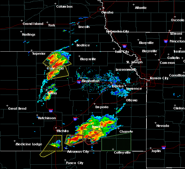 At 359 pm cdt, a severe thunderstorm was located near clifton, moving northeast at 40 mph (trained weather spotters reported hen egg sized hail in clifton at 357 pm). Hazards include two inch hail and 60 mph wind gusts. People and animals outdoors will be injured. expect hail damage to roofs, siding, windows, and vehicles. expect wind damage to roofs, siding, and trees. locations impacted include, washington, clyde, clifton, linn, greenleaf, palmer and vining. A tornado watch remains in effect until 900 pm cdt for north central kansas. At 359 pm cdt, a severe thunderstorm was located near clifton, moving northeast at 40 mph (trained weather spotters reported hen egg sized hail in clifton at 357 pm). Hazards include two inch hail and 60 mph wind gusts. People and animals outdoors will be injured. expect hail damage to roofs, siding, windows, and vehicles. expect wind damage to roofs, siding, and trees. locations impacted include, washington, clyde, clifton, linn, greenleaf, palmer and vining. A tornado watch remains in effect until 900 pm cdt for north central kansas.
|
| 10/6/2016 3:44 PM CDT | Quarter sized hail reported 3.9 miles NNE of Clyde, KS |
| 10/6/2016 3:44 PM CDT |
 At 343 pm cdt, a severe thunderstorm was located 4 miles south of clyde, moving northeast at 40 mph (radar indicated). Hazards include two inch hail and 60 mph wind gusts. People and animals outdoors will be injured. expect hail damage to roofs, siding, windows, and vehicles. Expect wind damage to roofs, siding, and trees. At 343 pm cdt, a severe thunderstorm was located 4 miles south of clyde, moving northeast at 40 mph (radar indicated). Hazards include two inch hail and 60 mph wind gusts. People and animals outdoors will be injured. expect hail damage to roofs, siding, windows, and vehicles. Expect wind damage to roofs, siding, and trees.
|
| 10/6/2016 3:39 PM CDT |
 At 339 pm cdt, a severe thunderstorm was located near vining, moving northeast at 40 mph (radar indicated). Hazards include two inch hail and 60 mph wind gusts. People and animals outdoors will be injured. expect hail damage to roofs, siding, windows, and vehicles. expect wind damage to roofs, siding, and trees. locations impacted include, clyde, clifton, aurora and vining. A tornado watch remains in effect until 900 pm cdt for north central kansas. At 339 pm cdt, a severe thunderstorm was located near vining, moving northeast at 40 mph (radar indicated). Hazards include two inch hail and 60 mph wind gusts. People and animals outdoors will be injured. expect hail damage to roofs, siding, windows, and vehicles. expect wind damage to roofs, siding, and trees. locations impacted include, clyde, clifton, aurora and vining. A tornado watch remains in effect until 900 pm cdt for north central kansas.
|
| 10/6/2016 3:20 PM CDT |
 At 320 pm cdt, a severe thunderstorm was located over aurora, moving northeast at 40 mph (radar indicated). Hazards include golf ball size hail and 60 mph wind gusts. People and animals outdoors will be injured. expect hail damage to roofs, siding, windows, and vehicles. expect wind damage to roofs, siding, and trees. locations impacted include, clyde, clifton, miltonvale, morganville, agenda, aurora and vining. A tornado watch remains in effect until 900 pm cdt for north central kansas. At 320 pm cdt, a severe thunderstorm was located over aurora, moving northeast at 40 mph (radar indicated). Hazards include golf ball size hail and 60 mph wind gusts. People and animals outdoors will be injured. expect hail damage to roofs, siding, windows, and vehicles. expect wind damage to roofs, siding, and trees. locations impacted include, clyde, clifton, miltonvale, morganville, agenda, aurora and vining. A tornado watch remains in effect until 900 pm cdt for north central kansas.
|
| 10/6/2016 3:08 PM CDT |
 At 307 pm cdt, a severe thunderstorm was located 8 miles northeast of delphos, moving northeast at 40 mph (radar indicated). Hazards include two inch hail and 60 mph wind gusts. People and animals outdoors will be injured. expect hail damage to roofs, siding, windows, and vehicles. Expect wind damage to roofs, siding, and trees. At 307 pm cdt, a severe thunderstorm was located 8 miles northeast of delphos, moving northeast at 40 mph (radar indicated). Hazards include two inch hail and 60 mph wind gusts. People and animals outdoors will be injured. expect hail damage to roofs, siding, windows, and vehicles. Expect wind damage to roofs, siding, and trees.
|
| 7/28/2016 6:55 PM CDT |
 The severe thunderstorm warning for north central clay, southwestern washington, southeastern republic and northeastern cloud counties will expire at 700 pm cdt, the storm which prompted the warning has weakened below severe limits, and no longer pose an immediate threat to life or property. therefore the warning will be allowed to expire. however gusty winds and heavy rain are still possible with this thunderstorm. a severe thunderstorm watch remains in effect until 1100 pm cdt for north central kansas. remember, a severe thunderstorm warning still remains in effect for cloudy county. The severe thunderstorm warning for north central clay, southwestern washington, southeastern republic and northeastern cloud counties will expire at 700 pm cdt, the storm which prompted the warning has weakened below severe limits, and no longer pose an immediate threat to life or property. therefore the warning will be allowed to expire. however gusty winds and heavy rain are still possible with this thunderstorm. a severe thunderstorm watch remains in effect until 1100 pm cdt for north central kansas. remember, a severe thunderstorm warning still remains in effect for cloudy county.
|
| 7/28/2016 6:28 PM CDT |
 At 627 pm cdt, a severe thunderstorm was located near norway, moving east at 40 mph (radar indicated). Hazards include 60 mph wind gusts and penny size hail. Expect damage to roofs. siding. And trees. At 627 pm cdt, a severe thunderstorm was located near norway, moving east at 40 mph (radar indicated). Hazards include 60 mph wind gusts and penny size hail. Expect damage to roofs. siding. And trees.
|
| 7/13/2016 7:32 AM CDT | At 732 am cdt, severe thunderstorms were located along a line extending from 6 miles north of concordia to near niles to 6 miles southeast of lindsborg, moving east at 50 mph (radar indicated). Hazards include 60 mph wind gusts and penny size hail. Expect damage to roofs. siding. and trees. Locations impacted include, concordia, minneapolis, clyde, bennington, miltonvale, glasco, delphos, tescott, jamestown, culver, wells, aurora, ada and niles. |
| 7/13/2016 7:13 AM CDT |
 At 712 am cdt, severe thunderstorms were located along a line extending from near jamestown to 7 miles south of beverly to 7 miles east of geneseo, moving east at 45 mph (radar indicated). Hazards include 60 mph wind gusts and penny size hail. Expect damage to roofs. siding. and trees. Locations impacted include, concordia, minneapolis, clyde, bennington, miltonvale, glasco, delphos, tescott, jamestown, culver, wells, aurora, ada and niles. At 712 am cdt, severe thunderstorms were located along a line extending from near jamestown to 7 miles south of beverly to 7 miles east of geneseo, moving east at 45 mph (radar indicated). Hazards include 60 mph wind gusts and penny size hail. Expect damage to roofs. siding. and trees. Locations impacted include, concordia, minneapolis, clyde, bennington, miltonvale, glasco, delphos, tescott, jamestown, culver, wells, aurora, ada and niles.
|
| 7/13/2016 7:01 AM CDT |
 At 659 am cdt, severe thunderstorms were located along a line extending from 6 miles south of jewell to 10 miles north of ellsworth to near chase, moving east at 40 mph (radar indicated). Hazards include 60 mph wind gusts and penny size hail. Expect damage to roofs. siding. And trees. At 659 am cdt, severe thunderstorms were located along a line extending from 6 miles south of jewell to 10 miles north of ellsworth to near chase, moving east at 40 mph (radar indicated). Hazards include 60 mph wind gusts and penny size hail. Expect damage to roofs. siding. And trees.
|
| 7/12/2016 12:25 AM CDT |
 At 1225 am cdt, a severe thunderstorm was located near vining, moving east at 35 mph (radar indicated). Hazards include golf ball size hail and 60 mph wind gusts. People and animals outdoors will be injured. expect hail damage to roofs, siding, windows, and vehicles. expect wind damage to roofs, siding, and trees. Locations impacted include, clay center, clyde, clifton, morganville, green, palmer and vining. At 1225 am cdt, a severe thunderstorm was located near vining, moving east at 35 mph (radar indicated). Hazards include golf ball size hail and 60 mph wind gusts. People and animals outdoors will be injured. expect hail damage to roofs, siding, windows, and vehicles. expect wind damage to roofs, siding, and trees. Locations impacted include, clay center, clyde, clifton, morganville, green, palmer and vining.
|
| 7/12/2016 12:23 AM CDT |
 At 1221 am cdt, a severe thunderstorm was located near vining, moving east at 30 mph (radar indicated). Hazards include 60 mph wind gusts and quarter size hail. Hail damage to vehicles is expected. Expect wind damage to roofs, siding, and trees. At 1221 am cdt, a severe thunderstorm was located near vining, moving east at 30 mph (radar indicated). Hazards include 60 mph wind gusts and quarter size hail. Hail damage to vehicles is expected. Expect wind damage to roofs, siding, and trees.
|
| 5/24/2016 10:27 PM CDT | The national weather service in topeka has issued a * severe thunderstorm warning for. clay county in north central kansas. southwestern washington county in north central kansas. southeastern republic county in north central kansas. Cloud county in north central kansas. |
| 5/11/2016 3:31 AM CDT |
 At 330 am cdt, a severe thunderstorm was located over morganville, moving northeast at 40 mph (radar indicated). Hazards include 60 mph wind gusts and half dollar size hail. Hail damage to vehicles is expected. expect wind damage to roofs, siding, and trees. Locations impacted include, clyde, clifton, miltonvale, linn, morganville, palmer, agenda, aurora, vining and idana. At 330 am cdt, a severe thunderstorm was located over morganville, moving northeast at 40 mph (radar indicated). Hazards include 60 mph wind gusts and half dollar size hail. Hail damage to vehicles is expected. expect wind damage to roofs, siding, and trees. Locations impacted include, clyde, clifton, miltonvale, linn, morganville, palmer, agenda, aurora, vining and idana.
|
| 5/11/2016 3:16 AM CDT |
 At 315 am cdt, a severe thunderstorm was located near idana, moving northeast at 40 mph (radar indicated). Hazards include 60 mph wind gusts and half dollar size hail. Hail damage to vehicles is expected. Expect wind damage to roofs, siding, and trees. At 315 am cdt, a severe thunderstorm was located near idana, moving northeast at 40 mph (radar indicated). Hazards include 60 mph wind gusts and half dollar size hail. Hail damage to vehicles is expected. Expect wind damage to roofs, siding, and trees.
|
| 5/11/2016 3:01 AM CDT |
 At 301 am cdt, a severe thunderstorm was located near aurora, moving northeast at 40 mph (radar indicated). Hazards include half dollar size hail. Damage to vehicles is expected. Locations impacted include, concordia, clay center, clyde, clifton, miltonvale, glasco, delphos, jamestown, morganville, norway, palmer, aurora, vining, oak hill and idana. At 301 am cdt, a severe thunderstorm was located near aurora, moving northeast at 40 mph (radar indicated). Hazards include half dollar size hail. Damage to vehicles is expected. Locations impacted include, concordia, clay center, clyde, clifton, miltonvale, glasco, delphos, jamestown, morganville, norway, palmer, aurora, vining, oak hill and idana.
|
| 5/11/2016 2:47 AM CDT |
 At 246 am cdt, a severe thunderstorm was located near miltonvale, moving northeast at 40 mph (radar indicated). Hazards include half dollar size hail. damage to vehicles is expected At 246 am cdt, a severe thunderstorm was located near miltonvale, moving northeast at 40 mph (radar indicated). Hazards include half dollar size hail. damage to vehicles is expected
|
| 5/9/2016 1:55 AM CDT | Quarter sized hail reported 3.7 miles SSW of Clyde, KS |
| 5/9/2016 1:42 AM CDT | Half Dollar sized hail reported 0.6 miles E of Clyde, KS |
| 5/9/2016 1:27 AM CDT | At 126 am cdt, a severe thunderstorm was located 6 miles north of aurora, moving northeast at 35 mph (radar indicated). Hazards include 60 mph wind gusts and half dollar size hail. Hail damage to vehicles is expected. Expect wind damage to roofs, siding, and trees. |
| 5/8/2016 10:49 PM CDT |
 At 1049 pm cdt, a severe thunderstorm was located over concordia, moving northeast at 35 mph (radar indicated). Hazards include 60 mph wind gusts and penny size hail. Expect damage to roofs. siding. and trees. Locations impacted include, concordia, clyde and aurora. At 1049 pm cdt, a severe thunderstorm was located over concordia, moving northeast at 35 mph (radar indicated). Hazards include 60 mph wind gusts and penny size hail. Expect damage to roofs. siding. and trees. Locations impacted include, concordia, clyde and aurora.
|
| 5/8/2016 10:36 PM CDT |
 At 1036 pm cdt, a severe thunderstorm was located 6 miles southwest of concordia, moving northeast at 40 mph (radar indicated). Hazards include 60 mph wind gusts and penny size hail. Expect damage to roofs. siding. And trees. At 1036 pm cdt, a severe thunderstorm was located 6 miles southwest of concordia, moving northeast at 40 mph (radar indicated). Hazards include 60 mph wind gusts and penny size hail. Expect damage to roofs. siding. And trees.
|
| 4/26/2016 5:06 PM CDT | Quarter sized hail reported 2.6 miles ESE of Clyde, KS |
| 4/26/2016 3:30 AM CDT |
 At 330 am cdt, a severe thunderstorm was located over vining, moving northeast at 30 mph (radar indicated). Hazards include quarter size hail. Damage to vehicles is expected. Locations impacted include, clyde, clifton, linn, palmer and vining. At 330 am cdt, a severe thunderstorm was located over vining, moving northeast at 30 mph (radar indicated). Hazards include quarter size hail. Damage to vehicles is expected. Locations impacted include, clyde, clifton, linn, palmer and vining.
|
| 4/26/2016 3:12 AM CDT |
 At 312 am cdt, a severe thunderstorm was located 8 miles southwest of vining, moving northeast at 30 mph (radar indicated). Hazards include quarter size hail. damage to vehicles is expected At 312 am cdt, a severe thunderstorm was located 8 miles southwest of vining, moving northeast at 30 mph (radar indicated). Hazards include quarter size hail. damage to vehicles is expected
|
| 8/10/2015 12:28 AM CDT |
 At 1228 am cdt, a severe thunderstorm was located near clyde, moving southeast at 20 mph (radar indicated). Hazards include 60 mph wind gusts and penny size hail. Expect damage to roofs. siding and trees. Locations impacted include, clyde, clifton and vining. At 1228 am cdt, a severe thunderstorm was located near clyde, moving southeast at 20 mph (radar indicated). Hazards include 60 mph wind gusts and penny size hail. Expect damage to roofs. siding and trees. Locations impacted include, clyde, clifton and vining.
|
| 8/10/2015 12:11 AM CDT |
 At 1211 am cdt, a severe thunderstorm was located 7 miles southwest of agenda, moving southeast at 20 mph (radar indicated). Hazards include 60 mph wind gusts and nickel size hail. Expect damage to roofs. Siding and trees. At 1211 am cdt, a severe thunderstorm was located 7 miles southwest of agenda, moving southeast at 20 mph (radar indicated). Hazards include 60 mph wind gusts and nickel size hail. Expect damage to roofs. Siding and trees.
|
| 5/6/2015 9:50 PM CDT | At 948 pm cdt, a confirmed tornado was located near clyde, and moving northeast at 30 mph (law enforcement confirmed tornado). Hazards include damaging tornado and golf ball size hail. Flying debris will be dangerous to those caught without shelter. mobile homes will be damaged or destroyed. damage to roofs, windows and vehicles will occur. tree damage is likely. the tornado will be near, clifton around 955 pm cdt. Observed. |
| 5/6/2015 9:42 PM CDT | Golf Ball sized hail reported 5.6 miles N of Clyde, KS, this is a delayed report. spotter measured golf ball size hail with the storm that passed over his location at 942 pm cdt. |
| 5/6/2015 8:54 PM CDT | The tornado warning for southwestern washington, northeastern cloud and southeastern republic counties will expire at 900 pm cdt, the storm which prompted the warning has weakened below severe limits, and no longer poses an immediate threat to life or property. however, small hail and gusty winds are still possible with this thunderstorm. in addition, strong thunderstorms may redevelop, and a tornado watch remains in effect until 200 am. |
| 5/6/2015 8:45 PM CDT | At 843 pm cdt, a severe thunderstorm capable of producing a tornado was located near clyde, and moving northeast at 40 mph (radar indicated rotation). Hazards include tornado and quarter size hail. Flying debris will be dangerous to those caught without shelter. mobile homes will be damaged or destroyed. damage to roofs, windows and vehicles will occur. tree damage is likely. this dangerous storm will be near, agenda around 850 pm cdt. Radar indicated. |
| 5/6/2015 8:28 PM CDT | At 828 pm cdt, a severe thunderstorm capable of producing a tornado was located near clyde, and moving northeast at 35 mph (radar indicated rotation). Hazards include tornado and quarter size hail. Flying debris will be dangerous to those caught without shelter. mobile homes will be damaged or destroyed. damage to roofs, windows and vehicles will occur. tree damage is likely. this dangerous storm will be near, clyde around 835 pm cdt. vining and clifton around 840 pm cdt. Radar indicated. |
| 4/18/2015 5:22 PM CDT | Quarter sized hail reported 5.3 miles ESE of Clyde, KS |
| 4/12/2015 9:11 PM CDT | A severe thunderstorm warning remains in effect for southwestern washington. northeastern cloud. northwestern clay and southeastern republic counties until 945 pm cdt. at 909 pm cdt. severe thunderstorms were located along a line extending from agenda to 9 miles west of aurora. And moving east at 30 mph. |
| 4/12/2015 8:59 PM CDT | The national weather service in topeka has issued a * severe thunderstorm warning for. northwestern clay county in north central kansas. cloud county in north central kansas. southeastern republic county in north central kansas. Southwestern washington county in north central kansas. |
| 5/22/2014 3:10 AM CDT | Quarter sized hail reported 0.1 miles NE of Clyde, KS, mostly dime size hail...perhaps a few up to quarter size. |
| 5/28/2013 6:22 PM CDT | Quarter sized hail reported 2.6 miles ESE of Clyde, KS |
| 5/28/2013 6:14 PM CDT | Quarter sized hail reported 6.3 miles N of Clyde, KS |
| 4/14/2012 2:46 PM CDT | Quarter sized hail reported 2.6 miles ESE of Clyde, KS |
| 1/1/0001 12:00 AM | Irrigation pivot reported overturned along with tree limbs down across clyd in cloud county KS, 2.2 miles N of Clyde, KS |
| 1/1/0001 12:00 AM | Ping Pong Ball sized hail reported 6.4 miles SSW of Clyde, KS |
| 1/1/0001 12:00 AM | Quarter sized hail reported 6.4 miles SSW of Clyde, KS |
| 1/1/0001 12:00 AM | Quarter sized hail reported 0.1 miles NE of Clyde, KS |
| 1/1/0001 12:00 AM | Quarter sized hail reported 11.1 miles N of Clyde, KS, delayed report via nssl severe hazards analysis and verification experiment |
| 1/1/0001 12:00 AM | Quarter sized hail reported 0.1 miles NE of Clyde, KS |
| 1/1/0001 12:00 AM | Golf Ball sized hail reported 4.1 miles ENE of Clyde, KS |
| 1/1/0001 12:00 AM | Quarter sized hail reported 0.1 miles NE of Clyde, KS |
Hail Maps for Clyde, KS
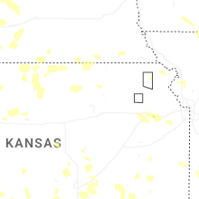
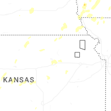


Connect with Interactive Hail Maps