

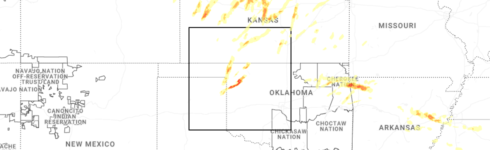
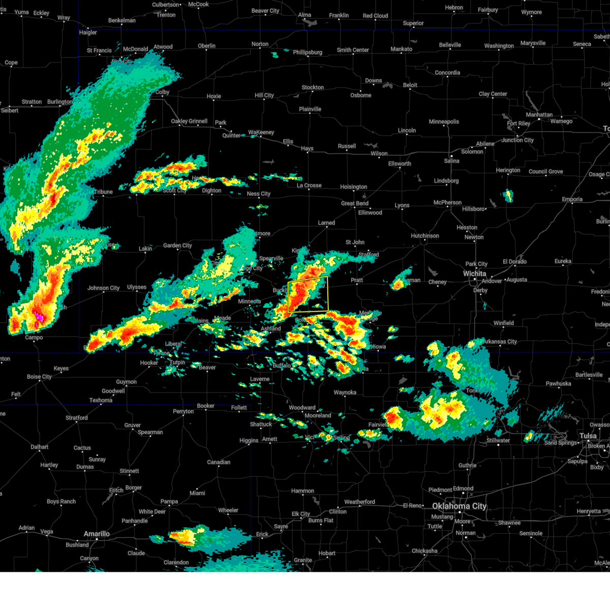
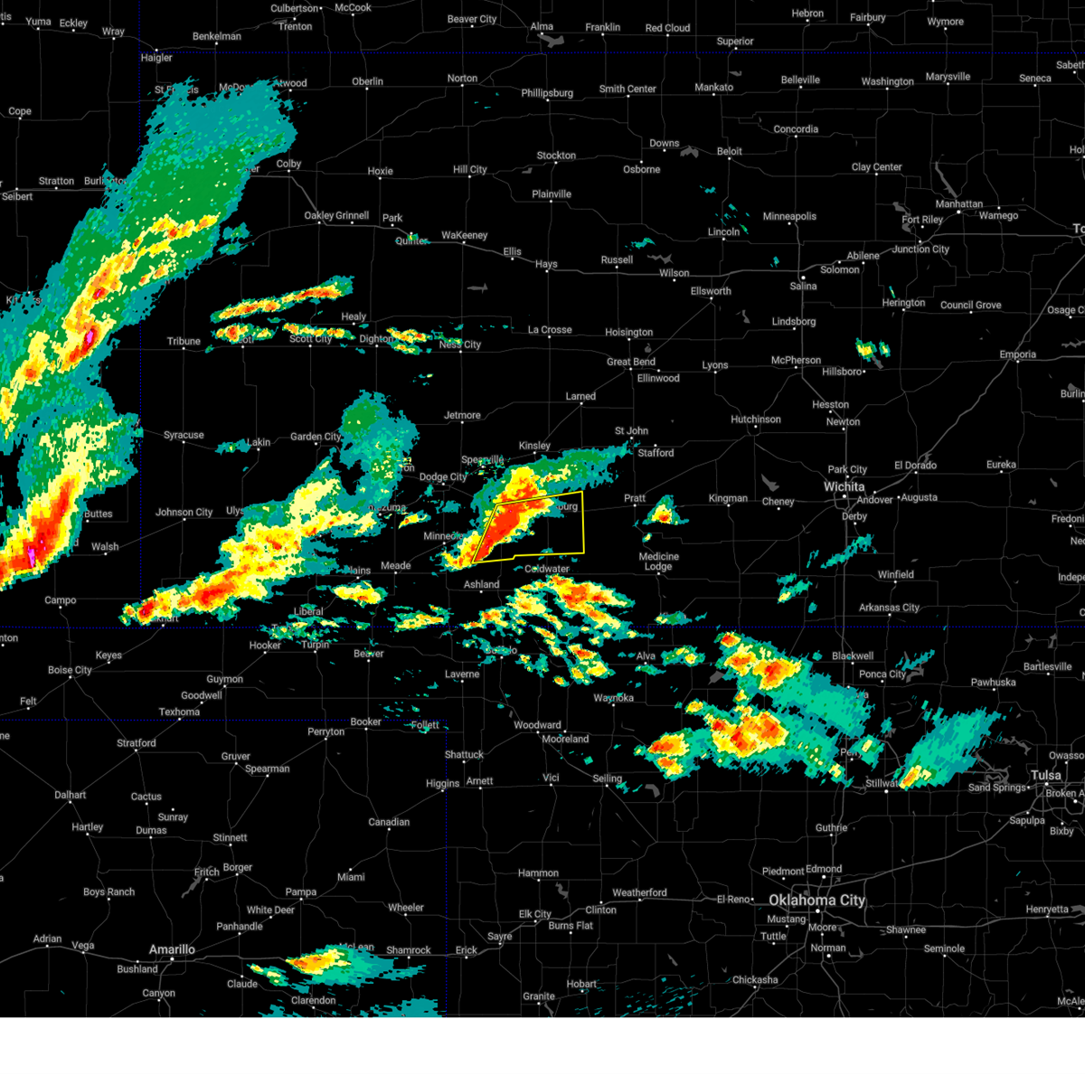
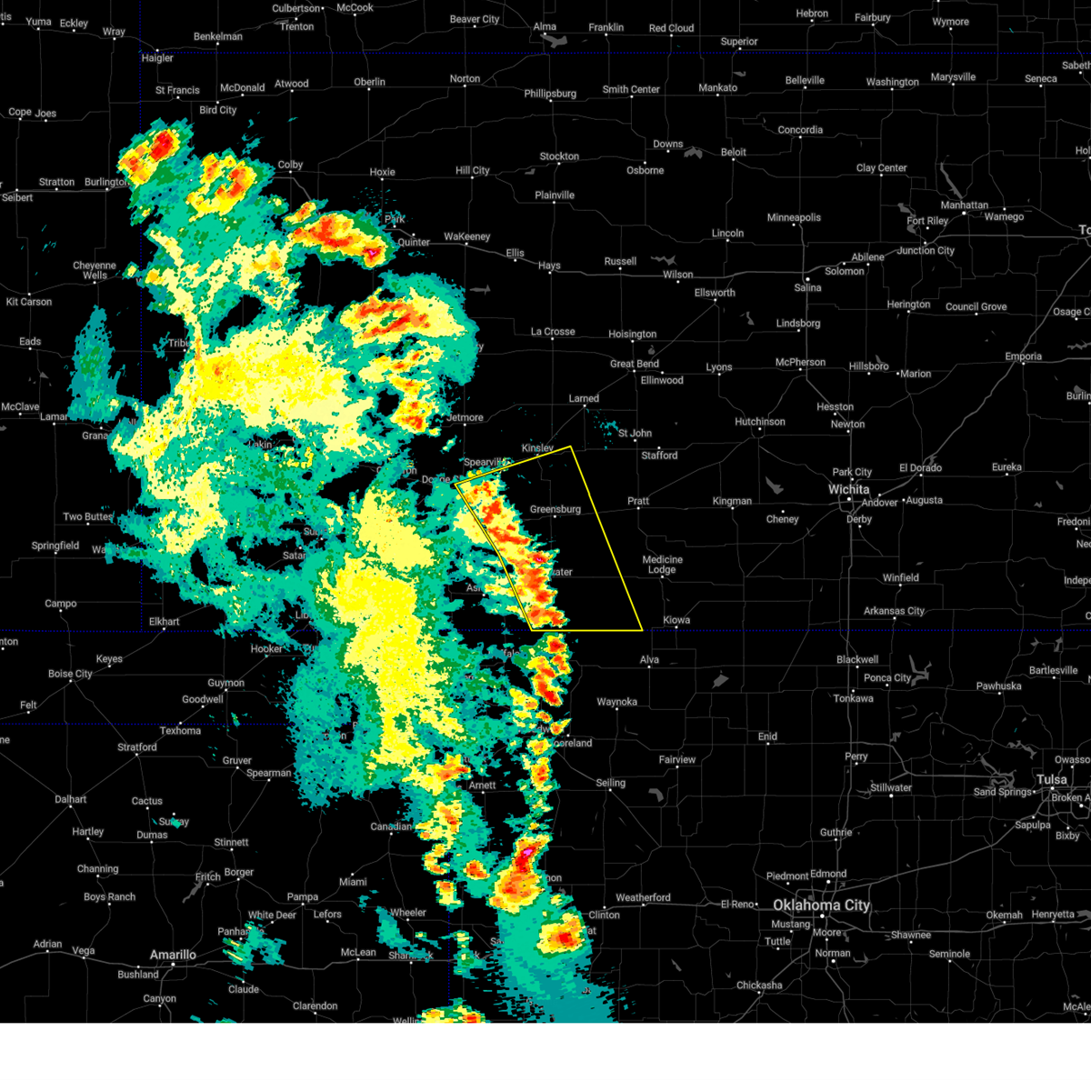
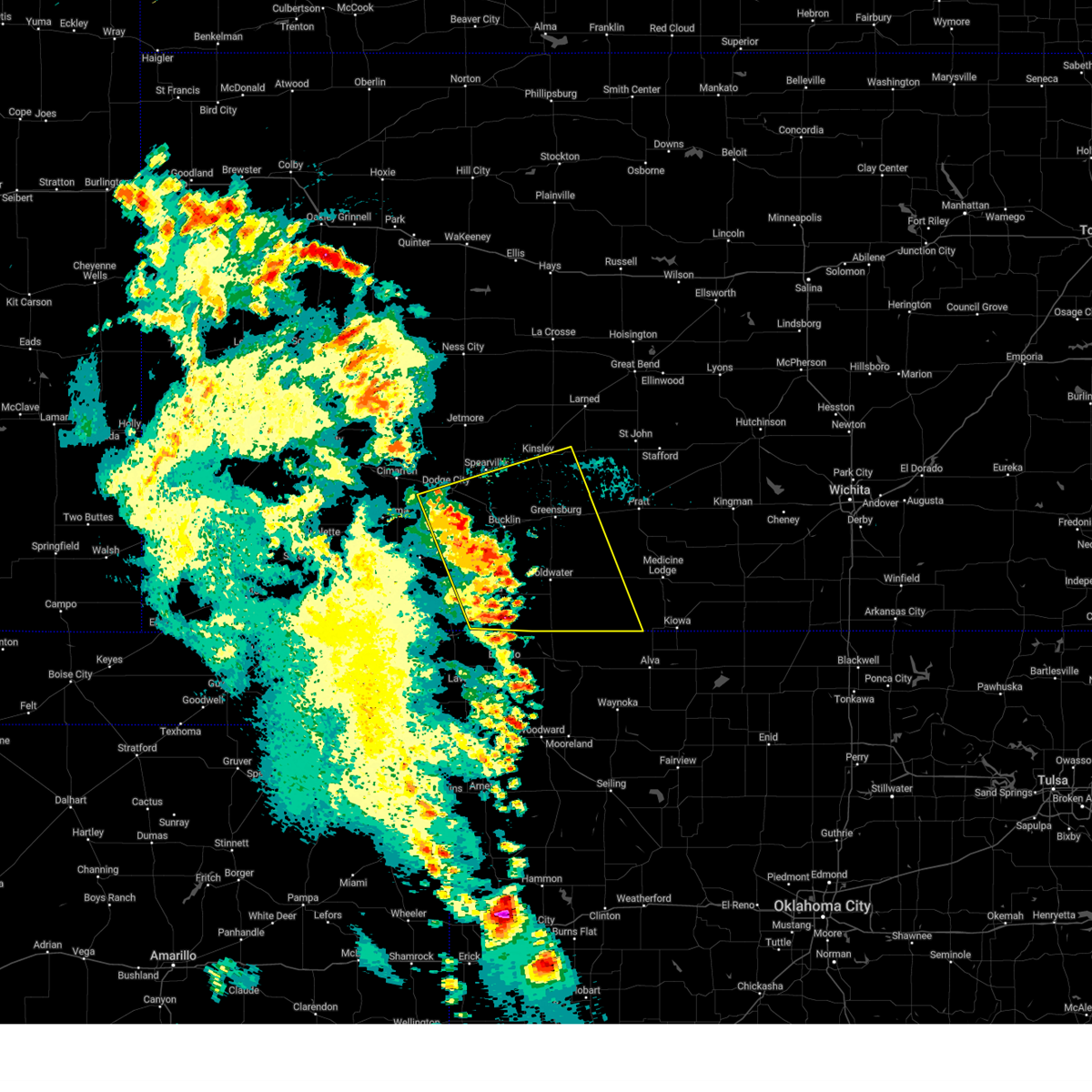
Hail Map for Greensburg, KS
The Greensburg, KS area has had 30 reports of on-the-ground hail by trained spotters, and has been under severe weather warnings 27 times during the past 12 months. Doppler radar has detected hail at or near Greensburg, KS on 89 occasions, including 4 occasions during the past year.
| Name: | Greensburg, KS |
| Where Located: | 80.9 miles N of Woodward, OK |
| Map: | Google Map for Greensburg, KS |
| Population: | 777 |
| Housing Units: | 431 |
| More Info: | Search Google for Greensburg, KS |
1
The Top Recent Hail Date for Greensburg, KS is Sunday, May 18, 2025 (11th out of 89)
Hail and Wind Damage Spotted near Greensburg, KS
| Date / Time | Report Details |
|---|---|
| 6/5/2025 9:55 PM CDT |
 The storm which prompted the warning has weakened below severe limits, and no longer poses an immediate threat to life or property. therefore, the warning will be allowed to expire. a severe thunderstorm watch remains in effect until 200 am cdt for south central kansas. The storm which prompted the warning has weakened below severe limits, and no longer poses an immediate threat to life or property. therefore, the warning will be allowed to expire. a severe thunderstorm watch remains in effect until 200 am cdt for south central kansas.
|
| 6/5/2025 9:43 PM CDT |
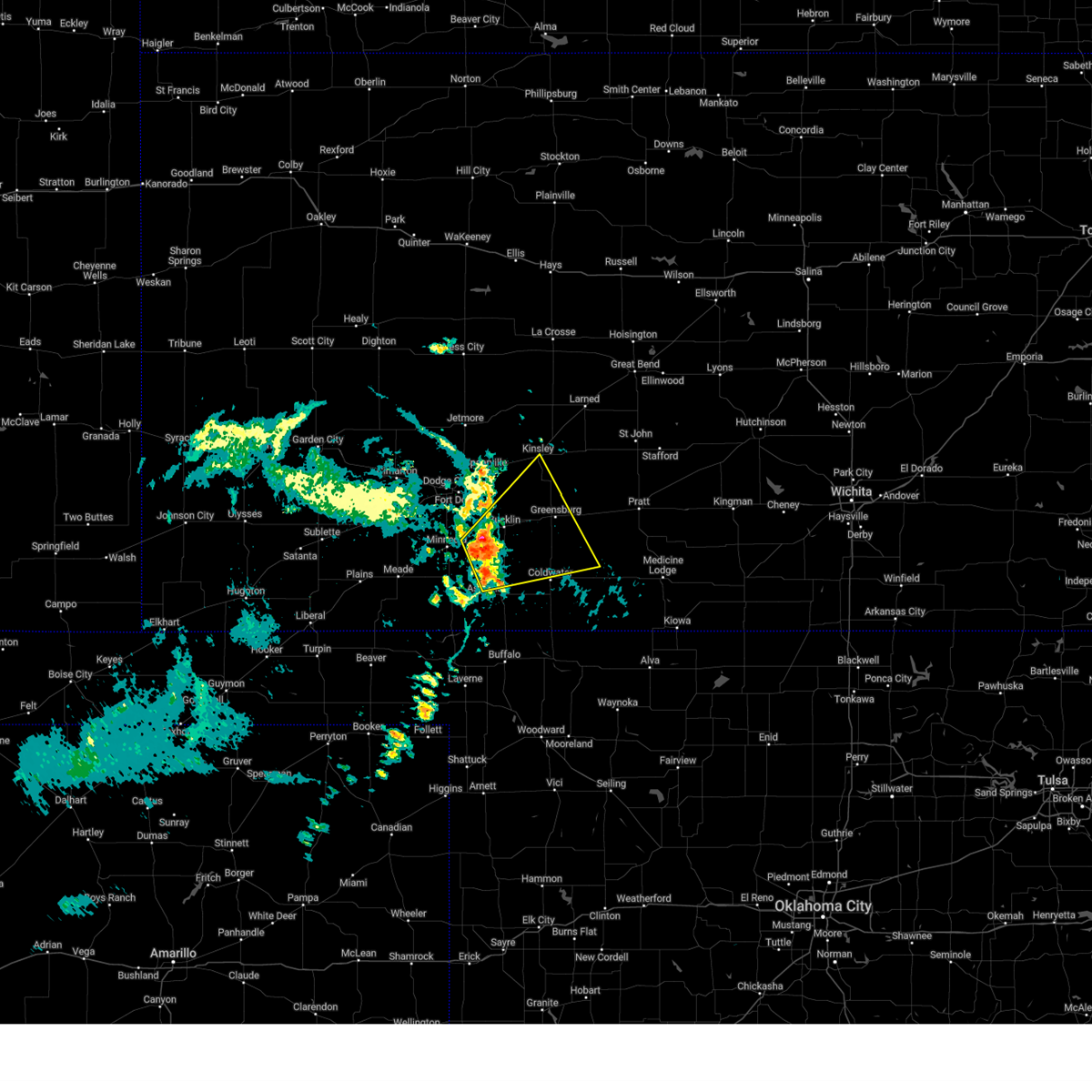
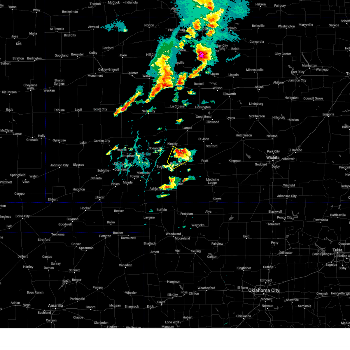
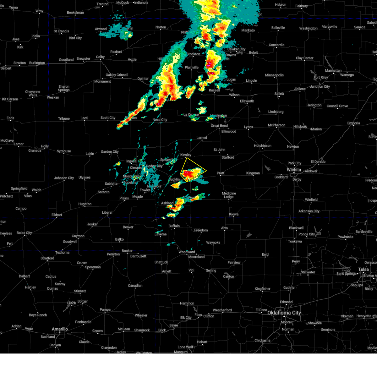
 At 943 pm cdt, a severe thunderstorm was located near greensburg, moving east at 30 mph (radar indicated). Hazards include 60 mph wind gusts and quarter size hail. Hail damage to vehicles is expected. expect wind damage to roofs, siding, and trees. Locations impacted include, greensburg and haviland. At 943 pm cdt, a severe thunderstorm was located near greensburg, moving east at 30 mph (radar indicated). Hazards include 60 mph wind gusts and quarter size hail. Hail damage to vehicles is expected. expect wind damage to roofs, siding, and trees. Locations impacted include, greensburg and haviland.
|
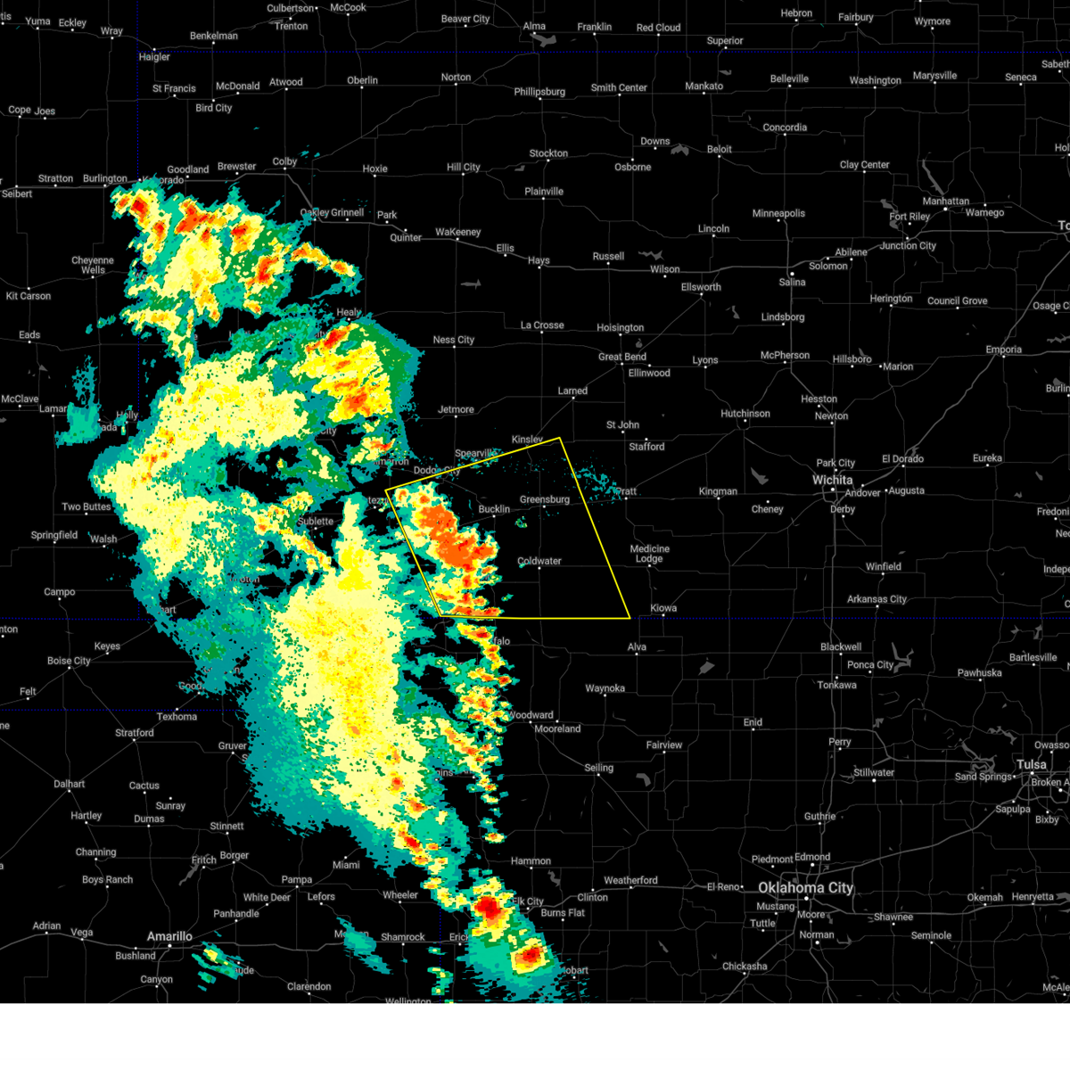
| 6/5/2025 9:29 PM CDT |
 At 924 pm cdt, a severe thunderstorm was located near mullinville, moving east at 30 mph (radar indicated). Hazards include 60 mph wind gusts and quarter size hail. Hail damage to vehicles is expected. expect wind damage to roofs, siding, and trees. Locations impacted include, greensburg, haviland, and mullinville. At 924 pm cdt, a severe thunderstorm was located near mullinville, moving east at 30 mph (radar indicated). Hazards include 60 mph wind gusts and quarter size hail. Hail damage to vehicles is expected. expect wind damage to roofs, siding, and trees. Locations impacted include, greensburg, haviland, and mullinville.
|
| 6/5/2025 9:29 PM CDT |
 the severe thunderstorm warning has been cancelled and is no longer in effect the severe thunderstorm warning has been cancelled and is no longer in effect
|
| 6/5/2025 9:08 PM CDT |
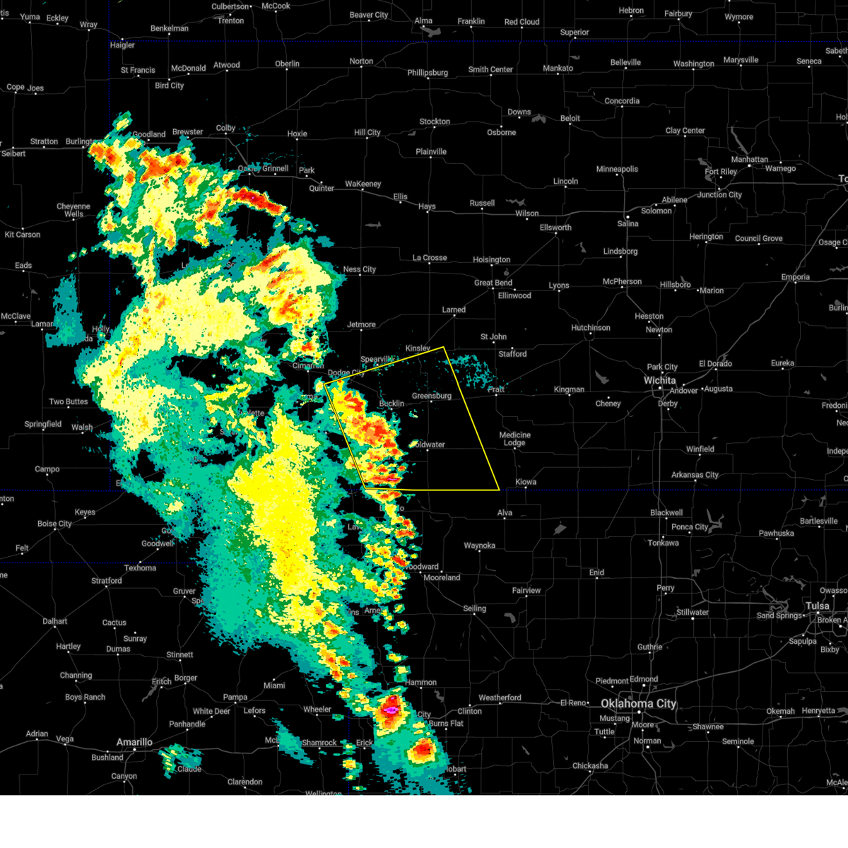
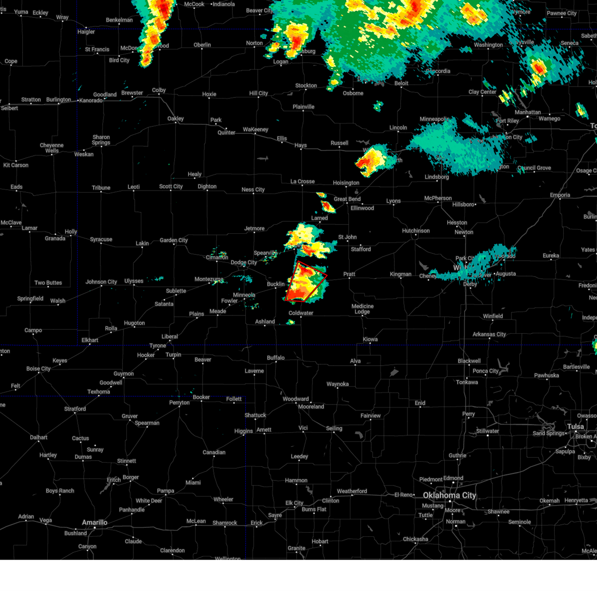
 Svrddc the national weather service in dodge city has issued a * severe thunderstorm warning for, southeastern ford county in southwestern kansas, kiowa county in south central kansas, northeastern clark county in southwestern kansas, * until 1000 pm cdt. * at 908 pm cdt, a severe thunderstorm was located near bucklin, moving east at 30 mph (radar indicated). Hazards include 60 mph wind gusts and quarter size hail. Hail damage to vehicles is expected. expect wind damage to roofs, siding, and trees. This severe thunderstorm will remain over mainly rural areas of southeastern ford, kiowa and northeastern clark counties. Svrddc the national weather service in dodge city has issued a * severe thunderstorm warning for, southeastern ford county in southwestern kansas, kiowa county in south central kansas, northeastern clark county in southwestern kansas, * until 1000 pm cdt. * at 908 pm cdt, a severe thunderstorm was located near bucklin, moving east at 30 mph (radar indicated). Hazards include 60 mph wind gusts and quarter size hail. Hail damage to vehicles is expected. expect wind damage to roofs, siding, and trees. This severe thunderstorm will remain over mainly rural areas of southeastern ford, kiowa and northeastern clark counties.
|
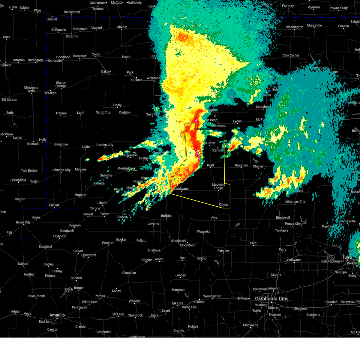
| 6/2/2025 7:41 PM CDT |
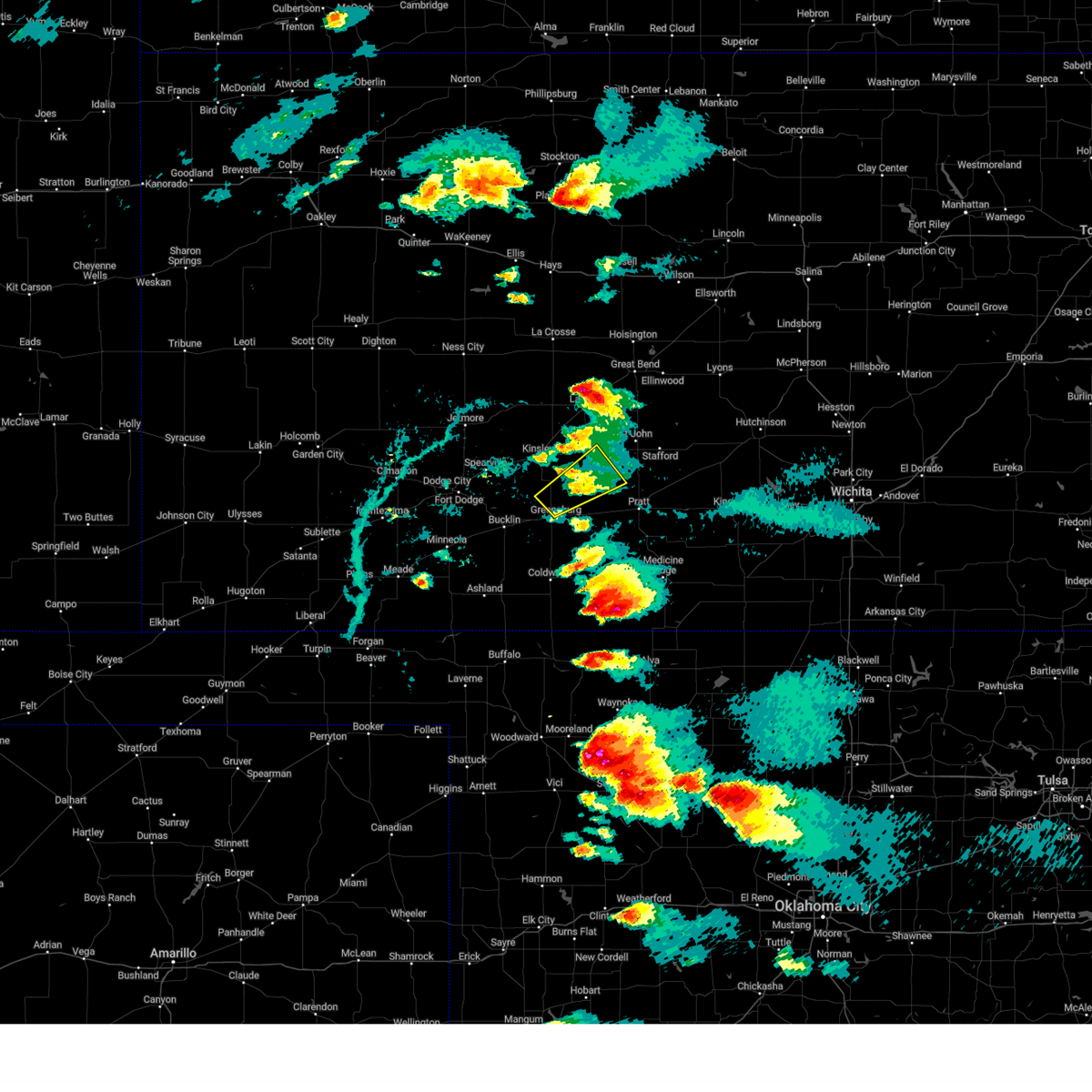
 At 740 pm cdt, severe thunderstorms were located along a line extending from 7 miles south of kinsley to near aetna, moving east at 50 mph (radar indicated). Hazards include 60 mph wind gusts. Expect damage to roofs, siding, and trees. Locations impacted include, haviland, sun city, belvidere, centerview, fellsburg, croft and wellsford. At 740 pm cdt, severe thunderstorms were located along a line extending from 7 miles south of kinsley to near aetna, moving east at 50 mph (radar indicated). Hazards include 60 mph wind gusts. Expect damage to roofs, siding, and trees. Locations impacted include, haviland, sun city, belvidere, centerview, fellsburg, croft and wellsford.
|
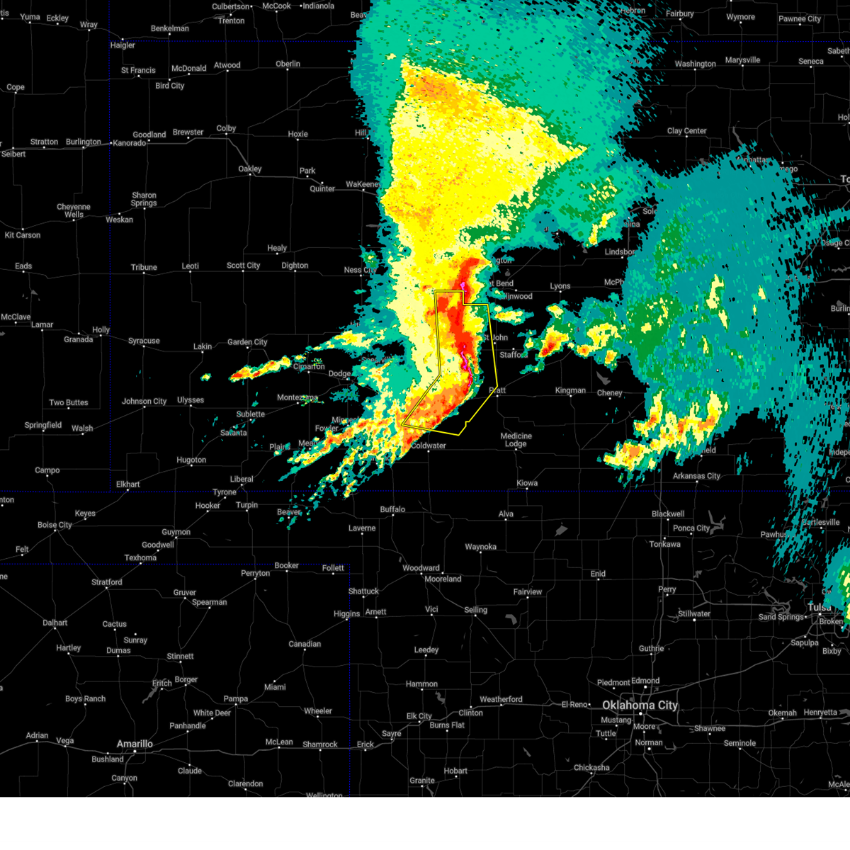
| 6/2/2025 7:22 PM CDT |
 At 722 pm cdt, severe thunderstorms were located along a line extending from near wright to near buttermilk, moving east at 50 mph (radar indicated). Hazards include 60 mph wind gusts. Expect damage to roofs, siding, and trees. these severe storms will be near, coldwater, mullinville, windhorst, and lake coldwater around 725 pm cdt. wilmore around 730 pm cdt. Other locations in the path of these severe thunderstorms include greensburg, aetna, belvidere, haviland, sun city, centerview, fellsburg, croft and wellsford. At 722 pm cdt, severe thunderstorms were located along a line extending from near wright to near buttermilk, moving east at 50 mph (radar indicated). Hazards include 60 mph wind gusts. Expect damage to roofs, siding, and trees. these severe storms will be near, coldwater, mullinville, windhorst, and lake coldwater around 725 pm cdt. wilmore around 730 pm cdt. Other locations in the path of these severe thunderstorms include greensburg, aetna, belvidere, haviland, sun city, centerview, fellsburg, croft and wellsford.
|
| 6/2/2025 7:22 PM CDT |
 the severe thunderstorm warning has been cancelled and is no longer in effect the severe thunderstorm warning has been cancelled and is no longer in effect
|
| 6/2/2025 7:12 PM CDT |
 Svrddc the national weather service in dodge city has issued a * severe thunderstorm warning for, ford county in southwestern kansas, kiowa county in south central kansas, northeastern meade county in southwestern kansas, western barber county in south central kansas, comanche county in south central kansas, southeastern gray county in southwestern kansas, southern edwards county in south central kansas, southwestern pratt county in south central kansas, clark county in southwestern kansas, * until 800 pm cdt. * at 712 pm cdt, severe thunderstorms were located along a line extending from near ft. dodge to near buttermilk, moving east at 50 mph (radar indicated). Hazards include 60 mph wind gusts. Expect damage to roofs, siding, and trees. severe thunderstorms will be near, coldwater, bucklin, protection, ford, wright, and buttermilk around 715 pm cdt. lake coldwater around 720 pm cdt. mullinville and windhorst around 725 pm cdt. wilmore around 730 pm cdt. Other locations in the path of these severe thunderstorms include greensburg, aetna, belvidere, haviland, sun city, centerview and croft. Svrddc the national weather service in dodge city has issued a * severe thunderstorm warning for, ford county in southwestern kansas, kiowa county in south central kansas, northeastern meade county in southwestern kansas, western barber county in south central kansas, comanche county in south central kansas, southeastern gray county in southwestern kansas, southern edwards county in south central kansas, southwestern pratt county in south central kansas, clark county in southwestern kansas, * until 800 pm cdt. * at 712 pm cdt, severe thunderstorms were located along a line extending from near ft. dodge to near buttermilk, moving east at 50 mph (radar indicated). Hazards include 60 mph wind gusts. Expect damage to roofs, siding, and trees. severe thunderstorms will be near, coldwater, bucklin, protection, ford, wright, and buttermilk around 715 pm cdt. lake coldwater around 720 pm cdt. mullinville and windhorst around 725 pm cdt. wilmore around 730 pm cdt. Other locations in the path of these severe thunderstorms include greensburg, aetna, belvidere, haviland, sun city, centerview and croft.
|
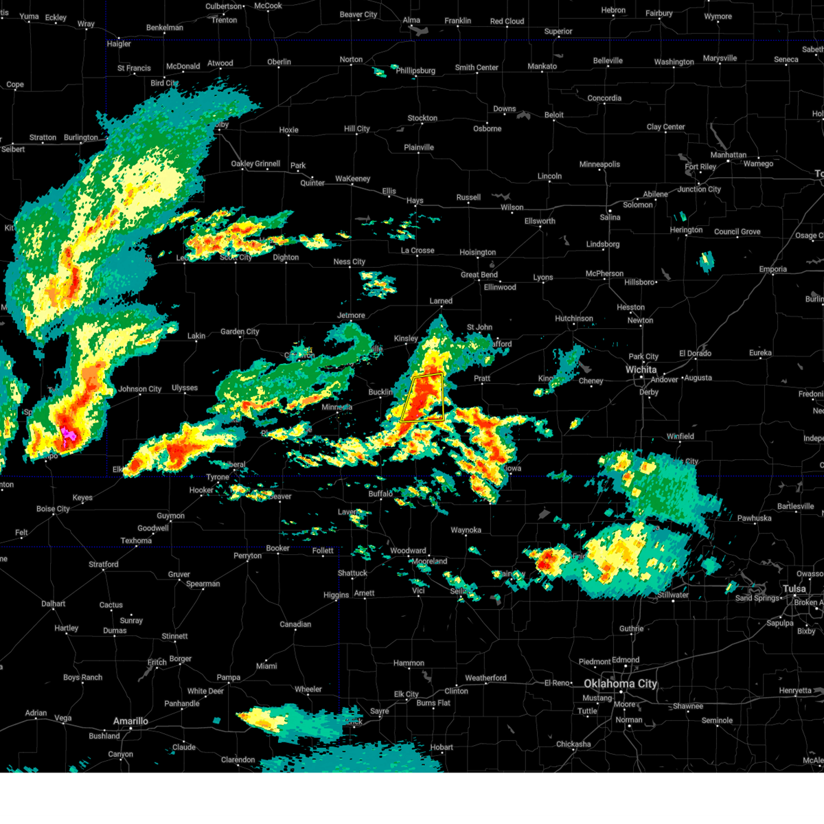
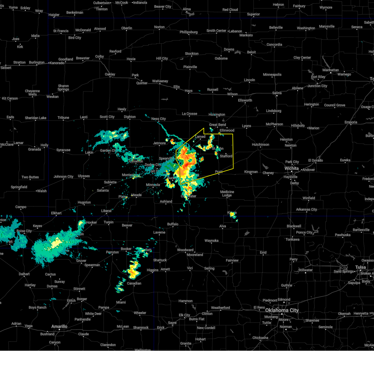
| 5/25/2025 6:01 AM CDT |
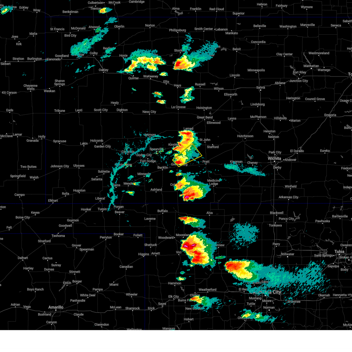
 At 600 am cdt, severe thunderstorms were located along a line extending from near larned to near byers to 6 miles northwest of belvidere, moving east at 50 mph (radar indicated). Hazards include 70 mph wind gusts and penny size hail. Expect considerable tree damage. damage is likely to mobile homes, roofs, and outbuildings. Locations impacted include, pratt, larned, greensburg, haviland, macksville, garfield, iuka, cullison, belpre, ash valley, byers, radium, fellsburg, hopewell, wellsford, croft, frizell, zook, trousdale, and dillwyn. At 600 am cdt, severe thunderstorms were located along a line extending from near larned to near byers to 6 miles northwest of belvidere, moving east at 50 mph (radar indicated). Hazards include 70 mph wind gusts and penny size hail. Expect considerable tree damage. damage is likely to mobile homes, roofs, and outbuildings. Locations impacted include, pratt, larned, greensburg, haviland, macksville, garfield, iuka, cullison, belpre, ash valley, byers, radium, fellsburg, hopewell, wellsford, croft, frizell, zook, trousdale, and dillwyn.
|
| 5/25/2025 5:59 AM CDT |
 Svrddc the national weather service in dodge city has issued a * severe thunderstorm warning for, kiowa county in south central kansas, barber county in south central kansas, northern comanche county in south central kansas, eastern pawnee county in south central kansas, stafford county in south central kansas, southeastern edwards county in south central kansas, pratt county in south central kansas, * until 700 am cdt. * at 558 am cdt, severe thunderstorms were located along a line extending from near pawnee rock to near hopewell to 9 miles northwest of wilmore, moving east at 55 mph (radar indicated). Hazards include 70 mph wind gusts and penny size hail. Expect considerable tree damage. damage is likely to mobile homes, roofs, and outbuildings. severe thunderstorms will be near, pratt, st. john, iuka, cullison, seward, byers, radium, dillwyn, belvidere, and croft around 605 am cdt. stafford, hudson, coats, and sun city around 615 am cdt. Other locations in the path of these severe thunderstorms include preston, sawyer, cairo, neola, lake city, zenith, isabel, medicine lodge and sharon. Svrddc the national weather service in dodge city has issued a * severe thunderstorm warning for, kiowa county in south central kansas, barber county in south central kansas, northern comanche county in south central kansas, eastern pawnee county in south central kansas, stafford county in south central kansas, southeastern edwards county in south central kansas, pratt county in south central kansas, * until 700 am cdt. * at 558 am cdt, severe thunderstorms were located along a line extending from near pawnee rock to near hopewell to 9 miles northwest of wilmore, moving east at 55 mph (radar indicated). Hazards include 70 mph wind gusts and penny size hail. Expect considerable tree damage. damage is likely to mobile homes, roofs, and outbuildings. severe thunderstorms will be near, pratt, st. john, iuka, cullison, seward, byers, radium, dillwyn, belvidere, and croft around 605 am cdt. stafford, hudson, coats, and sun city around 615 am cdt. Other locations in the path of these severe thunderstorms include preston, sawyer, cairo, neola, lake city, zenith, isabel, medicine lodge and sharon.
|
| 5/25/2025 5:48 AM CDT |
 the severe thunderstorm warning has been cancelled and is no longer in effect the severe thunderstorm warning has been cancelled and is no longer in effect
|
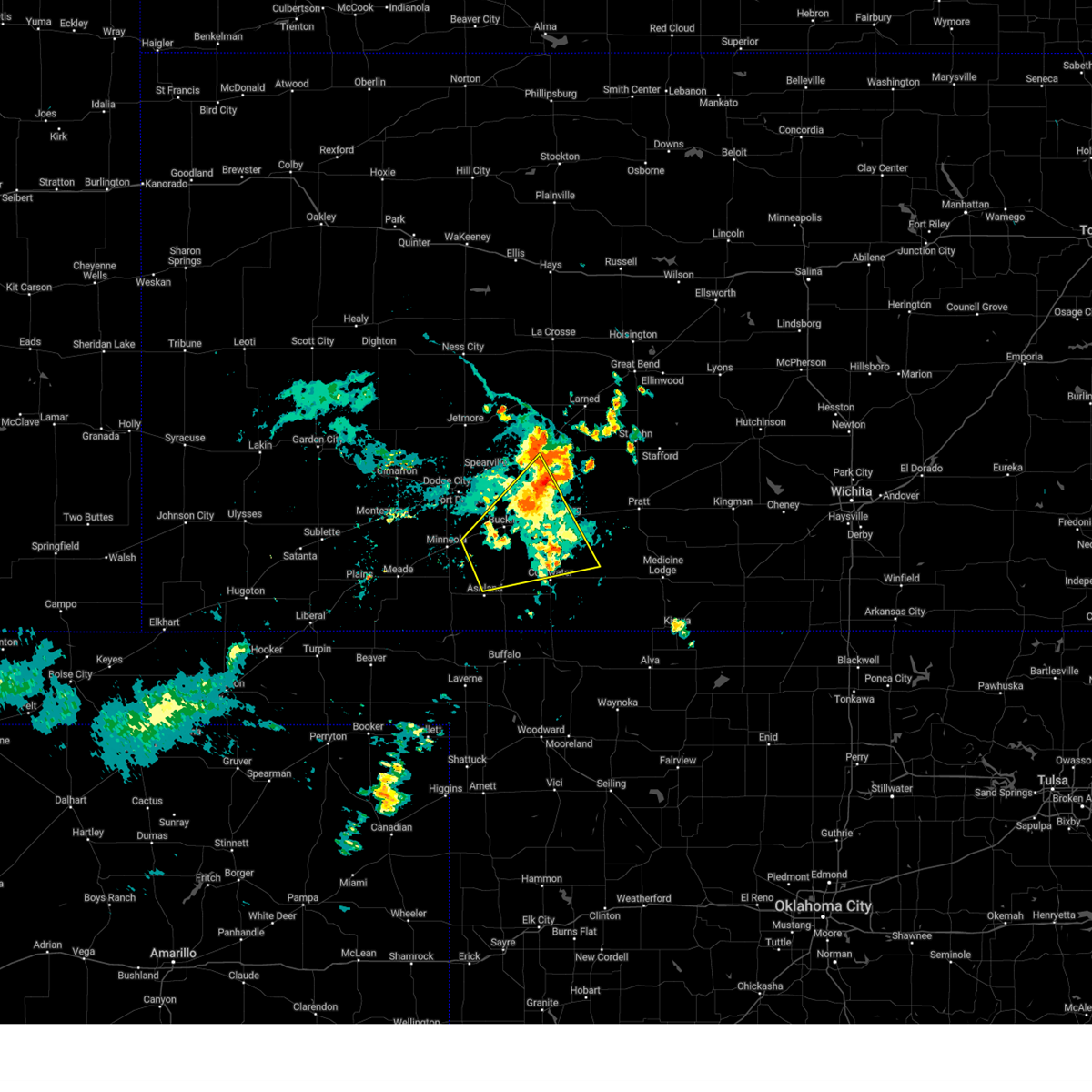
| 5/25/2025 5:48 AM CDT |
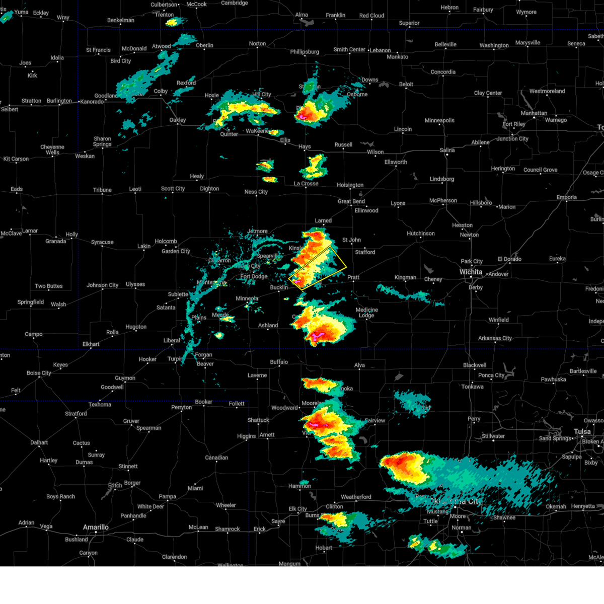
 At 547 am cdt, severe thunderstorms were located along a line extending from near frizell to trousdale to near greensburg, moving east at 50 mph (radar indicated). Hazards include 70 mph wind gusts and penny size hail. Expect considerable tree damage. damage is likely to mobile homes, roofs, and outbuildings. Locations impacted include, larned, haviland, macksville, byers, hopewell, zook, wellsford, cullison, dillwyn, pratt, iuka, radium and croft. At 547 am cdt, severe thunderstorms were located along a line extending from near frizell to trousdale to near greensburg, moving east at 50 mph (radar indicated). Hazards include 70 mph wind gusts and penny size hail. Expect considerable tree damage. damage is likely to mobile homes, roofs, and outbuildings. Locations impacted include, larned, haviland, macksville, byers, hopewell, zook, wellsford, cullison, dillwyn, pratt, iuka, radium and croft.
|
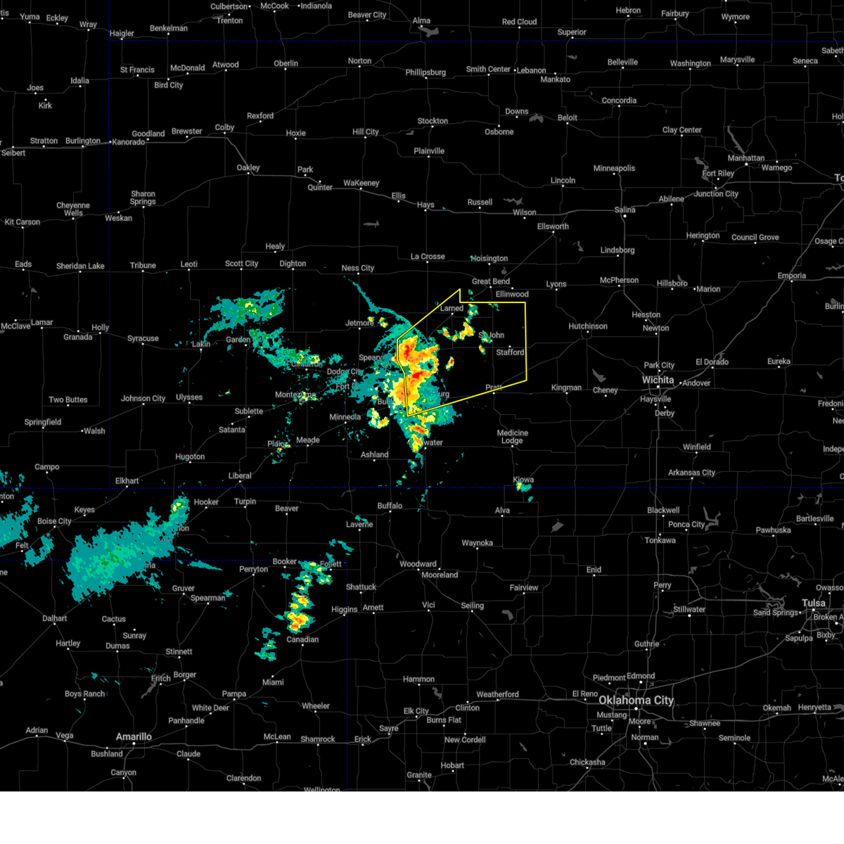
| 5/25/2025 5:23 AM CDT |
 Svrddc the national weather service in dodge city has issued a * severe thunderstorm warning for, eastern ford county in southwestern kansas, kiowa county in south central kansas, eastern hodgeman county in southwestern kansas, pawnee county in south central kansas, western stafford county in south central kansas, edwards county in south central kansas, western pratt county in south central kansas, * until 615 am cdt. * at 523 am cdt, severe thunderstorms were located along a line extending from 6 miles north of burdett to near kinsley to near ford, moving east at 50 mph (radar indicated). Hazards include 70 mph wind gusts and penny size hail. Expect considerable tree damage. damage is likely to mobile homes, roofs, and outbuildings. severe thunderstorms will be near, lewis, mullinville, rozel, sanford, and centerview around 530 am cdt. garfield and fellsburg around 535 am cdt. greensburg, frizell, and trousdale around 540 am cdt. Other locations in the path of these severe thunderstorms include larned, belpre, zook, haviland, macksville, hopewell, byers, wellsford, cullison, radium, dillwyn, croft, pratt and iuka. Svrddc the national weather service in dodge city has issued a * severe thunderstorm warning for, eastern ford county in southwestern kansas, kiowa county in south central kansas, eastern hodgeman county in southwestern kansas, pawnee county in south central kansas, western stafford county in south central kansas, edwards county in south central kansas, western pratt county in south central kansas, * until 615 am cdt. * at 523 am cdt, severe thunderstorms were located along a line extending from 6 miles north of burdett to near kinsley to near ford, moving east at 50 mph (radar indicated). Hazards include 70 mph wind gusts and penny size hail. Expect considerable tree damage. damage is likely to mobile homes, roofs, and outbuildings. severe thunderstorms will be near, lewis, mullinville, rozel, sanford, and centerview around 530 am cdt. garfield and fellsburg around 535 am cdt. greensburg, frizell, and trousdale around 540 am cdt. Other locations in the path of these severe thunderstorms include larned, belpre, zook, haviland, macksville, hopewell, byers, wellsford, cullison, radium, dillwyn, croft, pratt and iuka.
|
| 5/24/2025 1:52 AM CDT |
 Svrddc the national weather service in dodge city has issued a * severe thunderstorm warning for, southeastern kiowa county in south central kansas, western barber county in south central kansas, eastern comanche county in south central kansas, southwestern pratt county in south central kansas, * until 300 am cdt. * at 152 am cdt, severe thunderstorms were located along a line extending from near pratt to near croft to 9 miles south of greensburg, moving south at 35 mph (radar indicated). Hazards include 60 mph wind gusts and penny size hail. Expect damage to roofs, siding, and trees. severe thunderstorms will be near, coats and belvidere around 200 am cdt. sun city and wilmore around 205 am cdt. Other locations in the path of these severe thunderstorms include lake city and aetna. Svrddc the national weather service in dodge city has issued a * severe thunderstorm warning for, southeastern kiowa county in south central kansas, western barber county in south central kansas, eastern comanche county in south central kansas, southwestern pratt county in south central kansas, * until 300 am cdt. * at 152 am cdt, severe thunderstorms were located along a line extending from near pratt to near croft to 9 miles south of greensburg, moving south at 35 mph (radar indicated). Hazards include 60 mph wind gusts and penny size hail. Expect damage to roofs, siding, and trees. severe thunderstorms will be near, coats and belvidere around 200 am cdt. sun city and wilmore around 205 am cdt. Other locations in the path of these severe thunderstorms include lake city and aetna.
|
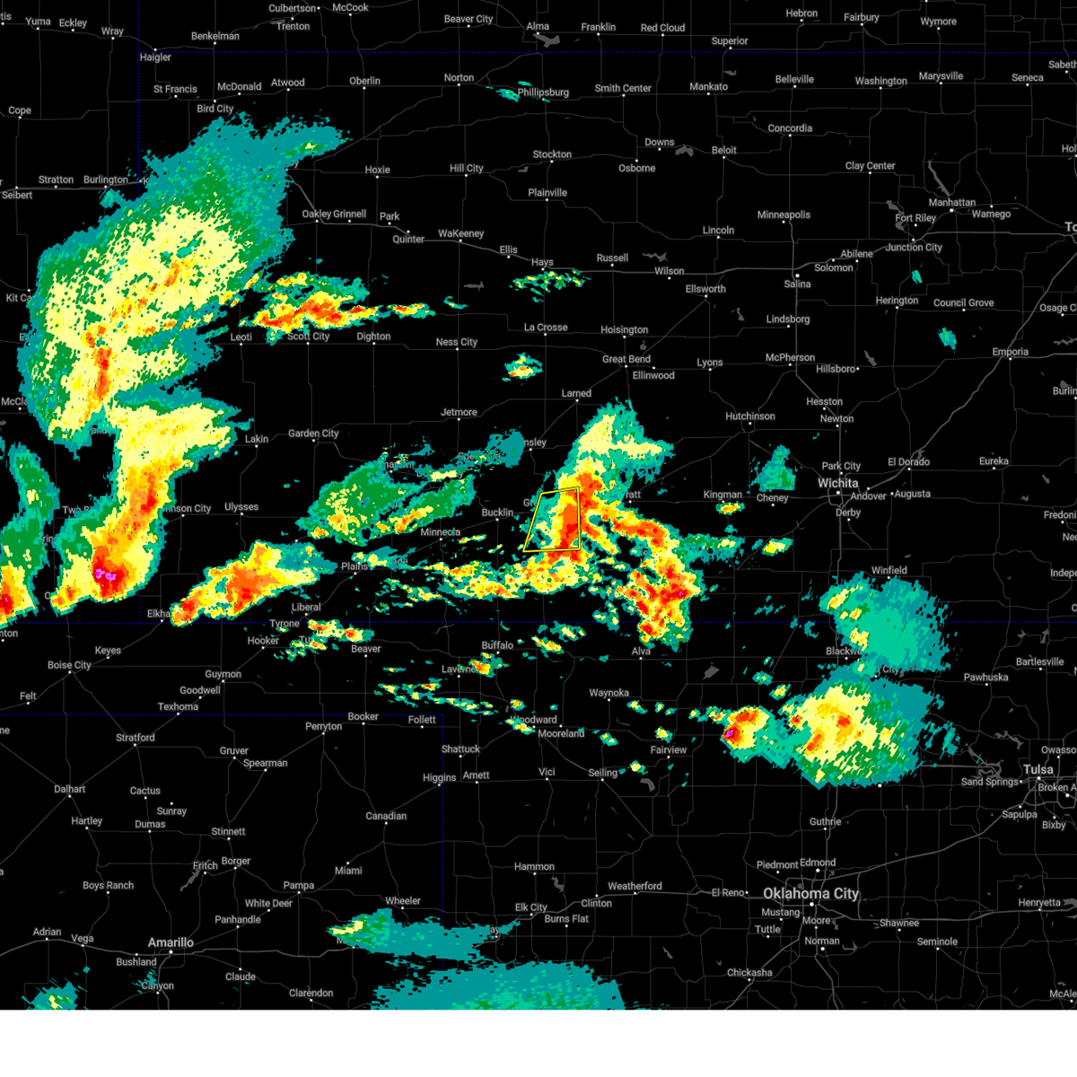
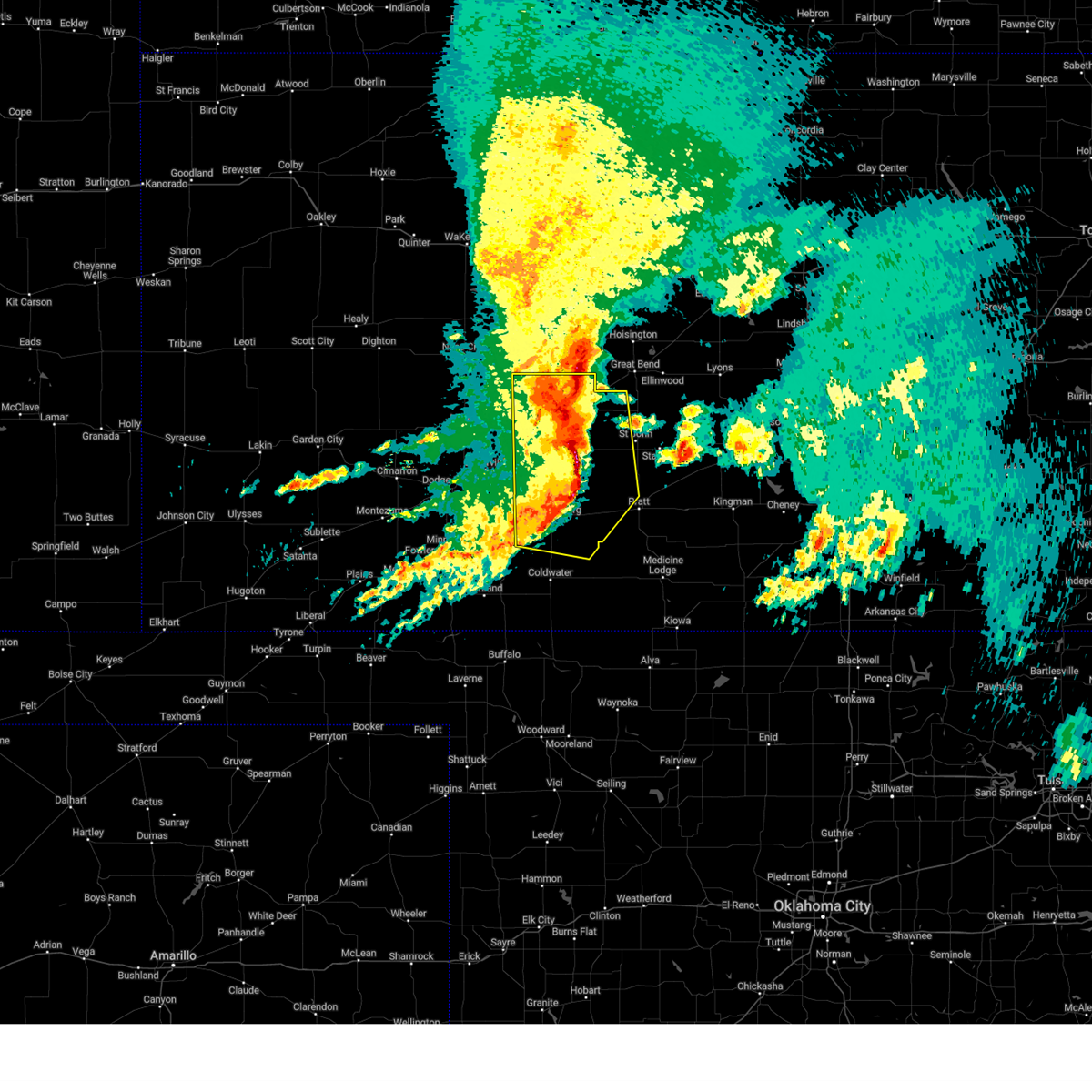
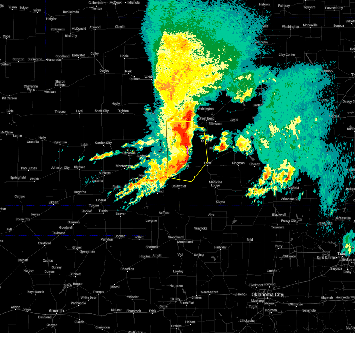
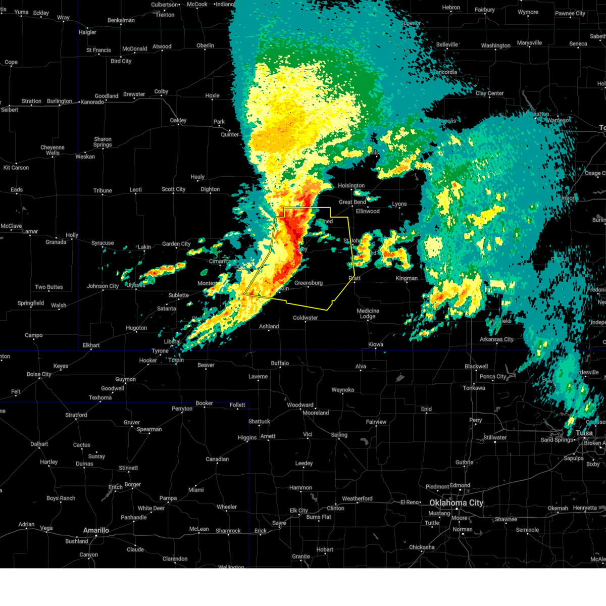
| 5/18/2025 10:10 PM CDT | Torddc the national weather service in dodge city has issued a * tornado warning for, eastern kiowa county in south central kansas, west central pratt county in south central kansas, * until 1100 pm cdt. * at 1009 pm cdt, a confirmed tornado was located 9 miles south of greensburg, moving northeast at 45 mph (weather spotters confirmed tornado). Hazards include damaging tornado and quarter size hail. Flying debris will be dangerous to those caught without shelter. mobile homes will be damaged or destroyed. damage to roofs, windows, and vehicles will occur. tree damage is likely. the tornado will be near, haviland around 1025 pm cdt. Other locations in the path of this tornadic thunderstorm include wellsford. |
| 5/18/2025 10:00 PM CDT | At 1000 pm cdt, a confirmed large and extremely dangerous tornado was located near greensburg, moving northeast at 35 mph. this is a particularly dangerous situation. take cover now! (radar confirmed tornado). Hazards include damaging tornado. You are in a life-threatening situation. flying debris may be deadly to those caught without shelter. mobile homes will be destroyed. considerable damage to homes, businesses, and vehicles is likely and complete destruction is possible. This tornadic thunderstorm will remain over mainly rural areas of northeastern kiowa and south central edwards counties. |
| 5/18/2025 9:57 PM CDT | At 957 pm cdt, a confirmed large and destructive tornado was located near greensburg, moving northeast at 30 mph. tornado emergency for greensburg. this is a particularly dangerous situation. take cover now! (weather spotters confirmed tornado). Hazards include deadly tornado. You are in a life-threatening situation. flying debris may be deadly to those caught without shelter. mobile homes will be destroyed. considerable damage to homes, businesses, and vehicles is likely and complete destruction is possible. The tornado will be near, greensburg around 1000 pm cdt. |
| 5/18/2025 9:48 PM CDT | Torddc the national weather service in dodge city has issued a * tornado warning for, northeastern kiowa county in south central kansas, * until 1030 pm cdt. * at 947 pm cdt, a confirmed large and destructive tornado was observed near greensburg, moving northeast at 30 mph. tornado emergency for greensburg. this is a particularly dangerous situation. take cover now! (weather spotters confirmed tornado). Hazards include deadly tornado. You are in a life-threatening situation. flying debris may be deadly to those caught without shelter. mobile homes will be destroyed. considerable damage to homes, businesses, and vehicles is likely and complete destruction is possible. The tornado will be near, greensburg around 955 pm cdt. |
| 5/18/2025 9:32 PM CDT |
 Torddc the national weather service in dodge city has issued a * tornado warning for, central kiowa county in south central kansas, south central edwards county in south central kansas, * until 1015 pm cdt. * at 932 pm cdt, a confirmed large and extremely dangerous tornado was located 10 miles southeast of mullinville, moving northeast at 35 mph. this is a particularly dangerous situation. take cover now! (radar confirmed tornado). Hazards include damaging tornado. You are in a life-threatening situation. flying debris may be deadly to those caught without shelter. mobile homes will be destroyed. considerable damage to homes, businesses, and vehicles is likely and complete destruction is possible. The tornado will be near, greensburg around 945 pm cdt. Torddc the national weather service in dodge city has issued a * tornado warning for, central kiowa county in south central kansas, south central edwards county in south central kansas, * until 1015 pm cdt. * at 932 pm cdt, a confirmed large and extremely dangerous tornado was located 10 miles southeast of mullinville, moving northeast at 35 mph. this is a particularly dangerous situation. take cover now! (radar confirmed tornado). Hazards include damaging tornado. You are in a life-threatening situation. flying debris may be deadly to those caught without shelter. mobile homes will be destroyed. considerable damage to homes, businesses, and vehicles is likely and complete destruction is possible. The tornado will be near, greensburg around 945 pm cdt.
|
| 5/18/2025 9:14 PM CDT | At 914 pm cdt, a severe thunderstorm was located near mullinville, moving northeast at 55 mph (radar indicated). Hazards include golf ball size hail. People and animals outdoors will be injured. expect damage to roofs, siding, windows, and vehicles. this severe storm will be near, mullinville around 920 pm cdt. Other locations in the path of this severe thunderstorm include centerview. |
| 5/18/2025 9:11 PM CDT | Svrddc the national weather service in dodge city has issued a * severe thunderstorm warning for, southeastern ford county in southwestern kansas, kiowa county in south central kansas, northwestern comanche county in south central kansas, southern edwards county in south central kansas, northwestern pratt county in south central kansas, northeastern clark county in southwestern kansas, * until 1000 pm cdt. * at 910 pm cdt, a severe thunderstorm was located 7 miles south of mullinville, moving northeast at 55 mph (radar indicated). Hazards include golf ball size hail. People and animals outdoors will be injured. expect damage to roofs, siding, windows, and vehicles. this severe thunderstorm will be near, mullinville around 915 pm cdt. Other locations in the path of this severe thunderstorm include centerview. |
| 5/18/2025 6:26 PM CDT | Svrddc the national weather service in dodge city has issued a * severe thunderstorm warning for, southeastern ford county in southwestern kansas, western kiowa county in south central kansas, edwards county in south central kansas, * until 715 pm cdt. * at 625 pm cdt, a severe thunderstorm was located near mullinville, moving north at 55 mph (radar indicated). Hazards include golf ball size hail and 60 mph wind gusts. People and animals outdoors will be injured. expect hail damage to roofs, siding, windows, and vehicles. expect wind damage to roofs, siding, and trees. this severe thunderstorm will be near, mullinville around 630 pm cdt. Other locations in the path of this severe thunderstorm include kinsley and lewis. |
| 9/20/2024 4:57 PM CDT |
 At 455 pm cdt, a severe thunderstorm was located near centerview, moving northeast at 45 mph (radar indicated. at 449 pm cdt a 61 mph wind gust was reported 1 mile south of kinsley). Hazards include 60 mph wind gusts. Expect damage to roofs, siding, and trees. this severe storm will be near, belpre around 500 pm cdt. macksville around 510 pm cdt. Other locations in the path of this severe thunderstorm include seward. At 455 pm cdt, a severe thunderstorm was located near centerview, moving northeast at 45 mph (radar indicated. at 449 pm cdt a 61 mph wind gust was reported 1 mile south of kinsley). Hazards include 60 mph wind gusts. Expect damage to roofs, siding, and trees. this severe storm will be near, belpre around 500 pm cdt. macksville around 510 pm cdt. Other locations in the path of this severe thunderstorm include seward.
|
| 9/20/2024 4:57 PM CDT |
 The storm which prompted the warning has moved out of the area. therefore, the warning will be allowed to expire. however, gusty winds are still possible with this thunderstorm. The storm which prompted the warning has moved out of the area. therefore, the warning will be allowed to expire. however, gusty winds are still possible with this thunderstorm.
|
| 9/20/2024 4:54 PM CDT |
 Svrddc the national weather service in dodge city has issued a * severe thunderstorm warning for, northern kiowa county in south central kansas, southeastern pawnee county in south central kansas, stafford county in south central kansas, northern pratt county in south central kansas, edwards county in south central kansas, * until 545 pm cdt. * at 453 pm cdt, a severe thunderstorm was located near centerview, moving northeast at 40 mph (radar indicated). Hazards include 60 mph wind gusts. Expect damage to roofs, siding, and trees. this severe thunderstorm will be near, belpre around 505 pm cdt. macksville around 510 pm cdt. Other locations in the path of this severe thunderstorm include seward. Svrddc the national weather service in dodge city has issued a * severe thunderstorm warning for, northern kiowa county in south central kansas, southeastern pawnee county in south central kansas, stafford county in south central kansas, northern pratt county in south central kansas, edwards county in south central kansas, * until 545 pm cdt. * at 453 pm cdt, a severe thunderstorm was located near centerview, moving northeast at 40 mph (radar indicated). Hazards include 60 mph wind gusts. Expect damage to roofs, siding, and trees. this severe thunderstorm will be near, belpre around 505 pm cdt. macksville around 510 pm cdt. Other locations in the path of this severe thunderstorm include seward.
|
| 9/20/2024 4:15 PM CDT |
 Svrddc the national weather service in dodge city has issued a * severe thunderstorm warning for, southeastern ford county in southwestern kansas, kiowa county in south central kansas, northern comanche county in south central kansas, southwestern edwards county in south central kansas, northeastern clark county in southwestern kansas, * until 500 pm cdt. * at 414 pm cdt, a severe thunderstorm was located 9 miles southeast of bucklin, moving northeast at 40 mph (radar indicated). Hazards include 60 mph wind gusts and penny size hail. Expect damage to roofs, siding, and trees. This severe thunderstorm will be near, greensburg around 430 pm cdt. Svrddc the national weather service in dodge city has issued a * severe thunderstorm warning for, southeastern ford county in southwestern kansas, kiowa county in south central kansas, northern comanche county in south central kansas, southwestern edwards county in south central kansas, northeastern clark county in southwestern kansas, * until 500 pm cdt. * at 414 pm cdt, a severe thunderstorm was located 9 miles southeast of bucklin, moving northeast at 40 mph (radar indicated). Hazards include 60 mph wind gusts and penny size hail. Expect damage to roofs, siding, and trees. This severe thunderstorm will be near, greensburg around 430 pm cdt.
|
| 7/6/2024 8:38 PM CDT |
 Svrddc the national weather service in dodge city has issued a * severe thunderstorm warning for, kiowa county in south central kansas, meade county in southwestern kansas, northwestern barber county in south central kansas, northern comanche county in south central kansas, southern stafford county in south central kansas, pratt county in south central kansas, clark county in southwestern kansas, * until 945 pm cdt. * at 838 pm cdt, severe thunderstorms were located along a line extending from near macksville to 8 miles northwest of bloom, moving southeast at 45 mph (radar indicated). Hazards include 60 mph wind gusts. Expect damage to roofs, siding, and trees. severe thunderstorms will be near, mullinville, byers, and hopewell around 845 pm cdt. greensburg around 850 pm cdt. haviland, cullison, clark state lake, and wellsford around 855 pm cdt. Other locations in the path of these severe thunderstorms include pratt, coats, belvidere, croft, ashland, sawyer, wilmore, coldwater, protection, sitka, sun city and lake coldwater. Svrddc the national weather service in dodge city has issued a * severe thunderstorm warning for, kiowa county in south central kansas, meade county in southwestern kansas, northwestern barber county in south central kansas, northern comanche county in south central kansas, southern stafford county in south central kansas, pratt county in south central kansas, clark county in southwestern kansas, * until 945 pm cdt. * at 838 pm cdt, severe thunderstorms were located along a line extending from near macksville to 8 miles northwest of bloom, moving southeast at 45 mph (radar indicated). Hazards include 60 mph wind gusts. Expect damage to roofs, siding, and trees. severe thunderstorms will be near, mullinville, byers, and hopewell around 845 pm cdt. greensburg around 850 pm cdt. haviland, cullison, clark state lake, and wellsford around 855 pm cdt. Other locations in the path of these severe thunderstorms include pratt, coats, belvidere, croft, ashland, sawyer, wilmore, coldwater, protection, sitka, sun city and lake coldwater.
|
| 7/6/2024 8:07 PM CDT |
 Svrddc the national weather service in dodge city has issued a * severe thunderstorm warning for, ford county in southwestern kansas, northern kiowa county in south central kansas, northern meade county in southwestern kansas, gray county in southwestern kansas, edwards county in south central kansas, northwestern clark county in southwestern kansas, * until 915 pm cdt. * at 807 pm cdt, severe thunderstorms were located along a line extending from 7 miles south of burdett to near ensign, moving southeast at 40 mph (radar indicated). Hazards include 60 mph wind gusts and penny size hail. Expect damage to roofs, siding, and trees. severe thunderstorms will be near, dodge city, spearville, offerle, wright, ft. dodge, and bellefont around 815 pm cdt. kinsley around 820 pm cdt. lewis and windhorst around 825 pm cdt. Other locations in the path of these severe thunderstorms include ford, bloom, centerview, bucklin, kingsdown, fellsburg, mullinville, trousdale and greensburg. Svrddc the national weather service in dodge city has issued a * severe thunderstorm warning for, ford county in southwestern kansas, northern kiowa county in south central kansas, northern meade county in southwestern kansas, gray county in southwestern kansas, edwards county in south central kansas, northwestern clark county in southwestern kansas, * until 915 pm cdt. * at 807 pm cdt, severe thunderstorms were located along a line extending from 7 miles south of burdett to near ensign, moving southeast at 40 mph (radar indicated). Hazards include 60 mph wind gusts and penny size hail. Expect damage to roofs, siding, and trees. severe thunderstorms will be near, dodge city, spearville, offerle, wright, ft. dodge, and bellefont around 815 pm cdt. kinsley around 820 pm cdt. lewis and windhorst around 825 pm cdt. Other locations in the path of these severe thunderstorms include ford, bloom, centerview, bucklin, kingsdown, fellsburg, mullinville, trousdale and greensburg.
|
| 6/18/2024 7:53 PM CDT |
 Svrddc the national weather service in dodge city has issued a * severe thunderstorm warning for, ford county in southwestern kansas, northwestern kiowa county in south central kansas, southeastern hodgeman county in southwestern kansas, south central pawnee county in south central kansas, edwards county in south central kansas, * until 845 pm cdt. * at 753 pm cdt, a severe thunderstorm was located near windhorst, moving east at 30 mph (radar indicated). Hazards include 70 mph wind gusts and quarter size hail. Hail damage to vehicles is expected. expect considerable tree damage. wind damage is also likely to mobile homes, roofs, and outbuildings. this severe thunderstorm will be near, windhorst around 800 pm cdt. Other locations in the path of this severe thunderstorm include centerview. Svrddc the national weather service in dodge city has issued a * severe thunderstorm warning for, ford county in southwestern kansas, northwestern kiowa county in south central kansas, southeastern hodgeman county in southwestern kansas, south central pawnee county in south central kansas, edwards county in south central kansas, * until 845 pm cdt. * at 753 pm cdt, a severe thunderstorm was located near windhorst, moving east at 30 mph (radar indicated). Hazards include 70 mph wind gusts and quarter size hail. Hail damage to vehicles is expected. expect considerable tree damage. wind damage is also likely to mobile homes, roofs, and outbuildings. this severe thunderstorm will be near, windhorst around 800 pm cdt. Other locations in the path of this severe thunderstorm include centerview.
|
| 6/13/2024 7:37 PM CDT |
 The storms which prompted the warning have moved out of the area. therefore, the warning will be allowed to expire. however, small hail, gusty winds and heavy rain are still possible with these thunderstorms. a severe thunderstorm watch remains in effect until 1100 pm cdt for south central and southwestern kansas. The storms which prompted the warning have moved out of the area. therefore, the warning will be allowed to expire. however, small hail, gusty winds and heavy rain are still possible with these thunderstorms. a severe thunderstorm watch remains in effect until 1100 pm cdt for south central and southwestern kansas.
|
| 6/13/2024 7:35 PM CDT |
 Svrddc the national weather service in dodge city has issued a * severe thunderstorm warning for, southeastern ford county in southwestern kansas, kiowa county in south central kansas, southern meade county in southwestern kansas, barber county in south central kansas, comanche county in south central kansas, western pratt county in south central kansas, southeastern edwards county in south central kansas, clark county in southwestern kansas, * until 845 pm cdt. * at 735 pm cdt, severe thunderstorms were located along a line extending from near trousdale to near meade state park, moving southeast at 40 mph (radar indicated). Hazards include 60 mph wind gusts and quarter size hail. Hail damage to vehicles is expected. Expect wind damage to roofs, siding, and trees. Svrddc the national weather service in dodge city has issued a * severe thunderstorm warning for, southeastern ford county in southwestern kansas, kiowa county in south central kansas, southern meade county in southwestern kansas, barber county in south central kansas, comanche county in south central kansas, western pratt county in south central kansas, southeastern edwards county in south central kansas, clark county in southwestern kansas, * until 845 pm cdt. * at 735 pm cdt, severe thunderstorms were located along a line extending from near trousdale to near meade state park, moving southeast at 40 mph (radar indicated). Hazards include 60 mph wind gusts and quarter size hail. Hail damage to vehicles is expected. Expect wind damage to roofs, siding, and trees.
|
| 6/13/2024 7:30 PM CDT |
 At 730 pm cdt, severe thunderstorms were located along a line extending from near trousdale to 7 miles east of clark state lake, moving east at 30 mph (radar indicated). Hazards include 60 mph wind gusts. Expect damage to roofs, siding, and trees. Locations impacted include, coldwater, bucklin, greensburg, haviland, protection, mullinville, wilmore, clark state lake, fellsburg, kingsdown, lake coldwater, centerview, trousdale, and belvidere. At 730 pm cdt, severe thunderstorms were located along a line extending from near trousdale to 7 miles east of clark state lake, moving east at 30 mph (radar indicated). Hazards include 60 mph wind gusts. Expect damage to roofs, siding, and trees. Locations impacted include, coldwater, bucklin, greensburg, haviland, protection, mullinville, wilmore, clark state lake, fellsburg, kingsdown, lake coldwater, centerview, trousdale, and belvidere.
|
| 6/13/2024 7:09 PM CDT |
 At 709 pm cdt, severe thunderstorms were located along a line extending from near centerview to near clark state lake, moving east at 20 mph (radar indicated). Hazards include 60 mph wind gusts. Expect damage to roofs, siding, and trees. Locations impacted include, coldwater, bucklin, greensburg, haviland, protection, mullinville, ford, bloom, wilmore, clark state lake, fellsburg, kingsdown, lake coldwater, centerview, trousdale, and belvidere. At 709 pm cdt, severe thunderstorms were located along a line extending from near centerview to near clark state lake, moving east at 20 mph (radar indicated). Hazards include 60 mph wind gusts. Expect damage to roofs, siding, and trees. Locations impacted include, coldwater, bucklin, greensburg, haviland, protection, mullinville, ford, bloom, wilmore, clark state lake, fellsburg, kingsdown, lake coldwater, centerview, trousdale, and belvidere.
|
| 6/13/2024 6:40 PM CDT |
 Svrddc the national weather service in dodge city has issued a * severe thunderstorm warning for, eastern ford county in southwestern kansas, kiowa county in south central kansas, northern comanche county in south central kansas, southern edwards county in south central kansas, northern clark county in southwestern kansas, * until 745 pm cdt. * at 640 pm cdt, severe thunderstorms were located along a line extending from 7 miles southeast of offerle to near minneola, moving east at 40 mph (radar indicated). Hazards include 60 mph wind gusts. expect damage to roofs, siding, and trees Svrddc the national weather service in dodge city has issued a * severe thunderstorm warning for, eastern ford county in southwestern kansas, kiowa county in south central kansas, northern comanche county in south central kansas, southern edwards county in south central kansas, northern clark county in southwestern kansas, * until 745 pm cdt. * at 640 pm cdt, severe thunderstorms were located along a line extending from 7 miles southeast of offerle to near minneola, moving east at 40 mph (radar indicated). Hazards include 60 mph wind gusts. expect damage to roofs, siding, and trees
|
| 6/9/2024 12:35 AM CDT |
 At 1235 am cdt, severe thunderstorms were located along a line extending from near belpre to near wellsford to 7 miles east of wilmore to 6 miles east of buttermilk, moving east at 40 mph (radar indicated). Hazards include 60 mph wind gusts and penny size hail. Expect damage to roofs, siding, and trees. Locations impacted include, macksville, cullison, sun city, hopewell, croft, wellsford, byers, pratt, coats, lake city, aetna, iuka, sawyer, medicine lodge, preston, isabel, cairo and neola. At 1235 am cdt, severe thunderstorms were located along a line extending from near belpre to near wellsford to 7 miles east of wilmore to 6 miles east of buttermilk, moving east at 40 mph (radar indicated). Hazards include 60 mph wind gusts and penny size hail. Expect damage to roofs, siding, and trees. Locations impacted include, macksville, cullison, sun city, hopewell, croft, wellsford, byers, pratt, coats, lake city, aetna, iuka, sawyer, medicine lodge, preston, isabel, cairo and neola.
|
| 6/9/2024 12:20 AM CDT |
 The storms which prompted the warning have moved out of the area. therefore, the warning will be allowed to expire. however, gusty winds are still possible with these thunderstorms. a severe thunderstorm watch remains in effect until 300 am cdt for south central and southwestern kansas. The storms which prompted the warning have moved out of the area. therefore, the warning will be allowed to expire. however, gusty winds are still possible with these thunderstorms. a severe thunderstorm watch remains in effect until 300 am cdt for south central and southwestern kansas.
|
| 6/9/2024 12:11 AM CDT |
 Svrddc the national weather service in dodge city has issued a * severe thunderstorm warning for, kiowa county in south central kansas, northwestern barber county in south central kansas, comanche county in south central kansas, southern stafford county in south central kansas, pratt county in south central kansas, edwards county in south central kansas, * until 130 am cdt. * at 1211 am cdt, severe thunderstorms were located along a line extending from near lewis to near greensburg to near coldwater to 7 miles south of protection, moving east at 45 mph (radar indicated). Hazards include 70 mph wind gusts and penny size hail. Expect considerable tree damage. damage is likely to mobile homes, roofs, and outbuildings. severe thunderstorms will be near, coldwater, greensburg, lewis, wilmore, fellsburg, lake coldwater, and centerview around 1215 am cdt. belpre and buttermilk around 1220 am cdt. haviland, trousdale, and belvidere around 1225 am cdt. macksville, hopewell, and wellsford around 1230 am cdt. other locations in the path of these severe thunderstorms include croft, cullison, sun city, byers, dillwyn, st. John, coats, pratt, iuka and lake city. Svrddc the national weather service in dodge city has issued a * severe thunderstorm warning for, kiowa county in south central kansas, northwestern barber county in south central kansas, comanche county in south central kansas, southern stafford county in south central kansas, pratt county in south central kansas, edwards county in south central kansas, * until 130 am cdt. * at 1211 am cdt, severe thunderstorms were located along a line extending from near lewis to near greensburg to near coldwater to 7 miles south of protection, moving east at 45 mph (radar indicated). Hazards include 70 mph wind gusts and penny size hail. Expect considerable tree damage. damage is likely to mobile homes, roofs, and outbuildings. severe thunderstorms will be near, coldwater, greensburg, lewis, wilmore, fellsburg, lake coldwater, and centerview around 1215 am cdt. belpre and buttermilk around 1220 am cdt. haviland, trousdale, and belvidere around 1225 am cdt. macksville, hopewell, and wellsford around 1230 am cdt. other locations in the path of these severe thunderstorms include croft, cullison, sun city, byers, dillwyn, st. John, coats, pratt, iuka and lake city.
|
| 6/9/2024 12:10 AM CDT | Sixty to 65 mph wind gust was reporte in kiowa county KS, 0.7 miles SE of Greensburg, KS |
| 6/8/2024 11:47 PM CDT |
 Svrddc the national weather service in dodge city has issued a * severe thunderstorm warning for, eastern ford county in southwestern kansas, kiowa county in south central kansas, southeastern hodgeman county in southwestern kansas, western comanche county in south central kansas, south central pawnee county in south central kansas, edwards county in south central kansas, clark county in southwestern kansas, * until 1230 am cdt. * at 1147 pm cdt, severe thunderstorms were located along a line extending from near gray to 6 miles south of windhorst to near ashland, moving southeast at 15 mph (radar indicated). Hazards include 70 mph wind gusts and penny size hail. Expect considerable tree damage. damage is likely to mobile homes, roofs, and outbuildings. Severe thunderstorms will be near, ashland, bucklin, offerle, clark state lake, and windhorst around 1150 pm cdt. Svrddc the national weather service in dodge city has issued a * severe thunderstorm warning for, eastern ford county in southwestern kansas, kiowa county in south central kansas, southeastern hodgeman county in southwestern kansas, western comanche county in south central kansas, south central pawnee county in south central kansas, edwards county in south central kansas, clark county in southwestern kansas, * until 1230 am cdt. * at 1147 pm cdt, severe thunderstorms were located along a line extending from near gray to 6 miles south of windhorst to near ashland, moving southeast at 15 mph (radar indicated). Hazards include 70 mph wind gusts and penny size hail. Expect considerable tree damage. damage is likely to mobile homes, roofs, and outbuildings. Severe thunderstorms will be near, ashland, bucklin, offerle, clark state lake, and windhorst around 1150 pm cdt.
|
| 6/3/2024 5:43 AM CDT |
 The severe thunderstorm which prompted the warning is moving out of the warned area. therefore, the warning will be allowed to expire. a severe thunderstorm watch remains in effect until 700 am cdt for south central and southwestern kansas. The severe thunderstorm which prompted the warning is moving out of the warned area. therefore, the warning will be allowed to expire. a severe thunderstorm watch remains in effect until 700 am cdt for south central and southwestern kansas.
|
| 6/3/2024 4:55 AM CDT |
 Svrddc the national weather service in dodge city has issued a * severe thunderstorm warning for, southeastern ford county in southwestern kansas, kiowa county in south central kansas, northwestern comanche county in south central kansas, northeastern clark county in southwestern kansas, * until 545 am cdt. * at 454 am cdt, a severe thunderstorm was located near bucklin, moving east at 35 mph. this is a destructive storm for southern kiowa county (radar indicated). Hazards include 80 mph wind gusts and penny size hail. Flying debris will be dangerous to those caught without shelter. mobile homes will be heavily damaged. expect considerable damage to roofs, windows, and vehicles. extensive tree damage and power outages are likely. This severe thunderstorm will remain over mainly rural areas of southeastern ford, kiowa, northwestern comanche and northeastern clark counties. Svrddc the national weather service in dodge city has issued a * severe thunderstorm warning for, southeastern ford county in southwestern kansas, kiowa county in south central kansas, northwestern comanche county in south central kansas, northeastern clark county in southwestern kansas, * until 545 am cdt. * at 454 am cdt, a severe thunderstorm was located near bucklin, moving east at 35 mph. this is a destructive storm for southern kiowa county (radar indicated). Hazards include 80 mph wind gusts and penny size hail. Flying debris will be dangerous to those caught without shelter. mobile homes will be heavily damaged. expect considerable damage to roofs, windows, and vehicles. extensive tree damage and power outages are likely. This severe thunderstorm will remain over mainly rural areas of southeastern ford, kiowa, northwestern comanche and northeastern clark counties.
|
| 6/3/2024 4:43 AM CDT |
 Svrddc the national weather service in dodge city has issued a * severe thunderstorm warning for, southeastern ford county in southwestern kansas, kiowa county in south central kansas, northwestern barber county in south central kansas, comanche county in south central kansas, western pratt county in south central kansas, southern edwards county in south central kansas, clark county in southwestern kansas, * until 530 am cdt. * at 441 am cdt, severe thunderstorms were located along a line extending from 6 miles east of windhorst to near englewood, moving east at 45 mph (automated equipment. a wind gust of 67 mph was measured at the dodge city airport at 420 am cdt. these storms have a history of producing wind damage). Hazards include 70 mph wind gusts and nickel size hail. Expect considerable tree damage. damage is likely to mobile homes, roofs, and outbuildings. severe thunderstorms will be near, ashland, bucklin, mullinville, and acres around 445 am cdt. sitka around 450 am cdt. greensburg and centerview around 455 am cdt. protection around 500 am cdt. Other locations in the path of these severe thunderstorms include coldwater, lake coldwater, haviland, wilmore, wellsford, buttermilk, cullison, belvidere and croft. Svrddc the national weather service in dodge city has issued a * severe thunderstorm warning for, southeastern ford county in southwestern kansas, kiowa county in south central kansas, northwestern barber county in south central kansas, comanche county in south central kansas, western pratt county in south central kansas, southern edwards county in south central kansas, clark county in southwestern kansas, * until 530 am cdt. * at 441 am cdt, severe thunderstorms were located along a line extending from 6 miles east of windhorst to near englewood, moving east at 45 mph (automated equipment. a wind gust of 67 mph was measured at the dodge city airport at 420 am cdt. these storms have a history of producing wind damage). Hazards include 70 mph wind gusts and nickel size hail. Expect considerable tree damage. damage is likely to mobile homes, roofs, and outbuildings. severe thunderstorms will be near, ashland, bucklin, mullinville, and acres around 445 am cdt. sitka around 450 am cdt. greensburg and centerview around 455 am cdt. protection around 500 am cdt. Other locations in the path of these severe thunderstorms include coldwater, lake coldwater, haviland, wilmore, wellsford, buttermilk, cullison, belvidere and croft.
|
| 5/28/2024 4:38 PM CDT |
 the severe thunderstorm warning has been cancelled and is no longer in effect the severe thunderstorm warning has been cancelled and is no longer in effect
|
| 5/28/2024 4:38 PM CDT |
 At 437 pm cdt, severe thunderstorms were located along a line extending from 7 miles south of fellsburg to near greensburg to 7 miles south of mullinville, moving southeast at 35 mph (radar indicated). Hazards include 60 mph wind gusts and half dollar size hail. Hail damage to vehicles is expected. expect wind damage to roofs, siding, and trees. these severe storms will be near, haviland around 445 pm cdt. Other locations in the path of these severe thunderstorms include belvidere. At 437 pm cdt, severe thunderstorms were located along a line extending from 7 miles south of fellsburg to near greensburg to 7 miles south of mullinville, moving southeast at 35 mph (radar indicated). Hazards include 60 mph wind gusts and half dollar size hail. Hail damage to vehicles is expected. expect wind damage to roofs, siding, and trees. these severe storms will be near, haviland around 445 pm cdt. Other locations in the path of these severe thunderstorms include belvidere.
|
| 5/28/2024 4:26 PM CDT |
 Svrddc the national weather service in dodge city has issued a * severe thunderstorm warning for, southeastern ford county in southwestern kansas, kiowa county in south central kansas, northwestern comanche county in south central kansas, south central edwards county in south central kansas, northeastern clark county in southwestern kansas, * until 515 pm cdt. * at 425 pm cdt, severe thunderstorms were located along a line extending from near centerview to near mullinville to near bucklin, moving southeast at 35 mph. this replaces the previous warning for ford county and kiowa county. (radar indicated). Hazards include 60 mph wind gusts and half dollar size hail. Hail damage to vehicles is expected. expect wind damage to roofs, siding, and trees. severe thunderstorms will be near, greensburg and mullinville around 430 pm cdt. haviland around 445 pm cdt. Other locations in the path of these severe thunderstorms include belvidere. Svrddc the national weather service in dodge city has issued a * severe thunderstorm warning for, southeastern ford county in southwestern kansas, kiowa county in south central kansas, northwestern comanche county in south central kansas, south central edwards county in south central kansas, northeastern clark county in southwestern kansas, * until 515 pm cdt. * at 425 pm cdt, severe thunderstorms were located along a line extending from near centerview to near mullinville to near bucklin, moving southeast at 35 mph. this replaces the previous warning for ford county and kiowa county. (radar indicated). Hazards include 60 mph wind gusts and half dollar size hail. Hail damage to vehicles is expected. expect wind damage to roofs, siding, and trees. severe thunderstorms will be near, greensburg and mullinville around 430 pm cdt. haviland around 445 pm cdt. Other locations in the path of these severe thunderstorms include belvidere.
|
| 5/25/2024 6:20 PM CDT |
 the severe thunderstorm warning has been cancelled and is no longer in effect the severe thunderstorm warning has been cancelled and is no longer in effect
|
| 5/25/2024 6:13 PM CDT |
 At 612 pm cdt, a severe thunderstorm was located near greensburg, moving northeast at 40 mph (radar indicated). Hazards include 60 mph wind gusts and quarter size hail. Hail damage to vehicles is expected. expect wind damage to roofs, siding, and trees. this severe storm will be near, fellsburg around 625 pm cdt. Other locations in the path of this severe thunderstorm include trousdale. At 612 pm cdt, a severe thunderstorm was located near greensburg, moving northeast at 40 mph (radar indicated). Hazards include 60 mph wind gusts and quarter size hail. Hail damage to vehicles is expected. expect wind damage to roofs, siding, and trees. this severe storm will be near, fellsburg around 625 pm cdt. Other locations in the path of this severe thunderstorm include trousdale.
|
| 5/25/2024 6:06 PM CDT |
 Svrddc the national weather service in dodge city has issued a * severe thunderstorm warning for, northern kiowa county in south central kansas, southwestern stafford county in south central kansas, northwestern pratt county in south central kansas, southeastern edwards county in south central kansas, * until 645 pm cdt. * at 606 pm cdt, a severe thunderstorm was located near mullinville, moving northeast at 40 mph (radar indicated). Hazards include two inch hail and 60 mph wind gusts. People and animals outdoors will be injured. expect hail damage to roofs, siding, windows, and vehicles. expect wind damage to roofs, siding, and trees. this severe thunderstorm will be near, fellsburg around 625 pm cdt. Other locations in the path of this severe thunderstorm include trousdale and hopewell. Svrddc the national weather service in dodge city has issued a * severe thunderstorm warning for, northern kiowa county in south central kansas, southwestern stafford county in south central kansas, northwestern pratt county in south central kansas, southeastern edwards county in south central kansas, * until 645 pm cdt. * at 606 pm cdt, a severe thunderstorm was located near mullinville, moving northeast at 40 mph (radar indicated). Hazards include two inch hail and 60 mph wind gusts. People and animals outdoors will be injured. expect hail damage to roofs, siding, windows, and vehicles. expect wind damage to roofs, siding, and trees. this severe thunderstorm will be near, fellsburg around 625 pm cdt. Other locations in the path of this severe thunderstorm include trousdale and hopewell.
|
| 5/25/2024 5:33 PM CDT |
 At 532 pm cdt, a severe thunderstorm was located very near bucklin, moving northeast at 60 mph (radar indicated). Hazards include tennis ball size hail and 60 mph wind gusts. People and animals outdoors will be injured. expect hail damage to roofs, siding, windows, and vehicles. expect wind damage to roofs, siding, and trees. Locations impacted include, centerview. At 532 pm cdt, a severe thunderstorm was located very near bucklin, moving northeast at 60 mph (radar indicated). Hazards include tennis ball size hail and 60 mph wind gusts. People and animals outdoors will be injured. expect hail damage to roofs, siding, windows, and vehicles. expect wind damage to roofs, siding, and trees. Locations impacted include, centerview.
|
| 5/25/2024 5:21 PM CDT |
 Svrddc the national weather service in dodge city has issued a * severe thunderstorm warning for, southeastern ford county in southwestern kansas, northern kiowa county in south central kansas, southwestern edwards county in south central kansas, northeastern clark county in southwestern kansas, * until 600 pm cdt. * at 521 pm cdt, a severe thunderstorm was located very near clark state lake, moving northeast at 60 mph (radar indicated). Hazards include two inch hail and 60 mph wind gusts. People and animals outdoors will be injured. expect hail damage to roofs, siding, windows, and vehicles. expect wind damage to roofs, siding, and trees. this severe thunderstorm will be near, kingsdown around 525 pm cdt. bucklin around 530 pm cdt. Other locations in the path of this severe thunderstorm include centerview. Svrddc the national weather service in dodge city has issued a * severe thunderstorm warning for, southeastern ford county in southwestern kansas, northern kiowa county in south central kansas, southwestern edwards county in south central kansas, northeastern clark county in southwestern kansas, * until 600 pm cdt. * at 521 pm cdt, a severe thunderstorm was located very near clark state lake, moving northeast at 60 mph (radar indicated). Hazards include two inch hail and 60 mph wind gusts. People and animals outdoors will be injured. expect hail damage to roofs, siding, windows, and vehicles. expect wind damage to roofs, siding, and trees. this severe thunderstorm will be near, kingsdown around 525 pm cdt. bucklin around 530 pm cdt. Other locations in the path of this severe thunderstorm include centerview.
|
| 5/19/2024 6:59 PM CDT |
 At 658 pm cdt, severe thunderstorms were located along a line extending from near hoisington to zenith to near cullison, moving northeast at 55 mph (radar indicated). Hazards include 60 mph wind gusts and penny size hail. Expect damage to roofs, siding, and trees. Locations impacted include, pratt, iuka, preston, zenith and neola. At 658 pm cdt, severe thunderstorms were located along a line extending from near hoisington to zenith to near cullison, moving northeast at 55 mph (radar indicated). Hazards include 60 mph wind gusts and penny size hail. Expect damage to roofs, siding, and trees. Locations impacted include, pratt, iuka, preston, zenith and neola.
|
| 5/19/2024 6:44 PM CDT |
 Svrddc the national weather service in dodge city has issued a * severe thunderstorm warning for, kiowa county in south central kansas, barber county in south central kansas, comanche county in south central kansas, southeastern pawnee county in south central kansas, stafford county in south central kansas, pratt county in south central kansas, southeastern edwards county in south central kansas, * until 745 pm cdt. * at 644 pm cdt, severe thunderstorms were located along a line extending from 6 miles west of great bend to 8 miles southwest of stafford to near croft, moving northeast at 55 mph. these are destructive storms for stafford and pratt counties (radar indicated). Hazards include 80 mph wind gusts and quarter size hail. Flying debris will be dangerous to those caught without shelter. mobile homes will be heavily damaged. expect considerable damage to roofs, windows, and vehicles. extensive tree damage and power outages are likely. severe thunderstorms will be near, pratt, stafford, iuka, hudson, and cullison around 650 pm cdt. zenith and neola around 655 pm cdt. Preston around 700 pm cdt. Svrddc the national weather service in dodge city has issued a * severe thunderstorm warning for, kiowa county in south central kansas, barber county in south central kansas, comanche county in south central kansas, southeastern pawnee county in south central kansas, stafford county in south central kansas, pratt county in south central kansas, southeastern edwards county in south central kansas, * until 745 pm cdt. * at 644 pm cdt, severe thunderstorms were located along a line extending from 6 miles west of great bend to 8 miles southwest of stafford to near croft, moving northeast at 55 mph. these are destructive storms for stafford and pratt counties (radar indicated). Hazards include 80 mph wind gusts and quarter size hail. Flying debris will be dangerous to those caught without shelter. mobile homes will be heavily damaged. expect considerable damage to roofs, windows, and vehicles. extensive tree damage and power outages are likely. severe thunderstorms will be near, pratt, stafford, iuka, hudson, and cullison around 650 pm cdt. zenith and neola around 655 pm cdt. Preston around 700 pm cdt.
|
| 5/19/2024 6:26 PM CDT |
 At 625 pm cdt, severe thunderstorms were located along a line extending from 7 miles northwest of dillwyn to 8 miles north of iuka to near cullison, moving east at 65 mph. these are destructive storms for all towns along us-50 and us-400 east of lewis and greensburg (radar indicated). Hazards include 90 mph wind gusts and quarter size hail. You are in a life-threatening situation. flying debris may be deadly to those caught without shelter. mobile homes will be heavily damaged or destroyed. homes and businesses will have substantial roof and window damage. expect extensive tree damage and power outages. locations impacted include, pratt, kinsley, st. John, stafford, bucklin, greensburg, haviland, macksville, lewis, mullinville, garfield, iuka, preston, hudson, sawyer, cullison, belpre, coats, byers, and fellsburg. At 625 pm cdt, severe thunderstorms were located along a line extending from 7 miles northwest of dillwyn to 8 miles north of iuka to near cullison, moving east at 65 mph. these are destructive storms for all towns along us-50 and us-400 east of lewis and greensburg (radar indicated). Hazards include 90 mph wind gusts and quarter size hail. You are in a life-threatening situation. flying debris may be deadly to those caught without shelter. mobile homes will be heavily damaged or destroyed. homes and businesses will have substantial roof and window damage. expect extensive tree damage and power outages. locations impacted include, pratt, kinsley, st. John, stafford, bucklin, greensburg, haviland, macksville, lewis, mullinville, garfield, iuka, preston, hudson, sawyer, cullison, belpre, coats, byers, and fellsburg.
|
| 5/19/2024 6:26 PM CDT |
 the severe thunderstorm warning has been cancelled and is no longer in effect the severe thunderstorm warning has been cancelled and is no longer in effect
|
| 5/19/2024 6:10 PM CDT |
 At 609 pm cdt, severe thunderstorms were located along a line extending from near garfield to near hopewell to near greensburg, moving east at 65 mph. these are destructive storms for all towns along us-50 and us-400 east of mullinville and offerle (radar indicated). Hazards include 90 mph wind gusts and half dollar size hail. You are in a life-threatening situation. flying debris may be deadly to those caught without shelter. mobile homes will be heavily damaged or destroyed. homes and businesses will have substantial roof and window damage. expect extensive tree damage and power outages. locations impacted include, haviland, macksville, belpre, byers, hopewell, zook, wellsford, cullison, dillwyn, pratt, st. John, iuka, stafford, neola, preston and hudson. At 609 pm cdt, severe thunderstorms were located along a line extending from near garfield to near hopewell to near greensburg, moving east at 65 mph. these are destructive storms for all towns along us-50 and us-400 east of mullinville and offerle (radar indicated). Hazards include 90 mph wind gusts and half dollar size hail. You are in a life-threatening situation. flying debris may be deadly to those caught without shelter. mobile homes will be heavily damaged or destroyed. homes and businesses will have substantial roof and window damage. expect extensive tree damage and power outages. locations impacted include, haviland, macksville, belpre, byers, hopewell, zook, wellsford, cullison, dillwyn, pratt, st. John, iuka, stafford, neola, preston and hudson.
|
| 5/19/2024 5:49 PM CDT |
 Svrddc the national weather service in dodge city has issued a * severe thunderstorm warning for, eastern ford county in southwestern kansas, kiowa county in south central kansas, southeastern hodgeman county in southwestern kansas, southeastern pawnee county in south central kansas, stafford county in south central kansas, pratt county in south central kansas, edwards county in south central kansas, * until 645 pm cdt. * at 548 pm cdt, severe thunderstorms were located along a line extending from near offerle to 8 miles southwest of centerview to near bucklin, moving east at 65 mph. these are destructive storms for all towns along us-50 and us-400 east of bucklin and spearville (radar indicated). Hazards include 80 mph wind gusts and quarter size hail. Flying debris will be dangerous to those caught without shelter. mobile homes will be heavily damaged. expect considerable damage to roofs, windows, and vehicles. extensive tree damage and power outages are likely. severe thunderstorms will be near, kinsley, greensburg, mullinville, fellsburg, and centerview around 555 pm cdt. lewis and trousdale around 600 pm cdt. garfield, belpre, and hopewell around 605 pm cdt. other locations in the path of these severe thunderstorms include haviland, macksville, zook, byers, dillwyn, wellsford, pratt, cullison, st. John, iuka, stafford, preston, hudson and neola. Svrddc the national weather service in dodge city has issued a * severe thunderstorm warning for, eastern ford county in southwestern kansas, kiowa county in south central kansas, southeastern hodgeman county in southwestern kansas, southeastern pawnee county in south central kansas, stafford county in south central kansas, pratt county in south central kansas, edwards county in south central kansas, * until 645 pm cdt. * at 548 pm cdt, severe thunderstorms were located along a line extending from near offerle to 8 miles southwest of centerview to near bucklin, moving east at 65 mph. these are destructive storms for all towns along us-50 and us-400 east of bucklin and spearville (radar indicated). Hazards include 80 mph wind gusts and quarter size hail. Flying debris will be dangerous to those caught without shelter. mobile homes will be heavily damaged. expect considerable damage to roofs, windows, and vehicles. extensive tree damage and power outages are likely. severe thunderstorms will be near, kinsley, greensburg, mullinville, fellsburg, and centerview around 555 pm cdt. lewis and trousdale around 600 pm cdt. garfield, belpre, and hopewell around 605 pm cdt. other locations in the path of these severe thunderstorms include haviland, macksville, zook, byers, dillwyn, wellsford, pratt, cullison, st. John, iuka, stafford, preston, hudson and neola.
|
| 10/3/2023 9:25 PM CDT |
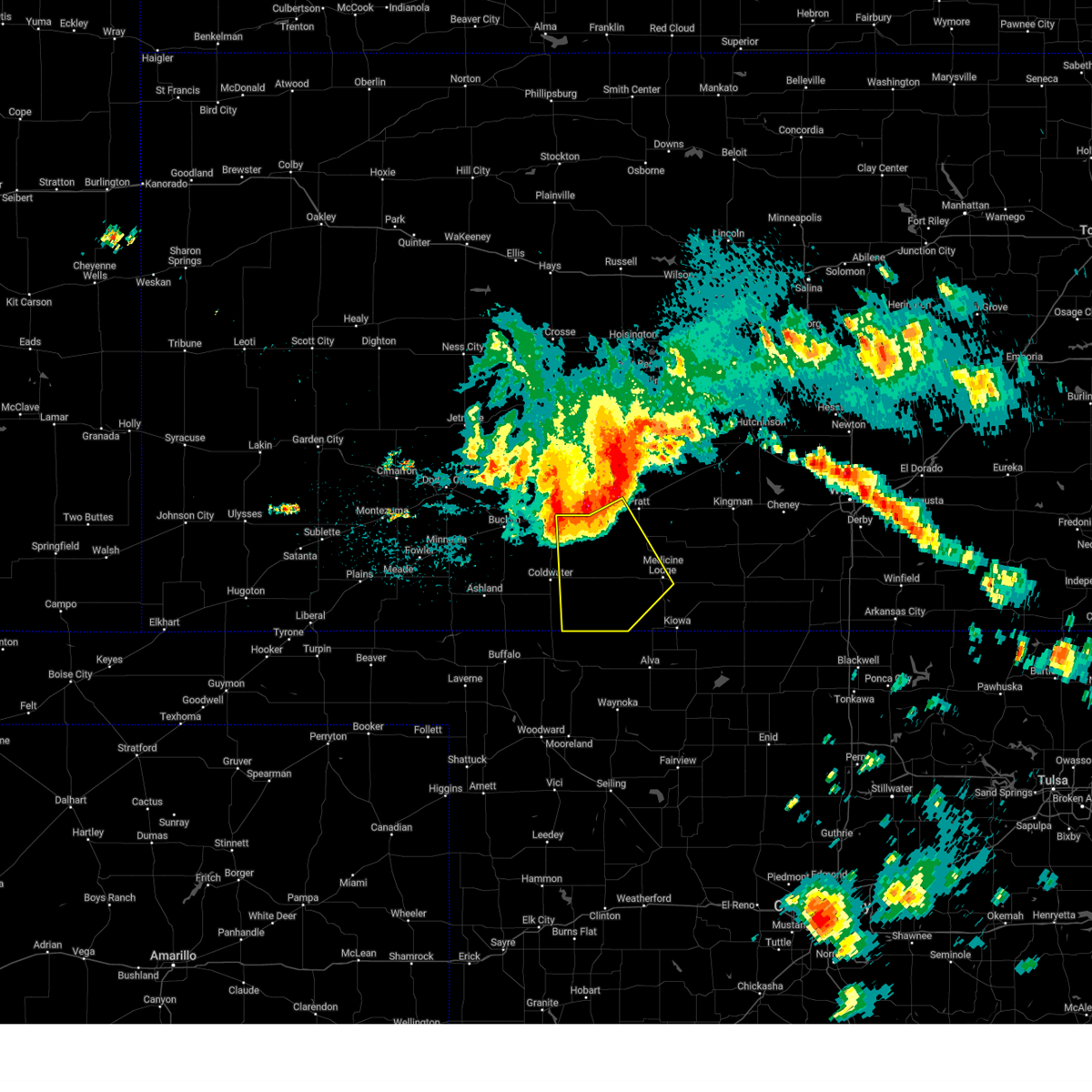
 At 925 pm cdt, severe thunderstorms were located along a line extending from greensburg to near protection, moving east at 45 mph (radar indicated). Hazards include 60 mph wind gusts and penny size hail. Expect damage to roofs, siding, and trees. severe thunderstorms will be near, coldwater, haviland, and lake coldwater around 935 pm cdt. wellsford around 940 pm cdt. wilmore and belvidere around 945 pm cdt. other locations in the path of these severe thunderstorms include cullison, croft, pratt, coats and sun city. hail threat, radar indicated max hail size, 0. 75 in wind threat, radar indicated max wind gust, 60 mph. At 925 pm cdt, severe thunderstorms were located along a line extending from greensburg to near protection, moving east at 45 mph (radar indicated). Hazards include 60 mph wind gusts and penny size hail. Expect damage to roofs, siding, and trees. severe thunderstorms will be near, coldwater, haviland, and lake coldwater around 935 pm cdt. wellsford around 940 pm cdt. wilmore and belvidere around 945 pm cdt. other locations in the path of these severe thunderstorms include cullison, croft, pratt, coats and sun city. hail threat, radar indicated max hail size, 0. 75 in wind threat, radar indicated max wind gust, 60 mph.
|
| 10/3/2023 6:10 PM CDT | Quarter sized hail reported 0.4 miles S of Greensburg, KS |
| 10/3/2023 5:57 PM CDT |
 The severe thunderstorm warning for northern kiowa and south central edwards counties will expire at 600 pm cdt, the storm which prompted the warning has moved out of the area. therefore, the warning will be allowed to expire. a severe thunderstorm watch remains in effect until midnight cdt for south central kansas. The severe thunderstorm warning for northern kiowa and south central edwards counties will expire at 600 pm cdt, the storm which prompted the warning has moved out of the area. therefore, the warning will be allowed to expire. a severe thunderstorm watch remains in effect until midnight cdt for south central kansas.
|
| 10/3/2023 5:42 PM CDT |
 At 542 pm cdt, a severe thunderstorm was located near greensburg, moving northeast at 45 mph (radar indicated). Hazards include two inch hail and 60 mph wind gusts. People and animals outdoors will be injured. expect hail damage to roofs, siding, windows, and vehicles. expect wind damage to roofs, siding, and trees. locations impacted include, fellsburg and centerview. thunderstorm damage threat, considerable hail threat, radar indicated max hail size, 2. 00 in wind threat, radar indicated max wind gust, 60 mph. At 542 pm cdt, a severe thunderstorm was located near greensburg, moving northeast at 45 mph (radar indicated). Hazards include two inch hail and 60 mph wind gusts. People and animals outdoors will be injured. expect hail damage to roofs, siding, windows, and vehicles. expect wind damage to roofs, siding, and trees. locations impacted include, fellsburg and centerview. thunderstorm damage threat, considerable hail threat, radar indicated max hail size, 2. 00 in wind threat, radar indicated max wind gust, 60 mph.
|
| 10/3/2023 5:29 PM CDT |
 At 528 pm cdt, a severe thunderstorm was located near mullinville, moving northeast at 45 mph (radar indicated). Hazards include tennis ball size hail and 60 mph wind gusts. People and animals outdoors will be injured. expect hail damage to roofs, siding, windows, and vehicles. expect wind damage to roofs, siding, and trees. this severe storm will be near, greensburg around 535 pm cdt. other locations in the path of this severe thunderstorm include centerview and fellsburg. thunderstorm damage threat, considerable hail threat, radar indicated max hail size, 2. 50 in wind threat, radar indicated max wind gust, 60 mph. At 528 pm cdt, a severe thunderstorm was located near mullinville, moving northeast at 45 mph (radar indicated). Hazards include tennis ball size hail and 60 mph wind gusts. People and animals outdoors will be injured. expect hail damage to roofs, siding, windows, and vehicles. expect wind damage to roofs, siding, and trees. this severe storm will be near, greensburg around 535 pm cdt. other locations in the path of this severe thunderstorm include centerview and fellsburg. thunderstorm damage threat, considerable hail threat, radar indicated max hail size, 2. 50 in wind threat, radar indicated max wind gust, 60 mph.
|
| 10/3/2023 5:20 PM CDT |
 At 520 pm cdt, a severe thunderstorm was located 8 miles southeast of bucklin, moving northeast at 45 mph (radar indicated). Hazards include 60 mph wind gusts and quarter size hail. Hail damage to vehicles is expected. expect wind damage to roofs, siding, and trees. this severe thunderstorm will be near, mullinville around 525 pm cdt. greensburg around 540 pm cdt. other locations in the path of this severe thunderstorm include centerview and fellsburg. hail threat, radar indicated max hail size, 1. 00 in wind threat, radar indicated max wind gust, 60 mph. At 520 pm cdt, a severe thunderstorm was located 8 miles southeast of bucklin, moving northeast at 45 mph (radar indicated). Hazards include 60 mph wind gusts and quarter size hail. Hail damage to vehicles is expected. expect wind damage to roofs, siding, and trees. this severe thunderstorm will be near, mullinville around 525 pm cdt. greensburg around 540 pm cdt. other locations in the path of this severe thunderstorm include centerview and fellsburg. hail threat, radar indicated max hail size, 1. 00 in wind threat, radar indicated max wind gust, 60 mph.
|
| 7/21/2023 12:34 AM CDT |
 At 1234 am cdt, severe thunderstorms were located along a line extending from near ford to 11 miles southeast of meade, moving east at 20 mph (radar indicated). Hazards include two inch hail and 60 mph wind gusts. People and animals outdoors will be injured. expect hail damage to roofs, siding, windows, and vehicles. expect wind damage to roofs, siding, and trees. severe thunderstorms will be near, ford around 1240 am cdt. other locations in the path of these severe thunderstorms include bucklin, mullinville and acres. thunderstorm damage threat, considerable hail threat, radar indicated max hail size, 2. 00 in wind threat, radar indicated max wind gust, 60 mph. At 1234 am cdt, severe thunderstorms were located along a line extending from near ford to 11 miles southeast of meade, moving east at 20 mph (radar indicated). Hazards include two inch hail and 60 mph wind gusts. People and animals outdoors will be injured. expect hail damage to roofs, siding, windows, and vehicles. expect wind damage to roofs, siding, and trees. severe thunderstorms will be near, ford around 1240 am cdt. other locations in the path of these severe thunderstorms include bucklin, mullinville and acres. thunderstorm damage threat, considerable hail threat, radar indicated max hail size, 2. 00 in wind threat, radar indicated max wind gust, 60 mph.
|
| 7/20/2023 7:42 PM CDT |
 The severe thunderstorm warning for kiowa, northwestern barber and southwestern pratt counties will expire at 745 pm cdt, the storm which prompted the warning has weakened below severe limits, and no longer poses an immediate threat to life or property. therefore, the warning will be allowed to expire. a severe thunderstorm watch remains in effect until midnight cdt for south central kansas. The severe thunderstorm warning for kiowa, northwestern barber and southwestern pratt counties will expire at 745 pm cdt, the storm which prompted the warning has weakened below severe limits, and no longer poses an immediate threat to life or property. therefore, the warning will be allowed to expire. a severe thunderstorm watch remains in effect until midnight cdt for south central kansas.
|
| 7/20/2023 7:29 PM CDT |
 At 728 pm cdt, a severe thunderstorm was located near haviland, moving east at 40 mph. this is a destructive storm for haviland (radar indicated). Hazards include 80 mph wind gusts and quarter size hail. Flying debris will be dangerous to those caught without shelter. mobile homes will be heavily damaged. expect considerable damage to roofs, windows, and vehicles. extensive tree damage and power outages are likely. locations impacted include, greensburg, haviland, cullison, coats, sun city, wellsford, croft and belvidere. thunderstorm damage threat, destructive hail threat, radar indicated max hail size, 1. 00 in wind threat, radar indicated max wind gust, 80 mph. At 728 pm cdt, a severe thunderstorm was located near haviland, moving east at 40 mph. this is a destructive storm for haviland (radar indicated). Hazards include 80 mph wind gusts and quarter size hail. Flying debris will be dangerous to those caught without shelter. mobile homes will be heavily damaged. expect considerable damage to roofs, windows, and vehicles. extensive tree damage and power outages are likely. locations impacted include, greensburg, haviland, cullison, coats, sun city, wellsford, croft and belvidere. thunderstorm damage threat, destructive hail threat, radar indicated max hail size, 1. 00 in wind threat, radar indicated max wind gust, 80 mph.
|
| 7/20/2023 7:21 PM CDT |
 At 720 pm cdt, a severe thunderstorm was located near greensburg, moving east at 40 mph. this is a destructive storm (radar indicated). Hazards include 90 mph wind gusts and quarter size hail. You are in a life-threatening situation. flying debris may be deadly to those caught without shelter. mobile homes will be heavily damaged or destroyed. homes and businesses will have substantial roof and window damage. expect extensive tree damage and power outages. locations impacted include, haviland, wellsford, croft, cullison and coats. thunderstorm damage threat, destructive hail threat, radar indicated max hail size, 1. 00 in wind threat, radar indicated max wind gust, 90 mph. At 720 pm cdt, a severe thunderstorm was located near greensburg, moving east at 40 mph. this is a destructive storm (radar indicated). Hazards include 90 mph wind gusts and quarter size hail. You are in a life-threatening situation. flying debris may be deadly to those caught without shelter. mobile homes will be heavily damaged or destroyed. homes and businesses will have substantial roof and window damage. expect extensive tree damage and power outages. locations impacted include, haviland, wellsford, croft, cullison and coats. thunderstorm damage threat, destructive hail threat, radar indicated max hail size, 1. 00 in wind threat, radar indicated max wind gust, 90 mph.
|
| 7/20/2023 7:01 PM CDT |
 At 701 pm cdt, a severe thunderstorm was located near mullinville, moving east at 40 mph. this is a destructive storm for mullinville and greensburg (radar indicated). Hazards include 90 mph wind gusts and quarter size hail. You are in a life-threatening situation. flying debris may be deadly to those caught without shelter. mobile homes will be heavily damaged or destroyed. homes and businesses will have substantial roof and window damage. expect extensive tree damage and power outages. this severe thunderstorm will be near, greensburg around 715 pm cdt. other locations in the path of this severe thunderstorm include haviland, wellsford, belvidere, croft, cullison and coats. thunderstorm damage threat, destructive hail threat, radar indicated max hail size, 1. 00 in wind threat, radar indicated max wind gust, 90 mph. At 701 pm cdt, a severe thunderstorm was located near mullinville, moving east at 40 mph. this is a destructive storm for mullinville and greensburg (radar indicated). Hazards include 90 mph wind gusts and quarter size hail. You are in a life-threatening situation. flying debris may be deadly to those caught without shelter. mobile homes will be heavily damaged or destroyed. homes and businesses will have substantial roof and window damage. expect extensive tree damage and power outages. this severe thunderstorm will be near, greensburg around 715 pm cdt. other locations in the path of this severe thunderstorm include haviland, wellsford, belvidere, croft, cullison and coats. thunderstorm damage threat, destructive hail threat, radar indicated max hail size, 1. 00 in wind threat, radar indicated max wind gust, 90 mph.
|
| 7/17/2023 6:34 PM CDT |
 At 634 pm cdt, a severe thunderstorm was located very near greensburg, moving southeast at 35 mph (radar indicated). Hazards include quarter size hail. Damage to vehicles is expected. this severe thunderstorm will be near, haviland around 645 pm cdt. other locations in the path of this severe thunderstorm include wellsford and belvidere. hail threat, radar indicated max hail size, 1. 00 in wind threat, radar indicated max wind gust, <50 mph. At 634 pm cdt, a severe thunderstorm was located very near greensburg, moving southeast at 35 mph (radar indicated). Hazards include quarter size hail. Damage to vehicles is expected. this severe thunderstorm will be near, haviland around 645 pm cdt. other locations in the path of this severe thunderstorm include wellsford and belvidere. hail threat, radar indicated max hail size, 1. 00 in wind threat, radar indicated max wind gust, <50 mph.
|
| 7/17/2023 5:37 PM CDT |
 At 536 pm cdt, a severe thunderstorm was located 7 miles east of windhorst, moving south at 15 mph. this is a destructive storm for kingsdown, bucklin, mullinville, greensburg, and adjacent areas (radar indicated). Hazards include baseball size hail and 70 mph wind gusts. People and animals outdoors will be severely injured. Expect shattered windows, extensive damage to roofs, siding, and vehicles. At 536 pm cdt, a severe thunderstorm was located 7 miles east of windhorst, moving south at 15 mph. this is a destructive storm for kingsdown, bucklin, mullinville, greensburg, and adjacent areas (radar indicated). Hazards include baseball size hail and 70 mph wind gusts. People and animals outdoors will be severely injured. Expect shattered windows, extensive damage to roofs, siding, and vehicles.
|
| 6/27/2023 9:17 PM CDT |
 At 917 pm cdt, a severe thunderstorm was located near protection, moving east at 50 mph (radar indicated). Hazards include 60 mph wind gusts and penny size hail. Expect damage to roofs, siding, and trees. hail threat, radar indicated max hail size, 0. 75 in wind threat, radar indicated max wind gust, 60 mph. At 917 pm cdt, a severe thunderstorm was located near protection, moving east at 50 mph (radar indicated). Hazards include 60 mph wind gusts and penny size hail. Expect damage to roofs, siding, and trees. hail threat, radar indicated max hail size, 0. 75 in wind threat, radar indicated max wind gust, 60 mph.
|
| 6/27/2023 9:11 PM CDT |
 At 910 pm cdt, severe thunderstorms were located along a line extending from 13 miles northwest of jetmore to near bucklin, moving northeast at 50 mph (radar indicated). Hazards include 70 mph wind gusts. Expect considerable tree damage. damage is likely to mobile homes, roofs, and outbuildings. thunderstorm damage threat, considerable hail threat, radar indicated max hail size, <. 75 in wind threat, radar indicated max wind gust, 70 mph. At 910 pm cdt, severe thunderstorms were located along a line extending from 13 miles northwest of jetmore to near bucklin, moving northeast at 50 mph (radar indicated). Hazards include 70 mph wind gusts. Expect considerable tree damage. damage is likely to mobile homes, roofs, and outbuildings. thunderstorm damage threat, considerable hail threat, radar indicated max hail size, <. 75 in wind threat, radar indicated max wind gust, 70 mph.
|
| 6/21/2023 6:24 AM CDT |
 At 623 am cdt, a severe thunderstorm was located near haviland, moving southeast at 25 mph (radar indicated). Hazards include ping pong ball size hail and 60 mph wind gusts. People and animals outdoors will be injured. expect hail damage to roofs, siding, windows, and vehicles. expect wind damage to roofs, siding, and trees. locations impacted include, greensburg, haviland and wellsford. hail threat, radar indicated max hail size, 1. 50 in wind threat, radar indicated max wind gust, 60 mph. At 623 am cdt, a severe thunderstorm was located near haviland, moving southeast at 25 mph (radar indicated). Hazards include ping pong ball size hail and 60 mph wind gusts. People and animals outdoors will be injured. expect hail damage to roofs, siding, windows, and vehicles. expect wind damage to roofs, siding, and trees. locations impacted include, greensburg, haviland and wellsford. hail threat, radar indicated max hail size, 1. 50 in wind threat, radar indicated max wind gust, 60 mph.
|
| 6/21/2023 6:14 AM CDT |
 At 613 am cdt, a severe thunderstorm was located near haviland, moving south at 25 mph (radar indicated). Hazards include ping pong ball size hail and 60 mph wind gusts. People and animals outdoors will be injured. expect hail damage to roofs, siding, windows, and vehicles. expect wind damage to roofs, siding, and trees. this severe thunderstorm will remain over mainly rural areas of eastern kiowa, southeastern edwards and west central pratt counties. hail threat, radar indicated max hail size, 1. 50 in wind threat, radar indicated max wind gust, 60 mph. At 613 am cdt, a severe thunderstorm was located near haviland, moving south at 25 mph (radar indicated). Hazards include ping pong ball size hail and 60 mph wind gusts. People and animals outdoors will be injured. expect hail damage to roofs, siding, windows, and vehicles. expect wind damage to roofs, siding, and trees. this severe thunderstorm will remain over mainly rural areas of eastern kiowa, southeastern edwards and west central pratt counties. hail threat, radar indicated max hail size, 1. 50 in wind threat, radar indicated max wind gust, 60 mph.
|
| 6/21/2023 5:48 AM CDT |
 At 548 am cdt, a severe thunderstorm was located near fellsburg, moving southeast at 25 mph (radar indicated). Hazards include ping pong ball size hail and 60 mph wind gusts. People and animals outdoors will be injured. expect hail damage to roofs, siding, windows, and vehicles. expect wind damage to roofs, siding, and trees. this severe storm will be near, trousdale around 555 am cdt. other locations in the path of this severe thunderstorm include haviland and wellsford. hail threat, radar indicated max hail size, 1. 50 in wind threat, radar indicated max wind gust, 60 mph. At 548 am cdt, a severe thunderstorm was located near fellsburg, moving southeast at 25 mph (radar indicated). Hazards include ping pong ball size hail and 60 mph wind gusts. People and animals outdoors will be injured. expect hail damage to roofs, siding, windows, and vehicles. expect wind damage to roofs, siding, and trees. this severe storm will be near, trousdale around 555 am cdt. other locations in the path of this severe thunderstorm include haviland and wellsford. hail threat, radar indicated max hail size, 1. 50 in wind threat, radar indicated max wind gust, 60 mph.
|
| 6/21/2023 5:41 AM CDT |
 At 540 am cdt, a severe thunderstorm was located near fellsburg, moving southeast at 25 mph (radar indicated). Hazards include quarter size hail. Damage to vehicles is expected. this severe thunderstorm will be near, fellsburg around 545 am cdt. trousdale around 600 am cdt. other locations in the path of this severe thunderstorm include hopewell and byers. hail threat, radar indicated max hail size, 1. 00 in wind threat, radar indicated max wind gust, <50 mph. At 540 am cdt, a severe thunderstorm was located near fellsburg, moving southeast at 25 mph (radar indicated). Hazards include quarter size hail. Damage to vehicles is expected. this severe thunderstorm will be near, fellsburg around 545 am cdt. trousdale around 600 am cdt. other locations in the path of this severe thunderstorm include hopewell and byers. hail threat, radar indicated max hail size, 1. 00 in wind threat, radar indicated max wind gust, <50 mph.
|
| 6/17/2023 8:47 PM CDT |
 At 847 pm cdt, severe thunderstorms were located along a line extending from near burdett to near centerview to 9 miles south of greensburg, moving east at 30 mph (radar indicated). Hazards include 60 mph wind gusts. Expect damage to roofs, siding, and trees. severe thunderstorms will be near, centerview around 850 pm cdt. fellsburg around 900 pm cdt. rozel around 905 pm cdt. Other locations in the path of these severe thunderstorms include trousdale, haviland, hopewell, ash valley, wellsford, croft and macksville. At 847 pm cdt, severe thunderstorms were located along a line extending from near burdett to near centerview to 9 miles south of greensburg, moving east at 30 mph (radar indicated). Hazards include 60 mph wind gusts. Expect damage to roofs, siding, and trees. severe thunderstorms will be near, centerview around 850 pm cdt. fellsburg around 900 pm cdt. rozel around 905 pm cdt. Other locations in the path of these severe thunderstorms include trousdale, haviland, hopewell, ash valley, wellsford, croft and macksville.
|
| 6/15/2023 6:23 PM CDT |
 At 623 pm cdt, severe thunderstorms were located along a line extending from 6 miles north of greensburg to 6 miles southeast of buttermilk, moving east at 10 mph (radar indicated). Hazards include 70 mph wind gusts and penny size hail. Expect considerable tree damage. damage is likely to mobile homes, roofs, and outbuildings. locations impacted include, haviland. thunderstorm damage threat, considerable hail threat, radar indicated max hail size, 0. 75 in wind threat, radar indicated max wind gust, 70 mph. At 623 pm cdt, severe thunderstorms were located along a line extending from 6 miles north of greensburg to 6 miles southeast of buttermilk, moving east at 10 mph (radar indicated). Hazards include 70 mph wind gusts and penny size hail. Expect considerable tree damage. damage is likely to mobile homes, roofs, and outbuildings. locations impacted include, haviland. thunderstorm damage threat, considerable hail threat, radar indicated max hail size, 0. 75 in wind threat, radar indicated max wind gust, 70 mph.
|
| 6/15/2023 5:53 PM CDT |
 At 553 pm cdt, severe thunderstorms were located along a line extending from near ford to 11 miles north of buffalo, moving east at 25 mph (radar indicated). Hazards include 70 mph wind gusts and half dollar size hail. Hail damage to vehicles is expected. expect considerable tree damage. wind damage is also likely to mobile homes, roofs, and outbuildings. severe thunderstorms will be near, bucklin around 600 pm cdt. other locations in the path of these severe thunderstorms include mullinville, buttermilk and greensburg. thunderstorm damage threat, considerable hail threat, radar indicated max hail size, 1. 25 in wind threat, radar indicated max wind gust, 70 mph. At 553 pm cdt, severe thunderstorms were located along a line extending from near ford to 11 miles north of buffalo, moving east at 25 mph (radar indicated). Hazards include 70 mph wind gusts and half dollar size hail. Hail damage to vehicles is expected. expect considerable tree damage. wind damage is also likely to mobile homes, roofs, and outbuildings. severe thunderstorms will be near, bucklin around 600 pm cdt. other locations in the path of these severe thunderstorms include mullinville, buttermilk and greensburg. thunderstorm damage threat, considerable hail threat, radar indicated max hail size, 1. 25 in wind threat, radar indicated max wind gust, 70 mph.
|
| 2/26/2023 6:30 PM CST |
 At 629 pm cst, severe thunderstorms were located along a line extending from near rozel to near offerle to kingsdown, moving northeast at 70 mph (radar indicated). Hazards include 60 mph wind gusts and penny size hail. Expect damage to roofs, siding, and trees. Locations impacted include, gray, kinsley, bucklin, greensburg, haviland, lewis, mullinville, ford, offerle, garfield, rozel, fellsburg, kingsdown, sanford, frizell, bellefont, windhorst and centerview. At 629 pm cst, severe thunderstorms were located along a line extending from near rozel to near offerle to kingsdown, moving northeast at 70 mph (radar indicated). Hazards include 60 mph wind gusts and penny size hail. Expect damage to roofs, siding, and trees. Locations impacted include, gray, kinsley, bucklin, greensburg, haviland, lewis, mullinville, ford, offerle, garfield, rozel, fellsburg, kingsdown, sanford, frizell, bellefont, windhorst and centerview.
|
| 2/26/2023 6:19 PM CST |
 At 618 pm cst, severe thunderstorms were located along a line extending from near hanston to 8 miles west of ashland, moving east at 45 mph (radar indicated). Hazards include 70 mph wind gusts and half dollar size hail. Hail damage to vehicles is expected. expect considerable tree damage. wind damage is also likely to mobile homes, roofs, and outbuildings. Locations impacted include, gray, hanston, rozel, sanford, coldwater, frizell and lake coldwater. At 618 pm cst, severe thunderstorms were located along a line extending from near hanston to 8 miles west of ashland, moving east at 45 mph (radar indicated). Hazards include 70 mph wind gusts and half dollar size hail. Hail damage to vehicles is expected. expect considerable tree damage. wind damage is also likely to mobile homes, roofs, and outbuildings. Locations impacted include, gray, hanston, rozel, sanford, coldwater, frizell and lake coldwater.
|
| 2/26/2023 5:57 PM CST |
 At 555 pm cst, severe thunderstorms were located along a line extending from 6 miles west of jetmore to 12 miles southeast of meade, moving east at 45 mph (radar indicated). Hazards include 70 mph wind gusts and half dollar size hail. Hail damage to vehicles is expected. expect considerable tree damage. wind damage is also likely to mobile homes, roofs, and outbuildings. severe thunderstorms will be near, jetmore around 605 pm cst. Other locations in the path of these severe thunderstorms include hanston, gray, ashland, sitka, rozel, protection and sanford. At 555 pm cst, severe thunderstorms were located along a line extending from 6 miles west of jetmore to 12 miles southeast of meade, moving east at 45 mph (radar indicated). Hazards include 70 mph wind gusts and half dollar size hail. Hail damage to vehicles is expected. expect considerable tree damage. wind damage is also likely to mobile homes, roofs, and outbuildings. severe thunderstorms will be near, jetmore around 605 pm cst. Other locations in the path of these severe thunderstorms include hanston, gray, ashland, sitka, rozel, protection and sanford.
|
| 6/22/2022 7:56 PM CDT |
 At 756 pm cdt, a severe thunderstorm was located near bucklin, moving northeast at 20 mph (radar indicated). Hazards include 60 mph wind gusts and half dollar size hail. Hail damage to vehicles is expected. expect wind damage to roofs, siding, and trees. this severe thunderstorm will be near, windhorst around 810 pm cdt. other locations in the path of this severe thunderstorm include offerle. hail threat, radar indicated max hail size, 1. 25 in wind threat, radar indicated max wind gust, 60 mph. At 756 pm cdt, a severe thunderstorm was located near bucklin, moving northeast at 20 mph (radar indicated). Hazards include 60 mph wind gusts and half dollar size hail. Hail damage to vehicles is expected. expect wind damage to roofs, siding, and trees. this severe thunderstorm will be near, windhorst around 810 pm cdt. other locations in the path of this severe thunderstorm include offerle. hail threat, radar indicated max hail size, 1. 25 in wind threat, radar indicated max wind gust, 60 mph.
|
| 6/22/2022 5:40 PM CDT |
 At 539 pm cdt, a severe thunderstorm was located near haviland, moving east at 25 mph (radar indicated). Hazards include 60 mph wind gusts and half dollar size hail. Hail damage to vehicles is expected. expect wind damage to roofs, siding, and trees. this severe storm will be near, haviland around 550 pm cdt. other locations in the path of this severe thunderstorm include wellsford, croft and cullison. hail threat, radar indicated max hail size, 1. 25 in wind threat, radar indicated max wind gust, 60 mph. At 539 pm cdt, a severe thunderstorm was located near haviland, moving east at 25 mph (radar indicated). Hazards include 60 mph wind gusts and half dollar size hail. Hail damage to vehicles is expected. expect wind damage to roofs, siding, and trees. this severe storm will be near, haviland around 550 pm cdt. other locations in the path of this severe thunderstorm include wellsford, croft and cullison. hail threat, radar indicated max hail size, 1. 25 in wind threat, radar indicated max wind gust, 60 mph.
|
| 6/22/2022 5:36 PM CDT |
 At 536 pm cdt, a severe thunderstorm was located near greensburg, moving east at 25 mph (radar indicated). Hazards include 60 mph wind gusts and nickel size hail. Expect damage to roofs, siding, and trees. this severe thunderstorm will be near, haviland around 550 pm cdt. other locations in the path of this severe thunderstorm include wellsford, croft and cullison. hail threat, radar indicated max hail size, 0. 88 in wind threat, radar indicated max wind gust, 60 mph. At 536 pm cdt, a severe thunderstorm was located near greensburg, moving east at 25 mph (radar indicated). Hazards include 60 mph wind gusts and nickel size hail. Expect damage to roofs, siding, and trees. this severe thunderstorm will be near, haviland around 550 pm cdt. other locations in the path of this severe thunderstorm include wellsford, croft and cullison. hail threat, radar indicated max hail size, 0. 88 in wind threat, radar indicated max wind gust, 60 mph.
|
| 5/14/2022 7:40 PM CDT | Golf Ball sized hail reported 6.8 miles SSW of Greensburg, KS |
| 5/2/2022 3:42 PM CDT |
 At 342 pm cdt, severe thunderstorms were located along a line extending from near wellsford to near buttermilk, moving east at 35 mph (radar indicated). Hazards include 70 mph wind gusts and quarter size hail. Hail damage to vehicles is expected. expect considerable tree damage. wind damage is also likely to mobile homes, roofs, and outbuildings. severe thunderstorms will be near, haviland around 345 pm cdt. wellsford around 350 pm cdt. cullison around 400 pm cdt. Other locations in the path of these severe thunderstorms include pratt, iuka and aetna. At 342 pm cdt, severe thunderstorms were located along a line extending from near wellsford to near buttermilk, moving east at 35 mph (radar indicated). Hazards include 70 mph wind gusts and quarter size hail. Hail damage to vehicles is expected. expect considerable tree damage. wind damage is also likely to mobile homes, roofs, and outbuildings. severe thunderstorms will be near, haviland around 345 pm cdt. wellsford around 350 pm cdt. cullison around 400 pm cdt. Other locations in the path of these severe thunderstorms include pratt, iuka and aetna.
|
| 5/2/2022 3:28 PM CDT |
 At 328 pm cdt, a severe thunderstorm was located near greensburg, moving east at 35 mph (radar indicated). Hazards include golf ball size hail and 70 mph wind gusts. People and animals outdoors will be injured. expect hail damage to roofs, siding, windows, and vehicles. expect considerable tree damage. wind damage is also likely to mobile homes, roofs, and outbuildings. locations impacted include, greensburg, haviland and mullinville. thunderstorm damage threat, considerable hail threat, radar indicated max hail size, 1. 75 in wind threat, radar indicated max wind gust, 70 mph. At 328 pm cdt, a severe thunderstorm was located near greensburg, moving east at 35 mph (radar indicated). Hazards include golf ball size hail and 70 mph wind gusts. People and animals outdoors will be injured. expect hail damage to roofs, siding, windows, and vehicles. expect considerable tree damage. wind damage is also likely to mobile homes, roofs, and outbuildings. locations impacted include, greensburg, haviland and mullinville. thunderstorm damage threat, considerable hail threat, radar indicated max hail size, 1. 75 in wind threat, radar indicated max wind gust, 70 mph.
|
| 5/2/2022 3:10 PM CDT |
 At 310 pm cdt, a severe thunderstorm was located very near mullinville, moving east at 35 mph (radar indicated). Hazards include golf ball size hail and 70 mph wind gusts. People and animals outdoors will be injured. expect hail damage to roofs, siding, windows, and vehicles. expect considerable tree damage. wind damage is also likely to mobile homes, roofs, and outbuildings. Locations impacted include, greensburg and haviland. At 310 pm cdt, a severe thunderstorm was located very near mullinville, moving east at 35 mph (radar indicated). Hazards include golf ball size hail and 70 mph wind gusts. People and animals outdoors will be injured. expect hail damage to roofs, siding, windows, and vehicles. expect considerable tree damage. wind damage is also likely to mobile homes, roofs, and outbuildings. Locations impacted include, greensburg and haviland.
|
| 5/2/2022 3:01 PM CDT |
 At 300 pm cdt, a severe thunderstorm was located near bucklin, moving east at 35 mph (radar indicated). Hazards include golf ball size hail and 70 mph wind gusts. People and animals outdoors will be injured. expect hail damage to roofs, siding, windows, and vehicles. expect considerable tree damage. wind damage is also likely to mobile homes, roofs, and outbuildings. this severe storm will be near, mullinville around 310 pm cdt. Other locations in the path of this severe thunderstorm include greensburg and haviland. At 300 pm cdt, a severe thunderstorm was located near bucklin, moving east at 35 mph (radar indicated). Hazards include golf ball size hail and 70 mph wind gusts. People and animals outdoors will be injured. expect hail damage to roofs, siding, windows, and vehicles. expect considerable tree damage. wind damage is also likely to mobile homes, roofs, and outbuildings. this severe storm will be near, mullinville around 310 pm cdt. Other locations in the path of this severe thunderstorm include greensburg and haviland.
|
| 5/2/2022 2:57 PM CDT |
 At 257 pm cdt, a severe thunderstorm was located near bucklin, moving east at 35 mph (radar indicated). Hazards include 60 mph wind gusts and half dollar size hail. Hail damage to vehicles is expected. expect wind damage to roofs, siding, and trees. this severe thunderstorm will be near, mullinville around 310 pm cdt. other locations in the path of this severe thunderstorm include greensburg and haviland. hail threat, radar indicated max hail size, 1. 25 in wind threat, radar indicated max wind gust, 60 mph. At 257 pm cdt, a severe thunderstorm was located near bucklin, moving east at 35 mph (radar indicated). Hazards include 60 mph wind gusts and half dollar size hail. Hail damage to vehicles is expected. expect wind damage to roofs, siding, and trees. this severe thunderstorm will be near, mullinville around 310 pm cdt. other locations in the path of this severe thunderstorm include greensburg and haviland. hail threat, radar indicated max hail size, 1. 25 in wind threat, radar indicated max wind gust, 60 mph.
|
| 4/23/2022 3:32 AM CDT |
 At 332 am cdt, severe thunderstorms were located along a line extending from near windhorst to near englewood, moving east at 45 mph (radar indicated). Hazards include 60 mph wind gusts. Expect damage to roofs, siding, and trees. locations impacted include, ashland, sitka and protection. hail threat, radar indicated max hail size, <. 75 in wind threat, radar indicated max wind gust, 60 mph. At 332 am cdt, severe thunderstorms were located along a line extending from near windhorst to near englewood, moving east at 45 mph (radar indicated). Hazards include 60 mph wind gusts. Expect damage to roofs, siding, and trees. locations impacted include, ashland, sitka and protection. hail threat, radar indicated max hail size, <. 75 in wind threat, radar indicated max wind gust, 60 mph.
|
| 4/23/2022 2:42 AM CDT |
 At 241 am cdt, severe thunderstorms were located along a line extending from near the haggard elev to 9 miles southeast of hayne, moving east at 45 mph (radar indicated). Hazards include 60 mph wind gusts. Expect damage to roofs, siding, and trees. severe thunderstorms will be near, the haggard elev around 245 am cdt. ensign around 250 am cdt. meade state park around 300 am cdt. other locations in the path of these severe thunderstorms include ford, englewood, acres, ashland and sitka. hail threat, radar indicated max hail size, <. 75 in wind threat, radar indicated max wind gust, 60 mph. At 241 am cdt, severe thunderstorms were located along a line extending from near the haggard elev to 9 miles southeast of hayne, moving east at 45 mph (radar indicated). Hazards include 60 mph wind gusts. Expect damage to roofs, siding, and trees. severe thunderstorms will be near, the haggard elev around 245 am cdt. ensign around 250 am cdt. meade state park around 300 am cdt. other locations in the path of these severe thunderstorms include ford, englewood, acres, ashland and sitka. hail threat, radar indicated max hail size, <. 75 in wind threat, radar indicated max wind gust, 60 mph.
|
| 10/13/2021 12:17 AM CDT |
 At 1216 am cdt, severe thunderstorms were located along a line extending from near radium to near wellsford to near buttermilk, moving northeast at 55 mph. these are destructive storms for pratt, medicine lodge, st. john, and stafford (radar indicated). Hazards include 80 mph wind gusts and penny size hail. Flying debris will be dangerous to those caught without shelter. mobile homes will be heavily damaged. expect considerable damage to roofs, windows, and vehicles. extensive tree damage and power outages are likely. severe thunderstorms will be near, seward and radium around 1220 am cdt. cullison around 1225 am cdt. pratt and iuka around 1235 am cdt. Other locations in the path of these severe thunderstorms include preston, sun city, neola, lake city, zenith, sawyer and isabel. At 1216 am cdt, severe thunderstorms were located along a line extending from near radium to near wellsford to near buttermilk, moving northeast at 55 mph. these are destructive storms for pratt, medicine lodge, st. john, and stafford (radar indicated). Hazards include 80 mph wind gusts and penny size hail. Flying debris will be dangerous to those caught without shelter. mobile homes will be heavily damaged. expect considerable damage to roofs, windows, and vehicles. extensive tree damage and power outages are likely. severe thunderstorms will be near, seward and radium around 1220 am cdt. cullison around 1225 am cdt. pratt and iuka around 1235 am cdt. Other locations in the path of these severe thunderstorms include preston, sun city, neola, lake city, zenith, sawyer and isabel.
|
| 10/13/2021 12:09 AM CDT |
 At 1208 am cdt, severe thunderstorms were located along a line extending from near zook to near fellsburg to near belvidere, moving east at 55 mph. these are destructive storms for haviland, macksville, hopewell, and belvidere (radar indicated). Hazards include 80 mph wind gusts and penny size hail. Flying debris will be dangerous to those caught without shelter. mobile homes will be heavily damaged. expect considerable damage to roofs, windows, and vehicles. extensive tree damage and power outages are likely. these severe storms will be near, belpre, zook and trousdale around 1215 am cdt. Macksville, hopewell and wellsford around 1230 am cdt. At 1208 am cdt, severe thunderstorms were located along a line extending from near zook to near fellsburg to near belvidere, moving east at 55 mph. these are destructive storms for haviland, macksville, hopewell, and belvidere (radar indicated). Hazards include 80 mph wind gusts and penny size hail. Flying debris will be dangerous to those caught without shelter. mobile homes will be heavily damaged. expect considerable damage to roofs, windows, and vehicles. extensive tree damage and power outages are likely. these severe storms will be near, belpre, zook and trousdale around 1215 am cdt. Macksville, hopewell and wellsford around 1230 am cdt.
|
| 10/13/2021 12:03 AM CDT | 70-80 mph wind gust in kiowa county KS, 1.2 miles WSW of Greensburg, KS |
| 10/12/2021 11:41 PM CDT |
 At 1140 pm cdt, severe thunderstorms were located along a line extending from near kinsley to 6 miles southwest of centerview to 11 miles southeast of mullinville, moving east at 25 mph (radar indicated). Hazards include 60 mph wind gusts. Expect damage to roofs, siding, and trees. severe thunderstorms will be near, centerview around 1150 pm cdt. lewis around 1155 pm cdt. garfield around 1200 am cdt. Other locations in the path of these severe thunderstorms include fellsburg, belpre, trousdale, zook, belvidere, macksville, hopewell and wellsford. At 1140 pm cdt, severe thunderstorms were located along a line extending from near kinsley to 6 miles southwest of centerview to 11 miles southeast of mullinville, moving east at 25 mph (radar indicated). Hazards include 60 mph wind gusts. Expect damage to roofs, siding, and trees. severe thunderstorms will be near, centerview around 1150 pm cdt. lewis around 1155 pm cdt. garfield around 1200 am cdt. Other locations in the path of these severe thunderstorms include fellsburg, belpre, trousdale, zook, belvidere, macksville, hopewell and wellsford.
|
| 10/12/2021 11:33 PM CDT |
 At 1133 pm cdt, severe thunderstorms were located along a line extending from near centerview to 6 miles northeast of mullinville to near bucklin, moving east at 30 mph (radar indicated). Hazards include 60 mph wind gusts and penny size hail. Expect damage to roofs, siding, and trees. locations impacted include, kinsley, bucklin, greensburg, lewis, mullinville, belpre, fellsburg, centerview and trousdale. hail threat, radar indicated max hail size, 0. 75 in wind threat, radar indicated max wind gust, 60 mph. At 1133 pm cdt, severe thunderstorms were located along a line extending from near centerview to 6 miles northeast of mullinville to near bucklin, moving east at 30 mph (radar indicated). Hazards include 60 mph wind gusts and penny size hail. Expect damage to roofs, siding, and trees. locations impacted include, kinsley, bucklin, greensburg, lewis, mullinville, belpre, fellsburg, centerview and trousdale. hail threat, radar indicated max hail size, 0. 75 in wind threat, radar indicated max wind gust, 60 mph.
|
| 10/12/2021 11:12 PM CDT |
 At 1112 pm cdt, severe thunderstorms were located along a line extending from near kinsley to 7 miles north of mullinville to near bucklin, moving east at 40 mph (radar indicated). Hazards include 60 mph wind gusts and penny size hail. Expect damage to roofs, siding, and trees. locations impacted include, kinsley, lewis, mullinville, centerview, greensburg, fellsburg, belpre and trousdale. hail threat, radar indicated max hail size, 0. 75 in wind threat, radar indicated max wind gust, 60 mph. At 1112 pm cdt, severe thunderstorms were located along a line extending from near kinsley to 7 miles north of mullinville to near bucklin, moving east at 40 mph (radar indicated). Hazards include 60 mph wind gusts and penny size hail. Expect damage to roofs, siding, and trees. locations impacted include, kinsley, lewis, mullinville, centerview, greensburg, fellsburg, belpre and trousdale. hail threat, radar indicated max hail size, 0. 75 in wind threat, radar indicated max wind gust, 60 mph.
|
| 10/12/2021 10:51 PM CDT |
 At 1050 pm cdt, severe thunderstorms were located along a line extending from near offerle to near windhorst to near kingsdown, moving east at 60 mph (radar indicated). Hazards include 70 mph wind gusts and penny size hail. Expect considerable tree damage. damage is likely to mobile homes, roofs, and outbuildings. severe thunderstorms will be near, offerle around 1055 pm cdt. kinsley around 1100 pm cdt. lewis and mullinville around 1110 pm cdt. Other locations in the path of these severe thunderstorms include centerview, greensburg, belpre, fellsburg and trousdale. At 1050 pm cdt, severe thunderstorms were located along a line extending from near offerle to near windhorst to near kingsdown, moving east at 60 mph (radar indicated). Hazards include 70 mph wind gusts and penny size hail. Expect considerable tree damage. damage is likely to mobile homes, roofs, and outbuildings. severe thunderstorms will be near, offerle around 1055 pm cdt. kinsley around 1100 pm cdt. lewis and mullinville around 1110 pm cdt. Other locations in the path of these severe thunderstorms include centerview, greensburg, belpre, fellsburg and trousdale.
|
| 8/7/2021 9:56 PM CDT |
 The severe thunderstorm warning for central kiowa and southeastern edwards counties will expire at 1000 pm cdt, the storm which prompted the warning has weakened below severe limits, and has exited the warned area. therefore, the warning will be allowed to expire. however gusty winds and heavy rain are still possible with this thunderstorm. a severe thunderstorm watch remains in effect until 1100 pm cdt for south central kansas. The severe thunderstorm warning for central kiowa and southeastern edwards counties will expire at 1000 pm cdt, the storm which prompted the warning has weakened below severe limits, and has exited the warned area. therefore, the warning will be allowed to expire. however gusty winds and heavy rain are still possible with this thunderstorm. a severe thunderstorm watch remains in effect until 1100 pm cdt for south central kansas.
|
| 8/7/2021 9:48 PM CDT |
 At 948 pm cdt, a severe thunderstorm was located near trousdale, moving east at 40 mph (radar indicated). Hazards include 60 mph wind gusts. Expect damage to roofs, siding, and trees. this severe thunderstorm will remain over mainly rural areas of central kiowa and southeastern edwards counties. hail threat, radar indicated max hail size, <. 75 in wind threat, radar indicated max wind gust, 60 mph. At 948 pm cdt, a severe thunderstorm was located near trousdale, moving east at 40 mph (radar indicated). Hazards include 60 mph wind gusts. Expect damage to roofs, siding, and trees. this severe thunderstorm will remain over mainly rural areas of central kiowa and southeastern edwards counties. hail threat, radar indicated max hail size, <. 75 in wind threat, radar indicated max wind gust, 60 mph.
|
| 8/7/2021 9:11 PM CDT |
 At 910 pm cdt, a severe thunderstorm was located near mullinville, moving east at 40 mph (radar indicated). Hazards include 70 mph wind gusts and penny size hail. Expect considerable tree damage. damage is likely to mobile homes, roofs, and outbuildings. this severe thunderstorm will be near, greensburg around 930 pm cdt. other locations in the path of this severe thunderstorm include centerview, fellsburg, haviland and trousdale. thunderstorm damage threat, considerable hail threat, radar indicated max hail size, 0. 75 in wind threat, radar indicated max wind gust, 70 mph. At 910 pm cdt, a severe thunderstorm was located near mullinville, moving east at 40 mph (radar indicated). Hazards include 70 mph wind gusts and penny size hail. Expect considerable tree damage. damage is likely to mobile homes, roofs, and outbuildings. this severe thunderstorm will be near, greensburg around 930 pm cdt. other locations in the path of this severe thunderstorm include centerview, fellsburg, haviland and trousdale. thunderstorm damage threat, considerable hail threat, radar indicated max hail size, 0. 75 in wind threat, radar indicated max wind gust, 70 mph.
|
| 7/18/2021 2:53 PM CDT |
 At 253 pm cdt, severe thunderstorms were located along a line extending from near macksville to near trousdale to 6 miles southwest of centerview, moving south at 20 mph (radar indicated). Hazards include 60 mph wind gusts. Expect damage to roofs, siding, and trees. Locations impacted include, fellsburg, centerview, greensburg, haviland, wellsford and byers. At 253 pm cdt, severe thunderstorms were located along a line extending from near macksville to near trousdale to 6 miles southwest of centerview, moving south at 20 mph (radar indicated). Hazards include 60 mph wind gusts. Expect damage to roofs, siding, and trees. Locations impacted include, fellsburg, centerview, greensburg, haviland, wellsford and byers.
|
| 7/18/2021 2:30 PM CDT |
 At 230 pm cdt, severe thunderstorms were located along a line extending from near radium to near belpre to 7 miles west of centerview, moving southeast at 30 mph (radar indicated). Hazards include 60 mph wind gusts and nickel size hail. Expect damage to roofs, siding, and trees. severe thunderstorms will be near, centerview around 240 pm cdt. fellsburg around 245 pm cdt. trousdale and hopewell around 250 pm cdt. other locations in the path of these severe thunderstorms include st. John, macksville, dillwyn, greensburg, cullison, byers and wellsford. At 230 pm cdt, severe thunderstorms were located along a line extending from near radium to near belpre to 7 miles west of centerview, moving southeast at 30 mph (radar indicated). Hazards include 60 mph wind gusts and nickel size hail. Expect damage to roofs, siding, and trees. severe thunderstorms will be near, centerview around 240 pm cdt. fellsburg around 245 pm cdt. trousdale and hopewell around 250 pm cdt. other locations in the path of these severe thunderstorms include st. John, macksville, dillwyn, greensburg, cullison, byers and wellsford.
|
| 6/25/2021 5:48 PM CDT |
 At 548 pm cdt, a severe thunderstorm was located near wilmore, moving north at 30 mph (radar indicated). Hazards include two inch hail and 60 mph wind gusts. People and animals outdoors will be injured. expect hail damage to roofs, siding, windows, and vehicles. Expect wind damage to roofs, siding, and trees. At 548 pm cdt, a severe thunderstorm was located near wilmore, moving north at 30 mph (radar indicated). Hazards include two inch hail and 60 mph wind gusts. People and animals outdoors will be injured. expect hail damage to roofs, siding, windows, and vehicles. Expect wind damage to roofs, siding, and trees.
|
| 5/2/2021 11:05 PM CDT |
 At 1104 pm cdt, a severe thunderstorm was located near hopewell, moving east at 45 mph (radar indicated). Hazards include 60 mph wind gusts and nickel size hail. Expect damage to roofs, siding, and trees. Locations impacted include, pratt, greensburg, haviland, macksville, mullinville, iuka, cullison, coats, byers, fellsburg, hopewell, wellsford, croft, centerview and trousdale. At 1104 pm cdt, a severe thunderstorm was located near hopewell, moving east at 45 mph (radar indicated). Hazards include 60 mph wind gusts and nickel size hail. Expect damage to roofs, siding, and trees. Locations impacted include, pratt, greensburg, haviland, macksville, mullinville, iuka, cullison, coats, byers, fellsburg, hopewell, wellsford, croft, centerview and trousdale.
|
| 5/2/2021 10:41 PM CDT |
 At 1040 pm cdt, a severe thunderstorm was located 7 miles north of greensburg, moving east at 45 mph (radar indicated). Hazards include 60 mph wind gusts and nickel size hail. expect damage to roofs, siding, and trees At 1040 pm cdt, a severe thunderstorm was located 7 miles north of greensburg, moving east at 45 mph (radar indicated). Hazards include 60 mph wind gusts and nickel size hail. expect damage to roofs, siding, and trees
|
| 8/29/2020 2:40 AM CDT |
 At 239 am cdt, an outflow boundary from thunderstorms were located along a line extending from near lewis to 7 miles southeast of greensburg to near buttermilk, moving east at 40 mph (radar indicated). Hazards include 60 mph wind gusts. Expect damage to roofs, siding, and trees. Locations impacted include, coldwater, greensburg, haviland, macksville, protection, lewis, cullison, belpre, sun city, wilmore, fellsburg, hopewell, wellsford, croft, lake coldwater, centerview, trousdale, belvidere and buttermilk. At 239 am cdt, an outflow boundary from thunderstorms were located along a line extending from near lewis to 7 miles southeast of greensburg to near buttermilk, moving east at 40 mph (radar indicated). Hazards include 60 mph wind gusts. Expect damage to roofs, siding, and trees. Locations impacted include, coldwater, greensburg, haviland, macksville, protection, lewis, cullison, belpre, sun city, wilmore, fellsburg, hopewell, wellsford, croft, lake coldwater, centerview, trousdale, belvidere and buttermilk.
|
| 8/29/2020 2:35 AM CDT |
 The severe thunderstorm warning for southeastern ford, western kiowa, northwestern comanche and northeastern clark counties will expire at 245 am cdt, the storm which prompted the warning has moved out of the area. therefore, the warning will be allowed to expire. however gusty winds are still possible with this thunderstorm. The severe thunderstorm warning for southeastern ford, western kiowa, northwestern comanche and northeastern clark counties will expire at 245 am cdt, the storm which prompted the warning has moved out of the area. therefore, the warning will be allowed to expire. however gusty winds are still possible with this thunderstorm.
|
| 8/29/2020 2:24 AM CDT |
 At 224 am cdt, an outflow boundary from thunderstorms was located very near mullinville, moving east at 30 mph (radar indicated). Hazards include 60 mph wind gusts. Expect damage to roofs, siding, and trees. Locations impacted include, ashland, bucklin, greensburg, protection, mullinville, sitka and clark state lake. At 224 am cdt, an outflow boundary from thunderstorms was located very near mullinville, moving east at 30 mph (radar indicated). Hazards include 60 mph wind gusts. Expect damage to roofs, siding, and trees. Locations impacted include, ashland, bucklin, greensburg, protection, mullinville, sitka and clark state lake.
|
| 8/29/2020 2:16 AM CDT |
 At 215 am cdt, an outflow boundary from thunderstorms were located along a line extending from 9 miles northwest of kinsley to mullinville to near sitka, moving east at 40 mph (radar indicated). Hazards include 60 mph wind gusts. expect damage to roofs, siding, and trees At 215 am cdt, an outflow boundary from thunderstorms were located along a line extending from 9 miles northwest of kinsley to mullinville to near sitka, moving east at 40 mph (radar indicated). Hazards include 60 mph wind gusts. expect damage to roofs, siding, and trees
|
| 8/29/2020 1:54 AM CDT |
 At 153 am cdt, a severe thunderstorm was located near kingsdown, moving east at 30 mph (radar indicated). Hazards include an outflow boundary with 60 mph wind gusts. expect damage to roofs, siding, and trees At 153 am cdt, a severe thunderstorm was located near kingsdown, moving east at 30 mph (radar indicated). Hazards include an outflow boundary with 60 mph wind gusts. expect damage to roofs, siding, and trees
|
| 7/13/2020 1:57 AM CDT |
 At 145 am cdt, a severe thunderstorm was located near coldwater, moving east at 15 mph (radar indicated). Hazards include 60 mph wind gusts and quarter size hail. Hail damage to vehicles is expected. expect wind damage to roofs, siding, and trees. Locations impacted include, coldwater, greensburg, wilmore and lake coldwater. At 145 am cdt, a severe thunderstorm was located near coldwater, moving east at 15 mph (radar indicated). Hazards include 60 mph wind gusts and quarter size hail. Hail damage to vehicles is expected. expect wind damage to roofs, siding, and trees. Locations impacted include, coldwater, greensburg, wilmore and lake coldwater.
|
| 7/13/2020 1:45 AM CDT |
 At 145 am cdt, a severe thunderstorm was located near coldwater, moving east at 15 mph (radar indicated). Hazards include 60 mph wind gusts and quarter size hail. Hail damage to vehicles is expected. expect wind damage to roofs, siding, and trees. Locations impacted include, coldwater, greensburg, wilmore and lake coldwater. At 145 am cdt, a severe thunderstorm was located near coldwater, moving east at 15 mph (radar indicated). Hazards include 60 mph wind gusts and quarter size hail. Hail damage to vehicles is expected. expect wind damage to roofs, siding, and trees. Locations impacted include, coldwater, greensburg, wilmore and lake coldwater.
|
| 7/13/2020 1:32 AM CDT |
 At 132 am cdt, a severe thunderstorm was located 9 miles northwest of lake coldwater, moving east at 20 mph (radar indicated). Hazards include 60 mph wind gusts and quarter size hail. Hail damage to vehicles is expected. Expect wind damage to roofs, siding, and trees. At 132 am cdt, a severe thunderstorm was located 9 miles northwest of lake coldwater, moving east at 20 mph (radar indicated). Hazards include 60 mph wind gusts and quarter size hail. Hail damage to vehicles is expected. Expect wind damage to roofs, siding, and trees.
|
| 6/24/2020 8:22 PM CDT |
 The severe thunderstorm warning for east central ford, northwestern kiowa and southwestern edwards counties will expire at 830 pm cdt, the storm which prompted the warning has moved out of the area. therefore, the warning will be allowed to expire. however small hail, gusty winds and heavy rain are still possible with this thunderstorm. a severe thunderstorm watch remains in effect until midnight cdt for south central and southwestern kansas. The severe thunderstorm warning for east central ford, northwestern kiowa and southwestern edwards counties will expire at 830 pm cdt, the storm which prompted the warning has moved out of the area. therefore, the warning will be allowed to expire. however small hail, gusty winds and heavy rain are still possible with this thunderstorm. a severe thunderstorm watch remains in effect until midnight cdt for south central and southwestern kansas.
|
| 6/24/2020 7:52 PM CDT |
 At 752 pm cdt, a severe thunderstorm was located 9 miles north of mullinville, moving south at 10 mph (radar indicated). Hazards include two inch hail and 70 mph wind gusts. People and animals outdoors will be injured. expect hail damage to roofs, siding, windows, and vehicles. expect considerable tree damage. wind damage is also likely to mobile homes, roofs, and outbuildings. Locations impacted include, greensburg and mullinville. At 752 pm cdt, a severe thunderstorm was located 9 miles north of mullinville, moving south at 10 mph (radar indicated). Hazards include two inch hail and 70 mph wind gusts. People and animals outdoors will be injured. expect hail damage to roofs, siding, windows, and vehicles. expect considerable tree damage. wind damage is also likely to mobile homes, roofs, and outbuildings. Locations impacted include, greensburg and mullinville.
|
| 6/24/2020 7:31 PM CDT |
 At 731 pm cdt, a severe thunderstorm was located 9 miles west of centerview, moving south at 15 mph (radar indicated). Hazards include tennis ball size hail and 70 mph wind gusts. People and animals outdoors will be injured. expect hail damage to roofs, siding, windows, and vehicles. expect considerable tree damage. Wind damage is also likely to mobile homes, roofs, and outbuildings. At 731 pm cdt, a severe thunderstorm was located 9 miles west of centerview, moving south at 15 mph (radar indicated). Hazards include tennis ball size hail and 70 mph wind gusts. People and animals outdoors will be injured. expect hail damage to roofs, siding, windows, and vehicles. expect considerable tree damage. Wind damage is also likely to mobile homes, roofs, and outbuildings.
|
| 6/21/2020 6:19 PM CDT |
 At 617 pm cdt, severe thunderstorms were located along a line extending from near hudson to near hopewell to near greensburg, moving southeast at 35 mph. these are very dangerous storms (radar indicated). Hazards include 80 mph wind gusts and quarter size hail. Flying debris will be dangerous to those caught without shelter. mobile homes will be heavily damaged. expect considerable damage to roofs, windows, and vehicles. Extensive tree damage and power outages are likely. At 617 pm cdt, severe thunderstorms were located along a line extending from near hudson to near hopewell to near greensburg, moving southeast at 35 mph. these are very dangerous storms (radar indicated). Hazards include 80 mph wind gusts and quarter size hail. Flying debris will be dangerous to those caught without shelter. mobile homes will be heavily damaged. expect considerable damage to roofs, windows, and vehicles. Extensive tree damage and power outages are likely.
|
| 6/21/2020 6:17 PM CDT |
 At 617 pm cdt, severe thunderstorms were located along a line extending from near hudson to near hopewell to near greensburg, moving southeast at 35 mph. these are very dangerous storms (radar indicated). Hazards include 80 mph wind gusts and quarter size hail. Flying debris will be dangerous to those caught without shelter. mobile homes will be heavily damaged. expect considerable damage to roofs, windows, and vehicles. Extensive tree damage and power outages are likely. At 617 pm cdt, severe thunderstorms were located along a line extending from near hudson to near hopewell to near greensburg, moving southeast at 35 mph. these are very dangerous storms (radar indicated). Hazards include 80 mph wind gusts and quarter size hail. Flying debris will be dangerous to those caught without shelter. mobile homes will be heavily damaged. expect considerable damage to roofs, windows, and vehicles. Extensive tree damage and power outages are likely.
|
| 6/21/2020 5:30 PM CDT |
 At 530 pm cdt, severe thunderstorms were located along a line extending from near windhorst to near fowler, moving southeast at 40 mph. these are very dangerous storms (radar indicated). Hazards include 80 mph wind gusts and half dollar size hail. Flying debris will be dangerous to those caught without shelter. mobile homes will be heavily damaged. expect considerable damage to roofs, windows, and vehicles. Extensive tree damage and power outages are likely. At 530 pm cdt, severe thunderstorms were located along a line extending from near windhorst to near fowler, moving southeast at 40 mph. these are very dangerous storms (radar indicated). Hazards include 80 mph wind gusts and half dollar size hail. Flying debris will be dangerous to those caught without shelter. mobile homes will be heavily damaged. expect considerable damage to roofs, windows, and vehicles. Extensive tree damage and power outages are likely.
|
| 5/24/2020 8:19 PM CDT |
 At 818 pm cdt, a severe thunderstorm was located near bucklin, moving northeast at 15 mph. a second severe thunderstorm was located 16 miles south of mullinville, also moving northeast at 15 mph (radar indicated). Hazards include two inch hail. People and animals outdoors will be injured. Expect damage to roofs, siding, windows, and vehicles. At 818 pm cdt, a severe thunderstorm was located near bucklin, moving northeast at 15 mph. a second severe thunderstorm was located 16 miles south of mullinville, also moving northeast at 15 mph (radar indicated). Hazards include two inch hail. People and animals outdoors will be injured. Expect damage to roofs, siding, windows, and vehicles.
|
| 9/24/2019 10:33 PM CDT |
 At 1032 pm cdt, a severe thunderstorm was located very near greensburg, moving east at 25 mph (radar indicated). Hazards include 60 mph wind gusts and quarter size hail. Hail damage to vehicles is expected. expect wind damage to roofs, siding, and trees. Locations impacted include, greensburg, haviland, wellsford, croft and belvidere. At 1032 pm cdt, a severe thunderstorm was located very near greensburg, moving east at 25 mph (radar indicated). Hazards include 60 mph wind gusts and quarter size hail. Hail damage to vehicles is expected. expect wind damage to roofs, siding, and trees. Locations impacted include, greensburg, haviland, wellsford, croft and belvidere.
|
| 9/24/2019 10:22 PM CDT |
 At 1021 pm cdt, a severe thunderstorm was located near greensburg, moving southeast at 25 mph (radar indicated). Hazards include 60 mph wind gusts and quarter size hail. Hail damage to vehicles is expected. Expect wind damage to roofs, siding, and trees. At 1021 pm cdt, a severe thunderstorm was located near greensburg, moving southeast at 25 mph (radar indicated). Hazards include 60 mph wind gusts and quarter size hail. Hail damage to vehicles is expected. Expect wind damage to roofs, siding, and trees.
|
| 9/24/2019 4:06 PM CDT |
 At 405 pm cdt, a severe thunderstorm was located 7 miles south of fellsburg, moving east at 20 mph (radar indicated). Hazards include two inch hail and 60 mph wind gusts. People and animals outdoors will be injured. expect hail damage to roofs, siding, windows, and vehicles. expect wind damage to roofs, siding, and trees. Locations impacted include, greensburg, haviland, fellsburg, wellsford, croft and trousdale. At 405 pm cdt, a severe thunderstorm was located 7 miles south of fellsburg, moving east at 20 mph (radar indicated). Hazards include two inch hail and 60 mph wind gusts. People and animals outdoors will be injured. expect hail damage to roofs, siding, windows, and vehicles. expect wind damage to roofs, siding, and trees. Locations impacted include, greensburg, haviland, fellsburg, wellsford, croft and trousdale.
|
| 9/24/2019 3:56 PM CDT |
 At 356 pm cdt, a severe thunderstorm was located 7 miles north of greensburg, moving east at 20 mph (radar indicated). Hazards include two inch hail and 60 mph wind gusts. People and animals outdoors will be injured. expect hail damage to roofs, siding, windows, and vehicles. expect wind damage to roofs, siding, and trees. Locations impacted include, greensburg, haviland, fellsburg, wellsford, croft, trousdale and centerview. At 356 pm cdt, a severe thunderstorm was located 7 miles north of greensburg, moving east at 20 mph (radar indicated). Hazards include two inch hail and 60 mph wind gusts. People and animals outdoors will be injured. expect hail damage to roofs, siding, windows, and vehicles. expect wind damage to roofs, siding, and trees. Locations impacted include, greensburg, haviland, fellsburg, wellsford, croft, trousdale and centerview.
|
| 9/24/2019 3:51 PM CDT | Quarter sized hail reported 7.5 miles SSE of Greensburg, KS, corrects previous hail report from 8 nnw greensburg. mostly dime size but mixed with a few quarter sized hail. |
| 9/24/2019 3:51 PM CDT |
 At 351 pm cdt, a severe thunderstorm was located 7 miles north of greensburg, moving east at 20 mph (radar indicated). Hazards include ping pong ball size hail and 60 mph wind gusts. People and animals outdoors will be injured. expect hail damage to roofs, siding, windows, and vehicles. expect wind damage to roofs, siding, and trees. Locations impacted include, greensburg, haviland, fellsburg, centerview, wellsford, croft and trousdale. At 351 pm cdt, a severe thunderstorm was located 7 miles north of greensburg, moving east at 20 mph (radar indicated). Hazards include ping pong ball size hail and 60 mph wind gusts. People and animals outdoors will be injured. expect hail damage to roofs, siding, windows, and vehicles. expect wind damage to roofs, siding, and trees. Locations impacted include, greensburg, haviland, fellsburg, centerview, wellsford, croft and trousdale.
|
| 9/24/2019 3:44 PM CDT |
 At 344 pm cdt, a severe thunderstorm was located near greensburg, moving east at 15 mph (radar indicated). Hazards include 60 mph wind gusts and half dollar size hail. Hail damage to vehicles is expected. expect wind damage to roofs, siding, and trees. Locations impacted include, greensburg, haviland, fellsburg, centerview, wellsford, croft and trousdale. At 344 pm cdt, a severe thunderstorm was located near greensburg, moving east at 15 mph (radar indicated). Hazards include 60 mph wind gusts and half dollar size hail. Hail damage to vehicles is expected. expect wind damage to roofs, siding, and trees. Locations impacted include, greensburg, haviland, fellsburg, centerview, wellsford, croft and trousdale.
|
| 9/24/2019 3:26 PM CDT |
 At 326 pm cdt, a severe thunderstorm was located 8 miles southwest of centerview, moving east at 20 mph (radar indicated). Hazards include half dollar size hail. damage to vehicles is expected At 326 pm cdt, a severe thunderstorm was located 8 miles southwest of centerview, moving east at 20 mph (radar indicated). Hazards include half dollar size hail. damage to vehicles is expected
|
| 8/29/2019 11:10 PM CDT |
 At 1110 pm cdt, severe thunderstorms were located along a line extending from near haviland to near sitka, moving southeast at 15 mph (radar indicated). Hazards include 60 mph wind gusts and quarter size hail. Hail damage to vehicles is expected. expect wind damage to roofs, siding, and trees. Locations impacted include, coldwater, greensburg, haviland, protection, sitka, lake city, sun city, wilmore, lake coldwater, croft, belvidere and buttermilk. At 1110 pm cdt, severe thunderstorms were located along a line extending from near haviland to near sitka, moving southeast at 15 mph (radar indicated). Hazards include 60 mph wind gusts and quarter size hail. Hail damage to vehicles is expected. expect wind damage to roofs, siding, and trees. Locations impacted include, coldwater, greensburg, haviland, protection, sitka, lake city, sun city, wilmore, lake coldwater, croft, belvidere and buttermilk.
|
| 8/29/2019 10:58 PM CDT |
 At 1057 pm cdt, severe thunderstorms were located along a line extending from near haviland to near sitka, moving southeast at 20 mph (radar indicated). Hazards include 60 mph wind gusts and quarter size hail. Hail damage to vehicles is expected. Expect wind damage to roofs, siding, and trees. At 1057 pm cdt, severe thunderstorms were located along a line extending from near haviland to near sitka, moving southeast at 20 mph (radar indicated). Hazards include 60 mph wind gusts and quarter size hail. Hail damage to vehicles is expected. Expect wind damage to roofs, siding, and trees.
|
| 8/29/2019 10:38 PM CDT |
 The severe thunderstorm warning for kiowa, northeastern comanche, southeastern edwards and western pratt counties will expire at 1045 pm cdt, the severe thunderstorm which prompted the warning has weakened below severe limits. heavy rain and small hail will continue, with wind gusts to near 50 mph. therefore, the warning will be allowed to expire. a severe thunderstorm watch remains in effect until 300 am cdt for south central kansas. The severe thunderstorm warning for kiowa, northeastern comanche, southeastern edwards and western pratt counties will expire at 1045 pm cdt, the severe thunderstorm which prompted the warning has weakened below severe limits. heavy rain and small hail will continue, with wind gusts to near 50 mph. therefore, the warning will be allowed to expire. a severe thunderstorm watch remains in effect until 300 am cdt for south central kansas.
|
| 8/29/2019 10:31 PM CDT |
 At 1031 pm cdt, a severe thunderstorm was located near haviland, moving southeast at 25 mph (radar indicated). Hazards include 60 mph wind gusts and quarter size hail. Hail damage to vehicles is expected. expect wind damage to roofs, siding, and trees. Locations impacted include, greensburg, haviland, cullison, byers, fellsburg, hopewell, centerview, wellsford, croft, trousdale and belvidere. At 1031 pm cdt, a severe thunderstorm was located near haviland, moving southeast at 25 mph (radar indicated). Hazards include 60 mph wind gusts and quarter size hail. Hail damage to vehicles is expected. expect wind damage to roofs, siding, and trees. Locations impacted include, greensburg, haviland, cullison, byers, fellsburg, hopewell, centerview, wellsford, croft, trousdale and belvidere.
|
| 8/29/2019 10:22 PM CDT |
 At 1022 pm cdt, a severe thunderstorm was located near haviland, moving southeast at 20 mph (radar indicated). Hazards include 60 mph wind gusts and quarter size hail. Hail damage to vehicles is expected. expect wind damage to roofs, siding, and trees. Locations impacted include, greensburg, haviland, mullinville, cullison, byers, fellsburg, hopewell, centerview, wellsford, croft, trousdale and belvidere. At 1022 pm cdt, a severe thunderstorm was located near haviland, moving southeast at 20 mph (radar indicated). Hazards include 60 mph wind gusts and quarter size hail. Hail damage to vehicles is expected. expect wind damage to roofs, siding, and trees. Locations impacted include, greensburg, haviland, mullinville, cullison, byers, fellsburg, hopewell, centerview, wellsford, croft, trousdale and belvidere.
|
| 8/29/2019 10:02 PM CDT |
 At 1002 pm cdt, a severe thunderstorm was located near greensburg, moving southeast at 20 mph (radar indicated). Hazards include 60 mph wind gusts and quarter size hail. Hail damage to vehicles is expected. Expect wind damage to roofs, siding, and trees. At 1002 pm cdt, a severe thunderstorm was located near greensburg, moving southeast at 20 mph (radar indicated). Hazards include 60 mph wind gusts and quarter size hail. Hail damage to vehicles is expected. Expect wind damage to roofs, siding, and trees.
|
| 8/25/2019 5:05 AM CDT |
 The severe thunderstorm warning for eastern kiowa, northern comanche and southwestern pratt counties will expire at 515 am cdt, the storm which prompted the warning has moved out of the area. therefore, the warning will be allowed to expire. however gusty winds and heavy rain are still possible with this thunderstorm. a severe thunderstorm watch remains in effect until 700 am cdt for south central kansas. The severe thunderstorm warning for eastern kiowa, northern comanche and southwestern pratt counties will expire at 515 am cdt, the storm which prompted the warning has moved out of the area. therefore, the warning will be allowed to expire. however gusty winds and heavy rain are still possible with this thunderstorm. a severe thunderstorm watch remains in effect until 700 am cdt for south central kansas.
|
| 8/25/2019 4:44 AM CDT |
 At 444 am cdt, a severe thunderstorm was located near belvidere, moving southeast at 35 mph (radar indicated). Hazards include ping pong ball size hail and 60 mph wind gusts. People and animals outdoors will be injured. expect hail damage to roofs, siding, windows, and vehicles. expect wind damage to roofs, siding, and trees. Locations impacted include, greensburg, haviland, cullison, wellsford, croft and belvidere. At 444 am cdt, a severe thunderstorm was located near belvidere, moving southeast at 35 mph (radar indicated). Hazards include ping pong ball size hail and 60 mph wind gusts. People and animals outdoors will be injured. expect hail damage to roofs, siding, windows, and vehicles. expect wind damage to roofs, siding, and trees. Locations impacted include, greensburg, haviland, cullison, wellsford, croft and belvidere.
|
| 8/25/2019 4:19 AM CDT |
 At 419 am cdt, severe thunderstorms was located 7 miles south of fellsburg and near kinsley, moving southeast at 35 mph (radar indicated). Hazards include ping pong ball size hail and 60 mph wind gusts. People and animals outdoors will be injured. expect hail damage to roofs, siding, windows, and vehicles. Expect wind damage to roofs, siding, and trees. At 419 am cdt, severe thunderstorms was located 7 miles south of fellsburg and near kinsley, moving southeast at 35 mph (radar indicated). Hazards include ping pong ball size hail and 60 mph wind gusts. People and animals outdoors will be injured. expect hail damage to roofs, siding, windows, and vehicles. Expect wind damage to roofs, siding, and trees.
|
| 8/13/2019 9:05 PM CDT |
 At 905 pm cdt, severe thunderstorms were located along a line extending from croft to near protection to near englewood, moving southeast at 45 mph (radar indicated). Hazards include 60 mph wind gusts. expect damage to roofs, siding, and trees At 905 pm cdt, severe thunderstorms were located along a line extending from croft to near protection to near englewood, moving southeast at 45 mph (radar indicated). Hazards include 60 mph wind gusts. expect damage to roofs, siding, and trees
|
| 8/13/2019 8:43 PM CDT |
 At 842 pm cdt, severe thunderstorms were located along a line extending from near belpre to 12 miles northwest of coldwater to near fowler, moving southeast at 55 mph (radar indicated). Hazards include 70 mph wind gusts. Expect considerable tree damage. damage is likely to mobile homes, roofs, and outbuildings. Locations impacted include, dodge city, kinsley, ashland, coldwater, bucklin, greensburg, minneola, haviland, fowler, protection, mullinville, ford, offerle, bloom, englewood, sitka, wilmore, fellsburg, wright and wellsford. At 842 pm cdt, severe thunderstorms were located along a line extending from near belpre to 12 miles northwest of coldwater to near fowler, moving southeast at 55 mph (radar indicated). Hazards include 70 mph wind gusts. Expect considerable tree damage. damage is likely to mobile homes, roofs, and outbuildings. Locations impacted include, dodge city, kinsley, ashland, coldwater, bucklin, greensburg, minneola, haviland, fowler, protection, mullinville, ford, offerle, bloom, englewood, sitka, wilmore, fellsburg, wright and wellsford.
|
| 8/13/2019 8:16 PM CDT |
 At 815 pm cdt, severe thunderstorms were located along a line extending from near kinsley to near ford to near ensign, moving southeast at 50 mph (radar indicated). Hazards include 70 mph wind gusts and half dollar size hail. Hail damage to vehicles is expected. expect considerable tree damage. Wind damage is also likely to mobile homes, roofs, and outbuildings. At 815 pm cdt, severe thunderstorms were located along a line extending from near kinsley to near ford to near ensign, moving southeast at 50 mph (radar indicated). Hazards include 70 mph wind gusts and half dollar size hail. Hail damage to vehicles is expected. expect considerable tree damage. Wind damage is also likely to mobile homes, roofs, and outbuildings.
|
| 8/7/2019 7:27 PM CDT |
 The national weather service in dodge city has issued a * severe thunderstorm warning for. western kiowa county in south central kansas. until 815 pm cdt. At 727 pm cdt, a severe thunderstorm was located 8 miles south of mullinville, moving northeast at 15 mph. The national weather service in dodge city has issued a * severe thunderstorm warning for. western kiowa county in south central kansas. until 815 pm cdt. At 727 pm cdt, a severe thunderstorm was located 8 miles south of mullinville, moving northeast at 15 mph.
|
| 6/21/2019 11:04 PM CDT |
 The national weather service in dodge city has issued a * severe thunderstorm warning for. northeastern kiowa county in south central kansas. central pratt county in south central kansas. until midnight cdt. At 1104 pm cdt, severe thunderstorms were located along a line. The national weather service in dodge city has issued a * severe thunderstorm warning for. northeastern kiowa county in south central kansas. central pratt county in south central kansas. until midnight cdt. At 1104 pm cdt, severe thunderstorms were located along a line.
|
| 6/19/2019 6:01 PM CDT |
 At 601 pm cdt, a severe thunderstorm was located near greensburg, moving southeast at 30 mph (emergency management. emergency management reported winds near 60 mph at greensburg at 5:55 pm cdt). Hazards include 70 mph wind gusts and half dollar size hail. Hail damage to vehicles is expected. expect considerable tree damage. wind damage is also likely to mobile homes, roofs, and outbuildings. Locations impacted include, greensburg, haviland, mullinville, wilmore, wellsford, croft and belvidere. At 601 pm cdt, a severe thunderstorm was located near greensburg, moving southeast at 30 mph (emergency management. emergency management reported winds near 60 mph at greensburg at 5:55 pm cdt). Hazards include 70 mph wind gusts and half dollar size hail. Hail damage to vehicles is expected. expect considerable tree damage. wind damage is also likely to mobile homes, roofs, and outbuildings. Locations impacted include, greensburg, haviland, mullinville, wilmore, wellsford, croft and belvidere.
|
| 6/19/2019 5:58 PM CDT | Quarter sized hail reported 0.6 miles ENE of Greensburg, KS |
| 6/19/2019 5:49 PM CDT |
 At 549 pm cdt, a severe thunderstorm was located very near greensburg, moving southeast at 30 mph (radar indicated). Hazards include 70 mph wind gusts and ping pong ball size hail. People and animals outdoors will be injured. expect hail damage to roofs, siding, windows, and vehicles. expect considerable tree damage. Wind damage is also likely to mobile homes, roofs, and outbuildings. At 549 pm cdt, a severe thunderstorm was located very near greensburg, moving southeast at 30 mph (radar indicated). Hazards include 70 mph wind gusts and ping pong ball size hail. People and animals outdoors will be injured. expect hail damage to roofs, siding, windows, and vehicles. expect considerable tree damage. Wind damage is also likely to mobile homes, roofs, and outbuildings.
|
| 6/19/2019 5:29 PM CDT |
 At 529 pm cdt, a severe thunderstorm was located 9 miles north of mullinville, moving southeast at 30 mph (radar indicated). Hazards include golf ball size hail and 70 mph wind gusts. People and animals outdoors will be injured. expect hail damage to roofs, siding, windows, and vehicles. expect considerable tree damage. Wind damage is also likely to mobile homes, roofs, and outbuildings. At 529 pm cdt, a severe thunderstorm was located 9 miles north of mullinville, moving southeast at 30 mph (radar indicated). Hazards include golf ball size hail and 70 mph wind gusts. People and animals outdoors will be injured. expect hail damage to roofs, siding, windows, and vehicles. expect considerable tree damage. Wind damage is also likely to mobile homes, roofs, and outbuildings.
|
| 6/14/2019 11:00 PM CDT | One to two inch tree limbs blown down in greensburg... and also in mullinville and havilan in kiowa county KS, 0.4 miles S of Greensburg, KS |
| 6/11/2019 8:12 PM CDT |
 The national weather service in dodge city has issued a * severe thunderstorm warning for. eastern kiowa county in south central kansas. northwestern barber county in south central kansas. northeastern comanche county in south central kansas. Southwestern pratt county in south central kansas. The national weather service in dodge city has issued a * severe thunderstorm warning for. eastern kiowa county in south central kansas. northwestern barber county in south central kansas. northeastern comanche county in south central kansas. Southwestern pratt county in south central kansas.
|
| 5/26/2019 11:33 PM CDT |
 At 1133 pm cdt, severe thunderstorms were located along a line extending from 7 miles southwest of sanford to 7 miles south of greensburg to 8 miles south of buttermilk, moving northeast at 70 mph (radar indicated). Hazards include 70 mph wind gusts and penny size hail. Expect considerable tree damage. damage is likely to mobile homes, roofs, and outbuildings. locations impacted include, pratt, larned, kinsley, st. John, coldwater, greensburg, haviland, macksville, protection, lewis, mullinville, burdett, garfield, iuka, rozel, sawyer, cullison, belpre, coats and lake city. At 1133 pm cdt, severe thunderstorms were located along a line extending from 7 miles southwest of sanford to 7 miles south of greensburg to 8 miles south of buttermilk, moving northeast at 70 mph (radar indicated). Hazards include 70 mph wind gusts and penny size hail. Expect considerable tree damage. damage is likely to mobile homes, roofs, and outbuildings. locations impacted include, pratt, larned, kinsley, st. John, coldwater, greensburg, haviland, macksville, protection, lewis, mullinville, burdett, garfield, iuka, rozel, sawyer, cullison, belpre, coats and lake city.
|
| 5/26/2019 11:07 PM CDT |
 At 1106 pm cdt, severe thunderstorms were located along a line extending from 6 miles northwest of spearville to 9 miles east of clark state lake to 7 miles north of buffalo, moving northeast at 70 mph (radar indicated). Hazards include 70 mph wind gusts and penny size hail. Expect considerable tree damage. Damage is likely to mobile homes, roofs, and outbuildings. At 1106 pm cdt, severe thunderstorms were located along a line extending from 6 miles northwest of spearville to 9 miles east of clark state lake to 7 miles north of buffalo, moving northeast at 70 mph (radar indicated). Hazards include 70 mph wind gusts and penny size hail. Expect considerable tree damage. Damage is likely to mobile homes, roofs, and outbuildings.
|
| 5/6/2019 11:36 PM CDT |
 The severe thunderstorm warning for eastern kiowa, western pawnee, southwestern stafford, edwards and western pratt counties will expire at 1145 pm cdt, the storms which prompted the warning have weakened below severe limits, and have exited the warned area. therefore, the warning will be allowed to expire. a tornado watch remains in effect until 100 am cdt for south central kansas. The severe thunderstorm warning for eastern kiowa, western pawnee, southwestern stafford, edwards and western pratt counties will expire at 1145 pm cdt, the storms which prompted the warning have weakened below severe limits, and have exited the warned area. therefore, the warning will be allowed to expire. a tornado watch remains in effect until 100 am cdt for south central kansas.
|
| 5/6/2019 11:15 PM CDT |
 A severe thunderstorm warning remains in effect until 1145 pm cdt for eastern kiowa. western pawnee. southwestern stafford. edwards and western pratt counties. At 1115 pm cdt, severe thunderstorms were located along a line extending from near rozel to near trousdale to near croft, moving east at 35 mph. A severe thunderstorm warning remains in effect until 1145 pm cdt for eastern kiowa. western pawnee. southwestern stafford. edwards and western pratt counties. At 1115 pm cdt, severe thunderstorms were located along a line extending from near rozel to near trousdale to near croft, moving east at 35 mph.
|
| 5/6/2019 10:48 PM CDT |
 At 1047 pm cdt, severe thunderstorms were located along a line extending from near gray to near kinsley to near greensburg, moving east at 40 mph (law enforcement. a 70 mph wind gust was reported in mullinville at 1040 pm cdt). Hazards include 70 mph wind gusts and nickel size hail. Expect considerable tree damage. Damage is likely to mobile homes, roofs, and outbuildings. At 1047 pm cdt, severe thunderstorms were located along a line extending from near gray to near kinsley to near greensburg, moving east at 40 mph (law enforcement. a 70 mph wind gust was reported in mullinville at 1040 pm cdt). Hazards include 70 mph wind gusts and nickel size hail. Expect considerable tree damage. Damage is likely to mobile homes, roofs, and outbuildings.
|
| 5/6/2019 10:41 PM CDT |
 At 1041 pm cdt, severe thunderstorms were located along a line extending from near hanston to near mullinville to near bucklin, moving east at 50 mph (radar indicated). Hazards include 70 mph wind gusts and quarter size hail. Hail damage to vehicles is expected. expect considerable tree damage. wind damage is also likely to mobile homes, roofs, and outbuildings. locations impacted include, dodge city, gray, kinsley, jetmore, bucklin, greensburg, spearville, mullinville, burdett, ford, hanston, offerle, bloom, clark state lake, kingsdown, wright, bellefont, windhorst and ft. Dodge. At 1041 pm cdt, severe thunderstorms were located along a line extending from near hanston to near mullinville to near bucklin, moving east at 50 mph (radar indicated). Hazards include 70 mph wind gusts and quarter size hail. Hail damage to vehicles is expected. expect considerable tree damage. wind damage is also likely to mobile homes, roofs, and outbuildings. locations impacted include, dodge city, gray, kinsley, jetmore, bucklin, greensburg, spearville, mullinville, burdett, ford, hanston, offerle, bloom, clark state lake, kingsdown, wright, bellefont, windhorst and ft. Dodge.
|
| 5/6/2019 10:13 PM CDT |
 At 1013 pm cdt, severe thunderstorms were located along a line extending from 11 miles northeast of kalvesta to near wright to near bloom, moving east at 70 mph (radar indicated). Hazards include 60 mph wind gusts and quarter size hail. Hail damage to vehicles is expected. Expect wind damage to roofs, siding, and trees. At 1013 pm cdt, severe thunderstorms were located along a line extending from 11 miles northeast of kalvesta to near wright to near bloom, moving east at 70 mph (radar indicated). Hazards include 60 mph wind gusts and quarter size hail. Hail damage to vehicles is expected. Expect wind damage to roofs, siding, and trees.
|
| 7/29/2018 12:51 AM CDT |
 At 1251 am cdt, a severe thunderstorm was located 6 miles west of centerview, moving east at 35 mph (radar indicated). Hazards include 60 mph wind gusts and half dollar size hail. Hail damage to vehicles is expected. Expect wind damage to roofs, siding, and trees. At 1251 am cdt, a severe thunderstorm was located 6 miles west of centerview, moving east at 35 mph (radar indicated). Hazards include 60 mph wind gusts and half dollar size hail. Hail damage to vehicles is expected. Expect wind damage to roofs, siding, and trees.
|
| 7/27/2018 9:08 PM CDT |
 At 907 pm cdt, a severe thunderstorm was located 5 miles east of ford, moving southeast at 15 mph (radar indicated). Hazards include two inch hail and 70 mph wind gusts. People and animals outdoors will be injured. expect hail damage to roofs, siding, windows, and vehicles. expect considerable tree damage. wind damage is also likely to mobile homes, roofs, and outbuildings. Locations impacted include, bucklin, greensburg and mullinville. At 907 pm cdt, a severe thunderstorm was located 5 miles east of ford, moving southeast at 15 mph (radar indicated). Hazards include two inch hail and 70 mph wind gusts. People and animals outdoors will be injured. expect hail damage to roofs, siding, windows, and vehicles. expect considerable tree damage. wind damage is also likely to mobile homes, roofs, and outbuildings. Locations impacted include, bucklin, greensburg and mullinville.
|
| 7/27/2018 8:53 PM CDT |
 At 852 pm cdt, a severe thunderstorm was located 4 miles south of windhorst, moving east at 10 mph (radar indicated). Hazards include golf ball size hail and 70 mph wind gusts. People and animals outdoors will be injured. expect hail damage to roofs, siding, windows, and vehicles. expect considerable tree damage. Wind damage is also likely to mobile homes, roofs, and outbuildings. At 852 pm cdt, a severe thunderstorm was located 4 miles south of windhorst, moving east at 10 mph (radar indicated). Hazards include golf ball size hail and 70 mph wind gusts. People and animals outdoors will be injured. expect hail damage to roofs, siding, windows, and vehicles. expect considerable tree damage. Wind damage is also likely to mobile homes, roofs, and outbuildings.
|
| 7/25/2018 10:07 PM CDT |
 The severe thunderstorm warning for ford, kiowa, eastern meade, comanche, southwestern edwards and clark counties will expire at 1015 pm cdt, the storms which prompted the warning have weakened below severe limits, and no longer pose an immediate threat to life or property. therefore, the warning will be allowed to expire. however gusty winds and heavy rain are still possible with these thunderstorms. a severe thunderstorm watch remains in effect until 100 am cdt for south central and southwestern kansas. The severe thunderstorm warning for ford, kiowa, eastern meade, comanche, southwestern edwards and clark counties will expire at 1015 pm cdt, the storms which prompted the warning have weakened below severe limits, and no longer pose an immediate threat to life or property. therefore, the warning will be allowed to expire. however gusty winds and heavy rain are still possible with these thunderstorms. a severe thunderstorm watch remains in effect until 100 am cdt for south central and southwestern kansas.
|
| 7/25/2018 9:39 PM CDT |
 At 938 pm cdt, severe thunderstorms were located along a line extending from 6 miles southwest of centerview to 3 miles northwest of bucklin to 4 miles west of dodge city, moving south at 45 mph (radar indicated). Hazards include 70 mph wind gusts and penny size hail. Expect considerable tree damage. damage is likely to mobile homes, roofs, and outbuildings. Locations impacted include, dodge city, ashland, coldwater, bucklin, greensburg, minneola, fowler, protection, mullinville, ford, bloom, englewood, sitka, wilmore, clark state lake, kingsdown, wright, lake coldwater, windhorst and acres. At 938 pm cdt, severe thunderstorms were located along a line extending from 6 miles southwest of centerview to 3 miles northwest of bucklin to 4 miles west of dodge city, moving south at 45 mph (radar indicated). Hazards include 70 mph wind gusts and penny size hail. Expect considerable tree damage. damage is likely to mobile homes, roofs, and outbuildings. Locations impacted include, dodge city, ashland, coldwater, bucklin, greensburg, minneola, fowler, protection, mullinville, ford, bloom, englewood, sitka, wilmore, clark state lake, kingsdown, wright, lake coldwater, windhorst and acres.
|
| 7/25/2018 9:09 PM CDT |
 The national weather service in dodge city has issued a * severe thunderstorm warning for. ford county in southwestern kansas. kiowa county in south central kansas. eastern meade county in southwestern kansas. Comanche county in south central kansas. The national weather service in dodge city has issued a * severe thunderstorm warning for. ford county in southwestern kansas. kiowa county in south central kansas. eastern meade county in southwestern kansas. Comanche county in south central kansas.
|
| 7/19/2018 11:41 PM CDT |
 At 1141 pm cdt, a severe thunderstorm was located 7 miles northwest of belvidere, moving southeast at 20 mph (radar indicated). Hazards include 60 mph wind gusts and quarter size hail. Hail damage to vehicles is expected. expect wind damage to roofs, siding, and trees. Locations impacted include, greensburg, sun city, wilmore, croft and belvidere. At 1141 pm cdt, a severe thunderstorm was located 7 miles northwest of belvidere, moving southeast at 20 mph (radar indicated). Hazards include 60 mph wind gusts and quarter size hail. Hail damage to vehicles is expected. expect wind damage to roofs, siding, and trees. Locations impacted include, greensburg, sun city, wilmore, croft and belvidere.
|
| 7/19/2018 11:26 PM CDT |
 At 1126 pm cdt, a severe thunderstorm was located 4 miles southeast of greensburg, moving southeast at 20 mph (radar indicated). Hazards include ping pong ball size hail and 60 mph wind gusts. People and animals outdoors will be injured. expect hail damage to roofs, siding, windows, and vehicles. expect wind damage to roofs, siding, and trees. Locations impacted include, coldwater, greensburg, haviland, cullison, sun city, wilmore, wellsford, croft and belvidere. At 1126 pm cdt, a severe thunderstorm was located 4 miles southeast of greensburg, moving southeast at 20 mph (radar indicated). Hazards include ping pong ball size hail and 60 mph wind gusts. People and animals outdoors will be injured. expect hail damage to roofs, siding, windows, and vehicles. expect wind damage to roofs, siding, and trees. Locations impacted include, coldwater, greensburg, haviland, cullison, sun city, wilmore, wellsford, croft and belvidere.
|
| 7/19/2018 11:13 PM CDT |
 At 1112 pm cdt, a severe thunderstorm was located 4 miles south of greensburg, moving southeast at 25 mph (radar indicated). Hazards include ping pong ball size hail and 60 mph wind gusts. People and animals outdoors will be injured. expect hail damage to roofs, siding, windows, and vehicles. expect wind damage to roofs, siding, and trees. Locations impacted include, coldwater, greensburg, haviland, mullinville, cullison, sun city, wilmore, wellsford, croft and belvidere. At 1112 pm cdt, a severe thunderstorm was located 4 miles south of greensburg, moving southeast at 25 mph (radar indicated). Hazards include ping pong ball size hail and 60 mph wind gusts. People and animals outdoors will be injured. expect hail damage to roofs, siding, windows, and vehicles. expect wind damage to roofs, siding, and trees. Locations impacted include, coldwater, greensburg, haviland, mullinville, cullison, sun city, wilmore, wellsford, croft and belvidere.
|
| 7/19/2018 11:01 PM CDT |
 At 1100 pm cdt, a severe thunderstorm was located 4 miles east of mullinville, moving east at 25 mph (radar indicated). Hazards include golf ball size hail and 60 mph wind gusts. People and animals outdoors will be injured. expect hail damage to roofs, siding, windows, and vehicles. Expect wind damage to roofs, siding, and trees. At 1100 pm cdt, a severe thunderstorm was located 4 miles east of mullinville, moving east at 25 mph (radar indicated). Hazards include golf ball size hail and 60 mph wind gusts. People and animals outdoors will be injured. expect hail damage to roofs, siding, windows, and vehicles. Expect wind damage to roofs, siding, and trees.
|
| 6/24/2018 12:14 AM CDT |
 At 1214 am cdt, severe thunderstorms were located along a line extending from 3 miles northwest of trousdale to 2 miles northeast of wilmore to 10 miles southeast of acres, moving southeast at 40 mph (radar indicated). Hazards include 60 mph wind gusts and penny size hail. expect damage to roofs, siding, and trees At 1214 am cdt, severe thunderstorms were located along a line extending from 3 miles northwest of trousdale to 2 miles northeast of wilmore to 10 miles southeast of acres, moving southeast at 40 mph (radar indicated). Hazards include 60 mph wind gusts and penny size hail. expect damage to roofs, siding, and trees
|
| 6/23/2018 11:50 PM CDT |
 At 1150 pm cdt, severe thunderstorms were located along a line extending from 4 miles southwest of garfield to 6 miles southwest of greensburg to 5 miles northwest of acres, moving east at 40 mph (radar indicated). Hazards include 70 mph wind gusts and penny size hail. Expect considerable tree damage. damage is likely to mobile homes, roofs, and outbuildings. Locations impacted include, kinsley, ashland, coldwater, bucklin, greensburg, spearville, haviland, macksville, protection, lewis, mullinville, ford, offerle, bloom, belpre, englewood, sitka, wilmore, fellsburg and wellsford. At 1150 pm cdt, severe thunderstorms were located along a line extending from 4 miles southwest of garfield to 6 miles southwest of greensburg to 5 miles northwest of acres, moving east at 40 mph (radar indicated). Hazards include 70 mph wind gusts and penny size hail. Expect considerable tree damage. damage is likely to mobile homes, roofs, and outbuildings. Locations impacted include, kinsley, ashland, coldwater, bucklin, greensburg, spearville, haviland, macksville, protection, lewis, mullinville, ford, offerle, bloom, belpre, englewood, sitka, wilmore, fellsburg and wellsford.
|
| 6/23/2018 11:37 PM CDT |
 At 1137 pm cdt, severe thunderstorms were located along a line extending from 8 miles south of rozel to near mullinville to 11 miles south of minneola, moving east at 40 mph (radar indicated). Hazards include 70 mph wind gusts and penny size hail. Expect considerable tree damage. damage is likely to mobile homes, roofs, and outbuildings. Locations impacted include, gray, larned, kinsley, ashland, coldwater, bucklin, greensburg, spearville, haviland, macksville, protection, lewis, mullinville, burdett, ford, hanston, offerle, garfield, rozel and bloom. At 1137 pm cdt, severe thunderstorms were located along a line extending from 8 miles south of rozel to near mullinville to 11 miles south of minneola, moving east at 40 mph (radar indicated). Hazards include 70 mph wind gusts and penny size hail. Expect considerable tree damage. damage is likely to mobile homes, roofs, and outbuildings. Locations impacted include, gray, larned, kinsley, ashland, coldwater, bucklin, greensburg, spearville, haviland, macksville, protection, lewis, mullinville, burdett, ford, hanston, offerle, garfield, rozel and bloom.
|
| 6/23/2018 11:16 PM CDT |
 At 1116 pm cdt, severe thunderstorms were located along a line extending from near hanston to 2 miles southeast of ford to near minneola, moving east at 40 mph (radar indicated). Hazards include 70 mph wind gusts and penny size hail. Expect considerable tree damage. Damage is likely to mobile homes, roofs, and outbuildings. At 1116 pm cdt, severe thunderstorms were located along a line extending from near hanston to 2 miles southeast of ford to near minneola, moving east at 40 mph (radar indicated). Hazards include 70 mph wind gusts and penny size hail. Expect considerable tree damage. Damage is likely to mobile homes, roofs, and outbuildings.
|
| 6/22/2018 7:47 PM CDT |
 At 747 pm cdt, severe thunderstorms were located along a line extending from near hopewell to 6 miles northwest of wilmore to 4 miles north of acres, moving southeast at 50 mph (radar indicated). Hazards include 70 mph wind gusts and penny size hail. Expect considerable tree damage. damage is likely to mobile homes, roofs, and outbuildings. Locations impacted include, pratt, ashland, coldwater, greensburg, haviland, protection, sawyer, cullison, isabel, coats, sitka, lake city, sun city, wilmore, hopewell, wellsford, croft, lake coldwater, acres and trousdale. At 747 pm cdt, severe thunderstorms were located along a line extending from near hopewell to 6 miles northwest of wilmore to 4 miles north of acres, moving southeast at 50 mph (radar indicated). Hazards include 70 mph wind gusts and penny size hail. Expect considerable tree damage. damage is likely to mobile homes, roofs, and outbuildings. Locations impacted include, pratt, ashland, coldwater, greensburg, haviland, protection, sawyer, cullison, isabel, coats, sitka, lake city, sun city, wilmore, hopewell, wellsford, croft, lake coldwater, acres and trousdale.
|
| 6/22/2018 7:32 PM CDT |
 At 732 pm cdt, severe thunderstorms were located along a line extending from 4 miles south of belpre to 9 miles south of minneola, moving southeast at 20 mph (radar indicated). Hazards include 70 mph wind gusts and nickel size hail. Expect considerable tree damage. damage is likely to mobile homes, roofs, and outbuildings. Locations impacted include, pratt, ashland, coldwater, bucklin, greensburg, minneola, haviland, protection, mullinville, ford, sawyer, bloom, cullison, isabel, coats, sitka, lake city, wilmore, sun city and fellsburg. At 732 pm cdt, severe thunderstorms were located along a line extending from 4 miles south of belpre to 9 miles south of minneola, moving southeast at 20 mph (radar indicated). Hazards include 70 mph wind gusts and nickel size hail. Expect considerable tree damage. damage is likely to mobile homes, roofs, and outbuildings. Locations impacted include, pratt, ashland, coldwater, bucklin, greensburg, minneola, haviland, protection, mullinville, ford, sawyer, bloom, cullison, isabel, coats, sitka, lake city, wilmore, sun city and fellsburg.
|
| 6/22/2018 7:06 PM CDT |
 At 705 pm cdt, severe thunderstorms were located along a line extending from belpre to 7 miles north of fowler, moving southeast at 45 mph. these are very dangerous storms (radar indicated). Hazards include 80 mph wind gusts and nickel size hail. Flying debris will be dangerous to those caught without shelter. mobile homes will be heavily damaged. expect considerable damage to roofs, windows, and vehicles. Extensive tree damage and power outages are likely. At 705 pm cdt, severe thunderstorms were located along a line extending from belpre to 7 miles north of fowler, moving southeast at 45 mph. these are very dangerous storms (radar indicated). Hazards include 80 mph wind gusts and nickel size hail. Flying debris will be dangerous to those caught without shelter. mobile homes will be heavily damaged. expect considerable damage to roofs, windows, and vehicles. Extensive tree damage and power outages are likely.
|
| 6/22/2018 7:00 PM CDT |
 At 700 pm cdt, severe thunderstorms were located along a line extending from 5 miles southwest of garfield to 8 miles southeast of ensign, moving southeast at 45 mph (radar indicated). Hazards include 70 mph wind gusts and penny size hail. Expect considerable tree damage. damage is likely to mobile homes, roofs, and outbuildings. Locations impacted include, dodge city, kinsley, bucklin, greensburg, spearville, minneola, lewis, mullinville, ford, offerle, garfield, ensign, bloom, belpre, fellsburg, clark state lake, kingsdown, howell, wright and bellefont. At 700 pm cdt, severe thunderstorms were located along a line extending from 5 miles southwest of garfield to 8 miles southeast of ensign, moving southeast at 45 mph (radar indicated). Hazards include 70 mph wind gusts and penny size hail. Expect considerable tree damage. damage is likely to mobile homes, roofs, and outbuildings. Locations impacted include, dodge city, kinsley, bucklin, greensburg, spearville, minneola, lewis, mullinville, ford, offerle, garfield, ensign, bloom, belpre, fellsburg, clark state lake, kingsdown, howell, wright and bellefont.
|
| 6/22/2018 6:43 PM CDT |
 At 643 pm cdt, severe thunderstorms were located along a line extending from near rozel to 4 miles northwest of ensign, moving southeast at 50 mph (radar indicated). Hazards include 70 mph wind gusts and nickel size hail. Expect considerable tree damage. damage is likely to mobile homes, roofs, and outbuildings. Locations impacted include, dodge city, gray, cimarron, kinsley, jetmore, bucklin, greensburg, spearville, minneola, lewis, mullinville, burdett, ford, hanston, offerle, garfield, ensign, rozel, bloom and belpre. At 643 pm cdt, severe thunderstorms were located along a line extending from near rozel to 4 miles northwest of ensign, moving southeast at 50 mph (radar indicated). Hazards include 70 mph wind gusts and nickel size hail. Expect considerable tree damage. damage is likely to mobile homes, roofs, and outbuildings. Locations impacted include, dodge city, gray, cimarron, kinsley, jetmore, bucklin, greensburg, spearville, minneola, lewis, mullinville, burdett, ford, hanston, offerle, garfield, ensign, rozel, bloom and belpre.
|
| 6/22/2018 6:19 PM CDT |
 At 618 pm cdt, severe thunderstorms were located along a line extending from 6 miles south of bazine to 5 miles north of ingalls, moving southeast at 45 mph (radar indicated). Hazards include 70 mph wind gusts and quarter size hail. Hail damage to vehicles is expected. expect considerable tree damage. Wind damage is also likely to mobile homes, roofs, and outbuildings. At 618 pm cdt, severe thunderstorms were located along a line extending from 6 miles south of bazine to 5 miles north of ingalls, moving southeast at 45 mph (radar indicated). Hazards include 70 mph wind gusts and quarter size hail. Hail damage to vehicles is expected. expect considerable tree damage. Wind damage is also likely to mobile homes, roofs, and outbuildings.
|
| 6/20/2018 12:18 AM CDT |
 At 1218 am cdt, the leading edge of severe thunderstorm high winds were located along a line extending from 5 miles north of zenith to 4 miles southwest of sun city to 8 miles southeast of sitka to 5 miles east of rosston, moving south at 40 mph (radar indicated). Hazards include 60 mph wind gusts. Expect damage to roofs, siding, and trees. locations impacted include, pratt, medicine lodge, st. John, stafford, ashland, coldwater, greensburg, haviland, protection, iuka, preston, hudson, sawyer, cullison, isabel, coats, sitka, lake city, wilmore and sun city. At 1218 am cdt, the leading edge of severe thunderstorm high winds were located along a line extending from 5 miles north of zenith to 4 miles southwest of sun city to 8 miles southeast of sitka to 5 miles east of rosston, moving south at 40 mph (radar indicated). Hazards include 60 mph wind gusts. Expect damage to roofs, siding, and trees. locations impacted include, pratt, medicine lodge, st. John, stafford, ashland, coldwater, greensburg, haviland, protection, iuka, preston, hudson, sawyer, cullison, isabel, coats, sitka, lake city, wilmore and sun city.
|
| 6/19/2018 11:58 PM CDT |
 At 1158 pm cdt, severe thunderstorms were located along a line extending from 7 miles southwest of raymond to 3 miles west of croft to 4 miles north of sitka to 7 miles southeast of englewood, moving south at 40 mph (radar indicated). Hazards include two inch hail and 60 mph wind gusts. People and animals outdoors will be injured. expect hail damage to roofs, siding, windows, and vehicles. Expect wind damage to roofs, siding, and trees. At 1158 pm cdt, severe thunderstorms were located along a line extending from 7 miles southwest of raymond to 3 miles west of croft to 4 miles north of sitka to 7 miles southeast of englewood, moving south at 40 mph (radar indicated). Hazards include two inch hail and 60 mph wind gusts. People and animals outdoors will be injured. expect hail damage to roofs, siding, windows, and vehicles. Expect wind damage to roofs, siding, and trees.
|
| 6/19/2018 11:43 PM CDT |
 At 1122 pm cdt, severe thunderstorms were located along a line extending from 4 miles east of pawnee rock to 6 miles north of greensburg to 6 miles southwest of minneola, moving southeast at 35 mph (radar indicated). Hazards include 70 mph wind gusts. Expect considerable tree damage. damage is likely to mobile homes, roofs, and outbuildings. locations impacted include, pratt, larned, kinsley, st. john, ashland, coldwater, bucklin, greensburg, minneola, haviland, macksville, protection, lewis, mullinville, ford, garfield, rozel, hudson, bloom and cullison. At 1104 pm, a 65 mph wind gust was reported 3 miles west of larned. At 1122 pm cdt, severe thunderstorms were located along a line extending from 4 miles east of pawnee rock to 6 miles north of greensburg to 6 miles southwest of minneola, moving southeast at 35 mph (radar indicated). Hazards include 70 mph wind gusts. Expect considerable tree damage. damage is likely to mobile homes, roofs, and outbuildings. locations impacted include, pratt, larned, kinsley, st. john, ashland, coldwater, bucklin, greensburg, minneola, haviland, macksville, protection, lewis, mullinville, ford, garfield, rozel, hudson, bloom and cullison. At 1104 pm, a 65 mph wind gust was reported 3 miles west of larned.
|
| 6/19/2018 11:23 PM CDT |
 At 1122 pm cdt, severe thunderstorms were located along a line extending from 4 miles east of pawnee rock to 6 miles north of greensburg to 6 miles southwest of minneola, moving southeast at 35 mph (radar indicated). Hazards include 70 mph wind gusts. Expect considerable tree damage. damage is likely to mobile homes, roofs, and outbuildings. locations impacted include, pratt, larned, kinsley, st. john, ashland, coldwater, bucklin, greensburg, minneola, haviland, macksville, protection, lewis, mullinville, ford, garfield, rozel, hudson, bloom and cullison. At 1104 pm, a 65 mph wind gust was reported 3 miles west of larned. At 1122 pm cdt, severe thunderstorms were located along a line extending from 4 miles east of pawnee rock to 6 miles north of greensburg to 6 miles southwest of minneola, moving southeast at 35 mph (radar indicated). Hazards include 70 mph wind gusts. Expect considerable tree damage. damage is likely to mobile homes, roofs, and outbuildings. locations impacted include, pratt, larned, kinsley, st. john, ashland, coldwater, bucklin, greensburg, minneola, haviland, macksville, protection, lewis, mullinville, ford, garfield, rozel, hudson, bloom and cullison. At 1104 pm, a 65 mph wind gust was reported 3 miles west of larned.
|
| 6/19/2018 10:53 PM CDT |
 At 1053 pm cdt, severe thunderstorms were located along a line extending from near la crosse to 2 miles south of offerle to 3 miles northwest of minneola, moving east at 40 mph (radar indicated). Hazards include 70 mph wind gusts. Expect considerable tree damage. Damage is likely to mobile homes, roofs, and outbuildings. At 1053 pm cdt, severe thunderstorms were located along a line extending from near la crosse to 2 miles south of offerle to 3 miles northwest of minneola, moving east at 40 mph (radar indicated). Hazards include 70 mph wind gusts. Expect considerable tree damage. Damage is likely to mobile homes, roofs, and outbuildings.
|
| 6/19/2018 10:39 PM CDT |
 At 1038 pm cdt, the leading edge of severe thunderstorm high winds were located along a line extending from 2 miles southeast of nekoma to 8 miles northwest of offerle to 5 miles south of ensign, moving east at 60 mph (radar indicated). Hazards include 70 mph wind gusts. Expect considerable tree damage. damage is likely to mobile homes, roofs, and outbuildings. Locations impacted include, gray, larned, kinsley, ashland, jetmore, coldwater, bucklin, greensburg, spearville, minneola, haviland, protection, lewis, bazine, mullinville, burdett, ford, hanston, offerle and garfield. At 1038 pm cdt, the leading edge of severe thunderstorm high winds were located along a line extending from 2 miles southeast of nekoma to 8 miles northwest of offerle to 5 miles south of ensign, moving east at 60 mph (radar indicated). Hazards include 70 mph wind gusts. Expect considerable tree damage. damage is likely to mobile homes, roofs, and outbuildings. Locations impacted include, gray, larned, kinsley, ashland, jetmore, coldwater, bucklin, greensburg, spearville, minneola, haviland, protection, lewis, bazine, mullinville, burdett, ford, hanston, offerle and garfield.
|
| 6/19/2018 10:03 PM CDT |
 At 1002 pm cdt, severe thunderstorms were located along a line extending from 5 miles northeast of ransom to 5 miles southeast of kalvesta to 9 miles northwest of tice, moving southeast at 60 mph (radar indicated). Hazards include 70 mph wind gusts and penny size hail. Expect considerable tree damage. Damage is likely to mobile homes, roofs, and outbuildings. At 1002 pm cdt, severe thunderstorms were located along a line extending from 5 miles northeast of ransom to 5 miles southeast of kalvesta to 9 miles northwest of tice, moving southeast at 60 mph (radar indicated). Hazards include 70 mph wind gusts and penny size hail. Expect considerable tree damage. Damage is likely to mobile homes, roofs, and outbuildings.
|
| 6/12/2018 7:24 PM CDT |
 At 724 pm cdt, a severe thunderstorm was located 3 miles northwest of greensburg, moving east at 15 mph (trained weather spotters). Hazards include 60 mph wind gusts and half dollar size hail. Hail damage to vehicles is expected. expect wind damage to roofs, siding, and trees. Locations impacted include, greensburg and mullinville. At 724 pm cdt, a severe thunderstorm was located 3 miles northwest of greensburg, moving east at 15 mph (trained weather spotters). Hazards include 60 mph wind gusts and half dollar size hail. Hail damage to vehicles is expected. expect wind damage to roofs, siding, and trees. Locations impacted include, greensburg and mullinville.
|
| 6/12/2018 7:21 PM CDT | Quarter sized hail reported 0.7 miles SE of Greensburg, KS, quarters at hospital in greensburg. |
| 6/12/2018 7:15 PM CDT | Quarter sized hail reported 0.4 miles S of Greensburg, KS, quarters in greensburg. |
| 6/12/2018 7:14 PM CDT | Golf Ball sized hail reported 5.5 miles E of Greensburg, KS, golf ball size 3-4 miles east of mullenville. |
| 6/12/2018 7:08 PM CDT |
 At 706 pm cdt, a severe thunderstorm was located near mullinville, moving east at 20 mph (trained weather spotters reported ping pong sized hail in mullinville at 703 pm). Hazards include ping pong ball size hail and 60 mph wind gusts. People and animals outdoors will be injured. expect hail damage to roofs, siding, windows, and vehicles. expect wind damage to roofs, siding, and trees. Locations impacted include, greensburg and mullinville. At 706 pm cdt, a severe thunderstorm was located near mullinville, moving east at 20 mph (trained weather spotters reported ping pong sized hail in mullinville at 703 pm). Hazards include ping pong ball size hail and 60 mph wind gusts. People and animals outdoors will be injured. expect hail damage to roofs, siding, windows, and vehicles. expect wind damage to roofs, siding, and trees. Locations impacted include, greensburg and mullinville.
|
| 6/12/2018 7:00 PM CDT |
 At 659 pm cdt, a severe thunderstorm was located 3 miles southwest of mullinville, moving east at 10 mph (radar indicated). Hazards include ping pong ball size hail and 60 mph wind gusts. People and animals outdoors will be injured. expect hail damage to roofs, siding, windows, and vehicles. Expect wind damage to roofs, siding, and trees. At 659 pm cdt, a severe thunderstorm was located 3 miles southwest of mullinville, moving east at 10 mph (radar indicated). Hazards include ping pong ball size hail and 60 mph wind gusts. People and animals outdoors will be injured. expect hail damage to roofs, siding, windows, and vehicles. Expect wind damage to roofs, siding, and trees.
|
| 6/7/2018 3:22 AM CDT |
 At 322 am cdt, severe thunderstorms were located along a line extending from 3 miles south of hudson to 9 miles north of hardtner, moving east at 35 mph (radar indicated). Hazards include 70 mph wind gusts and quarter size hail. Hail damage to vehicles is expected. expect considerable tree damage. wind damage is also likely to mobile homes, roofs, and outbuildings. locations impacted include, pratt, larned, medicine lodge, st. John, stafford, kiowa, coldwater, greensburg, haviland, macksville, lewis, garfield, hardtner, iuka, preston, sharon, hudson, sawyer, cullison and hazelton. At 322 am cdt, severe thunderstorms were located along a line extending from 3 miles south of hudson to 9 miles north of hardtner, moving east at 35 mph (radar indicated). Hazards include 70 mph wind gusts and quarter size hail. Hail damage to vehicles is expected. expect considerable tree damage. wind damage is also likely to mobile homes, roofs, and outbuildings. locations impacted include, pratt, larned, medicine lodge, st. John, stafford, kiowa, coldwater, greensburg, haviland, macksville, lewis, garfield, hardtner, iuka, preston, sharon, hudson, sawyer, cullison and hazelton.
|
| 6/7/2018 2:45 AM CDT |
 At 244 am cdt, severe thunderstorms were located along a line extending from zook to 7 miles northwest of aetna, moving east at 35 mph (radar indicated). Hazards include 70 mph wind gusts and quarter size hail. Hail damage to vehicles is expected. expect considerable tree damage. Wind damage is also likely to mobile homes, roofs, and outbuildings. At 244 am cdt, severe thunderstorms were located along a line extending from zook to 7 miles northwest of aetna, moving east at 35 mph (radar indicated). Hazards include 70 mph wind gusts and quarter size hail. Hail damage to vehicles is expected. expect considerable tree damage. Wind damage is also likely to mobile homes, roofs, and outbuildings.
|
| 6/7/2018 2:36 AM CDT |
 At 236 am cdt, severe thunderstorms were located along a line extending from 2 miles north of radium to near lake city, moving east at 40 mph (radar indicated). Hazards include 70 mph wind gusts and quarter size hail. Hail damage to vehicles is expected. expect considerable tree damage. wind damage is also likely to mobile homes, roofs, and outbuildings. locations impacted include, pratt, larned, st. John, greensburg, haviland, macksville, lewis, garfield, iuka, cullison, belpre, coats, seward, lake city, wilmore, sun city, byers, radium, fellsburg and wellsford. At 236 am cdt, severe thunderstorms were located along a line extending from 2 miles north of radium to near lake city, moving east at 40 mph (radar indicated). Hazards include 70 mph wind gusts and quarter size hail. Hail damage to vehicles is expected. expect considerable tree damage. wind damage is also likely to mobile homes, roofs, and outbuildings. locations impacted include, pratt, larned, st. John, greensburg, haviland, macksville, lewis, garfield, iuka, cullison, belpre, coats, seward, lake city, wilmore, sun city, byers, radium, fellsburg and wellsford.
|
| 6/7/2018 2:02 AM CDT |
 At 202 am cdt, severe thunderstorms were located along a line extending from sanford to 2 miles west of wilmore, moving east at 40 mph (radar indicated). Hazards include 70 mph wind gusts and quarter size hail. Hail damage to vehicles is expected. expect considerable tree damage. Wind damage is also likely to mobile homes, roofs, and outbuildings. At 202 am cdt, severe thunderstorms were located along a line extending from sanford to 2 miles west of wilmore, moving east at 40 mph (radar indicated). Hazards include 70 mph wind gusts and quarter size hail. Hail damage to vehicles is expected. expect considerable tree damage. Wind damage is also likely to mobile homes, roofs, and outbuildings.
|
| 5/29/2018 6:45 PM CDT | Hen Egg sized hail reported 0.7 miles SE of Greensburg, KS, corrects previous hail report from 1 w greensburg. 2 inch hail public report. |
| 5/29/2018 6:42 PM CDT |
 At 641 pm cdt, a severe thunderstorm was located 7 miles south of greensburg, moving east at 30 mph (radar indicated). Hazards include two inch hail and 60 mph wind gusts. People and animals outdoors will be injured. expect hail damage to roofs, siding, windows, and vehicles. Expect wind damage to roofs, siding, and trees. At 641 pm cdt, a severe thunderstorm was located 7 miles south of greensburg, moving east at 30 mph (radar indicated). Hazards include two inch hail and 60 mph wind gusts. People and animals outdoors will be injured. expect hail damage to roofs, siding, windows, and vehicles. Expect wind damage to roofs, siding, and trees.
|
| 5/29/2018 6:30 PM CDT | Hen Egg sized hail reported 0.7 miles SE of Greensburg, KS, 2 inch hail public report. |
| 5/29/2018 5:59 PM CDT |
 At 559 pm cdt, a severe thunderstorm was located 3 miles northwest of mullinville, moving east at 35 mph (radar indicated). Hazards include golf ball size hail and 60 mph wind gusts. People and animals outdoors will be injured. expect hail damage to roofs, siding, windows, and vehicles. Expect wind damage to roofs, siding, and trees. At 559 pm cdt, a severe thunderstorm was located 3 miles northwest of mullinville, moving east at 35 mph (radar indicated). Hazards include golf ball size hail and 60 mph wind gusts. People and animals outdoors will be injured. expect hail damage to roofs, siding, windows, and vehicles. Expect wind damage to roofs, siding, and trees.
|
| 5/18/2018 10:59 PM CDT |
 At 1059 pm cdt, a severe thunderstorm was located 4 miles northeast of protection, moving northeast at 40 mph (radar indicated). Hazards include 60 mph wind gusts and half dollar size hail. Hail damage to vehicles is expected. expect wind damage to roofs, siding, and trees. Locations impacted include, coldwater, greensburg, haviland, protection, mullinville, wilmore, lake coldwater and belvidere. At 1059 pm cdt, a severe thunderstorm was located 4 miles northeast of protection, moving northeast at 40 mph (radar indicated). Hazards include 60 mph wind gusts and half dollar size hail. Hail damage to vehicles is expected. expect wind damage to roofs, siding, and trees. Locations impacted include, coldwater, greensburg, haviland, protection, mullinville, wilmore, lake coldwater and belvidere.
|
| 5/18/2018 10:24 PM CDT |
 The national weather service in dodge city has issued a * severe thunderstorm warning for. kiowa county in south central kansas. northern comanche county in south central kansas. eastern clark county in southwestern kansas. Until 1130 pm cdt. The national weather service in dodge city has issued a * severe thunderstorm warning for. kiowa county in south central kansas. northern comanche county in south central kansas. eastern clark county in southwestern kansas. Until 1130 pm cdt.
|
| 5/18/2018 8:28 PM CDT |
 At 828 pm cdt, the leading edge of severe thunderstorms were located along a line extending from 3 miles east of lewis to near belvidere to 8 miles southwest of aetna, moving east at 25 mph (radar indicated). Hazards include 70 mph wind gusts and quarter size hail. Hail damage to vehicles is expected. expect considerable tree damage. wind damage is also likely to mobile homes, roofs, and outbuildings. locations impacted include, pratt, medicine lodge, kinsley, st. John, stafford, kiowa, coldwater, greensburg, haviland, macksville, lewis, offerle, hardtner, iuka, preston, sharon, sawyer, cullison, hazelton and isabel. At 828 pm cdt, the leading edge of severe thunderstorms were located along a line extending from 3 miles east of lewis to near belvidere to 8 miles southwest of aetna, moving east at 25 mph (radar indicated). Hazards include 70 mph wind gusts and quarter size hail. Hail damage to vehicles is expected. expect considerable tree damage. wind damage is also likely to mobile homes, roofs, and outbuildings. locations impacted include, pratt, medicine lodge, kinsley, st. John, stafford, kiowa, coldwater, greensburg, haviland, macksville, lewis, offerle, hardtner, iuka, preston, sharon, sawyer, cullison, hazelton and isabel.
|
| 5/18/2018 8:00 PM CDT |
 The national weather service in dodge city has issued a * severe thunderstorm warning for. kiowa county in south central kansas. barber county in south central kansas. comanche county in south central kansas. Southern stafford county in south central kansas. The national weather service in dodge city has issued a * severe thunderstorm warning for. kiowa county in south central kansas. barber county in south central kansas. comanche county in south central kansas. Southern stafford county in south central kansas.
|
| 5/18/2018 7:52 PM CDT |
 The severe thunderstorm warning for southeastern ford, western kiowa, western comanche and eastern clark counties will expire at 800 pm cdt, the storms which prompted the warning have weakened below severe limits, and no longer poses an immediate threat to life or property. therefore the warning will be allowed to expire. however small hail, gusty winds and heavy rain are still possible with this thunderstorm. a severe thunderstorm watch remains in effect until 1100 pm cdt for south central and southwestern kansas. The severe thunderstorm warning for southeastern ford, western kiowa, western comanche and eastern clark counties will expire at 800 pm cdt, the storms which prompted the warning have weakened below severe limits, and no longer poses an immediate threat to life or property. therefore the warning will be allowed to expire. however small hail, gusty winds and heavy rain are still possible with this thunderstorm. a severe thunderstorm watch remains in effect until 1100 pm cdt for south central and southwestern kansas.
|
| 5/18/2018 7:41 PM CDT |
 At 701 pm cdt, a severe thunderstorm was located 7 miles south of sitka, moving north at 25 mph (radar indicated). Hazards include golf ball size hail and 60 mph wind gusts. People and animals outdoors will be injured. expect hail damage to roofs, siding, windows, and vehicles. Expect wind damage to roofs, siding, and trees. At 701 pm cdt, a severe thunderstorm was located 7 miles south of sitka, moving north at 25 mph (radar indicated). Hazards include golf ball size hail and 60 mph wind gusts. People and animals outdoors will be injured. expect hail damage to roofs, siding, windows, and vehicles. Expect wind damage to roofs, siding, and trees.
|
| 5/18/2018 7:01 PM CDT |
 At 701 pm cdt, a severe thunderstorm was located 7 miles south of sitka, moving north at 25 mph (radar indicated). Hazards include golf ball size hail and 60 mph wind gusts. People and animals outdoors will be injured. expect hail damage to roofs, siding, windows, and vehicles. Expect wind damage to roofs, siding, and trees. At 701 pm cdt, a severe thunderstorm was located 7 miles south of sitka, moving north at 25 mph (radar indicated). Hazards include golf ball size hail and 60 mph wind gusts. People and animals outdoors will be injured. expect hail damage to roofs, siding, windows, and vehicles. Expect wind damage to roofs, siding, and trees.
|
| 5/13/2018 9:08 PM CDT |
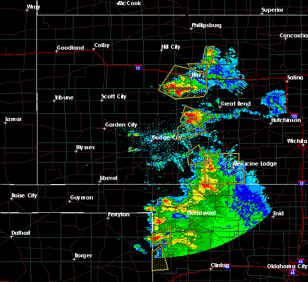 The severe thunderstorm warning for eastern kiowa and north central comanche counties will expire at 915 pm cdt, the severe thunderstorm which prompted the warning has moved out of the warned area. therefore, the warning will be allowed to expire. a severe thunderstorm watch remains in effect until 1100 pm cdt for south central kansas. The severe thunderstorm warning for eastern kiowa and north central comanche counties will expire at 915 pm cdt, the severe thunderstorm which prompted the warning has moved out of the warned area. therefore, the warning will be allowed to expire. a severe thunderstorm watch remains in effect until 1100 pm cdt for south central kansas.
|
| 5/13/2018 8:50 PM CDT |
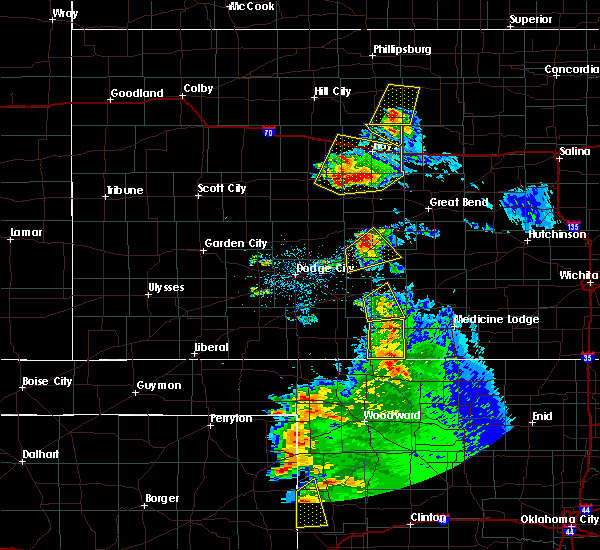 At 850 pm cdt, a severe thunderstorm was located 7 miles north of wilmore, moving east at 25 mph (radar indicated). Hazards include 70 mph wind gusts and quarter size hail. Hail damage to vehicles is expected. expect considerable tree damage. wind damage is also likely to mobile homes, roofs, and outbuildings. Locations impacted include, greensburg and belvidere. At 850 pm cdt, a severe thunderstorm was located 7 miles north of wilmore, moving east at 25 mph (radar indicated). Hazards include 70 mph wind gusts and quarter size hail. Hail damage to vehicles is expected. expect considerable tree damage. wind damage is also likely to mobile homes, roofs, and outbuildings. Locations impacted include, greensburg and belvidere.
|
| 5/13/2018 8:26 PM CDT |
 At 826 pm cdt, a severe thunderstorm was located 9 miles north of coldwater, moving east at 25 mph (radar indicated). Hazards include 70 mph wind gusts and quarter size hail. Hail damage to vehicles is expected. expect considerable tree damage. Wind damage is also likely to mobile homes, roofs, and outbuildings. At 826 pm cdt, a severe thunderstorm was located 9 miles north of coldwater, moving east at 25 mph (radar indicated). Hazards include 70 mph wind gusts and quarter size hail. Hail damage to vehicles is expected. expect considerable tree damage. Wind damage is also likely to mobile homes, roofs, and outbuildings.
|
| 5/13/2018 6:15 PM CDT | Quarter sized hail reported 3.9 miles W of Greensburg, KS, 1 inch reported from ict. |
| 5/13/2018 6:06 PM CDT |
 At 606 pm cdt, a severe thunderstorm was located 4 miles northeast of greensburg, moving north at 25 mph. this is a very dangerous storm (radar indicated). Hazards include three inch hail and 70 mph wind gusts. People and animals outdoors will be severely injured. expect shattered windows, extensive damage to roofs, siding, and vehicles. Locations impacted include, greensburg, haviland, fellsburg, hopewell, centerview, wellsford and trousdale. At 606 pm cdt, a severe thunderstorm was located 4 miles northeast of greensburg, moving north at 25 mph. this is a very dangerous storm (radar indicated). Hazards include three inch hail and 70 mph wind gusts. People and animals outdoors will be severely injured. expect shattered windows, extensive damage to roofs, siding, and vehicles. Locations impacted include, greensburg, haviland, fellsburg, hopewell, centerview, wellsford and trousdale.
|
| 5/13/2018 5:55 PM CDT | Tea Cup sized hail reported 3.8 miles NW of Greensburg, KS, 3.5 inch exact size reported by kake. |
| 5/13/2018 5:52 PM CDT |
 At 551 pm cdt, a severe thunderstorm was located 5 miles southeast of greensburg, moving north at 25 mph (radar indicated). Hazards include tennis ball size hail and 70 mph wind gusts. People and animals outdoors will be injured. expect hail damage to roofs, siding, windows, and vehicles. expect considerable tree damage. wind damage is also likely to mobile homes, roofs, and outbuildings. Locations impacted include, greensburg, haviland, fellsburg, hopewell, centerview, wellsford and trousdale. At 551 pm cdt, a severe thunderstorm was located 5 miles southeast of greensburg, moving north at 25 mph (radar indicated). Hazards include tennis ball size hail and 70 mph wind gusts. People and animals outdoors will be injured. expect hail damage to roofs, siding, windows, and vehicles. expect considerable tree damage. wind damage is also likely to mobile homes, roofs, and outbuildings. Locations impacted include, greensburg, haviland, fellsburg, hopewell, centerview, wellsford and trousdale.
|
| 5/13/2018 5:50 PM CDT |
 At 550 pm cdt, a severe thunderstorm was located 6 miles southeast of greensburg, moving north at 25 mph (radar indicated). Hazards include two inch hail and 70 mph wind gusts. People and animals outdoors will be injured. expect hail damage to roofs, siding, windows, and vehicles. expect considerable tree damage. Wind damage is also likely to mobile homes, roofs, and outbuildings. At 550 pm cdt, a severe thunderstorm was located 6 miles southeast of greensburg, moving north at 25 mph (radar indicated). Hazards include two inch hail and 70 mph wind gusts. People and animals outdoors will be injured. expect hail damage to roofs, siding, windows, and vehicles. expect considerable tree damage. Wind damage is also likely to mobile homes, roofs, and outbuildings.
|
| 5/2/2018 3:22 PM CDT | Quarter sized hail reported 1.1 miles ESE of Greensburg, KS, around 6 inches of hail on the ground. hail fog reducing visibility. |
| 5/2/2018 2:50 PM CDT | Quarter sized hail reported 0.4 miles S of Greensburg, KS |
| 5/2/2018 2:50 PM CDT |
 The severe thunderstorm warning for northwestern kiowa, south central pawnee and edwards counties will expire at 300 pm cdt, the storms which prompted the warning have moved out of the area. therefore the warning will be allowed to expire. a tornado watch remains in effect until 1000 pm cdt for south central kansas. The severe thunderstorm warning for northwestern kiowa, south central pawnee and edwards counties will expire at 300 pm cdt, the storms which prompted the warning have moved out of the area. therefore the warning will be allowed to expire. a tornado watch remains in effect until 1000 pm cdt for south central kansas.
|
| 5/2/2018 2:40 PM CDT | Storm damage reported in kiowa county KS, 2.3 miles W of Greensburg, KS |
| 5/2/2018 2:34 PM CDT |
 At 233 pm cdt, severe thunderstorms were located along a line extending from 7 miles north of kinsley to 3 miles northwest of fellsburg to 4 miles west of haviland, moving northeast at 45 mph (radar indicated). Hazards include 70 mph wind gusts and quarter size hail. Hail damage to vehicles is expected. expect considerable tree damage. wind damage is also likely to mobile homes, roofs, and outbuildings. locations impacted include, kinsley, greensburg, lewis, mullinville, offerle and centerview. A tornado watch remains in effect until 1000 pm cdt for south central kansas. At 233 pm cdt, severe thunderstorms were located along a line extending from 7 miles north of kinsley to 3 miles northwest of fellsburg to 4 miles west of haviland, moving northeast at 45 mph (radar indicated). Hazards include 70 mph wind gusts and quarter size hail. Hail damage to vehicles is expected. expect considerable tree damage. wind damage is also likely to mobile homes, roofs, and outbuildings. locations impacted include, kinsley, greensburg, lewis, mullinville, offerle and centerview. A tornado watch remains in effect until 1000 pm cdt for south central kansas.
|
| 5/2/2018 2:17 PM CDT |
 At 217 pm cdt, severe thunderstorms were located along a line extending from near offerle to 7 miles southwest of centerview to 8 miles southwest of greensburg, moving northeast at 50 mph (radar indicated). Hazards include 70 mph wind gusts and half dollar size hail. Hail damage to vehicles is expected. expect considerable tree damage. wind damage is also likely to mobile homes, roofs, and outbuildings. locations impacted include, kinsley, bucklin, greensburg, spearville, lewis, mullinville, offerle, bellefont, windhorst and centerview. A tornado watch remains in effect until 1000 pm cdt for south central and southwestern kansas. At 217 pm cdt, severe thunderstorms were located along a line extending from near offerle to 7 miles southwest of centerview to 8 miles southwest of greensburg, moving northeast at 50 mph (radar indicated). Hazards include 70 mph wind gusts and half dollar size hail. Hail damage to vehicles is expected. expect considerable tree damage. wind damage is also likely to mobile homes, roofs, and outbuildings. locations impacted include, kinsley, bucklin, greensburg, spearville, lewis, mullinville, offerle, bellefont, windhorst and centerview. A tornado watch remains in effect until 1000 pm cdt for south central and southwestern kansas.
|
| 8/10/2017 7:19 PM CDT | Quarter sized hail reported 5.1 miles N of Greensburg, KS |
| 8/10/2017 6:59 PM CDT |
 At 659 pm cdt, a severe thunderstorm was located 4 miles east of mullinville, or 5 miles west of greensburg, moving southeast at 20 mph (radar indicated). Hazards include 60 mph wind gusts and half dollar size hail. Hail damage to vehicles is expected. expect wind damage to roofs, siding, and trees. Locations impacted include, greensburg and the joy elevator. At 659 pm cdt, a severe thunderstorm was located 4 miles east of mullinville, or 5 miles west of greensburg, moving southeast at 20 mph (radar indicated). Hazards include 60 mph wind gusts and half dollar size hail. Hail damage to vehicles is expected. expect wind damage to roofs, siding, and trees. Locations impacted include, greensburg and the joy elevator.
|
| 8/10/2017 6:57 PM CDT |
 At 659 pm cdt, a severe thunderstorm was located 4 miles east of mullinville, or 5 miles west of greensburg, moving southeast at 20 mph (radar indicated). Hazards include 60 mph wind gusts and half dollar size hail. Hail damage to vehicles is expected. expect wind damage to roofs, siding, and trees. Locations impacted include, greensburg and the joy elevator. At 659 pm cdt, a severe thunderstorm was located 4 miles east of mullinville, or 5 miles west of greensburg, moving southeast at 20 mph (radar indicated). Hazards include 60 mph wind gusts and half dollar size hail. Hail damage to vehicles is expected. expect wind damage to roofs, siding, and trees. Locations impacted include, greensburg and the joy elevator.
|
| 8/10/2017 6:39 PM CDT |
 At 639 pm cdt, a severe thunderstorm was located 5 miles north of mullinville, or 10 miles northwest of greensburg, moving southeast at 25 mph (radar indicated). Hazards include two inch hail and 60 mph wind gusts. People and animals outdoors will be injured. expect hail damage to roofs, siding, windows, and vehicles. expect wind damage to roofs, siding, and trees. Locations impacted include, greensburg, mullinville and the joy elevator. At 639 pm cdt, a severe thunderstorm was located 5 miles north of mullinville, or 10 miles northwest of greensburg, moving southeast at 25 mph (radar indicated). Hazards include two inch hail and 60 mph wind gusts. People and animals outdoors will be injured. expect hail damage to roofs, siding, windows, and vehicles. expect wind damage to roofs, siding, and trees. Locations impacted include, greensburg, mullinville and the joy elevator.
|
| 8/10/2017 6:24 PM CDT |
 At 623 pm cdt, a severe thunderstorm was located 4 miles southeast of windhorst, or 15 miles southwest of kinsley, moving southeast at 20 mph (radar indicated). Hazards include two inch hail and 60 mph wind gusts. People and animals outdoors will be injured. expect hail damage to roofs, siding, windows, and vehicles. Expect wind damage to roofs, siding, and trees. At 623 pm cdt, a severe thunderstorm was located 4 miles southeast of windhorst, or 15 miles southwest of kinsley, moving southeast at 20 mph (radar indicated). Hazards include two inch hail and 60 mph wind gusts. People and animals outdoors will be injured. expect hail damage to roofs, siding, windows, and vehicles. Expect wind damage to roofs, siding, and trees.
|
| 6/22/2017 8:50 PM CDT |
 At 850 pm cdt, a severe thunderstorm was located 7 miles east of windhorst, or 11 miles southwest of kinsley, moving east at 30 mph (radar indicated). Hazards include 60 mph wind gusts and penny size hail. Expect damage to roofs, siding, and trees. Locations impacted include, kinsley, greensburg, bucklin, haviland, lewis, mullinville, offerle, belpre, wellsford, trousdale, belvidere, kingsdown, centerview, fellsburg, windhorst, the joy elevator and the brenham elevator. At 850 pm cdt, a severe thunderstorm was located 7 miles east of windhorst, or 11 miles southwest of kinsley, moving east at 30 mph (radar indicated). Hazards include 60 mph wind gusts and penny size hail. Expect damage to roofs, siding, and trees. Locations impacted include, kinsley, greensburg, bucklin, haviland, lewis, mullinville, offerle, belpre, wellsford, trousdale, belvidere, kingsdown, centerview, fellsburg, windhorst, the joy elevator and the brenham elevator.
|
| 6/22/2017 8:31 PM CDT |
 At 829 pm cdt, a severe thunderstorm was located 3 miles southwest of windhorst, or 17 miles east of dodge city, moving east at 20 mph (radar indicated). Hazards include 60 mph wind gusts and penny size hail. Expect damage to roofs, siding, and trees. Locations impacted include, dodge city, kinsley, greensburg, spearville, bucklin, haviland, lewis, mullinville, ford, offerle, fort dodge, wright, belpre, wellsford, trousdale, belvidere, bellefont, kingsdown, centerview and fellsburg. At 829 pm cdt, a severe thunderstorm was located 3 miles southwest of windhorst, or 17 miles east of dodge city, moving east at 20 mph (radar indicated). Hazards include 60 mph wind gusts and penny size hail. Expect damage to roofs, siding, and trees. Locations impacted include, dodge city, kinsley, greensburg, spearville, bucklin, haviland, lewis, mullinville, ford, offerle, fort dodge, wright, belpre, wellsford, trousdale, belvidere, bellefont, kingsdown, centerview and fellsburg.
|
| 6/22/2017 8:13 PM CDT |
 At 812 pm cdt, a severe thunderstorm was located 4 miles east of wright, or 11 miles east of dodge city, moving east at 30 mph (radar indicated). Hazards include 70 mph wind gusts and penny size hail. Expect considerable tree damage. Damage is likely to mobile homes, roofs, and outbuildings. At 812 pm cdt, a severe thunderstorm was located 4 miles east of wright, or 11 miles east of dodge city, moving east at 30 mph (radar indicated). Hazards include 70 mph wind gusts and penny size hail. Expect considerable tree damage. Damage is likely to mobile homes, roofs, and outbuildings.
|
| 6/17/2017 8:55 PM CDT | Ping Pong Ball sized hail reported 7.1 miles NNW of Greensburg, KS |
| 6/17/2017 8:43 PM CDT | Baseball sized hail reported 1.1 miles ESE of Greensburg, KS, golf ball to baseball size hail. |
| 6/17/2017 8:43 PM CDT |
 At 843 pm cdt, a severe thunderstorm was located very near greensburg, moving south at 20 mph. this is a very dangerous storm (radar indicated). Hazards include three inch hail and 70 mph wind gusts. People and animals outdoors will be severely injured. expect shattered windows, extensive damage to roofs, siding, and vehicles. Locations impacted include, greensburg, haviland, cullison, coats, wellsford, belvidere, croft, the joy elevator, texas lake wildlife area and the brenham elevator. At 843 pm cdt, a severe thunderstorm was located very near greensburg, moving south at 20 mph. this is a very dangerous storm (radar indicated). Hazards include three inch hail and 70 mph wind gusts. People and animals outdoors will be severely injured. expect shattered windows, extensive damage to roofs, siding, and vehicles. Locations impacted include, greensburg, haviland, cullison, coats, wellsford, belvidere, croft, the joy elevator, texas lake wildlife area and the brenham elevator.
|
| 6/17/2017 8:37 PM CDT | Baseball sized hail reported 1.7 miles ESE of Greensburg, KS |
| 6/17/2017 8:35 PM CDT | Storm damage reported in kiowa county KS, 1.7 miles ESE of Greensburg, KS |
| 6/17/2017 8:35 PM CDT | Golf Ball sized hail reported 1.1 miles ESE of Greensburg, KS |
| 6/17/2017 8:35 PM CDT |
 The severe thunderstorm warning for northern kiowa, southeastern edwards and northwestern pratt counties will expire at 845 pm cdt, the storm which prompted the warning has moved out of the area. therefore the warning will be allowed to expire. however small hail, gusty winds and heavy rain are still possible with this thunderstorm. a severe thunderstorm watch remains in effect until 200 am cdt for south central kansas. The severe thunderstorm warning for northern kiowa, southeastern edwards and northwestern pratt counties will expire at 845 pm cdt, the storm which prompted the warning has moved out of the area. therefore the warning will be allowed to expire. however small hail, gusty winds and heavy rain are still possible with this thunderstorm. a severe thunderstorm watch remains in effect until 200 am cdt for south central kansas.
|
| 6/17/2017 8:33 PM CDT |
 At 833 pm cdt, a severe thunderstorm was located near greensburg, moving south at 15 mph. this is a very dangerous storm (radar indicated). Hazards include baseball size hail and 70 mph wind gusts. People and animals outdoors will be severely injured. expect shattered windows, extensive damage to roofs, siding, and vehicles. Locations impacted include, greensburg, haviland, cullison, coats, wellsford, belvidere, croft, the joy elevator, texas lake wildlife area and the brenham elevator. At 833 pm cdt, a severe thunderstorm was located near greensburg, moving south at 15 mph. this is a very dangerous storm (radar indicated). Hazards include baseball size hail and 70 mph wind gusts. People and animals outdoors will be severely injured. expect shattered windows, extensive damage to roofs, siding, and vehicles. Locations impacted include, greensburg, haviland, cullison, coats, wellsford, belvidere, croft, the joy elevator, texas lake wildlife area and the brenham elevator.
|
| 6/17/2017 8:29 PM CDT |
 At 829 pm cdt, a severe thunderstorm was located 3 miles north of greensburg, moving south at 15 mph (radar indicated). Hazards include golf ball size hail and 70 mph wind gusts. People and animals outdoors will be injured. expect hail damage to roofs, siding, windows, and vehicles. expect considerable tree damage. Wind damage is also likely to mobile homes, roofs, and outbuildings. At 829 pm cdt, a severe thunderstorm was located 3 miles north of greensburg, moving south at 15 mph (radar indicated). Hazards include golf ball size hail and 70 mph wind gusts. People and animals outdoors will be injured. expect hail damage to roofs, siding, windows, and vehicles. expect considerable tree damage. Wind damage is also likely to mobile homes, roofs, and outbuildings.
|
| 6/17/2017 8:11 PM CDT |
 At 810 pm cdt, a severe thunderstorm was located 6 miles south of fellsburg, or 9 miles northeast of greensburg, moving south at 15 mph (radar indicated). Hazards include golf ball size hail and 70 mph wind gusts. People and animals outdoors will be injured. expect hail damage to roofs, siding, windows, and vehicles. expect considerable tree damage. wind damage is also likely to mobile homes, roofs, and outbuildings. Locations impacted include, greensburg, haviland, mullinville, cullison, wellsford, trousdale, hopewell, centerview, fellsburg, the joy elevator, texas lake wildlife area and the brenham elevator. At 810 pm cdt, a severe thunderstorm was located 6 miles south of fellsburg, or 9 miles northeast of greensburg, moving south at 15 mph (radar indicated). Hazards include golf ball size hail and 70 mph wind gusts. People and animals outdoors will be injured. expect hail damage to roofs, siding, windows, and vehicles. expect considerable tree damage. wind damage is also likely to mobile homes, roofs, and outbuildings. Locations impacted include, greensburg, haviland, mullinville, cullison, wellsford, trousdale, hopewell, centerview, fellsburg, the joy elevator, texas lake wildlife area and the brenham elevator.
|
| 6/17/2017 7:52 PM CDT |
 At 751 pm cdt, a severe thunderstorm was located very near fellsburg, or 13 miles north of greensburg, moving south at 15 mph (radar indicated). Hazards include ping pong ball size hail and 60 mph wind gusts. People and animals outdoors will be injured. expect hail damage to roofs, siding, windows, and vehicles. Expect wind damage to roofs, siding, and trees. At 751 pm cdt, a severe thunderstorm was located very near fellsburg, or 13 miles north of greensburg, moving south at 15 mph (radar indicated). Hazards include ping pong ball size hail and 60 mph wind gusts. People and animals outdoors will be injured. expect hail damage to roofs, siding, windows, and vehicles. Expect wind damage to roofs, siding, and trees.
|
| 5/18/2017 5:09 PM CDT |
 At 509 pm cdt, a severe thunderstorm capable of producing a tornado was located 4 miles east of mullinville, or 6 miles west of greensburg, moving northeast at 35 mph (radar indicated rotation). Hazards include tornado and tennis ball size hail. Flying debris will be dangerous to those caught without shelter. mobile homes will be damaged or destroyed. damage to roofs, windows, and vehicles will occur. tree damage is likely. this dangerous storm will be near, greensburg around 515 pm cdt. Other locations impacted by this tornadic thunderstorm include the joy elevator. At 509 pm cdt, a severe thunderstorm capable of producing a tornado was located 4 miles east of mullinville, or 6 miles west of greensburg, moving northeast at 35 mph (radar indicated rotation). Hazards include tornado and tennis ball size hail. Flying debris will be dangerous to those caught without shelter. mobile homes will be damaged or destroyed. damage to roofs, windows, and vehicles will occur. tree damage is likely. this dangerous storm will be near, greensburg around 515 pm cdt. Other locations impacted by this tornadic thunderstorm include the joy elevator.
|
| 5/18/2017 4:53 PM CDT |
 At 452 pm cdt, a severe thunderstorm capable of producing a tornado was located 7 miles southeast of mullinville, or 10 miles southwest of greensburg, moving northeast at 45 mph (radar indicated rotation). Hazards include tornado and tennis ball size hail. Flying debris will be dangerous to those caught without shelter. mobile homes will be damaged or destroyed. damage to roofs, windows, and vehicles will occur. tree damage is likely. this dangerous storm will be near, greensburg around 505 pm cdt. haviland around 515 pm cdt. Other locations impacted by this tornadic thunderstorm include the joy elevator and the brenham elevator. At 452 pm cdt, a severe thunderstorm capable of producing a tornado was located 7 miles southeast of mullinville, or 10 miles southwest of greensburg, moving northeast at 45 mph (radar indicated rotation). Hazards include tornado and tennis ball size hail. Flying debris will be dangerous to those caught without shelter. mobile homes will be damaged or destroyed. damage to roofs, windows, and vehicles will occur. tree damage is likely. this dangerous storm will be near, greensburg around 505 pm cdt. haviland around 515 pm cdt. Other locations impacted by this tornadic thunderstorm include the joy elevator and the brenham elevator.
|
| 5/18/2017 4:37 PM CDT |
 At 436 pm cdt, a severe thunderstorm was located 8 miles south of mullinville, or 12 miles southwest of greensburg, moving north at 40 mph (radar indicated). Hazards include golf ball size hail and 60 mph wind gusts. People and animals outdoors will be injured. expect hail damage to roofs, siding, windows, and vehicles. expect wind damage to roofs, siding, and trees. locations impacted include, greensburg, mullinville, the joy elevator and the brenham elevator. A tornado watch remains in effect until 1100 pm cdt for south central kansas. At 436 pm cdt, a severe thunderstorm was located 8 miles south of mullinville, or 12 miles southwest of greensburg, moving north at 40 mph (radar indicated). Hazards include golf ball size hail and 60 mph wind gusts. People and animals outdoors will be injured. expect hail damage to roofs, siding, windows, and vehicles. expect wind damage to roofs, siding, and trees. locations impacted include, greensburg, mullinville, the joy elevator and the brenham elevator. A tornado watch remains in effect until 1100 pm cdt for south central kansas.
|
| 5/18/2017 4:13 PM CDT |
 At 413 pm cdt, a severe thunderstorm was located near protection, moving north at 45 mph (radar indicated). Hazards include ping pong ball size hail and 60 mph wind gusts. People and animals outdoors will be injured. expect hail damage to roofs, siding, windows, and vehicles. Expect wind damage to roofs, siding, and trees. At 413 pm cdt, a severe thunderstorm was located near protection, moving north at 45 mph (radar indicated). Hazards include ping pong ball size hail and 60 mph wind gusts. People and animals outdoors will be injured. expect hail damage to roofs, siding, windows, and vehicles. Expect wind damage to roofs, siding, and trees.
|
| 5/16/2017 10:50 PM CDT |
 At 1049 pm cdt, severe thunderstorms were located along a line extending from 2 miles south of rozel to 2 miles west of haviland, moving northeast at 55 mph (radar indicated). Hazards include 70 mph wind gusts and half dollar size hail. Hail damage to vehicles is expected. expect considerable tree damage. Wind damage is also likely to mobile homes, roofs, and outbuildings. At 1049 pm cdt, severe thunderstorms were located along a line extending from 2 miles south of rozel to 2 miles west of haviland, moving northeast at 55 mph (radar indicated). Hazards include 70 mph wind gusts and half dollar size hail. Hail damage to vehicles is expected. expect considerable tree damage. Wind damage is also likely to mobile homes, roofs, and outbuildings.
|
| 5/16/2017 10:43 PM CDT |
 At 1042 pm cdt, severe thunderstorms were located along a line extending from 6 miles northwest of kinsley to 4 miles south of greensburg, moving northeast at 50 mph (radar indicated). Hazards include ping pong ball size hail and 70 mph wind gusts. People and animals outdoors will be injured. expect hail damage to roofs, siding, windows, and vehicles. expect wind damage to roofs, siding, and trees. Locations impacted include, kinsley, greensburg, haviland, centerview, fellsburg and the brenham elevator. At 1042 pm cdt, severe thunderstorms were located along a line extending from 6 miles northwest of kinsley to 4 miles south of greensburg, moving northeast at 50 mph (radar indicated). Hazards include ping pong ball size hail and 70 mph wind gusts. People and animals outdoors will be injured. expect hail damage to roofs, siding, windows, and vehicles. expect wind damage to roofs, siding, and trees. Locations impacted include, kinsley, greensburg, haviland, centerview, fellsburg and the brenham elevator.
|
| 5/16/2017 10:33 PM CDT |
 At 1032 pm cdt, severe thunderstorms were located along a line extending from offerle to 6 miles southeast of mullinville, moving northeast at 45 mph (radar indicated). Hazards include ping pong ball size hail and 60 mph wind gusts. People and animals outdoors will be injured. expect hail damage to roofs, siding, windows, and vehicles. expect wind damage to roofs, siding, and trees. Locations impacted include, kinsley, greensburg, haviland, mullinville, offerle, bellefont, centerview, fellsburg, the joy elevator and the brenham elevator. At 1032 pm cdt, severe thunderstorms were located along a line extending from offerle to 6 miles southeast of mullinville, moving northeast at 45 mph (radar indicated). Hazards include ping pong ball size hail and 60 mph wind gusts. People and animals outdoors will be injured. expect hail damage to roofs, siding, windows, and vehicles. expect wind damage to roofs, siding, and trees. Locations impacted include, kinsley, greensburg, haviland, mullinville, offerle, bellefont, centerview, fellsburg, the joy elevator and the brenham elevator.
|
| 5/16/2017 10:20 PM CDT |
 At 1020 pm cdt, severe thunderstorms were located along a line extending from 3 miles west of windhorst to 9 miles south of mullinville, moving northeast at 45 mph (radar indicated). Hazards include ping pong ball size hail and 60 mph wind gusts. People and animals outdoors will be injured. expect hail damage to roofs, siding, windows, and vehicles. Expect wind damage to roofs, siding, and trees. At 1020 pm cdt, severe thunderstorms were located along a line extending from 3 miles west of windhorst to 9 miles south of mullinville, moving northeast at 45 mph (radar indicated). Hazards include ping pong ball size hail and 60 mph wind gusts. People and animals outdoors will be injured. expect hail damage to roofs, siding, windows, and vehicles. Expect wind damage to roofs, siding, and trees.
|
| 9/9/2016 6:07 PM CDT |
 At 606 pm cdt, a severe thunderstorm was located 9 miles northwest of wilmore, or 9 miles north of coldwater, moving southeast at 25 mph (radar indicated). Hazards include 70 mph wind gusts and quarter size hail. Hail damage to vehicles is expected. expect considerable tree damage. wind damage is also likely to mobile homes, roofs, and outbuildings. Locations impacted include, greensburg, mullinville and the joy elevator. At 606 pm cdt, a severe thunderstorm was located 9 miles northwest of wilmore, or 9 miles north of coldwater, moving southeast at 25 mph (radar indicated). Hazards include 70 mph wind gusts and quarter size hail. Hail damage to vehicles is expected. expect considerable tree damage. wind damage is also likely to mobile homes, roofs, and outbuildings. Locations impacted include, greensburg, mullinville and the joy elevator.
|
| 9/9/2016 5:56 PM CDT |
 At 556 pm cdt, a severe thunderstorm was located 10 miles southeast of mullinville, or 11 miles southwest of greensburg, moving southeast at 25 mph (radar indicated). Hazards include ping pong ball size hail and 60 mph wind gusts. People and animals outdoors will be injured. expect hail damage to roofs, siding, windows, and vehicles. expect wind damage to roofs, siding, and trees. Locations impacted include, greensburg, mullinville and the joy elevator. At 556 pm cdt, a severe thunderstorm was located 10 miles southeast of mullinville, or 11 miles southwest of greensburg, moving southeast at 25 mph (radar indicated). Hazards include ping pong ball size hail and 60 mph wind gusts. People and animals outdoors will be injured. expect hail damage to roofs, siding, windows, and vehicles. expect wind damage to roofs, siding, and trees. Locations impacted include, greensburg, mullinville and the joy elevator.
|
| 9/9/2016 5:43 PM CDT |
 At 543 pm cdt, a severe thunderstorm was located 5 miles southeast of mullinville, or 8 miles southwest of greensburg, moving southeast at 25 mph (radar indicated). Hazards include golf ball size hail and 60 mph wind gusts. People and animals outdoors will be injured. expect hail damage to roofs, siding, windows, and vehicles. expect wind damage to roofs, siding, and trees. Locations impacted include, greensburg, mullinville and the joy elevator. At 543 pm cdt, a severe thunderstorm was located 5 miles southeast of mullinville, or 8 miles southwest of greensburg, moving southeast at 25 mph (radar indicated). Hazards include golf ball size hail and 60 mph wind gusts. People and animals outdoors will be injured. expect hail damage to roofs, siding, windows, and vehicles. expect wind damage to roofs, siding, and trees. Locations impacted include, greensburg, mullinville and the joy elevator.
|
| 9/9/2016 5:37 PM CDT |
 At 537 pm cdt, a severe thunderstorm was located 3 miles southeast of mullinville, or 8 miles southwest of greensburg, moving southeast at 25 mph (radar indicated). Hazards include 60 mph wind gusts and up to half dollar size hail. Hail damage to vehicles is expected. Expect wind damage to roofs, siding, and trees. At 537 pm cdt, a severe thunderstorm was located 3 miles southeast of mullinville, or 8 miles southwest of greensburg, moving southeast at 25 mph (radar indicated). Hazards include 60 mph wind gusts and up to half dollar size hail. Hail damage to vehicles is expected. Expect wind damage to roofs, siding, and trees.
|
| 5/26/2016 9:12 PM CDT |
 At 912 pm cdt, a severe thunderstorm was located near greensburg, moving northeast at 20 mph (radar indicated). Hazards include two inch hail and 70 mph wind gusts. People and animals outdoors will be injured. expect hail damage to roofs, siding, windows and vehicles. expect considerable tree damage. wind damage is also likely to mobile homes, roofs and outbuildings. locations impacted include, greensburg and centerview. A tornado watch remains in effect until 1000 pm cdt for south central kansas. At 912 pm cdt, a severe thunderstorm was located near greensburg, moving northeast at 20 mph (radar indicated). Hazards include two inch hail and 70 mph wind gusts. People and animals outdoors will be injured. expect hail damage to roofs, siding, windows and vehicles. expect considerable tree damage. wind damage is also likely to mobile homes, roofs and outbuildings. locations impacted include, greensburg and centerview. A tornado watch remains in effect until 1000 pm cdt for south central kansas.
|
| 5/26/2016 9:07 PM CDT |
 At 906 pm cdt, a severe thunderstorm was located near greensburg, moving northeast at 20 mph (radar indicated). Hazards include two inch hail and 70 mph wind gusts. People and animals outdoors will be injured. expect hail damage to roofs, siding, windows and vehicles. expect considerable tree damage. wind damage is also likely to mobile homes, roofs and outbuildings. locations impacted include, greensburg, lewis and centerview. A tornado watch remains in effect until 1000 pm cdt for south central kansas. At 906 pm cdt, a severe thunderstorm was located near greensburg, moving northeast at 20 mph (radar indicated). Hazards include two inch hail and 70 mph wind gusts. People and animals outdoors will be injured. expect hail damage to roofs, siding, windows and vehicles. expect considerable tree damage. wind damage is also likely to mobile homes, roofs and outbuildings. locations impacted include, greensburg, lewis and centerview. A tornado watch remains in effect until 1000 pm cdt for south central kansas.
|
| 5/26/2016 8:59 PM CDT |
 At 859 pm cdt, a severe thunderstorm was located 5 miles east of mullinville, moving northeast at 30 mph (radar indicated). Hazards include ping pong ball size hail and 60 mph wind gusts. People and animals outdoors will be injured. expect hail damage to roofs, siding, windows and vehicles. expect wind damage to roofs, siding and trees. locations impacted include, greensburg, lewis, mullinville and centerview. A tornado watch remains in effect until 1000 pm cdt for south central kansas. At 859 pm cdt, a severe thunderstorm was located 5 miles east of mullinville, moving northeast at 30 mph (radar indicated). Hazards include ping pong ball size hail and 60 mph wind gusts. People and animals outdoors will be injured. expect hail damage to roofs, siding, windows and vehicles. expect wind damage to roofs, siding and trees. locations impacted include, greensburg, lewis, mullinville and centerview. A tornado watch remains in effect until 1000 pm cdt for south central kansas.
|
| 5/26/2016 8:51 PM CDT |
 At 851 pm cdt, a severe thunderstorm was located 7 miles northwest of greensburg, moving northeast at 20 mph (radar indicated). Hazards include 60 mph wind gusts and half dollar size hail. Hail damage to vehicles is expected. Expect wind damage to roofs, siding and trees. At 851 pm cdt, a severe thunderstorm was located 7 miles northwest of greensburg, moving northeast at 20 mph (radar indicated). Hazards include 60 mph wind gusts and half dollar size hail. Hail damage to vehicles is expected. Expect wind damage to roofs, siding and trees.
|
| 5/26/2016 8:26 PM CDT |
 At 825 pm cdt, a severe thunderstorm was located 4 miles southeast of centerview, moving northeast at 35 mph. this is a very dangerous storm (radar indicated). Hazards include baseball size hail and 70 mph wind gusts. People and animals outdoors will be severely injured. Expect shattered windows, extensive damage to roofs, siding and vehicles. At 825 pm cdt, a severe thunderstorm was located 4 miles southeast of centerview, moving northeast at 35 mph. this is a very dangerous storm (radar indicated). Hazards include baseball size hail and 70 mph wind gusts. People and animals outdoors will be severely injured. Expect shattered windows, extensive damage to roofs, siding and vehicles.
|
| 5/26/2016 8:11 PM CDT |
 At 811 pm cdt, a severe thunderstorm was located near greensburg, moving east at 40 mph. this is a very dangerous storm (radar indicated). Hazards include baseball size hail and 70 mph wind gusts. People and animals outdoors will be severely injured. expect shattered windows, extensive damage to roofs, siding and vehicles. locations impacted include, greensburg, haviland, mullinville, wellsford, trousdale and fellsburg. A tornado watch remains in effect until 1000 pm cdt for south central kansas. At 811 pm cdt, a severe thunderstorm was located near greensburg, moving east at 40 mph. this is a very dangerous storm (radar indicated). Hazards include baseball size hail and 70 mph wind gusts. People and animals outdoors will be severely injured. expect shattered windows, extensive damage to roofs, siding and vehicles. locations impacted include, greensburg, haviland, mullinville, wellsford, trousdale and fellsburg. A tornado watch remains in effect until 1000 pm cdt for south central kansas.
|
| 5/26/2016 7:58 PM CDT |
 At 758 pm cdt, a severe thunderstorm was located 4 miles east of mullinville, moving northeast at 40 mph (radar indicated). Hazards include tennis ball size hail and 70 mph wind gusts. People and animals outdoors will be injured. expect hail damage to roofs, siding, windows and vehicles. expect considerable tree damage. wind damage is also likely to mobile homes, roofs and outbuildings. locations impacted include, greensburg, haviland, mullinville, wellsford, trousdale and fellsburg. A tornado watch remains in effect until 1000 pm cdt for south central kansas. At 758 pm cdt, a severe thunderstorm was located 4 miles east of mullinville, moving northeast at 40 mph (radar indicated). Hazards include tennis ball size hail and 70 mph wind gusts. People and animals outdoors will be injured. expect hail damage to roofs, siding, windows and vehicles. expect considerable tree damage. wind damage is also likely to mobile homes, roofs and outbuildings. locations impacted include, greensburg, haviland, mullinville, wellsford, trousdale and fellsburg. A tornado watch remains in effect until 1000 pm cdt for south central kansas.
|
| 5/26/2016 7:50 PM CDT |
 At 748 pm cdt, a severe thunderstorm was located 6 miles south of mullinville, moving east at 20 mph (radar indicated). Hazards include tennis ball size hail and 70 mph wind gusts. People and animals outdoors will be injured. expect hail damage to roofs, siding, windows and vehicles. expect considerable tree damage. wind damage is also likely to mobile homes, roofs and outbuildings. locations impacted include, greensburg, haviland, mullinville, wellsford, trousdale and fellsburg. A tornado watch remains in effect until 1000 pm cdt for south central kansas. At 748 pm cdt, a severe thunderstorm was located 6 miles south of mullinville, moving east at 20 mph (radar indicated). Hazards include tennis ball size hail and 70 mph wind gusts. People and animals outdoors will be injured. expect hail damage to roofs, siding, windows and vehicles. expect considerable tree damage. wind damage is also likely to mobile homes, roofs and outbuildings. locations impacted include, greensburg, haviland, mullinville, wellsford, trousdale and fellsburg. A tornado watch remains in effect until 1000 pm cdt for south central kansas.
|
| 5/26/2016 7:43 PM CDT |
 At 743 pm cdt, a severe thunderstorm was located 4 miles south of mullinville, moving northeast at 25 mph (radar indicated). Hazards include tennis ball size hail and 70 mph wind gusts. People and animals outdoors will be injured. expect hail damage to roofs, siding, windows and vehicles. expect considerable tree damage. Wind damage is also likely to mobile homes, roofs and outbuildings. At 743 pm cdt, a severe thunderstorm was located 4 miles south of mullinville, moving northeast at 25 mph (radar indicated). Hazards include tennis ball size hail and 70 mph wind gusts. People and animals outdoors will be injured. expect hail damage to roofs, siding, windows and vehicles. expect considerable tree damage. Wind damage is also likely to mobile homes, roofs and outbuildings.
|
| 5/26/2016 3:00 PM CDT |
 At 259 pm cdt, severe thunderstorms were located along a line extending from 2 miles southeast of centerview to 8 miles northwest of coldwater, moving northeast at 40 mph (radar indicated). Hazards include two inch hail. People and animals outdoors will be injured. expect damage to roofs, siding, windows and vehicles. locations impacted include, coldwater, greensburg, mullinville, lake coldwater and centerview. A tornado watch remains in effect until 1000 pm cdt for southwestern kansas. At 259 pm cdt, severe thunderstorms were located along a line extending from 2 miles southeast of centerview to 8 miles northwest of coldwater, moving northeast at 40 mph (radar indicated). Hazards include two inch hail. People and animals outdoors will be injured. expect damage to roofs, siding, windows and vehicles. locations impacted include, coldwater, greensburg, mullinville, lake coldwater and centerview. A tornado watch remains in effect until 1000 pm cdt for southwestern kansas.
|
| 5/26/2016 2:43 PM CDT |
 At 242 pm cdt, several severe thunderstorms were located along a line extending from 2 miles southwest of centerview to 10 miles northwest of coldwater, moving northeast at 40 mph (radar indicated). Hazards include two inch hail. People and animals outdoors will be injured. Expect damage to roofs, siding, windows and vehicles. At 242 pm cdt, several severe thunderstorms were located along a line extending from 2 miles southwest of centerview to 10 miles northwest of coldwater, moving northeast at 40 mph (radar indicated). Hazards include two inch hail. People and animals outdoors will be injured. Expect damage to roofs, siding, windows and vehicles.
|
| 5/26/2016 2:19 PM CDT |
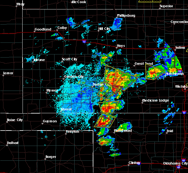 At 219 pm cdt, a severe thunderstorm capable of producing a tornado was located 6 miles north of greensburg, moving northeast at 45 mph (radar indicated rotation). Hazards include tornado and tennis ball size hail. Flying debris will be dangerous to those caught without shelter. mobile homes will be damaged or destroyed. damage to roofs, windows and vehicles will occur. tree damage is likely. Locations impacted include, greensburg. At 219 pm cdt, a severe thunderstorm capable of producing a tornado was located 6 miles north of greensburg, moving northeast at 45 mph (radar indicated rotation). Hazards include tornado and tennis ball size hail. Flying debris will be dangerous to those caught without shelter. mobile homes will be damaged or destroyed. damage to roofs, windows and vehicles will occur. tree damage is likely. Locations impacted include, greensburg.
|
| 5/26/2016 2:11 PM CDT |
 At 210 pm cdt, a severe thunderstorm capable of producing a tornado was located 5 miles west of greensburg, moving northeast at 45 mph (radar indicated rotation). Hazards include tornado and tennis ball size hail. Flying debris will be dangerous to those caught without shelter. mobile homes will be damaged or destroyed. damage to roofs, windows and vehicles will occur. tree damage is likely. This tornadic thunderstorm will remain over mainly rural areas of south central edwards and northwestern kiowa counties. At 210 pm cdt, a severe thunderstorm capable of producing a tornado was located 5 miles west of greensburg, moving northeast at 45 mph (radar indicated rotation). Hazards include tornado and tennis ball size hail. Flying debris will be dangerous to those caught without shelter. mobile homes will be damaged or destroyed. damage to roofs, windows and vehicles will occur. tree damage is likely. This tornadic thunderstorm will remain over mainly rural areas of south central edwards and northwestern kiowa counties.
|
| 5/26/2016 1:50 PM CDT |
 At 150 pm cdt, a severe thunderstorm capable of producing a tornado was located 4 miles southeast of greensburg, moving north at 40 mph (radar indicated rotation). Hazards include tornado and baseball size hail. Flying debris will be dangerous to those caught without shelter. mobile homes will be damaged or destroyed. damage to roofs, windows and vehicles will occur. tree damage is likely. This tornadic thunderstorm will remain over mainly rural areas of central kiowa county. At 150 pm cdt, a severe thunderstorm capable of producing a tornado was located 4 miles southeast of greensburg, moving north at 40 mph (radar indicated rotation). Hazards include tornado and baseball size hail. Flying debris will be dangerous to those caught without shelter. mobile homes will be damaged or destroyed. damage to roofs, windows and vehicles will occur. tree damage is likely. This tornadic thunderstorm will remain over mainly rural areas of central kiowa county.
|
| 5/26/2016 1:44 PM CDT |
 At 144 pm cdt, a severe thunderstorm capable of producing a tornado was located 6 miles south of greensburg, moving north at 40 mph (radar indicated rotation). Hazards include tornado and tennis ball size hail. Flying debris will be dangerous to those caught without shelter. mobile homes will be damaged or destroyed. damage to roofs, windows and vehicles will occur. tree damage is likely. This dangerous storm will be near, greensburg around 150 pm cdt. At 144 pm cdt, a severe thunderstorm capable of producing a tornado was located 6 miles south of greensburg, moving north at 40 mph (radar indicated rotation). Hazards include tornado and tennis ball size hail. Flying debris will be dangerous to those caught without shelter. mobile homes will be damaged or destroyed. damage to roofs, windows and vehicles will occur. tree damage is likely. This dangerous storm will be near, greensburg around 150 pm cdt.
|
| 5/26/2016 1:36 PM CDT |
 At 136 pm cdt, a severe thunderstorm capable of producing a tornado was located 8 miles northwest of wilmore, moving north at 40 mph (radar indicated rotation). Hazards include tornado and tennis ball size hail. Flying debris will be dangerous to those caught without shelter. mobile homes will be damaged or destroyed. damage to roofs, windows and vehicles will occur. tree damage is likely. This dangerous storm will be near, greensburg around 150 pm cdt. At 136 pm cdt, a severe thunderstorm capable of producing a tornado was located 8 miles northwest of wilmore, moving north at 40 mph (radar indicated rotation). Hazards include tornado and tennis ball size hail. Flying debris will be dangerous to those caught without shelter. mobile homes will be damaged or destroyed. damage to roofs, windows and vehicles will occur. tree damage is likely. This dangerous storm will be near, greensburg around 150 pm cdt.
|
| 5/26/2016 1:33 PM CDT |
 At 133 pm cdt, a severe thunderstorm was located 4 miles west of haviland, moving northeast at 45 mph (radar indicated). Hazards include tennis ball size hail and 70 mph wind gusts. People and animals outdoors will be injured. expect hail damage to roofs, siding, windows and vehicles. expect considerable tree damage. wind damage is also likely to mobile homes, roofs and outbuildings. locations impacted include, pratt, greensburg, haviland, cullison, croft, wellsford and belvidere. A tornado watch remains in effect until 1000 pm cdt for south central kansas. At 133 pm cdt, a severe thunderstorm was located 4 miles west of haviland, moving northeast at 45 mph (radar indicated). Hazards include tennis ball size hail and 70 mph wind gusts. People and animals outdoors will be injured. expect hail damage to roofs, siding, windows and vehicles. expect considerable tree damage. wind damage is also likely to mobile homes, roofs and outbuildings. locations impacted include, pratt, greensburg, haviland, cullison, croft, wellsford and belvidere. A tornado watch remains in effect until 1000 pm cdt for south central kansas.
|
| 5/26/2016 1:26 PM CDT |
 At 126 pm cdt, a severe thunderstorm was located 6 miles southeast of greensburg, moving northeast at 45 mph (radar indicated). Hazards include two inch hail and 60 mph wind gusts. People and animals outdoors will be injured. expect hail damage to roofs, siding, windows and vehicles. expect wind damage to roofs, siding and trees. Locations impacted include, pratt, greensburg, haviland, cullison, wilmore, croft, wellsford and belvidere. At 126 pm cdt, a severe thunderstorm was located 6 miles southeast of greensburg, moving northeast at 45 mph (radar indicated). Hazards include two inch hail and 60 mph wind gusts. People and animals outdoors will be injured. expect hail damage to roofs, siding, windows and vehicles. expect wind damage to roofs, siding and trees. Locations impacted include, pratt, greensburg, haviland, cullison, wilmore, croft, wellsford and belvidere.
|
| 5/26/2016 1:20 PM CDT |
 At 120 pm cdt, a severe thunderstorm was located 8 miles north of wilmore, moving northeast at 45 mph (radar indicated). Hazards include two inch hail and 60 mph wind gusts. People and animals outdoors will be injured. expect hail damage to roofs, siding, windows and vehicles. Expect wind damage to roofs, siding and trees. At 120 pm cdt, a severe thunderstorm was located 8 miles north of wilmore, moving northeast at 45 mph (radar indicated). Hazards include two inch hail and 60 mph wind gusts. People and animals outdoors will be injured. expect hail damage to roofs, siding, windows and vehicles. Expect wind damage to roofs, siding and trees.
|
| 5/8/2016 5:30 PM CDT |
 At 529 pm cdt, a severe thunderstorm was located 5 miles southeast of coldwater, moving northeast at 40 mph (radar indicated). Hazards include 60 mph wind gusts and quarter size hail. Hail damage to vehicles is expected. Expect wind damage to roofs, siding and trees. At 529 pm cdt, a severe thunderstorm was located 5 miles southeast of coldwater, moving northeast at 40 mph (radar indicated). Hazards include 60 mph wind gusts and quarter size hail. Hail damage to vehicles is expected. Expect wind damage to roofs, siding and trees.
|
| 11/16/2015 11:57 PM CST | The severe thunderstorm warning for southwestern pratt, northwestern barber and northeastern kiowa counties will expire at 1200 am cst, the storm which prompted the warning has weakened below severe limits. therefore the warning will be allowed to expire. however small hail and gusty winds are still possible with this thunderstorm. a tornado watch remains in effect until 300 am cst for south central kansas. |
| 11/16/2015 11:42 PM CST |
 At 1140 pm cst, a severe thunderstorm was located very near croft, moving northeast at 45 mph (radar indicated). Hazards include 60 mph wind gusts and quarter size hail. Hail damage to vehicles is expected. expect wind damage to roofs, siding and trees. locations impacted include, greensburg, haviland, cullison, sun city, croft and wellsford. A tornado watch remains in effect until 300 am cst for south central kansas. At 1140 pm cst, a severe thunderstorm was located very near croft, moving northeast at 45 mph (radar indicated). Hazards include 60 mph wind gusts and quarter size hail. Hail damage to vehicles is expected. expect wind damage to roofs, siding and trees. locations impacted include, greensburg, haviland, cullison, sun city, croft and wellsford. A tornado watch remains in effect until 300 am cst for south central kansas.
|
| 11/16/2015 11:19 PM CST |
 At 1117 pm cst, a severe thunderstorm was located very near wilmore, moving northeast at 45 mph (radar indicated). Hazards include 70 mph wind gusts and quarter size hail. Hail damage to vehicles is expected. expect considerable tree damage. Wind damage is also likely to mobile homes, roofs and outbuildings. At 1117 pm cst, a severe thunderstorm was located very near wilmore, moving northeast at 45 mph (radar indicated). Hazards include 70 mph wind gusts and quarter size hail. Hail damage to vehicles is expected. expect considerable tree damage. Wind damage is also likely to mobile homes, roofs and outbuildings.
|
| 9/10/2015 9:15 PM CDT |
 At 914 pm cdt, a severe thunderstorm was located very near spearville, moving southeast at 20 mph (radar indicated). Hazards include 60 mph wind gusts and quarter size hail. Hail damage to vehicles is expected. Expect wind damage to roofs, siding and trees. At 914 pm cdt, a severe thunderstorm was located very near spearville, moving southeast at 20 mph (radar indicated). Hazards include 60 mph wind gusts and quarter size hail. Hail damage to vehicles is expected. Expect wind damage to roofs, siding and trees.
|
| 6/11/2015 10:26 PM CDT | Quarter sized hail reported 0.4 miles S of Greensburg, KS |
| 6/11/2015 10:22 PM CDT |
 At 1022 pm cdt, a severe thunderstorm was located 3 miles northeast of greensburg, moving northeast at 25 mph (radar indicated). Hazards include quarter size hail. damage to vehicles is expected At 1022 pm cdt, a severe thunderstorm was located 3 miles northeast of greensburg, moving northeast at 25 mph (radar indicated). Hazards include quarter size hail. damage to vehicles is expected
|
| 6/11/2015 9:21 PM CDT |
 At 921 pm cdt, a severe thunderstorm was located 3 miles northwest of haviland, moving northeast at 25 mph (radar indicated). Hazards include ping pong ball size hail. People and animals outdoors will be injured. Expect damage to roofs, siding, windows and vehicles. At 921 pm cdt, a severe thunderstorm was located 3 miles northwest of haviland, moving northeast at 25 mph (radar indicated). Hazards include ping pong ball size hail. People and animals outdoors will be injured. Expect damage to roofs, siding, windows and vehicles.
|
| 6/11/2015 8:55 PM CDT |
 At 855 pm cdt, a severe thunderstorm was located 7 miles south of greensburg, moving east at 15 mph (radar indicated). Hazards include ping pong ball size hail and 60 mph wind gusts. People and animals outdoors will be injured. expect hail damage to roofs, siding, windows and vehicles. Expect wind damage to roofs, siding and trees. At 855 pm cdt, a severe thunderstorm was located 7 miles south of greensburg, moving east at 15 mph (radar indicated). Hazards include ping pong ball size hail and 60 mph wind gusts. People and animals outdoors will be injured. expect hail damage to roofs, siding, windows and vehicles. Expect wind damage to roofs, siding and trees.
|
| 5/9/2015 9:11 PM CDT | At 911 pm cdt, a severe thunderstorm was located very near mullinville, moving east at 30 mph (radar indicated). Hazards include 60 mph wind gusts and quarter size hail. Hail damage to vehicles is expected. expect wind damage to roofs, siding and trees. locations impacted include, greensburg and mullinville. Possible. |
| 5/9/2015 8:44 PM CDT | At 843 pm cdt, a severe thunderstorm was located 3 miles west of bucklin, moving northeast at 35 mph (radar indicated). Hazards include 60 mph wind gusts and half dollar size hail. Hail damage to vehicles is expected. Expect wind damage to roofs, siding and trees. |
| 5/9/2015 11:20 AM CDT | At 1119 am cdt, a severe thunderstorm was located near centerview, moving north at 40 mph (radar indicated). Hazards include 60 mph wind gusts and penny size hail. Expect damage to roofs. siding and trees. locations impacted include, kinsley, greensburg, haviland, lewis, mullinville, belpre, centerview, fellsburg and trousdale. 0. 75in. |
| 5/9/2015 11:00 AM CDT | At 1100 am cdt, a severe thunderstorm was located near greensburg, moving north at 40 mph (radar indicated). Hazards include 60 mph wind gusts and quarter size hail. Hail damage to vehicles is expected. Expect wind damage to roofs, siding and trees. |
| 4/16/2015 2:41 PM CDT | The severe thunderstorm warning for central kiowa county will expire at 245 pm cdt, the severe thunderstorm which prompted the warning has weakened. therefore the warning will be allowed to expire. small hail and very heavy rainfall can be expected across the northeastern half of kiowa county through 330 pm cdt. |
| 4/16/2015 2:18 PM CDT | At 217 pm cdt, a severe thunderstorm was located 4 miles southwest of greensburg, moving northeast at 30 mph (radar indicated. at 215 pm cdt...quarter size hail was reported 4 miles southeast of mullinville). Hazards include 60 mph wind gusts and half dollar size hail. Hail damage to vehicles is expected. expect wind damage to roofs, siding and trees. locations impacted include, greensburg and mullinville. 1. 25in. |
| 4/16/2015 2:03 PM CDT | At 202 pm cdt, a severe thunderstorm was located 3 miles southeast of mullinville, moving northeast at 35 mph (radar indicated). Hazards include 60 mph wind gusts and quarter size hail. Hail damage to vehicles is expected. Expect wind damage to roofs, siding and trees. |
| 5/11/2014 8:31 PM CDT | Golf Ball sized hail reported 0.4 miles S of Greensburg, KS |
| 5/11/2014 8:30 PM CDT | A very large tree branch was reported down on a powerline on florida street in greensbur in kiowa county KS, 0.4 miles S of Greensburg, KS |
| 7/29/2013 4:12 PM CDT | Ping Pong Ball sized hail reported 10 miles NNE of Greensburg, KS |
| 6/27/2013 5:30 PM CDT | Storm damage reported in kiowa county KS, 0.4 miles S of Greensburg, KS |
| 6/27/2013 5:29 PM CDT | Empty semi trailer was blown over at mile marker 102 on highway 5 in kiowa county KS, 4.9 miles E of Greensburg, KS |
| 6/24/2013 9:15 PM CDT | Baseball sized hail reported 4.2 miles SSE of Greensburg, KS |
| 6/16/2013 1:09 AM CDT | The officer estimated wind speeds of 60 to 70 mp in kiowa county KS, 0.4 miles S of Greensburg, KS |
| 5/29/2013 2:30 PM CDT | Winds were estimated at 60 to 70 mp in kiowa county KS, 6.7 miles NNE of Greensburg, KS |
| 5/29/2013 2:30 PM CDT | Winds were estimated at 60 to 70 mph. report corrected for sourc in kiowa county KS, 6.7 miles NNE of Greensburg, KS |
| 5/7/2013 7:30 PM CDT | Quarter sized hail reported 10.2 miles NNE of Greensburg, KS, the hail covered the ground from pea to quarter size and 2.05 inches of rain fell in 40 minutes. |
| 8/3/2012 10:35 PM CDT | Home owner lost shingles off of his roof due to the thunderstorm wind gust in kiowa county KS, 3.2 miles NE of Greensburg, KS |
| 8/3/2012 10:35 PM CDT | Home owner lost shingles off of their roof due to the thunderstorm wind gust in kiowa county KS, 3.2 miles NE of Greensburg, KS |
| 6/16/2012 3:55 AM CDT | Storm damage reported in kiowa county KS, 0.4 miles S of Greensburg, KS |
| 6/14/2012 9:49 PM CDT | Storm damage reported in kiowa county KS, 0.6 miles ENE of Greensburg, KS |
| 4/30/2012 6:59 PM CDT | Golf Ball sized hail reported 2.8 miles W of Greensburg, KS |
| 4/30/2012 6:55 PM CDT | Golf Ball sized hail reported 0.4 miles S of Greensburg, KS |
| 4/30/2012 6:43 PM CDT | Tennis Ball sized hail reported 0.4 miles S of Greensburg, KS |
| 4/30/2012 6:32 PM CDT | Half Dollar sized hail reported 9.9 miles E of Greensburg, KS |
| 4/14/2012 8:35 PM CDT | Tennis Ball sized hail reported 2.4 miles ESE of Greensburg, KS, hail was golf ball to tennis ball sized. |
| 4/14/2012 8:26 PM CDT | Ping Pong Ball sized hail reported 9.3 miles SE of Greensburg, KS |
| 1/1/0001 12:00 AM | Two-inch tree limbs were down. the caller also estimated the wind gusts at least at 60 mp in kiowa county KS, 5.4 miles SE of Greensburg, KS |
| 1/1/0001 12:00 AM | Ping Pong Ball sized hail reported 8.8 miles S of Greensburg, KS |
| 1/1/0001 12:00 AM | A semi was blown over by a strong thunderstorm wind gust. report was received through spotternetwork in kiowa county KS, 1.2 miles WSW of Greensburg, KS |
Hail Maps for Greensburg, KS
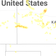
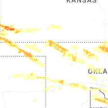
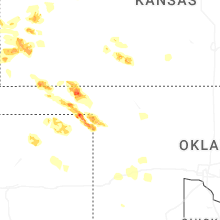
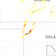


Connect with Interactive Hail Maps