

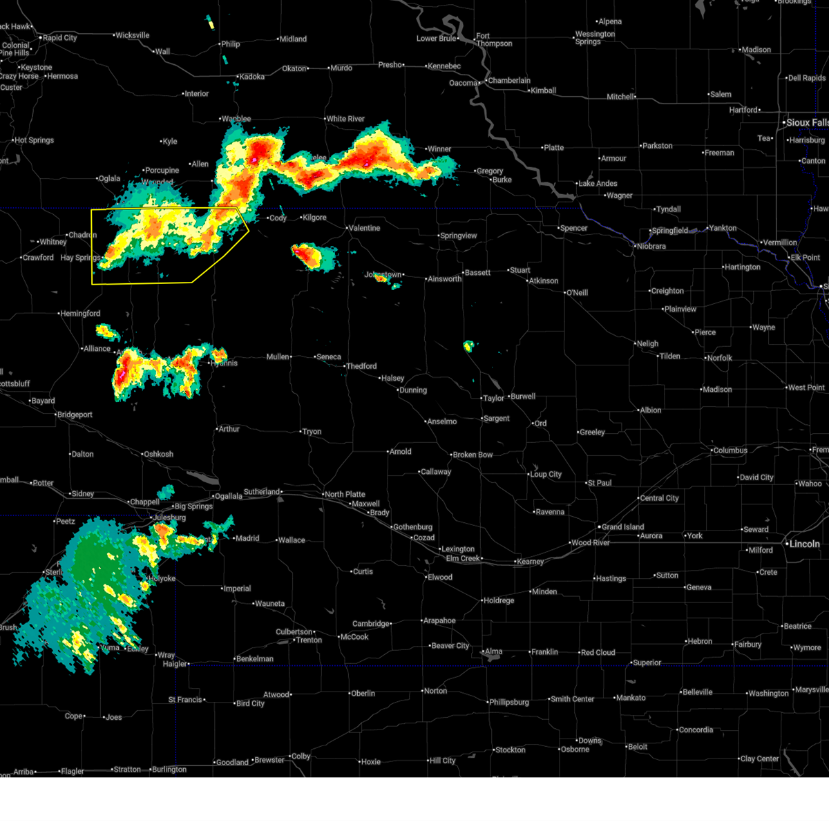
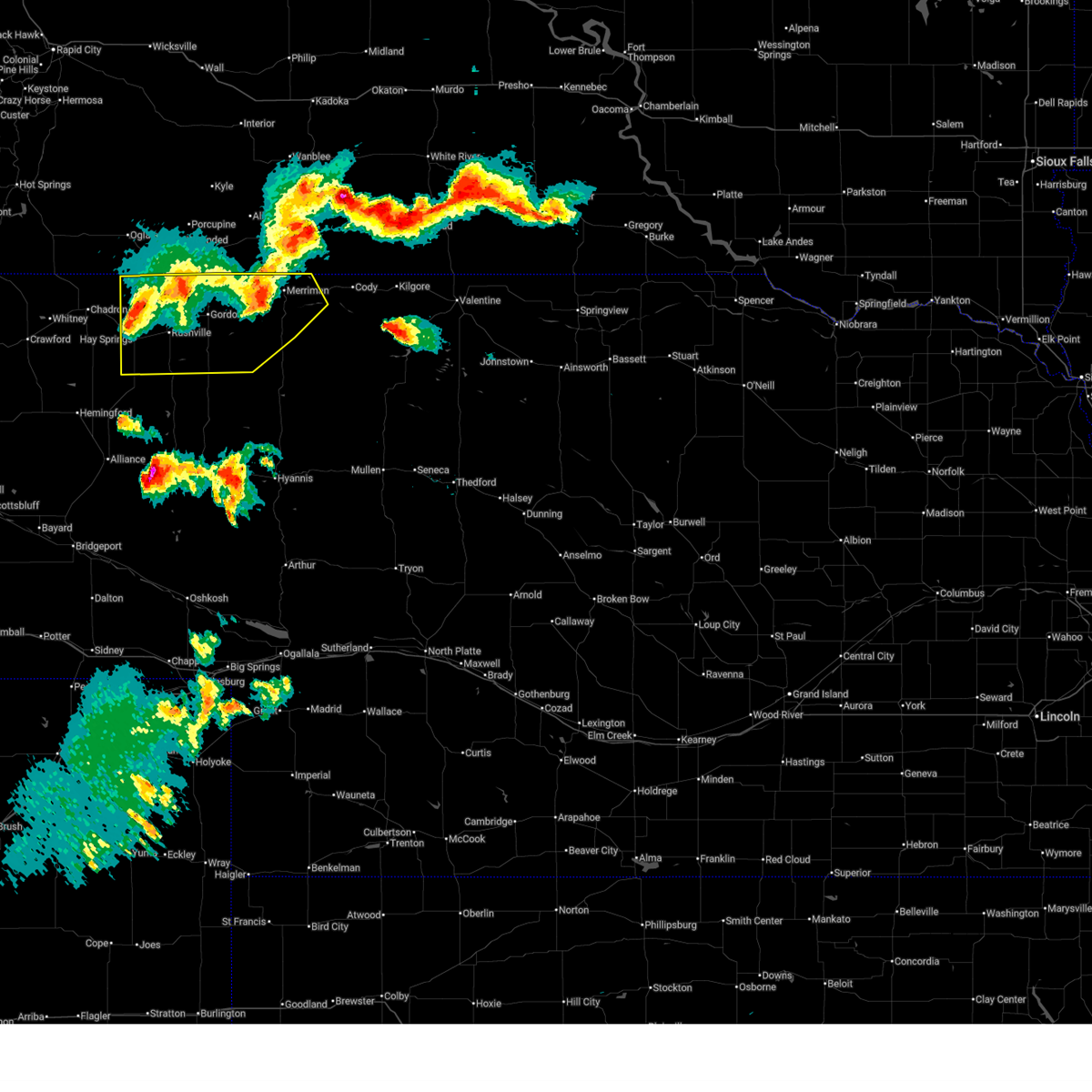
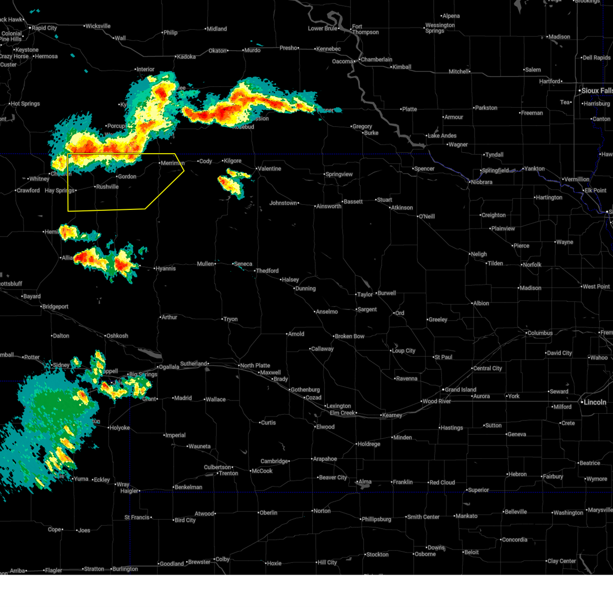
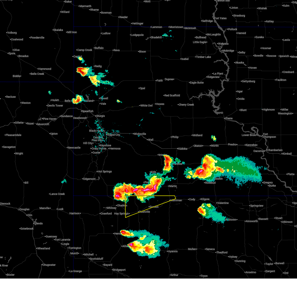
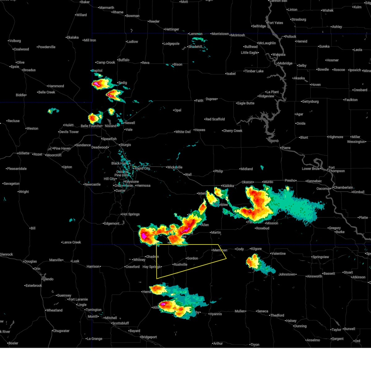
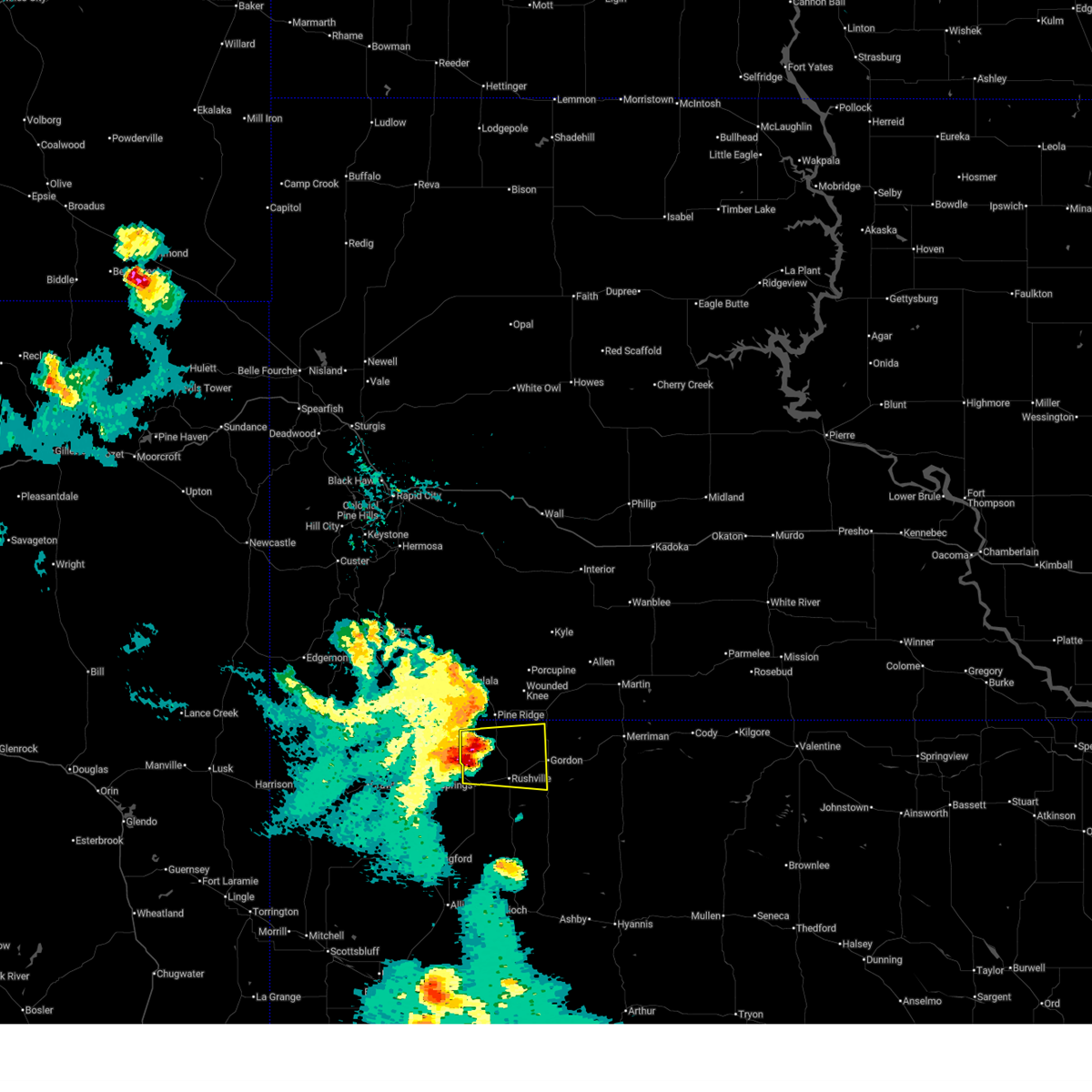
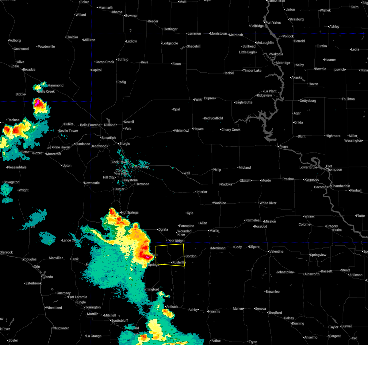
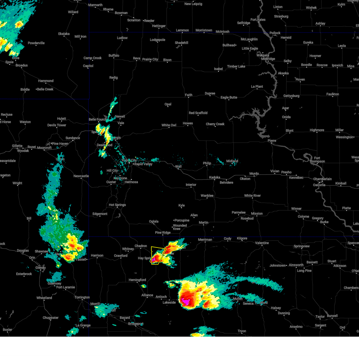
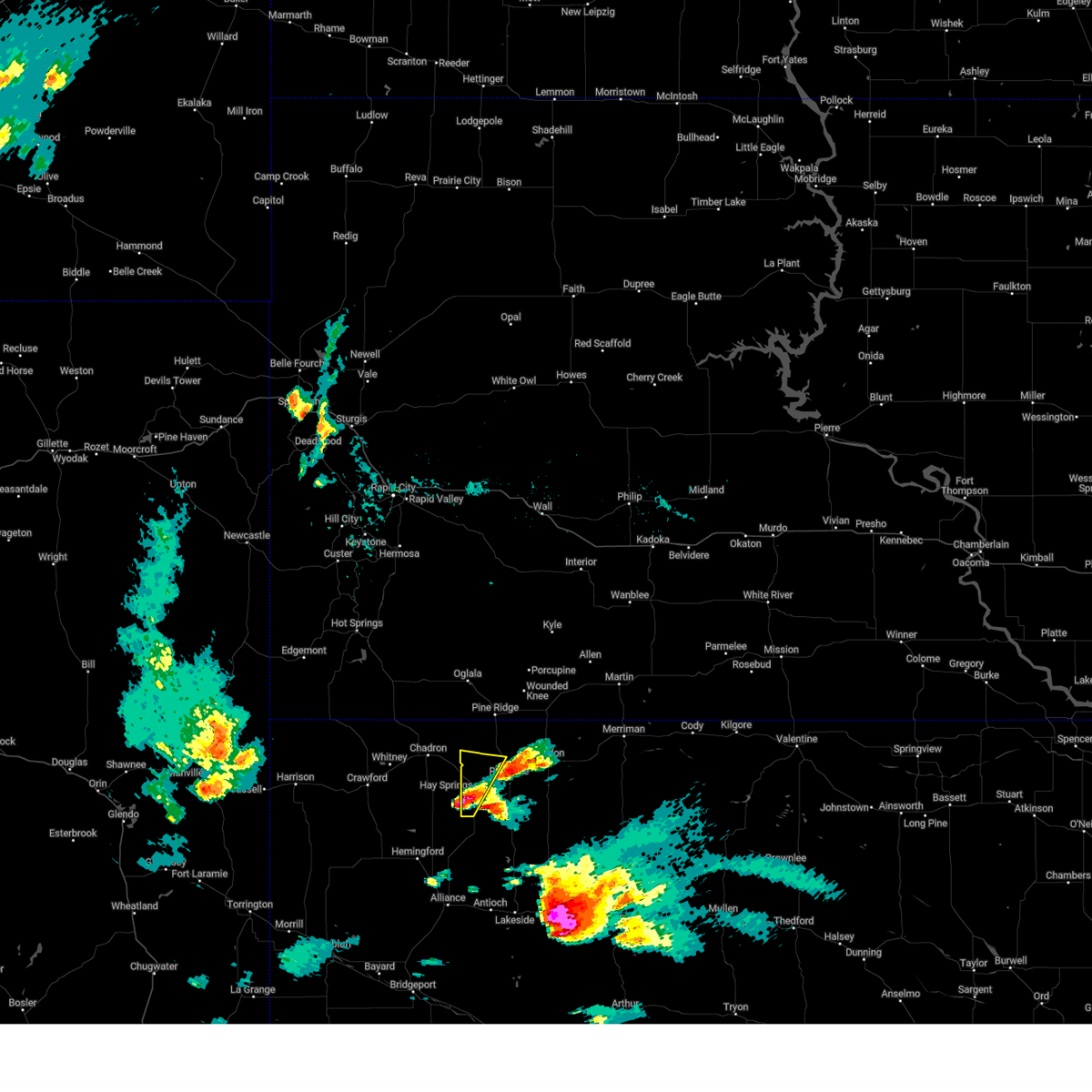
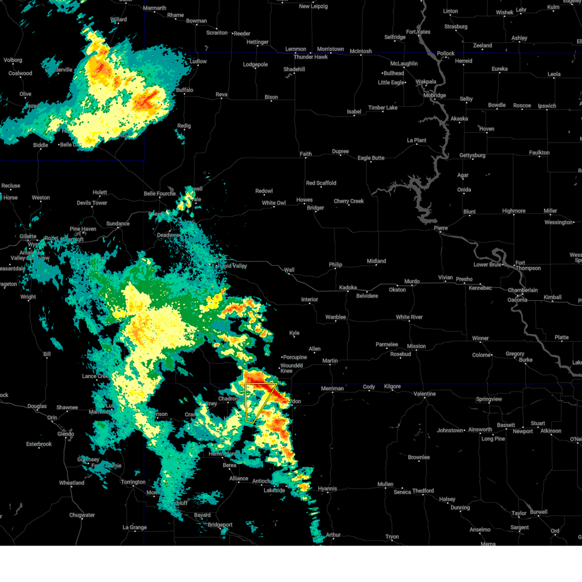
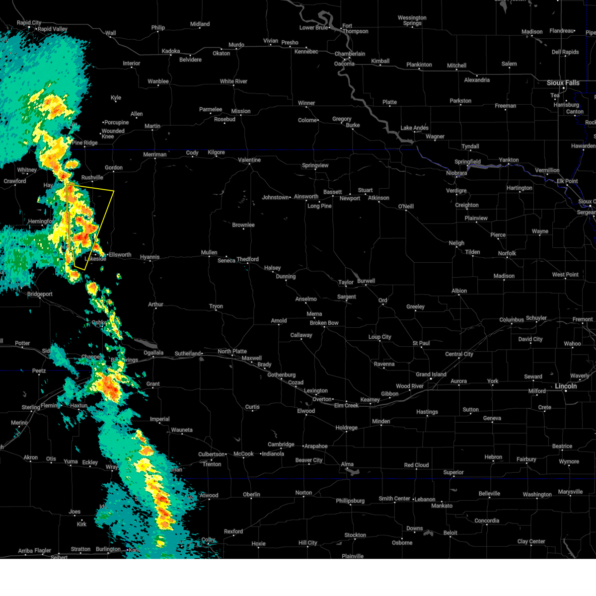
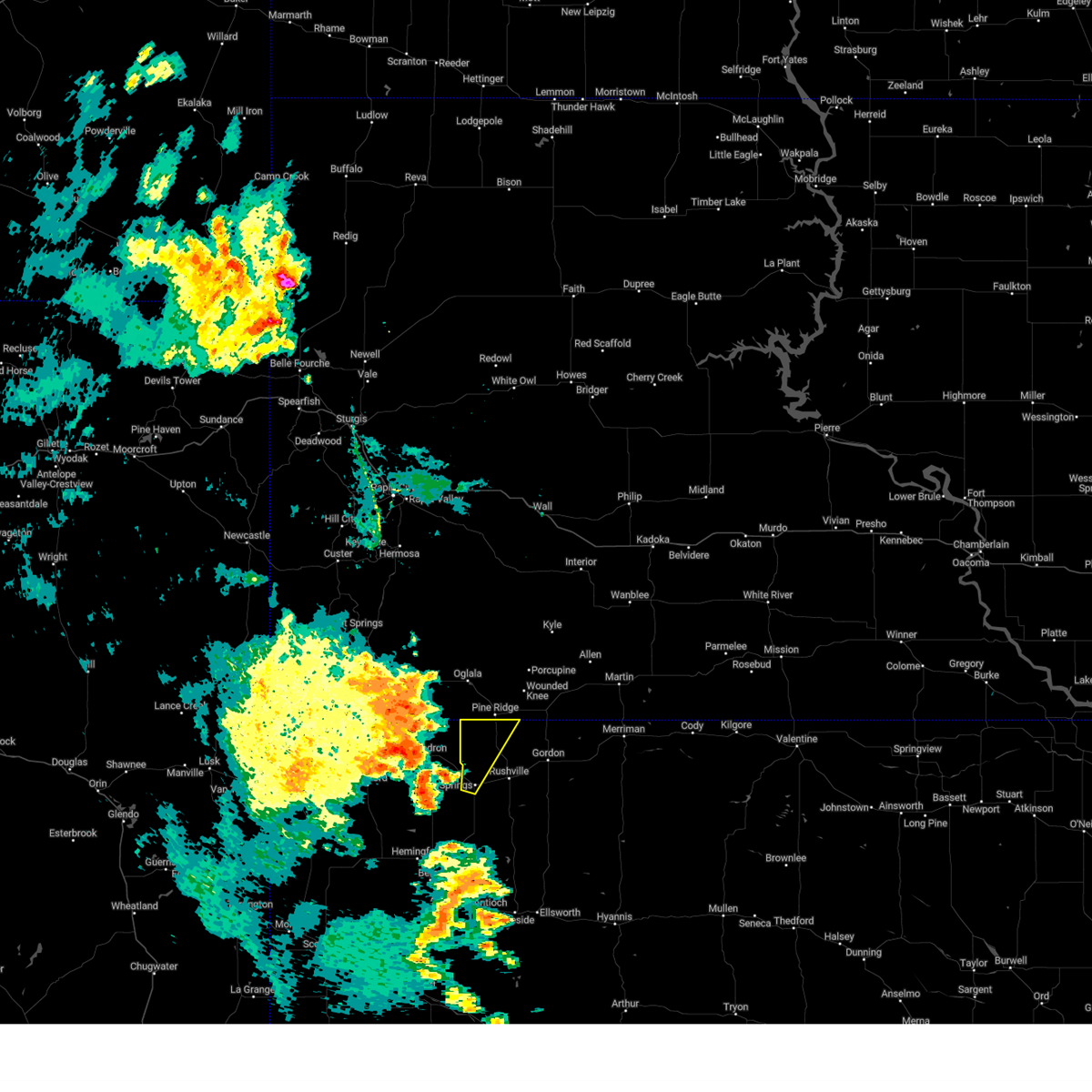
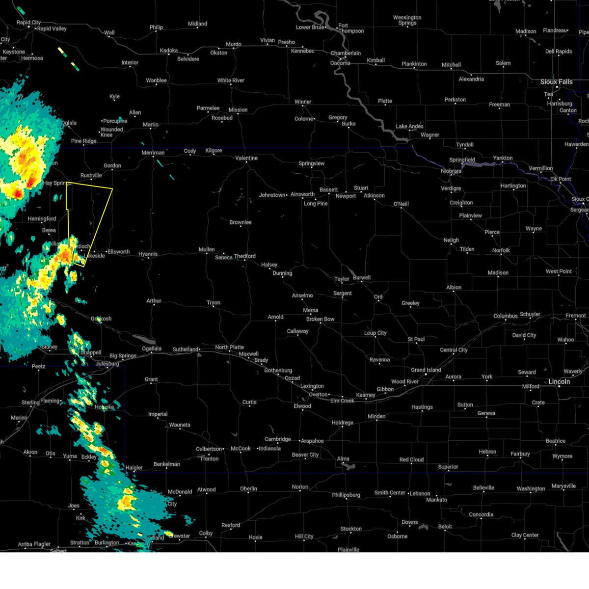
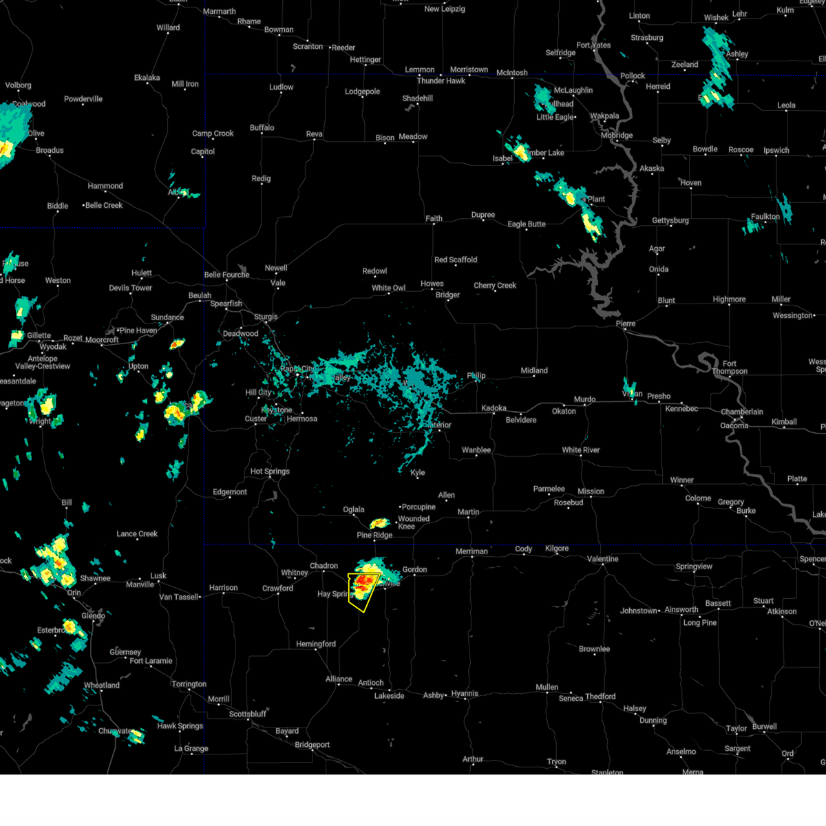
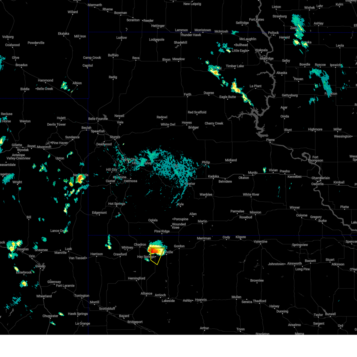
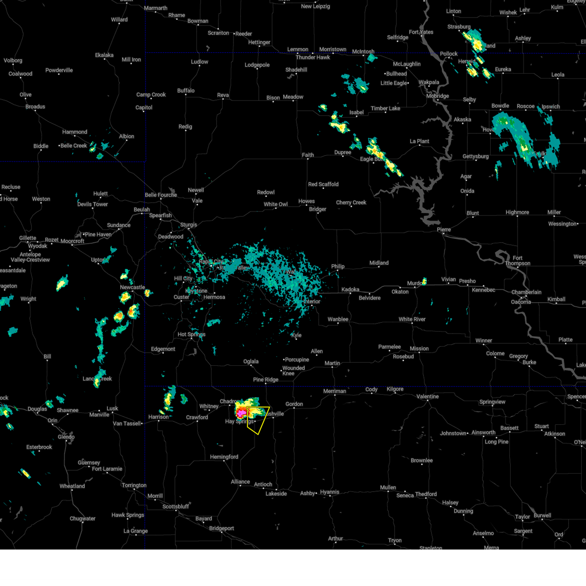
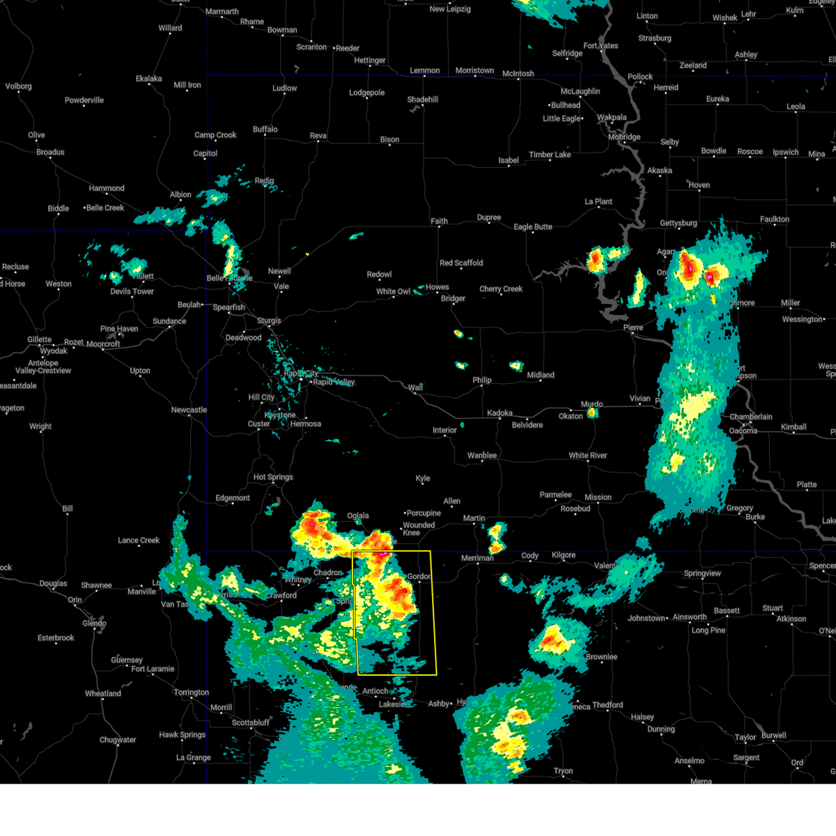
Hail Map for Hay Springs, NE
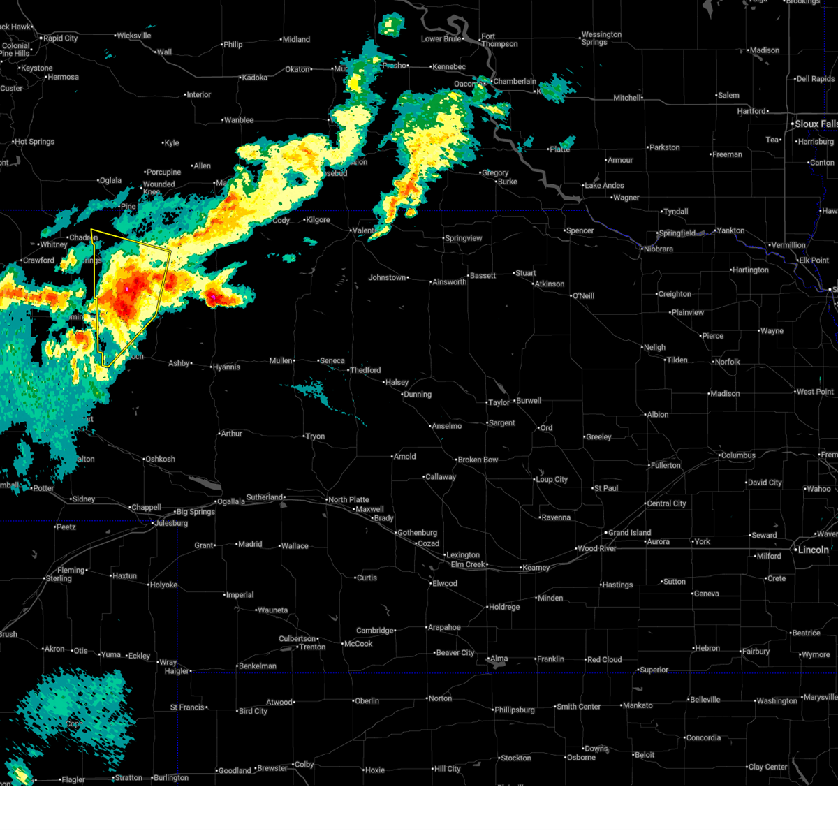
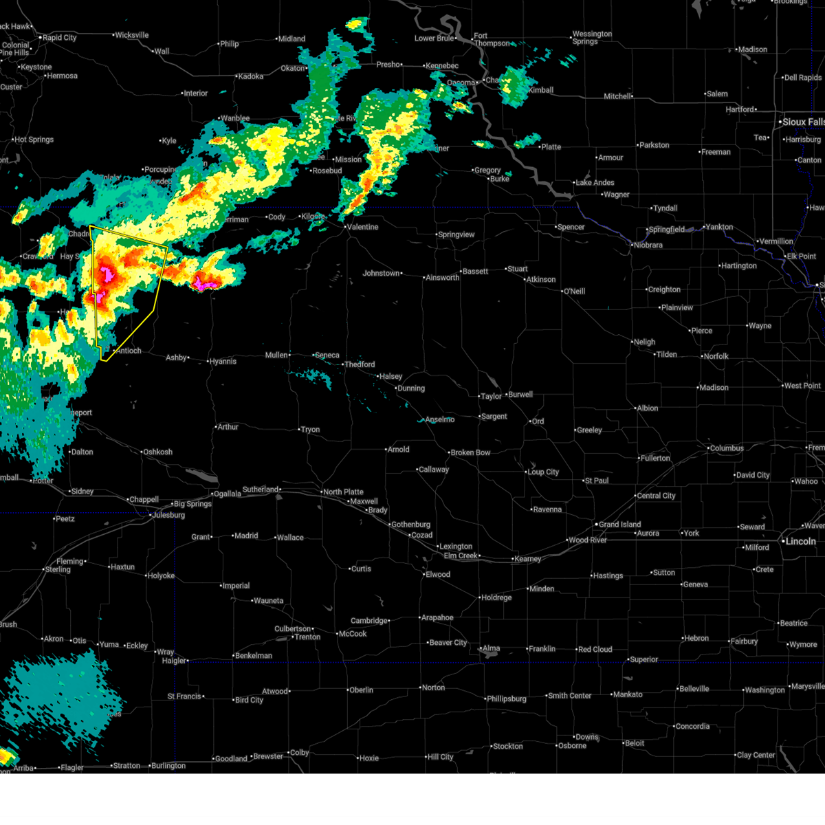
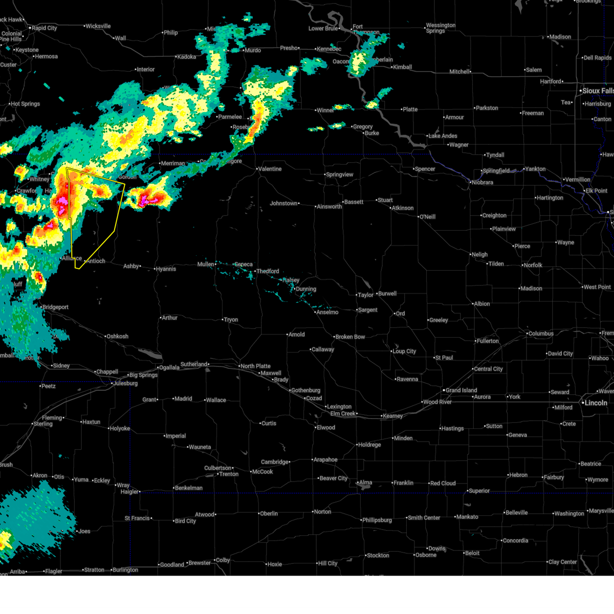
The Hay Springs, NE area has had 34 reports of on-the-ground hail by trained spotters, and has been under severe weather warnings 22 times during the past 12 months. Doppler radar has detected hail at or near Hay Springs, NE on 83 occasions, including 5 occasions during the past year.
| Name: | Hay Springs, NE |
| Where Located: | 75.6 miles NE of Scottsbluff, NE |
| Map: | Google Map for Hay Springs, NE |
| Population: | 570 |
| Housing Units: | 328 |
| More Info: | Search Google for Hay Springs, NE |
2
The Top Recent Hail Date for Hay Springs, NE is Wednesday, July 17, 2024 (9th out of 83)

Hail and Wind Damage Spotted near Hay Springs, NE
| Date / Time | Report Details |
|---|---|
| 7/1/2025 8:12 PM MDT |
 The storms which prompted the warning have weakened below severe limits, and no longer pose an immediate threat to life or property. therefore, the warning will be allowed to expire. a severe thunderstorm watch remains in effect until 1100 pm mdt for the panhandle of and north central nebraska. The storms which prompted the warning have weakened below severe limits, and no longer pose an immediate threat to life or property. therefore, the warning will be allowed to expire. a severe thunderstorm watch remains in effect until 1100 pm mdt for the panhandle of and north central nebraska.
|
| 7/1/2025 7:56 PM MDT |
 At 755 pm mdt, severe thunderstorms were located along a line extending from lacreek wildlife refuge to 14 miles east of gordon to near hay springs, moving southeast at 25 mph (radar indicated). Hazards include 60 mph wind gusts and quarter size hail. Hail damage to vehicles is expected. expect wind damage to roofs, siding, and trees. locations impacted include, gordon, rushville, hay springs, merriman, clinton, intersection of highway 87 and craven creek road, lone butte, irwin, intersection of beaver creek road and white clay creek road, intersection of highway 87 and larabee road, rock hill, pine ridge, hoover lake, metcalf state wildlife management area, highway 27 crossing the niobrara river, mount maria, intersection of highway 20 and irwin road, highway 250 crossing the niobrara river, walgren lake state recreation area, and shell lake state wildlife management area. this includes the following highways, highway 20 between mile markers 74 and 148. highway 250 between mile markers 34 and 48. Highway 61 between mile markers 205 and 231. At 755 pm mdt, severe thunderstorms were located along a line extending from lacreek wildlife refuge to 14 miles east of gordon to near hay springs, moving southeast at 25 mph (radar indicated). Hazards include 60 mph wind gusts and quarter size hail. Hail damage to vehicles is expected. expect wind damage to roofs, siding, and trees. locations impacted include, gordon, rushville, hay springs, merriman, clinton, intersection of highway 87 and craven creek road, lone butte, irwin, intersection of beaver creek road and white clay creek road, intersection of highway 87 and larabee road, rock hill, pine ridge, hoover lake, metcalf state wildlife management area, highway 27 crossing the niobrara river, mount maria, intersection of highway 20 and irwin road, highway 250 crossing the niobrara river, walgren lake state recreation area, and shell lake state wildlife management area. this includes the following highways, highway 20 between mile markers 74 and 148. highway 250 between mile markers 34 and 48. Highway 61 between mile markers 205 and 231.
|
| 7/1/2025 7:25 PM MDT |
 Svrlbf the national weather service in north platte has issued a * severe thunderstorm warning for, northwestern cherry county in north central nebraska, northern sheridan county in the panhandle of nebraska, * until 815 pm mdt. * at 725 pm mdt, severe thunderstorms were located along a line extending from near lacreek north housing to 8 miles southeast of wakpamni to 10 miles northeast of chadron, moving south at 30 mph (radar indicated). Hazards include 70 mph wind gusts and half dollar size hail. Hail damage to vehicles is expected. expect considerable tree damage. Wind damage is also likely to mobile homes, roofs, and outbuildings. Svrlbf the national weather service in north platte has issued a * severe thunderstorm warning for, northwestern cherry county in north central nebraska, northern sheridan county in the panhandle of nebraska, * until 815 pm mdt. * at 725 pm mdt, severe thunderstorms were located along a line extending from near lacreek north housing to 8 miles southeast of wakpamni to 10 miles northeast of chadron, moving south at 30 mph (radar indicated). Hazards include 70 mph wind gusts and half dollar size hail. Hail damage to vehicles is expected. expect considerable tree damage. Wind damage is also likely to mobile homes, roofs, and outbuildings.
|
| 7/1/2025 7:10 PM MDT |
 At 709 pm mdt, severe thunderstorms were located along a line extending from near swett to 8 miles south of slim butte, moving south at 20 mph (radar indicated). Hazards include 70 mph wind gusts and ping pong ball size hail. People and animals outdoors will be injured. expect hail damage to roofs, siding, windows, and vehicles. expect considerable tree damage. wind damage is also likely to mobile homes, roofs, and outbuildings. locations impacted include, gordon, rushville, hay springs, merriman, white clay, clinton, intersection of highway 87 and craven creek road, irwin, intersection of beaver creek road and white clay creek road, intersection of highway 87 and larabee road, mount maria, shell lake state wildlife management area, pine ridge, hoover lake, and metcalf state wildlife management area. this includes the following highways, highway 20 between mile markers 74 and 111, and between mile markers 126 and 138. highway 250 near mile marker 48. Highway 61 between mile markers 226 and 231. At 709 pm mdt, severe thunderstorms were located along a line extending from near swett to 8 miles south of slim butte, moving south at 20 mph (radar indicated). Hazards include 70 mph wind gusts and ping pong ball size hail. People and animals outdoors will be injured. expect hail damage to roofs, siding, windows, and vehicles. expect considerable tree damage. wind damage is also likely to mobile homes, roofs, and outbuildings. locations impacted include, gordon, rushville, hay springs, merriman, white clay, clinton, intersection of highway 87 and craven creek road, irwin, intersection of beaver creek road and white clay creek road, intersection of highway 87 and larabee road, mount maria, shell lake state wildlife management area, pine ridge, hoover lake, and metcalf state wildlife management area. this includes the following highways, highway 20 between mile markers 74 and 111, and between mile markers 126 and 138. highway 250 near mile marker 48. Highway 61 between mile markers 226 and 231.
|
| 7/1/2025 6:49 PM MDT |
 Svrlbf the national weather service in north platte has issued a * severe thunderstorm warning for, northwestern cherry county in north central nebraska, northern sheridan county in the panhandle of nebraska, * until 730 pm mdt. * at 649 pm mdt, severe thunderstorms were located along a line extending from near yellow bear canyon to near slim butte, moving southeast at 40 mph (radar indicated). Hazards include two inch hail and 60 mph wind gusts. People and animals outdoors will be injured. expect hail damage to roofs, siding, windows, and vehicles. Expect wind damage to roofs, siding, and trees. Svrlbf the national weather service in north platte has issued a * severe thunderstorm warning for, northwestern cherry county in north central nebraska, northern sheridan county in the panhandle of nebraska, * until 730 pm mdt. * at 649 pm mdt, severe thunderstorms were located along a line extending from near yellow bear canyon to near slim butte, moving southeast at 40 mph (radar indicated). Hazards include two inch hail and 60 mph wind gusts. People and animals outdoors will be injured. expect hail damage to roofs, siding, windows, and vehicles. Expect wind damage to roofs, siding, and trees.
|
| 6/29/2025 7:55 PM MDT |
 The storms which prompted the warning have weakened below severe limits, and no longer pose an immediate threat to life or property. therefore, the warning will be allowed to expire. a severe thunderstorm watch remains in effect until 900 pm mdt for the panhandle of nebraska. to report severe weather, contact your nearest law enforcement agency. they will relay your report to the national weather service north platte. The storms which prompted the warning have weakened below severe limits, and no longer pose an immediate threat to life or property. therefore, the warning will be allowed to expire. a severe thunderstorm watch remains in effect until 900 pm mdt for the panhandle of nebraska. to report severe weather, contact your nearest law enforcement agency. they will relay your report to the national weather service north platte.
|
| 6/29/2025 7:30 PM MDT |
 At 730 pm mdt, severe thunderstorms were located along a line extending from near hay springs to 15 miles northeast of wild horse butte to near hemingford, moving east at 25 mph (radar indicated). Hazards include 70 mph wind gusts and quarter size hail. Hail damage to vehicles is expected. expect considerable tree damage. wind damage is also likely to mobile homes, roofs, and outbuildings. locations impacted include, rushville, hay springs, antioch, clinton, lone butte, intersection of beaver creek road and white clay creek road, highway 27 crossing the niobrara river, smith lake state wildlife management area, highway 250 crossing the niobrara river, walgren lake state recreation area, intersection of highway 27 and mills road, wickson lake, diamond lake, metcalf state wildlife management area, krause lake, and intersection of highway 87 and antelope road. this includes the following highways, highway 20 between mile markers 74 and 100. highway 250 between mile markers 11 and 48. Highway 2 between mile markers 96 and 102. At 730 pm mdt, severe thunderstorms were located along a line extending from near hay springs to 15 miles northeast of wild horse butte to near hemingford, moving east at 25 mph (radar indicated). Hazards include 70 mph wind gusts and quarter size hail. Hail damage to vehicles is expected. expect considerable tree damage. wind damage is also likely to mobile homes, roofs, and outbuildings. locations impacted include, rushville, hay springs, antioch, clinton, lone butte, intersection of beaver creek road and white clay creek road, highway 27 crossing the niobrara river, smith lake state wildlife management area, highway 250 crossing the niobrara river, walgren lake state recreation area, intersection of highway 27 and mills road, wickson lake, diamond lake, metcalf state wildlife management area, krause lake, and intersection of highway 87 and antelope road. this includes the following highways, highway 20 between mile markers 74 and 100. highway 250 between mile markers 11 and 48. Highway 2 between mile markers 96 and 102.
|
| 6/29/2025 7:14 PM MDT |
 Svrlbf the national weather service in north platte has issued a * severe thunderstorm warning for, sheridan county in the panhandle of nebraska, * until 800 pm mdt. * at 714 pm mdt, severe thunderstorms were located along a line extending from near hay springs to 12 miles east of box butte dam to near hemingford, moving east at 30 mph (radar indicated). Hazards include 70 mph wind gusts and quarter size hail. Hail damage to vehicles is expected. expect considerable tree damage. Wind damage is also likely to mobile homes, roofs, and outbuildings. Svrlbf the national weather service in north platte has issued a * severe thunderstorm warning for, sheridan county in the panhandle of nebraska, * until 800 pm mdt. * at 714 pm mdt, severe thunderstorms were located along a line extending from near hay springs to 12 miles east of box butte dam to near hemingford, moving east at 30 mph (radar indicated). Hazards include 70 mph wind gusts and quarter size hail. Hail damage to vehicles is expected. expect considerable tree damage. Wind damage is also likely to mobile homes, roofs, and outbuildings.
|
| 6/13/2025 7:43 PM MDT |
 At 743 pm mdt, a severe thunderstorm was located 9 miles north of hay springs, moving east at 25 mph (radar indicated). Hazards include ping pong ball size hail and 60 mph wind gusts. People and animals outdoors will be injured. expect hail damage to roofs, siding, windows, and vehicles. expect wind damage to roofs, siding, and trees. locations impacted include, gordon, rushville, hay springs, clinton, metcalf state wildlife management area, lone butte, intersection of beaver creek road and white clay creek road, intersection of highway 87 and larabee road, and mount maria. this includes the following highways, highway 20 between mile markers 74 and 78, and between mile markers 81 and 105. Highway 250 between mile markers 46 and 48. At 743 pm mdt, a severe thunderstorm was located 9 miles north of hay springs, moving east at 25 mph (radar indicated). Hazards include ping pong ball size hail and 60 mph wind gusts. People and animals outdoors will be injured. expect hail damage to roofs, siding, windows, and vehicles. expect wind damage to roofs, siding, and trees. locations impacted include, gordon, rushville, hay springs, clinton, metcalf state wildlife management area, lone butte, intersection of beaver creek road and white clay creek road, intersection of highway 87 and larabee road, and mount maria. this includes the following highways, highway 20 between mile markers 74 and 78, and between mile markers 81 and 105. Highway 250 between mile markers 46 and 48.
|
| 6/13/2025 7:20 PM MDT |
 Svrlbf the national weather service in north platte has issued a * severe thunderstorm warning for, northwestern sheridan county in the panhandle of nebraska, * until 815 pm mdt. * at 720 pm mdt, a severe thunderstorm was located near chadron, moving east at 30 mph (radar indicated). Hazards include 60 mph wind gusts and quarter size hail. Hail damage to vehicles is expected. Expect wind damage to roofs, siding, and trees. Svrlbf the national weather service in north platte has issued a * severe thunderstorm warning for, northwestern sheridan county in the panhandle of nebraska, * until 815 pm mdt. * at 720 pm mdt, a severe thunderstorm was located near chadron, moving east at 30 mph (radar indicated). Hazards include 60 mph wind gusts and quarter size hail. Hail damage to vehicles is expected. Expect wind damage to roofs, siding, and trees.
|
| 5/23/2025 6:29 PM MDT | Golf Ball sized hail reported 13.5 miles N of Hay Springs, NE |
| 5/23/2025 6:12 PM MDT | Quarter sized hail reported 21.2 miles NNW of Hay Springs, NE |
| 4/27/2025 6:02 PM MDT |
 At 601 pm mdt, a severe thunderstorm was located near hay springs, moving northeast at 20 mph (radar indicated). Hazards include golf ball size hail and 60 mph wind gusts. People and animals outdoors will be injured. expect hail damage to roofs, siding, windows, and vehicles. expect wind damage to roofs, siding, and trees. locations impacted include, hay springs, intersection of beaver creek road and white clay creek road, intersection of highway 87 and antelope road, and walgren lake state recreation area. This includes highway 20 between mile markers 74 and 85. At 601 pm mdt, a severe thunderstorm was located near hay springs, moving northeast at 20 mph (radar indicated). Hazards include golf ball size hail and 60 mph wind gusts. People and animals outdoors will be injured. expect hail damage to roofs, siding, windows, and vehicles. expect wind damage to roofs, siding, and trees. locations impacted include, hay springs, intersection of beaver creek road and white clay creek road, intersection of highway 87 and antelope road, and walgren lake state recreation area. This includes highway 20 between mile markers 74 and 85.
|
| 4/27/2025 5:52 PM MDT |
 Svrlbf the national weather service in north platte has issued a * severe thunderstorm warning for, northwestern sheridan county in the panhandle of nebraska, * until 630 pm mdt. * at 552 pm mdt, a severe thunderstorm was located near hay springs, moving northeast at 20 mph (radar indicated). Hazards include ping pong ball size hail and 60 mph wind gusts. People and animals outdoors will be injured. expect hail damage to roofs, siding, windows, and vehicles. Expect wind damage to roofs, siding, and trees. Svrlbf the national weather service in north platte has issued a * severe thunderstorm warning for, northwestern sheridan county in the panhandle of nebraska, * until 630 pm mdt. * at 552 pm mdt, a severe thunderstorm was located near hay springs, moving northeast at 20 mph (radar indicated). Hazards include ping pong ball size hail and 60 mph wind gusts. People and animals outdoors will be injured. expect hail damage to roofs, siding, windows, and vehicles. Expect wind damage to roofs, siding, and trees.
|
| 9/17/2024 7:26 PM MDT |
 The storm which prompted the warning has moved out of the area. therefore, the warning will be allowed to expire. a severe thunderstorm watch remains in effect until 900 pm mdt for the panhandle of nebraska. to report severe weather, contact your nearest law enforcement agency. they will relay your report to the national weather service north platte. The storm which prompted the warning has moved out of the area. therefore, the warning will be allowed to expire. a severe thunderstorm watch remains in effect until 900 pm mdt for the panhandle of nebraska. to report severe weather, contact your nearest law enforcement agency. they will relay your report to the national weather service north platte.
|
| 9/17/2024 7:05 PM MDT |
 At 705 pm mdt, a severe thunderstorm was located near hay springs, moving north at 55 mph (radar indicated). Hazards include 60 mph wind gusts. Expect damage to roofs, siding, and trees. locations impacted include, hay springs, antioch, snow lake, miles lake, wickson lake, diamond lake, krause lake, smith lake state wildlife management area, highway 250 crossing the niobrara river, intersection of highway 87 and antelope road, and walgren lake state recreation area. this includes the following highways, highway 250 between mile markers 11 and 44. Highway 2 between mile markers 96 and 106. At 705 pm mdt, a severe thunderstorm was located near hay springs, moving north at 55 mph (radar indicated). Hazards include 60 mph wind gusts. Expect damage to roofs, siding, and trees. locations impacted include, hay springs, antioch, snow lake, miles lake, wickson lake, diamond lake, krause lake, smith lake state wildlife management area, highway 250 crossing the niobrara river, intersection of highway 87 and antelope road, and walgren lake state recreation area. this includes the following highways, highway 250 between mile markers 11 and 44. Highway 2 between mile markers 96 and 106.
|
| 9/17/2024 6:39 PM MDT |
 Svrlbf the national weather service in north platte has issued a * severe thunderstorm warning for, northwestern sheridan county in the panhandle of nebraska, * until 730 pm mdt. * at 638 pm mdt, a severe thunderstorm was located over chadron, moving northeast at 50 mph (radar indicated). Hazards include 70 mph wind gusts. Expect considerable tree damage. Damage is likely to mobile homes, roofs, and outbuildings. Svrlbf the national weather service in north platte has issued a * severe thunderstorm warning for, northwestern sheridan county in the panhandle of nebraska, * until 730 pm mdt. * at 638 pm mdt, a severe thunderstorm was located over chadron, moving northeast at 50 mph (radar indicated). Hazards include 70 mph wind gusts. Expect considerable tree damage. Damage is likely to mobile homes, roofs, and outbuildings.
|
| 9/17/2024 6:25 PM MDT |
 Svrlbf the national weather service in north platte has issued a * severe thunderstorm warning for, northwestern garden county in the panhandle of nebraska, southern sheridan county in the panhandle of nebraska, * until 715 pm mdt. * at 625 pm mdt, a severe thunderstorm was located near alliance airport, or near alliance, moving north at 55 mph (radar indicated). Hazards include 70 mph wind gusts. Expect considerable tree damage. Damage is likely to mobile homes, roofs, and outbuildings. Svrlbf the national weather service in north platte has issued a * severe thunderstorm warning for, northwestern garden county in the panhandle of nebraska, southern sheridan county in the panhandle of nebraska, * until 715 pm mdt. * at 625 pm mdt, a severe thunderstorm was located near alliance airport, or near alliance, moving north at 55 mph (radar indicated). Hazards include 70 mph wind gusts. Expect considerable tree damage. Damage is likely to mobile homes, roofs, and outbuildings.
|
| 8/21/2024 2:31 PM MDT |
 the severe thunderstorm warning has been cancelled and is no longer in effect the severe thunderstorm warning has been cancelled and is no longer in effect
|
| 8/21/2024 2:16 PM MDT |
 At 215 pm mdt, a severe thunderstorm was located near hay springs, moving east at 15 mph (radar indicated). Hazards include 60 mph wind gusts and penny size hail. Expect damage to roofs, siding, and trees. locations impacted include, hay springs, intersection of beaver creek road and white clay creek road, intersection of highway 87 and antelope road, and walgren lake state recreation area. This includes highway 20 between mile markers 74 and 85. At 215 pm mdt, a severe thunderstorm was located near hay springs, moving east at 15 mph (radar indicated). Hazards include 60 mph wind gusts and penny size hail. Expect damage to roofs, siding, and trees. locations impacted include, hay springs, intersection of beaver creek road and white clay creek road, intersection of highway 87 and antelope road, and walgren lake state recreation area. This includes highway 20 between mile markers 74 and 85.
|
| 8/21/2024 1:57 PM MDT |
 Svrlbf the national weather service in north platte has issued a * severe thunderstorm warning for, northwestern sheridan county in the panhandle of nebraska, * until 245 pm mdt. * at 155 pm mdt, a severe thunderstorm was located near red cloud campground, or 9 miles southeast of chadron, moving east at 10 mph (radar indicated). Hazards include 70 mph wind gusts and half dollar size hail. Hail damage to vehicles is expected. expect considerable tree damage. Wind damage is also likely to mobile homes, roofs, and outbuildings. Svrlbf the national weather service in north platte has issued a * severe thunderstorm warning for, northwestern sheridan county in the panhandle of nebraska, * until 245 pm mdt. * at 155 pm mdt, a severe thunderstorm was located near red cloud campground, or 9 miles southeast of chadron, moving east at 10 mph (radar indicated). Hazards include 70 mph wind gusts and half dollar size hail. Hail damage to vehicles is expected. expect considerable tree damage. Wind damage is also likely to mobile homes, roofs, and outbuildings.
|
| 7/27/2024 8:11 PM MDT |
 The storms which prompted the warning have weakened below severe limits, and no longer pose an immediate threat to life or property. therefore, the warning will be allowed to expire. however, gusty winds are still possible with these thunderstorms. The storms which prompted the warning have weakened below severe limits, and no longer pose an immediate threat to life or property. therefore, the warning will be allowed to expire. however, gusty winds are still possible with these thunderstorms.
|
| 7/27/2024 7:56 PM MDT |
 At 756 pm mdt, severe thunderstorms were located along a line extending from near white clay to 6 miles south of rushville to 18 miles northwest of ellsworth, moving east at 30 mph (radar indicated). Hazards include 60 mph wind gusts. Expect damage to roofs, siding, and trees. locations impacted include, gordon, rushville, hay springs, white clay, clinton, intersection of highway 87 and craven creek road, billys lake, lone butte, intersection of beaver creek road and white clay creek road, intersection of highway 87 and larabee road, highway 27 crossing the niobrara river, smith lake state wildlife management area, mount maria, highway 250 crossing the niobrara river, walgren lake state recreation area, intersection of highway 27 and mills road, pine ridge, diamond lake, metcalf state wildlife management area, and wolf hill. this includes the following highways, highway 20 between mile markers 74 and 111. Highway 250 between mile markers 13 and 48. At 756 pm mdt, severe thunderstorms were located along a line extending from near white clay to 6 miles south of rushville to 18 miles northwest of ellsworth, moving east at 30 mph (radar indicated). Hazards include 60 mph wind gusts. Expect damage to roofs, siding, and trees. locations impacted include, gordon, rushville, hay springs, white clay, clinton, intersection of highway 87 and craven creek road, billys lake, lone butte, intersection of beaver creek road and white clay creek road, intersection of highway 87 and larabee road, highway 27 crossing the niobrara river, smith lake state wildlife management area, mount maria, highway 250 crossing the niobrara river, walgren lake state recreation area, intersection of highway 27 and mills road, pine ridge, diamond lake, metcalf state wildlife management area, and wolf hill. this includes the following highways, highway 20 between mile markers 74 and 111. Highway 250 between mile markers 13 and 48.
|
| 7/27/2024 7:29 PM MDT |
 Svrlbf the national weather service in north platte has issued a * severe thunderstorm warning for, sheridan county in the panhandle of nebraska, * until 815 pm mdt. * at 728 pm mdt, severe thunderstorms were located along a line extending from near chadron to 8 miles south of hay springs to near wild horse butte, moving east at 50 mph (radar indicated). Hazards include 60 mph wind gusts. expect damage to roofs, siding, and trees Svrlbf the national weather service in north platte has issued a * severe thunderstorm warning for, sheridan county in the panhandle of nebraska, * until 815 pm mdt. * at 728 pm mdt, severe thunderstorms were located along a line extending from near chadron to 8 miles south of hay springs to near wild horse butte, moving east at 50 mph (radar indicated). Hazards include 60 mph wind gusts. expect damage to roofs, siding, and trees
|
| 7/3/2024 8:54 PM MDT |
 At 853 pm mdt, a severe thunderstorm was located near hay springs, moving east at 40 mph (radar indicated). Hazards include two inch hail and 60 mph wind gusts. People and animals outdoors will be injured. expect hail damage to roofs, siding, windows, and vehicles. expect wind damage to roofs, siding, and trees. locations impacted include, rushville, hay springs, big hill, billys lake, lone butte, intersection of beaver creek road and white clay creek road, highway 27 crossing the niobrara river, smith lake state wildlife management area, highway 250 crossing the niobrara river, intersection of highway 87 and antelope road, and walgren lake state recreation area. this includes the following highways, highway 20 between mile markers 74 and 96. Highway 250 between mile markers 26 and 48. At 853 pm mdt, a severe thunderstorm was located near hay springs, moving east at 40 mph (radar indicated). Hazards include two inch hail and 60 mph wind gusts. People and animals outdoors will be injured. expect hail damage to roofs, siding, windows, and vehicles. expect wind damage to roofs, siding, and trees. locations impacted include, rushville, hay springs, big hill, billys lake, lone butte, intersection of beaver creek road and white clay creek road, highway 27 crossing the niobrara river, smith lake state wildlife management area, highway 250 crossing the niobrara river, intersection of highway 87 and antelope road, and walgren lake state recreation area. this includes the following highways, highway 20 between mile markers 74 and 96. Highway 250 between mile markers 26 and 48.
|
| 7/3/2024 8:45 PM MDT | Quarter sized hail reported 1 miles N of Hay Springs, NE, hwy 87 covered in hail 1 mi s of hay springs. stones measured up to quarter size. time estimated by radar. |
| 7/3/2024 8:37 PM MDT | Estimated 60 mph wind gus in sheridan county NE, 4.3 miles NW of Hay Springs, NE |
| 7/3/2024 8:29 PM MDT |
 Svrlbf the national weather service in north platte has issued a * severe thunderstorm warning for, central sheridan county in the panhandle of nebraska, * until 915 pm mdt. * at 829 pm mdt, a severe thunderstorm was located over chadron campground, or near chadron, moving east at 40 mph (radar indicated). Hazards include ping pong ball size hail and 60 mph wind gusts. People and animals outdoors will be injured. expect hail damage to roofs, siding, windows, and vehicles. Expect wind damage to roofs, siding, and trees. Svrlbf the national weather service in north platte has issued a * severe thunderstorm warning for, central sheridan county in the panhandle of nebraska, * until 915 pm mdt. * at 829 pm mdt, a severe thunderstorm was located over chadron campground, or near chadron, moving east at 40 mph (radar indicated). Hazards include ping pong ball size hail and 60 mph wind gusts. People and animals outdoors will be injured. expect hail damage to roofs, siding, windows, and vehicles. Expect wind damage to roofs, siding, and trees.
|
| 6/10/2024 5:02 PM MDT |
 The storms which prompted the warning have weakened below severe limits, and no longer pose an immediate threat to life or property. therefore, the warning has been allowed to expire. however, gusty winds are still possible with these thunderstorms. a severe thunderstorm watch remains in effect until 800 pm mdt for the panhandle of nebraska. The storms which prompted the warning have weakened below severe limits, and no longer pose an immediate threat to life or property. therefore, the warning has been allowed to expire. however, gusty winds are still possible with these thunderstorms. a severe thunderstorm watch remains in effect until 800 pm mdt for the panhandle of nebraska.
|
| 6/10/2024 4:47 PM MDT |
 At 447 pm mdt, severe thunderstorms were located along a line extending from 7 miles southeast of white clay to near rushville to 12 miles northeast of wild horse butte, moving east at 35 mph (radar indicated). Hazards include 60 mph wind gusts. Expect damage to roofs, siding, and trees. locations impacted include, rushville, hay springs, white clay, clinton, intersection of highway 87 and craven creek road, intersection of beaver creek road and white clay creek road, intersection of highway 87 and larabee road, smith lake state wildlife management area, mount maria, highway 250 crossing the niobrara river, walgren lake state recreation area, pine ridge, metcalf state wildlife management area, and intersection of highway 87 and antelope road. this includes the following highways, highway 20 between mile markers 74 and 98. Highway 250 between mile markers 26 and 48. At 447 pm mdt, severe thunderstorms were located along a line extending from 7 miles southeast of white clay to near rushville to 12 miles northeast of wild horse butte, moving east at 35 mph (radar indicated). Hazards include 60 mph wind gusts. Expect damage to roofs, siding, and trees. locations impacted include, rushville, hay springs, white clay, clinton, intersection of highway 87 and craven creek road, intersection of beaver creek road and white clay creek road, intersection of highway 87 and larabee road, smith lake state wildlife management area, mount maria, highway 250 crossing the niobrara river, walgren lake state recreation area, pine ridge, metcalf state wildlife management area, and intersection of highway 87 and antelope road. this includes the following highways, highway 20 between mile markers 74 and 98. Highway 250 between mile markers 26 and 48.
|
| 6/10/2024 4:35 PM MDT |
 At 434 pm mdt, severe thunderstorms were located along a line extending from near white clay to near hay springs to 11 miles east of box butte dam, moving east at 30 mph (radar indicated). Hazards include 60 mph wind gusts and quarter size hail. Hail damage to vehicles is expected. expect wind damage to roofs, siding, and trees. locations impacted include, rushville, hay springs, white clay, clinton, intersection of highway 87 and craven creek road, intersection of beaver creek road and white clay creek road, intersection of highway 87 and larabee road, smith lake state wildlife management area, mount maria, highway 250 crossing the niobrara river, walgren lake state recreation area, pine ridge, metcalf state wildlife management area, and intersection of highway 87 and antelope road. this includes the following highways, highway 20 between mile markers 74 and 98. Highway 250 between mile markers 26 and 48. At 434 pm mdt, severe thunderstorms were located along a line extending from near white clay to near hay springs to 11 miles east of box butte dam, moving east at 30 mph (radar indicated). Hazards include 60 mph wind gusts and quarter size hail. Hail damage to vehicles is expected. expect wind damage to roofs, siding, and trees. locations impacted include, rushville, hay springs, white clay, clinton, intersection of highway 87 and craven creek road, intersection of beaver creek road and white clay creek road, intersection of highway 87 and larabee road, smith lake state wildlife management area, mount maria, highway 250 crossing the niobrara river, walgren lake state recreation area, pine ridge, metcalf state wildlife management area, and intersection of highway 87 and antelope road. this includes the following highways, highway 20 between mile markers 74 and 98. Highway 250 between mile markers 26 and 48.
|
| 6/10/2024 4:15 PM MDT |
 Svrlbf the national weather service in north platte has issued a * severe thunderstorm warning for, northwestern sheridan county in the panhandle of nebraska, * until 500 pm mdt. * at 414 pm mdt, severe thunderstorms were located along a line extending from 9 miles south of slim buttes housing to 7 miles west of hay springs to near box butte campground, moving east at 40 mph (radar indicated). Hazards include 60 mph wind gusts and quarter size hail. Hail damage to vehicles is expected. Expect wind damage to roofs, siding, and trees. Svrlbf the national weather service in north platte has issued a * severe thunderstorm warning for, northwestern sheridan county in the panhandle of nebraska, * until 500 pm mdt. * at 414 pm mdt, severe thunderstorms were located along a line extending from 9 miles south of slim buttes housing to 7 miles west of hay springs to near box butte campground, moving east at 40 mph (radar indicated). Hazards include 60 mph wind gusts and quarter size hail. Hail damage to vehicles is expected. Expect wind damage to roofs, siding, and trees.
|
| 6/2/2024 3:06 PM MDT | Ping Pong Ball sized hail reported 13.9 miles NNW of Hay Springs, NE |
| 6/1/2024 7:59 PM MDT |
 The severe thunderstorm which prompted the warning has weakened. therefore, the warning will be allowed to expire. however, small hail, gusty winds and heavy rain are still possible with this thunderstorm. a severe thunderstorm watch remains in effect until 1100 pm mdt for the panhandle of nebraska. to report severe weather, contact your nearest law enforcement agency. they will relay your report to the national weather service north platte. The severe thunderstorm which prompted the warning has weakened. therefore, the warning will be allowed to expire. however, small hail, gusty winds and heavy rain are still possible with this thunderstorm. a severe thunderstorm watch remains in effect until 1100 pm mdt for the panhandle of nebraska. to report severe weather, contact your nearest law enforcement agency. they will relay your report to the national weather service north platte.
|
| 6/1/2024 7:37 PM MDT |
 At 737 pm mdt, a severe thunderstorm was located near rushville, moving northeast at 35 mph (radar indicated). Hazards include 60 mph wind gusts and half dollar size hail. Hail damage to vehicles is expected. expect wind damage to roofs, siding, and trees. this severe storm will be near, rushville around 740 pm mdt. other locations impacted by this severe thunderstorm include intersection of beaver creek road and white clay creek road, intersection of highway 87 and larabee road, mount maria, walgren lake state recreation area, and metcalf state wildlife management area. this includes the following highways, highway 20 between mile markers 74 and 92. Highway 250 near mile marker 48. At 737 pm mdt, a severe thunderstorm was located near rushville, moving northeast at 35 mph (radar indicated). Hazards include 60 mph wind gusts and half dollar size hail. Hail damage to vehicles is expected. expect wind damage to roofs, siding, and trees. this severe storm will be near, rushville around 740 pm mdt. other locations impacted by this severe thunderstorm include intersection of beaver creek road and white clay creek road, intersection of highway 87 and larabee road, mount maria, walgren lake state recreation area, and metcalf state wildlife management area. this includes the following highways, highway 20 between mile markers 74 and 92. Highway 250 near mile marker 48.
|
| 6/1/2024 7:11 PM MDT |
 Svrlbf the national weather service in north platte has issued a * severe thunderstorm warning for, northwestern sheridan county in the panhandle of nebraska, * until 800 pm mdt. * at 711 pm mdt, a severe thunderstorm was located 7 miles southwest of hay springs, moving northeast at 30 mph (radar indicated). Hazards include 60 mph wind gusts and half dollar size hail. Hail damage to vehicles is expected. Expect wind damage to roofs, siding, and trees. Svrlbf the national weather service in north platte has issued a * severe thunderstorm warning for, northwestern sheridan county in the panhandle of nebraska, * until 800 pm mdt. * at 711 pm mdt, a severe thunderstorm was located 7 miles southwest of hay springs, moving northeast at 30 mph (radar indicated). Hazards include 60 mph wind gusts and half dollar size hail. Hail damage to vehicles is expected. Expect wind damage to roofs, siding, and trees.
|
| 5/25/2024 3:40 PM MDT |
 At 340 pm mdt, a severe thunderstorm was located near rushville, moving east at 40 mph (radar indicated). Hazards include 60 mph wind gusts and quarter size hail. Hail damage to vehicles is expected. expect wind damage to roofs, siding, and trees. locations impacted include, gordon, rushville, hay springs, clinton, lone butte, highway 27 crossing the niobrara river, highway 250 crossing the niobrara river, walgren lake state recreation area, and intersection of highway 27 and mills road. this includes the following highways, highway 20 between mile markers 80 and 108. Highway 250 between mile markers 31 and 48. At 340 pm mdt, a severe thunderstorm was located near rushville, moving east at 40 mph (radar indicated). Hazards include 60 mph wind gusts and quarter size hail. Hail damage to vehicles is expected. expect wind damage to roofs, siding, and trees. locations impacted include, gordon, rushville, hay springs, clinton, lone butte, highway 27 crossing the niobrara river, highway 250 crossing the niobrara river, walgren lake state recreation area, and intersection of highway 27 and mills road. this includes the following highways, highway 20 between mile markers 80 and 108. Highway 250 between mile markers 31 and 48.
|
| 5/25/2024 3:15 PM MDT |
 Svrlbf the national weather service in north platte has issued a * severe thunderstorm warning for, northern sheridan county in the panhandle of nebraska, * until 400 pm mdt. * at 315 pm mdt, a severe thunderstorm was located over hay springs, moving east at 35 mph (radar indicated). Hazards include 60 mph wind gusts and quarter size hail. Hail damage to vehicles is expected. Expect wind damage to roofs, siding, and trees. Svrlbf the national weather service in north platte has issued a * severe thunderstorm warning for, northern sheridan county in the panhandle of nebraska, * until 400 pm mdt. * at 315 pm mdt, a severe thunderstorm was located over hay springs, moving east at 35 mph (radar indicated). Hazards include 60 mph wind gusts and quarter size hail. Hail damage to vehicles is expected. Expect wind damage to roofs, siding, and trees.
|
| 10/2/2023 6:25 PM MDT | Quarter sized hail reported 4.8 miles NE of Hay Springs, NE |
| 10/2/2023 6:13 PM MDT |
 At 613 pm mdt, scattered severe thunderstorms were extending from 7 miles southwest of hay springs to near antioch to 11 miles northeast of crescent lake national wildlife refuge, moving north at 50 mph (radar indicated). Hazards include ping pong ball size hail and 60 mph wind gusts. People and animals outdoors will be injured. expect hail damage to roofs, siding, windows, and vehicles. expect wind damage to roofs, siding, and trees. locations impacted include, hay springs, ellsworth, antioch, watson lake, patterson lake, intersection of beaver creek road and white clay creek road, britton lake, kincaid lake, kennedy lake, wild horse flats, smith lake state wildlife management area, walgren lake state recreation area, snow lake, wickson lake, diamond lake, metcalf state wildlife management area, lakeside, wolf hill, herman lake, and jerry lake. this includes the following highways, highway 20 between mile markers 74 and 88. highway 250 between mile markers 1 and 27. highway 2 between mile markers 96 and 128. hail threat, radar indicated max hail size, 1. 50 in wind threat, radar indicated max wind gust, 60 mph. At 613 pm mdt, scattered severe thunderstorms were extending from 7 miles southwest of hay springs to near antioch to 11 miles northeast of crescent lake national wildlife refuge, moving north at 50 mph (radar indicated). Hazards include ping pong ball size hail and 60 mph wind gusts. People and animals outdoors will be injured. expect hail damage to roofs, siding, windows, and vehicles. expect wind damage to roofs, siding, and trees. locations impacted include, hay springs, ellsworth, antioch, watson lake, patterson lake, intersection of beaver creek road and white clay creek road, britton lake, kincaid lake, kennedy lake, wild horse flats, smith lake state wildlife management area, walgren lake state recreation area, snow lake, wickson lake, diamond lake, metcalf state wildlife management area, lakeside, wolf hill, herman lake, and jerry lake. this includes the following highways, highway 20 between mile markers 74 and 88. highway 250 between mile markers 1 and 27. highway 2 between mile markers 96 and 128. hail threat, radar indicated max hail size, 1. 50 in wind threat, radar indicated max wind gust, 60 mph.
|
| 10/2/2023 6:02 PM MDT |
 At 601 pm mdt, severe thunderstorms were located along a line extending from 12 miles north of wild horse butte to 7 miles southeast of alliance airport to 8 miles northeast of crescent lake national wildlife refuge, moving north at 45 mph (radar indicated). Hazards include 60 mph wind gusts and nickel size hail. expect damage to roofs, siding, and trees At 601 pm mdt, severe thunderstorms were located along a line extending from 12 miles north of wild horse butte to 7 miles southeast of alliance airport to 8 miles northeast of crescent lake national wildlife refuge, moving north at 45 mph (radar indicated). Hazards include 60 mph wind gusts and nickel size hail. expect damage to roofs, siding, and trees
|
| 8/7/2023 7:06 PM MDT |
 At 706 pm mdt, a severe thunderstorm was located near rushville, moving southeast at 30 mph (radar indicated). Hazards include 70 mph wind gusts and ping pong ball size hail. People and animals outdoors will be injured. expect hail damage to roofs, siding, windows, and vehicles. expect considerable tree damage. wind damage is also likely to mobile homes, roofs, and outbuildings. locations impacted include, rushville, hay springs, lone butte, intersection of beaver creek road and white clay creek road, highway 27 crossing the niobrara river, highway 250 crossing the niobrara river, intersection of highway 87 and antelope road and walgren lake state recreation area. this includes the following highways, highway 20 between mile markers 74 and 97. highway 250 between mile markers 37 and 48. thunderstorm damage threat, considerable hail threat, radar indicated max hail size, 1. 50 in wind threat, radar indicated max wind gust, 70 mph. At 706 pm mdt, a severe thunderstorm was located near rushville, moving southeast at 30 mph (radar indicated). Hazards include 70 mph wind gusts and ping pong ball size hail. People and animals outdoors will be injured. expect hail damage to roofs, siding, windows, and vehicles. expect considerable tree damage. wind damage is also likely to mobile homes, roofs, and outbuildings. locations impacted include, rushville, hay springs, lone butte, intersection of beaver creek road and white clay creek road, highway 27 crossing the niobrara river, highway 250 crossing the niobrara river, intersection of highway 87 and antelope road and walgren lake state recreation area. this includes the following highways, highway 20 between mile markers 74 and 97. highway 250 between mile markers 37 and 48. thunderstorm damage threat, considerable hail threat, radar indicated max hail size, 1. 50 in wind threat, radar indicated max wind gust, 70 mph.
|
| 8/7/2023 7:01 PM MDT | Quarter sized hail reported 8.3 miles SSW of Hay Springs, NE, public reports brief spurt of quarter sized hail with heavy rainfall. |
| 8/7/2023 6:41 PM MDT | Quarter sized hail reported 8.3 miles SSW of Hay Springs, NE, corrects previous hail report from 8 nne hay springs. public reports brief spurt of quarter sized hail with heavy rainfall. |
| 8/7/2023 6:41 PM MDT |
 At 641 pm mdt, a severe thunderstorm was located 8 miles north of hay springs, moving southeast at 30 mph (radar indicated). Hazards include 70 mph wind gusts and half dollar size hail. Hail damage to vehicles is expected. expect considerable tree damage. Wind damage is also likely to mobile homes, roofs, and outbuildings. At 641 pm mdt, a severe thunderstorm was located 8 miles north of hay springs, moving southeast at 30 mph (radar indicated). Hazards include 70 mph wind gusts and half dollar size hail. Hail damage to vehicles is expected. expect considerable tree damage. Wind damage is also likely to mobile homes, roofs, and outbuildings.
|
| 8/3/2023 9:16 PM MDT |
 At 915 pm mdt, severe thunderstorms were located along a line extending from 6 miles east of wolf creek housing to near rushville to 7 miles northeast of box butte dam, moving east at 25 mph (radar indicated). Hazards include 60 mph wind gusts and quarter size hail. Hail damage to vehicles is expected. expect wind damage to roofs, siding, and trees. locations impacted include, gordon, rushville, hay springs, white clay, clinton, intersection of highway 87 and craven creek road, lone butte, walgren lake, intersection of highway 27 and mills road, pine ridge, metcalf state wildlife management area and intersection of highway 87 and antelope road. this includes the following highways, highway 20 between mile markers 74 and 107. highway 250 between mile markers 30 and 48. hail threat, radar indicated max hail size, 1. 00 in wind threat, radar indicated max wind gust, 60 mph. At 915 pm mdt, severe thunderstorms were located along a line extending from 6 miles east of wolf creek housing to near rushville to 7 miles northeast of box butte dam, moving east at 25 mph (radar indicated). Hazards include 60 mph wind gusts and quarter size hail. Hail damage to vehicles is expected. expect wind damage to roofs, siding, and trees. locations impacted include, gordon, rushville, hay springs, white clay, clinton, intersection of highway 87 and craven creek road, lone butte, walgren lake, intersection of highway 27 and mills road, pine ridge, metcalf state wildlife management area and intersection of highway 87 and antelope road. this includes the following highways, highway 20 between mile markers 74 and 107. highway 250 between mile markers 30 and 48. hail threat, radar indicated max hail size, 1. 00 in wind threat, radar indicated max wind gust, 60 mph.
|
| 8/3/2023 8:43 PM MDT |
 At 842 pm mdt, severe thunderstorms were located along a line extending from porcupine butte housing to 8 miles southwest of box butte campground, moving east at 20 mph (radar indicated). Hazards include 60 mph wind gusts and quarter size hail. Hail damage to vehicles is expected. Expect wind damage to roofs, siding, and trees. At 842 pm mdt, severe thunderstorms were located along a line extending from porcupine butte housing to 8 miles southwest of box butte campground, moving east at 20 mph (radar indicated). Hazards include 60 mph wind gusts and quarter size hail. Hail damage to vehicles is expected. Expect wind damage to roofs, siding, and trees.
|
| 7/16/2023 5:22 PM MDT |
 At 521 pm mdt, a severe thunderstorm was located 7 miles southeast of hay springs, moving southeast at 45 mph (radar indicated). Hazards include 60 mph wind gusts and quarter size hail. Hail damage to vehicles is expected. expect wind damage to roofs, siding, and trees. locations impacted include, hay springs, intersection of beaver creek road and white clay creek road, highway 250 crossing the niobrara river, intersection of highway 87 and antelope road and walgren lake state recreation area. this includes the following highways, highway 20 between mile markers 74 and 87. highway 250 between mile markers 29 and 46. hail threat, radar indicated max hail size, 1. 00 in wind threat, radar indicated max wind gust, 60 mph. At 521 pm mdt, a severe thunderstorm was located 7 miles southeast of hay springs, moving southeast at 45 mph (radar indicated). Hazards include 60 mph wind gusts and quarter size hail. Hail damage to vehicles is expected. expect wind damage to roofs, siding, and trees. locations impacted include, hay springs, intersection of beaver creek road and white clay creek road, highway 250 crossing the niobrara river, intersection of highway 87 and antelope road and walgren lake state recreation area. this includes the following highways, highway 20 between mile markers 74 and 87. highway 250 between mile markers 29 and 46. hail threat, radar indicated max hail size, 1. 00 in wind threat, radar indicated max wind gust, 60 mph.
|
| 7/16/2023 5:20 PM MDT | Quarter sized hail reported 4.4 miles N of Hay Springs, NE, trained spotter reports quarter sized hail... time estimated by radar. |
| 7/16/2023 4:54 PM MDT |
 At 454 pm mdt, a severe thunderstorm was located near chadron, moving southeast at 45 mph (radar indicated). Hazards include 60 mph wind gusts and quarter size hail. Hail damage to vehicles is expected. Expect wind damage to roofs, siding, and trees. At 454 pm mdt, a severe thunderstorm was located near chadron, moving southeast at 45 mph (radar indicated). Hazards include 60 mph wind gusts and quarter size hail. Hail damage to vehicles is expected. Expect wind damage to roofs, siding, and trees.
|
| 7/14/2023 3:06 PM MDT |
 At 306 pm mdt, a severe thunderstorm was located 8 miles north of hay springs, moving southeast at 25 mph (radar indicated). Hazards include 60 mph wind gusts and quarter size hail. Hail damage to vehicles is expected. Expect wind damage to roofs, siding, and trees. At 306 pm mdt, a severe thunderstorm was located 8 miles north of hay springs, moving southeast at 25 mph (radar indicated). Hazards include 60 mph wind gusts and quarter size hail. Hail damage to vehicles is expected. Expect wind damage to roofs, siding, and trees.
|
| 7/3/2023 10:39 PM MDT |
 The severe thunderstorm warning for northern sheridan county will expire at 1045 pm mdt, the storms which prompted the warning remain severe so a new warning has been isused. a severe thunderstorm watch remains in effect until 400 am mdt for the panhandle of nebraska. The severe thunderstorm warning for northern sheridan county will expire at 1045 pm mdt, the storms which prompted the warning remain severe so a new warning has been isused. a severe thunderstorm watch remains in effect until 400 am mdt for the panhandle of nebraska.
|
| 7/3/2023 10:25 PM MDT |
 At 1024 pm mdt, severe thunderstorms were located along a line extending from near white clay to 12 miles south of hay springs, moving east at 45 mph (radar indicated). Hazards include 60 mph wind gusts and quarter size hail. Hail damage to vehicles is expected. expect wind damage to roofs, siding, and trees. locations impacted include, gordon, rushville, hay springs, white clay, clinton, lone butte, mount maria, highway 250 crossing the niobrara river, walgren lake state recreation area, pine ridge, and metcalf state wildlife management area. this includes the following highways, highway 20 between mile markers 74 and 108. highway 250 between mile markers 34 and 48. hail threat, radar indicated max hail size, 1. 00 in wind threat, radar indicated max wind gust, 60 mph. At 1024 pm mdt, severe thunderstorms were located along a line extending from near white clay to 12 miles south of hay springs, moving east at 45 mph (radar indicated). Hazards include 60 mph wind gusts and quarter size hail. Hail damage to vehicles is expected. expect wind damage to roofs, siding, and trees. locations impacted include, gordon, rushville, hay springs, white clay, clinton, lone butte, mount maria, highway 250 crossing the niobrara river, walgren lake state recreation area, pine ridge, and metcalf state wildlife management area. this includes the following highways, highway 20 between mile markers 74 and 108. highway 250 between mile markers 34 and 48. hail threat, radar indicated max hail size, 1. 00 in wind threat, radar indicated max wind gust, 60 mph.
|
| 7/3/2023 9:49 PM MDT |
 At 948 pm mdt, severe thunderstorms were located along a line extending from 12 miles north of chadron airport to 7 miles south of red cloud campground, moving east at 40 mph (radar indicated). Hazards include 70 mph wind gusts and quarter size hail. Hail damage to vehicles is expected. expect considerable tree damage. Wind damage is also likely to mobile homes, roofs, and outbuildings. At 948 pm mdt, severe thunderstorms were located along a line extending from 12 miles north of chadron airport to 7 miles south of red cloud campground, moving east at 40 mph (radar indicated). Hazards include 70 mph wind gusts and quarter size hail. Hail damage to vehicles is expected. expect considerable tree damage. Wind damage is also likely to mobile homes, roofs, and outbuildings.
|
| 6/27/2023 1:28 AM MDT |
 The severe thunderstorm warning for northwestern sheridan county will expire at 130 am mdt, the storm which prompted the warning has weakened below severe limits, and no longer poses an immediate threat to life or property. therefore, the warning will be allowed to expire. however small hail and gusty winds are still possible with this thunderstorm. to report severe weather, contact your nearest law enforcement agency. they will relay your report to the national weather service north platte. The severe thunderstorm warning for northwestern sheridan county will expire at 130 am mdt, the storm which prompted the warning has weakened below severe limits, and no longer poses an immediate threat to life or property. therefore, the warning will be allowed to expire. however small hail and gusty winds are still possible with this thunderstorm. to report severe weather, contact your nearest law enforcement agency. they will relay your report to the national weather service north platte.
|
| 6/27/2023 12:50 AM MDT |
 At 1250 am mdt, a severe thunderstorm was located 7 miles east of red cloud campground, or 8 miles west of hay springs, moving east at 30 mph (radar indicated). Hazards include 60 mph wind gusts and quarter size hail. Hail damage to vehicles is expected. expect wind damage to roofs, siding, and trees. locations impacted include, rushville, hay springs, clinton, metcalf state wildlife management area, lone butte, intersection of beaver creek road and white clay creek road, mount maria and walgren lake state recreation area. this includes the following highways, highway 20 between mile markers 74 and 104. highway 250 between mile markers 41 and 48. hail threat, radar indicated max hail size, 1. 00 in wind threat, radar indicated max wind gust, 60 mph. At 1250 am mdt, a severe thunderstorm was located 7 miles east of red cloud campground, or 8 miles west of hay springs, moving east at 30 mph (radar indicated). Hazards include 60 mph wind gusts and quarter size hail. Hail damage to vehicles is expected. expect wind damage to roofs, siding, and trees. locations impacted include, rushville, hay springs, clinton, metcalf state wildlife management area, lone butte, intersection of beaver creek road and white clay creek road, mount maria and walgren lake state recreation area. this includes the following highways, highway 20 between mile markers 74 and 104. highway 250 between mile markers 41 and 48. hail threat, radar indicated max hail size, 1. 00 in wind threat, radar indicated max wind gust, 60 mph.
|
| 6/27/2023 12:31 AM MDT |
 At 1231 am mdt, a severe thunderstorm was located near chadron, moving east at 25 mph (radar indicated). Hazards include 60 mph wind gusts and quarter size hail. Hail damage to vehicles is expected. Expect wind damage to roofs, siding, and trees. At 1231 am mdt, a severe thunderstorm was located near chadron, moving east at 25 mph (radar indicated). Hazards include 60 mph wind gusts and quarter size hail. Hail damage to vehicles is expected. Expect wind damage to roofs, siding, and trees.
|
| 5/30/2023 6:50 PM MDT |
 The severe thunderstorm warning for northwestern sheridan county will expire at 700 pm mdt, the storms which prompted the warning have moved out of the area. therefore, the warning will be allowed to expire. a severe thunderstorm watch remains in effect until 1100 pm mdt for the panhandle of nebraska. The severe thunderstorm warning for northwestern sheridan county will expire at 700 pm mdt, the storms which prompted the warning have moved out of the area. therefore, the warning will be allowed to expire. a severe thunderstorm watch remains in effect until 1100 pm mdt for the panhandle of nebraska.
|
| 5/30/2023 6:26 PM MDT |
 At 625 pm mdt, severe thunderstorms were located along a line extending from near wolf creek housing to near hay springs, moving northeast at 30 mph. a wind gust over 60 mph was reported at pine ridge (radar indicated). Hazards include 60 mph wind gusts and quarter size hail. Hail damage to vehicles is expected. expect wind damage to roofs, siding, and trees. locations impacted include, hay springs, white clay, pine ridge, intersection of highway 87 and craven creek road, metcalf state wildlife management area, intersection of beaver creek road and white clay creek road, intersection of highway 87 and larabee road and mount maria. this includes highway 20 between mile markers 74 and 86. hail threat, radar indicated max hail size, 1. 00 in wind threat, radar indicated max wind gust, 60 mph. At 625 pm mdt, severe thunderstorms were located along a line extending from near wolf creek housing to near hay springs, moving northeast at 30 mph. a wind gust over 60 mph was reported at pine ridge (radar indicated). Hazards include 60 mph wind gusts and quarter size hail. Hail damage to vehicles is expected. expect wind damage to roofs, siding, and trees. locations impacted include, hay springs, white clay, pine ridge, intersection of highway 87 and craven creek road, metcalf state wildlife management area, intersection of beaver creek road and white clay creek road, intersection of highway 87 and larabee road and mount maria. this includes highway 20 between mile markers 74 and 86. hail threat, radar indicated max hail size, 1. 00 in wind threat, radar indicated max wind gust, 60 mph.
|
| 5/30/2023 5:56 PM MDT |
 At 553 pm mdt, severe thunderstorms were located along a line extending from 6 miles southwest of white clay to 7 miles south of red cloud campground, moving northeast at 30 mph (radar indicated). Hazards include 60 mph wind gusts and quarter size hail. Hail damage to vehicles is expected. Expect wind damage to roofs, siding, and trees. At 553 pm mdt, severe thunderstorms were located along a line extending from 6 miles southwest of white clay to 7 miles south of red cloud campground, moving northeast at 30 mph (radar indicated). Hazards include 60 mph wind gusts and quarter size hail. Hail damage to vehicles is expected. Expect wind damage to roofs, siding, and trees.
|
| 5/17/2023 3:26 PM MDT |
 At 326 pm mdt, a severe thunderstorm was located 11 miles south of white clay, or 11 miles north of hay springs, moving southeast at 25 mph (public). Hazards include 60 mph wind gusts and quarter size hail. Hail damage to vehicles is expected. expect wind damage to roofs, siding, and trees. locations impacted include, hay springs, intersection of highway 87 and craven creek road, metcalf state wildlife management area, intersection of beaver creek road and white clay creek road, intersection of highway 87 and larabee road, mount maria, walgren lake state recreation area and pine ridge. this includes highway 20 between mile markers 77 and 88. hail threat, observed max hail size, 1. 00 in wind threat, observed max wind gust, 60 mph. At 326 pm mdt, a severe thunderstorm was located 11 miles south of white clay, or 11 miles north of hay springs, moving southeast at 25 mph (public). Hazards include 60 mph wind gusts and quarter size hail. Hail damage to vehicles is expected. expect wind damage to roofs, siding, and trees. locations impacted include, hay springs, intersection of highway 87 and craven creek road, metcalf state wildlife management area, intersection of beaver creek road and white clay creek road, intersection of highway 87 and larabee road, mount maria, walgren lake state recreation area and pine ridge. this includes highway 20 between mile markers 77 and 88. hail threat, observed max hail size, 1. 00 in wind threat, observed max wind gust, 60 mph.
|
| 5/17/2023 3:05 PM MDT |
 At 305 pm mdt, a severe thunderstorm was located 11 miles south of slim buttes housing, or 12 miles southwest of pine ridge, moving southeast at 35 mph (radar indicated). Hazards include 60 mph wind gusts and quarter size hail. Hail damage to vehicles is expected. Expect wind damage to roofs, siding, and trees. At 305 pm mdt, a severe thunderstorm was located 11 miles south of slim buttes housing, or 12 miles southwest of pine ridge, moving southeast at 35 mph (radar indicated). Hazards include 60 mph wind gusts and quarter size hail. Hail damage to vehicles is expected. Expect wind damage to roofs, siding, and trees.
|
| 8/14/2022 7:53 PM MDT |
 At 753 pm mdt, a severe thunderstorm was located 8 miles south of rushville, moving southeast at 20 mph (radar indicated). Hazards include 60 mph wind gusts and quarter size hail. Hail damage to vehicles is expected. expect wind damage to roofs, siding, and trees. locations impacted include, rushville, hay springs, clinton, lone butte, intersection of highway 87 and antelope road and walgren lake state recreation area. this includes the following highways, highway 20 between mile markers 78 and 98. Highway 250 between mile markers 40 and 48. At 753 pm mdt, a severe thunderstorm was located 8 miles south of rushville, moving southeast at 20 mph (radar indicated). Hazards include 60 mph wind gusts and quarter size hail. Hail damage to vehicles is expected. expect wind damage to roofs, siding, and trees. locations impacted include, rushville, hay springs, clinton, lone butte, intersection of highway 87 and antelope road and walgren lake state recreation area. this includes the following highways, highway 20 between mile markers 78 and 98. Highway 250 between mile markers 40 and 48.
|
| 8/14/2022 7:39 PM MDT |
 At 738 pm mdt, a severe thunderstorm was located near rushville, moving southeast at 20 mph (radar indicated). Hazards include 60 mph wind gusts and quarter size hail. Hail damage to vehicles is expected. expect wind damage to roofs, siding, and trees. locations impacted include, rushville, hay springs, clinton, lone butte, intersection of beaver creek road and white clay creek road, intersection of highway 87 and antelope road and walgren lake state recreation area. this includes the following highways, highway 20 between mile markers 75 and 98. Highway 250 between mile markers 40 and 48. At 738 pm mdt, a severe thunderstorm was located near rushville, moving southeast at 20 mph (radar indicated). Hazards include 60 mph wind gusts and quarter size hail. Hail damage to vehicles is expected. expect wind damage to roofs, siding, and trees. locations impacted include, rushville, hay springs, clinton, lone butte, intersection of beaver creek road and white clay creek road, intersection of highway 87 and antelope road and walgren lake state recreation area. this includes the following highways, highway 20 between mile markers 75 and 98. Highway 250 between mile markers 40 and 48.
|
| 8/14/2022 7:25 PM MDT | Trained spotter estimated 60 mph winds on the north side of hay spring in sheridan county NE, 0.3 miles N of Hay Springs, NE |
| 8/14/2022 7:12 PM MDT |
 At 712 pm mdt, a severe thunderstorm was located near hay springs, moving southeast at 20 mph (radar indicated). Hazards include 60 mph wind gusts and quarter size hail. Hail damage to vehicles is expected. Expect wind damage to roofs, siding, and trees. At 712 pm mdt, a severe thunderstorm was located near hay springs, moving southeast at 20 mph (radar indicated). Hazards include 60 mph wind gusts and quarter size hail. Hail damage to vehicles is expected. Expect wind damage to roofs, siding, and trees.
|
| 7/7/2022 5:43 PM MDT |
 At 542 pm mdt, severe thunderstorms were located along a line extending from near batesland to 8 miles north of rushville to near red cloud campground, moving southeast at 25 mph (radar indicated). Hazards include 60 mph wind gusts and penny size hail. expect damage to roofs, siding, and trees At 542 pm mdt, severe thunderstorms were located along a line extending from near batesland to 8 miles north of rushville to near red cloud campground, moving southeast at 25 mph (radar indicated). Hazards include 60 mph wind gusts and penny size hail. expect damage to roofs, siding, and trees
|
| 7/7/2022 5:17 PM MDT |
 At 517 pm mdt, severe thunderstorms were located along a line extending from near porcupine to near white clay to near whitney lake, moving south at 30 mph (radar indicated). Hazards include 60 mph wind gusts and penny size hail. Expect damage to roofs, siding, and trees. locations impacted include, rushville, hay springs, white clay, pine ridge, intersection of highway 87 and craven creek road, metcalf state wildlife management area, intersection of beaver creek road and white clay creek road, intersection of highway 87 and larabee road, mount maria, intersection of highway 87 and antelope road and walgren lake state recreation area. this includes the following highways, highway 20 between mile markers 74 and 95. highway 250 between mile markers 46 and 48. hail threat, radar indicated max hail size, 0. 75 in wind threat, radar indicated max wind gust, 60 mph. At 517 pm mdt, severe thunderstorms were located along a line extending from near porcupine to near white clay to near whitney lake, moving south at 30 mph (radar indicated). Hazards include 60 mph wind gusts and penny size hail. Expect damage to roofs, siding, and trees. locations impacted include, rushville, hay springs, white clay, pine ridge, intersection of highway 87 and craven creek road, metcalf state wildlife management area, intersection of beaver creek road and white clay creek road, intersection of highway 87 and larabee road, mount maria, intersection of highway 87 and antelope road and walgren lake state recreation area. this includes the following highways, highway 20 between mile markers 74 and 95. highway 250 between mile markers 46 and 48. hail threat, radar indicated max hail size, 0. 75 in wind threat, radar indicated max wind gust, 60 mph.
|
| 7/7/2022 4:42 PM MDT |
 At 442 pm mdt, severe thunderstorms were located along a line extending from near rockyford to near oglala to near whitney lake, moving southeast at 30 mph (radar indicated). Hazards include 60 mph wind gusts and penny size hail. expect damage to roofs, siding, and trees At 442 pm mdt, severe thunderstorms were located along a line extending from near rockyford to near oglala to near whitney lake, moving southeast at 30 mph (radar indicated). Hazards include 60 mph wind gusts and penny size hail. expect damage to roofs, siding, and trees
|
| 6/20/2022 3:53 PM MDT |
 The severe thunderstorm warning for northwestern sheridan county will expire at 400 pm mdt, the storm which prompted the warning has weakened below severe limits, and no longer poses an immediate threat to life or property. therefore, the warning will be allowed to expire. however, gusty winds are still possible with this thunderstorm. a severe thunderstorm watch remains in effect until 700 pm mdt for the panhandle of nebraska. The severe thunderstorm warning for northwestern sheridan county will expire at 400 pm mdt, the storm which prompted the warning has weakened below severe limits, and no longer poses an immediate threat to life or property. therefore, the warning will be allowed to expire. however, gusty winds are still possible with this thunderstorm. a severe thunderstorm watch remains in effect until 700 pm mdt for the panhandle of nebraska.
|
| 6/20/2022 3:34 PM MDT |
 At 333 pm mdt, a severe thunderstorm was located over hay springs, moving northeast at 30 mph (radar indicated). Hazards include 60 mph wind gusts and quarter size hail. Hail damage to vehicles is expected. expect wind damage to roofs, siding, and trees. locations impacted include, rushville, hay springs, intersection of beaver creek road and white clay creek road, mount maria, intersection of highway 87 and antelope road and walgren lake state recreation area. this includes the following highways, highway 20 between mile markers 74 and 95. highway 250 between mile markers 42 and 48. hail threat, radar indicated max hail size, 1. 00 in wind threat, radar indicated max wind gust, 60 mph. At 333 pm mdt, a severe thunderstorm was located over hay springs, moving northeast at 30 mph (radar indicated). Hazards include 60 mph wind gusts and quarter size hail. Hail damage to vehicles is expected. expect wind damage to roofs, siding, and trees. locations impacted include, rushville, hay springs, intersection of beaver creek road and white clay creek road, mount maria, intersection of highway 87 and antelope road and walgren lake state recreation area. this includes the following highways, highway 20 between mile markers 74 and 95. highway 250 between mile markers 42 and 48. hail threat, radar indicated max hail size, 1. 00 in wind threat, radar indicated max wind gust, 60 mph.
|
| 6/20/2022 3:12 PM MDT |
 At 311 pm mdt, a severe thunderstorm was located 10 miles northeast of box butte dam, or 15 miles southwest of hay springs, moving northeast at 35 mph (radar indicated). Hazards include 60 mph wind gusts and half dollar size hail. Hail damage to vehicles is expected. Expect wind damage to roofs, siding, and trees. At 311 pm mdt, a severe thunderstorm was located 10 miles northeast of box butte dam, or 15 miles southwest of hay springs, moving northeast at 35 mph (radar indicated). Hazards include 60 mph wind gusts and half dollar size hail. Hail damage to vehicles is expected. Expect wind damage to roofs, siding, and trees.
|
| 5/29/2022 5:12 PM MDT |
 At 511 pm mdt, severe thunderstorms were located along a line extending from 6 miles northeast of chadron to 10 miles northwest of ellsworth to near oshkosh, moving east at 35 mph (radar indicated). Hazards include 60 mph wind gusts and penny size hail. expect damage to roofs, siding, and trees At 511 pm mdt, severe thunderstorms were located along a line extending from 6 miles northeast of chadron to 10 miles northwest of ellsworth to near oshkosh, moving east at 35 mph (radar indicated). Hazards include 60 mph wind gusts and penny size hail. expect damage to roofs, siding, and trees
|
| 5/29/2022 4:45 PM MDT |
 At 445 pm mdt, severe thunderstorms were located along a line extending from near whitney lake to near wild horse butte to 10 miles east of dalton, moving east at 30 mph (radar indicated). Hazards include 70 mph wind gusts and penny size hail. Expect considerable tree damage. damage is likely to mobile homes, roofs, and outbuildings. locations impacted include, rushville, oshkosh, hay springs, ellsworth, lisco, antioch, dogtown flats, deer lake, intersection of beaver creek road and white clay creek road, britton lake, richardson lake, miles lake, mumper, wickson lake, diamond lake, herman lake, adams flats and krause lake. this includes the following highways, highway 20 between mile markers 74 and 90. highway 250 between mile markers 1 and 47. highway 2 between mile markers 96 and 130. thunderstorm damage threat, considerable hail threat, radar indicated max hail size, 0. 75 in wind threat, radar indicated max wind gust, 70 mph. At 445 pm mdt, severe thunderstorms were located along a line extending from near whitney lake to near wild horse butte to 10 miles east of dalton, moving east at 30 mph (radar indicated). Hazards include 70 mph wind gusts and penny size hail. Expect considerable tree damage. damage is likely to mobile homes, roofs, and outbuildings. locations impacted include, rushville, oshkosh, hay springs, ellsworth, lisco, antioch, dogtown flats, deer lake, intersection of beaver creek road and white clay creek road, britton lake, richardson lake, miles lake, mumper, wickson lake, diamond lake, herman lake, adams flats and krause lake. this includes the following highways, highway 20 between mile markers 74 and 90. highway 250 between mile markers 1 and 47. highway 2 between mile markers 96 and 130. thunderstorm damage threat, considerable hail threat, radar indicated max hail size, 0. 75 in wind threat, radar indicated max wind gust, 70 mph.
|
| 5/29/2022 4:22 PM MDT |
 At 421 pm mdt, severe thunderstorms were located along a line extending from near fort robinson campground to near berea to 7 miles west of gurley, moving east at 35 mph (radar indicated). Hazards include 70 mph wind gusts and penny size hail. Expect considerable tree damage. Damage is likely to mobile homes, roofs, and outbuildings. At 421 pm mdt, severe thunderstorms were located along a line extending from near fort robinson campground to near berea to 7 miles west of gurley, moving east at 35 mph (radar indicated). Hazards include 70 mph wind gusts and penny size hail. Expect considerable tree damage. Damage is likely to mobile homes, roofs, and outbuildings.
|
| 5/8/2022 11:28 PM MDT |
 At 1127 pm mdt, severe thunderstorms were located along a line extending from 6 miles northeast of red cloud campground to 17 miles northeast of wild horse butte to near ellsworth, moving east at 55 mph (radar indicated). Hazards include 70 mph wind gusts and half dollar size hail. Hail damage to vehicles is expected. expect considerable tree damage. wind damage is also likely to mobile homes, roofs, and outbuildings. locations impacted include, rushville, hay springs, ellsworth, patterson lake, intersection of highway 87 and larabee road, kennedy lake, smith lake state wildlife management area, mount maria, highway 250 crossing the niobrara river, walgren lake state recreation area, snow lake, wickson lake, diamond lake, metcalf state wildlife management area, lakeside, krause lake. this includes the following highways, highway 20 between mile markers 74 and 97. highway 250 between mile markers 1 and 48. highway 2 between mile markers 105 and 123. thunderstorm damage threat, considerable hail threat, radar indicated max hail size, 1. 25 in wind threat, observed max wind gust, 70 mph. At 1127 pm mdt, severe thunderstorms were located along a line extending from 6 miles northeast of red cloud campground to 17 miles northeast of wild horse butte to near ellsworth, moving east at 55 mph (radar indicated). Hazards include 70 mph wind gusts and half dollar size hail. Hail damage to vehicles is expected. expect considerable tree damage. wind damage is also likely to mobile homes, roofs, and outbuildings. locations impacted include, rushville, hay springs, ellsworth, patterson lake, intersection of highway 87 and larabee road, kennedy lake, smith lake state wildlife management area, mount maria, highway 250 crossing the niobrara river, walgren lake state recreation area, snow lake, wickson lake, diamond lake, metcalf state wildlife management area, lakeside, krause lake. this includes the following highways, highway 20 between mile markers 74 and 97. highway 250 between mile markers 1 and 48. highway 2 between mile markers 105 and 123. thunderstorm damage threat, considerable hail threat, radar indicated max hail size, 1. 25 in wind threat, observed max wind gust, 70 mph.
|
| 5/8/2022 11:09 PM MDT |
 At 1108 pm mdt, severe thunderstorms were located along a line extending from 9 miles southwest of red cloud campground to 6 miles northwest of wild horse butte to alliance, moving northeast at 50 mph. these are destructive storms for central and southern sheridan county (radar indicated. alliance airport gusted over 80 mph). Hazards include 80 mph wind gusts and half dollar size hail. Flying debris will be dangerous to those caught without shelter. mobile homes will be heavily damaged. expect considerable damage to roofs, windows, and vehicles. Extensive tree damage and power outages are likely. At 1108 pm mdt, severe thunderstorms were located along a line extending from 9 miles southwest of red cloud campground to 6 miles northwest of wild horse butte to alliance, moving northeast at 50 mph. these are destructive storms for central and southern sheridan county (radar indicated. alliance airport gusted over 80 mph). Hazards include 80 mph wind gusts and half dollar size hail. Flying debris will be dangerous to those caught without shelter. mobile homes will be heavily damaged. expect considerable damage to roofs, windows, and vehicles. Extensive tree damage and power outages are likely.
|
| 4/22/2022 9:51 PM MDT | Storm damage reported in sheridan county NE, 3.9 miles SW of Hay Springs, NE |
| 4/22/2022 9:30 PM MDT | Storm damage reported in sheridan county NE, 13.8 miles NNW of Hay Springs, NE |
| 8/14/2021 5:07 PM MDT |
 The severe thunderstorm warning for northwestern sheridan county will expire at 515 pm mdt, the storm which prompted the warning has weakened below severe limits, and no longer poses an immediate threat to life or property. therefore, the warning will be allowed to expire. however gusty winds are still possible with this thunderstorm. a severe thunderstorm watch remains in effect until 1100 pm mdt for the panhandle of nebraska. The severe thunderstorm warning for northwestern sheridan county will expire at 515 pm mdt, the storm which prompted the warning has weakened below severe limits, and no longer poses an immediate threat to life or property. therefore, the warning will be allowed to expire. however gusty winds are still possible with this thunderstorm. a severe thunderstorm watch remains in effect until 1100 pm mdt for the panhandle of nebraska.
|
| 8/14/2021 4:48 PM MDT |
 At 447 pm mdt, a severe thunderstorm was located 9 miles north of hay springs, moving southeast at 10 mph (radar indicated). Hazards include 60 mph wind gusts and quarter size hail. Hail damage to vehicles is expected. expect wind damage to roofs, siding, and trees. locations impacted include, hay springs, intersection of beaver creek road and white clay creek road, intersection of highway 87 and antelope road and metcalf state wildlife management area. this includes highway 20 between mile markers 74 and 85. hail threat, radar indicated max hail size, 1. 00 in wind threat, radar indicated max wind gust, 60 mph. At 447 pm mdt, a severe thunderstorm was located 9 miles north of hay springs, moving southeast at 10 mph (radar indicated). Hazards include 60 mph wind gusts and quarter size hail. Hail damage to vehicles is expected. expect wind damage to roofs, siding, and trees. locations impacted include, hay springs, intersection of beaver creek road and white clay creek road, intersection of highway 87 and antelope road and metcalf state wildlife management area. this includes highway 20 between mile markers 74 and 85. hail threat, radar indicated max hail size, 1. 00 in wind threat, radar indicated max wind gust, 60 mph.
|
| 8/14/2021 4:26 PM MDT |
 At 426 pm mdt, a severe thunderstorm was located 10 miles north of hay springs, moving southeast at 15 mph (radar indicated). Hazards include 60 mph wind gusts and half dollar size hail. Hail damage to vehicles is expected. Expect wind damage to roofs, siding, and trees. At 426 pm mdt, a severe thunderstorm was located 10 miles north of hay springs, moving southeast at 15 mph (radar indicated). Hazards include 60 mph wind gusts and half dollar size hail. Hail damage to vehicles is expected. Expect wind damage to roofs, siding, and trees.
|
| 7/16/2021 8:22 PM MDT |
 At 820 pm mdt, severe thunderstorms were located along a line extending from 11 miles east of merriman to 17 miles southeast of rushville, moving southeast at 35 mph (public). Hazards include 60 mph wind gusts and nickel size hail. Expect damage to roofs, siding, and trees. locations impacted include, gordon, rushville, hay springs, merriman, medicine lake, clinton, lone butte, irwin, smith lake, walgren lake, shell lake, rock hill and bayonne. this includes the following highways, highway 20 between mile markers 74 and 147. highway 250 between mile markers 23 and 48. Highway 61 between mile markers 202 and 231. At 820 pm mdt, severe thunderstorms were located along a line extending from 11 miles east of merriman to 17 miles southeast of rushville, moving southeast at 35 mph (public). Hazards include 60 mph wind gusts and nickel size hail. Expect damage to roofs, siding, and trees. locations impacted include, gordon, rushville, hay springs, merriman, medicine lake, clinton, lone butte, irwin, smith lake, walgren lake, shell lake, rock hill and bayonne. this includes the following highways, highway 20 between mile markers 74 and 147. highway 250 between mile markers 23 and 48. Highway 61 between mile markers 202 and 231.
|
| 7/16/2021 8:02 PM MDT |
 At 801 pm mdt, severe thunderstorms were located along a line extending from near merriman to 9 miles southeast of hay springs, moving southeast at 30 mph (public). Hazards include 60 mph wind gusts and quarter size hail. Hail damage to vehicles is expected. expect wind damage to roofs, siding, and trees. locations impacted include, gordon, rushville, hay springs, merriman, medicine lake, clinton, lone butte, irwin, smith lake, walgren lake, shell lake, rock hill, bayonne, hoover lake and highway 61 crossing the niobrara river. this includes the following highways, highway 20 between mile markers 74 and 147. highway 250 between mile markers 23 and 48. Highway 61 between mile markers 202 and 231. At 801 pm mdt, severe thunderstorms were located along a line extending from near merriman to 9 miles southeast of hay springs, moving southeast at 30 mph (public). Hazards include 60 mph wind gusts and quarter size hail. Hail damage to vehicles is expected. expect wind damage to roofs, siding, and trees. locations impacted include, gordon, rushville, hay springs, merriman, medicine lake, clinton, lone butte, irwin, smith lake, walgren lake, shell lake, rock hill, bayonne, hoover lake and highway 61 crossing the niobrara river. this includes the following highways, highway 20 between mile markers 74 and 147. highway 250 between mile markers 23 and 48. Highway 61 between mile markers 202 and 231.
|
| 7/16/2021 7:55 PM MDT | Storm damage reported in sheridan county NE, 0.3 miles N of Hay Springs, NE |
| 7/16/2021 7:42 PM MDT |
 At 741 pm mdt, severe thunderstorms were located along a line extending from 9 miles northeast of gordon to near hay springs, moving southeast at 25 mph (radar indicated). Hazards include golf ball size hail and 70 mph wind gusts. People and animals outdoors will be injured. expect hail damage to roofs, siding, windows, and vehicles. expect considerable tree damage. Wind damage is also likely to mobile homes, roofs, and outbuildings. At 741 pm mdt, severe thunderstorms were located along a line extending from 9 miles northeast of gordon to near hay springs, moving southeast at 25 mph (radar indicated). Hazards include golf ball size hail and 70 mph wind gusts. People and animals outdoors will be injured. expect hail damage to roofs, siding, windows, and vehicles. expect considerable tree damage. Wind damage is also likely to mobile homes, roofs, and outbuildings.
|
| 7/16/2021 7:30 PM MDT |
 At 730 pm mdt, a severe thunderstorm was located 10 miles southwest of white clay, or 12 miles north of hay springs, moving southeast at 20 mph (radar indicated). Hazards include two inch hail and 70 mph wind gusts. People and animals outdoors will be injured. expect hail damage to roofs, siding, windows, and vehicles. expect considerable tree damage. wind damage is also likely to mobile homes, roofs, and outbuildings. locations impacted include, hay springs, intersection of beaver creek road and white clay creek road, intersection of highway 87 and antelope road, walgren lake state recreation area and metcalf state wildlife management area. This includes highway 20 between mile markers 74 and 84. At 730 pm mdt, a severe thunderstorm was located 10 miles southwest of white clay, or 12 miles north of hay springs, moving southeast at 20 mph (radar indicated). Hazards include two inch hail and 70 mph wind gusts. People and animals outdoors will be injured. expect hail damage to roofs, siding, windows, and vehicles. expect considerable tree damage. wind damage is also likely to mobile homes, roofs, and outbuildings. locations impacted include, hay springs, intersection of beaver creek road and white clay creek road, intersection of highway 87 and antelope road, walgren lake state recreation area and metcalf state wildlife management area. This includes highway 20 between mile markers 74 and 84.
|
| 7/16/2021 7:13 PM MDT |
 At 713 pm mdt, a severe thunderstorm was located 7 miles east of chadron, moving southeast at 20 mph (radar indicated). Hazards include two inch hail and 70 mph wind gusts. People and animals outdoors will be injured. expect hail damage to roofs, siding, windows, and vehicles. expect considerable tree damage. Wind damage is also likely to mobile homes, roofs, and outbuildings. At 713 pm mdt, a severe thunderstorm was located 7 miles east of chadron, moving southeast at 20 mph (radar indicated). Hazards include two inch hail and 70 mph wind gusts. People and animals outdoors will be injured. expect hail damage to roofs, siding, windows, and vehicles. expect considerable tree damage. Wind damage is also likely to mobile homes, roofs, and outbuildings.
|
| 6/15/2021 4:25 AM MDT |
 At 425 am mdt, a severe thunderstorm was located 18 miles south of rushville, moving southeast at 30 mph (radar indicated). Hazards include ping pong ball size hail. People and animals outdoors will be injured. expect damage to roofs, siding, windows, and vehicles. locations impacted include, rushville, hay springs, diamond lake, smith lake state wildlife management area, highway 250 crossing the niobrara river, intersection of highway 87 and antelope road, walgren lake state recreation area and argo hill. this includes the following highways, highway 20 between mile markers 80 and 94. Highway 250 between mile markers 12 and 48. At 425 am mdt, a severe thunderstorm was located 18 miles south of rushville, moving southeast at 30 mph (radar indicated). Hazards include ping pong ball size hail. People and animals outdoors will be injured. expect damage to roofs, siding, windows, and vehicles. locations impacted include, rushville, hay springs, diamond lake, smith lake state wildlife management area, highway 250 crossing the niobrara river, intersection of highway 87 and antelope road, walgren lake state recreation area and argo hill. this includes the following highways, highway 20 between mile markers 80 and 94. Highway 250 between mile markers 12 and 48.
|
| 6/15/2021 3:57 AM MDT |
 The national weather service in north platte has issued a * severe thunderstorm warning for. central sheridan county in the panhandle of nebraska. until 445 am mdt. At 357 am mdt, a severe thunderstorm was located 8 miles south of rushville, moving southeast at 30 mph. The national weather service in north platte has issued a * severe thunderstorm warning for. central sheridan county in the panhandle of nebraska. until 445 am mdt. At 357 am mdt, a severe thunderstorm was located 8 miles south of rushville, moving southeast at 30 mph.
|
| 6/10/2021 11:36 PM MDT |
 At 1135 pm mdt, a severe thunderstorm was located over hay springs, moving east at 30 mph (radar indicated). Hazards include ping pong ball size hail and 60 mph wind gusts. People and animals outdoors will be injured. expect hail damage to roofs, siding, windows, and vehicles. expect wind damage to roofs, siding, and trees. locations impacted include, gordon, rushville, hay springs, white clay, clinton, intersection of highway 87 and craven creek road, morgan lake, lone butte, irwin, intersection of beaver creek road and white clay creek road, intersection of highway 87 and larabee road, highway 27 crossing the niobrara river, mount maria, intersection of highway 20 and irwin road, highway 250 crossing the niobrara river, walgren lake state recreation area, shell lake state wildlife management area, rock hill, bayonne and intersection of highway 27 and mills road. this includes the following highways, highway 20 between mile markers 74 and 128. Highway 250 between mile markers 31 and 48. At 1135 pm mdt, a severe thunderstorm was located over hay springs, moving east at 30 mph (radar indicated). Hazards include ping pong ball size hail and 60 mph wind gusts. People and animals outdoors will be injured. expect hail damage to roofs, siding, windows, and vehicles. expect wind damage to roofs, siding, and trees. locations impacted include, gordon, rushville, hay springs, white clay, clinton, intersection of highway 87 and craven creek road, morgan lake, lone butte, irwin, intersection of beaver creek road and white clay creek road, intersection of highway 87 and larabee road, highway 27 crossing the niobrara river, mount maria, intersection of highway 20 and irwin road, highway 250 crossing the niobrara river, walgren lake state recreation area, shell lake state wildlife management area, rock hill, bayonne and intersection of highway 27 and mills road. this includes the following highways, highway 20 between mile markers 74 and 128. Highway 250 between mile markers 31 and 48.
|
| 6/10/2021 11:10 PM MDT |
 At 1108 pm mdt, severe thunderstorms were located along a line extending from near slim buttes to 7 miles east of chadron to 12 miles southeast of red cloud campground, moving northeast at 60 mph (radar indicated). Hazards include 60 mph wind gusts and quarter size hail. Hail damage to vehicles is expected. Expect wind damage to roofs, siding, and trees. At 1108 pm mdt, severe thunderstorms were located along a line extending from near slim buttes to 7 miles east of chadron to 12 miles southeast of red cloud campground, moving northeast at 60 mph (radar indicated). Hazards include 60 mph wind gusts and quarter size hail. Hail damage to vehicles is expected. Expect wind damage to roofs, siding, and trees.
|
| 5/26/2021 5:58 PM MDT |
 The severe thunderstorm warning for northern sheridan county will expire at 600 pm mdt, the storm which prompted the warning has weakened below severe limits, and no longer poses an immediate threat to life or property. therefore, the warning will be allowed to expire. however small hail is still possible with this thunderstorm. a severe thunderstorm watch remains in effect until 900 pm mdt for the panhandle of and north central nebraska. The severe thunderstorm warning for northern sheridan county will expire at 600 pm mdt, the storm which prompted the warning has weakened below severe limits, and no longer poses an immediate threat to life or property. therefore, the warning will be allowed to expire. however small hail is still possible with this thunderstorm. a severe thunderstorm watch remains in effect until 900 pm mdt for the panhandle of and north central nebraska.
|
| 5/26/2021 5:48 PM MDT |
 At 548 pm mdt, a severe thunderstorm was located 7 miles north of rushville, moving northeast at 45 mph (radar indicated). Hazards include 60 mph wind gusts and quarter size hail. Hail damage to vehicles is expected. expect wind damage to roofs, siding, and trees. locations impacted include, gordon, rushville, hay springs, clinton, intersection of highway 87 and craven creek road, lone butte, intersection of beaver creek road and white clay creek road, intersection of highway 87 and larabee road, highway 27 crossing the niobrara river, mount maria, walgren lake state recreation area, intersection of highway 27 and mills road, metcalf state wildlife management area, intersection of highway 87 and antelope road and pine ridge. this includes the following highways, highway 20 between mile markers 74 and 105. Highway 250 between mile markers 40 and 48. At 548 pm mdt, a severe thunderstorm was located 7 miles north of rushville, moving northeast at 45 mph (radar indicated). Hazards include 60 mph wind gusts and quarter size hail. Hail damage to vehicles is expected. expect wind damage to roofs, siding, and trees. locations impacted include, gordon, rushville, hay springs, clinton, intersection of highway 87 and craven creek road, lone butte, intersection of beaver creek road and white clay creek road, intersection of highway 87 and larabee road, highway 27 crossing the niobrara river, mount maria, walgren lake state recreation area, intersection of highway 27 and mills road, metcalf state wildlife management area, intersection of highway 87 and antelope road and pine ridge. this includes the following highways, highway 20 between mile markers 74 and 105. Highway 250 between mile markers 40 and 48.
|
| 5/26/2021 5:18 PM MDT |
 At 518 pm mdt, a severe thunderstorm was located 7 miles west of hay springs, moving northeast at 45 mph (radar indicated). Hazards include 60 mph wind gusts and quarter size hail. Hail damage to vehicles is expected. Expect wind damage to roofs, siding, and trees. At 518 pm mdt, a severe thunderstorm was located 7 miles west of hay springs, moving northeast at 45 mph (radar indicated). Hazards include 60 mph wind gusts and quarter size hail. Hail damage to vehicles is expected. Expect wind damage to roofs, siding, and trees.
|
| 8/15/2020 2:21 PM MDT | Quarter sized hail reported 4.6 miles E of Hay Springs, NE |
| 8/15/2020 1:32 PM MDT | Half Dollar sized hail reported 4 miles NE of Hay Springs, NE, half dollar hail and torrential rain |
| 8/8/2020 6:26 PM MDT |
 At 626 pm mdt, severe thunderstorms were located along a line extending from near slim buttes to 9 miles southwest of white clay to 13 miles south of hay springs, moving northeast at 50 mph. these are very dangerous storms (radar indicated). Hazards include 80 mph wind gusts and penny size hail. Flying debris will be dangerous to those caught without shelter. mobile homes will be heavily damaged. expect considerable damage to roofs, windows, and vehicles. extensive tree damage and power outages are likely. these severe storms will be near, white clay around 635 pm mdt. rushville around 650 pm mdt. gordon around 710 pm mdt. other locations impacted by these severe thunderstorms include intersection of highway 87 and craven creek road, billys lake, morgan lake, lone butte, irwin, intersection of beaver creek road and white clay creek road, intersection of highway 87 and larabee road, highway 27 crossing the niobrara river, smith lake state wildlife management area and mount maria. this includes the following highways, highway 20 between mile markers 74 and 122. Highway 250 between mile markers 26 and 48. At 626 pm mdt, severe thunderstorms were located along a line extending from near slim buttes to 9 miles southwest of white clay to 13 miles south of hay springs, moving northeast at 50 mph. these are very dangerous storms (radar indicated). Hazards include 80 mph wind gusts and penny size hail. Flying debris will be dangerous to those caught without shelter. mobile homes will be heavily damaged. expect considerable damage to roofs, windows, and vehicles. extensive tree damage and power outages are likely. these severe storms will be near, white clay around 635 pm mdt. rushville around 650 pm mdt. gordon around 710 pm mdt. other locations impacted by these severe thunderstorms include intersection of highway 87 and craven creek road, billys lake, morgan lake, lone butte, irwin, intersection of beaver creek road and white clay creek road, intersection of highway 87 and larabee road, highway 27 crossing the niobrara river, smith lake state wildlife management area and mount maria. this includes the following highways, highway 20 between mile markers 74 and 122. Highway 250 between mile markers 26 and 48.
|
| 8/8/2020 6:12 PM MDT |
 At 611 pm mdt, severe thunderstorms were located along a line extending from 9 miles west of slim buttes to near red cloud campground to near box butte dam, moving east at 40 mph. these are very dangerous storms (radar indicated). Hazards include 80 mph wind gusts and penny size hail. Flying debris will be dangerous to those caught without shelter. mobile homes will be heavily damaged. expect considerable damage to roofs, windows, and vehicles. extensive tree damage and power outages are likely. severe thunderstorms will be near, hay springs around 625 pm mdt. rushville and white clay around 645 pm mdt. gordon around 705 pm mdt. other locations impacted by these severe thunderstorms include intersection of highway 87 and craven creek road, billys lake, morgan lake, lone butte, irwin, intersection of beaver creek road and white clay creek road, intersection of highway 87 and larabee road, highway 27 crossing the niobrara river, smith lake state wildlife management area and mount maria. these storms produced an 83 mph wind gust at the chadron airport at 6 pm mdt. this includes the following highways, highway 20 between mile markers 74 and 122. Highway 250 between mile markers 26 and 48. At 611 pm mdt, severe thunderstorms were located along a line extending from 9 miles west of slim buttes to near red cloud campground to near box butte dam, moving east at 40 mph. these are very dangerous storms (radar indicated). Hazards include 80 mph wind gusts and penny size hail. Flying debris will be dangerous to those caught without shelter. mobile homes will be heavily damaged. expect considerable damage to roofs, windows, and vehicles. extensive tree damage and power outages are likely. severe thunderstorms will be near, hay springs around 625 pm mdt. rushville and white clay around 645 pm mdt. gordon around 705 pm mdt. other locations impacted by these severe thunderstorms include intersection of highway 87 and craven creek road, billys lake, morgan lake, lone butte, irwin, intersection of beaver creek road and white clay creek road, intersection of highway 87 and larabee road, highway 27 crossing the niobrara river, smith lake state wildlife management area and mount maria. these storms produced an 83 mph wind gust at the chadron airport at 6 pm mdt. this includes the following highways, highway 20 between mile markers 74 and 122. Highway 250 between mile markers 26 and 48.
|
| 7/10/2020 7:01 PM MDT |
 At 700 pm mdt, a severe thunderstorm was located near swett, or 10 miles southwest of martin, moving southeast at 40 mph (radar indicated). Hazards include 60 mph wind gusts. expect damage to roofs, siding, and trees At 700 pm mdt, a severe thunderstorm was located near swett, or 10 miles southwest of martin, moving southeast at 40 mph (radar indicated). Hazards include 60 mph wind gusts. expect damage to roofs, siding, and trees
|
| 7/8/2020 7:08 PM MDT |
 The severe thunderstorm warning for northern sheridan county will expire at 715 pm mdt, the storm which prompted the warning has weakened below severe limits, and no longer poses an immediate threat to life or property. therefore, the warning will be allowed to expire. however gusty winds are still possible with this thunderstorm. The severe thunderstorm warning for northern sheridan county will expire at 715 pm mdt, the storm which prompted the warning has weakened below severe limits, and no longer poses an immediate threat to life or property. therefore, the warning will be allowed to expire. however gusty winds are still possible with this thunderstorm.
|
| 7/8/2020 6:46 PM MDT |
 At 646 pm mdt, a severe thunderstorm was located 10 miles south of white clay, or 10 miles north of rushville, moving northeast at 35 mph (radar indicated). Hazards include quarter size hail. Damage to vehicles is expected. locations impacted include, gordon, rushville, hay springs, white clay, clinton, intersection of highway 87 and craven creek road, lone butte, intersection of beaver creek road and white clay creek road, intersection of highway 87 and larabee road, mount maria, highway 250 crossing the niobrara river, walgren lake state recreation area, pine ridge, metcalf state wildlife management area and intersection of highway 87 and antelope road. this includes the following highways, highway 20 between mile markers 74 and 105. Highway 250 between mile markers 34 and 48. At 646 pm mdt, a severe thunderstorm was located 10 miles south of white clay, or 10 miles north of rushville, moving northeast at 35 mph (radar indicated). Hazards include quarter size hail. Damage to vehicles is expected. locations impacted include, gordon, rushville, hay springs, white clay, clinton, intersection of highway 87 and craven creek road, lone butte, intersection of beaver creek road and white clay creek road, intersection of highway 87 and larabee road, mount maria, highway 250 crossing the niobrara river, walgren lake state recreation area, pine ridge, metcalf state wildlife management area and intersection of highway 87 and antelope road. this includes the following highways, highway 20 between mile markers 74 and 105. Highway 250 between mile markers 34 and 48.
|
| 7/8/2020 6:26 PM MDT |
 The national weather service in north platte has issued a * severe thunderstorm warning for. northern sheridan county in the panhandle of nebraska. until 715 pm mdt. At 626 pm mdt, severe thunderstorms were located along a line extending from 6 miles southwest of white clay to near hay springs,. The national weather service in north platte has issued a * severe thunderstorm warning for. northern sheridan county in the panhandle of nebraska. until 715 pm mdt. At 626 pm mdt, severe thunderstorms were located along a line extending from 6 miles southwest of white clay to near hay springs,.
|
| 6/6/2020 6:37 PM MDT | 8 inch in diameter branches down. time estimated from rada in sheridan county NE, 12 miles N of Hay Springs, NE |
| 6/6/2020 6:35 PM MDT |
 At 633 pm mdt, severe thunderstorms were located along a line extending from near chadron to 15 miles east of wild horse butte to 10 miles southwest of ellsworth, moving northeast at 55 mph (radar indicated). Hazards include 70 mph wind gusts. Expect considerable tree damage. damage is likely to mobile homes, roofs, and outbuildings. locations impacted include, gordon, rushville, hay springs, ellsworth, white clay, ashby, antioch, clinton, intersection of highway 87 and craven creek road, big hill, dipping vat meadow, billys lake, lone butte, irwin, intersection of beaver creek road and white clay creek road, intersection of highway 87 and larabee road, rock hill, pine ridge, hoover lake and wickson lake. this includes the following highways, highway 20 between mile markers 74 and 129. highway 250 between mile markers 1 and 48. Highway 2 between mile markers 96 and 137. At 633 pm mdt, severe thunderstorms were located along a line extending from near chadron to 15 miles east of wild horse butte to 10 miles southwest of ellsworth, moving northeast at 55 mph (radar indicated). Hazards include 70 mph wind gusts. Expect considerable tree damage. damage is likely to mobile homes, roofs, and outbuildings. locations impacted include, gordon, rushville, hay springs, ellsworth, white clay, ashby, antioch, clinton, intersection of highway 87 and craven creek road, big hill, dipping vat meadow, billys lake, lone butte, irwin, intersection of beaver creek road and white clay creek road, intersection of highway 87 and larabee road, rock hill, pine ridge, hoover lake and wickson lake. this includes the following highways, highway 20 between mile markers 74 and 129. highway 250 between mile markers 1 and 48. Highway 2 between mile markers 96 and 137.
|
| 6/6/2020 6:16 PM MDT |
 At 615 pm mdt, severe thunderstorms were located along a line extending from 8 miles northwest of box butte campground to alliance airport to 13 miles west of crescent lake national wildlife refuge, moving northeast at 60 mph (radar indicated). Hazards include 70 mph wind gusts. Expect considerable tree damage. Damage is likely to mobile homes, roofs, and outbuildings. At 615 pm mdt, severe thunderstorms were located along a line extending from 8 miles northwest of box butte campground to alliance airport to 13 miles west of crescent lake national wildlife refuge, moving northeast at 60 mph (radar indicated). Hazards include 70 mph wind gusts. Expect considerable tree damage. Damage is likely to mobile homes, roofs, and outbuildings.
|
| 6/5/2020 9:41 PM MDT |
 The severe thunderstorm warning for southwestern sheridan county will expire at 945 pm mdt, the storm which prompted the warning has weakened below severe limits, and no longer poses an immediate threat to life or property. therefore, the warning will be allowed to expire. however gusty winds are still possible with this thunderstorm. The severe thunderstorm warning for southwestern sheridan county will expire at 945 pm mdt, the storm which prompted the warning has weakened below severe limits, and no longer poses an immediate threat to life or property. therefore, the warning will be allowed to expire. however gusty winds are still possible with this thunderstorm.
|
| 6/5/2020 9:25 PM MDT |
 At 925 pm mdt, a severe thunderstorm was located 7 miles southeast of hay springs, moving east at 30 mph (radar indicated). Hazards include 60 mph wind gusts and penny size hail. Expect damage to roofs, siding, and trees. locations impacted include, hay springs, diamond lake, intersection of beaver creek road and white clay creek road, smith lake state wildlife management area, highway 250 crossing the niobrara river, intersection of highway 87 and antelope road and walgren lake state recreation area. this includes the following highways, highway 20 between mile markers 74 and 87. Highway 250 between mile markers 18 and 46. At 925 pm mdt, a severe thunderstorm was located 7 miles southeast of hay springs, moving east at 30 mph (radar indicated). Hazards include 60 mph wind gusts and penny size hail. Expect damage to roofs, siding, and trees. locations impacted include, hay springs, diamond lake, intersection of beaver creek road and white clay creek road, smith lake state wildlife management area, highway 250 crossing the niobrara river, intersection of highway 87 and antelope road and walgren lake state recreation area. this includes the following highways, highway 20 between mile markers 74 and 87. Highway 250 between mile markers 18 and 46.
|
| 6/5/2020 8:54 PM MDT |
 At 853 pm mdt, a severe thunderstorm was located near red cloud campground, or 11 miles west of hay springs, moving southeast at 40 mph (radar indicated). Hazards include 60 mph wind gusts and quarter size hail. Hail damage to vehicles is expected. Expect wind damage to roofs, siding, and trees. At 853 pm mdt, a severe thunderstorm was located near red cloud campground, or 11 miles west of hay springs, moving southeast at 40 mph (radar indicated). Hazards include 60 mph wind gusts and quarter size hail. Hail damage to vehicles is expected. Expect wind damage to roofs, siding, and trees.
|
| 6/4/2020 4:05 PM MDT | Ping Pong Ball sized hail reported 16.2 miles N of Hay Springs, NE, estimated between 1 and 1.5 inch hail along with 30 to 35 mph winds. |
| 9/20/2019 7:29 PM MDT |
 At 729 pm mdt, severe thunderstorms were located along a line extending from 10 miles south of white clay to 14 miles northeast of wild horse butte, moving east at 25 mph (radar indicated). Hazards include 60 mph wind gusts and quarter size hail. Hail damage to vehicles is expected. expect wind damage to roofs, siding, and trees. locations impacted include, rushville, hay springs, white clay, intersection of highway 87 and craven creek road, intersection of beaver creek road and white clay creek road, intersection of highway 87 and larabee road, smith lake state wildlife management area, mount maria, highway 250 crossing the niobrara river, walgren lake state recreation area, pine ridge, diamond lake, metcalf state wildlife management area and intersection of highway 87 and antelope road. this includes the following highways, highway 20 between mile markers 74 and 97. Highway 250 between mile markers 18 and 48. At 729 pm mdt, severe thunderstorms were located along a line extending from 10 miles south of white clay to 14 miles northeast of wild horse butte, moving east at 25 mph (radar indicated). Hazards include 60 mph wind gusts and quarter size hail. Hail damage to vehicles is expected. expect wind damage to roofs, siding, and trees. locations impacted include, rushville, hay springs, white clay, intersection of highway 87 and craven creek road, intersection of beaver creek road and white clay creek road, intersection of highway 87 and larabee road, smith lake state wildlife management area, mount maria, highway 250 crossing the niobrara river, walgren lake state recreation area, pine ridge, diamond lake, metcalf state wildlife management area and intersection of highway 87 and antelope road. this includes the following highways, highway 20 between mile markers 74 and 97. Highway 250 between mile markers 18 and 48.
|
| 9/20/2019 6:59 PM MDT |
 At 658 pm mdt, severe thunderstorms were located along a line extending from 8 miles northwest of hay springs to near wild horse butte, moving northeast at 25 mph (radar indicated). Hazards include 60 mph wind gusts and quarter size hail. Hail damage to vehicles is expected. Expect wind damage to roofs, siding, and trees. At 658 pm mdt, severe thunderstorms were located along a line extending from 8 miles northwest of hay springs to near wild horse butte, moving northeast at 25 mph (radar indicated). Hazards include 60 mph wind gusts and quarter size hail. Hail damage to vehicles is expected. Expect wind damage to roofs, siding, and trees.
|
| 9/11/2019 4:10 PM MDT |
 At 409 pm mdt, a severe thunderstorm was located 9 miles north of rushville, moving northeast at 40 mph (radar indicated). Hazards include two inch hail and 60 mph wind gusts. People and animals outdoors will be injured. expect hail damage to roofs, siding, windows, and vehicles. expect wind damage to roofs, siding, and trees. locations impacted include, gordon, rushville, hay springs, white clay, clinton, intersection of highway 87 and craven creek road, lone butte, intersection of beaver creek road and white clay creek road, intersection of highway 87 and larabee road, mount maria, highway 250 crossing the niobrara river, walgren lake state recreation area, pine ridge, hoover lake, metcalf state wildlife management area and intersection of highway 87 and antelope road. this includes the following highways, highway 20 between mile markers 77 and 106. Highway 250 between mile markers 37 and 48. At 409 pm mdt, a severe thunderstorm was located 9 miles north of rushville, moving northeast at 40 mph (radar indicated). Hazards include two inch hail and 60 mph wind gusts. People and animals outdoors will be injured. expect hail damage to roofs, siding, windows, and vehicles. expect wind damage to roofs, siding, and trees. locations impacted include, gordon, rushville, hay springs, white clay, clinton, intersection of highway 87 and craven creek road, lone butte, intersection of beaver creek road and white clay creek road, intersection of highway 87 and larabee road, mount maria, highway 250 crossing the niobrara river, walgren lake state recreation area, pine ridge, hoover lake, metcalf state wildlife management area and intersection of highway 87 and antelope road. this includes the following highways, highway 20 between mile markers 77 and 106. Highway 250 between mile markers 37 and 48.
|
| 9/11/2019 4:02 PM MDT |
 The national weather service in north platte has issued a * severe thunderstorm warning for. northern sheridan county in the panhandle of nebraska. until 445 pm mdt. At 402 pm mdt, a severe thunderstorm was located over rushville, moving northeast at 40 mph. The national weather service in north platte has issued a * severe thunderstorm warning for. northern sheridan county in the panhandle of nebraska. until 445 pm mdt. At 402 pm mdt, a severe thunderstorm was located over rushville, moving northeast at 40 mph.
|
| 8/25/2019 10:41 PM MDT |
 The severe thunderstorm warning for northern sheridan county will expire at 1045 pm mdt, the storms which prompted the warning have moved out of the area. therefore, the warning will be allowed to expire. a severe thunderstorm watch remains in effect until 500 am mdt for the panhandle of and north central nebraska. to report severe weather, contact your nearest law enforcement agency. they will relay your report to the national weather service north platte. remember, a severe thunderstorm warning still remains in effect for northeastern and central sheridan county until 1130 pm mdt. The severe thunderstorm warning for northern sheridan county will expire at 1045 pm mdt, the storms which prompted the warning have moved out of the area. therefore, the warning will be allowed to expire. a severe thunderstorm watch remains in effect until 500 am mdt for the panhandle of and north central nebraska. to report severe weather, contact your nearest law enforcement agency. they will relay your report to the national weather service north platte. remember, a severe thunderstorm warning still remains in effect for northeastern and central sheridan county until 1130 pm mdt.
|
| 8/25/2019 10:13 PM MDT |
 At 1012 pm mdt, severe thunderstorms were located along a line extending from 11 miles east of white clay to near rushville, moving east at 60 mph. these are very dangerous storms (radar indicated). Hazards include 80 mph wind gusts and two inch hail. Flying debris will be dangerous to those caught without shelter. mobile homes will be heavily damaged. expect considerable damage to roofs, windows, and vehicles. extensive tree damage and power outages are likely. these severe storms will be near, gordon around 1025 pm mdt. other locations impacted by these severe thunderstorms include pine ridge, intersection of highway 87 and craven creek road, metcalf state wildlife management area, lone butte, intersection of beaver creek road and white clay creek road, intersection of highway 87 and larabee road, mount maria, highway 250 crossing the niobrara river, intersection of highway 87 and antelope road and walgren lake state recreation area. this includes the following highways, highway 20 between mile markers 74 and 106. Highway 250 between mile markers 29 and 48. At 1012 pm mdt, severe thunderstorms were located along a line extending from 11 miles east of white clay to near rushville, moving east at 60 mph. these are very dangerous storms (radar indicated). Hazards include 80 mph wind gusts and two inch hail. Flying debris will be dangerous to those caught without shelter. mobile homes will be heavily damaged. expect considerable damage to roofs, windows, and vehicles. extensive tree damage and power outages are likely. these severe storms will be near, gordon around 1025 pm mdt. other locations impacted by these severe thunderstorms include pine ridge, intersection of highway 87 and craven creek road, metcalf state wildlife management area, lone butte, intersection of beaver creek road and white clay creek road, intersection of highway 87 and larabee road, mount maria, highway 250 crossing the niobrara river, intersection of highway 87 and antelope road and walgren lake state recreation area. this includes the following highways, highway 20 between mile markers 74 and 106. Highway 250 between mile markers 29 and 48.
|
| 8/25/2019 10:04 PM MDT |
 At 1003 pm mdt, severe thunderstorms were located along a line extending from white clay to near hay springs, moving southeast at 35 mph (radar indicated). Hazards include two inch hail and 70 mph wind gusts. People and animals outdoors will be injured. expect hail damage to roofs, siding, windows, and vehicles. expect considerable tree damage. wind damage is also likely to mobile homes, roofs, and outbuildings. these severe storms will be near, gordon around 1040 pm mdt. other locations impacted by these severe thunderstorms include pine ridge, intersection of highway 87 and craven creek road, metcalf state wildlife management area, lone butte, intersection of beaver creek road and white clay creek road, intersection of highway 87 and larabee road, mount maria, highway 250 crossing the niobrara river, intersection of highway 87 and antelope road and walgren lake state recreation area. this includes the following highways, highway 20 between mile markers 74 and 106. Highway 250 between mile markers 29 and 48. At 1003 pm mdt, severe thunderstorms were located along a line extending from white clay to near hay springs, moving southeast at 35 mph (radar indicated). Hazards include two inch hail and 70 mph wind gusts. People and animals outdoors will be injured. expect hail damage to roofs, siding, windows, and vehicles. expect considerable tree damage. wind damage is also likely to mobile homes, roofs, and outbuildings. these severe storms will be near, gordon around 1040 pm mdt. other locations impacted by these severe thunderstorms include pine ridge, intersection of highway 87 and craven creek road, metcalf state wildlife management area, lone butte, intersection of beaver creek road and white clay creek road, intersection of highway 87 and larabee road, mount maria, highway 250 crossing the niobrara river, intersection of highway 87 and antelope road and walgren lake state recreation area. this includes the following highways, highway 20 between mile markers 74 and 106. Highway 250 between mile markers 29 and 48.
|
| 8/25/2019 9:48 PM MDT |
 At 948 pm mdt, a severe thunderstorm was located 7 miles southeast of slim buttes, or 11 miles southwest of pine ridge, moving southeast at 40 mph (radar indicated). Hazards include two inch hail and 70 mph wind gusts. People and animals outdoors will be injured. expect hail damage to roofs, siding, windows, and vehicles. expect considerable tree damage. Wind damage is also likely to mobile homes, roofs, and outbuildings. At 948 pm mdt, a severe thunderstorm was located 7 miles southeast of slim buttes, or 11 miles southwest of pine ridge, moving southeast at 40 mph (radar indicated). Hazards include two inch hail and 70 mph wind gusts. People and animals outdoors will be injured. expect hail damage to roofs, siding, windows, and vehicles. expect considerable tree damage. Wind damage is also likely to mobile homes, roofs, and outbuildings.
|
| 7/28/2019 3:12 PM MDT |
 The severe thunderstorm warning for northwestern sheridan county will expire at 315 pm mdt, the storm which prompted the warning has weakened below severe limits, and no longer poses an immediate threat to life or property. therefore, the warning will be allowed to expire. however small hail, gusty winds and heavy rain are still possible with this thunderstorm. The severe thunderstorm warning for northwestern sheridan county will expire at 315 pm mdt, the storm which prompted the warning has weakened below severe limits, and no longer poses an immediate threat to life or property. therefore, the warning will be allowed to expire. however small hail, gusty winds and heavy rain are still possible with this thunderstorm.
|
| 7/28/2019 2:54 PM MDT |
 At 253 pm mdt, a severe thunderstorm was located 7 miles northwest of hay springs, moving southeast at 35 mph (radar indicated). Hazards include 60 mph wind gusts and half dollar size hail. Hail damage to vehicles is expected. expect wind damage to roofs, siding, and trees. locations impacted include, rushville, hay springs, intersection of beaver creek road and white clay creek road, intersection of highway 87 and antelope road, walgren lake state recreation area and metcalf state wildlife management area. this includes the following highways, highway 20 between mile markers 74 and 92. Highway 250 between mile markers 44 and 48. At 253 pm mdt, a severe thunderstorm was located 7 miles northwest of hay springs, moving southeast at 35 mph (radar indicated). Hazards include 60 mph wind gusts and half dollar size hail. Hail damage to vehicles is expected. expect wind damage to roofs, siding, and trees. locations impacted include, rushville, hay springs, intersection of beaver creek road and white clay creek road, intersection of highway 87 and antelope road, walgren lake state recreation area and metcalf state wildlife management area. this includes the following highways, highway 20 between mile markers 74 and 92. Highway 250 between mile markers 44 and 48.
|
| 7/28/2019 2:31 PM MDT |
 At 230 pm mdt, a severe thunderstorm was located 9 miles northeast of chadron, moving southeast at 40 mph (radar indicated). Hazards include 60 mph wind gusts and half dollar size hail. Hail damage to vehicles is expected. Expect wind damage to roofs, siding, and trees. At 230 pm mdt, a severe thunderstorm was located 9 miles northeast of chadron, moving southeast at 40 mph (radar indicated). Hazards include 60 mph wind gusts and half dollar size hail. Hail damage to vehicles is expected. Expect wind damage to roofs, siding, and trees.
|
| 7/9/2019 3:31 PM MDT | Quarter sized hail reported 10 miles S of Hay Springs, NE |
| 7/9/2019 3:24 PM MDT |
 At 323 pm mdt, a severe thunderstorm was located 10 miles east of chadron, moving east at 55 mph (radar indicated). Hazards include 70 mph wind gusts and half dollar size hail. Hail damage to vehicles is expected. expect considerable tree damage. Wind damage is also likely to mobile homes, roofs, and outbuildings. At 323 pm mdt, a severe thunderstorm was located 10 miles east of chadron, moving east at 55 mph (radar indicated). Hazards include 70 mph wind gusts and half dollar size hail. Hail damage to vehicles is expected. expect considerable tree damage. Wind damage is also likely to mobile homes, roofs, and outbuildings.
|
| 6/20/2019 9:02 PM MDT |
 At 902 pm mdt, a severe thunderstorm was located 11 miles south of gordon, moving east at 25 mph (radar indicated). Hazards include 60 mph wind gusts and half dollar size hail. Hail damage to vehicles is expected. expect wind damage to roofs, siding, and trees. locations impacted include, rushville, hay springs, clinton, billys lake, lone butte, intersection of beaver creek road and white clay creek road, highway 27 crossing the niobrara river, highway 250 crossing the niobrara river, intersection of highway 87 and antelope road, walgren lake state recreation area and intersection of highway 27 and mills road. this includes the following highways, highway 20 between mile markers 74 and 100. highway 250 between mile markers 30 and 48. A tornado watch remains in effect until 1000 pm mdt for the panhandle of and north central nebraska. At 902 pm mdt, a severe thunderstorm was located 11 miles south of gordon, moving east at 25 mph (radar indicated). Hazards include 60 mph wind gusts and half dollar size hail. Hail damage to vehicles is expected. expect wind damage to roofs, siding, and trees. locations impacted include, rushville, hay springs, clinton, billys lake, lone butte, intersection of beaver creek road and white clay creek road, highway 27 crossing the niobrara river, highway 250 crossing the niobrara river, intersection of highway 87 and antelope road, walgren lake state recreation area and intersection of highway 27 and mills road. this includes the following highways, highway 20 between mile markers 74 and 100. highway 250 between mile markers 30 and 48. A tornado watch remains in effect until 1000 pm mdt for the panhandle of and north central nebraska.
|
| 6/20/2019 8:40 PM MDT |
 At 840 pm mdt, a severe thunderstorm was located 7 miles southeast of rushville, moving east at 40 mph (radar indicated). Hazards include 60 mph wind gusts and half dollar size hail. Hail damage to vehicles is expected. expect wind damage to roofs, siding, and trees. locations impacted include, rushville, hay springs, clinton, billys lake, lone butte, intersection of beaver creek road and white clay creek road, highway 27 crossing the niobrara river, highway 250 crossing the niobrara river, intersection of highway 87 and antelope road, walgren lake state recreation area and intersection of highway 27 and mills road. this includes the following highways, highway 20 between mile markers 74 and 100. highway 250 between mile markers 30 and 48. A tornado watch remains in effect until 1000 pm mdt for the panhandle of and north central nebraska. At 840 pm mdt, a severe thunderstorm was located 7 miles southeast of rushville, moving east at 40 mph (radar indicated). Hazards include 60 mph wind gusts and half dollar size hail. Hail damage to vehicles is expected. expect wind damage to roofs, siding, and trees. locations impacted include, rushville, hay springs, clinton, billys lake, lone butte, intersection of beaver creek road and white clay creek road, highway 27 crossing the niobrara river, highway 250 crossing the niobrara river, intersection of highway 87 and antelope road, walgren lake state recreation area and intersection of highway 27 and mills road. this includes the following highways, highway 20 between mile markers 74 and 100. highway 250 between mile markers 30 and 48. A tornado watch remains in effect until 1000 pm mdt for the panhandle of and north central nebraska.
|
| 6/20/2019 8:25 PM MDT |
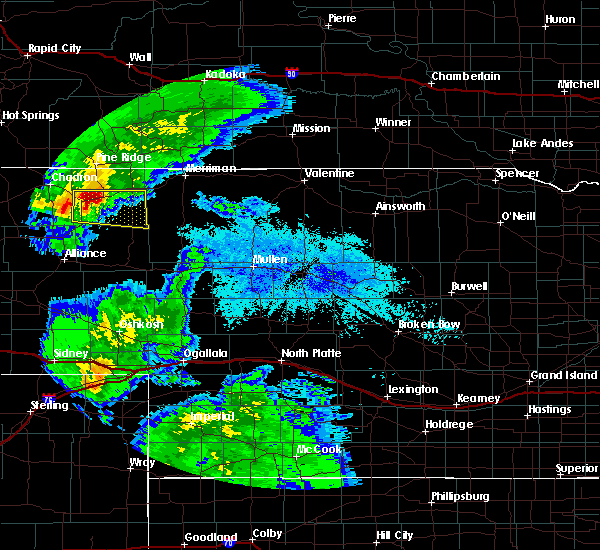 At 825 pm mdt, a severe thunderstorm was located near rushville, moving east at 55 mph (radar indicated). Hazards include 60 mph wind gusts and half dollar size hail. Hail damage to vehicles is expected. Expect wind damage to roofs, siding, and trees. At 825 pm mdt, a severe thunderstorm was located near rushville, moving east at 55 mph (radar indicated). Hazards include 60 mph wind gusts and half dollar size hail. Hail damage to vehicles is expected. Expect wind damage to roofs, siding, and trees.
|
| 7/29/2018 3:34 PM MDT |
 At 334 pm mdt, a severe thunderstorm was located over hay springs, moving southeast at 35 mph (radar indicated). Hazards include 60 mph wind gusts and quarter size hail. Hail damage to vehicles is expected. expect wind damage to roofs, siding, and trees. locations impacted include, hay springs, intersection of beaver creek road and white clay creek road, intersection of highway 87 and antelope road and walgren lake state recreation area. this includes the following highways, highway 20 between mile markers 74 and 85. Highway 250 near mile marker 41. At 334 pm mdt, a severe thunderstorm was located over hay springs, moving southeast at 35 mph (radar indicated). Hazards include 60 mph wind gusts and quarter size hail. Hail damage to vehicles is expected. expect wind damage to roofs, siding, and trees. locations impacted include, hay springs, intersection of beaver creek road and white clay creek road, intersection of highway 87 and antelope road and walgren lake state recreation area. this includes the following highways, highway 20 between mile markers 74 and 85. Highway 250 near mile marker 41.
|
| 7/29/2018 3:22 PM MDT |
 At 322 pm mdt, a severe thunderstorm was located 7 miles northwest of hay springs, moving southeast at 35 mph (radar indicated). Hazards include 60 mph wind gusts and half dollar size hail. Hail damage to vehicles is expected. Expect wind damage to roofs, siding, and trees. At 322 pm mdt, a severe thunderstorm was located 7 miles northwest of hay springs, moving southeast at 35 mph (radar indicated). Hazards include 60 mph wind gusts and half dollar size hail. Hail damage to vehicles is expected. Expect wind damage to roofs, siding, and trees.
|
| 7/27/2018 7:46 PM MDT |
 At 745 pm mdt, a severe thunderstorm was located near pine ridge, moving southeast at 35 mph (radar indicated). Hazards include two inch hail and 60 mph wind gusts. People and animals outdoors will be injured. expect hail damage to roofs, siding, windows, and vehicles. Expect wind damage to roofs, siding, and trees. At 745 pm mdt, a severe thunderstorm was located near pine ridge, moving southeast at 35 mph (radar indicated). Hazards include two inch hail and 60 mph wind gusts. People and animals outdoors will be injured. expect hail damage to roofs, siding, windows, and vehicles. Expect wind damage to roofs, siding, and trees.
|
| 7/25/2018 4:11 AM MDT |
 The severe thunderstorm warning for central sheridan county will expire at 415 am mdt, the storm which prompted the warning has weakened below severe limits, and no longer poses an immediate threat to life or property. therefore, the warning will be allowed to expire. however small hail and gusty winds are still possible with this thunderstorm. The severe thunderstorm warning for central sheridan county will expire at 415 am mdt, the storm which prompted the warning has weakened below severe limits, and no longer poses an immediate threat to life or property. therefore, the warning will be allowed to expire. however small hail and gusty winds are still possible with this thunderstorm.
|
| 7/25/2018 3:50 AM MDT |
 At 349 am mdt, a severe thunderstorm was located near hay springs, moving southeast at 40 mph (radar indicated). Hazards include 60 mph wind gusts and penny size hail. Expect damage to roofs, siding, and trees. locations impacted include, gordon, rushville, hay springs, clinton, lone butte, intersection of beaver creek road and white clay creek road, highway 27 crossing the niobrara river, highway 250 crossing the niobrara river, intersection of highway 87 and antelope road, walgren lake state recreation area and intersection of highway 27 and mills road. this includes the following highways, highway 20 between mile markers 74 and 110. Highway 250 between mile markers 30 and 48. At 349 am mdt, a severe thunderstorm was located near hay springs, moving southeast at 40 mph (radar indicated). Hazards include 60 mph wind gusts and penny size hail. Expect damage to roofs, siding, and trees. locations impacted include, gordon, rushville, hay springs, clinton, lone butte, intersection of beaver creek road and white clay creek road, highway 27 crossing the niobrara river, highway 250 crossing the niobrara river, intersection of highway 87 and antelope road, walgren lake state recreation area and intersection of highway 27 and mills road. this includes the following highways, highway 20 between mile markers 74 and 110. Highway 250 between mile markers 30 and 48.
|
| 7/25/2018 3:33 AM MDT |
 At 333 am mdt, a severe thunderstorm was located near chadron, moving east at 40 mph (radar indicated). Hazards include 60 mph wind gusts and penny size hail. expect damage to roofs, siding, and trees At 333 am mdt, a severe thunderstorm was located near chadron, moving east at 40 mph (radar indicated). Hazards include 60 mph wind gusts and penny size hail. expect damage to roofs, siding, and trees
|
| 7/25/2018 12:24 AM MDT |
 At 1224 am mdt, a severe thunderstorm was located near hay springs, moving east at 30 mph (radar indicated). Hazards include 60 mph wind gusts and penny size hail. Expect damage to roofs, siding, and trees. locations impacted include, rushville, hay springs, clinton, metcalf state wildlife management area, intersection of beaver creek road and white clay creek road, highway 250 crossing the niobrara river, intersection of highway 87 and antelope road and walgren lake state recreation area. this includes the following highways, highway 20 between mile markers 74 and 102. Highway 250 between mile markers 36 and 48. At 1224 am mdt, a severe thunderstorm was located near hay springs, moving east at 30 mph (radar indicated). Hazards include 60 mph wind gusts and penny size hail. Expect damage to roofs, siding, and trees. locations impacted include, rushville, hay springs, clinton, metcalf state wildlife management area, intersection of beaver creek road and white clay creek road, highway 250 crossing the niobrara river, intersection of highway 87 and antelope road and walgren lake state recreation area. this includes the following highways, highway 20 between mile markers 74 and 102. Highway 250 between mile markers 36 and 48.
|
| 7/25/2018 12:01 AM MDT |
 The national weather service in north platte has issued a * severe thunderstorm warning for. northwestern sheridan county in the panhandle of nebraska. until 1245 am mdt. At 1200 am mdt, a severe thunderstorm was located near chadron, moving east at 40 mph. The national weather service in north platte has issued a * severe thunderstorm warning for. northwestern sheridan county in the panhandle of nebraska. until 1245 am mdt. At 1200 am mdt, a severe thunderstorm was located near chadron, moving east at 40 mph.
|
| 7/16/2018 5:56 PM MDT | Quarter sized hail reported 6.6 miles W of Hay Springs, NE, pea to quarter size hail... lots of rain. |
| 6/28/2018 4:45 PM MDT | Quarter sized hail reported 12.8 miles N of Hay Springs, NE, largest hail size estimated 1 inch. |
| 5/10/2018 4:25 PM MDT |
 At 424 pm mdt, a severe thunderstorm was located 8 miles north of hay springs, moving east at 30 mph (radar indicated). Hazards include two inch hail. People and animals outdoors will be injured. Expect damage to roofs, siding, windows, and vehicles. At 424 pm mdt, a severe thunderstorm was located 8 miles north of hay springs, moving east at 30 mph (radar indicated). Hazards include two inch hail. People and animals outdoors will be injured. Expect damage to roofs, siding, windows, and vehicles.
|
| 7/6/2017 10:55 PM MDT |
 The severe thunderstorm warning for northwestern sheridan county will expire at 1100 pm mdt, the storms which prompted the warning have weakened below severe limits, and no longer pose an immediate threat to life or property. therefore the warning will be allowed to expire. however gusty winds are still possible with these thunderstorms. The severe thunderstorm warning for northwestern sheridan county will expire at 1100 pm mdt, the storms which prompted the warning have weakened below severe limits, and no longer pose an immediate threat to life or property. therefore the warning will be allowed to expire. however gusty winds are still possible with these thunderstorms.
|
| 7/6/2017 10:28 PM MDT |
 At 1028 pm mdt, severe thunderstorms were located along a line extending from near white clay to 12 miles northeast of box butte dam, moving east at 40 mph (radar indicated). Hazards include 60 mph wind gusts. Expect damage to roofs, siding, and trees. locations impacted include, gordon, rushville, hay springs, white clay, clinton, intersection of highway 87 and craven creek road, lone butte, intersection of beaver creek road and white clay creek road, intersection of highway 87 and larabee road, mount maria, highway 250 crossing the niobrara river, walgren lake state recreation area, pine ridge, hoover lake, metcalf state wildlife management area, intersection of highway 87 and antelope road and smith lake state wildlife management area. this includes the following highways, highway 20 between mile markers 74 and 105. Highway 250 between mile markers 28 and 48. At 1028 pm mdt, severe thunderstorms were located along a line extending from near white clay to 12 miles northeast of box butte dam, moving east at 40 mph (radar indicated). Hazards include 60 mph wind gusts. Expect damage to roofs, siding, and trees. locations impacted include, gordon, rushville, hay springs, white clay, clinton, intersection of highway 87 and craven creek road, lone butte, intersection of beaver creek road and white clay creek road, intersection of highway 87 and larabee road, mount maria, highway 250 crossing the niobrara river, walgren lake state recreation area, pine ridge, hoover lake, metcalf state wildlife management area, intersection of highway 87 and antelope road and smith lake state wildlife management area. this includes the following highways, highway 20 between mile markers 74 and 105. Highway 250 between mile markers 28 and 48.
|
| 7/6/2017 10:11 PM MDT |
 At 1009 pm mdt, severe thunderstorms were located along a line extending from near slim butte to 10 miles southwest of hemingford, moving east at 40 mph (radar indicated. at 1002 pm, a 63 mph wind gust was reported at chadron airport). Hazards include 60 mph wind gusts. expect damage to roofs, siding, and trees At 1009 pm mdt, severe thunderstorms were located along a line extending from near slim butte to 10 miles southwest of hemingford, moving east at 40 mph (radar indicated. at 1002 pm, a 63 mph wind gust was reported at chadron airport). Hazards include 60 mph wind gusts. expect damage to roofs, siding, and trees
|
| 7/2/2017 4:50 PM MDT | Quarter sized hail reported 0.3 miles N of Hay Springs, NE |
| 7/2/2017 4:41 PM MDT |
 At 441 pm mdt, a severe thunderstorm was located over hay springs, moving east at 25 mph (radar indicated). Hazards include quarter size hail. damage to vehicles is expected At 441 pm mdt, a severe thunderstorm was located over hay springs, moving east at 25 mph (radar indicated). Hazards include quarter size hail. damage to vehicles is expected
|
| 6/27/2017 10:27 AM MDT |
 At 427 pm mdt, a severe thunderstorm was located near hay springs, moving northeast at 45 mph (radar indicated). Hazards include golf ball size hail and 60 mph wind gusts. People and animals outdoors will be injured. expect hail damage to roofs, siding, windows, and vehicles. Expect wind damage to roofs, siding, and trees. At 427 pm mdt, a severe thunderstorm was located near hay springs, moving northeast at 45 mph (radar indicated). Hazards include golf ball size hail and 60 mph wind gusts. People and animals outdoors will be injured. expect hail damage to roofs, siding, windows, and vehicles. Expect wind damage to roofs, siding, and trees.
|
| 6/12/2017 8:25 PM MDT |
 At 824 pm mdt, doppler radar indicated a severe thunderstorm capable of producing large hail up to ping pong ball size. this storm was located near hay springs, and moving northeast at 35 mph. At 824 pm mdt, doppler radar indicated a severe thunderstorm capable of producing large hail up to ping pong ball size. this storm was located near hay springs, and moving northeast at 35 mph.
|
| 6/12/2017 8:03 PM MDT |
 At 742 pm mdt, doppler radar indicated a severe thunderstorm capable of producing large damaging hail up to two inches in diameter. this storm was located 8 miles southeast of hay springs, and moving northeast at 20 mph. At 742 pm mdt, doppler radar indicated a severe thunderstorm capable of producing large damaging hail up to two inches in diameter. this storm was located 8 miles southeast of hay springs, and moving northeast at 20 mph.
|
| 6/12/2017 7:43 PM MDT |
 At 742 pm mdt, doppler radar indicated a severe thunderstorm capable of producing large damaging hail up to two inches in diameter. this storm was located 8 miles southeast of hay springs, and moving northeast at 20 mph. At 742 pm mdt, doppler radar indicated a severe thunderstorm capable of producing large damaging hail up to two inches in diameter. this storm was located 8 miles southeast of hay springs, and moving northeast at 20 mph.
|
| 6/12/2017 7:19 PM MDT |
 At 718 pm mdt, doppler radar indicated a severe thunderstorm capable of producing large destructive hail up to tennis ball size and damaging winds in excess of 60 mph. this storm was located 13 miles south of hay springs, moving northeast at 10 mph. locations impacted include, rushville, hay springs, clinton, diamond lake, metcalf state wildlife management area, intersection of beaver creek road and white clay creek road, smith lake state wildlife management area, highway 250 crossing the niobrara river, intersection of highway 87 and antelope road and walgren lake state recreation area. this includes the following highways, highway 20 between mile markers 74 and 100. highway 250 between mile markers 25 and 48. a tornado watch remains in effect until 200 am mdt for the panhandle of nebraska. At 718 pm mdt, doppler radar indicated a severe thunderstorm capable of producing large destructive hail up to tennis ball size and damaging winds in excess of 60 mph. this storm was located 13 miles south of hay springs, moving northeast at 10 mph. locations impacted include, rushville, hay springs, clinton, diamond lake, metcalf state wildlife management area, intersection of beaver creek road and white clay creek road, smith lake state wildlife management area, highway 250 crossing the niobrara river, intersection of highway 87 and antelope road and walgren lake state recreation area. this includes the following highways, highway 20 between mile markers 74 and 100. highway 250 between mile markers 25 and 48. a tornado watch remains in effect until 200 am mdt for the panhandle of nebraska.
|
| 6/12/2017 7:06 PM MDT |
 At 706 pm mdt, doppler radar indicated a severe thunderstorm capable of producing large destructive hail up to tennis ball size. this storm was located 14 miles northeast of wild horse butte, or 16 miles south of hay springs, moving northeast at 25 mph. locations impacted include, rushville, hay springs, clinton, diamond lake, metcalf state wildlife management area, intersection of beaver creek road and white clay creek road, smith lake state wildlife management area, highway 250 crossing the niobrara river, intersection of highway 87 and antelope road and walgren lake state recreation area. this includes the following highways, highway 20 between mile markers 74 and 100. highway 250 between mile markers 25 and 48. a tornado watch remains in effect until 200 am mdt for the panhandle of nebraska. At 706 pm mdt, doppler radar indicated a severe thunderstorm capable of producing large destructive hail up to tennis ball size. this storm was located 14 miles northeast of wild horse butte, or 16 miles south of hay springs, moving northeast at 25 mph. locations impacted include, rushville, hay springs, clinton, diamond lake, metcalf state wildlife management area, intersection of beaver creek road and white clay creek road, smith lake state wildlife management area, highway 250 crossing the niobrara river, intersection of highway 87 and antelope road and walgren lake state recreation area. this includes the following highways, highway 20 between mile markers 74 and 100. highway 250 between mile markers 25 and 48. a tornado watch remains in effect until 200 am mdt for the panhandle of nebraska.
|
| 6/12/2017 6:57 PM MDT |
 At 656 pm mdt, doppler radar indicated a severe thunderstorm capable of producing large damaging hail up to two inches in diameter. this storm was located 8 miles northeast of wild horse butte, or 18 miles north of alliance, and moving northeast at 40 mph. At 656 pm mdt, doppler radar indicated a severe thunderstorm capable of producing large damaging hail up to two inches in diameter. this storm was located 8 miles northeast of wild horse butte, or 18 miles north of alliance, and moving northeast at 40 mph.
|
| 10/3/2016 4:11 PM MDT |
 The severe thunderstorm warning for central sheridan county will expire at 415 pm mdt, the storm which prompted the warning has weakened below severe limits, and no longer pose an immediate threat to life or property. therefore the warning will be allowed to expire. however heavy rain is still possible with this thunderstorm. a severe thunderstorm watch remains in effect until 900 pm mdt for the panhandle of nebraska. to report severe weather, contact your nearest law enforcement agency. they will relay your report to the national weather service north platte. The severe thunderstorm warning for central sheridan county will expire at 415 pm mdt, the storm which prompted the warning has weakened below severe limits, and no longer pose an immediate threat to life or property. therefore the warning will be allowed to expire. however heavy rain is still possible with this thunderstorm. a severe thunderstorm watch remains in effect until 900 pm mdt for the panhandle of nebraska. to report severe weather, contact your nearest law enforcement agency. they will relay your report to the national weather service north platte.
|
| 10/3/2016 3:57 PM MDT |
 At 338 pm mdt, a severe thunderstorm was located 16 miles northeast of wild horse butte, or 23 miles south of hay springs, moving northeast at 45 mph (radar indicated). Hazards include 60 mph wind gusts and quarter size hail. Hail damage to vehicles is expected. expect wind damage to roofs, siding, and trees. Locations impacted include, hay springs, intersection of highway 87 and antelope road, walgren lake state recreation area, diamond lake, highway 250 crossing the niobrara river, intersection of beaver creek road and white clay creek road and smith lake state wildlife management area. At 338 pm mdt, a severe thunderstorm was located 16 miles northeast of wild horse butte, or 23 miles south of hay springs, moving northeast at 45 mph (radar indicated). Hazards include 60 mph wind gusts and quarter size hail. Hail damage to vehicles is expected. expect wind damage to roofs, siding, and trees. Locations impacted include, hay springs, intersection of highway 87 and antelope road, walgren lake state recreation area, diamond lake, highway 250 crossing the niobrara river, intersection of beaver creek road and white clay creek road and smith lake state wildlife management area.
|
| 10/3/2016 3:39 PM MDT |
 At 338 pm mdt, a severe thunderstorm was located 16 miles northeast of wild horse butte, or 23 miles south of hay springs, moving northeast at 45 mph (radar indicated). Hazards include 60 mph wind gusts and quarter size hail. Hail damage to vehicles is expected. expect wind damage to roofs, siding, and trees. Locations impacted include, hay springs, intersection of highway 87 and antelope road, walgren lake state recreation area, diamond lake, highway 250 crossing the niobrara river, intersection of beaver creek road and white clay creek road and smith lake state wildlife management area. At 338 pm mdt, a severe thunderstorm was located 16 miles northeast of wild horse butte, or 23 miles south of hay springs, moving northeast at 45 mph (radar indicated). Hazards include 60 mph wind gusts and quarter size hail. Hail damage to vehicles is expected. expect wind damage to roofs, siding, and trees. Locations impacted include, hay springs, intersection of highway 87 and antelope road, walgren lake state recreation area, diamond lake, highway 250 crossing the niobrara river, intersection of beaver creek road and white clay creek road and smith lake state wildlife management area.
|
| 10/3/2016 3:18 PM MDT |
 At 318 pm mdt, a severe thunderstorm was located near wild horse butte, or 12 miles north of alliance, moving northeast at 35 mph (radar indicated). Hazards include 60 mph wind gusts and quarter size hail. Hail damage to vehicles is expected. Expect wind damage to roofs, siding, and trees. At 318 pm mdt, a severe thunderstorm was located near wild horse butte, or 12 miles north of alliance, moving northeast at 35 mph (radar indicated). Hazards include 60 mph wind gusts and quarter size hail. Hail damage to vehicles is expected. Expect wind damage to roofs, siding, and trees.
|
| 7/26/2016 8:00 PM MDT |
 At 800 pm mdt, severe thunderstorms were located along a line extending from gordon to 14 miles northeast of wild horse butte, moving southeast at 25 mph (public). Hazards include golf ball size hail and 60 mph wind gusts. People and animals outdoors will be injured. expect hail damage to roofs, siding, windows, and vehicles. expect wind damage to roofs, siding, and trees. locations impacted include, gordon, rushville, hay springs, clinton, lone butte, walgren lake state recreation area, diamond lake, intersection of beaver creek road and white clay creek road, smith lake state wildlife management area, intersection of highway 87 and antelope road, intersection of highway 27 and mills road, hoover lake, highway 27 crossing the niobrara river and highway 250 crossing the niobrara river. this includes the following highways, highway 20 between mile markers 76 and 112. Highway 250 between mile markers 19 and 48. At 800 pm mdt, severe thunderstorms were located along a line extending from gordon to 14 miles northeast of wild horse butte, moving southeast at 25 mph (public). Hazards include golf ball size hail and 60 mph wind gusts. People and animals outdoors will be injured. expect hail damage to roofs, siding, windows, and vehicles. expect wind damage to roofs, siding, and trees. locations impacted include, gordon, rushville, hay springs, clinton, lone butte, walgren lake state recreation area, diamond lake, intersection of beaver creek road and white clay creek road, smith lake state wildlife management area, intersection of highway 87 and antelope road, intersection of highway 27 and mills road, hoover lake, highway 27 crossing the niobrara river and highway 250 crossing the niobrara river. this includes the following highways, highway 20 between mile markers 76 and 112. Highway 250 between mile markers 19 and 48.
|
| 7/26/2016 7:55 PM MDT | Ping Pong Ball sized hail reported 12 miles N of Hay Springs, NE, winds were estimated at between 40 and 50 mph. |
| 7/26/2016 7:38 PM MDT |
 At 737 pm mdt, severe thunderstorms were located along a line extending from 10 miles south of white clay to 13 miles south of hay springs, moving southeast at 30 mph (public). Hazards include golf ball size hail and 60 mph wind gusts. People and animals outdoors will be injured. expect hail damage to roofs, siding, windows, and vehicles. expect wind damage to roofs, siding, and trees. locations impacted include, gordon, rushville, hay springs, clinton, lone butte, walgren lake state recreation area, diamond lake, intersection of beaver creek road and white clay creek road, smith lake state wildlife management area, intersection of highway 87 and antelope road, intersection of highway 27 and mills road, intersection of highway 87 and larabee road, hoover lake, highway 27 crossing the niobrara river, mount maria and highway 250 crossing the niobrara river. this includes the following highways, highway 20 between mile markers 76 and 112. Highway 250 between mile markers 19 and 48. At 737 pm mdt, severe thunderstorms were located along a line extending from 10 miles south of white clay to 13 miles south of hay springs, moving southeast at 30 mph (public). Hazards include golf ball size hail and 60 mph wind gusts. People and animals outdoors will be injured. expect hail damage to roofs, siding, windows, and vehicles. expect wind damage to roofs, siding, and trees. locations impacted include, gordon, rushville, hay springs, clinton, lone butte, walgren lake state recreation area, diamond lake, intersection of beaver creek road and white clay creek road, smith lake state wildlife management area, intersection of highway 87 and antelope road, intersection of highway 27 and mills road, intersection of highway 87 and larabee road, hoover lake, highway 27 crossing the niobrara river, mount maria and highway 250 crossing the niobrara river. this includes the following highways, highway 20 between mile markers 76 and 112. Highway 250 between mile markers 19 and 48.
|
| 7/26/2016 7:36 PM MDT | Golf Ball sized hail reported 4 miles NE of Hay Springs, NE |
| 7/26/2016 7:30 PM MDT |
 At 729 pm mdt, severe thunderstorms were located along a line extending from 8 miles southeast of white clay to near hay springs, moving southeast at 25 mph (radar indicated). Hazards include golf ball size hail and 60 mph wind gusts. People and animals outdoors will be injured. expect hail damage to roofs, siding, windows, and vehicles. Expect wind damage to roofs, siding, and trees. At 729 pm mdt, severe thunderstorms were located along a line extending from 8 miles southeast of white clay to near hay springs, moving southeast at 25 mph (radar indicated). Hazards include golf ball size hail and 60 mph wind gusts. People and animals outdoors will be injured. expect hail damage to roofs, siding, windows, and vehicles. Expect wind damage to roofs, siding, and trees.
|
| 7/26/2016 7:20 PM MDT | Golf Ball sized hail reported 5.9 miles S of Hay Springs, NE, winds were estimated at around 50 mph. |
| 7/26/2016 7:19 PM MDT |
 At 719 pm mdt, a severe thunderstorm was located 8 miles north of hay springs, moving southeast at 30 mph (radar indicated). Hazards include golf ball size hail and 60 mph wind gusts. People and animals outdoors will be injured. expect hail damage to roofs, siding, windows, and vehicles. expect wind damage to roofs, siding, and trees. locations impacted include, gordon, rushville, hay springs, white clay, clinton, pine ridge, lone butte, metcalf state wildlife management area, intersection of highway 87 and craven creek road, walgren lake state recreation area, intersection of beaver creek road and white clay creek road, intersection of highway 87 and antelope road, intersection of highway 87 and larabee road, mount maria and highway 250 crossing the niobrara river. this includes the following highways, highway 20 between mile markers 74 and 105. Highway 250 between mile markers 34 and 48. At 719 pm mdt, a severe thunderstorm was located 8 miles north of hay springs, moving southeast at 30 mph (radar indicated). Hazards include golf ball size hail and 60 mph wind gusts. People and animals outdoors will be injured. expect hail damage to roofs, siding, windows, and vehicles. expect wind damage to roofs, siding, and trees. locations impacted include, gordon, rushville, hay springs, white clay, clinton, pine ridge, lone butte, metcalf state wildlife management area, intersection of highway 87 and craven creek road, walgren lake state recreation area, intersection of beaver creek road and white clay creek road, intersection of highway 87 and antelope road, intersection of highway 87 and larabee road, mount maria and highway 250 crossing the niobrara river. this includes the following highways, highway 20 between mile markers 74 and 105. Highway 250 between mile markers 34 and 48.
|
| 7/26/2016 7:13 PM MDT | Golf Ball sized hail reported 10.8 miles SSE of Hay Springs, NE, winds were also estimated at between 50 and 60 mph. |
| 7/26/2016 7:00 PM MDT |
 At 700 pm mdt, a severe thunderstorm was located 10 miles northeast of chadron, moving southeast at 25 mph (radar indicated). Hazards include golf ball size hail and 60 mph wind gusts. People and animals outdoors will be injured. expect hail damage to roofs, siding, windows, and vehicles. Expect wind damage to roofs, siding, and trees. At 700 pm mdt, a severe thunderstorm was located 10 miles northeast of chadron, moving southeast at 25 mph (radar indicated). Hazards include golf ball size hail and 60 mph wind gusts. People and animals outdoors will be injured. expect hail damage to roofs, siding, windows, and vehicles. Expect wind damage to roofs, siding, and trees.
|
| 7/10/2016 8:35 PM MDT | Storm damage reported in sheridan county NE, 10.7 miles S of Hay Springs, NE |
| 7/10/2016 8:20 PM MDT |
 At 820 pm mdt, a severe thunderstorm was located 9 miles east of chadron, moving northeast at 30 mph (radar indicated). Hazards include 60 mph wind gusts. Expect damage to roofs. siding. And trees. At 820 pm mdt, a severe thunderstorm was located 9 miles east of chadron, moving northeast at 30 mph (radar indicated). Hazards include 60 mph wind gusts. Expect damage to roofs. siding. And trees.
|
| 7/6/2016 3:25 PM MDT | Quarter sized hail reported 14.8 miles N of Hay Springs, NE |
| 6/28/2016 5:57 PM MDT |
 At 556 pm mdt, severe thunderstorms were located along a line extending from 8 miles south of batesland to 8 miles southwest of gordon to 14 miles southeast of hay springs to near hemingford, moving southeast at 60 mph. these are very dangerous storms (radar indicated). Hazards include 80 mph wind gusts and quarter size hail. Flying debris will be dangerous to those caught without shelter. mobile homes will be heavily damaged. expect considerable damage to roofs, windows, and vehicles. Extensive tree damage and power outages are likely. At 556 pm mdt, severe thunderstorms were located along a line extending from 8 miles south of batesland to 8 miles southwest of gordon to 14 miles southeast of hay springs to near hemingford, moving southeast at 60 mph. these are very dangerous storms (radar indicated). Hazards include 80 mph wind gusts and quarter size hail. Flying debris will be dangerous to those caught without shelter. mobile homes will be heavily damaged. expect considerable damage to roofs, windows, and vehicles. Extensive tree damage and power outages are likely.
|
| 6/28/2016 5:43 PM MDT | Estimated wind speeds of between 60 and 70 mph in sheridan county NE, 1.1 miles ESE of Hay Springs, NE |
| 6/28/2016 5:39 PM MDT |
 At 538 pm mdt, severe thunderstorms were located along a line extending from 6 miles southwest of white clay to 8 miles east of box butte dam, moving southeast at 75 mph. these are very dangerous storms (radar indicated). Hazards include 80 mph wind gusts and quarter size hail. Flying debris will be dangerous to those caught without shelter. mobile homes will be heavily damaged. expect considerable damage to roofs, windows, and vehicles. extensive tree damage and power outages are likely. locations impacted include, rushville, hay springs, white clay, clinton, pine ridge, metcalf state wildlife management area, intersection of highway 87 and craven creek road, walgren lake state recreation area, intersection of beaver creek road and white clay creek road, smith lake state wildlife management area, intersection of highway 87 and antelope road, intersection of highway 87 and larabee road, krause lake, mount maria, wickson lake and highway 250 crossing the niobrara river. this includes the following highways, highway 20 between mile markers 74 and 98. Highway 250 between mile markers 24 and 48. At 538 pm mdt, severe thunderstorms were located along a line extending from 6 miles southwest of white clay to 8 miles east of box butte dam, moving southeast at 75 mph. these are very dangerous storms (radar indicated). Hazards include 80 mph wind gusts and quarter size hail. Flying debris will be dangerous to those caught without shelter. mobile homes will be heavily damaged. expect considerable damage to roofs, windows, and vehicles. extensive tree damage and power outages are likely. locations impacted include, rushville, hay springs, white clay, clinton, pine ridge, metcalf state wildlife management area, intersection of highway 87 and craven creek road, walgren lake state recreation area, intersection of beaver creek road and white clay creek road, smith lake state wildlife management area, intersection of highway 87 and antelope road, intersection of highway 87 and larabee road, krause lake, mount maria, wickson lake and highway 250 crossing the niobrara river. this includes the following highways, highway 20 between mile markers 74 and 98. Highway 250 between mile markers 24 and 48.
|
| 6/28/2016 5:20 PM MDT |
 At 519 pm mdt, severe thunderstorms were located along a line extending from 9 miles east of oelrichs to 6 miles south of whitney lake, moving southeast at 55 mph. these are very dangerous storms (radar indicated). Hazards include 90 mph wind gusts and ping pong ball size hail. You are in a life-threatening situation. flying debris may be deadly to those caught without shelter. mobile homes will be heavily damaged or destroyed. homes and businesses will have substantial roof and window damage. Expect extensive tree damage and power outages. At 519 pm mdt, severe thunderstorms were located along a line extending from 9 miles east of oelrichs to 6 miles south of whitney lake, moving southeast at 55 mph. these are very dangerous storms (radar indicated). Hazards include 90 mph wind gusts and ping pong ball size hail. You are in a life-threatening situation. flying debris may be deadly to those caught without shelter. mobile homes will be heavily damaged or destroyed. homes and businesses will have substantial roof and window damage. Expect extensive tree damage and power outages.
|
| 7/2/2015 12:03 AM MDT |
 At midnight mdt, a severe thunderstorm was located 11 miles south of pine ridge, and moving southeast at 35 mph (radar indicated). Hazards include 60 mph wind gusts and quarter size hail. Hail damage to vehicles is expected. expect wind damage to roofs, siding and trees. locations impacted include, intersection of beaver creek road and white clay creek road and mount maria. This includes highway 20 between mile markers 74 and 78. At midnight mdt, a severe thunderstorm was located 11 miles south of pine ridge, and moving southeast at 35 mph (radar indicated). Hazards include 60 mph wind gusts and quarter size hail. Hail damage to vehicles is expected. expect wind damage to roofs, siding and trees. locations impacted include, intersection of beaver creek road and white clay creek road and mount maria. This includes highway 20 between mile markers 74 and 78.
|
| 7/1/2015 11:50 PM MDT |
 At 1148 pm mdt, a severe thunderstorm was located 11 miles southwest of pine ridge, and moving southeast at 35 mph (radar indicated). Hazards include 60 mph wind gusts and quarter size hail. Hail damage to vehicles is expected. expect wind damage to roofs, siding and trees. locations impacted include, white clay, intersection of highway 87 and craven creek road, intersection of highway 87 and larabee road, metcalf state wildlife management area, intersection of beaver creek road and white clay creek road and mount maria. This includes highway 20 between mile markers 74 and 78. At 1148 pm mdt, a severe thunderstorm was located 11 miles southwest of pine ridge, and moving southeast at 35 mph (radar indicated). Hazards include 60 mph wind gusts and quarter size hail. Hail damage to vehicles is expected. expect wind damage to roofs, siding and trees. locations impacted include, white clay, intersection of highway 87 and craven creek road, intersection of highway 87 and larabee road, metcalf state wildlife management area, intersection of beaver creek road and white clay creek road and mount maria. This includes highway 20 between mile markers 74 and 78.
|
| 7/1/2015 11:30 PM MDT |
 At 1129 pm mdt, a severe thunderstorm was located 18 miles west of pine ridge, and moving southeast at 35 mph (radar indicated). Hazards include 60 mph wind gusts and quarter size hail. Hail damage to vehicles is expected. Expect wind damage to roofs, siding and trees. At 1129 pm mdt, a severe thunderstorm was located 18 miles west of pine ridge, and moving southeast at 35 mph (radar indicated). Hazards include 60 mph wind gusts and quarter size hail. Hail damage to vehicles is expected. Expect wind damage to roofs, siding and trees.
|
| 6/25/2015 5:07 PM MDT |
 At 505 pm mdt, severe thunderstorms were located along a line extending from 9 miles southeast of gordon to 15 miles south of rushville, and moving southeast at 25 mph (radar indicated). Hazards include 60 mph wind gusts and quarter size hail. Hail damage to vehicles is expected. expect wind damage to roofs, siding and trees. locations impacted include, bayonne, rock hill and intersection of highway 20 and irwin road. This includes highway 20 between mile markers 77 and 121. At 505 pm mdt, severe thunderstorms were located along a line extending from 9 miles southeast of gordon to 15 miles south of rushville, and moving southeast at 25 mph (radar indicated). Hazards include 60 mph wind gusts and quarter size hail. Hail damage to vehicles is expected. expect wind damage to roofs, siding and trees. locations impacted include, bayonne, rock hill and intersection of highway 20 and irwin road. This includes highway 20 between mile markers 77 and 121.
|
| 6/25/2015 4:47 PM MDT |
 At 444 pm mdt, severe thunderstorms were located along a line extending from 6 miles northwest of gordon to hay springs, and moving southeast at 25 mph (radar indicated). Hazards include 60 mph wind gusts and quarter size hail. Hail damage to vehicles is expected. Expect wind damage to roofs, siding and trees. At 444 pm mdt, severe thunderstorms were located along a line extending from 6 miles northwest of gordon to hay springs, and moving southeast at 25 mph (radar indicated). Hazards include 60 mph wind gusts and quarter size hail. Hail damage to vehicles is expected. Expect wind damage to roofs, siding and trees.
|
| 6/24/2015 3:04 AM MDT |
 At 302 am mdt, a severe thunderstorm was located 9 miles southwest of pine ridge, and moving east at 35 mph (radar indicated). Hazards include ping pong ball size hail. People and animals outdoors will be injured. expect damage to roofs, siding, windows and vehicles. The severe thunderstorm will affect mainly rural areas of northern sheridan county, including the following locations, white clay, intersection of highway 87 and larabee road, intersection of highway 87 and craven creek road and mount maria. At 302 am mdt, a severe thunderstorm was located 9 miles southwest of pine ridge, and moving east at 35 mph (radar indicated). Hazards include ping pong ball size hail. People and animals outdoors will be injured. expect damage to roofs, siding, windows and vehicles. The severe thunderstorm will affect mainly rural areas of northern sheridan county, including the following locations, white clay, intersection of highway 87 and larabee road, intersection of highway 87 and craven creek road and mount maria.
|
| 6/24/2015 2:45 AM MDT |
 At 240 am mdt, a severe thunderstorm was located 6 miles south of pine ridge, and moving northeast at 45 mph (radar indicated). Hazards include ping pong ball size hail. People and animals outdoors will be injured. expect damage to roofs, siding, windows and vehicles. The severe thunderstorm will affect mainly rural areas of northern sheridan county. At 240 am mdt, a severe thunderstorm was located 6 miles south of pine ridge, and moving northeast at 45 mph (radar indicated). Hazards include ping pong ball size hail. People and animals outdoors will be injured. expect damage to roofs, siding, windows and vehicles. The severe thunderstorm will affect mainly rural areas of northern sheridan county.
|
| 6/24/2015 2:37 AM MDT |
 At 230 am mdt, a severe thunderstorm was located 12 miles south of pine ridge, and moving northeast at 35 mph (radar indicated). Hazards include ping pong ball size hail. People and animals outdoors will be injured. expect damage to roofs, siding, windows and vehicles. The severe thunderstorm will affect mainly rural areas of northern sheridan county, including the following locations, intersection of highway 87 and craven creek road and white clay. At 230 am mdt, a severe thunderstorm was located 12 miles south of pine ridge, and moving northeast at 35 mph (radar indicated). Hazards include ping pong ball size hail. People and animals outdoors will be injured. expect damage to roofs, siding, windows and vehicles. The severe thunderstorm will affect mainly rural areas of northern sheridan county, including the following locations, intersection of highway 87 and craven creek road and white clay.
|
| 6/24/2015 2:21 AM MDT |
 At 216 am mdt, a severe thunderstorm was located 9 miles northwest of hay springs, and moving northeast at 35 mph (radar indicated). Hazards include ping pong ball size hail. People and animals outdoors will be injured. Expect damage to roofs, siding, windows and vehicles. At 216 am mdt, a severe thunderstorm was located 9 miles northwest of hay springs, and moving northeast at 35 mph (radar indicated). Hazards include ping pong ball size hail. People and animals outdoors will be injured. Expect damage to roofs, siding, windows and vehicles.
|
| 6/18/2015 12:36 AM MDT |
 At 1233 am mdt, a severe thunderstorm was located 7 miles southwest of pine ridge, and moving southeast at 45 mph (trained weather spotters). Hazards include 60 mph wind gusts and quarter size hail. Hail damage to vehicles is expected. expect wind damage to roofs, siding and trees. locations impacted include, hay springs, rushville, gordon, clinton, metcalf state wildlife management area, intersection of highway 87 and larabee road, intersection of beaver creek road and white clay creek road, mount maria, intersection of highway 87 and antelope road, walgren lake state recreation area, hoover lake, highway 250 crossing the niobrara river, lone butte, intersection of highway 27 and mills road, highway 27 crossing the niobrara river, billys lake and big hill. This includes highway 20 between mile markers 74 and 112. At 1233 am mdt, a severe thunderstorm was located 7 miles southwest of pine ridge, and moving southeast at 45 mph (trained weather spotters). Hazards include 60 mph wind gusts and quarter size hail. Hail damage to vehicles is expected. expect wind damage to roofs, siding and trees. locations impacted include, hay springs, rushville, gordon, clinton, metcalf state wildlife management area, intersection of highway 87 and larabee road, intersection of beaver creek road and white clay creek road, mount maria, intersection of highway 87 and antelope road, walgren lake state recreation area, hoover lake, highway 250 crossing the niobrara river, lone butte, intersection of highway 27 and mills road, highway 27 crossing the niobrara river, billys lake and big hill. This includes highway 20 between mile markers 74 and 112.
|
| 6/18/2015 12:16 AM MDT |
 At 1215 am mdt, a severe thunderstorm was located 14 miles west of pine ridge, and moving southeast at 40 mph (trained weather spotters). Hazards include 60 mph wind gusts and quarter size hail. Hail damage to vehicles is expected. Expect wind damage to roofs, siding and trees. At 1215 am mdt, a severe thunderstorm was located 14 miles west of pine ridge, and moving southeast at 40 mph (trained weather spotters). Hazards include 60 mph wind gusts and quarter size hail. Hail damage to vehicles is expected. Expect wind damage to roofs, siding and trees.
|
| 6/17/2015 8:29 PM MDT |
 At 828 pm mdt, severe thunderstorms were located along a line extending from 10 miles northwest of clinton to 9 miles southwest of hay springs, and moving east at 25 mph (radar indicated). Hazards include 60 mph wind gusts and quarter size hail. Hail damage to vehicles is expected. expect wind damage to roofs, siding and trees. locations impacted include, hay springs, rushville, clinton, intersection of highway 87 and antelope road, walgren lake state recreation area and highway 250 crossing the niobrara river. This includes highway 20 between mile markers 74 and 104. At 828 pm mdt, severe thunderstorms were located along a line extending from 10 miles northwest of clinton to 9 miles southwest of hay springs, and moving east at 25 mph (radar indicated). Hazards include 60 mph wind gusts and quarter size hail. Hail damage to vehicles is expected. expect wind damage to roofs, siding and trees. locations impacted include, hay springs, rushville, clinton, intersection of highway 87 and antelope road, walgren lake state recreation area and highway 250 crossing the niobrara river. This includes highway 20 between mile markers 74 and 104.
|
| 6/17/2015 8:06 PM MDT |
 At 804 pm mdt, severe thunderstorms were located along a line extending from 12 miles southwest of pine ridge to 18 miles west of hay springs, and moving east at 25 mph (radar indicated). Hazards include 60 mph wind gusts and quarter size hail. Hail damage to vehicles is expected. Expect wind damage to roofs, siding and trees. At 804 pm mdt, severe thunderstorms were located along a line extending from 12 miles southwest of pine ridge to 18 miles west of hay springs, and moving east at 25 mph (radar indicated). Hazards include 60 mph wind gusts and quarter size hail. Hail damage to vehicles is expected. Expect wind damage to roofs, siding and trees.
|
| 5/15/2015 5:27 PM MDT | At 524 pm mdt, a severe thunderstorm was located 14 miles south of hay springs, and moving north at 25 mph (radar indicated). Hazards include 60 mph wind gusts and quarter size hail. Hail damage to vehicles is expected. expect wind damage to roofs, siding and trees. locations impacted include, hay springs, intersection of highway 87 and antelope road and walgren lake state recreation area. this includes highway 20 between mile markers 77 and 85. 1. 00in. |
| 5/15/2015 5:20 PM MDT | Baseball sized hail reported 18.3 miles N of Hay Springs, NE, hail ranged from golf ball to baseball size |
| 5/15/2015 5:14 PM MDT | At 513 pm mdt, a severe thunderstorm was located 18 miles south of hay springs, and moving north at 25 mph (radar indicated). Hazards include 60 mph wind gusts and quarter size hail. Hail damage to vehicles is expected. expect wind damage to roofs, siding and trees. locations impacted include, hay springs, intersection of highway 87 and antelope road and walgren lake state recreation area. this includes highway 20 between mile markers 77 and 85. 1. 00in. |
| 5/15/2015 5:01 PM MDT | At 457 pm mdt, a severe thunderstorm was located 22 miles north of antioch and moving northwest at 25 mph (radar indicated). Hazards include 60 mph wind gusts and half dollar size hail. Hail damage to vehicles is expected. Expect wind damage to roofs, siding and trees. |
| 6/4/2014 7:05 PM MDT | Half Dollar sized hail reported 3.9 miles SW of Hay Springs, NE |
| 8/30/2013 5:50 PM MDT | Golf Ball sized hail reported 2.7 miles SE of Hay Springs, NE, golf ball size hail lasted 15 to 20 minutes and was about 7 inches deep. windshield broken on car. |
| 8/30/2013 5:50 PM MDT | Estimated 60 mph wind gus in sheridan county NE, 2.7 miles SE of Hay Springs, NE |
| 8/1/2013 5:30 PM MDT | Penny size hail also occurring at the locatio in sheridan county NE, 18.3 miles N of Hay Springs, NE |
| 7/24/2013 2:16 PM MDT | Quarter sized hail reported 16.2 miles N of Hay Springs, NE |
| 7/24/2013 2:14 PM MDT | Golf Ball sized hail reported 14.8 miles N of Hay Springs, NE, motorist driving 15 miles south of hay springs reported heavy rain and hail marbles to golf balls. |
| 7/23/2013 5:10 PM MDT | Ping Pong Ball sized hail reported 8.7 miles S of Hay Springs, NE |
| 7/23/2013 4:50 PM MDT | Hen Egg sized hail reported 10 miles S of Hay Springs, NE |
| 6/21/2013 5:00 PM MDT | Storm damage reported in sheridan county NE, 18.6 miles N of Hay Springs, NE |
| 6/16/2013 3:42 PM MDT | Quarter sized hail reported 3.8 miles N of Hay Springs, NE |
| 5/17/2013 3:11 PM MDT | Golf Ball sized hail reported 14.8 miles N of Hay Springs, NE, most hail stones are half dollar size with a few stones golf ball size. winds are estimated at 50 mph. |
| 6/25/2012 7:50 PM MDT | Half Dollar sized hail reported 6.6 miles S of Hay Springs, NE |
| 6/25/2012 6:15 PM MDT | Quarter sized hail reported 12.1 miles S of Hay Springs, NE |
| 6/25/2012 6:10 PM MDT | Storm damage reported in dawes county NE, 9 miles ESE of Hay Springs, NE |
| 1/1/0001 12:00 AM | Quarter sized hail reported 7.9 miles SSW of Hay Springs, NE |
| 1/1/0001 12:00 AM | Said small branches were broken off tree in sheridan county NE, 7.9 miles SSW of Hay Springs, NE |
| 1/1/0001 12:00 AM | Baseball sized hail reported 9.3 miles SW of Hay Springs, NE |
| 1/1/0001 12:00 AM | 4 to 5 inch branches ripped from trees in sheridan county NE, 2.4 miles N of Hay Springs, NE |
| 1/1/0001 12:00 AM | Greater than 4 inch branch ripped from tree in sheridan county NE, 2.1 miles E of Hay Springs, NE |
| 1/1/0001 12:00 AM | Quarter sized hail reported 0.3 miles N of Hay Springs, NE |
Hail Maps for Hay Springs, NE
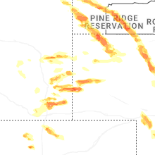
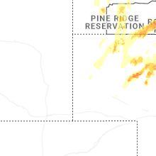


Connect with Interactive Hail Maps