

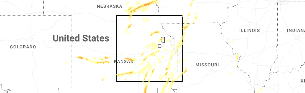
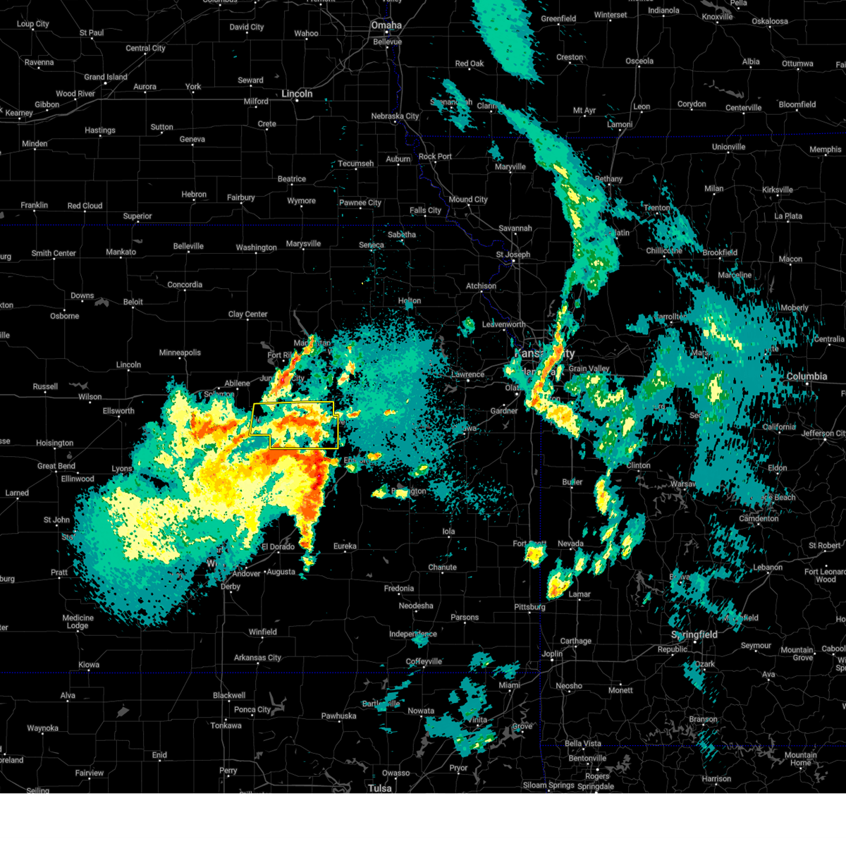
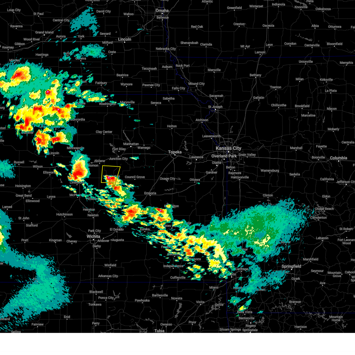
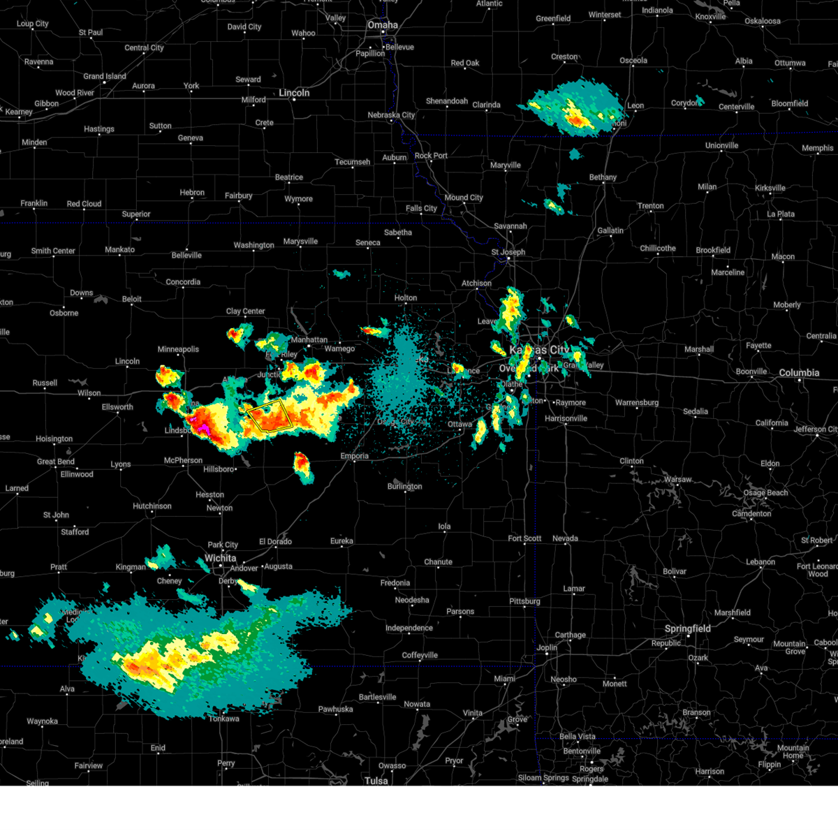
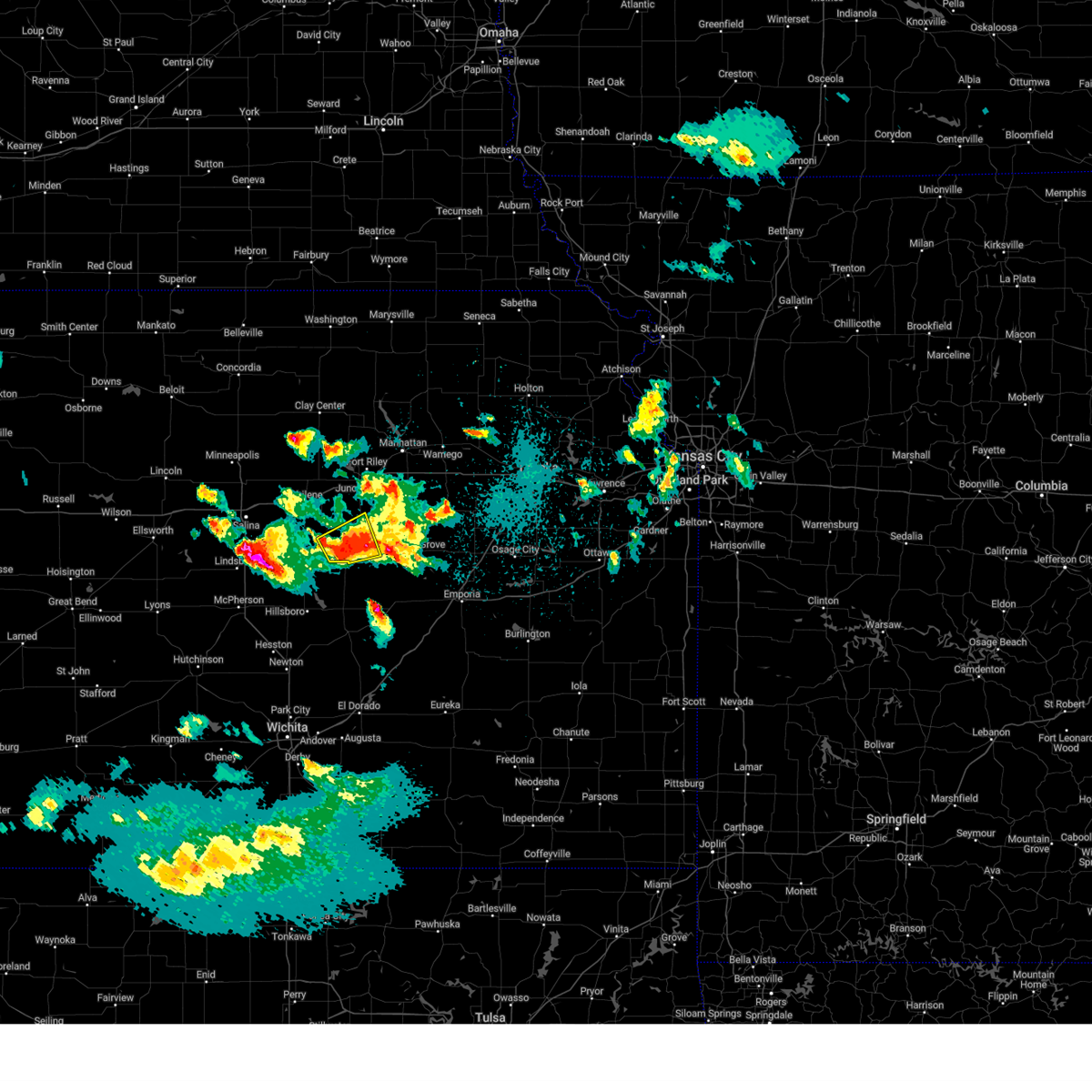
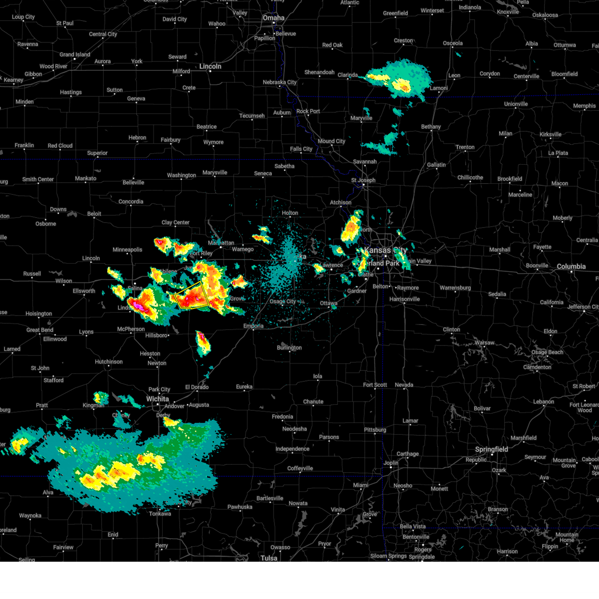
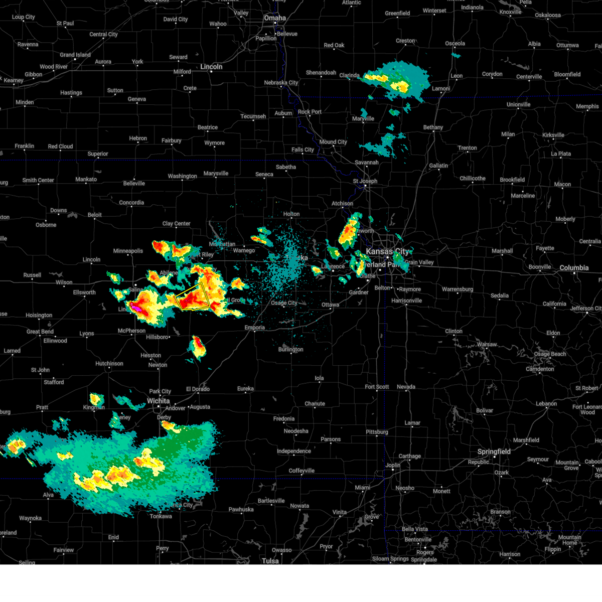
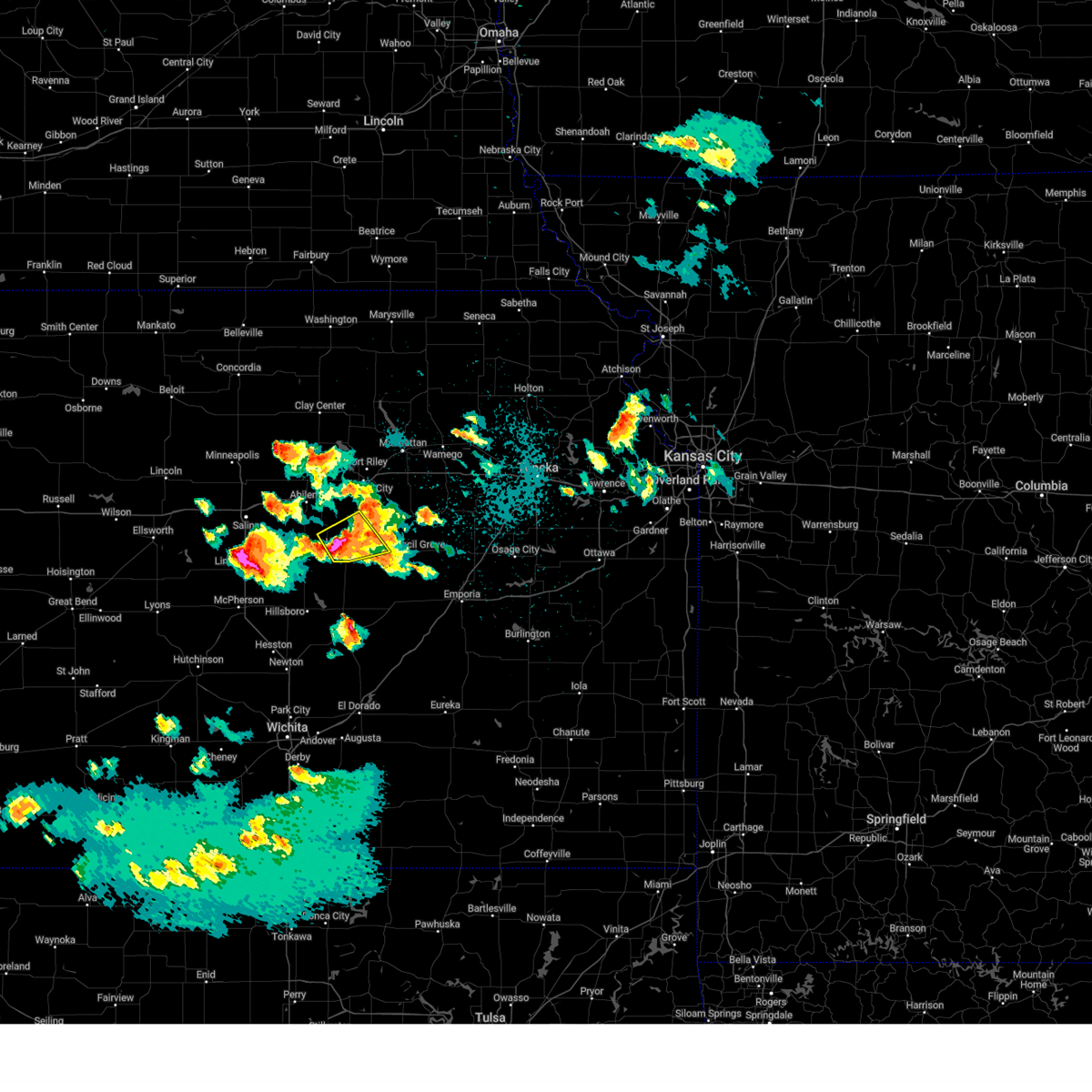
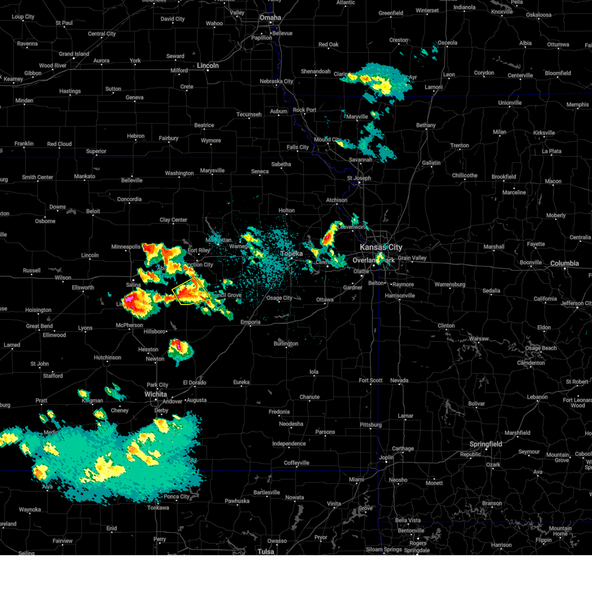
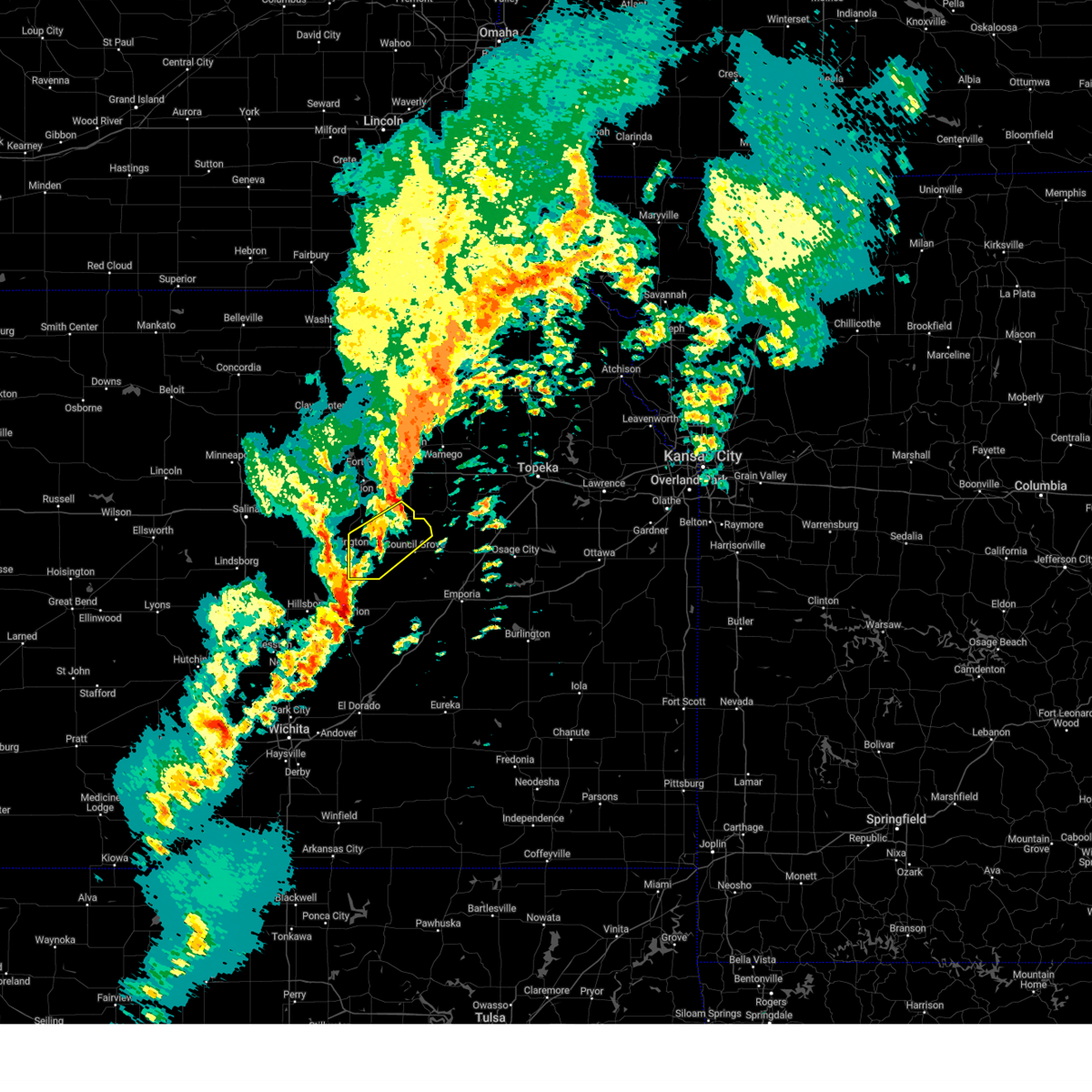
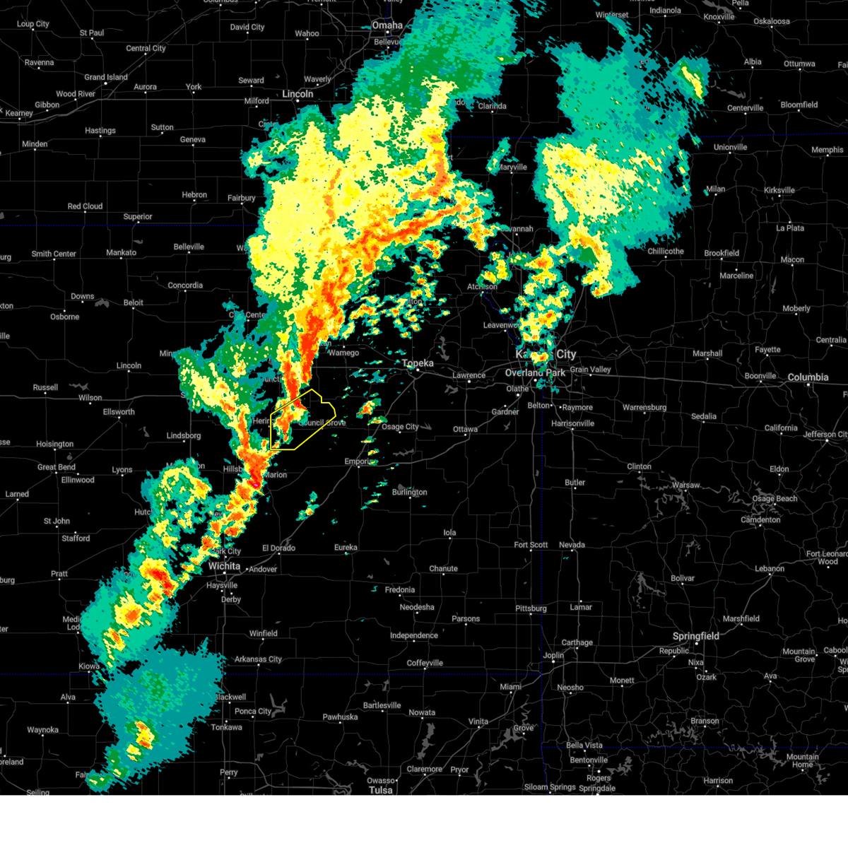
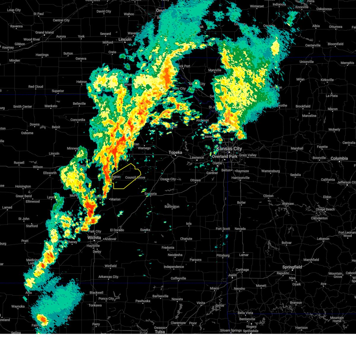
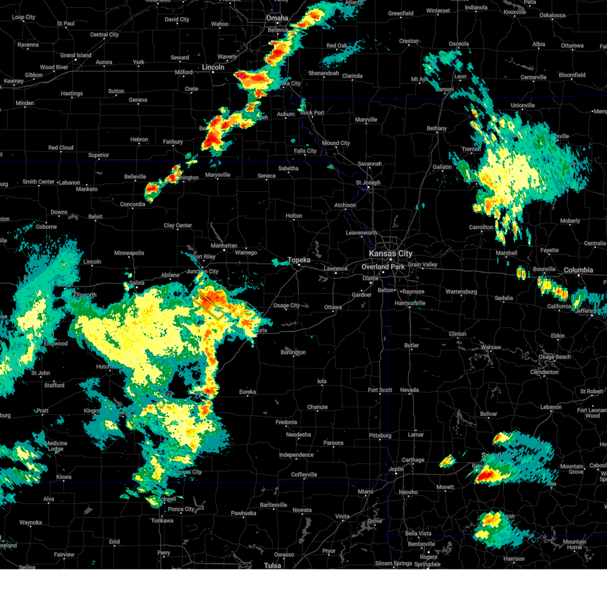
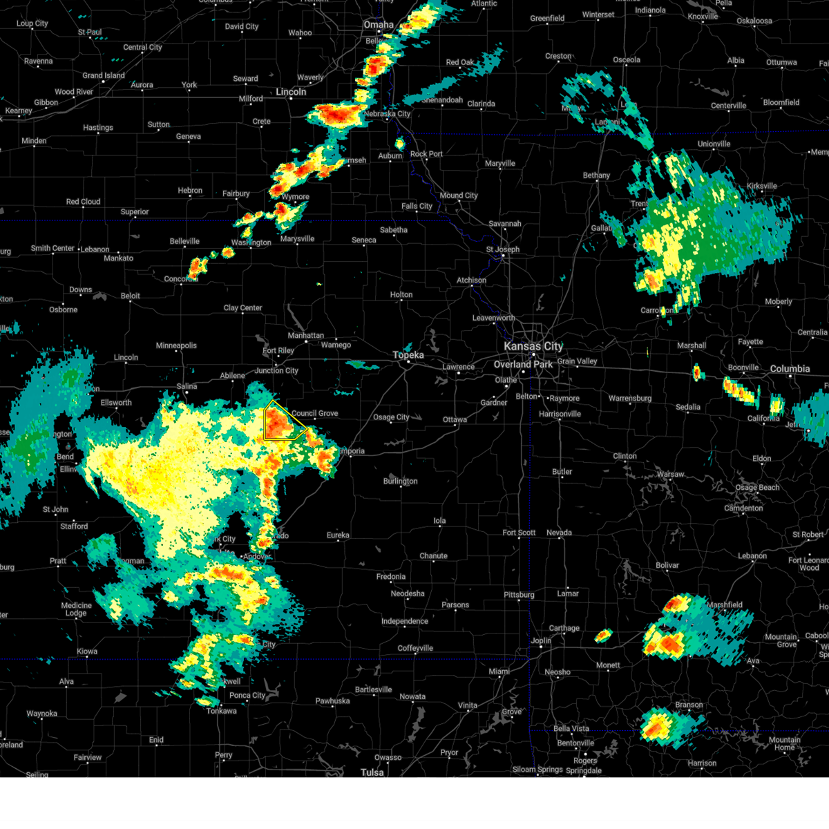
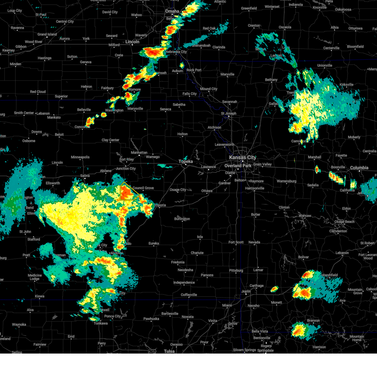
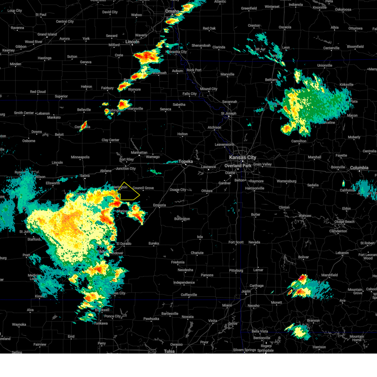
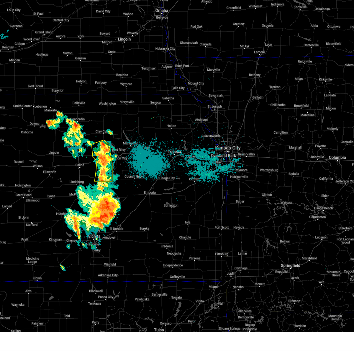
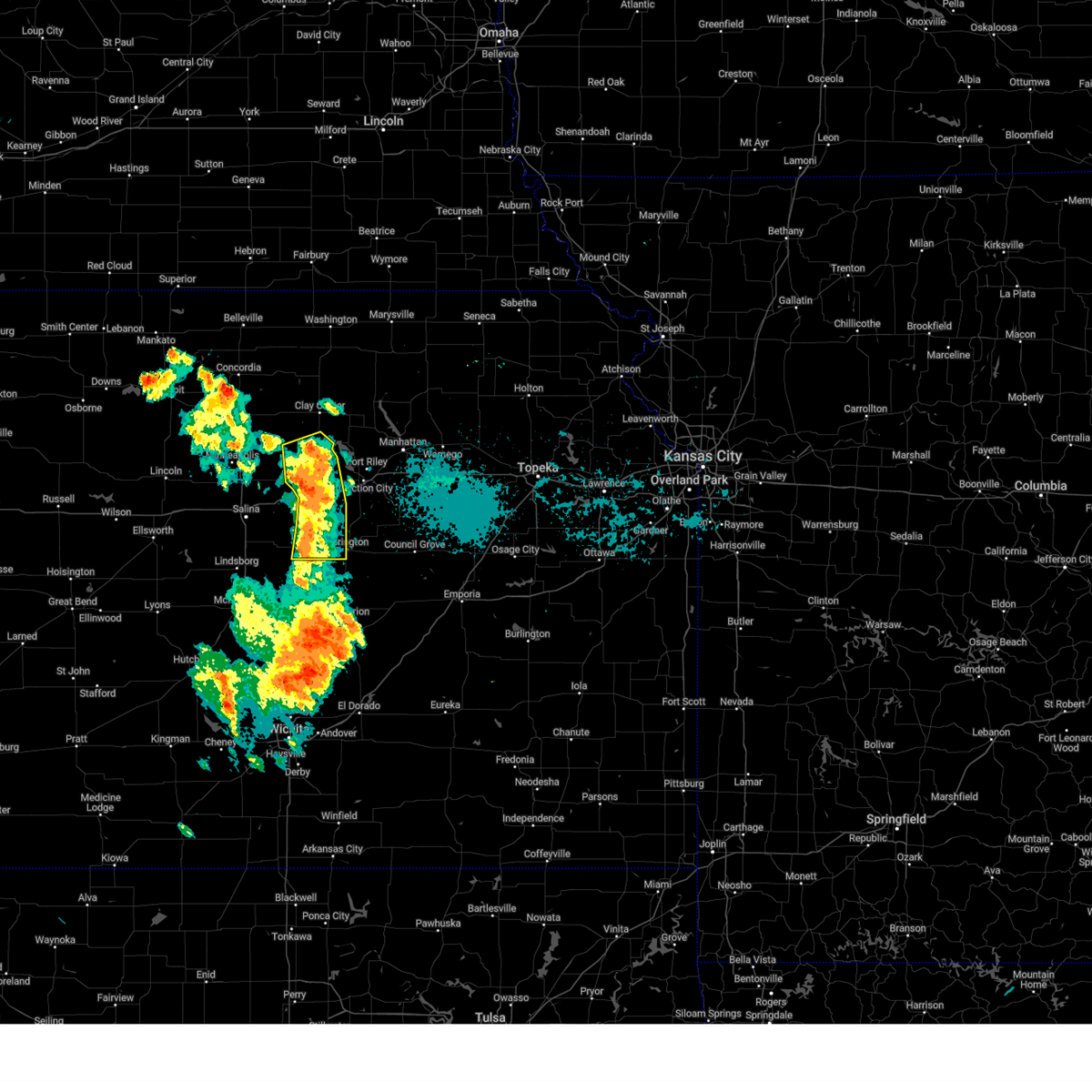
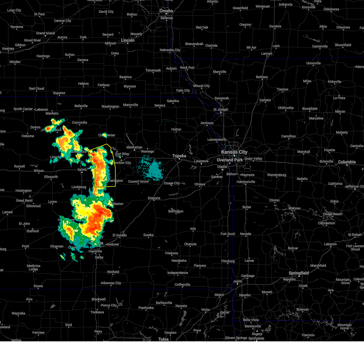
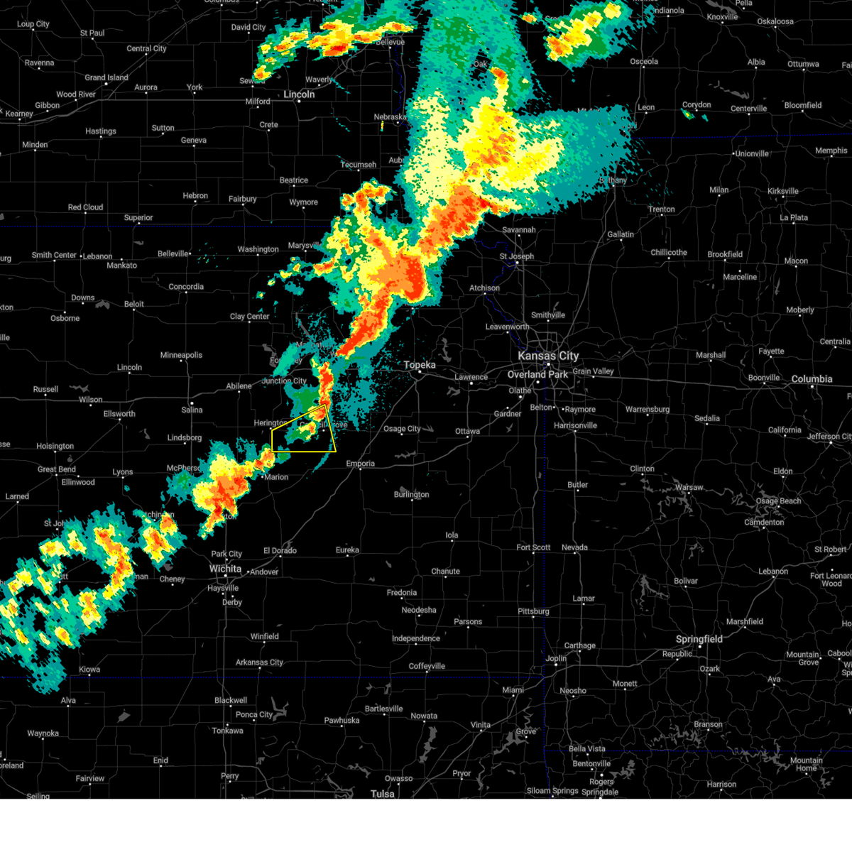
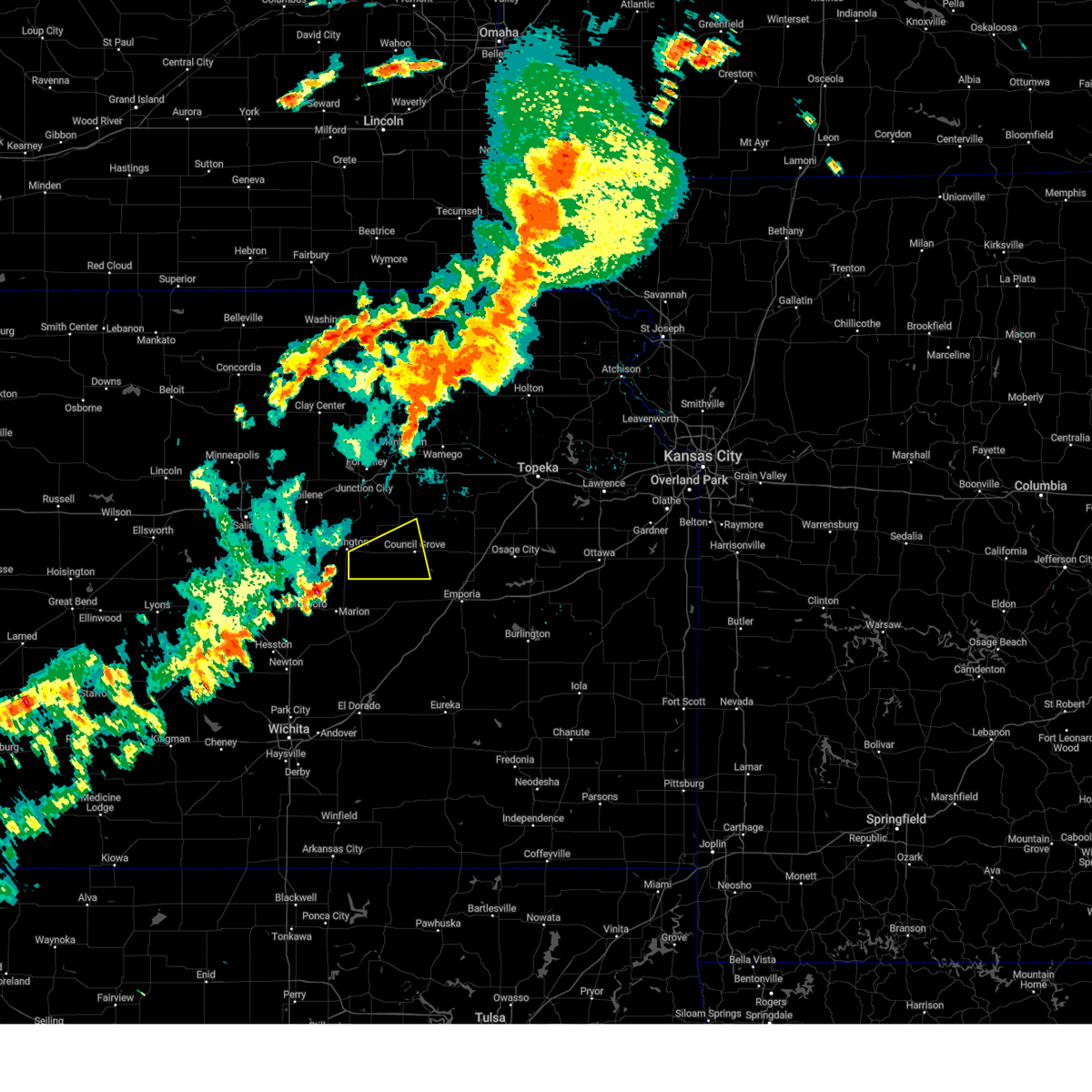
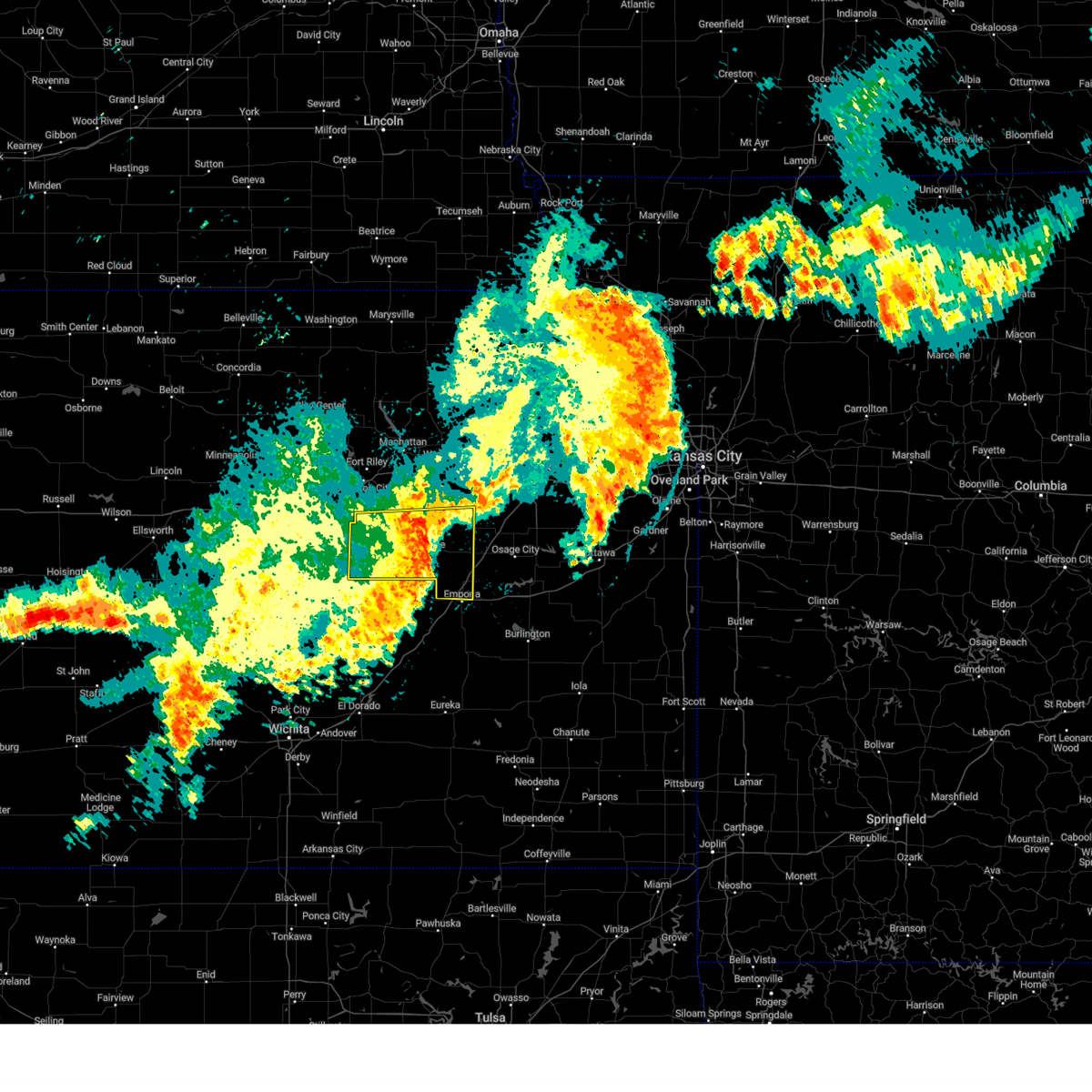
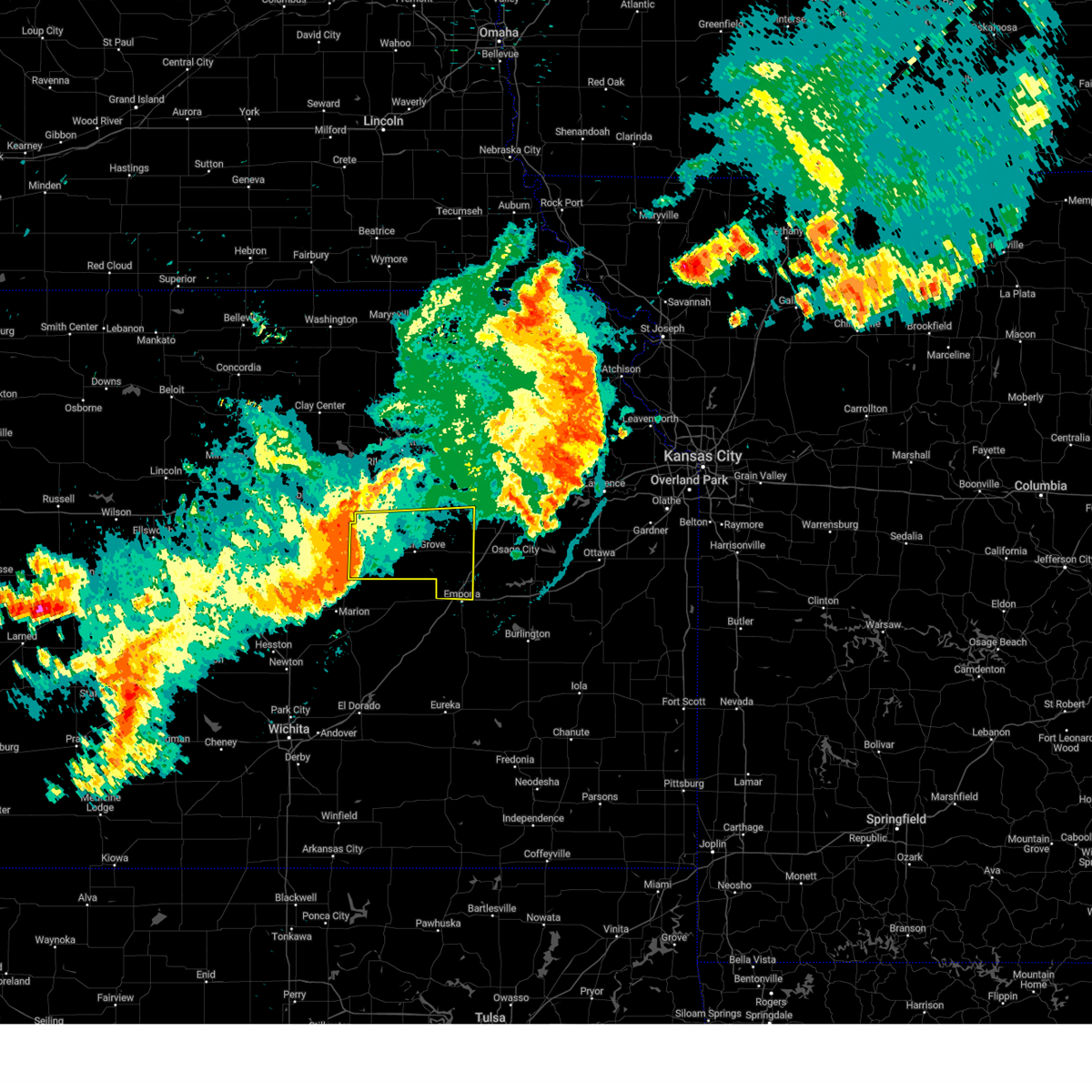
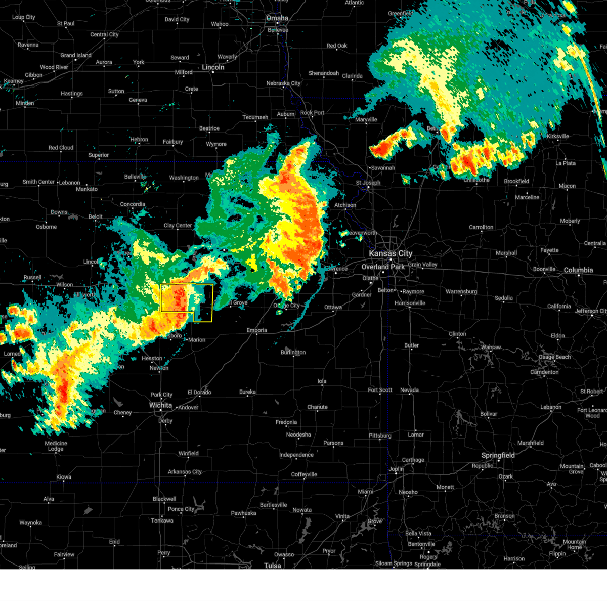
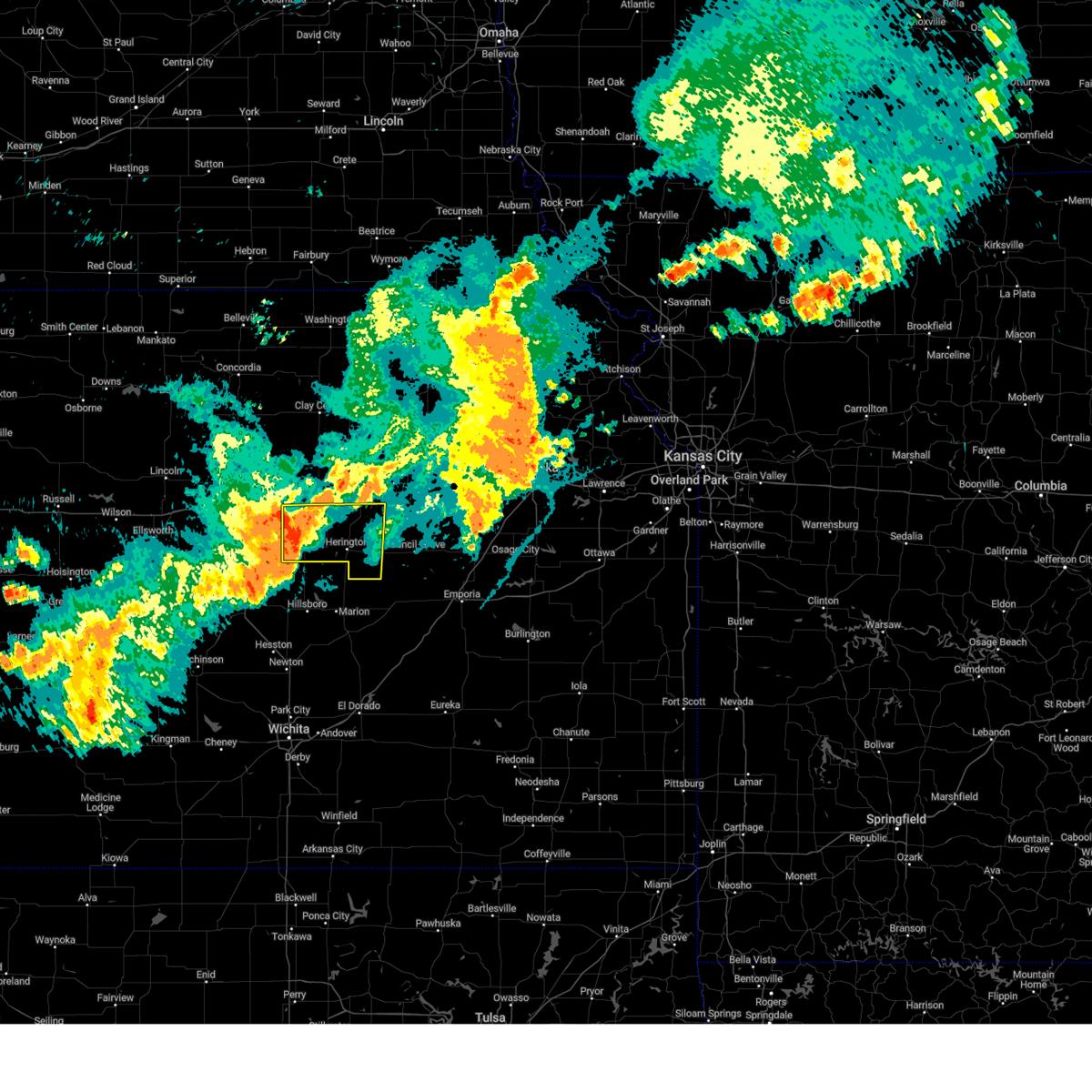
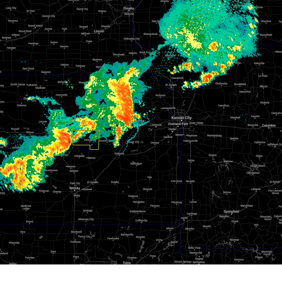
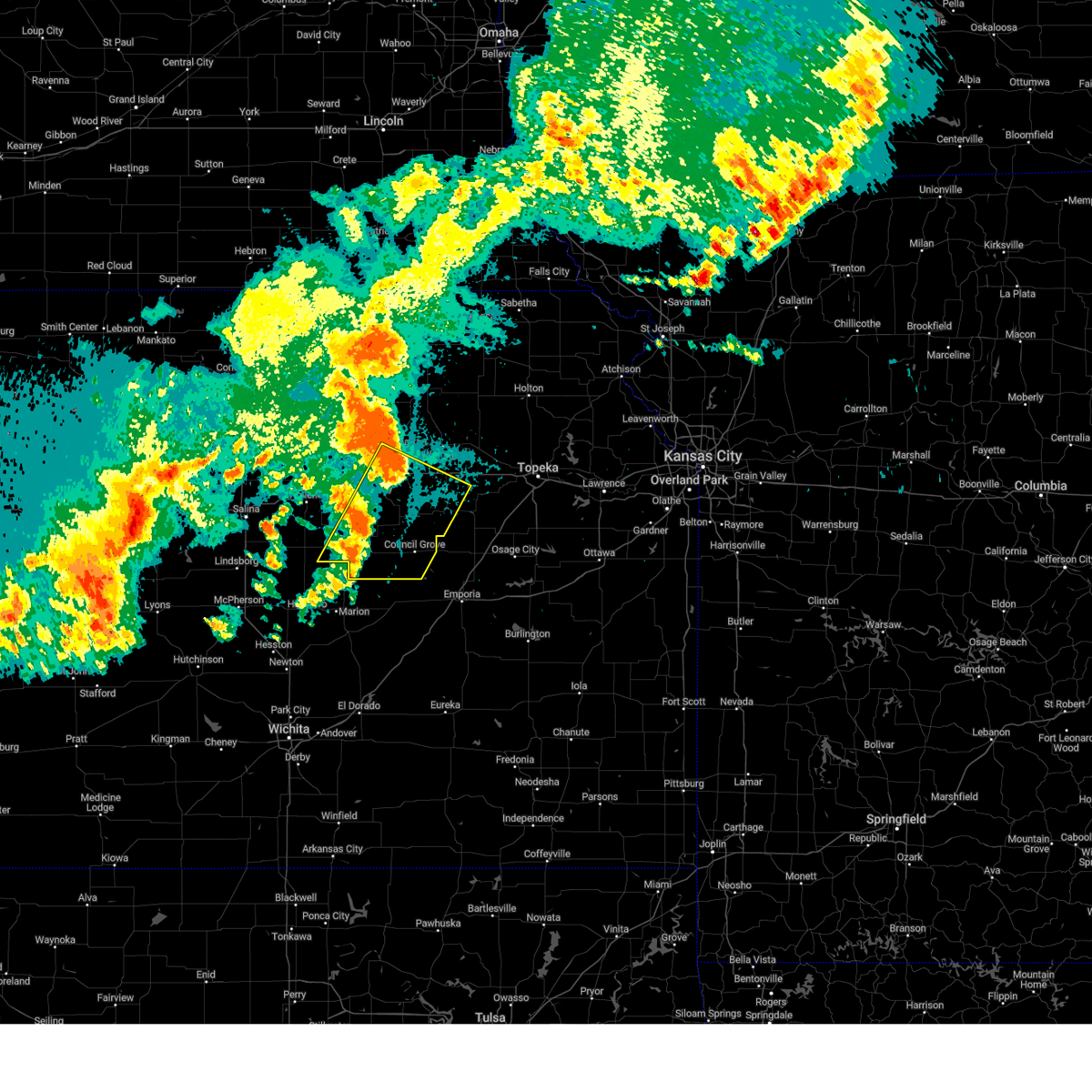
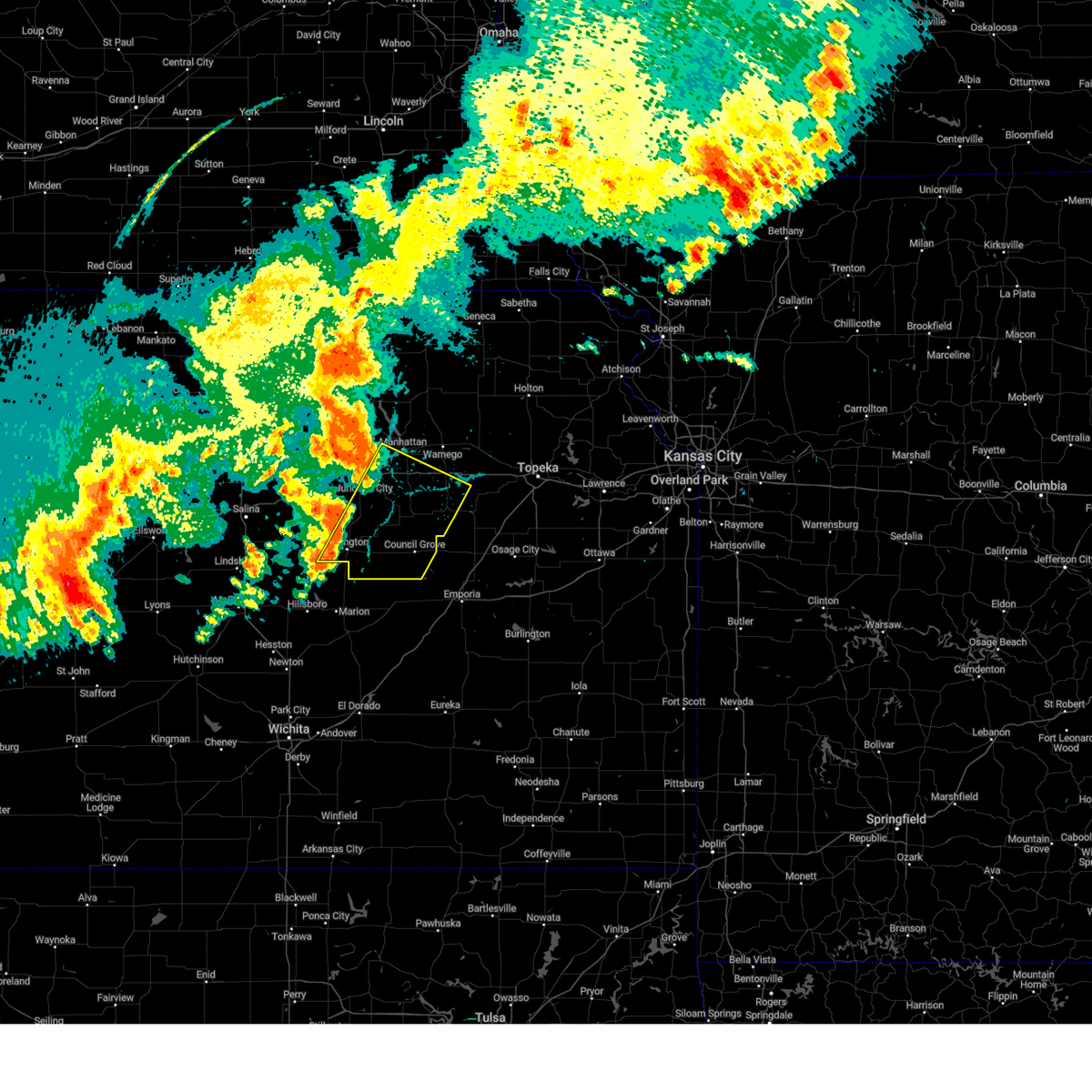
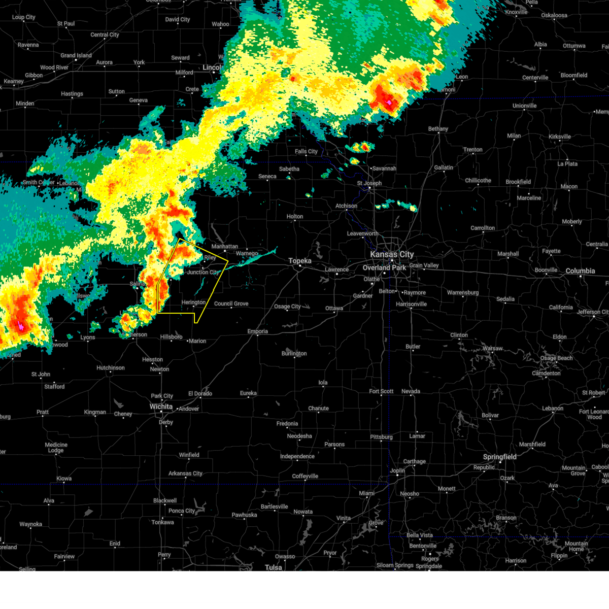
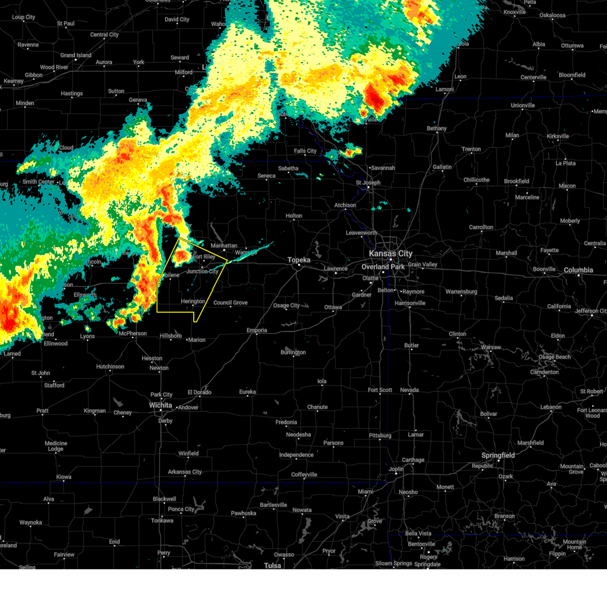
Hail Map for Herington, KS
The Herington, KS area has had 16 reports of on-the-ground hail by trained spotters, and has been under severe weather warnings 40 times during the past 12 months. Doppler radar has detected hail at or near Herington, KS on 108 occasions, including 7 occasions during the past year.
| Name: | Herington, KS |
| Where Located: | 38.8 miles SSW of Manhattan, KS |
| Map: | Google Map for Herington, KS |
| Population: | 2526 |
| Housing Units: | 1300 |
| More Info: | Search Google for Herington, KS |
4
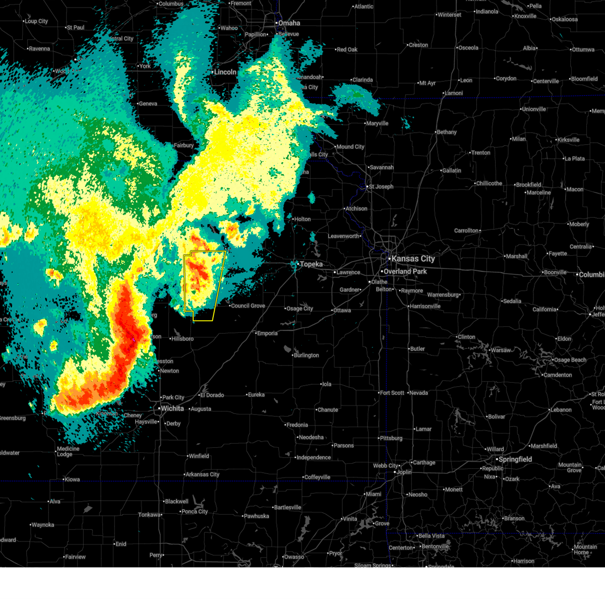
The Top Recent Hail Date for Herington, KS is Monday, May 19, 2025 (4th out of 108)
Hail and Wind Damage Spotted near Herington, KS
| Date / Time | Report Details |
|---|---|
| 6/17/2025 3:48 AM CDT |
 the severe thunderstorm warning has been cancelled and is no longer in effect the severe thunderstorm warning has been cancelled and is no longer in effect
|
| 6/17/2025 3:27 AM CDT |
 At 327 am cdt, a severe thunderstorm was located 7 miles south of junction city, moving east at 30 mph (radar indicated). Hazards include 60 mph wind gusts. Expect damage to roofs, siding, and trees. locations impacted include, southwestern manhattan, junction city, herington, ogden, grandview plaza, chapman, white city, woodbine, wilsey, parkerville, latimer, milford lake, and burdick. This includes interstate 70 between mile markers 286 and 312. At 327 am cdt, a severe thunderstorm was located 7 miles south of junction city, moving east at 30 mph (radar indicated). Hazards include 60 mph wind gusts. Expect damage to roofs, siding, and trees. locations impacted include, southwestern manhattan, junction city, herington, ogden, grandview plaza, chapman, white city, woodbine, wilsey, parkerville, latimer, milford lake, and burdick. This includes interstate 70 between mile markers 286 and 312.
|
| 6/17/2025 3:06 AM CDT |
 Svrtop the national weather service in topeka has issued a * severe thunderstorm warning for, eastern dickinson county in central kansas, geary county in east central kansas, southwestern riley county in northeastern kansas, western morris county in east central kansas, * until 415 am cdt. * at 306 am cdt, a severe thunderstorm was located near moonlight, or 11 miles west of junction city, moving east at 30 mph (radar indicated). Hazards include 70 mph wind gusts. Expect considerable tree damage. Damage is likely to mobile homes, roofs, and outbuildings. Svrtop the national weather service in topeka has issued a * severe thunderstorm warning for, eastern dickinson county in central kansas, geary county in east central kansas, southwestern riley county in northeastern kansas, western morris county in east central kansas, * until 415 am cdt. * at 306 am cdt, a severe thunderstorm was located near moonlight, or 11 miles west of junction city, moving east at 30 mph (radar indicated). Hazards include 70 mph wind gusts. Expect considerable tree damage. Damage is likely to mobile homes, roofs, and outbuildings.
|
| 5/20/2025 12:41 AM CDT |
 Svrtop the national weather service in topeka has issued a * severe thunderstorm warning for, southeastern dickinson county in central kansas, morris county in east central kansas, * until 115 am cdt. * at 1241 am cdt, severe thunderstorms were located along a line extending from near lincolnville to 5 miles southeast of burdick to 4 miles northeast of strong city, moving north at 45 mph (radar indicated). Hazards include 60 mph wind gusts. expect damage to roofs, siding, and trees Svrtop the national weather service in topeka has issued a * severe thunderstorm warning for, southeastern dickinson county in central kansas, morris county in east central kansas, * until 115 am cdt. * at 1241 am cdt, severe thunderstorms were located along a line extending from near lincolnville to 5 miles southeast of burdick to 4 miles northeast of strong city, moving north at 45 mph (radar indicated). Hazards include 60 mph wind gusts. expect damage to roofs, siding, and trees
|
| 5/19/2025 6:26 PM CDT | The storm which prompted the warning has weakened below severe limits, and no longer poses an immediate threat to life or property. therefore, the warning will be allowed to expire. however, small hail is still possible with this thunderstorm. a tornado watch remains in effect until 900 pm cdt for central and east central kansas. |
| 5/19/2025 5:57 PM CDT | Quarter sized hail reported 1.6 miles NNW of Herington, KS |
| 5/19/2025 5:44 PM CDT | Svrtop the national weather service in topeka has issued a * severe thunderstorm warning for, southeastern dickinson county in central kansas, western morris county in east central kansas, * until 630 pm cdt. * at 544 pm cdt, a severe thunderstorm was located 4 miles north of lincolnville, moving northeast at 30 mph (radar indicated). Hazards include 60 mph wind gusts and half dollar size hail. Hail damage to vehicles is expected. Expect wind damage to roofs, siding, and trees. |
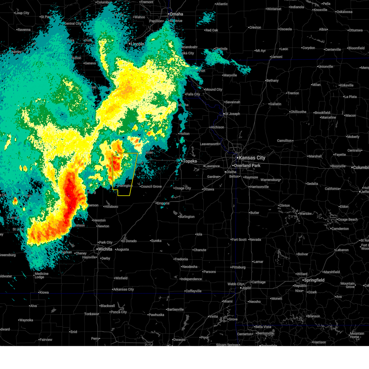
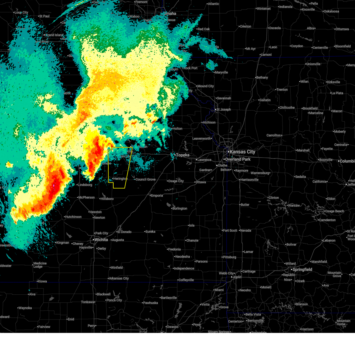
| 5/18/2025 6:42 PM CDT | Quarter sized hail reported 7.5 miles SSE of Herington, KS |
| 5/18/2025 6:36 PM CDT |
 At 634 pm cdt, a severe thunderstorm was located 4 miles southwest of woodbine, moving north at 60 mph (law enforcement. at 633 pm the fire chief reported quarter size hail in herington). Hazards include golf ball size hail and 60 mph wind gusts. People and animals outdoors will be injured. expect hail damage to roofs, siding, windows, and vehicles. expect wind damage to roofs, siding, and trees. Locations impacted include, herington, hope, woodbine, and latimer. At 634 pm cdt, a severe thunderstorm was located 4 miles southwest of woodbine, moving north at 60 mph (law enforcement. at 633 pm the fire chief reported quarter size hail in herington). Hazards include golf ball size hail and 60 mph wind gusts. People and animals outdoors will be injured. expect hail damage to roofs, siding, windows, and vehicles. expect wind damage to roofs, siding, and trees. Locations impacted include, herington, hope, woodbine, and latimer.
|
| 5/18/2025 6:33 PM CDT | Quarter sized hail reported 2.9 miles ENE of Herington, KS |
| 5/18/2025 6:27 PM CDT | At 626 pm cdt, a severe thunderstorm was located near ramona, moving north at 60 mph (radar indicated). Hazards include golf ball size hail and 60 mph wind gusts. People and animals outdoors will be injured. expect hail damage to roofs, siding, windows, and vehicles. expect wind damage to roofs, siding, and trees. Locations impacted include, herington, hope, woodbine, and latimer. |
| 5/18/2025 6:17 PM CDT | Svrtop the national weather service in topeka has issued a * severe thunderstorm warning for, southeastern dickinson county in central kansas, western morris county in east central kansas, * until 645 pm cdt. * at 617 pm cdt, a severe thunderstorm was located 5 miles west of lincolnville, moving north at 55 mph (radar indicated). Hazards include ping pong ball size hail and 60 mph wind gusts. People and animals outdoors will be injured. expect hail damage to roofs, siding, windows, and vehicles. Expect wind damage to roofs, siding, and trees. |
| 4/22/2025 10:05 PM CDT |
 The storm which prompted the warning has weakened below severe limits, and no longer poses an immediate threat to life or property. therefore, the warning will be allowed to expire. however, small hail, gusty winds and heavy rain are still possible with this thunderstorm. The storm which prompted the warning has weakened below severe limits, and no longer poses an immediate threat to life or property. therefore, the warning will be allowed to expire. however, small hail, gusty winds and heavy rain are still possible with this thunderstorm.
|
| 4/22/2025 9:52 PM CDT |
 At 951 pm cdt, a severe thunderstorm was located over latimer, moving northeast at 25 mph (radar indicated). Hazards include 60 mph wind gusts and nickel size hail. Expect damage to roofs, siding, and trees. Locations impacted include, herington and latimer. At 951 pm cdt, a severe thunderstorm was located over latimer, moving northeast at 25 mph (radar indicated). Hazards include 60 mph wind gusts and nickel size hail. Expect damage to roofs, siding, and trees. Locations impacted include, herington and latimer.
|
| 4/22/2025 9:50 PM CDT |
 At 949 pm cdt, a severe thunderstorm was located near latimer, moving northeast at 20 mph (radar indicated). Hazards include 60 mph wind gusts and nickel size hail. Expect damage to roofs, siding, and trees. Locations impacted include, woodbine, herington, latimer, and hope. At 949 pm cdt, a severe thunderstorm was located near latimer, moving northeast at 20 mph (radar indicated). Hazards include 60 mph wind gusts and nickel size hail. Expect damage to roofs, siding, and trees. Locations impacted include, woodbine, herington, latimer, and hope.
|
| 4/22/2025 9:43 PM CDT |
 At 942 pm cdt, a severe thunderstorm was located near herington, moving northeast at 20 mph (radar indicated). Hazards include 60 mph wind gusts and quarter size hail. Hail damage to vehicles is expected. expect wind damage to roofs, siding, and trees. Locations impacted include, woodbine, herington, latimer, and hope. At 942 pm cdt, a severe thunderstorm was located near herington, moving northeast at 20 mph (radar indicated). Hazards include 60 mph wind gusts and quarter size hail. Hail damage to vehicles is expected. expect wind damage to roofs, siding, and trees. Locations impacted include, woodbine, herington, latimer, and hope.
|
| 4/22/2025 9:38 PM CDT |
 Svrtop the national weather service in topeka has issued a * severe thunderstorm warning for, southeastern dickinson county in central kansas, northwestern morris county in east central kansas, * until 1015 pm cdt. * at 938 pm cdt, a severe thunderstorm was located near herington, moving northeast at 20 mph (radar indicated). Hazards include 60 mph wind gusts and quarter size hail. Hail damage to vehicles is expected. Expect wind damage to roofs, siding, and trees. Svrtop the national weather service in topeka has issued a * severe thunderstorm warning for, southeastern dickinson county in central kansas, northwestern morris county in east central kansas, * until 1015 pm cdt. * at 938 pm cdt, a severe thunderstorm was located near herington, moving northeast at 20 mph (radar indicated). Hazards include 60 mph wind gusts and quarter size hail. Hail damage to vehicles is expected. Expect wind damage to roofs, siding, and trees.
|
| 4/22/2025 9:33 PM CDT |
 At 931 pm cdt, a severe thunderstorm was located near woodbine, moving northeast at 25 mph (radar indicated). Hazards include 60 mph wind gusts and half dollar size hail. Hail damage to vehicles is expected. expect wind damage to roofs, siding, and trees. locations impacted include, woodbine, herington, latimer, and hope. At 9:21 pm, the fired department reported quarter size hail in hope. At 931 pm cdt, a severe thunderstorm was located near woodbine, moving northeast at 25 mph (radar indicated). Hazards include 60 mph wind gusts and half dollar size hail. Hail damage to vehicles is expected. expect wind damage to roofs, siding, and trees. locations impacted include, woodbine, herington, latimer, and hope. At 9:21 pm, the fired department reported quarter size hail in hope.
|
| 4/22/2025 9:20 PM CDT |
 Svrtop the national weather service in topeka has issued a * severe thunderstorm warning for, southeastern dickinson county in central kansas, northwestern morris county in east central kansas, * until 945 pm cdt. * at 919 pm cdt, a severe thunderstorm was located 4 miles northwest of herington, moving northeast at 25 mph (radar indicated). Hazards include 60 mph wind gusts and quarter size hail. Hail damage to vehicles is expected. Expect wind damage to roofs, siding, and trees. Svrtop the national weather service in topeka has issued a * severe thunderstorm warning for, southeastern dickinson county in central kansas, northwestern morris county in east central kansas, * until 945 pm cdt. * at 919 pm cdt, a severe thunderstorm was located 4 miles northwest of herington, moving northeast at 25 mph (radar indicated). Hazards include 60 mph wind gusts and quarter size hail. Hail damage to vehicles is expected. Expect wind damage to roofs, siding, and trees.
|
| 10/30/2024 4:30 PM CDT |
 The storm which prompted the warning has weakened below severe limits, and no longer poses an immediate threat to life or property. therefore, the warning has been allowed to expire. however, gusty winds are still possible with this thunderstorm. The storm which prompted the warning has weakened below severe limits, and no longer poses an immediate threat to life or property. therefore, the warning has been allowed to expire. however, gusty winds are still possible with this thunderstorm.
|
| 10/30/2024 4:22 PM CDT |
 At 422 pm cdt, a severe thunderstorm was located 4 miles northwest of wilsey, moving northeast at 45 mph (radar indicated). Hazards include 60 mph wind gusts. Expect damage to roofs, siding, and trees. Locations impacted include, herington, council grove, white city, dwight, wilsey, parkerville, latimer, council grove lake, and burdick. At 422 pm cdt, a severe thunderstorm was located 4 miles northwest of wilsey, moving northeast at 45 mph (radar indicated). Hazards include 60 mph wind gusts. Expect damage to roofs, siding, and trees. Locations impacted include, herington, council grove, white city, dwight, wilsey, parkerville, latimer, council grove lake, and burdick.
|
| 10/30/2024 4:22 PM CDT |
 the severe thunderstorm warning has been cancelled and is no longer in effect the severe thunderstorm warning has been cancelled and is no longer in effect
|
| 10/30/2024 4:02 PM CDT |
 Svrtop the national weather service in topeka has issued a * severe thunderstorm warning for, southeastern dickinson county in central kansas, southeastern geary county in east central kansas, morris county in east central kansas, * until 430 pm cdt. * at 402 pm cdt, a severe thunderstorm was located 5 miles north of burdick, moving northeast at 50 mph (radar indicated). Hazards include 60 mph wind gusts. expect damage to roofs, siding, and trees Svrtop the national weather service in topeka has issued a * severe thunderstorm warning for, southeastern dickinson county in central kansas, southeastern geary county in east central kansas, morris county in east central kansas, * until 430 pm cdt. * at 402 pm cdt, a severe thunderstorm was located 5 miles north of burdick, moving northeast at 50 mph (radar indicated). Hazards include 60 mph wind gusts. expect damage to roofs, siding, and trees
|
| 9/21/2024 6:05 PM CDT |
 At 605 pm cdt, a severe thunderstorm was located near parkerville, moving northeast at 30 mph (trained weather spotters). Hazards include 60 mph wind gusts and nickel size hail. Expect damage to roofs, siding, and trees. Locations impacted include, wilsey and latimer. At 605 pm cdt, a severe thunderstorm was located near parkerville, moving northeast at 30 mph (trained weather spotters). Hazards include 60 mph wind gusts and nickel size hail. Expect damage to roofs, siding, and trees. Locations impacted include, wilsey and latimer.
|
| 9/21/2024 5:51 PM CDT |
 the severe thunderstorm warning has been cancelled and is no longer in effect the severe thunderstorm warning has been cancelled and is no longer in effect
|
| 9/21/2024 5:51 PM CDT |
 At 550 pm cdt, a severe thunderstorm was located 4 miles west of wilsey, moving northeast at 45 mph (trained weather spotters. at 5:45pm, trained spotter reported 60mph wind gust 3 miles north of burdick). Hazards include 60 mph wind gusts and quarter size hail. Hail damage to vehicles is expected. expect wind damage to roofs, siding, and trees. Locations impacted include, herington, wilsey, latimer, and burdick. At 550 pm cdt, a severe thunderstorm was located 4 miles west of wilsey, moving northeast at 45 mph (trained weather spotters. at 5:45pm, trained spotter reported 60mph wind gust 3 miles north of burdick). Hazards include 60 mph wind gusts and quarter size hail. Hail damage to vehicles is expected. expect wind damage to roofs, siding, and trees. Locations impacted include, herington, wilsey, latimer, and burdick.
|
| 9/21/2024 5:45 PM CDT | Storm damage reported in morris county KS, 5.6 miles NNW of Herington, KS |
| 9/21/2024 5:34 PM CDT |
 Svrtop the national weather service in topeka has issued a * severe thunderstorm warning for, southeastern dickinson county in central kansas, southwestern morris county in east central kansas, * until 615 pm cdt. * at 534 pm cdt, a severe thunderstorm was located over lincolnville, moving northeast at 30 mph (radar indicated). Hazards include 60 mph wind gusts and quarter size hail. Hail damage to vehicles is expected. Expect wind damage to roofs, siding, and trees. Svrtop the national weather service in topeka has issued a * severe thunderstorm warning for, southeastern dickinson county in central kansas, southwestern morris county in east central kansas, * until 615 pm cdt. * at 534 pm cdt, a severe thunderstorm was located over lincolnville, moving northeast at 30 mph (radar indicated). Hazards include 60 mph wind gusts and quarter size hail. Hail damage to vehicles is expected. Expect wind damage to roofs, siding, and trees.
|
| 9/20/2024 7:58 PM CDT |
 the severe thunderstorm warning has been cancelled and is no longer in effect the severe thunderstorm warning has been cancelled and is no longer in effect
|
| 9/20/2024 7:49 PM CDT |
 At 748 pm cdt, severe thunderstorms were located along a line extending from 6 miles northeast of longford to near moonlight to near tampa, moving northeast at 40 mph (radar indicated). Hazards include 60 mph wind gusts. Expect damage to roofs, siding, and trees. locations impacted include, abilene, herington, chapman, enterprise, hope, woodbine, manchester, longford, carlton, moonlight, and talmage. This includes interstate 70 between mile markers 272 and 289. At 748 pm cdt, severe thunderstorms were located along a line extending from 6 miles northeast of longford to near moonlight to near tampa, moving northeast at 40 mph (radar indicated). Hazards include 60 mph wind gusts. Expect damage to roofs, siding, and trees. locations impacted include, abilene, herington, chapman, enterprise, hope, woodbine, manchester, longford, carlton, moonlight, and talmage. This includes interstate 70 between mile markers 272 and 289.
|
| 9/20/2024 7:49 PM CDT |
 the severe thunderstorm warning has been cancelled and is no longer in effect the severe thunderstorm warning has been cancelled and is no longer in effect
|
| 9/20/2024 7:39 PM CDT |
 Svrtop the national weather service in topeka has issued a * severe thunderstorm warning for, dickinson county in central kansas, southeastern ottawa county in north central kansas, southern clay county in north central kansas, * until 815 pm cdt. * at 739 pm cdt, severe thunderstorms were located along a line extending from near longford to near abilene to 4 miles west of tampa, moving northeast at 40 mph (radar indicated). Hazards include 60 mph wind gusts. expect damage to roofs, siding, and trees Svrtop the national weather service in topeka has issued a * severe thunderstorm warning for, dickinson county in central kansas, southeastern ottawa county in north central kansas, southern clay county in north central kansas, * until 815 pm cdt. * at 739 pm cdt, severe thunderstorms were located along a line extending from near longford to near abilene to 4 miles west of tampa, moving northeast at 40 mph (radar indicated). Hazards include 60 mph wind gusts. expect damage to roofs, siding, and trees
|
| 8/14/2024 9:25 PM CDT |
 The storm which prompted the warning has weakened below severe limits, and has exited the warned area. therefore, the warning will be allowed to expire. a severe thunderstorm watch remains in effect until 100 am cdt for east central kansas. remember, a severe thunderstorm warning still remains in effect for eastern morris county. The storm which prompted the warning has weakened below severe limits, and has exited the warned area. therefore, the warning will be allowed to expire. a severe thunderstorm watch remains in effect until 100 am cdt for east central kansas. remember, a severe thunderstorm warning still remains in effect for eastern morris county.
|
| 8/14/2024 8:39 PM CDT |
 Svrtop the national weather service in topeka has issued a * severe thunderstorm warning for, morris county in east central kansas, * until 930 pm cdt. * at 838 pm cdt, a severe thunderstorm was located 4 miles west of lincolnville, moving northeast at 45 mph (trained weather spotters. this storm has a history of producing wind gusts of 60 to 70 mph). Hazards include 60 mph wind gusts. Expect damage to roofs, siding, and trees. this severe thunderstorm will be near, burdick around 845 pm cdt. wilsey around 900 pm cdt. Council grove and council grove lake around 910 pm cdt. Svrtop the national weather service in topeka has issued a * severe thunderstorm warning for, morris county in east central kansas, * until 930 pm cdt. * at 838 pm cdt, a severe thunderstorm was located 4 miles west of lincolnville, moving northeast at 45 mph (trained weather spotters. this storm has a history of producing wind gusts of 60 to 70 mph). Hazards include 60 mph wind gusts. Expect damage to roofs, siding, and trees. this severe thunderstorm will be near, burdick around 845 pm cdt. wilsey around 900 pm cdt. Council grove and council grove lake around 910 pm cdt.
|
| 7/31/2024 10:36 PM CDT |
 the severe thunderstorm warning has been cancelled and is no longer in effect the severe thunderstorm warning has been cancelled and is no longer in effect
|
| 7/31/2024 10:07 PM CDT |
 Svrtop the national weather service in topeka has issued a * severe thunderstorm warning for, morris county in east central kansas, southwestern wabaunsee county in east central kansas, northwestern lyon county in east central kansas, * until 1100 pm cdt. * at 1007 pm cdt, a severe thunderstorm was located 5 miles west of wilsey, moving east at 50 mph (radar indicated). Hazards include 60 mph wind gusts and penny size hail. expect damage to roofs, siding, and trees Svrtop the national weather service in topeka has issued a * severe thunderstorm warning for, morris county in east central kansas, southwestern wabaunsee county in east central kansas, northwestern lyon county in east central kansas, * until 1100 pm cdt. * at 1007 pm cdt, a severe thunderstorm was located 5 miles west of wilsey, moving east at 50 mph (radar indicated). Hazards include 60 mph wind gusts and penny size hail. expect damage to roofs, siding, and trees
|
| 7/31/2024 9:57 PM CDT |
 the severe thunderstorm warning has been cancelled and is no longer in effect the severe thunderstorm warning has been cancelled and is no longer in effect
|
| 7/31/2024 9:57 PM CDT |
 At 955 pm cdt, a severe thunderstorm was located over woodbine, moving east at 50 mph (radar indicated). Hazards include 70 mph wind gusts and nickel size hail. Expect considerable tree damage. damage is likely to mobile homes, roofs, and outbuildings. Locations impacted include, herington, white city, hope, woodbine, carlton, latimer, and burdick. At 955 pm cdt, a severe thunderstorm was located over woodbine, moving east at 50 mph (radar indicated). Hazards include 70 mph wind gusts and nickel size hail. Expect considerable tree damage. damage is likely to mobile homes, roofs, and outbuildings. Locations impacted include, herington, white city, hope, woodbine, carlton, latimer, and burdick.
|
| 7/31/2024 9:40 PM CDT |
 At 939 pm cdt, a severe thunderstorm was located 8 miles northwest of hope, moving east at 55 mph (radar indicated). Hazards include 70 mph wind gusts and nickel size hail. Expect considerable tree damage. damage is likely to mobile homes, roofs, and outbuildings. Locations impacted include, abilene, herington, enterprise, white city, hope, woodbine, carlton, latimer, and burdick. At 939 pm cdt, a severe thunderstorm was located 8 miles northwest of hope, moving east at 55 mph (radar indicated). Hazards include 70 mph wind gusts and nickel size hail. Expect considerable tree damage. damage is likely to mobile homes, roofs, and outbuildings. Locations impacted include, abilene, herington, enterprise, white city, hope, woodbine, carlton, latimer, and burdick.
|
| 7/31/2024 9:27 PM CDT |
 Svrtop the national weather service in topeka has issued a * severe thunderstorm warning for, southern dickinson county in central kansas, southwestern geary county in east central kansas, western morris county in east central kansas, * until 1015 pm cdt. * at 926 pm cdt, a severe thunderstorm was located 5 miles north of gypsum, moving east at 55 mph (radar indicated. 77 mph wind gusts were reported at salina airport at 917 pm). Hazards include 70 mph wind gusts and nickel size hail. Expect considerable tree damage. Damage is likely to mobile homes, roofs, and outbuildings. Svrtop the national weather service in topeka has issued a * severe thunderstorm warning for, southern dickinson county in central kansas, southwestern geary county in east central kansas, western morris county in east central kansas, * until 1015 pm cdt. * at 926 pm cdt, a severe thunderstorm was located 5 miles north of gypsum, moving east at 55 mph (radar indicated. 77 mph wind gusts were reported at salina airport at 917 pm). Hazards include 70 mph wind gusts and nickel size hail. Expect considerable tree damage. Damage is likely to mobile homes, roofs, and outbuildings.
|
| 7/31/2024 8:35 PM CDT |
 At 833 pm cdt, severe thunderstorms were located along a line extending from 10 miles northwest of volland to near lincolnville, moving southeast at 45 mph (public. at 8:06pm, a weather station measured a 74 mph wind gust 1 mile south southeast of herington). Hazards include 70 mph wind gusts and nickel size hail. Expect considerable tree damage. damage is likely to mobile homes, roofs, and outbuildings. locations impacted include, manhattan, junction city, herington, council grove, alma, ogden, grandview plaza, white city, alta vista, hope, dwight, woodbine, wilsey, parkerville, latimer, council grove lake, volland, and burdick. This includes interstate 70 between mile markers 295 and 327. At 833 pm cdt, severe thunderstorms were located along a line extending from 10 miles northwest of volland to near lincolnville, moving southeast at 45 mph (public. at 8:06pm, a weather station measured a 74 mph wind gust 1 mile south southeast of herington). Hazards include 70 mph wind gusts and nickel size hail. Expect considerable tree damage. damage is likely to mobile homes, roofs, and outbuildings. locations impacted include, manhattan, junction city, herington, council grove, alma, ogden, grandview plaza, white city, alta vista, hope, dwight, woodbine, wilsey, parkerville, latimer, council grove lake, volland, and burdick. This includes interstate 70 between mile markers 295 and 327.
|
| 7/31/2024 8:19 PM CDT |
 Svrtop the national weather service in topeka has issued a * severe thunderstorm warning for, southeastern dickinson county in central kansas, geary county in east central kansas, southeastern riley county in northeastern kansas, morris county in east central kansas, southwestern wabaunsee county in east central kansas, * until 900 pm cdt. * at 817 pm cdt, severe thunderstorms were located along a line extending from near ogden to ramona, moving southeast at 45 mph (radar indicated). Hazards include 60 mph wind gusts and nickel size hail. 60 mph wind gusts have been reported along this line of storms from law enforcement and trained spotters. expect damage to roofs, siding, and trees Svrtop the national weather service in topeka has issued a * severe thunderstorm warning for, southeastern dickinson county in central kansas, geary county in east central kansas, southeastern riley county in northeastern kansas, morris county in east central kansas, southwestern wabaunsee county in east central kansas, * until 900 pm cdt. * at 817 pm cdt, severe thunderstorms were located along a line extending from near ogden to ramona, moving southeast at 45 mph (radar indicated). Hazards include 60 mph wind gusts and nickel size hail. 60 mph wind gusts have been reported along this line of storms from law enforcement and trained spotters. expect damage to roofs, siding, and trees
|
| 7/31/2024 8:10 PM CDT | Gust front from parent storm incoming from the west tore off 1 foot diameter portion of tree. estimated 65 mph wind gus in dickinson county KS, 2.9 miles ENE of Herington, KS |
| 7/31/2024 8:10 PM CDT | Delated report. estimated 70 or possibly higher with 20 to 30 inch trees split on western side of tow in dickinson county KS, 3.4 miles ENE of Herington, KS |
| 7/31/2024 8:09 PM CDT | Power lines and trees down in and around heringto in dickinson county KS, 2.7 miles NE of Herington, KS |
| 7/31/2024 8:06 PM CDT | Storm damage reported in dickinson county KS, 2.7 miles NE of Herington, KS |
| 7/31/2024 8:00 PM CDT |
 At 800 pm cdt, severe thunderstorms were located along a line extending from near milford lake to 3 miles southwest of carlton, moving east at 40 mph (radar indicated). Hazards include 60 mph wind gusts and quarter size hail. Hail damage to vehicles is expected. expect wind damage to roofs, siding, and trees. locations impacted include, southwestern manhattan, junction city, abilene, herington, ogden, grandview plaza, chapman, wakefield, enterprise, white city, milford, hope, woodbine, carlton, latimer, talmage, milford lake, and moonlight. This includes interstate 70 between mile markers 269 and 313. At 800 pm cdt, severe thunderstorms were located along a line extending from near milford lake to 3 miles southwest of carlton, moving east at 40 mph (radar indicated). Hazards include 60 mph wind gusts and quarter size hail. Hail damage to vehicles is expected. expect wind damage to roofs, siding, and trees. locations impacted include, southwestern manhattan, junction city, abilene, herington, ogden, grandview plaza, chapman, wakefield, enterprise, white city, milford, hope, woodbine, carlton, latimer, talmage, milford lake, and moonlight. This includes interstate 70 between mile markers 269 and 313.
|
| 7/31/2024 7:46 PM CDT |
 Svrtop the national weather service in topeka has issued a * severe thunderstorm warning for, dickinson county in central kansas, geary county in east central kansas, southwestern riley county in northeastern kansas, western morris county in east central kansas, southeastern clay county in north central kansas, * until 830 pm cdt. * at 744 pm cdt, severe thunderstorms were located along a line extending from 4 miles southwest of wakefield to 6 miles southeast of assaria, moving east at 45 mph (radar indicated). Hazards include 60 mph wind gusts and quarter size hail. Hail damage to vehicles is expected. Expect wind damage to roofs, siding, and trees. Svrtop the national weather service in topeka has issued a * severe thunderstorm warning for, dickinson county in central kansas, geary county in east central kansas, southwestern riley county in northeastern kansas, western morris county in east central kansas, southeastern clay county in north central kansas, * until 830 pm cdt. * at 744 pm cdt, severe thunderstorms were located along a line extending from 4 miles southwest of wakefield to 6 miles southeast of assaria, moving east at 45 mph (radar indicated). Hazards include 60 mph wind gusts and quarter size hail. Hail damage to vehicles is expected. Expect wind damage to roofs, siding, and trees.
|
| 7/4/2024 1:30 AM CDT |
 At 130 am cdt, severe thunderstorms were located along a line extending from tuttle creek lake to 5 miles southeast of ogden to 5 miles west of wilsey, moving east at 50 mph (radar indicated). Hazards include 60 mph wind gusts. Expect damage to roofs, siding, and trees. locations impacted include, manhattan, junction city, herington, ogden, grandview plaza, riley, white city, hope, dwight, woodbine, wilsey, parkerville, latimer, keats, and tuttle creek lake. This includes interstate 70 between mile markers 290 and 317. At 130 am cdt, severe thunderstorms were located along a line extending from tuttle creek lake to 5 miles southeast of ogden to 5 miles west of wilsey, moving east at 50 mph (radar indicated). Hazards include 60 mph wind gusts. Expect damage to roofs, siding, and trees. locations impacted include, manhattan, junction city, herington, ogden, grandview plaza, riley, white city, hope, dwight, woodbine, wilsey, parkerville, latimer, keats, and tuttle creek lake. This includes interstate 70 between mile markers 290 and 317.
|
| 7/4/2024 1:17 AM CDT |
 At 117 am cdt, severe thunderstorms were located along a line extending from 3 miles northeast of riley to junction city to near herington, moving east at 45 mph (radar indicated). Hazards include 60 mph wind gusts. Expect damage to roofs, siding, and trees. locations impacted include, manhattan, junction city, herington, ogden, grandview plaza, riley, white city, milford, leonardville, hope, dwight, woodbine, wilsey, parkerville, latimer, milford lake, keats, and tuttle creek lake. This includes interstate 70 between mile markers 290 and 317. At 117 am cdt, severe thunderstorms were located along a line extending from 3 miles northeast of riley to junction city to near herington, moving east at 45 mph (radar indicated). Hazards include 60 mph wind gusts. Expect damage to roofs, siding, and trees. locations impacted include, manhattan, junction city, herington, ogden, grandview plaza, riley, white city, milford, leonardville, hope, dwight, woodbine, wilsey, parkerville, latimer, milford lake, keats, and tuttle creek lake. This includes interstate 70 between mile markers 290 and 317.
|
| 7/4/2024 1:09 AM CDT |
 Svrtop the national weather service in topeka has issued a * severe thunderstorm warning for, southeastern dickinson county in central kansas, geary county in east central kansas, riley county in northeastern kansas, western morris county in east central kansas, southwestern pottawatomie county in northeastern kansas, * until 145 am cdt. * at 108 am cdt, severe thunderstorms were located along a line extending from 4 miles west of riley to 5 miles west of junction city to near hope, moving east at 45 mph (radar indicated). Hazards include 60 mph wind gusts. expect damage to roofs, siding, and trees Svrtop the national weather service in topeka has issued a * severe thunderstorm warning for, southeastern dickinson county in central kansas, geary county in east central kansas, riley county in northeastern kansas, western morris county in east central kansas, southwestern pottawatomie county in northeastern kansas, * until 145 am cdt. * at 108 am cdt, severe thunderstorms were located along a line extending from 4 miles west of riley to 5 miles west of junction city to near hope, moving east at 45 mph (radar indicated). Hazards include 60 mph wind gusts. expect damage to roofs, siding, and trees
|
| 7/4/2024 1:02 AM CDT |
 At 101 am cdt, severe thunderstorms were located along a line extending from 4 miles north of wakefield to 3 miles northeast of moonlight to near carlton, moving east at 50 mph (radar indicated). Hazards include 60 mph wind gusts. Expect damage to roofs, siding, and trees. locations impacted include, junction city, abilene, herington, grandview plaza, chapman, wakefield, riley, enterprise, milford, hope, woodbine, carlton, talmage, milford lake, and moonlight. This includes interstate 70 between mile markers 269 and 300. At 101 am cdt, severe thunderstorms were located along a line extending from 4 miles north of wakefield to 3 miles northeast of moonlight to near carlton, moving east at 50 mph (radar indicated). Hazards include 60 mph wind gusts. Expect damage to roofs, siding, and trees. locations impacted include, junction city, abilene, herington, grandview plaza, chapman, wakefield, riley, enterprise, milford, hope, woodbine, carlton, talmage, milford lake, and moonlight. This includes interstate 70 between mile markers 269 and 300.
|
| 7/4/2024 1:02 AM CDT |
 the severe thunderstorm warning has been cancelled and is no longer in effect the severe thunderstorm warning has been cancelled and is no longer in effect
|
| 7/4/2024 12:48 AM CDT |
 At 1248 am cdt, severe thunderstorms were located along a line extending from 7 miles southeast of idana to near talmage to near gypsum, moving east at 45 mph (radar indicated). Hazards include 70 mph wind gusts. Expect considerable tree damage. damage is likely to mobile homes, roofs, and outbuildings. locations impacted include, junction city, abilene, herington, grandview plaza, chapman, solomon, wakefield, riley, enterprise, milford, hope, woodbine, manchester, longford, carlton, oak hill, talmage, milford lake, and moonlight. This includes interstate 70 between mile markers 267 and 300. At 1248 am cdt, severe thunderstorms were located along a line extending from 7 miles southeast of idana to near talmage to near gypsum, moving east at 45 mph (radar indicated). Hazards include 70 mph wind gusts. Expect considerable tree damage. damage is likely to mobile homes, roofs, and outbuildings. locations impacted include, junction city, abilene, herington, grandview plaza, chapman, solomon, wakefield, riley, enterprise, milford, hope, woodbine, manchester, longford, carlton, oak hill, talmage, milford lake, and moonlight. This includes interstate 70 between mile markers 267 and 300.
|
| 7/4/2024 12:35 AM CDT |
 Svrtop the national weather service in topeka has issued a * severe thunderstorm warning for, dickinson county in central kansas, western geary county in east central kansas, southwestern riley county in northeastern kansas, eastern ottawa county in north central kansas, southern clay county in north central kansas, * until 115 am cdt. * at 1234 am cdt, severe thunderstorms were located along a line extending from 3 miles west of oak hill to 4 miles northeast of niles to 4 miles south of salina, moving east at 45 mph (at 12:28am, law enforcement reported 55 to 65mph winds in culver). Hazards include 70 mph wind gusts. Expect considerable tree damage. Damage is likely to mobile homes, roofs, and outbuildings. Svrtop the national weather service in topeka has issued a * severe thunderstorm warning for, dickinson county in central kansas, western geary county in east central kansas, southwestern riley county in northeastern kansas, eastern ottawa county in north central kansas, southern clay county in north central kansas, * until 115 am cdt. * at 1234 am cdt, severe thunderstorms were located along a line extending from 3 miles west of oak hill to 4 miles northeast of niles to 4 miles south of salina, moving east at 45 mph (at 12:28am, law enforcement reported 55 to 65mph winds in culver). Hazards include 70 mph wind gusts. Expect considerable tree damage. Damage is likely to mobile homes, roofs, and outbuildings.
|
| 6/26/2024 4:37 AM CDT |
 The storm which prompted the warning has weakened below severe limits, and no longer poses an immediate threat to life or property. therefore, the warning will be allowed to expire. a severe thunderstorm watch remains in effect until 700 am cdt for central and east central kansas. The storm which prompted the warning has weakened below severe limits, and no longer poses an immediate threat to life or property. therefore, the warning will be allowed to expire. a severe thunderstorm watch remains in effect until 700 am cdt for central and east central kansas.
|
| 6/26/2024 4:28 AM CDT |
 the severe thunderstorm warning has been cancelled and is no longer in effect the severe thunderstorm warning has been cancelled and is no longer in effect
|
| 6/26/2024 4:28 AM CDT |
 At 428 am cdt, a severe thunderstorm was located 4 miles south of abilene, moving southeast at 50 mph (radar indicated). Hazards include 60 mph wind gusts and penny size hail. Expect damage to roofs, siding, and trees. locations impacted include, abilene, herington, enterprise, hope, woodbine, and carlton. This includes interstate 70 between mile markers 269 and 279. At 428 am cdt, a severe thunderstorm was located 4 miles south of abilene, moving southeast at 50 mph (radar indicated). Hazards include 60 mph wind gusts and penny size hail. Expect damage to roofs, siding, and trees. locations impacted include, abilene, herington, enterprise, hope, woodbine, and carlton. This includes interstate 70 between mile markers 269 and 279.
|
| 6/26/2024 4:06 AM CDT |
 the severe thunderstorm warning has been cancelled and is no longer in effect the severe thunderstorm warning has been cancelled and is no longer in effect
|
| 6/26/2024 4:06 AM CDT |
 At 406 am cdt, severe thunderstorms were located along a line extending from 4 miles northeast of moonlight to solomon, moving southeast at 45 mph (radar indicated). Hazards include 60 mph wind gusts and penny size hail. Expect damage to roofs, siding, and trees. locations impacted include, abilene, herington, chapman, solomon, enterprise, hope, woodbine, manchester, carlton, niles, moonlight, and talmage. This includes interstate 70 between mile markers 267 and 289. At 406 am cdt, severe thunderstorms were located along a line extending from 4 miles northeast of moonlight to solomon, moving southeast at 45 mph (radar indicated). Hazards include 60 mph wind gusts and penny size hail. Expect damage to roofs, siding, and trees. locations impacted include, abilene, herington, chapman, solomon, enterprise, hope, woodbine, manchester, carlton, niles, moonlight, and talmage. This includes interstate 70 between mile markers 267 and 289.
|
| 6/26/2024 3:52 AM CDT |
 At 352 am cdt, severe thunderstorms were located along a line extending from 8 miles southwest of wakefield to 5 miles north of niles, moving southeast at 45 mph (radar indicated). Hazards include 60 mph wind gusts and penny size hail. Expect damage to roofs, siding, and trees. locations impacted include, abilene, herington, chapman, solomon, enterprise, hope, woodbine, manchester, longford, carlton, niles, talmage, and moonlight. This includes interstate 70 between mile markers 267 and 289. At 352 am cdt, severe thunderstorms were located along a line extending from 8 miles southwest of wakefield to 5 miles north of niles, moving southeast at 45 mph (radar indicated). Hazards include 60 mph wind gusts and penny size hail. Expect damage to roofs, siding, and trees. locations impacted include, abilene, herington, chapman, solomon, enterprise, hope, woodbine, manchester, longford, carlton, niles, talmage, and moonlight. This includes interstate 70 between mile markers 267 and 289.
|
| 6/26/2024 3:37 AM CDT |
 Svrtop the national weather service in topeka has issued a * severe thunderstorm warning for, dickinson county in central kansas, eastern ottawa county in north central kansas, southwestern clay county in north central kansas, * until 445 am cdt. * at 337 am cdt, severe thunderstorms were located along a line extending from 4 miles northeast of oak hill to near wells, moving southeast at 45 mph (radar indicated). Hazards include 60 mph wind gusts. expect damage to roofs, siding, and trees Svrtop the national weather service in topeka has issued a * severe thunderstorm warning for, dickinson county in central kansas, eastern ottawa county in north central kansas, southwestern clay county in north central kansas, * until 445 am cdt. * at 337 am cdt, severe thunderstorms were located along a line extending from 4 miles northeast of oak hill to near wells, moving southeast at 45 mph (radar indicated). Hazards include 60 mph wind gusts. expect damage to roofs, siding, and trees
|
| 6/15/2024 6:10 PM CDT |
 Svrtop the national weather service in topeka has issued a * severe thunderstorm warning for, southeastern geary county in east central kansas, south central riley county in northeastern kansas, northwestern morris county in east central kansas, * until 645 pm cdt. * at 609 pm cdt, severe thunderstorms were located along a line extending from 5 miles south of grandview plaza to 5 miles northwest of dwight to 5 miles southwest of parkerville, moving northeast at 25 mph (radar indicated). Hazards include 60 mph wind gusts. expect damage to roofs, siding, and trees Svrtop the national weather service in topeka has issued a * severe thunderstorm warning for, southeastern geary county in east central kansas, south central riley county in northeastern kansas, northwestern morris county in east central kansas, * until 645 pm cdt. * at 609 pm cdt, severe thunderstorms were located along a line extending from 5 miles south of grandview plaza to 5 miles northwest of dwight to 5 miles southwest of parkerville, moving northeast at 25 mph (radar indicated). Hazards include 60 mph wind gusts. expect damage to roofs, siding, and trees
|
| 6/15/2024 6:06 PM CDT |
 At 606 pm cdt, severe thunderstorms were located along a line extending from 6 miles south of grandview plaza to 3 miles north of white city to 4 miles west of wilsey, moving northeast at 25 mph (radar indicated). Hazards include 60 mph wind gusts and quarter size hail. Hail damage to vehicles is expected. expect wind damage to roofs, siding, and trees. locations impacted include, eastern manhattan, white city, alta vista, dwight, wilsey, and parkerville. This includes interstate 70 between mile markers 305 and 319. At 606 pm cdt, severe thunderstorms were located along a line extending from 6 miles south of grandview plaza to 3 miles north of white city to 4 miles west of wilsey, moving northeast at 25 mph (radar indicated). Hazards include 60 mph wind gusts and quarter size hail. Hail damage to vehicles is expected. expect wind damage to roofs, siding, and trees. locations impacted include, eastern manhattan, white city, alta vista, dwight, wilsey, and parkerville. This includes interstate 70 between mile markers 305 and 319.
|
| 6/15/2024 5:58 PM CDT |
 At 558 pm cdt, severe thunderstorms were located along a line extending from near grandview plaza to near white city to burdick, moving northeast at 20 mph (radar indicated). Hazards include 60 mph wind gusts and quarter size hail. Hail damage to vehicles is expected. expect wind damage to roofs, siding, and trees. locations impacted include, eastern manhattan, white city, alta vista, dwight, wilsey, and parkerville. This includes interstate 70 between mile markers 305 and 319. At 558 pm cdt, severe thunderstorms were located along a line extending from near grandview plaza to near white city to burdick, moving northeast at 20 mph (radar indicated). Hazards include 60 mph wind gusts and quarter size hail. Hail damage to vehicles is expected. expect wind damage to roofs, siding, and trees. locations impacted include, eastern manhattan, white city, alta vista, dwight, wilsey, and parkerville. This includes interstate 70 between mile markers 305 and 319.
|
| 6/15/2024 5:49 PM CDT |
 At 548 pm cdt, severe thunderstorms were located along a line extending from 8 miles northeast of woodbine to 5 miles west of white city to 4 miles north of burdick, moving east at 20 mph (radar indicated). Hazards include 60 mph wind gusts and nickel size hail. Expect damage to roofs, siding, and trees. Locations impacted include, herington, latimer, and burdick. At 548 pm cdt, severe thunderstorms were located along a line extending from 8 miles northeast of woodbine to 5 miles west of white city to 4 miles north of burdick, moving east at 20 mph (radar indicated). Hazards include 60 mph wind gusts and nickel size hail. Expect damage to roofs, siding, and trees. Locations impacted include, herington, latimer, and burdick.
|
| 6/15/2024 5:37 PM CDT |
 At 537 pm cdt, severe thunderstorms were located along a line extending from 7 miles southeast of chapman to 5 miles northeast of woodbine to near herington, moving northeast at 25 mph (radar indicated). Hazards include 60 mph wind gusts and quarter size hail. Hail damage to vehicles is expected. expect wind damage to roofs, siding, and trees. Locations impacted include, herington, woodbine, latimer, and burdick. At 537 pm cdt, severe thunderstorms were located along a line extending from 7 miles southeast of chapman to 5 miles northeast of woodbine to near herington, moving northeast at 25 mph (radar indicated). Hazards include 60 mph wind gusts and quarter size hail. Hail damage to vehicles is expected. expect wind damage to roofs, siding, and trees. Locations impacted include, herington, woodbine, latimer, and burdick.
|
| 6/15/2024 5:34 PM CDT |
 Svrtop the national weather service in topeka has issued a * severe thunderstorm warning for, southeastern geary county in east central kansas, southeastern riley county in northeastern kansas, central morris county in east central kansas, west central wabaunsee county in east central kansas, south central pottawatomie county in northeastern kansas, * until 615 pm cdt. * at 534 pm cdt, severe thunderstorms were located along a line extending from 3 miles east of grandview plaza to near white city to near lincolnville, moving northeast at 30 mph (radar indicated). Hazards include 60 mph wind gusts and quarter size hail. Hail damage to vehicles is expected. Expect wind damage to roofs, siding, and trees. Svrtop the national weather service in topeka has issued a * severe thunderstorm warning for, southeastern geary county in east central kansas, southeastern riley county in northeastern kansas, central morris county in east central kansas, west central wabaunsee county in east central kansas, south central pottawatomie county in northeastern kansas, * until 615 pm cdt. * at 534 pm cdt, severe thunderstorms were located along a line extending from 3 miles east of grandview plaza to near white city to near lincolnville, moving northeast at 30 mph (radar indicated). Hazards include 60 mph wind gusts and quarter size hail. Hail damage to vehicles is expected. Expect wind damage to roofs, siding, and trees.
|
| 6/15/2024 5:24 PM CDT |
 At 523 pm cdt, severe thunderstorms were located along a line extending from 8 miles southeast of enterprise to near woodbine to 4 miles east of ramona, moving northeast at 25 mph (trained weather spotters. at 5:21, 50-60mph winds were reported 4 miles northwest of woodbine). Hazards include 70 mph wind gusts and quarter size hail. Hail damage to vehicles is expected. expect considerable tree damage. wind damage is also likely to mobile homes, roofs, and outbuildings. Locations impacted include, herington, woodbine, latimer, and burdick. At 523 pm cdt, severe thunderstorms were located along a line extending from 8 miles southeast of enterprise to near woodbine to 4 miles east of ramona, moving northeast at 25 mph (trained weather spotters. at 5:21, 50-60mph winds were reported 4 miles northwest of woodbine). Hazards include 70 mph wind gusts and quarter size hail. Hail damage to vehicles is expected. expect considerable tree damage. wind damage is also likely to mobile homes, roofs, and outbuildings. Locations impacted include, herington, woodbine, latimer, and burdick.
|
| 6/15/2024 5:12 PM CDT |
 Svrtop the national weather service in topeka has issued a * severe thunderstorm warning for, southeastern dickinson county in central kansas, south central geary county in east central kansas, western morris county in east central kansas, * until 600 pm cdt. * at 512 pm cdt, severe thunderstorms were located along a line extending from 3 miles west of woodbine to 5 miles northeast of hope to 3 miles southeast of ramona, moving northeast at 25 mph (radar indicated). Hazards include 70 mph wind gusts and quarter size hail. Hail damage to vehicles is expected. expect considerable tree damage. Wind damage is also likely to mobile homes, roofs, and outbuildings. Svrtop the national weather service in topeka has issued a * severe thunderstorm warning for, southeastern dickinson county in central kansas, south central geary county in east central kansas, western morris county in east central kansas, * until 600 pm cdt. * at 512 pm cdt, severe thunderstorms were located along a line extending from 3 miles west of woodbine to 5 miles northeast of hope to 3 miles southeast of ramona, moving northeast at 25 mph (radar indicated). Hazards include 70 mph wind gusts and quarter size hail. Hail damage to vehicles is expected. expect considerable tree damage. Wind damage is also likely to mobile homes, roofs, and outbuildings.
|
| 6/8/2024 12:37 AM CDT |
 The storm which prompted the warning has weakened below severe limits, and no longer poses an immediate threat to life or property. therefore, the warning will be allowed to expire. a severe thunderstorm watch remains in effect until 100 am cdt for central and east central kansas. The storm which prompted the warning has weakened below severe limits, and no longer poses an immediate threat to life or property. therefore, the warning will be allowed to expire. a severe thunderstorm watch remains in effect until 100 am cdt for central and east central kansas.
|
| 6/8/2024 12:21 AM CDT |
 Svrtop the national weather service in topeka has issued a * severe thunderstorm warning for, southern dickinson county in central kansas, * until 1245 am cdt. * at 1220 am cdt, a severe thunderstorm was located 4 miles northeast of gypsum, moving east at 50 mph (a wind gust of 68 mph was reported by the salina asos at midnight). Hazards include 70 mph wind gusts and quarter size hail. Hail damage to vehicles is expected. expect considerable tree damage. Wind damage is also likely to mobile homes, roofs, and outbuildings. Svrtop the national weather service in topeka has issued a * severe thunderstorm warning for, southern dickinson county in central kansas, * until 1245 am cdt. * at 1220 am cdt, a severe thunderstorm was located 4 miles northeast of gypsum, moving east at 50 mph (a wind gust of 68 mph was reported by the salina asos at midnight). Hazards include 70 mph wind gusts and quarter size hail. Hail damage to vehicles is expected. expect considerable tree damage. Wind damage is also likely to mobile homes, roofs, and outbuildings.
|
| 6/7/2024 11:39 PM CDT |
 At 1139 pm cdt, severe thunderstorms were located along a line extending from near grandview plaza to near white city to 6 miles south of wilsey, moving east at 60 mph (radar indicated). Hazards include 60 mph wind gusts and quarter size hail. Hail damage to vehicles is expected. expect wind damage to roofs, siding, and trees. locations impacted include, junction city, council grove, grandview plaza, white city, dwight, wilsey, parkerville, latimer, council grove lake, and burdick. This includes interstate 70 between mile markers 291 and 313. At 1139 pm cdt, severe thunderstorms were located along a line extending from near grandview plaza to near white city to 6 miles south of wilsey, moving east at 60 mph (radar indicated). Hazards include 60 mph wind gusts and quarter size hail. Hail damage to vehicles is expected. expect wind damage to roofs, siding, and trees. locations impacted include, junction city, council grove, grandview plaza, white city, dwight, wilsey, parkerville, latimer, council grove lake, and burdick. This includes interstate 70 between mile markers 291 and 313.
|
| 6/7/2024 11:39 PM CDT |
 the severe thunderstorm warning has been cancelled and is no longer in effect the severe thunderstorm warning has been cancelled and is no longer in effect
|
| 6/7/2024 11:22 PM CDT |
 Svrtop the national weather service in topeka has issued a * severe thunderstorm warning for, eastern dickinson county in central kansas, geary county in east central kansas, morris county in east central kansas, * until midnight cdt. * at 1122 pm cdt, severe thunderstorms were located along a line extending from 3 miles north of moonlight to 3 miles west of woodbine to 4 miles southeast of ramona, moving east at 50 mph (radar indicated). Hazards include 60 mph wind gusts and penny size hail. expect damage to roofs, siding, and trees Svrtop the national weather service in topeka has issued a * severe thunderstorm warning for, eastern dickinson county in central kansas, geary county in east central kansas, morris county in east central kansas, * until midnight cdt. * at 1122 pm cdt, severe thunderstorms were located along a line extending from 3 miles north of moonlight to 3 miles west of woodbine to 4 miles southeast of ramona, moving east at 50 mph (radar indicated). Hazards include 60 mph wind gusts and penny size hail. expect damage to roofs, siding, and trees
|
| 6/7/2024 11:09 PM CDT |
 At 1108 pm cdt, a severe thunderstorm was located 7 miles northeast of carlton, moving east at 50 mph (radar indicated). Hazards include 70 mph wind gusts and nickel size hail. Expect considerable tree damage. damage is likely to mobile homes, roofs, and outbuildings. locations impacted include, abilene, herington, chapman, solomon, enterprise, hope, woodbine, carlton, and moonlight. This includes interstate 70 between mile markers 267 and 289. At 1108 pm cdt, a severe thunderstorm was located 7 miles northeast of carlton, moving east at 50 mph (radar indicated). Hazards include 70 mph wind gusts and nickel size hail. Expect considerable tree damage. damage is likely to mobile homes, roofs, and outbuildings. locations impacted include, abilene, herington, chapman, solomon, enterprise, hope, woodbine, carlton, and moonlight. This includes interstate 70 between mile markers 267 and 289.
|
| 6/7/2024 10:57 PM CDT |
 Svrtop the national weather service in topeka has issued a * severe thunderstorm warning for, dickinson county in central kansas, * until 1130 pm cdt. * at 1056 pm cdt, a severe thunderstorm was located 5 miles north of gypsum, moving east at 50 mph (radar indicated). Hazards include 70 mph wind gusts and nickel size hail. Expect considerable tree damage. Damage is likely to mobile homes, roofs, and outbuildings. Svrtop the national weather service in topeka has issued a * severe thunderstorm warning for, dickinson county in central kansas, * until 1130 pm cdt. * at 1056 pm cdt, a severe thunderstorm was located 5 miles north of gypsum, moving east at 50 mph (radar indicated). Hazards include 70 mph wind gusts and nickel size hail. Expect considerable tree damage. Damage is likely to mobile homes, roofs, and outbuildings.
|
| 6/2/2024 4:27 AM CDT |
 Svrtop the national weather service in topeka has issued a * severe thunderstorm warning for, southern geary county in east central kansas, northwestern morris county in east central kansas, * until 500 am cdt. * at 427 am cdt, a severe thunderstorm was located 8 miles northwest of white city, moving east at 20 mph (radar indicated). Hazards include 60 mph wind gusts and quarter size hail. Hail damage to vehicles is expected. Expect wind damage to roofs, siding, and trees. Svrtop the national weather service in topeka has issued a * severe thunderstorm warning for, southern geary county in east central kansas, northwestern morris county in east central kansas, * until 500 am cdt. * at 427 am cdt, a severe thunderstorm was located 8 miles northwest of white city, moving east at 20 mph (radar indicated). Hazards include 60 mph wind gusts and quarter size hail. Hail damage to vehicles is expected. Expect wind damage to roofs, siding, and trees.
|
| 5/25/2024 11:11 PM CDT |
 At 1111 pm cdt, a severe thunderstorm was located near wilsey, moving east at 55 mph (radar indicated). Hazards include 60 mph wind gusts and quarter size hail. Hail damage to vehicles is expected. expect wind damage to roofs, siding, and trees. Locations impacted include, council grove, wilsey, dunlap, and council grove lake. At 1111 pm cdt, a severe thunderstorm was located near wilsey, moving east at 55 mph (radar indicated). Hazards include 60 mph wind gusts and quarter size hail. Hail damage to vehicles is expected. expect wind damage to roofs, siding, and trees. Locations impacted include, council grove, wilsey, dunlap, and council grove lake.
|
| 5/25/2024 10:56 PM CDT |
 Svrtop the national weather service in topeka has issued a * severe thunderstorm warning for, morris county in east central kansas, * until 1130 pm cdt. * at 1056 pm cdt, a severe thunderstorm was located near burdick, moving northeast at 45 mph (radar indicated). Hazards include 60 mph wind gusts and half dollar size hail. Hail damage to vehicles is expected. Expect wind damage to roofs, siding, and trees. Svrtop the national weather service in topeka has issued a * severe thunderstorm warning for, morris county in east central kansas, * until 1130 pm cdt. * at 1056 pm cdt, a severe thunderstorm was located near burdick, moving northeast at 45 mph (radar indicated). Hazards include 60 mph wind gusts and half dollar size hail. Hail damage to vehicles is expected. Expect wind damage to roofs, siding, and trees.
|
| 5/19/2024 7:31 PM CDT |
 At 731 pm cdt, severe thunderstorms were located along a line extending from 3 miles northwest of junction city to 6 miles northwest of white city to 3 miles south of latimer, moving east at 30 mph (radar indicated). Hazards include ping pong ball size hail and 60 mph wind gusts. People and animals outdoors will be injured. expect hail damage to roofs, siding, windows, and vehicles. expect wind damage to roofs, siding, and trees. locations impacted include, junction city, herington, grandview plaza, chapman, white city, woodbine, wilsey, parkerville, and latimer. This includes interstate 70 between mile markers 287 and 304. At 731 pm cdt, severe thunderstorms were located along a line extending from 3 miles northwest of junction city to 6 miles northwest of white city to 3 miles south of latimer, moving east at 30 mph (radar indicated). Hazards include ping pong ball size hail and 60 mph wind gusts. People and animals outdoors will be injured. expect hail damage to roofs, siding, windows, and vehicles. expect wind damage to roofs, siding, and trees. locations impacted include, junction city, herington, grandview plaza, chapman, white city, woodbine, wilsey, parkerville, and latimer. This includes interstate 70 between mile markers 287 and 304.
|
| 5/19/2024 7:22 PM CDT |
 At 722 pm cdt, severe thunderstorms were located along a line extending from 5 miles south of milford lake to 7 miles northeast of woodbine to 3 miles east of herington, moving east at 30 mph (radar indicated). Hazards include ping pong ball size hail and 60 mph wind gusts. People and animals outdoors will be injured. expect hail damage to roofs, siding, windows, and vehicles. expect wind damage to roofs, siding, and trees. locations impacted include, junction city, herington, grandview plaza, chapman, white city, hope, woodbine, wilsey, parkerville, and latimer. This includes interstate 70 between mile markers 283 and 304. At 722 pm cdt, severe thunderstorms were located along a line extending from 5 miles south of milford lake to 7 miles northeast of woodbine to 3 miles east of herington, moving east at 30 mph (radar indicated). Hazards include ping pong ball size hail and 60 mph wind gusts. People and animals outdoors will be injured. expect hail damage to roofs, siding, windows, and vehicles. expect wind damage to roofs, siding, and trees. locations impacted include, junction city, herington, grandview plaza, chapman, white city, hope, woodbine, wilsey, parkerville, and latimer. This includes interstate 70 between mile markers 283 and 304.
|
| 5/19/2024 7:15 PM CDT |
 At 714 pm cdt, severe thunderstorms were located along a line extending from 6 miles north of chapman to 5 miles northeast of woodbine to herington, moving east at 30 mph (radar indicated). Hazards include ping pong ball size hail and 60 mph wind gusts. People and animals outdoors will be injured. expect hail damage to roofs, siding, windows, and vehicles. expect wind damage to roofs, siding, and trees. locations impacted include, junction city, herington, grandview plaza, chapman, enterprise, white city, hope, woodbine, wilsey, parkerville, latimer, and moonlight. This includes interstate 70 between mile markers 280 and 304. At 714 pm cdt, severe thunderstorms were located along a line extending from 6 miles north of chapman to 5 miles northeast of woodbine to herington, moving east at 30 mph (radar indicated). Hazards include ping pong ball size hail and 60 mph wind gusts. People and animals outdoors will be injured. expect hail damage to roofs, siding, windows, and vehicles. expect wind damage to roofs, siding, and trees. locations impacted include, junction city, herington, grandview plaza, chapman, enterprise, white city, hope, woodbine, wilsey, parkerville, latimer, and moonlight. This includes interstate 70 between mile markers 280 and 304.
|
| 5/19/2024 7:05 PM CDT |
 At 704 pm cdt, severe thunderstorms were located along a line extending from 4 miles north of moonlight to 5 miles north of woodbine to near hope, moving east at 30 mph (trained weather spotters reported ping pong ball size hail in hope at 7:03pm). Hazards include ping pong ball size hail and 60 mph wind gusts. People and animals outdoors will be injured. expect hail damage to roofs, siding, windows, and vehicles. expect wind damage to roofs, siding, and trees. locations impacted include, junction city, herington, grandview plaza, chapman, enterprise, white city, hope, woodbine, wilsey, parkerville, latimer, and moonlight. This includes interstate 70 between mile markers 276 and 304. At 704 pm cdt, severe thunderstorms were located along a line extending from 4 miles north of moonlight to 5 miles north of woodbine to near hope, moving east at 30 mph (trained weather spotters reported ping pong ball size hail in hope at 7:03pm). Hazards include ping pong ball size hail and 60 mph wind gusts. People and animals outdoors will be injured. expect hail damage to roofs, siding, windows, and vehicles. expect wind damage to roofs, siding, and trees. locations impacted include, junction city, herington, grandview plaza, chapman, enterprise, white city, hope, woodbine, wilsey, parkerville, latimer, and moonlight. This includes interstate 70 between mile markers 276 and 304.
|
| 5/19/2024 6:56 PM CDT |
 Svrtop the national weather service in topeka has issued a * severe thunderstorm warning for, eastern dickinson county in central kansas, southwestern geary county in east central kansas, western morris county in east central kansas, * until 745 pm cdt. * at 655 pm cdt, severe thunderstorms were located along a line extending from 4 miles northwest of moonlight to 4 miles southeast of enterprise to near hope, moving east at 30 mph (radar indicated). Hazards include ping pong ball size hail and 60 mph wind gusts. People and animals outdoors will be injured. expect hail damage to roofs, siding, windows, and vehicles. Expect wind damage to roofs, siding, and trees. Svrtop the national weather service in topeka has issued a * severe thunderstorm warning for, eastern dickinson county in central kansas, southwestern geary county in east central kansas, western morris county in east central kansas, * until 745 pm cdt. * at 655 pm cdt, severe thunderstorms were located along a line extending from 4 miles northwest of moonlight to 4 miles southeast of enterprise to near hope, moving east at 30 mph (radar indicated). Hazards include ping pong ball size hail and 60 mph wind gusts. People and animals outdoors will be injured. expect hail damage to roofs, siding, windows, and vehicles. Expect wind damage to roofs, siding, and trees.
|
| 5/6/2024 7:01 PM CDT |
 At 700 pm cdt, severe thunderstorms were located along a line extending from 3 miles east of talmage to near enterprise to 3 miles west of ramona, moving northeast at 55 mph (trained weather spotters. at 657 pm, a trained spotter reported wind gusts of 60 mph in abilene). Hazards include 60 mph wind gusts and half dollar size hail. Hail damage to vehicles is expected. expect wind damage to roofs, siding, and trees. locations impacted include, junction city, abilene, herington, grandview plaza, chapman, enterprise, white city, hope, woodbine, latimer, and moonlight. This includes interstate 70 between mile markers 274 and 305. At 700 pm cdt, severe thunderstorms were located along a line extending from 3 miles east of talmage to near enterprise to 3 miles west of ramona, moving northeast at 55 mph (trained weather spotters. at 657 pm, a trained spotter reported wind gusts of 60 mph in abilene). Hazards include 60 mph wind gusts and half dollar size hail. Hail damage to vehicles is expected. expect wind damage to roofs, siding, and trees. locations impacted include, junction city, abilene, herington, grandview plaza, chapman, enterprise, white city, hope, woodbine, latimer, and moonlight. This includes interstate 70 between mile markers 274 and 305.
|
| 5/6/2024 6:56 PM CDT |
 Svrtop the national weather service in topeka has issued a * severe thunderstorm warning for, central dickinson county in central kansas, southwestern geary county in east central kansas, northwestern morris county in east central kansas, * until 730 pm cdt. * at 655 pm cdt, severe thunderstorms were located along a line extending from near talmage to 4 miles south of enterprise to near tampa, moving northeast at 55 mph (radar indicated). Hazards include 70 mph wind gusts and half dollar size hail. Hail damage to vehicles is expected. expect considerable tree damage. Wind damage is also likely to mobile homes, roofs, and outbuildings. Svrtop the national weather service in topeka has issued a * severe thunderstorm warning for, central dickinson county in central kansas, southwestern geary county in east central kansas, northwestern morris county in east central kansas, * until 730 pm cdt. * at 655 pm cdt, severe thunderstorms were located along a line extending from near talmage to 4 miles south of enterprise to near tampa, moving northeast at 55 mph (radar indicated). Hazards include 70 mph wind gusts and half dollar size hail. Hail damage to vehicles is expected. expect considerable tree damage. Wind damage is also likely to mobile homes, roofs, and outbuildings.
|
| 4/30/2024 5:11 PM CDT | Quarter sized hail reported 5 miles N of Herington, KS |
| 4/30/2024 4:47 PM CDT |
 Svrtop the national weather service in topeka has issued a * severe thunderstorm warning for, western morris county in east central kansas, * until 515 pm cdt. * at 447 pm cdt, a severe thunderstorm was located over latimer, moving east at 20 mph (radar indicated). Hazards include 60 mph wind gusts and half dollar size hail. Hail damage to vehicles is expected. Expect wind damage to roofs, siding, and trees. Svrtop the national weather service in topeka has issued a * severe thunderstorm warning for, western morris county in east central kansas, * until 515 pm cdt. * at 447 pm cdt, a severe thunderstorm was located over latimer, moving east at 20 mph (radar indicated). Hazards include 60 mph wind gusts and half dollar size hail. Hail damage to vehicles is expected. Expect wind damage to roofs, siding, and trees.
|
| 4/16/2024 4:53 AM CDT |
 The storm which prompted the warning has weakened below severe limits, and no longer poses an immediate threat to life or property. therefore, the warning will be allowed to expire. however, small hail and gusty winds are still possible with this thunderstorm. a tornado watch remains in effect until 900 am cdt for northeastern and east central kansas. The storm which prompted the warning has weakened below severe limits, and no longer poses an immediate threat to life or property. therefore, the warning will be allowed to expire. however, small hail and gusty winds are still possible with this thunderstorm. a tornado watch remains in effect until 900 am cdt for northeastern and east central kansas.
|
| 4/16/2024 4:46 AM CDT |
 the severe thunderstorm warning has been cancelled and is no longer in effect the severe thunderstorm warning has been cancelled and is no longer in effect
|
| 4/16/2024 4:46 AM CDT |
 At 445 am cdt, a severe thunderstorm was located 8 miles northwest of dwight, moving northeast at 60 mph (radar indicated). Hazards include 60 mph wind gusts and penny size hail. Expect damage to roofs, siding, and trees. locations impacted include, junction city, herington, grandview plaza, white city, dwight, parkerville, and latimer. This includes interstate 70 between mile markers 296 and 321. At 445 am cdt, a severe thunderstorm was located 8 miles northwest of dwight, moving northeast at 60 mph (radar indicated). Hazards include 60 mph wind gusts and penny size hail. Expect damage to roofs, siding, and trees. locations impacted include, junction city, herington, grandview plaza, white city, dwight, parkerville, and latimer. This includes interstate 70 between mile markers 296 and 321.
|
| 4/16/2024 4:37 AM CDT |
 At 437 am cdt, a severe thunderstorm was located near white city, moving northeast at 50 mph (radar indicated). Hazards include 60 mph wind gusts and quarter size hail. Hail damage to vehicles is expected. expect wind damage to roofs, siding, and trees. locations impacted include, junction city, herington, grandview plaza, white city, dwight, parkerville, and latimer. This includes interstate 70 between mile markers 295 and 321. At 437 am cdt, a severe thunderstorm was located near white city, moving northeast at 50 mph (radar indicated). Hazards include 60 mph wind gusts and quarter size hail. Hail damage to vehicles is expected. expect wind damage to roofs, siding, and trees. locations impacted include, junction city, herington, grandview plaza, white city, dwight, parkerville, and latimer. This includes interstate 70 between mile markers 295 and 321.
|
| 4/16/2024 4:28 AM CDT |
 Svrtop the national weather service in topeka has issued a * severe thunderstorm warning for, southeastern dickinson county in central kansas, geary county in east central kansas, southeastern riley county in northeastern kansas, western morris county in east central kansas, west central wabaunsee county in east central kansas, * until 500 am cdt. * at 427 am cdt, a severe thunderstorm was located over latimer, moving northeast at 50 mph (radar indicated). Hazards include 60 mph wind gusts and nickel size hail. expect damage to roofs, siding, and trees Svrtop the national weather service in topeka has issued a * severe thunderstorm warning for, southeastern dickinson county in central kansas, geary county in east central kansas, southeastern riley county in northeastern kansas, western morris county in east central kansas, west central wabaunsee county in east central kansas, * until 500 am cdt. * at 427 am cdt, a severe thunderstorm was located over latimer, moving northeast at 50 mph (radar indicated). Hazards include 60 mph wind gusts and nickel size hail. expect damage to roofs, siding, and trees
|
| 3/13/2024 6:56 PM CDT |
 At 656 pm cdt, a severe thunderstorm was located 4 miles northwest of wilsey, moving north at 35 mph (radar indicated). Hazards include ping pong ball size hail and 60 mph wind gusts. People and animals outdoors will be injured. expect hail damage to roofs, siding, windows, and vehicles. expect wind damage to roofs, siding, and trees. Locations impacted include, white city, wilsey, and parkerville. At 656 pm cdt, a severe thunderstorm was located 4 miles northwest of wilsey, moving north at 35 mph (radar indicated). Hazards include ping pong ball size hail and 60 mph wind gusts. People and animals outdoors will be injured. expect hail damage to roofs, siding, windows, and vehicles. expect wind damage to roofs, siding, and trees. Locations impacted include, white city, wilsey, and parkerville.
|
| 3/13/2024 6:42 PM CDT |
 Svrtop the national weather service in topeka has issued a * severe thunderstorm warning for, central morris county in east central kansas, * until 715 pm cdt. * at 641 pm cdt, a severe thunderstorm was located 4 miles east of burdick, moving northeast at 35 mph (radar indicated). Hazards include ping pong ball size hail and 60 mph wind gusts. People and animals outdoors will be injured. expect hail damage to roofs, siding, windows, and vehicles. Expect wind damage to roofs, siding, and trees. Svrtop the national weather service in topeka has issued a * severe thunderstorm warning for, central morris county in east central kansas, * until 715 pm cdt. * at 641 pm cdt, a severe thunderstorm was located 4 miles east of burdick, moving northeast at 35 mph (radar indicated). Hazards include ping pong ball size hail and 60 mph wind gusts. People and animals outdoors will be injured. expect hail damage to roofs, siding, windows, and vehicles. Expect wind damage to roofs, siding, and trees.
|
| 9/16/2023 7:53 PM CDT |
 At 752 pm cdt, a severe thunderstorm was located near hope, moving south at 40 mph (radar indicated). Hazards include 60 mph wind gusts and quarter size hail. Hail damage to vehicles is expected. expect wind damage to roofs, siding, and trees. locations impacted include, herington and hope. hail threat, radar indicated max hail size, 1. 00 in wind threat, radar indicated max wind gust, 60 mph. At 752 pm cdt, a severe thunderstorm was located near hope, moving south at 40 mph (radar indicated). Hazards include 60 mph wind gusts and quarter size hail. Hail damage to vehicles is expected. expect wind damage to roofs, siding, and trees. locations impacted include, herington and hope. hail threat, radar indicated max hail size, 1. 00 in wind threat, radar indicated max wind gust, 60 mph.
|
| 9/16/2023 7:40 PM CDT |
 At 740 pm cdt, a severe thunderstorm was located 4 miles south of enterprise, moving south at 45 mph (radar indicated). Hazards include 60 mph wind gusts and quarter size hail. Hail damage to vehicles is expected. Expect wind damage to roofs, siding, and trees. At 740 pm cdt, a severe thunderstorm was located 4 miles south of enterprise, moving south at 45 mph (radar indicated). Hazards include 60 mph wind gusts and quarter size hail. Hail damage to vehicles is expected. Expect wind damage to roofs, siding, and trees.
|
| 7/14/2023 3:27 PM CDT |
 The severe thunderstorm warning for dickinson county will expire at 330 pm cdt, the storms which prompted the warning have weakened below severe limits, and no longer pose an immediate threat to life or property. therefore, the warning will be allowed to expire. however gusty winds are still possible with these thunderstorms. a severe thunderstorm watch remains in effect until 700 pm cdt for central and east central kansas. The severe thunderstorm warning for dickinson county will expire at 330 pm cdt, the storms which prompted the warning have weakened below severe limits, and no longer pose an immediate threat to life or property. therefore, the warning will be allowed to expire. however gusty winds are still possible with these thunderstorms. a severe thunderstorm watch remains in effect until 700 pm cdt for central and east central kansas.
|
| 7/14/2023 3:11 PM CDT |
 At 311 pm cdt, severe thunderstorms were located along a line extending from 3 miles east of enterprise to 4 miles northwest of ramona, moving east at 45 mph (radar indicated). Hazards include 60 mph wind gusts. Expect damage to roofs, siding, and trees. locations impacted include, abilene, herington, chapman, solomon, enterprise, hope, woodbine and carlton. this includes interstate 70 between mile markers 267 and 284. hail threat, radar indicated max hail size, <. 75 in wind threat, radar indicated max wind gust, 60 mph. At 311 pm cdt, severe thunderstorms were located along a line extending from 3 miles east of enterprise to 4 miles northwest of ramona, moving east at 45 mph (radar indicated). Hazards include 60 mph wind gusts. Expect damage to roofs, siding, and trees. locations impacted include, abilene, herington, chapman, solomon, enterprise, hope, woodbine and carlton. this includes interstate 70 between mile markers 267 and 284. hail threat, radar indicated max hail size, <. 75 in wind threat, radar indicated max wind gust, 60 mph.
|
| 7/14/2023 2:59 PM CDT |
 At 258 pm cdt, severe thunderstorms were located along a line extending from near abilene to 4 miles south of carlton, moving east at 50 mph (radar indicated). Hazards include 60 mph wind gusts. Expect damage to roofs, siding, and trees. locations impacted include, abilene, herington, chapman, solomon, enterprise, hope, woodbine, carlton and moonlight. this includes interstate 70 between mile markers 267 and 289. hail threat, radar indicated max hail size, <. 75 in wind threat, radar indicated max wind gust, 60 mph. At 258 pm cdt, severe thunderstorms were located along a line extending from near abilene to 4 miles south of carlton, moving east at 50 mph (radar indicated). Hazards include 60 mph wind gusts. Expect damage to roofs, siding, and trees. locations impacted include, abilene, herington, chapman, solomon, enterprise, hope, woodbine, carlton and moonlight. this includes interstate 70 between mile markers 267 and 289. hail threat, radar indicated max hail size, <. 75 in wind threat, radar indicated max wind gust, 60 mph.
|
| 7/14/2023 2:45 PM CDT |
 At 245 pm cdt, severe thunderstorms were located along a line extending from near solomon to 6 miles south of gypsum, moving east at 35 mph (radar indicated). Hazards include 60 mph wind gusts. expect damage to roofs, siding, and trees At 245 pm cdt, severe thunderstorms were located along a line extending from near solomon to 6 miles south of gypsum, moving east at 35 mph (radar indicated). Hazards include 60 mph wind gusts. expect damage to roofs, siding, and trees
|
| 7/14/2023 1:54 PM CDT |
 At 154 pm cdt, a severe thunderstorm was located near enterprise, moving east at 20 mph (radar indicated). Hazards include 60 mph wind gusts and quarter size hail. Hail damage to vehicles is expected. Expect wind damage to roofs, siding, and trees. At 154 pm cdt, a severe thunderstorm was located near enterprise, moving east at 20 mph (radar indicated). Hazards include 60 mph wind gusts and quarter size hail. Hail damage to vehicles is expected. Expect wind damage to roofs, siding, and trees.
|
| 7/4/2023 10:57 PM CDT |
 At 1057 pm cdt, severe thunderstorms were located along a line extending from 4 miles southeast of alma to 5 miles northeast of council grove lake to near burdick, moving east at 40 mph (radar indicated). Hazards include 60 mph wind gusts and penny size hail. expect damage to roofs, siding, and trees At 1057 pm cdt, severe thunderstorms were located along a line extending from 4 miles southeast of alma to 5 miles northeast of council grove lake to near burdick, moving east at 40 mph (radar indicated). Hazards include 60 mph wind gusts and penny size hail. expect damage to roofs, siding, and trees
|
| 7/4/2023 10:45 PM CDT |
 At 1045 pm cdt, severe thunderstorms were located along a line extending from 4 miles southwest of st. marys to 5 miles south of volland to near burdick, moving east at 65 mph (radar indicated). Hazards include 60 mph wind gusts and penny size hail. Expect damage to roofs, siding, and trees. locations impacted include, junction city, herington, council grove, eskridge, grandview plaza, chapman, enterprise, white city, alta vista, hope, dwight, allen, woodbine, wilsey, parkerville, carlton, bushong, dunlap, latimer and council grove lake. this includes interstate 70 between mile markers 282 and 301. hail threat, radar indicated max hail size, 0. 75 in wind threat, radar indicated max wind gust, 60 mph. At 1045 pm cdt, severe thunderstorms were located along a line extending from 4 miles southwest of st. marys to 5 miles south of volland to near burdick, moving east at 65 mph (radar indicated). Hazards include 60 mph wind gusts and penny size hail. Expect damage to roofs, siding, and trees. locations impacted include, junction city, herington, council grove, eskridge, grandview plaza, chapman, enterprise, white city, alta vista, hope, dwight, allen, woodbine, wilsey, parkerville, carlton, bushong, dunlap, latimer and council grove lake. this includes interstate 70 between mile markers 282 and 301. hail threat, radar indicated max hail size, 0. 75 in wind threat, radar indicated max wind gust, 60 mph.
|
| 7/4/2023 10:36 PM CDT |
 At 1035 pm cdt, severe thunderstorms were located along a line extending from wamego to 4 miles northwest of alta vista to near ramona, moving east at 60 mph (radar indicated). Hazards include 60 mph wind gusts and penny size hail. Expect damage to roofs, siding, and trees. locations impacted include, northwestern topeka, manhattan, junction city, abilene, wamego, herington, council grove, rossville, alma, eskridge, st. marys, ogden, grandview plaza, dover, silver lake, chapman, enterprise, st. george, maple hill and white city. this includes interstate 70 between mile markers 277 and 355. hail threat, radar indicated max hail size, 0. 75 in wind threat, radar indicated max wind gust, 60 mph. At 1035 pm cdt, severe thunderstorms were located along a line extending from wamego to 4 miles northwest of alta vista to near ramona, moving east at 60 mph (radar indicated). Hazards include 60 mph wind gusts and penny size hail. Expect damage to roofs, siding, and trees. locations impacted include, northwestern topeka, manhattan, junction city, abilene, wamego, herington, council grove, rossville, alma, eskridge, st. marys, ogden, grandview plaza, dover, silver lake, chapman, enterprise, st. george, maple hill and white city. this includes interstate 70 between mile markers 277 and 355. hail threat, radar indicated max hail size, 0. 75 in wind threat, radar indicated max wind gust, 60 mph.
|
| 7/4/2023 10:24 PM CDT |
 At 1024 pm cdt, severe thunderstorms were located along a line extending from near st. george to 8 miles northwest of dwight to 5 miles west of ramona, moving east at 65 mph (radar indicated). Hazards include 60 mph wind gusts and penny size hail. expect damage to roofs, siding, and trees At 1024 pm cdt, severe thunderstorms were located along a line extending from near st. george to 8 miles northwest of dwight to 5 miles west of ramona, moving east at 65 mph (radar indicated). Hazards include 60 mph wind gusts and penny size hail. expect damage to roofs, siding, and trees
|
| 7/4/2023 8:34 PM CDT |
 At 834 pm cdt, a severe thunderstorm was located 4 miles west of council grove lake, moving northeast at 15 mph (radar indicated). Hazards include 60 mph wind gusts and half dollar size hail. Hail damage to vehicles is expected. Expect wind damage to roofs, siding, and trees. At 834 pm cdt, a severe thunderstorm was located 4 miles west of council grove lake, moving northeast at 15 mph (radar indicated). Hazards include 60 mph wind gusts and half dollar size hail. Hail damage to vehicles is expected. Expect wind damage to roofs, siding, and trees.
|
| 7/1/2023 6:12 PM CDT |
 The severe thunderstorm warning for southern dickinson county will expire at 615 pm cdt, the storm which prompted the warning has moved out of the area. therefore, the warning will be allowed to expire. The severe thunderstorm warning for southern dickinson county will expire at 615 pm cdt, the storm which prompted the warning has moved out of the area. therefore, the warning will be allowed to expire.
|
| 7/1/2023 5:44 PM CDT |
 At 543 pm cdt, a severe thunderstorm was located 6 miles north of carlton, moving east at 40 mph (radar indicated). Hazards include 60 mph wind gusts. Expect damage to roofs, siding, and trees. locations impacted include, herington, hope, woodbine and carlton. hail threat, radar indicated max hail size, <. 75 in wind threat, radar indicated max wind gust, 60 mph. At 543 pm cdt, a severe thunderstorm was located 6 miles north of carlton, moving east at 40 mph (radar indicated). Hazards include 60 mph wind gusts. Expect damage to roofs, siding, and trees. locations impacted include, herington, hope, woodbine and carlton. hail threat, radar indicated max hail size, <. 75 in wind threat, radar indicated max wind gust, 60 mph.
|
| 7/1/2023 5:29 PM CDT |
 At 528 pm cdt, a severe thunderstorm was located 5 miles southeast of salina, moving east at 35 mph (radar indicated). Hazards include 60 mph wind gusts. expect damage to roofs, siding, and trees At 528 pm cdt, a severe thunderstorm was located 5 miles southeast of salina, moving east at 35 mph (radar indicated). Hazards include 60 mph wind gusts. expect damage to roofs, siding, and trees
|
| 6/9/2023 11:52 PM CDT |
 At 1151 pm cdt, severe thunderstorms were located along a line extending from 7 miles northwest of dwight to 3 miles east of latimer to 3 miles northwest of burdick, moving east at 40 mph (emergency management. at 1150 pm, emergency manager reported numerous large trees and power lines down in downtown herrington). Hazards include 60 mph wind gusts and penny size hail. expect damage to roofs, siding, and trees At 1151 pm cdt, severe thunderstorms were located along a line extending from 7 miles northwest of dwight to 3 miles east of latimer to 3 miles northwest of burdick, moving east at 40 mph (emergency management. at 1150 pm, emergency manager reported numerous large trees and power lines down in downtown herrington). Hazards include 60 mph wind gusts and penny size hail. expect damage to roofs, siding, and trees
|
| 6/9/2023 11:45 PM CDT | Numerous large trees and branches downed and power lines down in heringto in dickinson county KS, 2.4 miles ENE of Herington, KS |
| 6/5/2023 2:15 PM CDT | Quarter sized hail reported 2.4 miles ENE of Herington, KS |
| 5/9/2023 2:50 PM CDT |
 At 250 pm cdt, severe thunderstorms were located along a line extending from near olsburg to 3 miles west of alma to 4 miles northeast of burdick, moving east at 30 mph (radar indicated). Hazards include 70 mph wind gusts and half dollar size hail. Hail damage to vehicles is expected. expect considerable tree damage. wind damage is also likely to mobile homes, roofs, and outbuildings. locations impacted include, wamego, herington, council grove, alma, westmoreland, blaine, st. marys, st. george, alta vista, hope, mcfarland, paxico, belvue, emmett, louisville, wilsey, dunlap, council grove lake, volland and burdick. this includes interstate 70 between mile markers 315 and 339. thunderstorm damage threat, considerable hail threat, radar indicated max hail size, 1. 25 in wind threat, radar indicated max wind gust, 70 mph. At 250 pm cdt, severe thunderstorms were located along a line extending from near olsburg to 3 miles west of alma to 4 miles northeast of burdick, moving east at 30 mph (radar indicated). Hazards include 70 mph wind gusts and half dollar size hail. Hail damage to vehicles is expected. expect considerable tree damage. wind damage is also likely to mobile homes, roofs, and outbuildings. locations impacted include, wamego, herington, council grove, alma, westmoreland, blaine, st. marys, st. george, alta vista, hope, mcfarland, paxico, belvue, emmett, louisville, wilsey, dunlap, council grove lake, volland and burdick. this includes interstate 70 between mile markers 315 and 339. thunderstorm damage threat, considerable hail threat, radar indicated max hail size, 1. 25 in wind threat, radar indicated max wind gust, 70 mph.
|
| 5/9/2023 2:43 PM CDT | Quarter sized hail reported 2.4 miles ENE of Herington, KS |
| 5/9/2023 2:26 PM CDT |
 At 225 pm cdt, severe thunderstorms were located along a line extending from 8 miles south of barnes to 4 miles southwest of manhattan to near hope, moving east at 35 mph (radar indicated). Hazards include 70 mph wind gusts and half dollar size hail. Hail damage to vehicles is expected. expect considerable tree damage. wind damage is also likely to mobile homes, roofs, and outbuildings. locations impacted include, manhattan, junction city, clay center, ogden, grandview plaza, chapman, wakefield, riley, white city, milford, leonardville, dwight, olsburg, woodbine, randolph, green, palmer, parkerville, latimer and milford lake. this includes interstate 70 between mile markers 284 and 317. thunderstorm damage threat, considerable hail threat, radar indicated max hail size, 1. 25 in wind threat, radar indicated max wind gust, 70 mph. At 225 pm cdt, severe thunderstorms were located along a line extending from 8 miles south of barnes to 4 miles southwest of manhattan to near hope, moving east at 35 mph (radar indicated). Hazards include 70 mph wind gusts and half dollar size hail. Hail damage to vehicles is expected. expect considerable tree damage. wind damage is also likely to mobile homes, roofs, and outbuildings. locations impacted include, manhattan, junction city, clay center, ogden, grandview plaza, chapman, wakefield, riley, white city, milford, leonardville, dwight, olsburg, woodbine, randolph, green, palmer, parkerville, latimer and milford lake. this includes interstate 70 between mile markers 284 and 317. thunderstorm damage threat, considerable hail threat, radar indicated max hail size, 1. 25 in wind threat, radar indicated max wind gust, 70 mph.
|
| 5/9/2023 2:24 PM CDT |
 At 224 pm cdt, severe thunderstorms were located along a line extending from 9 miles south of barnes to 4 miles east of ogden to near hope, moving east at 35 mph (radar indicated). Hazards include 70 mph wind gusts and half dollar size hail. Hail damage to vehicles is expected. expect considerable tree damage. Wind damage is also likely to mobile homes, roofs, and outbuildings. At 224 pm cdt, severe thunderstorms were located along a line extending from 9 miles south of barnes to 4 miles east of ogden to near hope, moving east at 35 mph (radar indicated). Hazards include 70 mph wind gusts and half dollar size hail. Hail damage to vehicles is expected. expect considerable tree damage. Wind damage is also likely to mobile homes, roofs, and outbuildings.
|
| 5/9/2023 2:19 PM CDT |
 At 218 pm cdt, severe thunderstorms were located along a line extending from 9 miles southeast of linn to near ogden to 3 miles northwest of hope, moving east at 35 mph (radar indicated. at 215 pm, 60 mph wind was reported near ft. riley). Hazards include 70 mph wind gusts and half dollar size hail. Hail damage to vehicles is expected. expect considerable tree damage. wind damage is also likely to mobile homes, roofs, and outbuildings. locations impacted include, manhattan, junction city, abilene, clay center, blue rapids, ogden, grandview plaza, chapman, wakefield, riley, enterprise, waterville, white city, milford, leonardville, linn, greenleaf, dwight, olsburg and morganville. this includes interstate 70 between mile markers 268 and 317. thunderstorm damage threat, considerable hail threat, radar indicated max hail size, 1. 25 in wind threat, radar indicated max wind gust, 70 mph. At 218 pm cdt, severe thunderstorms were located along a line extending from 9 miles southeast of linn to near ogden to 3 miles northwest of hope, moving east at 35 mph (radar indicated. at 215 pm, 60 mph wind was reported near ft. riley). Hazards include 70 mph wind gusts and half dollar size hail. Hail damage to vehicles is expected. expect considerable tree damage. wind damage is also likely to mobile homes, roofs, and outbuildings. locations impacted include, manhattan, junction city, abilene, clay center, blue rapids, ogden, grandview plaza, chapman, wakefield, riley, enterprise, waterville, white city, milford, leonardville, linn, greenleaf, dwight, olsburg and morganville. this includes interstate 70 between mile markers 268 and 317. thunderstorm damage threat, considerable hail threat, radar indicated max hail size, 1. 25 in wind threat, radar indicated max wind gust, 70 mph.
|
| 5/9/2023 2:02 PM CDT |
 At 201 pm cdt, severe thunderstorms were located along a line extending from 8 miles south of barnes to near junction city, moving east at 35 mph (trained weather spotters. at 159 pm cdt, 60 to 70 mph wind was reported at the milford lake dam). Hazards include 70 mph wind gusts and ping pong ball size hail. People and animals outdoors will be injured. expect hail damage to roofs, siding, windows, and vehicles. expect considerable tree damage. wind damage is also likely to mobile homes, roofs, and outbuildings. locations impacted include, manhattan, junction city, abilene, clay center, blue rapids, ogden, grandview plaza, chapman, wakefield, riley, enterprise, waterville, white city, milford, leonardville, linn, greenleaf, dwight, olsburg and morganville. this includes interstate 70 between mile markers 268 and 317. thunderstorm damage threat, considerable hail threat, radar indicated max hail size, 1. 50 in wind threat, observed max wind gust, 70 mph. At 201 pm cdt, severe thunderstorms were located along a line extending from 8 miles south of barnes to near junction city, moving east at 35 mph (trained weather spotters. at 159 pm cdt, 60 to 70 mph wind was reported at the milford lake dam). Hazards include 70 mph wind gusts and ping pong ball size hail. People and animals outdoors will be injured. expect hail damage to roofs, siding, windows, and vehicles. expect considerable tree damage. wind damage is also likely to mobile homes, roofs, and outbuildings. locations impacted include, manhattan, junction city, abilene, clay center, blue rapids, ogden, grandview plaza, chapman, wakefield, riley, enterprise, waterville, white city, milford, leonardville, linn, greenleaf, dwight, olsburg and morganville. this includes interstate 70 between mile markers 268 and 317. thunderstorm damage threat, considerable hail threat, radar indicated max hail size, 1. 50 in wind threat, observed max wind gust, 70 mph.
|
| 5/9/2023 1:52 PM CDT |
 At 152 pm cdt, severe thunderstorms were located along a line extending from 8 miles southwest of barnes to 5 miles northeast of chapman, moving east at 35 mph (radar indicated). Hazards include 70 mph wind gusts and ping pong ball size hail. People and animals outdoors will be injured. expect hail damage to roofs, siding, windows, and vehicles. expect considerable tree damage. Wind damage is also likely to mobile homes, roofs, and outbuildings. At 152 pm cdt, severe thunderstorms were located along a line extending from 8 miles southwest of barnes to 5 miles northeast of chapman, moving east at 35 mph (radar indicated). Hazards include 70 mph wind gusts and ping pong ball size hail. People and animals outdoors will be injured. expect hail damage to roofs, siding, windows, and vehicles. expect considerable tree damage. Wind damage is also likely to mobile homes, roofs, and outbuildings.
|
| 4/19/2023 7:13 PM CDT |
 The severe thunderstorm warning for southeastern dickinson, southeastern geary, morris and southwestern wabaunsee counties will expire at 715 pm cdt, the storm which prompted the warning has weakened below severe limits, and has exited the warned area. therefore, the warning will be allowed to expire. a tornado watch remains in effect until 1100 pm cdt for central, northeastern and east central kansas. remember, a severe thunderstorm warning still remains in effect for wabaunsee and morris county. The severe thunderstorm warning for southeastern dickinson, southeastern geary, morris and southwestern wabaunsee counties will expire at 715 pm cdt, the storm which prompted the warning has weakened below severe limits, and has exited the warned area. therefore, the warning will be allowed to expire. a tornado watch remains in effect until 1100 pm cdt for central, northeastern and east central kansas. remember, a severe thunderstorm warning still remains in effect for wabaunsee and morris county.
|
| 4/19/2023 6:50 PM CDT |
 At 649 pm cdt, a severe thunderstorm was located near alta vista, moving northeast at 60 mph (radar indicated). Hazards include 60 mph wind gusts and half dollar size hail. Hail damage to vehicles is expected. expect wind damage to roofs, siding, and trees. locations impacted include, herington, council grove, white city, alta vista, dwight, wilsey, parkerville, latimer, council grove lake and volland. this includes interstate 70 between mile markers 307 and 314. hail threat, radar indicated max hail size, 1. 25 in wind threat, radar indicated max wind gust, 60 mph. At 649 pm cdt, a severe thunderstorm was located near alta vista, moving northeast at 60 mph (radar indicated). Hazards include 60 mph wind gusts and half dollar size hail. Hail damage to vehicles is expected. expect wind damage to roofs, siding, and trees. locations impacted include, herington, council grove, white city, alta vista, dwight, wilsey, parkerville, latimer, council grove lake and volland. this includes interstate 70 between mile markers 307 and 314. hail threat, radar indicated max hail size, 1. 25 in wind threat, radar indicated max wind gust, 60 mph.
|
| 4/19/2023 6:25 PM CDT |
 At 624 pm cdt, a severe thunderstorm was located 6 miles northeast of burdick, moving northeast at 60 mph (radar indicated). Hazards include 60 mph wind gusts and half dollar size hail. Hail damage to vehicles is expected. Expect wind damage to roofs, siding, and trees. At 624 pm cdt, a severe thunderstorm was located 6 miles northeast of burdick, moving northeast at 60 mph (radar indicated). Hazards include 60 mph wind gusts and half dollar size hail. Hail damage to vehicles is expected. Expect wind damage to roofs, siding, and trees.
|
| 6/21/2022 8:27 PM CDT |
 At 827 pm cdt, severe thunderstorms were located along a line extending from 3 miles north of wakefield to 5 miles south of ogden to near council grove lake, moving east at 40 mph (radar indicated). Hazards include 60 mph wind gusts and nickel size hail. Expect damage to roofs, siding, and trees. locations impacted include, junction city, herington, ogden, grandview plaza, wakefield, white city, milford, dwight, wilsey, parkerville, latimer and milford lake. this includes interstate 70 between mile markers 287 and 308. hail threat, radar indicated max hail size, 0. 88 in wind threat, radar indicated max wind gust, 60 mph. At 827 pm cdt, severe thunderstorms were located along a line extending from 3 miles north of wakefield to 5 miles south of ogden to near council grove lake, moving east at 40 mph (radar indicated). Hazards include 60 mph wind gusts and nickel size hail. Expect damage to roofs, siding, and trees. locations impacted include, junction city, herington, ogden, grandview plaza, wakefield, white city, milford, dwight, wilsey, parkerville, latimer and milford lake. this includes interstate 70 between mile markers 287 and 308. hail threat, radar indicated max hail size, 0. 88 in wind threat, radar indicated max wind gust, 60 mph.
|
| 6/21/2022 8:18 PM CDT |
 At 817 pm cdt, severe thunderstorms were located along a line extending from 8 miles west of wakefield to 3 miles east of grandview plaza to 3 miles north of wilsey, moving east at 40 mph (radar indicated). Hazards include 60 mph wind gusts and nickel size hail. expect damage to roofs, siding, and trees At 817 pm cdt, severe thunderstorms were located along a line extending from 8 miles west of wakefield to 3 miles east of grandview plaza to 3 miles north of wilsey, moving east at 40 mph (radar indicated). Hazards include 60 mph wind gusts and nickel size hail. expect damage to roofs, siding, and trees
|
| 6/21/2022 8:08 PM CDT |
 At 807 pm cdt, severe thunderstorms were located along a line extending from 5 miles east of oak hill to 5 miles east of chapman to 5 miles west of wilsey, moving east at 40 mph (emergency management reports several trees down in the town of abilene). Hazards include 70 mph wind gusts and quarter size hail. Hail damage to vehicles is expected. expect considerable tree damage. wind damage is also likely to mobile homes, roofs, and outbuildings. locations impacted include, abilene, herington, chapman, enterprise, hope, woodbine, manchester, longford, moonlight and talmage. this includes interstate 70 between mile markers 273 and 289. thunderstorm damage threat, considerable hail threat, radar indicated max hail size, 1. 00 in wind threat, observed max wind gust, 70 mph. At 807 pm cdt, severe thunderstorms were located along a line extending from 5 miles east of oak hill to 5 miles east of chapman to 5 miles west of wilsey, moving east at 40 mph (emergency management reports several trees down in the town of abilene). Hazards include 70 mph wind gusts and quarter size hail. Hail damage to vehicles is expected. expect considerable tree damage. wind damage is also likely to mobile homes, roofs, and outbuildings. locations impacted include, abilene, herington, chapman, enterprise, hope, woodbine, manchester, longford, moonlight and talmage. this includes interstate 70 between mile markers 273 and 289. thunderstorm damage threat, considerable hail threat, radar indicated max hail size, 1. 00 in wind threat, observed max wind gust, 70 mph.
|
| 6/21/2022 7:57 PM CDT |
 At 757 pm cdt, severe thunderstorms were located along a line extending from near oak hill to 3 miles southwest of chapman to 3 miles southeast of herington, moving east at 35 mph (radar indicated). Hazards include 70 mph wind gusts and nickel size hail. Expect considerable tree damage. Damage is likely to mobile homes, roofs, and outbuildings. At 757 pm cdt, severe thunderstorms were located along a line extending from near oak hill to 3 miles southwest of chapman to 3 miles southeast of herington, moving east at 35 mph (radar indicated). Hazards include 70 mph wind gusts and nickel size hail. Expect considerable tree damage. Damage is likely to mobile homes, roofs, and outbuildings.
|
| 6/21/2022 7:51 PM CDT |
 At 750 pm cdt, severe thunderstorms were located along a line extending from 5 miles west of longford to near enterprise to near herington, moving east at 30 mph (emergency management reported a tree down on the north side of abilene along interstate 70). Hazards include 70 mph wind gusts and quarter size hail. Hail damage to vehicles is expected. expect considerable tree damage. wind damage is also likely to mobile homes, roofs, and outbuildings. locations impacted include, abilene, herington, minneapolis, chapman, solomon, enterprise, bennington, hope, woodbine, wells, manchester, longford, carlton, niles, talmage and moonlight. this includes interstate 70 between mile markers 267 and 289. thunderstorm damage threat, considerable hail threat, radar indicated max hail size, 1. 00 in wind threat, observed max wind gust, 70 mph. At 750 pm cdt, severe thunderstorms were located along a line extending from 5 miles west of longford to near enterprise to near herington, moving east at 30 mph (emergency management reported a tree down on the north side of abilene along interstate 70). Hazards include 70 mph wind gusts and quarter size hail. Hail damage to vehicles is expected. expect considerable tree damage. wind damage is also likely to mobile homes, roofs, and outbuildings. locations impacted include, abilene, herington, minneapolis, chapman, solomon, enterprise, bennington, hope, woodbine, wells, manchester, longford, carlton, niles, talmage and moonlight. this includes interstate 70 between mile markers 267 and 289. thunderstorm damage threat, considerable hail threat, radar indicated max hail size, 1. 00 in wind threat, observed max wind gust, 70 mph.
|
| 6/21/2022 7:45 PM CDT |
 At 744 pm cdt, severe thunderstorms were located along a line extending from 4 miles northeast of wells to near abilene to 3 miles northeast of ramona, moving east at 30 mph (radar indicated). Hazards include 60 mph wind gusts and quarter size hail. Hail damage to vehicles is expected. Expect wind damage to roofs, siding, and trees. At 744 pm cdt, severe thunderstorms were located along a line extending from 4 miles northeast of wells to near abilene to 3 miles northeast of ramona, moving east at 30 mph (radar indicated). Hazards include 60 mph wind gusts and quarter size hail. Hail damage to vehicles is expected. Expect wind damage to roofs, siding, and trees.
|
| 6/11/2022 8:42 PM CDT |
 At 842 pm cdt, a severe thunderstorm was located near dunlap, moving south at 35 mph (radar indicated). Hazards include 60 mph wind gusts and quarter size hail. Hail damage to vehicles is expected. expect wind damage to roofs, siding, and trees. locations impacted include, council grove, americus, white city, wilsey, parkerville, dunlap and council grove lake. hail threat, radar indicated max hail size, 1. 00 in wind threat, radar indicated max wind gust, 60 mph. At 842 pm cdt, a severe thunderstorm was located near dunlap, moving south at 35 mph (radar indicated). Hazards include 60 mph wind gusts and quarter size hail. Hail damage to vehicles is expected. expect wind damage to roofs, siding, and trees. locations impacted include, council grove, americus, white city, wilsey, parkerville, dunlap and council grove lake. hail threat, radar indicated max hail size, 1. 00 in wind threat, radar indicated max wind gust, 60 mph.
|
| 6/11/2022 8:29 PM CDT |
 At 829 pm cdt, a severe thunderstorm was located near council grove, moving south at 35 mph (radar indicated). Hazards include 70 mph wind gusts and quarter size hail. Hail damage to vehicles is expected. expect considerable tree damage. Wind damage is also likely to mobile homes, roofs, and outbuildings. At 829 pm cdt, a severe thunderstorm was located near council grove, moving south at 35 mph (radar indicated). Hazards include 70 mph wind gusts and quarter size hail. Hail damage to vehicles is expected. expect considerable tree damage. Wind damage is also likely to mobile homes, roofs, and outbuildings.
|
| 6/11/2022 8:24 PM CDT |
 At 823 pm cdt, a severe thunderstorm was located near dunlap, moving south at 40 mph (radar indicated). Hazards include 70 mph wind gusts and quarter size hail. Hail damage to vehicles is expected. expect considerable tree damage. wind damage is also likely to mobile homes, roofs, and outbuildings. locations impacted include, council grove, white city, alta vista, dwight, allen, admire, wilsey, parkerville, bushong, dunlap and council grove lake. thunderstorm damage threat, considerable hail threat, radar indicated max hail size, 1. 00 in wind threat, radar indicated max wind gust, 70 mph. At 823 pm cdt, a severe thunderstorm was located near dunlap, moving south at 40 mph (radar indicated). Hazards include 70 mph wind gusts and quarter size hail. Hail damage to vehicles is expected. expect considerable tree damage. wind damage is also likely to mobile homes, roofs, and outbuildings. locations impacted include, council grove, white city, alta vista, dwight, allen, admire, wilsey, parkerville, bushong, dunlap and council grove lake. thunderstorm damage threat, considerable hail threat, radar indicated max hail size, 1. 00 in wind threat, radar indicated max wind gust, 70 mph.
|
| 6/11/2022 8:07 PM CDT |
 At 807 pm cdt, a severe thunderstorm was located near council grove, moving south at 40 mph (radar indicated). Hazards include 70 mph wind gusts and half dollar size hail. Hail damage to vehicles is expected. expect considerable tree damage. wind damage is also likely to mobile homes, roofs, and outbuildings. locations impacted include, council grove, alma, white city, alta vista, dwight, allen, admire, wilsey, parkerville, bushong, dunlap, council grove lake and volland. thunderstorm damage threat, considerable hail threat, radar indicated max hail size, 1. 25 in wind threat, radar indicated max wind gust, 70 mph. At 807 pm cdt, a severe thunderstorm was located near council grove, moving south at 40 mph (radar indicated). Hazards include 70 mph wind gusts and half dollar size hail. Hail damage to vehicles is expected. expect considerable tree damage. wind damage is also likely to mobile homes, roofs, and outbuildings. locations impacted include, council grove, alma, white city, alta vista, dwight, allen, admire, wilsey, parkerville, bushong, dunlap, council grove lake and volland. thunderstorm damage threat, considerable hail threat, radar indicated max hail size, 1. 25 in wind threat, radar indicated max wind gust, 70 mph.
|
| 6/11/2022 7:58 PM CDT |
 At 755 pm cdt, a severe thunderstorm was located near alta vista, moving south at 40 mph (trained weather spotters. at 745 pm trained spotters reported quarter size hail on i-70 5 miles northwest of alma). Hazards include 70 mph wind gusts and half dollar size hail. Hail damage to vehicles is expected. expect considerable tree damage. wind damage is also likely to mobile homes, roofs, and outbuildings. locations impacted include, manhattan, wamego, council grove, alma, eskridge, ogden, grandview plaza, st. george, white city, alta vista, dwight, mcfarland, paxico, allen, admire, wilsey, parkerville, bushong, dunlap and council grove lake. this includes interstate 70 between mile markers 301 and 334. thunderstorm damage threat, considerable hail threat, radar indicated max hail size, 1. 25 in wind threat, radar indicated max wind gust, 70 mph. At 755 pm cdt, a severe thunderstorm was located near alta vista, moving south at 40 mph (trained weather spotters. at 745 pm trained spotters reported quarter size hail on i-70 5 miles northwest of alma). Hazards include 70 mph wind gusts and half dollar size hail. Hail damage to vehicles is expected. expect considerable tree damage. wind damage is also likely to mobile homes, roofs, and outbuildings. locations impacted include, manhattan, wamego, council grove, alma, eskridge, ogden, grandview plaza, st. george, white city, alta vista, dwight, mcfarland, paxico, allen, admire, wilsey, parkerville, bushong, dunlap and council grove lake. this includes interstate 70 between mile markers 301 and 334. thunderstorm damage threat, considerable hail threat, radar indicated max hail size, 1. 25 in wind threat, radar indicated max wind gust, 70 mph.
|
| 6/11/2022 7:39 PM CDT |
 At 739 pm cdt, a severe thunderstorm was located 5 miles west of volland, moving south at 40 mph (radar indicated). Hazards include 70 mph wind gusts and ping pong ball size hail. People and animals outdoors will be injured. expect hail damage to roofs, siding, windows, and vehicles. expect considerable tree damage. Wind damage is also likely to mobile homes, roofs, and outbuildings. At 739 pm cdt, a severe thunderstorm was located 5 miles west of volland, moving south at 40 mph (radar indicated). Hazards include 70 mph wind gusts and ping pong ball size hail. People and animals outdoors will be injured. expect hail damage to roofs, siding, windows, and vehicles. expect considerable tree damage. Wind damage is also likely to mobile homes, roofs, and outbuildings.
|
| 5/31/2022 9:12 PM CDT |
 The severe thunderstorm warning for northwestern morris county will expire at 915 pm cdt, the storm which prompted the warning has weakened below severe limits, and no longer poses an immediate threat to life or property. therefore, the warning will be allowed to expire. however small hail is still possible with this thunderstorm. The severe thunderstorm warning for northwestern morris county will expire at 915 pm cdt, the storm which prompted the warning has weakened below severe limits, and no longer poses an immediate threat to life or property. therefore, the warning will be allowed to expire. however small hail is still possible with this thunderstorm.
|
| 5/31/2022 9:02 PM CDT |
 At 902 pm cdt, a severe thunderstorm was located near white city, moving north at 30 mph (radar indicated). Hazards include quarter size hail. Damage to vehicles is expected. locations impacted include, white city, dwight, parkerville and latimer. hail threat, radar indicated max hail size, 1. 00 in wind threat, radar indicated max wind gust, <50 mph. At 902 pm cdt, a severe thunderstorm was located near white city, moving north at 30 mph (radar indicated). Hazards include quarter size hail. Damage to vehicles is expected. locations impacted include, white city, dwight, parkerville and latimer. hail threat, radar indicated max hail size, 1. 00 in wind threat, radar indicated max wind gust, <50 mph.
|
| 5/31/2022 8:56 PM CDT |
 At 856 pm cdt, a severe thunderstorm was located near latimer, moving northeast at 30 mph (radar indicated). Hazards include half dollar size hail. Damage to vehicles is expected. locations impacted include, white city, dwight, wilsey, parkerville and latimer. hail threat, radar indicated max hail size, 1. 25 in wind threat, radar indicated max wind gust, <50 mph. At 856 pm cdt, a severe thunderstorm was located near latimer, moving northeast at 30 mph (radar indicated). Hazards include half dollar size hail. Damage to vehicles is expected. locations impacted include, white city, dwight, wilsey, parkerville and latimer. hail threat, radar indicated max hail size, 1. 25 in wind threat, radar indicated max wind gust, <50 mph.
|
| 5/31/2022 8:53 PM CDT | Quarter sized hail reported 5.3 miles WNW of Herington, KS |
| 5/31/2022 8:40 PM CDT |
 At 839 pm cdt, a severe thunderstorm was located near burdick, moving north at 30 mph (emergency management reported golf ball size hail in lost springs). Hazards include golf ball size hail. People and animals outdoors will be injured. expect damage to roofs, siding, windows, and vehicles. locations impacted include, herington, white city, dwight, woodbine, wilsey, parkerville, latimer and burdick. thunderstorm damage threat, considerable hail threat, observed max hail size, 1. 75 in wind threat, radar indicated max wind gust, <50 mph. At 839 pm cdt, a severe thunderstorm was located near burdick, moving north at 30 mph (emergency management reported golf ball size hail in lost springs). Hazards include golf ball size hail. People and animals outdoors will be injured. expect damage to roofs, siding, windows, and vehicles. locations impacted include, herington, white city, dwight, woodbine, wilsey, parkerville, latimer and burdick. thunderstorm damage threat, considerable hail threat, observed max hail size, 1. 75 in wind threat, radar indicated max wind gust, <50 mph.
|
| 5/31/2022 8:20 PM CDT |
 At 820 pm cdt, a severe thunderstorm was located near lincolnville, moving north at 30 mph (radar indicated). Hazards include ping pong ball size hail. People and animals outdoors will be injured. Expect damage to roofs, siding, windows, and vehicles. At 820 pm cdt, a severe thunderstorm was located near lincolnville, moving north at 30 mph (radar indicated). Hazards include ping pong ball size hail. People and animals outdoors will be injured. Expect damage to roofs, siding, windows, and vehicles.
|
| 5/17/2022 10:52 PM CDT |
 At 1052 pm cdt, severe thunderstorms were located along a line extending from 7 miles south of wakefield to near ramona to 5 miles southwest of canton, moving east at 45 mph (radar indicated). Hazards include 60 mph wind gusts and nickel size hail. Expect damage to roofs, siding, and trees. locations impacted include, abilene, herington, chapman, solomon, enterprise, hope, woodbine, manchester, carlton, moonlight and talmage. this includes interstate 70 between mile markers 267 and 289. hail threat, radar indicated max hail size, 0. 88 in wind threat, radar indicated max wind gust, 60 mph. At 1052 pm cdt, severe thunderstorms were located along a line extending from 7 miles south of wakefield to near ramona to 5 miles southwest of canton, moving east at 45 mph (radar indicated). Hazards include 60 mph wind gusts and nickel size hail. Expect damage to roofs, siding, and trees. locations impacted include, abilene, herington, chapman, solomon, enterprise, hope, woodbine, manchester, carlton, moonlight and talmage. this includes interstate 70 between mile markers 267 and 289. hail threat, radar indicated max hail size, 0. 88 in wind threat, radar indicated max wind gust, 60 mph.
|
| 5/17/2022 10:34 PM CDT |
 At 1033 pm cdt, severe thunderstorms were located along a line extending from 3 miles east of longford to 4 miles south of carlton to 7 miles northwest of mcpherson, moving east at 40 mph (radar indicated). Hazards include 60 mph wind gusts and penny size hail. Expect damage to roofs, siding, and trees. locations impacted include, abilene, herington, chapman, solomon, enterprise, hope, woodbine, manchester, longford, carlton, moonlight and talmage. this includes interstate 70 between mile markers 267 and 289. hail threat, radar indicated max hail size, 0. 75 in wind threat, radar indicated max wind gust, 60 mph. At 1033 pm cdt, severe thunderstorms were located along a line extending from 3 miles east of longford to 4 miles south of carlton to 7 miles northwest of mcpherson, moving east at 40 mph (radar indicated). Hazards include 60 mph wind gusts and penny size hail. Expect damage to roofs, siding, and trees. locations impacted include, abilene, herington, chapman, solomon, enterprise, hope, woodbine, manchester, longford, carlton, moonlight and talmage. this includes interstate 70 between mile markers 267 and 289. hail threat, radar indicated max hail size, 0. 75 in wind threat, radar indicated max wind gust, 60 mph.
|
| 5/17/2022 10:18 PM CDT |
 At 1018 pm cdt, severe thunderstorms were located along a line extending from 5 miles west of oak hill to 4 miles north of gypsum to 6 miles southwest of marquette, moving east at 45 mph (radar indicated). Hazards include 60 mph wind gusts and nickel size hail. expect damage to roofs, siding, and trees At 1018 pm cdt, severe thunderstorms were located along a line extending from 5 miles west of oak hill to 4 miles north of gypsum to 6 miles southwest of marquette, moving east at 45 mph (radar indicated). Hazards include 60 mph wind gusts and nickel size hail. expect damage to roofs, siding, and trees
|
| 5/17/2022 9:59 PM CDT |
 At 958 pm cdt, severe thunderstorms were located along a line extending from near dover to 3 miles west of dunlap, moving southeast at 30 mph. other severe thunderstorms were located near woodbine and were moving northeast at 30 mph (radar indicated). Hazards include 60 mph wind gusts and quarter size hail. Hail damage to vehicles is expected. Expect wind damage to roofs, siding, and trees. At 958 pm cdt, severe thunderstorms were located along a line extending from near dover to 3 miles west of dunlap, moving southeast at 30 mph. other severe thunderstorms were located near woodbine and were moving northeast at 30 mph (radar indicated). Hazards include 60 mph wind gusts and quarter size hail. Hail damage to vehicles is expected. Expect wind damage to roofs, siding, and trees.
|
| 5/13/2022 4:52 AM CDT |
 At 450 am cdt, a severe thunderstorm was located 6 miles southeast of hope, moving north at 30 mph. the severe thunderstorm has been weakening (radar indicated). Hazards include quarter size hail. Damage to vehicles is expected. locations impacted include, herington and hope. hail threat, radar indicated max hail size, 1. 00 in wind threat, radar indicated max wind gust, <50 mph. At 450 am cdt, a severe thunderstorm was located 6 miles southeast of hope, moving north at 30 mph. the severe thunderstorm has been weakening (radar indicated). Hazards include quarter size hail. Damage to vehicles is expected. locations impacted include, herington and hope. hail threat, radar indicated max hail size, 1. 00 in wind threat, radar indicated max wind gust, <50 mph.
|
| 5/13/2022 4:43 AM CDT |
 At 442 am cdt, a severe thunderstorm was located near hope, moving north at 35 mph (radar indicated). Hazards include quarter size hail. Damage to vehicles is expected. locations impacted include, herington, hope and woodbine. hail threat, radar indicated max hail size, 1. 00 in wind threat, radar indicated max wind gust, <50 mph. At 442 am cdt, a severe thunderstorm was located near hope, moving north at 35 mph (radar indicated). Hazards include quarter size hail. Damage to vehicles is expected. locations impacted include, herington, hope and woodbine. hail threat, radar indicated max hail size, 1. 00 in wind threat, radar indicated max wind gust, <50 mph.
|
| 5/13/2022 4:38 AM CDT |
 At 437 am cdt, a severe thunderstorm was located near ramona, moving north at 35 mph (radar indicated). Hazards include ping pong ball size hail. People and animals outdoors will be injured. Expect damage to roofs, siding, windows, and vehicles. At 437 am cdt, a severe thunderstorm was located near ramona, moving north at 35 mph (radar indicated). Hazards include ping pong ball size hail. People and animals outdoors will be injured. Expect damage to roofs, siding, windows, and vehicles.
|
| 4/29/2022 8:24 PM CDT |
 At 823 pm cdt, severe thunderstorms were located along a line extending from 3 miles southwest of st. george to 4 miles south of herington, moving east at 40 mph (radar indicated). Hazards include 70 mph wind gusts and half dollar size hail. Hail damage to vehicles is expected. expect considerable tree damage. Wind damage is also likely to mobile homes, roofs, and outbuildings. At 823 pm cdt, severe thunderstorms were located along a line extending from 3 miles southwest of st. george to 4 miles south of herington, moving east at 40 mph (radar indicated). Hazards include 70 mph wind gusts and half dollar size hail. Hail damage to vehicles is expected. expect considerable tree damage. Wind damage is also likely to mobile homes, roofs, and outbuildings.
|
| 4/29/2022 8:23 PM CDT |
 At 823 pm cdt, a severe thunderstorm capable of producing a tornado was located near white city, moving northeast at 40 mph (radar indicated rotation). Hazards include tornado and ping pong ball size hail. Flying debris will be dangerous to those caught without shelter. mobile homes will be damaged or destroyed. damage to roofs, windows, and vehicles will occur. Tree damage is likely. At 823 pm cdt, a severe thunderstorm capable of producing a tornado was located near white city, moving northeast at 40 mph (radar indicated rotation). Hazards include tornado and ping pong ball size hail. Flying debris will be dangerous to those caught without shelter. mobile homes will be damaged or destroyed. damage to roofs, windows, and vehicles will occur. Tree damage is likely.
|
| 4/29/2022 8:15 PM CDT |
 At 814 pm cdt, a severe thunderstorm capable of producing a tornado was located near herington, moving east at 35 mph (weather spotters reported a funnel cloud north of herington, moving towards latimer). Hazards include tornado and golf ball size hail. Flying debris will be dangerous to those caught without shelter. mobile homes will be damaged or destroyed. damage to roofs, windows, and vehicles will occur. tree damage is likely. Locations impacted include, herington, white city, wilsey, parkerville and latimer. At 814 pm cdt, a severe thunderstorm capable of producing a tornado was located near herington, moving east at 35 mph (weather spotters reported a funnel cloud north of herington, moving towards latimer). Hazards include tornado and golf ball size hail. Flying debris will be dangerous to those caught without shelter. mobile homes will be damaged or destroyed. damage to roofs, windows, and vehicles will occur. tree damage is likely. Locations impacted include, herington, white city, wilsey, parkerville and latimer.
|
| 4/29/2022 8:07 PM CDT |
 At 806 pm cdt, a severe thunderstorm capable of producing a tornado was located near herington, moving east at 35 mph (weather spotters reported funnel cloud. at 806 pm a trained spotter reported a funnel cloud west of herington. a second circulation was located near woodbine). Hazards include tornado and golf ball size hail. Flying debris will be dangerous to those caught without shelter. mobile homes will be damaged or destroyed. damage to roofs, windows, and vehicles will occur. Tree damage is likely. At 806 pm cdt, a severe thunderstorm capable of producing a tornado was located near herington, moving east at 35 mph (weather spotters reported funnel cloud. at 806 pm a trained spotter reported a funnel cloud west of herington. a second circulation was located near woodbine). Hazards include tornado and golf ball size hail. Flying debris will be dangerous to those caught without shelter. mobile homes will be damaged or destroyed. damage to roofs, windows, and vehicles will occur. Tree damage is likely.
|
| 4/29/2022 8:06 PM CDT | Two houses damaged just south of 800 and union road... possibly by a tornado. time estimated from rada in dickinson county KS, 3.8 miles ESE of Herington, KS |
| 4/29/2022 8:02 PM CDT |
 At 802 pm cdt, severe thunderstorms were located along a line extending from 5 miles northeast of chapman to 4 miles northwest of tampa, moving east at 25 mph (trained weather spotters. at 800 pm trained spotters reported ping pong ball size hail 2 miles south of chapman). Hazards include 70 mph wind gusts and ping pong ball size hail. People and animals outdoors will be injured. expect hail damage to roofs, siding, windows, and vehicles. expect considerable tree damage. Wind damage is also likely to mobile homes, roofs, and outbuildings. At 802 pm cdt, severe thunderstorms were located along a line extending from 5 miles northeast of chapman to 4 miles northwest of tampa, moving east at 25 mph (trained weather spotters. at 800 pm trained spotters reported ping pong ball size hail 2 miles south of chapman). Hazards include 70 mph wind gusts and ping pong ball size hail. People and animals outdoors will be injured. expect hail damage to roofs, siding, windows, and vehicles. expect considerable tree damage. Wind damage is also likely to mobile homes, roofs, and outbuildings.
|
| 12/15/2021 3:53 PM CST | 7 inch tree limb down. 70 mph wind in dickinson county KS, 2.9 miles ENE of Herington, KS |
| 12/15/2021 3:00 PM CST |
 At 259 pm cst, severe thunderstorms were located along a line extending from 3 miles northeast of niles to near gypsum to 7 miles east of lindsborg, moving northeast at 45 mph. these are destructive storms! (trained weather spotters. winds around salina have gusted over 80 mph). Hazards include 80 mph wind gusts. Flying debris will be dangerous to those caught without shelter. mobile homes will be heavily damaged. expect considerable damage to roofs, windows, and vehicles. Extensive tree damage and power outages are likely. At 259 pm cst, severe thunderstorms were located along a line extending from 3 miles northeast of niles to near gypsum to 7 miles east of lindsborg, moving northeast at 45 mph. these are destructive storms! (trained weather spotters. winds around salina have gusted over 80 mph). Hazards include 80 mph wind gusts. Flying debris will be dangerous to those caught without shelter. mobile homes will be heavily damaged. expect considerable damage to roofs, windows, and vehicles. Extensive tree damage and power outages are likely.
|
| 8/20/2021 8:32 PM CDT |
 At 831 pm cdt, severe thunderstorms were located along a line extending from 3 miles northwest of dwight to 3 miles southeast of wilsey to 10 miles southeast of lincolnville, moving east at 40 mph (radar indicated). Hazards include 60 mph wind gusts and penny size hail. expect damage to roofs, siding, and trees At 831 pm cdt, severe thunderstorms were located along a line extending from 3 miles northwest of dwight to 3 miles southeast of wilsey to 10 miles southeast of lincolnville, moving east at 40 mph (radar indicated). Hazards include 60 mph wind gusts and penny size hail. expect damage to roofs, siding, and trees
|
| 8/20/2021 8:30 PM CDT |
 At 830 pm cdt, a severe thunderstorm was located 4 miles north of burdick, moving east at 40 mph (radar indicated). Hazards include 60 mph wind gusts and penny size hail. Expect damage to roofs, siding, and trees. locations impacted include, herington, woodbine and latimer. hail threat, radar indicated max hail size, 0. 75 in wind threat, radar indicated max wind gust, 60 mph. At 830 pm cdt, a severe thunderstorm was located 4 miles north of burdick, moving east at 40 mph (radar indicated). Hazards include 60 mph wind gusts and penny size hail. Expect damage to roofs, siding, and trees. locations impacted include, herington, woodbine and latimer. hail threat, radar indicated max hail size, 0. 75 in wind threat, radar indicated max wind gust, 60 mph.
|
| 8/20/2021 8:01 PM CDT |
 At 801 pm cdt, a severe thunderstorm was located near hope, moving east at 30 mph (radar indicated). Hazards include 60 mph wind gusts and penny size hail. expect damage to roofs, siding, and trees At 801 pm cdt, a severe thunderstorm was located near hope, moving east at 30 mph (radar indicated). Hazards include 60 mph wind gusts and penny size hail. expect damage to roofs, siding, and trees
|
| 8/7/2021 10:24 PM CDT |
 The severe thunderstorm warning for geary, southern riley, morris, western wabaunsee, southern pottawatomie and northwestern lyon counties will expire at 1030 pm cdt, the storms which prompted the warning have weakened below severe limits, and no longer pose an immediate threat to life or property. therefore, the warning will be allowed to expire. however gusty winds are still possible with these thunderstorms. a severe thunderstorm watch remains in effect until 100 am cdt for central, northeastern and east central kansas. The severe thunderstorm warning for geary, southern riley, morris, western wabaunsee, southern pottawatomie and northwestern lyon counties will expire at 1030 pm cdt, the storms which prompted the warning have weakened below severe limits, and no longer pose an immediate threat to life or property. therefore, the warning will be allowed to expire. however gusty winds are still possible with these thunderstorms. a severe thunderstorm watch remains in effect until 100 am cdt for central, northeastern and east central kansas.
|
| 8/7/2021 10:11 PM CDT |
 At 1010 pm cdt, severe thunderstorms were located along a line extending from 7 miles east of tuttle creek lake to 4 miles northeast of burdick, moving east at 45 mph (radar indicated). Hazards include 60 mph wind gusts. Expect damage to roofs, siding, and trees. locations impacted include, manhattan, junction city, wamego, herington, council grove, alma, ogden, grandview plaza, riley, st. george, white city, milford, alta vista, dwight, mcfarland, paxico, belvue, louisville, wilsey and parkerville. this includes interstate 70 between mile markers 291 and 334. hail threat, radar indicated max hail size, <. 75 in wind threat, radar indicated max wind gust, 60 mph. At 1010 pm cdt, severe thunderstorms were located along a line extending from 7 miles east of tuttle creek lake to 4 miles northeast of burdick, moving east at 45 mph (radar indicated). Hazards include 60 mph wind gusts. Expect damage to roofs, siding, and trees. locations impacted include, manhattan, junction city, wamego, herington, council grove, alma, ogden, grandview plaza, riley, st. george, white city, milford, alta vista, dwight, mcfarland, paxico, belvue, louisville, wilsey and parkerville. this includes interstate 70 between mile markers 291 and 334. hail threat, radar indicated max hail size, <. 75 in wind threat, radar indicated max wind gust, 60 mph.
|
| 8/7/2021 9:53 PM CDT |
 The severe thunderstorm warning for dickinson, western geary, southwestern riley, western morris and southeastern clay counties will expire at 1000 pm cdt, the storms which prompted the warning have moved out of the area. therefore, the warning will be allowed to expire. a severe thunderstorm watch remains in effect until 100 am cdt for central, north central, northeastern and east central kansas. remember, a severe thunderstorm warning still remains in effect for riley, geary, and morris counties until 1030 pm cdt. The severe thunderstorm warning for dickinson, western geary, southwestern riley, western morris and southeastern clay counties will expire at 1000 pm cdt, the storms which prompted the warning have moved out of the area. therefore, the warning will be allowed to expire. a severe thunderstorm watch remains in effect until 100 am cdt for central, north central, northeastern and east central kansas. remember, a severe thunderstorm warning still remains in effect for riley, geary, and morris counties until 1030 pm cdt.
|
| 8/7/2021 9:49 PM CDT |
 At 949 pm cdt, severe thunderstorms were located along a line extending from near riley to 3 miles northwest of burdick, moving east at 50 mph (radar indicated). Hazards include 70 mph wind gusts. Expect considerable tree damage. Damage is likely to mobile homes, roofs, and outbuildings. At 949 pm cdt, severe thunderstorms were located along a line extending from near riley to 3 miles northwest of burdick, moving east at 50 mph (radar indicated). Hazards include 70 mph wind gusts. Expect considerable tree damage. Damage is likely to mobile homes, roofs, and outbuildings.
|
| 8/7/2021 9:37 PM CDT |
 At 935 pm cdt, severe thunderstorms were located along a line extending from 4 miles northeast of wakefield to 3 miles northwest of ramona, moving east at 50 mph (radar indicated). Hazards include 70 mph wind gusts. Expect considerable tree damage. damage is likely to mobile homes, roofs, and outbuildings. locations impacted include, junction city, abilene, herington, ogden, grandview plaza, chapman, wakefield, riley, enterprise, milford, hope, woodbine, carlton, latimer, talmage, milford lake, moonlight, keats and burdick. this includes interstate 70 between mile markers 270 and 304. thunderstorm damage threat, considerable hail threat, radar indicated max hail size, <. 75 in wind threat, radar indicated max wind gust, 70 mph. At 935 pm cdt, severe thunderstorms were located along a line extending from 4 miles northeast of wakefield to 3 miles northwest of ramona, moving east at 50 mph (radar indicated). Hazards include 70 mph wind gusts. Expect considerable tree damage. damage is likely to mobile homes, roofs, and outbuildings. locations impacted include, junction city, abilene, herington, ogden, grandview plaza, chapman, wakefield, riley, enterprise, milford, hope, woodbine, carlton, latimer, talmage, milford lake, moonlight, keats and burdick. this includes interstate 70 between mile markers 270 and 304. thunderstorm damage threat, considerable hail threat, radar indicated max hail size, <. 75 in wind threat, radar indicated max wind gust, 70 mph.
|
| 8/7/2021 9:22 PM CDT |
 At 922 pm cdt, severe thunderstorms were located along a line extending from 6 miles south of clay center to 3 miles south of carlton, moving east at 50 mph (radar indicated). Hazards include 70 mph wind gusts. Expect considerable tree damage. damage is likely to mobile homes, roofs, and outbuildings. locations impacted include, junction city, abilene, herington, ogden, grandview plaza, chapman, solomon, wakefield, riley, enterprise, milford, hope, woodbine, manchester, longford, carlton, oak hill, latimer, niles and talmage. this includes interstate 70 between mile markers 267 and 304. thunderstorm damage threat, considerable hail threat, radar indicated max hail size, <. 75 in wind threat, radar indicated max wind gust, 70 mph. At 922 pm cdt, severe thunderstorms were located along a line extending from 6 miles south of clay center to 3 miles south of carlton, moving east at 50 mph (radar indicated). Hazards include 70 mph wind gusts. Expect considerable tree damage. damage is likely to mobile homes, roofs, and outbuildings. locations impacted include, junction city, abilene, herington, ogden, grandview plaza, chapman, solomon, wakefield, riley, enterprise, milford, hope, woodbine, manchester, longford, carlton, oak hill, latimer, niles and talmage. this includes interstate 70 between mile markers 267 and 304. thunderstorm damage threat, considerable hail threat, radar indicated max hail size, <. 75 in wind threat, radar indicated max wind gust, 70 mph.
|
| 8/7/2021 9:08 PM CDT |
 At 907 pm cdt, severe thunderstorms were located along a line extending from 3 miles northeast of oak hill to 5 miles southwest of gypsum, moving east at 50 mph (radar indicated). Hazards include 60 mph wind gusts. expect damage to roofs, siding, and trees At 907 pm cdt, severe thunderstorms were located along a line extending from 3 miles northeast of oak hill to 5 miles southwest of gypsum, moving east at 50 mph (radar indicated). Hazards include 60 mph wind gusts. expect damage to roofs, siding, and trees
|
| 5/27/2021 12:52 AM CDT |
 At 1252 am cdt, severe thunderstorms were located along a line extending from 3 miles north of parkerville to 4 miles north of wilsey to 10 miles east of burdick, moving east at 25 mph (radar indicated). Hazards include 60 mph wind gusts. Expect damage to roofs, siding, and trees. Locations impacted include, dwight, council grove lake, council grove and dunlap. At 1252 am cdt, severe thunderstorms were located along a line extending from 3 miles north of parkerville to 4 miles north of wilsey to 10 miles east of burdick, moving east at 25 mph (radar indicated). Hazards include 60 mph wind gusts. Expect damage to roofs, siding, and trees. Locations impacted include, dwight, council grove lake, council grove and dunlap.
|
| 5/27/2021 12:44 AM CDT |
 At 1244 am cdt, severe thunderstorms were located along a line extending from near white city to 4 miles northwest of wilsey to 7 miles east of burdick, moving east at 25 mph (radar indicated). Hazards include 60 mph wind gusts. Expect damage to roofs, siding, and trees. severe thunderstorms will be near, parkerville around 1255 am cdt. Other locations in the path of these severe thunderstorms include council grove, dwight, council grove lake and dunlap. At 1244 am cdt, severe thunderstorms were located along a line extending from near white city to 4 miles northwest of wilsey to 7 miles east of burdick, moving east at 25 mph (radar indicated). Hazards include 60 mph wind gusts. Expect damage to roofs, siding, and trees. severe thunderstorms will be near, parkerville around 1255 am cdt. Other locations in the path of these severe thunderstorms include council grove, dwight, council grove lake and dunlap.
|
| 5/27/2021 12:26 AM CDT |
 At 1226 am cdt, a severe thunderstorm capable of producing a tornado was located 4 miles south of herington, moving northeast at 35 mph (radar indicated rotation). Hazards include tornado. Flying debris will be dangerous to those caught without shelter. mobile homes will be damaged or destroyed. damage to roofs, windows, and vehicles will occur. tree damage is likely. This dangerous storm will be near, herington around 1235 am cdt. At 1226 am cdt, a severe thunderstorm capable of producing a tornado was located 4 miles south of herington, moving northeast at 35 mph (radar indicated rotation). Hazards include tornado. Flying debris will be dangerous to those caught without shelter. mobile homes will be damaged or destroyed. damage to roofs, windows, and vehicles will occur. tree damage is likely. This dangerous storm will be near, herington around 1235 am cdt.
|
| 5/27/2021 12:23 AM CDT |
 At 1218 am cdt, a severe thunderstorm capable of producing a tornado was located 4 miles northwest of lincolnville, moving northeast at 25 mph (radar indicated rotation). Hazards include tornado and half dollar size hail. Flying debris will be dangerous to those caught without shelter. mobile homes will be damaged or destroyed. damage to roofs, windows, and vehicles will occur. tree damage is likely. this dangerous storm will be near, burdick around 1235 am cdt. Other locations in the path of this tornadic thunderstorm include herington. At 1218 am cdt, a severe thunderstorm capable of producing a tornado was located 4 miles northwest of lincolnville, moving northeast at 25 mph (radar indicated rotation). Hazards include tornado and half dollar size hail. Flying debris will be dangerous to those caught without shelter. mobile homes will be damaged or destroyed. damage to roofs, windows, and vehicles will occur. tree damage is likely. this dangerous storm will be near, burdick around 1235 am cdt. Other locations in the path of this tornadic thunderstorm include herington.
|
| 5/27/2021 12:18 AM CDT |
 At 1218 am cdt, a severe thunderstorm capable of producing a tornado was located 4 miles northwest of lincolnville, moving northeast at 25 mph (radar indicated rotation). Hazards include tornado and half dollar size hail. Flying debris will be dangerous to those caught without shelter. mobile homes will be damaged or destroyed. damage to roofs, windows, and vehicles will occur. tree damage is likely. this dangerous storm will be near, burdick around 1235 am cdt. Other locations in the path of this tornadic thunderstorm include herington. At 1218 am cdt, a severe thunderstorm capable of producing a tornado was located 4 miles northwest of lincolnville, moving northeast at 25 mph (radar indicated rotation). Hazards include tornado and half dollar size hail. Flying debris will be dangerous to those caught without shelter. mobile homes will be damaged or destroyed. damage to roofs, windows, and vehicles will occur. tree damage is likely. this dangerous storm will be near, burdick around 1235 am cdt. Other locations in the path of this tornadic thunderstorm include herington.
|
| 5/8/2021 9:53 PM CDT |
 At 941 pm cdt, severe thunderstorms were located along a line extending from near junction city to 3 miles northeast of woodbine, moving northeast at 40 mph (emergency management. at 940 pm cdt, emergency management reported wind gusts of 60 to 70 mph 4 miles west of junction city on k18). Hazards include ping pong ball size hail and 60 mph wind gusts. People and animals outdoors will be injured. expect hail damage to roofs, siding, windows, and vehicles. expect wind damage to roofs, siding, and trees. these severe storms will be near, junction city and grandview plaza around 945 pm cdt. ogden and white city around 955 pm cdt. manhattan and dwight around 1005 pm cdt. This includes interstate 70 between mile markers 290 and 315. At 941 pm cdt, severe thunderstorms were located along a line extending from near junction city to 3 miles northeast of woodbine, moving northeast at 40 mph (emergency management. at 940 pm cdt, emergency management reported wind gusts of 60 to 70 mph 4 miles west of junction city on k18). Hazards include ping pong ball size hail and 60 mph wind gusts. People and animals outdoors will be injured. expect hail damage to roofs, siding, windows, and vehicles. expect wind damage to roofs, siding, and trees. these severe storms will be near, junction city and grandview plaza around 945 pm cdt. ogden and white city around 955 pm cdt. manhattan and dwight around 1005 pm cdt. This includes interstate 70 between mile markers 290 and 315.
|
| 5/8/2021 9:42 PM CDT |
 At 941 pm cdt, severe thunderstorms were located along a line extending from near junction city to 3 miles northeast of woodbine, moving northeast at 40 mph (emergency management. at 940 pm cdt, emergency management reported wind gusts of 60 to 70 mph 4 miles west of junction city on k18). Hazards include ping pong ball size hail and 60 mph wind gusts. People and animals outdoors will be injured. expect hail damage to roofs, siding, windows, and vehicles. expect wind damage to roofs, siding, and trees. these severe storms will be near, junction city and grandview plaza around 945 pm cdt. ogden and white city around 955 pm cdt. manhattan and dwight around 1005 pm cdt. This includes interstate 70 between mile markers 290 and 315. At 941 pm cdt, severe thunderstorms were located along a line extending from near junction city to 3 miles northeast of woodbine, moving northeast at 40 mph (emergency management. at 940 pm cdt, emergency management reported wind gusts of 60 to 70 mph 4 miles west of junction city on k18). Hazards include ping pong ball size hail and 60 mph wind gusts. People and animals outdoors will be injured. expect hail damage to roofs, siding, windows, and vehicles. expect wind damage to roofs, siding, and trees. these severe storms will be near, junction city and grandview plaza around 945 pm cdt. ogden and white city around 955 pm cdt. manhattan and dwight around 1005 pm cdt. This includes interstate 70 between mile markers 290 and 315.
|
| 5/8/2021 9:26 PM CDT |
 At 925 pm cdt, a severe thunderstorm was located near chapman, moving east at 40 mph (trained weather spotters). Hazards include ping pong ball size hail and 60 mph wind gusts. People and animals outdoors will be injured. expect hail damage to roofs, siding, windows, and vehicles. expect wind damage to roofs, siding, and trees. this severe thunderstorm will remain over mainly rural areas of central dickinson county. This includes interstate 70 between mile markers 276 and 289. At 925 pm cdt, a severe thunderstorm was located near chapman, moving east at 40 mph (trained weather spotters). Hazards include ping pong ball size hail and 60 mph wind gusts. People and animals outdoors will be injured. expect hail damage to roofs, siding, windows, and vehicles. expect wind damage to roofs, siding, and trees. this severe thunderstorm will remain over mainly rural areas of central dickinson county. This includes interstate 70 between mile markers 276 and 289.
|
| 5/8/2021 9:24 PM CDT |
 At 924 pm cdt, a severe thunderstorm was located over chapman, moving east at 45 mph (trained weather spotters. this storm produced quarter sized hail in abilene). Hazards include ping pong ball size hail and 60 mph wind gusts. People and animals outdoors will be injured. expect hail damage to roofs, siding, windows, and vehicles. expect wind damage to roofs, siding, and trees. this severe thunderstorm will be near, junction city around 935 pm cdt. grandview plaza around 945 pm cdt. ogden around 950 pm cdt. southwestern manhattan around 1000 pm cdt. This includes interstate 70 between mile markers 290 and 315. At 924 pm cdt, a severe thunderstorm was located over chapman, moving east at 45 mph (trained weather spotters. this storm produced quarter sized hail in abilene). Hazards include ping pong ball size hail and 60 mph wind gusts. People and animals outdoors will be injured. expect hail damage to roofs, siding, windows, and vehicles. expect wind damage to roofs, siding, and trees. this severe thunderstorm will be near, junction city around 935 pm cdt. grandview plaza around 945 pm cdt. ogden around 950 pm cdt. southwestern manhattan around 1000 pm cdt. This includes interstate 70 between mile markers 290 and 315.
|
| 5/8/2021 9:13 PM CDT |
 At 912 pm cdt, a severe thunderstorm was located near abilene, moving east at 45 mph (emergency management. at 912 pm cdt, emergency management reported quarter sized hail in abilene). Hazards include golf ball size hail and 70 mph wind gusts. People and animals outdoors will be injured. expect hail damage to roofs, siding, windows, and vehicles. expect considerable tree damage. wind damage is also likely to mobile homes, roofs, and outbuildings. this severe storm will be near, chapman around 925 pm cdt. This includes interstate 70 between mile markers 267 and 289. At 912 pm cdt, a severe thunderstorm was located near abilene, moving east at 45 mph (emergency management. at 912 pm cdt, emergency management reported quarter sized hail in abilene). Hazards include golf ball size hail and 70 mph wind gusts. People and animals outdoors will be injured. expect hail damage to roofs, siding, windows, and vehicles. expect considerable tree damage. wind damage is also likely to mobile homes, roofs, and outbuildings. this severe storm will be near, chapman around 925 pm cdt. This includes interstate 70 between mile markers 267 and 289.
|
| 5/8/2021 9:06 PM CDT |
 At 906 pm cdt, a severe thunderstorm was located near abilene, moving east at 40 mph (radar indicated). Hazards include golf ball size hail and 70 mph wind gusts. People and animals outdoors will be injured. expect hail damage to roofs, siding, windows, and vehicles. expect considerable tree damage. wind damage is also likely to mobile homes, roofs, and outbuildings. this severe storm will be near, enterprise around 920 pm cdt. chapman around 925 pm cdt. This includes interstate 70 between mile markers 267 and 289. At 906 pm cdt, a severe thunderstorm was located near abilene, moving east at 40 mph (radar indicated). Hazards include golf ball size hail and 70 mph wind gusts. People and animals outdoors will be injured. expect hail damage to roofs, siding, windows, and vehicles. expect considerable tree damage. wind damage is also likely to mobile homes, roofs, and outbuildings. this severe storm will be near, enterprise around 920 pm cdt. chapman around 925 pm cdt. This includes interstate 70 between mile markers 267 and 289.
|
| 5/8/2021 8:48 PM CDT |
 At 847 pm cdt, a severe thunderstorm was located near new cambria, moving east at 45 mph (trained weather spotters. spotters in saline county have reported hail with this storm as large as 2 inches in diameter). Hazards include golf ball size hail and 70 mph wind gusts. People and animals outdoors will be injured. expect hail damage to roofs, siding, windows, and vehicles. expect considerable tree damage. wind damage is also likely to mobile homes, roofs, and outbuildings. this severe thunderstorm will be near, solomon around 855 pm cdt. abilene around 905 pm cdt. enterprise around 915 pm cdt. chapman around 925 pm cdt. woodbine around 930 pm cdt. This includes interstate 70 between mile markers 267 and 289. At 847 pm cdt, a severe thunderstorm was located near new cambria, moving east at 45 mph (trained weather spotters. spotters in saline county have reported hail with this storm as large as 2 inches in diameter). Hazards include golf ball size hail and 70 mph wind gusts. People and animals outdoors will be injured. expect hail damage to roofs, siding, windows, and vehicles. expect considerable tree damage. wind damage is also likely to mobile homes, roofs, and outbuildings. this severe thunderstorm will be near, solomon around 855 pm cdt. abilene around 905 pm cdt. enterprise around 915 pm cdt. chapman around 925 pm cdt. woodbine around 930 pm cdt. This includes interstate 70 between mile markers 267 and 289.
|
| 7/15/2020 3:21 AM CDT |
 The severe thunderstorm warning for southern morris county will expire at 330 am cdt, the storms which prompted the warning have weakened below severe limits, and no longer pose an immediate threat to life or property. therefore, the warning will be allowed to expire. however gusty winds are still possible with these thunderstorms. a severe thunderstorm watch remains in effect until 600 am cdt for east central kansas. The severe thunderstorm warning for southern morris county will expire at 330 am cdt, the storms which prompted the warning have weakened below severe limits, and no longer pose an immediate threat to life or property. therefore, the warning will be allowed to expire. however gusty winds are still possible with these thunderstorms. a severe thunderstorm watch remains in effect until 600 am cdt for east central kansas.
|
| 7/15/2020 3:15 AM CDT |
 At 315 am cdt, severe thunderstorms were located along a line extending from burdick to 9 miles west of strong city to 9 miles northeast of burns, moving northeast at 50 mph (radar indicated). Hazards include 60 mph wind gusts. Expect damage to roofs, siding, and trees. Locations impacted include, herington, council grove, wilsey, dunlap, burdick and council grove lake. At 315 am cdt, severe thunderstorms were located along a line extending from burdick to 9 miles west of strong city to 9 miles northeast of burns, moving northeast at 50 mph (radar indicated). Hazards include 60 mph wind gusts. Expect damage to roofs, siding, and trees. Locations impacted include, herington, council grove, wilsey, dunlap, burdick and council grove lake.
|
| 7/15/2020 3:07 AM CDT |
 At 306 am cdt, severe thunderstorms were located along a line extending from near lincolnville to 10 miles east of marion to near burns, moving east at 35 mph (radar indicated). Hazards include 60 mph wind gusts. Expect damage to roofs, siding, and trees. Locations impacted include, herington, council grove, wilsey, parkerville, dunlap, council grove lake and burdick. At 306 am cdt, severe thunderstorms were located along a line extending from near lincolnville to 10 miles east of marion to near burns, moving east at 35 mph (radar indicated). Hazards include 60 mph wind gusts. Expect damage to roofs, siding, and trees. Locations impacted include, herington, council grove, wilsey, parkerville, dunlap, council grove lake and burdick.
|
| 7/15/2020 2:47 AM CDT |
 At 247 am cdt, severe thunderstorms were located along a line extending from 5 miles southwest of hope to near lincolnville to 7 miles east of florence, moving northeast at 55 mph (radar indicated). Hazards include 60 mph wind gusts. Expect damage to roofs, siding, and trees. Locations impacted include, herington, council grove, white city, hope, woodbine, wilsey, parkerville, carlton, dunlap, latimer, council grove lake and burdick. At 247 am cdt, severe thunderstorms were located along a line extending from 5 miles southwest of hope to near lincolnville to 7 miles east of florence, moving northeast at 55 mph (radar indicated). Hazards include 60 mph wind gusts. Expect damage to roofs, siding, and trees. Locations impacted include, herington, council grove, white city, hope, woodbine, wilsey, parkerville, carlton, dunlap, latimer, council grove lake and burdick.
|
| 7/15/2020 2:33 AM CDT |
 At 233 am cdt, severe thunderstorms were located along a line extending from 9 miles south of gypsum to 3 miles southeast of durham to 6 miles southwest of marion, moving northeast at 50 mph (radar indicated). Hazards include 70 mph wind gusts and penny size hail. Expect considerable tree damage. Damage is likely to mobile homes, roofs, and outbuildings. At 233 am cdt, severe thunderstorms were located along a line extending from 9 miles south of gypsum to 3 miles southeast of durham to 6 miles southwest of marion, moving northeast at 50 mph (radar indicated). Hazards include 70 mph wind gusts and penny size hail. Expect considerable tree damage. Damage is likely to mobile homes, roofs, and outbuildings.
|
| 6/4/2020 1:23 AM CDT |
 The severe thunderstorm warning for southern dickinson county will expire at 130 am cdt, the storm which prompted the warning has weakened below severe limits, and no longer poses an immediate threat to life or property. therefore, the warning will be allowed to expire. however gusty winds and heavy rain are still possible with this thunderstorm. a severe thunderstorm watch remains in effect until 300 am cdt for central and east central kansas. The severe thunderstorm warning for southern dickinson county will expire at 130 am cdt, the storm which prompted the warning has weakened below severe limits, and no longer poses an immediate threat to life or property. therefore, the warning will be allowed to expire. however gusty winds and heavy rain are still possible with this thunderstorm. a severe thunderstorm watch remains in effect until 300 am cdt for central and east central kansas.
|
| 6/4/2020 12:45 AM CDT |
 At 1245 am cdt, a severe thunderstorm was located 5 miles northwest of gypsum, moving east at 30 mph (radar indicated). Hazards include 60 mph wind gusts and quarter size hail. Hail damage to vehicles is expected. Expect wind damage to roofs, siding, and trees. At 1245 am cdt, a severe thunderstorm was located 5 miles northwest of gypsum, moving east at 30 mph (radar indicated). Hazards include 60 mph wind gusts and quarter size hail. Hail damage to vehicles is expected. Expect wind damage to roofs, siding, and trees.
|
| 5/14/2020 9:40 PM CDT |
 At 940 pm cdt, severe thunderstorms were located along a line extending from 3 miles west of harveyville to near dunlap, moving southeast at 30 mph (radar indicated). Hazards include 70 mph wind gusts and quarter size hail. Hail damage to vehicles is expected. expect considerable tree damage. wind damage is also likely to mobile homes, roofs, and outbuildings. locations impacted include, emporia, osage city, council grove, carbondale, eskridge, lebo, burlingame, americus, scranton, white city, olpe, hartford, dwight, neosho rapids, harveyville, reading, allen, admire, wilsey and parkerville. this includes the following highways, interstate 35 between mile markers 128 and 149. Kansas turnpike between mile markers 117 and 165. At 940 pm cdt, severe thunderstorms were located along a line extending from 3 miles west of harveyville to near dunlap, moving southeast at 30 mph (radar indicated). Hazards include 70 mph wind gusts and quarter size hail. Hail damage to vehicles is expected. expect considerable tree damage. wind damage is also likely to mobile homes, roofs, and outbuildings. locations impacted include, emporia, osage city, council grove, carbondale, eskridge, lebo, burlingame, americus, scranton, white city, olpe, hartford, dwight, neosho rapids, harveyville, reading, allen, admire, wilsey and parkerville. this includes the following highways, interstate 35 between mile markers 128 and 149. Kansas turnpike between mile markers 117 and 165.
|
| 5/14/2020 9:36 PM CDT |
 At 936 pm cdt, severe thunderstorms were located along a line extending from near auburn to 3 miles east of parkerville, moving east at 35 mph (radar indicated). Hazards include 60 mph wind gusts and quarter size hail. Hail damage to vehicles is expected. expect wind damage to roofs, siding, and trees. locations impacted include, eskridge, white city, dwight, harveyville and parkerville. This includes kansas turnpike between mile markers 160 and 165. At 936 pm cdt, severe thunderstorms were located along a line extending from near auburn to 3 miles east of parkerville, moving east at 35 mph (radar indicated). Hazards include 60 mph wind gusts and quarter size hail. Hail damage to vehicles is expected. expect wind damage to roofs, siding, and trees. locations impacted include, eskridge, white city, dwight, harveyville and parkerville. This includes kansas turnpike between mile markers 160 and 165.
|
| 5/14/2020 9:31 PM CDT |
 At 931 pm cdt, severe thunderstorms were located along a line extending from 3 miles southeast of eskridge to near burdick, moving southeast at 30 mph (radar indicated). Hazards include 60 mph wind gusts and quarter size hail. Hail damage to vehicles is expected. Expect wind damage to roofs, siding, and trees. At 931 pm cdt, severe thunderstorms were located along a line extending from 3 miles southeast of eskridge to near burdick, moving southeast at 30 mph (radar indicated). Hazards include 60 mph wind gusts and quarter size hail. Hail damage to vehicles is expected. Expect wind damage to roofs, siding, and trees.
|
| 5/14/2020 9:15 PM CDT |
 At 914 pm cdt, severe thunderstorms were located along a line extending from 3 miles southeast of keene to near latimer, moving east at 30 mph (radar indicated). Hazards include 60 mph wind gusts and quarter size hail. Hail damage to vehicles is expected. expect wind damage to roofs, siding, and trees. locations impacted include, herington, eskridge, dover, white city, alta vista, dwight, harveyville, parkerville, latimer and keene. This includes kansas turnpike between mile markers 160 and 167. At 914 pm cdt, severe thunderstorms were located along a line extending from 3 miles southeast of keene to near latimer, moving east at 30 mph (radar indicated). Hazards include 60 mph wind gusts and quarter size hail. Hail damage to vehicles is expected. expect wind damage to roofs, siding, and trees. locations impacted include, herington, eskridge, dover, white city, alta vista, dwight, harveyville, parkerville, latimer and keene. This includes kansas turnpike between mile markers 160 and 167.
|
| 5/14/2020 9:01 PM CDT |
 At 901 pm cdt, severe thunderstorms were located along a line extending from 4 miles north of eskridge to near latimer, moving east at 35 mph (radar indicated). Hazards include 60 mph wind gusts and half dollar size hail. Hail damage to vehicles is expected. Expect wind damage to roofs, siding, and trees. At 901 pm cdt, severe thunderstorms were located along a line extending from 4 miles north of eskridge to near latimer, moving east at 35 mph (radar indicated). Hazards include 60 mph wind gusts and half dollar size hail. Hail damage to vehicles is expected. Expect wind damage to roofs, siding, and trees.
|
| 5/14/2020 8:48 PM CDT |
 At 848 pm cdt, a severe thunderstorm was located near latimer, moving east at 25 mph (radar indicated). Hazards include 60 mph wind gusts and quarter size hail. Hail damage to vehicles is expected. expect wind damage to roofs, siding, and trees. Locations impacted include, white city, parkerville and latimer. At 848 pm cdt, a severe thunderstorm was located near latimer, moving east at 25 mph (radar indicated). Hazards include 60 mph wind gusts and quarter size hail. Hail damage to vehicles is expected. expect wind damage to roofs, siding, and trees. Locations impacted include, white city, parkerville and latimer.
|
| 5/14/2020 8:32 PM CDT |
 At 832 pm cdt, a severe thunderstorm was located over woodbine, moving east at 20 mph (radar indicated). Hazards include 60 mph wind gusts and quarter size hail. Hail damage to vehicles is expected. expect wind damage to roofs, siding, and trees. Locations impacted include, white city, woodbine, parkerville and latimer. At 832 pm cdt, a severe thunderstorm was located over woodbine, moving east at 20 mph (radar indicated). Hazards include 60 mph wind gusts and quarter size hail. Hail damage to vehicles is expected. expect wind damage to roofs, siding, and trees. Locations impacted include, white city, woodbine, parkerville and latimer.
|
| 5/14/2020 8:15 PM CDT |
 At 814 pm cdt, a severe thunderstorm was located 5 miles west of woodbine, moving east at 20 mph (trained weather spotters. golf ball size hail has been reported with this storm). Hazards include 60 mph wind gusts and half dollar size hail. Hail damage to vehicles is expected. Expect wind damage to roofs, siding, and trees. At 814 pm cdt, a severe thunderstorm was located 5 miles west of woodbine, moving east at 20 mph (trained weather spotters. golf ball size hail has been reported with this storm). Hazards include 60 mph wind gusts and half dollar size hail. Hail damage to vehicles is expected. Expect wind damage to roofs, siding, and trees.
|
| 3/26/2020 11:35 PM CDT |
 At 1134 pm cdt, a severe thunderstorm was located over white city, moving northeast at 45 mph (radar indicated). Hazards include ping pong ball size hail. People and animals outdoors will be injured. expect damage to roofs, siding, windows, and vehicles. Locations impacted include, herington, white city, dwight, parkerville and latimer. At 1134 pm cdt, a severe thunderstorm was located over white city, moving northeast at 45 mph (radar indicated). Hazards include ping pong ball size hail. People and animals outdoors will be injured. expect damage to roofs, siding, windows, and vehicles. Locations impacted include, herington, white city, dwight, parkerville and latimer.
|
| 3/26/2020 11:27 PM CDT |
 At 1126 pm cdt, a severe thunderstorm was located over latimer, moving northeast at 45 mph (radar indicated). Hazards include ping pong ball size hail. People and animals outdoors will be injured. expect damage to roofs, siding, windows, and vehicles. Locations impacted include, herington, white city, hope, dwight, woodbine, parkerville and latimer. At 1126 pm cdt, a severe thunderstorm was located over latimer, moving northeast at 45 mph (radar indicated). Hazards include ping pong ball size hail. People and animals outdoors will be injured. expect damage to roofs, siding, windows, and vehicles. Locations impacted include, herington, white city, hope, dwight, woodbine, parkerville and latimer.
|
| 3/26/2020 11:19 PM CDT |
 At 1119 pm cdt, a severe thunderstorm was located over herington, moving northeast at 40 mph (radar indicated). Hazards include half dollar size hail. damage to vehicles is expected At 1119 pm cdt, a severe thunderstorm was located over herington, moving northeast at 40 mph (radar indicated). Hazards include half dollar size hail. damage to vehicles is expected
|
| 9/27/2019 10:28 PM CDT |
 At 1028 pm cdt, severe thunderstorms were located along a line extending from near hope to 4 miles east of burdick, moving east at 35 mph (radar indicated). Hazards include 60 mph wind gusts and half dollar size hail. Hail damage to vehicles is expected. expect wind damage to roofs, siding, and trees. Locations impacted include, herington, wilsey and burdick. At 1028 pm cdt, severe thunderstorms were located along a line extending from near hope to 4 miles east of burdick, moving east at 35 mph (radar indicated). Hazards include 60 mph wind gusts and half dollar size hail. Hail damage to vehicles is expected. expect wind damage to roofs, siding, and trees. Locations impacted include, herington, wilsey and burdick.
|
| 9/27/2019 10:26 PM CDT |
 The severe thunderstorm warning for southwestern morris county will expire at 1030 pm cdt, the storm which prompted the warning has weakened below severe limits, and no longer poses an immediate threat to life or property. therefore, the warning will be allowed to expire. however small hail and heavy rain are still possible with this thunderstorm. a severe thunderstorm watch remains in effect until 200 am cdt for east central kansas. The severe thunderstorm warning for southwestern morris county will expire at 1030 pm cdt, the storm which prompted the warning has weakened below severe limits, and no longer poses an immediate threat to life or property. therefore, the warning will be allowed to expire. however small hail and heavy rain are still possible with this thunderstorm. a severe thunderstorm watch remains in effect until 200 am cdt for east central kansas.
|
| 9/27/2019 10:26 PM CDT |
 The severe thunderstorm warning for northwestern morris county will expire at 1030 pm cdt, the storm which prompted the warning has weakened below severe limits, and no longer poses an immediate threat to life or property. therefore, the warning will be allowed to expire. however small hail and heavy rain are still possible with this thunderstorm. a severe thunderstorm watch remains in effect until 200 am cdt for east central kansas. The severe thunderstorm warning for northwestern morris county will expire at 1030 pm cdt, the storm which prompted the warning has weakened below severe limits, and no longer poses an immediate threat to life or property. therefore, the warning will be allowed to expire. however small hail and heavy rain are still possible with this thunderstorm. a severe thunderstorm watch remains in effect until 200 am cdt for east central kansas.
|
| 9/27/2019 10:15 PM CDT |
 The national weather service in topeka has issued a * severe thunderstorm warning for. southeastern dickinson county in central kansas. southwestern morris county in east central kansas. until 1100 pm cdt. At 1014 pm cdt, severe thunderstorms were located along a line. The national weather service in topeka has issued a * severe thunderstorm warning for. southeastern dickinson county in central kansas. southwestern morris county in east central kansas. until 1100 pm cdt. At 1014 pm cdt, severe thunderstorms were located along a line.
|
| 9/27/2019 10:07 PM CDT |
 At 1006 pm cdt, a severe thunderstorm was located 5 miles southeast of latimer, moving east at 20 mph (radar indicated). Hazards include ping pong ball size hail and 60 mph wind gusts. People and animals outdoors will be injured. expect hail damage to roofs, siding, windows, and vehicles. Expect wind damage to roofs, siding, and trees. At 1006 pm cdt, a severe thunderstorm was located 5 miles southeast of latimer, moving east at 20 mph (radar indicated). Hazards include ping pong ball size hail and 60 mph wind gusts. People and animals outdoors will be injured. expect hail damage to roofs, siding, windows, and vehicles. Expect wind damage to roofs, siding, and trees.
|
| 9/27/2019 9:57 PM CDT |
 At 957 pm cdt, a severe thunderstorm was located near latimer, moving east at 25 mph (radar indicated). Hazards include ping pong ball size hail and 60 mph wind gusts. People and animals outdoors will be injured. expect hail damage to roofs, siding, windows, and vehicles. expect wind damage to roofs, siding, and trees. Locations impacted include, white city and parkerville. At 957 pm cdt, a severe thunderstorm was located near latimer, moving east at 25 mph (radar indicated). Hazards include ping pong ball size hail and 60 mph wind gusts. People and animals outdoors will be injured. expect hail damage to roofs, siding, windows, and vehicles. expect wind damage to roofs, siding, and trees. Locations impacted include, white city and parkerville.
|
| 9/27/2019 9:44 PM CDT | Quarter sized hail reported 5.4 miles SSE of Herington, KS |
| 9/27/2019 9:40 PM CDT |
 At 940 pm cdt, a severe thunderstorm was located 4 miles southeast of woodbine, moving northeast at 20 mph (trained weather spotters). Hazards include golf ball size hail and 60 mph wind gusts. People and animals outdoors will be injured. expect hail damage to roofs, siding, windows, and vehicles. Expect wind damage to roofs, siding, and trees. At 940 pm cdt, a severe thunderstorm was located 4 miles southeast of woodbine, moving northeast at 20 mph (trained weather spotters). Hazards include golf ball size hail and 60 mph wind gusts. People and animals outdoors will be injured. expect hail damage to roofs, siding, windows, and vehicles. Expect wind damage to roofs, siding, and trees.
|
| 9/27/2019 9:36 PM CDT |
 At 936 pm cdt, a severe thunderstorm was located 4 miles south of woodbine, moving northeast at 20 mph (trained weather spotters). Hazards include golf ball size hail and 60 mph wind gusts. People and animals outdoors will be injured. expect hail damage to roofs, siding, windows, and vehicles. expect wind damage to roofs, siding, and trees. Locations impacted include, herington and woodbine. At 936 pm cdt, a severe thunderstorm was located 4 miles south of woodbine, moving northeast at 20 mph (trained weather spotters). Hazards include golf ball size hail and 60 mph wind gusts. People and animals outdoors will be injured. expect hail damage to roofs, siding, windows, and vehicles. expect wind damage to roofs, siding, and trees. Locations impacted include, herington and woodbine.
|
| 9/27/2019 9:22 PM CDT |
 At 921 pm cdt, a severe thunderstorm was located over hope, moving northeast at 20 mph (trained weather spotters. at 9:20 pm cdt, spotters in hope reported golf ball sized hail). Hazards include golf ball size hail and 60 mph wind gusts. People and animals outdoors will be injured. expect hail damage to roofs, siding, windows, and vehicles. expect wind damage to roofs, siding, and trees. Locations impacted include, herington, hope and woodbine. At 921 pm cdt, a severe thunderstorm was located over hope, moving northeast at 20 mph (trained weather spotters. at 9:20 pm cdt, spotters in hope reported golf ball sized hail). Hazards include golf ball size hail and 60 mph wind gusts. People and animals outdoors will be injured. expect hail damage to roofs, siding, windows, and vehicles. expect wind damage to roofs, siding, and trees. Locations impacted include, herington, hope and woodbine.
|
| 9/27/2019 9:15 PM CDT |
 At 914 pm cdt, a severe thunderstorm was located over hope, moving northeast at 25 mph (radar indicated). Hazards include 60 mph wind gusts and half dollar size hail. Hail damage to vehicles is expected. Expect wind damage to roofs, siding, and trees. At 914 pm cdt, a severe thunderstorm was located over hope, moving northeast at 25 mph (radar indicated). Hazards include 60 mph wind gusts and half dollar size hail. Hail damage to vehicles is expected. Expect wind damage to roofs, siding, and trees.
|
| 8/30/2019 12:44 AM CDT |
 At 1243 am cdt, a severe thunderstorm was located over parkerville, moving southeast at 45 mph (radar indicated). Hazards include 60 mph wind gusts. expect damage to roofs, siding, and trees At 1243 am cdt, a severe thunderstorm was located over parkerville, moving southeast at 45 mph (radar indicated). Hazards include 60 mph wind gusts. expect damage to roofs, siding, and trees
|
| 8/29/2019 11:38 PM CDT |
 At 1137 pm cdt, severe thunderstorms were located along a line extending from near solomon to lindsborg, moving east at 45 mph (radar indicated. a 59 mph wind gust was reported at salina around 1135 pm cdt). Hazards include 60 mph wind gusts. expect damage to roofs, siding, and trees At 1137 pm cdt, severe thunderstorms were located along a line extending from near solomon to lindsborg, moving east at 45 mph (radar indicated. a 59 mph wind gust was reported at salina around 1135 pm cdt). Hazards include 60 mph wind gusts. expect damage to roofs, siding, and trees
|
| 8/25/2019 3:05 AM CDT |
 At 305 am cdt, a severe thunderstorm was located 6 miles west of wilsey, moving northeast at 30 mph (radar indicated). Hazards include half dollar size hail. damage to vehicles is expected At 305 am cdt, a severe thunderstorm was located 6 miles west of wilsey, moving northeast at 30 mph (radar indicated). Hazards include half dollar size hail. damage to vehicles is expected
|
| 8/17/2019 11:54 PM CDT |
 The severe thunderstorm warning for southern dickinson county will expire at midnight cdt. the storm which prompted the warning has weakened below severe limits, and no longer poses an immediate threat to life or property. therefore, the warning will be allowed to expire. However gusty winds around 40 mph and heavy rain are still possible with this. The severe thunderstorm warning for southern dickinson county will expire at midnight cdt. the storm which prompted the warning has weakened below severe limits, and no longer poses an immediate threat to life or property. therefore, the warning will be allowed to expire. However gusty winds around 40 mph and heavy rain are still possible with this.
|
| 8/17/2019 11:46 PM CDT |
 At 1145 pm cdt, a severe thunderstorm was located 4 miles southwest of hope, moving east at 50 mph (radar indicated). Hazards include 60 mph wind gusts. Expect damage to roofs, siding, and trees. Locations impacted include, herington, hope and carlton. At 1145 pm cdt, a severe thunderstorm was located 4 miles southwest of hope, moving east at 50 mph (radar indicated). Hazards include 60 mph wind gusts. Expect damage to roofs, siding, and trees. Locations impacted include, herington, hope and carlton.
|
| 8/17/2019 11:37 PM CDT |
 A severe thunderstorm warning remains in effect until midnight cdt for southern dickinson county. at 1136 pm cdt, severe thunderstorms were located along a line extending from near carlton to near lehigh, moving east at 45 mph. hazard. 60 mph wind gusts. source. radar indicated. These storms have a history of producing. A severe thunderstorm warning remains in effect until midnight cdt for southern dickinson county. at 1136 pm cdt, severe thunderstorms were located along a line extending from near carlton to near lehigh, moving east at 45 mph. hazard. 60 mph wind gusts. source. radar indicated. These storms have a history of producing.
|
| 8/17/2019 11:15 PM CDT |
 The national weather service in topeka has issued a * severe thunderstorm warning for. southern dickinson county in central kansas. until midnight cdt. At 1114 pm cdt, severe thunderstorms were located along a line extending from near salina to 5 miles north of mcpherson, moving. The national weather service in topeka has issued a * severe thunderstorm warning for. southern dickinson county in central kansas. until midnight cdt. At 1114 pm cdt, severe thunderstorms were located along a line extending from near salina to 5 miles north of mcpherson, moving.
|
| 6/18/2019 2:15 PM CDT |
 The national weather service in topeka has issued a * severe thunderstorm warning for. eastern dickinson county in central kansas. geary county in east central kansas. southwestern riley county in northeastern kansas. Northwestern morris county in east central kansas. The national weather service in topeka has issued a * severe thunderstorm warning for. eastern dickinson county in central kansas. geary county in east central kansas. southwestern riley county in northeastern kansas. Northwestern morris county in east central kansas.
|
| 5/28/2019 8:24 PM CDT |
 At 823 pm cdt, a severe thunderstorm capable of producing a tornado was located 4 miles northwest of herington, moving northeast at 35 mph (radar indicated rotation). Hazards include tornado and quarter size hail. Flying debris will be dangerous to those caught without shelter. mobile homes will be damaged or destroyed. damage to roofs, windows, and vehicles will occur. tree damage is likely. this dangerous storm will be near, woodbine around 830 pm cdt. Latimer around 835 pm cdt. At 823 pm cdt, a severe thunderstorm capable of producing a tornado was located 4 miles northwest of herington, moving northeast at 35 mph (radar indicated rotation). Hazards include tornado and quarter size hail. Flying debris will be dangerous to those caught without shelter. mobile homes will be damaged or destroyed. damage to roofs, windows, and vehicles will occur. tree damage is likely. this dangerous storm will be near, woodbine around 830 pm cdt. Latimer around 835 pm cdt.
|
| 5/28/2019 8:12 PM CDT |
 At 812 pm cdt, a severe thunderstorm capable of producing a tornado was located over hope, moving northeast at 35 mph (radar indicated rotation). Hazards include tornado and half dollar size hail. Flying debris will be dangerous to those caught without shelter. mobile homes will be damaged or destroyed. damage to roofs, windows, and vehicles will occur. tree damage is likely. this dangerous storm will be near, herington around 825 pm cdt. woodbine around 830 pm cdt. Latimer around 840 pm cdt. At 812 pm cdt, a severe thunderstorm capable of producing a tornado was located over hope, moving northeast at 35 mph (radar indicated rotation). Hazards include tornado and half dollar size hail. Flying debris will be dangerous to those caught without shelter. mobile homes will be damaged or destroyed. damage to roofs, windows, and vehicles will occur. tree damage is likely. this dangerous storm will be near, herington around 825 pm cdt. woodbine around 830 pm cdt. Latimer around 840 pm cdt.
|
| 5/28/2019 12:16 PM CDT |
 At 1215 pm cdt, a severe thunderstorm was located over white city, moving northeast at 55 mph (radar indicated). Hazards include 60 mph wind gusts and quarter size hail. Hail damage to vehicles is expected. expect wind damage to roofs, siding, and trees. Locations impacted include, white city, dwight, parkerville and latimer. At 1215 pm cdt, a severe thunderstorm was located over white city, moving northeast at 55 mph (radar indicated). Hazards include 60 mph wind gusts and quarter size hail. Hail damage to vehicles is expected. expect wind damage to roofs, siding, and trees. Locations impacted include, white city, dwight, parkerville and latimer.
|
| 5/28/2019 11:53 AM CDT |
 At 1152 am cdt, a severe thunderstorm was located 4 miles northwest of lincolnville, moving northeast at 60 mph (radar indicated). Hazards include 60 mph wind gusts and quarter size hail. Hail damage to vehicles is expected. Expect wind damage to roofs, siding, and trees. At 1152 am cdt, a severe thunderstorm was located 4 miles northwest of lincolnville, moving northeast at 60 mph (radar indicated). Hazards include 60 mph wind gusts and quarter size hail. Hail damage to vehicles is expected. Expect wind damage to roofs, siding, and trees.
|
| 5/27/2019 2:20 AM CDT |
 At 220 am cdt, severe thunderstorms were located along a line extending from 5 miles south of haddam to near leonardville to 4 miles southeast of herington, moving northeast at 50 mph (radar indicated). Hazards include 70 mph wind gusts and penny size hail. Expect considerable tree damage. damage is likely to mobile homes, roofs, and outbuildings. locations impacted include, junction city, clay center, herington, belleville, grandview plaza, chapman, wakefield, riley, enterprise, white city, clifton, milford, leonardville, linn, hope, morganville, woodbine, cuba, green and palmer. This includes interstate 70 between mile markers 279 and 302. At 220 am cdt, severe thunderstorms were located along a line extending from 5 miles south of haddam to near leonardville to 4 miles southeast of herington, moving northeast at 50 mph (radar indicated). Hazards include 70 mph wind gusts and penny size hail. Expect considerable tree damage. damage is likely to mobile homes, roofs, and outbuildings. locations impacted include, junction city, clay center, herington, belleville, grandview plaza, chapman, wakefield, riley, enterprise, white city, clifton, milford, leonardville, linn, hope, morganville, woodbine, cuba, green and palmer. This includes interstate 70 between mile markers 279 and 302.
|
| 5/27/2019 2:01 AM CDT |
 At 201 am cdt, severe thunderstorms were located along a line extending from 6 miles northeast of concordia to 6 miles west of wakefield to 3 miles southeast of tampa, moving northeast at 60 mph (radar indicated). Hazards include 70 mph wind gusts and penny size hail. Expect considerable tree damage. damage is likely to mobile homes, roofs, and outbuildings. locations impacted include, junction city, clay center, herington, belleville, grandview plaza, chapman, wakefield, riley, enterprise, white city, clifton, milford, leonardville, linn, scandia, hope, courtland, morganville, woodbine and cuba. This includes interstate 70 between mile markers 279 and 302. At 201 am cdt, severe thunderstorms were located along a line extending from 6 miles northeast of concordia to 6 miles west of wakefield to 3 miles southeast of tampa, moving northeast at 60 mph (radar indicated). Hazards include 70 mph wind gusts and penny size hail. Expect considerable tree damage. damage is likely to mobile homes, roofs, and outbuildings. locations impacted include, junction city, clay center, herington, belleville, grandview plaza, chapman, wakefield, riley, enterprise, white city, clifton, milford, leonardville, linn, scandia, hope, courtland, morganville, woodbine and cuba. This includes interstate 70 between mile markers 279 and 302.
|
| 5/27/2019 1:42 AM CDT |
 At 141 am cdt, severe thunderstorms were located along a line extending from 5 miles southeast of scottsville to 5 miles north of niles to 3 miles south of canton, moving northeast at 65 mph. these are very dangerous storms (radar indicated. these storms have the history of producing 70 to 80 mph winds). Hazards include 80 mph wind gusts and penny size hail. Flying debris will be dangerous to those caught without shelter. mobile homes will be heavily damaged. expect considerable damage to roofs, windows, and vehicles. extensive tree damage and power outages are likely. locations impacted include, junction city, clay center, herington, belleville, grandview plaza, chapman, wakefield, riley, enterprise, white city, clifton, milford, leonardville, linn, scandia, hope, courtland, morganville, woodbine and cuba. This includes interstate 70 between mile markers 279 and 302. At 141 am cdt, severe thunderstorms were located along a line extending from 5 miles southeast of scottsville to 5 miles north of niles to 3 miles south of canton, moving northeast at 65 mph. these are very dangerous storms (radar indicated. these storms have the history of producing 70 to 80 mph winds). Hazards include 80 mph wind gusts and penny size hail. Flying debris will be dangerous to those caught without shelter. mobile homes will be heavily damaged. expect considerable damage to roofs, windows, and vehicles. extensive tree damage and power outages are likely. locations impacted include, junction city, clay center, herington, belleville, grandview plaza, chapman, wakefield, riley, enterprise, white city, clifton, milford, leonardville, linn, scandia, hope, courtland, morganville, woodbine and cuba. This includes interstate 70 between mile markers 279 and 302.
|
| 5/27/2019 1:34 AM CDT |
 At 134 am cdt, severe thunderstorms were located along a line extending from near asherville to near bennington to 6 miles north of moundridge, moving northeast at 65 mph. these are very dangerous storms (radar indicated). Hazards include 80 mph wind gusts and penny size hail. Flying debris will be dangerous to those caught without shelter. mobile homes will be heavily damaged. expect considerable damage to roofs, windows, and vehicles. Extensive tree damage and power outages are likely. At 134 am cdt, severe thunderstorms were located along a line extending from near asherville to near bennington to 6 miles north of moundridge, moving northeast at 65 mph. these are very dangerous storms (radar indicated). Hazards include 80 mph wind gusts and penny size hail. Flying debris will be dangerous to those caught without shelter. mobile homes will be heavily damaged. expect considerable damage to roofs, windows, and vehicles. Extensive tree damage and power outages are likely.
|
| 5/25/2019 10:03 PM CDT |
 At 1003 pm cdt, severe thunderstorms were located along a line extending from 4 miles south of white city to 3 miles south of bushong, moving northeast at 45 mph (radar indicated). Hazards include 60 mph wind gusts. Expect damage to roofs, siding, and trees. Locations impacted include, herington, council grove, white city, dwight, wilsey, parkerville, dunlap, latimer, council grove lake and burdick. At 1003 pm cdt, severe thunderstorms were located along a line extending from 4 miles south of white city to 3 miles south of bushong, moving northeast at 45 mph (radar indicated). Hazards include 60 mph wind gusts. Expect damage to roofs, siding, and trees. Locations impacted include, herington, council grove, white city, dwight, wilsey, parkerville, dunlap, latimer, council grove lake and burdick.
|
| 5/25/2019 9:49 PM CDT |
 At 949 pm cdt, severe thunderstorms were located along a line extending from 3 miles southeast of herington to 5 miles west of americus, moving northeast at 50 mph (radar indicated). Hazards include 60 mph wind gusts and penny size hail. Expect damage to roofs, siding, and trees. Locations impacted include, herington, council grove, white city, dwight, wilsey, parkerville, dunlap, latimer, council grove lake and burdick. At 949 pm cdt, severe thunderstorms were located along a line extending from 3 miles southeast of herington to 5 miles west of americus, moving northeast at 50 mph (radar indicated). Hazards include 60 mph wind gusts and penny size hail. Expect damage to roofs, siding, and trees. Locations impacted include, herington, council grove, white city, dwight, wilsey, parkerville, dunlap, latimer, council grove lake and burdick.
|
| 5/25/2019 9:34 PM CDT |
 At 934 pm cdt, severe thunderstorms were located along a line extending from 4 miles north of lincolnville to 8 miles west of strong city, moving northeast at 45 mph (radar indicated). Hazards include 60 mph wind gusts and penny size hail. Expect damage to roofs, siding, and trees. Locations impacted include, herington, council grove, white city, dwight, woodbine, wilsey, parkerville, dunlap, latimer, council grove lake and burdick. At 934 pm cdt, severe thunderstorms were located along a line extending from 4 miles north of lincolnville to 8 miles west of strong city, moving northeast at 45 mph (radar indicated). Hazards include 60 mph wind gusts and penny size hail. Expect damage to roofs, siding, and trees. Locations impacted include, herington, council grove, white city, dwight, woodbine, wilsey, parkerville, dunlap, latimer, council grove lake and burdick.
|
| 5/25/2019 9:21 PM CDT |
 At 920 pm cdt, severe thunderstorms were located along a line extending from 6 miles west of lincolnville to 8 miles northeast of florence, moving northeast at 45 mph (radar indicated). Hazards include 60 mph wind gusts and nickel size hail. expect damage to roofs, siding, and trees At 920 pm cdt, severe thunderstorms were located along a line extending from 6 miles west of lincolnville to 8 miles northeast of florence, moving northeast at 45 mph (radar indicated). Hazards include 60 mph wind gusts and nickel size hail. expect damage to roofs, siding, and trees
|
| 5/18/2019 10:23 PM CDT |
 At 1021 pm cdt, severe thunderstorms were located along a line extending from 4 miles northwest of ogden to 8 miles northwest of volland to 3 miles southeast of dwight, moving east at 40 mph (trained spotters. at 1019 pm cdt...trained spotters reported 60 mph wind gust 5 miles southeast of milford). Hazards include 60 mph wind gusts and quarter size hail. Hail damage to vehicles is expected. expect wind damage to roofs, siding, and trees. locations impacted include, southwestern manhattan, junction city, ogden, grandview plaza, white city, dwight, parkerville, latimer and milford lake. This includes interstate 70 between mile markers 291 and 312. At 1021 pm cdt, severe thunderstorms were located along a line extending from 4 miles northwest of ogden to 8 miles northwest of volland to 3 miles southeast of dwight, moving east at 40 mph (trained spotters. at 1019 pm cdt...trained spotters reported 60 mph wind gust 5 miles southeast of milford). Hazards include 60 mph wind gusts and quarter size hail. Hail damage to vehicles is expected. expect wind damage to roofs, siding, and trees. locations impacted include, southwestern manhattan, junction city, ogden, grandview plaza, white city, dwight, parkerville, latimer and milford lake. This includes interstate 70 between mile markers 291 and 312.
|
| 5/18/2019 10:03 PM CDT |
 At 1002 pm cdt, severe thunderstorms were located along a line extending from 4 miles southwest of milford lake to 6 miles south of grandview plaza to 3 miles southwest of white city, moving east at 40 mph (emergency management. at 10 pm cdt...emergency manager reported 60 to 65 mph wind gusts 6 miles west southwest of junction city at interstate 70 and milford lake road). Hazards include 60 mph wind gusts and quarter size hail. Hail damage to vehicles is expected. expect wind damage to roofs, siding, and trees. locations impacted include, southwestern manhattan, junction city, herington, ogden, grandview plaza, chapman, enterprise, white city, dwight, woodbine, parkerville, latimer, milford lake and moonlight. This includes interstate 70 between mile markers 280 and 312. At 1002 pm cdt, severe thunderstorms were located along a line extending from 4 miles southwest of milford lake to 6 miles south of grandview plaza to 3 miles southwest of white city, moving east at 40 mph (emergency management. at 10 pm cdt...emergency manager reported 60 to 65 mph wind gusts 6 miles west southwest of junction city at interstate 70 and milford lake road). Hazards include 60 mph wind gusts and quarter size hail. Hail damage to vehicles is expected. expect wind damage to roofs, siding, and trees. locations impacted include, southwestern manhattan, junction city, herington, ogden, grandview plaza, chapman, enterprise, white city, dwight, woodbine, parkerville, latimer, milford lake and moonlight. This includes interstate 70 between mile markers 280 and 312.
|
| 5/18/2019 9:51 PM CDT |
 At 950 pm cdt, severe thunderstorms were located along a line extending from 6 miles southwest of milford lake to 6 miles northeast of woodbine to 3 miles southwest of latimer, moving east at 40 mph (radar indicated). Hazards include 60 mph wind gusts and quarter size hail. Hail damage to vehicles is expected. Expect wind damage to roofs, siding, and trees. At 950 pm cdt, severe thunderstorms were located along a line extending from 6 miles southwest of milford lake to 6 miles northeast of woodbine to 3 miles southwest of latimer, moving east at 40 mph (radar indicated). Hazards include 60 mph wind gusts and quarter size hail. Hail damage to vehicles is expected. Expect wind damage to roofs, siding, and trees.
|
| 5/7/2019 1:09 AM CDT |
 At 109 am cdt, a severe thunderstorm was located near wilsey, moving northeast at 25 mph (radar indicated). Hazards include 60 mph wind gusts and quarter size hail. Hail damage to vehicles is expected. Expect wind damage to roofs, siding, and trees. At 109 am cdt, a severe thunderstorm was located near wilsey, moving northeast at 25 mph (radar indicated). Hazards include 60 mph wind gusts and quarter size hail. Hail damage to vehicles is expected. Expect wind damage to roofs, siding, and trees.
|
| 5/6/2019 6:43 PM CDT |
 At 641 pm cdt, a severe thunderstorm was located over latimer, moving east at 35 mph (trained weather spotters. at 636 pm trained spotters reported quarter size hail 3 miles west of latimer). Hazards include ping pong ball size hail and 60 mph wind gusts. People and animals outdoors will be injured. expect hail damage to roofs, siding, windows, and vehicles. expect wind damage to roofs, siding, and trees. Locations impacted include, white city, wilsey, parkerville and latimer. At 641 pm cdt, a severe thunderstorm was located over latimer, moving east at 35 mph (trained weather spotters. at 636 pm trained spotters reported quarter size hail 3 miles west of latimer). Hazards include ping pong ball size hail and 60 mph wind gusts. People and animals outdoors will be injured. expect hail damage to roofs, siding, windows, and vehicles. expect wind damage to roofs, siding, and trees. Locations impacted include, white city, wilsey, parkerville and latimer.
|
| 5/6/2019 6:36 PM CDT | Quarter sized hail reported 4.1 miles S of Herington, KS |
| 5/6/2019 6:35 PM CDT |
 At 635 pm cdt, a severe thunderstorm was located near latimer, moving east at 35 mph (radar indicated). Hazards include golf ball size hail and 60 mph wind gusts. People and animals outdoors will be injured. expect hail damage to roofs, siding, windows, and vehicles. expect wind damage to roofs, siding, and trees. Locations impacted include, herington, white city, woodbine, wilsey, parkerville and latimer. At 635 pm cdt, a severe thunderstorm was located near latimer, moving east at 35 mph (radar indicated). Hazards include golf ball size hail and 60 mph wind gusts. People and animals outdoors will be injured. expect hail damage to roofs, siding, windows, and vehicles. expect wind damage to roofs, siding, and trees. Locations impacted include, herington, white city, woodbine, wilsey, parkerville and latimer.
|
| 5/6/2019 6:29 PM CDT |
 At 629 pm cdt, a severe thunderstorm was located near woodbine, moving east at 35 mph (radar indicated). Hazards include golf ball size hail and 60 mph wind gusts. People and animals outdoors will be injured. expect hail damage to roofs, siding, windows, and vehicles. expect wind damage to roofs, siding, and trees. Locations impacted include, herington, white city, woodbine, wilsey, parkerville and latimer. At 629 pm cdt, a severe thunderstorm was located near woodbine, moving east at 35 mph (radar indicated). Hazards include golf ball size hail and 60 mph wind gusts. People and animals outdoors will be injured. expect hail damage to roofs, siding, windows, and vehicles. expect wind damage to roofs, siding, and trees. Locations impacted include, herington, white city, woodbine, wilsey, parkerville and latimer.
|
| 5/6/2019 6:19 PM CDT |
 At 618 pm cdt, a severe thunderstorm was located 4 miles north of hope, moving east at 35 mph (radar indicated). Hazards include ping pong ball size hail and 60 mph wind gusts. People and animals outdoors will be injured. expect hail damage to roofs, siding, windows, and vehicles. expect wind damage to roofs, siding, and trees. Locations impacted include, herington, white city, hope, woodbine, wilsey, parkerville and latimer. At 618 pm cdt, a severe thunderstorm was located 4 miles north of hope, moving east at 35 mph (radar indicated). Hazards include ping pong ball size hail and 60 mph wind gusts. People and animals outdoors will be injured. expect hail damage to roofs, siding, windows, and vehicles. expect wind damage to roofs, siding, and trees. Locations impacted include, herington, white city, hope, woodbine, wilsey, parkerville and latimer.
|
| 5/6/2019 6:12 PM CDT |
 At 611 pm cdt, a severe thunderstorm was located 6 miles northwest of hope, moving east at 35 mph (emergency management. at 609 pm ping pong ball size hail was reported 6 miles south of abilene). Hazards include ping pong ball size hail and 60 mph wind gusts. People and animals outdoors will be injured. expect hail damage to roofs, siding, windows, and vehicles. Expect wind damage to roofs, siding, and trees. At 611 pm cdt, a severe thunderstorm was located 6 miles northwest of hope, moving east at 35 mph (emergency management. at 609 pm ping pong ball size hail was reported 6 miles south of abilene). Hazards include ping pong ball size hail and 60 mph wind gusts. People and animals outdoors will be injured. expect hail damage to roofs, siding, windows, and vehicles. Expect wind damage to roofs, siding, and trees.
|
| 5/6/2019 5:56 PM CDT |
 At 555 pm cdt, a severe thunderstorm was located 5 miles west of white city, moving southeast at 30 mph (radar indicated). Hazards include 60 mph wind gusts and quarter size hail. Hail damage to vehicles is expected. expect wind damage to roofs, siding, and trees. Locations impacted include, white city, parkerville and latimer. At 555 pm cdt, a severe thunderstorm was located 5 miles west of white city, moving southeast at 30 mph (radar indicated). Hazards include 60 mph wind gusts and quarter size hail. Hail damage to vehicles is expected. expect wind damage to roofs, siding, and trees. Locations impacted include, white city, parkerville and latimer.
|
| 5/6/2019 5:38 PM CDT |
 At 537 pm cdt, a severe thunderstorm was located 5 miles south of chapman, moving southeast at 30 mph (radar indicated). Hazards include ping pong ball size hail and 60 mph wind gusts. People and animals outdoors will be injured. expect hail damage to roofs, siding, windows, and vehicles. expect wind damage to roofs, siding, and trees. this severe thunderstorm will be near, woodbine around 550 pm cdt. latimer around 605 pm cdt. white city around 610 pm cdt. parkerville around 615 pm cdt. This includes interstate 70 between mile markers 286 and 291. At 537 pm cdt, a severe thunderstorm was located 5 miles south of chapman, moving southeast at 30 mph (radar indicated). Hazards include ping pong ball size hail and 60 mph wind gusts. People and animals outdoors will be injured. expect hail damage to roofs, siding, windows, and vehicles. expect wind damage to roofs, siding, and trees. this severe thunderstorm will be near, woodbine around 550 pm cdt. latimer around 605 pm cdt. white city around 610 pm cdt. parkerville around 615 pm cdt. This includes interstate 70 between mile markers 286 and 291.
|
| 3/28/2019 9:49 AM CDT |
 At 948 am cdt, severe thunderstorms were located along a line extending from near enterprise to near ramona, moving north to northeast at 30 mph (radar indicated). Hazards include quarter size hail. Damage to vehicles is expected. locations impacted include, junction city, abilene, herington, chapman, enterprise, white city, hope, woodbine, latimer and burdick. This includes interstate 70 between mile markers 274 and 295. At 948 am cdt, severe thunderstorms were located along a line extending from near enterprise to near ramona, moving north to northeast at 30 mph (radar indicated). Hazards include quarter size hail. Damage to vehicles is expected. locations impacted include, junction city, abilene, herington, chapman, enterprise, white city, hope, woodbine, latimer and burdick. This includes interstate 70 between mile markers 274 and 295.
|
| 3/28/2019 9:28 AM CDT |
 At 928 am cdt, a severe thunderstorm was located 6 miles northwest of hope, moving northeast at 25 mph (radar indicated). Hazards include quarter size hail. damage to vehicles is expected At 928 am cdt, a severe thunderstorm was located 6 miles northwest of hope, moving northeast at 25 mph (radar indicated). Hazards include quarter size hail. damage to vehicles is expected
|
| 3/28/2019 9:21 AM CDT |
 At 921 am cdt, a severe thunderstorm was located 4 miles north of herington, moving northeast at 30 mph (radar indicated). Hazards include quarter size hail. Damage to vehicles is expected. This severe storm will be near, latimer around 930 am cdt. At 921 am cdt, a severe thunderstorm was located 4 miles north of herington, moving northeast at 30 mph (radar indicated). Hazards include quarter size hail. Damage to vehicles is expected. This severe storm will be near, latimer around 930 am cdt.
|
| 3/28/2019 9:02 AM CDT |
 At 901 am cdt, a severe thunderstorm was located near hope, moving northeast at 30 mph (radar indicated). Hazards include quarter size hail. Damage to vehicles is expected. this severe thunderstorm will be near, hope around 910 am cdt. herington around 920 am cdt. woodbine around 925 am cdt. Latimer around 930 am cdt. At 901 am cdt, a severe thunderstorm was located near hope, moving northeast at 30 mph (radar indicated). Hazards include quarter size hail. Damage to vehicles is expected. this severe thunderstorm will be near, hope around 910 am cdt. herington around 920 am cdt. woodbine around 925 am cdt. Latimer around 930 am cdt.
|
| 9/20/2018 8:36 PM CDT |
 At 815 pm cdt, severe thunderstorms were located along a line extending from near leonardville to 4 miles northeast of gypsum, moving east at 30 mph (radar indicated). Hazards include 60 mph wind gusts. Expect damage to roofs, siding, and trees. locations impacted include, abilene, clay center, herington, chapman, solomon, wakefield, enterprise, hope, woodbine, manchester, longford, carlton, oak hill, talmage, idana and moonlight. This includes interstate 70 between mile markers 267 and 289. At 815 pm cdt, severe thunderstorms were located along a line extending from near leonardville to 4 miles northeast of gypsum, moving east at 30 mph (radar indicated). Hazards include 60 mph wind gusts. Expect damage to roofs, siding, and trees. locations impacted include, abilene, clay center, herington, chapman, solomon, wakefield, enterprise, hope, woodbine, manchester, longford, carlton, oak hill, talmage, idana and moonlight. This includes interstate 70 between mile markers 267 and 289.
|
| 9/20/2018 8:15 PM CDT |
 At 815 pm cdt, severe thunderstorms were located along a line extending from near leonardville to 4 miles northeast of gypsum, moving east at 30 mph (radar indicated). Hazards include 60 mph wind gusts. Expect damage to roofs, siding, and trees. locations impacted include, abilene, clay center, herington, chapman, solomon, wakefield, enterprise, hope, woodbine, manchester, longford, carlton, oak hill, talmage, idana and moonlight. This includes interstate 70 between mile markers 267 and 289. At 815 pm cdt, severe thunderstorms were located along a line extending from near leonardville to 4 miles northeast of gypsum, moving east at 30 mph (radar indicated). Hazards include 60 mph wind gusts. Expect damage to roofs, siding, and trees. locations impacted include, abilene, clay center, herington, chapman, solomon, wakefield, enterprise, hope, woodbine, manchester, longford, carlton, oak hill, talmage, idana and moonlight. This includes interstate 70 between mile markers 267 and 289.
|
| 9/20/2018 7:52 PM CDT |
 The national weather service in topeka has issued a * severe thunderstorm warning for. dickinson county in central kansas. clay county in north central kansas. until 845 pm cdt. At 751 pm cdt, severe thunderstorms were located along a line. The national weather service in topeka has issued a * severe thunderstorm warning for. dickinson county in central kansas. clay county in north central kansas. until 845 pm cdt. At 751 pm cdt, severe thunderstorms were located along a line.
|
| 7/25/2018 10:49 PM CDT |
 At 1048 pm cdt, a severe thunderstorm was located 7 miles north of hope, moving southeast at 40 mph (law enforcement. at 1040 pm cdt...local dispatch reported power outages in the abilene area). Hazards include 70 mph wind gusts. Expect considerable tree damage. damage is likely to mobile homes, roofs, and outbuildings. locations impacted include, abilene, herington, enterprise, hope, woodbine, wilsey and latimer. This includes interstate 70 between mile markers 269 and 283. At 1048 pm cdt, a severe thunderstorm was located 7 miles north of hope, moving southeast at 40 mph (law enforcement. at 1040 pm cdt...local dispatch reported power outages in the abilene area). Hazards include 70 mph wind gusts. Expect considerable tree damage. damage is likely to mobile homes, roofs, and outbuildings. locations impacted include, abilene, herington, enterprise, hope, woodbine, wilsey and latimer. This includes interstate 70 between mile markers 269 and 283.
|
| 7/25/2018 10:38 PM CDT |
 At 1037 pm cdt, a severe thunderstorm was located near abilene, moving southeast at 40 mph (radar indicated. at 1028 pm cdt...abilene airport reported a 76 mph wind gust). Hazards include 70 mph wind gusts. Expect considerable tree damage. Damage is likely to mobile homes, roofs, and outbuildings. At 1037 pm cdt, a severe thunderstorm was located near abilene, moving southeast at 40 mph (radar indicated. at 1028 pm cdt...abilene airport reported a 76 mph wind gust). Hazards include 70 mph wind gusts. Expect considerable tree damage. Damage is likely to mobile homes, roofs, and outbuildings.
|
| 7/19/2018 1:58 PM CDT |
 At 158 pm cdt, severe thunderstorms were located along a line extending from 4 miles south of clay center to 7 miles southwest of wakefield to 5 miles northwest of hope, moving east at 30 mph (radar indicated). Hazards include 60 mph wind gusts and quarter size hail. Hail damage to vehicles is expected. expect wind damage to roofs, siding, and trees. locations impacted include, abilene, herington, chapman, solomon, wakefield, enterprise, hope, woodbine, manchester, longford, carlton, oak hill, talmage and moonlight. This includes interstate 70 between mile markers 267 and 289. At 158 pm cdt, severe thunderstorms were located along a line extending from 4 miles south of clay center to 7 miles southwest of wakefield to 5 miles northwest of hope, moving east at 30 mph (radar indicated). Hazards include 60 mph wind gusts and quarter size hail. Hail damage to vehicles is expected. expect wind damage to roofs, siding, and trees. locations impacted include, abilene, herington, chapman, solomon, wakefield, enterprise, hope, woodbine, manchester, longford, carlton, oak hill, talmage and moonlight. This includes interstate 70 between mile markers 267 and 289.
|
| 7/19/2018 1:31 PM CDT |
 At 131 pm cdt, severe thunderstorms were located along a line extending from 3 miles southeast of miltonvale to 3 miles southwest of longford to near gypsum, moving east at 30 mph (trained weather spotters. these storms have a history of producing damaging winds). Hazards include 70 mph wind gusts and quarter size hail. Hail damage to vehicles is expected. expect considerable tree damage. wind damage is also likely to mobile homes, roofs, and outbuildings. locations impacted include, abilene, herington, chapman, solomon, wakefield, enterprise, hope, woodbine, manchester, longford, carlton, oak hill, talmage and moonlight. This includes interstate 70 between mile markers 267 and 289. At 131 pm cdt, severe thunderstorms were located along a line extending from 3 miles southeast of miltonvale to 3 miles southwest of longford to near gypsum, moving east at 30 mph (trained weather spotters. these storms have a history of producing damaging winds). Hazards include 70 mph wind gusts and quarter size hail. Hail damage to vehicles is expected. expect considerable tree damage. wind damage is also likely to mobile homes, roofs, and outbuildings. locations impacted include, abilene, herington, chapman, solomon, wakefield, enterprise, hope, woodbine, manchester, longford, carlton, oak hill, talmage and moonlight. This includes interstate 70 between mile markers 267 and 289.
|
| 7/19/2018 1:18 PM CDT |
 At 118 pm cdt, severe thunderstorms were located along a line extending from 4 miles southwest of miltonvale to near wells to 5 miles northeast of assaria, moving east at 30 mph (radar indicated). Hazards include 70 mph wind gusts and nickel size hail. Expect considerable tree damage. Damage is likely to mobile homes, roofs, and outbuildings. At 118 pm cdt, severe thunderstorms were located along a line extending from 4 miles southwest of miltonvale to near wells to 5 miles northeast of assaria, moving east at 30 mph (radar indicated). Hazards include 70 mph wind gusts and nickel size hail. Expect considerable tree damage. Damage is likely to mobile homes, roofs, and outbuildings.
|
| 6/11/2018 10:13 PM CDT |
 The national weather service in topeka has issued a * severe thunderstorm warning for. southeastern dickinson county in central kansas. southern geary county in east central kansas. western morris county in east central kansas. West central wabaunsee county in east central kansas. The national weather service in topeka has issued a * severe thunderstorm warning for. southeastern dickinson county in central kansas. southern geary county in east central kansas. western morris county in east central kansas. West central wabaunsee county in east central kansas.
|
| 5/14/2018 12:01 AM CDT |
 At 1156 pm cdt, severe thunderstorms were located along a line extending from 6 miles north of wells to near new cambria to near lindsborg, moving east at 45 mph (radar indicated). Hazards include 70 mph wind gusts and nickel size hail. Expect considerable tree damage. Damage is likely to mobile homes, roofs, and outbuildings. At 1156 pm cdt, severe thunderstorms were located along a line extending from 6 miles north of wells to near new cambria to near lindsborg, moving east at 45 mph (radar indicated). Hazards include 70 mph wind gusts and nickel size hail. Expect considerable tree damage. Damage is likely to mobile homes, roofs, and outbuildings.
|
| 5/13/2018 11:56 PM CDT |
 At 1156 pm cdt, severe thunderstorms were located along a line extending from 6 miles north of wells to near new cambria to near lindsborg, moving east at 45 mph (radar indicated). Hazards include 70 mph wind gusts and nickel size hail. Expect considerable tree damage. Damage is likely to mobile homes, roofs, and outbuildings. At 1156 pm cdt, severe thunderstorms were located along a line extending from 6 miles north of wells to near new cambria to near lindsborg, moving east at 45 mph (radar indicated). Hazards include 70 mph wind gusts and nickel size hail. Expect considerable tree damage. Damage is likely to mobile homes, roofs, and outbuildings.
|
| 5/3/2018 9:09 PM CDT |
 The national weather service in topeka has issued a * severe thunderstorm warning for. northern morris county in east central kansas. southwestern wabaunsee county in east central kansas. Until 1000 pm cdt * at 908 pm cdt, a severe thunderstorm was located over latimer,. The national weather service in topeka has issued a * severe thunderstorm warning for. northern morris county in east central kansas. southwestern wabaunsee county in east central kansas. Until 1000 pm cdt * at 908 pm cdt, a severe thunderstorm was located over latimer,.
|
| 6/17/2017 8:24 PM CDT |
 The severe thunderstorm warning for southern morris county will expire at 830 pm cdt, the storm which prompted the warning has weakened below severe limits, and no longer poses an immediate threat to life or property. therefore the warning will be allowed to expire. however small hail, gusty winds and heavy rain are still possible with this thunderstorm. a severe thunderstorm watch remains in effect until 200 am cdt for central and east central kansas. The severe thunderstorm warning for southern morris county will expire at 830 pm cdt, the storm which prompted the warning has weakened below severe limits, and no longer poses an immediate threat to life or property. therefore the warning will be allowed to expire. however small hail, gusty winds and heavy rain are still possible with this thunderstorm. a severe thunderstorm watch remains in effect until 200 am cdt for central and east central kansas.
|
| 6/17/2017 7:44 PM CDT |
 At 744 pm cdt, a severe thunderstorm was located 4 miles northwest of burdick, moving southeast at 35 mph (radar indicated). Hazards include ping pong ball size hail. People and animals outdoors will be injured. expect damage to roofs, siding, windows, and vehicles. This severe thunderstorm will be near, wilsey around 800 pm cdt. At 744 pm cdt, a severe thunderstorm was located 4 miles northwest of burdick, moving southeast at 35 mph (radar indicated). Hazards include ping pong ball size hail. People and animals outdoors will be injured. expect damage to roofs, siding, windows, and vehicles. This severe thunderstorm will be near, wilsey around 800 pm cdt.
|
| 6/17/2017 7:05 PM CDT |
 At 705 pm cdt, a severe thunderstorm was located over white city, moving southeast at 30 mph. this is a very dangerous storm (trained weather spotters). Hazards include baseball size hail and 60 mph wind gusts. People and animals outdoors will be severely injured. expect shattered windows, extensive damage to roofs, siding, and vehicles. this severe storm will be near, parkerville around 710 pm cdt. dwight around 715 pm cdt. Council grove and council grove lake around 730 pm cdt. At 705 pm cdt, a severe thunderstorm was located over white city, moving southeast at 30 mph. this is a very dangerous storm (trained weather spotters). Hazards include baseball size hail and 60 mph wind gusts. People and animals outdoors will be severely injured. expect shattered windows, extensive damage to roofs, siding, and vehicles. this severe storm will be near, parkerville around 710 pm cdt. dwight around 715 pm cdt. Council grove and council grove lake around 730 pm cdt.
|
| 6/17/2017 6:45 PM CDT |
 At 644 pm cdt, a severe thunderstorm was located 5 miles northwest of white city, moving east southeast at 35 mph. this is a very dangerous storm (radar indicated). Hazards include baseball size hail and 60 mph wind gusts. People and animals outdoors will be severely injured. expect shattered windows, extensive damage to roofs, siding, and vehicles. this severe thunderstorm will be near, white city around 655 pm cdt. dwight and parkerville around 705 pm cdt. alta vista around 715 pm cdt. Council grove and council grove lake around 720 pm cdt. At 644 pm cdt, a severe thunderstorm was located 5 miles northwest of white city, moving east southeast at 35 mph. this is a very dangerous storm (radar indicated). Hazards include baseball size hail and 60 mph wind gusts. People and animals outdoors will be severely injured. expect shattered windows, extensive damage to roofs, siding, and vehicles. this severe thunderstorm will be near, white city around 655 pm cdt. dwight and parkerville around 705 pm cdt. alta vista around 715 pm cdt. Council grove and council grove lake around 720 pm cdt.
|
| 6/15/2017 6:35 PM CDT |
 At 634 pm cdt, severe thunderstorms were located along a line extending from 5 miles south of grandview plaza to near parkerville to 8 miles southeast of lincolnville, moving west at 25 mph (radar indicated). Hazards include golf ball size hail and 60 mph wind gusts. People and animals outdoors will be injured. expect hail damage to roofs, siding, windows, and vehicles. expect wind damage to roofs, siding, and trees. Locations impacted include, council grove, white city, alta vista, dwight, wilsey, parkerville, dunlap, latimer, council grove lake, volland and burdick. At 634 pm cdt, severe thunderstorms were located along a line extending from 5 miles south of grandview plaza to near parkerville to 8 miles southeast of lincolnville, moving west at 25 mph (radar indicated). Hazards include golf ball size hail and 60 mph wind gusts. People and animals outdoors will be injured. expect hail damage to roofs, siding, windows, and vehicles. expect wind damage to roofs, siding, and trees. Locations impacted include, council grove, white city, alta vista, dwight, wilsey, parkerville, dunlap, latimer, council grove lake, volland and burdick.
|
| 6/15/2017 6:18 PM CDT |
 At 618 pm cdt, severe thunderstorms were located along a line extending from 8 miles southeast of grandview plaza to 4 miles east of parkerville to 11 miles southeast of burdick, moving east at 50 mph (radar indicated). Hazards include golf ball size hail and 60 mph wind gusts. People and animals outdoors will be injured. expect hail damage to roofs, siding, windows, and vehicles. expect wind damage to roofs, siding, and trees. locations impacted include, junction city, herington, council grove, chapman, white city, alta vista, hope, dwight, woodbine, wilsey, parkerville, dunlap, latimer, council grove lake, volland and burdick. This includes interstate 70 between mile markers 285 and 296. At 618 pm cdt, severe thunderstorms were located along a line extending from 8 miles southeast of grandview plaza to 4 miles east of parkerville to 11 miles southeast of burdick, moving east at 50 mph (radar indicated). Hazards include golf ball size hail and 60 mph wind gusts. People and animals outdoors will be injured. expect hail damage to roofs, siding, windows, and vehicles. expect wind damage to roofs, siding, and trees. locations impacted include, junction city, herington, council grove, chapman, white city, alta vista, hope, dwight, woodbine, wilsey, parkerville, dunlap, latimer, council grove lake, volland and burdick. This includes interstate 70 between mile markers 285 and 296.
|
| 6/15/2017 6:02 PM CDT |
 At 600 pm cdt, a severe thunderstorm capable of producing a tornado was located near white city, moving east at 55 mph (radar indicated rotation). Hazards include tornado and golf ball size hail. Flying debris will be dangerous to those caught without shelter. mobile homes will be damaged or destroyed. damage to roofs, windows, and vehicles will occur. tree damage is likely. This dangerous storm will be near, parkerville around 605 pm cdt. At 600 pm cdt, a severe thunderstorm capable of producing a tornado was located near white city, moving east at 55 mph (radar indicated rotation). Hazards include tornado and golf ball size hail. Flying debris will be dangerous to those caught without shelter. mobile homes will be damaged or destroyed. damage to roofs, windows, and vehicles will occur. tree damage is likely. This dangerous storm will be near, parkerville around 605 pm cdt.
|
| 6/15/2017 5:55 PM CDT |
 At 553 pm cdt, a severe thunderstorm capable of producing a tornado was located 5 miles west of woodbine, moving east at 50 mph (radar indicated rotation). Hazards include tornado and golf ball size hail. in addition to the tornado threat, 80 to 90 mph winds are likely with this storm. Flying debris will be dangerous to those caught without shelter. mobile homes will be damaged or destroyed. damage to roofs, windows, and vehicles will occur. tree damage is likely. this dangerous storm will be near, latimer around 605 pm cdt. White city and parkerville around 615 pm cdt. At 553 pm cdt, a severe thunderstorm capable of producing a tornado was located 5 miles west of woodbine, moving east at 50 mph (radar indicated rotation). Hazards include tornado and golf ball size hail. in addition to the tornado threat, 80 to 90 mph winds are likely with this storm. Flying debris will be dangerous to those caught without shelter. mobile homes will be damaged or destroyed. damage to roofs, windows, and vehicles will occur. tree damage is likely. this dangerous storm will be near, latimer around 605 pm cdt. White city and parkerville around 615 pm cdt.
|
| 6/15/2017 5:51 PM CDT |
 At 550 pm cdt, a severe thunderstorm capable of producing a tornado was located 4 miles southwest of woodbine, moving east at 55 mph (radar indicated rotation). Hazards include tornado and golf ball size hail. in addition to the tornado threat, widespread 80 to 90 mph winds will be possible as well. Flying debris will be dangerous to those caught without shelter. mobile homes will be damaged or destroyed. damage to roofs, windows, and vehicles will occur. tree damage is likely. this dangerous storm will be near, herington around 555 pm cdt. latimer around 600 pm cdt. White city and parkerville around 610 pm cdt. At 550 pm cdt, a severe thunderstorm capable of producing a tornado was located 4 miles southwest of woodbine, moving east at 55 mph (radar indicated rotation). Hazards include tornado and golf ball size hail. in addition to the tornado threat, widespread 80 to 90 mph winds will be possible as well. Flying debris will be dangerous to those caught without shelter. mobile homes will be damaged or destroyed. damage to roofs, windows, and vehicles will occur. tree damage is likely. this dangerous storm will be near, herington around 555 pm cdt. latimer around 600 pm cdt. White city and parkerville around 610 pm cdt.
|
| 6/15/2017 5:45 PM CDT |
 At 545 pm cdt, severe thunderstorms were located along a line extending from 7 miles south of clay center to near moonlight to 5 miles west of tampa, moving west at 25 mph. these are very dangerous storms (radar indicated). Hazards include 80 mph wind gusts and golf ball size hail. Flying debris will be dangerous to those caught without shelter. mobile homes will be heavily damaged. expect considerable damage to roofs, windows, and vehicles. Extensive tree damage and power outages are likely. At 545 pm cdt, severe thunderstorms were located along a line extending from 7 miles south of clay center to near moonlight to 5 miles west of tampa, moving west at 25 mph. these are very dangerous storms (radar indicated). Hazards include 80 mph wind gusts and golf ball size hail. Flying debris will be dangerous to those caught without shelter. mobile homes will be heavily damaged. expect considerable damage to roofs, windows, and vehicles. Extensive tree damage and power outages are likely.
|
| 6/15/2017 5:42 PM CDT |
 At 541 pm cdt, a severe thunderstorm capable of producing a tornado was located 5 miles northwest of hope, moving east at 55 mph (radar indicated rotation). Hazards include tornado and golf ball size hail. Flying debris will be dangerous to those caught without shelter. mobile homes will be damaged or destroyed. damage to roofs, windows, and vehicles will occur. tree damage is likely. this dangerous storm will be near, hope around 545 pm cdt. herington and woodbine around 555 pm cdt. latimer around 600 pm cdt. white city around 605 pm cdt. Parkerville around 610 pm cdt. At 541 pm cdt, a severe thunderstorm capable of producing a tornado was located 5 miles northwest of hope, moving east at 55 mph (radar indicated rotation). Hazards include tornado and golf ball size hail. Flying debris will be dangerous to those caught without shelter. mobile homes will be damaged or destroyed. damage to roofs, windows, and vehicles will occur. tree damage is likely. this dangerous storm will be near, hope around 545 pm cdt. herington and woodbine around 555 pm cdt. latimer around 600 pm cdt. white city around 605 pm cdt. Parkerville around 610 pm cdt.
|
| 6/15/2017 5:33 PM CDT |
 At 532 pm cdt, a severe thunderstorm was located over carlton, moving east at 60 mph. this is a very dangerous storm (trained weather spotters reported a 70 mph wind gust 2 miles north of lindsborg at 530 pm). Hazards include 90 mph wind gusts and quarter size hail. You are in a life-threatening situation. flying debris may be deadly to those caught without shelter. mobile homes will be heavily damaged or destroyed. homes and businesses will have substantial roof and window damage. expect extensive tree damage and power outages. this severe storm will be near, hope and woodbine around 545 pm cdt. This includes interstate 70 between mile markers 267 and 282. At 532 pm cdt, a severe thunderstorm was located over carlton, moving east at 60 mph. this is a very dangerous storm (trained weather spotters reported a 70 mph wind gust 2 miles north of lindsborg at 530 pm). Hazards include 90 mph wind gusts and quarter size hail. You are in a life-threatening situation. flying debris may be deadly to those caught without shelter. mobile homes will be heavily damaged or destroyed. homes and businesses will have substantial roof and window damage. expect extensive tree damage and power outages. this severe storm will be near, hope and woodbine around 545 pm cdt. This includes interstate 70 between mile markers 267 and 282.
|
| 6/15/2017 5:05 PM CDT |
 At 505 pm cdt, a severe thunderstorm was located 6 miles west of woodbine, moving east at 20 mph (radar indicated). Hazards include golf ball size hail and 60 mph wind gusts. People and animals outdoors will be injured. expect hail damage to roofs, siding, windows, and vehicles. expect wind damage to roofs, siding, and trees. locations impacted include, abilene, herington, chapman, solomon, enterprise, hope, woodbine, carlton and latimer. This includes interstate 70 between mile markers 267 and 283. At 505 pm cdt, a severe thunderstorm was located 6 miles west of woodbine, moving east at 20 mph (radar indicated). Hazards include golf ball size hail and 60 mph wind gusts. People and animals outdoors will be injured. expect hail damage to roofs, siding, windows, and vehicles. expect wind damage to roofs, siding, and trees. locations impacted include, abilene, herington, chapman, solomon, enterprise, hope, woodbine, carlton and latimer. This includes interstate 70 between mile markers 267 and 283.
|
| 6/15/2017 4:54 PM CDT |
 At 454 pm cdt, a severe thunderstorm was located 5 miles north of hope, moving east at 25 mph (radar indicated). Hazards include golf ball size hail and 60 mph wind gusts. People and animals outdoors will be injured. expect hail damage to roofs, siding, windows, and vehicles. Expect wind damage to roofs, siding, and trees. At 454 pm cdt, a severe thunderstorm was located 5 miles north of hope, moving east at 25 mph (radar indicated). Hazards include golf ball size hail and 60 mph wind gusts. People and animals outdoors will be injured. expect hail damage to roofs, siding, windows, and vehicles. Expect wind damage to roofs, siding, and trees.
|
| 5/18/2017 4:38 PM CDT |
 At 437 pm cdt, a severe thunderstorm was located 4 miles south of wilsey, moving northeast at 35 mph (radar indicated). Hazards include golf ball size hail and 60 mph wind gusts. People and animals outdoors will be injured. expect hail damage to roofs, siding, windows, and vehicles. Expect wind damage to roofs, siding, and trees. At 437 pm cdt, a severe thunderstorm was located 4 miles south of wilsey, moving northeast at 35 mph (radar indicated). Hazards include golf ball size hail and 60 mph wind gusts. People and animals outdoors will be injured. expect hail damage to roofs, siding, windows, and vehicles. Expect wind damage to roofs, siding, and trees.
|
| 5/18/2017 4:31 PM CDT |
 At 430 pm cdt, a severe thunderstorm was located over latimer, moving north at 30 mph (radar indicated). Hazards include half dollar size hail. damage to vehicles is expected At 430 pm cdt, a severe thunderstorm was located over latimer, moving north at 30 mph (radar indicated). Hazards include half dollar size hail. damage to vehicles is expected
|
| 10/6/2016 5:52 PM CDT |
 At 551 pm cdt, severe thunderstorms were located along a line extending from 9 miles south of manhattan to 4 miles north of burdick, moving east at 45 mph (trained weather spotters). Hazards include 60 mph wind gusts and quarter size hail. Hail damage to vehicles is expected. expect wind damage to roofs, siding, and trees. locations impacted include, council grove, alma, white city, alta vista, dwight, mcfarland, paxico, wilsey, parkerville, latimer, volland, council grove lake and burdick. this includes interstate 70 between mile markers 326 and 335. A tornado watch remains in effect until 900 pm cdt for northeastern and east central kansas. At 551 pm cdt, severe thunderstorms were located along a line extending from 9 miles south of manhattan to 4 miles north of burdick, moving east at 45 mph (trained weather spotters). Hazards include 60 mph wind gusts and quarter size hail. Hail damage to vehicles is expected. expect wind damage to roofs, siding, and trees. locations impacted include, council grove, alma, white city, alta vista, dwight, mcfarland, paxico, wilsey, parkerville, latimer, volland, council grove lake and burdick. this includes interstate 70 between mile markers 326 and 335. A tornado watch remains in effect until 900 pm cdt for northeastern and east central kansas.
|
| 10/6/2016 5:44 PM CDT |
 At 541 pm cdt, severe thunderstorms were located along a line extending from 6 miles east of grandview plaza to 5 miles south of herington, moving east at 45 mph (trained weather spotters reported quarter size hail 3 miles west of latimer at 540 pm). Hazards include 60 mph winds and quarter size hail. Hail damage to vehicles is expected. expect wind damage to roofs, siding, and trees. locations impacted include, herington, council grove, alma, white city, alta vista, dwight, mcfarland, paxico, wilsey, parkerville, latimer, volland, council grove lake and burdick. this includes interstate 70 between mile markers 326 and 335. A tornado watch remains in effect until 900 pm cdt for northeastern, east central and central kansas. At 541 pm cdt, severe thunderstorms were located along a line extending from 6 miles east of grandview plaza to 5 miles south of herington, moving east at 45 mph (trained weather spotters reported quarter size hail 3 miles west of latimer at 540 pm). Hazards include 60 mph winds and quarter size hail. Hail damage to vehicles is expected. expect wind damage to roofs, siding, and trees. locations impacted include, herington, council grove, alma, white city, alta vista, dwight, mcfarland, paxico, wilsey, parkerville, latimer, volland, council grove lake and burdick. this includes interstate 70 between mile markers 326 and 335. A tornado watch remains in effect until 900 pm cdt for northeastern, east central and central kansas.
|
| 10/6/2016 5:40 PM CDT | Quarter sized hail reported 4.1 miles S of Herington, KS, . |
| 10/6/2016 5:32 PM CDT |
 At 531 pm cdt, severe thunderstorms were located along a line extending from 3 miles east of grandview plaza to 3 miles east of ramona, moving northeast at 40 mph (radar indicated). Hazards include ping pong ball size hail and 60 mph wind gusts. People and animals outdoors will be injured. expect hail damage to roofs, siding, windows, and vehicles. Expect wind damage to roofs, siding, and trees. At 531 pm cdt, severe thunderstorms were located along a line extending from 3 miles east of grandview plaza to 3 miles east of ramona, moving northeast at 40 mph (radar indicated). Hazards include ping pong ball size hail and 60 mph wind gusts. People and animals outdoors will be injured. expect hail damage to roofs, siding, windows, and vehicles. Expect wind damage to roofs, siding, and trees.
|
| 10/4/2016 8:13 PM CDT |
 At 754 pm cdt, a severe thunderstorm was located near burdick, moving northeast at 40 mph (trained weather spotters reported quarter size hail in burdick at 750 pm). Hazards include 60 mph wind gusts and half dollar size hail. Hail damage to vehicles is expected. expect wind damage to roofs, siding, and trees. locations impacted include, wilsey and burdick. A tornado watch remains in effect until 900 pm cdt for east central kansas. At 754 pm cdt, a severe thunderstorm was located near burdick, moving northeast at 40 mph (trained weather spotters reported quarter size hail in burdick at 750 pm). Hazards include 60 mph wind gusts and half dollar size hail. Hail damage to vehicles is expected. expect wind damage to roofs, siding, and trees. locations impacted include, wilsey and burdick. A tornado watch remains in effect until 900 pm cdt for east central kansas.
|
| 10/4/2016 7:55 PM CDT |
 At 754 pm cdt, a severe thunderstorm was located near burdick, moving northeast at 40 mph (trained weather spotters reported quarter size hail in burdick at 750 pm). Hazards include 60 mph wind gusts and half dollar size hail. Hail damage to vehicles is expected. expect wind damage to roofs, siding, and trees. locations impacted include, wilsey and burdick. A tornado watch remains in effect until 900 pm cdt for east central kansas. At 754 pm cdt, a severe thunderstorm was located near burdick, moving northeast at 40 mph (trained weather spotters reported quarter size hail in burdick at 750 pm). Hazards include 60 mph wind gusts and half dollar size hail. Hail damage to vehicles is expected. expect wind damage to roofs, siding, and trees. locations impacted include, wilsey and burdick. A tornado watch remains in effect until 900 pm cdt for east central kansas.
|
| 10/4/2016 7:40 PM CDT |
 At 739 pm cdt, a severe thunderstorm was located near lincolnville, moving northeast at 35 mph (trained weather spotters reported golf ball size hail 4 miles northwest of marion with this storm). Hazards include 60 mph wind gusts and half dollar size hail. Hail damage to vehicles is expected. Expect wind damage to roofs, siding, and trees. At 739 pm cdt, a severe thunderstorm was located near lincolnville, moving northeast at 35 mph (trained weather spotters reported golf ball size hail 4 miles northwest of marion with this storm). Hazards include 60 mph wind gusts and half dollar size hail. Hail damage to vehicles is expected. Expect wind damage to roofs, siding, and trees.
|
| 7/28/2016 7:57 PM CDT |
 The severe thunderstorm warning for western morris, geary, eastern clay, riley, southeastern dickinson and western pottawatomie counties will expire at 800 pm cdt, the storms which prompted the warning have weakened below severe limits, and no longer pose an immediate threat to life or property. therefore the warning will be allowed to expire. however small hail, gusty winds and heavy rain are still possible with these thunderstorms. a severe thunderstorm watch remains in effect until 1100 pm cdt for north central, northeastern, east central and central kansas. The severe thunderstorm warning for western morris, geary, eastern clay, riley, southeastern dickinson and western pottawatomie counties will expire at 800 pm cdt, the storms which prompted the warning have weakened below severe limits, and no longer pose an immediate threat to life or property. therefore the warning will be allowed to expire. however small hail, gusty winds and heavy rain are still possible with these thunderstorms. a severe thunderstorm watch remains in effect until 1100 pm cdt for north central, northeastern, east central and central kansas.
|
| 7/28/2016 7:45 PM CDT |
 At 744 pm cdt, severe thunderstorms were located along a line extending from near randolph to 8 miles north of dwight to herington, moving east at 45 mph (radar indicated). Hazards include 60 mph wind gusts. Expect damage to roofs. siding. and trees. locations impacted include, manhattan, junction city, herington, ogden, grandview plaza, chapman, riley, enterprise, white city, milford, leonardville, hope, dwight, olsburg, woodbine, randolph, green, parkerville, carlton and latimer. This includes interstate 70 between mile markers 282 and 316. At 744 pm cdt, severe thunderstorms were located along a line extending from near randolph to 8 miles north of dwight to herington, moving east at 45 mph (radar indicated). Hazards include 60 mph wind gusts. Expect damage to roofs. siding. and trees. locations impacted include, manhattan, junction city, herington, ogden, grandview plaza, chapman, riley, enterprise, white city, milford, leonardville, hope, dwight, olsburg, woodbine, randolph, green, parkerville, carlton and latimer. This includes interstate 70 between mile markers 282 and 316.
|
| 7/28/2016 7:34 PM CDT |
 At 731 pm cdt, severe thunderstorms were located along a line extending from 7 miles northwest of randolph to junction city to near carlton, moving southeast at 40 mph (trained weather spotters estimated wind gusts of 60 mph on the northwest side of junction city). Hazards include 60 mph wind gusts. Expect damage to roofs. siding. and trees. locations impacted include, manhattan, junction city, abilene, herington, ogden, grandview plaza, chapman, wakefield, riley, enterprise, white city, milford, leonardville, hope, dwight, olsburg, woodbine, randolph, green and parkerville. This includes interstate 70 between mile markers 273 and 316. At 731 pm cdt, severe thunderstorms were located along a line extending from 7 miles northwest of randolph to junction city to near carlton, moving southeast at 40 mph (trained weather spotters estimated wind gusts of 60 mph on the northwest side of junction city). Hazards include 60 mph wind gusts. Expect damage to roofs. siding. and trees. locations impacted include, manhattan, junction city, abilene, herington, ogden, grandview plaza, chapman, wakefield, riley, enterprise, white city, milford, leonardville, hope, dwight, olsburg, woodbine, randolph, green and parkerville. This includes interstate 70 between mile markers 273 and 316.
|
| 7/28/2016 7:28 PM CDT |
 At 727 pm cdt, severe thunderstorms were located along a line extending from 8 miles northwest of randolph to junction city to near carlton, moving southeast at 35 mph (radar indicated). Hazards include 60 mph wind gusts and penny size hail. Expect damage to roofs. siding. and trees. locations impacted include, manhattan, junction city, abilene, herington, ogden, grandview plaza, chapman, wakefield, riley, enterprise, white city, milford, leonardville, hope, dwight, olsburg, woodbine, randolph, green and parkerville. This includes interstate 70 between mile markers 273 and 316. At 727 pm cdt, severe thunderstorms were located along a line extending from 8 miles northwest of randolph to junction city to near carlton, moving southeast at 35 mph (radar indicated). Hazards include 60 mph wind gusts and penny size hail. Expect damage to roofs. siding. and trees. locations impacted include, manhattan, junction city, abilene, herington, ogden, grandview plaza, chapman, wakefield, riley, enterprise, white city, milford, leonardville, hope, dwight, olsburg, woodbine, randolph, green and parkerville. This includes interstate 70 between mile markers 273 and 316.
|
| 7/28/2016 7:19 PM CDT |
 At 719 pm cdt, severe thunderstorms were located along a line extending from 8 miles north of green to near junction city to near carlton, moving southeast at 35 mph (radar indicated). Hazards include 60 mph wind gusts and penny size hail. Expect damage to roofs. siding. And trees. At 719 pm cdt, severe thunderstorms were located along a line extending from 8 miles north of green to near junction city to near carlton, moving southeast at 35 mph (radar indicated). Hazards include 60 mph wind gusts and penny size hail. Expect damage to roofs. siding. And trees.
|
| 7/13/2016 8:04 AM CDT |
 At 803 am cdt, severe thunderstorms were located along a line extending from near clay center to near wakefield to tampa, moving east at 50 mph (trained weather spotters estimated 60 mph wind gusts 1 mile south of longford). Hazards include 60 mph wind gusts. Expect damage to roofs. siding. and trees. locations impacted include, abilene, herington, chapman, wakefield, enterprise, bennington, hope, woodbine, wells, manchester, longford, carlton, oak hill, moonlight, niles and talmage. This includes interstate 70 between mile markers 268 and 289. At 803 am cdt, severe thunderstorms were located along a line extending from near clay center to near wakefield to tampa, moving east at 50 mph (trained weather spotters estimated 60 mph wind gusts 1 mile south of longford). Hazards include 60 mph wind gusts. Expect damage to roofs. siding. and trees. locations impacted include, abilene, herington, chapman, wakefield, enterprise, bennington, hope, woodbine, wells, manchester, longford, carlton, oak hill, moonlight, niles and talmage. This includes interstate 70 between mile markers 268 and 289.
|
| 7/13/2016 7:51 AM CDT |
 At 750 am cdt, severe thunderstorms were located along a line extending from near miltonvale to near solomon to 10 miles north of canton, moving east at 45 mph (radar indicated). Hazards include ping pong ball size hail and 60 mph wind gusts. People and animals outdoors will be injured. expect hail damage to roofs, siding, windows, and vehicles. expect wind damage to roofs, siding, and trees. locations impacted include, abilene, herington, chapman, wakefield, enterprise, bennington, hope, woodbine, wells, manchester, longford, carlton, oak hill, moonlight, niles and talmage. This includes interstate 70 between mile markers 268 and 289. At 750 am cdt, severe thunderstorms were located along a line extending from near miltonvale to near solomon to 10 miles north of canton, moving east at 45 mph (radar indicated). Hazards include ping pong ball size hail and 60 mph wind gusts. People and animals outdoors will be injured. expect hail damage to roofs, siding, windows, and vehicles. expect wind damage to roofs, siding, and trees. locations impacted include, abilene, herington, chapman, wakefield, enterprise, bennington, hope, woodbine, wells, manchester, longford, carlton, oak hill, moonlight, niles and talmage. This includes interstate 70 between mile markers 268 and 289.
|
| 7/13/2016 7:42 AM CDT |
 At 741 am cdt, severe thunderstorms were located along a line extending from 5 miles southwest of miltonvale to niles to 8 miles southeast of lindsborg, moving east at 50 mph (radar indicated). Hazards include 60 mph wind gusts and penny size hail. Expect damage to roofs. siding. And trees. At 741 am cdt, severe thunderstorms were located along a line extending from 5 miles southwest of miltonvale to niles to 8 miles southeast of lindsborg, moving east at 50 mph (radar indicated). Hazards include 60 mph wind gusts and penny size hail. Expect damage to roofs. siding. And trees.
|
| 7/12/2016 3:42 AM CDT | The severe thunderstorm warning for northwestern wabaunsee, northwestern morris, geary, southern riley, southeastern dickinson and central pottawatomie counties will expire at 345 am cdt, the storms which prompted the warning have moved out of the area. therefore the warning will be allowed to expire. however small. |
| 7/12/2016 3:18 AM CDT |
 At 317 am cdt, severe thunderstorms were located along a line extending from near olsburg to 5 miles southeast of ogden to hope, moving east at 45 mph (radar indicated). Hazards include 60 mph wind gusts and penny size hail. Expect damage to roofs. siding. and trees. locations impacted include, manhattan, junction city, wamego, herington, westmoreland, ogden, grandview plaza, st. george, white city, hope, dwight, olsburg, louisville, woodbine, parkerville, latimer, keats and tuttle creek lake. This includes interstate 70 between mile markers 293 and 321. At 317 am cdt, severe thunderstorms were located along a line extending from near olsburg to 5 miles southeast of ogden to hope, moving east at 45 mph (radar indicated). Hazards include 60 mph wind gusts and penny size hail. Expect damage to roofs. siding. and trees. locations impacted include, manhattan, junction city, wamego, herington, westmoreland, ogden, grandview plaza, st. george, white city, hope, dwight, olsburg, louisville, woodbine, parkerville, latimer, keats and tuttle creek lake. This includes interstate 70 between mile markers 293 and 321.
|
| 7/12/2016 3:07 AM CDT |
 At 306 am cdt, severe thunderstorms were located along a line extending from near tuttle creek lake to junction city to near hope, moving east at 35 mph (radar indicated). Hazards include 60 mph wind gusts and penny size hail. Expect damage to roofs. siding. And trees. At 306 am cdt, severe thunderstorms were located along a line extending from near tuttle creek lake to junction city to near hope, moving east at 35 mph (radar indicated). Hazards include 60 mph wind gusts and penny size hail. Expect damage to roofs. siding. And trees.
|
| 7/6/2016 2:35 AM CDT |
 The severe thunderstorm warning for dickinson county will expire at 245 am cdt, the storm which prompted the warning has weakened below severe limits, and has exited the warned area. therefore the warning will be allowed to expire. a severe thunderstorm watch remains in effect until 900 am cdt for east central and central kansas. The severe thunderstorm warning for dickinson county will expire at 245 am cdt, the storm which prompted the warning has weakened below severe limits, and has exited the warned area. therefore the warning will be allowed to expire. a severe thunderstorm watch remains in effect until 900 am cdt for east central and central kansas.
|
| 7/6/2016 2:13 AM CDT |
 At 213 am cdt, a severe thunderstorm was located 6 miles southeast of new cambria, moving east at 20 mph (radar indicated). Hazards include 70 mph wind gusts and quarter size hail. Hail damage to vehicles is expected. expect considerable tree damage. Wind damage is also likely to mobile homes, roofs, and outbuildings. At 213 am cdt, a severe thunderstorm was located 6 miles southeast of new cambria, moving east at 20 mph (radar indicated). Hazards include 70 mph wind gusts and quarter size hail. Hail damage to vehicles is expected. expect considerable tree damage. Wind damage is also likely to mobile homes, roofs, and outbuildings.
|
| 6/15/2016 6:49 PM CDT |
 At 647 pm cdt, severe thunderstorms were located along a line extending from near manchester to near hope, moving northeast at 25 mph (law enforcement. at 645 pm, the sheriff reported some wind damage in enterprise with power lines down). Hazards include 60 mph wind gusts and quarter size hail. Hail damage to vehicles is expected. expect wind damage to roofs, siding, and trees. locations impacted include, abilene, herington, solomon, enterprise, hope, woodbine, manchester, carlton, niles and talmage. This includes interstate 70 between mile markers 267 and 281. At 647 pm cdt, severe thunderstorms were located along a line extending from near manchester to near hope, moving northeast at 25 mph (law enforcement. at 645 pm, the sheriff reported some wind damage in enterprise with power lines down). Hazards include 60 mph wind gusts and quarter size hail. Hail damage to vehicles is expected. expect wind damage to roofs, siding, and trees. locations impacted include, abilene, herington, solomon, enterprise, hope, woodbine, manchester, carlton, niles and talmage. This includes interstate 70 between mile markers 267 and 281.
|
| 6/15/2016 6:20 PM CDT |
 At 620 pm cdt, severe thunderstorms were located along a line extending from near niles to near carlton, moving northeast at 25 mph (radar indicated). Hazards include ping pong ball size hail and 60 mph wind gusts. People and animals outdoors will be injured. expect hail damage to roofs, siding, windows, and vehicles. expect wind damage to roofs, siding, and trees. locations impacted include, abilene, herington, solomon, enterprise, hope, woodbine, manchester, carlton, niles and talmage. This includes interstate 70 between mile markers 267 and 281. At 620 pm cdt, severe thunderstorms were located along a line extending from near niles to near carlton, moving northeast at 25 mph (radar indicated). Hazards include ping pong ball size hail and 60 mph wind gusts. People and animals outdoors will be injured. expect hail damage to roofs, siding, windows, and vehicles. expect wind damage to roofs, siding, and trees. locations impacted include, abilene, herington, solomon, enterprise, hope, woodbine, manchester, carlton, niles and talmage. This includes interstate 70 between mile markers 267 and 281.
|
| 6/15/2016 6:08 PM CDT |
 At 608 pm cdt, severe thunderstorms were located along a line extending from 5 miles northwest of new cambria to 6 miles south of carlton, moving northeast at 25 mph (radar indicated). Hazards include 60 mph wind gusts and quarter size hail. Hail damage to vehicles is expected. Expect wind damage to roofs, siding, and trees. At 608 pm cdt, severe thunderstorms were located along a line extending from 5 miles northwest of new cambria to 6 miles south of carlton, moving northeast at 25 mph (radar indicated). Hazards include 60 mph wind gusts and quarter size hail. Hail damage to vehicles is expected. Expect wind damage to roofs, siding, and trees.
|
| 5/29/2016 3:12 PM CDT | The severe thunderstorm warning for southwestern morris and southeastern dickinson counties will expire at 315 pm cdt, the severe thunderstorm which prompted the warning has weakened. therefore the warning will be allowed to expire. however small. |
| 5/29/2016 3:05 PM CDT |
 At 303 pm cdt, a severe thunderstorm was located over hope, moving northeast at 20 mph. a second severe thunderstorm was located 3 miles south of herington, moving northeast at 20 mph (radar indicated). Hazards include 60 mph wind gusts and quarter size hail. Hail damage to vehicles is expected. expect wind damage to roofs, siding, and trees. Locations impacted include, herington and hope. At 303 pm cdt, a severe thunderstorm was located over hope, moving northeast at 20 mph. a second severe thunderstorm was located 3 miles south of herington, moving northeast at 20 mph (radar indicated). Hazards include 60 mph wind gusts and quarter size hail. Hail damage to vehicles is expected. expect wind damage to roofs, siding, and trees. Locations impacted include, herington and hope.
|
| 5/29/2016 2:58 PM CDT |
 At 256 pm cdt, a severe thunderstorm was located near herington, moving northeast at 20 mph. a second severe thunderstorm was located near hope, moving northeast at 20 mph (radar indicated). Hazards include 60 mph wind gusts and quarter size hail. Hail damage to vehicles is expected. expect wind damage to roofs, siding, and trees. Locations impacted include, herington and hope. At 256 pm cdt, a severe thunderstorm was located near herington, moving northeast at 20 mph. a second severe thunderstorm was located near hope, moving northeast at 20 mph (radar indicated). Hazards include 60 mph wind gusts and quarter size hail. Hail damage to vehicles is expected. expect wind damage to roofs, siding, and trees. Locations impacted include, herington and hope.
|
| 5/29/2016 2:46 PM CDT |
 At 245 pm cdt, a severe thunderstorm was located over ramona, moving northeast at 20 mph (radar indicated). Hazards include 60 mph wind gusts and half dollar size hail. Hail damage to vehicles is expected. Expect wind damage to roofs, siding, and trees. At 245 pm cdt, a severe thunderstorm was located over ramona, moving northeast at 20 mph (radar indicated). Hazards include 60 mph wind gusts and half dollar size hail. Hail damage to vehicles is expected. Expect wind damage to roofs, siding, and trees.
|
| 5/27/2016 5:54 PM CDT |
 At 553 pm cdt, a severe thunderstorm was located over white city, moving northeast at 40 mph (radar indicated). Hazards include 60 mph wind gusts and quarter size hail. Hail damage to vehicles is expected. expect wind damage to roofs, siding, and trees. Locations impacted include, white city, dwight, wilsey, parkerville and latimer. At 553 pm cdt, a severe thunderstorm was located over white city, moving northeast at 40 mph (radar indicated). Hazards include 60 mph wind gusts and quarter size hail. Hail damage to vehicles is expected. expect wind damage to roofs, siding, and trees. Locations impacted include, white city, dwight, wilsey, parkerville and latimer.
|
| 5/27/2016 5:34 PM CDT |
 At 533 pm cdt, a severe thunderstorm was located near latimer, moving northeast at 45 mph (radar indicated). Hazards include 60 mph wind gusts and quarter size hail. Hail damage to vehicles is expected. Expect wind damage to roofs, siding, and trees. At 533 pm cdt, a severe thunderstorm was located near latimer, moving northeast at 45 mph (radar indicated). Hazards include 60 mph wind gusts and quarter size hail. Hail damage to vehicles is expected. Expect wind damage to roofs, siding, and trees.
|
| 5/26/2016 5:44 PM CDT |
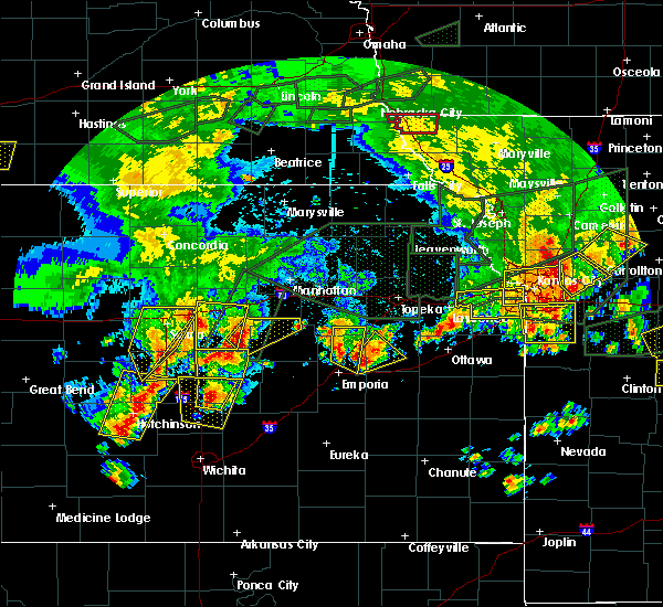 At 544 pm cdt, a severe thunderstorm was located over herington, moving northeast at 55 mph (radar indicated. spotters reported 2.25 inch hail in ramona kansas at 540pm). Hazards include two inch hail and 60 mph wind gusts. People and animals outdoors will be injured. expect hail damage to roofs, siding, windows, and vehicles. expect wind damage to roofs, siding, and trees. locations impacted include, herington, white city, hope, dwight, woodbine, parkerville and latimer. A tornado watch remains in effect until 1000 pm cdt for east central kansas. At 544 pm cdt, a severe thunderstorm was located over herington, moving northeast at 55 mph (radar indicated. spotters reported 2.25 inch hail in ramona kansas at 540pm). Hazards include two inch hail and 60 mph wind gusts. People and animals outdoors will be injured. expect hail damage to roofs, siding, windows, and vehicles. expect wind damage to roofs, siding, and trees. locations impacted include, herington, white city, hope, dwight, woodbine, parkerville and latimer. A tornado watch remains in effect until 1000 pm cdt for east central kansas.
|
| 5/26/2016 5:38 PM CDT |
 At 538 pm cdt, a severe thunderstorm was located over herington, moving northeast at 55 mph (radar indicated). Hazards include golf ball size hail and 60 mph wind gusts. People and animals outdoors will be injured. expect hail damage to roofs, siding, windows, and vehicles. Expect wind damage to roofs, siding, and trees. At 538 pm cdt, a severe thunderstorm was located over herington, moving northeast at 55 mph (radar indicated). Hazards include golf ball size hail and 60 mph wind gusts. People and animals outdoors will be injured. expect hail damage to roofs, siding, windows, and vehicles. Expect wind damage to roofs, siding, and trees.
|
| 5/24/2016 10:23 PM CDT | The national weather service in topeka has issued a * severe thunderstorm warning for. western geary county in east central kansas. southeastern clay county in north central kansas. dickinson county in central kansas. Until 1100 pm cdt. |
| 4/24/2016 11:08 PM CDT |
 At 1108 pm cdt, a severe thunderstorm was located near wilsey, moving east at 25 mph (radar indicated). Hazards include 60 mph wind gusts and quarter size hail. Hail damage to vehicles is expected. expect wind damage to roofs, siding, and trees. locations impacted include, wilsey and council grove lake. A tornado watch remains in effect until midnight cdt for east central kansas. At 1108 pm cdt, a severe thunderstorm was located near wilsey, moving east at 25 mph (radar indicated). Hazards include 60 mph wind gusts and quarter size hail. Hail damage to vehicles is expected. expect wind damage to roofs, siding, and trees. locations impacted include, wilsey and council grove lake. A tornado watch remains in effect until midnight cdt for east central kansas.
|
| 4/24/2016 10:58 PM CDT | Quarter sized hail reported 2.9 miles N of Herington, KS |
| 4/24/2016 10:56 PM CDT |
 At 1055 pm cdt, a severe thunderstorm was located near herington, moving east at 25 mph (radar indicated). Hazards include 60 mph wind gusts and quarter size hail. Hail damage to vehicles is expected. Expect wind damage to roofs, siding, and trees. At 1055 pm cdt, a severe thunderstorm was located near herington, moving east at 25 mph (radar indicated). Hazards include 60 mph wind gusts and quarter size hail. Hail damage to vehicles is expected. Expect wind damage to roofs, siding, and trees.
|
| 4/24/2016 9:37 PM CDT |
 At 937 pm cdt, a severe thunderstorm was located near carlton, moving east at 25 mph (radar indicated). Hazards include 60 mph wind gusts and nickel size hail. Expect damage to roofs. siding. and trees. locations impacted include, herington, hope and woodbine. A tornado watch remains in effect until 1100 pm cdt for east central kansas. At 937 pm cdt, a severe thunderstorm was located near carlton, moving east at 25 mph (radar indicated). Hazards include 60 mph wind gusts and nickel size hail. Expect damage to roofs. siding. and trees. locations impacted include, herington, hope and woodbine. A tornado watch remains in effect until 1100 pm cdt for east central kansas.
|
| 4/24/2016 9:22 PM CDT |
 At 921 pm cdt, a severe thunderstorm was located over carlton, moving east at 40 mph (radar indicated). Hazards include 60 mph wind gusts and nickel size hail. Expect damage to roofs. siding. And trees. At 921 pm cdt, a severe thunderstorm was located over carlton, moving east at 40 mph (radar indicated). Hazards include 60 mph wind gusts and nickel size hail. Expect damage to roofs. siding. And trees.
|
| 11/17/2015 3:23 AM CST |
 At 322 am cst, a severe thunderstorm was located over white city, moving northeast at 55 mph (radar indicated). Hazards include 60 mph wind gusts. Expect damage to roofs. Siding and trees. At 322 am cst, a severe thunderstorm was located over white city, moving northeast at 55 mph (radar indicated). Hazards include 60 mph wind gusts. Expect damage to roofs. Siding and trees.
|
| 9/10/2015 9:11 PM CDT |
 At 910 pm cdt, a severe thunderstorm was located 6 miles southwest of council grove, moving southeast at 45 mph (radar indicated). Hazards include 60 mph wind gusts and penny size hail. Expect damage to roofs. siding and trees. Locations impacted include, council grove, white city, wilsey, parkerville, burdick and council grove lake. At 910 pm cdt, a severe thunderstorm was located 6 miles southwest of council grove, moving southeast at 45 mph (radar indicated). Hazards include 60 mph wind gusts and penny size hail. Expect damage to roofs. siding and trees. Locations impacted include, council grove, white city, wilsey, parkerville, burdick and council grove lake.
|
| 9/10/2015 8:59 PM CDT |
 At 859 pm cdt, a severe thunderstorm was located near wilsey, moving southeast at 45 mph (radar indicated). Hazards include 60 mph wind gusts and penny size hail. Expect damage to roofs. Siding and trees. At 859 pm cdt, a severe thunderstorm was located near wilsey, moving southeast at 45 mph (radar indicated). Hazards include 60 mph wind gusts and penny size hail. Expect damage to roofs. Siding and trees.
|
| 9/10/2015 8:55 PM CDT |
 At 853 pm cdt, a severe thunderstorm was located over latimer, moving southeast at 45 mph (radar indicated). Hazards include 70 mph wind gusts and quarter size hail. Hail damage to vehicles is expected. expect considerable tree damage. wind damage is also likely to mobile homes, roofs and outbuildings. Locations impacted include, herington, white city, parkerville and latimer. At 853 pm cdt, a severe thunderstorm was located over latimer, moving southeast at 45 mph (radar indicated). Hazards include 70 mph wind gusts and quarter size hail. Hail damage to vehicles is expected. expect considerable tree damage. wind damage is also likely to mobile homes, roofs and outbuildings. Locations impacted include, herington, white city, parkerville and latimer.
|
| 9/10/2015 8:44 PM CDT |
 At 844 pm cdt, a severe thunderstorm was located over woodbine, moving southeast at 45 mph (radar indicated). Hazards include 60 mph wind gusts and quarter size hail. Hail damage to vehicles is expected. expect wind damage to roofs, siding and trees. locations impacted include, herington, chapman, white city, woodbine, parkerville and latimer. This includes interstate 70 between mile markers 284 and 292. At 844 pm cdt, a severe thunderstorm was located over woodbine, moving southeast at 45 mph (radar indicated). Hazards include 60 mph wind gusts and quarter size hail. Hail damage to vehicles is expected. expect wind damage to roofs, siding and trees. locations impacted include, herington, chapman, white city, woodbine, parkerville and latimer. This includes interstate 70 between mile markers 284 and 292.
|
| 9/10/2015 8:39 PM CDT |
 At 838 pm cdt, a severe thunderstorm was located over woodbine, moving southeast at 45 mph (law enforcement). Hazards include 60 mph wind gusts and half dollar size hail. Hail damage to vehicles is expected. expect wind damage to roofs, siding and trees. locations impacted include, herington, chapman, enterprise, white city, woodbine, parkerville, latimer and moonlight. This includes interstate 70 between mile markers 278 and 292. At 838 pm cdt, a severe thunderstorm was located over woodbine, moving southeast at 45 mph (law enforcement). Hazards include 60 mph wind gusts and half dollar size hail. Hail damage to vehicles is expected. expect wind damage to roofs, siding and trees. locations impacted include, herington, chapman, enterprise, white city, woodbine, parkerville, latimer and moonlight. This includes interstate 70 between mile markers 278 and 292.
|
| 9/10/2015 8:29 PM CDT |
 At 827 pm cdt, a severe thunderstorm was located near enterprise, moving southeast at 45 mph (law enforcement. at 826 pm cdt...law enforcement estimated 65 mph wind gusts 2 miles east of abilene). Hazards include 60 mph wind gusts and half dollar size hail. Hail damage to vehicles is expected. expect wind damage to roofs, siding and trees. locations impacted include, abilene, herington, chapman, enterprise, white city, woodbine, parkerville, latimer, moonlight and talmage. This includes interstate 70 between mile markers 271 and 292. At 827 pm cdt, a severe thunderstorm was located near enterprise, moving southeast at 45 mph (law enforcement. at 826 pm cdt...law enforcement estimated 65 mph wind gusts 2 miles east of abilene). Hazards include 60 mph wind gusts and half dollar size hail. Hail damage to vehicles is expected. expect wind damage to roofs, siding and trees. locations impacted include, abilene, herington, chapman, enterprise, white city, woodbine, parkerville, latimer, moonlight and talmage. This includes interstate 70 between mile markers 271 and 292.
|
| 9/10/2015 8:21 PM CDT |
 At 821 pm cdt, a severe thunderstorm was located near talmage, moving southeast at 40 mph (radar indicated). Hazards include 60 mph wind gusts and half dollar size hail. Hail damage to vehicles is expected. Expect wind damage to roofs, siding and trees. At 821 pm cdt, a severe thunderstorm was located near talmage, moving southeast at 40 mph (radar indicated). Hazards include 60 mph wind gusts and half dollar size hail. Hail damage to vehicles is expected. Expect wind damage to roofs, siding and trees.
|
| 9/7/2015 9:42 PM CDT |
 At 941 pm cdt, a severe thunderstorm was located near parkerville, moving east at 15 mph (radar indicated). Hazards include 60 mph wind gusts and quarter size hail. Hail damage to vehicles is expected. expect wind damage to roofs, siding and trees. Locations impacted include, wilsey and council grove lake. At 941 pm cdt, a severe thunderstorm was located near parkerville, moving east at 15 mph (radar indicated). Hazards include 60 mph wind gusts and quarter size hail. Hail damage to vehicles is expected. expect wind damage to roofs, siding and trees. Locations impacted include, wilsey and council grove lake.
|
| 9/7/2015 9:32 PM CDT |
 At 932 pm cdt, a severe thunderstorm was located near latimer, moving east at 15 mph (radar indicated). Hazards include 60 mph wind gusts and quarter size hail. Hail damage to vehicles is expected. Expect wind damage to roofs, siding and trees. At 932 pm cdt, a severe thunderstorm was located near latimer, moving east at 15 mph (radar indicated). Hazards include 60 mph wind gusts and quarter size hail. Hail damage to vehicles is expected. Expect wind damage to roofs, siding and trees.
|
| 9/7/2015 9:22 PM CDT |
 At 920 pm cdt, a severe thunderstorm was located near white city, moving east at 25 mph (emergency management. at 905 pm cdt...60 mph wind gusts were reported on us highway 77, 4 miles south of interstate 70). Hazards include 60 mph wind gusts and quarter size hail. Hail damage to vehicles is expected. expect wind damage to roofs, siding and trees. locations impacted include, junction city, white city, dwight, parkerville and latimer. This includes interstate 70 between mile markers 291 and 296. At 920 pm cdt, a severe thunderstorm was located near white city, moving east at 25 mph (emergency management. at 905 pm cdt...60 mph wind gusts were reported on us highway 77, 4 miles south of interstate 70). Hazards include 60 mph wind gusts and quarter size hail. Hail damage to vehicles is expected. expect wind damage to roofs, siding and trees. locations impacted include, junction city, white city, dwight, parkerville and latimer. This includes interstate 70 between mile markers 291 and 296.
|
| 9/7/2015 9:13 PM CDT |
 At 912 pm cdt, a severe thunderstorm was located 7 miles northwest of white city, moving east at 25 mph (radar indicated). Hazards include 70 mph wind gusts and penny size hail. Expect considerable tree damage. damage is likely to mobile homes, roofs and outbuildings. locations impacted include, junction city, white city, dwight, woodbine, parkerville and latimer. This includes interstate 70 between mile markers 288 and 297. At 912 pm cdt, a severe thunderstorm was located 7 miles northwest of white city, moving east at 25 mph (radar indicated). Hazards include 70 mph wind gusts and penny size hail. Expect considerable tree damage. damage is likely to mobile homes, roofs and outbuildings. locations impacted include, junction city, white city, dwight, woodbine, parkerville and latimer. This includes interstate 70 between mile markers 288 and 297.
|
| 9/7/2015 9:06 PM CDT |
 At 905 pm cdt, a severe thunderstorm was located 6 miles northeast of woodbine, moving east at 25 mph (emergency management. at 8:20 pm cdt...widespread power outages reported in abilene. possible house damaged 8 miles south southwest of abilene). Hazards include 70 mph wind gusts and penny size hail. Expect considerable tree damage. damage is likely to mobile homes, roofs and outbuildings. locations impacted include, junction city, chapman, white city, dwight, woodbine, parkerville and latimer. This includes interstate 70 between mile markers 284 and 297. At 905 pm cdt, a severe thunderstorm was located 6 miles northeast of woodbine, moving east at 25 mph (emergency management. at 8:20 pm cdt...widespread power outages reported in abilene. possible house damaged 8 miles south southwest of abilene). Hazards include 70 mph wind gusts and penny size hail. Expect considerable tree damage. damage is likely to mobile homes, roofs and outbuildings. locations impacted include, junction city, chapman, white city, dwight, woodbine, parkerville and latimer. This includes interstate 70 between mile markers 284 and 297.
|
| 9/7/2015 8:54 PM CDT |
 At 854 pm cdt, a severe thunderstorm was located near woodbine, moving east at 25 mph (law enforcement. power lines reported down in the abilene area. report came in at 854 pm cdt). Hazards include 60 mph wind gusts and penny size hail. Expect damage to roofs. Siding and trees. At 854 pm cdt, a severe thunderstorm was located near woodbine, moving east at 25 mph (law enforcement. power lines reported down in the abilene area. report came in at 854 pm cdt). Hazards include 60 mph wind gusts and penny size hail. Expect damage to roofs. Siding and trees.
|
| 9/7/2015 6:06 PM CDT |
 The severe thunderstorm warning for dickinson county will expire at 615 pm cdt, the storm which prompted the warning has weakened below severe limits, and no longer pose an immediate threat to life or property. therefore the warning will be allowed to expire. however gusty winds near 50 mph and heavy rain are still possible with this thunderstorm. a severe thunderstorm watch remains in effect until 900 pm cdt for central kansas. The severe thunderstorm warning for dickinson county will expire at 615 pm cdt, the storm which prompted the warning has weakened below severe limits, and no longer pose an immediate threat to life or property. therefore the warning will be allowed to expire. however gusty winds near 50 mph and heavy rain are still possible with this thunderstorm. a severe thunderstorm watch remains in effect until 900 pm cdt for central kansas.
|
| 9/7/2015 5:54 PM CDT |
 At 554 pm cdt, a severe thunderstorm was located 6 miles northeast of gypsum, moving east at 30 mph (radar indicated). Hazards include 60 mph wind gusts and nickel size hail. Expect damage to roofs. siding and trees. locations impacted include, abilene, herington, solomon, enterprise, hope, woodbine and carlton. This includes interstate 70 between mile markers 267 and 280. At 554 pm cdt, a severe thunderstorm was located 6 miles northeast of gypsum, moving east at 30 mph (radar indicated). Hazards include 60 mph wind gusts and nickel size hail. Expect damage to roofs. siding and trees. locations impacted include, abilene, herington, solomon, enterprise, hope, woodbine and carlton. This includes interstate 70 between mile markers 267 and 280.
|
| 9/7/2015 5:29 PM CDT |
 At 528 pm cdt, a severe thunderstorm was located near gypsum, moving east at 35 mph (measured at the salina airport at 518 pm cdt). Hazards include 60 mph wind gusts and nickel size hail. Expect damage to roofs. Siding and trees. At 528 pm cdt, a severe thunderstorm was located near gypsum, moving east at 35 mph (measured at the salina airport at 518 pm cdt). Hazards include 60 mph wind gusts and nickel size hail. Expect damage to roofs. Siding and trees.
|
| 7/6/2015 3:28 PM CDT |
 At 328 pm cdt, a severe thunderstorm was located 6 miles west of wilsey, moving east at 25 mph (radar indicated). Hazards include 70 mph wind gusts. Expect considerable tree damage. damage is likely to mobile homes, roofs and outbuildings. Locations impacted include, council grove, wilsey, latimer, burdick and council grove lake. At 328 pm cdt, a severe thunderstorm was located 6 miles west of wilsey, moving east at 25 mph (radar indicated). Hazards include 70 mph wind gusts. Expect considerable tree damage. damage is likely to mobile homes, roofs and outbuildings. Locations impacted include, council grove, wilsey, latimer, burdick and council grove lake.
|
| 7/6/2015 3:12 PM CDT |
 At 311 pm cdt, a severe thunderstorm was located over herington, moving east at 25 mph (radar indicated). Hazards include 70 mph wind gusts. Expect considerable tree damage. Damage is likely to mobile homes, roofs and outbuildings. At 311 pm cdt, a severe thunderstorm was located over herington, moving east at 25 mph (radar indicated). Hazards include 70 mph wind gusts. Expect considerable tree damage. Damage is likely to mobile homes, roofs and outbuildings.
|
| 6/14/2015 7:26 PM CDT |
 The severe thunderstorm warning for southeastern dickinson and southwestern morris counties will expire at 730 pm cdt, the storm which prompted the warning has weakened below severe limits, and no longer poses an immediate threat to life or property. however, heavy rain is still possible with this thunderstorm. The severe thunderstorm warning for southeastern dickinson and southwestern morris counties will expire at 730 pm cdt, the storm which prompted the warning has weakened below severe limits, and no longer poses an immediate threat to life or property. however, heavy rain is still possible with this thunderstorm.
|
| 6/14/2015 7:00 PM CDT |
 At 655 pm cdt, a severe thunderstorm was located near lincolnville, and moving northeast at 25 mph (radar indicated). Hazards include 60 mph wind gusts and nickel size hail. Expect damage to roofs. siding and trees. Locations impacted include, herington, burdick and wilsey. At 655 pm cdt, a severe thunderstorm was located near lincolnville, and moving northeast at 25 mph (radar indicated). Hazards include 60 mph wind gusts and nickel size hail. Expect damage to roofs. siding and trees. Locations impacted include, herington, burdick and wilsey.
|
| 6/14/2015 6:46 PM CDT |
 At 643 pm cdt, a severe thunderstorm was located near lincolnville, and moving northeast at 25 mph (radar indicated). Hazards include 60 mph wind gusts and nickel size hail. Expect damage to roofs. Siding and trees. At 643 pm cdt, a severe thunderstorm was located near lincolnville, and moving northeast at 25 mph (radar indicated). Hazards include 60 mph wind gusts and nickel size hail. Expect damage to roofs. Siding and trees.
|
| 6/11/2015 6:42 PM CDT | The severe thunderstorm warning for southeastern dickinson and west central morris counties will expire at 645 pm cdt, the storm which prompted the warning has weakened below severe limits, and no longer poses an immediate threat to life or property. however, heavy rain is still possible with this thunderstorm. in addition, strong thunderstorms may redevelop, and a severe thunderstorm watch remains in effect until midnight. |
| 6/11/2015 6:14 PM CDT |
 At 612 pm cdt, a severe thunderstorm was located near hope, and moving northeast at 30 mph (radar indicated). Hazards include 60 mph wind gusts and quarter size hail. Hail damage to vehicles is expected. expect wind damage to roofs, siding and trees. Locations impacted include, herington, hope, woodbine and latimer. At 612 pm cdt, a severe thunderstorm was located near hope, and moving northeast at 30 mph (radar indicated). Hazards include 60 mph wind gusts and quarter size hail. Hail damage to vehicles is expected. expect wind damage to roofs, siding and trees. Locations impacted include, herington, hope, woodbine and latimer.
|
| 6/11/2015 5:58 PM CDT |
 At 556 pm cdt, a severe thunderstorm was located near tampa, and moving northeast at 30 mph (radar indicated). Hazards include 60 mph wind gusts and quarter size hail. Hail damage to vehicles is expected. Expect wind damage to roofs, siding and trees. At 556 pm cdt, a severe thunderstorm was located near tampa, and moving northeast at 30 mph (radar indicated). Hazards include 60 mph wind gusts and quarter size hail. Hail damage to vehicles is expected. Expect wind damage to roofs, siding and trees.
|
| 6/7/2015 8:26 PM CDT | At 824 pm cdt, a severe thunderstorm was located 6 miles south of herington, and moving southeast at 30 mph (radar indicated). Hazards include tennis ball size hail and 60 mph wind gusts. People and animals outdoors will be injured. expect hail damage to roofs, siding, windows and vehicles. expect wind damage to roofs, siding and trees. Locations impacted include, burdick. |
| 6/7/2015 8:22 PM CDT | Quarter sized hail reported 2.4 miles ENE of Herington, KS |
| 6/7/2015 8:22 PM CDT | At 819 pm cdt, a severe thunderstorm was located near herington, and moving southeast at 30 mph (radar indicated). Hazards include tennis ball size hail and 60 mph wind gusts. People and animals outdoors will be injured. expect hail damage to roofs, siding, windows and vehicles. expect wind damage to roofs, siding and trees. Locations impacted include, burdick. |
| 6/7/2015 8:19 PM CDT | At 817 pm cdt, a severe thunderstorm was located near herington, and moving southeast at 30 mph (radar indicated). Hazards include tennis ball size hail and 60 mph wind gusts. People and animals outdoors will be injured. expect hail damage to roofs, siding, windows and vehicles. Expect wind damage to roofs, siding and trees. |
| 6/7/2015 8:11 PM CDT | At 809 pm cdt, a severe thunderstorm was located near hope, and moving southeast at 40 mph (radar indicated). Hazards include golf ball size hail and 60 mph wind gusts. People and animals outdoors will be injured. expect hail damage to roofs, siding, windows and vehicles. Expect wind damage to roofs, siding and trees. |
| 6/7/2015 8:03 PM CDT | At 801 pm cdt, a severe thunderstorm was located near hope, and moving southeast at 35 mph (radar indicated). Hazards include tennis ball size hail and 60 mph wind gusts. People and animals outdoors will be injured. expect hail damage to roofs, siding, windows and vehicles. expect wind damage to roofs, siding and trees. Locations impacted include, herington and hope. |
| 6/7/2015 7:59 PM CDT | At 756 pm cdt, a severe thunderstorm was located 6 miles west of hope, and moving southeast at 35 mph (radar indicated). Hazards include golf ball size hail and 60 mph wind gusts. People and animals outdoors will be injured. expect hail damage to roofs, siding, windows and vehicles. expect wind damage to roofs, siding and trees. Locations impacted include, herington and hope. |
| 6/7/2015 7:49 PM CDT | At 746 pm cdt, a severe thunderstorm was located 6 miles north of carlton, and moving southeast at 35 mph (radar indicated). Hazards include tennis ball size hail and 60 mph wind gusts. People and animals outdoors will be injured. expect hail damage to roofs, siding, windows and vehicles. expect wind damage to roofs, siding and trees. Locations impacted include, herington and hope. |
| 6/7/2015 7:37 PM CDT | At 735 pm cdt, a severe thunderstorm was located 7 miles north of gypsum, and moving southeast at 35 mph (radar indicated). Hazards include tennis ball size hail and 60 mph wind gusts. People and animals outdoors will be injured. expect hail damage to roofs, siding, windows and vehicles. expect wind damage to roofs, siding and trees. Locations impacted include, herington, carlton and hope. |
| 6/7/2015 7:28 PM CDT | At 725 pm cdt, a severe thunderstorm was located near new cambria, and moving southeast at 35 mph (radar indicated). Hazards include hen egg size hail and 60 mph wind gusts. People and animals outdoors will be injured. expect hail damage to roofs, siding, windows and vehicles. Expect wind damage to roofs, siding and trees. |
| 6/5/2015 2:14 AM CDT | At 211 am cdt, severe thunderstorms were located along a line extending from 5 miles north of harveyville to 5 miles northwest of bushong to herington, and moving south at 35 mph (radar indicated). Hazards include isolated 60 mph wind gusts. Expect damage to roofs. siding and trees. locations impacted include, harveyville, bushong, burdick, allen, dunlap and admire. this includes the kansas turnpike between mile markers 149 and 154. This includes interstate 70 between mile markers 292 and 345. |
| 6/5/2015 1:44 AM CDT | At 141 am cdt, severe thunderstorms were located along a line extending from maple hill to 6 miles southeast of alta vista to 8 miles northeast of woodbine, and moving south at 30 mph (radar indicated). Hazards include 60 mph wind gusts and penny size hail. Expect damage to roofs. Siding and trees. |
| 6/5/2015 1:28 AM CDT | At 125 am cdt, severe thunderstorms were located along a line extending from manchester to 5 miles north of woodbine, and moving south at 25 mph (radar indicated). Hazards include 60 mph wind gusts and penny size hail. Expect damage to roofs. siding and trees. locations impacted include, herington, solomon, woodbine, hope and carlton. This includes interstate 70 between mile markers 267 and 292. |
| 6/5/2015 1:20 AM CDT | At 111 am cdt, severe thunderstorms were located along a line extending from moonlight to alta vista to willard, and moving south at 45 mph (emergency management. 1 mile east of wamego). Hazards include 65 mph wind gusts. Expect damage to roofs. siding and trees. locations impacted include, eskridge, council grove, dwight, keene, white city, parkerville, council grove lake, latimer, harveyville, bushong, wilsey, allen, dunlap, admire and burdick. this includes the kansas turnpike between mile markers 149 and 154. This includes interstate 70 between mile markers 290 and 344. |
| 6/5/2015 1:09 AM CDT | At 106 am cdt, severe thunderstorms were located along a line extending from moonlight to 7 miles northwest of volland to rossville, and moving south at 45 mph (radar indicated). Hazards include 70 mph wind gusts and penny size hail. Expect considerable tree damage. Damage is likely to mobile homes, roofs and outbuildings. |
| 6/5/2015 1:04 AM CDT | At 101 am cdt, severe thunderstorms were located along a line extending from scottsville to 5 miles west of manchester to 5 miles northeast of chapman, and moving south at 25 mph (radar indicated). Hazards include 60 mph wind gusts and penny size hail. Expect damage to roofs. Siding and trees. |
| 8/15/2013 5:28 PM CDT | Herington middle school mesone in dickinson county KS, 2.4 miles ENE of Herington, KS |
| 8/2/2013 11:43 PM CDT | Quarter sized hail reported 2.4 miles ENE of Herington, KS |
| 1/1/0001 12:00 AM | Golf Ball sized hail reported 4.3 miles N of Herington, KS, also reported 60 mph wind gusts |
| 1/1/0001 12:00 AM | Storm damage reported in morris county KS, 1.6 miles NNW of Herington, KS |
| 1/1/0001 12:00 AM | Storm damage reported in dickinson county KS, 6.5 miles NE of Herington, KS |
| 1/1/0001 12:00 AM | Hen Egg sized hail reported 6.6 miles E of Herington, KS |
| 1/1/0001 12:00 AM | Quarter sized hail reported 4.7 miles S of Herington, KS |
| 1/1/0001 12:00 AM | Walnut tree blown over. time estimate in dickinson county KS, 2.4 miles ENE of Herington, KS |
Hail Maps for Herington, KS


Connect with Interactive Hail Maps