

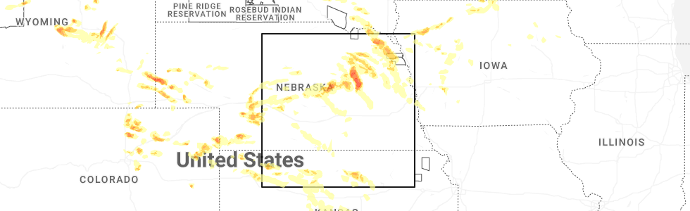
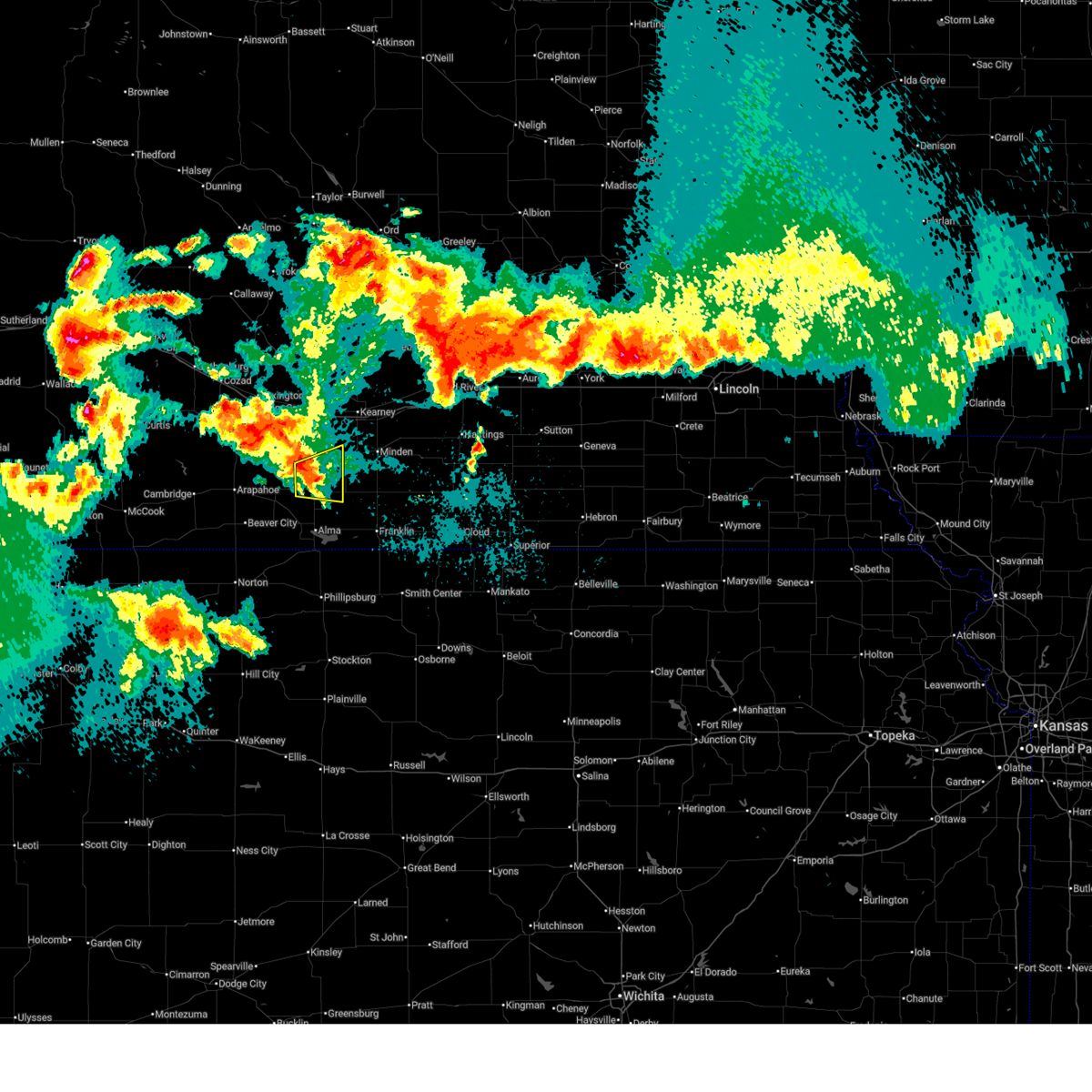
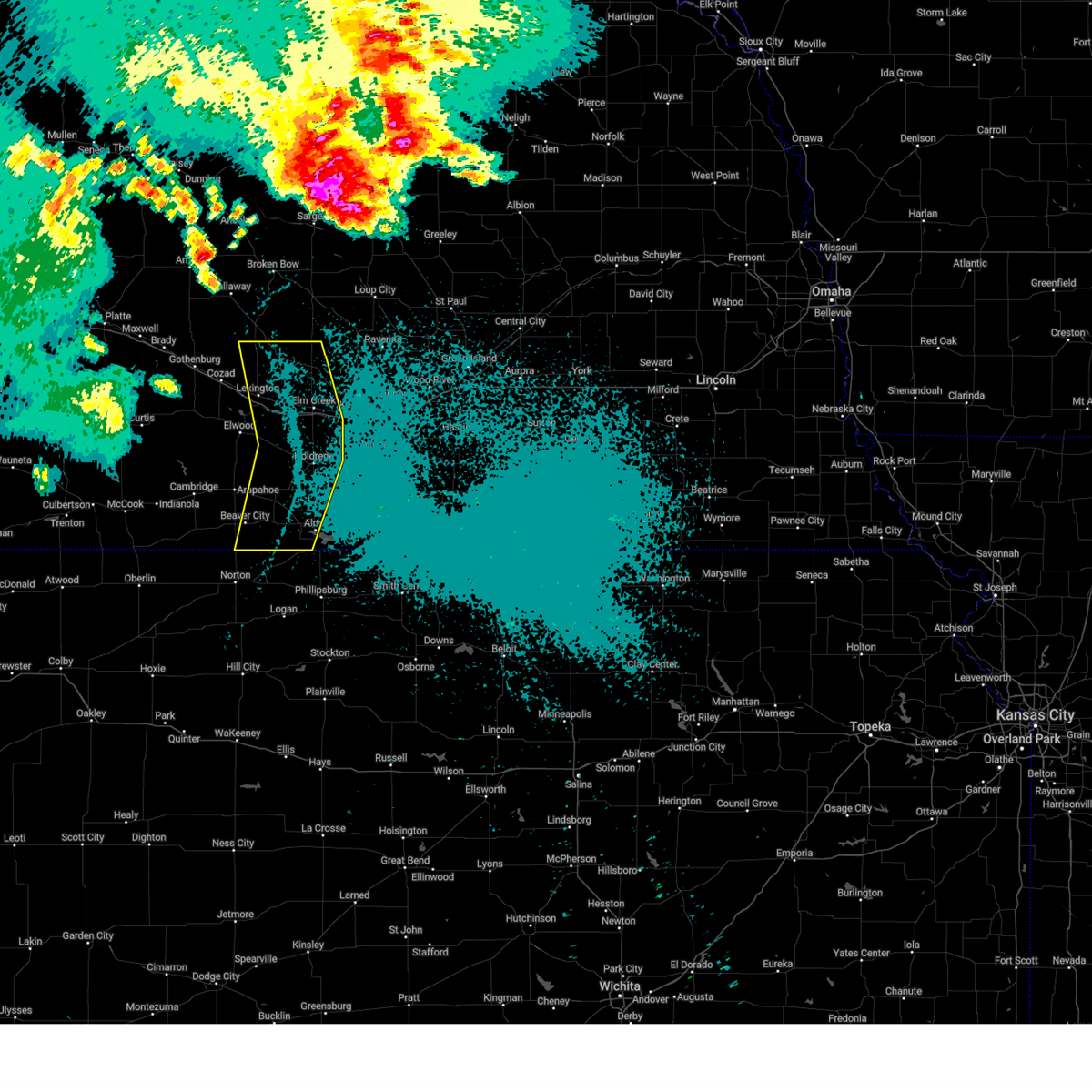
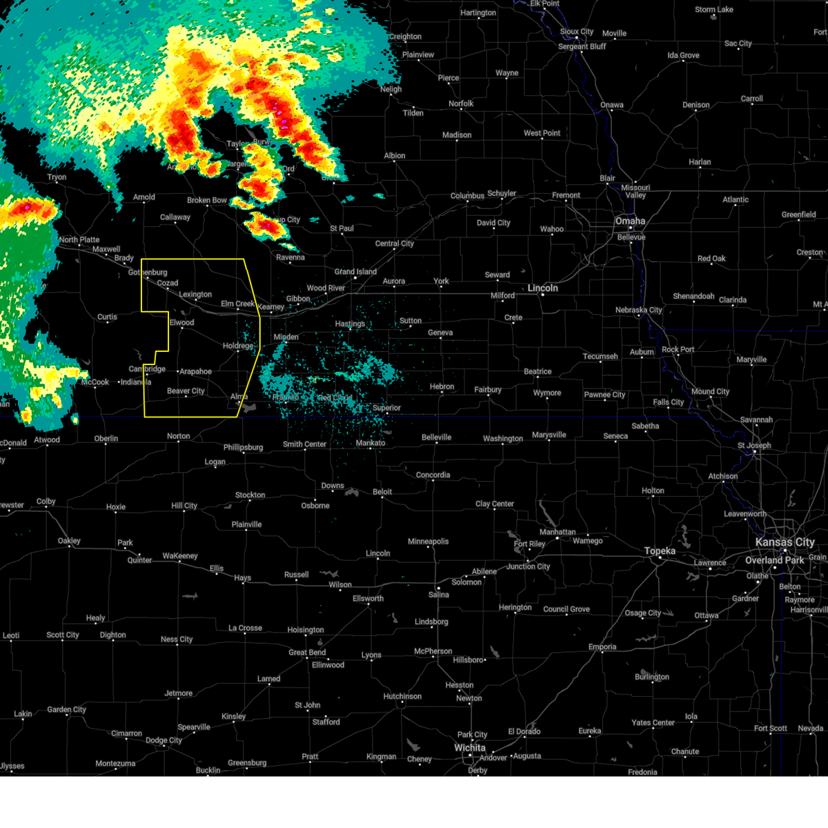
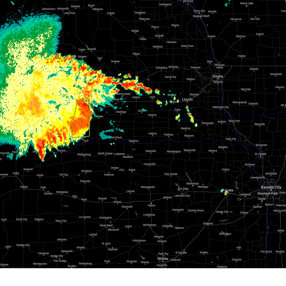
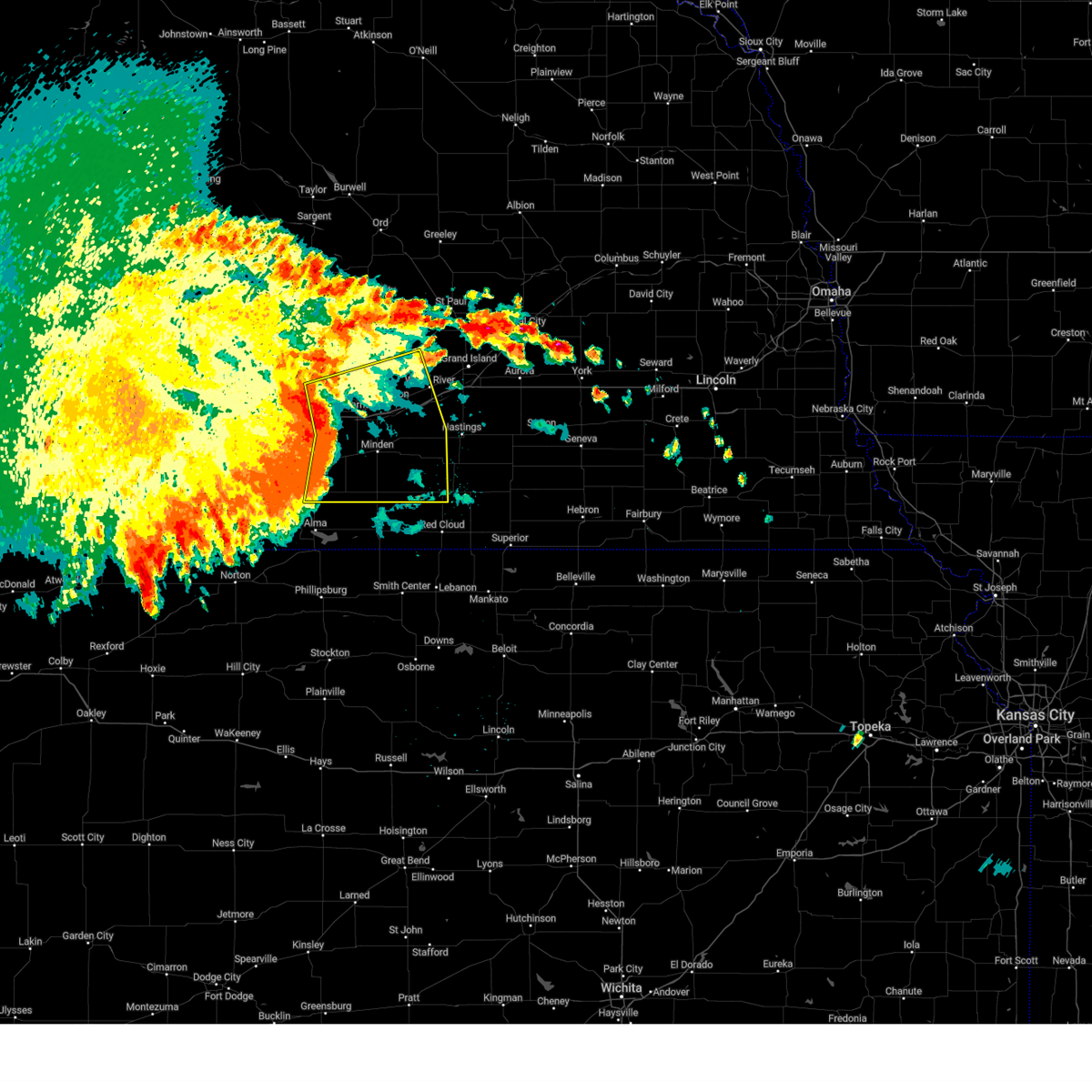
Hail Map for Holdrege, NE
The Holdrege, NE area has had 29 reports of on-the-ground hail by trained spotters, and has been under severe weather warnings 25 times during the past 12 months. Doppler radar has detected hail at or near Holdrege, NE on 102 occasions, including 7 occasions during the past year.
| Name: | Holdrege, NE |
| Where Located: | 63.8 miles WSW of Grand Island, NE |
| Map: | Google Map for Holdrege, NE |
| Population: | 5495 |
| Housing Units: | 2589 |
| More Info: | Search Google for Holdrege, NE |
1
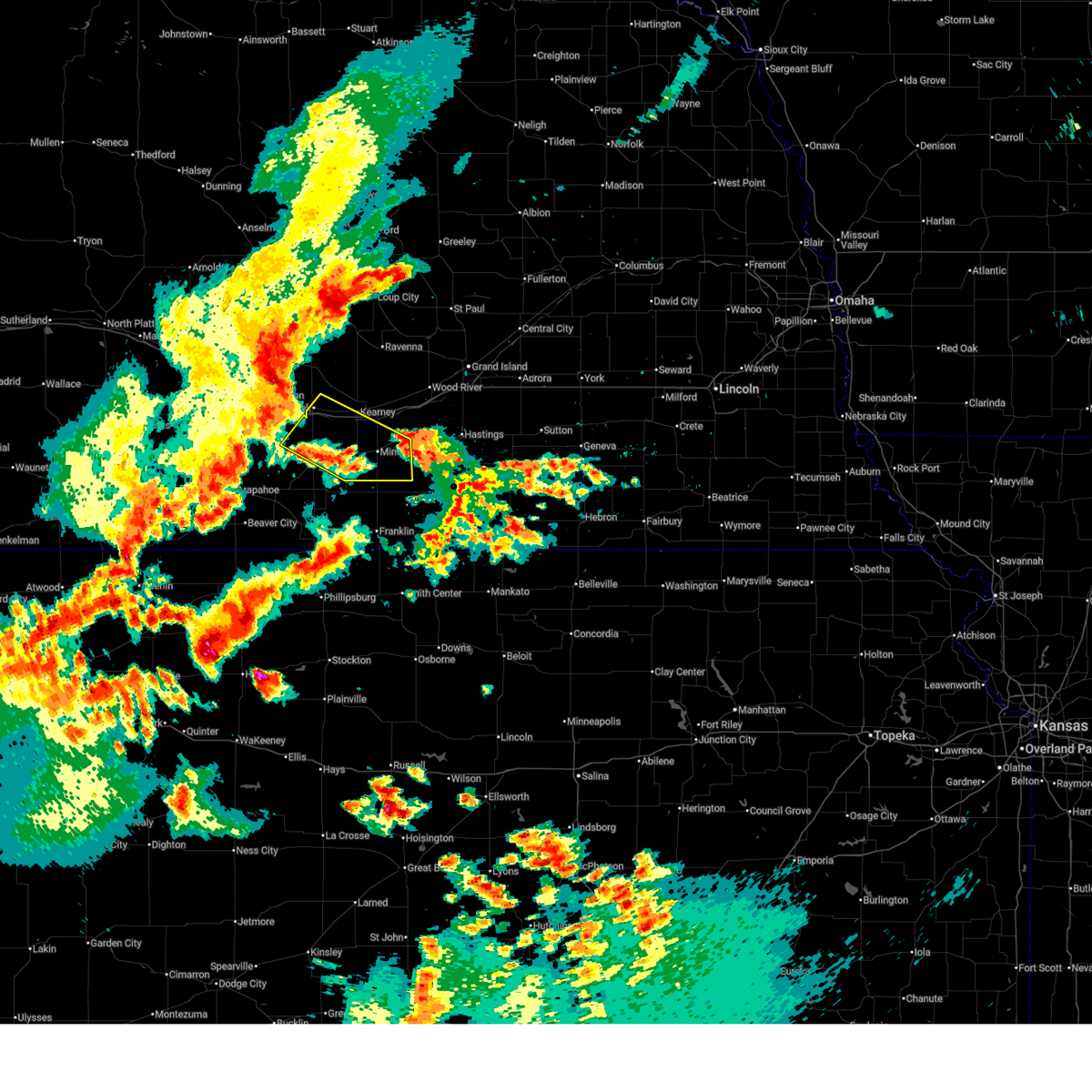
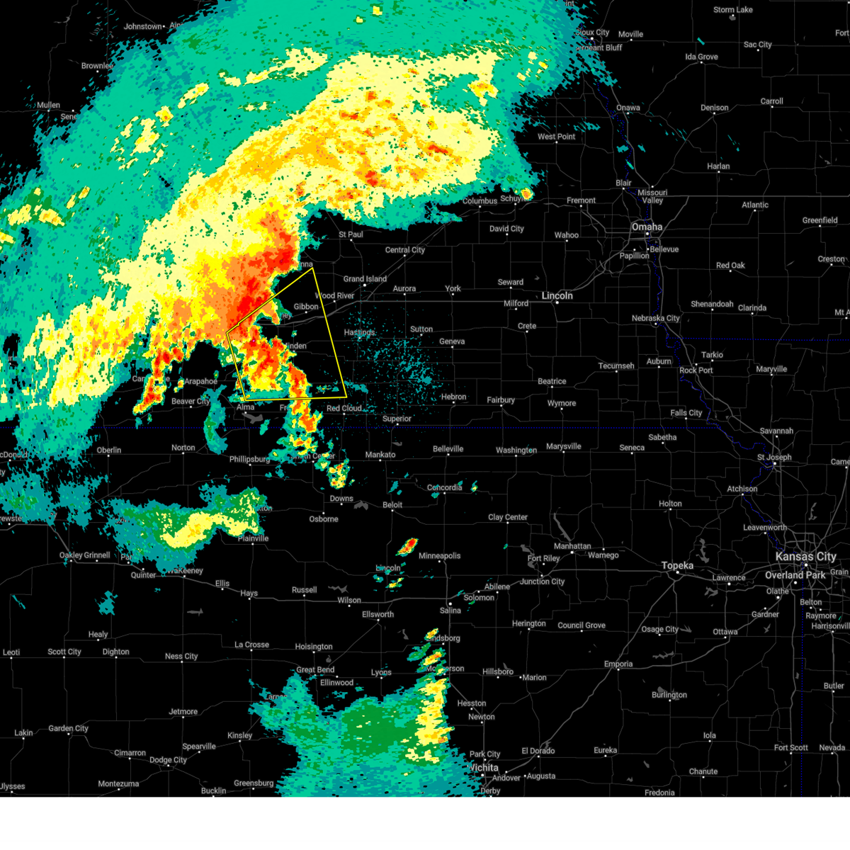
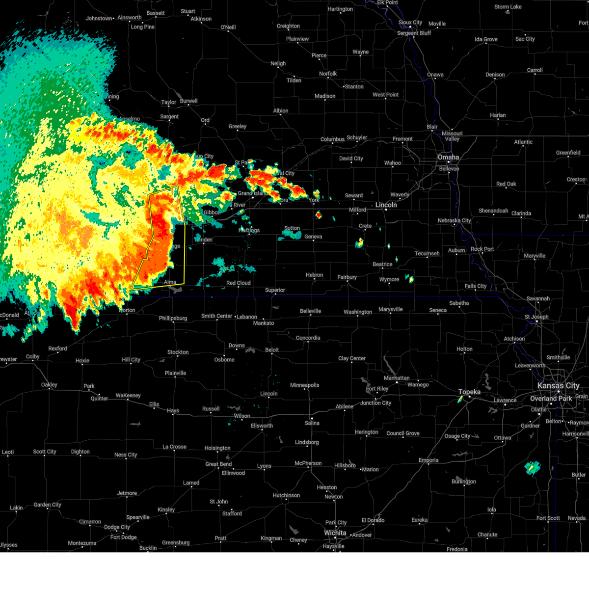
The Top Recent Hail Date for Holdrege, NE is Monday, June 16, 2025 (23rd out of 102)
Hail and Wind Damage Spotted near Holdrege, NE
| Date / Time | Report Details |
|---|---|
| 6/30/2025 3:15 AM CDT | On the backside of storm in phelps county NE, 1.9 miles WSW of Holdrege, NE |
| 6/30/2025 2:30 AM CDT |
 Svrgid the national weather service in hastings has issued a * severe thunderstorm warning for, phelps county in south central nebraska, kearney county in south central nebraska, southwestern buffalo county in south central nebraska, * until 300 am cdt. * at 230 am cdt, a severe thunderstorm was located 7 miles southwest of odessa, or 11 miles north of holdrege, moving southeast at 45 mph (radar indicated). Hazards include 70 mph wind gusts. Expect considerable tree damage. damage is likely to mobile homes, roofs, and outbuildings. this severe thunderstorm will be near, axtell around 245 am cdt. other locations in the path of this severe thunderstorm include minden. This includes interstate 80 between mile markers 255 and 276. Svrgid the national weather service in hastings has issued a * severe thunderstorm warning for, phelps county in south central nebraska, kearney county in south central nebraska, southwestern buffalo county in south central nebraska, * until 300 am cdt. * at 230 am cdt, a severe thunderstorm was located 7 miles southwest of odessa, or 11 miles north of holdrege, moving southeast at 45 mph (radar indicated). Hazards include 70 mph wind gusts. Expect considerable tree damage. damage is likely to mobile homes, roofs, and outbuildings. this severe thunderstorm will be near, axtell around 245 am cdt. other locations in the path of this severe thunderstorm include minden. This includes interstate 80 between mile markers 255 and 276.
|
| 6/25/2025 3:13 PM CDT | At 311 pm cdt, a severe thunderstorm was located near odessa, or 12 miles west of kearney, moving northeast at 40 mph (automated weather station. a mesonet site in loomis reported a wind gust of 57 mph). Hazards include 60 mph wind gusts and quarter size hail. Hail damage to vehicles is expected. expect wind damage to roofs, siding, and trees. this severe storm will be near, odessa around 315 pm cdt. amherst around 320 pm cdt. riverdale around 325 pm cdt. This includes interstate 80 between mile markers 255 and 271. |
| 6/25/2025 3:13 PM CDT | the severe thunderstorm warning has been cancelled and is no longer in effect |
| 6/25/2025 2:46 PM CDT |
 Svrgid the national weather service in hastings has issued a * severe thunderstorm warning for, central phelps county in south central nebraska, northwestern kearney county in south central nebraska, western buffalo county in south central nebraska, southeastern dawson county in south central nebraska, * until 330 pm cdt. * at 246 pm cdt, a severe thunderstorm was located over loomis, or near holdrege, moving northeast at 40 mph (radar indicated). Hazards include 60 mph wind gusts and quarter size hail. Hail damage to vehicles is expected. expect wind damage to roofs, siding, and trees. this severe thunderstorm will be near, elm creek around 305 pm cdt. other locations in the path of this severe thunderstorm include odessa and amherst. This includes interstate 80 between mile markers 251 and 271. Svrgid the national weather service in hastings has issued a * severe thunderstorm warning for, central phelps county in south central nebraska, northwestern kearney county in south central nebraska, western buffalo county in south central nebraska, southeastern dawson county in south central nebraska, * until 330 pm cdt. * at 246 pm cdt, a severe thunderstorm was located over loomis, or near holdrege, moving northeast at 40 mph (radar indicated). Hazards include 60 mph wind gusts and quarter size hail. Hail damage to vehicles is expected. expect wind damage to roofs, siding, and trees. this severe thunderstorm will be near, elm creek around 305 pm cdt. other locations in the path of this severe thunderstorm include odessa and amherst. This includes interstate 80 between mile markers 251 and 271.
|
| 6/16/2025 10:37 PM CDT |
 At 1037 pm cdt, a severe thunderstorm was located near ragan, or near holdrege, moving east at 10 mph (radar indicated). Hazards include 60 mph wind gusts and quarter size hail. Hail damage to vehicles is expected. expect wind damage to roofs, siding, and trees. This severe thunderstorm will remain over mainly rural areas of southeastern phelps and northeastern harlan counties. At 1037 pm cdt, a severe thunderstorm was located near ragan, or near holdrege, moving east at 10 mph (radar indicated). Hazards include 60 mph wind gusts and quarter size hail. Hail damage to vehicles is expected. expect wind damage to roofs, siding, and trees. This severe thunderstorm will remain over mainly rural areas of southeastern phelps and northeastern harlan counties.
|
| 6/16/2025 10:19 PM CDT |
 Svrgid the national weather service in hastings has issued a * severe thunderstorm warning for, southeastern phelps county in south central nebraska, northeastern harlan county in south central nebraska, * until 1100 pm cdt. * at 1019 pm cdt, a severe thunderstorm was located near holdrege, moving east at 10 mph (radar indicated). Hazards include 60 mph wind gusts and quarter size hail. Hail damage to vehicles is expected. expect wind damage to roofs, siding, and trees. This severe thunderstorm will be near, ragan around 1030 pm cdt. Svrgid the national weather service in hastings has issued a * severe thunderstorm warning for, southeastern phelps county in south central nebraska, northeastern harlan county in south central nebraska, * until 1100 pm cdt. * at 1019 pm cdt, a severe thunderstorm was located near holdrege, moving east at 10 mph (radar indicated). Hazards include 60 mph wind gusts and quarter size hail. Hail damage to vehicles is expected. expect wind damage to roofs, siding, and trees. This severe thunderstorm will be near, ragan around 1030 pm cdt.
|
| 6/2/2025 10:13 PM CDT |
 At 1013 pm cdt, severe thunderstorms were located along a line extending from near odessa to near upland, moving northeast at 45 mph (radar indicated). Hazards include 60 to 65 mph wind gusts and quarter size hail. Hail damage to vehicles is expected. expect wind damage to roofs, siding, and trees. locations impacted include, kearney, holdrege, minden, gibbon, shelton, kenesaw, axtell, odessa, hildreth, wilcox, campbell, bladen, holstein, funk, riverdale, upland, heartwell, huntley, norman, and ragan. This includes interstate 80 between mile markers 256 and 294. At 1013 pm cdt, severe thunderstorms were located along a line extending from near odessa to near upland, moving northeast at 45 mph (radar indicated). Hazards include 60 to 65 mph wind gusts and quarter size hail. Hail damage to vehicles is expected. expect wind damage to roofs, siding, and trees. locations impacted include, kearney, holdrege, minden, gibbon, shelton, kenesaw, axtell, odessa, hildreth, wilcox, campbell, bladen, holstein, funk, riverdale, upland, heartwell, huntley, norman, and ragan. This includes interstate 80 between mile markers 256 and 294.
|
| 6/2/2025 10:07 PM CDT |
 Svrgid the national weather service in hastings has issued a * severe thunderstorm warning for, northwestern webster county in south central nebraska, northern franklin county in south central nebraska, phelps county in south central nebraska, western adams county in south central nebraska, kearney county in south central nebraska, southeastern buffalo county in south central nebraska, northeastern harlan county in south central nebraska, southwestern hall county in south central nebraska, * until 1030 pm cdt. * at 1007 pm cdt, severe thunderstorms were located along a line extending from 8 miles northeast of loomis to near hildreth, moving northeast at 40 mph (radar indicated). Hazards include 60 to 65 mph wind gusts and quarter size hail. Hail damage to vehicles is expected. expect wind damage to roofs, siding, and trees. severe thunderstorms will be near, axtell, hildreth, and upland around 1010 pm cdt. minden around 1015 pm cdt. odessa around 1020 pm cdt. This includes interstate 80 between mile markers 256 and 294. Svrgid the national weather service in hastings has issued a * severe thunderstorm warning for, northwestern webster county in south central nebraska, northern franklin county in south central nebraska, phelps county in south central nebraska, western adams county in south central nebraska, kearney county in south central nebraska, southeastern buffalo county in south central nebraska, northeastern harlan county in south central nebraska, southwestern hall county in south central nebraska, * until 1030 pm cdt. * at 1007 pm cdt, severe thunderstorms were located along a line extending from 8 miles northeast of loomis to near hildreth, moving northeast at 40 mph (radar indicated). Hazards include 60 to 65 mph wind gusts and quarter size hail. Hail damage to vehicles is expected. expect wind damage to roofs, siding, and trees. severe thunderstorms will be near, axtell, hildreth, and upland around 1010 pm cdt. minden around 1015 pm cdt. odessa around 1020 pm cdt. This includes interstate 80 between mile markers 256 and 294.
|
| 6/2/2025 10:02 PM CDT | Awos reports gust to 61mp in phelps county NE, 1.9 miles WSW of Holdrege, NE |
| 6/2/2025 9:56 PM CDT | Personal weather station gust to 64mp in phelps county NE, 3.9 miles NNE of Holdrege, NE |
| 5/14/2025 10:28 PM CDT |
 The storms which prompted the warning have weakened below severe limits, and no longer pose an immediate threat to life or property. therefore, the warning will be allowed to expire. however, gusty winds around 50 mph are still possible. a severe thunderstorm watch remains in effect until 300 am cdt for south central nebraska. The storms which prompted the warning have weakened below severe limits, and no longer pose an immediate threat to life or property. therefore, the warning will be allowed to expire. however, gusty winds around 50 mph are still possible. a severe thunderstorm watch remains in effect until 300 am cdt for south central nebraska.
|
| 5/14/2025 10:15 PM CDT |
 At 1013 pm cdt, outflow from strong thunderstorms over southwest nebraska was located along a line extending from 8 miles north of oconto to 8 miles northeast of loomis to 6 miles west of long island, moving east at 55 mph (automated weather station. widespread wind gusts of 50 to 60 mph have been reported with this outflow, along with reduced visibility to one quarter mile, or less, from blowing dust). Hazards include 60 mph wind gusts. Expect damage to roofs, siding, and trees. these severe winds will be near, holdrege, alma, elm creek, odessa, orleans, sumner, funk, miller, and ragan around 1020 pm cdt. amherst and huntley around 1025 pm cdt. This includes interstate 80 between mile markers 234 and 267. At 1013 pm cdt, outflow from strong thunderstorms over southwest nebraska was located along a line extending from 8 miles north of oconto to 8 miles northeast of loomis to 6 miles west of long island, moving east at 55 mph (automated weather station. widespread wind gusts of 50 to 60 mph have been reported with this outflow, along with reduced visibility to one quarter mile, or less, from blowing dust). Hazards include 60 mph wind gusts. Expect damage to roofs, siding, and trees. these severe winds will be near, holdrege, alma, elm creek, odessa, orleans, sumner, funk, miller, and ragan around 1020 pm cdt. amherst and huntley around 1025 pm cdt. This includes interstate 80 between mile markers 234 and 267.
|
| 5/14/2025 9:27 PM CDT |
 Svrgid the national weather service in hastings has issued a * severe thunderstorm warning for, phelps county in south central nebraska, gosper county in south central nebraska, western buffalo county in south central nebraska, dawson county in south central nebraska, furnas county in south central nebraska, harlan county in south central nebraska, * until 1030 pm cdt. * at 924 pm cdt, outflow from strong thunderstorms over southwest nebraska was located along a line extending from 9 miles northeast of north platte airport to 6 miles east of stockville to 6 miles southwest of danbury, moving east at 55 mph (automated weather station. widespread wind gusts of 50 to 70 mph have been reported with this outflow, along with reduced visibility to one half mile, or less, from blowing dust). Hazards include 70 mph wind gusts. Expect considerable tree damage. damage is likely to mobile homes, roofs, and outbuildings. rapid reduction in visibility due to blowing dust. severe winds will be near, cambridge around 930 pm cdt. gothenburg around 935 pm cdt. cozad, elwood, holbrook, wilsonville, and willow island around 940 pm cdt. other locations in the path of these severe thunderstorms include arapahoe, hendley, johnson lake, smithfield, lexington, bertrand, beaver city, edison, oxford, hollinger, overton, loomis, stamford and eddyville. This includes interstate 80 between mile markers 209 and 267. Svrgid the national weather service in hastings has issued a * severe thunderstorm warning for, phelps county in south central nebraska, gosper county in south central nebraska, western buffalo county in south central nebraska, dawson county in south central nebraska, furnas county in south central nebraska, harlan county in south central nebraska, * until 1030 pm cdt. * at 924 pm cdt, outflow from strong thunderstorms over southwest nebraska was located along a line extending from 9 miles northeast of north platte airport to 6 miles east of stockville to 6 miles southwest of danbury, moving east at 55 mph (automated weather station. widespread wind gusts of 50 to 70 mph have been reported with this outflow, along with reduced visibility to one half mile, or less, from blowing dust). Hazards include 70 mph wind gusts. Expect considerable tree damage. damage is likely to mobile homes, roofs, and outbuildings. rapid reduction in visibility due to blowing dust. severe winds will be near, cambridge around 930 pm cdt. gothenburg around 935 pm cdt. cozad, elwood, holbrook, wilsonville, and willow island around 940 pm cdt. other locations in the path of these severe thunderstorms include arapahoe, hendley, johnson lake, smithfield, lexington, bertrand, beaver city, edison, oxford, hollinger, overton, loomis, stamford and eddyville. This includes interstate 80 between mile markers 209 and 267.
|
| 8/14/2024 12:38 AM CDT |
 At 1238 am cdt, severe thunderstorms were located along a line extending from amherst to 7 miles southeast of odessa to near ragan, moving east at 55 mph (radar indicated). Hazards include 60 mph wind gusts. Expect damage to roofs, siding, and trees. these severe thunderstorms will remain over mainly rural areas of phelps, southwestern buffalo, southeastern dawson and harlan counties. This includes interstate 80 between mile markers 249 and 267. At 1238 am cdt, severe thunderstorms were located along a line extending from amherst to 7 miles southeast of odessa to near ragan, moving east at 55 mph (radar indicated). Hazards include 60 mph wind gusts. Expect damage to roofs, siding, and trees. these severe thunderstorms will remain over mainly rural areas of phelps, southwestern buffalo, southeastern dawson and harlan counties. This includes interstate 80 between mile markers 249 and 267.
|
| 8/14/2024 12:38 AM CDT |
 the severe thunderstorm warning has been cancelled and is no longer in effect the severe thunderstorm warning has been cancelled and is no longer in effect
|
| 8/14/2024 12:34 AM CDT |
 Svrgid the national weather service in hastings has issued a * severe thunderstorm warning for, northern franklin county in south central nebraska, northwestern webster county in south central nebraska, eastern phelps county in south central nebraska, western adams county in south central nebraska, kearney county in south central nebraska, buffalo county in south central nebraska, northeastern harlan county in south central nebraska, western hall county in south central nebraska, * until 115 am cdt. * at 1234 am cdt, severe thunderstorms were located along a line extending from near elm creek to 8 miles south of odessa to near huntley, moving east at 50 mph (radar indicated). Hazards include 60 mph wind gusts. Expect damage to roofs, siding, and trees. severe thunderstorms will be near, kearney, axtell, odessa, wilcox, and riverdale around 1240 am cdt. minden and hildreth around 1245 am cdt. upland around 1250 am cdt. other locations in the path of these severe thunderstorms include heartwell, gibbon, norman, shelton, kenesaw, campbell and holstein. This includes interstate 80 between mile markers 257 and 301. Svrgid the national weather service in hastings has issued a * severe thunderstorm warning for, northern franklin county in south central nebraska, northwestern webster county in south central nebraska, eastern phelps county in south central nebraska, western adams county in south central nebraska, kearney county in south central nebraska, buffalo county in south central nebraska, northeastern harlan county in south central nebraska, western hall county in south central nebraska, * until 115 am cdt. * at 1234 am cdt, severe thunderstorms were located along a line extending from near elm creek to 8 miles south of odessa to near huntley, moving east at 50 mph (radar indicated). Hazards include 60 mph wind gusts. Expect damage to roofs, siding, and trees. severe thunderstorms will be near, kearney, axtell, odessa, wilcox, and riverdale around 1240 am cdt. minden and hildreth around 1245 am cdt. upland around 1250 am cdt. other locations in the path of these severe thunderstorms include heartwell, gibbon, norman, shelton, kenesaw, campbell and holstein. This includes interstate 80 between mile markers 257 and 301.
|
| 8/14/2024 12:27 AM CDT |
 the severe thunderstorm warning has been cancelled and is no longer in effect the severe thunderstorm warning has been cancelled and is no longer in effect
|
| 8/14/2024 12:27 AM CDT |
 At 1227 am cdt, severe thunderstorms were located along a line extending from near miller to 8 miles southwest of odessa to 7 miles southwest of ragan, moving east at 65 mph (radar indicated). Hazards include 60 mph wind gusts and penny size hail. Expect damage to roofs, siding, and trees. these severe storms will be near, holdrege, elm creek, odessa, amherst, funk, miller, and ragan around 1230 am cdt. This includes interstate 80 between mile markers 246 and 267. At 1227 am cdt, severe thunderstorms were located along a line extending from near miller to 8 miles southwest of odessa to 7 miles southwest of ragan, moving east at 65 mph (radar indicated). Hazards include 60 mph wind gusts and penny size hail. Expect damage to roofs, siding, and trees. these severe storms will be near, holdrege, elm creek, odessa, amherst, funk, miller, and ragan around 1230 am cdt. This includes interstate 80 between mile markers 246 and 267.
|
| 8/14/2024 12:14 AM CDT |
 At 1214 am cdt, severe thunderstorms were located along a line extending from near lexington to near bertrand to hollinger, moving east at 55 mph (radar indicated). Hazards include 60 mph wind gusts and penny size hail. Expect damage to roofs, siding, and trees. these severe storms will be near, oxford, overton, loomis, stamford, and atlanta around 1220 am cdt. holdrege, elm creek, and orleans around 1225 am cdt. funk around 1230 am cdt. odessa, amherst, huntley, and ragan around 1235 am cdt. This includes interstate 80 between mile markers 236 and 267. At 1214 am cdt, severe thunderstorms were located along a line extending from near lexington to near bertrand to hollinger, moving east at 55 mph (radar indicated). Hazards include 60 mph wind gusts and penny size hail. Expect damage to roofs, siding, and trees. these severe storms will be near, oxford, overton, loomis, stamford, and atlanta around 1220 am cdt. holdrege, elm creek, and orleans around 1225 am cdt. funk around 1230 am cdt. odessa, amherst, huntley, and ragan around 1235 am cdt. This includes interstate 80 between mile markers 236 and 267.
|
| 8/13/2024 11:54 PM CDT |
 Svrgid the national weather service in hastings has issued a * severe thunderstorm warning for, phelps county in south central nebraska, gosper county in south central nebraska, western buffalo county in south central nebraska, dawson county in south central nebraska, furnas county in south central nebraska, harlan county in south central nebraska, * until 1245 am cdt. * at 1154 pm cdt, severe thunderstorms were located along a line extending from near cozad to 9 miles north of arapahoe to near hendley, moving east at 55 mph (radar indicated). Hazards include ping pong ball size hail and 60 mph wind gusts. People and animals outdoors will be injured. expect hail damage to roofs, siding, windows, and vehicles. expect wind damage to roofs, siding, and trees. severe thunderstorms will be near, lexington, arapahoe, elwood, beaver city, edison, smithfield, hendley, and johnson lake around 1200 am cdt. bertrand and hollinger around 1205 am cdt. oxford around 1210 am cdt. other locations in the path of these severe thunderstorms include overton, loomis, stamford, atlanta, holdrege, elm creek, orleans, odessa, amherst, funk, huntley and ragan. This includes interstate 80 between mile markers 217 and 267. Svrgid the national weather service in hastings has issued a * severe thunderstorm warning for, phelps county in south central nebraska, gosper county in south central nebraska, western buffalo county in south central nebraska, dawson county in south central nebraska, furnas county in south central nebraska, harlan county in south central nebraska, * until 1245 am cdt. * at 1154 pm cdt, severe thunderstorms were located along a line extending from near cozad to 9 miles north of arapahoe to near hendley, moving east at 55 mph (radar indicated). Hazards include ping pong ball size hail and 60 mph wind gusts. People and animals outdoors will be injured. expect hail damage to roofs, siding, windows, and vehicles. expect wind damage to roofs, siding, and trees. severe thunderstorms will be near, lexington, arapahoe, elwood, beaver city, edison, smithfield, hendley, and johnson lake around 1200 am cdt. bertrand and hollinger around 1205 am cdt. oxford around 1210 am cdt. other locations in the path of these severe thunderstorms include overton, loomis, stamford, atlanta, holdrege, elm creek, orleans, odessa, amherst, funk, huntley and ragan. This includes interstate 80 between mile markers 217 and 267.
|
| 7/16/2024 9:05 PM CDT | Photo relayed via social media. power pole snapped about halfway up and lots of tree damage. heavy rain and very strong winds were also reported. time estimated from ra in phelps county NE, 3.6 miles WNW of Holdrege, NE |
| 7/16/2024 8:55 PM CDT | Storm damage reported in phelps county NE, 1.9 miles WSW of Holdrege, NE |
| 7/16/2024 8:55 PM CDT |
 Svrgid the national weather service in hastings has issued a * severe thunderstorm warning for, northwestern franklin county in south central nebraska, southeastern phelps county in south central nebraska, southwestern kearney county in south central nebraska, northeastern harlan county in south central nebraska, * until 930 pm cdt. * at 854 pm cdt, a severe thunderstorm was located near funk, or near holdrege, moving southeast at 35 mph (automated weather station). Hazards include 60 mph wind gusts and quarter size hail. Hail damage to vehicles is expected. expect wind damage to roofs, siding, and trees. this severe thunderstorm will be near, holdrege and funk around 900 pm cdt. wilcox around 910 pm cdt. Other locations in the path of this severe thunderstorm include ragan. Svrgid the national weather service in hastings has issued a * severe thunderstorm warning for, northwestern franklin county in south central nebraska, southeastern phelps county in south central nebraska, southwestern kearney county in south central nebraska, northeastern harlan county in south central nebraska, * until 930 pm cdt. * at 854 pm cdt, a severe thunderstorm was located near funk, or near holdrege, moving southeast at 35 mph (automated weather station). Hazards include 60 mph wind gusts and quarter size hail. Hail damage to vehicles is expected. expect wind damage to roofs, siding, and trees. this severe thunderstorm will be near, holdrege and funk around 900 pm cdt. wilcox around 910 pm cdt. Other locations in the path of this severe thunderstorm include ragan.
|
| 7/16/2024 8:52 PM CDT | Wl-holdrege4.88nn in phelps county NE, 5.4 miles SSE of Holdrege, NE |
| 7/16/2024 8:51 PM CDT | Storm damage reported in phelps county NE, 4.2 miles S of Holdrege, NE |
| 7/16/2024 8:51 PM CDT |
 At 851 pm cdt, a severe thunderstorm was located near holdrege, moving south at 35 mph (automated weather station). Hazards include ping pong ball size hail and 60 mph wind gusts. People and animals outdoors will be injured. expect hail damage to roofs, siding, windows, and vehicles. expect wind damage to roofs, siding, and trees. this severe storm will be near, holdrege around 855 pm cdt. Funk around 900 pm cdt. At 851 pm cdt, a severe thunderstorm was located near holdrege, moving south at 35 mph (automated weather station). Hazards include ping pong ball size hail and 60 mph wind gusts. People and animals outdoors will be injured. expect hail damage to roofs, siding, windows, and vehicles. expect wind damage to roofs, siding, and trees. this severe storm will be near, holdrege around 855 pm cdt. Funk around 900 pm cdt.
|
| 7/16/2024 8:49 PM CDT | Wl-holdrege5.87 in phelps county NE, 6.2 miles S of Holdrege, NE |
| 7/16/2024 8:43 PM CDT |
 the severe thunderstorm warning has been cancelled and is no longer in effect the severe thunderstorm warning has been cancelled and is no longer in effect
|
| 7/16/2024 8:43 PM CDT |
 At 843 pm cdt, a severe thunderstorm was located 9 miles northeast of loomis, or 9 miles north of holdrege, moving south at 35 mph (trained weather spotters). Hazards include golf ball size hail and 70 mph wind gusts. People and animals outdoors will be injured. expect hail damage to roofs, siding, windows, and vehicles. expect considerable tree damage. wind damage is also likely to mobile homes, roofs, and outbuildings. This severe storm will be near, holdrege around 850 pm cdt. At 843 pm cdt, a severe thunderstorm was located 9 miles northeast of loomis, or 9 miles north of holdrege, moving south at 35 mph (trained weather spotters). Hazards include golf ball size hail and 70 mph wind gusts. People and animals outdoors will be injured. expect hail damage to roofs, siding, windows, and vehicles. expect considerable tree damage. wind damage is also likely to mobile homes, roofs, and outbuildings. This severe storm will be near, holdrege around 850 pm cdt.
|
| 7/16/2024 8:29 PM CDT |
 At 828 pm cdt, a severe thunderstorm was located near elm creek, or 16 miles north of holdrege, moving south at 35 mph (trained weather spotters. this storm has a history of producing up to 70 mph wind gusts and golf ball size hail). Hazards include golf ball size hail and 70 mph wind gusts. People and animals outdoors will be injured. expect hail damage to roofs, siding, windows, and vehicles. expect considerable tree damage. wind damage is also likely to mobile homes, roofs, and outbuildings. this severe storm will be near, holdrege around 850 pm cdt. This includes interstate 80 between mile markers 247 and 260. At 828 pm cdt, a severe thunderstorm was located near elm creek, or 16 miles north of holdrege, moving south at 35 mph (trained weather spotters. this storm has a history of producing up to 70 mph wind gusts and golf ball size hail). Hazards include golf ball size hail and 70 mph wind gusts. People and animals outdoors will be injured. expect hail damage to roofs, siding, windows, and vehicles. expect considerable tree damage. wind damage is also likely to mobile homes, roofs, and outbuildings. this severe storm will be near, holdrege around 850 pm cdt. This includes interstate 80 between mile markers 247 and 260.
|
| 7/16/2024 8:15 PM CDT |
 At 814 pm cdt, a severe thunderstorm was located near overton, or 13 miles east of lexington, moving south at 40 mph (trained weather spotters. this storm has a history of producing wind gusts near 65 mph and golf ball size hail). Hazards include golf ball size hail and 70 mph wind gusts. People and animals outdoors will be injured. expect hail damage to roofs, siding, windows, and vehicles. expect considerable tree damage. wind damage is also likely to mobile homes, roofs, and outbuildings. this severe storm will be near, overton around 820 pm cdt. holdrege around 845 pm cdt. This includes interstate 80 between mile markers 244 and 260. At 814 pm cdt, a severe thunderstorm was located near overton, or 13 miles east of lexington, moving south at 40 mph (trained weather spotters. this storm has a history of producing wind gusts near 65 mph and golf ball size hail). Hazards include golf ball size hail and 70 mph wind gusts. People and animals outdoors will be injured. expect hail damage to roofs, siding, windows, and vehicles. expect considerable tree damage. wind damage is also likely to mobile homes, roofs, and outbuildings. this severe storm will be near, overton around 820 pm cdt. holdrege around 845 pm cdt. This includes interstate 80 between mile markers 244 and 260.
|
| 7/16/2024 8:10 PM CDT |
 Svrgid the national weather service in hastings has issued a * severe thunderstorm warning for, phelps county in south central nebraska, southwestern buffalo county in south central nebraska, southeastern dawson county in south central nebraska, * until 900 pm cdt. * at 809 pm cdt, a severe thunderstorm was located near overton, or 13 miles east of lexington, moving south at 40 mph (trained weather spotters). Hazards include golf ball size hail and 70 mph wind gusts. People and animals outdoors will be injured. expect hail damage to roofs, siding, windows, and vehicles. expect considerable tree damage. wind damage is also likely to mobile homes, roofs, and outbuildings. this severe thunderstorm will be near, overton around 815 pm cdt. other locations in the path of this severe thunderstorm include holdrege. This includes interstate 80 between mile markers 244 and 260. Svrgid the national weather service in hastings has issued a * severe thunderstorm warning for, phelps county in south central nebraska, southwestern buffalo county in south central nebraska, southeastern dawson county in south central nebraska, * until 900 pm cdt. * at 809 pm cdt, a severe thunderstorm was located near overton, or 13 miles east of lexington, moving south at 40 mph (trained weather spotters). Hazards include golf ball size hail and 70 mph wind gusts. People and animals outdoors will be injured. expect hail damage to roofs, siding, windows, and vehicles. expect considerable tree damage. wind damage is also likely to mobile homes, roofs, and outbuildings. this severe thunderstorm will be near, overton around 815 pm cdt. other locations in the path of this severe thunderstorm include holdrege. This includes interstate 80 between mile markers 244 and 260.
|
| 7/6/2024 4:25 PM CDT | A photo of downed tree branches. time estimated based on rada in phelps county NE, 7.1 miles S of Holdrege, NE |
| 7/6/2024 3:42 PM CDT |
 At 342 pm cdt, severe thunderstorms were located along a line extending from 7 miles north of axtell to near funk to 7 miles northeast of loomis, moving east at 40 mph (automated weather station). Hazards include golf ball size hail and 60 mph wind gusts. People and animals outdoors will be injured. expect hail damage to roofs, siding, windows, and vehicles. expect wind damage to roofs, siding, and trees. these severe thunderstorms will remain over mainly rural areas of eastern phelps, western kearney and south central buffalo counties. This includes interstate 80 between mile markers 260 and 275. At 342 pm cdt, severe thunderstorms were located along a line extending from 7 miles north of axtell to near funk to 7 miles northeast of loomis, moving east at 40 mph (automated weather station). Hazards include golf ball size hail and 60 mph wind gusts. People and animals outdoors will be injured. expect hail damage to roofs, siding, windows, and vehicles. expect wind damage to roofs, siding, and trees. these severe thunderstorms will remain over mainly rural areas of eastern phelps, western kearney and south central buffalo counties. This includes interstate 80 between mile markers 260 and 275.
|
| 7/6/2024 3:28 PM CDT |
 the severe thunderstorm warning has been cancelled and is no longer in effect the severe thunderstorm warning has been cancelled and is no longer in effect
|
| 7/6/2024 3:28 PM CDT |
 At 328 pm cdt, severe thunderstorms were located along a line extending from 8 miles southwest of odessa to loomis to near smithfield, moving east at 25 mph (automated weather station). Hazards include golf ball size hail and 60 mph wind gusts. People and animals outdoors will be injured. expect hail damage to roofs, siding, windows, and vehicles. expect wind damage to roofs, siding, and trees. these severe storms will be near, loomis around 335 pm cdt. holdrege around 340 pm cdt. This includes interstate 80 between mile markers 255 and 275. At 328 pm cdt, severe thunderstorms were located along a line extending from 8 miles southwest of odessa to loomis to near smithfield, moving east at 25 mph (automated weather station). Hazards include golf ball size hail and 60 mph wind gusts. People and animals outdoors will be injured. expect hail damage to roofs, siding, windows, and vehicles. expect wind damage to roofs, siding, and trees. these severe storms will be near, loomis around 335 pm cdt. holdrege around 340 pm cdt. This includes interstate 80 between mile markers 255 and 275.
|
| 7/6/2024 3:19 PM CDT |
 Svrgid the national weather service in hastings has issued a * severe thunderstorm warning for, phelps county in south central nebraska, western kearney county in south central nebraska, east central gosper county in south central nebraska, southwestern buffalo county in south central nebraska, * until 400 pm cdt. * at 319 pm cdt, severe thunderstorms were located along a line extending from 9 miles south of elm creek to near bertrand to smithfield, moving east at 25 mph (radar indicated). Hazards include golf ball size hail and 60 mph wind gusts. People and animals outdoors will be injured. expect hail damage to roofs, siding, windows, and vehicles. expect wind damage to roofs, siding, and trees. severe thunderstorms will be near, bertrand and loomis around 325 pm cdt. This includes interstate 80 between mile markers 255 and 275. Svrgid the national weather service in hastings has issued a * severe thunderstorm warning for, phelps county in south central nebraska, western kearney county in south central nebraska, east central gosper county in south central nebraska, southwestern buffalo county in south central nebraska, * until 400 pm cdt. * at 319 pm cdt, severe thunderstorms were located along a line extending from 9 miles south of elm creek to near bertrand to smithfield, moving east at 25 mph (radar indicated). Hazards include golf ball size hail and 60 mph wind gusts. People and animals outdoors will be injured. expect hail damage to roofs, siding, windows, and vehicles. expect wind damage to roofs, siding, and trees. severe thunderstorms will be near, bertrand and loomis around 325 pm cdt. This includes interstate 80 between mile markers 255 and 275.
|
| 7/6/2024 2:20 PM CDT | Golf Ball sized hail reported 9.8 miles S of Holdrege, NE, report from mping: golf ball (1.75 in.). |
| 7/6/2024 1:48 PM CDT | Golf Ball sized hail reported 9.8 miles S of Holdrege, NE, report from mping: golf ball (1.75 in.) time estimated from radar. |
| 7/6/2024 1:46 PM CDT | Quarter sized hail reported 9.7 miles S of Holdrege, NE |
| 7/6/2024 1:34 PM CDT |
 At 133 pm cdt, a severe thunderstorm was located 7 miles northeast of bertrand, or 13 miles northwest of holdrege, moving southeast at 30 mph (public). Hazards include golf ball size hail. People and animals outdoors will be injured. expect damage to roofs, siding, windows, and vehicles. locations impacted include, holdrege. This includes interstate 80 between mile markers 245 and 253. At 133 pm cdt, a severe thunderstorm was located 7 miles northeast of bertrand, or 13 miles northwest of holdrege, moving southeast at 30 mph (public). Hazards include golf ball size hail. People and animals outdoors will be injured. expect damage to roofs, siding, windows, and vehicles. locations impacted include, holdrege. This includes interstate 80 between mile markers 245 and 253.
|
| 7/6/2024 1:34 PM CDT |
 the severe thunderstorm warning has been cancelled and is no longer in effect the severe thunderstorm warning has been cancelled and is no longer in effect
|
| 7/6/2024 1:21 PM CDT |
 At 121 pm cdt, a severe thunderstorm was located 7 miles north of bertrand, or 11 miles southeast of lexington, moving east at 30 mph (public). Hazards include golf ball size hail. People and animals outdoors will be injured. expect damage to roofs, siding, windows, and vehicles. locations impacted include, holdrege. This includes interstate 80 between mile markers 240 and 253. At 121 pm cdt, a severe thunderstorm was located 7 miles north of bertrand, or 11 miles southeast of lexington, moving east at 30 mph (public). Hazards include golf ball size hail. People and animals outdoors will be injured. expect damage to roofs, siding, windows, and vehicles. locations impacted include, holdrege. This includes interstate 80 between mile markers 240 and 253.
|
| 7/6/2024 1:08 PM CDT |
 Svrgid the national weather service in hastings has issued a * severe thunderstorm warning for, central phelps county in south central nebraska, northeastern gosper county in south central nebraska, southeastern dawson county in south central nebraska, * until 200 pm cdt. * at 108 pm cdt, a severe thunderstorm was located near smithfield, or 8 miles south of lexington, moving southeast at 30 mph (public). Hazards include golf ball size hail. People and animals outdoors will be injured. Expect damage to roofs, siding, windows, and vehicles. Svrgid the national weather service in hastings has issued a * severe thunderstorm warning for, central phelps county in south central nebraska, northeastern gosper county in south central nebraska, southeastern dawson county in south central nebraska, * until 200 pm cdt. * at 108 pm cdt, a severe thunderstorm was located near smithfield, or 8 miles south of lexington, moving southeast at 30 mph (public). Hazards include golf ball size hail. People and animals outdoors will be injured. Expect damage to roofs, siding, windows, and vehicles.
|
| 7/1/2024 6:55 PM CDT | Awos station khde holdrege airpor in phelps county NE, 2.9 miles WSW of Holdrege, NE |
| 7/1/2024 6:52 PM CDT |
 the severe thunderstorm warning has been cancelled and is no longer in effect the severe thunderstorm warning has been cancelled and is no longer in effect
|
| 7/1/2024 6:52 PM CDT |
 The storm which prompted the warning has moved out of the area. therefore, the warning will be allowed to expire. a tornado watch remains in effect until 1000 pm cdt for south central nebraska. The storm which prompted the warning has moved out of the area. therefore, the warning will be allowed to expire. a tornado watch remains in effect until 1000 pm cdt for south central nebraska.
|
| 7/1/2024 6:47 PM CDT |
 At 647 pm cdt, a severe thunderstorm was located over holdrege, moving northeast at 30 mph (radar indicated). Hazards include 60 mph wind gusts and quarter size hail. Hail damage to vehicles is expected. expect wind damage to roofs, siding, and trees. Locations impacted include, holdrege, loomis, funk, and ragan. At 647 pm cdt, a severe thunderstorm was located over holdrege, moving northeast at 30 mph (radar indicated). Hazards include 60 mph wind gusts and quarter size hail. Hail damage to vehicles is expected. expect wind damage to roofs, siding, and trees. Locations impacted include, holdrege, loomis, funk, and ragan.
|
| 7/1/2024 6:45 PM CDT |
 Svrgid the national weather service in hastings has issued a * severe thunderstorm warning for, central phelps county in south central nebraska, northeastern harlan county in south central nebraska, * until 730 pm cdt. * at 645 pm cdt, a severe thunderstorm was located over holdrege, moving northeast at 30 mph (radar indicated). Hazards include 60 mph wind gusts and quarter size hail. Hail damage to vehicles is expected. expect wind damage to roofs, siding, and trees. this severe thunderstorm will be near, holdrege around 650 pm cdt. Funk around 655 pm cdt. Svrgid the national weather service in hastings has issued a * severe thunderstorm warning for, central phelps county in south central nebraska, northeastern harlan county in south central nebraska, * until 730 pm cdt. * at 645 pm cdt, a severe thunderstorm was located over holdrege, moving northeast at 30 mph (radar indicated). Hazards include 60 mph wind gusts and quarter size hail. Hail damage to vehicles is expected. expect wind damage to roofs, siding, and trees. this severe thunderstorm will be near, holdrege around 650 pm cdt. Funk around 655 pm cdt.
|
| 7/1/2024 6:39 PM CDT | From wl-holdrege3.44ss in phelps county NE, 3.7 miles NNE of Holdrege, NE |
| 7/1/2024 6:38 PM CDT | Social media report of 1-2 inch in diameter branches down south of the fairgrounds. time estimated based on rada in phelps county NE, 1 miles NW of Holdrege, NE |
| 7/1/2024 6:37 PM CDT |
 Torgid the national weather service in hastings has issued a * tornado warning for, southeastern phelps county in south central nebraska, southwestern kearney county in south central nebraska, northeastern harlan county in south central nebraska, * until 700 pm cdt. * at 636 pm cdt, a severe thunderstorm capable of producing a tornado was located near holdrege, moving northeast at 35 mph (radar indicated rotation). Hazards include tornado and quarter size hail. Flying debris will be dangerous to those caught without shelter. mobile homes will be damaged or destroyed. damage to roofs, windows, and vehicles will occur. tree damage is likely. this dangerous storm will be near, holdrege around 640 pm cdt. funk around 645 pm cdt. wilcox around 650 pm cdt. Axtell around 655 pm cdt. Torgid the national weather service in hastings has issued a * tornado warning for, southeastern phelps county in south central nebraska, southwestern kearney county in south central nebraska, northeastern harlan county in south central nebraska, * until 700 pm cdt. * at 636 pm cdt, a severe thunderstorm capable of producing a tornado was located near holdrege, moving northeast at 35 mph (radar indicated rotation). Hazards include tornado and quarter size hail. Flying debris will be dangerous to those caught without shelter. mobile homes will be damaged or destroyed. damage to roofs, windows, and vehicles will occur. tree damage is likely. this dangerous storm will be near, holdrege around 640 pm cdt. funk around 645 pm cdt. wilcox around 650 pm cdt. Axtell around 655 pm cdt.
|
| 7/1/2024 6:30 PM CDT |
 At 630 pm cdt, a severe thunderstorm capable of producing a tornado was located over atlanta, or 7 miles southwest of holdrege, moving northeast at 35 mph (radar indicated rotation). Hazards include tornado and quarter size hail. Flying debris will be dangerous to those caught without shelter. mobile homes will be damaged or destroyed. damage to roofs, windows, and vehicles will occur. tree damage is likely. This dangerous storm will be near, holdrege around 635 pm cdt. At 630 pm cdt, a severe thunderstorm capable of producing a tornado was located over atlanta, or 7 miles southwest of holdrege, moving northeast at 35 mph (radar indicated rotation). Hazards include tornado and quarter size hail. Flying debris will be dangerous to those caught without shelter. mobile homes will be damaged or destroyed. damage to roofs, windows, and vehicles will occur. tree damage is likely. This dangerous storm will be near, holdrege around 635 pm cdt.
|
| 7/1/2024 6:28 PM CDT |
 the severe thunderstorm warning has been cancelled and is no longer in effect the severe thunderstorm warning has been cancelled and is no longer in effect
|
| 7/1/2024 6:28 PM CDT |
 At 628 pm cdt, a severe thunderstorm was located near atlanta, or 9 miles west of holdrege, moving northeast at 30 mph (radar indicated). Hazards include 60 mph wind gusts and quarter size hail. Hail damage to vehicles is expected. expect wind damage to roofs, siding, and trees. Locations impacted include, holdrege, bertrand, loomis, funk, atlanta, and ragan. At 628 pm cdt, a severe thunderstorm was located near atlanta, or 9 miles west of holdrege, moving northeast at 30 mph (radar indicated). Hazards include 60 mph wind gusts and quarter size hail. Hail damage to vehicles is expected. expect wind damage to roofs, siding, and trees. Locations impacted include, holdrege, bertrand, loomis, funk, atlanta, and ragan.
|
| 7/1/2024 6:20 PM CDT |
 the tornado warning has been cancelled and is no longer in effect the tornado warning has been cancelled and is no longer in effect
|
| 7/1/2024 6:20 PM CDT |
 At 620 pm cdt, a severe thunderstorm capable of producing a tornado was located near oxford, or 13 miles southwest of holdrege, moving northeast at 30 mph (radar indicated rotation). Hazards include tornado and quarter size hail. Flying debris will be dangerous to those caught without shelter. mobile homes will be damaged or destroyed. damage to roofs, windows, and vehicles will occur. tree damage is likely. this dangerous storm will be near, atlanta around 625 pm cdt. Holdrege around 635 pm cdt. At 620 pm cdt, a severe thunderstorm capable of producing a tornado was located near oxford, or 13 miles southwest of holdrege, moving northeast at 30 mph (radar indicated rotation). Hazards include tornado and quarter size hail. Flying debris will be dangerous to those caught without shelter. mobile homes will be damaged or destroyed. damage to roofs, windows, and vehicles will occur. tree damage is likely. this dangerous storm will be near, atlanta around 625 pm cdt. Holdrege around 635 pm cdt.
|
| 7/1/2024 6:15 PM CDT |
 At 615 pm cdt, a severe thunderstorm was located 7 miles north of oxford, or 16 miles west of holdrege, moving northeast at 30 mph (radar indicated). Hazards include 60 mph wind gusts and quarter size hail. Hail damage to vehicles is expected. expect wind damage to roofs, siding, and trees. Locations impacted include, holdrege, oxford, bertrand, loomis, funk, atlanta, smithfield, and ragan. At 615 pm cdt, a severe thunderstorm was located 7 miles north of oxford, or 16 miles west of holdrege, moving northeast at 30 mph (radar indicated). Hazards include 60 mph wind gusts and quarter size hail. Hail damage to vehicles is expected. expect wind damage to roofs, siding, and trees. Locations impacted include, holdrege, oxford, bertrand, loomis, funk, atlanta, smithfield, and ragan.
|
| 7/1/2024 6:12 PM CDT |
 Torgid the national weather service in hastings has issued a * tornado warning for, southwestern phelps county in south central nebraska, northeastern furnas county in south central nebraska, northern harlan county in south central nebraska, * until 645 pm cdt. * at 612 pm cdt, a severe thunderstorm capable of producing a tornado was located over oxford, or 17 miles southwest of holdrege, moving northeast at 35 mph (radar indicated rotation). Hazards include tornado. Flying debris will be dangerous to those caught without shelter. mobile homes will be damaged or destroyed. damage to roofs, windows, and vehicles will occur. tree damage is likely. this dangerous storm will be near, atlanta around 620 pm cdt. Other locations in the path of this tornadic thunderstorm include holdrege. Torgid the national weather service in hastings has issued a * tornado warning for, southwestern phelps county in south central nebraska, northeastern furnas county in south central nebraska, northern harlan county in south central nebraska, * until 645 pm cdt. * at 612 pm cdt, a severe thunderstorm capable of producing a tornado was located over oxford, or 17 miles southwest of holdrege, moving northeast at 35 mph (radar indicated rotation). Hazards include tornado. Flying debris will be dangerous to those caught without shelter. mobile homes will be damaged or destroyed. damage to roofs, windows, and vehicles will occur. tree damage is likely. this dangerous storm will be near, atlanta around 620 pm cdt. Other locations in the path of this tornadic thunderstorm include holdrege.
|
| 7/1/2024 6:09 PM CDT |
 Svrgid the national weather service in hastings has issued a * severe thunderstorm warning for, phelps county in south central nebraska, southeastern gosper county in south central nebraska, northeastern furnas county in south central nebraska, northern harlan county in south central nebraska, * until 700 pm cdt. * at 609 pm cdt, a severe thunderstorm was located near edison, or 18 miles west of holdrege, moving northeast at 30 mph (radar indicated). Hazards include 60 mph wind gusts and penny size hail. expect damage to roofs, siding, and trees Svrgid the national weather service in hastings has issued a * severe thunderstorm warning for, phelps county in south central nebraska, southeastern gosper county in south central nebraska, northeastern furnas county in south central nebraska, northern harlan county in south central nebraska, * until 700 pm cdt. * at 609 pm cdt, a severe thunderstorm was located near edison, or 18 miles west of holdrege, moving northeast at 30 mph (radar indicated). Hazards include 60 mph wind gusts and penny size hail. expect damage to roofs, siding, and trees
|
| 6/16/2024 10:09 PM CDT |
 The storm which prompted the warning has weakened below severe limits, and no longer poses an immediate threat to life or property. therefore, the warning will be allowed to expire. a severe thunderstorm watch remains in effect until 200 am cdt for south central nebraska. to report severe weather, contact your nearest law enforcement agency. they will relay your report to the national weather service hastings. The storm which prompted the warning has weakened below severe limits, and no longer poses an immediate threat to life or property. therefore, the warning will be allowed to expire. a severe thunderstorm watch remains in effect until 200 am cdt for south central nebraska. to report severe weather, contact your nearest law enforcement agency. they will relay your report to the national weather service hastings.
|
| 6/16/2024 10:00 PM CDT |
 At 959 pm cdt, a severe thunderstorm was located over ragan, or 9 miles southeast of holdrege, moving east at 25 mph (radar indicated). Hazards include 60 mph wind gusts and quarter size hail. Hail damage to vehicles is expected. expect wind damage to roofs, siding, and trees. This severe thunderstorm will remain over mainly rural areas of southeastern phelps and northeastern harlan counties. At 959 pm cdt, a severe thunderstorm was located over ragan, or 9 miles southeast of holdrege, moving east at 25 mph (radar indicated). Hazards include 60 mph wind gusts and quarter size hail. Hail damage to vehicles is expected. expect wind damage to roofs, siding, and trees. This severe thunderstorm will remain over mainly rural areas of southeastern phelps and northeastern harlan counties.
|
| 6/16/2024 9:51 PM CDT |
 At 950 pm cdt, a severe thunderstorm was located near ragan, or 10 miles south of holdrege, moving east at 30 mph (radar indicated). Hazards include ping pong ball size hail and 60 mph wind gusts. People and animals outdoors will be injured. expect hail damage to roofs, siding, windows, and vehicles. expect wind damage to roofs, siding, and trees. This severe storm will be near, ragan around 955 pm cdt. At 950 pm cdt, a severe thunderstorm was located near ragan, or 10 miles south of holdrege, moving east at 30 mph (radar indicated). Hazards include ping pong ball size hail and 60 mph wind gusts. People and animals outdoors will be injured. expect hail damage to roofs, siding, windows, and vehicles. expect wind damage to roofs, siding, and trees. This severe storm will be near, ragan around 955 pm cdt.
|
| 6/16/2024 9:41 PM CDT |
 Svrgid the national weather service in hastings has issued a * severe thunderstorm warning for, southern phelps county in south central nebraska, northern harlan county in south central nebraska, * until 1015 pm cdt. * at 941 pm cdt, a severe thunderstorm was located near atlanta, or 11 miles southwest of holdrege, moving east at 25 mph (radar indicated). Hazards include ping pong ball size hail and 60 mph wind gusts. People and animals outdoors will be injured. expect hail damage to roofs, siding, windows, and vehicles. expect wind damage to roofs, siding, and trees. this severe thunderstorm will be near, atlanta around 945 pm cdt. Ragan around 1000 pm cdt. Svrgid the national weather service in hastings has issued a * severe thunderstorm warning for, southern phelps county in south central nebraska, northern harlan county in south central nebraska, * until 1015 pm cdt. * at 941 pm cdt, a severe thunderstorm was located near atlanta, or 11 miles southwest of holdrege, moving east at 25 mph (radar indicated). Hazards include ping pong ball size hail and 60 mph wind gusts. People and animals outdoors will be injured. expect hail damage to roofs, siding, windows, and vehicles. expect wind damage to roofs, siding, and trees. this severe thunderstorm will be near, atlanta around 945 pm cdt. Ragan around 1000 pm cdt.
|
| 6/14/2024 11:12 PM CDT |
 The storms which prompted the warning have moved out of the area. therefore, the warning will be allowed to expire. however, gusty winds and heavy rain are still possible with these thunderstorms. a severe thunderstorm watch remains in effect until 200 am cdt for north central kansas, and south central nebraska. The storms which prompted the warning have moved out of the area. therefore, the warning will be allowed to expire. however, gusty winds and heavy rain are still possible with these thunderstorms. a severe thunderstorm watch remains in effect until 200 am cdt for north central kansas, and south central nebraska.
|
| 6/14/2024 10:51 PM CDT |
 At 1051 pm cdt, severe thunderstorms were located along a line extending from near atlanta to near wilcox to 8 miles east of huntley to near naponee, moving northeast at 50 mph (radar indicated). Hazards include 60 mph wind gusts and penny size hail. Expect damage to roofs, siding, and trees. these severe storms will be near, holdrege, hildreth, wilcox, funk, naponee, and bloomington around 1055 pm cdt. Axtell around 1100 pm cdt. At 1051 pm cdt, severe thunderstorms were located along a line extending from near atlanta to near wilcox to 8 miles east of huntley to near naponee, moving northeast at 50 mph (radar indicated). Hazards include 60 mph wind gusts and penny size hail. Expect damage to roofs, siding, and trees. these severe storms will be near, holdrege, hildreth, wilcox, funk, naponee, and bloomington around 1055 pm cdt. Axtell around 1100 pm cdt.
|
| 6/14/2024 10:51 PM CDT |
 the severe thunderstorm warning has been cancelled and is no longer in effect the severe thunderstorm warning has been cancelled and is no longer in effect
|
| 6/14/2024 10:39 PM CDT |
 At 1038 pm cdt, severe thunderstorms were located along a line extending from near oxford to 6 miles west of huntley to near alma to 7 miles southeast of woodruff, moving northeast at 55 mph (radar indicated). Hazards include 60 mph wind gusts and penny size hail. Expect damage to roofs, siding, and trees. these severe storms will be near, republican city, atlanta, naponee, huntley, ragan, and harlan county dam around 1045 pm cdt. holdrege and wilcox around 1050 pm cdt. hildreth, funk, and bloomington around 1055 pm cdt. Axtell around 1100 pm cdt. At 1038 pm cdt, severe thunderstorms were located along a line extending from near oxford to 6 miles west of huntley to near alma to 7 miles southeast of woodruff, moving northeast at 55 mph (radar indicated). Hazards include 60 mph wind gusts and penny size hail. Expect damage to roofs, siding, and trees. these severe storms will be near, republican city, atlanta, naponee, huntley, ragan, and harlan county dam around 1045 pm cdt. holdrege and wilcox around 1050 pm cdt. hildreth, funk, and bloomington around 1055 pm cdt. Axtell around 1100 pm cdt.
|
| 6/14/2024 10:29 PM CDT |
 Svrgid the national weather service in hastings has issued a * severe thunderstorm warning for, northern phillips county in north central kansas, western franklin county in south central nebraska, phelps county in south central nebraska, southwestern kearney county in south central nebraska, eastern furnas county in south central nebraska, harlan county in south central nebraska, * until 1115 pm cdt. * at 1029 pm cdt, severe thunderstorms were located along a line extending from near hollinger to orleans to near woodruff to 7 miles northwest of phillipsburg, moving northeast at 55 mph (radar indicated). Hazards include 60 mph wind gusts. Expect damage to roofs, siding, and trees. severe thunderstorms will be near, alma and oxford around 1035 pm cdt. republican city, atlanta, huntley, ragan, and harlan county dam around 1040 pm cdt. naponee around 1045 pm cdt. Other locations in the path of these severe thunderstorms include holdrege, wilcox, axtell, hildreth, funk and bloomington. Svrgid the national weather service in hastings has issued a * severe thunderstorm warning for, northern phillips county in north central kansas, western franklin county in south central nebraska, phelps county in south central nebraska, southwestern kearney county in south central nebraska, eastern furnas county in south central nebraska, harlan county in south central nebraska, * until 1115 pm cdt. * at 1029 pm cdt, severe thunderstorms were located along a line extending from near hollinger to orleans to near woodruff to 7 miles northwest of phillipsburg, moving northeast at 55 mph (radar indicated). Hazards include 60 mph wind gusts. Expect damage to roofs, siding, and trees. severe thunderstorms will be near, alma and oxford around 1035 pm cdt. republican city, atlanta, huntley, ragan, and harlan county dam around 1040 pm cdt. naponee around 1045 pm cdt. Other locations in the path of these severe thunderstorms include holdrege, wilcox, axtell, hildreth, funk and bloomington.
|
| 6/7/2024 8:44 PM CDT |
 the severe thunderstorm warning has been cancelled and is no longer in effect the severe thunderstorm warning has been cancelled and is no longer in effect
|
| 6/7/2024 8:44 PM CDT |
 At 844 pm cdt, severe thunderstorms were located along a line extending from 6 miles south of odessa to loomis, moving south at 35 mph (radar indicated). Hazards include 60 mph wind gusts and half dollar size hail. Hail damage to vehicles is expected. expect wind damage to roofs, siding, and trees. these severe storms will be near, holdrege and funk around 850 pm cdt. Axtell and atlanta around 855 pm cdt. At 844 pm cdt, severe thunderstorms were located along a line extending from 6 miles south of odessa to loomis, moving south at 35 mph (radar indicated). Hazards include 60 mph wind gusts and half dollar size hail. Hail damage to vehicles is expected. expect wind damage to roofs, siding, and trees. these severe storms will be near, holdrege and funk around 850 pm cdt. Axtell and atlanta around 855 pm cdt.
|
| 6/7/2024 8:25 PM CDT | A video sent in showing two miles of down powerlines snapped in hal in phelps county NE, 8.2 miles W of Holdrege, NE |
| 6/7/2024 8:24 PM CDT |
 Svrgid the national weather service in hastings has issued a * severe thunderstorm warning for, phelps county in south central nebraska, western kearney county in south central nebraska, southwestern buffalo county in south central nebraska, southeastern dawson county in south central nebraska, * until 900 pm cdt. * at 824 pm cdt, severe thunderstorms were located along a line extending from near odessa to 7 miles south of overton, moving south at 35 mph (radar indicated). Hazards include 60 mph wind gusts and half dollar size hail. Hail damage to vehicles is expected. expect wind damage to roofs, siding, and trees. severe thunderstorms will be near, odessa around 830 pm cdt. loomis around 840 pm cdt. other locations in the path of these severe thunderstorms include holdrege. This includes interstate 80 between mile markers 245 and 272. Svrgid the national weather service in hastings has issued a * severe thunderstorm warning for, phelps county in south central nebraska, western kearney county in south central nebraska, southwestern buffalo county in south central nebraska, southeastern dawson county in south central nebraska, * until 900 pm cdt. * at 824 pm cdt, severe thunderstorms were located along a line extending from near odessa to 7 miles south of overton, moving south at 35 mph (radar indicated). Hazards include 60 mph wind gusts and half dollar size hail. Hail damage to vehicles is expected. expect wind damage to roofs, siding, and trees. severe thunderstorms will be near, odessa around 830 pm cdt. loomis around 840 pm cdt. other locations in the path of these severe thunderstorms include holdrege. This includes interstate 80 between mile markers 245 and 272.
|
| 6/2/2024 9:15 PM CDT |
 At 915 pm cdt, severe thunderstorms were located along a line extending from near kearney to hildreth to near woodruff, moving east at 50 mph (radar indicated). Hazards include 60 mph wind gusts and penny size hail. Expect damage to roofs, siding, and trees. these severe storms will be near, minden, republican city, upland, naponee, bloomington, and harlan county dam around 920 pm cdt. franklin, heartwell, and norman around 925 pm cdt. Campbell around 930 pm cdt. At 915 pm cdt, severe thunderstorms were located along a line extending from near kearney to hildreth to near woodruff, moving east at 50 mph (radar indicated). Hazards include 60 mph wind gusts and penny size hail. Expect damage to roofs, siding, and trees. these severe storms will be near, minden, republican city, upland, naponee, bloomington, and harlan county dam around 920 pm cdt. franklin, heartwell, and norman around 925 pm cdt. Campbell around 930 pm cdt.
|
| 6/2/2024 9:09 PM CDT | Social media report of estimated winds of 60 mph. time estimated based on rada in phelps county NE, 0.3 miles E of Holdrege, NE |
| 6/2/2024 8:53 PM CDT |
 Svrgid the national weather service in hastings has issued a * severe thunderstorm warning for, franklin county in south central nebraska, phelps county in south central nebraska, kearney county in south central nebraska, furnas county in south central nebraska, harlan county in south central nebraska, * until 930 pm cdt. * at 852 pm cdt, severe thunderstorms were located along a line extending from near elm creek to near ragan to 8 miles north of almena, moving east at 50 mph (radar indicated). Hazards include 60 mph wind gusts and penny size hail. Expect damage to roofs, siding, and trees. severe thunderstorms will be near, alma, axtell, orleans, wilcox, funk, huntley, and ragan around 900 pm cdt. hildreth around 905 pm cdt. republican city and harlan county dam around 910 pm cdt. Other locations in the path of these severe thunderstorms include minden, upland, naponee and bloomington. Svrgid the national weather service in hastings has issued a * severe thunderstorm warning for, franklin county in south central nebraska, phelps county in south central nebraska, kearney county in south central nebraska, furnas county in south central nebraska, harlan county in south central nebraska, * until 930 pm cdt. * at 852 pm cdt, severe thunderstorms were located along a line extending from near elm creek to near ragan to 8 miles north of almena, moving east at 50 mph (radar indicated). Hazards include 60 mph wind gusts and penny size hail. Expect damage to roofs, siding, and trees. severe thunderstorms will be near, alma, axtell, orleans, wilcox, funk, huntley, and ragan around 900 pm cdt. hildreth around 905 pm cdt. republican city and harlan county dam around 910 pm cdt. Other locations in the path of these severe thunderstorms include minden, upland, naponee and bloomington.
|
| 6/2/2024 8:28 PM CDT |
 At 828 pm cdt, severe thunderstorms were located along a line extending from near smithfield to 6 miles northeast of edison to near wilsonville, moving east at 60 mph (radar indicated). Hazards include 70 mph wind gusts and penny size hail. Expect considerable tree damage. damage is likely to mobile homes, roofs, and outbuildings. these severe storms will be near, oxford, beaver city, loomis, edison, atlanta, and hollinger around 835 pm cdt. holdrege around 840 pm cdt. stamford around 845 pm cdt. Funk around 850 pm cdt. At 828 pm cdt, severe thunderstorms were located along a line extending from near smithfield to 6 miles northeast of edison to near wilsonville, moving east at 60 mph (radar indicated). Hazards include 70 mph wind gusts and penny size hail. Expect considerable tree damage. damage is likely to mobile homes, roofs, and outbuildings. these severe storms will be near, oxford, beaver city, loomis, edison, atlanta, and hollinger around 835 pm cdt. holdrege around 840 pm cdt. stamford around 845 pm cdt. Funk around 850 pm cdt.
|
| 6/2/2024 8:15 PM CDT |
 Svrgid the national weather service in hastings has issued a * severe thunderstorm warning for, phelps county in south central nebraska, gosper county in south central nebraska, furnas county in south central nebraska, northwestern harlan county in south central nebraska, * until 900 pm cdt. * at 815 pm cdt, severe thunderstorms were located along a line extending from near eustis to 8 miles north of holbrook to near danbury, moving east at 50 mph (radar indicated). Hazards include 70 mph wind gusts and penny size hail. Expect considerable tree damage. damage is likely to mobile homes, roofs, and outbuildings. severe thunderstorms will be near, cambridge, elwood, holbrook, and johnson lake around 820 pm cdt. arapahoe and smithfield around 825 pm cdt. wilsonville around 830 pm cdt. bertrand, edison, and hendley around 835 pm cdt. Other locations in the path of these severe thunderstorms include loomis, oxford, beaver city, holdrege, atlanta and hollinger. Svrgid the national weather service in hastings has issued a * severe thunderstorm warning for, phelps county in south central nebraska, gosper county in south central nebraska, furnas county in south central nebraska, northwestern harlan county in south central nebraska, * until 900 pm cdt. * at 815 pm cdt, severe thunderstorms were located along a line extending from near eustis to 8 miles north of holbrook to near danbury, moving east at 50 mph (radar indicated). Hazards include 70 mph wind gusts and penny size hail. Expect considerable tree damage. damage is likely to mobile homes, roofs, and outbuildings. severe thunderstorms will be near, cambridge, elwood, holbrook, and johnson lake around 820 pm cdt. arapahoe and smithfield around 825 pm cdt. wilsonville around 830 pm cdt. bertrand, edison, and hendley around 835 pm cdt. Other locations in the path of these severe thunderstorms include loomis, oxford, beaver city, holdrege, atlanta and hollinger.
|
| 6/2/2024 7:52 PM CDT |
 At 752 pm cdt, severe thunderstorms were located along a line extending from near stockville to 7 miles south of culbertson, moving east at 40 mph (radar indicated). Hazards include 70 mph wind gusts and ping pong ball size hail. People and animals outdoors will be injured. expect hail damage to roofs, siding, windows, and vehicles. expect considerable tree damage. wind damage is also likely to mobile homes, roofs, and outbuildings. Locations impacted include, holdrege, cambridge, arapahoe, oxford, bertrand, beaver city, loomis, holbrook, funk, stamford, edison, atlanta, wilsonville, hendley, and hollinger. At 752 pm cdt, severe thunderstorms were located along a line extending from near stockville to 7 miles south of culbertson, moving east at 40 mph (radar indicated). Hazards include 70 mph wind gusts and ping pong ball size hail. People and animals outdoors will be injured. expect hail damage to roofs, siding, windows, and vehicles. expect considerable tree damage. wind damage is also likely to mobile homes, roofs, and outbuildings. Locations impacted include, holdrege, cambridge, arapahoe, oxford, bertrand, beaver city, loomis, holbrook, funk, stamford, edison, atlanta, wilsonville, hendley, and hollinger.
|
| 6/2/2024 7:36 PM CDT |
 Svrgid the national weather service in hastings has issued a * severe thunderstorm warning for, southern phelps county in south central nebraska, west central kearney county in south central nebraska, gosper county in south central nebraska, furnas county in south central nebraska, northwestern harlan county in south central nebraska, * until 830 pm cdt. * at 735 pm cdt, severe thunderstorms were located along a line extending from 10 miles southwest of curtis to near trenton, moving east at 65 mph. these are destructive storms for gosper, furnas, phelps, and harlan counties (radar indicated). Hazards include 80 mph wind gusts and ping pong ball size hail. Flying debris will be dangerous to those caught without shelter. mobile homes will be heavily damaged. expect considerable damage to roofs, windows, and vehicles. Extensive tree damage and power outages are likely. Svrgid the national weather service in hastings has issued a * severe thunderstorm warning for, southern phelps county in south central nebraska, west central kearney county in south central nebraska, gosper county in south central nebraska, furnas county in south central nebraska, northwestern harlan county in south central nebraska, * until 830 pm cdt. * at 735 pm cdt, severe thunderstorms were located along a line extending from 10 miles southwest of curtis to near trenton, moving east at 65 mph. these are destructive storms for gosper, furnas, phelps, and harlan counties (radar indicated). Hazards include 80 mph wind gusts and ping pong ball size hail. Flying debris will be dangerous to those caught without shelter. mobile homes will be heavily damaged. expect considerable damage to roofs, windows, and vehicles. Extensive tree damage and power outages are likely.
|
| 5/23/2024 11:55 PM CDT |
 Svrgid the national weather service in hastings has issued a * severe thunderstorm warning for, northern smith county in north central kansas, northern phillips county in north central kansas, webster county in south central nebraska, adams county in south central nebraska, western hamilton county in south central nebraska, buffalo county in south central nebraska, eastern harlan county in south central nebraska, hall county in south central nebraska, western clay county in south central nebraska, franklin county in south central nebraska, western nuckolls county in south central nebraska, eastern phelps county in south central nebraska, kearney county in south central nebraska, southern sherman county in central nebraska, southwestern merrick county in central nebraska, southern howard county in central nebraska, * until 1245 am cdt. * at 1155 pm cdt, severe thunderstorms were located along a line extending from 7 miles south of boelus to near franklin to near phillipsburg, moving east at 55 mph (radar indicated). Hazards include 70 mph wind gusts and quarter size hail. Hail damage to vehicles is expected. expect considerable tree damage. wind damage is also likely to mobile homes, roofs, and outbuildings. severe thunderstorms will be near, wood river, shelton, franklin, kenesaw, cairo, campbell, heartwell, and norman around 1200 am cdt. holstein, riverton, and prosser around 1205 am cdt. juniata, alda, bladen, and roseland around 1210 am cdt. grand island, hastings, doniphan, and ayr around 1215 am cdt. other locations in the path of these severe thunderstorms include blue hill, hansen, inavale, phillips, trumbull, cowles, rosemont, red cloud, giltner, glenvil, lawrence, chapman, inland and harvard. This includes interstate 80 between mile markers 260 and 329. Svrgid the national weather service in hastings has issued a * severe thunderstorm warning for, northern smith county in north central kansas, northern phillips county in north central kansas, webster county in south central nebraska, adams county in south central nebraska, western hamilton county in south central nebraska, buffalo county in south central nebraska, eastern harlan county in south central nebraska, hall county in south central nebraska, western clay county in south central nebraska, franklin county in south central nebraska, western nuckolls county in south central nebraska, eastern phelps county in south central nebraska, kearney county in south central nebraska, southern sherman county in central nebraska, southwestern merrick county in central nebraska, southern howard county in central nebraska, * until 1245 am cdt. * at 1155 pm cdt, severe thunderstorms were located along a line extending from 7 miles south of boelus to near franklin to near phillipsburg, moving east at 55 mph (radar indicated). Hazards include 70 mph wind gusts and quarter size hail. Hail damage to vehicles is expected. expect considerable tree damage. wind damage is also likely to mobile homes, roofs, and outbuildings. severe thunderstorms will be near, wood river, shelton, franklin, kenesaw, cairo, campbell, heartwell, and norman around 1200 am cdt. holstein, riverton, and prosser around 1205 am cdt. juniata, alda, bladen, and roseland around 1210 am cdt. grand island, hastings, doniphan, and ayr around 1215 am cdt. other locations in the path of these severe thunderstorms include blue hill, hansen, inavale, phillips, trumbull, cowles, rosemont, red cloud, giltner, glenvil, lawrence, chapman, inland and harvard. This includes interstate 80 between mile markers 260 and 329.
|
| 5/23/2024 11:40 PM CDT |
 the severe thunderstorm warning has been cancelled and is no longer in effect the severe thunderstorm warning has been cancelled and is no longer in effect
|
| 5/23/2024 11:40 PM CDT |
 At 1139 pm cdt, severe thunderstorms were located along a line extending from near hazard to near odessa to near alma, moving northeast at 45 mph (radar indicated). Hazards include 70 mph wind gusts and quarter size hail. Hail damage to vehicles is expected. expect considerable tree damage. wind damage is also likely to mobile homes, roofs, and outbuildings. these severe storms will be near, kearney, odessa, wilcox, pleasanton, funk, riverdale, republican city, hazard, huntley, and ragan around 1145 pm cdt. axtell and harlan county dam around 1150 pm cdt. ravenna, hildreth, and poole around 1200 am cdt. This includes interstate 80 between mile markers 238 and 290. At 1139 pm cdt, severe thunderstorms were located along a line extending from near hazard to near odessa to near alma, moving northeast at 45 mph (radar indicated). Hazards include 70 mph wind gusts and quarter size hail. Hail damage to vehicles is expected. expect considerable tree damage. wind damage is also likely to mobile homes, roofs, and outbuildings. these severe storms will be near, kearney, odessa, wilcox, pleasanton, funk, riverdale, republican city, hazard, huntley, and ragan around 1145 pm cdt. axtell and harlan county dam around 1150 pm cdt. ravenna, hildreth, and poole around 1200 am cdt. This includes interstate 80 between mile markers 238 and 290.
|
| 5/23/2024 11:30 PM CDT | Possible tornado damage in holdrege including large trees uprooted or snapped... garage severely damaged... damage to outbuildings... gutters... and a chimne in phelps county NE, 0.3 miles E of Holdrege, NE |
| 5/23/2024 11:20 PM CDT |
 Svrgid the national weather service in hastings has issued a * severe thunderstorm warning for, northwestern smith county in north central kansas, northern phillips county in north central kansas, franklin county in south central nebraska, phelps county in south central nebraska, kearney county in south central nebraska, gosper county in south central nebraska, buffalo county in south central nebraska, southern sherman county in central nebraska, eastern dawson county in south central nebraska, eastern furnas county in south central nebraska, harlan county in south central nebraska, * until midnight cdt. * at 1120 pm cdt, severe thunderstorms were located along a line extending from near miller to loomis to near long island, moving northeast at 45 mph (radar indicated). Hazards include 70 mph wind gusts and quarter size hail. Hail damage to vehicles is expected. expect considerable tree damage. wind damage is also likely to mobile homes, roofs, and outbuildings. severe thunderstorms will be near, holdrege, elm creek, orleans, loomis, amherst, long island, atlanta, and woodruff around 1125 pm cdt. alma and odessa around 1130 pm cdt. hazard, huntley, and ragan around 1135 pm cdt. pleasanton, funk, and riverdale around 1140 pm cdt. other locations in the path of these severe thunderstorms include kearney, wilcox, republican city and axtell. This includes interstate 80 between mile markers 233 and 290. Svrgid the national weather service in hastings has issued a * severe thunderstorm warning for, northwestern smith county in north central kansas, northern phillips county in north central kansas, franklin county in south central nebraska, phelps county in south central nebraska, kearney county in south central nebraska, gosper county in south central nebraska, buffalo county in south central nebraska, southern sherman county in central nebraska, eastern dawson county in south central nebraska, eastern furnas county in south central nebraska, harlan county in south central nebraska, * until midnight cdt. * at 1120 pm cdt, severe thunderstorms were located along a line extending from near miller to loomis to near long island, moving northeast at 45 mph (radar indicated). Hazards include 70 mph wind gusts and quarter size hail. Hail damage to vehicles is expected. expect considerable tree damage. wind damage is also likely to mobile homes, roofs, and outbuildings. severe thunderstorms will be near, holdrege, elm creek, orleans, loomis, amherst, long island, atlanta, and woodruff around 1125 pm cdt. alma and odessa around 1130 pm cdt. hazard, huntley, and ragan around 1135 pm cdt. pleasanton, funk, and riverdale around 1140 pm cdt. other locations in the path of these severe thunderstorms include kearney, wilcox, republican city and axtell. This includes interstate 80 between mile markers 233 and 290.
|
| 5/3/2024 9:28 PM CDT |
 The tornadic thunderstorm which prompted the warning has weakened. therefore, the warning will be allowed to expire. however, hail and gusty winds are still possible with this thunderstorm. a severe thunderstorm watch remains in effect until midnight cdt for south central nebraska. The tornadic thunderstorm which prompted the warning has weakened. therefore, the warning will be allowed to expire. however, hail and gusty winds are still possible with this thunderstorm. a severe thunderstorm watch remains in effect until midnight cdt for south central nebraska.
|
| 5/3/2024 9:20 PM CDT |
 At 919 pm cdt, a severe thunderstorm capable of producing a tornado was located near holdrege, moving northeast at 25 mph (radar indicated rotation). Hazards include tornado and golf ball size hail. Flying debris will be dangerous to those caught without shelter. mobile homes will be damaged or destroyed. damage to roofs, windows, and vehicles will occur. tree damage is likely. This dangerous storm will be near, funk around 925 pm cdt. At 919 pm cdt, a severe thunderstorm capable of producing a tornado was located near holdrege, moving northeast at 25 mph (radar indicated rotation). Hazards include tornado and golf ball size hail. Flying debris will be dangerous to those caught without shelter. mobile homes will be damaged or destroyed. damage to roofs, windows, and vehicles will occur. tree damage is likely. This dangerous storm will be near, funk around 925 pm cdt.
|
| 5/3/2024 9:17 PM CDT |
 Torgid the national weather service in hastings has issued a * tornado warning for, east central phelps county in south central nebraska, * until 930 pm cdt. * at 917 pm cdt, a severe thunderstorm capable of producing a tornado was located near holdrege, moving northeast at 25 mph (radar indicated rotation). Hazards include tornado. Flying debris will be dangerous to those caught without shelter. mobile homes will be damaged or destroyed. damage to roofs, windows, and vehicles will occur. tree damage is likely. This dangerous storm will be near, funk around 920 pm cdt. Torgid the national weather service in hastings has issued a * tornado warning for, east central phelps county in south central nebraska, * until 930 pm cdt. * at 917 pm cdt, a severe thunderstorm capable of producing a tornado was located near holdrege, moving northeast at 25 mph (radar indicated rotation). Hazards include tornado. Flying debris will be dangerous to those caught without shelter. mobile homes will be damaged or destroyed. damage to roofs, windows, and vehicles will occur. tree damage is likely. This dangerous storm will be near, funk around 920 pm cdt.
|
| 5/3/2024 9:13 PM CDT | Quarter sized hail reported 0.2 miles W of Holdrege, NE, report from mping: quarter (1.00 in.). |
| 5/3/2024 9:10 PM CDT | Hen Egg sized hail reported 0.3 miles E of Holdrege, NE, corrects previous hail report from holdrege. |
| 5/3/2024 9:10 PM CDT | Half Dollar sized hail reported 0.2 miles W of Holdrege, NE, report on social media of half dollar sized hail in holdrege. |
| 5/3/2024 9:10 PM CDT | Golf Ball sized hail reported 0.7 miles SSW of Holdrege, NE, report on social media of golf ball size hail in holdrege. |
| 5/3/2024 9:10 PM CDT |
 Svrgid the national weather service in hastings has issued a * severe thunderstorm warning for, northwestern franklin county in south central nebraska, phelps county in south central nebraska, western kearney county in south central nebraska, northern harlan county in south central nebraska, * until 1000 pm cdt. * at 910 pm cdt, severe thunderstorms were located along a line extending from 8 miles southwest of elm creek to near atlanta to 7 miles east of oxford, moving east at 30 mph (radar indicated). Hazards include golf ball size hail and 60 mph wind gusts. People and animals outdoors will be injured. expect hail damage to roofs, siding, windows, and vehicles. expect wind damage to roofs, siding, and trees. severe thunderstorms will be near, holdrege around 915 pm cdt. ragan around 920 pm cdt. funk and huntley around 925 pm cdt. Other locations in the path of these severe thunderstorms include wilcox, axtell and hildreth. Svrgid the national weather service in hastings has issued a * severe thunderstorm warning for, northwestern franklin county in south central nebraska, phelps county in south central nebraska, western kearney county in south central nebraska, northern harlan county in south central nebraska, * until 1000 pm cdt. * at 910 pm cdt, severe thunderstorms were located along a line extending from 8 miles southwest of elm creek to near atlanta to 7 miles east of oxford, moving east at 30 mph (radar indicated). Hazards include golf ball size hail and 60 mph wind gusts. People and animals outdoors will be injured. expect hail damage to roofs, siding, windows, and vehicles. expect wind damage to roofs, siding, and trees. severe thunderstorms will be near, holdrege around 915 pm cdt. ragan around 920 pm cdt. funk and huntley around 925 pm cdt. Other locations in the path of these severe thunderstorms include wilcox, axtell and hildreth.
|
| 5/3/2024 9:08 PM CDT | Quarter sized hail reported 0.3 miles E of Holdrege, NE, pea to quarter sized hail. |
| 5/3/2024 9:03 PM CDT |
 the severe thunderstorm warning has been cancelled and is no longer in effect the severe thunderstorm warning has been cancelled and is no longer in effect
|
| 5/3/2024 9:03 PM CDT |
 At 902 pm cdt, a severe thunderstorm was located near atlanta, or near holdrege, moving east at 35 mph (radar indicated). Hazards include golf ball size hail and 60 mph wind gusts. People and animals outdoors will be injured. expect hail damage to roofs, siding, windows, and vehicles. expect wind damage to roofs, siding, and trees. Locations impacted include, holdrege, alma, oxford, bertrand, orleans, loomis, funk, atlanta, huntley, and ragan. At 902 pm cdt, a severe thunderstorm was located near atlanta, or near holdrege, moving east at 35 mph (radar indicated). Hazards include golf ball size hail and 60 mph wind gusts. People and animals outdoors will be injured. expect hail damage to roofs, siding, windows, and vehicles. expect wind damage to roofs, siding, and trees. Locations impacted include, holdrege, alma, oxford, bertrand, orleans, loomis, funk, atlanta, huntley, and ragan.
|
| 5/3/2024 8:56 PM CDT | House damaged from possible tornado 1 west of atlanta on facebook. time estimated from rada in phelps county NE, 7.4 miles NE of Holdrege, NE |
| 5/3/2024 8:28 PM CDT |
 Svrgid the national weather service in hastings has issued a * severe thunderstorm warning for, phelps county in south central nebraska, gosper county in south central nebraska, northeastern furnas county in south central nebraska, harlan county in south central nebraska, * until 915 pm cdt. * at 828 pm cdt, a severe thunderstorm was located 8 miles northeast of arapahoe, or 22 miles west of holdrege, moving east at 35 mph (radar indicated). Hazards include golf ball size hail and 60 mph wind gusts. People and animals outdoors will be injured. expect hail damage to roofs, siding, windows, and vehicles. Expect wind damage to roofs, siding, and trees. Svrgid the national weather service in hastings has issued a * severe thunderstorm warning for, phelps county in south central nebraska, gosper county in south central nebraska, northeastern furnas county in south central nebraska, harlan county in south central nebraska, * until 915 pm cdt. * at 828 pm cdt, a severe thunderstorm was located 8 miles northeast of arapahoe, or 22 miles west of holdrege, moving east at 35 mph (radar indicated). Hazards include golf ball size hail and 60 mph wind gusts. People and animals outdoors will be injured. expect hail damage to roofs, siding, windows, and vehicles. Expect wind damage to roofs, siding, and trees.
|
| 5/3/2024 9:10 AM CDT | Hen Egg sized hail reported 0.3 miles E of Holdrege, NE |
| 4/16/2024 2:11 AM CDT |
 At 211 am cdt, severe thunderstorms were located along a line extending from funk to near hildreth to riverton, moving northeast at 35 mph (radar indicated). Hazards include 60 mph wind gusts and quarter size hail. Hail damage to vehicles is expected. expect wind damage to roofs, siding, and trees. Locations impacted include, holdrege, minden, franklin, axtell, hildreth, wilcox, campbell, funk, upland, bloomington, riverton, heartwell, norman, and ragan. At 211 am cdt, severe thunderstorms were located along a line extending from funk to near hildreth to riverton, moving northeast at 35 mph (radar indicated). Hazards include 60 mph wind gusts and quarter size hail. Hail damage to vehicles is expected. expect wind damage to roofs, siding, and trees. Locations impacted include, holdrege, minden, franklin, axtell, hildreth, wilcox, campbell, funk, upland, bloomington, riverton, heartwell, norman, and ragan.
|
| 4/16/2024 1:58 AM CDT |
 Svrgid the national weather service in hastings has issued a * severe thunderstorm warning for, franklin county in south central nebraska, phelps county in south central nebraska, kearney county in south central nebraska, harlan county in south central nebraska, * until 230 am cdt. * at 158 am cdt, severe thunderstorms were located along a line extending from near orleans to bloomington, moving north at 35 mph (radar indicated). Hazards include 60 mph wind gusts and nickel size hail. expect damage to roofs, siding, and trees Svrgid the national weather service in hastings has issued a * severe thunderstorm warning for, franklin county in south central nebraska, phelps county in south central nebraska, kearney county in south central nebraska, harlan county in south central nebraska, * until 230 am cdt. * at 158 am cdt, severe thunderstorms were located along a line extending from near orleans to bloomington, moving north at 35 mph (radar indicated). Hazards include 60 mph wind gusts and nickel size hail. expect damage to roofs, siding, and trees
|
| 4/16/2024 1:14 AM CDT |
 Svrgid the national weather service in hastings has issued a * severe thunderstorm warning for, northwestern phelps county in south central nebraska, gosper county in south central nebraska, southern dawson county in south central nebraska, * until 145 am cdt. * at 114 am cdt, severe thunderstorms were located along a line extending from 8 miles southwest of elwood to near loomis, moving north at 35 mph (radar indicated). Hazards include 60 mph wind gusts and penny size hail. expect damage to roofs, siding, and trees Svrgid the national weather service in hastings has issued a * severe thunderstorm warning for, northwestern phelps county in south central nebraska, gosper county in south central nebraska, southern dawson county in south central nebraska, * until 145 am cdt. * at 114 am cdt, severe thunderstorms were located along a line extending from 8 miles southwest of elwood to near loomis, moving north at 35 mph (radar indicated). Hazards include 60 mph wind gusts and penny size hail. expect damage to roofs, siding, and trees
|
| 4/6/2024 3:29 PM CDT |
 Svrgid the national weather service in hastings has issued a * severe thunderstorm warning for, franklin county in south central nebraska, phelps county in south central nebraska, kearney county in south central nebraska, northeastern gosper county in south central nebraska, buffalo county in south central nebraska, southwestern sherman county in central nebraska, dawson county in south central nebraska, northeastern harlan county in south central nebraska, * until 415 pm cdt. * at 329 pm cdt, severe thunderstorms were located along a line extending from 13 miles northeast of gothenburg to overton to near franklin, moving north at 65 mph (automated weather station). Hazards include 70 mph wind gusts. Expect considerable tree damage. damage is likely to mobile homes, roofs, and outbuildings. severe thunderstorms will be near, elm creek, axtell, odessa, hildreth, sumner, upland, and eddyville around 335 pm cdt. kearney, minden, amherst, and miller around 340 pm cdt. riverdale around 345 pm cdt. other locations in the path of these severe thunderstorms include gibbon, pleasanton, litchfield, hazard and poole. This includes interstate 80 between mile markers 224 and 292. Svrgid the national weather service in hastings has issued a * severe thunderstorm warning for, franklin county in south central nebraska, phelps county in south central nebraska, kearney county in south central nebraska, northeastern gosper county in south central nebraska, buffalo county in south central nebraska, southwestern sherman county in central nebraska, dawson county in south central nebraska, northeastern harlan county in south central nebraska, * until 415 pm cdt. * at 329 pm cdt, severe thunderstorms were located along a line extending from 13 miles northeast of gothenburg to overton to near franklin, moving north at 65 mph (automated weather station). Hazards include 70 mph wind gusts. Expect considerable tree damage. damage is likely to mobile homes, roofs, and outbuildings. severe thunderstorms will be near, elm creek, axtell, odessa, hildreth, sumner, upland, and eddyville around 335 pm cdt. kearney, minden, amherst, and miller around 340 pm cdt. riverdale around 345 pm cdt. other locations in the path of these severe thunderstorms include gibbon, pleasanton, litchfield, hazard and poole. This includes interstate 80 between mile markers 224 and 292.
|
| 4/6/2024 3:19 PM CDT |
 At 319 pm cdt, severe thunderstorms were located along a line extending from 9 miles east of brady to 7 miles south of overton to near bloomington, moving north at 55 mph (radar indicated). Hazards include 70 mph wind gusts. Expect considerable tree damage. damage is likely to mobile homes, roofs, and outbuildings. these severe storms will be near, overton, hildreth, wilcox, and funk around 325 pm cdt. elm creek and axtell around 330 pm cdt. odessa, sumner, and eddyville around 335 pm cdt. minden and miller around 340 pm cdt. kearney and amherst around 345 pm cdt. This includes interstate 80 between mile markers 209 and 274. At 319 pm cdt, severe thunderstorms were located along a line extending from 9 miles east of brady to 7 miles south of overton to near bloomington, moving north at 55 mph (radar indicated). Hazards include 70 mph wind gusts. Expect considerable tree damage. damage is likely to mobile homes, roofs, and outbuildings. these severe storms will be near, overton, hildreth, wilcox, and funk around 325 pm cdt. elm creek and axtell around 330 pm cdt. odessa, sumner, and eddyville around 335 pm cdt. minden and miller around 340 pm cdt. kearney and amherst around 345 pm cdt. This includes interstate 80 between mile markers 209 and 274.
|
| 4/6/2024 3:19 PM CDT |
 the severe thunderstorm warning has been cancelled and is no longer in effect the severe thunderstorm warning has been cancelled and is no longer in effect
|
| 4/6/2024 3:07 PM CDT |
 At 307 pm cdt, severe thunderstorms were located along a line extending from near gothenburg to near bertrand to near bloomington, moving north at 60 mph (radar indicated). Hazards include 70 mph wind gusts. Expect considerable tree damage. damage is likely to mobile homes, roofs, and outbuildings. these severe storms will be near, lexington, holdrege, cozad, overton, wilcox, funk, and ragan around 315 pm cdt. elm creek, axtell, and hildreth around 325 pm cdt. eddyville around 330 pm cdt. odessa and sumner around 335 pm cdt. other locations impacted by these severe thunderstorms include farnam. This includes interstate 80 between mile markers 209 and 274. At 307 pm cdt, severe thunderstorms were located along a line extending from near gothenburg to near bertrand to near bloomington, moving north at 60 mph (radar indicated). Hazards include 70 mph wind gusts. Expect considerable tree damage. damage is likely to mobile homes, roofs, and outbuildings. these severe storms will be near, lexington, holdrege, cozad, overton, wilcox, funk, and ragan around 315 pm cdt. elm creek, axtell, and hildreth around 325 pm cdt. eddyville around 330 pm cdt. odessa and sumner around 335 pm cdt. other locations impacted by these severe thunderstorms include farnam. This includes interstate 80 between mile markers 209 and 274.
|
| 4/6/2024 2:53 PM CDT |
 Svrgid the national weather service in hastings has issued a * severe thunderstorm warning for, northwestern smith county in north central kansas, northeastern phillips county in north central kansas, franklin county in south central nebraska, phelps county in south central nebraska, kearney county in south central nebraska, gosper county in south central nebraska, southwestern buffalo county in south central nebraska, dawson county in south central nebraska, northeastern furnas county in south central nebraska, harlan county in south central nebraska, * until 330 pm cdt. * at 252 pm cdt, severe thunderstorms were located along a line extending from 9 miles northwest of eustis to near kensington, moving north at 55 mph (radar indicated). Hazards include 70 mph wind gusts. Expect considerable tree damage. damage is likely to mobile homes, roofs, and outbuildings. severe thunderstorms will be near, alma, elwood, orleans, republican city, and harlan county dam around 255 pm cdt. gothenburg, bertrand, atlanta, naponee, smithfield, huntley, willow island, and johnson lake around 300 pm cdt. cozad, loomis, bloomington, and ragan around 305 pm cdt. lexington, holdrege, and franklin around 310 pm cdt. other locations in the path of these severe thunderstorms include wilcox, funk, overton, hildreth and axtell. This includes interstate 80 between mile markers 209 and 274. Svrgid the national weather service in hastings has issued a * severe thunderstorm warning for, northwestern smith county in north central kansas, northeastern phillips county in north central kansas, franklin county in south central nebraska, phelps county in south central nebraska, kearney county in south central nebraska, gosper county in south central nebraska, southwestern buffalo county in south central nebraska, dawson county in south central nebraska, northeastern furnas county in south central nebraska, harlan county in south central nebraska, * until 330 pm cdt. * at 252 pm cdt, severe thunderstorms were located along a line extending from 9 miles northwest of eustis to near kensington, moving north at 55 mph (radar indicated). Hazards include 70 mph wind gusts. Expect considerable tree damage. damage is likely to mobile homes, roofs, and outbuildings. severe thunderstorms will be near, alma, elwood, orleans, republican city, and harlan county dam around 255 pm cdt. gothenburg, bertrand, atlanta, naponee, smithfield, huntley, willow island, and johnson lake around 300 pm cdt. cozad, loomis, bloomington, and ragan around 305 pm cdt. lexington, holdrege, and franklin around 310 pm cdt. other locations in the path of these severe thunderstorms include wilcox, funk, overton, hildreth and axtell. This includes interstate 80 between mile markers 209 and 274.
|
| 10/12/2023 3:06 PM CDT |
 The tornado warning for phelps and northwestern harlan counties will expire at 315 pm cdt, the storm which prompted the warning has weakened below severe limits, and no longer appears capable of producing a tornado. therefore, the warning will be allowed to expire. however, gusty winds are still possible with this thunderstorm. a tornado watch remains in effect until 700 pm cdt for south central nebraska. The tornado warning for phelps and northwestern harlan counties will expire at 315 pm cdt, the storm which prompted the warning has weakened below severe limits, and no longer appears capable of producing a tornado. therefore, the warning will be allowed to expire. however, gusty winds are still possible with this thunderstorm. a tornado watch remains in effect until 700 pm cdt for south central nebraska.
|
| 10/12/2023 2:55 PM CDT |
 At 255 pm cdt, a severe thunderstorm capable of producing a tornado was located near oxford, or 15 miles southwest of holdrege, moving northeast at 35 mph (radar indicated rotation). Hazards include tornado and half dollar size hail. Flying debris will be dangerous to those caught without shelter. mobile homes will be damaged or destroyed. damage to roofs, windows, and vehicles will occur. tree damage is likely. This dangerous storm will be near, atlanta around 305 pm cdt. At 255 pm cdt, a severe thunderstorm capable of producing a tornado was located near oxford, or 15 miles southwest of holdrege, moving northeast at 35 mph (radar indicated rotation). Hazards include tornado and half dollar size hail. Flying debris will be dangerous to those caught without shelter. mobile homes will be damaged or destroyed. damage to roofs, windows, and vehicles will occur. tree damage is likely. This dangerous storm will be near, atlanta around 305 pm cdt.
|
| 10/12/2023 2:52 PM CDT |
 At 251 pm cdt, a severe thunderstorm capable of producing a tornado was located near oxford, or 16 miles southwest of holdrege, moving northeast at 40 mph (radar indicated rotation). Hazards include tornado. Flying debris will be dangerous to those caught without shelter. mobile homes will be damaged or destroyed. damage to roofs, windows, and vehicles will occur. tree damage is likely. this dangerous storm will be near, atlanta around 300 pm cdt. Holdrege around 310 pm cdt. At 251 pm cdt, a severe thunderstorm capable of producing a tornado was located near oxford, or 16 miles southwest of holdrege, moving northeast at 40 mph (radar indicated rotation). Hazards include tornado. Flying debris will be dangerous to those caught without shelter. mobile homes will be damaged or destroyed. damage to roofs, windows, and vehicles will occur. tree damage is likely. this dangerous storm will be near, atlanta around 300 pm cdt. Holdrege around 310 pm cdt.
|
| 10/3/2023 5:15 PM CDT |
 At 515 pm cdt, severe thunderstorms were located along a line extending from near elm creek to hildreth to near glade, moving northeast at 45 mph (radar indicated). Hazards include 70 mph wind gusts and ping pong ball size hail. People and animals outdoors will be injured. expect hail damage to roofs, siding, windows, and vehicles. expect considerable tree damage. wind damage is also likely to mobile homes, roofs, and outbuildings. severe thunderstorms will be near, elm creek, axtell, odessa, hildreth, agra, naponee, and bloomington around 520 pm cdt. minden and upland around 525 pm cdt. kearney, franklin, kensington, amherst, and riverdale around 530 pm cdt. norman around 535 pm cdt. This includes interstate 80 between mile markers 255 and 291. At 515 pm cdt, severe thunderstorms were located along a line extending from near elm creek to hildreth to near glade, moving northeast at 45 mph (radar indicated). Hazards include 70 mph wind gusts and ping pong ball size hail. People and animals outdoors will be injured. expect hail damage to roofs, siding, windows, and vehicles. expect considerable tree damage. wind damage is also likely to mobile homes, roofs, and outbuildings. severe thunderstorms will be near, elm creek, axtell, odessa, hildreth, agra, naponee, and bloomington around 520 pm cdt. minden and upland around 525 pm cdt. kearney, franklin, kensington, amherst, and riverdale around 530 pm cdt. norman around 535 pm cdt. This includes interstate 80 between mile markers 255 and 291.
|
| 10/3/2023 5:07 PM CDT |
 At 507 pm cdt, a severe thunderstorm capable of producing a tornado was located near holdrege, moving north at 50 mph (radar indicated rotation). Hazards include tornado and golf ball size hail. Flying debris will be dangerous to those caught without shelter. mobile homes will be damaged or destroyed. damage to roofs, windows, and vehicles will occur. tree damage is likely. This tornadic thunderstorm will remain over mainly rural areas of northeastern phelps county. At 507 pm cdt, a severe thunderstorm capable of producing a tornado was located near holdrege, moving north at 50 mph (radar indicated rotation). Hazards include tornado and golf ball size hail. Flying debris will be dangerous to those caught without shelter. mobile homes will be damaged or destroyed. damage to roofs, windows, and vehicles will occur. tree damage is likely. This tornadic thunderstorm will remain over mainly rural areas of northeastern phelps county.
|
| 10/3/2023 5:01 PM CDT |
 At 501 pm cdt, severe thunderstorms were located along a line extending from 7 miles southwest of bertrand to near huntley to near phillipsburg, moving northeast at 55 mph (radar indicated). Hazards include golf ball size hail and 70 mph wind gusts. People and animals outdoors will be injured. expect hail damage to roofs, siding, windows, and vehicles. expect considerable tree damage. wind damage is also likely to mobile homes, roofs, and outbuildings. these severe storms will be near, holdrege, alma, bertrand, loomis, republican city, atlanta, smithfield, huntley, ragan, and harlan county dam around 505 pm cdt. wilcox around 510 pm cdt. funk and naponee around 515 pm cdt. Axtell around 520 pm cdt. At 501 pm cdt, severe thunderstorms were located along a line extending from 7 miles southwest of bertrand to near huntley to near phillipsburg, moving northeast at 55 mph (radar indicated). Hazards include golf ball size hail and 70 mph wind gusts. People and animals outdoors will be injured. expect hail damage to roofs, siding, windows, and vehicles. expect considerable tree damage. wind damage is also likely to mobile homes, roofs, and outbuildings. these severe storms will be near, holdrege, alma, bertrand, loomis, republican city, atlanta, smithfield, huntley, ragan, and harlan county dam around 505 pm cdt. wilcox around 510 pm cdt. funk and naponee around 515 pm cdt. Axtell around 520 pm cdt.
|
| 10/3/2023 4:49 PM CDT |
 At 449 pm cdt, severe thunderstorms were located along a line extending from near arapahoe to orleans to speed, moving northeast at 55 mph (radar indicated). Hazards include golf ball size hail and 70 mph wind gusts. People and animals outdoors will be injured. expect hail damage to roofs, siding, windows, and vehicles. expect considerable tree damage. wind damage is also likely to mobile homes, roofs, and outbuildings. severe thunderstorms will be near, phillipsburg, alma, huntley, and woodruff around 455 pm cdt. bertrand, atlanta, and ragan around 500 pm cdt. Holdrege, loomis, republican city, smithfield, and harlan county dam around 505 pm cdt. At 449 pm cdt, severe thunderstorms were located along a line extending from near arapahoe to orleans to speed, moving northeast at 55 mph (radar indicated). Hazards include golf ball size hail and 70 mph wind gusts. People and animals outdoors will be injured. expect hail damage to roofs, siding, windows, and vehicles. expect considerable tree damage. wind damage is also likely to mobile homes, roofs, and outbuildings. severe thunderstorms will be near, phillipsburg, alma, huntley, and woodruff around 455 pm cdt. bertrand, atlanta, and ragan around 500 pm cdt. Holdrege, loomis, republican city, smithfield, and harlan county dam around 505 pm cdt.
|
| 10/3/2023 4:29 PM CDT |
 At 429 pm cdt, a severe thunderstorm was located near funk, or near holdrege, moving northeast at 50 mph (radar indicated). Hazards include golf ball size hail and 60 mph wind gusts. People and animals outdoors will be injured. expect hail damage to roofs, siding, windows, and vehicles. expect wind damage to roofs, siding, and trees. this severe thunderstorm will be near, funk around 435 pm cdt. thunderstorm damage threat, considerable hail threat, radar indicated max hail size, 1. 75 in wind threat, radar indicated max wind gust, 60 mph. At 429 pm cdt, a severe thunderstorm was located near funk, or near holdrege, moving northeast at 50 mph (radar indicated). Hazards include golf ball size hail and 60 mph wind gusts. People and animals outdoors will be injured. expect hail damage to roofs, siding, windows, and vehicles. expect wind damage to roofs, siding, and trees. this severe thunderstorm will be near, funk around 435 pm cdt. thunderstorm damage threat, considerable hail threat, radar indicated max hail size, 1. 75 in wind threat, radar indicated max wind gust, 60 mph.
|
| 9/21/2023 4:45 PM CDT |
 At 444 pm cdt, severe thunderstorms were located along a line extending from near funk to near hildreth to near minden to near roseland, moving north at 20 mph (radar indicated). Hazards include half dollar size hail. Damage to vehicles is expected. these severe storms will be near, minden, kenesaw, juniata, axtell, and heartwell around 450 pm cdt. prosser around 510 pm cdt. hail threat, radar indicated max hail size, 1. 25 in wind threat, radar indicated max wind gust, <50 mph. At 444 pm cdt, severe thunderstorms were located along a line extending from near funk to near hildreth to near minden to near roseland, moving north at 20 mph (radar indicated). Hazards include half dollar size hail. Damage to vehicles is expected. these severe storms will be near, minden, kenesaw, juniata, axtell, and heartwell around 450 pm cdt. prosser around 510 pm cdt. hail threat, radar indicated max hail size, 1. 25 in wind threat, radar indicated max wind gust, <50 mph.
|
| 9/21/2023 4:35 PM CDT |
 At 434 pm cdt, severe thunderstorms were located along a line extending from near funk to near hildreth to near minden to holstein, moving north at 15 mph (radar indicated). Hazards include ping pong ball size hail. People and animals outdoors will be injured. expect damage to roofs, siding, windows, and vehicles. severe thunderstorms will be near, minden, axtell, holstein, funk, and norman around 440 pm cdt. heartwell around 450 pm cdt. hail threat, radar indicated max hail size, 1. 50 in wind threat, radar indicated max wind gust, <50 mph. At 434 pm cdt, severe thunderstorms were located along a line extending from near funk to near hildreth to near minden to holstein, moving north at 15 mph (radar indicated). Hazards include ping pong ball size hail. People and animals outdoors will be injured. expect damage to roofs, siding, windows, and vehicles. severe thunderstorms will be near, minden, axtell, holstein, funk, and norman around 440 pm cdt. heartwell around 450 pm cdt. hail threat, radar indicated max hail size, 1. 50 in wind threat, radar indicated max wind gust, <50 mph.
|
| 9/21/2023 4:18 PM CDT |
 At 418 pm cdt, a severe thunderstorm capable of producing a tornado was located near ragan, or near holdrege, moving northeast at 15 mph (radar indicated rotation). Hazards include tornado and half dollar size hail. Flying debris will be dangerous to those caught without shelter. mobile homes will be damaged or destroyed. damage to roofs, windows, and vehicles will occur. tree damage is likely. Locations impacted include, holdrege, axtell, wilcox, funk, and ragan. At 418 pm cdt, a severe thunderstorm capable of producing a tornado was located near ragan, or near holdrege, moving northeast at 15 mph (radar indicated rotation). Hazards include tornado and half dollar size hail. Flying debris will be dangerous to those caught without shelter. mobile homes will be damaged or destroyed. damage to roofs, windows, and vehicles will occur. tree damage is likely. Locations impacted include, holdrege, axtell, wilcox, funk, and ragan.
|
| 9/21/2023 4:00 PM CDT |
 At 400 pm cdt, a severe thunderstorm capable of producing a tornado was located near funk, or near holdrege, moving north at 25 mph (radar indicated rotation). Hazards include tornado and ping pong ball size hail. Flying debris will be dangerous to those caught without shelter. mobile homes will be damaged or destroyed. damage to roofs, windows, and vehicles will occur. Tree damage is likely. At 400 pm cdt, a severe thunderstorm capable of producing a tornado was located near funk, or near holdrege, moving north at 25 mph (radar indicated rotation). Hazards include tornado and ping pong ball size hail. Flying debris will be dangerous to those caught without shelter. mobile homes will be damaged or destroyed. damage to roofs, windows, and vehicles will occur. Tree damage is likely.
|
| 8/4/2023 9:45 PM CDT |
 At 945 pm cdt, severe thunderstorms were located along a line extending from bertrand to hendley to near clayton, moving east at 60 mph (trained weather spotters. between 926 pm cdt and 938 pm cdt trained weather spotters reported multiple wind gusts of 60 to 70 mph from cambridge to around holbrook). Hazards include 70 mph wind gusts. Expect considerable tree damage. damage is likely to mobile homes, roofs, and outbuildings. locations impacted include, holdrege, alma, cambridge, arapahoe, oxford, bertrand, beaver city, orleans, loomis, holbrook, funk, stamford, republican city, edison, atlanta, wilsonville, huntley, ragan, hendley and hollinger. thunderstorm damage threat, considerable hail threat, radar indicated max hail size, <. 75 in wind threat, observed max wind gust, 70 mph. At 945 pm cdt, severe thunderstorms were located along a line extending from bertrand to hendley to near clayton, moving east at 60 mph (trained weather spotters. between 926 pm cdt and 938 pm cdt trained weather spotters reported multiple wind gusts of 60 to 70 mph from cambridge to around holbrook). Hazards include 70 mph wind gusts. Expect considerable tree damage. damage is likely to mobile homes, roofs, and outbuildings. locations impacted include, holdrege, alma, cambridge, arapahoe, oxford, bertrand, beaver city, orleans, loomis, holbrook, funk, stamford, republican city, edison, atlanta, wilsonville, huntley, ragan, hendley and hollinger. thunderstorm damage threat, considerable hail threat, radar indicated max hail size, <. 75 in wind threat, observed max wind gust, 70 mph.
|
| 8/4/2023 9:31 PM CDT |
 At 930 pm cdt, severe thunderstorms were located along a line extending from near elwood to near wilsonville to near jennings, moving east at 60 mph (trained weather spotters). Hazards include 60 mph wind gusts. Expect damage to roofs, siding, and trees. severe thunderstorms will be near, hendley around 940 pm cdt. bertrand around 945 pm cdt. beaver city and loomis around 950 pm cdt. holdrege and hollinger around 955 pm cdt. stamford around 1000 pm cdt. funk around 1005 pm cdt. orleans around 1010 pm cdt. alma around 1015 pm cdt. hail threat, radar indicated max hail size, <. 75 in wind threat, observed max wind gust, 60 mph. At 930 pm cdt, severe thunderstorms were located along a line extending from near elwood to near wilsonville to near jennings, moving east at 60 mph (trained weather spotters). Hazards include 60 mph wind gusts. Expect damage to roofs, siding, and trees. severe thunderstorms will be near, hendley around 940 pm cdt. bertrand around 945 pm cdt. beaver city and loomis around 950 pm cdt. holdrege and hollinger around 955 pm cdt. stamford around 1000 pm cdt. funk around 1005 pm cdt. orleans around 1010 pm cdt. alma around 1015 pm cdt. hail threat, radar indicated max hail size, <. 75 in wind threat, observed max wind gust, 60 mph.
|
| 8/3/2023 7:05 AM CDT |
 At 704 am cdt, severe thunderstorms were located along a line extending from near funk to near wilcox to harlan county dam, moving east at 35 mph (radar indicated). Hazards include 60 mph wind gusts. Expect damage to roofs, siding, and trees. severe thunderstorms will be near, wilcox and naponee around 710 am cdt. axtell, hildreth and bloomington around 720 am cdt. other locations in the path of these severe thunderstorms include franklin, upland, minden, campbell, bladen, riverton, heartwell, norman and inavale. hail threat, radar indicated max hail size, <. 75 in wind threat, observed max wind gust, 60 mph. At 704 am cdt, severe thunderstorms were located along a line extending from near funk to near wilcox to harlan county dam, moving east at 35 mph (radar indicated). Hazards include 60 mph wind gusts. Expect damage to roofs, siding, and trees. severe thunderstorms will be near, wilcox and naponee around 710 am cdt. axtell, hildreth and bloomington around 720 am cdt. other locations in the path of these severe thunderstorms include franklin, upland, minden, campbell, bladen, riverton, heartwell, norman and inavale. hail threat, radar indicated max hail size, <. 75 in wind threat, observed max wind gust, 60 mph.
|
| 7/29/2023 5:20 AM CDT |
 At 518 am cdt, severe thunderstorms were located along a line extending from near ravenna to near riverdale to 7 miles southwest of overton, moving southeast at 50 mph (automated weather station. this line of thunderstorms has a history of producing measured wind gusts of 60 to 70 mph). Hazards include 70 mph wind gusts and penny size hail. Expect considerable tree damage. damage is likely to mobile homes, roofs, and outbuildings. severe thunderstorms will be near, kearney around 530 am cdt. other locations in the path of these severe thunderstorms include holdrege, shelton, minden, wood river, funk, heartwell, ragan, wilcox, prosser, norman, juniata, holstein, hansen, hastings, trumbull, campbell, bladen and inland. this includes interstate 80 between mile markers 240 and 308. thunderstorm damage threat, considerable hail threat, radar indicated max hail size, 0. 75 in wind threat, observed max wind gust, 70 mph. At 518 am cdt, severe thunderstorms were located along a line extending from near ravenna to near riverdale to 7 miles southwest of overton, moving southeast at 50 mph (automated weather station. this line of thunderstorms has a history of producing measured wind gusts of 60 to 70 mph). Hazards include 70 mph wind gusts and penny size hail. Expect considerable tree damage. damage is likely to mobile homes, roofs, and outbuildings. severe thunderstorms will be near, kearney around 530 am cdt. other locations in the path of these severe thunderstorms include holdrege, shelton, minden, wood river, funk, heartwell, ragan, wilcox, prosser, norman, juniata, holstein, hansen, hastings, trumbull, campbell, bladen and inland. this includes interstate 80 between mile markers 240 and 308. thunderstorm damage threat, considerable hail threat, radar indicated max hail size, 0. 75 in wind threat, observed max wind gust, 70 mph.
|
| 7/14/2023 11:37 AM CDT |
 At 1135 am cdt, severe thunderstorms were located along a line extending from near atlanta to near orleans to near almena, moving southeast at 45 mph (radar indicated. in addition, at 1118 pm cdt, the public reported quarter size hail in beaver city). Hazards include 70 mph wind gusts and ping pong ball size hail, although the main area of large hail will only impact areas near the intersection of furnas, harlan and phillips counties. People and animals outdoors will be injured. expect hail damage to roofs, siding, windows, and vehicles. expect considerable tree damage. wind damage is also likely to mobile homes, roofs, and outbuildings. these severe storms will be near, alma and woodruff around 1140 am cdt. prairie view around 1145 am cdt. ragan and harlan county dam around 1150 am cdt. huntley around 1155 am cdt. thunderstorm damage threat, considerable hail threat, observed max hail size, 1. 50 in wind threat, radar indicated max wind gust, 70 mph. At 1135 am cdt, severe thunderstorms were located along a line extending from near atlanta to near orleans to near almena, moving southeast at 45 mph (radar indicated. in addition, at 1118 pm cdt, the public reported quarter size hail in beaver city). Hazards include 70 mph wind gusts and ping pong ball size hail, although the main area of large hail will only impact areas near the intersection of furnas, harlan and phillips counties. People and animals outdoors will be injured. expect hail damage to roofs, siding, windows, and vehicles. expect considerable tree damage. wind damage is also likely to mobile homes, roofs, and outbuildings. these severe storms will be near, alma and woodruff around 1140 am cdt. prairie view around 1145 am cdt. ragan and harlan county dam around 1150 am cdt. huntley around 1155 am cdt. thunderstorm damage threat, considerable hail threat, observed max hail size, 1. 50 in wind threat, radar indicated max wind gust, 70 mph.
|
| 7/14/2023 11:24 AM CDT |
 At 1123 am cdt, severe thunderstorms were located along a line extending from near bertrand to stamford to 7 miles northwest of almena, moving southeast at 45 mph (radar indicated). Hazards include 70 mph wind gusts and ping pong ball size hail, with the largest hail mainly confined to southeastern furnas county. People and animals outdoors will be injured. expect hail damage to roofs, siding, windows, and vehicles. expect considerable tree damage. wind damage is also likely to mobile homes, roofs, and outbuildings. these severe storms will be near, orleans around 1130 am cdt. holdrege, alma and woodruff around 1140 am cdt. prairie view around 1145 am cdt. ragan and harlan county dam around 1150 am cdt. huntley around 1155 am cdt. thunderstorm damage threat, considerable hail threat, radar indicated max hail size, 1. 50 in wind threat, observed max wind gust, 70 mph. At 1123 am cdt, severe thunderstorms were located along a line extending from near bertrand to stamford to 7 miles northwest of almena, moving southeast at 45 mph (radar indicated). Hazards include 70 mph wind gusts and ping pong ball size hail, with the largest hail mainly confined to southeastern furnas county. People and animals outdoors will be injured. expect hail damage to roofs, siding, windows, and vehicles. expect considerable tree damage. wind damage is also likely to mobile homes, roofs, and outbuildings. these severe storms will be near, orleans around 1130 am cdt. holdrege, alma and woodruff around 1140 am cdt. prairie view around 1145 am cdt. ragan and harlan county dam around 1150 am cdt. huntley around 1155 am cdt. thunderstorm damage threat, considerable hail threat, radar indicated max hail size, 1. 50 in wind threat, observed max wind gust, 70 mph.
|
| 7/14/2023 11:10 AM CDT |
 At 1109 am cdt, severe thunderstorms were located along a line extending from near smithfield to near hollinger to 10 miles south of hendley, moving southeast at 50 mph (radar indicated). Hazards include golf ball size hail and 70 mph wind gusts, with the main threat for the largest hail over central and south central furnas county. People and animals outdoors will be injured. expect hail damage to roofs, siding, windows, and vehicles. expect considerable tree damage. wind damage is also likely to mobile homes, roofs, and outbuildings. severe thunderstorms will be near, oxford and hollinger around 1115 am cdt. stamford around 1120 am cdt. loomis around 1125 am cdt. other locations in the path of these severe thunderstorms include orleans, atlanta, holdrege, alma, woodruff, prairie view, ragan, harlan county dam, logan and huntley. thunderstorm damage threat, considerable hail threat, radar indicated max hail size, 1. 75 in wind threat, observed max wind gust, 70 mph. At 1109 am cdt, severe thunderstorms were located along a line extending from near smithfield to near hollinger to 10 miles south of hendley, moving southeast at 50 mph (radar indicated). Hazards include golf ball size hail and 70 mph wind gusts, with the main threat for the largest hail over central and south central furnas county. People and animals outdoors will be injured. expect hail damage to roofs, siding, windows, and vehicles. expect considerable tree damage. wind damage is also likely to mobile homes, roofs, and outbuildings. severe thunderstorms will be near, oxford and hollinger around 1115 am cdt. stamford around 1120 am cdt. loomis around 1125 am cdt. other locations in the path of these severe thunderstorms include orleans, atlanta, holdrege, alma, woodruff, prairie view, ragan, harlan county dam, logan and huntley. thunderstorm damage threat, considerable hail threat, radar indicated max hail size, 1. 75 in wind threat, observed max wind gust, 70 mph.
|
| 7/10/2023 8:26 PM CDT |
 At 826 pm cdt, a severe thunderstorm was located near bertrand, or 14 miles south of lexington, moving south at 20 mph (radar indicated). Hazards include ping pong ball size hail and 60 mph wind gusts. People and animals outdoors will be injured. expect hail damage to roofs, siding, windows, and vehicles. expect wind damage to roofs, siding, and trees. locations impacted include, bertrand, loomis and smithfield. hail threat, radar indicated max hail size, 1. 50 in wind threat, radar indicated max wind gust, 60 mph. At 826 pm cdt, a severe thunderstorm was located near bertrand, or 14 miles south of lexington, moving south at 20 mph (radar indicated). Hazards include ping pong ball size hail and 60 mph wind gusts. People and animals outdoors will be injured. expect hail damage to roofs, siding, windows, and vehicles. expect wind damage to roofs, siding, and trees. locations impacted include, bertrand, loomis and smithfield. hail threat, radar indicated max hail size, 1. 50 in wind threat, radar indicated max wind gust, 60 mph.
|
| 7/10/2023 8:14 PM CDT |
 At 814 pm cdt, a severe thunderstorm was located 7 miles northeast of smithfield, or 8 miles southeast of lexington, moving south at 15 mph (radar indicated). Hazards include 60 mph wind gusts and quarter size hail. Hail damage to vehicles is expected. Expect wind damage to roofs, siding, and trees. At 814 pm cdt, a severe thunderstorm was located 7 miles northeast of smithfield, or 8 miles southeast of lexington, moving south at 15 mph (radar indicated). Hazards include 60 mph wind gusts and quarter size hail. Hail damage to vehicles is expected. Expect wind damage to roofs, siding, and trees.
|
| 6/16/2023 5:22 PM CDT |
 At 522 pm cdt, severe thunderstorms were located along a line extending from loomis to near axtell, and are nearly stationary (radar indicated). Hazards include quarter size hail. Damage to vehicles is expected. locations impacted include, holdrege, axtell and funk. hail threat, radar indicated max hail size, 1. 00 in wind threat, radar indicated max wind gust, <50 mph. At 522 pm cdt, severe thunderstorms were located along a line extending from loomis to near axtell, and are nearly stationary (radar indicated). Hazards include quarter size hail. Damage to vehicles is expected. locations impacted include, holdrege, axtell and funk. hail threat, radar indicated max hail size, 1. 00 in wind threat, radar indicated max wind gust, <50 mph.
|
| 6/16/2023 5:06 PM CDT |
 At 506 pm cdt, a severe thunderstorm was located near holdrege, moving east at 5 mph (radar indicated). Hazards include quarter size hail. damage to vehicles is expected At 506 pm cdt, a severe thunderstorm was located near holdrege, moving east at 5 mph (radar indicated). Hazards include quarter size hail. damage to vehicles is expected
|
| 5/9/2023 8:42 AM CDT |
 At 842 am cdt, severe thunderstorms were located along a line extending from loomis to near oxford to near wilsonville, moving east at 30 mph (trained weather spotters reported another round of half dollar size hail in edison). Hazards include 60 mph wind gusts and half dollar size hail. Hail damage to vehicles is expected. expect wind damage to roofs, siding, and trees. these severe storms will be near, oxford, loomis and stamford around 845 am cdt. atlanta around 850 am cdt. holdrege around 855 am cdt. orleans around 900 am cdt. alma and huntley around 910 am cdt. ragan around 915 am cdt. republican city and harlan county dam around 925 am cdt. long island around 930 am cdt. hail threat, observed max hail size, 1. 25 in wind threat, radar indicated max wind gust, 60 mph. At 842 am cdt, severe thunderstorms were located along a line extending from loomis to near oxford to near wilsonville, moving east at 30 mph (trained weather spotters reported another round of half dollar size hail in edison). Hazards include 60 mph wind gusts and half dollar size hail. Hail damage to vehicles is expected. expect wind damage to roofs, siding, and trees. these severe storms will be near, oxford, loomis and stamford around 845 am cdt. atlanta around 850 am cdt. holdrege around 855 am cdt. orleans around 900 am cdt. alma and huntley around 910 am cdt. ragan around 915 am cdt. republican city and harlan county dam around 925 am cdt. long island around 930 am cdt. hail threat, observed max hail size, 1. 25 in wind threat, radar indicated max wind gust, 60 mph.
|
| 5/9/2023 8:33 AM CDT |
 At 833 am cdt, cluster of severe thunderstorms were located along a line extending from near bertrand to oxford to near wilsonville, moving east at 30 mph (radar indicated). Hazards include 60 mph wind gusts and quarter size hail. Hail damage to vehicles is expected. expect wind damage to roofs, siding, and trees. severe thunderstorms will be near, oxford, loomis and stamford around 840 am cdt. atlanta around 850 am cdt. other locations in the path of these severe thunderstorms include holdrege, orleans, alma, huntley, ragan, republican city and harlan county dam. hail threat, radar indicated max hail size, 1. 00 in wind threat, radar indicated max wind gust, 60 mph. At 833 am cdt, cluster of severe thunderstorms were located along a line extending from near bertrand to oxford to near wilsonville, moving east at 30 mph (radar indicated). Hazards include 60 mph wind gusts and quarter size hail. Hail damage to vehicles is expected. expect wind damage to roofs, siding, and trees. severe thunderstorms will be near, oxford, loomis and stamford around 840 am cdt. atlanta around 850 am cdt. other locations in the path of these severe thunderstorms include holdrege, orleans, alma, huntley, ragan, republican city and harlan county dam. hail threat, radar indicated max hail size, 1. 00 in wind threat, radar indicated max wind gust, 60 mph.
|
| 5/9/2023 8:28 AM CDT |
 At 828 am cdt, severe thunderstorms were located along a line extending from bertrand to near oxford to near wilsonville, moving east at 30 mph (trained weather spotters reported up to half dollar size hail in edison). Hazards include 60 mph wind gusts and half dollar size hail. Hail damage to vehicles is expected. expect wind damage to roofs, siding, and trees. these severe storms will be near, oxford and bertrand around 835 am cdt. stamford around 840 am cdt. loomis and hendley around 845 am cdt. atlanta around 850 am cdt. holdrege and orleans around 855 am cdt. funk and huntley around 910 am cdt. ragan around 915 am cdt. hail threat, observed max hail size, 1. 25 in wind threat, radar indicated max wind gust, 60 mph. At 828 am cdt, severe thunderstorms were located along a line extending from bertrand to near oxford to near wilsonville, moving east at 30 mph (trained weather spotters reported up to half dollar size hail in edison). Hazards include 60 mph wind gusts and half dollar size hail. Hail damage to vehicles is expected. expect wind damage to roofs, siding, and trees. these severe storms will be near, oxford and bertrand around 835 am cdt. stamford around 840 am cdt. loomis and hendley around 845 am cdt. atlanta around 850 am cdt. holdrege and orleans around 855 am cdt. funk and huntley around 910 am cdt. ragan around 915 am cdt. hail threat, observed max hail size, 1. 25 in wind threat, radar indicated max wind gust, 60 mph.
|
| 5/9/2023 8:10 AM CDT |
 At 810 am cdt, a cluster of severe thunderstorms were located along a line extending from near bertrand to near edison to near hendley, moving east at 35 mph. the most intense part of the cluster is near arapahoe (radar indicated). Hazards include 60 mph wind gusts and quarter size hail. Hail damage to vehicles is expected. expect wind damage to roofs, siding, and trees. these severe storms will be near, bertrand around 815 am cdt. loomis around 820 am cdt. oxford around 825 am cdt. stamford and atlanta around 840 am cdt. orleans around 850 am cdt. ragan around 855 am cdt. alma and huntley around 900 am cdt. hail threat, radar indicated max hail size, 1. 00 in wind threat, radar indicated max wind gust, 60 mph. At 810 am cdt, a cluster of severe thunderstorms were located along a line extending from near bertrand to near edison to near hendley, moving east at 35 mph. the most intense part of the cluster is near arapahoe (radar indicated). Hazards include 60 mph wind gusts and quarter size hail. Hail damage to vehicles is expected. expect wind damage to roofs, siding, and trees. these severe storms will be near, bertrand around 815 am cdt. loomis around 820 am cdt. oxford around 825 am cdt. stamford and atlanta around 840 am cdt. orleans around 850 am cdt. ragan around 855 am cdt. alma and huntley around 900 am cdt. hail threat, radar indicated max hail size, 1. 00 in wind threat, radar indicated max wind gust, 60 mph.
|
| 5/9/2023 7:58 AM CDT |
 At 758 am cdt, severe thunderstorms were located along a line extending from near smithfield to arapahoe to near hendley, moving east at 35 mph (radar indicated). Hazards include 60 mph wind gusts and quarter size hail. Hail damage to vehicles is expected. expect wind damage to roofs, siding, and trees. severe thunderstorms will be near, bertrand and smithfield around 805 am cdt. edison around 810 am cdt. loomis around 815 am cdt. other locations in the path of these severe thunderstorms include oxford, hollinger, stamford, atlanta, funk, orleans and ragan. hail threat, radar indicated max hail size, 1. 00 in wind threat, radar indicated max wind gust, 60 mph. At 758 am cdt, severe thunderstorms were located along a line extending from near smithfield to arapahoe to near hendley, moving east at 35 mph (radar indicated). Hazards include 60 mph wind gusts and quarter size hail. Hail damage to vehicles is expected. expect wind damage to roofs, siding, and trees. severe thunderstorms will be near, bertrand and smithfield around 805 am cdt. edison around 810 am cdt. loomis around 815 am cdt. other locations in the path of these severe thunderstorms include oxford, hollinger, stamford, atlanta, funk, orleans and ragan. hail threat, radar indicated max hail size, 1. 00 in wind threat, radar indicated max wind gust, 60 mph.
|
| 5/6/2023 6:45 PM CDT |
 At 645 pm cdt, a severe thunderstorm was located near funk, or near holdrege, moving east at 45 mph (radar indicated). Hazards include 60 mph wind gusts and quarter size hail. Hail damage to vehicles is expected. expect wind damage to roofs, siding, and trees. this severe storm will be near, funk around 650 pm cdt. axtell around 700 pm cdt. minden around 710 pm cdt. heartwell and norman around 720 pm cdt. hail threat, radar indicated max hail size, 1. 00 in wind threat, radar indicated max wind gust, 60 mph. At 645 pm cdt, a severe thunderstorm was located near funk, or near holdrege, moving east at 45 mph (radar indicated). Hazards include 60 mph wind gusts and quarter size hail. Hail damage to vehicles is expected. expect wind damage to roofs, siding, and trees. this severe storm will be near, funk around 650 pm cdt. axtell around 700 pm cdt. minden around 710 pm cdt. heartwell and norman around 720 pm cdt. hail threat, radar indicated max hail size, 1. 00 in wind threat, radar indicated max wind gust, 60 mph.
|
| 5/6/2023 6:39 PM CDT |
 At 638 pm cdt, a severe thunderstorm was located near loomis, or near holdrege, moving east at 45 mph (radar indicated). Hazards include 60 mph wind gusts and quarter size hail. Hail damage to vehicles is expected. expect wind damage to roofs, siding, and trees. this severe thunderstorm will be near, funk around 650 pm cdt. other locations in the path of this severe thunderstorm include axtell, minden, heartwell and norman. hail threat, radar indicated max hail size, 1. 00 in wind threat, radar indicated max wind gust, 60 mph. At 638 pm cdt, a severe thunderstorm was located near loomis, or near holdrege, moving east at 45 mph (radar indicated). Hazards include 60 mph wind gusts and quarter size hail. Hail damage to vehicles is expected. expect wind damage to roofs, siding, and trees. this severe thunderstorm will be near, funk around 650 pm cdt. other locations in the path of this severe thunderstorm include axtell, minden, heartwell and norman. hail threat, radar indicated max hail size, 1. 00 in wind threat, radar indicated max wind gust, 60 mph.
|
| 5/6/2023 6:35 PM CDT |
 At 635 pm cdt, a severe thunderstorm was located near loomis, or 8 miles northwest of holdrege, moving east at 45 mph (radar indicated). Hazards include 60 mph wind gusts and quarter size hail. Hail damage to vehicles is expected. expect wind damage to roofs, siding, and trees. this severe storm will be near, holdrege around 645 pm cdt. hail threat, radar indicated max hail size, 1. 00 in wind threat, radar indicated max wind gust, 60 mph. At 635 pm cdt, a severe thunderstorm was located near loomis, or 8 miles northwest of holdrege, moving east at 45 mph (radar indicated). Hazards include 60 mph wind gusts and quarter size hail. Hail damage to vehicles is expected. expect wind damage to roofs, siding, and trees. this severe storm will be near, holdrege around 645 pm cdt. hail threat, radar indicated max hail size, 1. 00 in wind threat, radar indicated max wind gust, 60 mph.
|
| 5/6/2023 6:26 PM CDT |
 At 626 pm cdt, a severe thunderstorm was located over bertrand, or 14 miles northwest of holdrege, moving east at 45 mph (radar indicated). Hazards include 60 mph wind gusts and quarter size hail. Hail damage to vehicles is expected. expect wind damage to roofs, siding, and trees. this severe storm will be near, loomis around 635 pm cdt. holdrege around 645 pm cdt. hail threat, radar indicated max hail size, 1. 00 in wind threat, radar indicated max wind gust, 60 mph. At 626 pm cdt, a severe thunderstorm was located over bertrand, or 14 miles northwest of holdrege, moving east at 45 mph (radar indicated). Hazards include 60 mph wind gusts and quarter size hail. Hail damage to vehicles is expected. expect wind damage to roofs, siding, and trees. this severe storm will be near, loomis around 635 pm cdt. holdrege around 645 pm cdt. hail threat, radar indicated max hail size, 1. 00 in wind threat, radar indicated max wind gust, 60 mph.
|
| 5/6/2023 6:17 PM CDT |
 At 617 pm cdt, a severe thunderstorm was located over smithfield, or 15 miles south of lexington, moving east at 40 mph (radar indicated). Hazards include ping pong ball size hail and 60 mph wind gusts. People and animals outdoors will be injured. expect hail damage to roofs, siding, windows, and vehicles. expect wind damage to roofs, siding, and trees. this severe storm will be near, bertrand around 630 pm cdt. loomis around 635 pm cdt. holdrege around 645 pm cdt. hail threat, radar indicated max hail size, 1. 50 in wind threat, radar indicated max wind gust, 60 mph. At 617 pm cdt, a severe thunderstorm was located over smithfield, or 15 miles south of lexington, moving east at 40 mph (radar indicated). Hazards include ping pong ball size hail and 60 mph wind gusts. People and animals outdoors will be injured. expect hail damage to roofs, siding, windows, and vehicles. expect wind damage to roofs, siding, and trees. this severe storm will be near, bertrand around 630 pm cdt. loomis around 635 pm cdt. holdrege around 645 pm cdt. hail threat, radar indicated max hail size, 1. 50 in wind threat, radar indicated max wind gust, 60 mph.
|
| 5/6/2023 6:08 PM CDT |
 At 608 pm cdt, a severe thunderstorm was located near elwood, or 17 miles southwest of lexington, moving east at 40 mph (radar indicated). Hazards include 60 mph wind gusts and quarter size hail. Hail damage to vehicles is expected. expect wind damage to roofs, siding, and trees. this severe thunderstorm will be near, smithfield around 620 pm cdt. Other locations in the path of this severe thunderstorm include bertrand, loomis and holdrege. At 608 pm cdt, a severe thunderstorm was located near elwood, or 17 miles southwest of lexington, moving east at 40 mph (radar indicated). Hazards include 60 mph wind gusts and quarter size hail. Hail damage to vehicles is expected. expect wind damage to roofs, siding, and trees. this severe thunderstorm will be near, smithfield around 620 pm cdt. Other locations in the path of this severe thunderstorm include bertrand, loomis and holdrege.
|
| 5/5/2023 11:10 PM CDT |
 At 1110 pm cdt, severe thunderstorms were located along a line extending from near oconto to near johnson lake to 9 miles northeast of medicine creek reservoir state recreation area, moving east at 40 mph (radar indicated). Hazards include 60 mph wind gusts and quarter size hail. Hail damage to vehicles is expected. expect wind damage to roofs, siding, and trees. severe thunderstorms will be near, eddyville and smithfield around 1115 pm cdt. overton around 1130 pm cdt. other locations in the path of these severe thunderstorms include elm creek, bertrand, odessa, loomis, atlanta and holdrege. This includes interstate 80 between mile markers 237 and 269. At 1110 pm cdt, severe thunderstorms were located along a line extending from near oconto to near johnson lake to 9 miles northeast of medicine creek reservoir state recreation area, moving east at 40 mph (radar indicated). Hazards include 60 mph wind gusts and quarter size hail. Hail damage to vehicles is expected. expect wind damage to roofs, siding, and trees. severe thunderstorms will be near, eddyville and smithfield around 1115 pm cdt. overton around 1130 pm cdt. other locations in the path of these severe thunderstorms include elm creek, bertrand, odessa, loomis, atlanta and holdrege. This includes interstate 80 between mile markers 237 and 269.
|
| 5/5/2023 8:42 PM CDT |
 At 842 pm cdt, a severe thunderstorm was located over loomis, or 8 miles west of holdrege, moving northeast at 15 mph (radar indicated). Hazards include golf ball size hail and 60 mph wind gusts. People and animals outdoors will be injured. expect hail damage to roofs, siding, windows, and vehicles. expect wind damage to roofs, siding, and trees. this severe storm will be near, loomis around 845 pm cdt. holdrege around 910 pm cdt. thunderstorm damage threat, considerable hail threat, radar indicated max hail size, 1. 75 in wind threat, radar indicated max wind gust, 60 mph. At 842 pm cdt, a severe thunderstorm was located over loomis, or 8 miles west of holdrege, moving northeast at 15 mph (radar indicated). Hazards include golf ball size hail and 60 mph wind gusts. People and animals outdoors will be injured. expect hail damage to roofs, siding, windows, and vehicles. expect wind damage to roofs, siding, and trees. this severe storm will be near, loomis around 845 pm cdt. holdrege around 910 pm cdt. thunderstorm damage threat, considerable hail threat, radar indicated max hail size, 1. 75 in wind threat, radar indicated max wind gust, 60 mph.
|
| 5/5/2023 8:31 PM CDT |
 At 831 pm cdt, a severe thunderstorm was located near loomis, or 10 miles west of holdrege, moving northeast at 15 mph (radar indicated). Hazards include golf ball size hail and 60 mph wind gusts. People and animals outdoors will be injured. expect hail damage to roofs, siding, windows, and vehicles. expect wind damage to roofs, siding, and trees. this severe thunderstorm will be near, loomis around 845 pm cdt. other locations in the path of this severe thunderstorm include holdrege. thunderstorm damage threat, considerable hail threat, radar indicated max hail size, 1. 75 in wind threat, radar indicated max wind gust, 60 mph. At 831 pm cdt, a severe thunderstorm was located near loomis, or 10 miles west of holdrege, moving northeast at 15 mph (radar indicated). Hazards include golf ball size hail and 60 mph wind gusts. People and animals outdoors will be injured. expect hail damage to roofs, siding, windows, and vehicles. expect wind damage to roofs, siding, and trees. this severe thunderstorm will be near, loomis around 845 pm cdt. other locations in the path of this severe thunderstorm include holdrege. thunderstorm damage threat, considerable hail threat, radar indicated max hail size, 1. 75 in wind threat, radar indicated max wind gust, 60 mph.
|
| 7/5/2022 8:42 PM CDT |
 The severe thunderstorm warning for southwestern phelps and northwestern harlan counties will expire at 845 pm cdt, the storm which prompted the warning has weakened below severe limits, and no longer poses an immediate threat to life or property. therefore, the warning will be allowed to expire. however small hail and gusty winds are still possible with this thunderstorm. The severe thunderstorm warning for southwestern phelps and northwestern harlan counties will expire at 845 pm cdt, the storm which prompted the warning has weakened below severe limits, and no longer poses an immediate threat to life or property. therefore, the warning will be allowed to expire. however small hail and gusty winds are still possible with this thunderstorm.
|
| 7/5/2022 8:40 PM CDT | Large tree limb down.(8-10 inches) fb repor in phelps county NE, 0.3 miles E of Holdrege, NE |
| 7/5/2022 8:31 PM CDT |
 At 830 pm cdt, a severe thunderstorm was located over ragan, or 7 miles south of holdrege, moving northeast at 25 mph (radar indicated). Hazards include 60 mph wind gusts and half dollar size hail. Hail damage to vehicles is expected. expect wind damage to roofs, siding, and trees. locations impacted include, rural areas south of holdrege. hail threat, radar indicated max hail size, 1. 25 in wind threat, radar indicated max wind gust, 60 mph. At 830 pm cdt, a severe thunderstorm was located over ragan, or 7 miles south of holdrege, moving northeast at 25 mph (radar indicated). Hazards include 60 mph wind gusts and half dollar size hail. Hail damage to vehicles is expected. expect wind damage to roofs, siding, and trees. locations impacted include, rural areas south of holdrege. hail threat, radar indicated max hail size, 1. 25 in wind threat, radar indicated max wind gust, 60 mph.
|
| 7/5/2022 8:20 PM CDT |
 At 820 pm cdt, a severe thunderstorm was located near atlanta, or 7 miles south of holdrege, moving northeast at 25 mph (radar indicated). Hazards include 60 mph wind gusts and quarter size hail. Hail damage to vehicles is expected. expect wind damage to roofs, siding, and trees. locations impacted include, holdrege and atlanta. hail threat, radar indicated max hail size, 1. 00 in wind threat, radar indicated max wind gust, 60 mph. At 820 pm cdt, a severe thunderstorm was located near atlanta, or 7 miles south of holdrege, moving northeast at 25 mph (radar indicated). Hazards include 60 mph wind gusts and quarter size hail. Hail damage to vehicles is expected. expect wind damage to roofs, siding, and trees. locations impacted include, holdrege and atlanta. hail threat, radar indicated max hail size, 1. 00 in wind threat, radar indicated max wind gust, 60 mph.
|
| 7/5/2022 8:12 PM CDT |
 At 812 pm cdt, a severe thunderstorm was located over atlanta, or 9 miles southwest of holdrege, moving northeast at 25 mph (radar indicated). Hazards include 60 mph wind gusts and quarter size hail. Hail damage to vehicles is expected. Expect wind damage to roofs, siding, and trees. At 812 pm cdt, a severe thunderstorm was located over atlanta, or 9 miles southwest of holdrege, moving northeast at 25 mph (radar indicated). Hazards include 60 mph wind gusts and quarter size hail. Hail damage to vehicles is expected. Expect wind damage to roofs, siding, and trees.
|
| 6/24/2022 11:41 PM CDT |
 The severe thunderstorm warning for phelps, southwestern buffalo, gosper, southeastern dawson, furnas and harlan counties will expire at 1145 pm cdt, the storms which prompted the warning have moved out of the area. therefore, this particular warning will be allowed to expire. however, a new severe thunderstorm warning has been issued until midnight cdt for portions of franklin, phelps, kearney, buffalo and harlan counties. The severe thunderstorm warning for phelps, southwestern buffalo, gosper, southeastern dawson, furnas and harlan counties will expire at 1145 pm cdt, the storms which prompted the warning have moved out of the area. therefore, this particular warning will be allowed to expire. however, a new severe thunderstorm warning has been issued until midnight cdt for portions of franklin, phelps, kearney, buffalo and harlan counties.
|
| 6/24/2022 11:35 PM CDT |
 At 1134 pm cdt, severe thunderstorms were located along a line extending from near elm creek to near funk to near ragan, moving east at 40 mph (radar indicated). Hazards include 60 mph wind gusts. Expect damage to roofs, siding, and trees. severe thunderstorms will be near, axtell around 1145 pm cdt. wilcox around 1150 pm cdt. other locations in the path of these severe thunderstorms include kearney, minden, hildreth and upland. this includes interstate 80 between mile markers 260 and 289. hail threat, radar indicated max hail size, <. 75 in wind threat, radar indicated max wind gust, 60 mph. At 1134 pm cdt, severe thunderstorms were located along a line extending from near elm creek to near funk to near ragan, moving east at 40 mph (radar indicated). Hazards include 60 mph wind gusts. Expect damage to roofs, siding, and trees. severe thunderstorms will be near, axtell around 1145 pm cdt. wilcox around 1150 pm cdt. other locations in the path of these severe thunderstorms include kearney, minden, hildreth and upland. this includes interstate 80 between mile markers 260 and 289. hail threat, radar indicated max hail size, <. 75 in wind threat, radar indicated max wind gust, 60 mph.
|
| 6/24/2022 11:24 PM CDT |
 At 1123 pm cdt, severe thunderstorms were located along a line extending from near overton to near holdrege to near long island, moving east at 55 mph (radar indicated. in addition, a 63 mph wind was measured at 1118 pm cdt by a weather station 6 miles west-northwest of atlanta). Hazards include 60 mph wind gusts and penny size hail. Expect damage to roofs, siding, and trees. these severe storms will be near, holdrege and ragan around 1130 pm cdt. alma, elm creek and funk around 1135 pm cdt. odessa around 1140 pm cdt. republican city around 1145 pm cdt. this includes interstate 80 between mile markers 232 and 265. hail threat, radar indicated max hail size, 0. 75 in wind threat, observed max wind gust, 60 mph. At 1123 pm cdt, severe thunderstorms were located along a line extending from near overton to near holdrege to near long island, moving east at 55 mph (radar indicated. in addition, a 63 mph wind was measured at 1118 pm cdt by a weather station 6 miles west-northwest of atlanta). Hazards include 60 mph wind gusts and penny size hail. Expect damage to roofs, siding, and trees. these severe storms will be near, holdrege and ragan around 1130 pm cdt. alma, elm creek and funk around 1135 pm cdt. odessa around 1140 pm cdt. republican city around 1145 pm cdt. this includes interstate 80 between mile markers 232 and 265. hail threat, radar indicated max hail size, 0. 75 in wind threat, observed max wind gust, 60 mph.
|
| 6/24/2022 11:11 PM CDT |
 At 1110 pm cdt, severe thunderstorms were located along a line extending from near lexington to 7 miles north of oxford to 8 miles northwest of almena, moving east at 45 mph (radar indicated. in addition, a trained spotter reported 63 mph winds between cambridge and holbrook at 1054 pm cdt). Hazards include 60 mph wind gusts and penny size hail. Expect damage to roofs, siding, and trees. these severe storms will be near, oxford around 1115 pm cdt. overton, loomis and atlanta around 1125 pm cdt. holdrege around 1130 pm cdt. elm creek around 1135 pm cdt. funk and ragan around 1140 pm cdt. alma and odessa around 1145 pm cdt. republican city around 1155 pm cdt. this includes interstate 80 between mile markers 231 and 265. hail threat, radar indicated max hail size, 0. 75 in wind threat, observed max wind gust, 60 mph. At 1110 pm cdt, severe thunderstorms were located along a line extending from near lexington to 7 miles north of oxford to 8 miles northwest of almena, moving east at 45 mph (radar indicated. in addition, a trained spotter reported 63 mph winds between cambridge and holbrook at 1054 pm cdt). Hazards include 60 mph wind gusts and penny size hail. Expect damage to roofs, siding, and trees. these severe storms will be near, oxford around 1115 pm cdt. overton, loomis and atlanta around 1125 pm cdt. holdrege around 1130 pm cdt. elm creek around 1135 pm cdt. funk and ragan around 1140 pm cdt. alma and odessa around 1145 pm cdt. republican city around 1155 pm cdt. this includes interstate 80 between mile markers 231 and 265. hail threat, radar indicated max hail size, 0. 75 in wind threat, observed max wind gust, 60 mph.
|
| 6/24/2022 10:56 PM CDT |
 At 1055 pm cdt, severe thunderstorms were located along a line extending from near johnson lake to near arapahoe to 10 miles south of hendley, moving east at 45 mph (radar indicated). Hazards include 60 mph wind gusts and penny size hail. Expect damage to roofs, siding, and trees. severe thunderstorms will be near, edison around 1100 pm cdt. lexington around 1105 pm cdt. oxford around 1110 pm cdt. overton, loomis and atlanta around 1120 pm cdt. holdrege around 1130 pm cdt. elm creek and ragan around 1135 pm cdt. alma, odessa and funk around 1140 pm cdt. republican city around 1145 pm cdt. other locations impacted by these severe thunderstorms include farnam. this includes interstate 80 between mile markers 231 and 265. hail threat, radar indicated max hail size, 0. 75 in wind threat, radar indicated max wind gust, 60 mph. At 1055 pm cdt, severe thunderstorms were located along a line extending from near johnson lake to near arapahoe to 10 miles south of hendley, moving east at 45 mph (radar indicated). Hazards include 60 mph wind gusts and penny size hail. Expect damage to roofs, siding, and trees. severe thunderstorms will be near, edison around 1100 pm cdt. lexington around 1105 pm cdt. oxford around 1110 pm cdt. overton, loomis and atlanta around 1120 pm cdt. holdrege around 1130 pm cdt. elm creek and ragan around 1135 pm cdt. alma, odessa and funk around 1140 pm cdt. republican city around 1145 pm cdt. other locations impacted by these severe thunderstorms include farnam. this includes interstate 80 between mile markers 231 and 265. hail threat, radar indicated max hail size, 0. 75 in wind threat, radar indicated max wind gust, 60 mph.
|
| 6/15/2022 1:05 AM CDT |
 At 105 am cdt, a severe thunderstorm was located over loomis, or 7 miles west of holdrege, moving east at 50 mph (radar indicated). Hazards include 60 mph wind gusts and quarter size hail. Hail damage to vehicles is expected. expect wind damage to roofs, siding, and trees. locations impacted include, holdrege, bertrand, loomis, funk and atlanta. hail threat, radar indicated max hail size, 1. 00 in wind threat, radar indicated max wind gust, 60 mph. At 105 am cdt, a severe thunderstorm was located over loomis, or 7 miles west of holdrege, moving east at 50 mph (radar indicated). Hazards include 60 mph wind gusts and quarter size hail. Hail damage to vehicles is expected. expect wind damage to roofs, siding, and trees. locations impacted include, holdrege, bertrand, loomis, funk and atlanta. hail threat, radar indicated max hail size, 1. 00 in wind threat, radar indicated max wind gust, 60 mph.
|
| 6/15/2022 12:55 AM CDT |
 At 1254 am cdt, a severe thunderstorm was located near odessa, or 12 miles southwest of kearney, moving east at 45 mph (radar indicated). Hazards include ping pong ball size hail and 60 mph wind gusts. People and animals outdoors will be injured. expect hail damage to roofs, siding, windows, and vehicles. expect wind damage to roofs, siding, and trees. this severe thunderstorm will be near, kearney around 110 am cdt. other locations in the path of this severe thunderstorm include gibbon and shelton. this includes interstate 80 between mile markers 255 and 292. hail threat, radar indicated max hail size, 1. 50 in wind threat, radar indicated max wind gust, 60 mph. At 1254 am cdt, a severe thunderstorm was located near odessa, or 12 miles southwest of kearney, moving east at 45 mph (radar indicated). Hazards include ping pong ball size hail and 60 mph wind gusts. People and animals outdoors will be injured. expect hail damage to roofs, siding, windows, and vehicles. expect wind damage to roofs, siding, and trees. this severe thunderstorm will be near, kearney around 110 am cdt. other locations in the path of this severe thunderstorm include gibbon and shelton. this includes interstate 80 between mile markers 255 and 292. hail threat, radar indicated max hail size, 1. 50 in wind threat, radar indicated max wind gust, 60 mph.
|
| 6/15/2022 12:51 AM CDT |
 At 1251 am cdt, a severe thunderstorm was located 9 miles north of holdrege, moving east at 45 mph (radar indicated). Hazards include 60 mph wind gusts and half dollar size hail. Hail damage to vehicles is expected. expect wind damage to roofs, siding, and trees. this severe thunderstorm will remain over mainly rural areas of phelps and gosper counties. hail threat, radar indicated max hail size, 1. 25 in wind threat, radar indicated max wind gust, 60 mph. At 1251 am cdt, a severe thunderstorm was located 9 miles north of holdrege, moving east at 45 mph (radar indicated). Hazards include 60 mph wind gusts and half dollar size hail. Hail damage to vehicles is expected. expect wind damage to roofs, siding, and trees. this severe thunderstorm will remain over mainly rural areas of phelps and gosper counties. hail threat, radar indicated max hail size, 1. 25 in wind threat, radar indicated max wind gust, 60 mph.
|
| 6/15/2022 12:27 AM CDT |
 At 1227 am cdt, severe thunderstorms were located along a line extending from 6 miles northeast of smithfield to 8 miles north of edison to holbrook, moving east at 35 mph (radar indicated). Hazards include 60 mph wind gusts and half dollar size hail. Hail damage to vehicles is expected. expect wind damage to roofs, siding, and trees. severe thunderstorms will be near, smithfield around 1230 am cdt. bertrand around 1240 am cdt. edison around 1245 am cdt. other locations in the path of these severe thunderstorms include loomis, holdrege, funk and atlanta. hail threat, radar indicated max hail size, 1. 25 in wind threat, radar indicated max wind gust, 60 mph. At 1227 am cdt, severe thunderstorms were located along a line extending from 6 miles northeast of smithfield to 8 miles north of edison to holbrook, moving east at 35 mph (radar indicated). Hazards include 60 mph wind gusts and half dollar size hail. Hail damage to vehicles is expected. expect wind damage to roofs, siding, and trees. severe thunderstorms will be near, smithfield around 1230 am cdt. bertrand around 1240 am cdt. edison around 1245 am cdt. other locations in the path of these severe thunderstorms include loomis, holdrege, funk and atlanta. hail threat, radar indicated max hail size, 1. 25 in wind threat, radar indicated max wind gust, 60 mph.
|
| 6/15/2022 12:04 AM CDT |
 At 1202 am cdt, a severe thunderstorm was located near odessa, or 9 miles southwest of kearney, moving east at 40 mph (radar indicated). Hazards include 60 mph wind gusts and half dollar size hail. Hail damage to vehicles is expected. expect wind damage to roofs, siding, and trees. locations impacted include, kearney, minden, , axtell, odessa, and funk. this includes interstate 80 between mile markers 255 and 283. hail threat, radar indicated max hail size, 1. 25 in wind threat, radar indicated max wind gust, 60 mph. At 1202 am cdt, a severe thunderstorm was located near odessa, or 9 miles southwest of kearney, moving east at 40 mph (radar indicated). Hazards include 60 mph wind gusts and half dollar size hail. Hail damage to vehicles is expected. expect wind damage to roofs, siding, and trees. locations impacted include, kearney, minden, , axtell, odessa, and funk. this includes interstate 80 between mile markers 255 and 283. hail threat, radar indicated max hail size, 1. 25 in wind threat, radar indicated max wind gust, 60 mph.
|
| 6/14/2022 11:51 PM CDT |
 At 1149 pm cdt, a severe thunderstorm was located 9 miles south of elm creek, or 10 miles north of holdrege, moving east at 40 mph (public. at 1132 pm cdt...ping pong ball sized hail was reported in bertrand). Hazards include golf ball size hail. People and animals outdoors will be injured. expect damage to roofs, siding, windows, and vehicles. locations impacted include, kearney, holdrege, minden, elm creek, axtell, odessa, loomis, funk and riverdale. this includes interstate 80 between mile markers 255 and 283. thunderstorm damage threat, considerable hail threat, observed max hail size, 1. 75 in wind threat, radar indicated max wind gust, <50 mph. At 1149 pm cdt, a severe thunderstorm was located 9 miles south of elm creek, or 10 miles north of holdrege, moving east at 40 mph (public. at 1132 pm cdt...ping pong ball sized hail was reported in bertrand). Hazards include golf ball size hail. People and animals outdoors will be injured. expect damage to roofs, siding, windows, and vehicles. locations impacted include, kearney, holdrege, minden, elm creek, axtell, odessa, loomis, funk and riverdale. this includes interstate 80 between mile markers 255 and 283. thunderstorm damage threat, considerable hail threat, observed max hail size, 1. 75 in wind threat, radar indicated max wind gust, <50 mph.
|
| 6/14/2022 11:42 PM CDT |
 At 1142 pm cdt, a severe thunderstorm was located near bertrand, or 12 miles northwest of holdrege, moving east at 40 mph (radar indicated). Hazards include golf ball size hail. People and animals outdoors will be injured. Expect damage to roofs, siding, windows, and vehicles. At 1142 pm cdt, a severe thunderstorm was located near bertrand, or 12 miles northwest of holdrege, moving east at 40 mph (radar indicated). Hazards include golf ball size hail. People and animals outdoors will be injured. Expect damage to roofs, siding, windows, and vehicles.
|
| 6/14/2022 11:20 PM CDT |
 At 1119 pm cdt, a severe thunderstorm was located 7 miles northwest of axtell, or 10 miles southwest of kearney, moving east at 45 mph (radar indicated). Hazards include ping pong ball size hail. People and animals outdoors will be injured. expect damage to roofs, siding, windows, and vehicles. this severe storm will be near, minden around 1135 pm cdt. this includes interstate 80 between mile markers 260 and 283. hail threat, radar indicated max hail size, 1. 50 in wind threat, radar indicated max wind gust, <50 mph. At 1119 pm cdt, a severe thunderstorm was located 7 miles northwest of axtell, or 10 miles southwest of kearney, moving east at 45 mph (radar indicated). Hazards include ping pong ball size hail. People and animals outdoors will be injured. expect damage to roofs, siding, windows, and vehicles. this severe storm will be near, minden around 1135 pm cdt. this includes interstate 80 between mile markers 260 and 283. hail threat, radar indicated max hail size, 1. 50 in wind threat, radar indicated max wind gust, <50 mph.
|
| 6/14/2022 11:12 PM CDT |
 At 1112 pm cdt, a severe thunderstorm was located 7 miles northwest of funk, or 9 miles north of holdrege, moving east at 45 mph (radar indicated). Hazards include ping pong ball size hail. People and animals outdoors will be injured. expect damage to roofs, siding, windows, and vehicles. this severe thunderstorm will be near, axtell around 1125 pm cdt. other locations in the path of this severe thunderstorm include minden. this includes interstate 80 between mile markers 260 and 283. hail threat, radar indicated max hail size, 1. 50 in wind threat, radar indicated max wind gust, <50 mph. At 1112 pm cdt, a severe thunderstorm was located 7 miles northwest of funk, or 9 miles north of holdrege, moving east at 45 mph (radar indicated). Hazards include ping pong ball size hail. People and animals outdoors will be injured. expect damage to roofs, siding, windows, and vehicles. this severe thunderstorm will be near, axtell around 1125 pm cdt. other locations in the path of this severe thunderstorm include minden. this includes interstate 80 between mile markers 260 and 283. hail threat, radar indicated max hail size, 1. 50 in wind threat, radar indicated max wind gust, <50 mph.
|
| 6/14/2022 10:31 PM CDT |
 At 1030 pm cdt, severe thunderstorms were located along a line extending from 7 miles north of funk to 9 miles north of arapahoe, moving northeast at 40 mph (radar indicated). Hazards include quarter size hail. Damage to vehicles is expected. severe thunderstorms will be near, odessa around 1040 pm cdt. bertrand around 1045 pm cdt. kearney and riverdale around 1050 pm cdt. other locations in the path of these severe thunderstorms include elm creek. this includes interstate 80 between mile markers 255 and 281. hail threat, radar indicated max hail size, 1. 00 in wind threat, radar indicated max wind gust, <50 mph. At 1030 pm cdt, severe thunderstorms were located along a line extending from 7 miles north of funk to 9 miles north of arapahoe, moving northeast at 40 mph (radar indicated). Hazards include quarter size hail. Damage to vehicles is expected. severe thunderstorms will be near, odessa around 1040 pm cdt. bertrand around 1045 pm cdt. kearney and riverdale around 1050 pm cdt. other locations in the path of these severe thunderstorms include elm creek. this includes interstate 80 between mile markers 255 and 281. hail threat, radar indicated max hail size, 1. 00 in wind threat, radar indicated max wind gust, <50 mph.
|
| 6/7/2022 8:56 PM CDT |
 At 856 pm cdt, severe thunderstorms were located along a line extending from minden to near hendley, moving east at 50 mph (trained weather spotters). Hazards include 60 mph wind gusts and half dollar size hail. Hail damage to vehicles is expected. expect wind damage to roofs, siding, and trees. these severe storms will be near, minden around 900 pm cdt. hollinger around 910 pm cdt. stamford around 920 pm cdt. orleans around 930 pm cdt. hail threat, observed max hail size, 1. 25 in wind threat, radar indicated max wind gust, 60 mph. At 856 pm cdt, severe thunderstorms were located along a line extending from minden to near hendley, moving east at 50 mph (trained weather spotters). Hazards include 60 mph wind gusts and half dollar size hail. Hail damage to vehicles is expected. expect wind damage to roofs, siding, and trees. these severe storms will be near, minden around 900 pm cdt. hollinger around 910 pm cdt. stamford around 920 pm cdt. orleans around 930 pm cdt. hail threat, observed max hail size, 1. 25 in wind threat, radar indicated max wind gust, 60 mph.
|
| 6/7/2022 8:45 PM CDT |
 At 845 pm cdt, severe thunderstorms were located along a line extending from near axtell to holbrook, moving east at 50 mph (radar indicated). Hazards include 60 mph wind gusts and half dollar size hail. Hail damage to vehicles is expected. expect wind damage to roofs, siding, and trees. these severe storms will be near, axtell around 850 pm cdt. minden around 855 pm cdt. beaver city and edison around 900 pm cdt. hollinger around 905 pm cdt. oxford around 910 pm cdt. stamford around 915 pm cdt. orleans around 925 pm cdt. huntley around 930 pm cdt. hail threat, radar indicated max hail size, 1. 25 in wind threat, radar indicated max wind gust, 60 mph. At 845 pm cdt, severe thunderstorms were located along a line extending from near axtell to holbrook, moving east at 50 mph (radar indicated). Hazards include 60 mph wind gusts and half dollar size hail. Hail damage to vehicles is expected. expect wind damage to roofs, siding, and trees. these severe storms will be near, axtell around 850 pm cdt. minden around 855 pm cdt. beaver city and edison around 900 pm cdt. hollinger around 905 pm cdt. oxford around 910 pm cdt. stamford around 915 pm cdt. orleans around 925 pm cdt. huntley around 930 pm cdt. hail threat, radar indicated max hail size, 1. 25 in wind threat, radar indicated max wind gust, 60 mph.
|
| 6/7/2022 8:31 PM CDT |
 At 830 pm cdt, severe thunderstorms were located along a line extending from 7 miles northwest of funk to 6 miles northwest of holbrook, moving east at 55 mph (radar indicated). Hazards include 60 mph wind gusts and half dollar size hail. Hail damage to vehicles is expected. expect wind damage to roofs, siding, and trees. severe thunderstorms will be near, funk around 835 pm cdt. axtell around 845 pm cdt. edison around 850 pm cdt. other locations in the path of these severe thunderstorms include minden, oxford, orleans, huntley and ragan. hail threat, radar indicated max hail size, 1. 25 in wind threat, radar indicated max wind gust, 60 mph. At 830 pm cdt, severe thunderstorms were located along a line extending from 7 miles northwest of funk to 6 miles northwest of holbrook, moving east at 55 mph (radar indicated). Hazards include 60 mph wind gusts and half dollar size hail. Hail damage to vehicles is expected. expect wind damage to roofs, siding, and trees. severe thunderstorms will be near, funk around 835 pm cdt. axtell around 845 pm cdt. edison around 850 pm cdt. other locations in the path of these severe thunderstorms include minden, oxford, orleans, huntley and ragan. hail threat, radar indicated max hail size, 1. 25 in wind threat, radar indicated max wind gust, 60 mph.
|
| 6/5/2022 9:38 PM CDT |
 The severe thunderstorm warning for southeastern phelps, west central kearney and northeastern harlan counties will expire at 945 pm cdt, the storm which prompted the warning has weakened below severe limits, and no longer poses an immediate threat to life or property. therefore, the warning will be allowed to expire. however gusty winds and heavy rain are still possible with this thunderstorm. to report severe weather, contact your nearest law enforcement agency. they will relay your report to the national weather service hastings. The severe thunderstorm warning for southeastern phelps, west central kearney and northeastern harlan counties will expire at 945 pm cdt, the storm which prompted the warning has weakened below severe limits, and no longer poses an immediate threat to life or property. therefore, the warning will be allowed to expire. however gusty winds and heavy rain are still possible with this thunderstorm. to report severe weather, contact your nearest law enforcement agency. they will relay your report to the national weather service hastings.
|
| 6/5/2022 9:25 PM CDT |
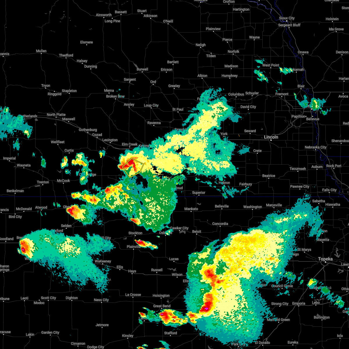 At 925 pm cdt, a severe thunderstorm was located near funk, or near holdrege, moving southeast at 20 mph (radar indicated). Hazards include 60 mph wind gusts and quarter size hail. Hail damage to vehicles is expected. expect wind damage to roofs, siding, and trees. this severe storm will be near, funk around 935 pm cdt. axtell around 945 pm cdt. ragan around 950 pm cdt. hail threat, radar indicated max hail size, 1. 00 in wind threat, radar indicated max wind gust, 60 mph. At 925 pm cdt, a severe thunderstorm was located near funk, or near holdrege, moving southeast at 20 mph (radar indicated). Hazards include 60 mph wind gusts and quarter size hail. Hail damage to vehicles is expected. expect wind damage to roofs, siding, and trees. this severe storm will be near, funk around 935 pm cdt. axtell around 945 pm cdt. ragan around 950 pm cdt. hail threat, radar indicated max hail size, 1. 00 in wind threat, radar indicated max wind gust, 60 mph.
|
| 6/5/2022 9:03 PM CDT |
 At 903 pm cdt, a severe thunderstorm was located 7 miles north of holdrege, moving southeast at 20 mph (radar indicated). Hazards include 60 mph wind gusts and quarter size hail. Hail damage to vehicles is expected. expect wind damage to roofs, siding, and trees. this severe thunderstorm will be near, holdrege around 920 pm cdt. other locations in the path of this severe thunderstorm include funk, axtell, wilcox and ragan. hail threat, radar indicated max hail size, 1. 00 in wind threat, radar indicated max wind gust, 60 mph. At 903 pm cdt, a severe thunderstorm was located 7 miles north of holdrege, moving southeast at 20 mph (radar indicated). Hazards include 60 mph wind gusts and quarter size hail. Hail damage to vehicles is expected. expect wind damage to roofs, siding, and trees. this severe thunderstorm will be near, holdrege around 920 pm cdt. other locations in the path of this severe thunderstorm include funk, axtell, wilcox and ragan. hail threat, radar indicated max hail size, 1. 00 in wind threat, radar indicated max wind gust, 60 mph.
|
| 5/17/2022 6:36 PM CDT | Golf Ball sized hail reported 9.6 miles NNW of Holdrege, NE, rec. via spotter network. |
| 5/17/2022 6:30 PM CDT | Tennis Ball sized hail reported 8.4 miles N of Holdrege, NE, rec. report and photo via facebook. |
| 5/17/2022 6:25 PM CDT | Tea Cup sized hail reported 6.9 miles N of Holdrege, NE, report and photo on facebook... relayed by ntv studio. hail this size was also reported just south of this location near the intersection of hwy 183 and hwy 4. time was |
| 5/17/2022 6:16 PM CDT | Ping Pong Ball sized hail reported 9 miles N of Holdrege, NE, rec. via mping. |
| 5/17/2022 6:00 PM CDT |
 At 559 pm cdt, a severe thunderstorm was located just southeast of holdrege, moving southeast at 5 mph (radar indicated). Hazards include 60 mph wind gusts and quarter size hail. Hail damage to vehicles is expected. expect wind damage to roofs, siding, and trees. this severe thunderstorm will be near, funk around 605 pm cdt. other locations in the path of this severe thunderstorm include wilcox and ragan. hail threat, radar indicated max hail size, 1. 00 in wind threat, radar indicated max wind gust, 60 mph. At 559 pm cdt, a severe thunderstorm was located just southeast of holdrege, moving southeast at 5 mph (radar indicated). Hazards include 60 mph wind gusts and quarter size hail. Hail damage to vehicles is expected. expect wind damage to roofs, siding, and trees. this severe thunderstorm will be near, funk around 605 pm cdt. other locations in the path of this severe thunderstorm include wilcox and ragan. hail threat, radar indicated max hail size, 1. 00 in wind threat, radar indicated max wind gust, 60 mph.
|
| 5/17/2022 5:45 PM CDT | Quarter sized hail reported 0.2 miles W of Holdrege, NE, rec. via facebook. |
| 5/15/2022 4:43 AM CDT |
 At 442 am cdt, severe thunderstorms were located along a line extending from near kearney to 7 miles southeast of odessa to funk, moving east at 40 mph (radar indicated). Hazards include 60 mph wind gusts and quarter size hail. Hail damage to vehicles is expected. expect wind damage to roofs, siding, and trees. these severe storms will be near, minden around 500 am cdt. heartwell and norman around 515 am cdt. this includes interstate 80 between mile markers 263 and 292. hail threat, radar indicated max hail size, 1. 00 in wind threat, radar indicated max wind gust, 60 mph. At 442 am cdt, severe thunderstorms were located along a line extending from near kearney to 7 miles southeast of odessa to funk, moving east at 40 mph (radar indicated). Hazards include 60 mph wind gusts and quarter size hail. Hail damage to vehicles is expected. expect wind damage to roofs, siding, and trees. these severe storms will be near, minden around 500 am cdt. heartwell and norman around 515 am cdt. this includes interstate 80 between mile markers 263 and 292. hail threat, radar indicated max hail size, 1. 00 in wind threat, radar indicated max wind gust, 60 mph.
|
| 5/15/2022 4:40 AM CDT | Wl-holdrege2.58wn in phelps county NE, 2.5 miles ESE of Holdrege, NE |
| 5/15/2022 4:38 AM CDT | Wl-holdrege2.72 in phelps county NE, 2.7 miles N of Holdrege, NE |
| 5/15/2022 4:27 AM CDT |
 At 426 am cdt, severe thunderstorms were located along a line extending from near elm creek to near odessa to near loomis, moving east at 40 mph (radar indicated). Hazards include 60 mph wind gusts and quarter size hail. Hail damage to vehicles is expected. expect wind damage to roofs, siding, and trees. severe thunderstorms will be near, odessa around 435 am cdt. kearney and funk around 445 am cdt. other locations in the path of these severe thunderstorms include axtell, wilcox, minden, gibbon, heartwell and norman. this includes interstate 80 between mile markers 255 and 292. hail threat, radar indicated max hail size, 1. 00 in wind threat, radar indicated max wind gust, 60 mph. At 426 am cdt, severe thunderstorms were located along a line extending from near elm creek to near odessa to near loomis, moving east at 40 mph (radar indicated). Hazards include 60 mph wind gusts and quarter size hail. Hail damage to vehicles is expected. expect wind damage to roofs, siding, and trees. severe thunderstorms will be near, odessa around 435 am cdt. kearney and funk around 445 am cdt. other locations in the path of these severe thunderstorms include axtell, wilcox, minden, gibbon, heartwell and norman. this includes interstate 80 between mile markers 255 and 292. hail threat, radar indicated max hail size, 1. 00 in wind threat, radar indicated max wind gust, 60 mph.
|
| 5/12/2022 2:25 PM CDT |
 At 224 pm cdt, severe thunderstorms were located along a line extending from 6 miles north of mason city to 8 miles northeast of riverdale to upland, moving northeast at 55 mph (radar indicated). Hazards include 70 mph wind gusts and half dollar size hail. Hail damage to vehicles is expected. expect considerable tree damage. wind damage is also likely to mobile homes, roofs, and outbuildings. these severe storms will be near, pleasanton around 230 pm cdt. arcadia and poole around 235 pm cdt. ravenna, holstein and norman around 240 pm cdt. heartwell around 245 pm cdt. kenesaw, rockville and boelus around 250 pm cdt. ord, ashton and elyria around 255 pm cdt. wood river, farwell, prosser and fort hartsuff state park around 300 pm cdt. this includes interstate 80 between mile markers 255 and 302. thunderstorm damage threat, considerable hail threat, radar indicated max hail size, 1. 25 in wind threat, radar indicated max wind gust, 70 mph. At 224 pm cdt, severe thunderstorms were located along a line extending from 6 miles north of mason city to 8 miles northeast of riverdale to upland, moving northeast at 55 mph (radar indicated). Hazards include 70 mph wind gusts and half dollar size hail. Hail damage to vehicles is expected. expect considerable tree damage. wind damage is also likely to mobile homes, roofs, and outbuildings. these severe storms will be near, pleasanton around 230 pm cdt. arcadia and poole around 235 pm cdt. ravenna, holstein and norman around 240 pm cdt. heartwell around 245 pm cdt. kenesaw, rockville and boelus around 250 pm cdt. ord, ashton and elyria around 255 pm cdt. wood river, farwell, prosser and fort hartsuff state park around 300 pm cdt. this includes interstate 80 between mile markers 255 and 302. thunderstorm damage threat, considerable hail threat, radar indicated max hail size, 1. 25 in wind threat, radar indicated max wind gust, 70 mph.
|
| 5/12/2022 2:11 PM CDT |
 At 211 pm cdt, severe thunderstorms were located along a line extending from near mason city to near kearney to 8 miles north of franklin, moving northeast at 55 mph (radar indicated). Hazards include 70 mph wind gusts and half dollar size hail. Hail damage to vehicles is expected. expect considerable tree damage. wind damage is also likely to mobile homes, roofs, and outbuildings. severe thunderstorms will be near, pleasanton around 225 pm cdt. arcadia and poole around 230 pm cdt. other locations in the path of these severe thunderstorms include ravenna, norman, holstein, heartwell, ord, kenesaw, rockville, elyria and boelus. this includes interstate 80 between mile markers 249 and 302. thunderstorm damage threat, considerable hail threat, radar indicated max hail size, 1. 25 in wind threat, radar indicated max wind gust, 70 mph. At 211 pm cdt, severe thunderstorms were located along a line extending from near mason city to near kearney to 8 miles north of franklin, moving northeast at 55 mph (radar indicated). Hazards include 70 mph wind gusts and half dollar size hail. Hail damage to vehicles is expected. expect considerable tree damage. wind damage is also likely to mobile homes, roofs, and outbuildings. severe thunderstorms will be near, pleasanton around 225 pm cdt. arcadia and poole around 230 pm cdt. other locations in the path of these severe thunderstorms include ravenna, norman, holstein, heartwell, ord, kenesaw, rockville, elyria and boelus. this includes interstate 80 between mile markers 249 and 302. thunderstorm damage threat, considerable hail threat, radar indicated max hail size, 1. 25 in wind threat, radar indicated max wind gust, 70 mph.
|
| 5/12/2022 2:04 PM CDT |
 At 204 pm cdt, severe thunderstorms were located along a line extending from near eddyville to near sumner to near elm creek, moving north at 65 mph (radar indicated). Hazards include 60 mph wind gusts and half dollar size hail. Hail damage to vehicles is expected. expect wind damage to roofs, siding, and trees. these severe storms will be near, amherst around 215 pm cdt. this includes interstate 80 between mile markers 244 and 276. hail threat, radar indicated max hail size, 1. 25 in wind threat, radar indicated max wind gust, 60 mph. At 204 pm cdt, severe thunderstorms were located along a line extending from near eddyville to near sumner to near elm creek, moving north at 65 mph (radar indicated). Hazards include 60 mph wind gusts and half dollar size hail. Hail damage to vehicles is expected. expect wind damage to roofs, siding, and trees. these severe storms will be near, amherst around 215 pm cdt. this includes interstate 80 between mile markers 244 and 276. hail threat, radar indicated max hail size, 1. 25 in wind threat, radar indicated max wind gust, 60 mph.
|
| 5/12/2022 1:57 PM CDT |
 At 157 pm cdt, severe thunderstorms were located along a line extending from near eddyville to 6 miles south of sumner to 8 miles south of overton, moving north at 65 mph (radar indicated). Hazards include 60 mph wind gusts and half dollar size hail. Hail damage to vehicles is expected. expect wind damage to roofs, siding, and trees. these severe storms will be near, eddyville around 200 pm cdt. sumner around 205 pm cdt. amherst and miller around 215 pm cdt. this includes interstate 80 between mile markers 235 and 276. hail threat, radar indicated max hail size, 1. 25 in wind threat, radar indicated max wind gust, 60 mph. At 157 pm cdt, severe thunderstorms were located along a line extending from near eddyville to 6 miles south of sumner to 8 miles south of overton, moving north at 65 mph (radar indicated). Hazards include 60 mph wind gusts and half dollar size hail. Hail damage to vehicles is expected. expect wind damage to roofs, siding, and trees. these severe storms will be near, eddyville around 200 pm cdt. sumner around 205 pm cdt. amherst and miller around 215 pm cdt. this includes interstate 80 between mile markers 235 and 276. hail threat, radar indicated max hail size, 1. 25 in wind threat, radar indicated max wind gust, 60 mph.
|
| 5/12/2022 1:49 PM CDT |
 At 148 pm cdt, severe thunderstorms were located along a line extending from 7 miles north of lexington to near overton to near loomis, moving north at 65 mph (radar indicated). Hazards include 60 mph wind gusts and half dollar size hail. Hail damage to vehicles is expected. expect wind damage to roofs, siding, and trees. severe thunderstorms will be near, eddyville around 200 pm cdt. elm creek and sumner around 205 pm cdt. other locations in the path of these severe thunderstorms include amherst and miller. this includes interstate 80 between mile markers 228 and 276. hail threat, radar indicated max hail size, 1. 25 in wind threat, radar indicated max wind gust, 60 mph. At 148 pm cdt, severe thunderstorms were located along a line extending from 7 miles north of lexington to near overton to near loomis, moving north at 65 mph (radar indicated). Hazards include 60 mph wind gusts and half dollar size hail. Hail damage to vehicles is expected. expect wind damage to roofs, siding, and trees. severe thunderstorms will be near, eddyville around 200 pm cdt. elm creek and sumner around 205 pm cdt. other locations in the path of these severe thunderstorms include amherst and miller. this includes interstate 80 between mile markers 228 and 276. hail threat, radar indicated max hail size, 1. 25 in wind threat, radar indicated max wind gust, 60 mph.
|
| 4/29/2022 5:54 PM CDT |
 At 553 pm cdt, severe thunderstorms were located along a line extending from near hildreth to franklin to near kensington, moving east at 25 mph (radar indicated. at 5:45 pm 60 mph wind was reported along the gust front in northern phillips county. large hail is possible with the thunderstorms). Hazards include ping pong ball size hail and 60 mph wind gusts. People and animals outdoors will be injured. expect hail damage to roofs, siding, windows, and vehicles. expect wind damage to roofs, siding, and trees. severe thunderstorms will be near, upland around 605 pm cdt. other locations in the path of these severe thunderstorms include smith center, riverton, bellaire, inavale, red cloud, lebanon and cowles. hail threat, radar indicated max hail size, 1. 50 in wind threat, radar indicated max wind gust, 60 mph. At 553 pm cdt, severe thunderstorms were located along a line extending from near hildreth to franklin to near kensington, moving east at 25 mph (radar indicated. at 5:45 pm 60 mph wind was reported along the gust front in northern phillips county. large hail is possible with the thunderstorms). Hazards include ping pong ball size hail and 60 mph wind gusts. People and animals outdoors will be injured. expect hail damage to roofs, siding, windows, and vehicles. expect wind damage to roofs, siding, and trees. severe thunderstorms will be near, upland around 605 pm cdt. other locations in the path of these severe thunderstorms include smith center, riverton, bellaire, inavale, red cloud, lebanon and cowles. hail threat, radar indicated max hail size, 1. 50 in wind threat, radar indicated max wind gust, 60 mph.
|
| 4/29/2022 5:37 PM CDT |
 At 537 pm cdt, severe thunderstorms were located along a line extending from near funk to near ragan to near huntley, moving east at 40 mph (radar indicated). Hazards include ping pong ball size hail. People and animals outdoors will be injured. expect damage to roofs, siding, windows, and vehicles. severe thunderstorms will be near, wilcox around 545 pm cdt. axtell and hildreth around 550 pm cdt. other locations in the path of these severe thunderstorms include minden, upland, campbell and norman. hail threat, radar indicated max hail size, 1. 50 in wind threat, radar indicated max wind gust, <50 mph. At 537 pm cdt, severe thunderstorms were located along a line extending from near funk to near ragan to near huntley, moving east at 40 mph (radar indicated). Hazards include ping pong ball size hail. People and animals outdoors will be injured. expect damage to roofs, siding, windows, and vehicles. severe thunderstorms will be near, wilcox around 545 pm cdt. axtell and hildreth around 550 pm cdt. other locations in the path of these severe thunderstorms include minden, upland, campbell and norman. hail threat, radar indicated max hail size, 1. 50 in wind threat, radar indicated max wind gust, <50 mph.
|
| 4/29/2022 5:21 PM CDT |
 At 520 pm cdt, severe thunderstorms were located along a line extending from near miller to 7 miles southwest of elm creek to near oxford, moving east at 40 mph (radar indicated). Hazards include 60 mph wind gusts and quarter size hail. Hail damage to vehicles is expected. expect wind damage to roofs, siding, and trees. these severe storms will be near, elm creek around 525 pm cdt. odessa around 535 pm cdt. huntley and ragan around 540 pm cdt. this includes interstate 80 between mile markers 250 and 266. hail threat, radar indicated max hail size, 1. 00 in wind threat, radar indicated max wind gust, 60 mph. At 520 pm cdt, severe thunderstorms were located along a line extending from near miller to 7 miles southwest of elm creek to near oxford, moving east at 40 mph (radar indicated). Hazards include 60 mph wind gusts and quarter size hail. Hail damage to vehicles is expected. expect wind damage to roofs, siding, and trees. these severe storms will be near, elm creek around 525 pm cdt. odessa around 535 pm cdt. huntley and ragan around 540 pm cdt. this includes interstate 80 between mile markers 250 and 266. hail threat, radar indicated max hail size, 1. 00 in wind threat, radar indicated max wind gust, 60 mph.
|
| 4/29/2022 5:00 PM CDT |
 At 500 pm cdt, severe thunderstorms were located along a line extending from eddyville to 6 miles northeast of smithfield to near edison, moving east at 40 mph (radar indicated). Hazards include 60 mph wind gusts and quarter size hail. Hail damage to vehicles is expected. expect wind damage to roofs, siding, and trees. severe thunderstorms will be near, overton and sumner around 510 pm cdt. oxford around 515 pm cdt. miller around 520 pm cdt. other locations in the path of these severe thunderstorms include elm creek, odessa and huntley. this includes interstate 80 between mile markers 237 and 266. hail threat, radar indicated max hail size, 1. 00 in wind threat, radar indicated max wind gust, 60 mph. At 500 pm cdt, severe thunderstorms were located along a line extending from eddyville to 6 miles northeast of smithfield to near edison, moving east at 40 mph (radar indicated). Hazards include 60 mph wind gusts and quarter size hail. Hail damage to vehicles is expected. expect wind damage to roofs, siding, and trees. severe thunderstorms will be near, overton and sumner around 510 pm cdt. oxford around 515 pm cdt. miller around 520 pm cdt. other locations in the path of these severe thunderstorms include elm creek, odessa and huntley. this includes interstate 80 between mile markers 237 and 266. hail threat, radar indicated max hail size, 1. 00 in wind threat, radar indicated max wind gust, 60 mph.
|
| 4/23/2022 3:17 AM CDT |
 At 315 am cdt, severe thunderstorms were located along a line extending from near odessa to wilcox to near bloomington to near glade, moving northeast at 45 mph (radar indicated). Hazards include 60 mph wind gusts. Expect damage to roofs, siding, and trees. locations impacted include, kearney, holdrege, phillipsburg, alma, franklin, axtell, odessa, kensington, hildreth, wilcox, agra, funk, riverdale, kirwin, republican city, naponee, bloomington, glade, huntley and ragan. this includes interstate 80 between mile markers 259 and 279. please note that a high wind warning for non-thunderstorm winds remains in effect across the area until 5 am cdt, and damaging wind gusts could still occur behind the line of thunderstorms. precautionary/preparedness actions, for your protection move to an interior room on the lowest floor of a building. hail threat, radar indicated max hail size, <. 75 in wind threat, radar indicated max wind gust, 60 mph. At 315 am cdt, severe thunderstorms were located along a line extending from near odessa to wilcox to near bloomington to near glade, moving northeast at 45 mph (radar indicated). Hazards include 60 mph wind gusts. Expect damage to roofs, siding, and trees. locations impacted include, kearney, holdrege, phillipsburg, alma, franklin, axtell, odessa, kensington, hildreth, wilcox, agra, funk, riverdale, kirwin, republican city, naponee, bloomington, glade, huntley and ragan. this includes interstate 80 between mile markers 259 and 279. please note that a high wind warning for non-thunderstorm winds remains in effect across the area until 5 am cdt, and damaging wind gusts could still occur behind the line of thunderstorms. precautionary/preparedness actions, for your protection move to an interior room on the lowest floor of a building. hail threat, radar indicated max hail size, <. 75 in wind threat, radar indicated max wind gust, 60 mph.
|
| 4/23/2022 2:57 AM CDT |
 At 256 am cdt, severe thunderstorms were located along a line extending from near loomis to orleans to 9 miles north of phillipsburg to near speed, moving northeast at 40 mph (radar indicated). Hazards include 70 mph wind gusts. Expect considerable tree damage. damage is likely to mobile homes, roofs, and outbuildings. severe thunderstorms will be near, holdrege, alma and loomis around 300 am cdt. funk around 305 am cdt. phillipsburg, republican city and huntley around 310 am cdt. odessa around 315 am cdt. other locations in the path of these severe thunderstorms include kirwin, naponee, ragan, agra, bloomington, kearney, franklin, kensington, hildreth and wilcox. this includes interstate 80 between mile markers 255 and 279. thunderstorm damage threat, considerable hail threat, radar indicated max hail size, <. 75 in wind threat, radar indicated max wind gust, 70 mph. At 256 am cdt, severe thunderstorms were located along a line extending from near loomis to orleans to 9 miles north of phillipsburg to near speed, moving northeast at 40 mph (radar indicated). Hazards include 70 mph wind gusts. Expect considerable tree damage. damage is likely to mobile homes, roofs, and outbuildings. severe thunderstorms will be near, holdrege, alma and loomis around 300 am cdt. funk around 305 am cdt. phillipsburg, republican city and huntley around 310 am cdt. odessa around 315 am cdt. other locations in the path of these severe thunderstorms include kirwin, naponee, ragan, agra, bloomington, kearney, franklin, kensington, hildreth and wilcox. this includes interstate 80 between mile markers 255 and 279. thunderstorm damage threat, considerable hail threat, radar indicated max hail size, <. 75 in wind threat, radar indicated max wind gust, 70 mph.
|
| 4/23/2022 2:44 AM CDT |
 At 244 am cdt, severe thunderstorms were located along a line extending from near loomis to 6 miles northwest of woodruff to speed, moving east at 45 mph (radar indicated). Hazards include 70 mph wind gusts. Expect considerable tree damage. damage is likely to mobile homes, roofs, and outbuildings. locations impacted include, holdrege, phillipsburg, alma, oxford, bertrand, logan, orleans, loomis, stamford, long island, prairie view, edison, atlanta, glade, huntley, ragan, speed, hollinger and woodruff. thunderstorm damage threat, considerable hail threat, radar indicated max hail size, <. 75 in wind threat, radar indicated max wind gust, 70 mph. At 244 am cdt, severe thunderstorms were located along a line extending from near loomis to 6 miles northwest of woodruff to speed, moving east at 45 mph (radar indicated). Hazards include 70 mph wind gusts. Expect considerable tree damage. damage is likely to mobile homes, roofs, and outbuildings. locations impacted include, holdrege, phillipsburg, alma, oxford, bertrand, logan, orleans, loomis, stamford, long island, prairie view, edison, atlanta, glade, huntley, ragan, speed, hollinger and woodruff. thunderstorm damage threat, considerable hail threat, radar indicated max hail size, <. 75 in wind threat, radar indicated max wind gust, 70 mph.
|
| 4/23/2022 2:24 AM CDT |
 At 223 am cdt, severe thunderstorms were located along a line extending from edison to 8 miles northwest of almena to near edmond, moving northeast at 80 mph (radar indicated). Hazards include 70 mph wind gusts. Expect considerable tree damage. damage is likely to mobile homes, roofs, and outbuildings. severe thunderstorms will be near, beaver city, stamford and hollinger around 235 am cdt. oxford, bertrand and prairie view around 240 am cdt. other locations in the path of these severe thunderstorms include long island, atlanta, woodruff, holdrege, alma, orleans, loomis and huntley. thunderstorm damage threat, considerable hail threat, radar indicated max hail size, <. 75 in wind threat, radar indicated max wind gust, 70 mph. At 223 am cdt, severe thunderstorms were located along a line extending from edison to 8 miles northwest of almena to near edmond, moving northeast at 80 mph (radar indicated). Hazards include 70 mph wind gusts. Expect considerable tree damage. damage is likely to mobile homes, roofs, and outbuildings. severe thunderstorms will be near, beaver city, stamford and hollinger around 235 am cdt. oxford, bertrand and prairie view around 240 am cdt. other locations in the path of these severe thunderstorms include long island, atlanta, woodruff, holdrege, alma, orleans, loomis and huntley. thunderstorm damage threat, considerable hail threat, radar indicated max hail size, <. 75 in wind threat, radar indicated max wind gust, 70 mph.
|
| 12/15/2021 1:15 PM CST | Storm damage reported in phelps county NE, 1.9 miles WSW of Holdrege, NE |
| 12/15/2021 1:07 PM CST |
 At 106 pm cst, severe thunderstorms were located along a line extending from atlanta to 6 miles southeast of naponee to near natoma, moving northeast at 80 mph (radar indicated). Hazards include 70 mph wind gusts. Expect considerable tree damage. damage is likely to mobile homes, roofs, and outbuildings. these severe storms will be near, holdrege, naponee, bloomington and ragan around 110 pm cst. franklin, wilcox and funk around 115 pm cst. axtell and riverton around 120 pm cst. osborne and inavale around 125 pm cst. minden and red cloud around 130 pm cst. thunderstorm damage threat, considerable hail threat, radar indicated max hail size, <. 75 in wind threat, radar indicated max wind gust, 70 mph. At 106 pm cst, severe thunderstorms were located along a line extending from atlanta to 6 miles southeast of naponee to near natoma, moving northeast at 80 mph (radar indicated). Hazards include 70 mph wind gusts. Expect considerable tree damage. damage is likely to mobile homes, roofs, and outbuildings. these severe storms will be near, holdrege, naponee, bloomington and ragan around 110 pm cst. franklin, wilcox and funk around 115 pm cst. axtell and riverton around 120 pm cst. osborne and inavale around 125 pm cst. minden and red cloud around 130 pm cst. thunderstorm damage threat, considerable hail threat, radar indicated max hail size, <. 75 in wind threat, radar indicated max wind gust, 70 mph.
|
| 12/15/2021 12:54 PM CST |
 At 1250 pm cst, severe thunderstorms were located along a line extending from near stamford to phillipsburg to plainville, moving northeast at 75 mph (radar indicated). Hazards include 70 mph wind gusts. Expect considerable tree damage. damage is likely to mobile homes, roofs, and outbuildings. severe thunderstorms will be near, phillipsburg, agra and stamford around 1255 pm cst. stockton and orleans around 100 pm cst. woodston and huntley around 105 pm cst. atlanta, naponee, alton and ragan around 110 pm cst. other locations in the path of these severe thunderstorms include holdrege, franklin, wilcox, bloomington, axtell, funk, gaylord, riverton, harlan, cedar, smith center, upland, athol, campbell, bladen and bellaire. thunderstorm damage threat, considerable hail threat, radar indicated max hail size, <. 75 in wind threat, radar indicated max wind gust, 70 mph. At 1250 pm cst, severe thunderstorms were located along a line extending from near stamford to phillipsburg to plainville, moving northeast at 75 mph (radar indicated). Hazards include 70 mph wind gusts. Expect considerable tree damage. damage is likely to mobile homes, roofs, and outbuildings. severe thunderstorms will be near, phillipsburg, agra and stamford around 1255 pm cst. stockton and orleans around 100 pm cst. woodston and huntley around 105 pm cst. atlanta, naponee, alton and ragan around 110 pm cst. other locations in the path of these severe thunderstorms include holdrege, franklin, wilcox, bloomington, axtell, funk, gaylord, riverton, harlan, cedar, smith center, upland, athol, campbell, bladen and bellaire. thunderstorm damage threat, considerable hail threat, radar indicated max hail size, <. 75 in wind threat, radar indicated max wind gust, 70 mph.
|
| 7/9/2021 10:30 PM CDT | Power out in part of holdrege. power poles snapped. time estimate in phelps county NE, 0.3 miles E of Holdrege, NE |
| 7/9/2021 10:17 PM CDT | Storm damage reported in phelps county NE, 5.3 miles ENE of Holdrege, NE |
| 7/9/2021 10:17 PM CDT | Storm damage reported in phelps county NE, 4.5 miles SSW of Holdrege, NE |
| 7/9/2021 10:17 PM CDT |
 At 1017 pm cdt, severe thunderstorms were located along a line extending from 6 miles southwest of pleasanton to near loomis to near atlanta to 6 miles north of edison, moving southeast at 60 mph (radar indicated). Hazards include 70 mph wind gusts and half dollar size hail. Hail damage to vehicles is expected. expect considerable tree damage. wind damage is also likely to mobile homes, roofs, and outbuildings. severe thunderstorms will be near, holdrege and atlanta around 1020 pm cdt. oxford, funk and riverdale around 1025 pm cdt. kearney and ragan around 1030 pm cdt. gibbon, wilcox and huntley around 1035 pm cdt. other locations in the path of these severe thunderstorms include orleans, hildreth, republican city, alma, naponee, heartwell, bloomington and harlan county dam. This includes interstate 80 between mile markers 242 and 292. At 1017 pm cdt, severe thunderstorms were located along a line extending from 6 miles southwest of pleasanton to near loomis to near atlanta to 6 miles north of edison, moving southeast at 60 mph (radar indicated). Hazards include 70 mph wind gusts and half dollar size hail. Hail damage to vehicles is expected. expect considerable tree damage. wind damage is also likely to mobile homes, roofs, and outbuildings. severe thunderstorms will be near, holdrege and atlanta around 1020 pm cdt. oxford, funk and riverdale around 1025 pm cdt. kearney and ragan around 1030 pm cdt. gibbon, wilcox and huntley around 1035 pm cdt. other locations in the path of these severe thunderstorms include orleans, hildreth, republican city, alma, naponee, heartwell, bloomington and harlan county dam. This includes interstate 80 between mile markers 242 and 292.
|
| 6/19/2021 10:20 PM CDT |
 At 1019 pm cdt, severe thunderstorms were located along a line extending from near oxford to near alma to naponee, moving northeast at 40 mph (radar indicated). Hazards include 70 mph wind gusts. Expect considerable tree damage. damage is likely to mobile homes, roofs, and outbuildings. Locations impacted include, republican city, naponee, harlan county dam, huntley, atlanta, holdrege, ragan and funk. At 1019 pm cdt, severe thunderstorms were located along a line extending from near oxford to near alma to naponee, moving northeast at 40 mph (radar indicated). Hazards include 70 mph wind gusts. Expect considerable tree damage. damage is likely to mobile homes, roofs, and outbuildings. Locations impacted include, republican city, naponee, harlan county dam, huntley, atlanta, holdrege, ragan and funk.
|
| 6/19/2021 9:52 PM CDT |
 At 951 pm cdt, severe thunderstorms were located along a line extending from near beaver city to 8 miles southwest of stamford to near long island, moving northeast at 25 mph (radar indicated). Hazards include 70 mph wind gusts and quarter size hail. Hail damage to vehicles is expected. expect considerable tree damage. wind damage is also likely to mobile homes, roofs, and outbuildings. these severe storms will be near, hollinger around 1000 pm cdt. Other locations in the path of these severe thunderstorms include edison, stamford, oxford, orleans, alma, republican city, atlanta, naponee, huntley and harlan county dam. At 951 pm cdt, severe thunderstorms were located along a line extending from near beaver city to 8 miles southwest of stamford to near long island, moving northeast at 25 mph (radar indicated). Hazards include 70 mph wind gusts and quarter size hail. Hail damage to vehicles is expected. expect considerable tree damage. wind damage is also likely to mobile homes, roofs, and outbuildings. these severe storms will be near, hollinger around 1000 pm cdt. Other locations in the path of these severe thunderstorms include edison, stamford, oxford, orleans, alma, republican city, atlanta, naponee, huntley and harlan county dam.
|
| 6/19/2021 9:42 PM CDT |
 At 942 pm cdt, severe thunderstorms were located along a line extending from holbrook to 6 miles south of beaver city to near almena, moving east at 25 mph (radar indicated). Hazards include 70 mph wind gusts. Expect considerable tree damage. damage is likely to mobile homes, roofs, and outbuildings. severe thunderstorms will be near, beaver city around 950 pm cdt. hollinger around 1000 pm cdt. Other locations in the path of these severe thunderstorms include edison, stamford, oxford and orleans. At 942 pm cdt, severe thunderstorms were located along a line extending from holbrook to 6 miles south of beaver city to near almena, moving east at 25 mph (radar indicated). Hazards include 70 mph wind gusts. Expect considerable tree damage. damage is likely to mobile homes, roofs, and outbuildings. severe thunderstorms will be near, beaver city around 950 pm cdt. hollinger around 1000 pm cdt. Other locations in the path of these severe thunderstorms include edison, stamford, oxford and orleans.
|
| 4/28/2021 12:38 AM CDT |
 The severe thunderstorm warning for phelps and northwestern harlan counties will expire at 1245 am cdt, the storm which prompted the warning has weakened below severe limits, and no longer poses an immediate threat to life or property. therefore, the warning will be allowed to expire. however small hail and gusty winds of 50 to 55 mph are still possible with this thunderstorm. The severe thunderstorm warning for phelps and northwestern harlan counties will expire at 1245 am cdt, the storm which prompted the warning has weakened below severe limits, and no longer poses an immediate threat to life or property. therefore, the warning will be allowed to expire. however small hail and gusty winds of 50 to 55 mph are still possible with this thunderstorm.
|
| 4/28/2021 12:12 AM CDT |
 At 1212 am cdt, a severe thunderstorm was located near holdrege, moving northeast at 45 mph (radar indicated). Hazards include 60 mph wind gusts and quarter size hail. Hail damage to vehicles is expected. expect wind damage to roofs, siding, and trees. Locations impacted include, holdrege, loomis, funk and atlanta. At 1212 am cdt, a severe thunderstorm was located near holdrege, moving northeast at 45 mph (radar indicated). Hazards include 60 mph wind gusts and quarter size hail. Hail damage to vehicles is expected. expect wind damage to roofs, siding, and trees. Locations impacted include, holdrege, loomis, funk and atlanta.
|
| 4/27/2021 11:56 PM CDT |
 At 1156 pm cdt, a severe thunderstorm was located near oxford, or 14 miles southwest of holdrege, moving northeast at 45 mph (radar indicated). Hazards include 60 mph wind gusts and quarter size hail. Hail damage to vehicles is expected. Expect wind damage to roofs, siding, and trees. At 1156 pm cdt, a severe thunderstorm was located near oxford, or 14 miles southwest of holdrege, moving northeast at 45 mph (radar indicated). Hazards include 60 mph wind gusts and quarter size hail. Hail damage to vehicles is expected. Expect wind damage to roofs, siding, and trees.
|
| 7/13/2020 10:53 PM CDT |
 The severe thunderstorm warning for phelps, northwestern kearney, western buffalo, gosper and eastern dawson counties will expire at 1100 pm cdt, the storms which prompted the warning have weakened below severe limits, and no longer pose an immediate threat to life or property. therefore, the warning will be allowed to expire. however gusty winds are still possible with these thunderstorms. a severe thunderstorm watch remains in effect until 300 am cdt for south central nebraska. The severe thunderstorm warning for phelps, northwestern kearney, western buffalo, gosper and eastern dawson counties will expire at 1100 pm cdt, the storms which prompted the warning have weakened below severe limits, and no longer pose an immediate threat to life or property. therefore, the warning will be allowed to expire. however gusty winds are still possible with these thunderstorms. a severe thunderstorm watch remains in effect until 300 am cdt for south central nebraska.
|
| 7/13/2020 10:20 PM CDT |
 At 955 pm cdt, severe thunderstorms were located along a line extending from near oconto to near lexington to near elwood to 11 miles north of arapahoe, moving east at 50 mph (radar indicated). Hazards include 60 mph wind gusts and penny size hail. expect damage to roofs, siding, and trees At 955 pm cdt, severe thunderstorms were located along a line extending from near oconto to near lexington to near elwood to 11 miles north of arapahoe, moving east at 50 mph (radar indicated). Hazards include 60 mph wind gusts and penny size hail. expect damage to roofs, siding, and trees
|
| 7/13/2020 9:56 PM CDT |
 At 955 pm cdt, severe thunderstorms were located along a line extending from near oconto to near lexington to near elwood to 11 miles north of arapahoe, moving east at 50 mph (radar indicated). Hazards include 60 mph wind gusts and penny size hail. expect damage to roofs, siding, and trees At 955 pm cdt, severe thunderstorms were located along a line extending from near oconto to near lexington to near elwood to 11 miles north of arapahoe, moving east at 50 mph (radar indicated). Hazards include 60 mph wind gusts and penny size hail. expect damage to roofs, siding, and trees
|
| 7/10/2020 6:20 PM CDT |
 At 619 pm cdt, severe thunderstorms were located along a line extending from near shelton to 7 miles southeast of kearney to near holdrege, moving south at 40 mph (radar indicated. in addition, at 613 pm cdt, a mesonet station recorded a 60 mph wind gust on the northeast side of kearney). Hazards include 70 mph wind gusts and ping pong ball size hail. People and animals outdoors will be injured. expect hail damage to roofs, siding, windows, and vehicles. expect considerable tree damage. Wind damage is also likely to mobile homes, roofs, and outbuildings. At 619 pm cdt, severe thunderstorms were located along a line extending from near shelton to 7 miles southeast of kearney to near holdrege, moving south at 40 mph (radar indicated. in addition, at 613 pm cdt, a mesonet station recorded a 60 mph wind gust on the northeast side of kearney). Hazards include 70 mph wind gusts and ping pong ball size hail. People and animals outdoors will be injured. expect hail damage to roofs, siding, windows, and vehicles. expect considerable tree damage. Wind damage is also likely to mobile homes, roofs, and outbuildings.
|
| 7/8/2020 11:00 PM CDT |
 At 1059 pm cdt, severe thunderstorms were located along a line extending from near riverton to 11 miles northwest of smith center to near speed, moving southeast at 60 mph (radar indicated). Hazards include 70 mph wind gusts. Expect considerable tree damage. damage is likely to mobile homes, roofs, and outbuildings. Locations impacted include, holdrege, phillipsburg, minden, smith center, alma, red cloud, franklin, oxford, axtell, beaver city, logan, kensington, orleans, hildreth, wilcox, campbell, agra, funk, stamford and kirwin. At 1059 pm cdt, severe thunderstorms were located along a line extending from near riverton to 11 miles northwest of smith center to near speed, moving southeast at 60 mph (radar indicated). Hazards include 70 mph wind gusts. Expect considerable tree damage. damage is likely to mobile homes, roofs, and outbuildings. Locations impacted include, holdrege, phillipsburg, minden, smith center, alma, red cloud, franklin, oxford, axtell, beaver city, logan, kensington, orleans, hildreth, wilcox, campbell, agra, funk, stamford and kirwin.
|
| 7/8/2020 10:33 PM CDT |
 At 1033 pm cdt, severe thunderstorms were located along a line extending from near ragan to near alma to near norton, moving southeast at 60 mph (radar indicated). Hazards include 70 mph wind gusts. Expect considerable tree damage. Damage is likely to mobile homes, roofs, and outbuildings. At 1033 pm cdt, severe thunderstorms were located along a line extending from near ragan to near alma to near norton, moving southeast at 60 mph (radar indicated). Hazards include 70 mph wind gusts. Expect considerable tree damage. Damage is likely to mobile homes, roofs, and outbuildings.
|
| 7/8/2020 10:32 PM CDT | Davis weatherlink statio in phelps county NE, 4.4 miles SE of Holdrege, NE |
| 7/8/2020 10:01 PM CDT |
 At 1001 pm cdt, severe thunderstorms were located along a line extending from near johnson lake to near smithfield to 8 miles north of edison to near arapahoe to near wilsonville, moving east at 50 mph (radar indicated). Hazards include 70 mph wind gusts and penny size hail. Expect considerable tree damage. Damage is likely to mobile homes, roofs, and outbuildings. At 1001 pm cdt, severe thunderstorms were located along a line extending from near johnson lake to near smithfield to 8 miles north of edison to near arapahoe to near wilsonville, moving east at 50 mph (radar indicated). Hazards include 70 mph wind gusts and penny size hail. Expect considerable tree damage. Damage is likely to mobile homes, roofs, and outbuildings.
|
| 7/2/2020 8:41 PM CDT |
 At 839 pm cdt, severe thunderstorms were located along a line extending from near loomis to 8 miles north of agra to near codell, moving east at 55 mph (trained weather spotters and mesonet stations have reported several wind gusts of 60 to 70 mph along the leading edge of this line of thunderstorms). Hazards include 70 mph wind gusts and nickel size hail. Expect considerable tree damage. damage is likely to mobile homes, roofs, and outbuildings. Locations impacted include, holdrege, phillipsburg, plainville, smith center, stockton, alma, arapahoe, franklin, oxford, axtell, beaver city, logan, kensington, orleans, loomis, hildreth, wilcox, natoma, palco and agra. At 839 pm cdt, severe thunderstorms were located along a line extending from near loomis to 8 miles north of agra to near codell, moving east at 55 mph (trained weather spotters and mesonet stations have reported several wind gusts of 60 to 70 mph along the leading edge of this line of thunderstorms). Hazards include 70 mph wind gusts and nickel size hail. Expect considerable tree damage. damage is likely to mobile homes, roofs, and outbuildings. Locations impacted include, holdrege, phillipsburg, plainville, smith center, stockton, alma, arapahoe, franklin, oxford, axtell, beaver city, logan, kensington, orleans, loomis, hildreth, wilcox, natoma, palco and agra.
|
| 7/2/2020 8:23 PM CDT |
 At 820 pm cdt, severe thunderstorms were located along a line extending from 7 miles southwest of smithfield to near long island to 9 miles southwest of palco, moving east at 60 mph (trained weather spotters. multiple trained spotters and mesonet stations are reporting wind gusts near 70 mph all along the leading edge of the line of thunderstorms). Hazards include 70 mph wind gusts and quarter size hail. Hail damage to vehicles is expected. expect considerable tree damage. wind damage is also likely to mobile homes, roofs, and outbuildings. Locations impacted include, holdrege, phillipsburg, plainville, smith center, stockton, alma, arapahoe, franklin, oxford, axtell, beaver city, logan, kensington, orleans, loomis, hildreth, wilcox, natoma, palco and agra. At 820 pm cdt, severe thunderstorms were located along a line extending from 7 miles southwest of smithfield to near long island to 9 miles southwest of palco, moving east at 60 mph (trained weather spotters. multiple trained spotters and mesonet stations are reporting wind gusts near 70 mph all along the leading edge of the line of thunderstorms). Hazards include 70 mph wind gusts and quarter size hail. Hail damage to vehicles is expected. expect considerable tree damage. wind damage is also likely to mobile homes, roofs, and outbuildings. Locations impacted include, holdrege, phillipsburg, plainville, smith center, stockton, alma, arapahoe, franklin, oxford, axtell, beaver city, logan, kensington, orleans, loomis, hildreth, wilcox, natoma, palco and agra.
|
| 7/2/2020 8:03 PM CDT |
 At 803 pm cdt, severe thunderstorms were located along a line extending from 11 miles southwest of elwood to near beaver city to 11 miles southwest of hill city, moving east at 55 mph (radar indicated). Hazards include 70 mph wind gusts and quarter size hail. Hail damage to vehicles is expected. expect considerable tree damage. Wind damage is also likely to mobile homes, roofs, and outbuildings. At 803 pm cdt, severe thunderstorms were located along a line extending from 11 miles southwest of elwood to near beaver city to 11 miles southwest of hill city, moving east at 55 mph (radar indicated). Hazards include 70 mph wind gusts and quarter size hail. Hail damage to vehicles is expected. expect considerable tree damage. Wind damage is also likely to mobile homes, roofs, and outbuildings.
|
| 6/21/2020 8:41 PM CDT |
 The severe thunderstorm warning for southeastern phelps, southwestern kearney and northeastern harlan counties will expire at 845 pm cdt, the storm which prompted the warning has weakened below severe limits, and no longer poses an immediate threat to life or property. therefore, the warning will be allowed to expire. however small hail, gusty winds and heavy rain are still possible with this thunderstorm. a severe thunderstorm watch remains in effect until 1000 pm cdt for south central nebraska. The severe thunderstorm warning for southeastern phelps, southwestern kearney and northeastern harlan counties will expire at 845 pm cdt, the storm which prompted the warning has weakened below severe limits, and no longer poses an immediate threat to life or property. therefore, the warning will be allowed to expire. however small hail, gusty winds and heavy rain are still possible with this thunderstorm. a severe thunderstorm watch remains in effect until 1000 pm cdt for south central nebraska.
|
| 6/21/2020 8:30 PM CDT | Call from the e in phelps county NE, 3.9 miles NNE of Holdrege, NE |
| 6/21/2020 8:30 PM CDT |
 At 830 pm cdt, a severe thunderstorm was located near holdrege, moving southeast at 20 mph (radar indicated). Hazards include 60 mph wind gusts and quarter size hail. Hail damage to vehicles is expected. expect wind damage to roofs, siding, and trees. Locations impacted include, holdrege, wilcox, funk, atlanta, huntley and ragan. At 830 pm cdt, a severe thunderstorm was located near holdrege, moving southeast at 20 mph (radar indicated). Hazards include 60 mph wind gusts and quarter size hail. Hail damage to vehicles is expected. expect wind damage to roofs, siding, and trees. Locations impacted include, holdrege, wilcox, funk, atlanta, huntley and ragan.
|
| 6/21/2020 8:19 PM CDT |
 At 818 pm cdt, a severe thunderstorm was located near holdrege, moving southeast at 20 mph (radar indicated). Hazards include 60 mph wind gusts and quarter size hail. Hail damage to vehicles is expected. Expect wind damage to roofs, siding, and trees. At 818 pm cdt, a severe thunderstorm was located near holdrege, moving southeast at 20 mph (radar indicated). Hazards include 60 mph wind gusts and quarter size hail. Hail damage to vehicles is expected. Expect wind damage to roofs, siding, and trees.
|
| 6/2/2020 10:47 PM CDT |
 At 1047 pm cdt, a severe thunderstorm was located near funk, or near holdrege, moving east at 15 mph (radar indicated). Hazards include quarter size hail. Damage to vehicles is expected. Locations impacted include, holdrege and funk. At 1047 pm cdt, a severe thunderstorm was located near funk, or near holdrege, moving east at 15 mph (radar indicated). Hazards include quarter size hail. Damage to vehicles is expected. Locations impacted include, holdrege and funk.
|
| 6/2/2020 10:31 PM CDT |
 At 1031 pm cdt, severe thunderstorms were located along a line extending from 7 miles north of holdrege to near loomis, moving east at 15 mph (radar indicated). Hazards include quarter size hail. Damage to vehicles is expected. Locations impacted include, holdrege and funk. At 1031 pm cdt, severe thunderstorms were located along a line extending from 7 miles north of holdrege to near loomis, moving east at 15 mph (radar indicated). Hazards include quarter size hail. Damage to vehicles is expected. Locations impacted include, holdrege and funk.
|
| 6/2/2020 10:21 PM CDT |
 At 1021 pm cdt, severe thunderstorms were located along a line extending from 6 miles north of holdrege to loomis, moving southeast at 10 mph (radar indicated). Hazards include quarter size hail. damage to vehicles is expected At 1021 pm cdt, severe thunderstorms were located along a line extending from 6 miles north of holdrege to loomis, moving southeast at 10 mph (radar indicated). Hazards include quarter size hail. damage to vehicles is expected
|
| 9/30/2019 8:11 PM CDT |
 The severe thunderstorm warning for central phelps county will expire at 815 pm cdt, the storm which prompted the warning has weakened below severe limits, and no longer poses an immediate threat to life or property. therefore, the warning will be allowed to expire. to report severe weather, contact your nearest law enforcement agency. they will relay your report to the national weather service hastings. The severe thunderstorm warning for central phelps county will expire at 815 pm cdt, the storm which prompted the warning has weakened below severe limits, and no longer poses an immediate threat to life or property. therefore, the warning will be allowed to expire. to report severe weather, contact your nearest law enforcement agency. they will relay your report to the national weather service hastings.
|
| 9/30/2019 7:58 PM CDT |
 At 757 pm cdt, a severe thunderstorm was located near loomis, or near holdrege, moving northeast at 20 mph (radar indicated). Hazards include quarter size hail. Damage to vehicles is expected. Locations impacted include, holdrege and loomis. At 757 pm cdt, a severe thunderstorm was located near loomis, or near holdrege, moving northeast at 20 mph (radar indicated). Hazards include quarter size hail. Damage to vehicles is expected. Locations impacted include, holdrege and loomis.
|
| 9/30/2019 7:47 PM CDT |
 At 747 pm cdt, a severe thunderstorm was located over loomis, or near holdrege, moving northeast at 20 mph (radar indicated). Hazards include quarter size hail. damage to vehicles is expected At 747 pm cdt, a severe thunderstorm was located over loomis, or near holdrege, moving northeast at 20 mph (radar indicated). Hazards include quarter size hail. damage to vehicles is expected
|
| 9/30/2019 5:46 PM CDT |
 At 546 pm cdt, a severe thunderstorm was located near oxford, or 13 miles southwest of holdrege, moving northeast at 40 mph (radar indicated). Hazards include half dollar size hail. damage to vehicles is expected At 546 pm cdt, a severe thunderstorm was located near oxford, or 13 miles southwest of holdrege, moving northeast at 40 mph (radar indicated). Hazards include half dollar size hail. damage to vehicles is expected
|
| 9/11/2019 11:44 PM CDT |
 At 1144 pm cdt, severe thunderstorms were located along a line extending from 6 miles south of oconto to 6 miles west of lexington to near elwood to near holbrook, moving east at 30 mph (radar indicated). Hazards include 60 mph wind gusts. expect damage to roofs, siding, and trees At 1144 pm cdt, severe thunderstorms were located along a line extending from 6 miles south of oconto to 6 miles west of lexington to near elwood to near holbrook, moving east at 30 mph (radar indicated). Hazards include 60 mph wind gusts. expect damage to roofs, siding, and trees
|
| 8/12/2019 12:05 AM CDT |
 At 1205 am cdt, a severe thunderstorm was located near lexington, moving east at 45 mph (radar indicated). Hazards include 70 mph wind gusts. Expect considerable tree damage. Damage is likely to mobile homes, roofs, and outbuildings. At 1205 am cdt, a severe thunderstorm was located near lexington, moving east at 45 mph (radar indicated). Hazards include 70 mph wind gusts. Expect considerable tree damage. Damage is likely to mobile homes, roofs, and outbuildings.
|
| 7/21/2019 4:19 AM CDT |
 At 419 am cdt, severe thunderstorms were located along a line extending from 6 miles northwest of funk to near holdrege, moving southeast at 35 mph (radar indicated). Hazards include 60 mph wind gusts. Expect damage to roofs, siding, and trees. Locations impacted include, holdrege, loomis, funk and atlanta. At 419 am cdt, severe thunderstorms were located along a line extending from 6 miles northwest of funk to near holdrege, moving southeast at 35 mph (radar indicated). Hazards include 60 mph wind gusts. Expect damage to roofs, siding, and trees. Locations impacted include, holdrege, loomis, funk and atlanta.
|
| 7/21/2019 4:09 AM CDT |
 At 409 am cdt, severe thunderstorms were located along a line extending from near elm creek to near loomis, moving southeast at 30 mph (radar indicated). Hazards include 60 mph wind gusts. expect damage to roofs, siding, and trees At 409 am cdt, severe thunderstorms were located along a line extending from near elm creek to near loomis, moving southeast at 30 mph (radar indicated). Hazards include 60 mph wind gusts. expect damage to roofs, siding, and trees
|
| 7/8/2019 11:55 PM CDT |
 The severe thunderstorm warning for eastern phelps, kearney, eastern buffalo and western hall counties will expire at midnight cdt, the storms which prompted the warning have weakened below severe limits, and no longer pose an immediate threat to life or property. therefore, the warning will be allowed to expire. however gusty winds are still possible with these thunderstorms. The severe thunderstorm warning for eastern phelps, kearney, eastern buffalo and western hall counties will expire at midnight cdt, the storms which prompted the warning have weakened below severe limits, and no longer pose an immediate threat to life or property. therefore, the warning will be allowed to expire. however gusty winds are still possible with these thunderstorms.
|
| 7/8/2019 11:14 PM CDT |
 At 1114 pm cdt, severe thunderstorms were located along a line extending from ravenna to near rockville to 9 miles northwest of shelton to near gibbon to near kearney to 6 miles northwest of minden to axtell to near wilcox, moving east at 20 mph (radar indicated). Hazards include 60 mph wind gusts and half dollar size hail. Hail damage to vehicles is expected. Expect wind damage to roofs, siding, and trees. At 1114 pm cdt, severe thunderstorms were located along a line extending from ravenna to near rockville to 9 miles northwest of shelton to near gibbon to near kearney to 6 miles northwest of minden to axtell to near wilcox, moving east at 20 mph (radar indicated). Hazards include 60 mph wind gusts and half dollar size hail. Hail damage to vehicles is expected. Expect wind damage to roofs, siding, and trees.
|
| 7/8/2019 10:26 PM CDT |
 At 1026 pm cdt, a severe thunderstorm was located over atlanta, or near holdrege, moving northeast at 40 mph (radar indicated). Hazards include ping pong ball size hail and 60 mph wind gusts. People and animals outdoors will be injured. expect hail damage to roofs, siding, windows, and vehicles. Expect wind damage to roofs, siding, and trees. At 1026 pm cdt, a severe thunderstorm was located over atlanta, or near holdrege, moving northeast at 40 mph (radar indicated). Hazards include ping pong ball size hail and 60 mph wind gusts. People and animals outdoors will be injured. expect hail damage to roofs, siding, windows, and vehicles. Expect wind damage to roofs, siding, and trees.
|
| 7/5/2019 2:03 AM CDT |
 At 136 am cdt, a severe thunderstorm was located near atlanta, or near holdrege, moving east at 20 mph (radar indicated). Hazards include 60 mph wind gusts and quarter size hail. Hail damage to vehicles is expected. Expect wind damage to roofs, siding, and trees. At 136 am cdt, a severe thunderstorm was located near atlanta, or near holdrege, moving east at 20 mph (radar indicated). Hazards include 60 mph wind gusts and quarter size hail. Hail damage to vehicles is expected. Expect wind damage to roofs, siding, and trees.
|
| 7/5/2019 1:36 AM CDT |
 At 136 am cdt, a severe thunderstorm was located near atlanta, or near holdrege, moving east at 20 mph (radar indicated). Hazards include 60 mph wind gusts and quarter size hail. Hail damage to vehicles is expected. Expect wind damage to roofs, siding, and trees. At 136 am cdt, a severe thunderstorm was located near atlanta, or near holdrege, moving east at 20 mph (radar indicated). Hazards include 60 mph wind gusts and quarter size hail. Hail damage to vehicles is expected. Expect wind damage to roofs, siding, and trees.
|
| 7/5/2019 12:28 AM CDT |
 The severe thunderstorm warning for phelps, northwestern kearney, southwestern buffalo and gosper counties will expire at 1230 am cdt, the storms which prompted the warning have weakened below severe limits, and no longer pose an immediate threat to life or property. therefore, the warning will be allowed to expire. a severe thunderstorm watch remains in effect until 500 am cdt for south central nebraska. remember, a severe thunderstorm warning still remains in effect for portions of gosper county until 115 am cdt. The severe thunderstorm warning for phelps, northwestern kearney, southwestern buffalo and gosper counties will expire at 1230 am cdt, the storms which prompted the warning have weakened below severe limits, and no longer pose an immediate threat to life or property. therefore, the warning will be allowed to expire. a severe thunderstorm watch remains in effect until 500 am cdt for south central nebraska. remember, a severe thunderstorm warning still remains in effect for portions of gosper county until 115 am cdt.
|
| 7/5/2019 12:03 AM CDT |
 At 1202 am cdt, severe thunderstorms were located along a line extending from 7 miles southwest of smithfield to 7 miles south of kearney, and are nearly stationary (radar indicated). Hazards include 60 mph wind gusts and quarter size hail. Hail damage to vehicles is expected. expect wind damage to roofs, siding, and trees. locations impacted include, kearney, holdrege, bertrand, axtell, elwood, odessa, loomis, funk and smithfield. This includes interstate 80 between mile markers 256 and 279. At 1202 am cdt, severe thunderstorms were located along a line extending from 7 miles southwest of smithfield to 7 miles south of kearney, and are nearly stationary (radar indicated). Hazards include 60 mph wind gusts and quarter size hail. Hail damage to vehicles is expected. expect wind damage to roofs, siding, and trees. locations impacted include, kearney, holdrege, bertrand, axtell, elwood, odessa, loomis, funk and smithfield. This includes interstate 80 between mile markers 256 and 279.
|
| 7/4/2019 11:39 PM CDT |
 The national weather service in hastings has issued a * severe thunderstorm warning for. phelps county in south central nebraska. northwestern kearney county in south central nebraska. southwestern buffalo county in south central nebraska. Gosper county in south central nebraska. The national weather service in hastings has issued a * severe thunderstorm warning for. phelps county in south central nebraska. northwestern kearney county in south central nebraska. southwestern buffalo county in south central nebraska. Gosper county in south central nebraska.
|
| 6/21/2019 12:35 AM CDT |
 At 1232 am cdt, severe thunderstorms were located along a line extending from near odessa to 6 miles north of upland to inavale to near athol, moving east at 55 mph (radar indicated. in addition, a 70 mph wind gust was measured by a mesonet station 5 miles south-southwest of wilcox at 1229 am cdt). Hazards include 70 mph wind gusts and penny size hail. Expect considerable tree damage. damage is likely to mobile homes, roofs, and outbuildings. locations impacted include, kearney, holdrege, phillipsburg, minden, smith center, alma, red cloud, franklin, bertrand, axtell, logan, kensington, orleans, loomis, hildreth, wilcox, campbell, agra, bladen and holstein. This includes interstate 80 between mile markers 266 and 282. At 1232 am cdt, severe thunderstorms were located along a line extending from near odessa to 6 miles north of upland to inavale to near athol, moving east at 55 mph (radar indicated. in addition, a 70 mph wind gust was measured by a mesonet station 5 miles south-southwest of wilcox at 1229 am cdt). Hazards include 70 mph wind gusts and penny size hail. Expect considerable tree damage. damage is likely to mobile homes, roofs, and outbuildings. locations impacted include, kearney, holdrege, phillipsburg, minden, smith center, alma, red cloud, franklin, bertrand, axtell, logan, kensington, orleans, loomis, hildreth, wilcox, campbell, agra, bladen and holstein. This includes interstate 80 between mile markers 266 and 282.
|
| 6/21/2019 12:20 AM CDT | Mesonet station nb054 ragan 5 in harlan county NE, 7.6 miles N of Holdrege, NE |
| 6/21/2019 12:09 AM CDT |
 The national weather service in hastings has issued a * severe thunderstorm warning for. northern smith county in north central kansas. phillips county in north central kansas. franklin county in south central nebraska. Western webster county in south central nebraska. The national weather service in hastings has issued a * severe thunderstorm warning for. northern smith county in north central kansas. phillips county in north central kansas. franklin county in south central nebraska. Western webster county in south central nebraska.
|
| 6/21/2019 12:09 AM CDT |
 At 1208 am cdt, severe thunderstorms were located along a line extending from near bertrand to near ragan to near naponee to near phillipsburg, moving east at 40 mph. these are very dangerous storms (radar indicated). Hazards include 80 mph wind gusts and quarter size hail. Flying debris will be dangerous to those caught without shelter. mobile homes will be heavily damaged. expect considerable damage to roofs, windows, and vehicles. Extensive tree damage and power outages are likely. At 1208 am cdt, severe thunderstorms were located along a line extending from near bertrand to near ragan to near naponee to near phillipsburg, moving east at 40 mph. these are very dangerous storms (radar indicated). Hazards include 80 mph wind gusts and quarter size hail. Flying debris will be dangerous to those caught without shelter. mobile homes will be heavily damaged. expect considerable damage to roofs, windows, and vehicles. Extensive tree damage and power outages are likely.
|
| 6/20/2019 11:49 PM CDT |
 At 1134 pm cdt, severe thunderstorms were located along a line extending from near bertrand to near hollinger to near prairie view, moving east at 45 mph (radar indicated). Hazards include 70 mph wind gusts and quarter size hail. Hail damage to vehicles is expected. expect considerable tree damage. Wind damage is also likely to mobile homes, roofs, and outbuildings. At 1134 pm cdt, severe thunderstorms were located along a line extending from near bertrand to near hollinger to near prairie view, moving east at 45 mph (radar indicated). Hazards include 70 mph wind gusts and quarter size hail. Hail damage to vehicles is expected. expect considerable tree damage. Wind damage is also likely to mobile homes, roofs, and outbuildings.
|
| 6/20/2019 11:34 PM CDT |
 At 1134 pm cdt, severe thunderstorms were located along a line extending from near bertrand to near hollinger to near prairie view, moving east at 45 mph (radar indicated). Hazards include 70 mph wind gusts and quarter size hail. Hail damage to vehicles is expected. expect considerable tree damage. Wind damage is also likely to mobile homes, roofs, and outbuildings. At 1134 pm cdt, severe thunderstorms were located along a line extending from near bertrand to near hollinger to near prairie view, moving east at 45 mph (radar indicated). Hazards include 70 mph wind gusts and quarter size hail. Hail damage to vehicles is expected. expect considerable tree damage. Wind damage is also likely to mobile homes, roofs, and outbuildings.
|
| 6/8/2019 9:24 PM CDT |
 The severe thunderstorm warning for eastern phelps and harlan counties will expire at 930 pm cdt, the storms which prompted the warning have moved out of the area. therefore, the warning will be allowed to expire. a severe thunderstorm watch remains in effect until 300 am cdt for south central nebraska. The severe thunderstorm warning for eastern phelps and harlan counties will expire at 930 pm cdt, the storms which prompted the warning have moved out of the area. therefore, the warning will be allowed to expire. a severe thunderstorm watch remains in effect until 300 am cdt for south central nebraska.
|
| 6/8/2019 9:10 PM CDT |
 At 909 pm cdt, severe thunderstorms were located along a line extending from near holdrege to near ragan to 6 miles north of orleans, moving southeast at 15 mph (radar indicated). Hazards include 60 mph wind gusts and nickel size hail. Expect damage to roofs, siding, and trees. Locations impacted include, holdrege, alma, orleans, funk, stamford, republican city, atlanta, huntley, ragan and harlan county dam. At 909 pm cdt, severe thunderstorms were located along a line extending from near holdrege to near ragan to 6 miles north of orleans, moving southeast at 15 mph (radar indicated). Hazards include 60 mph wind gusts and nickel size hail. Expect damage to roofs, siding, and trees. Locations impacted include, holdrege, alma, orleans, funk, stamford, republican city, atlanta, huntley, ragan and harlan county dam.
|
| 6/8/2019 8:58 PM CDT |
 At 856 pm cdt, severe thunderstorms were located along a line extending from near holdrege to near ragan to near oxford, moving east at 40 mph (radar indicated. at 847 pm thunderstorm wind gusts of 60 mph were reported 4 miles north northeast of oxford). Hazards include 70 mph wind gusts and nickel size hail. Expect considerable tree damage. damage is likely to mobile homes, roofs, and outbuildings. Locations impacted include, holdrege, alma, oxford, orleans, loomis, funk, stamford, republican city, atlanta, huntley, ragan and harlan county dam. At 856 pm cdt, severe thunderstorms were located along a line extending from near holdrege to near ragan to near oxford, moving east at 40 mph (radar indicated. at 847 pm thunderstorm wind gusts of 60 mph were reported 4 miles north northeast of oxford). Hazards include 70 mph wind gusts and nickel size hail. Expect considerable tree damage. damage is likely to mobile homes, roofs, and outbuildings. Locations impacted include, holdrege, alma, oxford, orleans, loomis, funk, stamford, republican city, atlanta, huntley, ragan and harlan county dam.
|
| 6/8/2019 8:57 PM CDT | Storm damage reported in phelps county NE, 1.9 miles WSW of Holdrege, NE |
| 6/8/2019 8:55 PM CDT | Power was lost in part of town... sparks were reported at a substation. 4 power poles were damaged near 18th ave. and lincoln st. a large tree was downed at the cemeter in phelps county NE, 0.3 miles E of Holdrege, NE |
| 6/8/2019 8:50 PM CDT | Storm damage reported in phelps county NE, 1.1 miles SE of Holdrege, NE |
| 6/8/2019 8:46 PM CDT | Storm damage reported in phelps county NE, 5.6 miles E of Holdrege, NE |
| 6/8/2019 8:45 PM CDT | Wind gusts estimated to be at least 70 mp in phelps county NE, 3.2 miles NE of Holdrege, NE |
| 6/8/2019 8:44 PM CDT |
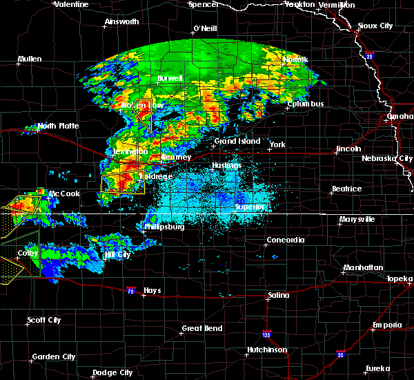 The national weather service in hastings has issued a * severe thunderstorm warning for. phelps county in south central nebraska. northeastern furnas county in south central nebraska. harlan county in south central nebraska. Until 930 pm cdt. The national weather service in hastings has issued a * severe thunderstorm warning for. phelps county in south central nebraska. northeastern furnas county in south central nebraska. harlan county in south central nebraska. Until 930 pm cdt.
|
| 6/8/2019 8:43 PM CDT | Storm damage reported in phelps county NE, 3 miles ESE of Holdrege, NE |
| 6/8/2019 8:34 PM CDT |
 At 833 pm cdt, severe thunderstorms were located along a line extending from near bertrand to near edison, moving east at 45 mph (radar indicated). Hazards include 70 mph wind gusts and nickel size hail. Expect considerable tree damage. damage is likely to mobile homes, roofs, and outbuildings. Locations impacted include, holdrege, arapahoe, bertrand, loomis and atlanta. At 833 pm cdt, severe thunderstorms were located along a line extending from near bertrand to near edison, moving east at 45 mph (radar indicated). Hazards include 70 mph wind gusts and nickel size hail. Expect considerable tree damage. damage is likely to mobile homes, roofs, and outbuildings. Locations impacted include, holdrege, arapahoe, bertrand, loomis and atlanta.
|
| 6/8/2019 8:18 PM CDT |
 At 814 pm cdt, a 70 mph wind gust was measured 7 miles north of arapahoe (trained weather spotters). Hazards include 70 mph wind gusts and nickel size hail. Expect considerable tree damage. damage is likely to mobile homes, roofs, and outbuildings. Locations impacted include, holdrege, arapahoe, bertrand, loomis and atlanta. At 814 pm cdt, a 70 mph wind gust was measured 7 miles north of arapahoe (trained weather spotters). Hazards include 70 mph wind gusts and nickel size hail. Expect considerable tree damage. damage is likely to mobile homes, roofs, and outbuildings. Locations impacted include, holdrege, arapahoe, bertrand, loomis and atlanta.
|
| 6/8/2019 8:13 PM CDT |
 At 812 pm cdt, a severe thunderstorm was located 8 miles north of edison, or 21 miles west of holdrege, moving east at 40 mph (radar indicated). Hazards include 60 mph wind gusts and nickel size hail. expect damage to roofs, siding, and trees At 812 pm cdt, a severe thunderstorm was located 8 miles north of edison, or 21 miles west of holdrege, moving east at 40 mph (radar indicated). Hazards include 60 mph wind gusts and nickel size hail. expect damage to roofs, siding, and trees
|
| 6/3/2019 11:33 PM CDT |
 At 1132 pm cdt, severe thunderstorms were located along a line extending from near elm creek to funk to huntley to 6 miles southwest of harlan county dam, moving east at 50 mph (radar indicated). Hazards include 70 mph wind gusts and penny size hail. Expect considerable tree damage. damage is likely to mobile homes, roofs, and outbuildings. Locations impacted include, holdrege, minden, alma, franklin, oxford, bertrand, axtell, orleans, loomis, hildreth, wilcox, campbell, funk, stamford, republican city, upland, atlanta, naponee, bloomington and riverton. At 1132 pm cdt, severe thunderstorms were located along a line extending from near elm creek to funk to huntley to 6 miles southwest of harlan county dam, moving east at 50 mph (radar indicated). Hazards include 70 mph wind gusts and penny size hail. Expect considerable tree damage. damage is likely to mobile homes, roofs, and outbuildings. Locations impacted include, holdrege, minden, alma, franklin, oxford, bertrand, axtell, orleans, loomis, hildreth, wilcox, campbell, funk, stamford, republican city, upland, atlanta, naponee, bloomington and riverton.
|
| 6/3/2019 11:23 PM CDT |
 At 1122 pm cdt, severe thunderstorms were located along a line extending from overton to holdrege to near huntley to near woodruff, moving east at 50 mph (radar indicated. at 1115pm a wind gust of 67 mph was reported north of oxford, ne). Hazards include 70 mph wind gusts and penny size hail. Expect considerable tree damage. damage is likely to mobile homes, roofs, and outbuildings. Locations impacted include, holdrege, minden, alma, franklin, oxford, bertrand, axtell, elwood, orleans, loomis, hildreth, wilcox, campbell, funk, stamford, republican city, upland, atlanta, naponee and bloomington. At 1122 pm cdt, severe thunderstorms were located along a line extending from overton to holdrege to near huntley to near woodruff, moving east at 50 mph (radar indicated. at 1115pm a wind gust of 67 mph was reported north of oxford, ne). Hazards include 70 mph wind gusts and penny size hail. Expect considerable tree damage. damage is likely to mobile homes, roofs, and outbuildings. Locations impacted include, holdrege, minden, alma, franklin, oxford, bertrand, axtell, elwood, orleans, loomis, hildreth, wilcox, campbell, funk, stamford, republican city, upland, atlanta, naponee and bloomington.
|
| 6/3/2019 10:57 PM CDT |
 At 1056 pm cdt, severe thunderstorms were located along a line extending from near eustis to 10 miles south of smithfield to near oxford to near stamford, moving east at 50 mph (radar indicated. at 1050pm damaging wind gusts estimated around 70 mph were reported near edison, ne in furnas county). Hazards include 70 mph wind gusts and penny size hail. Expect considerable tree damage. Damage is likely to mobile homes, roofs, and outbuildings. At 1056 pm cdt, severe thunderstorms were located along a line extending from near eustis to 10 miles south of smithfield to near oxford to near stamford, moving east at 50 mph (radar indicated. at 1050pm damaging wind gusts estimated around 70 mph were reported near edison, ne in furnas county). Hazards include 70 mph wind gusts and penny size hail. Expect considerable tree damage. Damage is likely to mobile homes, roofs, and outbuildings.
|
| 5/26/2019 6:26 PM CDT |
 The severe thunderstorm warning for northwestern phillips, southwestern phelps, southeastern gosper, eastern furnas and harlan counties will expire at 630 pm cdt, the storm which prompted the warning has weakened below severe limits, and no longer poses an immediate threat to life or property. therefore, the warning will be allowed to expire. however gusty winds are still possible with another storm moving into southeastern furnas, southern harlan, and phillips county, kansas. a severe thunderstorm watch remains in effect until midnight cdt for north central kansas, and south central nebraska. The severe thunderstorm warning for northwestern phillips, southwestern phelps, southeastern gosper, eastern furnas and harlan counties will expire at 630 pm cdt, the storm which prompted the warning has weakened below severe limits, and no longer poses an immediate threat to life or property. therefore, the warning will be allowed to expire. however gusty winds are still possible with another storm moving into southeastern furnas, southern harlan, and phillips county, kansas. a severe thunderstorm watch remains in effect until midnight cdt for north central kansas, and south central nebraska.
|
| 5/26/2019 6:11 PM CDT |
 At 608 pm cdt, a severe thunderstorm was located near long island, or 20 miles northwest of phillipsburg, moving northeast at 40 mph. another storm located in norton county, kansas will be moving into parts of the currently warned area by 630 pm cdt and may produce more severe weather if this storm continues its latest trends (radar indicated). Hazards include 60 mph wind gusts and quarter size hail. Hail damage to vehicles is expected. expect wind damage to roofs, siding, and trees. Locations impacted include, alma, oxford, orleans, stamford, long island, prairie view, atlanta, huntley, ragan, hollinger and woodruff. At 608 pm cdt, a severe thunderstorm was located near long island, or 20 miles northwest of phillipsburg, moving northeast at 40 mph. another storm located in norton county, kansas will be moving into parts of the currently warned area by 630 pm cdt and may produce more severe weather if this storm continues its latest trends (radar indicated). Hazards include 60 mph wind gusts and quarter size hail. Hail damage to vehicles is expected. expect wind damage to roofs, siding, and trees. Locations impacted include, alma, oxford, orleans, stamford, long island, prairie view, atlanta, huntley, ragan, hollinger and woodruff.
|
| 5/26/2019 5:51 PM CDT |
 At 550 pm cdt, a severe thunderstorm was located near almena, or 14 miles northeast of norton, moving north at 45 mph (radar indicated). Hazards include 60 mph wind gusts and quarter size hail. Hail damage to vehicles is expected. Expect wind damage to roofs, siding, and trees. At 550 pm cdt, a severe thunderstorm was located near almena, or 14 miles northeast of norton, moving north at 45 mph (radar indicated). Hazards include 60 mph wind gusts and quarter size hail. Hail damage to vehicles is expected. Expect wind damage to roofs, siding, and trees.
|
| 5/23/2019 6:36 PM CDT |
 At 636 pm cdt, a severe thunderstorm was located near loomis, or near holdrege, moving northeast at 65 mph (trained weather spotters). Hazards include 60 mph wind gusts and quarter size hail. Hail damage to vehicles is expected. expect wind damage to roofs, siding, and trees. locations impacted include, holdrege, elm creek, bertrand, overton, odessa and loomis. This includes interstate 80 between mile markers 246 and 268. At 636 pm cdt, a severe thunderstorm was located near loomis, or near holdrege, moving northeast at 65 mph (trained weather spotters). Hazards include 60 mph wind gusts and quarter size hail. Hail damage to vehicles is expected. expect wind damage to roofs, siding, and trees. locations impacted include, holdrege, elm creek, bertrand, overton, odessa and loomis. This includes interstate 80 between mile markers 246 and 268.
|
| 5/23/2019 6:25 PM CDT |
 At 625 pm cdt, a severe thunderstorm was located near atlanta, or 11 miles southwest of holdrege, moving north at 65 mph (trained weather spotters reported quarter to ping pong ball size hail in oxford). Hazards include 60 mph wind gusts and quarter size hail. Hail damage to vehicles is expected. Expect wind damage to roofs, siding, and trees. At 625 pm cdt, a severe thunderstorm was located near atlanta, or 11 miles southwest of holdrege, moving north at 65 mph (trained weather spotters reported quarter to ping pong ball size hail in oxford). Hazards include 60 mph wind gusts and quarter size hail. Hail damage to vehicles is expected. Expect wind damage to roofs, siding, and trees.
|
| 4/10/2019 9:42 PM CDT |
 At 942 pm cdt, severe thunderstorms were located along a line extending from near oxford to near stamford to near long island, moving northeast at 35 mph (radar indicated). Hazards include 60 mph wind gusts and half dollar size hail. Hail damage to vehicles is expected. Expect wind damage to roofs, siding, and trees. At 942 pm cdt, severe thunderstorms were located along a line extending from near oxford to near stamford to near long island, moving northeast at 35 mph (radar indicated). Hazards include 60 mph wind gusts and half dollar size hail. Hail damage to vehicles is expected. Expect wind damage to roofs, siding, and trees.
|
| 9/1/2018 12:53 AM CDT |
 At 1253 am cdt, a severe thunderstorm was located near atlanta, or near holdrege, moving east at 40 mph (radar indicated). Hazards include 60 mph wind gusts and quarter size hail. Hail damage to vehicles is expected. Expect wind damage to roofs, siding, and trees. At 1253 am cdt, a severe thunderstorm was located near atlanta, or near holdrege, moving east at 40 mph (radar indicated). Hazards include 60 mph wind gusts and quarter size hail. Hail damage to vehicles is expected. Expect wind damage to roofs, siding, and trees.
|
| 6/30/2018 4:40 PM CDT |
 The severe thunderstorm warning for southwestern phelps county will expire at 445 pm cdt, the storm which prompted the warning has moved out of the area. therefore, this warning will be allowed to expire. a severe thunderstorm watch remains in effect until 1100 pm cdt for south central nebraska. to report severe weather, contact your nearest law enforcement agency. they will relay your report to the national weather service hastings. remember, a severe thunderstorm warning still remains in effect for central phelps county until 500 pm cdt. The severe thunderstorm warning for southwestern phelps county will expire at 445 pm cdt, the storm which prompted the warning has moved out of the area. therefore, this warning will be allowed to expire. a severe thunderstorm watch remains in effect until 1100 pm cdt for south central nebraska. to report severe weather, contact your nearest law enforcement agency. they will relay your report to the national weather service hastings. remember, a severe thunderstorm warning still remains in effect for central phelps county until 500 pm cdt.
|
| 6/30/2018 4:36 PM CDT |
 At 436 pm cdt, a severe thunderstorm was located near loomis, or near holdrege, moving northeast at 10 mph (radar indicated). Hazards include golf ball size hail and 70 mph wind gusts. People and animals outdoors will be injured. expect hail damage to roofs, siding, windows, and vehicles. expect considerable tree damage. Wind damage is also likely to mobile homes, roofs, and outbuildings. At 436 pm cdt, a severe thunderstorm was located near loomis, or near holdrege, moving northeast at 10 mph (radar indicated). Hazards include golf ball size hail and 70 mph wind gusts. People and animals outdoors will be injured. expect hail damage to roofs, siding, windows, and vehicles. expect considerable tree damage. Wind damage is also likely to mobile homes, roofs, and outbuildings.
|
| 6/30/2018 4:21 PM CDT |
 At 410 pm cdt, a severe thunderstorm was located near loomis, or 10 miles west of holdrege, moving northeast at 15 mph (radar indicated). Hazards include golf ball size hail and 60 mph wind gusts. People and animals outdoors will be injured. expect hail damage to roofs, siding, windows, and vehicles. Expect wind damage to roofs, siding, and trees. At 410 pm cdt, a severe thunderstorm was located near loomis, or 10 miles west of holdrege, moving northeast at 15 mph (radar indicated). Hazards include golf ball size hail and 60 mph wind gusts. People and animals outdoors will be injured. expect hail damage to roofs, siding, windows, and vehicles. Expect wind damage to roofs, siding, and trees.
|
| 6/30/2018 4:12 PM CDT | Baseball sized hail reported 4.6 miles E of Holdrege, NE |
| 6/30/2018 4:10 PM CDT |
 At 410 pm cdt, a severe thunderstorm was located near loomis, or 10 miles west of holdrege, moving northeast at 15 mph (radar indicated). Hazards include golf ball size hail and 60 mph wind gusts. People and animals outdoors will be injured. expect hail damage to roofs, siding, windows, and vehicles. Expect wind damage to roofs, siding, and trees. At 410 pm cdt, a severe thunderstorm was located near loomis, or 10 miles west of holdrege, moving northeast at 15 mph (radar indicated). Hazards include golf ball size hail and 60 mph wind gusts. People and animals outdoors will be injured. expect hail damage to roofs, siding, windows, and vehicles. Expect wind damage to roofs, siding, and trees.
|
| 6/30/2018 4:03 PM CDT |
 At 402 pm cdt, a severe thunderstorm was located over funk, or 7 miles east of holdrege, moving northeast at 15 mph. a tornado warning remains in effect for southeastern phelps and southwestern kearney counties until 430 pm cdt (radar indicated). Hazards include golf ball size hail and 60 mph wind gusts. People and animals outdoors will be injured. expect hail damage to roofs, siding, windows, and vehicles. expect wind damage to roofs, siding, and trees. Locations impacted include, holdrege, axtell, wilcox and funk. At 402 pm cdt, a severe thunderstorm was located over funk, or 7 miles east of holdrege, moving northeast at 15 mph. a tornado warning remains in effect for southeastern phelps and southwestern kearney counties until 430 pm cdt (radar indicated). Hazards include golf ball size hail and 60 mph wind gusts. People and animals outdoors will be injured. expect hail damage to roofs, siding, windows, and vehicles. expect wind damage to roofs, siding, and trees. Locations impacted include, holdrege, axtell, wilcox and funk.
|
| 6/30/2018 3:56 PM CDT |
 The tornado warning for southeastern phelps and north central harlan counties will expire at 400 pm cdt, the tornado warning that was previously in effect has been reissued for southeastern phelps and southwestern kearney counties and is in effect until 430 pm cdt. please refer to that bulletin for the latest severe weather information. a severe thunderstorm watch remains in effect until 1100 pm cdt for south central nebraska. to report severe weather, contact your nearest law enforcement agency. they will relay your report to the national weather service hastings. The tornado warning for southeastern phelps and north central harlan counties will expire at 400 pm cdt, the tornado warning that was previously in effect has been reissued for southeastern phelps and southwestern kearney counties and is in effect until 430 pm cdt. please refer to that bulletin for the latest severe weather information. a severe thunderstorm watch remains in effect until 1100 pm cdt for south central nebraska. to report severe weather, contact your nearest law enforcement agency. they will relay your report to the national weather service hastings.
|
| 6/30/2018 3:52 PM CDT |
 At 351 pm cdt, a severe thunderstorm was located over funk, or near holdrege, moving northeast at 10 mph (radar indicated). Hazards include golf ball size hail and 60 mph wind gusts. People and animals outdoors will be injured. expect hail damage to roofs, siding, windows, and vehicles. Expect wind damage to roofs, siding, and trees. At 351 pm cdt, a severe thunderstorm was located over funk, or near holdrege, moving northeast at 10 mph (radar indicated). Hazards include golf ball size hail and 60 mph wind gusts. People and animals outdoors will be injured. expect hail damage to roofs, siding, windows, and vehicles. Expect wind damage to roofs, siding, and trees.
|
| 6/30/2018 3:45 PM CDT |
 At 345 pm cdt, a severe thunderstorm capable of producing a tornado was located near ragan, or near holdrege, moving northeast at 10 mph (radar indicated rotation). Hazards include tornado and golf ball size hail. Flying debris will be dangerous to those caught without shelter. mobile homes will be damaged or destroyed. damage to roofs, windows, and vehicles will occur. tree damage is likely. This dangerous storm will be near, funk around 400 pm cdt. At 345 pm cdt, a severe thunderstorm capable of producing a tornado was located near ragan, or near holdrege, moving northeast at 10 mph (radar indicated rotation). Hazards include tornado and golf ball size hail. Flying debris will be dangerous to those caught without shelter. mobile homes will be damaged or destroyed. damage to roofs, windows, and vehicles will occur. tree damage is likely. This dangerous storm will be near, funk around 400 pm cdt.
|
| 6/30/2018 3:37 PM CDT |
 At 336 pm cdt, a severe thunderstorm capable of producing a tornado was located near ragan, or near holdrege, moving northeast at 15 mph (radar indicated rotation). Hazards include tornado and golf ball size hail. Flying debris will be dangerous to those caught without shelter. mobile homes will be damaged or destroyed. damage to roofs, windows, and vehicles will occur. tree damage is likely. This dangerous storm will be near, funk around 400 pm cdt. At 336 pm cdt, a severe thunderstorm capable of producing a tornado was located near ragan, or near holdrege, moving northeast at 15 mph (radar indicated rotation). Hazards include tornado and golf ball size hail. Flying debris will be dangerous to those caught without shelter. mobile homes will be damaged or destroyed. damage to roofs, windows, and vehicles will occur. tree damage is likely. This dangerous storm will be near, funk around 400 pm cdt.
|
| 6/30/2018 3:31 PM CDT |
 At 329 pm cdt, severe thunderstorms were located along a line extending from near funk to 7 miles northeast of arapahoe, moving northeast at 15 mph. the strongest storms are located along the gosper and furnas county line and just south of holdrege near the phelps and harlan county line. a tornado warning is also in effect for southeastern phelps and north central harlan counties until 400 pm cdt (radar indicated). Hazards include golf ball size hail and 70 mph wind gusts. People and animals outdoors will be injured. expect hail damage to roofs, siding, windows, and vehicles. expect considerable tree damage. wind damage is also likely to mobile homes, roofs, and outbuildings. Locations impacted include, holdrege, arapahoe, oxford, bertrand, loomis, funk, edison, atlanta and ragan. At 329 pm cdt, severe thunderstorms were located along a line extending from near funk to 7 miles northeast of arapahoe, moving northeast at 15 mph. the strongest storms are located along the gosper and furnas county line and just south of holdrege near the phelps and harlan county line. a tornado warning is also in effect for southeastern phelps and north central harlan counties until 400 pm cdt (radar indicated). Hazards include golf ball size hail and 70 mph wind gusts. People and animals outdoors will be injured. expect hail damage to roofs, siding, windows, and vehicles. expect considerable tree damage. wind damage is also likely to mobile homes, roofs, and outbuildings. Locations impacted include, holdrege, arapahoe, oxford, bertrand, loomis, funk, edison, atlanta and ragan.
|
| 6/30/2018 3:27 PM CDT |
 At 327 pm cdt, a severe thunderstorm capable of producing a tornado was located near ragan, or near holdrege, moving northeast at 15 mph (radar indicated rotation). Hazards include tornado and golf ball size hail. Flying debris will be dangerous to those caught without shelter. mobile homes will be damaged or destroyed. damage to roofs, windows, and vehicles will occur. tree damage is likely. This dangerous storm will be near, funk around 400 pm cdt. At 327 pm cdt, a severe thunderstorm capable of producing a tornado was located near ragan, or near holdrege, moving northeast at 15 mph (radar indicated rotation). Hazards include tornado and golf ball size hail. Flying debris will be dangerous to those caught without shelter. mobile homes will be damaged or destroyed. damage to roofs, windows, and vehicles will occur. tree damage is likely. This dangerous storm will be near, funk around 400 pm cdt.
|
| 6/30/2018 3:13 PM CDT |
 At 312 pm cdt, severe thunderstorms were located along a line extending from near holdrege to near arapahoe, moving north at 25 mph. the strongest storms are located north of araphoe near the gosper and furnas county line, and near atlanta near the harlan and phelps county line (radar indicated). Hazards include golf ball size hail and 60 mph wind gusts. People and animals outdoors will be injured. expect hail damage to roofs, siding, windows, and vehicles. Expect wind damage to roofs, siding, and trees. At 312 pm cdt, severe thunderstorms were located along a line extending from near holdrege to near arapahoe, moving north at 25 mph. the strongest storms are located north of araphoe near the gosper and furnas county line, and near atlanta near the harlan and phelps county line (radar indicated). Hazards include golf ball size hail and 60 mph wind gusts. People and animals outdoors will be injured. expect hail damage to roofs, siding, windows, and vehicles. Expect wind damage to roofs, siding, and trees.
|
| 6/30/2018 3:05 PM CDT |
 At 304 pm cdt, a severe thunderstorm was located over holdrege, moving north at 15 mph (radar indicated). Hazards include 60 mph wind gusts and half dollar size hail. Hail damage to vehicles is expected. expect wind damage to roofs, siding, and trees. Locations impacted include, holdrege, loomis, funk, atlanta and ragan. At 304 pm cdt, a severe thunderstorm was located over holdrege, moving north at 15 mph (radar indicated). Hazards include 60 mph wind gusts and half dollar size hail. Hail damage to vehicles is expected. expect wind damage to roofs, siding, and trees. Locations impacted include, holdrege, loomis, funk, atlanta and ragan.
|
| 6/30/2018 2:51 PM CDT |
 At 251 pm cdt, a severe thunderstorm was located near holdrege, moving north at 20 mph (radar indicated). Hazards include 60 mph wind gusts and half dollar size hail. Hail damage to vehicles is expected. expect wind damage to roofs, siding, and trees. Locations impacted include, holdrege, loomis, funk, atlanta and ragan. At 251 pm cdt, a severe thunderstorm was located near holdrege, moving north at 20 mph (radar indicated). Hazards include 60 mph wind gusts and half dollar size hail. Hail damage to vehicles is expected. expect wind damage to roofs, siding, and trees. Locations impacted include, holdrege, loomis, funk, atlanta and ragan.
|
| 6/30/2018 2:43 PM CDT |
 At 243 pm cdt, a severe thunderstorm was located near atlanta, or 7 miles south of holdrege, moving north at 20 mph (radar indicated). Hazards include 60 mph wind gusts and half dollar size hail. Hail damage to vehicles is expected. Expect wind damage to roofs, siding, and trees. At 243 pm cdt, a severe thunderstorm was located near atlanta, or 7 miles south of holdrege, moving north at 20 mph (radar indicated). Hazards include 60 mph wind gusts and half dollar size hail. Hail damage to vehicles is expected. Expect wind damage to roofs, siding, and trees.
|
| 6/19/2018 9:31 PM CDT |
 At 931 pm cdt, severe thunderstorms were located along a line extending from near smithfield to near hollinger, moving east at 35 mph (radar indicated. this storm has a history of producing winds around 60 mph). Hazards include 60 mph wind gusts. Expect damage to roofs, siding, and trees. severe thunderstorms will be near, bertrand and stamford around 945 pm cdt. loomis around 955 pm cdt. Holdrege, alma and orleans around 1000 pm cdt. At 931 pm cdt, severe thunderstorms were located along a line extending from near smithfield to near hollinger, moving east at 35 mph (radar indicated. this storm has a history of producing winds around 60 mph). Hazards include 60 mph wind gusts. Expect damage to roofs, siding, and trees. severe thunderstorms will be near, bertrand and stamford around 945 pm cdt. loomis around 955 pm cdt. Holdrege, alma and orleans around 1000 pm cdt.
|
| 6/19/2018 5:22 PM CDT |
 At 521 pm cdt, a severe thunderstorm capable of producing a tornado was located near wilcox, or 14 miles east of holdrege, moving east at 15 mph. another storm just southeast of holdrege was also exhibiting some weak rotation (radar indicated rotation). Hazards include tornado and quarter size hail. Flying debris will be dangerous to those caught without shelter. mobile homes will be damaged or destroyed. damage to roofs, windows, and vehicles will occur. tree damage is likely. This dangerous storm will be near, hildreth around 535 pm cdt. At 521 pm cdt, a severe thunderstorm capable of producing a tornado was located near wilcox, or 14 miles east of holdrege, moving east at 15 mph. another storm just southeast of holdrege was also exhibiting some weak rotation (radar indicated rotation). Hazards include tornado and quarter size hail. Flying debris will be dangerous to those caught without shelter. mobile homes will be damaged or destroyed. damage to roofs, windows, and vehicles will occur. tree damage is likely. This dangerous storm will be near, hildreth around 535 pm cdt.
|
| 6/19/2018 5:11 PM CDT |
 At 510 pm cdt, a severe thunderstorm capable of producing a tornado was located over wilcox, or 9 miles southeast of holdrege, moving northeast at 15 mph. trained spotters observed a funnel near wilcox a few minutes ago (radar indicated rotation). Hazards include tornado and golf ball size hail. Flying debris will be dangerous to those caught without shelter. mobile homes will be damaged or destroyed. damage to roofs, windows, and vehicles will occur. tree damage is likely. this dangerous storm will be near, wilcox around 520 pm cdt. hildreth around 535 pm cdt. Axtell around 540 pm cdt. At 510 pm cdt, a severe thunderstorm capable of producing a tornado was located over wilcox, or 9 miles southeast of holdrege, moving northeast at 15 mph. trained spotters observed a funnel near wilcox a few minutes ago (radar indicated rotation). Hazards include tornado and golf ball size hail. Flying debris will be dangerous to those caught without shelter. mobile homes will be damaged or destroyed. damage to roofs, windows, and vehicles will occur. tree damage is likely. this dangerous storm will be near, wilcox around 520 pm cdt. hildreth around 535 pm cdt. Axtell around 540 pm cdt.
|
| 6/9/2018 2:24 AM CDT |
 At 222 am cdt, severe thunderstorms were located along a line extending from near holstein to near minden to near atlanta, moving south at 50 mph (radar indicated. in addition, at 2 am cdt, estimated 50 to 60 mph gusts were reported at windmill state recreation area near gibbon). Hazards include 60 mph wind gusts. Expect damage to roofs, siding, and trees. Locations impacted include, holdrege, minden, axtell, loomis, hildreth, wilcox, funk, upland, atlanta, heartwell, norman and ragan. At 222 am cdt, severe thunderstorms were located along a line extending from near holstein to near minden to near atlanta, moving south at 50 mph (radar indicated. in addition, at 2 am cdt, estimated 50 to 60 mph gusts were reported at windmill state recreation area near gibbon). Hazards include 60 mph wind gusts. Expect damage to roofs, siding, and trees. Locations impacted include, holdrege, minden, axtell, loomis, hildreth, wilcox, funk, upland, atlanta, heartwell, norman and ragan.
|
| 6/9/2018 2:06 AM CDT |
 The national weather service in hastings has issued a * severe thunderstorm warning for. northern franklin county in south central nebraska. phelps county in south central nebraska. southwestern adams county in south central nebraska. Kearney county in south central nebraska. The national weather service in hastings has issued a * severe thunderstorm warning for. northern franklin county in south central nebraska. phelps county in south central nebraska. southwestern adams county in south central nebraska. Kearney county in south central nebraska.
|
| 6/1/2018 11:10 PM CDT |
 At 1110 pm cdt, severe thunderstorms were located along a line extending from 6 miles south of poole to odessa to near bertrand, moving southeast at 25 mph (radar indicated). Hazards include ping pong ball size hail and 60 mph wind gusts. People and animals outdoors will be injured. expect hail damage to roofs, siding, windows, and vehicles. Expect wind damage to roofs, siding, and trees. At 1110 pm cdt, severe thunderstorms were located along a line extending from 6 miles south of poole to odessa to near bertrand, moving southeast at 25 mph (radar indicated). Hazards include ping pong ball size hail and 60 mph wind gusts. People and animals outdoors will be injured. expect hail damage to roofs, siding, windows, and vehicles. Expect wind damage to roofs, siding, and trees.
|
| 5/11/2018 1:27 AM CDT |
 The severe thunderstorm warning for phelps, kearney, buffalo, southeastern dawson and southwestern hall counties will expire at 130 am cdt, the storm which prompted the warning has weakened below severe limits, and no longer poses an immediate threat to life or property. therefore the warning will be allowed to expire. however small hail and gusty winds are still possible with this thunderstorm. a severe thunderstorm watch remains in effect until 300 am cdt for south central nebraska. The severe thunderstorm warning for phelps, kearney, buffalo, southeastern dawson and southwestern hall counties will expire at 130 am cdt, the storm which prompted the warning has weakened below severe limits, and no longer poses an immediate threat to life or property. therefore the warning will be allowed to expire. however small hail and gusty winds are still possible with this thunderstorm. a severe thunderstorm watch remains in effect until 300 am cdt for south central nebraska.
|
| 5/11/2018 12:44 AM CDT |
 At 1243 am cdt, a severe thunderstorm was located near elm creek, or 16 miles east of lexington, moving east at 40 mph (radar indicated). Hazards include 60 mph wind gusts and penny size hail. expect damage to roofs, siding, and trees At 1243 am cdt, a severe thunderstorm was located near elm creek, or 16 miles east of lexington, moving east at 40 mph (radar indicated). Hazards include 60 mph wind gusts and penny size hail. expect damage to roofs, siding, and trees
|
| 5/11/2018 12:30 AM CDT |
 At 1227 am cdt, severe thunderstorms were located along a line extending from near dannebrog to heartwell to near hildreth to near huntley, moving southeast at 40 mph (trained weather spotters. numerous reports continue to come in from trained spotters and automated observing equipment indicating fairly widespread 60 to 70 mph winds associated with the leading gust front and then with the thunderstorms back behind the gust front. gustnadoes have also been reported along the gust front, which are comparable to very strong dust devils). Hazards include 70 mph wind gusts and penny size hail. Expect considerable tree damage. damage is likely to mobile homes, roofs, and outbuildings. locations impacted include, kearney, holdrege, minden, st. paul, gibbon, ravenna, wood river, shelton, loup city, kenesaw, cairo, bertrand, axtell, loomis, hildreth, wilcox, pleasanton, dannebrog, wolbach and elba. This includes interstate 80 between mile markers 264 and 304. At 1227 am cdt, severe thunderstorms were located along a line extending from near dannebrog to heartwell to near hildreth to near huntley, moving southeast at 40 mph (trained weather spotters. numerous reports continue to come in from trained spotters and automated observing equipment indicating fairly widespread 60 to 70 mph winds associated with the leading gust front and then with the thunderstorms back behind the gust front. gustnadoes have also been reported along the gust front, which are comparable to very strong dust devils). Hazards include 70 mph wind gusts and penny size hail. Expect considerable tree damage. damage is likely to mobile homes, roofs, and outbuildings. locations impacted include, kearney, holdrege, minden, st. paul, gibbon, ravenna, wood river, shelton, loup city, kenesaw, cairo, bertrand, axtell, loomis, hildreth, wilcox, pleasanton, dannebrog, wolbach and elba. This includes interstate 80 between mile markers 264 and 304.
|
| 5/11/2018 12:06 AM CDT |
 At 1204 am cdt, severe thunderstorms were located along a line extending from near rockville to near kearney to near oxford, moving southeast at 30 mph (trained weather spotters reported damaging wind gusts along the outflow ahead of the thunderstorms). Hazards include 70 mph wind gusts. Expect considerable tree damage. Damage is likely to mobile homes, roofs, and outbuildings. At 1204 am cdt, severe thunderstorms were located along a line extending from near rockville to near kearney to near oxford, moving southeast at 30 mph (trained weather spotters reported damaging wind gusts along the outflow ahead of the thunderstorms). Hazards include 70 mph wind gusts. Expect considerable tree damage. Damage is likely to mobile homes, roofs, and outbuildings.
|
| 5/11/2018 12:00 AM CDT | Storm damage reported in phelps county NE, 4.9 miles S of Holdrege, NE |
| 5/11/2018 12:00 AM CDT | Corrected spelling error in previous comment. peak gust obtained from dialing voice line in between standard 20-minute ob in phelps county NE, 1.9 miles WSW of Holdrege, NE |
| 10/1/2017 9:38 PM CDT |
 At 938 pm cdt, a severe thunderstorm was located 9 miles south of elm creek, or 9 miles north of holdrege, moving east at 45 mph (radar indicated). Hazards include 60 mph wind gusts and quarter size hail. Hail damage to vehicles is expected. expect wind damage to roofs, siding, and trees. locations impacted include, holdrege, bertrand, loomis and funk. A tornado watch remains in effect until 1100 pm cdt for south central nebraska. At 938 pm cdt, a severe thunderstorm was located 9 miles south of elm creek, or 9 miles north of holdrege, moving east at 45 mph (radar indicated). Hazards include 60 mph wind gusts and quarter size hail. Hail damage to vehicles is expected. expect wind damage to roofs, siding, and trees. locations impacted include, holdrege, bertrand, loomis and funk. A tornado watch remains in effect until 1100 pm cdt for south central nebraska.
|
| 10/1/2017 9:28 PM CDT |
 At 927 pm cdt, a severe thunderstorm was located near bertrand, or 11 miles northwest of holdrege, moving east at 55 mph (radar indicated). Hazards include 60 mph wind gusts and quarter size hail. Hail damage to vehicles is expected. expect wind damage to roofs, siding, and trees. locations impacted include, holdrege, bertrand, loomis, funk and smithfield. A tornado watch remains in effect until 1100 pm cdt for south central nebraska. At 927 pm cdt, a severe thunderstorm was located near bertrand, or 11 miles northwest of holdrege, moving east at 55 mph (radar indicated). Hazards include 60 mph wind gusts and quarter size hail. Hail damage to vehicles is expected. expect wind damage to roofs, siding, and trees. locations impacted include, holdrege, bertrand, loomis, funk and smithfield. A tornado watch remains in effect until 1100 pm cdt for south central nebraska.
|
| 10/1/2017 9:14 PM CDT |
 At 914 pm cdt, a severe thunderstorm was located near smithfield, or 18 miles south of lexington, moving east at 45 mph (radar indicated). Hazards include ping pong ball size hail and 60 mph wind gusts. People and animals outdoors will be injured. expect hail damage to roofs, siding, windows, and vehicles. expect wind damage to roofs, siding, and trees. locations impacted include, holdrege, bertrand, elwood, loomis, funk and smithfield. A tornado watch remains in effect until 1100 pm cdt for south central nebraska. At 914 pm cdt, a severe thunderstorm was located near smithfield, or 18 miles south of lexington, moving east at 45 mph (radar indicated). Hazards include ping pong ball size hail and 60 mph wind gusts. People and animals outdoors will be injured. expect hail damage to roofs, siding, windows, and vehicles. expect wind damage to roofs, siding, and trees. locations impacted include, holdrege, bertrand, elwood, loomis, funk and smithfield. A tornado watch remains in effect until 1100 pm cdt for south central nebraska.
|
| 10/1/2017 8:58 PM CDT |
 At 858 pm cdt, a severe thunderstorm was located 10 miles southwest of elwood, or 23 miles southwest of lexington, moving east at 50 mph (radar indicated). Hazards include 60 mph wind gusts and quarter size hail. Hail damage to vehicles is expected. Expect wind damage to roofs, siding, and trees. At 858 pm cdt, a severe thunderstorm was located 10 miles southwest of elwood, or 23 miles southwest of lexington, moving east at 50 mph (radar indicated). Hazards include 60 mph wind gusts and quarter size hail. Hail damage to vehicles is expected. Expect wind damage to roofs, siding, and trees.
|
| 8/27/2017 4:28 AM CDT |
 At 428 am cdt, severe thunderstorms were located along a line extending from near gibbon to near minden to 8 miles south of overton, moving southeast at 70 mph (radar indicated. at 419 am...winds of 58 mph were measured in kearney). Hazards include 70 mph wind gusts. Expect considerable tree damage. damage is likely to mobile homes, roofs, and outbuildings. these severe storms will be near, minden, kenesaw and heartwell around 435 am cdt. funk and norman around 440 am cdt. roseland and holstein around 445 am cdt. Wilcox and ayr around 450 am cdt. At 428 am cdt, severe thunderstorms were located along a line extending from near gibbon to near minden to 8 miles south of overton, moving southeast at 70 mph (radar indicated. at 419 am...winds of 58 mph were measured in kearney). Hazards include 70 mph wind gusts. Expect considerable tree damage. damage is likely to mobile homes, roofs, and outbuildings. these severe storms will be near, minden, kenesaw and heartwell around 435 am cdt. funk and norman around 440 am cdt. roseland and holstein around 445 am cdt. Wilcox and ayr around 450 am cdt.
|
| 8/27/2017 4:11 AM CDT |
 At 410 am cdt, severe thunderstorms were located along a line extending from near poole to near amherst to near lexington, moving southeast at 60 mph (radar indicated. emergency management reported powerlines down in parts of buffalo county). Hazards include 70 mph wind gusts and quarter size hail. Hail damage to vehicles is expected. expect considerable tree damage. wind damage is also likely to mobile homes, roofs, and outbuildings. severe thunderstorms will be near, smithfield around 425 am cdt. bertrand, axtell and funk around 430 am cdt. loomis around 435 am cdt. kenesaw, wilcox and heartwell around 440 am cdt. atlanta around 445 am cdt. holstein and norman around 450 am cdt. Roseland around 455 am cdt. At 410 am cdt, severe thunderstorms were located along a line extending from near poole to near amherst to near lexington, moving southeast at 60 mph (radar indicated. emergency management reported powerlines down in parts of buffalo county). Hazards include 70 mph wind gusts and quarter size hail. Hail damage to vehicles is expected. expect considerable tree damage. wind damage is also likely to mobile homes, roofs, and outbuildings. severe thunderstorms will be near, smithfield around 425 am cdt. bertrand, axtell and funk around 430 am cdt. loomis around 435 am cdt. kenesaw, wilcox and heartwell around 440 am cdt. atlanta around 445 am cdt. holstein and norman around 450 am cdt. Roseland around 455 am cdt.
|
| 8/19/2017 10:11 PM CDT |
 The severe thunderstorm warning for eastern phelps and southwestern buffalo counties will expire at 1015 pm cdt, the storm which prompted the warning has weakened below severe limits, and no longer poses an immediate threat to life or property. therefore the warning will be allowed to expire. however small hail and gusty winds are still possible with this thunderstorm. a severe thunderstorm watch remains in effect until 100 am cdt for south central nebraska. The severe thunderstorm warning for eastern phelps and southwestern buffalo counties will expire at 1015 pm cdt, the storm which prompted the warning has weakened below severe limits, and no longer poses an immediate threat to life or property. therefore the warning will be allowed to expire. however small hail and gusty winds are still possible with this thunderstorm. a severe thunderstorm watch remains in effect until 100 am cdt for south central nebraska.
|
| 8/19/2017 10:07 PM CDT |
 At 1007 pm cdt, a severe thunderstorm was located over elm creek, or 14 miles west of kearney, moving northeast at 20 mph (radar indicated). Hazards include 60 mph wind gusts and quarter size hail. Hail damage to vehicles is expected. expect wind damage to roofs, siding, and trees. locations impacted include, holdrege, elm creek, odessa, amherst and funk. This includes interstate 80 between mile markers 255 and 267. At 1007 pm cdt, a severe thunderstorm was located over elm creek, or 14 miles west of kearney, moving northeast at 20 mph (radar indicated). Hazards include 60 mph wind gusts and quarter size hail. Hail damage to vehicles is expected. expect wind damage to roofs, siding, and trees. locations impacted include, holdrege, elm creek, odessa, amherst and funk. This includes interstate 80 between mile markers 255 and 267.
|
| 8/19/2017 9:52 PM CDT |
 At 952 pm cdt, a severe thunderstorm was located near elm creek, or 15 miles north of holdrege, moving east at 20 mph (radar indicated). Hazards include 60 mph wind gusts and quarter size hail. Hail damage to vehicles is expected. Expect wind damage to roofs, siding, and trees. At 952 pm cdt, a severe thunderstorm was located near elm creek, or 15 miles north of holdrege, moving east at 20 mph (radar indicated). Hazards include 60 mph wind gusts and quarter size hail. Hail damage to vehicles is expected. Expect wind damage to roofs, siding, and trees.
|
| 8/16/2017 4:56 PM CDT |
 At 456 pm cdt, severe thunderstorms were located along a line extending from smithfield to hollinger to 11 miles northwest of norton, moving southeast at 30 mph (radar indicated). Hazards include 70 mph wind gusts. Expect considerable tree damage. Damage is likely to mobile homes, roofs, and outbuildings. At 456 pm cdt, severe thunderstorms were located along a line extending from smithfield to hollinger to 11 miles northwest of norton, moving southeast at 30 mph (radar indicated). Hazards include 70 mph wind gusts. Expect considerable tree damage. Damage is likely to mobile homes, roofs, and outbuildings.
|
| 8/16/2017 4:56 PM CDT |
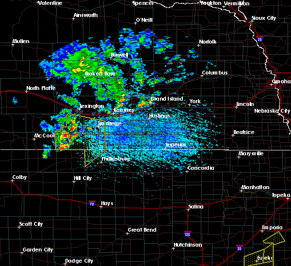 At 456 pm cdt, severe thunderstorms were located along a line extending from smithfield to hollinger to 11 miles northwest of norton, moving southeast at 30 mph (radar indicated). Hazards include 70 mph wind gusts. Expect considerable tree damage. Damage is likely to mobile homes, roofs, and outbuildings. At 456 pm cdt, severe thunderstorms were located along a line extending from smithfield to hollinger to 11 miles northwest of norton, moving southeast at 30 mph (radar indicated). Hazards include 70 mph wind gusts. Expect considerable tree damage. Damage is likely to mobile homes, roofs, and outbuildings.
|
| 8/16/2017 1:53 AM CDT |
 At 153 am cdt, severe thunderstorms were located along a line extending from 6 miles southwest of elwood to holbrook to 8 miles south of hendley, moving east at 30 mph (trained weather spotters). Hazards include 60 mph wind gusts and dime size hail. expect damage to roofs, siding, and trees At 153 am cdt, severe thunderstorms were located along a line extending from 6 miles southwest of elwood to holbrook to 8 miles south of hendley, moving east at 30 mph (trained weather spotters). Hazards include 60 mph wind gusts and dime size hail. expect damage to roofs, siding, and trees
|
| 7/2/2017 10:56 PM CDT |
 The severe thunderstorm warning for southwestern phelps and harlan counties will expire at 1100 pm cdt, the storms which prompted the warning have weakened below severe limits, and no longer pose an immediate threat to life or property. therefore the warning will be allowed to expire. a severe thunderstorm watch remains in effect until midnight cdt for north central kansas, and south central nebraska. The severe thunderstorm warning for southwestern phelps and harlan counties will expire at 1100 pm cdt, the storms which prompted the warning have weakened below severe limits, and no longer pose an immediate threat to life or property. therefore the warning will be allowed to expire. a severe thunderstorm watch remains in effect until midnight cdt for north central kansas, and south central nebraska.
|
| 7/2/2017 10:32 PM CDT |
 At 1031 pm cdt, severe thunderstorms were located along a line extending from 8 miles west of atlanta to near oxford to 6 miles northwest of almena, moving southeast at 20 mph (radar indicated). Hazards include 70 mph wind gusts and quarter size hail. Hail damage to vehicles is expected. expect considerable tree damage. wind damage is also likely to mobile homes, roofs, and outbuildings. Locations impacted include, holdrege, alma, oxford, orleans, stamford, atlanta, huntley and ragan. At 1031 pm cdt, severe thunderstorms were located along a line extending from 8 miles west of atlanta to near oxford to 6 miles northwest of almena, moving southeast at 20 mph (radar indicated). Hazards include 70 mph wind gusts and quarter size hail. Hail damage to vehicles is expected. expect considerable tree damage. wind damage is also likely to mobile homes, roofs, and outbuildings. Locations impacted include, holdrege, alma, oxford, orleans, stamford, atlanta, huntley and ragan.
|
| 7/2/2017 10:14 PM CDT |
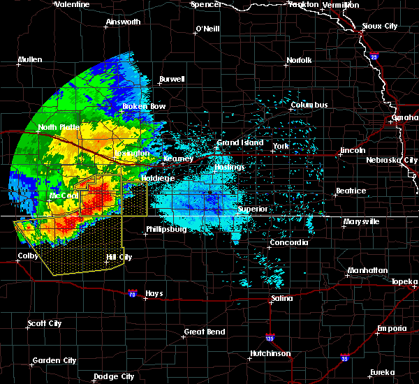 At 1014 pm cdt, severe thunderstorms were located along a line extending from 8 miles south of bertrand to oxford to 7 miles south of beaver city, moving southeast at 20 mph (radar indicated). Hazards include 70 mph wind gusts and half dollar size hail. Hail damage to vehicles is expected. expect considerable tree damage. Wind damage is also likely to mobile homes, roofs, and outbuildings. At 1014 pm cdt, severe thunderstorms were located along a line extending from 8 miles south of bertrand to oxford to 7 miles south of beaver city, moving southeast at 20 mph (radar indicated). Hazards include 70 mph wind gusts and half dollar size hail. Hail damage to vehicles is expected. expect considerable tree damage. Wind damage is also likely to mobile homes, roofs, and outbuildings.
|
| 6/27/2017 5:54 PM CDT |
 At 1054 pm cdt, severe thunderstorms were located along a line extending from near ravenna to 7 miles northeast of riverdale to 9 miles south of elm creek to 7 miles southwest of loomis, moving east at 60 mph (radar indicated). Hazards include 70 mph wind gusts and nickel size hail. Expect considerable tree damage. damage is likely to mobile homes, roofs, and outbuildings. locations impacted include, grand island, kearney, hastings, holdrege, minden, gibbon, ravenna, wood river, shelton, elm creek, kenesaw, doniphan, cairo, juniata, axtell, alda, odessa, loomis, wilcox and pleasanton. This includes interstate 80 between mile markers 256 and 316. At 1054 pm cdt, severe thunderstorms were located along a line extending from near ravenna to 7 miles northeast of riverdale to 9 miles south of elm creek to 7 miles southwest of loomis, moving east at 60 mph (radar indicated). Hazards include 70 mph wind gusts and nickel size hail. Expect considerable tree damage. damage is likely to mobile homes, roofs, and outbuildings. locations impacted include, grand island, kearney, hastings, holdrege, minden, gibbon, ravenna, wood river, shelton, elm creek, kenesaw, doniphan, cairo, juniata, axtell, alda, odessa, loomis, wilcox and pleasanton. This includes interstate 80 between mile markers 256 and 316.
|
| 6/27/2017 5:42 PM CDT |
 At 1041 pm cdt, severe thunderstorms were located along a line extending from near pleasanton to amherst to near bertrand to 7 miles northeast of arapahoe, moving east at 60 mph (radar indicated). Hazards include 70 mph wind gusts and nickel size hail. Expect considerable tree damage. Damage is likely to mobile homes, roofs, and outbuildings. At 1041 pm cdt, severe thunderstorms were located along a line extending from near pleasanton to amherst to near bertrand to 7 miles northeast of arapahoe, moving east at 60 mph (radar indicated). Hazards include 70 mph wind gusts and nickel size hail. Expect considerable tree damage. Damage is likely to mobile homes, roofs, and outbuildings.
|
| 6/27/2017 5:30 PM CDT |
 At 1030 pm cdt, severe thunderstorms were located along a line extending from near pleasanton to near elm creek to near bertrand to 8 miles southwest of loomis, moving east at 55 mph (radar indicated). Hazards include 70 mph wind gusts and nickel size hail. Expect considerable tree damage. damage is likely to mobile homes, roofs, and outbuildings. locations impacted include, kearney, lexington, holdrege, elm creek, bertrand, axtell, elwood, overton, odessa, loomis, wilcox, amherst, sumner, funk, riverdale, miller, atlanta and smithfield. This includes interstate 80 between mile markers 236 and 281. At 1030 pm cdt, severe thunderstorms were located along a line extending from near pleasanton to near elm creek to near bertrand to 8 miles southwest of loomis, moving east at 55 mph (radar indicated). Hazards include 70 mph wind gusts and nickel size hail. Expect considerable tree damage. damage is likely to mobile homes, roofs, and outbuildings. locations impacted include, kearney, lexington, holdrege, elm creek, bertrand, axtell, elwood, overton, odessa, loomis, wilcox, amherst, sumner, funk, riverdale, miller, atlanta and smithfield. This includes interstate 80 between mile markers 236 and 281.
|
| 6/27/2017 5:06 PM CDT |
 At 1005 pm cdt, severe thunderstorms were located along a line extending from near sumner to near johnson lake to 6 miles southwest of elwood to near holbrook, moving east at 55 mph (radar indicated). Hazards include 60 mph wind gusts and nickel size hail. expect damage to roofs, siding, and trees At 1005 pm cdt, severe thunderstorms were located along a line extending from near sumner to near johnson lake to 6 miles southwest of elwood to near holbrook, moving east at 55 mph (radar indicated). Hazards include 60 mph wind gusts and nickel size hail. expect damage to roofs, siding, and trees
|
| 6/21/2017 8:16 PM CDT |
 At 816 pm cdt, a severe thunderstorm was located near bertrand, or 12 miles west of holdrege, moving east at 15 mph (radar indicated). Hazards include 60 mph wind gusts and penny size hail. Expect damage to roofs, siding, and trees. Locations impacted include, holdrege, bertrand, loomis, funk, atlanta and ragan. At 816 pm cdt, a severe thunderstorm was located near bertrand, or 12 miles west of holdrege, moving east at 15 mph (radar indicated). Hazards include 60 mph wind gusts and penny size hail. Expect damage to roofs, siding, and trees. Locations impacted include, holdrege, bertrand, loomis, funk, atlanta and ragan.
|
| 6/21/2017 7:52 PM CDT |
 At 752 pm cdt, a severe thunderstorm was located 8 miles southwest of bertrand, or 17 miles west of holdrege, moving east at 25 mph (radar indicated). Hazards include ping pong ball size hail and 60 mph wind gusts. People and animals outdoors will be injured. expect hail damage to roofs, siding, windows, and vehicles. Expect wind damage to roofs, siding, and trees. At 752 pm cdt, a severe thunderstorm was located 8 miles southwest of bertrand, or 17 miles west of holdrege, moving east at 25 mph (radar indicated). Hazards include ping pong ball size hail and 60 mph wind gusts. People and animals outdoors will be injured. expect hail damage to roofs, siding, windows, and vehicles. Expect wind damage to roofs, siding, and trees.
|
| 5/16/2017 11:58 PM CDT |
 At 1158 pm cdt, severe thunderstorms were located along a line extending from near funk to near naponee to 9 miles southeast of harlan county dam, moving east at 50 mph (radar indicated). Hazards include 60 mph wind gusts. expect damage to roofs, siding, and trees At 1158 pm cdt, severe thunderstorms were located along a line extending from near funk to near naponee to 9 miles southeast of harlan county dam, moving east at 50 mph (radar indicated). Hazards include 60 mph wind gusts. expect damage to roofs, siding, and trees
|
| 5/16/2017 11:47 PM CDT |
 At 1146 pm cdt, severe thunderstorms were located along a line extending from near loomis to near alma to 6 miles north of phillipsburg, moving east at 50 mph (radar indicated). Hazards include 60 mph wind gusts. Expect damage to roofs, siding, and trees. Locations impacted include, holdrege, phillipsburg, alma, orleans, loomis, agra, funk, republican city, atlanta, huntley, ragan, woodruff and harlan county dam. At 1146 pm cdt, severe thunderstorms were located along a line extending from near loomis to near alma to 6 miles north of phillipsburg, moving east at 50 mph (radar indicated). Hazards include 60 mph wind gusts. Expect damage to roofs, siding, and trees. Locations impacted include, holdrege, phillipsburg, alma, orleans, loomis, agra, funk, republican city, atlanta, huntley, ragan, woodruff and harlan county dam.
|
| 5/16/2017 11:22 PM CDT |
 At 1121 pm cdt, severe thunderstorms were located along a line extending from arapahoe to 7 miles southwest of stamford to near prairie view, moving east at 50 mph (radar indicated). Hazards include 60 mph wind gusts. expect damage to roofs, siding, and trees At 1121 pm cdt, severe thunderstorms were located along a line extending from arapahoe to 7 miles southwest of stamford to near prairie view, moving east at 50 mph (radar indicated). Hazards include 60 mph wind gusts. expect damage to roofs, siding, and trees
|
| 5/16/2017 7:03 PM CDT |
 At 703 pm cdt, severe thunderstorms were located along a line extending from 7 miles northeast of bertrand to near kearney to near kenesaw, moving north at 45 mph (radar indicated). Hazards include 70 mph wind gusts. Expect considerable tree damage. Damage is likely to mobile homes, roofs, and outbuildings. At 703 pm cdt, severe thunderstorms were located along a line extending from 7 miles northeast of bertrand to near kearney to near kenesaw, moving north at 45 mph (radar indicated). Hazards include 70 mph wind gusts. Expect considerable tree damage. Damage is likely to mobile homes, roofs, and outbuildings.
|
| 5/16/2017 6:55 PM CDT | Measured at airpor in phelps county NE, 1.9 miles WSW of Holdrege, NE |
| 5/15/2017 9:13 PM CDT |
 At 913 pm cdt, a severe thunderstorm was located over huntley, or 14 miles south of holdrege, moving northeast at 45 mph (trained weather spotters). Hazards include 60 mph wind gusts and quarter size hail. Hail damage to vehicles is expected. expect wind damage to roofs, siding, and trees. Locations impacted include, holdrege, alma, orleans, loomis, funk, stamford, atlanta, huntley and ragan. At 913 pm cdt, a severe thunderstorm was located over huntley, or 14 miles south of holdrege, moving northeast at 45 mph (trained weather spotters). Hazards include 60 mph wind gusts and quarter size hail. Hail damage to vehicles is expected. expect wind damage to roofs, siding, and trees. Locations impacted include, holdrege, alma, orleans, loomis, funk, stamford, atlanta, huntley and ragan.
|
| 5/15/2017 9:02 PM CDT |
 At 902 pm cdt, a severe thunderstorm was located near orleans, or 18 miles south of holdrege, moving northeast at 50 mph (radar indicated). Hazards include 60 mph wind gusts and quarter size hail. Hail damage to vehicles is expected. expect wind damage to roofs, siding, and trees. Locations impacted include, holdrege, alma, oxford, orleans, loomis, funk, stamford, atlanta, huntley and ragan. At 902 pm cdt, a severe thunderstorm was located near orleans, or 18 miles south of holdrege, moving northeast at 50 mph (radar indicated). Hazards include 60 mph wind gusts and quarter size hail. Hail damage to vehicles is expected. expect wind damage to roofs, siding, and trees. Locations impacted include, holdrege, alma, oxford, orleans, loomis, funk, stamford, atlanta, huntley and ragan.
|
| 5/15/2017 8:50 PM CDT |
 At 849 pm cdt, a severe thunderstorm was located near stamford, or 22 miles northeast of norton, moving northeast at 50 mph (radar indicated). Hazards include 60 mph wind gusts and quarter size hail. Hail damage to vehicles is expected. Expect wind damage to roofs, siding, and trees. At 849 pm cdt, a severe thunderstorm was located near stamford, or 22 miles northeast of norton, moving northeast at 50 mph (radar indicated). Hazards include 60 mph wind gusts and quarter size hail. Hail damage to vehicles is expected. Expect wind damage to roofs, siding, and trees.
|
| 5/15/2017 8:19 PM CDT |
 At 818 pm cdt, severe thunderstorms were located along a line extending from just south of kearney to near minden to near harlan county dam, moving northeast at 50 mph (trained weather spotters). Hazards include 60 mph wind gusts and penny size hail. Expect damage to roofs, siding, and trees. Locations impacted include, holdrege, minden, alma, franklin, axtell, orleans, hildreth, wilcox, campbell, funk, republican city, upland, naponee, bloomington, riverton, heartwell, huntley, norman, ragan and harlan county dam. At 818 pm cdt, severe thunderstorms were located along a line extending from just south of kearney to near minden to near harlan county dam, moving northeast at 50 mph (trained weather spotters). Hazards include 60 mph wind gusts and penny size hail. Expect damage to roofs, siding, and trees. Locations impacted include, holdrege, minden, alma, franklin, axtell, orleans, hildreth, wilcox, campbell, funk, republican city, upland, naponee, bloomington, riverton, heartwell, huntley, norman, ragan and harlan county dam.
|
| 5/15/2017 8:10 PM CDT | Storm damage reported in phelps county NE, 5.2 miles WSW of Holdrege, NE |
| 5/15/2017 8:06 PM CDT |
 At 805 pm cdt, a severe thunderstorm was located over funk, or near holdrege, moving northeast at 45 mph. another severe thunderstorm was located south of orleans, moving northeast at 45 mph (trained weather spotters). Hazards include 60 mph wind gusts and penny size hail. Expect damage to roofs, siding, and trees. Locations impacted include, holdrege, alma, orleans, funk, republican city, atlanta, huntley, ragan and harlan county dam. At 805 pm cdt, a severe thunderstorm was located over funk, or near holdrege, moving northeast at 45 mph. another severe thunderstorm was located south of orleans, moving northeast at 45 mph (trained weather spotters). Hazards include 60 mph wind gusts and penny size hail. Expect damage to roofs, siding, and trees. Locations impacted include, holdrege, alma, orleans, funk, republican city, atlanta, huntley, ragan and harlan county dam.
|
| 5/15/2017 8:04 PM CDT |
 At 803 pm cdt, severe thunderstorms were located along a line extending from 8 miles southwest of odessa to near ragan to near woodruff, moving northeast at 55 mph (trained weather spotters). Hazards include 60 mph wind gusts and penny size hail. expect damage to roofs, siding, and trees At 803 pm cdt, severe thunderstorms were located along a line extending from 8 miles southwest of odessa to near ragan to near woodruff, moving northeast at 55 mph (trained weather spotters). Hazards include 60 mph wind gusts and penny size hail. expect damage to roofs, siding, and trees
|
| 5/15/2017 8:01 PM CDT | Quarter sized hail reported 0.2 miles W of Holdrege, NE, reported via mping. |
| 5/15/2017 7:53 PM CDT |
 At 752 pm cdt, a severe thunderstorm was located near atlanta, or near holdrege, moving northeast at 45 mph (trained weather spotters reported up to quarter size hail in oxford at 737 pm). Hazards include 60 mph wind gusts and quarter size hail. Hail damage to vehicles is expected. expect wind damage to roofs, siding, and trees. Locations impacted include, holdrege, alma, oxford, orleans, loomis, funk, stamford, republican city, atlanta, huntley, ragan and harlan county dam. At 752 pm cdt, a severe thunderstorm was located near atlanta, or near holdrege, moving northeast at 45 mph (trained weather spotters reported up to quarter size hail in oxford at 737 pm). Hazards include 60 mph wind gusts and quarter size hail. Hail damage to vehicles is expected. expect wind damage to roofs, siding, and trees. Locations impacted include, holdrege, alma, oxford, orleans, loomis, funk, stamford, republican city, atlanta, huntley, ragan and harlan county dam.
|
| 5/15/2017 7:33 PM CDT |
 At 732 pm cdt, a severe thunderstorm was located over oxford, or 18 miles southwest of holdrege, moving northeast at 45 mph (radar indicated). Hazards include 70 mph wind gusts and quarter size hail. Hail damage to vehicles is expected. expect considerable tree damage. Wind damage is also likely to mobile homes, roofs, and outbuildings. At 732 pm cdt, a severe thunderstorm was located over oxford, or 18 miles southwest of holdrege, moving northeast at 45 mph (radar indicated). Hazards include 70 mph wind gusts and quarter size hail. Hail damage to vehicles is expected. expect considerable tree damage. Wind damage is also likely to mobile homes, roofs, and outbuildings.
|
| 5/8/2017 8:46 PM CDT |
 At 845 pm cdt, a severe thunderstorm was located near atlanta, or 10 miles west of holdrege, moving east at 5 mph (radar indicated). Hazards include quarter size hail. Damage to vehicles is expected. Locations impacted include, holdrege, loomis and atlanta. At 845 pm cdt, a severe thunderstorm was located near atlanta, or 10 miles west of holdrege, moving east at 5 mph (radar indicated). Hazards include quarter size hail. Damage to vehicles is expected. Locations impacted include, holdrege, loomis and atlanta.
|
| 5/8/2017 8:24 PM CDT |
 At 824 pm cdt, a severe thunderstorm was located 7 miles west of atlanta, or 12 miles west of holdrege, moving east at 5 mph (radar indicated). Hazards include half dollar size hail. damage to vehicles is expected At 824 pm cdt, a severe thunderstorm was located 7 miles west of atlanta, or 12 miles west of holdrege, moving east at 5 mph (radar indicated). Hazards include half dollar size hail. damage to vehicles is expected
|
| 4/9/2017 6:23 PM CDT |
 The severe thunderstorm warning for eastern phelps, southwestern buffalo and southeastern dawson counties will expire at 630 pm cdt, the storms which prompted the warning have moved out of the area. therefore the warning will be allowed to expire. a severe thunderstorm watch remains in effect until 1000 pm cdt for south central nebraska. The severe thunderstorm warning for eastern phelps, southwestern buffalo and southeastern dawson counties will expire at 630 pm cdt, the storms which prompted the warning have moved out of the area. therefore the warning will be allowed to expire. a severe thunderstorm watch remains in effect until 1000 pm cdt for south central nebraska.
|
| 4/9/2017 6:11 PM CDT |
 At 611 pm cdt, severe thunderstorms were located along a line extending from near miller to near elm creek to near odessa to near wilcox, moving east at 45 mph (radar indicated). Hazards include 60 mph wind gusts and quarter size hail. Hail damage to vehicles is expected. expect wind damage to roofs, siding, and trees. locations impacted include, holdrege, elm creek, odessa and funk. This includes interstate 80 between mile markers 254 and 267. At 611 pm cdt, severe thunderstorms were located along a line extending from near miller to near elm creek to near odessa to near wilcox, moving east at 45 mph (radar indicated). Hazards include 60 mph wind gusts and quarter size hail. Hail damage to vehicles is expected. expect wind damage to roofs, siding, and trees. locations impacted include, holdrege, elm creek, odessa and funk. This includes interstate 80 between mile markers 254 and 267.
|
| 4/9/2017 6:00 PM CDT | Golf Ball sized hail reported 0.3 miles E of Holdrege, NE, via social media. |
| 4/9/2017 5:59 PM CDT | Golf Ball sized hail reported 1.1 miles SE of Holdrege, NE, quarter to golf ball size hail reported in holdrege. |
| 4/9/2017 5:58 PM CDT |
 At 557 pm cdt, severe thunderstorms were located along a line extending from near sumner to near odessa to 7 miles southeast of elm creek to ragan, moving east at 40 mph (trained weather spotters). Hazards include 70 mph wind gusts. Expect considerable tree damage. damage is likely to mobile homes, roofs, and outbuildings. locations impacted include, lexington, holdrege, elm creek, overton, odessa, loomis, sumner, funk, miller and atlanta. This includes interstate 80 between mile markers 235 and 267. At 557 pm cdt, severe thunderstorms were located along a line extending from near sumner to near odessa to 7 miles southeast of elm creek to ragan, moving east at 40 mph (trained weather spotters). Hazards include 70 mph wind gusts. Expect considerable tree damage. damage is likely to mobile homes, roofs, and outbuildings. locations impacted include, lexington, holdrege, elm creek, overton, odessa, loomis, sumner, funk, miller and atlanta. This includes interstate 80 between mile markers 235 and 267.
|
| 4/9/2017 5:25 PM CDT |
 At 524 pm cdt, severe thunderstorms were located along a line extending from cozad to near smithfield to near edison, moving east at 45 mph (trained weather spotters. there have been several reports of 60 to 70 mph winds associated with this line of thunderstorms). Hazards include 70 mph wind gusts. Expect considerable tree damage. Damage is likely to mobile homes, roofs, and outbuildings. At 524 pm cdt, severe thunderstorms were located along a line extending from cozad to near smithfield to near edison, moving east at 45 mph (trained weather spotters. there have been several reports of 60 to 70 mph winds associated with this line of thunderstorms). Hazards include 70 mph wind gusts. Expect considerable tree damage. Damage is likely to mobile homes, roofs, and outbuildings.
|
| 3/23/2017 11:53 PM CDT |
 The severe thunderstorm warning for northern smith, northern phillips, webster, franklin, phelps, adams, kearney, gosper, furnas and harlan counties will expire at midnight cdt, the storms which prompted the warning have weakened below severe limits, and no longer pose an immediate threat to life or property. therefore, the warning will be allowed to expire. however gusty winds sustained at 25 to 35 mph with gusts to 45 to 55 mph are expected through 4 am. The severe thunderstorm warning for northern smith, northern phillips, webster, franklin, phelps, adams, kearney, gosper, furnas and harlan counties will expire at midnight cdt, the storms which prompted the warning have weakened below severe limits, and no longer pose an immediate threat to life or property. therefore, the warning will be allowed to expire. however gusty winds sustained at 25 to 35 mph with gusts to 45 to 55 mph are expected through 4 am.
|
| 3/23/2017 11:13 PM CDT |
 At 1113 pm cdt, severe thunderstorms were located along a line extending from indianola to near long island to naponee to 7 miles north of lebanon, moving northeast at 70 mph (radar indicated). Hazards include 70 mph wind gusts. Expect considerable tree damage. Damage is likely to mobile homes, roofs, and outbuildings. At 1113 pm cdt, severe thunderstorms were located along a line extending from indianola to near long island to naponee to 7 miles north of lebanon, moving northeast at 70 mph (radar indicated). Hazards include 70 mph wind gusts. Expect considerable tree damage. Damage is likely to mobile homes, roofs, and outbuildings.
|
| 3/23/2017 10:17 PM CDT |
 At 1016 pm cdt, severe thunderstorms were producing severe outflow wind extending from near eddyville to near giltner, moving northeast at 35 mph (radar indicated). Hazards include 70 mph wind gusts. Expect considerable tree damage. Damage is likely to mobile homes, roofs, and outbuildings. At 1016 pm cdt, severe thunderstorms were producing severe outflow wind extending from near eddyville to near giltner, moving northeast at 35 mph (radar indicated). Hazards include 70 mph wind gusts. Expect considerable tree damage. Damage is likely to mobile homes, roofs, and outbuildings.
|
| 3/23/2017 9:43 PM CDT |
 At 940 pm cdt, severe thunderstorms were located along a line extending from elm creek to near upland to near athol, moving east at 70 mph (emergency management). Hazards include 70 mph wind gusts. Expect considerable tree damage. damage is likely to mobile homes, roofs, and outbuildings. several locations outside of rainfall have reported blowing dust reducing visibility to less than a quarter mile. stop signs and trees have been blown over. power lines are down in arapahoe. locations impacted include, kearney, hastings, holdrege, phillipsburg, minden, gibbon, smith center, ravenna, wood river, alma, shelton, arapahoe, red cloud, franklin, blue hill, elm creek, kenesaw, oxford, juniata and bertrand. This includes interstate 80 between mile markers 240 and 306. At 940 pm cdt, severe thunderstorms were located along a line extending from elm creek to near upland to near athol, moving east at 70 mph (emergency management). Hazards include 70 mph wind gusts. Expect considerable tree damage. damage is likely to mobile homes, roofs, and outbuildings. several locations outside of rainfall have reported blowing dust reducing visibility to less than a quarter mile. stop signs and trees have been blown over. power lines are down in arapahoe. locations impacted include, kearney, hastings, holdrege, phillipsburg, minden, gibbon, smith center, ravenna, wood river, alma, shelton, arapahoe, red cloud, franklin, blue hill, elm creek, kenesaw, oxford, juniata and bertrand. This includes interstate 80 between mile markers 240 and 306.
|
| 3/23/2017 9:25 PM CDT |
 At 924 pm cdt, severe thunderstorms were located along a line extending from near smithfield to 7 miles southwest of hildreth to near kirwin, moving northeast at 70 mph (emergency management). Hazards include 70 mph wind gusts. Expect considerable tree damage. Damage is likely to mobile homes, roofs, and outbuildings. At 924 pm cdt, severe thunderstorms were located along a line extending from near smithfield to 7 miles southwest of hildreth to near kirwin, moving northeast at 70 mph (emergency management). Hazards include 70 mph wind gusts. Expect considerable tree damage. Damage is likely to mobile homes, roofs, and outbuildings.
|
| 3/23/2017 9:15 PM CDT | . in phelps county NE, 0.2 miles W of Holdrege, NE |
| 9/15/2016 6:45 PM CDT | Ping Pong Ball sized hail reported 6.9 miles S of Holdrege, NE, dime to ping pong sized hail. roads and ground covered in hail |
| 7/27/2016 1:55 AM CDT |
 At 154 am cdt, severe thunderstorms were located along a line extending from near heartwell to near hildreth to near hollinger, moving southeast at 40 mph (radar indicated). Hazards include 60 mph wind gusts. Expect damage to roofs. siding. and trees. Locations impacted include, hastings, holdrege, minden, alma, arapahoe, kenesaw, oxford, juniata, bertrand, axtell, beaver city, orleans, loomis, hildreth, wilcox, roseland, holstein, funk, stamford and republican city. At 154 am cdt, severe thunderstorms were located along a line extending from near heartwell to near hildreth to near hollinger, moving southeast at 40 mph (radar indicated). Hazards include 60 mph wind gusts. Expect damage to roofs. siding. and trees. Locations impacted include, hastings, holdrege, minden, alma, arapahoe, kenesaw, oxford, juniata, bertrand, axtell, beaver city, orleans, loomis, hildreth, wilcox, roseland, holstein, funk, stamford and republican city.
|
| 7/27/2016 1:29 AM CDT |
 At 129 am cdt, severe thunderstorms were located along a line extending from near farwell to near shelton to near oxford, moving southeast at 45 mph (radar indicated). Hazards include 70 mph wind gusts. Expect considerable tree damage. Damage is likely to mobile homes, roofs, and outbuildings. At 129 am cdt, severe thunderstorms were located along a line extending from near farwell to near shelton to near oxford, moving southeast at 45 mph (radar indicated). Hazards include 70 mph wind gusts. Expect considerable tree damage. Damage is likely to mobile homes, roofs, and outbuildings.
|
| 7/6/2016 11:12 PM CDT |
 At 1112 pm cdt, severe thunderstorms were located along a line extending from 6 miles northeast of loomis to near funk to near ragan to huntley to near woodruff, moving east at 60 mph (radar indicated). Hazards include 60 mph wind gusts and penny size hail. Expect damage to roofs. siding. and trees. Locations impacted include, holdrege, minden, alma, arapahoe, franklin, oxford, bertrand, axtell, elwood, beaver city, orleans, loomis, hildreth, wilcox, funk, stamford, republican city, upland, edison and atlanta. At 1112 pm cdt, severe thunderstorms were located along a line extending from 6 miles northeast of loomis to near funk to near ragan to huntley to near woodruff, moving east at 60 mph (radar indicated). Hazards include 60 mph wind gusts and penny size hail. Expect damage to roofs. siding. and trees. Locations impacted include, holdrege, minden, alma, arapahoe, franklin, oxford, bertrand, axtell, elwood, beaver city, orleans, loomis, hildreth, wilcox, funk, stamford, republican city, upland, edison and atlanta.
|
| 7/6/2016 10:41 PM CDT |
 At 1040 pm cdt, severe thunderstorms were located along a line extending from 8 miles southwest of elwood to 6 miles north of arapahoe to near edison to beaver city to 9 miles southeast of wilsonville, moving east at 60 mph (radar indicated). Hazards include 70 mph wind gusts and penny size hail. Expect considerable tree damage. Damage is likely to mobile homes, roofs, and outbuildings. At 1040 pm cdt, severe thunderstorms were located along a line extending from 8 miles southwest of elwood to 6 miles north of arapahoe to near edison to beaver city to 9 miles southeast of wilsonville, moving east at 60 mph (radar indicated). Hazards include 70 mph wind gusts and penny size hail. Expect considerable tree damage. Damage is likely to mobile homes, roofs, and outbuildings.
|
| 6/28/2016 11:57 PM CDT | The severe thunderstorm warning for gosper, phelps, furnas and western harlan counties will expire at midnight cdt, the storms which prompted the warning have weakened below severe limits, and no longer pose an immediate threat to life or property. therefore the warning will be allowed to expire. however gusty winds are still possible with these thunderstorms. a severe thunderstorm watch remains in effect until 400 am cdt for north central kansas, and south central nebraska. |
| 6/28/2016 11:21 PM CDT |
 At 1121 pm cdt, severe thunderstorms were located along a line extending from 8 miles west of johnson lake to 10 miles north of holbrook to 6 miles southwest of cambridge, moving east at 60 mph (radar indicated). Hazards include 60 mph wind gusts. Expect damage to roofs. siding. And trees. At 1121 pm cdt, severe thunderstorms were located along a line extending from 8 miles west of johnson lake to 10 miles north of holbrook to 6 miles southwest of cambridge, moving east at 60 mph (radar indicated). Hazards include 60 mph wind gusts. Expect damage to roofs. siding. And trees.
|
| 5/30/2016 9:08 PM CDT |
 At 908 pm cdt, severe thunderstorms were located along a line extending from near overton to 7 miles southwest of loomis to 9 miles south of hollinger, moving east at 45 mph (radar indicated). Hazards include 60 mph wind gusts. Expect damage to roofs. siding. and trees. Locations impacted include, holdrege, alma, cambridge, arapahoe, oxford, bertrand, elwood, beaver city, orleans, loomis, holbrook, funk, stamford, republican city, edison, atlanta, wilsonville, smithfield, huntley and ragan. At 908 pm cdt, severe thunderstorms were located along a line extending from near overton to 7 miles southwest of loomis to 9 miles south of hollinger, moving east at 45 mph (radar indicated). Hazards include 60 mph wind gusts. Expect damage to roofs. siding. and trees. Locations impacted include, holdrege, alma, cambridge, arapahoe, oxford, bertrand, elwood, beaver city, orleans, loomis, holbrook, funk, stamford, republican city, edison, atlanta, wilsonville, smithfield, huntley and ragan.
|
| 5/30/2016 8:55 PM CDT |
 At 854 pm cdt, severe thunderstorms were located along a line extending from near smithfield to 9 miles north of edison to 7 miles southeast of hendley, moving east at 40 mph. this warning replaces the previous warning for gosper and furnas counties expiring at 9pm (radar indicated). Hazards include 60 mph wind gusts. Expect damage to roofs. siding. And trees. At 854 pm cdt, severe thunderstorms were located along a line extending from near smithfield to 9 miles north of edison to 7 miles southeast of hendley, moving east at 40 mph. this warning replaces the previous warning for gosper and furnas counties expiring at 9pm (radar indicated). Hazards include 60 mph wind gusts. Expect damage to roofs. siding. And trees.
|
| 5/29/2016 5:54 PM CDT |
 The severe thunderstorm warning for south central phelps and north central harlan counties will expire at 600 pm cdt, the storm which prompted the warning has weakened below severe limits, and no longer poses an immediate threat to life or property. therefore the warning will be allowed to expire. however gusty winds are still possible with this thunderstorm. The severe thunderstorm warning for south central phelps and north central harlan counties will expire at 600 pm cdt, the storm which prompted the warning has weakened below severe limits, and no longer poses an immediate threat to life or property. therefore the warning will be allowed to expire. however gusty winds are still possible with this thunderstorm.
|
| 5/29/2016 5:46 PM CDT |
 At 544 pm cdt, a severe thunderstorm was located near atlanta, or 7 miles south of holdrege, moving northeast at 20 mph. this storm has begun to weaken, but may still contain quarter size hail and 60 mph wind (radar indicated). Hazards include 60 mph wind gusts and quarter size hail. Hail damage to vehicles is expected. expect wind damage to roofs, siding, and trees. Locations impacted include, holdrege and atlanta. At 544 pm cdt, a severe thunderstorm was located near atlanta, or 7 miles south of holdrege, moving northeast at 20 mph. this storm has begun to weaken, but may still contain quarter size hail and 60 mph wind (radar indicated). Hazards include 60 mph wind gusts and quarter size hail. Hail damage to vehicles is expected. expect wind damage to roofs, siding, and trees. Locations impacted include, holdrege and atlanta.
|
| 5/29/2016 5:27 PM CDT |
 At 527 pm cdt, a severe thunderstorm was located near atlanta, or 11 miles southwest of holdrege, moving northeast at 25 mph (radar indicated). Hazards include ping pong ball size hail and 60 mph wind gusts. People and animals outdoors will be injured. expect hail damage to roofs, siding, windows, and vehicles. Expect wind damage to roofs, siding, and trees. At 527 pm cdt, a severe thunderstorm was located near atlanta, or 11 miles southwest of holdrege, moving northeast at 25 mph (radar indicated). Hazards include ping pong ball size hail and 60 mph wind gusts. People and animals outdoors will be injured. expect hail damage to roofs, siding, windows, and vehicles. Expect wind damage to roofs, siding, and trees.
|
| 5/26/2016 5:51 PM CDT |
 At 551 pm cdt, a severe thunderstorm was located near wilcox, or 14 miles southeast of holdrege, moving north at 25 mph (radar indicated). Hazards include 60 mph wind gusts and quarter size hail. Hail damage to vehicles is expected. expect wind damage to roofs, siding, and trees. this severe thunderstorm will be near, wilcox around 605 pm cdt. axtell around 620 pm cdt. funk around 625 pm cdt. A tornado watch remains in effect until 1000 pm cdt for south central nebraska. At 551 pm cdt, a severe thunderstorm was located near wilcox, or 14 miles southeast of holdrege, moving north at 25 mph (radar indicated). Hazards include 60 mph wind gusts and quarter size hail. Hail damage to vehicles is expected. expect wind damage to roofs, siding, and trees. this severe thunderstorm will be near, wilcox around 605 pm cdt. axtell around 620 pm cdt. funk around 625 pm cdt. A tornado watch remains in effect until 1000 pm cdt for south central nebraska.
|
| 5/25/2016 9:56 PM CDT | The severe thunderstorm warning for southeastern gosper, phelps and northern harlan counties will expire at 1000 pm cdt, the storms which prompted the warning have weakened below severe limits, and no longer pose an immediate threat to life or property. therefore the warning will be allowed to expire. however gusty winds are still possible with these thunderstorms. a severe thunderstorm watch remains in effect until 200 am cdt for south central nebraska. to report severe weather, contact your nearest law enforcement agency. they will relay your report to the national weather service hastings. |
| 5/25/2016 9:34 PM CDT |
 At 934 pm cdt, severe thunderstorms were located along a line extending from 8 miles southwest of odessa to holdrege to near ragan to near oxford, moving east at 45 mph (radar indicated). Hazards include 60 mph wind gusts and quarter size hail. Hail damage to vehicles is expected. expect wind damage to roofs, siding, and trees. Locations impacted include, holdrege, oxford, bertrand, loomis, funk, atlanta and ragan. At 934 pm cdt, severe thunderstorms were located along a line extending from 8 miles southwest of odessa to holdrege to near ragan to near oxford, moving east at 45 mph (radar indicated). Hazards include 60 mph wind gusts and quarter size hail. Hail damage to vehicles is expected. expect wind damage to roofs, siding, and trees. Locations impacted include, holdrege, oxford, bertrand, loomis, funk, atlanta and ragan.
|
| 5/25/2016 9:22 PM CDT |
 At 922 pm cdt, severe thunderstorms were located along a line extending from 6 miles south of overton to loomis to near atlanta to 6 miles north of edison, moving east at 40 mph (radar indicated). Hazards include 60 mph wind gusts and quarter size hail. Hail damage to vehicles is expected. expect wind damage to roofs, siding, and trees. Locations impacted include, holdrege, oxford, bertrand, loomis, funk, edison, atlanta, smithfield and ragan. At 922 pm cdt, severe thunderstorms were located along a line extending from 6 miles south of overton to loomis to near atlanta to 6 miles north of edison, moving east at 40 mph (radar indicated). Hazards include 60 mph wind gusts and quarter size hail. Hail damage to vehicles is expected. expect wind damage to roofs, siding, and trees. Locations impacted include, holdrege, oxford, bertrand, loomis, funk, edison, atlanta, smithfield and ragan.
|
| 5/25/2016 9:11 PM CDT |
 At 910 pm cdt, severe thunderstorms were located along a line extending from 7 miles southeast of lexington to near smithfield to 7 miles southwest of bertrand to holbrook, moving east at 40 mph (radar indicated). Hazards include 60 mph wind gusts and quarter size hail. Hail damage to vehicles is expected. Expect wind damage to roofs, siding, and trees. At 910 pm cdt, severe thunderstorms were located along a line extending from 7 miles southeast of lexington to near smithfield to 7 miles southwest of bertrand to holbrook, moving east at 40 mph (radar indicated). Hazards include 60 mph wind gusts and quarter size hail. Hail damage to vehicles is expected. Expect wind damage to roofs, siding, and trees.
|
| 5/25/2016 1:22 AM CDT | The national weather service in hastings has issued a * severe thunderstorm warning for. southeastern gosper county in south central nebraska. phelps county in south central nebraska. northeastern furnas county in south central nebraska. Northwestern harlan county in south central nebraska. |
| 5/10/2016 7:07 PM CDT |
 At 706 pm cdt, a severe thunderstorm was located near axtell, or 12 miles northeast of holdrege, moving northeast at 35 mph. a second severe thunderstorm was located near ragan and tracking northeast towards wilcox (radar indicated). Hazards include 60 mph wind gusts and quarter size hail. Hail damage to vehicles is expected. expect wind damage to roofs, siding, and trees. Locations impacted include, holdrege, minden, axtell, loomis, hildreth, wilcox, funk, atlanta, heartwell, huntley and ragan. At 706 pm cdt, a severe thunderstorm was located near axtell, or 12 miles northeast of holdrege, moving northeast at 35 mph. a second severe thunderstorm was located near ragan and tracking northeast towards wilcox (radar indicated). Hazards include 60 mph wind gusts and quarter size hail. Hail damage to vehicles is expected. expect wind damage to roofs, siding, and trees. Locations impacted include, holdrege, minden, axtell, loomis, hildreth, wilcox, funk, atlanta, heartwell, huntley and ragan.
|
| 5/10/2016 6:46 PM CDT |
 At 646 pm cdt, a severe thunderstorm was located over holdrege, moving northeast at 35 mph (radar indicated). Hazards include 60 mph wind gusts and quarter size hail. Hail damage to vehicles is expected. Expect wind damage to roofs, siding, and trees. At 646 pm cdt, a severe thunderstorm was located over holdrege, moving northeast at 35 mph (radar indicated). Hazards include 60 mph wind gusts and quarter size hail. Hail damage to vehicles is expected. Expect wind damage to roofs, siding, and trees.
|
| 5/10/2016 6:31 PM CDT |
 At 631 pm cdt, a severe thunderstorm was located over atlanta, or 7 miles southwest of holdrege, moving northeast at 25 mph. this is a very dangerous storm (trained weather spotters). Hazards include 80 mph wind gusts and ping pong ball size hail. Flying debris will be dangerous to those caught without shelter. mobile homes will be heavily damaged. expect considerable damage to roofs, windows, and vehicles. extensive tree damage and power outages are likely. Locations impacted include, holdrege, oxford, loomis, atlanta, huntley and ragan. At 631 pm cdt, a severe thunderstorm was located over atlanta, or 7 miles southwest of holdrege, moving northeast at 25 mph. this is a very dangerous storm (trained weather spotters). Hazards include 80 mph wind gusts and ping pong ball size hail. Flying debris will be dangerous to those caught without shelter. mobile homes will be heavily damaged. expect considerable damage to roofs, windows, and vehicles. extensive tree damage and power outages are likely. Locations impacted include, holdrege, oxford, loomis, atlanta, huntley and ragan.
|
| 5/10/2016 6:25 PM CDT |
 At 625 pm cdt, a severe thunderstorm was located over atlanta, or 7 miles southwest of holdrege, moving northeast at 30 mph. this is a very dangerous storm (trained weather spotters). Hazards include 80 mph wind gusts and ping pong ball size hail. Flying debris will be dangerous to those caught without shelter. mobile homes will be heavily damaged. expect considerable damage to roofs, windows, and vehicles. extensive tree damage and power outages are likely. Locations impacted include, holdrege, oxford, orleans, loomis, stamford, edison, atlanta, huntley, ragan and hollinger. At 625 pm cdt, a severe thunderstorm was located over atlanta, or 7 miles southwest of holdrege, moving northeast at 30 mph. this is a very dangerous storm (trained weather spotters). Hazards include 80 mph wind gusts and ping pong ball size hail. Flying debris will be dangerous to those caught without shelter. mobile homes will be heavily damaged. expect considerable damage to roofs, windows, and vehicles. extensive tree damage and power outages are likely. Locations impacted include, holdrege, oxford, orleans, loomis, stamford, edison, atlanta, huntley, ragan and hollinger.
|
| 5/10/2016 6:04 PM CDT |
 At 604 pm cdt, a severe thunderstorm was located over oxford, or 16 miles southwest of holdrege, moving northeast at 35 mph (radar indicated). Hazards include quarter size hail. damage to vehicles is expected At 604 pm cdt, a severe thunderstorm was located over oxford, or 16 miles southwest of holdrege, moving northeast at 35 mph (radar indicated). Hazards include quarter size hail. damage to vehicles is expected
|
| 5/9/2016 5:13 PM CDT |
 At 513 pm cdt, a severe thunderstorm was located 8 miles northwest of funk, or 8 miles north of holdrege, and is nearly stationary (radar indicated). Hazards include golf ball size hail. People and animals outdoors will be injured. Expect damage to roofs, siding, windows, and vehicles. At 513 pm cdt, a severe thunderstorm was located 8 miles northwest of funk, or 8 miles north of holdrege, and is nearly stationary (radar indicated). Hazards include golf ball size hail. People and animals outdoors will be injured. Expect damage to roofs, siding, windows, and vehicles.
|
| 4/26/2016 7:47 PM CDT |
 At 746 pm cdt, severe thunderstorms were located along a line extending from near holdrege to near bloomington, moving northeast at 15 mph (radar indicated). Hazards include golf ball size hail and 60 mph wind gusts. People and animals outdoors will be injured. expect hail damage to roofs, siding, windows, and vehicles. Expect wind damage to roofs, siding, and trees. At 746 pm cdt, severe thunderstorms were located along a line extending from near holdrege to near bloomington, moving northeast at 15 mph (radar indicated). Hazards include golf ball size hail and 60 mph wind gusts. People and animals outdoors will be injured. expect hail damage to roofs, siding, windows, and vehicles. Expect wind damage to roofs, siding, and trees.
|
| 4/26/2016 7:36 PM CDT |
 At 735 pm cdt, a severe thunderstorm was located near loomis, or 7 miles west of holdrege, moving north at 10 mph (radar indicated). Hazards include 60 mph wind gusts and half dollar size hail. Hail damage to vehicles is expected. expect wind damage to roofs, siding, and trees. Locations impacted include, holdrege, bertrand, loomis and atlanta. At 735 pm cdt, a severe thunderstorm was located near loomis, or 7 miles west of holdrege, moving north at 10 mph (radar indicated). Hazards include 60 mph wind gusts and half dollar size hail. Hail damage to vehicles is expected. expect wind damage to roofs, siding, and trees. Locations impacted include, holdrege, bertrand, loomis and atlanta.
|
| 4/26/2016 7:28 PM CDT |
 At 728 pm cdt, a severe thunderstorm was located near atlanta, or 8 miles west of holdrege, moving north at 10 mph (radar indicated). Hazards include 60 mph wind gusts and quarter size hail. Hail damage to vehicles is expected. Expect wind damage to roofs, siding, and trees. At 728 pm cdt, a severe thunderstorm was located near atlanta, or 8 miles west of holdrege, moving north at 10 mph (radar indicated). Hazards include 60 mph wind gusts and quarter size hail. Hail damage to vehicles is expected. Expect wind damage to roofs, siding, and trees.
|
| 4/7/2016 1:30 PM CDT | A semi-tractor trailer was overturned due to strong wind...just east of holdreg in phelps county NE, 0.7 miles W of Holdrege, NE |
| 11/16/2015 8:14 PM CST |
 At 814 pm cst, a severe thunderstorm capable of producing a tornado was located near oxford, or 15 miles southwest of holdrege, moving north at 35 mph (radar indicated rotation). Hazards include tornado and quarter size hail. Flying debris will be dangerous to those caught without shelter. mobile homes will be damaged or destroyed. damage to roofs, windows and vehicles will occur. tree damage is likely. this dangerous storm will be near, atlanta around 825 pm cst. Holdrege around 840 pm cst. At 814 pm cst, a severe thunderstorm capable of producing a tornado was located near oxford, or 15 miles southwest of holdrege, moving north at 35 mph (radar indicated rotation). Hazards include tornado and quarter size hail. Flying debris will be dangerous to those caught without shelter. mobile homes will be damaged or destroyed. damage to roofs, windows and vehicles will occur. tree damage is likely. this dangerous storm will be near, atlanta around 825 pm cst. Holdrege around 840 pm cst.
|
| 11/16/2015 8:01 PM CST |
 At 758 pm cst, a confirmed tornado was located 5 miles southwest of stamford, moving north at 35 mph. this is the second of two areas of rotation associated with this storm, the other area of rotation is located approximately 2 miles northeast of hollinger (weather spotters confirmed tornado). Hazards include damaging tornado and ping pong ball size hail. Flying debris will be dangerous to those caught without shelter. mobile homes will be damaged or destroyed. damage to roofs, windows and vehicles will occur. tree damage is likely. this tornado will be near, oxford around 805 pm cst. atlanta around 825 pm cst. Holdrege around 840 pm cst. At 758 pm cst, a confirmed tornado was located 5 miles southwest of stamford, moving north at 35 mph. this is the second of two areas of rotation associated with this storm, the other area of rotation is located approximately 2 miles northeast of hollinger (weather spotters confirmed tornado). Hazards include damaging tornado and ping pong ball size hail. Flying debris will be dangerous to those caught without shelter. mobile homes will be damaged or destroyed. damage to roofs, windows and vehicles will occur. tree damage is likely. this tornado will be near, oxford around 805 pm cst. atlanta around 825 pm cst. Holdrege around 840 pm cst.
|
| 11/16/2015 7:55 PM CST |
 At 754 pm cst, a severe thunderstorm capable of producing a tornado was located over hollinger, or 25 miles southwest of holdrege, moving north at 35 mph (radar indicated rotation). Hazards include tornado and ping pong ball size hail. Flying debris will be dangerous to those caught without shelter. mobile homes will be damaged or destroyed. damage to roofs, windows and vehicles will occur. tree damage is likely. this dangerous storm will be near, oxford around 810 pm cst. atlanta around 825 pm cst. Holdrege around 840 pm cst. At 754 pm cst, a severe thunderstorm capable of producing a tornado was located over hollinger, or 25 miles southwest of holdrege, moving north at 35 mph (radar indicated rotation). Hazards include tornado and ping pong ball size hail. Flying debris will be dangerous to those caught without shelter. mobile homes will be damaged or destroyed. damage to roofs, windows and vehicles will occur. tree damage is likely. this dangerous storm will be near, oxford around 810 pm cst. atlanta around 825 pm cst. Holdrege around 840 pm cst.
|
| 8/4/2015 4:14 PM CDT |
 At 414 pm cdt, severe thunderstorms were located along a line extending from elm creek to 7 miles south of atlanta, moving east at 35 mph (trained weather spotters). Hazards include 60 mph wind gusts and penny size hail. Expect damage to roofs. siding and trees. Locations impacted include, holdrege, bertrand, loomis, funk, atlanta and ragan. At 414 pm cdt, severe thunderstorms were located along a line extending from elm creek to 7 miles south of atlanta, moving east at 35 mph (trained weather spotters). Hazards include 60 mph wind gusts and penny size hail. Expect damage to roofs. siding and trees. Locations impacted include, holdrege, bertrand, loomis, funk, atlanta and ragan.
|
| 8/4/2015 4:01 PM CDT |
 At 400 pm cdt, severe thunderstorms were located along a line extending from near overton to near oxford, moving east at 40 mph (trained weather spotters). Hazards include 60 mph wind gusts and penny size hail. Expect damage to roofs. siding and trees. Locations impacted include, holdrege, oxford, bertrand, loomis, funk, edison, atlanta, smithfield and ragan. At 400 pm cdt, severe thunderstorms were located along a line extending from near overton to near oxford, moving east at 40 mph (trained weather spotters). Hazards include 60 mph wind gusts and penny size hail. Expect damage to roofs. siding and trees. Locations impacted include, holdrege, oxford, bertrand, loomis, funk, edison, atlanta, smithfield and ragan.
|
| 8/4/2015 3:38 PM CDT |
 At 338 pm cdt, severe thunderstorms were located along a line extending from near johnson lake to near arapahoe, moving east at 35 mph (trained weather spotters). Hazards include 60 mph wind gusts and penny size hail. Expect damage to roofs. Siding and trees. At 338 pm cdt, severe thunderstorms were located along a line extending from near johnson lake to near arapahoe, moving east at 35 mph (trained weather spotters). Hazards include 60 mph wind gusts and penny size hail. Expect damage to roofs. Siding and trees.
|
| 5/9/2015 9:05 PM CDT | At 902 pm cdt, a severe thunderstorm capable of producing a tornado was located over holdrege, moving north at 25 mph (radar indicated rotation). Hazards include tornado and quarter size hail. Flying debris will be dangerous to those caught without shelter. mobile homes will be damaged or destroyed. damage to roofs, windows and vehicles will occur. tree damage is likely. a second dangerous storm capable of producing a tornado will be near, loomis around 915 pm cdt. both storms have shown some signs of weakening but are still capable of producing a tornado. tornadoes were reported earlier over western harlan county. Radar indicated. |
| 5/9/2015 8:53 PM CDT | At 851 pm cdt, a severe thunderstorm capable of producing a tornado was located near ragan, or 7 miles south of holdrege, moving north at 25 mph. a second thunderstorm capable of producing a tornado was located 4 miles southwest of atlanta and was also moving north at 25 mph. tornadoes have been reported earlier with this storm by trained weather spotters (radar indicated rotation). Hazards include tornado and quarter size hail. Flying debris will be dangerous to those caught without shelter. mobile homes will be damaged or destroyed. damage to roofs, windows and vehicles will occur. tree damage is likely. this dangerous storm will be near, atlanta around 855 pm cdt. holdrege around 910 pm cdt. loomis around 915 pm cdt. Radar indicated. |
| 5/9/2015 8:50 PM CDT | At 851 pm cdt, a severe thunderstorm capable of producing a tornado was located near ragan, or 7 miles south of holdrege, moving north at 25 mph. a second thunderstorm capable of producing a tornado was located 4 miles southwest of atlanta and was also moving north at 25 mph. tornadoes have been reported earlier with this storm by trained weather spotters (radar indicated rotation). Hazards include tornado and quarter size hail. Flying debris will be dangerous to those caught without shelter. mobile homes will be damaged or destroyed. damage to roofs, windows and vehicles will occur. tree damage is likely. this dangerous storm will be near, atlanta around 855 pm cdt. holdrege around 910 pm cdt. loomis around 915 pm cdt. Radar indicated. |
| 7/23/2014 3:38 AM CDT | Baseball sized hail reported 9.6 miles NNW of Holdrege, NE, hail up to baseball size |
| 6/14/2014 11:00 PM CDT | Storm damage reported in phelps county NE, 0.3 miles E of Holdrege, NE |
| 6/14/2014 10:55 PM CDT | Holdrege awos reported a 60 mph wind gust in phelps county NE, 1.9 miles WSW of Holdrege, NE |
| 6/14/2014 10:37 PM CDT | Golf Ball sized hail reported 6.2 miles N of Holdrege, NE, golf ball size hail |
| 6/14/2014 10:25 PM CDT | Golf Ball sized hail reported 9 miles NE of Holdrege, NE |
| 9/1/2013 12:36 AM CDT | Photo received via facebook of a large part of a tree that broke off the trunk. the diameter of the multi-branch portion that broke off was estimated at 15 inches. the in phelps county NE, 0.3 miles E of Holdrege, NE |
| 6/16/2013 6:25 PM CDT | Golf Ball sized hail reported 8.3 miles S of Holdrege, NE, time estimated from radar. relayed report from spotters. |
| 5/27/2013 5:26 PM CDT | Ping Pong Ball sized hail reported 6 miles SSW of Holdrege, NE |
| 4/9/2013 12:40 AM CDT | Emergency manager reported a large metal outbuilding near 733 and q road was destroyed. time estimated from rada in phelps county NE, 3.7 miles WSW of Holdrege, NE |
| 4/9/2013 12:35 AM CDT | Storm damage reported in phelps county NE, 1.9 miles WSW of Holdrege, NE |
| 4/9/2013 12:30 AM CDT | Window blown out and garage door removed by wind in phelps county NE, 0.3 miles E of Holdrege, NE |
| 4/9/2013 12:20 AM CDT | Semi blown over by wind in phelps county NE, 4 miles NE of Holdrege, NE |
| 5/30/2012 2:52 PM CDT | Quarter sized hail reported 6.9 miles SSE of Holdrege, NE |
| 5/30/2012 1:35 PM CDT | Quarter sized hail reported 0.3 miles E of Holdrege, NE |
| 1/1/0001 12:00 AM | Storm damage reported in phelps county NE, 1.9 miles WSW of Holdrege, NE |
| 1/1/0001 12:00 AM | Measured by awos in phelps county NE, 1.9 miles WSW of Holdrege, NE |
| 1/1/0001 12:00 AM | Quarter sized hail reported 6.9 miles NW of Holdrege, NE |
| 1/1/0001 12:00 AM | Trailer house was blown over on the west edge of holdrege. mulitple power outages across holdredge and tree limbs with a diameter up to 2 to 6 inches blown dow in phelps county NE, 0.3 miles E of Holdrege, NE |
| 1/1/0001 12:00 AM | Ping Pong Ball sized hail reported 4.8 miles NW of Holdrege, NE |
| 1/1/0001 12:00 AM | 60 mile per hour winds northwest of holdrege and nickel size hai in phelps county NE, 2 miles SE of Holdrege, NE |
| 1/1/0001 12:00 AM | Power lines down in holdreg in phelps county NE, 0.3 miles E of Holdrege, NE |
| 1/1/0001 12:00 AM | Golf Ball sized hail reported 8.3 miles S of Holdrege, NE, along highway 183 |
Hail Maps for Holdrege, NE


Connect with Interactive Hail Maps