

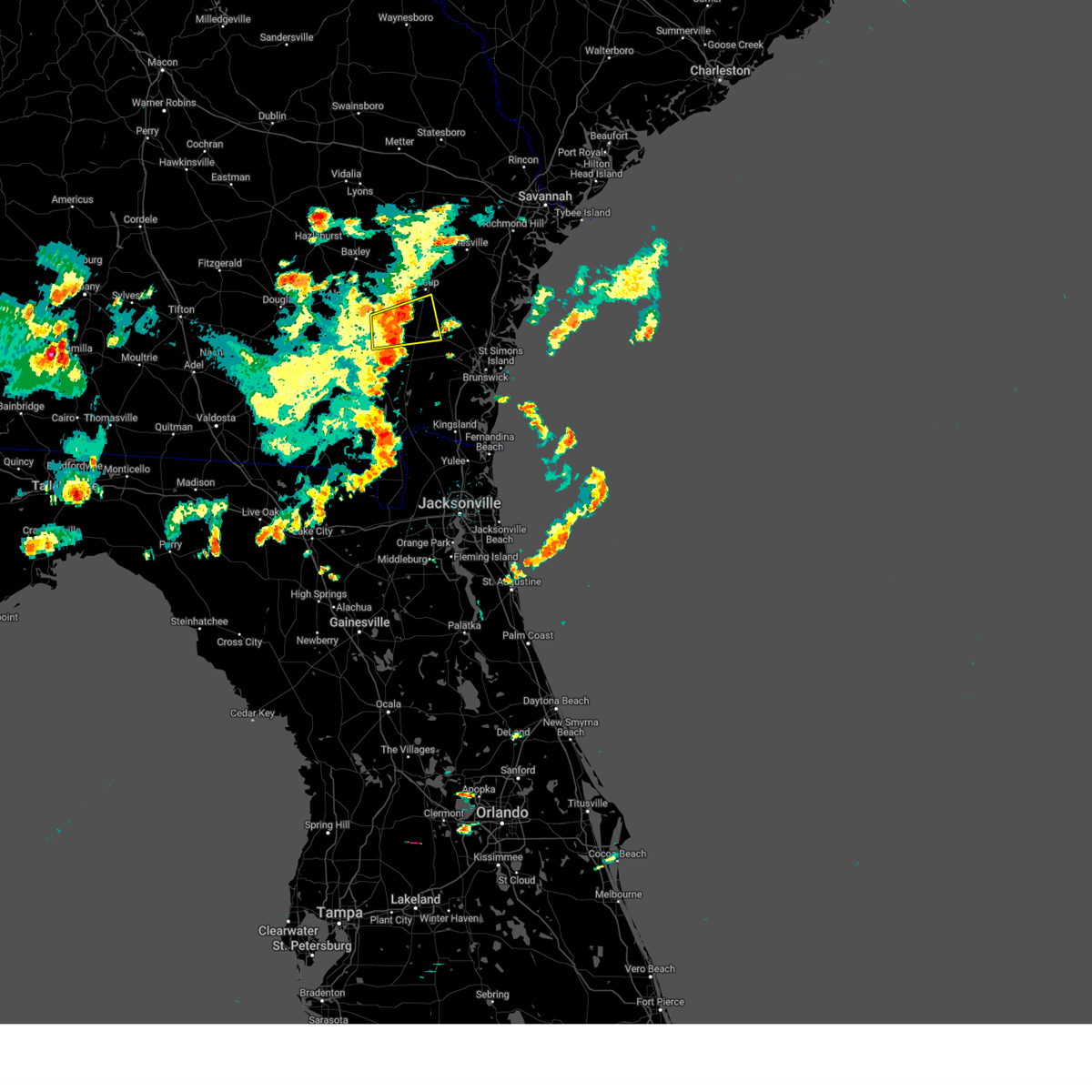
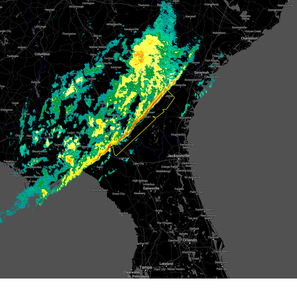
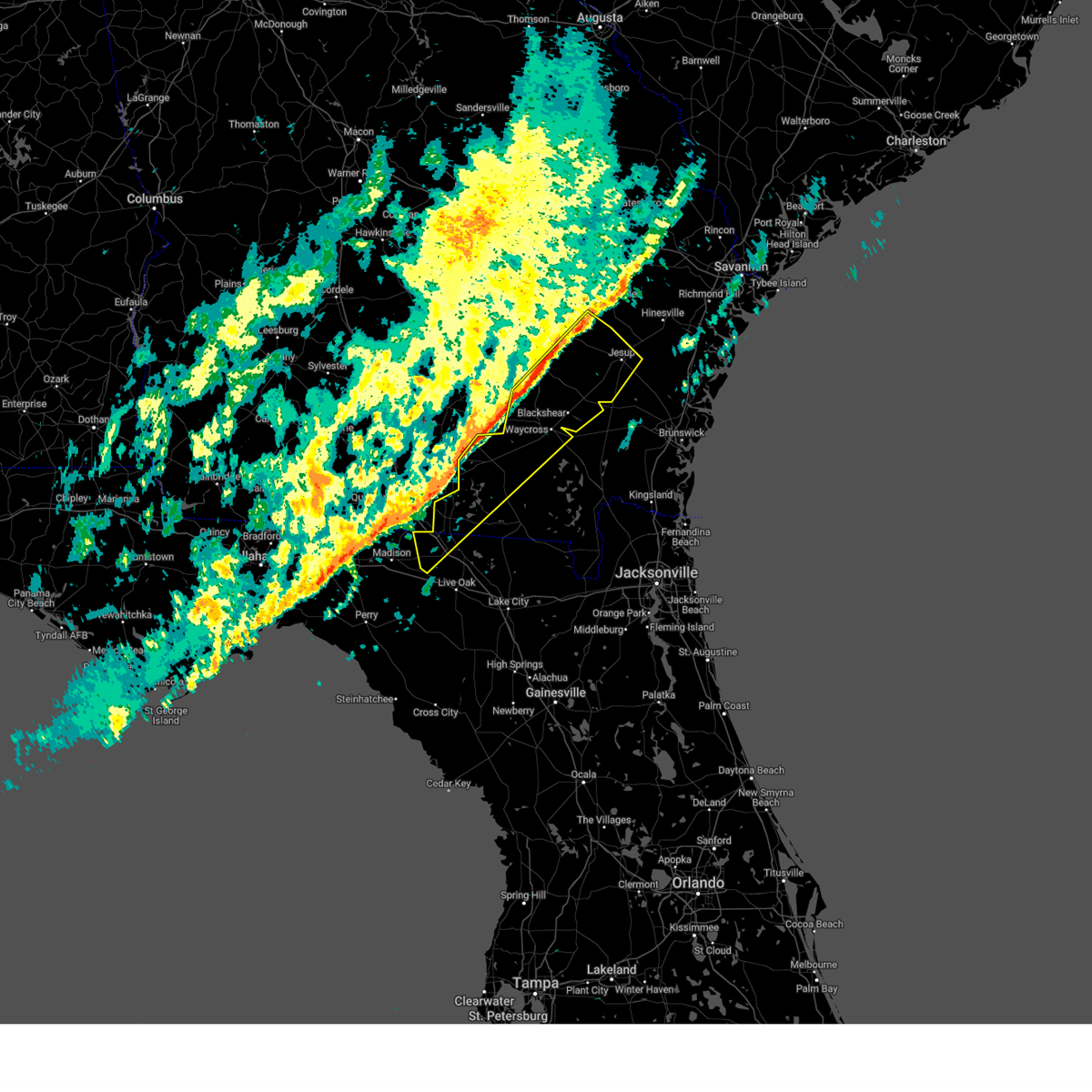
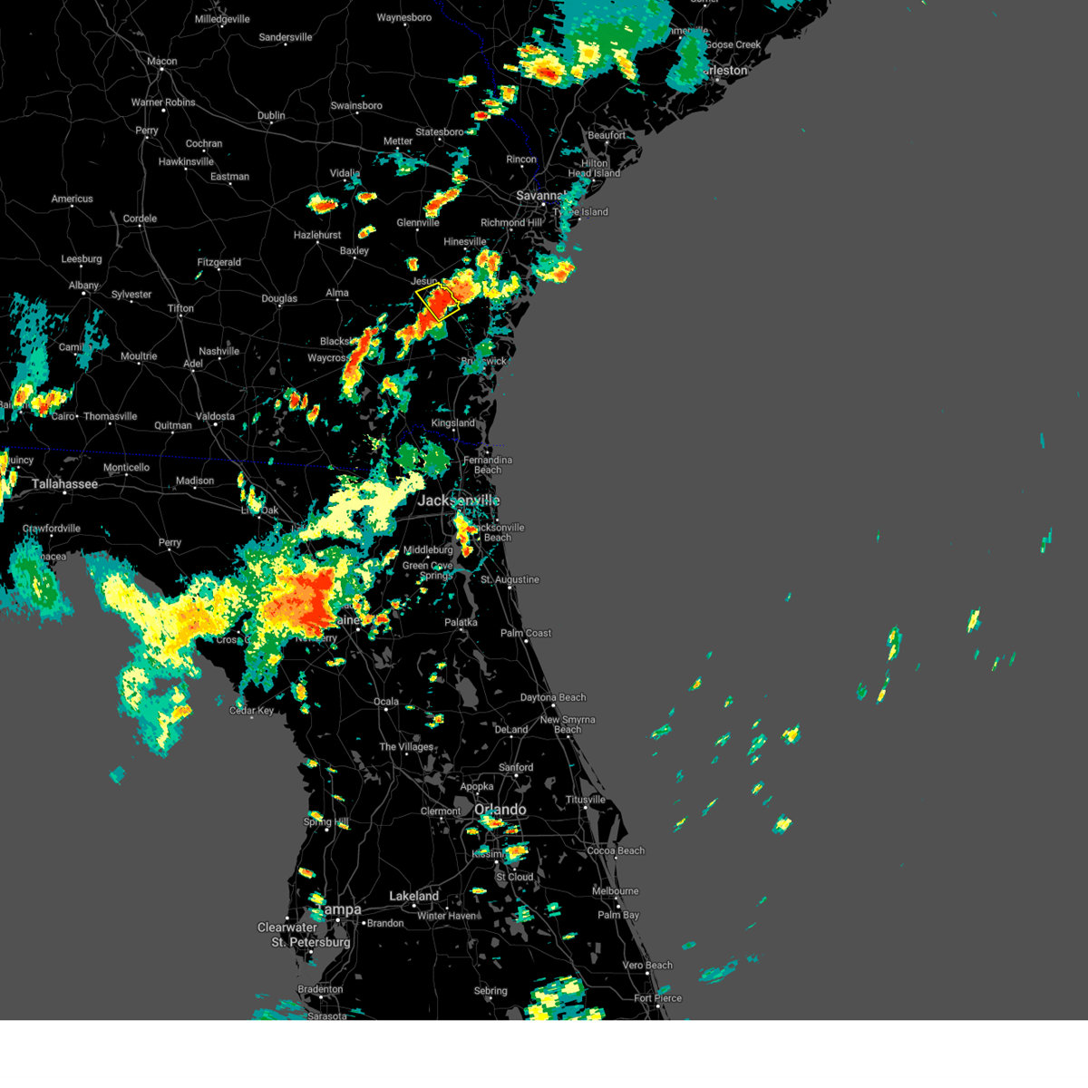
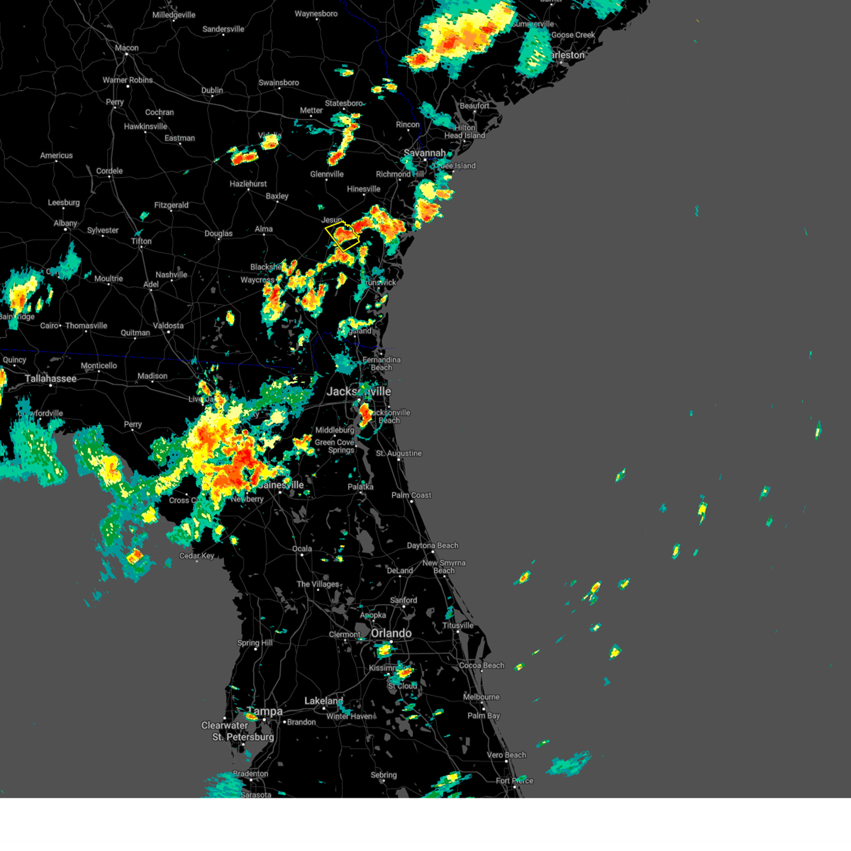
Hail Map for Jesup, GA
The Jesup, GA area has had 10 reports of on-the-ground hail by trained spotters, and has been under severe weather warnings 8 times during the past 12 months. Doppler radar has detected hail at or near Jesup, GA on 65 occasions, including 2 occasions during the past year.
| Name: | Jesup, GA |
| Where Located: | 56.5 miles E of Douglas, GA |
| Map: | Google Map for Jesup, GA |
| Population: | 10214 |
| Housing Units: | 3663 |
| More Info: | Search Google for Jesup, GA |
1
The Top Recent Hail Date for Jesup, GA is Tuesday, May 27, 2025 (18th out of 65)

Hail and Wind Damage Spotted near Jesup, GA
| Date / Time | Report Details |
|---|---|
| 6/9/2025 3:20 PM EDT | Emer. mngr shared on social media a photo of a downed tree across road. time estimated based off rada in wayne county GA, 7.9 miles WNW of Jesup, GA |
| 6/9/2025 2:59 PM EDT |
 the severe thunderstorm warning has been cancelled and is no longer in effect the severe thunderstorm warning has been cancelled and is no longer in effect
|
| 6/9/2025 2:45 PM EDT |
 Svrjax the national weather service in jacksonville has issued a * severe thunderstorm warning for, eastern pierce county in southeastern georgia, northeastern brantley county in southeastern georgia, southwestern wayne county in southeastern georgia, southern appling county in southeastern georgia, * until 315 pm edt. * at 245 pm edt, a severe thunderstorm was located over patterson, moving east at 25 mph (radar indicated). Hazards include 60 mph wind gusts and quarter size hail. Hail damage to vehicles is expected. Expect wind damage to roofs, siding, and trees. Svrjax the national weather service in jacksonville has issued a * severe thunderstorm warning for, eastern pierce county in southeastern georgia, northeastern brantley county in southeastern georgia, southwestern wayne county in southeastern georgia, southern appling county in southeastern georgia, * until 315 pm edt. * at 245 pm edt, a severe thunderstorm was located over patterson, moving east at 25 mph (radar indicated). Hazards include 60 mph wind gusts and quarter size hail. Hail damage to vehicles is expected. Expect wind damage to roofs, siding, and trees.
|
| 5/27/2025 9:14 PM EDT |
 Svrjax the national weather service in jacksonville has issued a * severe thunderstorm warning for, central wayne county in southeastern georgia, * until 1000 pm edt. * at 914 pm edt, a severe thunderstorm was located over jesup, moving south at 15 mph (radar indicated). Hazards include 60 mph wind gusts and nickel size hail. expect damage to roofs, siding, and trees Svrjax the national weather service in jacksonville has issued a * severe thunderstorm warning for, central wayne county in southeastern georgia, * until 1000 pm edt. * at 914 pm edt, a severe thunderstorm was located over jesup, moving south at 15 mph (radar indicated). Hazards include 60 mph wind gusts and nickel size hail. expect damage to roofs, siding, and trees
|
| 2/16/2025 9:37 AM EST |
 The storms which prompted the warning have weakened below severe limits, and no longer pose an immediate threat to life or property. therefore, the warning will be allowed to expire. however, gusty winds and heavy rain are still possible with these thunderstorms. a severe thunderstorm watch remains in effect until 100 pm est for northern florida, and southeastern georgia. The storms which prompted the warning have weakened below severe limits, and no longer pose an immediate threat to life or property. therefore, the warning will be allowed to expire. however, gusty winds and heavy rain are still possible with these thunderstorms. a severe thunderstorm watch remains in effect until 100 pm est for northern florida, and southeastern georgia.
|
| 2/16/2025 9:15 AM EST |
 At 914 am est, severe thunderstorms were located along a line extending from donald to near homerville to 11 miles northwest of perry, moving east at 50 mph (radar indicated). Hazards include 60 mph wind gusts. Expect damage to roofs, siding, and trees. Locations impacted include, waycross, jesup, blackshear, homerville, jennings, patterson, argyle, statenville, suwannee river state park, and screven. At 914 am est, severe thunderstorms were located along a line extending from donald to near homerville to 11 miles northwest of perry, moving east at 50 mph (radar indicated). Hazards include 60 mph wind gusts. Expect damage to roofs, siding, and trees. Locations impacted include, waycross, jesup, blackshear, homerville, jennings, patterson, argyle, statenville, suwannee river state park, and screven.
|
| 2/16/2025 8:58 AM EST |
 Svrjax the national weather service in jacksonville has issued a * severe thunderstorm warning for, northwestern hamilton county in northern florida, pierce county in southeastern georgia, echols county in southeastern georgia, northern ware county in southeastern georgia, southern bacon county in southeastern georgia, wayne county in southeastern georgia, clinch county in southeastern georgia, southeastern appling county in southeastern georgia, * until 945 am est. * at 858 am est, severe thunderstorms were located along a line extending from 11 miles northeast of surrency to 6 miles north of dixie union to 7 miles northeast of madison, moving east at 50 mph (radar indicated). Hazards include 60 mph wind gusts. expect damage to roofs, siding, and trees Svrjax the national weather service in jacksonville has issued a * severe thunderstorm warning for, northwestern hamilton county in northern florida, pierce county in southeastern georgia, echols county in southeastern georgia, northern ware county in southeastern georgia, southern bacon county in southeastern georgia, wayne county in southeastern georgia, clinch county in southeastern georgia, southeastern appling county in southeastern georgia, * until 945 am est. * at 858 am est, severe thunderstorms were located along a line extending from 11 miles northeast of surrency to 6 miles north of dixie union to 7 miles northeast of madison, moving east at 50 mph (radar indicated). Hazards include 60 mph wind gusts. expect damage to roofs, siding, and trees
|
| 8/2/2024 3:54 PM EDT |
 The storm which prompted the warning has weakened below severe limits, and no longer poses an immediate threat to life or property. therefore, the warning will be allowed to expire. however, gusty winds and heavy rain are still possible with this thunderstorm. The storm which prompted the warning has weakened below severe limits, and no longer poses an immediate threat to life or property. therefore, the warning will be allowed to expire. however, gusty winds and heavy rain are still possible with this thunderstorm.
|
| 8/2/2024 3:31 PM EDT |
 Svrjax the national weather service in jacksonville has issued a * severe thunderstorm warning for, southeastern wayne county in southeastern georgia, * until 400 pm edt. * at 330 pm edt, a severe thunderstorm was located near tibet, moving southwest at 5 mph (radar indicated). Hazards include 60 mph wind gusts and quarter size hail. Hail damage to vehicles is expected. Expect wind damage to roofs, siding, and trees. Svrjax the national weather service in jacksonville has issued a * severe thunderstorm warning for, southeastern wayne county in southeastern georgia, * until 400 pm edt. * at 330 pm edt, a severe thunderstorm was located near tibet, moving southwest at 5 mph (radar indicated). Hazards include 60 mph wind gusts and quarter size hail. Hail damage to vehicles is expected. Expect wind damage to roofs, siding, and trees.
|
| 7/6/2024 4:15 PM EDT | A large tree fell across manningtown rd. photos were relayed social media. time was estimated by rada in wayne county GA, 13.4 miles N of Jesup, GA |
| 5/14/2024 7:49 AM EDT |
 Svrjax the national weather service in jacksonville has issued a * severe thunderstorm warning for, pierce county in southeastern georgia, north central ware county in southeastern georgia, bacon county in southeastern georgia, northwestern wayne county in southeastern georgia, appling county in southeastern georgia, * until 830 am edt. * at 749 am edt, a severe thunderstorm was located near alma, moving northeast at 45 mph (radar indicated). Hazards include 60 mph wind gusts and penny size hail. expect damage to roofs, siding, and trees Svrjax the national weather service in jacksonville has issued a * severe thunderstorm warning for, pierce county in southeastern georgia, north central ware county in southeastern georgia, bacon county in southeastern georgia, northwestern wayne county in southeastern georgia, appling county in southeastern georgia, * until 830 am edt. * at 749 am edt, a severe thunderstorm was located near alma, moving northeast at 45 mph (radar indicated). Hazards include 60 mph wind gusts and penny size hail. expect damage to roofs, siding, and trees
|
| 5/9/2024 3:54 PM EDT |
 At 354 pm edt, severe thunderstorms were located along a line extending from near jesup to 8 miles north of raybon to near patterson, moving east at 40 mph (radar indicated). Hazards include 70 mph wind gusts and quarter size hail. Hail damage to vehicles is expected. expect considerable tree damage. wind damage is also likely to mobile homes, roofs, and outbuildings. locations impacted include, brunswick, st. Simons island, gardi, dock junction, country club estates, thalmann, sea island, everett, raybon, and waynesville. At 354 pm edt, severe thunderstorms were located along a line extending from near jesup to 8 miles north of raybon to near patterson, moving east at 40 mph (radar indicated). Hazards include 70 mph wind gusts and quarter size hail. Hail damage to vehicles is expected. expect considerable tree damage. wind damage is also likely to mobile homes, roofs, and outbuildings. locations impacted include, brunswick, st. Simons island, gardi, dock junction, country club estates, thalmann, sea island, everett, raybon, and waynesville.
|
| 5/9/2024 3:54 PM EDT |
 the severe thunderstorm warning has been cancelled and is no longer in effect the severe thunderstorm warning has been cancelled and is no longer in effect
|
| 5/9/2024 3:40 PM EDT |
 Svrjax the national weather service in jacksonville has issued a * severe thunderstorm warning for, north central camden county in southeastern georgia, glynn county in southeastern georgia, pierce county in southeastern georgia, northeastern brantley county in southeastern georgia, southern wayne county in southeastern georgia, southeastern appling county in southeastern georgia, * until 500 pm edt. * at 340 pm edt, severe thunderstorms were located along a line extending from near screven to near offerman to near blackshear, moving east at 40 mph (radar indicated). Hazards include 70 mph wind gusts and quarter size hail. Hail damage to vehicles is expected. expect considerable tree damage. Wind damage is also likely to mobile homes, roofs, and outbuildings. Svrjax the national weather service in jacksonville has issued a * severe thunderstorm warning for, north central camden county in southeastern georgia, glynn county in southeastern georgia, pierce county in southeastern georgia, northeastern brantley county in southeastern georgia, southern wayne county in southeastern georgia, southeastern appling county in southeastern georgia, * until 500 pm edt. * at 340 pm edt, severe thunderstorms were located along a line extending from near screven to near offerman to near blackshear, moving east at 40 mph (radar indicated). Hazards include 70 mph wind gusts and quarter size hail. Hail damage to vehicles is expected. expect considerable tree damage. Wind damage is also likely to mobile homes, roofs, and outbuildings.
|
| 5/9/2024 3:08 PM EDT |
 Svrjax the national weather service in jacksonville has issued a * severe thunderstorm warning for, wayne county in southeastern georgia, east central appling county in southeastern georgia, * until 345 pm edt. * at 308 pm edt, severe thunderstorms were located along a line extending from 7 miles southwest of donald to near surrency, moving southeast at 20 mph (radar indicated). Hazards include 60 mph wind gusts and quarter size hail. Hail damage to vehicles is expected. Expect wind damage to roofs, siding, and trees. Svrjax the national weather service in jacksonville has issued a * severe thunderstorm warning for, wayne county in southeastern georgia, east central appling county in southeastern georgia, * until 345 pm edt. * at 308 pm edt, severe thunderstorms were located along a line extending from 7 miles southwest of donald to near surrency, moving southeast at 20 mph (radar indicated). Hazards include 60 mph wind gusts and quarter size hail. Hail damage to vehicles is expected. Expect wind damage to roofs, siding, and trees.
|
| 4/3/2024 9:23 AM EDT |
 Torjax the national weather service in jacksonville has issued a * tornado warning for, east central wayne county in southeastern georgia, * until 945 am edt. * at 923 am edt, a severe thunderstorm capable of producing a tornado was located over gardi, moving east at 45 mph (radar indicated rotation). Hazards include tornado. Flying debris will be dangerous to those caught without shelter. mobile homes will be damaged or destroyed. damage to roofs, windows, and vehicles will occur. tree damage is likely. This tornadic thunderstorm will remain over mainly rural areas of east central wayne county. Torjax the national weather service in jacksonville has issued a * tornado warning for, east central wayne county in southeastern georgia, * until 945 am edt. * at 923 am edt, a severe thunderstorm capable of producing a tornado was located over gardi, moving east at 45 mph (radar indicated rotation). Hazards include tornado. Flying debris will be dangerous to those caught without shelter. mobile homes will be damaged or destroyed. damage to roofs, windows, and vehicles will occur. tree damage is likely. This tornadic thunderstorm will remain over mainly rural areas of east central wayne county.
|
| 4/3/2024 8:56 AM EDT |
 The storms which prompted the warning have weakened below severe limits, and no longer pose an immediate threat to life or property. therefore, the warning will be allowed to expire. however, small hail and gusty winds are still possible with these thunderstorms. a tornado watch remains in effect until 100 pm edt for southeastern georgia. The storms which prompted the warning have weakened below severe limits, and no longer pose an immediate threat to life or property. therefore, the warning will be allowed to expire. however, small hail and gusty winds are still possible with these thunderstorms. a tornado watch remains in effect until 100 pm edt for southeastern georgia.
|
| 4/3/2024 8:37 AM EDT |
 At 837 am edt, severe thunderstorms were located along a line extending from 6 miles south of surrency to near dixie union, moving east at 45 mph (radar indicated). Hazards include 60 mph wind gusts and penny size hail. Expect damage to roofs, siding, and trees. Locations impacted include, jesup, patterson, screven, odum, offerman, bristol, doctortown, dixie union, and new lacy. At 837 am edt, severe thunderstorms were located along a line extending from 6 miles south of surrency to near dixie union, moving east at 45 mph (radar indicated). Hazards include 60 mph wind gusts and penny size hail. Expect damage to roofs, siding, and trees. Locations impacted include, jesup, patterson, screven, odum, offerman, bristol, doctortown, dixie union, and new lacy.
|
| 4/3/2024 8:28 AM EDT |
 Svrjax the national weather service in jacksonville has issued a * severe thunderstorm warning for, pierce county in southeastern georgia, northwestern ware county in southeastern georgia, southeastern bacon county in southeastern georgia, southwestern wayne county in southeastern georgia, southeastern appling county in southeastern georgia, * until 900 am edt. * at 828 am edt, severe thunderstorms were located along a line extending from 8 miles southwest of surrency to near dixie union, moving east at 50 mph (radar indicated). Hazards include 60 mph wind gusts and penny size hail. expect damage to roofs, siding, and trees Svrjax the national weather service in jacksonville has issued a * severe thunderstorm warning for, pierce county in southeastern georgia, northwestern ware county in southeastern georgia, southeastern bacon county in southeastern georgia, southwestern wayne county in southeastern georgia, southeastern appling county in southeastern georgia, * until 900 am edt. * at 828 am edt, severe thunderstorms were located along a line extending from 8 miles southwest of surrency to near dixie union, moving east at 50 mph (radar indicated). Hazards include 60 mph wind gusts and penny size hail. expect damage to roofs, siding, and trees
|
| 1/9/2024 2:52 PM EST |
 The severe thunderstorm warning for northwestern nassau, camden, western glynn, brantley, southeastern ware, southeastern wayne and northeastern charlton counties will expire at 300 pm est, the storms which prompted the warning have moved out of the area. therefore, the warning will be allowed to expire. however, gusty winds are still possible with these thunderstorms. a tornado watch remains in effect until 600 pm est for northeastern florida, and southeastern georgia. The severe thunderstorm warning for northwestern nassau, camden, western glynn, brantley, southeastern ware, southeastern wayne and northeastern charlton counties will expire at 300 pm est, the storms which prompted the warning have moved out of the area. therefore, the warning will be allowed to expire. however, gusty winds are still possible with these thunderstorms. a tornado watch remains in effect until 600 pm est for northeastern florida, and southeastern georgia.
|
| 1/9/2024 2:21 PM EST |
 The severe thunderstorm warning for eastern pierce, western brantley, southeastern ware, southwestern wayne, southeastern clinch, northwestern charlton and southeastern appling counties will expire at 230 pm est, the storms which prompted the warning have weakened below severe limits, and no longer pose an immediate threat to life or property. therefore, the warning will be allowed to expire. however, gusty winds are still possible with these thunderstorms. a tornado watch remains in effect until 300 pm est for southeastern georgia. a tornado watch also remains in effect until 600 pm est for southeastern georgia. The severe thunderstorm warning for eastern pierce, western brantley, southeastern ware, southwestern wayne, southeastern clinch, northwestern charlton and southeastern appling counties will expire at 230 pm est, the storms which prompted the warning have weakened below severe limits, and no longer pose an immediate threat to life or property. therefore, the warning will be allowed to expire. however, gusty winds are still possible with these thunderstorms. a tornado watch remains in effect until 300 pm est for southeastern georgia. a tornado watch also remains in effect until 600 pm est for southeastern georgia.
|
| 1/9/2024 2:16 PM EST |
 At 216 pm est, severe thunderstorms were located along a line extending from near odum to 7 miles west of race pond, moving northeast at 60 mph (radar indicated). Hazards include 60 mph wind gusts and penny size hail. Expect damage to roofs, siding, and trees. Locations impacted include, jesup, blackshear, patterson, stephen foster state park, screven, offerman, braganza, race pond, and fort mudge. At 216 pm est, severe thunderstorms were located along a line extending from near odum to 7 miles west of race pond, moving northeast at 60 mph (radar indicated). Hazards include 60 mph wind gusts and penny size hail. Expect damage to roofs, siding, and trees. Locations impacted include, jesup, blackshear, patterson, stephen foster state park, screven, offerman, braganza, race pond, and fort mudge.
|
| 1/9/2024 2:04 PM EST |
 At 204 pm est, a severe thunderstorm capable of producing a tornado was located over odum, or 9 miles northwest of jesup, moving east at 65 mph (radar indicated rotation). Hazards include tornado. Flying debris will be dangerous to those caught without shelter. mobile homes will be damaged or destroyed. damage to roofs, windows, and vehicles will occur. tree damage is likely. This dangerous storm will be near, doctortown around 210 pm est. At 204 pm est, a severe thunderstorm capable of producing a tornado was located over odum, or 9 miles northwest of jesup, moving east at 65 mph (radar indicated rotation). Hazards include tornado. Flying debris will be dangerous to those caught without shelter. mobile homes will be damaged or destroyed. damage to roofs, windows, and vehicles will occur. tree damage is likely. This dangerous storm will be near, doctortown around 210 pm est.
|
| 1/9/2024 2:03 PM EST |
 At 202 pm est, severe thunderstorms were located along a line extending from near race pond to 10 miles north of taylor, moving northeast at 70 mph (radar indicated). Hazards include 70 mph wind gusts and penny size hail. Expect considerable tree damage. damage is likely to mobile homes, roofs, and outbuildings. Locations impacted include, kingsland, jesup, hilliard, folkston, woodbine, nahunta, gardi, dock junction, homeland, and hickox. At 202 pm est, severe thunderstorms were located along a line extending from near race pond to 10 miles north of taylor, moving northeast at 70 mph (radar indicated). Hazards include 70 mph wind gusts and penny size hail. Expect considerable tree damage. damage is likely to mobile homes, roofs, and outbuildings. Locations impacted include, kingsland, jesup, hilliard, folkston, woodbine, nahunta, gardi, dock junction, homeland, and hickox.
|
| 1/9/2024 1:55 PM EST |
 At 155 pm est, severe thunderstorms were located along a line extending from 7 miles southeast of hickox to 9 miles southeast of fargo, moving northeast at 95 mph (radar indicated). Hazards include 70 mph wind gusts and penny size hail. Expect considerable tree damage. Damage is likely to mobile homes, roofs, and outbuildings. At 155 pm est, severe thunderstorms were located along a line extending from 7 miles southeast of hickox to 9 miles southeast of fargo, moving northeast at 95 mph (radar indicated). Hazards include 70 mph wind gusts and penny size hail. Expect considerable tree damage. Damage is likely to mobile homes, roofs, and outbuildings.
|
| 1/9/2024 1:40 PM EST |
 At 140 pm est, a severe thunderstorm capable of producing a tornado was located near bristol, or 9 miles northwest of blackshear, moving northeast at 65 mph (radar indicated rotation). Hazards include tornado. Flying debris will be dangerous to those caught without shelter. mobile homes will be damaged or destroyed. damage to roofs, windows, and vehicles will occur. tree damage is likely. this dangerous storm will be near, bristol around 145 pm est. Odum around 200 pm est. At 140 pm est, a severe thunderstorm capable of producing a tornado was located near bristol, or 9 miles northwest of blackshear, moving northeast at 65 mph (radar indicated rotation). Hazards include tornado. Flying debris will be dangerous to those caught without shelter. mobile homes will be damaged or destroyed. damage to roofs, windows, and vehicles will occur. tree damage is likely. this dangerous storm will be near, bristol around 145 pm est. Odum around 200 pm est.
|
| 1/9/2024 1:33 PM EST |
 At 133 pm est, severe thunderstorms were located along a line extending from near dixie union to near needmore, moving northeast at 60 mph (radar indicated). Hazards include 70 mph wind gusts and penny size hail. Expect considerable tree damage. Damage is likely to mobile homes, roofs, and outbuildings. At 133 pm est, severe thunderstorms were located along a line extending from near dixie union to near needmore, moving northeast at 60 mph (radar indicated). Hazards include 70 mph wind gusts and penny size hail. Expect considerable tree damage. Damage is likely to mobile homes, roofs, and outbuildings.
|
| 9/12/2023 6:41 PM EDT |
 The severe thunderstorm warning for southwestern wayne county will expire at 645 pm edt, the storm which prompted the warning has weakened below severe limits, and no longer poses an immediate threat to life or property. therefore, the warning will be allowed to expire. however, gusty winds are still possible with this thunderstorm. The severe thunderstorm warning for southwestern wayne county will expire at 645 pm edt, the storm which prompted the warning has weakened below severe limits, and no longer poses an immediate threat to life or property. therefore, the warning will be allowed to expire. however, gusty winds are still possible with this thunderstorm.
|
| 9/12/2023 6:35 PM EDT |
 At 635 pm edt, a severe thunderstorm was located near screven, or 10 miles northeast of patterson, moving south at 20 mph (radar indicated). Hazards include 60 mph wind gusts and quarter size hail. Hail damage to vehicles is expected. expect wind damage to roofs, siding, and trees. locations impacted include, jesup, screven, and broadhurst. hail threat, radar indicated max hail size, 1. 00 in wind threat, radar indicated max wind gust, 60 mph. At 635 pm edt, a severe thunderstorm was located near screven, or 10 miles northeast of patterson, moving south at 20 mph (radar indicated). Hazards include 60 mph wind gusts and quarter size hail. Hail damage to vehicles is expected. expect wind damage to roofs, siding, and trees. locations impacted include, jesup, screven, and broadhurst. hail threat, radar indicated max hail size, 1. 00 in wind threat, radar indicated max wind gust, 60 mph.
|
| 9/12/2023 6:22 PM EDT |
 At 622 pm edt, a severe thunderstorm was located over screven, or 8 miles southwest of jesup, moving south at 20 mph (radar indicated). Hazards include 60 mph wind gusts and quarter size hail. Hail damage to vehicles is expected. Expect wind damage to roofs, siding, and trees. At 622 pm edt, a severe thunderstorm was located over screven, or 8 miles southwest of jesup, moving south at 20 mph (radar indicated). Hazards include 60 mph wind gusts and quarter size hail. Hail damage to vehicles is expected. Expect wind damage to roofs, siding, and trees.
|
| 8/8/2023 8:05 PM EDT |
 The severe thunderstorm warning for pierce, northwestern brantley, central ware, central wayne and northwestern charlton counties will expire at 815 pm edt, the storms which prompted the warning have moved out of the area. therefore, the warning will be allowed to expire. a severe thunderstorm watch remains in effect until 1100 pm edt for southeastern georgia. The severe thunderstorm warning for pierce, northwestern brantley, central ware, central wayne and northwestern charlton counties will expire at 815 pm edt, the storms which prompted the warning have moved out of the area. therefore, the warning will be allowed to expire. a severe thunderstorm watch remains in effect until 1100 pm edt for southeastern georgia.
|
| 8/8/2023 7:59 PM EDT |
 At 758 pm edt, severe thunderstorms were located along a line extending from near donald to near jennings, moving east at 15 mph (radar indicated). Hazards include 60 mph wind gusts and quarter size hail. Hail damage to vehicles is expected. expect wind damage to roofs, siding, and trees. locations impacted include, waycross, jesup, blackshear, patterson, screven, offerman, boggy bay, braganza, fort mudge, and doctortown. hail threat, radar indicated max hail size, 1. 00 in wind threat, radar indicated max wind gust, 60 mph. At 758 pm edt, severe thunderstorms were located along a line extending from near donald to near jennings, moving east at 15 mph (radar indicated). Hazards include 60 mph wind gusts and quarter size hail. Hail damage to vehicles is expected. expect wind damage to roofs, siding, and trees. locations impacted include, waycross, jesup, blackshear, patterson, screven, offerman, boggy bay, braganza, fort mudge, and doctortown. hail threat, radar indicated max hail size, 1. 00 in wind threat, radar indicated max wind gust, 60 mph.
|
| 8/8/2023 7:47 PM EDT |
 At 746 pm edt, severe thunderstorms were located along a line extending from near glennville to near lake park, moving east at 15 mph (radar indicated). Hazards include 60 mph wind gusts and quarter size hail. Hail damage to vehicles is expected. expect wind damage to roofs, siding, and trees. locations impacted include, waycross, jesup, blackshear, homerville, patterson, fargo, argyle, statenville, screven, and odum. hail threat, radar indicated max hail size, 1. 00 in wind threat, radar indicated max wind gust, 60 mph. At 746 pm edt, severe thunderstorms were located along a line extending from near glennville to near lake park, moving east at 15 mph (radar indicated). Hazards include 60 mph wind gusts and quarter size hail. Hail damage to vehicles is expected. expect wind damage to roofs, siding, and trees. locations impacted include, waycross, jesup, blackshear, homerville, patterson, fargo, argyle, statenville, screven, and odum. hail threat, radar indicated max hail size, 1. 00 in wind threat, radar indicated max wind gust, 60 mph.
|
| 8/8/2023 7:21 PM EDT |
 At 720 pm edt, severe thunderstorms were located along a line extending from 10 miles southwest of glennville to near lake park, moving east at 15 mph (radar indicated). Hazards include 60 mph wind gusts and quarter size hail. Hail damage to vehicles is expected. expect wind damage to roofs, siding, and trees. locations impacted include, waycross, jesup, baxley, alma, blackshear, homerville, pearson, patterson, fargo, and argyle. hail threat, radar indicated max hail size, 1. 00 in wind threat, radar indicated max wind gust, 60 mph. At 720 pm edt, severe thunderstorms were located along a line extending from 10 miles southwest of glennville to near lake park, moving east at 15 mph (radar indicated). Hazards include 60 mph wind gusts and quarter size hail. Hail damage to vehicles is expected. expect wind damage to roofs, siding, and trees. locations impacted include, waycross, jesup, baxley, alma, blackshear, homerville, pearson, patterson, fargo, and argyle. hail threat, radar indicated max hail size, 1. 00 in wind threat, radar indicated max wind gust, 60 mph.
|
| 8/8/2023 7:08 PM EDT |
 At 708 pm edt, severe thunderstorms were located along a line extending from 10 miles northeast of surrency to 6 miles southwest of lake park, moving east at 15 mph (radar indicated). Hazards include 60 mph wind gusts and quarter size hail. Hail damage to vehicles is expected. Expect wind damage to roofs, siding, and trees. At 708 pm edt, severe thunderstorms were located along a line extending from 10 miles northeast of surrency to 6 miles southwest of lake park, moving east at 15 mph (radar indicated). Hazards include 60 mph wind gusts and quarter size hail. Hail damage to vehicles is expected. Expect wind damage to roofs, siding, and trees.
|
| 7/30/2023 7:47 PM EDT |
 At 746 pm edt, severe thunderstorms were located along a line extending from screven to near nahunta, moving southeast at 25 mph (radar indicated). Hazards include 60 mph wind gusts and nickel size hail. Expect damage to roofs, siding, and trees. locations impacted include, jesup, nahunta, patterson, gardi, screven, offerman, hickox, thalmann, everett and raybon. hail threat, radar indicated max hail size, 0. 88 in wind threat, radar indicated max wind gust, 60 mph. At 746 pm edt, severe thunderstorms were located along a line extending from screven to near nahunta, moving southeast at 25 mph (radar indicated). Hazards include 60 mph wind gusts and nickel size hail. Expect damage to roofs, siding, and trees. locations impacted include, jesup, nahunta, patterson, gardi, screven, offerman, hickox, thalmann, everett and raybon. hail threat, radar indicated max hail size, 0. 88 in wind threat, radar indicated max wind gust, 60 mph.
|
| 7/30/2023 7:27 PM EDT |
 At 727 pm edt, severe thunderstorms were located along a line extending from near odum to near raybon, moving southeast at 20 mph (radar indicated). Hazards include 60 mph wind gusts and nickel size hail. expect damage to roofs, siding, and trees At 727 pm edt, severe thunderstorms were located along a line extending from near odum to near raybon, moving southeast at 20 mph (radar indicated). Hazards include 60 mph wind gusts and nickel size hail. expect damage to roofs, siding, and trees
|
| 7/30/2023 7:23 PM EDT |
 At 723 pm edt, severe thunderstorms were located along a line extending from 7 miles northwest of screven to 7 miles northeast of manor, moving southeast at 25 mph (radar indicated). Hazards include 60 mph wind gusts and quarter size hail. Hail damage to vehicles is expected. expect wind damage to roofs, siding, and trees. locations impacted include, jesup, blackshear, patterson, surrency, gardi, screven, odum, offerman, bristol and doctortown. hail threat, radar indicated max hail size, 1. 00 in wind threat, radar indicated max wind gust, 60 mph. At 723 pm edt, severe thunderstorms were located along a line extending from 7 miles northwest of screven to 7 miles northeast of manor, moving southeast at 25 mph (radar indicated). Hazards include 60 mph wind gusts and quarter size hail. Hail damage to vehicles is expected. expect wind damage to roofs, siding, and trees. locations impacted include, jesup, blackshear, patterson, surrency, gardi, screven, odum, offerman, bristol and doctortown. hail threat, radar indicated max hail size, 1. 00 in wind threat, radar indicated max wind gust, 60 mph.
|
| 7/30/2023 7:16 PM EDT |
 At 716 pm edt, severe thunderstorms were located along a line extending from 7 miles southwest of odum to 7 miles northeast of manor, moving west at 205 mph (radar indicated). Hazards include 60 mph wind gusts and quarter size hail. Hail damage to vehicles is expected. expect wind damage to roofs, siding, and trees. locations impacted include, waycross, jesup, alma, blackshear, patterson, surrency, gardi, screven, odum and offerman. time, mot, loc 2316z 068deg 179kt 3158 8209 3120 8253 hail threat, radar indicated max hail size, 1. 00 in wind threat, radar indicated max wind gust, 60 mph. At 716 pm edt, severe thunderstorms were located along a line extending from 7 miles southwest of odum to 7 miles northeast of manor, moving west at 205 mph (radar indicated). Hazards include 60 mph wind gusts and quarter size hail. Hail damage to vehicles is expected. expect wind damage to roofs, siding, and trees. locations impacted include, waycross, jesup, alma, blackshear, patterson, surrency, gardi, screven, odum and offerman. time, mot, loc 2316z 068deg 179kt 3158 8209 3120 8253 hail threat, radar indicated max hail size, 1. 00 in wind threat, radar indicated max wind gust, 60 mph.
|
| 7/30/2023 7:06 PM EDT |
 At 706 pm edt, severe thunderstorms were located along a line extending from near odum to near cogdell, moving east at 25 mph (radar indicated). Hazards include 60 mph wind gusts and quarter size hail. Hail damage to vehicles is expected. expect wind damage to roofs, siding, and trees. locations impacted include, waycross, jesup, alma, blackshear, homerville, patterson, argyle, surrency, gardi and screven. hail threat, radar indicated max hail size, 1. 00 in wind threat, radar indicated max wind gust, 60 mph. At 706 pm edt, severe thunderstorms were located along a line extending from near odum to near cogdell, moving east at 25 mph (radar indicated). Hazards include 60 mph wind gusts and quarter size hail. Hail damage to vehicles is expected. expect wind damage to roofs, siding, and trees. locations impacted include, waycross, jesup, alma, blackshear, homerville, patterson, argyle, surrency, gardi and screven. hail threat, radar indicated max hail size, 1. 00 in wind threat, radar indicated max wind gust, 60 mph.
|
| 7/30/2023 6:38 PM EDT |
 At 638 pm edt, severe thunderstorms were located along a line extending from near surrency to pearson, moving southeast at 25 mph (radar indicated). Hazards include 60 mph wind gusts and quarter size hail. Hail damage to vehicles is expected. Expect wind damage to roofs, siding, and trees. At 638 pm edt, severe thunderstorms were located along a line extending from near surrency to pearson, moving southeast at 25 mph (radar indicated). Hazards include 60 mph wind gusts and quarter size hail. Hail damage to vehicles is expected. Expect wind damage to roofs, siding, and trees.
|
| 4/29/2023 5:12 PM EDT |
 The severe thunderstorm warning for central wayne county will expire at 515 pm edt, the storm which prompted the warning has moved out of the area. therefore, the warning will be allowed to expire. The severe thunderstorm warning for central wayne county will expire at 515 pm edt, the storm which prompted the warning has moved out of the area. therefore, the warning will be allowed to expire.
|
| 4/29/2023 4:55 PM EDT |
 At 455 pm edt, a severe thunderstorm was located over doctortown, or near jesup, moving northeast at 20 mph (radar indicated). Hazards include 60 mph wind gusts and quarter size hail. Hail damage to vehicles is expected. Expect wind damage to roofs, siding, and trees. At 455 pm edt, a severe thunderstorm was located over doctortown, or near jesup, moving northeast at 20 mph (radar indicated). Hazards include 60 mph wind gusts and quarter size hail. Hail damage to vehicles is expected. Expect wind damage to roofs, siding, and trees.
|
| 4/27/2023 4:40 PM EDT |
 At 440 pm edt, a severe thunderstorm was located 7 miles south of gardi, moving northeast at 15 mph (radar indicated). Hazards include 60 mph wind gusts and quarter size hail. Hail damage to vehicles is expected. expect wind damage to roofs, siding, and trees. locations impacted include, jesup, gardi and broadhurst. hail threat, radar indicated max hail size, 1. 00 in wind threat, radar indicated max wind gust, 60 mph. At 440 pm edt, a severe thunderstorm was located 7 miles south of gardi, moving northeast at 15 mph (radar indicated). Hazards include 60 mph wind gusts and quarter size hail. Hail damage to vehicles is expected. expect wind damage to roofs, siding, and trees. locations impacted include, jesup, gardi and broadhurst. hail threat, radar indicated max hail size, 1. 00 in wind threat, radar indicated max wind gust, 60 mph.
|
| 4/27/2023 4:15 PM EDT |
 At 414 pm edt, a severe thunderstorm was located 8 miles north of raybon, or 11 miles east of patterson, moving northeast at 15 mph (radar indicated). Hazards include 60 mph wind gusts and quarter size hail. Hail damage to vehicles is expected. Expect wind damage to roofs, siding, and trees. At 414 pm edt, a severe thunderstorm was located 8 miles north of raybon, or 11 miles east of patterson, moving northeast at 15 mph (radar indicated). Hazards include 60 mph wind gusts and quarter size hail. Hail damage to vehicles is expected. Expect wind damage to roofs, siding, and trees.
|
| 4/26/2023 3:52 PM EDT | Golf Ball sized hail reported 7.2 miles NW of Jesup, GA, relayed via social media. |
| 4/26/2023 2:55 PM EDT | Golf Ball sized hail reported 16.1 miles NW of Jesup, GA, received report of golf ball size along hwy 341 in wayne county about 2 miles w/nw of post road. stated hail caused corner of vehicle windshield to crack. |
| 4/26/2023 2:30 PM EDT | Golf Ball sized hail reported 7.2 miles NW of Jesup, GA, corrects previous hail report from 1 n gardi. relayed via social media. time estimated by radar. hail within the gardi... ga area. |
| 4/1/2023 4:25 PM EDT |
 At 425 pm edt, a severe thunderstorm was located over screven, or 9 miles southwest of jesup, moving east at 40 mph (radar indicated). Hazards include 60 mph wind gusts and nickel size hail. expect damage to roofs, siding, and trees At 425 pm edt, a severe thunderstorm was located over screven, or 9 miles southwest of jesup, moving east at 40 mph (radar indicated). Hazards include 60 mph wind gusts and nickel size hail. expect damage to roofs, siding, and trees
|
| 4/1/2023 4:22 PM EDT |
 At 422 pm edt, a severe thunderstorm was located near odum, or near jesup, moving east at 50 mph (radar indicated). Hazards include 60 mph wind gusts and nickel size hail. expect damage to roofs, siding, and trees At 422 pm edt, a severe thunderstorm was located near odum, or near jesup, moving east at 50 mph (radar indicated). Hazards include 60 mph wind gusts and nickel size hail. expect damage to roofs, siding, and trees
|
| 3/12/2023 3:57 PM EDT |
 The severe thunderstorm warning for northern wayne county will expire at 400 pm edt, the storm which prompted the warning is expected to move out of the area. therefore, the warning will be allowed to expire. however gusty winds are still possible with this thunderstorm. a tornado watch remains in effect until 800 pm edt for southeastern georgia. The severe thunderstorm warning for northern wayne county will expire at 400 pm edt, the storm which prompted the warning is expected to move out of the area. therefore, the warning will be allowed to expire. however gusty winds are still possible with this thunderstorm. a tornado watch remains in effect until 800 pm edt for southeastern georgia.
|
| 3/12/2023 3:40 PM EDT |
 At 339 pm edt, a severe thunderstorm was located over odum, or 9 miles northwest of jesup, moving east at 35 mph (radar indicated). Hazards include 60 mph wind gusts and quarter size hail. Hail damage to vehicles is expected. expect wind damage to roofs, siding, and trees. Locations impacted include, jesup, odum and doctortown. At 339 pm edt, a severe thunderstorm was located over odum, or 9 miles northwest of jesup, moving east at 35 mph (radar indicated). Hazards include 60 mph wind gusts and quarter size hail. Hail damage to vehicles is expected. expect wind damage to roofs, siding, and trees. Locations impacted include, jesup, odum and doctortown.
|
| 3/12/2023 3:20 PM EDT |
 At 320 pm edt, a severe thunderstorm was located over surrency, moving east at 35 mph (radar indicated). Hazards include 60 mph wind gusts and quarter size hail. Hail damage to vehicles is expected. Expect wind damage to roofs, siding, and trees. At 320 pm edt, a severe thunderstorm was located over surrency, moving east at 35 mph (radar indicated). Hazards include 60 mph wind gusts and quarter size hail. Hail damage to vehicles is expected. Expect wind damage to roofs, siding, and trees.
|
| 1/4/2023 1:39 PM EST |
 At 139 pm est, severe thunderstorms were located along a line extending from 6 miles southeast of gardi to near waverly to woodbine to st. george, moving east at 50 mph (radar indicated). Hazards include 60 mph wind gusts and quarter size hail. Hail damage to vehicles is expected. expect wind damage to roofs, siding, and trees. Locations impacted include, kingsland, brunswick, jesup, hilliard, folkston, woodbine, callahan, gardi, dock junction and homeland. At 139 pm est, severe thunderstorms were located along a line extending from 6 miles southeast of gardi to near waverly to woodbine to st. george, moving east at 50 mph (radar indicated). Hazards include 60 mph wind gusts and quarter size hail. Hail damage to vehicles is expected. expect wind damage to roofs, siding, and trees. Locations impacted include, kingsland, brunswick, jesup, hilliard, folkston, woodbine, callahan, gardi, dock junction and homeland.
|
| 1/4/2023 1:36 PM EST |
 At 136 pm est, severe thunderstorms were located along a line extending from near gardi to near waynesville to near woodbine to near st. george, moving east at 50 mph (radar indicated). Hazards include 60 mph wind gusts and quarter size hail. Hail damage to vehicles is expected. expect wind damage to roofs, siding, and trees. Locations impacted include, kingsland, brunswick, jesup, hilliard, folkston, woodbine, callahan, dock junction, gardi and homeland. At 136 pm est, severe thunderstorms were located along a line extending from near gardi to near waynesville to near woodbine to near st. george, moving east at 50 mph (radar indicated). Hazards include 60 mph wind gusts and quarter size hail. Hail damage to vehicles is expected. expect wind damage to roofs, siding, and trees. Locations impacted include, kingsland, brunswick, jesup, hilliard, folkston, woodbine, callahan, dock junction, gardi and homeland.
|
| 1/4/2023 1:30 PM EST |
 At 130 pm est, severe thunderstorms were located along a line extending from near gardi to near waynesville to 7 miles west of woodbine to 6 miles northwest of st. george, moving east at 50 mph (radar indicated). Hazards include 60 mph wind gusts and quarter size hail. Hail damage to vehicles is expected. expect wind damage to roofs, siding, and trees. Locations impacted include, kingsland, brunswick, jesup, hilliard, folkston, woodbine, callahan, nahunta, dock junction and gardi. At 130 pm est, severe thunderstorms were located along a line extending from near gardi to near waynesville to 7 miles west of woodbine to 6 miles northwest of st. george, moving east at 50 mph (radar indicated). Hazards include 60 mph wind gusts and quarter size hail. Hail damage to vehicles is expected. expect wind damage to roofs, siding, and trees. Locations impacted include, kingsland, brunswick, jesup, hilliard, folkston, woodbine, callahan, nahunta, dock junction and gardi.
|
| 1/4/2023 1:11 PM EST |
 At 110 pm est, severe thunderstorms were located along a line extending from near screven to near nahunta to race pond to 12 miles northwest of taylor, moving east at 50 mph (radar indicated). Hazards include 60 mph wind gusts and quarter size hail. Hail damage to vehicles is expected. Expect wind damage to roofs, siding, and trees. At 110 pm est, severe thunderstorms were located along a line extending from near screven to near nahunta to race pond to 12 miles northwest of taylor, moving east at 50 mph (radar indicated). Hazards include 60 mph wind gusts and quarter size hail. Hail damage to vehicles is expected. Expect wind damage to roofs, siding, and trees.
|
| 6/17/2022 11:08 PM EDT |
 At 1107 pm edt, severe thunderstorms were located along a line extending from near dixie union to 6 miles southeast of patterson to near raybon to near everett, moving southeast at 40 mph. these storms have a history of producing damage (radar indicated). Hazards include 60 mph wind gusts. Expect damage to roofs, siding, and trees. locations impacted include, waycross, blackshear, nahunta, patterson, gardi, screven, offerman, pebble hill, thalmann and everett. hail threat, radar indicated max hail size, <. 75 in wind threat, radar indicated max wind gust, 60 mph. At 1107 pm edt, severe thunderstorms were located along a line extending from near dixie union to 6 miles southeast of patterson to near raybon to near everett, moving southeast at 40 mph. these storms have a history of producing damage (radar indicated). Hazards include 60 mph wind gusts. Expect damage to roofs, siding, and trees. locations impacted include, waycross, blackshear, nahunta, patterson, gardi, screven, offerman, pebble hill, thalmann and everett. hail threat, radar indicated max hail size, <. 75 in wind threat, radar indicated max wind gust, 60 mph.
|
| 6/17/2022 10:59 PM EDT |
 At 1057 pm edt, severe thunderstorms were located along a line extending from near alma to patterson to near screven to near gardi, moving southeast at 40 mph. radar indicates potential for gusts up to at least 60 mph in a swath across pierce and western wayne counties heading for brantley county (radar indicated). Hazards include 60 mph wind gusts. Expect damage to roofs, siding, and trees. locations impacted include, waycross, blackshear, nahunta, patterson, gardi, screven, offerman, pebble hill, thalmann and everett. hail threat, radar indicated max hail size, <. 75 in wind threat, radar indicated max wind gust, 60 mph. At 1057 pm edt, severe thunderstorms were located along a line extending from near alma to patterson to near screven to near gardi, moving southeast at 40 mph. radar indicates potential for gusts up to at least 60 mph in a swath across pierce and western wayne counties heading for brantley county (radar indicated). Hazards include 60 mph wind gusts. Expect damage to roofs, siding, and trees. locations impacted include, waycross, blackshear, nahunta, patterson, gardi, screven, offerman, pebble hill, thalmann and everett. hail threat, radar indicated max hail size, <. 75 in wind threat, radar indicated max wind gust, 60 mph.
|
| 6/17/2022 10:48 PM EDT |
 At 1048 pm edt, severe thunderstorms were located along a line extending from near alma to near gardi, moving south at 25 mph (radar indicated). Hazards include 60 mph wind gusts and penny size hail. Expect damage to roofs, siding, and trees. locations impacted include, jesup, alma and doctortown. hail threat, radar indicated max hail size, 0. 75 in wind threat, radar indicated max wind gust, 60 mph. At 1048 pm edt, severe thunderstorms were located along a line extending from near alma to near gardi, moving south at 25 mph (radar indicated). Hazards include 60 mph wind gusts and penny size hail. Expect damage to roofs, siding, and trees. locations impacted include, jesup, alma and doctortown. hail threat, radar indicated max hail size, 0. 75 in wind threat, radar indicated max wind gust, 60 mph.
|
| 6/17/2022 10:41 PM EDT |
 At 1040 pm edt, severe thunderstorms were located along a line extending from near nicholls to 7 miles north of bristol to near gardi, moving southeast at 35 mph (radar indicated). Hazards include 60 mph wind gusts. expect damage to roofs, siding, and trees At 1040 pm edt, severe thunderstorms were located along a line extending from near nicholls to 7 miles north of bristol to near gardi, moving southeast at 35 mph (radar indicated). Hazards include 60 mph wind gusts. expect damage to roofs, siding, and trees
|
| 6/17/2022 10:36 PM EDT | Tree down near the intersection of ga-203 and odum screven r in wayne county GA, 7.7 miles ENE of Jesup, GA |
| 6/17/2022 10:12 PM EDT |
 At 1012 pm edt, severe thunderstorms were located along a line extending from near graham to near donald, moving southeast at 25 mph (radar indicated). Hazards include 60 mph wind gusts and penny size hail. expect damage to roofs, siding, and trees At 1012 pm edt, severe thunderstorms were located along a line extending from near graham to near donald, moving southeast at 25 mph (radar indicated). Hazards include 60 mph wind gusts and penny size hail. expect damage to roofs, siding, and trees
|
| 6/3/2022 6:29 PM EDT | Delayed report. tree down over railroad tracks near the intersection of hopkins break rd and hwy 2 in wayne county GA, 9 miles NW of Jesup, GA |
| 5/15/2022 3:55 PM EDT |
 The severe thunderstorm warning for central wayne county will expire at 400 pm edt, the storm which prompted the warning has weakened below severe limits, and no longer poses an immediate threat to life or property. therefore, the warning will be allowed to expire. however heavy rain is still possible with this thunderstorm. The severe thunderstorm warning for central wayne county will expire at 400 pm edt, the storm which prompted the warning has weakened below severe limits, and no longer poses an immediate threat to life or property. therefore, the warning will be allowed to expire. however heavy rain is still possible with this thunderstorm.
|
| 5/15/2022 3:43 PM EDT |
 At 343 pm edt, a severe thunderstorm was located near jesup, moving northeast at 10 mph (radar indicated). Hazards include 60 mph wind gusts and quarter size hail. Hail damage to vehicles is expected. expect wind damage to roofs, siding, and trees. locations impacted include, jesup, gardi, screven, doctortown and broadhurst. hail threat, radar indicated max hail size, 1. 00 in wind threat, radar indicated max wind gust, 60 mph. At 343 pm edt, a severe thunderstorm was located near jesup, moving northeast at 10 mph (radar indicated). Hazards include 60 mph wind gusts and quarter size hail. Hail damage to vehicles is expected. expect wind damage to roofs, siding, and trees. locations impacted include, jesup, gardi, screven, doctortown and broadhurst. hail threat, radar indicated max hail size, 1. 00 in wind threat, radar indicated max wind gust, 60 mph.
|
| 5/15/2022 3:30 PM EDT |
 At 330 pm edt, a severe thunderstorm was located near jesup, moving northeast at 10 mph (radar indicated). Hazards include 60 mph wind gusts and quarter size hail. Hail damage to vehicles is expected. Expect wind damage to roofs, siding, and trees. At 330 pm edt, a severe thunderstorm was located near jesup, moving northeast at 10 mph (radar indicated). Hazards include 60 mph wind gusts and quarter size hail. Hail damage to vehicles is expected. Expect wind damage to roofs, siding, and trees.
|
| 4/5/2022 5:25 PM EDT | Five trees down along hwy 341 between akin road and wire road. some trees fell on powerlines. time estimated by rada in wayne county GA, 13.9 miles NW of Jesup, GA |
| 7/18/2021 5:10 PM EDT | Mesonet station ga355 us 341 at sr 38. wayne county 911 reported numerous trees down in jesup and just outside of city limit in wayne county GA, 1.3 miles WSW of Jesup, GA |
| 4/25/2021 12:19 AM EDT |
 At 1219 am edt, a severe thunderstorm was located over gardi, moving east at 60 mph (radar indicated). Hazards include 60 mph wind gusts and quarter size hail. Hail damage to vehicles is expected. expect wind damage to roofs, siding, and trees. Locations impacted include, jesup and gardi. At 1219 am edt, a severe thunderstorm was located over gardi, moving east at 60 mph (radar indicated). Hazards include 60 mph wind gusts and quarter size hail. Hail damage to vehicles is expected. expect wind damage to roofs, siding, and trees. Locations impacted include, jesup and gardi.
|
| 4/25/2021 12:07 AM EDT |
 At 1206 am edt, a severe thunderstorm was located near screven, or near jesup, moving east at 60 mph (radar indicated). Hazards include 60 mph wind gusts and quarter size hail. Hail damage to vehicles is expected. Expect wind damage to roofs, siding, and trees. At 1206 am edt, a severe thunderstorm was located near screven, or near jesup, moving east at 60 mph (radar indicated). Hazards include 60 mph wind gusts and quarter size hail. Hail damage to vehicles is expected. Expect wind damage to roofs, siding, and trees.
|
| 4/24/2021 10:27 PM EDT |
 At 1026 pm edt, a severe thunderstorm was located 8 miles north of raybon, or 11 miles east of patterson, moving east at 45 mph (radar indicated). Hazards include 60 mph wind gusts and nickel size hail. possible tornado. Expect damage to roofs, siding, and trees. Locations impacted include, jesup, patterson, gardi, screven, offerman, thalmann, everett, doctortown, mount pleasant and hortense. At 1026 pm edt, a severe thunderstorm was located 8 miles north of raybon, or 11 miles east of patterson, moving east at 45 mph (radar indicated). Hazards include 60 mph wind gusts and nickel size hail. possible tornado. Expect damage to roofs, siding, and trees. Locations impacted include, jesup, patterson, gardi, screven, offerman, thalmann, everett, doctortown, mount pleasant and hortense.
|
| 4/24/2021 9:58 PM EDT |
 At 957 pm edt, a severe thunderstorm was located near bristol, or 8 miles north of blackshear, moving east at 50 mph (radar indicated). Hazards include 60 mph wind gusts and nickel size hail. expect damage to roofs, siding, and trees At 957 pm edt, a severe thunderstorm was located near bristol, or 8 miles north of blackshear, moving east at 50 mph (radar indicated). Hazards include 60 mph wind gusts and nickel size hail. expect damage to roofs, siding, and trees
|
| 4/24/2021 8:10 PM EDT |
 The severe thunderstorm warning for northeastern pierce, northeastern brantley and southwestern wayne counties will expire at 815 pm edt, the storm which prompted the warning has weakened below severe limits, and no longer poses an immediate threat to life or property. therefore, the warning will be allowed to expire. however small hail is still possible with this thunderstorm. The severe thunderstorm warning for northeastern pierce, northeastern brantley and southwestern wayne counties will expire at 815 pm edt, the storm which prompted the warning has weakened below severe limits, and no longer poses an immediate threat to life or property. therefore, the warning will be allowed to expire. however small hail is still possible with this thunderstorm.
|
| 4/24/2021 8:03 PM EDT |
 At 802 pm edt, a severe thunderstorm was located near screven, or 9 miles northeast of patterson, moving east at 55 mph (radar indicated). Hazards include quarter size hail. Damage to vehicles is expected. Locations impacted include, gardi, screven, offerman, broadhurst and hortense. At 802 pm edt, a severe thunderstorm was located near screven, or 9 miles northeast of patterson, moving east at 55 mph (radar indicated). Hazards include quarter size hail. Damage to vehicles is expected. Locations impacted include, gardi, screven, offerman, broadhurst and hortense.
|
| 4/24/2021 7:40 PM EDT |
 At 740 pm edt, a severe thunderstorm was located near jamestown, or 8 miles northwest of blackshear, moving east at 55 mph (radar indicated). Hazards include quarter size hail. damage to vehicles is expected At 740 pm edt, a severe thunderstorm was located near jamestown, or 8 miles northwest of blackshear, moving east at 55 mph (radar indicated). Hazards include quarter size hail. damage to vehicles is expected
|
| 4/24/2021 12:52 PM EDT |
 At 1252 pm edt, a severe thunderstorm was located over doctortown, or near jesup, moving east at 40 mph (radar indicated). Hazards include 70 mph wind gusts and quarter size hail. Hail damage to vehicles is expected. expect considerable tree damage. wind damage is also likely to mobile homes, roofs, and outbuildings. Locations impacted include, jesup and doctortown. At 1252 pm edt, a severe thunderstorm was located over doctortown, or near jesup, moving east at 40 mph (radar indicated). Hazards include 70 mph wind gusts and quarter size hail. Hail damage to vehicles is expected. expect considerable tree damage. wind damage is also likely to mobile homes, roofs, and outbuildings. Locations impacted include, jesup and doctortown.
|
| 4/24/2021 12:39 PM EDT |
 The severe thunderstorm warning for pierce, northeastern brantley, wayne and southeastern appling counties will expire at 1245 pm edt, the storms which prompted the warning have moved out of the area. therefore, the warning will be allowed to expire. a tornado watch remains in effect until 600 pm edt for southeastern georgia. remember, a severe thunderstorm warning still remains in effect for northern wayne county until 100 pm. The severe thunderstorm warning for pierce, northeastern brantley, wayne and southeastern appling counties will expire at 1245 pm edt, the storms which prompted the warning have moved out of the area. therefore, the warning will be allowed to expire. a tornado watch remains in effect until 600 pm edt for southeastern georgia. remember, a severe thunderstorm warning still remains in effect for northern wayne county until 100 pm.
|
| 4/24/2021 12:36 PM EDT |
 At 1236 pm edt, a severe thunderstorm was located near odum, or near jesup, moving east at 50 mph (radar indicated). Hazards include 70 mph wind gusts and quarter size hail. Hail damage to vehicles is expected. expect considerable tree damage. Wind damage is also likely to mobile homes, roofs, and outbuildings. At 1236 pm edt, a severe thunderstorm was located near odum, or near jesup, moving east at 50 mph (radar indicated). Hazards include 70 mph wind gusts and quarter size hail. Hail damage to vehicles is expected. expect considerable tree damage. Wind damage is also likely to mobile homes, roofs, and outbuildings.
|
| 4/24/2021 12:04 PM EDT |
 At 1204 pm edt, severe thunderstorms were located along a line extending from near alma to 9 miles west of dixie union, moving east at 35 mph (radar indicated). Hazards include 70 mph wind gusts and quarter size hail. Hail damage to vehicles is expected. expect considerable tree damage. Wind damage is also likely to mobile homes, roofs, and outbuildings. At 1204 pm edt, severe thunderstorms were located along a line extending from near alma to 9 miles west of dixie union, moving east at 35 mph (radar indicated). Hazards include 70 mph wind gusts and quarter size hail. Hail damage to vehicles is expected. expect considerable tree damage. Wind damage is also likely to mobile homes, roofs, and outbuildings.
|
| 3/28/2021 7:39 PM EDT |
 At 739 pm edt, a severe thunderstorm was located over surrency, moving east at 50 mph (radar indicated). Hazards include 60 mph wind gusts and nickel size hail. expect damage to roofs, siding, and trees At 739 pm edt, a severe thunderstorm was located over surrency, moving east at 50 mph (radar indicated). Hazards include 60 mph wind gusts and nickel size hail. expect damage to roofs, siding, and trees
|
| 3/18/2021 1:47 PM EDT |
 At 146 pm edt, a severe thunderstorm capable of producing a tornado was located near screven, or 11 miles north of patterson, moving northeast at 50 mph (radar indicated rotation). Hazards include tornado. Flying debris will be dangerous to those caught without shelter. mobile homes will be damaged or destroyed. damage to roofs, windows, and vehicles will occur. tree damage is likely. Locations impacted include, jesup, odum and doctortown. At 146 pm edt, a severe thunderstorm capable of producing a tornado was located near screven, or 11 miles north of patterson, moving northeast at 50 mph (radar indicated rotation). Hazards include tornado. Flying debris will be dangerous to those caught without shelter. mobile homes will be damaged or destroyed. damage to roofs, windows, and vehicles will occur. tree damage is likely. Locations impacted include, jesup, odum and doctortown.
|
| 3/18/2021 1:38 PM EDT |
 At 138 pm edt, a severe thunderstorm capable of producing a tornado was located near bristol, or 8 miles north of patterson, moving northeast at 55 mph (radar indicated rotation). Hazards include tornado. Flying debris will be dangerous to those caught without shelter. mobile homes will be damaged or destroyed. damage to roofs, windows, and vehicles will occur. Tree damage is likely. At 138 pm edt, a severe thunderstorm capable of producing a tornado was located near bristol, or 8 miles north of patterson, moving northeast at 55 mph (radar indicated rotation). Hazards include tornado. Flying debris will be dangerous to those caught without shelter. mobile homes will be damaged or destroyed. damage to roofs, windows, and vehicles will occur. Tree damage is likely.
|
| 12/24/2020 6:00 PM EST |
 At 600 pm est, severe thunderstorms were located along a line extending from near ludowici to near waynesville to 9 miles southeast of stephen foster state park, moving southeast at 50 mph (radar indicated). Hazards include 60 mph wind gusts. Expect damage to roofs, siding, and trees. locations impacted include, kingsland, brunswick, st. Simons island, jesup, folkston, woodbine, nahunta, dock junction, kings bay base and stephen foster state park. At 600 pm est, severe thunderstorms were located along a line extending from near ludowici to near waynesville to 9 miles southeast of stephen foster state park, moving southeast at 50 mph (radar indicated). Hazards include 60 mph wind gusts. Expect damage to roofs, siding, and trees. locations impacted include, kingsland, brunswick, st. Simons island, jesup, folkston, woodbine, nahunta, dock junction, kings bay base and stephen foster state park.
|
| 12/24/2020 5:45 PM EST | Several trees reported down in jesup. time estimated by rada in wayne county GA, 1.3 miles WSW of Jesup, GA |
| 12/24/2020 5:33 PM EST |
 At 533 pm est, severe thunderstorms were located along a line extending from 8 miles west of donald to near patterson to near stephen foster state park, moving east at 55 mph (radar indicated). Hazards include 60 mph wind gusts. expect damage to roofs, siding, and trees At 533 pm est, severe thunderstorms were located along a line extending from 8 miles west of donald to near patterson to near stephen foster state park, moving east at 55 mph (radar indicated). Hazards include 60 mph wind gusts. expect damage to roofs, siding, and trees
|
| 9/29/2020 3:38 PM EDT |
 The severe thunderstorm warning for central wayne county will expire at 345 pm edt, the storm which prompted the warning has weakened below severe limits, and is exiting the warned area. therefore, the warning will be allowed to expire. however gusty winds are still possible with this thunderstorm. The severe thunderstorm warning for central wayne county will expire at 345 pm edt, the storm which prompted the warning has weakened below severe limits, and is exiting the warned area. therefore, the warning will be allowed to expire. however gusty winds are still possible with this thunderstorm.
|
| 9/29/2020 3:23 PM EDT |
 At 323 pm edt, a severe thunderstorm was located over jesup, moving northeast at 35 mph (radar indicated). Hazards include 60 mph wind gusts. Expect damage to roofs, siding, and trees. Locations impacted include, jesup, gardi and doctortown. At 323 pm edt, a severe thunderstorm was located over jesup, moving northeast at 35 mph (radar indicated). Hazards include 60 mph wind gusts. Expect damage to roofs, siding, and trees. Locations impacted include, jesup, gardi and doctortown.
|
| 9/29/2020 3:16 PM EDT |
 At 315 pm edt, a severe thunderstorm was located near screven, or near jesup, moving northeast at 35 mph (radar indicated). Hazards include 60 mph wind gusts. expect damage to roofs, siding, and trees At 315 pm edt, a severe thunderstorm was located near screven, or near jesup, moving northeast at 35 mph (radar indicated). Hazards include 60 mph wind gusts. expect damage to roofs, siding, and trees
|
| 9/1/2020 8:02 PM EDT |
 At 802 pm edt, a severe thunderstorm was located over gardi, moving northeast at 15 mph (radar indicated). Hazards include 60 mph wind gusts. expect damage to roofs, siding, and trees At 802 pm edt, a severe thunderstorm was located over gardi, moving northeast at 15 mph (radar indicated). Hazards include 60 mph wind gusts. expect damage to roofs, siding, and trees
|
| 8/18/2020 6:55 PM EDT | Several trees down in between the odum and jesup areas. tree down near hwy 169. radar estimated tim in wayne county GA, 4.9 miles SSE of Jesup, GA |
| 6/27/2020 9:06 PM EDT | Two medium sized trees down with a measured 60 mph wind gust... 2 miles east of madray spring in wayne county GA, 10.5 miles SSE of Jesup, GA |
| 6/19/2020 9:27 PM EDT |
 At 927 pm edt, a severe thunderstorm was located over screven, or 9 miles southwest of jesup, moving southeast at 10 mph (radar indicated). Hazards include golf ball size hail and 60 mph wind gusts. People and animals outdoors will be injured. expect hail damage to roofs, siding, windows, and vehicles. expect wind damage to roofs, siding, and trees. Locations impacted include, screven and broadhurst. At 927 pm edt, a severe thunderstorm was located over screven, or 9 miles southwest of jesup, moving southeast at 10 mph (radar indicated). Hazards include golf ball size hail and 60 mph wind gusts. People and animals outdoors will be injured. expect hail damage to roofs, siding, windows, and vehicles. expect wind damage to roofs, siding, and trees. Locations impacted include, screven and broadhurst.
|
| 6/19/2020 9:25 PM EDT |
 At 925 pm edt, a severe thunderstorm was located near screven, or 9 miles west of jesup, moving southeast at 10 mph (radar indicated). Hazards include ping pong ball size hail and 60 mph wind gusts. People and animals outdoors will be injured. expect hail damage to roofs, siding, windows, and vehicles. expect wind damage to roofs, siding, and trees. Locations impacted include, screven and broadhurst. At 925 pm edt, a severe thunderstorm was located near screven, or 9 miles west of jesup, moving southeast at 10 mph (radar indicated). Hazards include ping pong ball size hail and 60 mph wind gusts. People and animals outdoors will be injured. expect hail damage to roofs, siding, windows, and vehicles. expect wind damage to roofs, siding, and trees. Locations impacted include, screven and broadhurst.
|
| 6/19/2020 9:21 PM EDT |
 At 921 pm edt, a severe thunderstorm was located near screven, or 9 miles west of jesup, moving southeast at 10 mph (radar indicated). Hazards include 60 mph wind gusts and half dollar size hail. Hail damage to vehicles is expected. expect wind damage to roofs, siding, and trees. Locations impacted include, screven and broadhurst. At 921 pm edt, a severe thunderstorm was located near screven, or 9 miles west of jesup, moving southeast at 10 mph (radar indicated). Hazards include 60 mph wind gusts and half dollar size hail. Hail damage to vehicles is expected. expect wind damage to roofs, siding, and trees. Locations impacted include, screven and broadhurst.
|
| 6/19/2020 9:19 PM EDT |
 At 919 pm edt, a severe thunderstorm was located near screven, or 9 miles west of jesup, moving southeast at 10 mph (radar indicated). Hazards include 60 mph wind gusts and half dollar size hail. Hail damage to vehicles is expected. Expect wind damage to roofs, siding, and trees. At 919 pm edt, a severe thunderstorm was located near screven, or 9 miles west of jesup, moving southeast at 10 mph (radar indicated). Hazards include 60 mph wind gusts and half dollar size hail. Hail damage to vehicles is expected. Expect wind damage to roofs, siding, and trees.
|
| 5/22/2020 8:33 PM EDT |
 At 833 pm edt, a severe thunderstorm was located near screven, or 9 miles west of jesup, moving northeast at 5 mph (radar indicated). Hazards include 60 mph wind gusts and quarter size hail. Hail damage to vehicles is expected. expect wind damage to roofs, siding, and trees. This severe thunderstorm will remain over mainly rural areas of west central wayne county. At 833 pm edt, a severe thunderstorm was located near screven, or 9 miles west of jesup, moving northeast at 5 mph (radar indicated). Hazards include 60 mph wind gusts and quarter size hail. Hail damage to vehicles is expected. expect wind damage to roofs, siding, and trees. This severe thunderstorm will remain over mainly rural areas of west central wayne county.
|
| 4/23/2020 1:34 PM EDT |
 At 134 pm edt, severe thunderstorms were located along a line extending from 7 miles northeast of willacoochee to 6 miles north of mayday, moving east at 50 mph (radar indicated). Hazards include 70 mph wind gusts and quarter size hail. Hail damage to vehicles is expected. expect considerable tree damage. Wind damage is also likely to mobile homes, roofs, and outbuildings. At 134 pm edt, severe thunderstorms were located along a line extending from 7 miles northeast of willacoochee to 6 miles north of mayday, moving east at 50 mph (radar indicated). Hazards include 70 mph wind gusts and quarter size hail. Hail damage to vehicles is expected. expect considerable tree damage. Wind damage is also likely to mobile homes, roofs, and outbuildings.
|
| 4/20/2020 4:12 AM EDT |
 The severe thunderstorm warning for northwestern camden, glynn, pierce, brantley, northeastern ware, southeastern bacon, wayne, southeastern appling and northeastern charlton counties will expire at 415 am edt, the storm which prompted the warning has moved out of the area. therefore, the warning will be allowed to expire. a tornado watch remains in effect until 1100 am edt for southeastern georgia. The severe thunderstorm warning for northwestern camden, glynn, pierce, brantley, northeastern ware, southeastern bacon, wayne, southeastern appling and northeastern charlton counties will expire at 415 am edt, the storm which prompted the warning has moved out of the area. therefore, the warning will be allowed to expire. a tornado watch remains in effect until 1100 am edt for southeastern georgia.
|
| 4/20/2020 3:35 AM EDT |
 At 334 am edt, a severe thunderstorm was located near thalmann, or 14 miles south of gardi, moving northeast at 90 mph (radar indicated). Hazards include 60 mph wind gusts and quarter size hail. Hail damage to vehicles is expected. Expect wind damage to roofs, siding, and trees. At 334 am edt, a severe thunderstorm was located near thalmann, or 14 miles south of gardi, moving northeast at 90 mph (radar indicated). Hazards include 60 mph wind gusts and quarter size hail. Hail damage to vehicles is expected. Expect wind damage to roofs, siding, and trees.
|
| 4/20/2020 2:59 AM EDT |
 The national weather service in jacksonville has issued a * severe thunderstorm warning for. northwestern glynn county in southeastern georgia. pierce county in southeastern georgia. southeastern atkinson county in southeastern georgia. Central brantley county in southeastern georgia. The national weather service in jacksonville has issued a * severe thunderstorm warning for. northwestern glynn county in southeastern georgia. pierce county in southeastern georgia. southeastern atkinson county in southeastern georgia. Central brantley county in southeastern georgia.
|
| 4/13/2020 8:03 AM EDT |
 At 803 am edt, severe thunderstorms were located along a line extending from near richmond hill to near south newport to everett, moving east at 55 mph (radar indicated). Hazards include 70 mph wind gusts. Expect considerable tree damage. damage is likely to mobile homes, roofs, and outbuildings. Locations impacted include, jesup, patterson, gardi, screven, offerman, doctortown, mount pleasant, hortense and broadhurst. At 803 am edt, severe thunderstorms were located along a line extending from near richmond hill to near south newport to everett, moving east at 55 mph (radar indicated). Hazards include 70 mph wind gusts. Expect considerable tree damage. damage is likely to mobile homes, roofs, and outbuildings. Locations impacted include, jesup, patterson, gardi, screven, offerman, doctortown, mount pleasant, hortense and broadhurst.
|
| 4/13/2020 7:54 AM EDT |
 At 753 am edt, severe thunderstorms were located along a line extending from near flemington to near jones to 7 miles northwest of thalmann, moving east at 55 mph (radar indicated). Hazards include 70 mph wind gusts. Expect considerable tree damage. damage is likely to mobile homes, roofs, and outbuildings. Locations impacted include, jesup, patterson, gardi, screven, offerman, bristol, doctortown, mount pleasant, hortense and broadhurst. At 753 am edt, severe thunderstorms were located along a line extending from near flemington to near jones to 7 miles northwest of thalmann, moving east at 55 mph (radar indicated). Hazards include 70 mph wind gusts. Expect considerable tree damage. damage is likely to mobile homes, roofs, and outbuildings. Locations impacted include, jesup, patterson, gardi, screven, offerman, bristol, doctortown, mount pleasant, hortense and broadhurst.
|
| 4/13/2020 7:39 AM EDT |
 At 738 am edt, a severe thunderstorm capable of producing a tornado was located near doctortown, or near ludowici, moving east at 55 mph (radar indicated rotation). Hazards include tornado. Flying debris will be dangerous to those caught without shelter. mobile homes will be damaged or destroyed. damage to roofs, windows, and vehicles will occur. tree damage is likely. This tornadic thunderstorm will remain over mainly rural areas of central wayne county. At 738 am edt, a severe thunderstorm capable of producing a tornado was located near doctortown, or near ludowici, moving east at 55 mph (radar indicated rotation). Hazards include tornado. Flying debris will be dangerous to those caught without shelter. mobile homes will be damaged or destroyed. damage to roofs, windows, and vehicles will occur. tree damage is likely. This tornadic thunderstorm will remain over mainly rural areas of central wayne county.
|
| 4/13/2020 7:34 AM EDT |
 At 734 am edt, severe thunderstorms were located along a line extending from 6 miles northeast of donald to near gardi to near offerman, moving east at 55 mph (radar indicated). Hazards include 70 mph wind gusts. Expect considerable tree damage. damage is likely to mobile homes, roofs, and outbuildings. Locations impacted include, jesup, patterson, gardi, screven, odum, offerman, bristol, doctortown, new lacy and mount pleasant. At 734 am edt, severe thunderstorms were located along a line extending from 6 miles northeast of donald to near gardi to near offerman, moving east at 55 mph (radar indicated). Hazards include 70 mph wind gusts. Expect considerable tree damage. damage is likely to mobile homes, roofs, and outbuildings. Locations impacted include, jesup, patterson, gardi, screven, odum, offerman, bristol, doctortown, new lacy and mount pleasant.
|
| 4/13/2020 7:28 AM EDT |
 At 727 am edt, a severe thunderstorm capable of producing a tornado was located near jesup, moving east at 55 mph (radar indicated rotation). Hazards include tornado. Flying debris will be dangerous to those caught without shelter. mobile homes will be damaged or destroyed. damage to roofs, windows, and vehicles will occur. tree damage is likely. This dangerous storm will be near, doctortown around 735 am edt. At 727 am edt, a severe thunderstorm capable of producing a tornado was located near jesup, moving east at 55 mph (radar indicated rotation). Hazards include tornado. Flying debris will be dangerous to those caught without shelter. mobile homes will be damaged or destroyed. damage to roofs, windows, and vehicles will occur. tree damage is likely. This dangerous storm will be near, doctortown around 735 am edt.
|
| 4/13/2020 7:24 AM EDT |
 At 723 am edt, a severe thunderstorm capable of producing a tornado was located near odum, or 7 miles west of jesup, moving east at 55 mph (radar indicated rotation). Hazards include tornado. Flying debris will be dangerous to those caught without shelter. mobile homes will be damaged or destroyed. damage to roofs, windows, and vehicles will occur. tree damage is likely. this dangerous storm will be near, jesup around 730 am edt. Doctortown around 735 am edt. At 723 am edt, a severe thunderstorm capable of producing a tornado was located near odum, or 7 miles west of jesup, moving east at 55 mph (radar indicated rotation). Hazards include tornado. Flying debris will be dangerous to those caught without shelter. mobile homes will be damaged or destroyed. damage to roofs, windows, and vehicles will occur. tree damage is likely. this dangerous storm will be near, jesup around 730 am edt. Doctortown around 735 am edt.
|
| 4/13/2020 7:14 AM EDT |
 At 713 am edt, a severe thunderstorm capable of producing a tornado was located 9 miles north of bristol, or 10 miles south of surrency, moving east at 55 mph (radar indicated rotation). Hazards include tornado. Flying debris will be dangerous to those caught without shelter. mobile homes will be damaged or destroyed. damage to roofs, windows, and vehicles will occur. tree damage is likely. this dangerous storm will be near, odum around 725 am edt. jesup around 730 am edt. Doctortown around 735 am edt. At 713 am edt, a severe thunderstorm capable of producing a tornado was located 9 miles north of bristol, or 10 miles south of surrency, moving east at 55 mph (radar indicated rotation). Hazards include tornado. Flying debris will be dangerous to those caught without shelter. mobile homes will be damaged or destroyed. damage to roofs, windows, and vehicles will occur. tree damage is likely. this dangerous storm will be near, odum around 725 am edt. jesup around 730 am edt. Doctortown around 735 am edt.
|
| 4/13/2020 7:09 AM EDT |
 At 709 am edt, severe thunderstorms were located along a line extending from 11 miles east of plant hatch to 9 miles southwest of odum to near dixie union, moving east at 55 mph (radar indicated). Hazards include 70 mph wind gusts. Expect considerable tree damage. Damage is likely to mobile homes, roofs, and outbuildings. At 709 am edt, severe thunderstorms were located along a line extending from 11 miles east of plant hatch to 9 miles southwest of odum to near dixie union, moving east at 55 mph (radar indicated). Hazards include 70 mph wind gusts. Expect considerable tree damage. Damage is likely to mobile homes, roofs, and outbuildings.
|
| 3/4/2020 11:51 AM EST |
 The severe thunderstorm warning for southeastern wayne county will expire at noon est, the storm which prompted the warning has moved out of the area. therefore, the warning will be allowed to expire. however heavy rain is still possible with this thunderstorm. a tornado watch remains in effect until 600 pm est for southeastern georgia. The severe thunderstorm warning for southeastern wayne county will expire at noon est, the storm which prompted the warning has moved out of the area. therefore, the warning will be allowed to expire. however heavy rain is still possible with this thunderstorm. a tornado watch remains in effect until 600 pm est for southeastern georgia.
|
| 3/4/2020 11:32 AM EST |
 At 1131 am est, a severe thunderstorm was located near gardi, moving east at 45 mph (radar indicated). Hazards include 60 mph wind gusts. Expect damage to roofs, siding, and trees. Locations impacted include, gardi, broadhurst and mount pleasant. At 1131 am est, a severe thunderstorm was located near gardi, moving east at 45 mph (radar indicated). Hazards include 60 mph wind gusts. Expect damage to roofs, siding, and trees. Locations impacted include, gardi, broadhurst and mount pleasant.
|
| 3/4/2020 11:30 AM EST |
 At 1130 am est, a severe thunderstorm was located near gardi, moving east at 45 mph (radar indicated). Hazards include 60 mph wind gusts. expect damage to roofs, siding, and trees At 1130 am est, a severe thunderstorm was located near gardi, moving east at 45 mph (radar indicated). Hazards include 60 mph wind gusts. expect damage to roofs, siding, and trees
|
| 3/4/2020 11:21 AM EST |
 The tornado warning for central wayne county will expire at 1130 am est, the storm which prompted the warning has weakened below severe limits, and no longer appears capable of producing a tornado. therefore, the warning will be allowed to expire. a tornado watch remains in effect until 600 pm est for southeastern georgia. to report severe weather, contact your nearest law enforcement agency. they will relay your report to the national weather service jacksonville. The tornado warning for central wayne county will expire at 1130 am est, the storm which prompted the warning has weakened below severe limits, and no longer appears capable of producing a tornado. therefore, the warning will be allowed to expire. a tornado watch remains in effect until 600 pm est for southeastern georgia. to report severe weather, contact your nearest law enforcement agency. they will relay your report to the national weather service jacksonville.
|
| 3/4/2020 11:13 AM EST |
 At 1113 am est, a severe thunderstorm capable of producing a tornado was located near jesup, moving east at 80 mph (radar indicated rotation). Hazards include tornado. Flying debris will be dangerous to those caught without shelter. mobile homes will be damaged or destroyed. damage to roofs, windows, and vehicles will occur. tree damage is likely. This tornadic thunderstorm will remain over mainly rural areas of central wayne county. At 1113 am est, a severe thunderstorm capable of producing a tornado was located near jesup, moving east at 80 mph (radar indicated rotation). Hazards include tornado. Flying debris will be dangerous to those caught without shelter. mobile homes will be damaged or destroyed. damage to roofs, windows, and vehicles will occur. tree damage is likely. This tornadic thunderstorm will remain over mainly rural areas of central wayne county.
|
| 3/4/2020 11:06 AM EST |
 At 1106 am est, a severe thunderstorm capable of producing a tornado was located near screven, or 11 miles north of patterson, moving east at 50 mph (radar indicated rotation). Hazards include tornado. Flying debris will be dangerous to those caught without shelter. mobile homes will be damaged or destroyed. damage to roofs, windows, and vehicles will occur. tree damage is likely. this dangerous storm will be near, odum around 1110 am est. jesup around 1115 am est. Gardi and doctortown around 1120 am est. At 1106 am est, a severe thunderstorm capable of producing a tornado was located near screven, or 11 miles north of patterson, moving east at 50 mph (radar indicated rotation). Hazards include tornado. Flying debris will be dangerous to those caught without shelter. mobile homes will be damaged or destroyed. damage to roofs, windows, and vehicles will occur. tree damage is likely. this dangerous storm will be near, odum around 1110 am est. jesup around 1115 am est. Gardi and doctortown around 1120 am est.
|
| 2/6/2020 9:34 PM EST |
 At 933 pm est, a severe thunderstorm was located near gardi, moving northeast at 60 mph (radar indicated). Hazards include 60 mph wind gusts. Expect damage to roofs, siding, and trees. Locations impacted include, gardi, everett, raybon, mount pleasant, hortense and broadhurst. At 933 pm est, a severe thunderstorm was located near gardi, moving northeast at 60 mph (radar indicated). Hazards include 60 mph wind gusts. Expect damage to roofs, siding, and trees. Locations impacted include, gardi, everett, raybon, mount pleasant, hortense and broadhurst.
|
| 2/6/2020 9:07 PM EST |
 At 907 pm est, a severe thunderstorm was located near patterson, moving northeast at 60 mph (radar indicated). Hazards include 60 mph wind gusts. expect damage to roofs, siding, and trees At 907 pm est, a severe thunderstorm was located near patterson, moving northeast at 60 mph (radar indicated). Hazards include 60 mph wind gusts. expect damage to roofs, siding, and trees
|
| 2/6/2020 8:58 PM EST |
 At 858 pm est, a severe thunderstorm was located near odum, or 10 miles northwest of jesup, moving northeast at 45 mph (radar indicated). Hazards include 70 mph wind gusts. Expect considerable tree damage. damage is likely to mobile homes, roofs, and outbuildings. Locations impacted include, odum. At 858 pm est, a severe thunderstorm was located near odum, or 10 miles northwest of jesup, moving northeast at 45 mph (radar indicated). Hazards include 70 mph wind gusts. Expect considerable tree damage. damage is likely to mobile homes, roofs, and outbuildings. Locations impacted include, odum.
|
| 2/6/2020 8:29 PM EST |
 At 828 pm est, a severe thunderstorm was located 9 miles east of alma, moving northeast at 45 mph (radar indicated). Hazards include 70 mph wind gusts. Expect considerable tree damage. Damage is likely to mobile homes, roofs, and outbuildings. At 828 pm est, a severe thunderstorm was located 9 miles east of alma, moving northeast at 45 mph (radar indicated). Hazards include 70 mph wind gusts. Expect considerable tree damage. Damage is likely to mobile homes, roofs, and outbuildings.
|
| 7/19/2019 5:22 PM EDT |
 At 522 pm edt, a severe thunderstorm was located over doctortown, or near jesup, and is nearly stationary (radar indicated). Hazards include 60 mph wind gusts. expect damage to roofs, siding, and trees At 522 pm edt, a severe thunderstorm was located over doctortown, or near jesup, and is nearly stationary (radar indicated). Hazards include 60 mph wind gusts. expect damage to roofs, siding, and trees
|
| 7/19/2019 5:06 PM EDT |
 The severe thunderstorm warning for northeastern pierce and southwestern wayne counties will expire at 515 pm edt. the storm which prompted the warning has weakened below severe limits, and no longer poses an immediate threat to life or property. therefore, the warning will be allowed to expire. However gusty winds are still possible with this thunderstorm. The severe thunderstorm warning for northeastern pierce and southwestern wayne counties will expire at 515 pm edt. the storm which prompted the warning has weakened below severe limits, and no longer poses an immediate threat to life or property. therefore, the warning will be allowed to expire. However gusty winds are still possible with this thunderstorm.
|
| 7/19/2019 4:37 PM EDT |
 At 437 pm edt, a severe thunderstorm was located over offerman, or over patterson, moving northeast at 15 mph (radar indicated). Hazards include 60 mph wind gusts and quarter size hail. Hail damage to vehicles is expected. Expect wind damage to roofs, siding, and trees. At 437 pm edt, a severe thunderstorm was located over offerman, or over patterson, moving northeast at 15 mph (radar indicated). Hazards include 60 mph wind gusts and quarter size hail. Hail damage to vehicles is expected. Expect wind damage to roofs, siding, and trees.
|
| 6/20/2019 7:59 PM EDT |
 At 759 pm edt, severe thunderstorms were located along a line extending from near odum to near homerville, moving southeast at 45 mph (radar indicated). Hazards include 60 mph wind gusts. Expect damage to roofs, siding, and trees. Locations impacted include, waycross, jesup, blackshear, homerville, patterson, argyle, gardi, screven, odum and offerman. At 759 pm edt, severe thunderstorms were located along a line extending from near odum to near homerville, moving southeast at 45 mph (radar indicated). Hazards include 60 mph wind gusts. Expect damage to roofs, siding, and trees. Locations impacted include, waycross, jesup, blackshear, homerville, patterson, argyle, gardi, screven, odum and offerman.
|
| 6/20/2019 7:39 PM EDT |
 At 739 pm edt, severe thunderstorms were located along a line extending from surrency to 10 miles north of du pont, moving southeast at 45 mph (radar indicated). Hazards include 60 mph wind gusts. expect damage to roofs, siding, and trees At 739 pm edt, severe thunderstorms were located along a line extending from surrency to 10 miles north of du pont, moving southeast at 45 mph (radar indicated). Hazards include 60 mph wind gusts. expect damage to roofs, siding, and trees
|
| 6/4/2019 3:54 PM EDT |
 At 354 pm edt, a severe thunderstorm was located over gardi, moving south at 15 mph (radar indicated). Hazards include 60 mph wind gusts and quarter size hail. Hail damage to vehicles is expected. Expect wind damage to roofs, siding, and trees. At 354 pm edt, a severe thunderstorm was located over gardi, moving south at 15 mph (radar indicated). Hazards include 60 mph wind gusts and quarter size hail. Hail damage to vehicles is expected. Expect wind damage to roofs, siding, and trees.
|
| 6/4/2019 3:40 PM EDT |
 The severe thunderstorm warning for central wayne county will expire at 345 pm edt, the storm which prompted the warning has weakened below severe limits, and no longer poses an immediate threat to life or property. therefore, the warning will be allowed to expire. however gusty winds and heavy rain are still possible with this thunderstorm. to report severe weather, contact your nearest law enforcement agency. they will relay your report to the national weather service jacksonville. remember, a severe thunderstorm warning still remains in effect for eastern wayne county until 400 pm edt,. The severe thunderstorm warning for central wayne county will expire at 345 pm edt, the storm which prompted the warning has weakened below severe limits, and no longer poses an immediate threat to life or property. therefore, the warning will be allowed to expire. however gusty winds and heavy rain are still possible with this thunderstorm. to report severe weather, contact your nearest law enforcement agency. they will relay your report to the national weather service jacksonville. remember, a severe thunderstorm warning still remains in effect for eastern wayne county until 400 pm edt,.
|
| 6/4/2019 3:30 PM EDT | Golf Ball sized hail reported 7.7 miles SSE of Jesup, GA, video showing hail estimated golf ball sized at oglethorpe and osteen branch roads to the northwest of jesup. |
| 6/4/2019 3:25 PM EDT |
 At 313 pm edt, a severe thunderstorm was located near doctortown, or 8 miles north of jesup, moving southeast at 20 mph (radar indicated). Hazards include 60 mph wind gusts and quarter size hail. Hail damage to vehicles is expected. Expect wind damage to roofs, siding, and trees. At 313 pm edt, a severe thunderstorm was located near doctortown, or 8 miles north of jesup, moving southeast at 20 mph (radar indicated). Hazards include 60 mph wind gusts and quarter size hail. Hail damage to vehicles is expected. Expect wind damage to roofs, siding, and trees.
|
| 6/4/2019 3:13 PM EDT |
 At 313 pm edt, a severe thunderstorm was located near doctortown, or 8 miles north of jesup, moving southeast at 20 mph (radar indicated). Hazards include 60 mph wind gusts and quarter size hail. Hail damage to vehicles is expected. Expect wind damage to roofs, siding, and trees. At 313 pm edt, a severe thunderstorm was located near doctortown, or 8 miles north of jesup, moving southeast at 20 mph (radar indicated). Hazards include 60 mph wind gusts and quarter size hail. Hail damage to vehicles is expected. Expect wind damage to roofs, siding, and trees.
|
| 5/12/2019 3:15 PM EDT |
 At 315 pm edt, a severe thunderstorm was located near jesup, moving northeast at 40 mph (radar indicated). Hazards include 60 mph wind gusts and penny size hail. Expect damage to roofs, siding, and trees. Locations impacted include, jesup, gardi, screven, doctortown and broadhurst. At 315 pm edt, a severe thunderstorm was located near jesup, moving northeast at 40 mph (radar indicated). Hazards include 60 mph wind gusts and penny size hail. Expect damage to roofs, siding, and trees. Locations impacted include, jesup, gardi, screven, doctortown and broadhurst.
|
| 5/12/2019 3:09 PM EDT | Traffic lights were reported out at the intersection of ga-27 and lanes bridge road. time estimated by rada in wayne county GA, 0.8 miles SW of Jesup, GA |
| 5/12/2019 3:04 PM EDT |
 At 303 pm edt, a severe thunderstorm was located near screven, or 8 miles northeast of patterson, moving northeast at 35 mph (radar indicated). Hazards include 60 mph wind gusts and penny size hail. Expect damage to roofs, siding, and trees. Locations impacted include, jesup, gardi, screven, doctortown and broadhurst. At 303 pm edt, a severe thunderstorm was located near screven, or 8 miles northeast of patterson, moving northeast at 35 mph (radar indicated). Hazards include 60 mph wind gusts and penny size hail. Expect damage to roofs, siding, and trees. Locations impacted include, jesup, gardi, screven, doctortown and broadhurst.
|
| 5/12/2019 2:47 PM EDT |
 At 247 pm edt, a severe thunderstorm was located over bristol, or near patterson, moving northeast at 35 mph. additional storms are over wayne county moving northeast (radar indicated). Hazards include 60 mph wind gusts and penny size hail. expect damage to roofs, siding, and trees At 247 pm edt, a severe thunderstorm was located over bristol, or near patterson, moving northeast at 35 mph. additional storms are over wayne county moving northeast (radar indicated). Hazards include 60 mph wind gusts and penny size hail. expect damage to roofs, siding, and trees
|
| 4/19/2019 12:01 PM EDT |
 At 1201 pm edt, severe thunderstorms were located along a line extending from near doctortown to homeland, moving northheast at 50 mph (radar indicated). Hazards include 70 mph wind gusts. Expect considerable tree damage. Damage is likely to mobile homes, roofs, and outbuildings. At 1201 pm edt, severe thunderstorms were located along a line extending from near doctortown to homeland, moving northheast at 50 mph (radar indicated). Hazards include 70 mph wind gusts. Expect considerable tree damage. Damage is likely to mobile homes, roofs, and outbuildings.
|
| 4/19/2019 11:52 AM EDT | Emergency managerreported the gas pumps blown over in a gas staion with a small fire. trees down near broadhurs in wayne county GA, 0.5 miles WNW of Jesup, GA |
| 4/19/2019 11:12 AM EDT |
 At 1112 am edt, severe thunderstorms were located along a line extending from baxley to near stephen foster state park, moving northeast at 55 mph (radar indicated). Hazards include 70 mph wind gusts. Expect considerable tree damage. Damage is likely to mobile homes, roofs, and outbuildings. At 1112 am edt, severe thunderstorms were located along a line extending from baxley to near stephen foster state park, moving northeast at 55 mph (radar indicated). Hazards include 70 mph wind gusts. Expect considerable tree damage. Damage is likely to mobile homes, roofs, and outbuildings.
|
| 3/3/2019 7:10 PM EST |
 The severe thunderstorm warning for northwestern wayne and east central appling counties will expire at 715 pm est, the storm which prompted the warning has moved out of the area. therefore, the warning will be allowed to expire. a tornado watch remains in effect until 1100 pm est for southeastern georgia. The severe thunderstorm warning for northwestern wayne and east central appling counties will expire at 715 pm est, the storm which prompted the warning has moved out of the area. therefore, the warning will be allowed to expire. a tornado watch remains in effect until 1100 pm est for southeastern georgia.
|
| 3/3/2019 6:48 PM EST |
 At 648 pm est, a severe thunderstorm was located near surrency, moving east at 40 mph (radar indicated). Hazards include 60 mph wind gusts. expect damage to roofs, siding, and trees At 648 pm est, a severe thunderstorm was located near surrency, moving east at 40 mph (radar indicated). Hazards include 60 mph wind gusts. expect damage to roofs, siding, and trees
|
| 3/3/2019 6:16 PM EST | 911 call center reported a tree down on state road 169 near bethesda road blocking the south bound lane. time estimated by rada in wayne county GA, 6.6 miles SSE of Jesup, GA |
| 3/3/2019 6:14 PM EST |
 At 614 pm est, a severe thunderstorm capable of producing a tornado was located near odum, or near jesup, moving east at 45 mph (radar indicated rotation). Hazards include tornado and hail up to two inches in diameter. Flying debris will be dangerous to those caught without shelter. mobile homes will be damaged or destroyed. damage to roofs, windows, and vehicles will occur. Tree damage is likely. At 614 pm est, a severe thunderstorm capable of producing a tornado was located near odum, or near jesup, moving east at 45 mph (radar indicated rotation). Hazards include tornado and hail up to two inches in diameter. Flying debris will be dangerous to those caught without shelter. mobile homes will be damaged or destroyed. damage to roofs, windows, and vehicles will occur. Tree damage is likely.
|
| 3/3/2019 5:54 PM EST |
 At 553 pm est, a severe thunderstorm capable of producing a tornado was located 8 miles south of surrency, moving east at 45 mph (radar indicated rotation). Hazards include tornado and two inch hail. Flying debris will be dangerous to those caught without shelter. mobile homes will be damaged or destroyed. damage to roofs, windows, and vehicles will occur. tree damage is likely. Locations impacted include, jesup and odum. At 553 pm est, a severe thunderstorm capable of producing a tornado was located 8 miles south of surrency, moving east at 45 mph (radar indicated rotation). Hazards include tornado and two inch hail. Flying debris will be dangerous to those caught without shelter. mobile homes will be damaged or destroyed. damage to roofs, windows, and vehicles will occur. tree damage is likely. Locations impacted include, jesup and odum.
|
| 3/3/2019 5:30 PM EST |
 At 529 pm est, a severe thunderstorm capable of producing a tornado was located near alma, moving east at 50 mph (radar indicated rotation). Hazards include tornado and hail up to two inches in diameter. Flying debris will be dangerous to those caught without shelter. mobile homes will be damaged or destroyed. damage to roofs, windows, and vehicles will occur. Tree damage is likely. At 529 pm est, a severe thunderstorm capable of producing a tornado was located near alma, moving east at 50 mph (radar indicated rotation). Hazards include tornado and hail up to two inches in diameter. Flying debris will be dangerous to those caught without shelter. mobile homes will be damaged or destroyed. damage to roofs, windows, and vehicles will occur. Tree damage is likely.
|
| 8/14/2018 8:03 PM EDT |
 At 803 pm edt, a severe thunderstorm was located near surrency, moving southeast at 20 mph (radar indicated). Hazards include 60 mph wind gusts and penny size hail. expect damage to roofs, siding, and trees At 803 pm edt, a severe thunderstorm was located near surrency, moving southeast at 20 mph (radar indicated). Hazards include 60 mph wind gusts and penny size hail. expect damage to roofs, siding, and trees
|
| 6/28/2018 5:53 PM EDT |
 At 553 pm edt, a severe thunderstorm was located near gardi, moving southeast at 35 mph (radar indicated). Hazards include 60 mph wind gusts. Expect damage to roofs, siding, and trees. Locations impacted include, jesup, gardi, doctortown, broadhurst and mount pleasant. At 553 pm edt, a severe thunderstorm was located near gardi, moving southeast at 35 mph (radar indicated). Hazards include 60 mph wind gusts. Expect damage to roofs, siding, and trees. Locations impacted include, jesup, gardi, doctortown, broadhurst and mount pleasant.
|
| 6/28/2018 5:36 PM EDT |
 At 536 pm edt, a severe thunderstorm was located over jesup, moving southeast at 35 mph (radar indicated). Hazards include 60 mph wind gusts. expect damage to roofs, siding, and trees At 536 pm edt, a severe thunderstorm was located over jesup, moving southeast at 35 mph (radar indicated). Hazards include 60 mph wind gusts. expect damage to roofs, siding, and trees
|
| 6/2/2018 3:00 PM EDT |
 At 300 pm edt, severe thunderstorms were located along a line extending from near ludowici to near odum, moving southeast at 15 mph (radar indicated). Hazards include 60 mph wind gusts and quarter size hail. Hail damage to vehicles is expected. expect wind damage to roofs, siding, and trees. Locations impacted include, jesup, odum and doctortown. At 300 pm edt, severe thunderstorms were located along a line extending from near ludowici to near odum, moving southeast at 15 mph (radar indicated). Hazards include 60 mph wind gusts and quarter size hail. Hail damage to vehicles is expected. expect wind damage to roofs, siding, and trees. Locations impacted include, jesup, odum and doctortown.
|
| 6/2/2018 2:32 PM EDT |
 At 231 pm edt, severe thunderstorms were located along a line extending from near donald to near surrency, moving southeast at 15 mph (radar indicated). Hazards include 60 mph wind gusts and quarter size hail. Hail damage to vehicles is expected. Expect wind damage to roofs, siding, and trees. At 231 pm edt, severe thunderstorms were located along a line extending from near donald to near surrency, moving southeast at 15 mph (radar indicated). Hazards include 60 mph wind gusts and quarter size hail. Hail damage to vehicles is expected. Expect wind damage to roofs, siding, and trees.
|
| 5/28/2018 5:52 PM EDT |
 At 552 pm edt, a severe thunderstorm was located near odum, or 7 miles southeast of surrency, moving north at 30 mph (radar indicated). Hazards include 60 mph wind gusts. Expect damage to roofs, siding, and trees. Locations impacted include, jesup, gardi, odum, doctortown and mount pleasant. At 552 pm edt, a severe thunderstorm was located near odum, or 7 miles southeast of surrency, moving north at 30 mph (radar indicated). Hazards include 60 mph wind gusts. Expect damage to roofs, siding, and trees. Locations impacted include, jesup, gardi, odum, doctortown and mount pleasant.
|
| 5/28/2018 5:46 PM EDT |
 At 546 pm edt, a severe thunderstorm was located near odum, or 10 miles southeast of surrency, moving north at 30 mph (radar indicated). Hazards include 60 mph wind gusts. Expect damage to roofs, siding, and trees. Locations impacted include, jesup, gardi, odum, doctortown and mount pleasant. At 546 pm edt, a severe thunderstorm was located near odum, or 10 miles southeast of surrency, moving north at 30 mph (radar indicated). Hazards include 60 mph wind gusts. Expect damage to roofs, siding, and trees. Locations impacted include, jesup, gardi, odum, doctortown and mount pleasant.
|
| 5/28/2018 5:41 PM EDT |
 At 540 pm edt, a severe thunderstorm was located near screven, or 11 miles north of patterson, moving north at 35 mph (radar indicated). Hazards include 60 mph wind gusts. Expect damage to roofs, siding, and trees. Locations impacted include, jesup, gardi, screven, odum, doctortown, mount pleasant and broadhurst. At 540 pm edt, a severe thunderstorm was located near screven, or 11 miles north of patterson, moving north at 35 mph (radar indicated). Hazards include 60 mph wind gusts. Expect damage to roofs, siding, and trees. Locations impacted include, jesup, gardi, screven, odum, doctortown, mount pleasant and broadhurst.
|
| 5/28/2018 5:21 PM EDT |
 At 521 pm edt, a severe thunderstorm was located near offerman, or near patterson, moving north at 30 mph (radar indicated). Hazards include 60 mph wind gusts. expect damage to roofs, siding, and trees At 521 pm edt, a severe thunderstorm was located near offerman, or near patterson, moving north at 30 mph (radar indicated). Hazards include 60 mph wind gusts. expect damage to roofs, siding, and trees
|
| 4/15/2018 2:15 PM EDT |
 At 214 pm edt, a severe thunderstorm was located 7 miles north of waynesville, or 13 miles northeast of nahunta, moving northeast at 45 mph (radar indicated). Hazards include 60 mph wind gusts and quarter size hail. Hail damage to vehicles is expected. Expect wind damage to roofs, siding, and trees. At 214 pm edt, a severe thunderstorm was located 7 miles north of waynesville, or 13 miles northeast of nahunta, moving northeast at 45 mph (radar indicated). Hazards include 60 mph wind gusts and quarter size hail. Hail damage to vehicles is expected. Expect wind damage to roofs, siding, and trees.
|
| 4/15/2018 1:00 PM EDT | Tree down along south macon street in jesup. time given was based on radar in wayne county GA, 0.5 miles WNW of Jesup, GA |
| 3/20/2018 2:49 PM EDT |
 At 248 pm edt, a severe thunderstorm capable of producing a tornado was located near screven, or 11 miles southwest of gardi, moving northeast at 55 mph (radar indicated rotation). Hazards include tornado and quarter size hail. Flying debris will be dangerous to those caught without shelter. mobile homes will be damaged or destroyed. damage to roofs, windows, and vehicles will occur. tree damage is likely. this dangerous storm will be near, gardi around 300 pm edt. Other locations impacted by this tornadic thunderstorm include broadhurst. At 248 pm edt, a severe thunderstorm capable of producing a tornado was located near screven, or 11 miles southwest of gardi, moving northeast at 55 mph (radar indicated rotation). Hazards include tornado and quarter size hail. Flying debris will be dangerous to those caught without shelter. mobile homes will be damaged or destroyed. damage to roofs, windows, and vehicles will occur. tree damage is likely. this dangerous storm will be near, gardi around 300 pm edt. Other locations impacted by this tornadic thunderstorm include broadhurst.
|
| 3/20/2018 2:13 PM EDT |
 At 213 pm edt, a severe thunderstorm was located 7 miles southeast of alma, moving east at 55 mph (radar indicated). Hazards include 60 mph wind gusts and quarter size hail. Hail damage to vehicles is expected. Expect wind damage to roofs, siding, and trees. At 213 pm edt, a severe thunderstorm was located 7 miles southeast of alma, moving east at 55 mph (radar indicated). Hazards include 60 mph wind gusts and quarter size hail. Hail damage to vehicles is expected. Expect wind damage to roofs, siding, and trees.
|
| 7/19/2017 8:42 PM EDT |
 At 842 pm edt, a severe thunderstorm was located near odum, or 10 miles north of jesup, moving south at 15 mph (radar indicated). Hazards include 60 mph wind gusts and quarter size hail. Hail damage to vehicles is expected. Expect wind damage to roofs, siding, and trees. At 842 pm edt, a severe thunderstorm was located near odum, or 10 miles north of jesup, moving south at 15 mph (radar indicated). Hazards include 60 mph wind gusts and quarter size hail. Hail damage to vehicles is expected. Expect wind damage to roofs, siding, and trees.
|
| 5/23/2017 7:50 PM EDT |
 At 750 pm edt, a severe thunderstorm capable of producing a tornado was located near doctortown, or just north of jesup, moving east at 40 mph (radar indicated rotation). Hazards include tornado. Flying debris will be dangerous to those caught without shelter. mobile homes will be damaged or destroyed. damage to roofs, windows, and vehicles will occur. tree damage is likely. Locations impacted include, doctortown. At 750 pm edt, a severe thunderstorm capable of producing a tornado was located near doctortown, or just north of jesup, moving east at 40 mph (radar indicated rotation). Hazards include tornado. Flying debris will be dangerous to those caught without shelter. mobile homes will be damaged or destroyed. damage to roofs, windows, and vehicles will occur. tree damage is likely. Locations impacted include, doctortown.
|
| 5/23/2017 7:38 PM EDT |
 At 737 pm edt, a severe thunderstorm capable of producing a tornado was located over odum, or 8 miles northwest of jesup, moving east at 40 mph (radar indicated rotation). Hazards include tornado. Flying debris will be dangerous to those caught without shelter. mobile homes will be damaged or destroyed. damage to roofs, windows, and vehicles will occur. Tree damage is likely. At 737 pm edt, a severe thunderstorm capable of producing a tornado was located over odum, or 8 miles northwest of jesup, moving east at 40 mph (radar indicated rotation). Hazards include tornado. Flying debris will be dangerous to those caught without shelter. mobile homes will be damaged or destroyed. damage to roofs, windows, and vehicles will occur. Tree damage is likely.
|
| 5/23/2017 5:02 PM EDT |
 At 502 pm edt, a severe thunderstorm capable of producing a tornado was located near jesup, moving northeast at 40 mph (radar indicated rotation). Hazards include tornado. Flying debris will be dangerous to those caught without shelter. mobile homes will be damaged or destroyed. damage to roofs, windows, and vehicles will occur. tree damage is likely. this dangerous storm will be near, gardi around 510 pm edt. Doctortown around 515 pm edt. At 502 pm edt, a severe thunderstorm capable of producing a tornado was located near jesup, moving northeast at 40 mph (radar indicated rotation). Hazards include tornado. Flying debris will be dangerous to those caught without shelter. mobile homes will be damaged or destroyed. damage to roofs, windows, and vehicles will occur. tree damage is likely. this dangerous storm will be near, gardi around 510 pm edt. Doctortown around 515 pm edt.
|
| 5/23/2017 4:42 PM EDT |
 At 442 pm edt, a severe thunderstorm capable of producing a tornado was located over offerman, or near patterson, moving northeast at 40 mph (radar indicated rotation). Hazards include tornado. Flying debris will be dangerous to those caught without shelter. mobile homes will be damaged or destroyed. damage to roofs, windows, and vehicles will occur. tree damage is likely. this dangerous storm will be near, screven around 455 pm edt. jesup around 505 pm edt. gardi around 510 pm edt. doctortown around 515 pm edt. Other locations impacted by this tornadic thunderstorm include broadhurst. At 442 pm edt, a severe thunderstorm capable of producing a tornado was located over offerman, or near patterson, moving northeast at 40 mph (radar indicated rotation). Hazards include tornado. Flying debris will be dangerous to those caught without shelter. mobile homes will be damaged or destroyed. damage to roofs, windows, and vehicles will occur. tree damage is likely. this dangerous storm will be near, screven around 455 pm edt. jesup around 505 pm edt. gardi around 510 pm edt. doctortown around 515 pm edt. Other locations impacted by this tornadic thunderstorm include broadhurst.
|
| 5/4/2017 3:30 PM EDT | Quarter sized hail reported 2.2 miles NNW of Jesup, GA, media shared social media post of quarter size hail. |
| 5/4/2017 3:30 PM EDT | Half Dollar sized hail reported 0.5 miles WNW of Jesup, GA, storm spotter reported quarter to half dollar size hail in the jesup vicinity. time is estimated based on radar. |
| 5/4/2017 3:25 PM EDT |
 At 325 pm edt, a severe thunderstorm capable of producing a tornado was located near jesup, moving northeast at 25 mph (radar indicated rotation). Hazards include tornado and quarter size hail. Flying debris will be dangerous to those caught without shelter. mobile homes will be damaged or destroyed. damage to roofs, windows, and vehicles will occur. tree damage is likely. this dangerous storm will be near, gardi around 330 pm edt. jesup around 335 pm edt. Doctortown around 345 pm edt. At 325 pm edt, a severe thunderstorm capable of producing a tornado was located near jesup, moving northeast at 25 mph (radar indicated rotation). Hazards include tornado and quarter size hail. Flying debris will be dangerous to those caught without shelter. mobile homes will be damaged or destroyed. damage to roofs, windows, and vehicles will occur. tree damage is likely. this dangerous storm will be near, gardi around 330 pm edt. jesup around 335 pm edt. Doctortown around 345 pm edt.
|
| 5/4/2017 3:15 PM EDT |
 At 315 pm edt, a severe thunderstorm capable of producing a tornado was located near screven, or near jesup, moving northeast at 30 mph (radar indicated rotation). Hazards include tornado. Flying debris will be dangerous to those caught without shelter. mobile homes will be damaged or destroyed. damage to roofs, windows, and vehicles will occur. tree damage is likely. this dangerous storm will be near, gardi around 325 pm edt. jesup around 330 pm edt. doctortown around 340 pm edt. Other locations impacted by this tornadic thunderstorm include broadhurst. At 315 pm edt, a severe thunderstorm capable of producing a tornado was located near screven, or near jesup, moving northeast at 30 mph (radar indicated rotation). Hazards include tornado. Flying debris will be dangerous to those caught without shelter. mobile homes will be damaged or destroyed. damage to roofs, windows, and vehicles will occur. tree damage is likely. this dangerous storm will be near, gardi around 325 pm edt. jesup around 330 pm edt. doctortown around 340 pm edt. Other locations impacted by this tornadic thunderstorm include broadhurst.
|
| 5/4/2017 3:00 PM EDT |
 At 259 pm edt, a severe thunderstorm was located over screven, or 8 miles northeast of patterson, moving northeast at 25 mph (radar indicated). Hazards include 60 mph wind gusts and penny size hail. expect damage to roofs, siding, and trees At 259 pm edt, a severe thunderstorm was located over screven, or 8 miles northeast of patterson, moving northeast at 25 mph (radar indicated). Hazards include 60 mph wind gusts and penny size hail. expect damage to roofs, siding, and trees
|
| 5/4/2017 2:28 PM EDT | 911 reported part of a building fell onto a car. time estimated from rada in wayne county GA, 1.1 miles W of Jesup, GA |
| 4/5/2017 11:20 PM EDT |
 The severe thunderstorm warning for southeastern wayne county will expire at 1130 pm edt, the storms which prompted the warning have weakened below severe limits, and have exited the warned area. therefore the warning will be allowed to expire. to report severe weather, contact your nearest law enforcement agency. they will relay your report to the national weather service jacksonville. The severe thunderstorm warning for southeastern wayne county will expire at 1130 pm edt, the storms which prompted the warning have weakened below severe limits, and have exited the warned area. therefore the warning will be allowed to expire. to report severe weather, contact your nearest law enforcement agency. they will relay your report to the national weather service jacksonville.
|
| 4/5/2017 11:10 PM EDT |
 At 1110 pm edt, severe thunderstorms were located along a line extending from near gardi to near raybon, and are nearly stationary (radar indicated). Hazards include 60 mph wind gusts and quarter size hail. Hail damage to vehicles is expected. expect wind damage to roofs, siding, and trees. Locations impacted include, jesup, gardi and mount pleasant. At 1110 pm edt, severe thunderstorms were located along a line extending from near gardi to near raybon, and are nearly stationary (radar indicated). Hazards include 60 mph wind gusts and quarter size hail. Hail damage to vehicles is expected. expect wind damage to roofs, siding, and trees. Locations impacted include, jesup, gardi and mount pleasant.
|
| 4/5/2017 10:51 PM EDT |
 At 1050 pm edt, severe thunderstorms were located along a line extending from near gardi to near raybon, and are nearly stationary (radar indicated). Hazards include 60 mph wind gusts and quarter size hail. Hail damage to vehicles is expected. Expect wind damage to roofs, siding, and trees. At 1050 pm edt, severe thunderstorms were located along a line extending from near gardi to near raybon, and are nearly stationary (radar indicated). Hazards include 60 mph wind gusts and quarter size hail. Hail damage to vehicles is expected. Expect wind damage to roofs, siding, and trees.
|
| 4/5/2017 10:21 PM EDT |
 At 1021 pm edt, a severe thunderstorm was located near gardi, moving northeast at 45 mph (radar indicated). Hazards include 60 mph wind gusts and quarter size hail. Hail damage to vehicles is expected. expect wind damage to roofs, siding, and trees. locations impacted include, jesup and gardi. A tornado watch remains in effect until 1100 pm edt for southeastern georgia. At 1021 pm edt, a severe thunderstorm was located near gardi, moving northeast at 45 mph (radar indicated). Hazards include 60 mph wind gusts and quarter size hail. Hail damage to vehicles is expected. expect wind damage to roofs, siding, and trees. locations impacted include, jesup and gardi. A tornado watch remains in effect until 1100 pm edt for southeastern georgia.
|
| 4/5/2017 10:08 PM EDT |
 At 1007 pm edt, a severe thunderstorm was located 7 miles east of screven, or 8 miles southwest of gardi, moving northeast at 45 mph (radar indicated). Hazards include 60 mph wind gusts and quarter size hail. Hail damage to vehicles is expected. expect wind damage to roofs, siding, and trees. locations impacted include, jesup, gardi, screven, broadhurst and mount pleasant. A tornado watch remains in effect until 1100 pm edt for southeastern georgia. At 1007 pm edt, a severe thunderstorm was located 7 miles east of screven, or 8 miles southwest of gardi, moving northeast at 45 mph (radar indicated). Hazards include 60 mph wind gusts and quarter size hail. Hail damage to vehicles is expected. expect wind damage to roofs, siding, and trees. locations impacted include, jesup, gardi, screven, broadhurst and mount pleasant. A tornado watch remains in effect until 1100 pm edt for southeastern georgia.
|
| 4/5/2017 9:53 PM EDT |
 At 953 pm edt, a severe thunderstorm was located over screven, or 10 miles northeast of patterson, moving northeast at 55 mph (radar indicated). Hazards include 60 mph wind gusts and quarter size hail. Hail damage to vehicles is expected. expect wind damage to roofs, siding, and trees. locations impacted include, jesup, blackshear, patterson, gardi, screven, offerman and broadhurst. A tornado watch remains in effect until 1100 pm edt for southeastern georgia. At 953 pm edt, a severe thunderstorm was located over screven, or 10 miles northeast of patterson, moving northeast at 55 mph (radar indicated). Hazards include 60 mph wind gusts and quarter size hail. Hail damage to vehicles is expected. expect wind damage to roofs, siding, and trees. locations impacted include, jesup, blackshear, patterson, gardi, screven, offerman and broadhurst. A tornado watch remains in effect until 1100 pm edt for southeastern georgia.
|
| 4/5/2017 9:52 PM EDT |
 At 952 pm edt, a severe thunderstorm was located near offerman, or near patterson, moving northeast at 45 mph (radar indicated). Hazards include 60 mph wind gusts and quarter size hail. Hail damage to vehicles is expected. Expect wind damage to roofs, siding, and trees. At 952 pm edt, a severe thunderstorm was located near offerman, or near patterson, moving northeast at 45 mph (radar indicated). Hazards include 60 mph wind gusts and quarter size hail. Hail damage to vehicles is expected. Expect wind damage to roofs, siding, and trees.
|
| 4/5/2017 9:35 PM EDT |
 At 934 pm edt, a severe thunderstorm was located over blackshear, moving northeast at 50 mph (radar indicated). Hazards include 60 mph wind gusts and quarter size hail. Hail damage to vehicles is expected. expect wind damage to roofs, siding, and trees. locations impacted include, jesup, blackshear, patterson, gardi, screven, offerman, bristol, doctortown and broadhurst. A tornado watch remains in effect until 1100 pm edt for southeastern georgia. At 934 pm edt, a severe thunderstorm was located over blackshear, moving northeast at 50 mph (radar indicated). Hazards include 60 mph wind gusts and quarter size hail. Hail damage to vehicles is expected. expect wind damage to roofs, siding, and trees. locations impacted include, jesup, blackshear, patterson, gardi, screven, offerman, bristol, doctortown and broadhurst. A tornado watch remains in effect until 1100 pm edt for southeastern georgia.
|
| 4/5/2017 9:21 PM EDT |
 At 921 pm edt, a severe thunderstorm was located near pebble hill, or near waycross, moving northeast at 55 mph (radar indicated). Hazards include 60 mph wind gusts and quarter size hail. Hail damage to vehicles is expected. Expect wind damage to roofs, siding, and trees. At 921 pm edt, a severe thunderstorm was located near pebble hill, or near waycross, moving northeast at 55 mph (radar indicated). Hazards include 60 mph wind gusts and quarter size hail. Hail damage to vehicles is expected. Expect wind damage to roofs, siding, and trees.
|
| 4/5/2017 9:07 PM EDT |
 The severe thunderstorm warning for northern pierce, north central ware, southern bacon, northwestern wayne and southeastern appling counties will expire at 915 pm edt, the storm which prompted the warning has weakened below severe limits, and no longer poses an immediate threat to life or property. therefore the warning will be allowed to expire. however gusty winds are still possible with this thunderstorm. a tornado watch remains in effect until 1100 pm edt for southeastern georgia. The severe thunderstorm warning for northern pierce, north central ware, southern bacon, northwestern wayne and southeastern appling counties will expire at 915 pm edt, the storm which prompted the warning has weakened below severe limits, and no longer poses an immediate threat to life or property. therefore the warning will be allowed to expire. however gusty winds are still possible with this thunderstorm. a tornado watch remains in effect until 1100 pm edt for southeastern georgia.
|
| 4/5/2017 8:44 PM EDT |
 At 844 pm edt, a severe thunderstorm was located 8 miles northwest of bristol, or 11 miles east of alma, moving northeast at 45 mph (radar indicated). Hazards include 70 mph wind gusts and quarter size hail. Hail damage to vehicles is expected. expect considerable tree damage. wind damage is also likely to mobile homes, roofs, and outbuildings. locations impacted include, jesup, alma, surrency, screven, odum, jamestown, pebble hill, bristol, doctortown and dixie union. A tornado watch remains in effect until 1100 pm edt for southeastern georgia. At 844 pm edt, a severe thunderstorm was located 8 miles northwest of bristol, or 11 miles east of alma, moving northeast at 45 mph (radar indicated). Hazards include 70 mph wind gusts and quarter size hail. Hail damage to vehicles is expected. expect considerable tree damage. wind damage is also likely to mobile homes, roofs, and outbuildings. locations impacted include, jesup, alma, surrency, screven, odum, jamestown, pebble hill, bristol, doctortown and dixie union. A tornado watch remains in effect until 1100 pm edt for southeastern georgia.
|
| 4/5/2017 8:25 PM EDT |
 At 824 pm edt, a severe thunderstorm was located near dixie union, or 8 miles south of alma, moving northeast at 45 mph (radar indicated). Hazards include 70 mph wind gusts and quarter size hail. Hail damage to vehicles is expected. expect considerable tree damage. Wind damage is also likely to mobile homes, roofs, and outbuildings. At 824 pm edt, a severe thunderstorm was located near dixie union, or 8 miles south of alma, moving northeast at 45 mph (radar indicated). Hazards include 70 mph wind gusts and quarter size hail. Hail damage to vehicles is expected. expect considerable tree damage. Wind damage is also likely to mobile homes, roofs, and outbuildings.
|
| 4/5/2017 8:01 PM EDT |
 At 801 pm edt, a severe thunderstorm was located over odum, or near jesup, moving northeast at 35 mph (radar indicated). Hazards include 60 mph wind gusts and quarter size hail. Hail damage to vehicles is expected. Expect wind damage to roofs, siding, and trees. At 801 pm edt, a severe thunderstorm was located over odum, or near jesup, moving northeast at 35 mph (radar indicated). Hazards include 60 mph wind gusts and quarter size hail. Hail damage to vehicles is expected. Expect wind damage to roofs, siding, and trees.
|
| 4/3/2017 5:22 PM EDT |
 The severe thunderstorm warning for central wayne county will expire at 530 pm edt, the storm which prompted the warning has moved out of the area. therefore the warning will be allowed to expire. however gusty winds are still possible behind this thunderstorm. a tornado watch remains in effect until 900 pm edt for southeastern georgia. The severe thunderstorm warning for central wayne county will expire at 530 pm edt, the storm which prompted the warning has moved out of the area. therefore the warning will be allowed to expire. however gusty winds are still possible behind this thunderstorm. a tornado watch remains in effect until 900 pm edt for southeastern georgia.
|
| 4/3/2017 5:11 PM EDT |
 At 511 pm edt, a severe thunderstorm was located over doctortown, or near jesup, moving northeast at 35 mph (radar indicated). Hazards include 60 mph wind gusts and quarter size hail. Hail damage to vehicles is expected. Expect wind damage to roofs, siding, and trees. At 511 pm edt, a severe thunderstorm was located over doctortown, or near jesup, moving northeast at 35 mph (radar indicated). Hazards include 60 mph wind gusts and quarter size hail. Hail damage to vehicles is expected. Expect wind damage to roofs, siding, and trees.
|
| 4/3/2017 2:49 PM EDT |
 At 248 pm edt, a severe thunderstorm was located near ludowici, moving northeast at 45 mph (radar indicated). Hazards include 60 mph wind gusts and nickel size hail. Expect damage to roofs, siding, and trees. locations impacted include, jesup, gardi and doctortown. A tornado watch remains in effect until 900 pm edt for southeastern georgia. At 248 pm edt, a severe thunderstorm was located near ludowici, moving northeast at 45 mph (radar indicated). Hazards include 60 mph wind gusts and nickel size hail. Expect damage to roofs, siding, and trees. locations impacted include, jesup, gardi and doctortown. A tornado watch remains in effect until 900 pm edt for southeastern georgia.
|
| 4/3/2017 2:34 PM EDT |
 At 234 pm edt, a severe thunderstorm was located over jesup, moving northeast at 45 mph (radar indicated). Hazards include 60 mph wind gusts and nickel size hail. expect damage to roofs, siding, and trees At 234 pm edt, a severe thunderstorm was located over jesup, moving northeast at 45 mph (radar indicated). Hazards include 60 mph wind gusts and nickel size hail. expect damage to roofs, siding, and trees
|
| 2/7/2017 10:00 PM EST | Section of a mobile home roof was ripped off on red hill road in jesup. time estimated by rada in wayne county GA, 4.4 miles SSE of Jesup, GA |
| 1/22/2017 6:23 PM EST |
 The severe thunderstorm warning for western wayne, northern pierce and southeastern appling counties will expire at 630 pm est, the storms which prompted the warning have moved out of the area. therefore the warning will be allowed to expire. however gusty winds are still possible with these thunderstorms. a tornado watch remains in effect until 800 pm est for southeastern georgia. The severe thunderstorm warning for western wayne, northern pierce and southeastern appling counties will expire at 630 pm est, the storms which prompted the warning have moved out of the area. therefore the warning will be allowed to expire. however gusty winds are still possible with these thunderstorms. a tornado watch remains in effect until 800 pm est for southeastern georgia.
|
| 1/22/2017 6:08 PM EST |
 At 608 pm est, severe thunderstorms were located along a line extending from screven to near fort mudge, moving northeast at 60 mph (radar indicated). Hazards include 60 mph wind gusts and penny size hail. Expect damage to roofs, siding, and trees. locations impacted include, jesup, blackshear, nahunta, patterson, gardi, screven, offerman, waynesville, braganza and raybon. A tornado watch remains in effect until 800 pm est for southeastern georgia. At 608 pm est, severe thunderstorms were located along a line extending from screven to near fort mudge, moving northeast at 60 mph (radar indicated). Hazards include 60 mph wind gusts and penny size hail. Expect damage to roofs, siding, and trees. locations impacted include, jesup, blackshear, nahunta, patterson, gardi, screven, offerman, waynesville, braganza and raybon. A tornado watch remains in effect until 800 pm est for southeastern georgia.
|
| 1/22/2017 5:59 PM EST |
 At 559 pm est, severe thunderstorms were located along a line extending from 9 miles southwest of glennville to near blackshear, moving east at 30 mph (radar indicated). Hazards include 70 mph wind gusts and quarter size hail. Hail damage to vehicles is expected. expect considerable tree damage. wind damage is also likely to mobile homes, roofs, and outbuildings. locations impacted include, jesup, patterson, screven, odum, offerman, bristol and doctortown. A tornado watch remains in effect until 800 pm est for southeastern georgia. At 559 pm est, severe thunderstorms were located along a line extending from 9 miles southwest of glennville to near blackshear, moving east at 30 mph (radar indicated). Hazards include 70 mph wind gusts and quarter size hail. Hail damage to vehicles is expected. expect considerable tree damage. wind damage is also likely to mobile homes, roofs, and outbuildings. locations impacted include, jesup, patterson, screven, odum, offerman, bristol and doctortown. A tornado watch remains in effect until 800 pm est for southeastern georgia.
|
| 1/22/2017 5:45 PM EST |
 At 545 pm est, severe thunderstorms were located along a line extending from near jamestown to 11 miles south of manor, moving northeast at 60 mph (radar indicated). Hazards include 60 mph wind gusts and quarter size hail. Hail damage to vehicles is expected. Expect wind damage to roofs, siding, and trees. At 545 pm est, severe thunderstorms were located along a line extending from near jamestown to 11 miles south of manor, moving northeast at 60 mph (radar indicated). Hazards include 60 mph wind gusts and quarter size hail. Hail damage to vehicles is expected. Expect wind damage to roofs, siding, and trees.
|
| 1/22/2017 5:42 PM EST |
 At 541 pm est, severe thunderstorms were located along a line extending from 10 miles north of surrency to near jamestown, moving northeast at 40 mph (radar indicated). Hazards include 70 mph wind gusts and quarter size hail. Hail damage to vehicles is expected. expect considerable tree damage. Wind damage is also likely to mobile homes, roofs, and outbuildings. At 541 pm est, severe thunderstorms were located along a line extending from 10 miles north of surrency to near jamestown, moving northeast at 40 mph (radar indicated). Hazards include 70 mph wind gusts and quarter size hail. Hail damage to vehicles is expected. expect considerable tree damage. Wind damage is also likely to mobile homes, roofs, and outbuildings.
|
| 1/22/2017 5:42 PM EST |
 The national weather service in jacksonville has issued a * severe thunderstorm warning for. southeastern bacon county in southeastern georgia. western wayne county in southeastern georgia. central pierce county in southeastern georgia. Eastern appling county in southeastern georgia. The national weather service in jacksonville has issued a * severe thunderstorm warning for. southeastern bacon county in southeastern georgia. western wayne county in southeastern georgia. central pierce county in southeastern georgia. Eastern appling county in southeastern georgia.
|
| 1/22/2017 5:23 PM EST |
 At 523 pm est, a severe thunderstorm was located over jesup, moving northeast at 60 mph (radar indicated). Hazards include 60 mph wind gusts and nickel size hail. Expect damage to roofs, siding, and trees. locations impacted include, jesup, gardi and doctortown. A tornado watch remains in effect until 800 pm est for southeastern georgia. At 523 pm est, a severe thunderstorm was located over jesup, moving northeast at 60 mph (radar indicated). Hazards include 60 mph wind gusts and nickel size hail. Expect damage to roofs, siding, and trees. locations impacted include, jesup, gardi and doctortown. A tornado watch remains in effect until 800 pm est for southeastern georgia.
|
| 1/22/2017 5:02 PM EST |
 At 501 pm est, a severe thunderstorm was located near patterson, moving northeast at 55 mph (radar indicated). Hazards include 60 mph wind gusts and nickel size hail. expect damage to roofs, siding, and trees At 501 pm est, a severe thunderstorm was located near patterson, moving northeast at 55 mph (radar indicated). Hazards include 60 mph wind gusts and nickel size hail. expect damage to roofs, siding, and trees
|
| 1/22/2017 1:06 PM EST |
 At 106 pm est, severe thunderstorms were located along a line extending from near blackshear to 10 miles south of braganza, moving northeast at 75 mph (radar indicated). Hazards include 60 mph wind gusts and quarter size hail. Hail damage to vehicles is expected. Expect wind damage to roofs, siding, and trees. At 106 pm est, severe thunderstorms were located along a line extending from near blackshear to 10 miles south of braganza, moving northeast at 75 mph (radar indicated). Hazards include 60 mph wind gusts and quarter size hail. Hail damage to vehicles is expected. Expect wind damage to roofs, siding, and trees.
|
| 1/22/2017 7:42 AM EST |
 At 742 am est, severe thunderstorms were located along a line extending from 6 miles west of donald to near odum to near screven, moving east at 65 mph (radar indicated). Hazards include 60 mph wind gusts and penny size hail. expect damage to roofs, siding, and trees At 742 am est, severe thunderstorms were located along a line extending from 6 miles west of donald to near odum to near screven, moving east at 65 mph (radar indicated). Hazards include 60 mph wind gusts and penny size hail. expect damage to roofs, siding, and trees
|
| 1/22/2017 5:28 AM EST |
 At 527 am est, a severe thunderstorm capable of producing a tornado was located over odum, or 9 miles northwest of jesup, moving northeast at 65 mph (radar indicated rotation). Hazards include tornado and quarter size hail. Flying debris will be dangerous to those caught without shelter. mobile homes will be damaged or destroyed. damage to roofs, windows, and vehicles will occur. tree damage is likely. Locations impacted include, jesup, baxley, surrency, odum and doctortown. At 527 am est, a severe thunderstorm capable of producing a tornado was located over odum, or 9 miles northwest of jesup, moving northeast at 65 mph (radar indicated rotation). Hazards include tornado and quarter size hail. Flying debris will be dangerous to those caught without shelter. mobile homes will be damaged or destroyed. damage to roofs, windows, and vehicles will occur. tree damage is likely. Locations impacted include, jesup, baxley, surrency, odum and doctortown.
|
| 1/22/2017 5:11 AM EST |
 At 511 am est, a severe thunderstorm capable of producing a tornado was located 8 miles northwest of bristol, or 9 miles east of alma, moving northeast at 65 mph (radar indicated rotation). Hazards include tornado and quarter size hail. Flying debris will be dangerous to those caught without shelter. mobile homes will be damaged or destroyed. damage to roofs, windows, and vehicles will occur. Tree damage is likely. At 511 am est, a severe thunderstorm capable of producing a tornado was located 8 miles northwest of bristol, or 9 miles east of alma, moving northeast at 65 mph (radar indicated rotation). Hazards include tornado and quarter size hail. Flying debris will be dangerous to those caught without shelter. mobile homes will be damaged or destroyed. damage to roofs, windows, and vehicles will occur. Tree damage is likely.
|
| 6/17/2016 8:01 PM EDT |
 At 800 pm edt, severe thunderstorms were located along a line extending from near ambrose to near gardi, moving southeast at 35 mph (radar indicated). Hazards include 60 mph wind gusts and penny size hail. Expect damage to roofs. siding. and trees. Locations impacted include, jesup, baxley, alma, broxton, ambrose, surrency, gardi, odum, doctortown, west green, pridgen, denton and new lacy. At 800 pm edt, severe thunderstorms were located along a line extending from near ambrose to near gardi, moving southeast at 35 mph (radar indicated). Hazards include 60 mph wind gusts and penny size hail. Expect damage to roofs. siding. and trees. Locations impacted include, jesup, baxley, alma, broxton, ambrose, surrency, gardi, odum, doctortown, west green, pridgen, denton and new lacy.
|
| 6/17/2016 7:50 PM EDT | Multiple trees and powerlines down near highway 27 and highway 84 in jesup and all across wayne count in wayne county GA, 0.5 miles WNW of Jesup, GA |
| 6/17/2016 7:42 PM EDT |
 At 740 pm edt, severe thunderstorms were located along a line extending from near ambrose to near doctortown, moving southeast at 35 mph. the threat is shifting across the southern part of the warning area through 815 pm. gusty winds may continue behind the line of storms across the northern portion of jeff davis and appling counties (radar indicated). Hazards include 60 mph wind gusts and penny size hail. Expect damage to roofs. siding. and trees. Locations impacted include, jesup, baxley, hazlehurst, alma, broxton, ambrose, graham, surrency, gardi, odum, doctortown, west green, snipesville, pridgen, denton, pine grove and new lacy. At 740 pm edt, severe thunderstorms were located along a line extending from near ambrose to near doctortown, moving southeast at 35 mph. the threat is shifting across the southern part of the warning area through 815 pm. gusty winds may continue behind the line of storms across the northern portion of jeff davis and appling counties (radar indicated). Hazards include 60 mph wind gusts and penny size hail. Expect damage to roofs. siding. and trees. Locations impacted include, jesup, baxley, hazlehurst, alma, broxton, ambrose, graham, surrency, gardi, odum, doctortown, west green, snipesville, pridgen, denton, pine grove and new lacy.
|
| 6/17/2016 7:27 PM EDT |
 At 725 pm edt, severe thunderstorms were located along a line extending from near west green to near donald, moving southeast at 25 mph. this band will affect bacon, southern applin and northern wayne counties through 745 pm. other potentially severe storms will affect western jeff davis and northwest coffee counties through 800 pm (radar indicated). Hazards include 60 mph wind gusts and penny size hail. Expect damage to roofs. siding. and trees. Locations impacted include, jesup, baxley, hazlehurst, alma, broxton, ambrose, graham, surrency, gardi, plant hatch, odum, doctortown, west green, snipesville, pridgen, denton, pine grove and new lacy. At 725 pm edt, severe thunderstorms were located along a line extending from near west green to near donald, moving southeast at 25 mph. this band will affect bacon, southern applin and northern wayne counties through 745 pm. other potentially severe storms will affect western jeff davis and northwest coffee counties through 800 pm (radar indicated). Hazards include 60 mph wind gusts and penny size hail. Expect damage to roofs. siding. and trees. Locations impacted include, jesup, baxley, hazlehurst, alma, broxton, ambrose, graham, surrency, gardi, plant hatch, odum, doctortown, west green, snipesville, pridgen, denton, pine grove and new lacy.
|
| 6/17/2016 7:13 PM EDT |
 At 713 pm edt, severe thunderstorms were located along a line extending from 9 miles south of rhine to near allenhurst, moving south at 35 mph (radar indicated). Hazards include 60 mph wind gusts and penny size hail. Expect damage to roofs. siding. And trees. At 713 pm edt, severe thunderstorms were located along a line extending from 9 miles south of rhine to near allenhurst, moving south at 35 mph (radar indicated). Hazards include 60 mph wind gusts and penny size hail. Expect damage to roofs. siding. And trees.
|
| 6/16/2016 1:51 PM EDT |
 At 150 pm edt, a severe thunderstorm was located near gardi, moving east at 35 mph (radar indicated). Hazards include 60 mph wind gusts. Expect damage to roofs. siding. and trees. Locations impacted include, jesup, gardi, doctortown, everett, broadhurst and mount pleasant. At 150 pm edt, a severe thunderstorm was located near gardi, moving east at 35 mph (radar indicated). Hazards include 60 mph wind gusts. Expect damage to roofs. siding. and trees. Locations impacted include, jesup, gardi, doctortown, everett, broadhurst and mount pleasant.
|
| 6/16/2016 1:19 PM EDT |
 At 119 pm edt, a severe thunderstorm was located near jesup, moving east at 40 mph (radar indicated). Hazards include 60 mph wind gusts. Expect damage to roofs. siding. And trees. At 119 pm edt, a severe thunderstorm was located near jesup, moving east at 40 mph (radar indicated). Hazards include 60 mph wind gusts. Expect damage to roofs. siding. And trees.
|
| 6/14/2016 2:20 PM EDT | Large tree down at broadhurst rd and hwy 301 in wayne county GA, 9.1 miles N of Jesup, GA |
| 6/14/2016 2:16 PM EDT | Large trees down on gardi road in wayne county GA, 7.8 miles NNW of Jesup, GA |
| 6/14/2016 2:05 PM EDT |
 At 205 pm edt, a severe thunderstorm was located over gardi, moving northeast at 25 mph (radar indicated). Hazards include 60 mph wind gusts and nickel size hail. Expect damage to roofs. siding. And trees. At 205 pm edt, a severe thunderstorm was located over gardi, moving northeast at 25 mph (radar indicated). Hazards include 60 mph wind gusts and nickel size hail. Expect damage to roofs. siding. And trees.
|
| 6/2/2016 4:15 PM EDT | Wayne county 911 dispatch received a report of a large tree downed across manningtown road. time of damage based on radar dat in wayne county GA, 11.4 miles NNW of Jesup, GA |
| 5/31/2016 6:01 PM EDT |
 At 600 pm edt, a severe thunderstorm was located over screven, or 9 miles southwest of jesup, moving southeast at 20 mph (radar indicated). Hazards include 60 mph wind gusts and penny size hail. Expect damage to roofs. siding. and trees. Locations impacted include, jesup, screven, odum and broadhurst. At 600 pm edt, a severe thunderstorm was located over screven, or 9 miles southwest of jesup, moving southeast at 20 mph (radar indicated). Hazards include 60 mph wind gusts and penny size hail. Expect damage to roofs. siding. and trees. Locations impacted include, jesup, screven, odum and broadhurst.
|
| 5/31/2016 5:45 PM EDT |
 At 544 pm edt, a severe thunderstorm was located near screven, or 11 miles north of patterson, moving southeast at 15 to 20 mph (radar indicated). Hazards include 60 mph wind gusts and penny size hail. Expect damage to roofs. siding. And trees. At 544 pm edt, a severe thunderstorm was located near screven, or 11 miles north of patterson, moving southeast at 15 to 20 mph (radar indicated). Hazards include 60 mph wind gusts and penny size hail. Expect damage to roofs. siding. And trees.
|
| 4/1/2016 6:57 PM EDT | The severe thunderstorm warning for northeastern brantley and southeastern wayne counties will expire at 700 pm edt, the storms which prompted the warning have weakened below severe limits, and no longer pose an immediate threat to life or property. therefore the warning will be allowed to expire. however heavy rain is still possible with these thunderstorms. a tornado watch remains in effect until 900 pm edt for southeastern georgia. |
| 4/1/2016 6:47 PM EDT |
 At 647 pm edt, severe thunderstorms were located along a line extending from near ludowici to gardi to near hickox, moving northeast at 55 mph (radar indicated). Hazards include 60 mph wind gusts. Expect damage to roofs. siding. and trees. locations impacted include, jesup, nahunta, gardi, waynesville, doctortown, raybon, hickox, atkinson, broadhurst, mount pleasant and hortense. A tornado watch remains in effect until 900 pm edt for southeastern georgia. At 647 pm edt, severe thunderstorms were located along a line extending from near ludowici to gardi to near hickox, moving northeast at 55 mph (radar indicated). Hazards include 60 mph wind gusts. Expect damage to roofs. siding. and trees. locations impacted include, jesup, nahunta, gardi, waynesville, doctortown, raybon, hickox, atkinson, broadhurst, mount pleasant and hortense. A tornado watch remains in effect until 900 pm edt for southeastern georgia.
|
| 4/1/2016 6:36 PM EDT | 911 dispatch reports a tree down on north brunswick street and another tree down on old screven rd. time estimated from rada in wayne county GA, 0.6 miles S of Jesup, GA |
| 4/1/2016 6:27 PM EDT |
 At 626 pm edt, severe thunderstorms were located along a line extending from near odum to near offerman to near fort mudge, moving east at 45 mph (radar indicated). Hazards include 60 mph wind gusts. Expect damage to roofs. siding. and trees. locations impacted include, jesup, nahunta, patterson, gardi, screven, odum, offerman, waynesville, doctortown, raybon, fort mudge, hickox, atkinson, mount pleasant, hortense and broadhurst. A tornado watch remains in effect until 900 pm edt for southeastern georgia. At 626 pm edt, severe thunderstorms were located along a line extending from near odum to near offerman to near fort mudge, moving east at 45 mph (radar indicated). Hazards include 60 mph wind gusts. Expect damage to roofs. siding. and trees. locations impacted include, jesup, nahunta, patterson, gardi, screven, odum, offerman, waynesville, doctortown, raybon, fort mudge, hickox, atkinson, mount pleasant, hortense and broadhurst. A tornado watch remains in effect until 900 pm edt for southeastern georgia.
|
| 4/1/2016 6:09 PM EDT |
 At 608 pm edt, severe thunderstorms were located along a line extending from near surrency to near blackshear to 8 miles southwest of boggy bay, moving northeast at 50 mph (radar indicated). Hazards include 60 mph wind gusts. Expect damage to roofs. siding. And trees. At 608 pm edt, severe thunderstorms were located along a line extending from near surrency to near blackshear to 8 miles southwest of boggy bay, moving northeast at 50 mph (radar indicated). Hazards include 60 mph wind gusts. Expect damage to roofs. siding. And trees.
|
| 8/22/2015 7:44 PM EDT |
 At 743 pm edt, doppler radar indicated a severe thunderstorm capable of producing quarter size hail and damaging winds in excess of 60 mph. this storm was located near cox, or 11 miles south of tibet, and moving southwest at 15 mph. At 743 pm edt, doppler radar indicated a severe thunderstorm capable of producing quarter size hail and damaging winds in excess of 60 mph. this storm was located near cox, or 11 miles south of tibet, and moving southwest at 15 mph.
|
| 8/19/2015 7:24 PM EDT |
 At 724 pm edt, doppler radar indicated a severe thunderstorm capable of producing damaging winds in excess of 60 mph. this storm was located near odum, or 10 miles west of jesup, and moving northeast at 15 mph. nickel size hail may also accompany the damaging winds. At 724 pm edt, doppler radar indicated a severe thunderstorm capable of producing damaging winds in excess of 60 mph. this storm was located near odum, or 10 miles west of jesup, and moving northeast at 15 mph. nickel size hail may also accompany the damaging winds.
|
| 8/19/2015 7:18 PM EDT |
 At 717 pm edt, doppler radar indicated a line of severe thunderstorms capable of producing damaging winds in excess of 60 mph. these storms were located along a line extending from near odum to near townsend, moving northeast at 10 mph. nickel size hail may also accompany the damaging winds. locations impacted include, jesup, screven, odum and doctortown. At 717 pm edt, doppler radar indicated a line of severe thunderstorms capable of producing damaging winds in excess of 60 mph. these storms were located along a line extending from near odum to near townsend, moving northeast at 10 mph. nickel size hail may also accompany the damaging winds. locations impacted include, jesup, screven, odum and doctortown.
|
| 8/19/2015 6:40 PM EDT |
 At 640 pm edt, doppler radar indicated a line of severe thunderstorms capable of producing damaging winds in excess of 60 mph. these storms were located along a line extending from 10 miles southwest of surrency to near thalmann, and moving northeast at 10 mph. nickel size hail may also accompany the damaging winds. At 640 pm edt, doppler radar indicated a line of severe thunderstorms capable of producing damaging winds in excess of 60 mph. these storms were located along a line extending from 10 miles southwest of surrency to near thalmann, and moving northeast at 10 mph. nickel size hail may also accompany the damaging winds.
|
| 7/2/2015 6:13 PM EDT |
 At 613 pm edt, doppler radar indicated a line of severe thunderstorms capable of producing damaging winds in excess of 60 mph. these storms were located along a line extending from near jesup to near nahunta to race pond, and moving northeast at 35 mph. At 613 pm edt, doppler radar indicated a line of severe thunderstorms capable of producing damaging winds in excess of 60 mph. these storms were located along a line extending from near jesup to near nahunta to race pond, and moving northeast at 35 mph.
|
| 6/17/2015 4:55 PM EDT | Dispatch reported 2 trees down in the jesup city limit in wayne county GA, 0.8 miles SW of Jesup, GA |
| 6/17/2015 4:55 PM EDT | Media reported via social media a tree downed on powerline in wayne county GA, 2.7 miles SE of Jesup, GA |
| 6/17/2015 4:51 PM EDT |
 At 450 pm edt, doppler radar indicated a severe thunderstorm capable of producing damaging winds in excess of 60 mph. this storm was located near odum, or 8 miles northwest of jesup, and moving north at 15 mph. nickel size hail may also accompany the damaging winds. At 450 pm edt, doppler radar indicated a severe thunderstorm capable of producing damaging winds in excess of 60 mph. this storm was located near odum, or 8 miles northwest of jesup, and moving north at 15 mph. nickel size hail may also accompany the damaging winds.
|
| 6/12/2015 6:37 PM EDT |
 The severe thunderstorm warning for southern wayne county will expire at 645 pm edt. the storm which prompted the warning has weakened below severe limits. and no longer poses an immediate threat to life or property. therefore the warning will be allowed to expire. However gusty winds are still possible with this thunderstorm. The severe thunderstorm warning for southern wayne county will expire at 645 pm edt. the storm which prompted the warning has weakened below severe limits. and no longer poses an immediate threat to life or property. therefore the warning will be allowed to expire. However gusty winds are still possible with this thunderstorm.
|
| 6/12/2015 6:21 PM EDT |
 At 621 pm edt, doppler radar indicated a severe thunderstorm capable of producing damaging winds in excess of 60 mph. this storm was located near gardi, moving east at 20 mph. locations impacted include, jesup, gardi, screven, doctortown, broadhurst and mount pleasant. At 621 pm edt, doppler radar indicated a severe thunderstorm capable of producing damaging winds in excess of 60 mph. this storm was located near gardi, moving east at 20 mph. locations impacted include, jesup, gardi, screven, doctortown, broadhurst and mount pleasant.
|
| 6/12/2015 5:55 PM EDT |
 At 555 pm edt, doppler radar indicated a severe thunderstorm capable of producing destructive winds in excess of 70 mph. this storm was located 7 miles north of raybon, or 11 miles north of nahunta, and moving east at 40 mph. penny size hail may also accompany the damaging winds. At 555 pm edt, doppler radar indicated a severe thunderstorm capable of producing destructive winds in excess of 70 mph. this storm was located 7 miles north of raybon, or 11 miles north of nahunta, and moving east at 40 mph. penny size hail may also accompany the damaging winds.
|
| 6/3/2015 6:08 PM EDT | At 607 pm edt, doppler radar indicated a line of severe thunderstorms capable of producing half dollar size hail and destructive winds in excess of 70 mph. these storms were located along a line extending from near gardi to near blackshear, moving southeast at 20 mph. additional warnings may be required. locations impacted include, jesup, blackshear, patterson, gardi, screven, offerman, raybon, broadhurst, mount pleasant and hortense. |
| 6/3/2015 6:01 PM EDT | Large and small tree limbs down in various places around jesup in wayne county GA, 4.2 miles SSW of Jesup, GA |
| 6/3/2015 6:00 PM EDT | Trees snapped or uprooted and large trees down on power line near country club in wayne county GA, 4.2 miles SSW of Jesup, GA |
| 6/3/2015 5:59 PM EDT | At 557 pm edt, doppler radar indicated a line of severe thunderstorms capable of producing half dollar size hail and destructive winds in excess of 70 mph. these storms were located along a line extending from near gardi to near blackshear, moving south at 20 to 25 mph. locations impacted include, jesup, blackshear, patterson, gardi, screven, offerman, bristol, raybon, broadhurst, mount pleasant and hortense. |
| 6/3/2015 5:45 PM EDT | At 544 pm edt, doppler radar indicated a line of severe thunderstorms capable of producing quarter size hail and damaging winds in excess of 60 mph. these storms were located along a line extending from near doctortown to 6 miles northwest of blackshear, and moving south at 25 mph. |
| 6/3/2015 5:26 PM EDT | At 525 pm edt, doppler radar indicated a line of severe thunderstorms capable of producing quarter size hail and damaging winds in excess of 60 mph. these storms were located along a line extending from doctortown to near bristol, moving south at 10 mph. locations impacted include, jesup, patterson, gardi, screven, odum, offerman, bristol, doctortown and broadhurst. |
| 6/3/2015 5:17 PM EDT | At 517 pm edt, doppler radar indicated a line of severe thunderstorms capable of producing damaging winds in excess of 60 mph. these storms were located along a line extending from doctortown to 6 miles north of bristol, and moving south at 10 mph. nickel size hail may also accompany the damaging winds. |
| 6/2/2015 4:18 PM EDT | At 418 pm edt, doppler radar indicated a severe thunderstorm capable of producing quarter size hail and damaging winds in excess of 60 mph. this storm was located over gardi, moving north at 5 mph. another storm was located in northwest gylnn county. locations impacted include, jesup, gardi, doctortown, everett and mount pleasant. |
| 6/2/2015 4:09 PM EDT | At 409 pm edt, doppler radar indicated a severe thunderstorm capable of producing quarter size hail and damaging winds in excess of 60 mph. this storm was located over gardi, and moving north at 5 mph. |
| 4/25/2015 9:23 PM EDT | The severe thunderstorm warning for eastern appling and wayne counties will expire at 930 pm edt, the storms which prompted the warning have moved out of the area. therefore the warning will be allowed to expire. |
| 4/25/2015 9:16 PM EDT | At 916 pm edt, doppler radar indicated a line of severe thunderstorms capable of producing quarter size hail and damaging winds in excess of 60 mph. these storms were located along a line extending from near donald to near jesup to 7 miles southeast of homerville, and moving east at 70 mph. |
| 4/25/2015 8:54 PM EDT | At 853 pm edt, doppler radar indicated a line of severe thunderstorms capable of producing quarter size hail and damaging winds in excess of 60 mph. these storms were located along a line extending from 11 miles southwest of mendes to 7 miles east of alma, and moving east at 55 mph. |
| 4/19/2015 3:40 PM EDT | Trees were blown down in the little creek are in wayne county GA, 5.7 miles NNW of Jesup, GA |
| 4/19/2015 3:38 PM EDT | Trees were blown down in the longford are in wayne county GA, 3.2 miles NW of Jesup, GA |
| 4/19/2015 3:34 PM EDT | At 334 pm edt, doppler radar indicated a line of severe thunderstorms capable of producing damaging winds in excess of 60 mph. these storms were located along a line extending from near screven to near dock junction, and moving northeast at 30 mph. nickel size hail may also accompany the damaging winds. |
| 4/19/2015 3:23 PM EDT | At 323 pm edt, doppler radar indicated a line of severe thunderstorms capable of producing destructive winds in excess of 70 mph. these storms were located along a line extending from 9 miles southwest of mendes to near surrency to 6 miles north of bristol to 8 miles northeast of dixie union, moving east at 20 mph. locations impacted include, jesup, surrency, screven, odum, bristol and doctortown. a tornado watch remains in effect until 800 pm edt for southeastern georgia. |
| 4/19/2015 3:18 PM EDT | At 318 pm edt, doppler radar indicated a line of severe thunderstorms capable of producing destructive winds in excess of 70 mph. these storms were located along a line extending from 11 miles east of plant hatch to 6 miles southwest of surrency to 7 miles northwest of bristol to 7 miles north of dixie union, moving east at 20 mph. locations impacted include, jesup, surrency, screven, odum, bristol, doctortown and new lacy. a tornado watch remains in effect until 800 pm edt for southeastern georgia. |
| 4/19/2015 3:09 PM EDT | At 309 pm edt, doppler radar indicated a line of severe thunderstorms capable of producing destructive winds in excess of 70 mph. these storms were located along a line extending from 7 miles east of plant hatch to 8 miles southwest of surrency to near alma to 7 miles northwest of dixie union, moving east at 25 mph. locations impacted include, jesup, baxley, alma, surrency, screven, odum, bristol, doctortown and new lacy. a tornado watch remains in effect until 800 pm edt for southeastern georgia. |
| 4/19/2015 3:02 PM EDT | this alert has expired |
| 8/18/2014 6:55 PM EDT | A tree was reported down near tank roa in wayne county GA, 2.7 miles SE of Jesup, GA |
| 6/24/2014 6:25 PM EDT | A tree was blown down on beechwood driv in wayne county GA, 3.5 miles SSW of Jesup, GA |
| 5/18/2014 10:00 PM EDT | Ping Pong Ball sized hail reported 0.9 miles NNW of Jesup, GA, half dollar to ping pong sized hail in the jesup ga area around 10 pm. report received through social media. |
| 5/18/2014 9:55 PM EDT | Ping Pong Ball sized hail reported 7.8 miles E of Jesup, GA, received photos of large hail estimated at an inch and a half in diameter off of old spivey road. |
| 5/18/2014 9:50 PM EDT | Quarter sized hail reported 6.6 miles E of Jesup, GA, spotter reported quarter sized hail off old spivey road. |
| 2/21/2014 10:30 AM EST | Two large trees damaged a building just off u.s. highway 84 about one mile south of the altamaha rive in wayne county GA, 4.4 miles SW of Jesup, GA |
| 2/21/2014 10:30 AM EST | Ema reported damage to a barn and trees down near williams road. time estimated from rada in wayne county GA, 2.3 miles SSE of Jesup, GA |
| 8/9/2012 6:05 PM EDT | A spotter reported two trees were blown down into the power lines. the time of the report was based on rada in wayne county GA, 4.1 miles S of Jesup, GA |
| 8/9/2012 5:57 PM EDT | A spotter reported power lines and trees were blown down in the jesup area. the time of damage was estimated based on rada in wayne county GA, 1.3 miles WSW of Jesup, GA |
| 8/9/2012 5:50 PM EDT | Trees and power lines were blown down in the jesup city limits. the time of damage was estimated based on radar dat in wayne county GA, 0.5 miles WNW of Jesup, GA |
| 6/4/2012 2:30 PM EDT | Tree reported down on old waynesville roa in wayne county GA, 1.4 miles NW of Jesup, GA |
| 1/1/0001 12:00 AM | Trees were blown down along pine forest driv in wayne county GA, 2.9 miles N of Jesup, GA |
| 1/1/0001 12:00 AM | 911 call center reported 2 trees down near the intersection of bluff road and linden road. they also reported another tree down on kerry davis roa in wayne county GA, 5.7 miles SSW of Jesup, GA |
| 1/1/0001 12:00 AM | Skywarn spotter reported tin roof ripped off shed and several trees and power lines down. quarter size hail was also observe in wayne county GA, 4.7 miles S of Jesup, GA |
| 1/1/0001 12:00 AM | Golf Ball sized hail reported 4.8 miles S of Jesup, GA, 911 call center reported half dollar size to golf ball size hail northwest of jesup. relayed by local law enforcement. |
| 1/1/0001 12:00 AM | 911 call center reported 2 trees down on powerlines. relayed by local law enforcemen in wayne county GA, 4.8 miles S of Jesup, GA |
| 1/1/0001 12:00 AM | Emergency manager reported 15 trees and some powerlines down south of jesup along ga highway 2 in wayne county GA, 5 miles NW of Jesup, GA |
| 1/1/0001 12:00 AM | Law enforcement reported a small tree down on sky lark driv in wayne county GA, 5.6 miles ENE of Jesup, GA |
| 1/1/0001 12:00 AM | Law enforcement reported a tree down on gardi roa in wayne county GA, 9.3 miles NNW of Jesup, GA |
Hail Maps for Jesup, GA


Connect with Interactive Hail Maps