

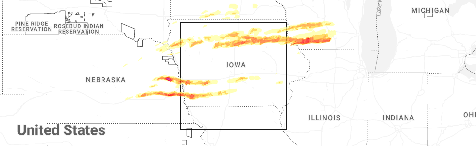
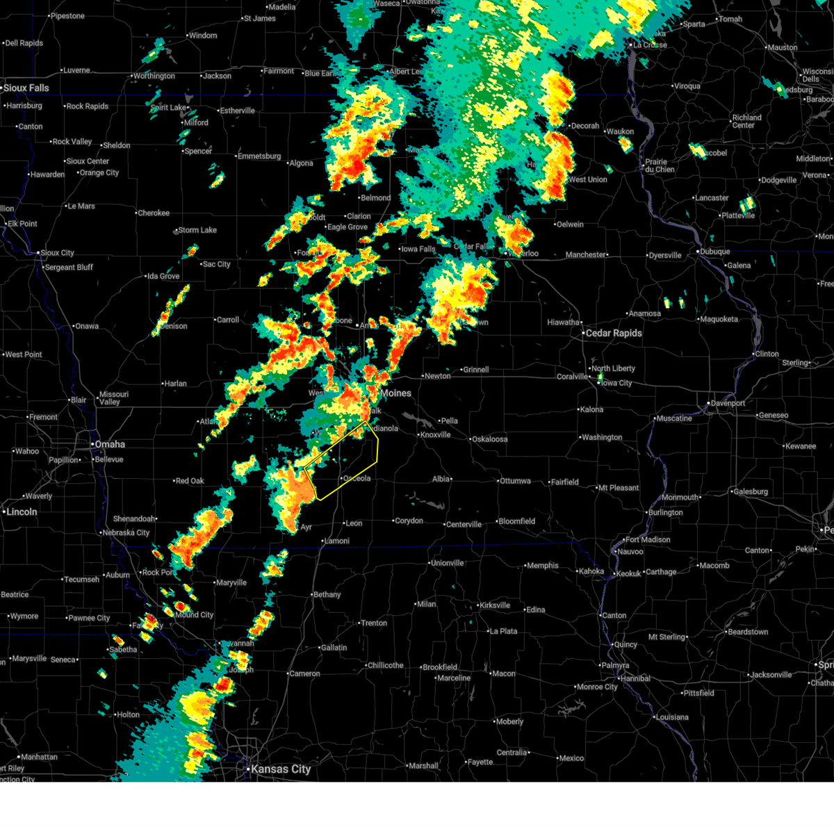
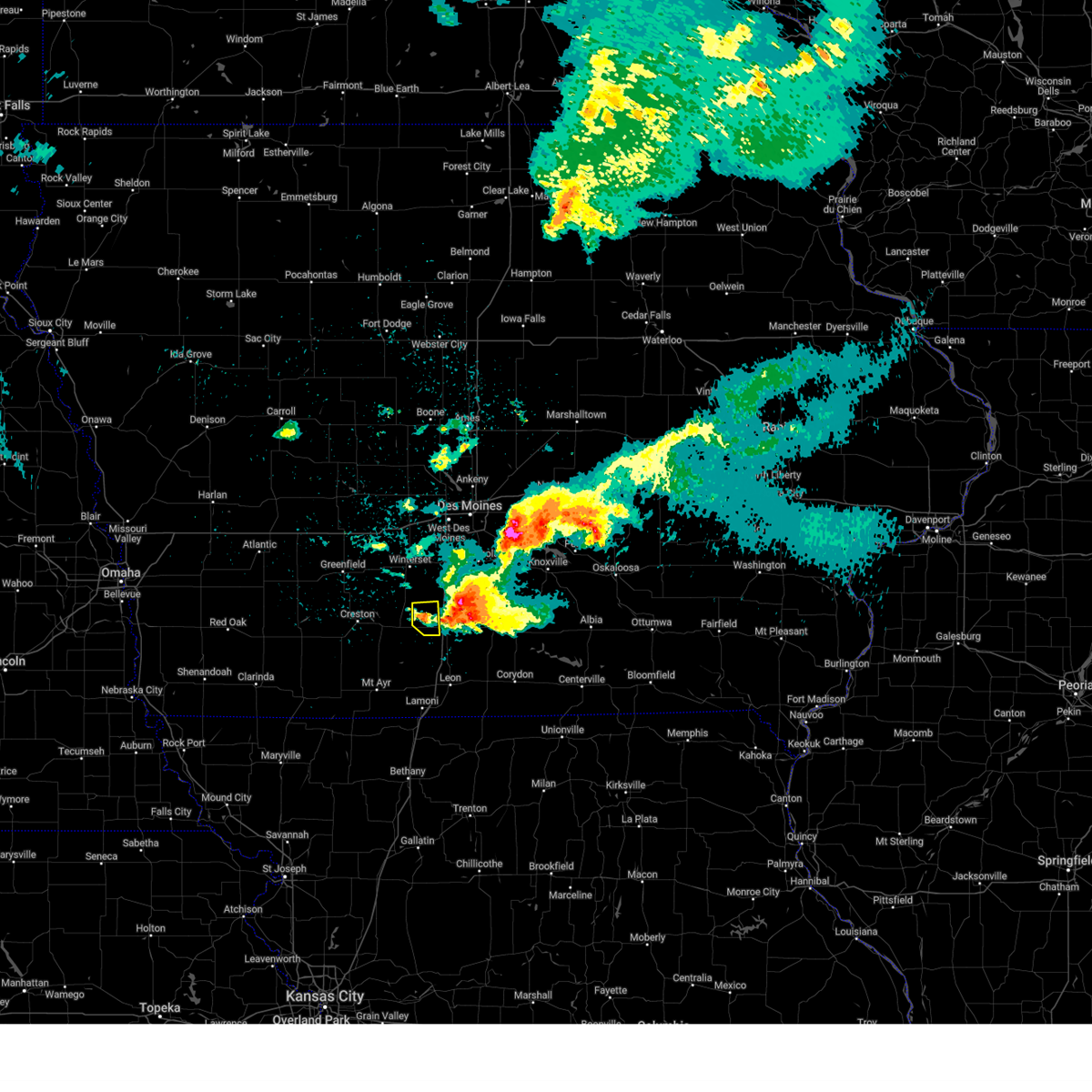
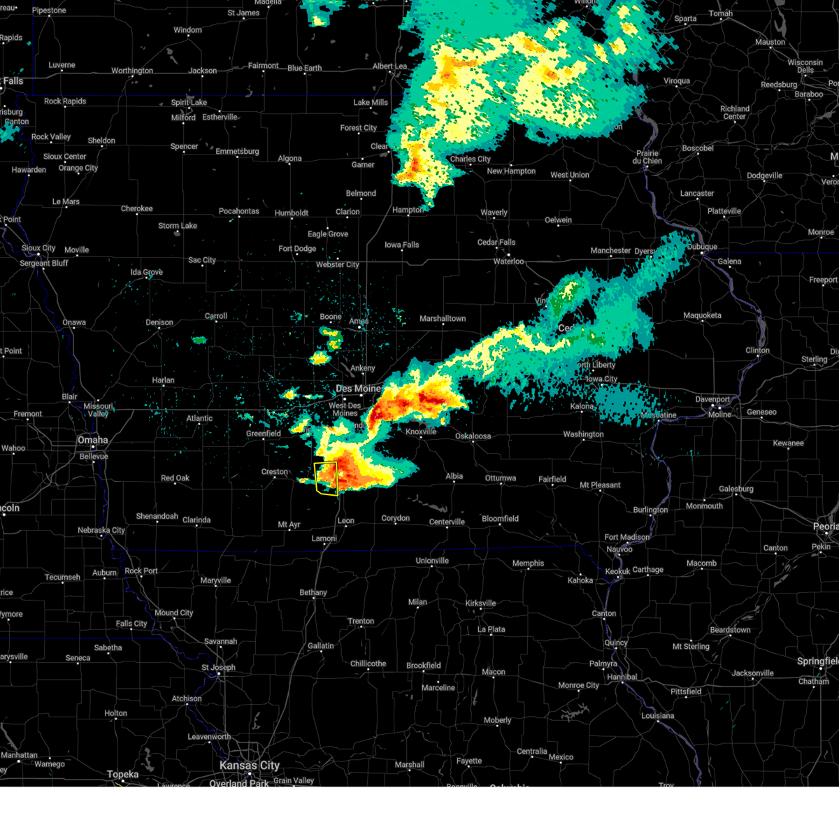
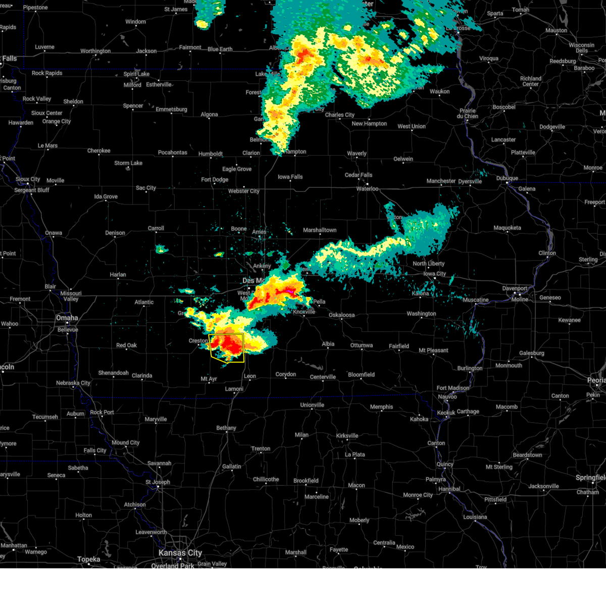
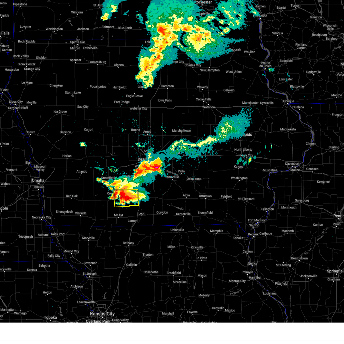
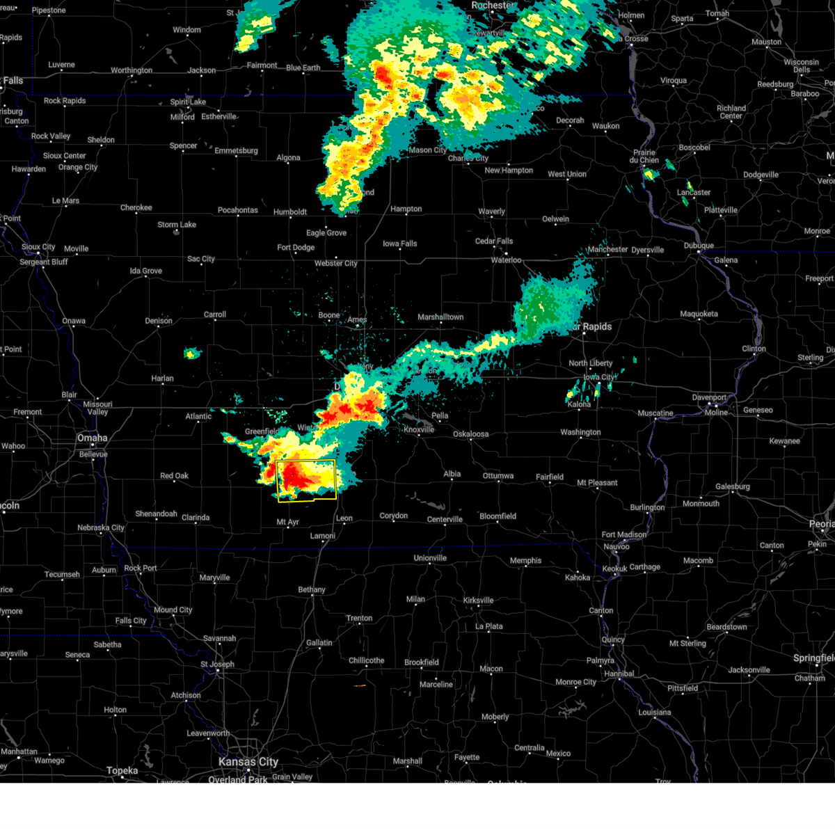
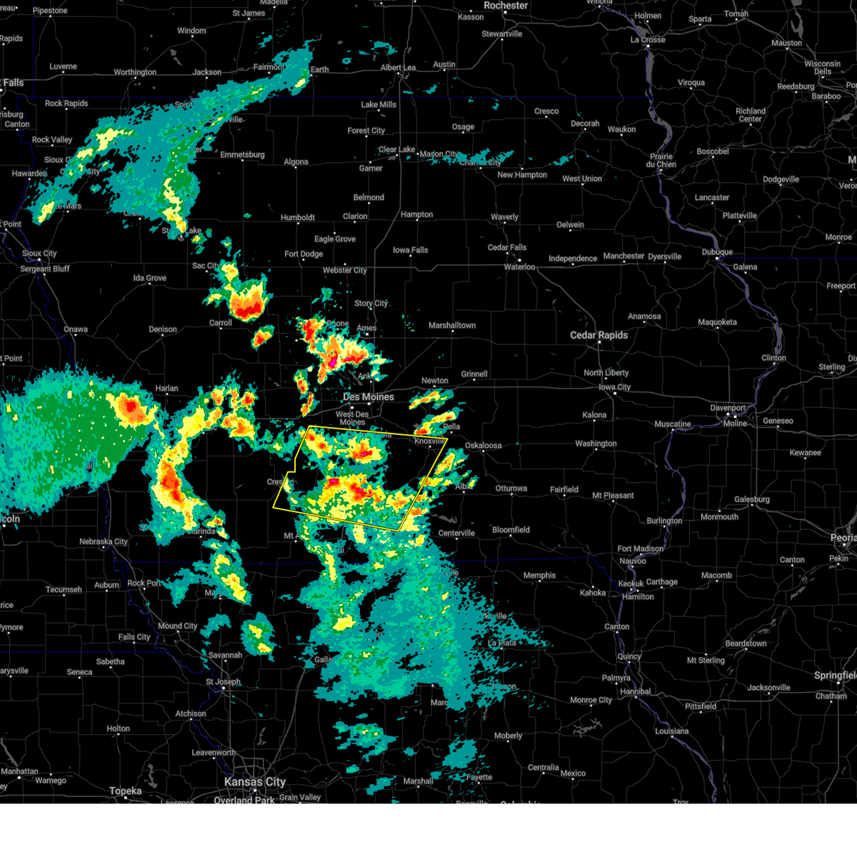
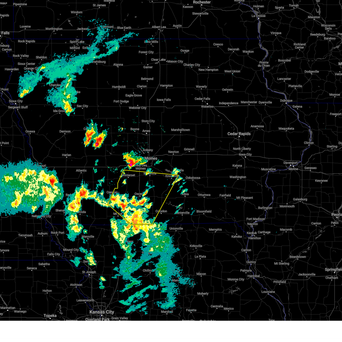
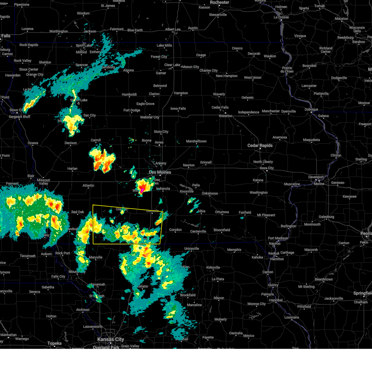
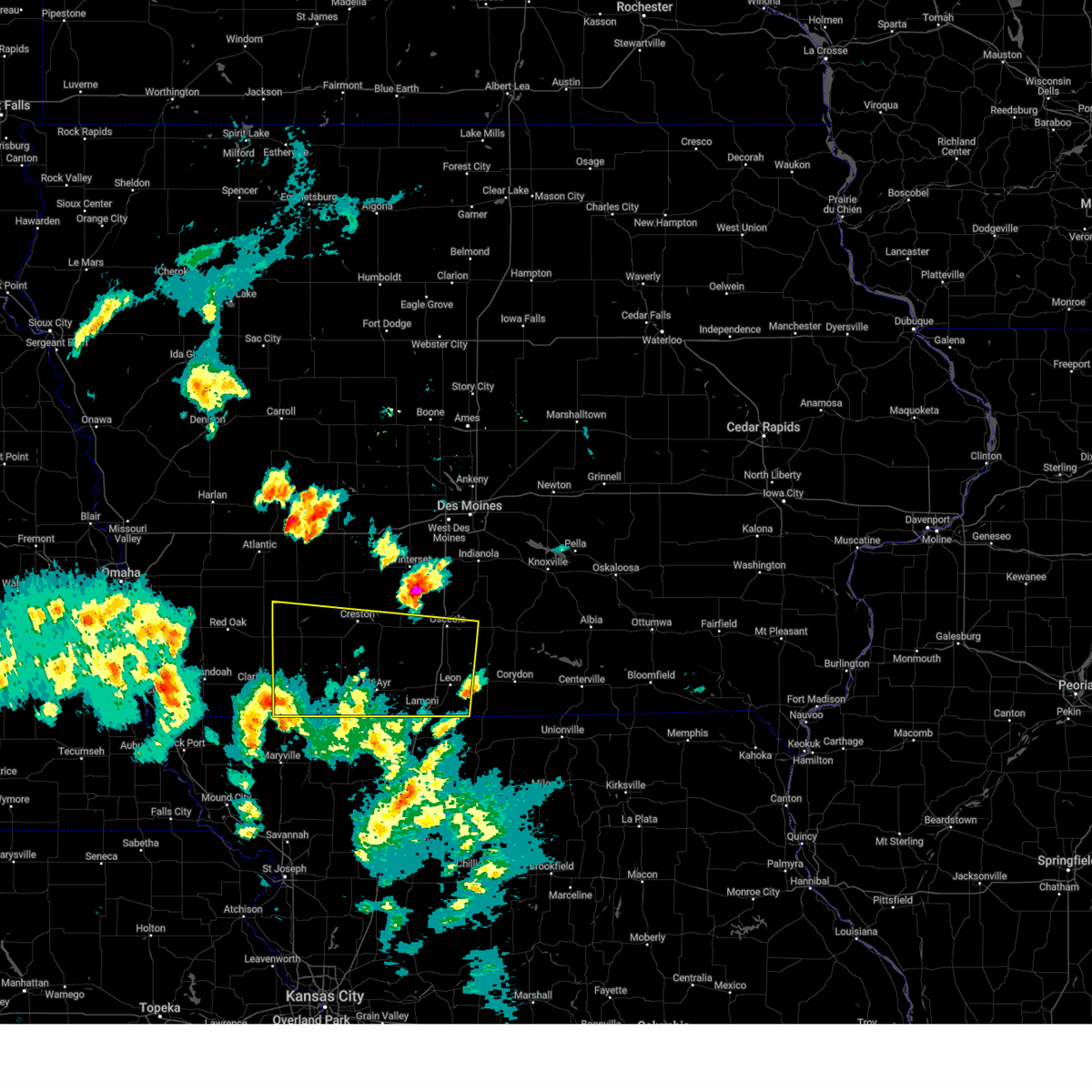
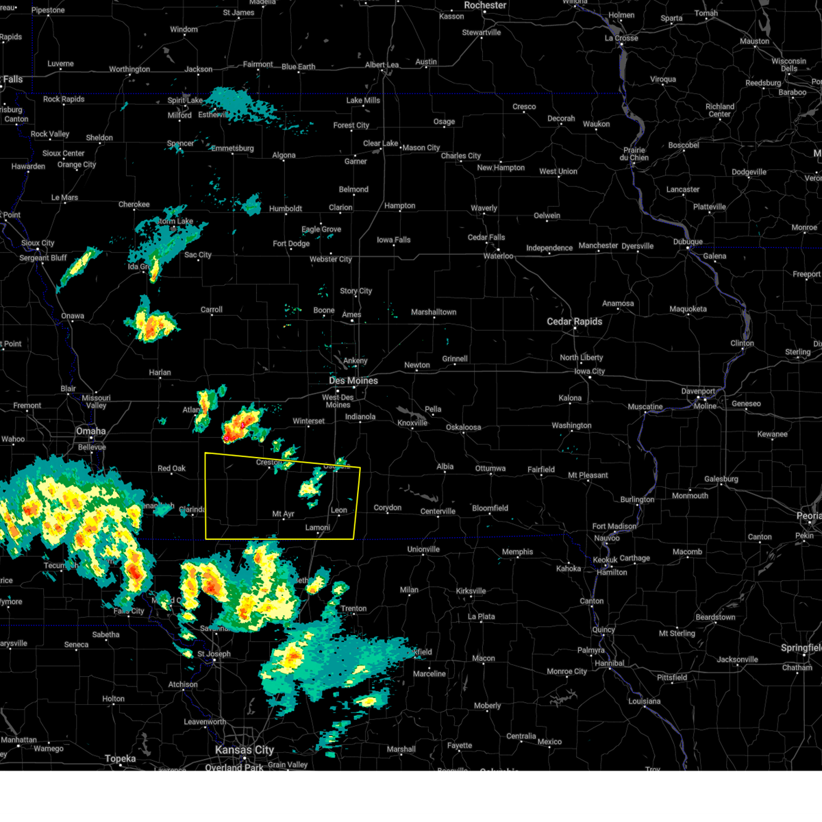
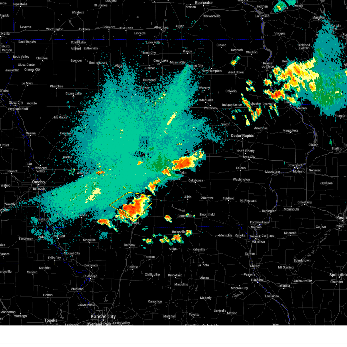
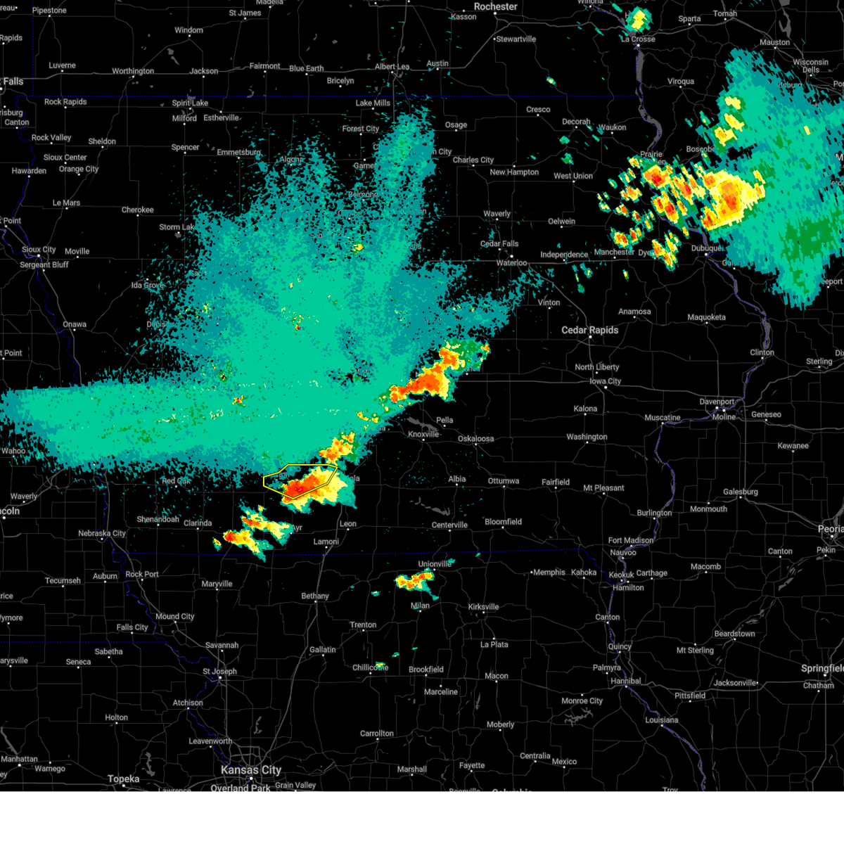
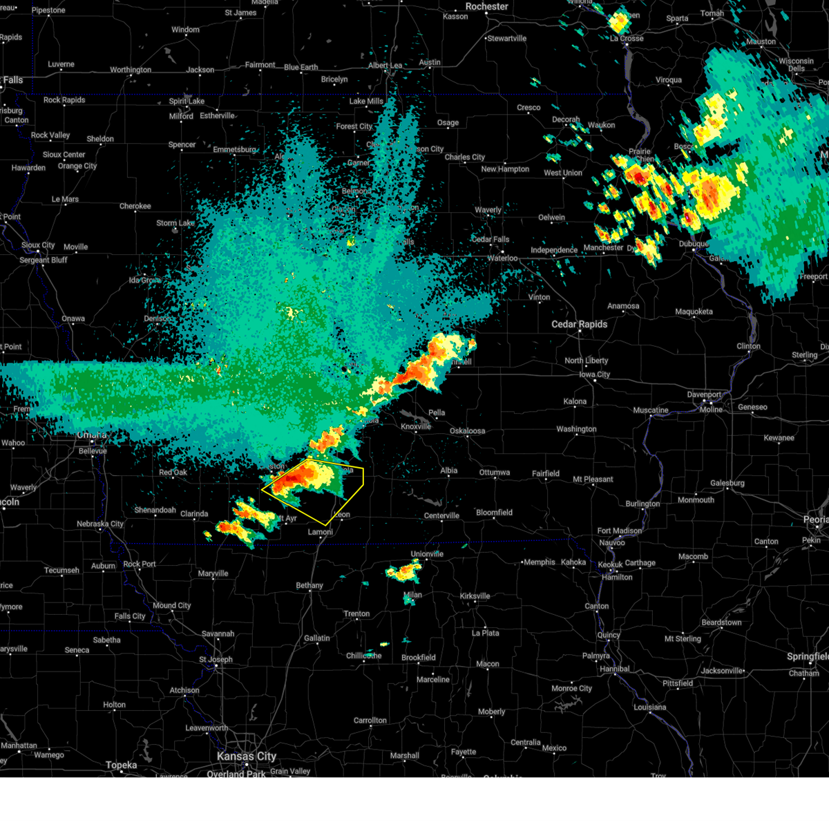
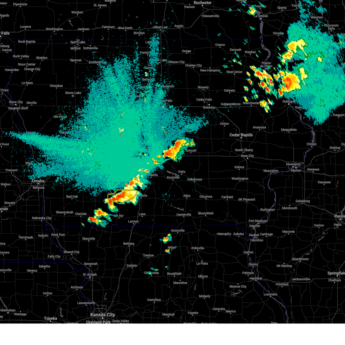
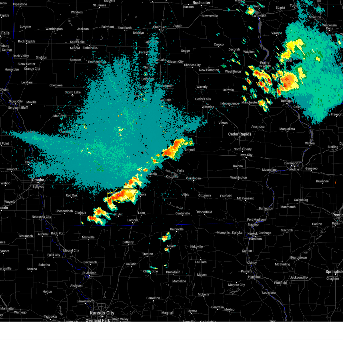
Hail Map for Murray, IA
The Murray, IA area has had 23 reports of on-the-ground hail by trained spotters, and has been under severe weather warnings 36 times during the past 12 months. Doppler radar has detected hail at or near Murray, IA on 73 occasions, including 3 occasions during the past year.
| Name: | Murray, IA |
| Where Located: | 41.6 miles SSW of Des Moines, IA |
| Map: | Google Map for Murray, IA |
| Population: | 756 |
| Housing Units: | 337 |
| More Info: | Search Google for Murray, IA |
1
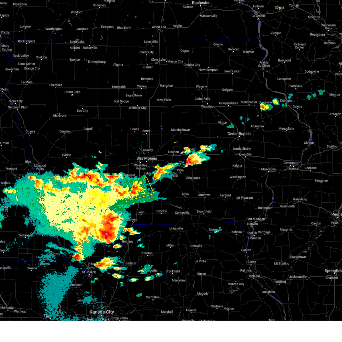
The Top Recent Hail Date for Murray, IA is Thursday, April 17, 2025 (4th out of 73)
Hail and Wind Damage Spotted near Murray, IA
| Date / Time | Report Details |
|---|---|
| 7/11/2025 4:39 PM CDT | The storm which prompted the warning has weakened below severe limits, and no longer appears capable of producing a tornado. therefore, the warning will be allowed to expire. a tornado watch remains in effect until 800 pm cdt for south central iowa. |
| 7/11/2025 4:32 PM CDT |
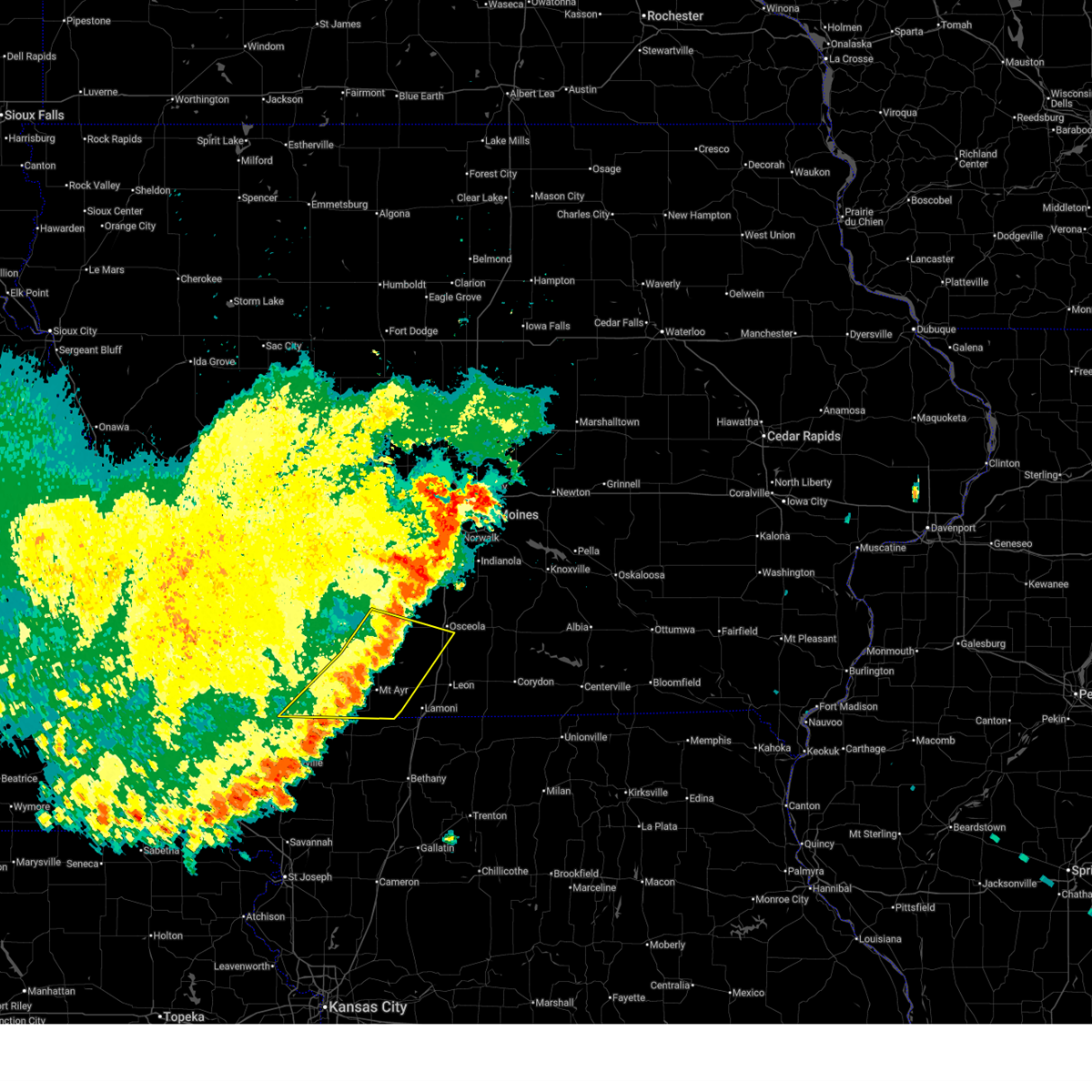
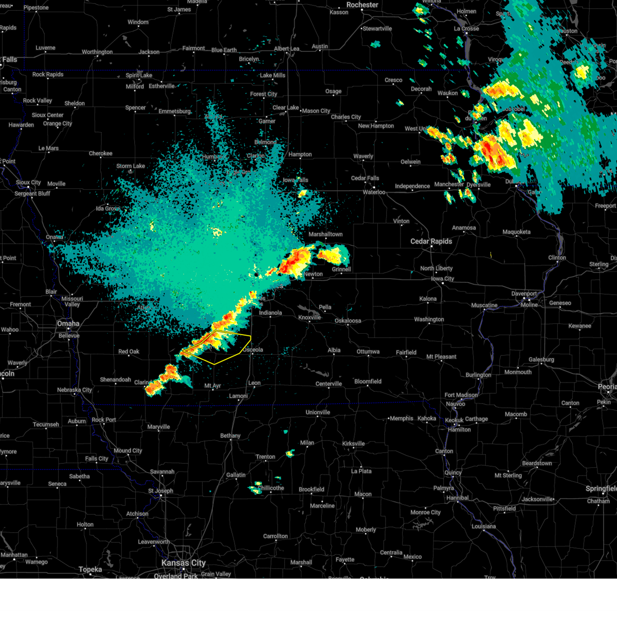
 At 431 pm cdt, a severe thunderstorm capable of producing a tornado was located 5 miles northeast of murray, or 8 miles northwest of osceola, moving northeast at 30 mph (radar indicated rotation). Hazards include tornado. Flying debris will be dangerous to those caught without shelter. mobile homes will be damaged or destroyed. damage to roofs, windows, and vehicles will occur. tree damage is likely. This tornadic thunderstorm will remain over mainly rural areas of northwestern clarke county, including the following locations, murray. At 431 pm cdt, a severe thunderstorm capable of producing a tornado was located 5 miles northeast of murray, or 8 miles northwest of osceola, moving northeast at 30 mph (radar indicated rotation). Hazards include tornado. Flying debris will be dangerous to those caught without shelter. mobile homes will be damaged or destroyed. damage to roofs, windows, and vehicles will occur. tree damage is likely. This tornadic thunderstorm will remain over mainly rural areas of northwestern clarke county, including the following locations, murray.
|
| 7/11/2025 4:19 PM CDT |
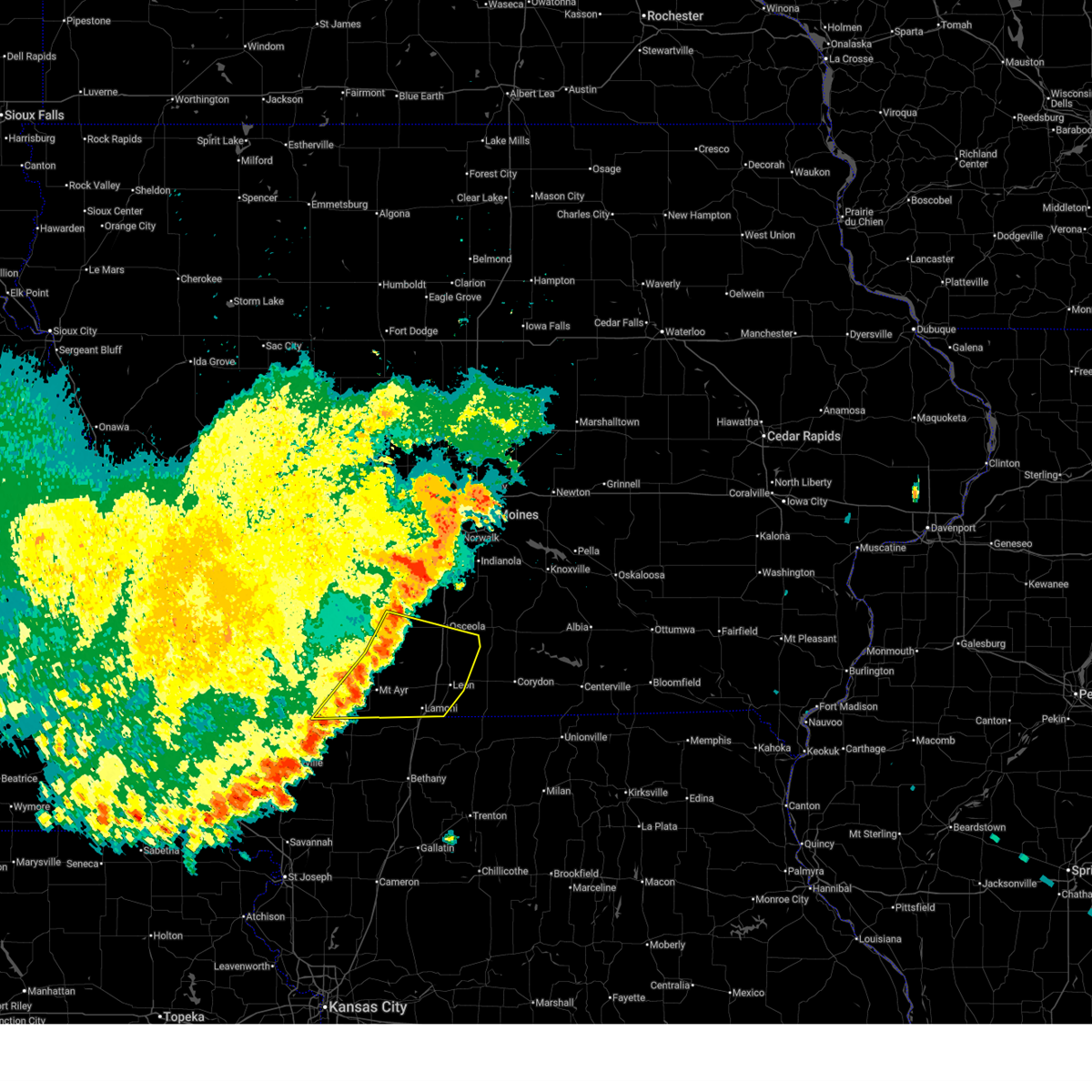
 Tordmx the national weather service in des moines has issued a * tornado warning for, northwestern clarke county in south central iowa, * until 445 pm cdt. * at 419 pm cdt, a severe thunderstorm capable of producing a tornado was located over murray, or 10 miles west of osceola, moving east at 25 mph (radar indicated rotation). Hazards include tornado. Flying debris will be dangerous to those caught without shelter. mobile homes will be damaged or destroyed. damage to roofs, windows, and vehicles will occur. tree damage is likely. this dangerous storm will be near, murray around 425 pm cdt. osceola around 430 pm cdt. lakeside casino around 435 pm cdt. other locations impacted by this tornadic thunderstorm include murray. This includes interstate 35 between mile markers 33 and 41. Tordmx the national weather service in des moines has issued a * tornado warning for, northwestern clarke county in south central iowa, * until 445 pm cdt. * at 419 pm cdt, a severe thunderstorm capable of producing a tornado was located over murray, or 10 miles west of osceola, moving east at 25 mph (radar indicated rotation). Hazards include tornado. Flying debris will be dangerous to those caught without shelter. mobile homes will be damaged or destroyed. damage to roofs, windows, and vehicles will occur. tree damage is likely. this dangerous storm will be near, murray around 425 pm cdt. osceola around 430 pm cdt. lakeside casino around 435 pm cdt. other locations impacted by this tornadic thunderstorm include murray. This includes interstate 35 between mile markers 33 and 41.
|
| 7/8/2025 1:16 AM CDT |
 At 116 am cdt, severe thunderstorms were located along a line extending from osceola to near grand river to near hatfield, moving east at 30 mph (radar indicated). Hazards include 60 mph wind gusts. Expect damage to roofs, siding, and trees. locations impacted include, osceola, leon, mount ayr, lamoni, sun valley lake, lakeside casino, murray, kellerton, grand river, van wert, garden grove, davis city, decatur, tingley, weldon, redding, thayer, ellston, delphos, and beaconsfield. This includes interstate 35 between mile markers 1 and 34. At 116 am cdt, severe thunderstorms were located along a line extending from osceola to near grand river to near hatfield, moving east at 30 mph (radar indicated). Hazards include 60 mph wind gusts. Expect damage to roofs, siding, and trees. locations impacted include, osceola, leon, mount ayr, lamoni, sun valley lake, lakeside casino, murray, kellerton, grand river, van wert, garden grove, davis city, decatur, tingley, weldon, redding, thayer, ellston, delphos, and beaconsfield. This includes interstate 35 between mile markers 1 and 34.
|
| 7/8/2025 1:16 AM CDT |
 the severe thunderstorm warning has been cancelled and is no longer in effect the severe thunderstorm warning has been cancelled and is no longer in effect
|
| 7/8/2025 1:14 AM CDT |
 The storms which prompted the warning have weakened below severe limits, and no longer pose an immediate threat to life or property. therefore, the warning will be allowed to expire. however, gusty winds and heavy rain are still possible with these thunderstorms. a severe thunderstorm watch remains in effect until 400 am cdt for south central, central and southwestern iowa. The storms which prompted the warning have weakened below severe limits, and no longer pose an immediate threat to life or property. therefore, the warning will be allowed to expire. however, gusty winds and heavy rain are still possible with these thunderstorms. a severe thunderstorm watch remains in effect until 400 am cdt for south central, central and southwestern iowa.
|
| 7/8/2025 12:56 AM CDT |
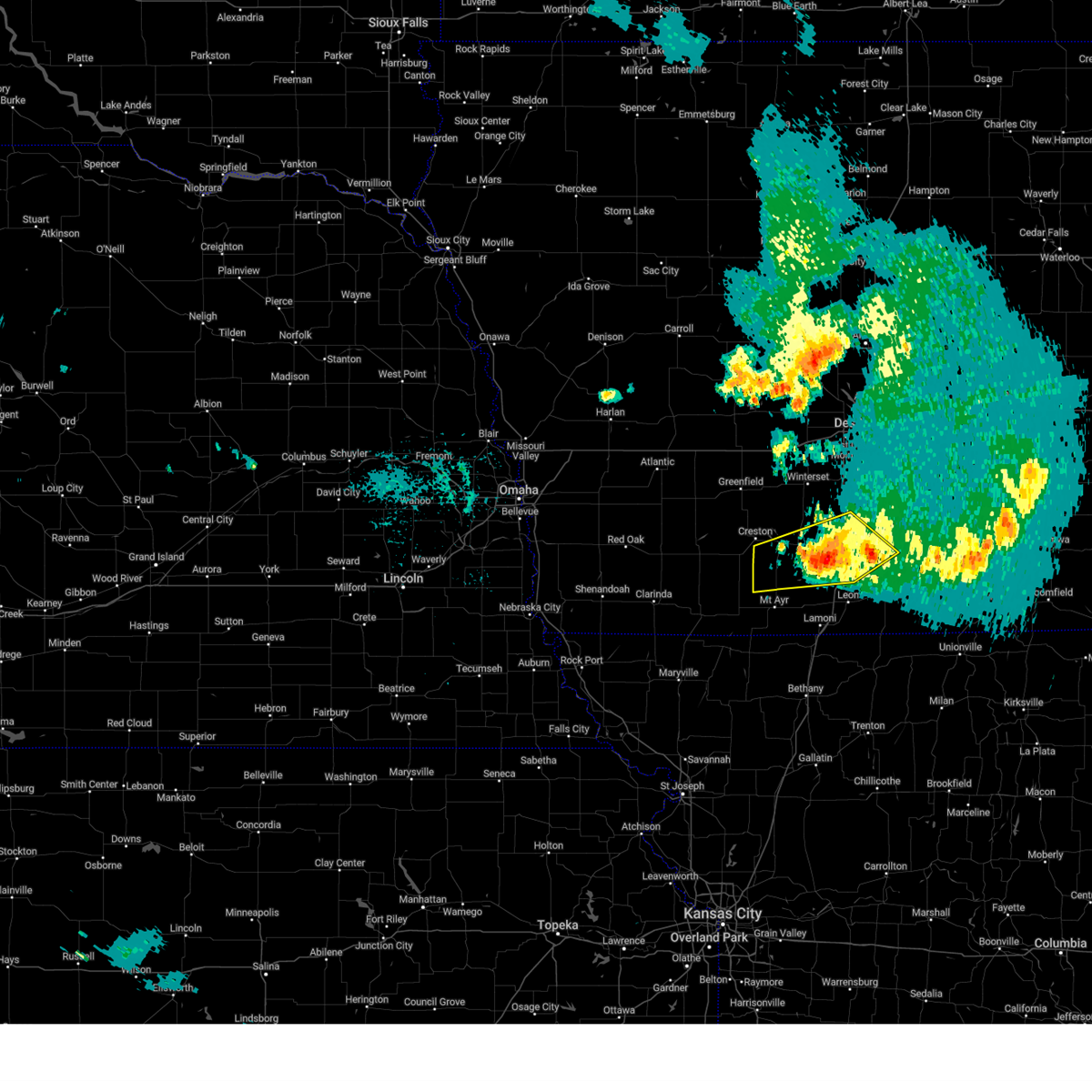
 Svrdmx the national weather service in des moines has issued a * severe thunderstorm warning for, decatur county in south central iowa, eastern union county in south central iowa, ringgold county in south central iowa, southeastern taylor county in southwestern iowa, southern clarke county in south central iowa, * until 145 am cdt. * at 1254 am cdt, severe thunderstorms were located along a line extending from murray to sun valley lake to near irena, moving southeast at 30 mph (radar indicated). Hazards include 60 mph wind gusts. expect damage to roofs, siding, and trees Svrdmx the national weather service in des moines has issued a * severe thunderstorm warning for, decatur county in south central iowa, eastern union county in south central iowa, ringgold county in south central iowa, southeastern taylor county in southwestern iowa, southern clarke county in south central iowa, * until 145 am cdt. * at 1254 am cdt, severe thunderstorms were located along a line extending from murray to sun valley lake to near irena, moving southeast at 30 mph (radar indicated). Hazards include 60 mph wind gusts. expect damage to roofs, siding, and trees
|
| 7/8/2025 12:52 AM CDT |
 the severe thunderstorm warning has been cancelled and is no longer in effect the severe thunderstorm warning has been cancelled and is no longer in effect
|
| 7/8/2025 12:52 AM CDT |
 At 1251 am cdt, severe thunderstorms were located along a line extending from murray to mt ayr municipal airport to 4 miles southeast of parnell, moving southeast at 40 mph (radar indicated). Hazards include 60 mph wind gusts. Expect damage to roofs, siding, and trees. locations impacted include, osceola, mount ayr, bedford, sun valley lake, afton, murray, clearfield, diagonal, kellerton, grand river, blockton, tingley, arispe, redding, shannon city, thayer, ellston, conway, benton, and maloy. This includes interstate 35 between mile markers 27 and 32. At 1251 am cdt, severe thunderstorms were located along a line extending from murray to mt ayr municipal airport to 4 miles southeast of parnell, moving southeast at 40 mph (radar indicated). Hazards include 60 mph wind gusts. Expect damage to roofs, siding, and trees. locations impacted include, osceola, mount ayr, bedford, sun valley lake, afton, murray, clearfield, diagonal, kellerton, grand river, blockton, tingley, arispe, redding, shannon city, thayer, ellston, conway, benton, and maloy. This includes interstate 35 between mile markers 27 and 32.
|
| 7/8/2025 12:37 AM CDT |
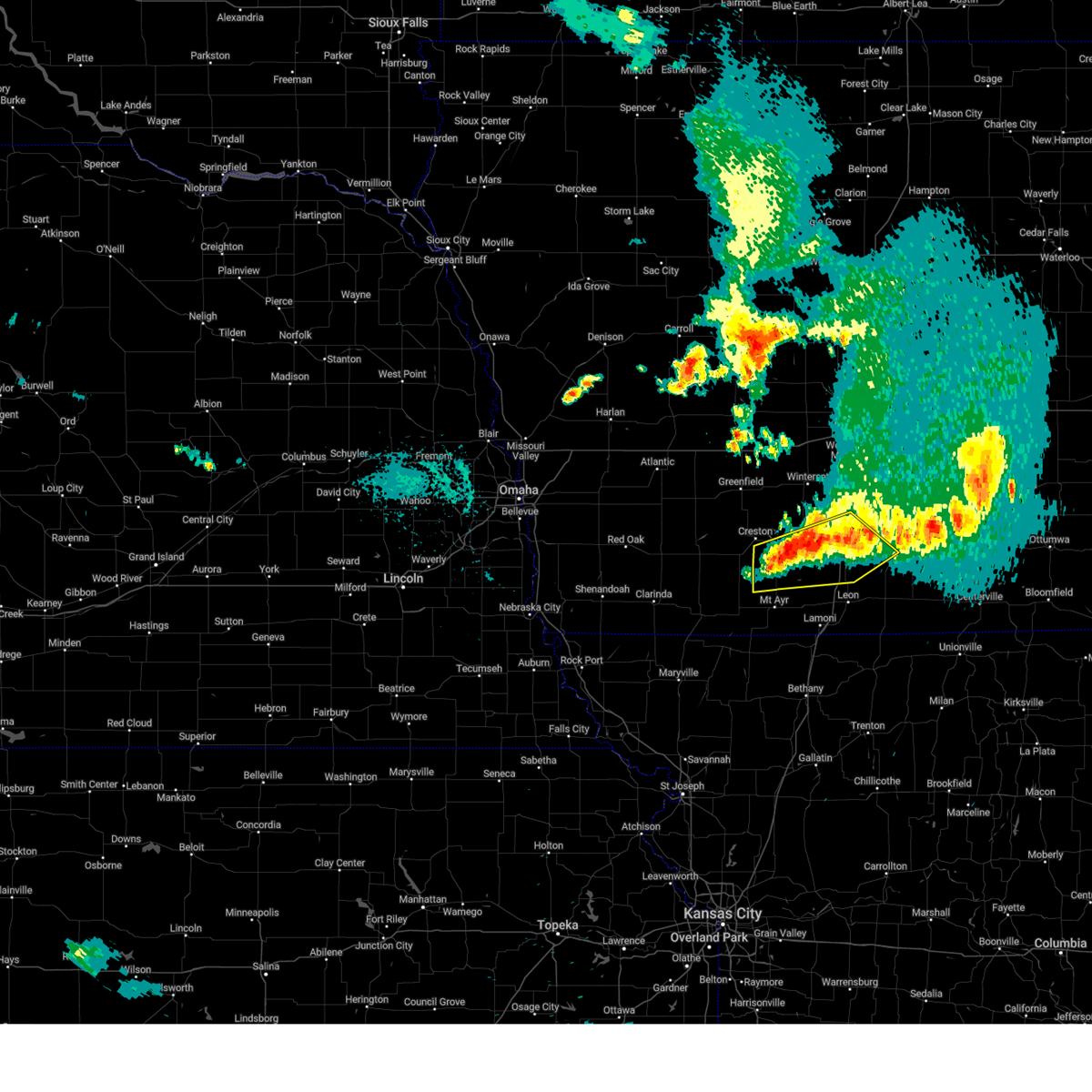
 Svrdmx the national weather service in des moines has issued a * severe thunderstorm warning for, polk county in central iowa, madison county in south central iowa, northeastern union county in south central iowa, northern clarke county in south central iowa, eastern dallas county in central iowa, warren county in south central iowa, * until 115 am cdt. * at 1237 am cdt, severe thunderstorms were located along a line extending from near madrid to bevington to 4 miles west of east peru, moving east at 25 mph (radar indicated). Hazards include 60 mph wind gusts. expect damage to roofs, siding, and trees Svrdmx the national weather service in des moines has issued a * severe thunderstorm warning for, polk county in central iowa, madison county in south central iowa, northeastern union county in south central iowa, northern clarke county in south central iowa, eastern dallas county in central iowa, warren county in south central iowa, * until 115 am cdt. * at 1237 am cdt, severe thunderstorms were located along a line extending from near madrid to bevington to 4 miles west of east peru, moving east at 25 mph (radar indicated). Hazards include 60 mph wind gusts. expect damage to roofs, siding, and trees
|
| 7/8/2025 12:22 AM CDT |
 Svrdmx the national weather service in des moines has issued a * severe thunderstorm warning for, northwestern decatur county in south central iowa, union county in south central iowa, southeastern adams county in southwestern iowa, ringgold county in south central iowa, taylor county in southwestern iowa, southwestern clarke county in south central iowa, * until 100 am cdt. * at 1222 am cdt, severe thunderstorms were located along a line extending from near creston to 4 miles north of clearfield to hopkins, moving southeast at 40 mph (radar indicated). Hazards include 60 mph wind gusts. expect damage to roofs, siding, and trees Svrdmx the national weather service in des moines has issued a * severe thunderstorm warning for, northwestern decatur county in south central iowa, union county in south central iowa, southeastern adams county in southwestern iowa, ringgold county in south central iowa, taylor county in southwestern iowa, southwestern clarke county in south central iowa, * until 100 am cdt. * at 1222 am cdt, severe thunderstorms were located along a line extending from near creston to 4 miles north of clearfield to hopkins, moving southeast at 40 mph (radar indicated). Hazards include 60 mph wind gusts. expect damage to roofs, siding, and trees
|
| 6/26/2025 4:45 PM CDT |
 Svrdmx the national weather service in des moines has issued a * severe thunderstorm warning for, northwestern lucas county in south central iowa, southeastern madison county in south central iowa, east central union county in south central iowa, clarke county in south central iowa, southwestern warren county in south central iowa, * until 530 pm cdt. * at 444 pm cdt, severe thunderstorms were located along a line extending from near lorimor to murray roadside rest area to 6 miles north of grand river, moving northeast at 45 mph (radar indicated). Hazards include 60 mph wind gusts. expect damage to roofs, siding, and trees Svrdmx the national weather service in des moines has issued a * severe thunderstorm warning for, northwestern lucas county in south central iowa, southeastern madison county in south central iowa, east central union county in south central iowa, clarke county in south central iowa, southwestern warren county in south central iowa, * until 530 pm cdt. * at 444 pm cdt, severe thunderstorms were located along a line extending from near lorimor to murray roadside rest area to 6 miles north of grand river, moving northeast at 45 mph (radar indicated). Hazards include 60 mph wind gusts. expect damage to roofs, siding, and trees
|
| 4/17/2025 11:27 PM CDT |
 The storm which prompted the warning has weakened below severe limits, and no longer poses an immediate threat to life or property. therefore, the warning will be allowed to expire. however, gusty winds are still possible with this thunderstorm. a tornado watch remains in effect until midnight cdt for south central iowa. The storm which prompted the warning has weakened below severe limits, and no longer poses an immediate threat to life or property. therefore, the warning will be allowed to expire. however, gusty winds are still possible with this thunderstorm. a tornado watch remains in effect until midnight cdt for south central iowa.
|
| 4/17/2025 11:25 PM CDT |
 the severe thunderstorm warning has been cancelled and is no longer in effect the severe thunderstorm warning has been cancelled and is no longer in effect
|
| 4/17/2025 11:25 PM CDT |
 At 1124 pm cdt, a severe thunderstorm was located near osceola, moving east at 30 mph (public). Hazards include 60 mph wind gusts and quarter size hail. Hail damage to vehicles is expected. expect wind damage to roofs, siding, and trees. Locations impacted include, murray roadside rest area and murray. At 1124 pm cdt, a severe thunderstorm was located near osceola, moving east at 30 mph (public). Hazards include 60 mph wind gusts and quarter size hail. Hail damage to vehicles is expected. expect wind damage to roofs, siding, and trees. Locations impacted include, murray roadside rest area and murray.
|
| 4/17/2025 11:13 PM CDT |
 At 1112 pm cdt, a severe thunderstorm was located over lakeside casino, or over osceola, moving east at 30 mph (public). Hazards include 60 mph wind gusts and quarter size hail. Hail damage to vehicles is expected. expect wind damage to roofs, siding, and trees. Locations impacted include, murray roadside rest area and murray. At 1112 pm cdt, a severe thunderstorm was located over lakeside casino, or over osceola, moving east at 30 mph (public). Hazards include 60 mph wind gusts and quarter size hail. Hail damage to vehicles is expected. expect wind damage to roofs, siding, and trees. Locations impacted include, murray roadside rest area and murray.
|
| 4/17/2025 11:13 PM CDT |
 the severe thunderstorm warning has been cancelled and is no longer in effect the severe thunderstorm warning has been cancelled and is no longer in effect
|
| 4/17/2025 11:11 PM CDT | Half Dollar sized hail reported 0.2 miles NNW of Murray, IA |
| 4/17/2025 11:01 PM CDT |
 At 1100 pm cdt, a severe thunderstorm was located over murray roadside rest area, or 9 miles west of osceola, moving east at 30 mph (public). Hazards include 70 mph wind gusts and ping pong ball size hail. People and animals outdoors will be injured. expect hail damage to roofs, siding, windows, and vehicles. expect considerable tree damage. wind damage is also likely to mobile homes, roofs, and outbuildings. Locations impacted include, afton, murray, murray roadside rest area, lorimor, and thayer. At 1100 pm cdt, a severe thunderstorm was located over murray roadside rest area, or 9 miles west of osceola, moving east at 30 mph (public). Hazards include 70 mph wind gusts and ping pong ball size hail. People and animals outdoors will be injured. expect hail damage to roofs, siding, windows, and vehicles. expect considerable tree damage. wind damage is also likely to mobile homes, roofs, and outbuildings. Locations impacted include, afton, murray, murray roadside rest area, lorimor, and thayer.
|
| 4/17/2025 10:46 PM CDT |
 At 1045 pm cdt, a severe thunderstorm was located near thayer, or 14 miles east of creston, moving east at 30 mph (public. at 10:43 pm, quarter sized hail was reported a mile south of afton). Hazards include 70 mph wind gusts and ping pong ball size hail. People and animals outdoors will be injured. expect hail damage to roofs, siding, windows, and vehicles. expect considerable tree damage. wind damage is also likely to mobile homes, roofs, and outbuildings. Locations impacted include, arispe, thayer, shannon city, afton, murray, murray roadside rest area, and lorimor. At 1045 pm cdt, a severe thunderstorm was located near thayer, or 14 miles east of creston, moving east at 30 mph (public. at 10:43 pm, quarter sized hail was reported a mile south of afton). Hazards include 70 mph wind gusts and ping pong ball size hail. People and animals outdoors will be injured. expect hail damage to roofs, siding, windows, and vehicles. expect considerable tree damage. wind damage is also likely to mobile homes, roofs, and outbuildings. Locations impacted include, arispe, thayer, shannon city, afton, murray, murray roadside rest area, and lorimor.
|
| 4/17/2025 10:39 PM CDT |
 Svrdmx the national weather service in des moines has issued a * severe thunderstorm warning for, union county in south central iowa, northeastern ringgold county in south central iowa, western clarke county in south central iowa, * until 1130 pm cdt. * at 1038 pm cdt, a severe thunderstorm was located near afton, or 10 miles southeast of creston, moving east at 30 mph (radar indicated). Hazards include 70 mph wind gusts and ping pong ball size hail. People and animals outdoors will be injured. expect hail damage to roofs, siding, windows, and vehicles. expect considerable tree damage. Wind damage is also likely to mobile homes, roofs, and outbuildings. Svrdmx the national weather service in des moines has issued a * severe thunderstorm warning for, union county in south central iowa, northeastern ringgold county in south central iowa, western clarke county in south central iowa, * until 1130 pm cdt. * at 1038 pm cdt, a severe thunderstorm was located near afton, or 10 miles southeast of creston, moving east at 30 mph (radar indicated). Hazards include 70 mph wind gusts and ping pong ball size hail. People and animals outdoors will be injured. expect hail damage to roofs, siding, windows, and vehicles. expect considerable tree damage. Wind damage is also likely to mobile homes, roofs, and outbuildings.
|
| 3/14/2025 5:26 PM CDT |
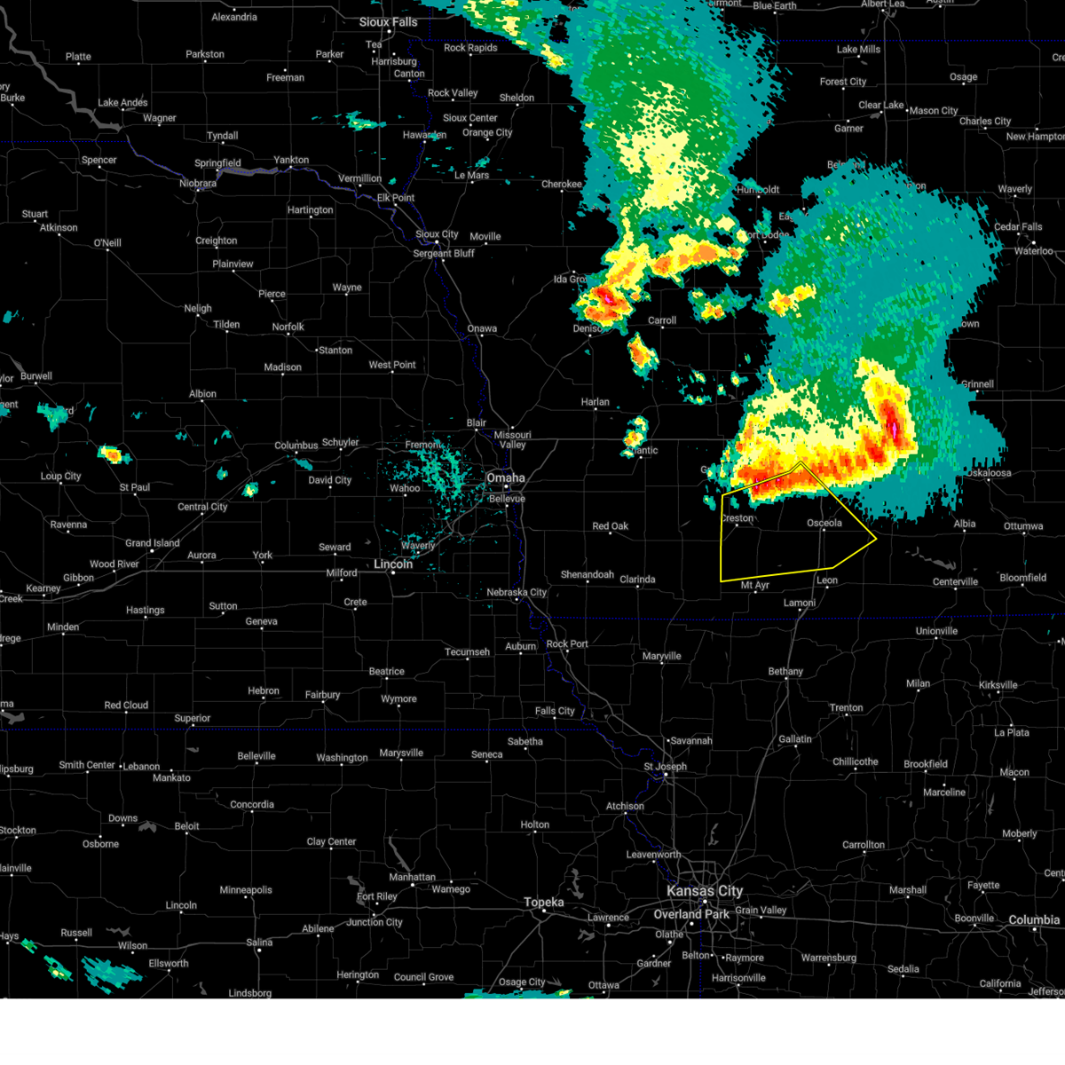
 At 526 pm cdt, severe thunderstorms were located along a line extending from 4 miles west of macksburg to near new virginia to near chariton, moving north at 60 mph (radar indicated). Hazards include 70 mph wind gusts and quarter size hail. Hail damage to vehicles is expected. expect considerable tree damage. wind damage is also likely to mobile homes, roofs, and outbuildings. locations impacted include, lacona, truro, red haw lake state park, lake ahquabi state park, sandyville, spring hill, melcher-dallas, thayer, martensdale, creston municipal airport, otter creek county park, ackworth, murray, lorimor, osceola, arispe, williamson, humeston, macksburg, and pleasantville. This includes interstate 35 between mile markers 21 and 61. At 526 pm cdt, severe thunderstorms were located along a line extending from 4 miles west of macksburg to near new virginia to near chariton, moving north at 60 mph (radar indicated). Hazards include 70 mph wind gusts and quarter size hail. Hail damage to vehicles is expected. expect considerable tree damage. wind damage is also likely to mobile homes, roofs, and outbuildings. locations impacted include, lacona, truro, red haw lake state park, lake ahquabi state park, sandyville, spring hill, melcher-dallas, thayer, martensdale, creston municipal airport, otter creek county park, ackworth, murray, lorimor, osceola, arispe, williamson, humeston, macksburg, and pleasantville. This includes interstate 35 between mile markers 21 and 61.
|
| 3/14/2025 5:01 PM CDT |
 Svrdmx the national weather service in des moines has issued a * severe thunderstorm warning for, lucas county in south central iowa, decatur county in south central iowa, madison county in south central iowa, southern marion county in south central iowa, union county in south central iowa, western wayne county in south central iowa, northeastern ringgold county in south central iowa, clarke county in south central iowa, warren county in south central iowa, * until 545 pm cdt. * at 500 pm cdt, severe thunderstorms were located along a line extending from 4 miles southwest of macksburg to 4 miles west of woodburn to near lineville, moving north at 65 mph (radar indicated). Hazards include 70 mph wind gusts and nickel size hail. Expect considerable tree damage. Damage is likely to mobile homes, roofs, and outbuildings. Svrdmx the national weather service in des moines has issued a * severe thunderstorm warning for, lucas county in south central iowa, decatur county in south central iowa, madison county in south central iowa, southern marion county in south central iowa, union county in south central iowa, western wayne county in south central iowa, northeastern ringgold county in south central iowa, clarke county in south central iowa, warren county in south central iowa, * until 545 pm cdt. * at 500 pm cdt, severe thunderstorms were located along a line extending from 4 miles southwest of macksburg to 4 miles west of woodburn to near lineville, moving north at 65 mph (radar indicated). Hazards include 70 mph wind gusts and nickel size hail. Expect considerable tree damage. Damage is likely to mobile homes, roofs, and outbuildings.
|
| 3/14/2025 4:45 PM CDT |
 At 445 pm cdt, severe thunderstorms were located along a line extending from near nodaway to near diagonal to 4 miles south of leon, moving north at 65 mph (radar indicated). Hazards include 60 mph wind gusts and nickel size hail. Expect damage to roofs, siding, and trees. locations impacted include, sun valley lake, ellston, pleasanton, creston municipal airport, shannon city, osceola, arispe, green valley lake, nine eagles state park, lamoni municipal airport, green valley lake state park, mt ayr municipal airport, leon, tingley, lake of three fires state park, beaconsfield, redding, sharpsburg, grand river, and afton. This includes interstate 35 between mile markers 2 and 37. At 445 pm cdt, severe thunderstorms were located along a line extending from near nodaway to near diagonal to 4 miles south of leon, moving north at 65 mph (radar indicated). Hazards include 60 mph wind gusts and nickel size hail. Expect damage to roofs, siding, and trees. locations impacted include, sun valley lake, ellston, pleasanton, creston municipal airport, shannon city, osceola, arispe, green valley lake, nine eagles state park, lamoni municipal airport, green valley lake state park, mt ayr municipal airport, leon, tingley, lake of three fires state park, beaconsfield, redding, sharpsburg, grand river, and afton. This includes interstate 35 between mile markers 2 and 37.
|
| 3/14/2025 4:28 PM CDT |
 At 427 pm cdt, severe thunderstorms were located along a line extending from 5 miles south of new market to near irena to near cainsville, moving north at 65 mph (radar indicated). Hazards include 70 mph wind gusts and nickel size hail. Expect considerable tree damage. damage is likely to mobile homes, roofs, and outbuildings. locations impacted include, sun valley lake, ellston, pleasanton, creston municipal airport, shannon city, osceola, arispe, green valley lake, nine eagles state park, lamoni municipal airport, green valley lake state park, mt ayr municipal airport, leon, tingley, lake of three fires state park, beaconsfield, redding, sharpsburg, grand river, and afton. This includes interstate 35 between mile markers 2 and 37. At 427 pm cdt, severe thunderstorms were located along a line extending from 5 miles south of new market to near irena to near cainsville, moving north at 65 mph (radar indicated). Hazards include 70 mph wind gusts and nickel size hail. Expect considerable tree damage. damage is likely to mobile homes, roofs, and outbuildings. locations impacted include, sun valley lake, ellston, pleasanton, creston municipal airport, shannon city, osceola, arispe, green valley lake, nine eagles state park, lamoni municipal airport, green valley lake state park, mt ayr municipal airport, leon, tingley, lake of three fires state park, beaconsfield, redding, sharpsburg, grand river, and afton. This includes interstate 35 between mile markers 2 and 37.
|
| 3/14/2025 4:15 PM CDT | Quarter sized hail reported 1.5 miles E of Murray, IA, dime-quarter sized hail. |
| 3/14/2025 4:13 PM CDT |
 Svrdmx the national weather service in des moines has issued a * severe thunderstorm warning for, decatur county in south central iowa, union county in south central iowa, ringgold county in south central iowa, adams county in southwestern iowa, taylor county in southwestern iowa, clarke county in south central iowa, * until 500 pm cdt. * at 412 pm cdt, severe thunderstorms were located along a line extending from 5 miles southwest of pickering to near gentry to near gilman city, moving north at 65 mph (radar indicated). Hazards include 70 mph wind gusts and nickel size hail. Expect considerable tree damage. Damage is likely to mobile homes, roofs, and outbuildings. Svrdmx the national weather service in des moines has issued a * severe thunderstorm warning for, decatur county in south central iowa, union county in south central iowa, ringgold county in south central iowa, adams county in southwestern iowa, taylor county in southwestern iowa, clarke county in south central iowa, * until 500 pm cdt. * at 412 pm cdt, severe thunderstorms were located along a line extending from 5 miles southwest of pickering to near gentry to near gilman city, moving north at 65 mph (radar indicated). Hazards include 70 mph wind gusts and nickel size hail. Expect considerable tree damage. Damage is likely to mobile homes, roofs, and outbuildings.
|
| 9/19/2024 11:13 PM CDT |
 The storms which prompted the warning have weakened below severe limits, and no longer pose an immediate threat to life or property. therefore, the warning will be allowed to expire. however, gusty winds are still possible with these thunderstorms. The storms which prompted the warning have weakened below severe limits, and no longer pose an immediate threat to life or property. therefore, the warning will be allowed to expire. however, gusty winds are still possible with these thunderstorms.
|
| 9/19/2024 10:41 PM CDT |
 The storms which prompted the warning have moved out of the warned area. therefore, the warning will be allowed to expire. remember, a severe thunderstorm warning still remains in effect for portions of union, clarke, ringgold, and decatur counties. The storms which prompted the warning have moved out of the warned area. therefore, the warning will be allowed to expire. remember, a severe thunderstorm warning still remains in effect for portions of union, clarke, ringgold, and decatur counties.
|
| 9/19/2024 10:37 PM CDT |
 Svrdmx the national weather service in des moines has issued a * severe thunderstorm warning for, northwestern decatur county in south central iowa, southeastern union county in south central iowa, northeastern ringgold county in south central iowa, clarke county in south central iowa, * until 1115 pm cdt. * at 1037 pm cdt, severe thunderstorms were located along a line extending from near murray to near thayer to near shannon city, moving east at 30 mph (radar indicated). Hazards include 60 mph wind gusts and quarter size hail. Hail damage to vehicles is expected. Expect wind damage to roofs, siding, and trees. Svrdmx the national weather service in des moines has issued a * severe thunderstorm warning for, northwestern decatur county in south central iowa, southeastern union county in south central iowa, northeastern ringgold county in south central iowa, clarke county in south central iowa, * until 1115 pm cdt. * at 1037 pm cdt, severe thunderstorms were located along a line extending from near murray to near thayer to near shannon city, moving east at 30 mph (radar indicated). Hazards include 60 mph wind gusts and quarter size hail. Hail damage to vehicles is expected. Expect wind damage to roofs, siding, and trees.
|
| 9/19/2024 10:23 PM CDT |
 At 1023 pm cdt, severe thunderstorms were located along a line extending from lorimor to near afton to 4 miles east of creston municipal airport, moving southeast at 20 mph (radar indicated). Hazards include 60 mph wind gusts and quarter size hail. Hail damage to vehicles is expected. expect wind damage to roofs, siding, and trees. Locations impacted include, creston, green valley lake, afton, murray, lorimor, cromwell, arispe, thayer, creston municipal airport, and green valley lake state park. At 1023 pm cdt, severe thunderstorms were located along a line extending from lorimor to near afton to 4 miles east of creston municipal airport, moving southeast at 20 mph (radar indicated). Hazards include 60 mph wind gusts and quarter size hail. Hail damage to vehicles is expected. expect wind damage to roofs, siding, and trees. Locations impacted include, creston, green valley lake, afton, murray, lorimor, cromwell, arispe, thayer, creston municipal airport, and green valley lake state park.
|
| 9/19/2024 10:23 PM CDT |
 the severe thunderstorm warning has been cancelled and is no longer in effect the severe thunderstorm warning has been cancelled and is no longer in effect
|
| 9/19/2024 10:02 PM CDT |
 Svrdmx the national weather service in des moines has issued a * severe thunderstorm warning for, southern madison county in south central iowa, union county in south central iowa, east central adams county in southwestern iowa, northwestern clarke county in south central iowa, southeastern adair county in southwestern iowa, * until 1045 pm cdt. * at 1001 pm cdt, severe thunderstorms were located along a line extending from near macksburg to 5 miles east of green valley lake to near creston, moving east at 20 mph (radar indicated). Hazards include 60 mph wind gusts and quarter size hail. Hail damage to vehicles is expected. Expect wind damage to roofs, siding, and trees. Svrdmx the national weather service in des moines has issued a * severe thunderstorm warning for, southern madison county in south central iowa, union county in south central iowa, east central adams county in southwestern iowa, northwestern clarke county in south central iowa, southeastern adair county in southwestern iowa, * until 1045 pm cdt. * at 1001 pm cdt, severe thunderstorms were located along a line extending from near macksburg to 5 miles east of green valley lake to near creston, moving east at 20 mph (radar indicated). Hazards include 60 mph wind gusts and quarter size hail. Hail damage to vehicles is expected. Expect wind damage to roofs, siding, and trees.
|
| 7/31/2024 8:21 PM CDT |
 Svrdmx the national weather service in des moines has issued a * severe thunderstorm warning for, monroe county in south central iowa, lucas county in south central iowa, decatur county in south central iowa, southeastern madison county in south central iowa, southern marion county in south central iowa, wayne county in south central iowa, southwestern mahaska county in south central iowa, southeastern ringgold county in south central iowa, appanoose county in south central iowa, clarke county in south central iowa, southern warren county in south central iowa, * until 900 pm cdt. * at 821 pm cdt, severe thunderstorms were located along a line extending from near otter creek county park to humeston to near nine eagles state park, moving east at 70 mph (radar indicated). Hazards include 60 mph wind gusts. lamoni airport gusted to 59 mph. expect damage to roofs, siding, and trees Svrdmx the national weather service in des moines has issued a * severe thunderstorm warning for, monroe county in south central iowa, lucas county in south central iowa, decatur county in south central iowa, southeastern madison county in south central iowa, southern marion county in south central iowa, wayne county in south central iowa, southwestern mahaska county in south central iowa, southeastern ringgold county in south central iowa, appanoose county in south central iowa, clarke county in south central iowa, southern warren county in south central iowa, * until 900 pm cdt. * at 821 pm cdt, severe thunderstorms were located along a line extending from near otter creek county park to humeston to near nine eagles state park, moving east at 70 mph (radar indicated). Hazards include 60 mph wind gusts. lamoni airport gusted to 59 mph. expect damage to roofs, siding, and trees
|
| 7/30/2024 10:56 AM CDT |
 The storms which prompted the warning have weakened below severe limits, and no longer pose an immediate threat to life or property. therefore, the warning will be allowed to expire. however, gusty winds are still possible with these thunderstorms. a severe thunderstorm watch remains in effect until 400 pm cdt for south central iowa. to report severe weather, contact your nearest law enforcement agency. they will relay your report to the national weather service des moines. The storms which prompted the warning have weakened below severe limits, and no longer pose an immediate threat to life or property. therefore, the warning will be allowed to expire. however, gusty winds are still possible with these thunderstorms. a severe thunderstorm watch remains in effect until 400 pm cdt for south central iowa. to report severe weather, contact your nearest law enforcement agency. they will relay your report to the national weather service des moines.
|
| 7/30/2024 10:36 AM CDT |
 At 1036 am cdt, severe thunderstorms were located along a line extending from woodburn to near osceola to near arispe, moving southeast at 35 mph (radar indicated). Hazards include 60 mph wind gusts and penny size hail. Expect damage to roofs, siding, and trees. locations impacted include, osceola, sun valley lake, lakeside casino, afton, murray, new virginia, diagonal, grand river, van wert, lucas, woodburn, tingley, weldon, arispe, shannon city, thayer, ellston, creston municipal airport, and murray roadside rest area. This includes interstate 35 between mile markers 21 and 44. At 1036 am cdt, severe thunderstorms were located along a line extending from woodburn to near osceola to near arispe, moving southeast at 35 mph (radar indicated). Hazards include 60 mph wind gusts and penny size hail. Expect damage to roofs, siding, and trees. locations impacted include, osceola, sun valley lake, lakeside casino, afton, murray, new virginia, diagonal, grand river, van wert, lucas, woodburn, tingley, weldon, arispe, shannon city, thayer, ellston, creston municipal airport, and murray roadside rest area. This includes interstate 35 between mile markers 21 and 44.
|
| 7/30/2024 10:36 AM CDT |
 the severe thunderstorm warning has been cancelled and is no longer in effect the severe thunderstorm warning has been cancelled and is no longer in effect
|
| 7/30/2024 10:00 AM CDT |
 Svrdmx the national weather service in des moines has issued a * severe thunderstorm warning for, west central lucas county in south central iowa, northwestern decatur county in south central iowa, southern madison county in south central iowa, union county in south central iowa, northern ringgold county in south central iowa, clarke county in south central iowa, southeastern adair county in southwestern iowa, southwestern warren county in south central iowa, * until 1100 am cdt. * at 1000 am cdt, severe thunderstorms were located along a line extending from near truro to near lorimor to 4 miles west of green valley lake state park, moving southeast at 40 mph (radar indicated). Hazards include 60 mph wind gusts and nickel size hail. expect damage to roofs, siding, and trees Svrdmx the national weather service in des moines has issued a * severe thunderstorm warning for, west central lucas county in south central iowa, northwestern decatur county in south central iowa, southern madison county in south central iowa, union county in south central iowa, northern ringgold county in south central iowa, clarke county in south central iowa, southeastern adair county in southwestern iowa, southwestern warren county in south central iowa, * until 1100 am cdt. * at 1000 am cdt, severe thunderstorms were located along a line extending from near truro to near lorimor to 4 miles west of green valley lake state park, moving southeast at 40 mph (radar indicated). Hazards include 60 mph wind gusts and nickel size hail. expect damage to roofs, siding, and trees
|
| 7/10/2024 1:19 PM CDT | Measured wind gust. nearly an inch of rain in 30 minutes. 1 to 2 inch limbs broken off tree in clarke county IA, 1.5 miles E of Murray, IA |
| 6/25/2024 10:31 PM CDT |
 the severe thunderstorm warning has been cancelled and is no longer in effect the severe thunderstorm warning has been cancelled and is no longer in effect
|
| 6/25/2024 10:31 PM CDT |
 At 1030 pm cdt, severe thunderstorms were located along a line extending from near st. marys to near east peru to near thayer, moving east at 45 mph (radar indicated). Hazards include 60 mph wind gusts and penny size hail. Expect damage to roofs, siding, and trees. locations impacted include, des moines, west des moines, norwalk, winterset, osceola, earlham, lakeside casino, avenue of the saints event center, murray, st. charles, dexter, new virginia, truro, martensdale, lorimor, cumming, patterson, st. marys, east peru, and macksburg. this includes the following highways, interstate 35 between mile markers 36 and 67. Interstate 80 between mile markers 98 and 106. At 1030 pm cdt, severe thunderstorms were located along a line extending from near st. marys to near east peru to near thayer, moving east at 45 mph (radar indicated). Hazards include 60 mph wind gusts and penny size hail. Expect damage to roofs, siding, and trees. locations impacted include, des moines, west des moines, norwalk, winterset, osceola, earlham, lakeside casino, avenue of the saints event center, murray, st. charles, dexter, new virginia, truro, martensdale, lorimor, cumming, patterson, st. marys, east peru, and macksburg. this includes the following highways, interstate 35 between mile markers 36 and 67. Interstate 80 between mile markers 98 and 106.
|
| 6/25/2024 10:06 PM CDT |
 Svrdmx the national weather service in des moines has issued a * severe thunderstorm warning for, madison county in south central iowa, northeastern union county in south central iowa, western clarke county in south central iowa, eastern adair county in southwestern iowa, south central dallas county in central iowa, western warren county in south central iowa, * until 1045 pm cdt. * at 1006 pm cdt, severe thunderstorms were located along a line extending from 4 miles southeast of earlham to 8 miles west of winterset-madison county airport to near orient, moving southeast at 45 mph (radar indicated). Hazards include 60 mph wind gusts and nickel size hail. expect damage to roofs, siding, and trees Svrdmx the national weather service in des moines has issued a * severe thunderstorm warning for, madison county in south central iowa, northeastern union county in south central iowa, western clarke county in south central iowa, eastern adair county in southwestern iowa, south central dallas county in central iowa, western warren county in south central iowa, * until 1045 pm cdt. * at 1006 pm cdt, severe thunderstorms were located along a line extending from 4 miles southeast of earlham to 8 miles west of winterset-madison county airport to near orient, moving southeast at 45 mph (radar indicated). Hazards include 60 mph wind gusts and nickel size hail. expect damage to roofs, siding, and trees
|
| 6/25/2024 9:26 PM CDT |
 At 926 pm cdt, a severe thunderstorm was located near shannon city, or 11 miles north of mount ayr, moving east at 30 mph (radar indicated). Hazards include 60 mph wind gusts and quarter size hail. Hail damage to vehicles is expected. expect wind damage to roofs, siding, and trees. locations impacted include, creston, osceola, sun valley lake, afton, murray, grand river, van wert, decatur city, tingley, arispe, shannon city, thayer, ellston, beaconsfield, creston municipal airport, and murray roadside rest area. This includes interstate 35 between mile markers 12 and 33. At 926 pm cdt, a severe thunderstorm was located near shannon city, or 11 miles north of mount ayr, moving east at 30 mph (radar indicated). Hazards include 60 mph wind gusts and quarter size hail. Hail damage to vehicles is expected. expect wind damage to roofs, siding, and trees. locations impacted include, creston, osceola, sun valley lake, afton, murray, grand river, van wert, decatur city, tingley, arispe, shannon city, thayer, ellston, beaconsfield, creston municipal airport, and murray roadside rest area. This includes interstate 35 between mile markers 12 and 33.
|
| 6/25/2024 8:53 PM CDT |
 Svrdmx the national weather service in des moines has issued a * severe thunderstorm warning for, northern decatur county in south central iowa, union county in south central iowa, northern ringgold county in south central iowa, southern clarke county in south central iowa, * until 945 pm cdt. * at 852 pm cdt, severe thunderstorms were located along a line extending from near arispe to 4 miles northeast of grand river to near garden grove, moving southeast at 15 mph (radar indicated). Hazards include 60 mph wind gusts and quarter size hail. Hail damage to vehicles is expected. Expect wind damage to roofs, siding, and trees. Svrdmx the national weather service in des moines has issued a * severe thunderstorm warning for, northern decatur county in south central iowa, union county in south central iowa, northern ringgold county in south central iowa, southern clarke county in south central iowa, * until 945 pm cdt. * at 852 pm cdt, severe thunderstorms were located along a line extending from near arispe to 4 miles northeast of grand river to near garden grove, moving southeast at 15 mph (radar indicated). Hazards include 60 mph wind gusts and quarter size hail. Hail damage to vehicles is expected. Expect wind damage to roofs, siding, and trees.
|
| 5/24/2024 4:41 AM CDT |
 At 441 am cdt, a severe thunderstorm was located over st. marys, or 9 miles west of indianola, moving east at 55 mph (law enforcement). Hazards include 70 mph wind gusts and penny size hail. Expect considerable tree damage. damage is likely to mobile homes, roofs, and outbuildings. locations impacted include, des moines, indianola, norwalk, winterset, osceola, carlisle, lakeside casino, avenue of the saints event center, afton, milo, murray, st. charles, new virginia, truro, martensdale, lorimor, cumming, lucas, woodburn, and patterson. This includes interstate 35 between mile markers 30 and 66. At 441 am cdt, a severe thunderstorm was located over st. marys, or 9 miles west of indianola, moving east at 55 mph (law enforcement). Hazards include 70 mph wind gusts and penny size hail. Expect considerable tree damage. damage is likely to mobile homes, roofs, and outbuildings. locations impacted include, des moines, indianola, norwalk, winterset, osceola, carlisle, lakeside casino, avenue of the saints event center, afton, milo, murray, st. charles, new virginia, truro, martensdale, lorimor, cumming, lucas, woodburn, and patterson. This includes interstate 35 between mile markers 30 and 66.
|
| 5/24/2024 4:34 AM CDT |
 At 433 am cdt, severe thunderstorms were located along a line extending from near barnum to near boxholm to 5 miles southwest of minburn to near winterset, moving east at 55 mph (emergency management). Hazards include 60 mph wind gusts and penny size hail. Expect damage to roofs, siding, and trees. locations impacted include, west des moines, fort dodge, waukee, boone, creston, perry, winterset, jefferson, adel, rockwell city, dakota city, humboldt, ogden, manson, stuart, dallas center, earlham, panora, de soto, and gowrie. This includes interstate 80 between mile markers 89 and 117. At 433 am cdt, severe thunderstorms were located along a line extending from near barnum to near boxholm to 5 miles southwest of minburn to near winterset, moving east at 55 mph (emergency management). Hazards include 60 mph wind gusts and penny size hail. Expect damage to roofs, siding, and trees. locations impacted include, west des moines, fort dodge, waukee, boone, creston, perry, winterset, jefferson, adel, rockwell city, dakota city, humboldt, ogden, manson, stuart, dallas center, earlham, panora, de soto, and gowrie. This includes interstate 80 between mile markers 89 and 117.
|
| 5/24/2024 4:34 AM CDT |
 the severe thunderstorm warning has been cancelled and is no longer in effect the severe thunderstorm warning has been cancelled and is no longer in effect
|
| 5/24/2024 4:24 AM CDT |
 the severe thunderstorm warning has been cancelled and is no longer in effect the severe thunderstorm warning has been cancelled and is no longer in effect
|
| 5/24/2024 4:24 AM CDT |
 At 423 am cdt, severe thunderstorms were located along a line extending from near manson to dana to near linden to 4 miles north of macksburg, moving east at 55 mph (radar indicated). Hazards include 60 mph wind gusts and penny size hail. Expect damage to roofs, siding, and trees. locations impacted include, west des moines, fort dodge, waukee, boone, creston, perry, winterset, jefferson, adel, greenfield, rockwell city, guthrie center, dakota city, humboldt, ogden, lake city, manson, stuart, dallas center, and earlham. This includes interstate 80 between mile markers 80 and 117. At 423 am cdt, severe thunderstorms were located along a line extending from near manson to dana to near linden to 4 miles north of macksburg, moving east at 55 mph (radar indicated). Hazards include 60 mph wind gusts and penny size hail. Expect damage to roofs, siding, and trees. locations impacted include, west des moines, fort dodge, waukee, boone, creston, perry, winterset, jefferson, adel, greenfield, rockwell city, guthrie center, dakota city, humboldt, ogden, lake city, manson, stuart, dallas center, and earlham. This includes interstate 80 between mile markers 80 and 117.
|
| 5/24/2024 4:21 AM CDT |
 Svrdmx the national weather service in des moines has issued a * severe thunderstorm warning for, northwestern lucas county in south central iowa, madison county in south central iowa, union county in south central iowa, clarke county in south central iowa, eastern adair county in southwestern iowa, warren county in south central iowa, * until 500 am cdt. * at 421 am cdt, a severe thunderstorm was located 5 miles northeast of macksburg, or 7 miles southwest of winterset, moving east at 55 mph (law enforcement). Hazards include 70 mph wind gusts and penny size hail. Expect considerable tree damage. Damage is likely to mobile homes, roofs, and outbuildings. Svrdmx the national weather service in des moines has issued a * severe thunderstorm warning for, northwestern lucas county in south central iowa, madison county in south central iowa, union county in south central iowa, clarke county in south central iowa, eastern adair county in southwestern iowa, warren county in south central iowa, * until 500 am cdt. * at 421 am cdt, a severe thunderstorm was located 5 miles northeast of macksburg, or 7 miles southwest of winterset, moving east at 55 mph (law enforcement). Hazards include 70 mph wind gusts and penny size hail. Expect considerable tree damage. Damage is likely to mobile homes, roofs, and outbuildings.
|
| 5/24/2024 3:56 AM CDT |
 Svrdmx the national weather service in des moines has issued a * severe thunderstorm warning for, madison county in south central iowa, webster county in central iowa, southeastern pocahontas county in northwestern iowa, eastern audubon county in west central iowa, southeastern sac county in west central iowa, western boone county in central iowa, adair county in southwestern iowa, greene county in west central iowa, eastern cass county in southwestern iowa, union county in south central iowa, guthrie county in west central iowa, adams county in southwestern iowa, calhoun county in west central iowa, south central humboldt county in north central iowa, northeastern taylor county in southwestern iowa, eastern carroll county in west central iowa, western clarke county in south central iowa, dallas county in central iowa, * until 445 am cdt. * at 355 am cdt, severe thunderstorms were located along a line extending from near sac city municipal airport to 4 miles southwest of ralston to 4 miles north of adair to 6 miles southeast of bridgewater, moving east at 55 mph (personal weather station near audubon reported 62 mph wind gust at 339 am). Hazards include 60 mph wind gusts and quarter size hail. Hail damage to vehicles is expected. Expect wind damage to roofs, siding, and trees. Svrdmx the national weather service in des moines has issued a * severe thunderstorm warning for, madison county in south central iowa, webster county in central iowa, southeastern pocahontas county in northwestern iowa, eastern audubon county in west central iowa, southeastern sac county in west central iowa, western boone county in central iowa, adair county in southwestern iowa, greene county in west central iowa, eastern cass county in southwestern iowa, union county in south central iowa, guthrie county in west central iowa, adams county in southwestern iowa, calhoun county in west central iowa, south central humboldt county in north central iowa, northeastern taylor county in southwestern iowa, eastern carroll county in west central iowa, western clarke county in south central iowa, dallas county in central iowa, * until 445 am cdt. * at 355 am cdt, severe thunderstorms were located along a line extending from near sac city municipal airport to 4 miles southwest of ralston to 4 miles north of adair to 6 miles southeast of bridgewater, moving east at 55 mph (personal weather station near audubon reported 62 mph wind gust at 339 am). Hazards include 60 mph wind gusts and quarter size hail. Hail damage to vehicles is expected. Expect wind damage to roofs, siding, and trees.
|
| 5/21/2024 4:31 PM CDT | Quarter sized hail reported 1.5 miles E of Murray, IA, report from mping: quarter size hail. |
| 5/21/2024 4:18 PM CDT | Report from mping. 3-inch tree limbs broken. power poles broke in clarke county IA, 1.5 miles E of Murray, IA |
| 5/21/2024 4:11 PM CDT |
 Svrdmx the national weather service in des moines has issued a * severe thunderstorm warning for, northwestern lucas county in south central iowa, polk county in central iowa, northwestern decatur county in south central iowa, story county in central iowa, eastern madison county in south central iowa, eastern union county in south central iowa, southeastern boone county in central iowa, clarke county in south central iowa, eastern dallas county in central iowa, warren county in south central iowa, * until 515 pm cdt. * at 410 pm cdt, severe thunderstorms were located along a line extending from 4 miles west of granger to near grand river, moving northeast at 60 mph (radar indicated). Hazards include 60 mph wind gusts and quarter size hail. Hail damage to vehicles is expected. Expect wind damage to roofs, siding, and trees. Svrdmx the national weather service in des moines has issued a * severe thunderstorm warning for, northwestern lucas county in south central iowa, polk county in central iowa, northwestern decatur county in south central iowa, story county in central iowa, eastern madison county in south central iowa, eastern union county in south central iowa, southeastern boone county in central iowa, clarke county in south central iowa, eastern dallas county in central iowa, warren county in south central iowa, * until 515 pm cdt. * at 410 pm cdt, severe thunderstorms were located along a line extending from 4 miles west of granger to near grand river, moving northeast at 60 mph (radar indicated). Hazards include 60 mph wind gusts and quarter size hail. Hail damage to vehicles is expected. Expect wind damage to roofs, siding, and trees.
|
| 5/21/2024 3:55 PM CDT |
 Tordmx the national weather service in des moines has issued a * tornado warning for, southeastern madison county in south central iowa, eastern union county in south central iowa, north central ringgold county in south central iowa, northwestern clarke county in south central iowa, southwestern warren county in south central iowa, * until 445 pm cdt. * at 354 pm cdt, a severe thunderstorm capable of producing a tornado was located over arispe, or 11 miles southeast of creston, moving northeast at 75 mph (radar indicated rotation). Hazards include tornado and half dollar size hail. Flying debris will be dangerous to those caught without shelter. mobile homes will be damaged or destroyed. damage to roofs, windows, and vehicles will occur. tree damage is likely. this dangerous storm will be near, afton and thayer around 400 pm cdt. murray and lorimor around 405 pm cdt. truro and east peru around 410 pm cdt. st. charles around 415 pm cdt. avenue of the saints event center and st. marys around 420 pm cdt. indianola and lake ahquabi state park around 425 pm cdt. other locations impacted by this tornadic thunderstorm include new virginia, truro, bevington, lake ahquabi state park, thayer, martensdale, shannon city, afton, patterson, and murray. This includes interstate 35 between mile markers 40 and 65. Tordmx the national weather service in des moines has issued a * tornado warning for, southeastern madison county in south central iowa, eastern union county in south central iowa, north central ringgold county in south central iowa, northwestern clarke county in south central iowa, southwestern warren county in south central iowa, * until 445 pm cdt. * at 354 pm cdt, a severe thunderstorm capable of producing a tornado was located over arispe, or 11 miles southeast of creston, moving northeast at 75 mph (radar indicated rotation). Hazards include tornado and half dollar size hail. Flying debris will be dangerous to those caught without shelter. mobile homes will be damaged or destroyed. damage to roofs, windows, and vehicles will occur. tree damage is likely. this dangerous storm will be near, afton and thayer around 400 pm cdt. murray and lorimor around 405 pm cdt. truro and east peru around 410 pm cdt. st. charles around 415 pm cdt. avenue of the saints event center and st. marys around 420 pm cdt. indianola and lake ahquabi state park around 425 pm cdt. other locations impacted by this tornadic thunderstorm include new virginia, truro, bevington, lake ahquabi state park, thayer, martensdale, shannon city, afton, patterson, and murray. This includes interstate 35 between mile markers 40 and 65.
|
| 5/20/2024 12:14 AM CDT |
 Svrdmx the national weather service in des moines has issued a * severe thunderstorm warning for, western decatur county in south central iowa, union county in south central iowa, ringgold county in south central iowa, clarke county in south central iowa, * until 100 am cdt. * at 1213 am cdt, a severe thunderstorm was located over mt ayr municipal airport, or over mount ayr, moving north at 45 mph (radar indicated). Hazards include 60 mph wind gusts and penny size hail. expect damage to roofs, siding, and trees Svrdmx the national weather service in des moines has issued a * severe thunderstorm warning for, western decatur county in south central iowa, union county in south central iowa, ringgold county in south central iowa, clarke county in south central iowa, * until 100 am cdt. * at 1213 am cdt, a severe thunderstorm was located over mt ayr municipal airport, or over mount ayr, moving north at 45 mph (radar indicated). Hazards include 60 mph wind gusts and penny size hail. expect damage to roofs, siding, and trees
|
| 5/7/2024 12:33 AM CDT |
 Svrdmx the national weather service in des moines has issued a * severe thunderstorm warning for, lucas county in south central iowa, decatur county in south central iowa, southeastern madison county in south central iowa, wayne county in south central iowa, clarke county in south central iowa, southwestern warren county in south central iowa, * until 115 am cdt. * at 1232 am cdt, severe thunderstorms were located along a line extending from 5 miles south of murray roadside rest area to nine eagles state park, moving north at 65 mph (radar indicated). Hazards include 60 mph wind gusts and penny size hail. expect damage to roofs, siding, and trees Svrdmx the national weather service in des moines has issued a * severe thunderstorm warning for, lucas county in south central iowa, decatur county in south central iowa, southeastern madison county in south central iowa, wayne county in south central iowa, clarke county in south central iowa, southwestern warren county in south central iowa, * until 115 am cdt. * at 1232 am cdt, severe thunderstorms were located along a line extending from 5 miles south of murray roadside rest area to nine eagles state park, moving north at 65 mph (radar indicated). Hazards include 60 mph wind gusts and penny size hail. expect damage to roofs, siding, and trees
|
| 4/30/2024 6:23 PM CDT |
 Svrdmx the national weather service in des moines has issued a * severe thunderstorm warning for, northern lucas county in south central iowa, southeastern madison county in south central iowa, western marion county in south central iowa, northern clarke county in south central iowa, warren county in south central iowa, * until 730 pm cdt. * at 623 pm cdt, a severe thunderstorm was located near st. marys, or 10 miles southwest of indianola, moving east at 35 mph (radar indicated). Hazards include golf ball size hail and 60 mph wind gusts. People and animals outdoors will be injured. expect hail damage to roofs, siding, windows, and vehicles. Expect wind damage to roofs, siding, and trees. Svrdmx the national weather service in des moines has issued a * severe thunderstorm warning for, northern lucas county in south central iowa, southeastern madison county in south central iowa, western marion county in south central iowa, northern clarke county in south central iowa, warren county in south central iowa, * until 730 pm cdt. * at 623 pm cdt, a severe thunderstorm was located near st. marys, or 10 miles southwest of indianola, moving east at 35 mph (radar indicated). Hazards include golf ball size hail and 60 mph wind gusts. People and animals outdoors will be injured. expect hail damage to roofs, siding, windows, and vehicles. Expect wind damage to roofs, siding, and trees.
|
| 4/30/2024 6:14 PM CDT |
 At 614 pm cdt, a severe thunderstorm was located near van wert, or 8 miles southwest of osceola, moving east at 40 mph (radar indicated). Hazards include 60 mph wind gusts and quarter size hail. Hail damage to vehicles is expected. expect wind damage to roofs, siding, and trees. locations impacted include, osceola, lakeside casino, murray, grand river, van wert, weldon, and murray roadside rest area. This includes interstate 35 between mile markers 15 and 35. At 614 pm cdt, a severe thunderstorm was located near van wert, or 8 miles southwest of osceola, moving east at 40 mph (radar indicated). Hazards include 60 mph wind gusts and quarter size hail. Hail damage to vehicles is expected. expect wind damage to roofs, siding, and trees. locations impacted include, osceola, lakeside casino, murray, grand river, van wert, weldon, and murray roadside rest area. This includes interstate 35 between mile markers 15 and 35.
|
| 4/30/2024 6:13 PM CDT |
 the severe thunderstorm warning has been cancelled and is no longer in effect the severe thunderstorm warning has been cancelled and is no longer in effect
|
| 4/30/2024 6:13 PM CDT |
 At 612 pm cdt, a severe thunderstorm was located over east peru, or 11 miles south of winterset, moving east at 55 mph (emergency management reported quarter sized hail in lorimor). Hazards include two inch hail and 60 mph wind gusts. People and animals outdoors will be injured. expect hail damage to roofs, siding, windows, and vehicles. expect wind damage to roofs, siding, and trees. Locations impacted include, murray, lorimor, thayer, and murray roadside rest area. At 612 pm cdt, a severe thunderstorm was located over east peru, or 11 miles south of winterset, moving east at 55 mph (emergency management reported quarter sized hail in lorimor). Hazards include two inch hail and 60 mph wind gusts. People and animals outdoors will be injured. expect hail damage to roofs, siding, windows, and vehicles. expect wind damage to roofs, siding, and trees. Locations impacted include, murray, lorimor, thayer, and murray roadside rest area.
|
| 4/30/2024 6:03 PM CDT |
 At 603 pm cdt, a severe thunderstorm was located over lorimor, or 14 miles northeast of creston, moving east at 55 mph (radar indicated). Hazards include golf ball size hail and 60 mph wind gusts. People and animals outdoors will be injured. expect hail damage to roofs, siding, windows, and vehicles. expect wind damage to roofs, siding, and trees. Locations impacted include, creston, green valley lake, afton, murray, orient, lorimor, macksburg, thayer, murray roadside rest area, and green valley lake state park. At 603 pm cdt, a severe thunderstorm was located over lorimor, or 14 miles northeast of creston, moving east at 55 mph (radar indicated). Hazards include golf ball size hail and 60 mph wind gusts. People and animals outdoors will be injured. expect hail damage to roofs, siding, windows, and vehicles. expect wind damage to roofs, siding, and trees. Locations impacted include, creston, green valley lake, afton, murray, orient, lorimor, macksburg, thayer, murray roadside rest area, and green valley lake state park.
|
| 4/30/2024 5:58 PM CDT |
 Svrdmx the national weather service in des moines has issued a * severe thunderstorm warning for, southwestern madison county in south central iowa, union county in south central iowa, northwestern clarke county in south central iowa, southeastern adair county in southwestern iowa, * until 630 pm cdt. * at 558 pm cdt, a severe thunderstorm was located 6 miles north of afton, or 10 miles east of creston, moving east at 55 mph (radar indicated). Hazards include 60 mph wind gusts and half dollar size hail. Hail damage to vehicles is expected. Expect wind damage to roofs, siding, and trees. Svrdmx the national weather service in des moines has issued a * severe thunderstorm warning for, southwestern madison county in south central iowa, union county in south central iowa, northwestern clarke county in south central iowa, southeastern adair county in southwestern iowa, * until 630 pm cdt. * at 558 pm cdt, a severe thunderstorm was located 6 miles north of afton, or 10 miles east of creston, moving east at 55 mph (radar indicated). Hazards include 60 mph wind gusts and half dollar size hail. Hail damage to vehicles is expected. Expect wind damage to roofs, siding, and trees.
|
| 4/30/2024 5:57 PM CDT | Storm inflow gust on personal weather statio in clarke county IA, 1.5 miles E of Murray, IA |
| 4/30/2024 5:49 PM CDT |
 Svrdmx the national weather service in des moines has issued a * severe thunderstorm warning for, northwestern lucas county in south central iowa, southern madison county in south central iowa, northeastern union county in south central iowa, northern clarke county in south central iowa, warren county in south central iowa, * until 630 pm cdt. * at 548 pm cdt, a severe thunderstorm was located near east peru, or 11 miles south of winterset, moving east at 50 mph (radar indicated). Hazards include golf ball size hail and 60 mph wind gusts. People and animals outdoors will be injured. expect hail damage to roofs, siding, windows, and vehicles. Expect wind damage to roofs, siding, and trees. Svrdmx the national weather service in des moines has issued a * severe thunderstorm warning for, northwestern lucas county in south central iowa, southern madison county in south central iowa, northeastern union county in south central iowa, northern clarke county in south central iowa, warren county in south central iowa, * until 630 pm cdt. * at 548 pm cdt, a severe thunderstorm was located near east peru, or 11 miles south of winterset, moving east at 50 mph (radar indicated). Hazards include golf ball size hail and 60 mph wind gusts. People and animals outdoors will be injured. expect hail damage to roofs, siding, windows, and vehicles. Expect wind damage to roofs, siding, and trees.
|
| 4/30/2024 5:45 PM CDT |
 Svrdmx the national weather service in des moines has issued a * severe thunderstorm warning for, northern decatur county in south central iowa, southeastern union county in south central iowa, northeastern ringgold county in south central iowa, western clarke county in south central iowa, * until 630 pm cdt. * at 545 pm cdt, a severe thunderstorm was located over tingley, or 9 miles north of mount ayr, moving east at 40 mph (radar indicated). Hazards include 60 mph wind gusts and quarter size hail. Hail damage to vehicles is expected. Expect wind damage to roofs, siding, and trees. Svrdmx the national weather service in des moines has issued a * severe thunderstorm warning for, northern decatur county in south central iowa, southeastern union county in south central iowa, northeastern ringgold county in south central iowa, western clarke county in south central iowa, * until 630 pm cdt. * at 545 pm cdt, a severe thunderstorm was located over tingley, or 9 miles north of mount ayr, moving east at 40 mph (radar indicated). Hazards include 60 mph wind gusts and quarter size hail. Hail damage to vehicles is expected. Expect wind damage to roofs, siding, and trees.
|
| 4/27/2024 4:33 PM CDT |
 the severe thunderstorm warning has been cancelled and is no longer in effect the severe thunderstorm warning has been cancelled and is no longer in effect
|
| 4/27/2024 4:13 PM CDT |
 Svrdmx the national weather service in des moines has issued a * severe thunderstorm warning for, northwestern lucas county in south central iowa, southeastern madison county in south central iowa, northern clarke county in south central iowa, southwestern warren county in south central iowa, * until 500 pm cdt. * at 413 pm cdt, a severe thunderstorm was located over murray, or 7 miles west of osceola, moving northeast at 30 mph (radar indicated). Hazards include 60 mph wind gusts and half dollar size hail. Hail damage to vehicles is expected. Expect wind damage to roofs, siding, and trees. Svrdmx the national weather service in des moines has issued a * severe thunderstorm warning for, northwestern lucas county in south central iowa, southeastern madison county in south central iowa, northern clarke county in south central iowa, southwestern warren county in south central iowa, * until 500 pm cdt. * at 413 pm cdt, a severe thunderstorm was located over murray, or 7 miles west of osceola, moving northeast at 30 mph (radar indicated). Hazards include 60 mph wind gusts and half dollar size hail. Hail damage to vehicles is expected. Expect wind damage to roofs, siding, and trees.
|
| 4/27/2024 3:30 PM CDT |
 The severe thunderstorm which prompted the warning has weakened. therefore, the warning will be allowed to expire. a tornado watch remains in effect until 900 pm cdt for south central iowa. The severe thunderstorm which prompted the warning has weakened. therefore, the warning will be allowed to expire. a tornado watch remains in effect until 900 pm cdt for south central iowa.
|
| 4/27/2024 3:17 PM CDT |
 At 317 pm cdt, a severe thunderstorm was located over thayer, or 13 miles west of osceola, moving northeast at 30 mph (radar indicated). Hazards include 60 mph wind gusts and quarter size hail. Hail damage to vehicles is expected. expect wind damage to roofs, siding, and trees. Locations impacted include, afton, murray, lorimor, tingley, arispe, shannon city, thayer, and murray roadside rest area. At 317 pm cdt, a severe thunderstorm was located over thayer, or 13 miles west of osceola, moving northeast at 30 mph (radar indicated). Hazards include 60 mph wind gusts and quarter size hail. Hail damage to vehicles is expected. expect wind damage to roofs, siding, and trees. Locations impacted include, afton, murray, lorimor, tingley, arispe, shannon city, thayer, and murray roadside rest area.
|
| 4/27/2024 3:04 PM CDT |
 At 304 pm cdt, a severe thunderstorm was located near thayer, or 13 miles east of creston, moving northeast at 30 mph (radar indicated). Hazards include 60 mph wind gusts and half dollar size hail. Hail damage to vehicles is expected. expect wind damage to roofs, siding, and trees. Locations impacted include, afton, murray, lorimor, diagonal, tingley, arispe, shannon city, thayer, and murray roadside rest area. At 304 pm cdt, a severe thunderstorm was located near thayer, or 13 miles east of creston, moving northeast at 30 mph (radar indicated). Hazards include 60 mph wind gusts and half dollar size hail. Hail damage to vehicles is expected. expect wind damage to roofs, siding, and trees. Locations impacted include, afton, murray, lorimor, diagonal, tingley, arispe, shannon city, thayer, and murray roadside rest area.
|
| 4/27/2024 2:40 PM CDT |
 Svrdmx the national weather service in des moines has issued a * severe thunderstorm warning for, eastern union county in south central iowa, northwestern ringgold county in south central iowa, west central clarke county in south central iowa, * until 330 pm cdt. * at 239 pm cdt, a severe thunderstorm was located over shannon city, or 10 miles north of mount ayr, moving northeast at 30 mph (radar indicated). Hazards include 60 mph wind gusts and half dollar size hail. Hail damage to vehicles is expected. Expect wind damage to roofs, siding, and trees. Svrdmx the national weather service in des moines has issued a * severe thunderstorm warning for, eastern union county in south central iowa, northwestern ringgold county in south central iowa, west central clarke county in south central iowa, * until 330 pm cdt. * at 239 pm cdt, a severe thunderstorm was located over shannon city, or 10 miles north of mount ayr, moving northeast at 30 mph (radar indicated). Hazards include 60 mph wind gusts and half dollar size hail. Hail damage to vehicles is expected. Expect wind damage to roofs, siding, and trees.
|
| 4/26/2024 9:07 PM CDT |
 the tornado warning has been cancelled and is no longer in effect the tornado warning has been cancelled and is no longer in effect
|
| 4/26/2024 9:01 PM CDT |
 At 900 pm cdt, a severe thunderstorm capable of producing a tornado was located over murray roadside rest area, or 7 miles west of osceola, moving northeast at 40 mph (radar indicated rotation). Hazards include tornado and quarter size hail. Flying debris will be dangerous to those caught without shelter. mobile homes will be damaged or destroyed. damage to roofs, windows, and vehicles will occur. tree damage is likely. This tornadic thunderstorm will remain over mainly rural areas of southeastern union, northeastern ringgold and west central clarke counties, including the following locations, ellston, thayer, murray, murray roadside rest area, arispe, lorimor, and tingley. At 900 pm cdt, a severe thunderstorm capable of producing a tornado was located over murray roadside rest area, or 7 miles west of osceola, moving northeast at 40 mph (radar indicated rotation). Hazards include tornado and quarter size hail. Flying debris will be dangerous to those caught without shelter. mobile homes will be damaged or destroyed. damage to roofs, windows, and vehicles will occur. tree damage is likely. This tornadic thunderstorm will remain over mainly rural areas of southeastern union, northeastern ringgold and west central clarke counties, including the following locations, ellston, thayer, murray, murray roadside rest area, arispe, lorimor, and tingley.
|
| 4/26/2024 8:38 PM CDT |
 Tordmx the national weather service in des moines has issued a * tornado warning for, southeastern union county in south central iowa, northeastern ringgold county in south central iowa, west central clarke county in south central iowa, * until 930 pm cdt. * at 838 pm cdt, a severe thunderstorm capable of producing a tornado was located near tingley, or 13 miles north of mount ayr, moving northeast at 35 mph (radar indicated rotation). Hazards include tornado and quarter size hail. Flying debris will be dangerous to those caught without shelter. mobile homes will be damaged or destroyed. damage to roofs, windows, and vehicles will occur. tree damage is likely. this dangerous storm will be near, thayer around 850 pm cdt. murray and murray roadside rest area around 855 pm cdt. Other locations impacted by this tornadic thunderstorm include ellston, tingley, thayer, murray, murray roadside rest area, shannon city, arispe, and lorimor. Tordmx the national weather service in des moines has issued a * tornado warning for, southeastern union county in south central iowa, northeastern ringgold county in south central iowa, west central clarke county in south central iowa, * until 930 pm cdt. * at 838 pm cdt, a severe thunderstorm capable of producing a tornado was located near tingley, or 13 miles north of mount ayr, moving northeast at 35 mph (radar indicated rotation). Hazards include tornado and quarter size hail. Flying debris will be dangerous to those caught without shelter. mobile homes will be damaged or destroyed. damage to roofs, windows, and vehicles will occur. tree damage is likely. this dangerous storm will be near, thayer around 850 pm cdt. murray and murray roadside rest area around 855 pm cdt. Other locations impacted by this tornadic thunderstorm include ellston, tingley, thayer, murray, murray roadside rest area, shannon city, arispe, and lorimor.
|
| 4/26/2024 8:06 PM CDT |
 At 805 pm cdt, a severe thunderstorm capable of producing a tornado was located over beaconsfield, or 12 miles northeast of mount ayr, moving northeast at 40 mph (radar indicated rotation. at 803 pm the mount ayr cooperative observer reported 3 inch diameter hail in the city). Hazards include tornado and three inch hail. Flying debris will be dangerous to those caught without shelter. mobile homes will be damaged or destroyed. damage to roofs, windows, and vehicles will occur. tree damage is likely. this dangerous storm will be near, sun valley lake and grand river around 810 pm cdt. osceola around 825 pm cdt. lakeside casino around 830 pm cdt. other locations impacted by this tornadic thunderstorm include grand river, ellston, murray roadside rest area, beaconsfield, woodburn, and murray. This includes interstate 35 between mile markers 25 and 41. At 805 pm cdt, a severe thunderstorm capable of producing a tornado was located over beaconsfield, or 12 miles northeast of mount ayr, moving northeast at 40 mph (radar indicated rotation. at 803 pm the mount ayr cooperative observer reported 3 inch diameter hail in the city). Hazards include tornado and three inch hail. Flying debris will be dangerous to those caught without shelter. mobile homes will be damaged or destroyed. damage to roofs, windows, and vehicles will occur. tree damage is likely. this dangerous storm will be near, sun valley lake and grand river around 810 pm cdt. osceola around 825 pm cdt. lakeside casino around 830 pm cdt. other locations impacted by this tornadic thunderstorm include grand river, ellston, murray roadside rest area, beaconsfield, woodburn, and murray. This includes interstate 35 between mile markers 25 and 41.
|
| 4/26/2024 7:58 PM CDT |
 Tordmx the national weather service in des moines has issued a * tornado warning for, northwestern decatur county in south central iowa, southeastern union county in south central iowa, northeastern ringgold county in south central iowa, clarke county in south central iowa, * until 845 pm cdt. * at 757 pm cdt, a severe thunderstorm capable of producing a tornado was located near kellerton, or 6 miles northeast of mount ayr, moving northeast at 45 mph (radar indicated rotation). Hazards include tornado and hail up to two inches in diameter. Flying debris will be dangerous to those caught without shelter. mobile homes will be damaged or destroyed. damage to roofs, windows, and vehicles will occur. tree damage is likely. this dangerous storm will be near, sun valley lake, grand river, ellston, and beaconsfield around 805 pm cdt. van wert around 820 pm cdt. osceola around 825 pm cdt. woodburn around 835 pm cdt. other locations impacted by this tornadic thunderstorm include ellston, beaconsfield, grand river, murray, murray roadside rest area, woodburn, and van wert. This includes interstate 35 between mile markers 23 and 41. Tordmx the national weather service in des moines has issued a * tornado warning for, northwestern decatur county in south central iowa, southeastern union county in south central iowa, northeastern ringgold county in south central iowa, clarke county in south central iowa, * until 845 pm cdt. * at 757 pm cdt, a severe thunderstorm capable of producing a tornado was located near kellerton, or 6 miles northeast of mount ayr, moving northeast at 45 mph (radar indicated rotation). Hazards include tornado and hail up to two inches in diameter. Flying debris will be dangerous to those caught without shelter. mobile homes will be damaged or destroyed. damage to roofs, windows, and vehicles will occur. tree damage is likely. this dangerous storm will be near, sun valley lake, grand river, ellston, and beaconsfield around 805 pm cdt. van wert around 820 pm cdt. osceola around 825 pm cdt. woodburn around 835 pm cdt. other locations impacted by this tornadic thunderstorm include ellston, beaconsfield, grand river, murray, murray roadside rest area, woodburn, and van wert. This includes interstate 35 between mile markers 23 and 41.
|
| 7/12/2023 8:05 AM CDT |
 At 805 am cdt, a severe thunderstorm was located over lake ahquabi state park, or 7 miles south of indianola, moving east at 55 mph (radar indicated). Hazards include 60 mph wind gusts and nickel size hail. Expect damage to roofs, siding, and trees. this severe thunderstorm will remain over mainly rural areas of polk, story, madison, northeastern union, eastern boone, clarke, eastern dallas and warren counties, including the following locations, truro, lake ahquabi state park, spring hill, martensdale, otter creek county park, maxwell, cambridge and lorimor. this includes the following highways, interstate 35 between mile markers 30 and 72, and between mile markers 87 and 120. interstate 80 between mile markers 107 and 146. interstate 235 between mile markers 1 and 14. hail threat, radar indicated max hail size, 0. 88 in wind threat, radar indicated max wind gust, 60 mph. At 805 am cdt, a severe thunderstorm was located over lake ahquabi state park, or 7 miles south of indianola, moving east at 55 mph (radar indicated). Hazards include 60 mph wind gusts and nickel size hail. Expect damage to roofs, siding, and trees. this severe thunderstorm will remain over mainly rural areas of polk, story, madison, northeastern union, eastern boone, clarke, eastern dallas and warren counties, including the following locations, truro, lake ahquabi state park, spring hill, martensdale, otter creek county park, maxwell, cambridge and lorimor. this includes the following highways, interstate 35 between mile markers 30 and 72, and between mile markers 87 and 120. interstate 80 between mile markers 107 and 146. interstate 235 between mile markers 1 and 14. hail threat, radar indicated max hail size, 0. 88 in wind threat, radar indicated max wind gust, 60 mph.
|
| 7/12/2023 7:41 AM CDT |
 At 740 am cdt, a severe thunderstorm was located near winterset, moving east at 55 mph (radar indicated). Hazards include 60 mph wind gusts and nickel size hail. Expect damage to roofs, siding, and trees. this severe thunderstorm will be near, east peru around 745 am cdt. truro and patterson around 750 am cdt. avenue of the saints event center, st. charles, martensdale, st. marys and bevington around 755 am cdt. new virginia around 800 am cdt. other locations in the path of this severe thunderstorm include lake ahquabi state park and otter creek county park. this includes the following highways, interstate 35 between mile markers 30 and 72, and between mile markers 87 and 120. interstate 80 between mile markers 96 and 146. interstate 235 between mile markers 1 and 14. hail threat, radar indicated max hail size, 0. 88 in wind threat, radar indicated max wind gust, 60 mph. At 740 am cdt, a severe thunderstorm was located near winterset, moving east at 55 mph (radar indicated). Hazards include 60 mph wind gusts and nickel size hail. Expect damage to roofs, siding, and trees. this severe thunderstorm will be near, east peru around 745 am cdt. truro and patterson around 750 am cdt. avenue of the saints event center, st. charles, martensdale, st. marys and bevington around 755 am cdt. new virginia around 800 am cdt. other locations in the path of this severe thunderstorm include lake ahquabi state park and otter creek county park. this includes the following highways, interstate 35 between mile markers 30 and 72, and between mile markers 87 and 120. interstate 80 between mile markers 96 and 146. interstate 235 between mile markers 1 and 14. hail threat, radar indicated max hail size, 0. 88 in wind threat, radar indicated max wind gust, 60 mph.
|
| 7/12/2023 7:22 AM CDT |
 At 720 am cdt, severe thunderstorms were located along a line extending from 4 miles east of orient to near kent to near yorktown, moving southeast at 65 mph (radar indicated). Hazards include 60 mph wind gusts. expect damage to roofs, siding, and trees At 720 am cdt, severe thunderstorms were located along a line extending from 4 miles east of orient to near kent to near yorktown, moving southeast at 65 mph (radar indicated). Hazards include 60 mph wind gusts. expect damage to roofs, siding, and trees
|
| 6/30/2023 7:25 AM CDT |
 At 724 am cdt, severe thunderstorms were located along a line extending from macksburg to lamoni, moving east at 50 mph (law enforcement). Hazards include 70 mph wind gusts and quarter size hail. Hail damage to vehicles is expected. expect considerable tree damage. wind damage is also likely to mobile homes, roofs, and outbuildings. these severe storms will be near, davis city around 730 am cdt. other locations in the path of these severe thunderstorms include leon, decatur city, pleasanton, nine eagles state park, east peru, truro, st. charles, st. marys, clio, allerton, indianola, corydon, lake ahquabi state park and otter creek county park. this includes interstate 35 between mile markers 1 and 52. thunderstorm damage threat, considerable hail threat, radar indicated max hail size, 1. 00 in wind threat, observed max wind gust, 70 mph. At 724 am cdt, severe thunderstorms were located along a line extending from macksburg to lamoni, moving east at 50 mph (law enforcement). Hazards include 70 mph wind gusts and quarter size hail. Hail damage to vehicles is expected. expect considerable tree damage. wind damage is also likely to mobile homes, roofs, and outbuildings. these severe storms will be near, davis city around 730 am cdt. other locations in the path of these severe thunderstorms include leon, decatur city, pleasanton, nine eagles state park, east peru, truro, st. charles, st. marys, clio, allerton, indianola, corydon, lake ahquabi state park and otter creek county park. this includes interstate 35 between mile markers 1 and 52. thunderstorm damage threat, considerable hail threat, radar indicated max hail size, 1. 00 in wind threat, observed max wind gust, 70 mph.
|
| 6/30/2023 7:10 AM CDT |
 At 709 am cdt, severe thunderstorms were located along a line extending from macksburg to lamoni, moving east at 50 mph (law enforcement). Hazards include 70 mph wind gusts and quarter size hail. Hail damage to vehicles is expected. expect considerable tree damage. wind damage is also likely to mobile homes, roofs, and outbuildings. these severe storms will be near, davis city around 715 am cdt. leon, decatur city, pleasanton and nine eagles state park around 720 am cdt. other locations in the path of these severe thunderstorms include east peru, truro, avenue of the saints event center, st. charles, bevington, st. marys, clio, allerton, indianola, corydon, lake ahquabi state park and otter creek county park. this includes interstate 35 between mile markers 1 and 56. thunderstorm damage threat, considerable hail threat, radar indicated max hail size, 1. 00 in wind threat, observed max wind gust, 70 mph. At 709 am cdt, severe thunderstorms were located along a line extending from macksburg to lamoni, moving east at 50 mph (law enforcement). Hazards include 70 mph wind gusts and quarter size hail. Hail damage to vehicles is expected. expect considerable tree damage. wind damage is also likely to mobile homes, roofs, and outbuildings. these severe storms will be near, davis city around 715 am cdt. leon, decatur city, pleasanton and nine eagles state park around 720 am cdt. other locations in the path of these severe thunderstorms include east peru, truro, avenue of the saints event center, st. charles, bevington, st. marys, clio, allerton, indianola, corydon, lake ahquabi state park and otter creek county park. this includes interstate 35 between mile markers 1 and 56. thunderstorm damage threat, considerable hail threat, radar indicated max hail size, 1. 00 in wind threat, observed max wind gust, 70 mph.
|
| 6/30/2023 7:04 AM CDT |
 At 703 am cdt, severe thunderstorms were located along a line extending from near macksburg to near lamoni, moving east at 50 mph (law enforcement). Hazards include 60 mph wind gusts and quarter size hail. Hail damage to vehicles is expected. expect wind damage to roofs, siding, and trees. severe thunderstorms will be near, lamoni municipal airport around 710 am cdt. lorimor, davis city, decatur city and nine eagles state park around 715 am cdt. leon and pleasanton around 720 am cdt. other locations in the path of these severe thunderstorms include truro, east peru, avenue of the saints event center, st. charles, new virginia, st. marys, bevington, clio, allerton and lake ahquabi state park. this includes interstate 35 between mile markers 1 and 56. hail threat, radar indicated max hail size, 1. 00 in wind threat, observed max wind gust, 60 mph. At 703 am cdt, severe thunderstorms were located along a line extending from near macksburg to near lamoni, moving east at 50 mph (law enforcement). Hazards include 60 mph wind gusts and quarter size hail. Hail damage to vehicles is expected. expect wind damage to roofs, siding, and trees. severe thunderstorms will be near, lamoni municipal airport around 710 am cdt. lorimor, davis city, decatur city and nine eagles state park around 715 am cdt. leon and pleasanton around 720 am cdt. other locations in the path of these severe thunderstorms include truro, east peru, avenue of the saints event center, st. charles, new virginia, st. marys, bevington, clio, allerton and lake ahquabi state park. this includes interstate 35 between mile markers 1 and 56. hail threat, radar indicated max hail size, 1. 00 in wind threat, observed max wind gust, 60 mph.
|
| 6/30/2023 5:55 AM CDT | Quarter sized hail reported 1.5 miles E of Murray, IA, estimated wind gusts around 40 mph. |
| 6/29/2023 9:32 AM CDT |
 At 932 am cdt, severe thunderstorms were located along a line extending from 7 miles south of dexter to murray to near lamoni, moving northeast at 55 mph (radar indicated). Hazards include 60 mph wind gusts. Expect damage to roofs, siding, and trees. locations impacted include, winterset, greenfield, lamoni, stuart, earlham, sun valley lake, anita, afton, adair, murray, fontanelle, orient, lorimor, kellerton, grand river, davis city, decatur city, tingley, macksburg and arispe. this includes the following highways, interstate 35 between mile markers 2 and 18. interstate 80 between mile markers 77 and 99. hail threat, radar indicated max hail size, <. 75 in wind threat, radar indicated max wind gust, 60 mph. At 932 am cdt, severe thunderstorms were located along a line extending from 7 miles south of dexter to murray to near lamoni, moving northeast at 55 mph (radar indicated). Hazards include 60 mph wind gusts. Expect damage to roofs, siding, and trees. locations impacted include, winterset, greenfield, lamoni, stuart, earlham, sun valley lake, anita, afton, adair, murray, fontanelle, orient, lorimor, kellerton, grand river, davis city, decatur city, tingley, macksburg and arispe. this includes the following highways, interstate 35 between mile markers 2 and 18. interstate 80 between mile markers 77 and 99. hail threat, radar indicated max hail size, <. 75 in wind threat, radar indicated max wind gust, 60 mph.
|
| 6/29/2023 8:54 AM CDT |
 At 853 am cdt, severe thunderstorms were located along a line extending from 5 miles south of lake anita state park to near kent to blockton, moving east at 55 mph (radar indicated). Hazards include 60 mph wind gusts and penny size hail. expect damage to roofs, siding, and trees At 853 am cdt, severe thunderstorms were located along a line extending from 5 miles south of lake anita state park to near kent to blockton, moving east at 55 mph (radar indicated). Hazards include 60 mph wind gusts and penny size hail. expect damage to roofs, siding, and trees
|
| 4/4/2023 6:19 PM CDT | Quarter sized hail reported 2.3 miles WNW of Murray, IA |
| 4/4/2023 6:15 PM CDT |
 At 614 pm cdt, a severe thunderstorm was located over murray, or 6 miles west of osceola, moving northeast at 60 mph (radar indicated). Hazards include two inch hail and 60 mph wind gusts. People and animals outdoors will be injured. expect hail damage to roofs, siding, windows, and vehicles. expect wind damage to roofs, siding, and trees. this severe storm will be near, new virginia and truro around 625 pm cdt. other locations in the path of this severe thunderstorm include otter creek county park, lake ahquabi state park, indianola, milo, ackworth and sandyville. this includes interstate 35 between mile markers 32 and 60. thunderstorm damage threat, considerable hail threat, radar indicated max hail size, 2. 00 in wind threat, radar indicated max wind gust, 60 mph. At 614 pm cdt, a severe thunderstorm was located over murray, or 6 miles west of osceola, moving northeast at 60 mph (radar indicated). Hazards include two inch hail and 60 mph wind gusts. People and animals outdoors will be injured. expect hail damage to roofs, siding, windows, and vehicles. expect wind damage to roofs, siding, and trees. this severe storm will be near, new virginia and truro around 625 pm cdt. other locations in the path of this severe thunderstorm include otter creek county park, lake ahquabi state park, indianola, milo, ackworth and sandyville. this includes interstate 35 between mile markers 32 and 60. thunderstorm damage threat, considerable hail threat, radar indicated max hail size, 2. 00 in wind threat, radar indicated max wind gust, 60 mph.
|
| 4/4/2023 6:10 PM CDT |
 At 609 pm cdt, a severe thunderstorm was located over murray roadside rest area, or 10 miles west of osceola, moving northeast at 60 mph (radar indicated). Hazards include 60 mph wind gusts and half dollar size hail. Hail damage to vehicles is expected. expect wind damage to roofs, siding, and trees. this severe thunderstorm will be near, osceola and lakeside casino around 620 pm cdt. new virginia and truro around 625 pm cdt. other locations in the path of this severe thunderstorm include otter creek county park, lake ahquabi state park, indianola, milo, ackworth and sandyville. this includes interstate 35 between mile markers 30 and 60. hail threat, radar indicated max hail size, 1. 25 in wind threat, radar indicated max wind gust, 60 mph. At 609 pm cdt, a severe thunderstorm was located over murray roadside rest area, or 10 miles west of osceola, moving northeast at 60 mph (radar indicated). Hazards include 60 mph wind gusts and half dollar size hail. Hail damage to vehicles is expected. expect wind damage to roofs, siding, and trees. this severe thunderstorm will be near, osceola and lakeside casino around 620 pm cdt. new virginia and truro around 625 pm cdt. other locations in the path of this severe thunderstorm include otter creek county park, lake ahquabi state park, indianola, milo, ackworth and sandyville. this includes interstate 35 between mile markers 30 and 60. hail threat, radar indicated max hail size, 1. 25 in wind threat, radar indicated max wind gust, 60 mph.
|
| 4/4/2023 5:48 PM CDT |
 At 547 pm cdt, a severe thunderstorm was located over diagonal, or 9 miles northwest of mount ayr, moving northeast at 50 mph (radar indicated). Hazards include 60 mph wind gusts and half dollar size hail. Hail damage to vehicles is expected. expect wind damage to roofs, siding, and trees. locations impacted include, arispe, ellston, afton, thayer, murray, lorimor and murray roadside rest area. hail threat, radar indicated max hail size, 1. 25 in wind threat, radar indicated max wind gust, 60 mph. At 547 pm cdt, a severe thunderstorm was located over diagonal, or 9 miles northwest of mount ayr, moving northeast at 50 mph (radar indicated). Hazards include 60 mph wind gusts and half dollar size hail. Hail damage to vehicles is expected. expect wind damage to roofs, siding, and trees. locations impacted include, arispe, ellston, afton, thayer, murray, lorimor and murray roadside rest area. hail threat, radar indicated max hail size, 1. 25 in wind threat, radar indicated max wind gust, 60 mph.
|
| 4/4/2023 5:35 PM CDT |
 At 535 pm cdt, a severe thunderstorm was located near clearfield, or 12 miles west of mount ayr, moving northeast at 50 mph (radar indicated). Hazards include 60 mph wind gusts and half dollar size hail. Hail damage to vehicles is expected. expect wind damage to roofs, siding, and trees. this severe thunderstorm will be near, diagonal around 545 pm cdt. tingley and shannon city around 555 pm cdt. other locations in the path of this severe thunderstorm include arispe, ellston, afton, thayer, murray, lorimor and murray roadside rest area. hail threat, radar indicated max hail size, 1. 25 in wind threat, radar indicated max wind gust, 60 mph. At 535 pm cdt, a severe thunderstorm was located near clearfield, or 12 miles west of mount ayr, moving northeast at 50 mph (radar indicated). Hazards include 60 mph wind gusts and half dollar size hail. Hail damage to vehicles is expected. expect wind damage to roofs, siding, and trees. this severe thunderstorm will be near, diagonal around 545 pm cdt. tingley and shannon city around 555 pm cdt. other locations in the path of this severe thunderstorm include arispe, ellston, afton, thayer, murray, lorimor and murray roadside rest area. hail threat, radar indicated max hail size, 1. 25 in wind threat, radar indicated max wind gust, 60 mph.
|
| 3/31/2023 1:59 PM CDT | Golf Ball sized hail reported 1.5 miles E of Murray, IA, report from mping: golf ball (1.75 in.). |
| 3/31/2023 1:59 PM CDT | Delayed report. one-inch tree limbs broken. shingles blown of in clarke county IA, 1.5 miles E of Murray, IA |
| 3/31/2023 1:53 PM CDT | Golf Ball sized hail reported 1.5 miles E of Murray, IA |
| 10/23/2022 4:50 PM CDT | Branches down measuring around 1 to 2 inches with the passing stor in clarke county IA, 1.5 miles E of Murray, IA |
| 8/27/2022 8:34 PM CDT | At 833 pm cdt, severe thunderstorms were located along a line extending from 9 miles northeast of lake icaria to near creston to 8 miles west of mount ayr, moving northeast at 50 mph (radar indicated). Hazards include 60 mph wind gusts. Expect damage to roofs, siding, and trees. severe thunderstorms will be near, creston, green valley lake and creston municipal airport around 840 pm cdt. orient, nodaway park and green valley lake state park around 845 pm cdt. greenfield, tingley and greenfield municipal airport around 850 pm cdt. other locations in the path of these severe thunderstorms include arispe, afton, macksburg, thayer, murray, lorimor, murray roadside rest area, winterset and winterset-madison county airport. this includes interstate 80 between mile markers 97 and 98. hail threat, radar indicated max hail size, <. 75 in wind threat, radar indicated max wind gust, 60 mph. |
| 6/7/2022 8:28 PM CDT |
 At 828 pm cdt, a severe thunderstorm was located 7 miles east of sun valley lake, or 13 miles southwest of osceola, moving southeast at 45 mph (radar indicated). Hazards include 60 mph wind gusts and quarter size hail. Hail damage to vehicles is expected. expect wind damage to roofs, siding, and trees. this severe thunderstorm will be near, van wert, decatur city and weldon around 840 pm cdt. leon around 845 pm cdt. other locations in the path of this severe thunderstorm include garden grove. this includes interstate 35 between mile markers 4 and 32. hail threat, radar indicated max hail size, 1. 00 in wind threat, radar indicated max wind gust, 60 mph. At 828 pm cdt, a severe thunderstorm was located 7 miles east of sun valley lake, or 13 miles southwest of osceola, moving southeast at 45 mph (radar indicated). Hazards include 60 mph wind gusts and quarter size hail. Hail damage to vehicles is expected. expect wind damage to roofs, siding, and trees. this severe thunderstorm will be near, van wert, decatur city and weldon around 840 pm cdt. leon around 845 pm cdt. other locations in the path of this severe thunderstorm include garden grove. this includes interstate 35 between mile markers 4 and 32. hail threat, radar indicated max hail size, 1. 00 in wind threat, radar indicated max wind gust, 60 mph.
|
| 6/7/2022 8:11 PM CDT |
 At 810 pm cdt, a severe thunderstorm was located 10 miles north of sun valley lake, or 14 miles east of creston, moving southeast at 55 mph (creston awos reported 68 mph gust). Hazards include 60 mph wind gusts and quarter size hail. Hail damage to vehicles is expected. expect wind damage to roofs, siding, and trees. this severe storm will be near, murray around 815 pm cdt. sun valley lake and murray roadside rest area around 820 pm cdt. other locations in the path of this severe thunderstorm include grand river. hail threat, radar indicated max hail size, 1. 00 in wind threat, observed max wind gust, 60 mph. At 810 pm cdt, a severe thunderstorm was located 10 miles north of sun valley lake, or 14 miles east of creston, moving southeast at 55 mph (creston awos reported 68 mph gust). Hazards include 60 mph wind gusts and quarter size hail. Hail damage to vehicles is expected. expect wind damage to roofs, siding, and trees. this severe storm will be near, murray around 815 pm cdt. sun valley lake and murray roadside rest area around 820 pm cdt. other locations in the path of this severe thunderstorm include grand river. hail threat, radar indicated max hail size, 1. 00 in wind threat, observed max wind gust, 60 mph.
|
| 6/7/2022 8:02 PM CDT |
 At 802 pm cdt, a severe thunderstorm was located 7 miles east of creston, moving southeast at 45 mph (creston awos gusted to 68 mph). Hazards include 60 mph wind gusts and quarter size hail. Hail damage to vehicles is expected. expect wind damage to roofs, siding, and trees. this severe storm will be near, afton around 805 pm cdt. arispe around 810 pm cdt. other locations in the path of this severe thunderstorm include thayer, sun valley lake, murray, murray roadside rest area and grand river. hail threat, radar indicated max hail size, 1. 00 in wind threat, observed max wind gust, 60 mph. At 802 pm cdt, a severe thunderstorm was located 7 miles east of creston, moving southeast at 45 mph (creston awos gusted to 68 mph). Hazards include 60 mph wind gusts and quarter size hail. Hail damage to vehicles is expected. expect wind damage to roofs, siding, and trees. this severe storm will be near, afton around 805 pm cdt. arispe around 810 pm cdt. other locations in the path of this severe thunderstorm include thayer, sun valley lake, murray, murray roadside rest area and grand river. hail threat, radar indicated max hail size, 1. 00 in wind threat, observed max wind gust, 60 mph.
|
| 6/7/2022 7:51 PM CDT |
 At 750 pm cdt, a severe thunderstorm was located near green valley lake, or near creston, moving southeast at 55 mph (radar indicated). Hazards include 60 mph wind gusts and quarter size hail. Hail damage to vehicles is expected. expect wind damage to roofs, siding, and trees. this severe thunderstorm will be near, afton and arispe around 800 pm cdt. lorimor around 805 pm cdt. murray and thayer around 810 pm cdt. other locations in the path of this severe thunderstorm include sun valley lake, murray roadside rest area and grand river. This includes interstate 35 between mile markers 27 and 41. At 750 pm cdt, a severe thunderstorm was located near green valley lake, or near creston, moving southeast at 55 mph (radar indicated). Hazards include 60 mph wind gusts and quarter size hail. Hail damage to vehicles is expected. expect wind damage to roofs, siding, and trees. this severe thunderstorm will be near, afton and arispe around 800 pm cdt. lorimor around 805 pm cdt. murray and thayer around 810 pm cdt. other locations in the path of this severe thunderstorm include sun valley lake, murray roadside rest area and grand river. This includes interstate 35 between mile markers 27 and 41.
|
| 4/23/2022 7:14 PM CDT |
 At 713 pm cdt, severe thunderstorms were located along a line extending from near earlham to 10 miles south of winterset to 7 miles northeast of sun valley lake, moving northeast at 70 mph (radar indicated). Hazards include 60 mph wind gusts. expect damage to roofs, siding, and trees At 713 pm cdt, severe thunderstorms were located along a line extending from near earlham to 10 miles south of winterset to 7 miles northeast of sun valley lake, moving northeast at 70 mph (radar indicated). Hazards include 60 mph wind gusts. expect damage to roofs, siding, and trees
|
| 4/23/2022 7:03 PM CDT |
 At 703 pm cdt, severe thunderstorms were located along a line extending from near greenfield to near creston to 11 miles west of sun valley lake, moving northeast at 65 mph (radar indicated). Hazards include 60 mph wind gusts and penny size hail. Expect damage to roofs, siding, and trees. Locations impacted include, winterset, afton, murray, lorimor, tingley, east peru, macksburg, arispe, thayer, winterset-madison county airport and murray roadside rest area. At 703 pm cdt, severe thunderstorms were located along a line extending from near greenfield to near creston to 11 miles west of sun valley lake, moving northeast at 65 mph (radar indicated). Hazards include 60 mph wind gusts and penny size hail. Expect damage to roofs, siding, and trees. Locations impacted include, winterset, afton, murray, lorimor, tingley, east peru, macksburg, arispe, thayer, winterset-madison county airport and murray roadside rest area.
|
| 4/23/2022 6:56 PM CDT |
 At 656 pm cdt, severe thunderstorms were located along a line extending from 8 miles northwest of green valley lake to near creston to 9 miles northwest of mount ayr, moving east at 65 mph (radar indicated). Hazards include 60 mph wind gusts and penny size hail. Expect damage to roofs, siding, and trees. Locations impacted include, creston, winterset, green valley lake, sun valley lake, afton, murray, orient, lorimor, diagonal, tingley, east peru, macksburg, cromwell, arispe, shannon city, thayer, ellston, creston municipal airport, green valley lake state park and winterset-madison county airport. At 656 pm cdt, severe thunderstorms were located along a line extending from 8 miles northwest of green valley lake to near creston to 9 miles northwest of mount ayr, moving east at 65 mph (radar indicated). Hazards include 60 mph wind gusts and penny size hail. Expect damage to roofs, siding, and trees. Locations impacted include, creston, winterset, green valley lake, sun valley lake, afton, murray, orient, lorimor, diagonal, tingley, east peru, macksburg, cromwell, arispe, shannon city, thayer, ellston, creston municipal airport, green valley lake state park and winterset-madison county airport.
|
| 4/23/2022 6:41 PM CDT |
 At 641 pm cdt, severe thunderstorms were located along a line extending from near lake icaria to lenox to 7 miles north of athelstan, moving northeast at 65 mph (radar indicated). Hazards include 60 mph wind gusts and penny size hail. expect damage to roofs, siding, and trees At 641 pm cdt, severe thunderstorms were located along a line extending from near lake icaria to lenox to 7 miles north of athelstan, moving northeast at 65 mph (radar indicated). Hazards include 60 mph wind gusts and penny size hail. expect damage to roofs, siding, and trees
|
| 12/15/2021 5:57 PM CST |
 At 556 pm cst, severe thunderstorms were located along a line extending from near winterset to 6 miles west of lamoni, moving east at 55 mph (trained weather spotters). Hazards include 70 mph wind gusts. Expect considerable tree damage. damage is likely to mobile homes, roofs, and outbuildings. Locations impacted include, creston, osceola, leon, mount ayr, lamoni, lenox, sun valley lake, green valley lake, lakeside casino, afton, murray, new virginia, clearfield, lorimor, diagonal, kellerton, grand river, van wert, davis city and woodburn. At 556 pm cst, severe thunderstorms were located along a line extending from near winterset to 6 miles west of lamoni, moving east at 55 mph (trained weather spotters). Hazards include 70 mph wind gusts. Expect considerable tree damage. damage is likely to mobile homes, roofs, and outbuildings. Locations impacted include, creston, osceola, leon, mount ayr, lamoni, lenox, sun valley lake, green valley lake, lakeside casino, afton, murray, new virginia, clearfield, lorimor, diagonal, kellerton, grand river, van wert, davis city and woodburn.
|
| 8/10/2021 12:50 PM CDT |
 At 1249 pm cdt, a severe thunderstorm was located 8 miles west of lakeside casino, or 9 miles west of osceola, moving northeast at 30 mph. trained spotters reported dime to quarter sized hail with this storm in murray (trained weather spotters). Hazards include quarter size hail. Damage to vehicles is expected. this severe thunderstorm will be near, lakeside casino around 105 pm cdt. other locations in the path of this severe thunderstorm include osceola. this includes interstate 35 between mile markers 31 and 43. hail threat, radar indicated max hail size, 1. 00 in wind threat, radar indicated max wind gust, <50 mph. At 1249 pm cdt, a severe thunderstorm was located 8 miles west of lakeside casino, or 9 miles west of osceola, moving northeast at 30 mph. trained spotters reported dime to quarter sized hail with this storm in murray (trained weather spotters). Hazards include quarter size hail. Damage to vehicles is expected. this severe thunderstorm will be near, lakeside casino around 105 pm cdt. other locations in the path of this severe thunderstorm include osceola. this includes interstate 35 between mile markers 31 and 43. hail threat, radar indicated max hail size, 1. 00 in wind threat, radar indicated max wind gust, <50 mph.
|
| 8/10/2021 12:45 PM CDT | Quarter sized hail reported 1.5 miles E of Murray, IA, dime to quarter sized hail in progress. |
| 7/30/2021 10:07 PM CDT |
 The severe thunderstorm warning for northeastern union and northwestern clarke counties will expire at 1015 pm cdt, the storm which prompted the warning has moved out of the area. therefore, the warning will be allowed to expire. another severe thunderstorm warning continues for southwestern and portions of south central clarke county until 1045 pm. a severe thunderstorm watch remains in effect until 200 am cdt for south central iowa. The severe thunderstorm warning for northeastern union and northwestern clarke counties will expire at 1015 pm cdt, the storm which prompted the warning has moved out of the area. therefore, the warning will be allowed to expire. another severe thunderstorm warning continues for southwestern and portions of south central clarke county until 1045 pm. a severe thunderstorm watch remains in effect until 200 am cdt for south central iowa.
|
| 7/30/2021 9:59 PM CDT |
 At 958 pm cdt, a severe thunderstorm was located 8 miles west of lakeside casino, or 9 miles west of osceola, moving southeast at 25 mph (trained weather spotters). Hazards include 60 mph wind gusts and half dollar size hail. golf ball sized hail has fallen near murray at 957pm. Hail damage to vehicles is expected. expect wind damage to roofs, siding, and trees. locations impacted include, osceola, sun valley lake, murray, grand river, van wert, weldon, thayer, beaconsfield and murray roadside rest area. This includes interstate 35 between mile markers 18 and 29. At 958 pm cdt, a severe thunderstorm was located 8 miles west of lakeside casino, or 9 miles west of osceola, moving southeast at 25 mph (trained weather spotters). Hazards include 60 mph wind gusts and half dollar size hail. golf ball sized hail has fallen near murray at 957pm. Hail damage to vehicles is expected. expect wind damage to roofs, siding, and trees. locations impacted include, osceola, sun valley lake, murray, grand river, van wert, weldon, thayer, beaconsfield and murray roadside rest area. This includes interstate 35 between mile markers 18 and 29.
|
| 7/30/2021 9:57 PM CDT | Golf Ball sized hail reported 1.5 miles E of Murray, IA, trained spotter reports wind driven golf ball sized hail and heavy rainfall. |
| 7/30/2021 9:52 PM CDT |
 At 952 pm cdt, a severe thunderstorm was located 9 miles west of lakeside casino, or 10 miles west of osceola, moving southeast at 25 mph (radar indicated). Hazards include 60 mph wind gusts and half dollar size hail. Hail damage to vehicles is expected. expect wind damage to roofs, siding, and trees. this severe thunderstorm will remain over mainly rural areas of northwestern decatur, southeastern union, northeastern ringgold and southwestern clarke counties, including the following locations, weldon, thayer, grand river, murray, murray roadside rest area, van wert and beaconsfield. This includes interstate 35 between mile markers 18 and 29. At 952 pm cdt, a severe thunderstorm was located 9 miles west of lakeside casino, or 10 miles west of osceola, moving southeast at 25 mph (radar indicated). Hazards include 60 mph wind gusts and half dollar size hail. Hail damage to vehicles is expected. expect wind damage to roofs, siding, and trees. this severe thunderstorm will remain over mainly rural areas of northwestern decatur, southeastern union, northeastern ringgold and southwestern clarke counties, including the following locations, weldon, thayer, grand river, murray, murray roadside rest area, van wert and beaconsfield. This includes interstate 35 between mile markers 18 and 29.
|
| 7/30/2021 9:48 PM CDT |
 At 948 pm cdt, a severe thunderstorm was located 10 miles northwest of lakeside casino, or 11 miles northwest of osceola, moving southeast at 25 mph (radar indicated). Hazards include quarter size hail. Damage to vehicles is expected. Locations impacted include, murray, lorimor, thayer and murray roadside rest area. At 948 pm cdt, a severe thunderstorm was located 10 miles northwest of lakeside casino, or 11 miles northwest of osceola, moving southeast at 25 mph (radar indicated). Hazards include quarter size hail. Damage to vehicles is expected. Locations impacted include, murray, lorimor, thayer and murray roadside rest area.
|
| 7/30/2021 9:38 PM CDT |
 At 938 pm cdt, a severe thunderstorm was located 13 miles south of winterset, moving southeast at 25 mph (radar indicated). Hazards include quarter size hail. Damage to vehicles is expected. This severe thunderstorm will remain over mainly rural areas of south central madison, northeastern union and northwestern clarke counties, including the following locations, murray, murray roadside rest area, lorimor and thayer. At 938 pm cdt, a severe thunderstorm was located 13 miles south of winterset, moving southeast at 25 mph (radar indicated). Hazards include quarter size hail. Damage to vehicles is expected. This severe thunderstorm will remain over mainly rural areas of south central madison, northeastern union and northwestern clarke counties, including the following locations, murray, murray roadside rest area, lorimor and thayer.
|
| 6/20/2021 5:00 PM CDT |
 At 500 pm cdt, a severe thunderstorm was located near lakeside casino, or near osceola, moving east at 30 mph (radar indicated). Hazards include 60 mph wind gusts and quarter size hail. Hail damage to vehicles is expected. expect wind damage to roofs, siding, and trees. locations impacted include, osceola, lakeside casino, murray, thayer and murray roadside rest area. This includes interstate 35 between mile markers 27 and 34. At 500 pm cdt, a severe thunderstorm was located near lakeside casino, or near osceola, moving east at 30 mph (radar indicated). Hazards include 60 mph wind gusts and quarter size hail. Hail damage to vehicles is expected. expect wind damage to roofs, siding, and trees. locations impacted include, osceola, lakeside casino, murray, thayer and murray roadside rest area. This includes interstate 35 between mile markers 27 and 34.
|
| 6/20/2021 4:27 PM CDT |
 At 427 pm cdt, a severe thunderstorm was located 14 miles east of creston, moving east at 30 mph (radar indicated). Hazards include tennis ball size hail and 60 mph wind gusts. People and animals outdoors will be injured. expect hail damage to roofs, siding, windows, and vehicles. expect wind damage to roofs, siding, and trees. locations impacted include, osceola, lakeside casino, murray, lorimor, thayer and murray roadside rest area. This includes interstate 35 between mile markers 28 and 34. At 427 pm cdt, a severe thunderstorm was located 14 miles east of creston, moving east at 30 mph (radar indicated). Hazards include tennis ball size hail and 60 mph wind gusts. People and animals outdoors will be injured. expect hail damage to roofs, siding, windows, and vehicles. expect wind damage to roofs, siding, and trees. locations impacted include, osceola, lakeside casino, murray, lorimor, thayer and murray roadside rest area. This includes interstate 35 between mile markers 28 and 34.
|
| 6/20/2021 4:20 PM CDT |
 At 420 pm cdt, a severe thunderstorm was located 11 miles east of creston, moving east at 30 mph (radar indicated). Hazards include 60 mph wind gusts and half dollar size hail. Hail damage to vehicles is expected. Expect wind damage to roofs, siding, and trees. At 420 pm cdt, a severe thunderstorm was located 11 miles east of creston, moving east at 30 mph (radar indicated). Hazards include 60 mph wind gusts and half dollar size hail. Hail damage to vehicles is expected. Expect wind damage to roofs, siding, and trees.
|
| 6/19/2021 12:33 AM CDT |
 At 1232 am cdt, a severe thunderstorm was located 11 miles north of sun valley lake, or 14 miles west of osceola, moving southeast at 35 mph (radar indicated). Hazards include 60 mph wind gusts and quarter size hail. Hail damage to vehicles is expected. expect wind damage to roofs, siding, and trees. Locations impacted include, murray, lorimor, thayer and murray roadside rest area. At 1232 am cdt, a severe thunderstorm was located 11 miles north of sun valley lake, or 14 miles west of osceola, moving southeast at 35 mph (radar indicated). Hazards include 60 mph wind gusts and quarter size hail. Hail damage to vehicles is expected. expect wind damage to roofs, siding, and trees. Locations impacted include, murray, lorimor, thayer and murray roadside rest area.
|
| 6/19/2021 12:20 AM CDT |
 At 1219 am cdt, a severe thunderstorm was located 8 miles east of creston, moving southeast at 35 mph (radar indicated). Hazards include 60 mph wind gusts and quarter size hail. Hail damage to vehicles is expected. expect wind damage to roofs, siding, and trees. This severe thunderstorm will remain over mainly rural areas of southwestern madison, eastern union, northeastern ringgold, west central clarke and southeastern adair counties, including the following locations, afton, murray, murray roadside rest area, lorimor and thayer. At 1219 am cdt, a severe thunderstorm was located 8 miles east of creston, moving southeast at 35 mph (radar indicated). Hazards include 60 mph wind gusts and quarter size hail. Hail damage to vehicles is expected. expect wind damage to roofs, siding, and trees. This severe thunderstorm will remain over mainly rural areas of southwestern madison, eastern union, northeastern ringgold, west central clarke and southeastern adair counties, including the following locations, afton, murray, murray roadside rest area, lorimor and thayer.
|
| 6/18/2021 11:59 PM CDT |
 At 1159 pm cdt, a severe thunderstorm was located near green valley lake, or 7 miles north of creston, moving southeast at 35 mph (radar indicated). Hazards include 60 mph wind gusts and half dollar size hail. Hail damage to vehicles is expected. expect wind damage to roofs, siding, and trees. This severe thunderstorm will be near, creston around 1210 am cdt. At 1159 pm cdt, a severe thunderstorm was located near green valley lake, or 7 miles north of creston, moving southeast at 35 mph (radar indicated). Hazards include 60 mph wind gusts and half dollar size hail. Hail damage to vehicles is expected. expect wind damage to roofs, siding, and trees. This severe thunderstorm will be near, creston around 1210 am cdt.
|
| 6/18/2021 11:02 PM CDT |
 At 1101 pm cdt, a severe thunderstorm was located near osceola, moving east at 30 mph (radar indicated). Hazards include 60 mph wind gusts and half dollar size hail. Hail damage to vehicles is expected. expect wind damage to roofs, siding, and trees. locations impacted include, osceola, lakeside casino, murray, new virginia, woodburn, otter creek county park and murray roadside rest area. This includes interstate 35 between mile markers 30 and 48. At 1101 pm cdt, a severe thunderstorm was located near osceola, moving east at 30 mph (radar indicated). Hazards include 60 mph wind gusts and half dollar size hail. Hail damage to vehicles is expected. expect wind damage to roofs, siding, and trees. locations impacted include, osceola, lakeside casino, murray, new virginia, woodburn, otter creek county park and murray roadside rest area. This includes interstate 35 between mile markers 30 and 48.
|
| 6/18/2021 10:43 PM CDT |
 At 1043 pm cdt, a severe thunderstorm was located 14 miles south of winterset, moving east at 30 mph (radar indicated). Hazards include 60 mph wind gusts and half dollar size hail. Hail damage to vehicles is expected. Expect wind damage to roofs, siding, and trees. At 1043 pm cdt, a severe thunderstorm was located 14 miles south of winterset, moving east at 30 mph (radar indicated). Hazards include 60 mph wind gusts and half dollar size hail. Hail damage to vehicles is expected. Expect wind damage to roofs, siding, and trees.
|
| 3/10/2021 5:27 PM CST |
 At 527 pm cst, a severe thunderstorm was located 8 miles west of lakeside casino, or 9 miles west of osceola, moving northeast at 65 mph (radar indicated). Hazards include 60 mph wind gusts. Expect damage to roofs, siding, and trees. locations impacted include, murray and murray roadside rest area. This includes interstate 35 between mile markers 38 and 42. At 527 pm cst, a severe thunderstorm was located 8 miles west of lakeside casino, or 9 miles west of osceola, moving northeast at 65 mph (radar indicated). Hazards include 60 mph wind gusts. Expect damage to roofs, siding, and trees. locations impacted include, murray and murray roadside rest area. This includes interstate 35 between mile markers 38 and 42.
|
| 3/10/2021 5:18 PM CST |
 At 518 pm cst, a severe thunderstorm was located near sun valley lake, or 15 miles northeast of mount ayr, moving northeast at 60 mph (radar indicated). Hazards include 60 mph wind gusts. expect damage to roofs, siding, and trees At 518 pm cst, a severe thunderstorm was located near sun valley lake, or 15 miles northeast of mount ayr, moving northeast at 60 mph (radar indicated). Hazards include 60 mph wind gusts. expect damage to roofs, siding, and trees
|
| 10/12/2020 12:41 AM CDT |
 At 1231 am cdt, severe thunderstorms were located along a line extending from near lakeside casino to 10 miles southeast of irena, moving east at 45 mph (radar indicated). Hazards include 60 mph wind gusts. Expect damage to roofs, siding, and trees. Locations impacted include, osceola, leon, mount ayr, lamoni, sun valley lake, lakeside casino, afton, murray, new virginia, truro, lorimor, diagonal, kellerton, grand river, van wert, garden grove, davis city, woodburn, decatur city and tingley. At 1231 am cdt, severe thunderstorms were located along a line extending from near lakeside casino to 10 miles southeast of irena, moving east at 45 mph (radar indicated). Hazards include 60 mph wind gusts. Expect damage to roofs, siding, and trees. Locations impacted include, osceola, leon, mount ayr, lamoni, sun valley lake, lakeside casino, afton, murray, new virginia, truro, lorimor, diagonal, kellerton, grand river, van wert, garden grove, davis city, woodburn, decatur city and tingley.
|
| 10/12/2020 12:31 AM CDT |
 At 1231 am cdt, severe thunderstorms were located along a line extending from near lakeside casino to 10 miles southeast of irena, moving east at 45 mph (radar indicated). Hazards include 60 mph wind gusts. Expect damage to roofs, siding, and trees. Locations impacted include, osceola, leon, mount ayr, lamoni, sun valley lake, lakeside casino, afton, murray, new virginia, truro, lorimor, diagonal, kellerton, grand river, van wert, garden grove, davis city, woodburn, decatur city and tingley. At 1231 am cdt, severe thunderstorms were located along a line extending from near lakeside casino to 10 miles southeast of irena, moving east at 45 mph (radar indicated). Hazards include 60 mph wind gusts. Expect damage to roofs, siding, and trees. Locations impacted include, osceola, leon, mount ayr, lamoni, sun valley lake, lakeside casino, afton, murray, new virginia, truro, lorimor, diagonal, kellerton, grand river, van wert, garden grove, davis city, woodburn, decatur city and tingley.
|
| 10/12/2020 12:20 AM CDT |
 At 1219 am cdt, severe thunderstorms were located along a line extending from 12 miles west of lakeside casino to near grant city, moving east at 45 mph (radar indicated). Hazards include 60 mph wind gusts. Expect damage to roofs, siding, and trees. Locations impacted include, creston, osceola, greenfield, leon, mount ayr, lamoni, sun valley lake, green valley lake, lakeside casino, afton, murray, new virginia, truro, orient, lorimor, diagonal, kellerton, grand river, van wert and garden grove. At 1219 am cdt, severe thunderstorms were located along a line extending from 12 miles west of lakeside casino to near grant city, moving east at 45 mph (radar indicated). Hazards include 60 mph wind gusts. Expect damage to roofs, siding, and trees. Locations impacted include, creston, osceola, greenfield, leon, mount ayr, lamoni, sun valley lake, green valley lake, lakeside casino, afton, murray, new virginia, truro, orient, lorimor, diagonal, kellerton, grand river, van wert and garden grove.
|
| 10/11/2020 11:52 PM CDT |
 At 1152 pm cdt, severe thunderstorms were located along a line extending from near green valley lake to 7 miles west of athelstan, moving east at 50 mph (trained weather spotters). Hazards include 60 mph wind gusts. expect damage to roofs, siding, and trees At 1152 pm cdt, severe thunderstorms were located along a line extending from near green valley lake to 7 miles west of athelstan, moving east at 50 mph (trained weather spotters). Hazards include 60 mph wind gusts. expect damage to roofs, siding, and trees
|
| 8/10/2020 11:12 AM CDT |
 At 1112 am cdt, severe thunderstorms were located along a line extending from 6 miles northwest of pleasantville to near leon, moving east at 50 mph (radar indicated). Hazards include 70 mph wind gusts. Expect considerable tree damage. damage is likely to mobile homes, roofs, and outbuildings. locations impacted include, west des moines, indianola, norwalk, knoxville, osceola, chariton, pleasantville, melcher-dallas, lakeside casino, knoxville raceway, avenue of the saints event center, lake red rock, milo, hartford, murray, st. charles, russell, new virginia, truro and martensdale. This includes interstate 35 between mile markers 25 and 66. At 1112 am cdt, severe thunderstorms were located along a line extending from 6 miles northwest of pleasantville to near leon, moving east at 50 mph (radar indicated). Hazards include 70 mph wind gusts. Expect considerable tree damage. damage is likely to mobile homes, roofs, and outbuildings. locations impacted include, west des moines, indianola, norwalk, knoxville, osceola, chariton, pleasantville, melcher-dallas, lakeside casino, knoxville raceway, avenue of the saints event center, lake red rock, milo, hartford, murray, st. charles, russell, new virginia, truro and martensdale. This includes interstate 35 between mile markers 25 and 66.
|
| 8/10/2020 10:54 AM CDT | Damage to home foundation and several large tree limbs down as well as very large tree trun in clarke county IA, 1.5 miles E of Murray, IA |
| 8/10/2020 10:51 AM CDT |
 At 1050 am cdt, severe thunderstorms were located along a line extending from norwalk to near sun valley lake, moving east at 50 mph (radar indicated). Hazards include 60 mph wind gusts. expect damage to roofs, siding, and trees At 1050 am cdt, severe thunderstorms were located along a line extending from norwalk to near sun valley lake, moving east at 50 mph (radar indicated). Hazards include 60 mph wind gusts. expect damage to roofs, siding, and trees
|
| 6/5/2020 4:35 AM CDT |
 At 435 am cdt, a severe thunderstorm was located near lakeside casino, or near osceola, moving east at 35 mph (radar indicated). Hazards include 60 mph wind gusts and quarter size hail. Hail damage to vehicles is expected. Expect wind damage to roofs, siding, and trees. At 435 am cdt, a severe thunderstorm was located near lakeside casino, or near osceola, moving east at 35 mph (radar indicated). Hazards include 60 mph wind gusts and quarter size hail. Hail damage to vehicles is expected. Expect wind damage to roofs, siding, and trees.
|
| 6/5/2020 4:33 AM CDT | Quarter sized hail reported 1.5 miles E of Murray, IA |
| 6/3/2020 6:13 AM CDT |
 The severe thunderstorm warning for southeastern union and western clarke counties will expire at 615 am cdt, the storm which prompted the warning has moved out of the area. therefore, the warning will be allowed to expire. however small hail is still possible with this thunderstorm. remember, a severe thunderstorm warning still remains in effect for far southern union county for large hail until 645 am cdt. The severe thunderstorm warning for southeastern union and western clarke counties will expire at 615 am cdt, the storm which prompted the warning has moved out of the area. therefore, the warning will be allowed to expire. however small hail is still possible with this thunderstorm. remember, a severe thunderstorm warning still remains in effect for far southern union county for large hail until 645 am cdt.
|
| 6/3/2020 6:07 AM CDT |
 At 606 am cdt, a severe thunderstorm was located 8 miles northwest of sun valley lake, or 13 miles southeast of creston, moving east at 25 mph (radar indicated). Hazards include quarter size hail. Damage to vehicles is expected. locations impacted include, osceola, lakeside casino, afton, murray, arispe, thayer and murray roadside rest area. This includes interstate 35 between mile markers 31 and 39. At 606 am cdt, a severe thunderstorm was located 8 miles northwest of sun valley lake, or 13 miles southeast of creston, moving east at 25 mph (radar indicated). Hazards include quarter size hail. Damage to vehicles is expected. locations impacted include, osceola, lakeside casino, afton, murray, arispe, thayer and murray roadside rest area. This includes interstate 35 between mile markers 31 and 39.
|
| 6/3/2020 5:55 AM CDT |
 At 555 am cdt, a severe thunderstorm was located 9 miles southeast of creston, moving east at 20 mph (radar indicated). Hazards include ping pong ball size hail and 60 mph wind gusts. People and animals outdoors will be injured. expect hail damage to roofs, siding, windows, and vehicles. expect wind damage to roofs, siding, and trees. locations impacted include, osceola, lakeside casino, afton, murray, new virginia, truro, lorimor, east peru, arispe, thayer and murray roadside rest area. This includes interstate 35 between mile markers 32 and 48. At 555 am cdt, a severe thunderstorm was located 9 miles southeast of creston, moving east at 20 mph (radar indicated). Hazards include ping pong ball size hail and 60 mph wind gusts. People and animals outdoors will be injured. expect hail damage to roofs, siding, windows, and vehicles. expect wind damage to roofs, siding, and trees. locations impacted include, osceola, lakeside casino, afton, murray, new virginia, truro, lorimor, east peru, arispe, thayer and murray roadside rest area. This includes interstate 35 between mile markers 32 and 48.
|
| 6/3/2020 5:42 AM CDT |
 At 541 am cdt, a severe thunderstorm was located 12 miles east of creston, moving east at 25 mph (radar indicated). Hazards include ping pong ball size hail and 60 mph wind gusts. People and animals outdoors will be injured. expect hail damage to roofs, siding, windows, and vehicles. expect wind damage to roofs, siding, and trees. locations impacted include, osceola, lakeside casino, afton, murray, new virginia, truro, lorimor, east peru, arispe, thayer, creston municipal airport and murray roadside rest area. This includes interstate 35 between mile markers 32 and 48. At 541 am cdt, a severe thunderstorm was located 12 miles east of creston, moving east at 25 mph (radar indicated). Hazards include ping pong ball size hail and 60 mph wind gusts. People and animals outdoors will be injured. expect hail damage to roofs, siding, windows, and vehicles. expect wind damage to roofs, siding, and trees. locations impacted include, osceola, lakeside casino, afton, murray, new virginia, truro, lorimor, east peru, arispe, thayer, creston municipal airport and murray roadside rest area. This includes interstate 35 between mile markers 32 and 48.
|
| 6/3/2020 5:29 AM CDT |
 At 528 am cdt, a severe thunderstorm was located 8 miles east of creston, moving east at 30 mph (radar indicated). Hazards include half dollar size hail. damage to vehicles is expected At 528 am cdt, a severe thunderstorm was located 8 miles east of creston, moving east at 30 mph (radar indicated). Hazards include half dollar size hail. damage to vehicles is expected
|
| 5/14/2020 6:09 PM CDT |
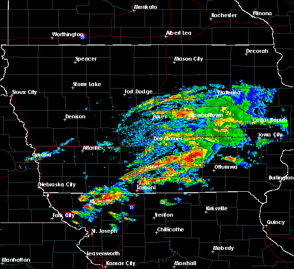 The severe thunderstorm warning for northwestern lucas, southeastern union, central clarke and southeastern warren counties will expire at 615 pm cdt, the storms which prompted the warning have weakened below severe limits, and no longer pose an immediate threat to life or property. therefore, the warning will be allowed to expire. however small hail is still possible with these thunderstorms. a severe thunderstorm watch remains in effect until midnight cdt for south central iowa. to report severe weather, contact your nearest law enforcement agency. they will relay your report to the national weather service des moines. The severe thunderstorm warning for northwestern lucas, southeastern union, central clarke and southeastern warren counties will expire at 615 pm cdt, the storms which prompted the warning have weakened below severe limits, and no longer pose an immediate threat to life or property. therefore, the warning will be allowed to expire. however small hail is still possible with these thunderstorms. a severe thunderstorm watch remains in effect until midnight cdt for south central iowa. to report severe weather, contact your nearest law enforcement agency. they will relay your report to the national weather service des moines.
|
| 5/14/2020 6:03 PM CDT |
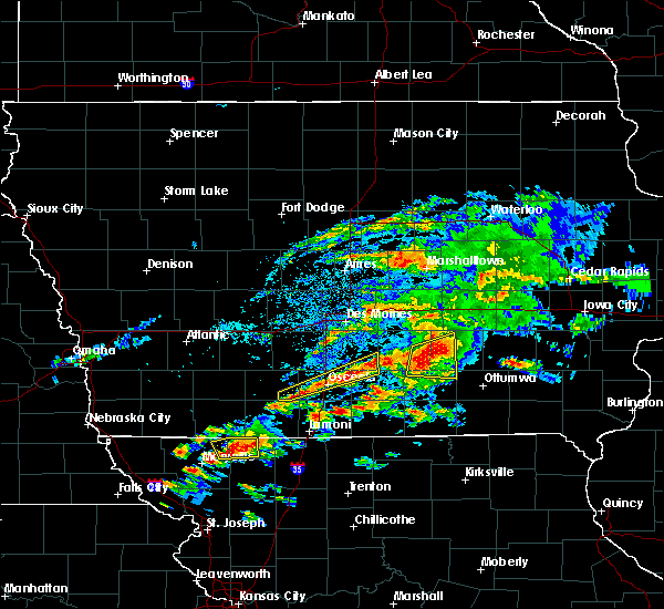 At 602 pm cdt, severe thunderstorms were located along a line extending from 8 miles northeast of osceola to near melcher-dallas, moving northeast at 40 mph (radar indicated). Hazards include quarter size hail. Damage to vehicles is expected. locations impacted include, osceola, lakeside casino, murray, lacona and murray roadside rest area. This includes interstate 35 between mile markers 32 and 39. At 602 pm cdt, severe thunderstorms were located along a line extending from 8 miles northeast of osceola to near melcher-dallas, moving northeast at 40 mph (radar indicated). Hazards include quarter size hail. Damage to vehicles is expected. locations impacted include, osceola, lakeside casino, murray, lacona and murray roadside rest area. This includes interstate 35 between mile markers 32 and 39.
|
| 5/14/2020 5:44 PM CDT |
 At 544 pm cdt, severe thunderstorms were located along a line extending from near lakeside casino to 12 miles south of indianola, moving northeast at 40 mph (radar indicated). Hazards include 60 mph wind gusts and quarter size hail. Hail damage to vehicles is expected. Expect wind damage to roofs, siding, and trees. At 544 pm cdt, severe thunderstorms were located along a line extending from near lakeside casino to 12 miles south of indianola, moving northeast at 40 mph (radar indicated). Hazards include 60 mph wind gusts and quarter size hail. Hail damage to vehicles is expected. Expect wind damage to roofs, siding, and trees.
|
| 4/11/2020 11:47 PM CDT | Quarter sized hail reported 1.5 miles E of Murray, IA |
| 8/20/2019 6:36 AM CDT |
 At 636 am cdt, the leading edge of severe thunderstorms was located along a line extending from near keswick to 7 miles southwest of delta to near albia to 9 miles south of chariton, moving east at 65 mph (radar indicated). Hazards include 60 mph wind gusts. Expect damage to roofs, siding, and trees. locations impacted include, oskaloosa, pella, grinnell, knoxville, osceola, chariton, albia, montezuma, brooklyn, new sharon, melcher-dallas, eddyville, knoxville raceway, rock creek lake, lakeside casino, lake red rock, victor, sully, murray and fremont. this includes the following highways, interstate 35 between mile markers 30 and 42. Interstate 80 between mile markers 172 and 204. At 636 am cdt, the leading edge of severe thunderstorms was located along a line extending from near keswick to 7 miles southwest of delta to near albia to 9 miles south of chariton, moving east at 65 mph (radar indicated). Hazards include 60 mph wind gusts. Expect damage to roofs, siding, and trees. locations impacted include, oskaloosa, pella, grinnell, knoxville, osceola, chariton, albia, montezuma, brooklyn, new sharon, melcher-dallas, eddyville, knoxville raceway, rock creek lake, lakeside casino, lake red rock, victor, sully, murray and fremont. this includes the following highways, interstate 35 between mile markers 30 and 42. Interstate 80 between mile markers 172 and 204.
|
| 8/20/2019 5:55 AM CDT |
 The national weather service in des moines has issued a * severe thunderstorm warning for. monroe county in south central iowa. poweshiek county in central iowa. lucas county in south central iowa. Marion county in south central iowa. The national weather service in des moines has issued a * severe thunderstorm warning for. monroe county in south central iowa. poweshiek county in central iowa. lucas county in south central iowa. Marion county in south central iowa.
|
| 8/20/2019 5:38 AM CDT |
 At 538 am cdt, a severe thunderstorm was located over winterset, moving southeast at 35 mph (radar indicated). Hazards include 60 mph wind gusts. expect damage to roofs, siding, and trees At 538 am cdt, a severe thunderstorm was located over winterset, moving southeast at 35 mph (radar indicated). Hazards include 60 mph wind gusts. expect damage to roofs, siding, and trees
|
| 6/25/2019 10:33 PM CDT |
 At 1027 pm cdt, a severe thunderstorm was located near sun valley lake, or 12 miles east of mount ayr, moving southeast at 30 mph. additional storms near beaconsfield, diagonal and east of grantasena will move southeast through the warned area. frequent lightning and heavy rainfall will also occur with these storms (radar indicated). Hazards include quarter size hail. Damage to vehicles is expected. locations impacted include, creston, osceola, leon, mount ayr, corning, lamoni, sun valley lake, green valley lake, lake icaria, lakeside casino, afton, murray, clearfield, diagonal, kellerton, prescott, grand river, van wert, davis city and decatur city. This includes interstate 35 between mile markers 1 and 34. At 1027 pm cdt, a severe thunderstorm was located near sun valley lake, or 12 miles east of mount ayr, moving southeast at 30 mph. additional storms near beaconsfield, diagonal and east of grantasena will move southeast through the warned area. frequent lightning and heavy rainfall will also occur with these storms (radar indicated). Hazards include quarter size hail. Damage to vehicles is expected. locations impacted include, creston, osceola, leon, mount ayr, corning, lamoni, sun valley lake, green valley lake, lake icaria, lakeside casino, afton, murray, clearfield, diagonal, kellerton, prescott, grand river, van wert, davis city and decatur city. This includes interstate 35 between mile markers 1 and 34.
|
| 6/25/2019 10:18 PM CDT |
 At 1016 pm cdt, a severe thunderstorm was located near sun valley lake, or 14 miles northeast of mount ayr, moving southeast at 30 mph. additional storms near murray, shannon city, lenox, and south of masena will move southeast through the warned area. frequent lightning and heavy rainfall will occur with these storms (radar indicated). Hazards include quarter size hail. Damage to vehicles is expected. locations impacted include, creston, osceola, leon, mount ayr, corning, lamoni, lenox, sun valley lake, green valley lake, lake icaria, lakeside casino, afton, murray, clearfield, diagonal, kellerton, prescott, grand river, van wert and davis city. This includes interstate 35 between mile markers 1 and 34. At 1016 pm cdt, a severe thunderstorm was located near sun valley lake, or 14 miles northeast of mount ayr, moving southeast at 30 mph. additional storms near murray, shannon city, lenox, and south of masena will move southeast through the warned area. frequent lightning and heavy rainfall will occur with these storms (radar indicated). Hazards include quarter size hail. Damage to vehicles is expected. locations impacted include, creston, osceola, leon, mount ayr, corning, lamoni, lenox, sun valley lake, green valley lake, lake icaria, lakeside casino, afton, murray, clearfield, diagonal, kellerton, prescott, grand river, van wert and davis city. This includes interstate 35 between mile markers 1 and 34.
|
| 6/25/2019 10:05 PM CDT |
 At 1001 pm cdt, a severe thunderstorm was located near sun valley lake, or 11 miles northeast of mount ayr, moving southeast at 30 mph. additional storms near shannon city, lenox, and south of masena will move southeast through the warned area. frequent lightning and heavy rainfall will occur with these storms (radar indicated). Hazards include ping pong ball size hail. People and animals outdoors will be injured. Expect damage to roofs, siding, windows, and vehicles. At 1001 pm cdt, a severe thunderstorm was located near sun valley lake, or 11 miles northeast of mount ayr, moving southeast at 30 mph. additional storms near shannon city, lenox, and south of masena will move southeast through the warned area. frequent lightning and heavy rainfall will occur with these storms (radar indicated). Hazards include ping pong ball size hail. People and animals outdoors will be injured. Expect damage to roofs, siding, windows, and vehicles.
|
| 6/25/2019 9:51 PM CDT |
 At 948 pm cdt, a severe thunderstorm was located 8 miles northwest of sun valley lake, or 13 miles southeast of creston, moving east at 30 mph. additional storms were located near kent, lenox and corning moving east southeast. heavy rainfall and frequent lightning is also likely with these storms (radar indicated). Hazards include golf ball size hail. People and animals outdoors will be injured. expect damage to roofs, siding, windows, and vehicles. Locations impacted include, creston, corning, lenox, sun valley lake, green valley lake, lake icaria, afton, murray, diagonal, kellerton, prescott, grand river, tingley, cromwell, arispe, shannon city, kent, thayer, ellston and carbon. At 948 pm cdt, a severe thunderstorm was located 8 miles northwest of sun valley lake, or 13 miles southeast of creston, moving east at 30 mph. additional storms were located near kent, lenox and corning moving east southeast. heavy rainfall and frequent lightning is also likely with these storms (radar indicated). Hazards include golf ball size hail. People and animals outdoors will be injured. expect damage to roofs, siding, windows, and vehicles. Locations impacted include, creston, corning, lenox, sun valley lake, green valley lake, lake icaria, afton, murray, diagonal, kellerton, prescott, grand river, tingley, cromwell, arispe, shannon city, kent, thayer, ellston and carbon.
|
| 6/25/2019 9:43 PM CDT |
 At 942 pm cdt, a severe thunderstorm was located 11 miles southeast of osceola, moving east at 25 mph. there are additional storms near osceola and thayer that will move east southeast (radar indicated). Hazards include quarter size hail. damage to vehicles is expected At 942 pm cdt, a severe thunderstorm was located 11 miles southeast of osceola, moving east at 25 mph. there are additional storms near osceola and thayer that will move east southeast (radar indicated). Hazards include quarter size hail. damage to vehicles is expected
|
| 6/25/2019 9:26 PM CDT |
 At 926 pm cdt, a severe thunderstorm was located 7 miles south of creston, moving southeast at 30 mph (radar indicated). Hazards include golf ball size hail. People and animals outdoors will be injured. Expect damage to roofs, siding, windows, and vehicles. At 926 pm cdt, a severe thunderstorm was located 7 miles south of creston, moving southeast at 30 mph (radar indicated). Hazards include golf ball size hail. People and animals outdoors will be injured. Expect damage to roofs, siding, windows, and vehicles.
|
| 6/25/2019 9:11 PM CDT |
 At 911 pm cdt, a severe thunderstorm was located 7 miles southwest of osceola, moving east at 35 mph (radar indicated). Hazards include quarter size hail. Damage to vehicles is expected. locations impacted include, osceola, leon, murray, humeston, van wert, garden grove, weldon, derby, le roy and murray roadside rest area. This includes interstate 35 between mile markers 16 and 34. At 911 pm cdt, a severe thunderstorm was located 7 miles southwest of osceola, moving east at 35 mph (radar indicated). Hazards include quarter size hail. Damage to vehicles is expected. locations impacted include, osceola, leon, murray, humeston, van wert, garden grove, weldon, derby, le roy and murray roadside rest area. This includes interstate 35 between mile markers 16 and 34.
|
| 6/25/2019 9:09 PM CDT |
 At 909 pm cdt, a severe thunderstorm was located 8 miles southwest of lakeside casino, or 8 miles southwest of osceola, moving east at 35 mph (radar indicated). Hazards include quarter size hail. Damage to vehicles is expected. locations impacted include, osceola, leon, murray, humeston, van wert, garden grove, weldon, derby, thayer, le roy and murray roadside rest area. This includes interstate 35 between mile markers 16 and 34. At 909 pm cdt, a severe thunderstorm was located 8 miles southwest of lakeside casino, or 8 miles southwest of osceola, moving east at 35 mph (radar indicated). Hazards include quarter size hail. Damage to vehicles is expected. locations impacted include, osceola, leon, murray, humeston, van wert, garden grove, weldon, derby, thayer, le roy and murray roadside rest area. This includes interstate 35 between mile markers 16 and 34.
|
| 6/25/2019 9:00 PM CDT |
 At 859 pm cdt, a severe thunderstorm was located 9 miles northeast of sun valley lake, or 11 miles southwest of osceola, moving east at 35 mph (radar indicated). Hazards include quarter size hail. Damage to vehicles is expected. locations impacted include, osceola, leon, murray, humeston, van wert, garden grove, weldon, derby, thayer, le roy and murray roadside rest area. This includes interstate 35 between mile markers 16 and 34. At 859 pm cdt, a severe thunderstorm was located 9 miles northeast of sun valley lake, or 11 miles southwest of osceola, moving east at 35 mph (radar indicated). Hazards include quarter size hail. Damage to vehicles is expected. locations impacted include, osceola, leon, murray, humeston, van wert, garden grove, weldon, derby, thayer, le roy and murray roadside rest area. This includes interstate 35 between mile markers 16 and 34.
|
| 6/25/2019 8:56 PM CDT | Quarter sized hail reported 0.2 miles NNW of Murray, IA, law enforcement reported quarter size hail in murray. |
| 6/25/2019 8:55 PM CDT | Hen Egg sized hail reported 1.5 miles E of Murray, IA, mix of quarter to hen egg sized hail. |
| 6/25/2019 8:52 PM CDT | Quarter sized hail reported 0.2 miles NNW of Murray, IA, via social media. |
| 6/25/2019 8:52 PM CDT | Golf Ball sized hail reported 1.5 miles E of Murray, IA, increased to golfball sized. while on the phone indicated that some even larger may have started to fall. |
| 6/25/2019 8:52 PM CDT |
 At 852 pm cdt, a severe thunderstorm was located 8 miles north of sun valley lake, or 14 miles west of osceola, moving east at 35 mph (radar indicated). Hazards include golf ball size hail. People and animals outdoors will be injured. expect damage to roofs, siding, windows, and vehicles. locations impacted include, osceola, leon, afton, murray, humeston, van wert, garden grove, weldon, derby, arispe, thayer, le roy and murray roadside rest area. This includes interstate 35 between mile markers 16 and 34. At 852 pm cdt, a severe thunderstorm was located 8 miles north of sun valley lake, or 14 miles west of osceola, moving east at 35 mph (radar indicated). Hazards include golf ball size hail. People and animals outdoors will be injured. expect damage to roofs, siding, windows, and vehicles. locations impacted include, osceola, leon, afton, murray, humeston, van wert, garden grove, weldon, derby, arispe, thayer, le roy and murray roadside rest area. This includes interstate 35 between mile markers 16 and 34.
|
| 6/25/2019 8:49 PM CDT |
 At 849 pm cdt, a severe thunderstorm was located 9 miles north of sun valley lake, or 14 miles east of creston, moving east at 35 mph (radar indicated). Hazards include quarter size hail. damage to vehicles is expected At 849 pm cdt, a severe thunderstorm was located 9 miles north of sun valley lake, or 14 miles east of creston, moving east at 35 mph (radar indicated). Hazards include quarter size hail. damage to vehicles is expected
|
| 6/25/2019 8:40 PM CDT | Quarter sized hail reported 1.5 miles E of Murray, IA, sporadic quarter hail mixed with heavy rain... still ongoing. |
| 6/21/2019 11:16 PM CDT |
 A severe thunderstorm warning remains in effect until 1130 pm cdt for south central madison and northwestern clarke counties. at 1116 pm cdt, a severe thunderstorm was located 9 miles northwest of lakeside casino, or 10 miles northwest of osceola, moving northeast at 35 mph. hazard. 60 mph wind gusts and quarter size hail. A severe thunderstorm warning remains in effect until 1130 pm cdt for south central madison and northwestern clarke counties. at 1116 pm cdt, a severe thunderstorm was located 9 miles northwest of lakeside casino, or 10 miles northwest of osceola, moving northeast at 35 mph. hazard. 60 mph wind gusts and quarter size hail.
|
| 6/21/2019 10:52 PM CDT |
 At 1108 pm cdt, a severe thunderstorm was located 11 miles west of lakeside casino, or 12 miles northwest of osceola, moving northeast at 25 mph (radar indicated). Hazards include 60 mph wind gusts and quarter size hail. Hail damage to vehicles is expected. expect wind damage to roofs, siding, and trees. Locations impacted include, murray, lorimor, east peru and thayer. At 1108 pm cdt, a severe thunderstorm was located 11 miles west of lakeside casino, or 12 miles northwest of osceola, moving northeast at 25 mph (radar indicated). Hazards include 60 mph wind gusts and quarter size hail. Hail damage to vehicles is expected. expect wind damage to roofs, siding, and trees. Locations impacted include, murray, lorimor, east peru and thayer.
|
| 5/28/2019 2:43 PM CDT |
 At 243 pm cdt, a severe thunderstorm was located 7 miles southwest of avenue of the saints event center, or 12 miles north of osceola, moving northeast at 50 mph (radar indicated). Hazards include 60 mph wind gusts and quarter size hail. Hail damage to vehicles is expected. expect wind damage to roofs, siding, and trees. locations impacted include, indianola, winterset, osceola, lakeside casino, avenue of the saints event center, murray, st. charles, new virginia, truro, martensdale, lacona, cumming, patterson, st. marys, east peru, bevington, spring hill, lake ahquabi state park, otter creek county park and murray roadside rest area. This includes interstate 35 between mile markers 34 and 67. At 243 pm cdt, a severe thunderstorm was located 7 miles southwest of avenue of the saints event center, or 12 miles north of osceola, moving northeast at 50 mph (radar indicated). Hazards include 60 mph wind gusts and quarter size hail. Hail damage to vehicles is expected. expect wind damage to roofs, siding, and trees. locations impacted include, indianola, winterset, osceola, lakeside casino, avenue of the saints event center, murray, st. charles, new virginia, truro, martensdale, lacona, cumming, patterson, st. marys, east peru, bevington, spring hill, lake ahquabi state park, otter creek county park and murray roadside rest area. This includes interstate 35 between mile markers 34 and 67.
|
| 5/28/2019 2:34 PM CDT |
 At 234 pm cdt, a severe thunderstorm was located 13 miles northwest of lakeside casino, or 14 miles northwest of osceola, moving northeast at 45 mph (radar indicated). Hazards include 60 mph wind gusts and quarter size hail. Hail damage to vehicles is expected. Expect wind damage to roofs, siding, and trees. At 234 pm cdt, a severe thunderstorm was located 13 miles northwest of lakeside casino, or 14 miles northwest of osceola, moving northeast at 45 mph (radar indicated). Hazards include 60 mph wind gusts and quarter size hail. Hail damage to vehicles is expected. Expect wind damage to roofs, siding, and trees.
|
| 5/24/2019 6:32 AM CDT |
 At 632 am cdt, severe thunderstorms were located along a line extending from 6 miles northwest of avenue of the saints event center to 6 miles southwest of leon, moving east at 60 mph (radar indicated). Hazards include 60 mph wind gusts. Expect damage to roofs, siding, and trees. locations impacted include, winterset, osceola, leon, lakeside casino, avenue of the saints event center, murray, st. charles, new virginia, truro, martensdale, van wert, garden grove, davis city, decatur city, patterson, st. marys, east peru, weldon, bevington and pleasanton. This includes interstate 35 between mile markers 6 and 61. At 632 am cdt, severe thunderstorms were located along a line extending from 6 miles northwest of avenue of the saints event center to 6 miles southwest of leon, moving east at 60 mph (radar indicated). Hazards include 60 mph wind gusts. Expect damage to roofs, siding, and trees. locations impacted include, winterset, osceola, leon, lakeside casino, avenue of the saints event center, murray, st. charles, new virginia, truro, martensdale, van wert, garden grove, davis city, decatur city, patterson, st. marys, east peru, weldon, bevington and pleasanton. This includes interstate 35 between mile markers 6 and 61.
|
| 5/24/2019 6:23 AM CDT |
 At 623 am cdt, severe thunderstorms were located along a line extending from winterset to lamoni, moving east at 55 mph (radar indicated). Hazards include 60 mph wind gusts. Expect damage to roofs, siding, and trees. locations impacted include, winterset, osceola, leon, lamoni, sun valley lake, lakeside casino, avenue of the saints event center, afton, murray, st. charles, new virginia, truro, martensdale, lorimor, kellerton, grand river, van wert, garden grove, davis city and decatur city. This includes interstate 35 between mile markers 1 and 61. At 623 am cdt, severe thunderstorms were located along a line extending from winterset to lamoni, moving east at 55 mph (radar indicated). Hazards include 60 mph wind gusts. Expect damage to roofs, siding, and trees. locations impacted include, winterset, osceola, leon, lamoni, sun valley lake, lakeside casino, avenue of the saints event center, afton, murray, st. charles, new virginia, truro, martensdale, lorimor, kellerton, grand river, van wert, garden grove, davis city and decatur city. This includes interstate 35 between mile markers 1 and 61.
|
| 5/24/2019 5:57 AM CDT |
 At 557 am cdt, severe thunderstorms were located along a line extending from near greenfield to 6 miles west of mount ayr, moving east at 60 mph (radar indicated). Hazards include 60 mph wind gusts. expect damage to roofs, siding, and trees At 557 am cdt, severe thunderstorms were located along a line extending from near greenfield to 6 miles west of mount ayr, moving east at 60 mph (radar indicated). Hazards include 60 mph wind gusts. expect damage to roofs, siding, and trees
|
| 9/1/2018 5:45 AM CDT |
 At 545 am cdt, a severe thunderstorm was located 12 miles north of sun valley lake, or 14 miles west of osceola, moving northeast at 25 mph (radar indicated). Hazards include 60 mph wind gusts and quarter size hail. Hail damage to vehicles is expected. Expect wind damage to roofs, siding, and trees. At 545 am cdt, a severe thunderstorm was located 12 miles north of sun valley lake, or 14 miles west of osceola, moving northeast at 25 mph (radar indicated). Hazards include 60 mph wind gusts and quarter size hail. Hail damage to vehicles is expected. Expect wind damage to roofs, siding, and trees.
|
| 6/28/2018 12:18 PM CDT |
 At 1217 pm cdt, severe thunderstorms were located along a line extending from 10 miles northeast of lakeside casino to 8 miles southeast of osceola to near lamoni, moving southeast at 50 mph (trained weather spotters. these storms have a history of producing widespread wind damage). Hazards include 70 mph wind gusts and nickel size hail. Expect considerable tree damage. damage is likely to mobile homes, roofs, and outbuildings. locations impacted include, osceola, chariton, leon, corydon, lamoni, lakeside casino, rathbun lake, murray, seymour, russell, allerton, humeston, new virginia, kellerton, grand river, van wert, lineville, lucas, garden grove and davis city. This includes interstate 35 between mile markers 1 and 51. At 1217 pm cdt, severe thunderstorms were located along a line extending from 10 miles northeast of lakeside casino to 8 miles southeast of osceola to near lamoni, moving southeast at 50 mph (trained weather spotters. these storms have a history of producing widespread wind damage). Hazards include 70 mph wind gusts and nickel size hail. Expect considerable tree damage. damage is likely to mobile homes, roofs, and outbuildings. locations impacted include, osceola, chariton, leon, corydon, lamoni, lakeside casino, rathbun lake, murray, seymour, russell, allerton, humeston, new virginia, kellerton, grand river, van wert, lineville, lucas, garden grove and davis city. This includes interstate 35 between mile markers 1 and 51.
|
| 6/28/2018 12:16 PM CDT | Quarter sized hail reported 1.5 miles E of Murray, IA |
| 6/28/2018 12:15 PM CDT |
 At 1214 pm cdt, severe thunderstorms were located along a line extending from near avenue of the saints event center to near lakeside casino to near sun valley lake, moving east at 55 mph (trained weather spotters. these storms have a history of producing wind damage in the warned counties). Hazards include 70 mph wind gusts and nickel size hail. Expect considerable tree damage. damage is likely to mobile homes, roofs, and outbuildings. locations impacted include, winterset, osceola, sun valley lake, lakeside casino, avenue of the saints event center, murray, st. charles, truro, lorimor, kellerton, grand river, patterson, east peru, macksburg, bevington, thayer, beaconsfield, winterset-madison county airport and murray roadside rest area. This includes interstate 35 between mile markers 29 and 43. At 1214 pm cdt, severe thunderstorms were located along a line extending from near avenue of the saints event center to near lakeside casino to near sun valley lake, moving east at 55 mph (trained weather spotters. these storms have a history of producing wind damage in the warned counties). Hazards include 70 mph wind gusts and nickel size hail. Expect considerable tree damage. damage is likely to mobile homes, roofs, and outbuildings. locations impacted include, winterset, osceola, sun valley lake, lakeside casino, avenue of the saints event center, murray, st. charles, truro, lorimor, kellerton, grand river, patterson, east peru, macksburg, bevington, thayer, beaconsfield, winterset-madison county airport and murray roadside rest area. This includes interstate 35 between mile markers 29 and 43.
|
| 6/28/2018 12:05 PM CDT | Large trees and power lines down in murra in clarke county IA, 0.5 miles S of Murray, IA |
| 6/28/2018 12:04 PM CDT |
 At 1202 pm cdt, severe thunderstorms were located along a line extending from 8 miles north of lakeside casino to 8 miles southwest of osceola to 7 miles east of mount ayr, moving southeast at 55 mph (trained weather spotters. these storms have produced widespread 60 to 70 mph wind gusts with widespread wind damage). Hazards include 70 mph wind gusts and nickel size hail. Expect considerable tree damage. Damage is likely to mobile homes, roofs, and outbuildings. At 1202 pm cdt, severe thunderstorms were located along a line extending from 8 miles north of lakeside casino to 8 miles southwest of osceola to 7 miles east of mount ayr, moving southeast at 55 mph (trained weather spotters. these storms have produced widespread 60 to 70 mph wind gusts with widespread wind damage). Hazards include 70 mph wind gusts and nickel size hail. Expect considerable tree damage. Damage is likely to mobile homes, roofs, and outbuildings.
|
| 6/28/2018 11:57 AM CDT |
 At 1156 am cdt, severe thunderstorms were located along a line extending from near winterset to 9 miles northwest of lakeside casino to near sun valley lake, moving southeast at 60 mph (trained weather spotters. numerous reports of wind damage have occurred with these storms). Hazards include 70 mph wind gusts and nickel size hail. Expect considerable tree damage. damage is likely to mobile homes, roofs, and outbuildings. locations impacted include, creston, winterset, osceola, mount ayr, stuart, sun valley lake, green valley lake, lakeside casino, avenue of the saints event center, afton, murray, st. charles, truro, orient, lorimor, diagonal, kellerton, grand river, tingley and patterson. This includes interstate 35 between mile markers 29 and 43. At 1156 am cdt, severe thunderstorms were located along a line extending from near winterset to 9 miles northwest of lakeside casino to near sun valley lake, moving southeast at 60 mph (trained weather spotters. numerous reports of wind damage have occurred with these storms). Hazards include 70 mph wind gusts and nickel size hail. Expect considerable tree damage. damage is likely to mobile homes, roofs, and outbuildings. locations impacted include, creston, winterset, osceola, mount ayr, stuart, sun valley lake, green valley lake, lakeside casino, avenue of the saints event center, afton, murray, st. charles, truro, orient, lorimor, diagonal, kellerton, grand river, tingley and patterson. This includes interstate 35 between mile markers 29 and 43.
|
| 6/28/2018 11:37 AM CDT |
 At 1137 am cdt, severe thunderstorms were located along a line extending from 6 miles southwest of earlham to 10 miles northeast of green valley lake to near lenox, moving southeast at 60 mph (trained weather spotters. large branches down and winds estimated near 70 mph in greenfield. power out). Hazards include 70 mph wind gusts and nickel size hail. Expect considerable tree damage. damage is likely to mobile homes, roofs, and outbuildings. locations impacted include, creston, winterset, osceola, greenfield, mount ayr, stuart, lenox, sun valley lake, green valley lake, lakeside casino, avenue of the saints event center, lake icaria, afton, murray, st. charles, truro, orient, clearfield, lorimor and diagonal. This includes interstate 35 between mile markers 29 and 42. At 1137 am cdt, severe thunderstorms were located along a line extending from 6 miles southwest of earlham to 10 miles northeast of green valley lake to near lenox, moving southeast at 60 mph (trained weather spotters. large branches down and winds estimated near 70 mph in greenfield. power out). Hazards include 70 mph wind gusts and nickel size hail. Expect considerable tree damage. damage is likely to mobile homes, roofs, and outbuildings. locations impacted include, creston, winterset, osceola, greenfield, mount ayr, stuart, lenox, sun valley lake, green valley lake, lakeside casino, avenue of the saints event center, lake icaria, afton, murray, st. charles, truro, orient, clearfield, lorimor and diagonal. This includes interstate 35 between mile markers 29 and 42.
|
| 6/28/2018 11:26 AM CDT |
 At 1125 am cdt, severe thunderstorms were located along a line extending from 7 miles northwest of stuart to greenfield to near corning, moving southeast at 60 mph (trained weather spotters. these storms have a history of wind damage). Hazards include 70 mph wind gusts and nickel size hail. Expect considerable tree damage. Damage is likely to mobile homes, roofs, and outbuildings. At 1125 am cdt, severe thunderstorms were located along a line extending from 7 miles northwest of stuart to greenfield to near corning, moving southeast at 60 mph (trained weather spotters. these storms have a history of wind damage). Hazards include 70 mph wind gusts and nickel size hail. Expect considerable tree damage. Damage is likely to mobile homes, roofs, and outbuildings.
|
| 5/2/2018 6:35 PM CDT | Golf Ball sized hail reported 1 miles E of Murray, IA, hail on going for 10 minutes. up to golf ball sized. |
| 5/2/2018 6:35 PM CDT |
 At 635 pm cdt, a severe thunderstorm was located 8 miles west of lakeside casino, or 8 miles west of osceola, moving east at 20 mph (trained weather spotters reported golf ball sized hail 1 mile west of murray). Hazards include golf ball size hail and 60 mph wind gusts. People and animals outdoors will be injured. expect hail damage to roofs, siding, windows, and vehicles. expect wind damage to roofs, siding, and trees. locations impacted include, osceola, lakeside casino, afton, murray, thayer and murray roadside rest area. this includes interstate 35 between mile markers 25 and 41. A tornado watch remains in effect until 100 am cdt for south central iowa. At 635 pm cdt, a severe thunderstorm was located 8 miles west of lakeside casino, or 8 miles west of osceola, moving east at 20 mph (trained weather spotters reported golf ball sized hail 1 mile west of murray). Hazards include golf ball size hail and 60 mph wind gusts. People and animals outdoors will be injured. expect hail damage to roofs, siding, windows, and vehicles. expect wind damage to roofs, siding, and trees. locations impacted include, osceola, lakeside casino, afton, murray, thayer and murray roadside rest area. this includes interstate 35 between mile markers 25 and 41. A tornado watch remains in effect until 100 am cdt for south central iowa.
|
| 5/2/2018 6:28 PM CDT | Quarter sized hail reported 1 miles E of Murray, IA, heavy rain and quarter sized hail. |
| 5/2/2018 6:24 PM CDT |
 At 624 pm cdt, a severe thunderstorm was located 10 miles north of sun valley lake, or 12 miles west of osceola, moving east at 20 mph (radar indicated). Hazards include 60 mph wind gusts and quarter size hail. Hail damage to vehicles is expected. Expect wind damage to roofs, siding, and trees. At 624 pm cdt, a severe thunderstorm was located 10 miles north of sun valley lake, or 12 miles west of osceola, moving east at 20 mph (radar indicated). Hazards include 60 mph wind gusts and quarter size hail. Hail damage to vehicles is expected. Expect wind damage to roofs, siding, and trees.
|
| 6/15/2017 8:26 PM CDT |
 At 826 pm cdt, a severe thunderstorm was located near lakeside casino, or near osceola, moving east at 35 mph (radar indicated). Hazards include two inch hail. People and animals outdoors will be injured. expect damage to roofs, siding, windows, and vehicles. locations impacted include, osceola, lakeside casino, murray, new virginia, woodburn and murray roadside rest area. This includes interstate 35 between mile markers 28 and 44. At 826 pm cdt, a severe thunderstorm was located near lakeside casino, or near osceola, moving east at 35 mph (radar indicated). Hazards include two inch hail. People and animals outdoors will be injured. expect damage to roofs, siding, windows, and vehicles. locations impacted include, osceola, lakeside casino, murray, new virginia, woodburn and murray roadside rest area. This includes interstate 35 between mile markers 28 and 44.
|
| 6/15/2017 8:23 PM CDT |
 At 823 pm cdt, a severe thunderstorm was located near lakeside casino, or near osceola, moving east at 35 mph (radar indicated). Hazards include ping pong ball size hail. People and animals outdoors will be injured. Expect damage to roofs, siding, windows, and vehicles. At 823 pm cdt, a severe thunderstorm was located near lakeside casino, or near osceola, moving east at 35 mph (radar indicated). Hazards include ping pong ball size hail. People and animals outdoors will be injured. Expect damage to roofs, siding, windows, and vehicles.
|
| 5/17/2017 3:47 PM CDT |
 At 347 pm cdt, a severe thunderstorm was located 8 miles south of osceola, moving northeast at 65 mph (radar indicated). Hazards include 60 mph wind gusts. expect damage to roofs, siding, and trees At 347 pm cdt, a severe thunderstorm was located 8 miles south of osceola, moving northeast at 65 mph (radar indicated). Hazards include 60 mph wind gusts. expect damage to roofs, siding, and trees
|
| 5/17/2017 3:43 PM CDT | Home owner just west of murray reports shingles blown off... flag pole snapped... and small tree branches dow in clarke county IA, 1 miles E of Murray, IA |
| 5/17/2017 3:40 PM CDT |
 At 339 pm cdt, severe thunderstorms were located along a line extending from near greenfield to 10 miles southwest of winterset to 8 miles west of lakeside casino, moving northeast at 60 mph (radar indicated. at 330pm 65 mph winds were reported by a department of transportation weather station near creston). Hazards include 60 mph wind gusts and nickel size hail. Expect damage to roofs, siding, and trees. locations impacted include, winterset, greenfield, afton, murray, truro, orient, lorimor, east peru, macksburg, thayer, greenfield municipal airport and winterset-madison county airport. this includes interstate 35 near mile marker 42. A tornado watch remains in effect until 700 pm cdt for south central and southwestern iowa. At 339 pm cdt, severe thunderstorms were located along a line extending from near greenfield to 10 miles southwest of winterset to 8 miles west of lakeside casino, moving northeast at 60 mph (radar indicated. at 330pm 65 mph winds were reported by a department of transportation weather station near creston). Hazards include 60 mph wind gusts and nickel size hail. Expect damage to roofs, siding, and trees. locations impacted include, winterset, greenfield, afton, murray, truro, orient, lorimor, east peru, macksburg, thayer, greenfield municipal airport and winterset-madison county airport. this includes interstate 35 near mile marker 42. A tornado watch remains in effect until 700 pm cdt for south central and southwestern iowa.
|
| 5/17/2017 3:29 PM CDT |
 At 329 pm cdt, severe thunderstorms were located along a line extending from near greenfield to 7 miles east of green valley lake to 8 miles north of sun valley lake, moving northeast at 60 mph (radar indicated. at 320pm...60 mph winds were recorded at the creston airport). Hazards include 60 mph wind gusts and nickel size hail. expect damage to roofs, siding, and trees At 329 pm cdt, severe thunderstorms were located along a line extending from near greenfield to 7 miles east of green valley lake to 8 miles north of sun valley lake, moving northeast at 60 mph (radar indicated. at 320pm...60 mph winds were recorded at the creston airport). Hazards include 60 mph wind gusts and nickel size hail. expect damage to roofs, siding, and trees
|
| 5/10/2017 12:34 PM CDT |
 At 1234 pm cdt, a severe thunderstorm was located 9 miles northeast of sun valley lake, or 11 miles southwest of osceola, moving east at 40 mph (radar indicated). Hazards include 60 mph wind gusts and penny size hail. Expect damage to roofs, siding, and trees. Locations impacted include, sun valley lake, afton, murray, grand river, tingley, arispe, shannon city, thayer, ellston and murray roadside rest area. At 1234 pm cdt, a severe thunderstorm was located 9 miles northeast of sun valley lake, or 11 miles southwest of osceola, moving east at 40 mph (radar indicated). Hazards include 60 mph wind gusts and penny size hail. Expect damage to roofs, siding, and trees. Locations impacted include, sun valley lake, afton, murray, grand river, tingley, arispe, shannon city, thayer, ellston and murray roadside rest area.
|
| 5/10/2017 12:13 PM CDT |
 At 1213 pm cdt, a severe thunderstorm was located 10 miles southeast of creston, moving east at 40 mph (radar indicated). Hazards include 60 mph wind gusts and penny size hail. expect damage to roofs, siding, and trees At 1213 pm cdt, a severe thunderstorm was located 10 miles southeast of creston, moving east at 40 mph (radar indicated). Hazards include 60 mph wind gusts and penny size hail. expect damage to roofs, siding, and trees
|
| 4/9/2017 11:52 PM CDT |
 At 1151 pm cdt, a severe thunderstorm was located over osceola, moving east at 55 mph (radar indicated). Hazards include quarter size hail. Damage to vehicles is expected. locations impacted include, osceola, lakeside casino, murray, woodburn and murray roadside rest area. This includes interstate 35 between mile markers 27 and 43. At 1151 pm cdt, a severe thunderstorm was located over osceola, moving east at 55 mph (radar indicated). Hazards include quarter size hail. Damage to vehicles is expected. locations impacted include, osceola, lakeside casino, murray, woodburn and murray roadside rest area. This includes interstate 35 between mile markers 27 and 43.
|
| 4/9/2017 11:34 PM CDT |
 At 1134 pm cdt, a severe thunderstorm was located 10 miles north of sun valley lake, or 13 miles west of osceola, moving northeast at 55 mph (radar indicated). Hazards include quarter size hail. damage to vehicles is expected At 1134 pm cdt, a severe thunderstorm was located 10 miles north of sun valley lake, or 13 miles west of osceola, moving northeast at 55 mph (radar indicated). Hazards include quarter size hail. damage to vehicles is expected
|
| 3/6/2017 7:27 PM CST |
 The severe thunderstorm warning for southeastern union and clarke counties will expire at 730 pm cst, the storm which prompted the warning has moved out of the area. therefore the warning will be allowed to expire. however gusty winds are still possible with this thunderstorm. a tornado watch remains in effect until 1000 pm cst for south central iowa. The severe thunderstorm warning for southeastern union and clarke counties will expire at 730 pm cst, the storm which prompted the warning has moved out of the area. therefore the warning will be allowed to expire. however gusty winds are still possible with this thunderstorm. a tornado watch remains in effect until 1000 pm cst for south central iowa.
|
| 3/6/2017 7:10 PM CST |
 At 709 pm cst, a severe thunderstorm was located near osceola, moving east at 50 mph (radar indicated). Hazards include 60 mph wind gusts and quarter size hail. Hail damage to vehicles is expected. expect wind damage to roofs, siding, and trees. locations impacted include, osceola, lakeside casino, murray, woodburn, thayer and murray roadside rest area. this includes interstate 35 between mile markers 25 and 43. A tornado watch remains in effect until 1000 pm cst for south central iowa. At 709 pm cst, a severe thunderstorm was located near osceola, moving east at 50 mph (radar indicated). Hazards include 60 mph wind gusts and quarter size hail. Hail damage to vehicles is expected. expect wind damage to roofs, siding, and trees. locations impacted include, osceola, lakeside casino, murray, woodburn, thayer and murray roadside rest area. this includes interstate 35 between mile markers 25 and 43. A tornado watch remains in effect until 1000 pm cst for south central iowa.
|
| 3/6/2017 6:39 PM CST |
 At 638 pm cst, a severe thunderstorm was located 9 miles east of creston, moving east at 45 mph (radar indicated). Hazards include 60 mph wind gusts and quarter size hail. Hail damage to vehicles is expected. Expect wind damage to roofs, siding, and trees. At 638 pm cst, a severe thunderstorm was located 9 miles east of creston, moving east at 45 mph (radar indicated). Hazards include 60 mph wind gusts and quarter size hail. Hail damage to vehicles is expected. Expect wind damage to roofs, siding, and trees.
|
| 8/11/2016 9:34 PM CDT |
 At 932 pm cdt, severe thunderstorms were located along a line extending from near carlisle to 10 miles south of indianola to near lakeside casino, moving east at 35 mph (trained weather spotters. at 923pm...a 63 mph gust was reported 2 miles west of murray). Hazards include 60 mph wind gusts. Expect damage to roofs. siding. and trees. locations impacted include, des moines, indianola, norwalk, osceola, carlisle, monroe, pleasantville, melcher-dallas, lakeside casino, avenue of the saints event center, lake red rock, milo, hartford, murray, st. Charles, new virginia, truro, martensdale, lacona and lorimor. At 932 pm cdt, severe thunderstorms were located along a line extending from near carlisle to 10 miles south of indianola to near lakeside casino, moving east at 35 mph (trained weather spotters. at 923pm...a 63 mph gust was reported 2 miles west of murray). Hazards include 60 mph wind gusts. Expect damage to roofs. siding. and trees. locations impacted include, des moines, indianola, norwalk, osceola, carlisle, monroe, pleasantville, melcher-dallas, lakeside casino, avenue of the saints event center, lake red rock, milo, hartford, murray, st. Charles, new virginia, truro, martensdale, lacona and lorimor.
|
| 8/11/2016 9:23 PM CDT | Measured on home weather statio in clarke county IA, 2 miles E of Murray, IA |
| 8/11/2016 9:20 PM CDT |
 At 920 pm cdt, a severe thunderstorm was located near avenue of the saints event center, or 9 miles southwest of indianola, moving east at 50 mph (radar indicated). Hazards include 60 mph wind gusts. Expect damage to roofs. siding. And trees. At 920 pm cdt, a severe thunderstorm was located near avenue of the saints event center, or 9 miles southwest of indianola, moving east at 50 mph (radar indicated). Hazards include 60 mph wind gusts. Expect damage to roofs. siding. And trees.
|
| 7/19/2016 1:48 PM CDT |
 At 148 pm cdt, severe thunderstorms were located along a line extending from 12 miles south of indianola to near osceola to sun valley lake, moving southeast at 35 mph (radar indicated). Hazards include 60 mph wind gusts and quarter size hail. Hail damage to vehicles is expected. Expect wind damage to roofs, siding, and trees. At 148 pm cdt, severe thunderstorms were located along a line extending from 12 miles south of indianola to near osceola to sun valley lake, moving southeast at 35 mph (radar indicated). Hazards include 60 mph wind gusts and quarter size hail. Hail damage to vehicles is expected. Expect wind damage to roofs, siding, and trees.
|
| 5/13/2016 12:50 PM CDT | Quarter sized hail reported 1.5 miles E of Murray, IA, spotter reported brief period of quarter sized hail. noted it was soft hail. |
| 4/27/2016 6:26 PM CDT |
 The severe thunderstorm warning for southern madison, western clarke, northeastern union and east central adair counties will expire at 630 pm cdt, the storms which prompted the warning have weakened below severe limits, and no longer pose an immediate threat to life or property. therefore the warning will be allowed to expire. a tornado watch remains in effect until 900 pm cdt for southwestern iowa. to report severe weather, contact your nearest law enforcement agency. they will relay your report to the national weather service des moines. The severe thunderstorm warning for southern madison, western clarke, northeastern union and east central adair counties will expire at 630 pm cdt, the storms which prompted the warning have weakened below severe limits, and no longer pose an immediate threat to life or property. therefore the warning will be allowed to expire. a tornado watch remains in effect until 900 pm cdt for southwestern iowa. to report severe weather, contact your nearest law enforcement agency. they will relay your report to the national weather service des moines.
|
| 4/27/2016 6:18 PM CDT |
 At 618 pm cdt, severe thunderstorms were located along a line extending from 8 miles west of winterset to 14 miles southwest of avenue of the saints event center to 9 miles west of lakeside casino, moving north at 45 mph (radar indicated). Hazards include 60 mph wind gusts and quarter size hail. Hail damage to vehicles is expected. expect wind damage to roofs, siding, and trees. locations impacted include, winterset, avenue of the saints event center, murray, st. charles, truro, east peru, macksburg and murray roadside rest area. this includes interstate 35 between mile markers 42 and 43. A tornado watch remains in effect until 900 pm cdt for southwestern iowa. At 618 pm cdt, severe thunderstorms were located along a line extending from 8 miles west of winterset to 14 miles southwest of avenue of the saints event center to 9 miles west of lakeside casino, moving north at 45 mph (radar indicated). Hazards include 60 mph wind gusts and quarter size hail. Hail damage to vehicles is expected. expect wind damage to roofs, siding, and trees. locations impacted include, winterset, avenue of the saints event center, murray, st. charles, truro, east peru, macksburg and murray roadside rest area. this includes interstate 35 between mile markers 42 and 43. A tornado watch remains in effect until 900 pm cdt for southwestern iowa.
|
| 4/27/2016 5:58 PM CDT |
 At 558 pm cdt, severe thunderstorms were located along a line extending from 6 miles east of green valley lake to 13 miles east of creston to 4 miles north of sun valley lake, moving north at 40 mph (radar indicated). Hazards include 60 mph wind gusts and quarter size hail. Hail damage to vehicles is expected. expect wind damage to roofs, siding, and trees. locations impacted include, creston, winterset, avenue of the saints event center, afton, murray, st. charles, truro, lorimor, east peru, macksburg, arispe, shannon city, thayer, creston municipal airport and murray roadside rest area. this includes interstate 35 between mile markers 42 and 43. A tornado watch remains in effect until 900 pm cdt for southwestern iowa. At 558 pm cdt, severe thunderstorms were located along a line extending from 6 miles east of green valley lake to 13 miles east of creston to 4 miles north of sun valley lake, moving north at 40 mph (radar indicated). Hazards include 60 mph wind gusts and quarter size hail. Hail damage to vehicles is expected. expect wind damage to roofs, siding, and trees. locations impacted include, creston, winterset, avenue of the saints event center, afton, murray, st. charles, truro, lorimor, east peru, macksburg, arispe, shannon city, thayer, creston municipal airport and murray roadside rest area. this includes interstate 35 between mile markers 42 and 43. A tornado watch remains in effect until 900 pm cdt for southwestern iowa.
|
| 4/27/2016 5:42 PM CDT |
 At 542 pm cdt, severe thunderstorms were located along a line extending from 9 miles southeast of creston to 6 miles west of sun valley lake to 7 miles northeast of mount ayr, moving north at 45 mph (radar indicated). Hazards include 60 mph wind gusts and quarter size hail. Hail damage to vehicles is expected. Expect wind damage to roofs, siding, and trees. At 542 pm cdt, severe thunderstorms were located along a line extending from 9 miles southeast of creston to 6 miles west of sun valley lake to 7 miles northeast of mount ayr, moving north at 45 mph (radar indicated). Hazards include 60 mph wind gusts and quarter size hail. Hail damage to vehicles is expected. Expect wind damage to roofs, siding, and trees.
|
| 11/11/2015 2:55 PM CST |
 At 255 pm cst, a severe thunderstorm was located over osceola, moving northeast at 50 mph (radar indicated). Hazards include 60 mph wind gusts. Expect damage to roofs. Siding and trees. At 255 pm cst, a severe thunderstorm was located over osceola, moving northeast at 50 mph (radar indicated). Hazards include 60 mph wind gusts. Expect damage to roofs. Siding and trees.
|
| 11/11/2015 2:52 PM CST |
 At 252 pm cst, severe thunderstorms were located along a line extending from 8 miles south of earlham to near winterset to 7 miles northwest of lakeside casino, moving northeast at 50 mph (radar indicated). Hazards include 60 mph wind gusts. Expect damage to roofs. siding and trees. locations impacted include, indianola, winterset, avenue of the saints event center, murray, st. charles, new virginia, truro, martensdale, patterson, st. marys, east peru, bevington, winterset-madison county airport, lake ahquabi state park and murray roadside rest area. this includes the following highways, interstate 35 between mile markers 42 and 59. interstate 80 between mile markers 96 and 99. A tornado watch remains in effect until 600 pm cst for southwestern iowa. At 252 pm cst, severe thunderstorms were located along a line extending from 8 miles south of earlham to near winterset to 7 miles northwest of lakeside casino, moving northeast at 50 mph (radar indicated). Hazards include 60 mph wind gusts. Expect damage to roofs. siding and trees. locations impacted include, indianola, winterset, avenue of the saints event center, murray, st. charles, new virginia, truro, martensdale, patterson, st. marys, east peru, bevington, winterset-madison county airport, lake ahquabi state park and murray roadside rest area. this includes the following highways, interstate 35 between mile markers 42 and 59. interstate 80 between mile markers 96 and 99. A tornado watch remains in effect until 600 pm cst for southwestern iowa.
|
| 11/11/2015 2:30 PM CST |
 At 229 pm cst, severe thunderstorms were located along a line extending from 5 miles north of green valley lake to 14 miles east of creston, moving northeast at 55 mph (radar indicated). Hazards include 70 mph wind gusts. Expect considerable tree damage. Damage is likely to mobile homes, roofs and outbuildings. At 229 pm cst, severe thunderstorms were located along a line extending from 5 miles north of green valley lake to 14 miles east of creston, moving northeast at 55 mph (radar indicated). Hazards include 70 mph wind gusts. Expect considerable tree damage. Damage is likely to mobile homes, roofs and outbuildings.
|
| 8/10/2015 12:59 AM CDT |
 At 1259 am cdt, a severe thunderstorm was located 5 miles southwest of winterset, moving southeast at 45 mph (radar indicated). Hazards include 60 mph wind gusts. Expect damage to roofs. siding and trees. this severe thunderstorm will be near, osceola and lakeside casino around 130 am cdt. other locations impacted by this severe thunderstorm include woodburn, new virginia, lorimor, truro, winterset-madison county airport, murray roadside rest area, murray, east peru, thayer and macksburg. This includes interstate 35 between mile markers 25 and 50. At 1259 am cdt, a severe thunderstorm was located 5 miles southwest of winterset, moving southeast at 45 mph (radar indicated). Hazards include 60 mph wind gusts. Expect damage to roofs. siding and trees. this severe thunderstorm will be near, osceola and lakeside casino around 130 am cdt. other locations impacted by this severe thunderstorm include woodburn, new virginia, lorimor, truro, winterset-madison county airport, murray roadside rest area, murray, east peru, thayer and macksburg. This includes interstate 35 between mile markers 25 and 50.
|
| 8/2/2015 6:47 PM CDT |
 At 646 pm cdt, a severe thunderstorm was located near creston, moving south at 30 mph (trained weather spotters). Hazards include 60 mph wind gusts and half dollar size hail. Hail damage to vehicles is expected. expect wind damage to roofs, siding and trees. Locations impacted include, creston, green valley lake, afton, murray, lorimor, diagonal, tingley, cromwell, arispe, shannon city, kent, thayer, green valley lake state park, murray roadside rest area and creston municipal airport. At 646 pm cdt, a severe thunderstorm was located near creston, moving south at 30 mph (trained weather spotters). Hazards include 60 mph wind gusts and half dollar size hail. Hail damage to vehicles is expected. expect wind damage to roofs, siding and trees. Locations impacted include, creston, green valley lake, afton, murray, lorimor, diagonal, tingley, cromwell, arispe, shannon city, kent, thayer, green valley lake state park, murray roadside rest area and creston municipal airport.
|
| 8/2/2015 6:26 PM CDT |
 At 626 pm cdt, severe thunderstorms were located along a line extending from 10 miles south of winterset to 4 miles west of green valley lake, moving south at 20 mph (radar indicated). Hazards include 60 mph wind gusts and half dollar size hail. Hail damage to vehicles is expected. Expect wind damage to roofs, siding and trees. At 626 pm cdt, severe thunderstorms were located along a line extending from 10 miles south of winterset to 4 miles west of green valley lake, moving south at 20 mph (radar indicated). Hazards include 60 mph wind gusts and half dollar size hail. Hail damage to vehicles is expected. Expect wind damage to roofs, siding and trees.
|
| 6/24/2015 9:24 PM CDT |
 At 924 pm cdt, severe thunderstorms were located along a line extending from 4 miles east of melcher-dallas to 4 miles northwest of chariton to 6 miles southwest of osceola, moving southeast at 35 mph (radar indicated). Hazards include 60 mph wind gusts and quarter size hail. Hail damage to vehicles is expected. expect wind damage to roofs, siding and trees. locations impacted include, knoxville, osceola, chariton, pleasantville, melcher-dallas, knoxville raceway, lakeside casino, lake red rock, murray, russell, lacona, harvey, lucas, woodburn, williamson, hamilton, derby, melrose, marysville and chariton municipal airport. this includes interstate 35 between mile markers 25 and 39. A tornado watch remains in effect until 200 am cdt for south central iowa. At 924 pm cdt, severe thunderstorms were located along a line extending from 4 miles east of melcher-dallas to 4 miles northwest of chariton to 6 miles southwest of osceola, moving southeast at 35 mph (radar indicated). Hazards include 60 mph wind gusts and quarter size hail. Hail damage to vehicles is expected. expect wind damage to roofs, siding and trees. locations impacted include, knoxville, osceola, chariton, pleasantville, melcher-dallas, knoxville raceway, lakeside casino, lake red rock, murray, russell, lacona, harvey, lucas, woodburn, williamson, hamilton, derby, melrose, marysville and chariton municipal airport. this includes interstate 35 between mile markers 25 and 39. A tornado watch remains in effect until 200 am cdt for south central iowa.
|
| 6/24/2015 9:10 PM CDT |
 At 909 pm cdt, severe thunderstorms were located along a line extending from 4 miles northwest of melcher-dallas to 12 miles northwest of chariton to 9 miles west of lakeside casino, moving southeast at 35 mph (radar indicated). Hazards include 60 mph wind gusts and quarter size hail. Hail damage to vehicles is expected. Expect wind damage to roofs, siding and trees. At 909 pm cdt, severe thunderstorms were located along a line extending from 4 miles northwest of melcher-dallas to 12 miles northwest of chariton to 9 miles west of lakeside casino, moving southeast at 35 mph (radar indicated). Hazards include 60 mph wind gusts and quarter size hail. Hail damage to vehicles is expected. Expect wind damage to roofs, siding and trees.
|
| 6/21/2015 10:04 PM CDT |
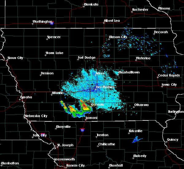 At 1003 pm cdt, a severe thunderstorm was located 9 miles northwest of lakeside casino, or 10 miles northwest of osceola, moving east at 30 mph (radar indicated). Hazards include quarter size hail. Damage to vehicles is expected. locations impacted include, osceola, murray, new virginia and truro. This includes interstate 35 between mile markers 35 and 48. At 1003 pm cdt, a severe thunderstorm was located 9 miles northwest of lakeside casino, or 10 miles northwest of osceola, moving east at 30 mph (radar indicated). Hazards include quarter size hail. Damage to vehicles is expected. locations impacted include, osceola, murray, new virginia and truro. This includes interstate 35 between mile markers 35 and 48.
|
| 6/21/2015 9:49 PM CDT |
 At 949 pm cdt, a severe thunderstorm was located 14 miles east of creston, moving east at 30 mph (radar indicated). Hazards include quarter size hail. damage to vehicles is expected At 949 pm cdt, a severe thunderstorm was located 14 miles east of creston, moving east at 30 mph (radar indicated). Hazards include quarter size hail. damage to vehicles is expected
|
| 6/14/2013 11:11 PM CDT | Trained spotter reports a couple of trees split...power lines down from falling branches...and an 8 by 12 foot section of roof removed from a home in murray. time estim in clarke county IA, 0.5 miles S of Murray, IA |
| 4/14/2012 7:29 PM CDT | Baseball sized hail reported 0.2 miles NNW of Murray, IA |
| 1/1/0001 12:00 AM | Trained spotter reports wind gusts to around 70 mph lasting for quite some time. multiple large trees down...some on houses. also dime to nickel hai in clarke county IA, 0.5 miles S of Murray, IA |
| 1/1/0001 12:00 AM | 20 by 10 foot shed blown over on its side. 50 by 12 foot mobile home suffered major roof damag in clarke county IA, 0.5 miles S of Murray, IA |
| 1/1/0001 12:00 AM | 6 foot diameter tree sheared off near the base...25 foot flag pole snapped...a few street signs mangled and numerous 2 to 4 inch diameter limbs down across tow in clarke county IA, 0.5 miles S of Murray, IA |
| 1/1/0001 12:00 AM | Ping Pong Ball sized hail reported 0.2 miles NNW of Murray, IA |
| 1/1/0001 12:00 AM | Quarter sized hail reported 0.2 miles NNW of Murray, IA, mainly nickel hail...with a few quarter sized mixed in... |
Hail Maps for Murray, IA


Connect with Interactive Hail Maps