

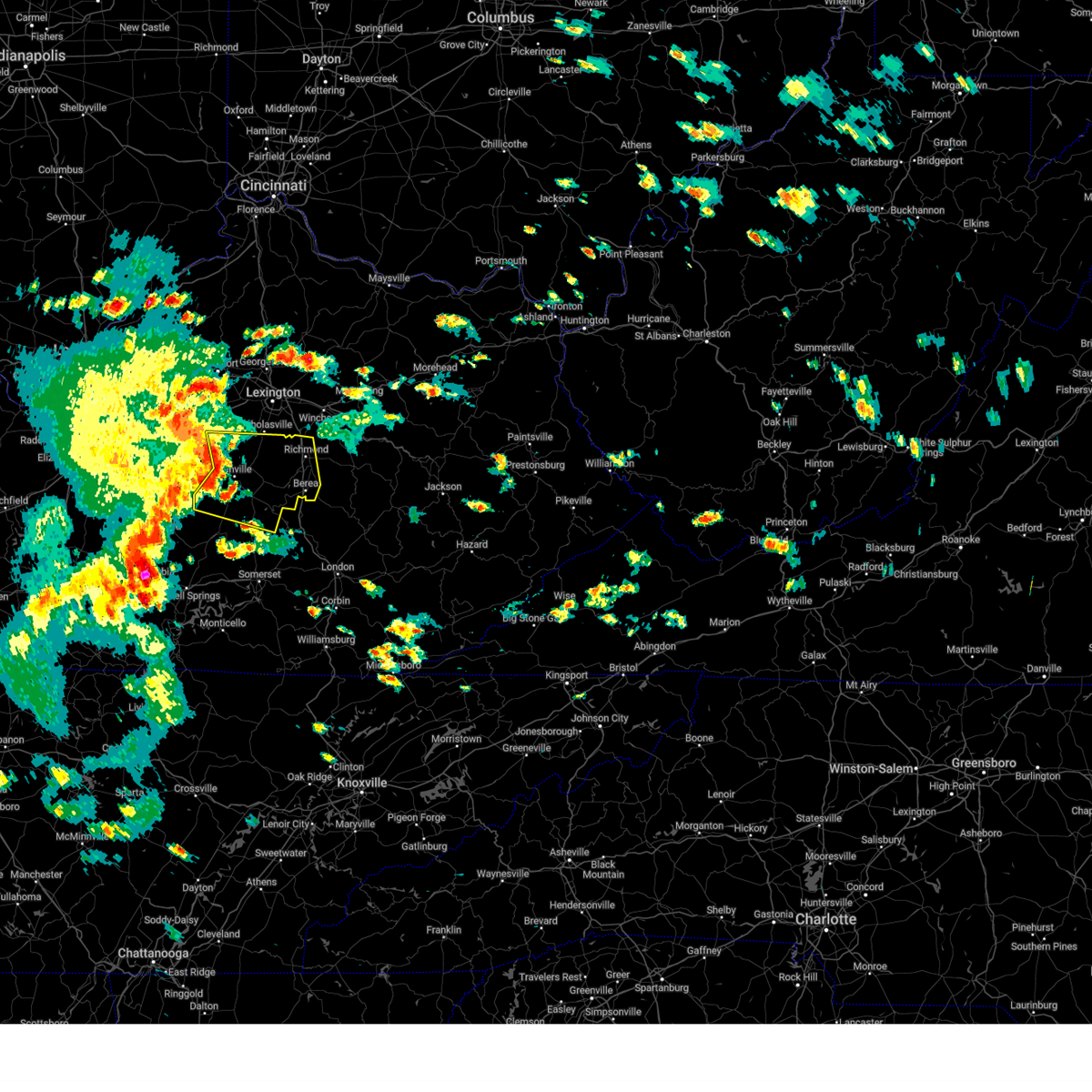
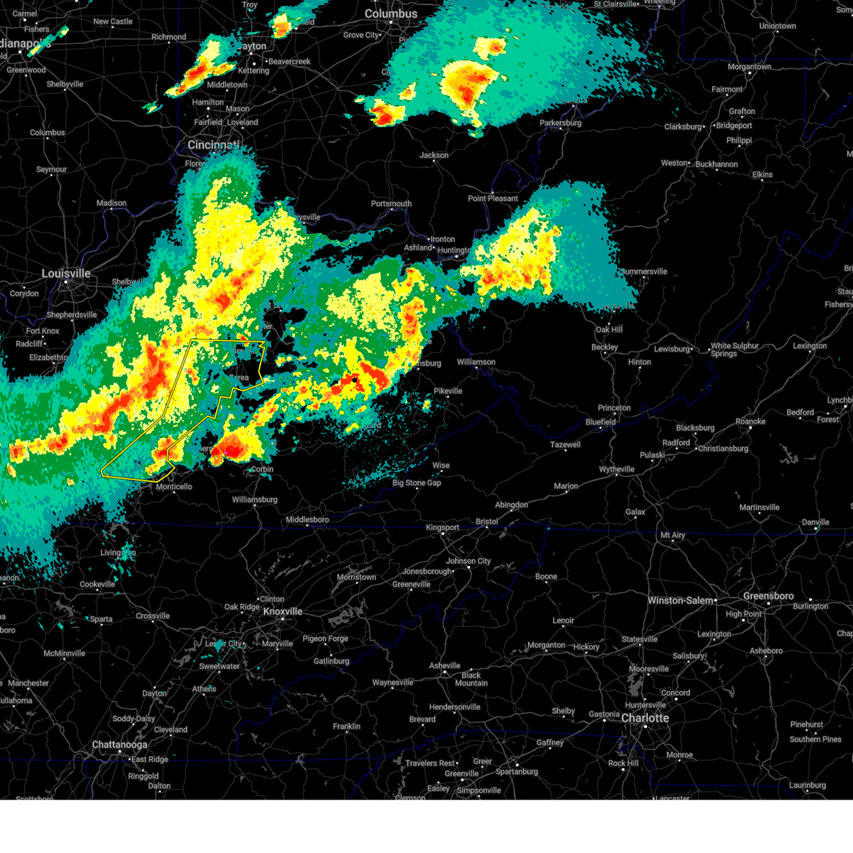
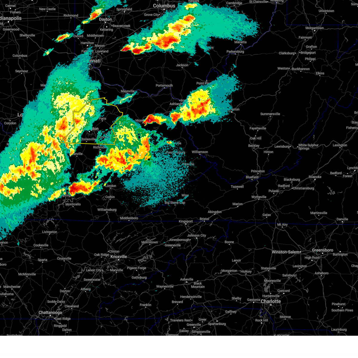
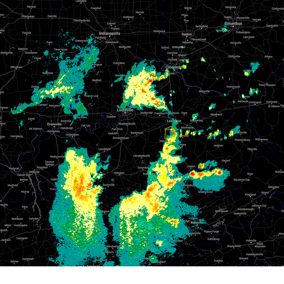
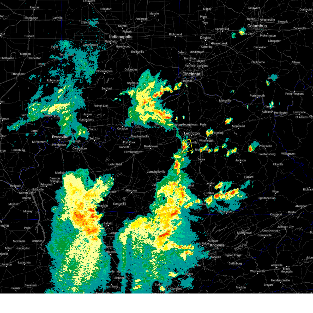
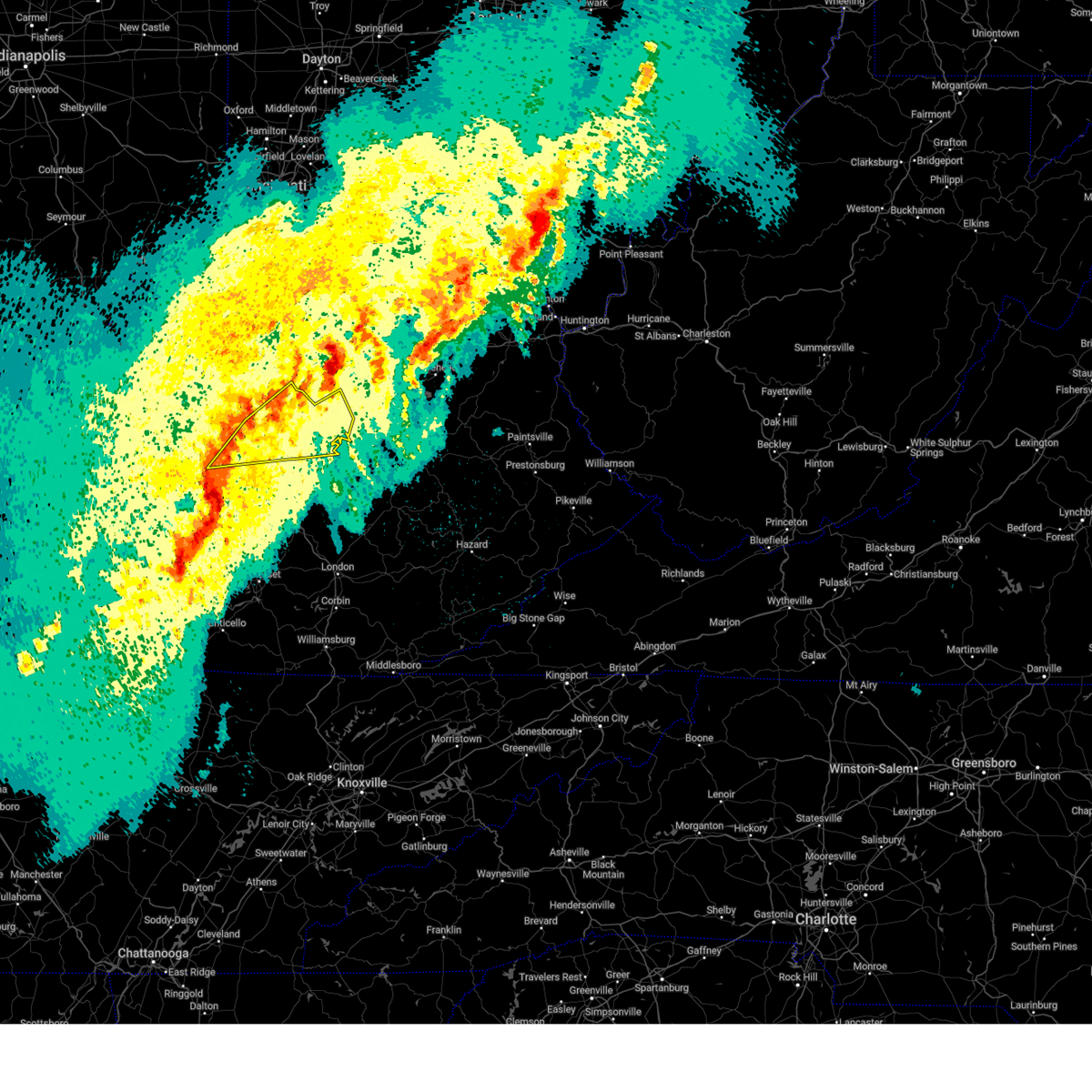
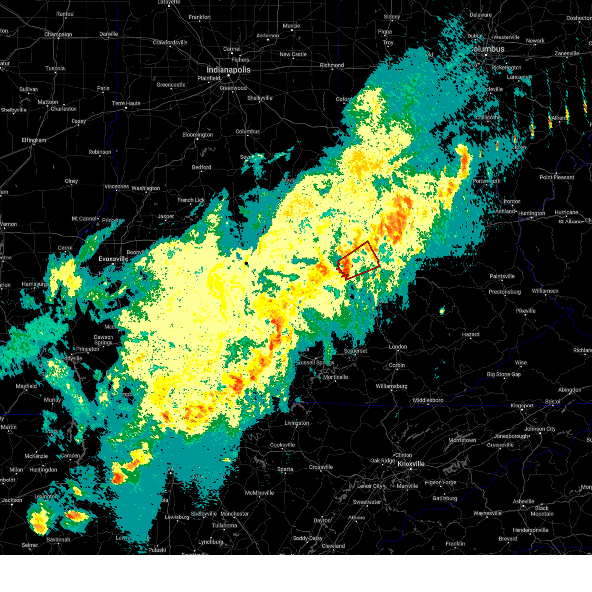
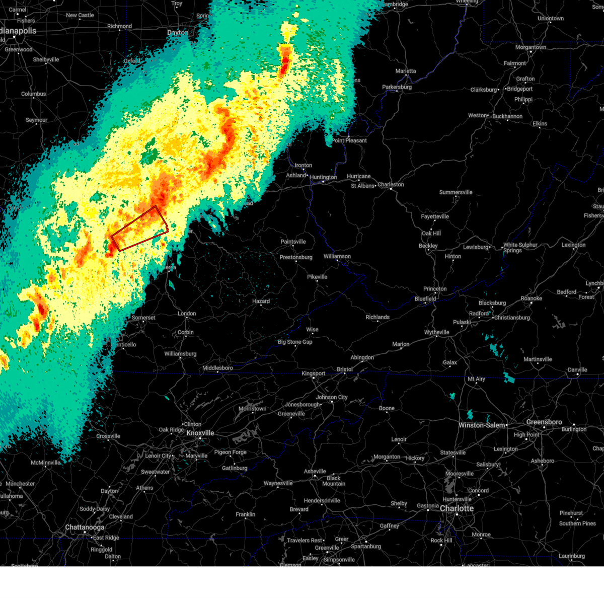
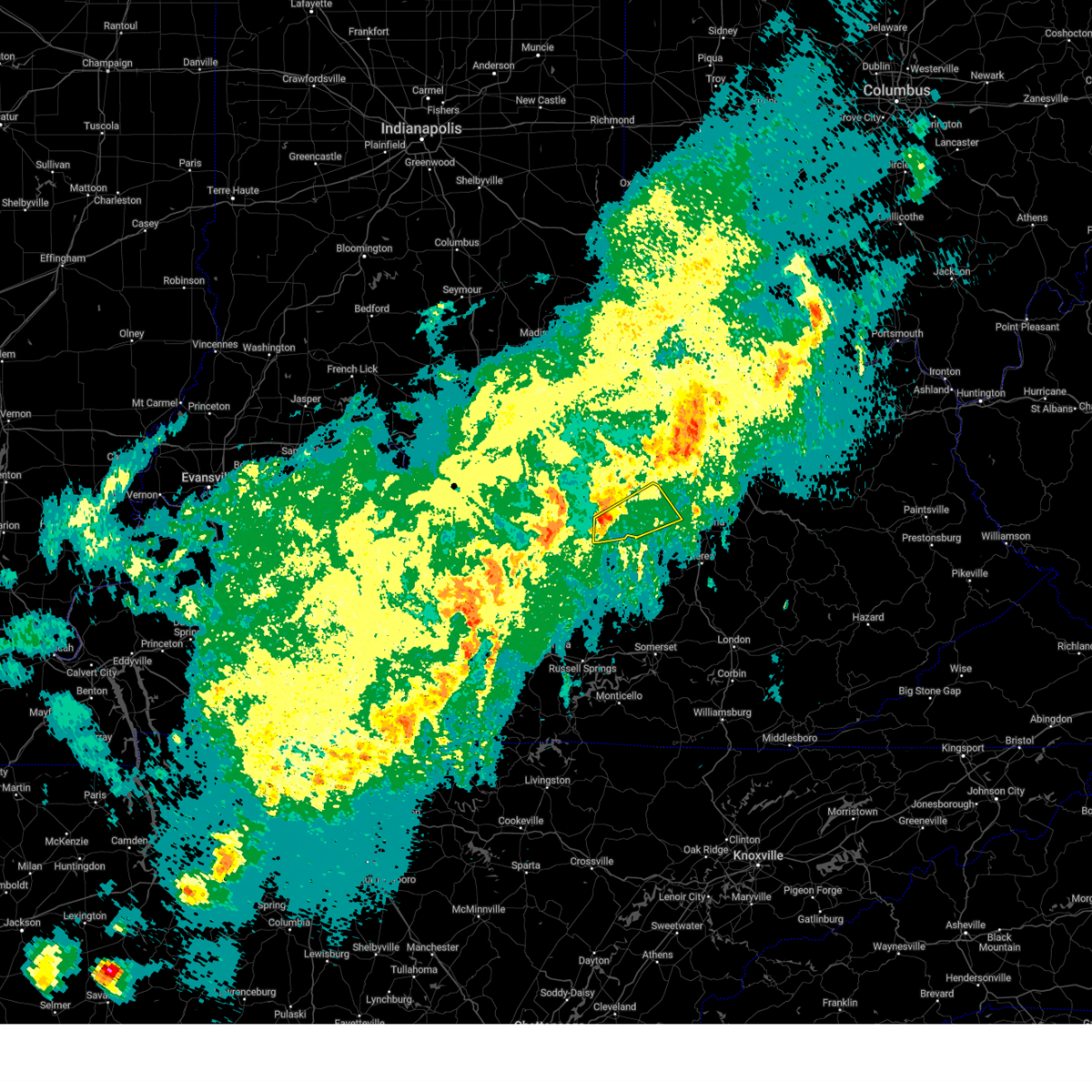
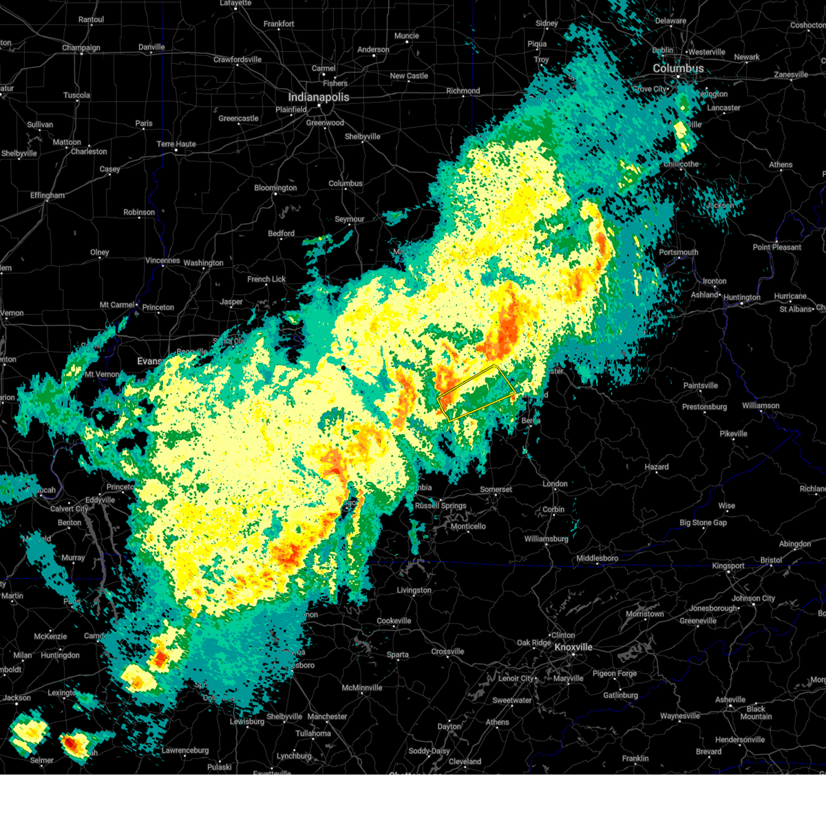
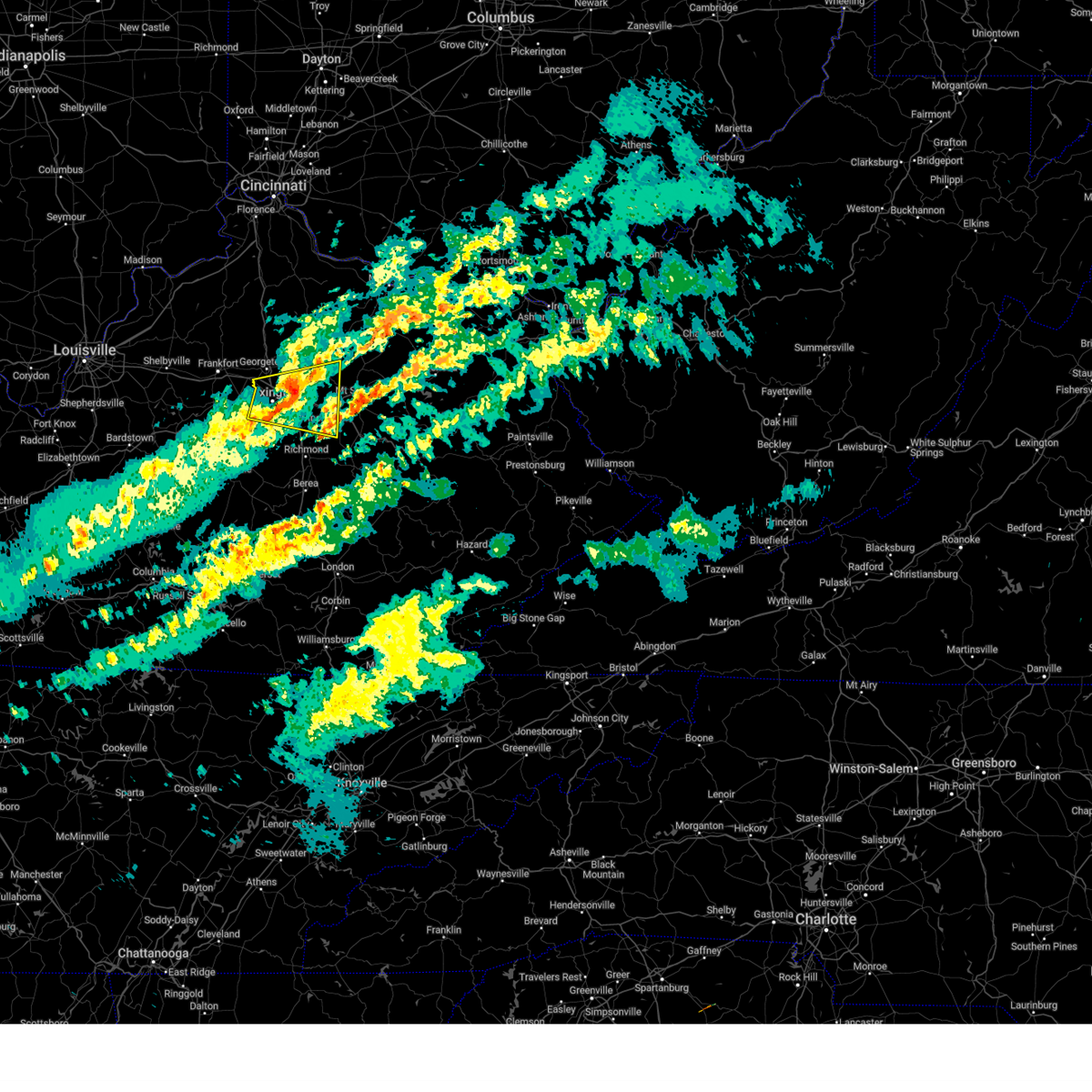
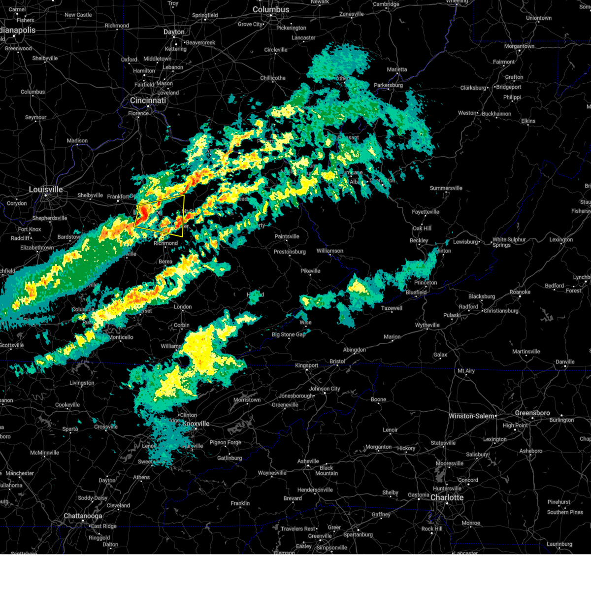
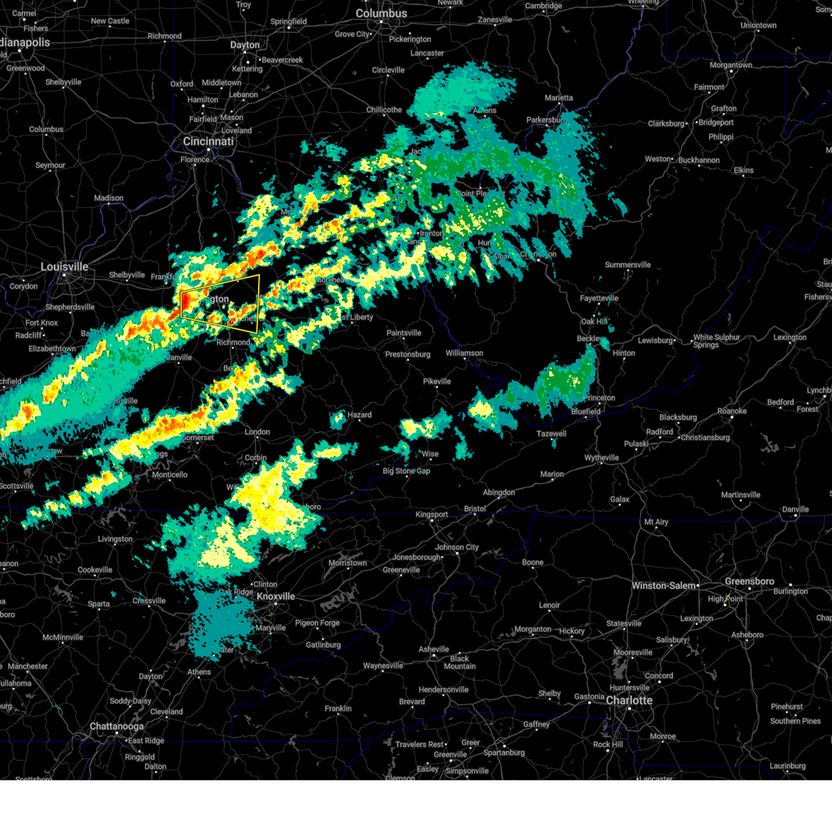
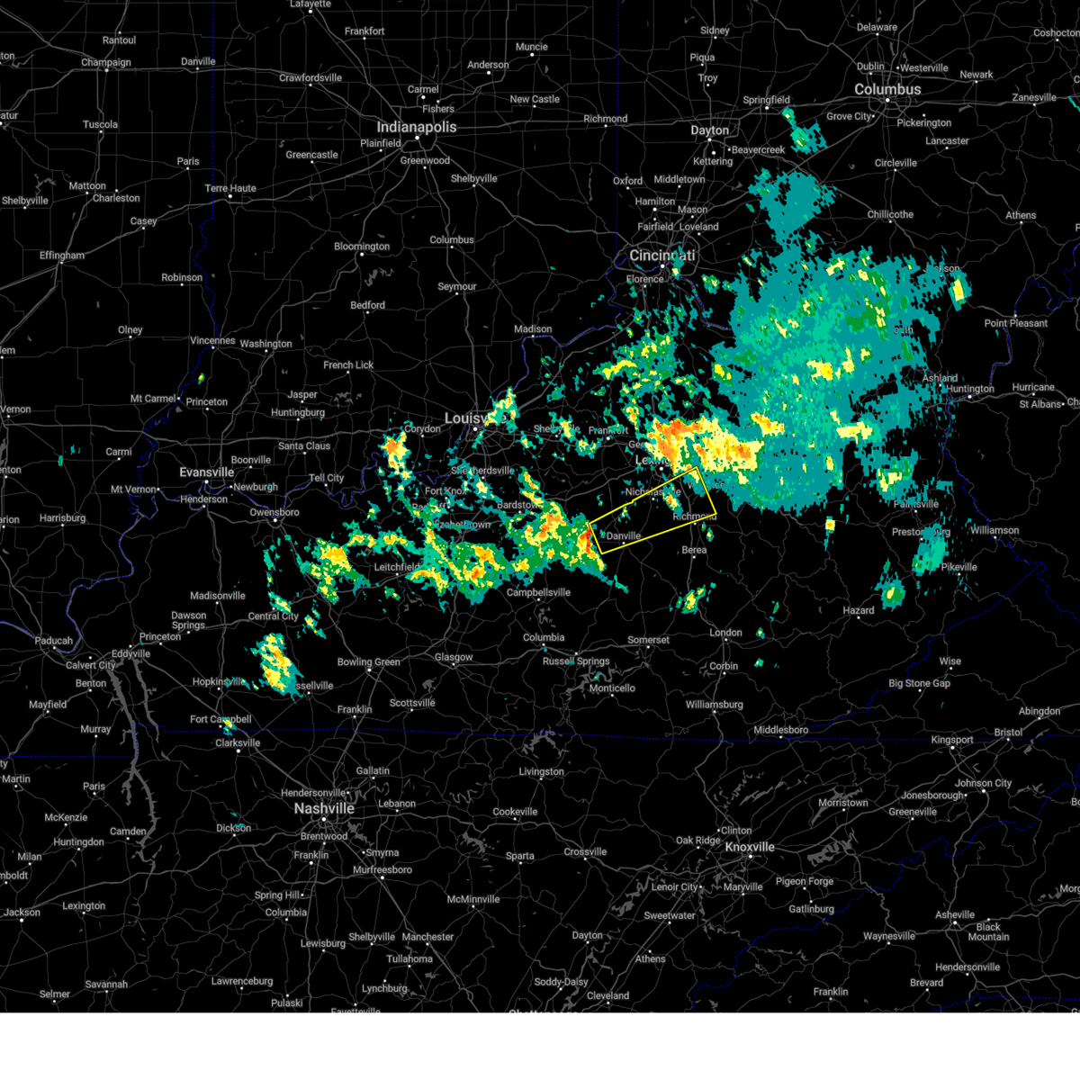
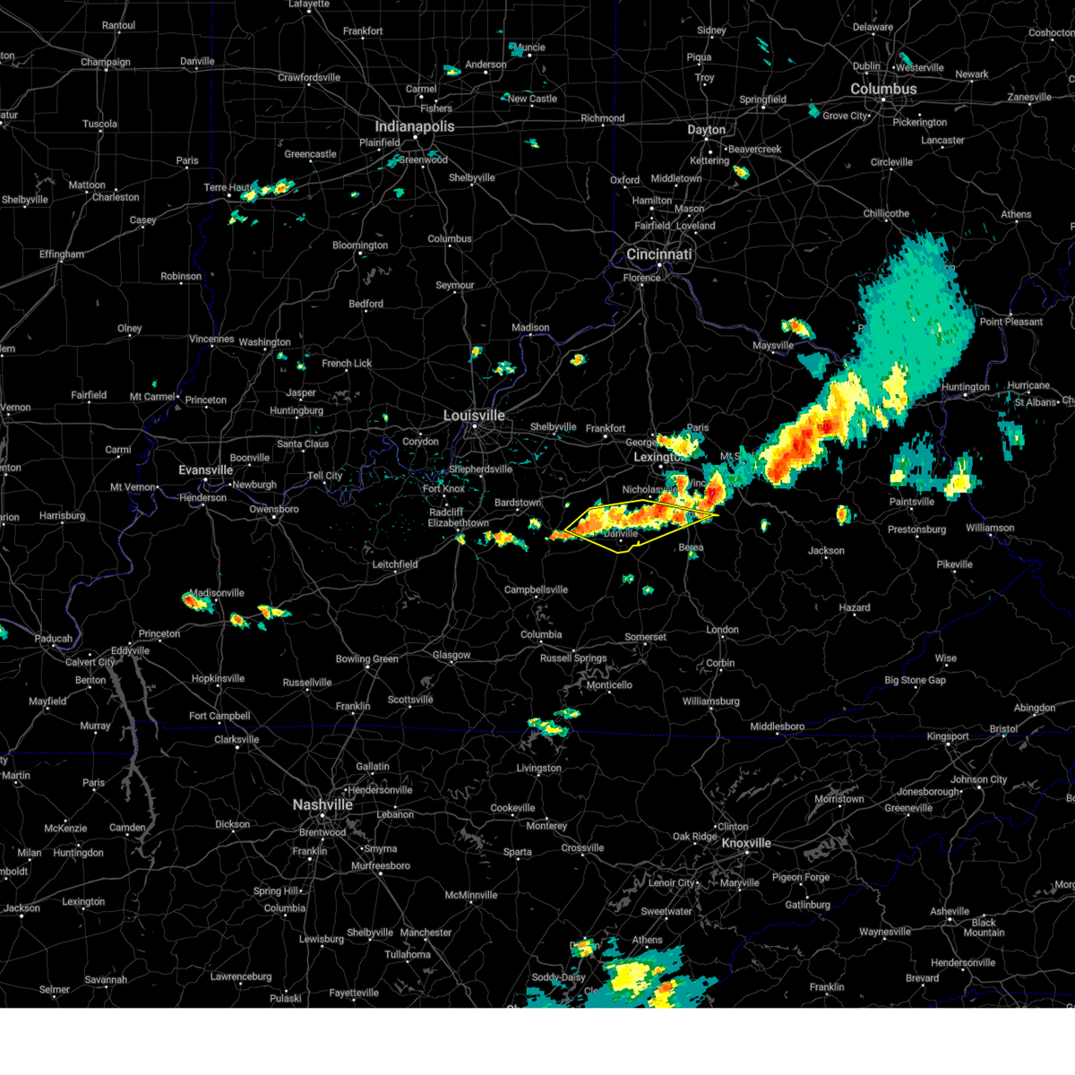
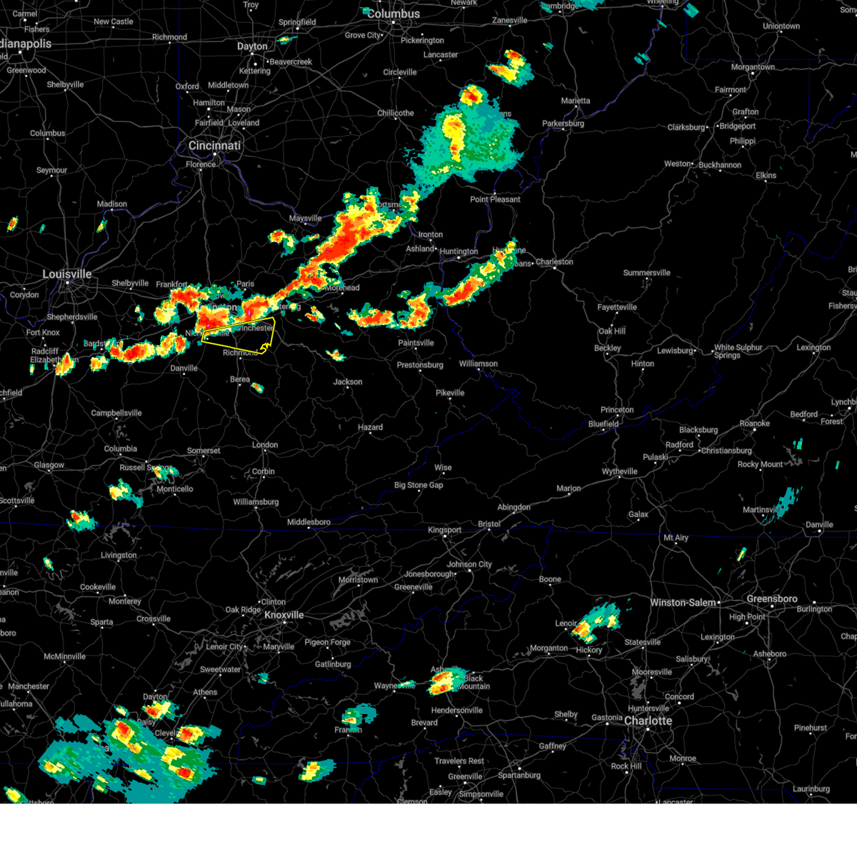
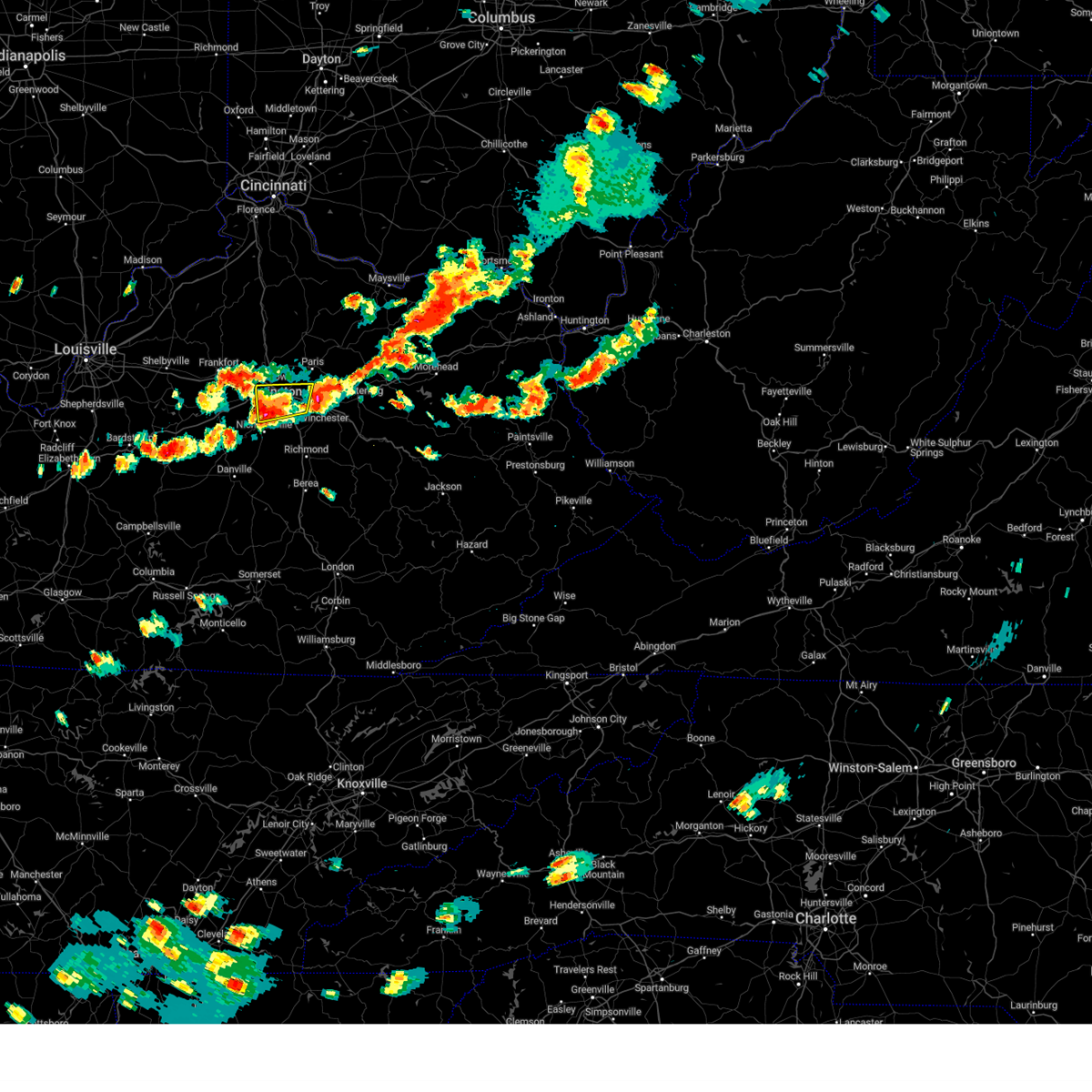
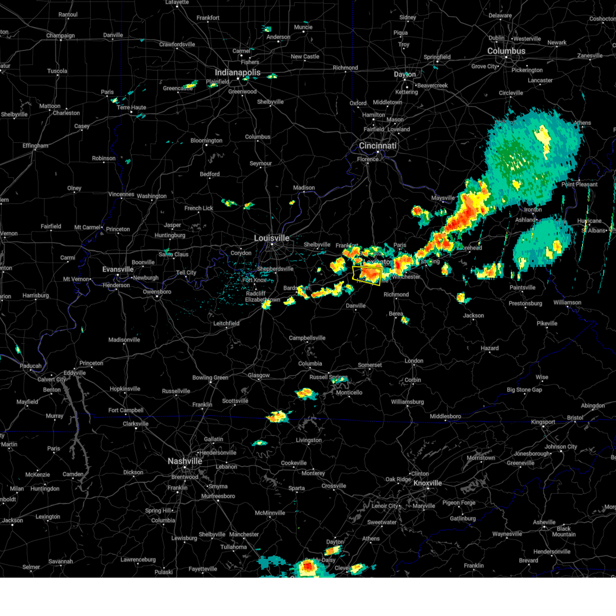
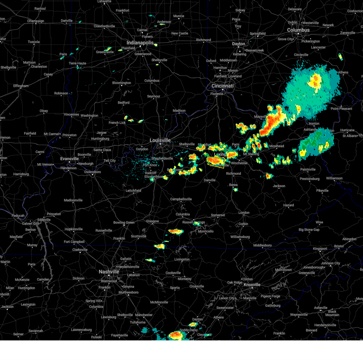
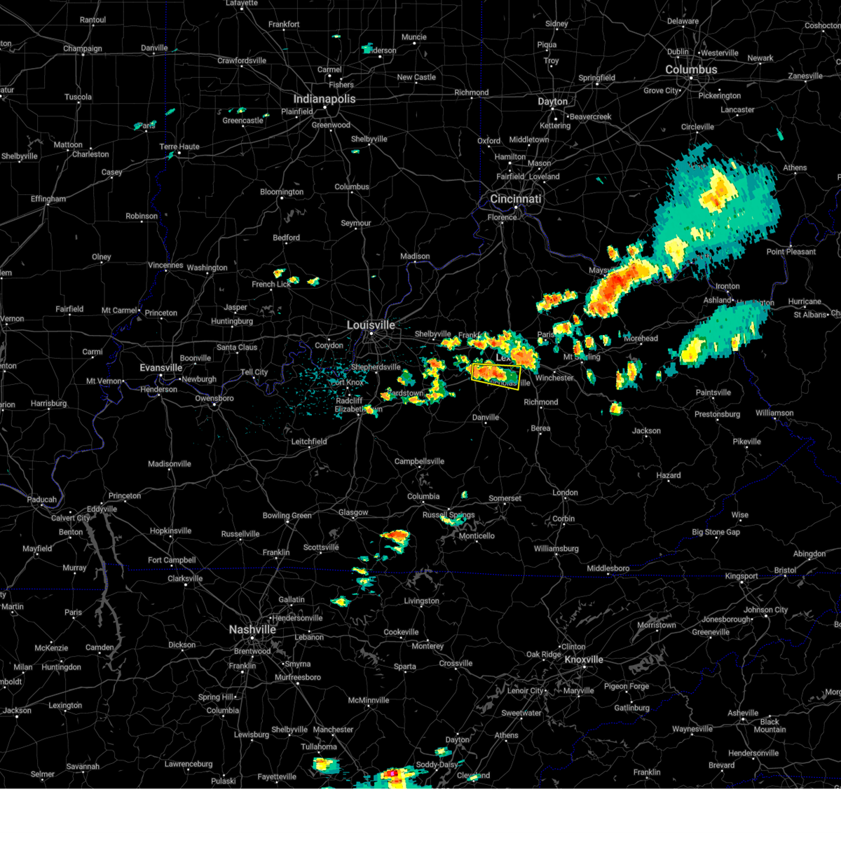
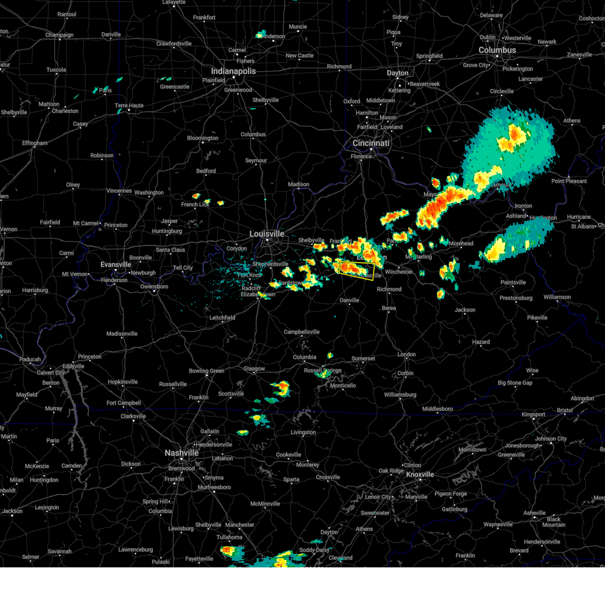
Hail Map for Nicholasville, KY
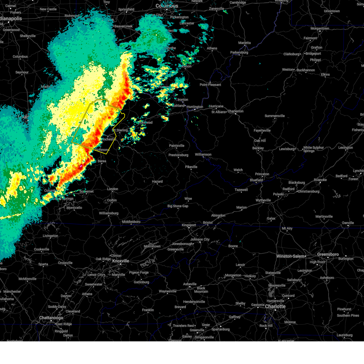
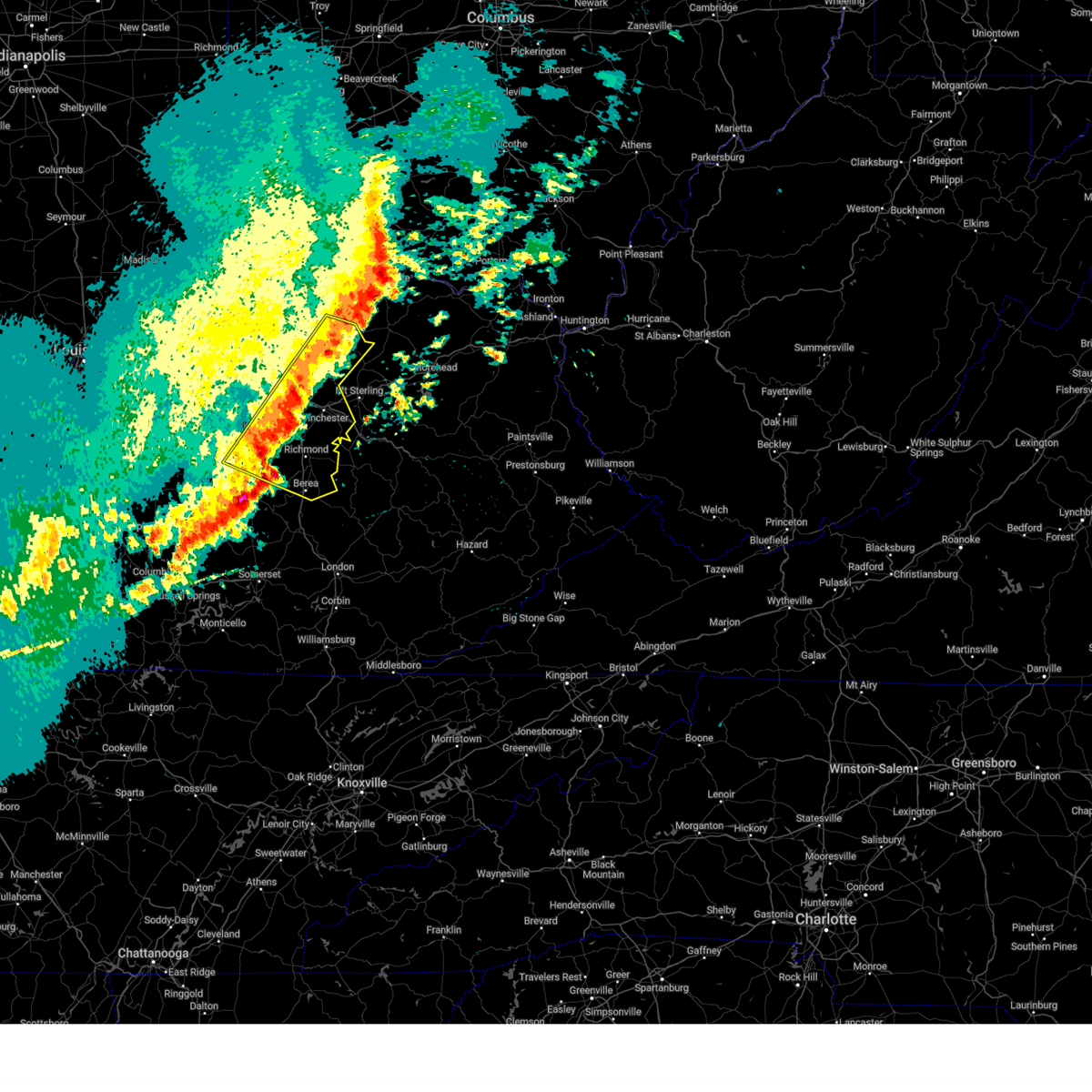
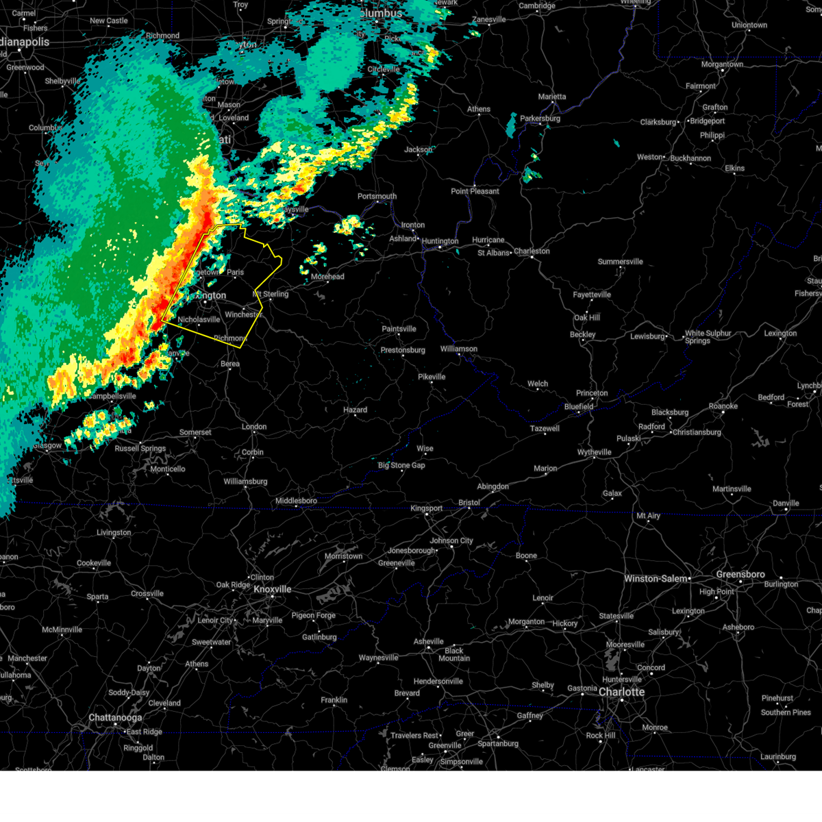
The Nicholasville, KY area has had 19 reports of on-the-ground hail by trained spotters, and has been under severe weather warnings 49 times during the past 12 months. Doppler radar has detected hail at or near Nicholasville, KY on 54 occasions, including 2 occasions during the past year.
| Name: | Nicholasville, KY |
| Where Located: | 35.2 miles WNW of Irvine, KY |
| Map: | Google Map for Nicholasville, KY |
| Population: | 28015 |
| Housing Units: | 11405 |
| More Info: | Search Google for Nicholasville, KY |
2
The Top Recent Hail Date for Nicholasville, KY is Saturday, August 17, 2024 (12th out of 54)

Hail and Wind Damage Spotted near Nicholasville, KY
| Date / Time | Report Details |
|---|---|
| 6/26/2025 6:06 PM EDT | Tree down on roadway near intersection of mason headley rd and versailles r in fayette county KY, 11.2 miles S of Nicholasville, KY |
| 6/6/2025 2:20 PM EDT |
 Svrlmk the national weather service in louisville has issued a * severe thunderstorm warning for, lincoln county in central kentucky, central mercer county in central kentucky, south central woodford county in central kentucky, garrard county in central kentucky, southern jessamine county in central kentucky, boyle county in central kentucky, madison county in central kentucky, north central casey county in central kentucky, * until 300 pm edt. * at 220 pm edt, severe thunderstorms were located along a line extending from near harrodsburg to near danville to 14 miles north of liberty, moving east at 45 mph (radar indicated). Hazards include 60 mph wind gusts. expect damage to roofs, siding, and trees Svrlmk the national weather service in louisville has issued a * severe thunderstorm warning for, lincoln county in central kentucky, central mercer county in central kentucky, south central woodford county in central kentucky, garrard county in central kentucky, southern jessamine county in central kentucky, boyle county in central kentucky, madison county in central kentucky, north central casey county in central kentucky, * until 300 pm edt. * at 220 pm edt, severe thunderstorms were located along a line extending from near harrodsburg to near danville to 14 miles north of liberty, moving east at 45 mph (radar indicated). Hazards include 60 mph wind gusts. expect damage to roofs, siding, and trees
|
| 5/30/2025 7:45 AM EDT |
 The storm which prompted the warning has weakened below severe limits, and has exited the warned area. therefore, the warning has been allowed to expire. to report severe weather, contact your nearest law enforcement agency. they will relay your report to the national weather service louisville. The storm which prompted the warning has weakened below severe limits, and has exited the warned area. therefore, the warning has been allowed to expire. to report severe weather, contact your nearest law enforcement agency. they will relay your report to the national weather service louisville.
|
| 5/30/2025 7:36 AM EDT |
 the tornado warning has been cancelled and is no longer in effect the tornado warning has been cancelled and is no longer in effect
|
| 5/30/2025 7:36 AM EDT |
 At 736 am edt, a severe thunderstorm capable of producing a tornado was located near nicholasville, moving east at 30 mph (radar indicated rotation). Hazards include tornado. Flying debris will be dangerous to those caught without shelter. mobile homes will be damaged or destroyed. damage to roofs, windows, and vehicles will occur. tree damage is likely. this dangerous storm will be near, nicholasville around 740 am edt. Other locations impacted by this tornadic thunderstorm include vineyard, jessamine, and wilmore. At 736 am edt, a severe thunderstorm capable of producing a tornado was located near nicholasville, moving east at 30 mph (radar indicated rotation). Hazards include tornado. Flying debris will be dangerous to those caught without shelter. mobile homes will be damaged or destroyed. damage to roofs, windows, and vehicles will occur. tree damage is likely. this dangerous storm will be near, nicholasville around 740 am edt. Other locations impacted by this tornadic thunderstorm include vineyard, jessamine, and wilmore.
|
| 5/30/2025 7:21 AM EDT |
 Torlmk the national weather service in louisville has issued a * tornado warning for, east central mercer county in central kentucky, northwestern garrard county in central kentucky, central jessamine county in central kentucky, * until 745 am edt. * at 720 am edt, a severe thunderstorm capable of producing a tornado was located near harrodsburg, moving east at 30 mph (radar indicated rotation). Hazards include tornado. Flying debris will be dangerous to those caught without shelter. mobile homes will be damaged or destroyed. damage to roofs, windows, and vehicles will occur. tree damage is likely. this dangerous storm will be near, nicholasville around 735 am edt. Other locations impacted by this tornadic thunderstorm include shakertown, pink, high bridge, vineyard, burgin, jessamine, little hickman, and wilmore. Torlmk the national weather service in louisville has issued a * tornado warning for, east central mercer county in central kentucky, northwestern garrard county in central kentucky, central jessamine county in central kentucky, * until 745 am edt. * at 720 am edt, a severe thunderstorm capable of producing a tornado was located near harrodsburg, moving east at 30 mph (radar indicated rotation). Hazards include tornado. Flying debris will be dangerous to those caught without shelter. mobile homes will be damaged or destroyed. damage to roofs, windows, and vehicles will occur. tree damage is likely. this dangerous storm will be near, nicholasville around 735 am edt. Other locations impacted by this tornadic thunderstorm include shakertown, pink, high bridge, vineyard, burgin, jessamine, little hickman, and wilmore.
|
| 5/16/2025 11:14 PM EDT |
 Svrlmk the national weather service in louisville has issued a * severe thunderstorm warning for, lincoln county in central kentucky, southeastern mercer county in central kentucky, garrard county in central kentucky, russell county in south central kentucky, southern jessamine county in central kentucky, eastern boyle county in central kentucky, madison county in central kentucky, casey county in central kentucky, southern adair county in south central kentucky, * until midnight edt/1100 pm cdt/. * at 1113 pm edt/1013 pm cdt/, severe thunderstorms were located along a line extending from 6 miles west of nicholasville to 10 miles southwest of danville to near greensburg, moving east at 75 mph (radar indicated). Hazards include 70 mph wind gusts and quarter size hail. Hail damage to vehicles is expected. expect considerable tree damage. Wind damage is also likely to mobile homes, roofs, and outbuildings. Svrlmk the national weather service in louisville has issued a * severe thunderstorm warning for, lincoln county in central kentucky, southeastern mercer county in central kentucky, garrard county in central kentucky, russell county in south central kentucky, southern jessamine county in central kentucky, eastern boyle county in central kentucky, madison county in central kentucky, casey county in central kentucky, southern adair county in south central kentucky, * until midnight edt/1100 pm cdt/. * at 1113 pm edt/1013 pm cdt/, severe thunderstorms were located along a line extending from 6 miles west of nicholasville to 10 miles southwest of danville to near greensburg, moving east at 75 mph (radar indicated). Hazards include 70 mph wind gusts and quarter size hail. Hail damage to vehicles is expected. expect considerable tree damage. Wind damage is also likely to mobile homes, roofs, and outbuildings.
|
| 5/16/2025 10:43 PM EDT |
 Svrlmk the national weather service in louisville has issued a * severe thunderstorm warning for, southeastern anderson county in central kentucky, clark county in central kentucky, jessamine county in central kentucky, nicholas county in central kentucky, harrison county in central kentucky, northeastern franklin county in central kentucky, northern mercer county in central kentucky, woodford county in central kentucky, scott county in central kentucky, bourbon county in central kentucky, northeastern washington county in central kentucky, northern madison county in central kentucky, fayette county in central kentucky, * until 1130 pm edt. * at 1042 pm edt, severe thunderstorms were located along a line extending from 8 miles northwest of owenton to 7 miles northwest of lawrenceburg to 12 miles north of springfield, moving east at 70 mph (radar indicated). Hazards include 70 mph wind gusts and penny size hail. Expect considerable tree damage. Damage is likely to mobile homes, roofs, and outbuildings. Svrlmk the national weather service in louisville has issued a * severe thunderstorm warning for, southeastern anderson county in central kentucky, clark county in central kentucky, jessamine county in central kentucky, nicholas county in central kentucky, harrison county in central kentucky, northeastern franklin county in central kentucky, northern mercer county in central kentucky, woodford county in central kentucky, scott county in central kentucky, bourbon county in central kentucky, northeastern washington county in central kentucky, northern madison county in central kentucky, fayette county in central kentucky, * until 1130 pm edt. * at 1042 pm edt, severe thunderstorms were located along a line extending from 8 miles northwest of owenton to 7 miles northwest of lawrenceburg to 12 miles north of springfield, moving east at 70 mph (radar indicated). Hazards include 70 mph wind gusts and penny size hail. Expect considerable tree damage. Damage is likely to mobile homes, roofs, and outbuildings.
|
| 5/2/2025 5:15 PM EDT |
 The storm which prompted the warning has weakened below severe limits, and has exited the warned area. therefore, the warning has been allowed to expire. a severe thunderstorm watch remains in effect until 900 pm edt for central kentucky. to report severe weather, contact your nearest law enforcement agency. they will relay your report to the national weather service louisville. The storm which prompted the warning has weakened below severe limits, and has exited the warned area. therefore, the warning has been allowed to expire. a severe thunderstorm watch remains in effect until 900 pm edt for central kentucky. to report severe weather, contact your nearest law enforcement agency. they will relay your report to the national weather service louisville.
|
| 5/2/2025 4:58 PM EDT |
 At 458 pm edt, a severe thunderstorm was located near nicholasville, moving east at 35 mph (radar indicated). Hazards include 60 mph wind gusts and quarter size hail. Hail damage to vehicles is expected. expect wind damage to roofs, siding, and trees. Locations impacted include, nicholasville, wilmore, shakertown, bushtown, jessamine, little hickman, troy, keene, pink, and dixon town. At 458 pm edt, a severe thunderstorm was located near nicholasville, moving east at 35 mph (radar indicated). Hazards include 60 mph wind gusts and quarter size hail. Hail damage to vehicles is expected. expect wind damage to roofs, siding, and trees. Locations impacted include, nicholasville, wilmore, shakertown, bushtown, jessamine, little hickman, troy, keene, pink, and dixon town.
|
| 5/2/2025 4:38 PM EDT | Svrlmk the national weather service in louisville has issued a * severe thunderstorm warning for, central mercer county in central kentucky, southeastern woodford county in central kentucky, northwestern garrard county in central kentucky, jessamine county in central kentucky, * until 515 pm edt. * at 438 pm edt, a severe thunderstorm was located over harrodsburg, moving east at 35 mph (radar indicated). Hazards include 60 mph wind gusts and quarter size hail. Hail damage to vehicles is expected. Expect wind damage to roofs, siding, and trees. |
| 4/29/2025 6:23 PM EDT | Svrlmk the national weather service in louisville has issued a * severe thunderstorm warning for, mercer county in central kentucky, southern woodford county in central kentucky, northwestern garrard county in central kentucky, jessamine county in central kentucky, west central madison county in central kentucky, southwestern fayette county in central kentucky, * until 700 pm edt. * at 622 pm edt, a severe thunderstorm was located 7 miles north of harrodsburg, moving east at 40 mph (radar indicated). Hazards include 60 mph wind gusts and quarter size hail. Hail damage to vehicles is expected. Expect wind damage to roofs, siding, and trees. |
| 4/3/2025 2:53 AM EDT |
 Svrlmk the national weather service in louisville has issued a * severe thunderstorm warning for, southeastern mercer county in central kentucky, southeastern woodford county in central kentucky, northwestern garrard county in central kentucky, clark county in central kentucky, jessamine county in central kentucky, north central boyle county in central kentucky, northern madison county in central kentucky, fayette county in central kentucky, * until 345 am edt. * at 253 am edt, a severe thunderstorm was located near nicholasville, moving east at 60 mph (radar indicated). Hazards include 70 mph wind gusts. Expect considerable tree damage. Damage is likely to mobile homes, roofs, and outbuildings. Svrlmk the national weather service in louisville has issued a * severe thunderstorm warning for, southeastern mercer county in central kentucky, southeastern woodford county in central kentucky, northwestern garrard county in central kentucky, clark county in central kentucky, jessamine county in central kentucky, north central boyle county in central kentucky, northern madison county in central kentucky, fayette county in central kentucky, * until 345 am edt. * at 253 am edt, a severe thunderstorm was located near nicholasville, moving east at 60 mph (radar indicated). Hazards include 70 mph wind gusts. Expect considerable tree damage. Damage is likely to mobile homes, roofs, and outbuildings.
|
| 4/3/2025 2:37 AM EDT | The storm which prompted the warning has weakened below severe limits, and no longer appears capable of producing a tornado. therefore, the warning will be allowed to expire. however, gusty winds and heavy rain are still possible with this thunderstorm. a tornado watch remains in effect until 700 am edt for central kentucky. |
| 4/3/2025 2:36 AM EDT | Quarter sized hail reported 12.4 miles SSW of Nicholasville, KY |
| 4/3/2025 2:33 AM EDT | At 233 am edt, a severe thunderstorm capable of producing a tornado was located over cardinal hill, moving northeast at 65 mph (radar indicated rotation). Hazards include tornado. Flying debris will be dangerous to those caught without shelter. mobile homes will be damaged or destroyed. damage to roofs, windows, and vehicles will occur. tree damage is likely. this dangerous storm will be near, lexington, bryan station, thoroughbred acres, and cadentown around 240 am edt. Other locations impacted by this tornadic thunderstorm include viley, elmendorf, chilesburg, spindletop estates, yarnallton, coletown, blue grass airport, athens, elk chester, and east hickman. |
| 4/3/2025 2:33 AM EDT | the tornado warning has been cancelled and is no longer in effect |
| 4/3/2025 2:29 AM EDT |
 The storm which prompted the warning has moved out of the area. therefore, the warning will be allowed to expire. a tornado watch remains in effect until 700 am edt for central kentucky. The storm which prompted the warning has moved out of the area. therefore, the warning will be allowed to expire. a tornado watch remains in effect until 700 am edt for central kentucky.
|
| 4/3/2025 2:23 AM EDT |
 At 223 am edt, a severe thunderstorm capable of producing a tornado was located 7 miles south of versailles, moving northeast at 65 mph (radar indicated rotation). Hazards include tornado. Flying debris will be dangerous to those caught without shelter. mobile homes will be damaged or destroyed. damage to roofs, windows, and vehicles will occur. tree damage is likely. this dangerous storm will be near, lexington, meadowthorpe, fayette mall, u k arboretum, dunbar high school, chevy chase, and cardinal hill around 230 am edt. northland, highlands, bryan station, thoroughbred acres, and cadentown around 235 am edt. Other locations impacted by this tornadic thunderstorm include viley, chilesburg, spindletop estates, coletown, jessamine, dixon town, high bridge, pisgah, holiday hills, and nealton. At 223 am edt, a severe thunderstorm capable of producing a tornado was located 7 miles south of versailles, moving northeast at 65 mph (radar indicated rotation). Hazards include tornado. Flying debris will be dangerous to those caught without shelter. mobile homes will be damaged or destroyed. damage to roofs, windows, and vehicles will occur. tree damage is likely. this dangerous storm will be near, lexington, meadowthorpe, fayette mall, u k arboretum, dunbar high school, chevy chase, and cardinal hill around 230 am edt. northland, highlands, bryan station, thoroughbred acres, and cadentown around 235 am edt. Other locations impacted by this tornadic thunderstorm include viley, chilesburg, spindletop estates, coletown, jessamine, dixon town, high bridge, pisgah, holiday hills, and nealton.
|
| 4/3/2025 2:23 AM EDT |
 the tornado warning has been cancelled and is no longer in effect the tornado warning has been cancelled and is no longer in effect
|
| 4/3/2025 2:13 AM EDT |
 Torlmk the national weather service in louisville has issued a * tornado warning for, central mercer county in central kentucky, southern woodford county in central kentucky, southeastern anderson county in central kentucky, northern jessamine county in central kentucky, fayette county in central kentucky, * until 245 am edt. * at 213 am edt, a severe thunderstorm capable of producing a tornado was located near harrodsburg, moving northeast at 65 mph (radar indicated rotation). Hazards include tornado. Flying debris will be dangerous to those caught without shelter. mobile homes will be damaged or destroyed. damage to roofs, windows, and vehicles will occur. tree damage is likely. this dangerous storm will be near, lexington around 225 am edt. fayette mall, u k arboretum, dunbar high school, and cardinal hill around 230 am edt. northland, meadowthorpe, veterans park, thoroughbred acres, cadentown, and chevy chase around 235 am edt. bryan station around 240 am edt. Other locations impacted by this tornadic thunderstorm include viley, chilesburg, spindletop estates, terrapin, dixon town, high bridge, pisgah, mundys landing, bracktown, and nevin. Torlmk the national weather service in louisville has issued a * tornado warning for, central mercer county in central kentucky, southern woodford county in central kentucky, southeastern anderson county in central kentucky, northern jessamine county in central kentucky, fayette county in central kentucky, * until 245 am edt. * at 213 am edt, a severe thunderstorm capable of producing a tornado was located near harrodsburg, moving northeast at 65 mph (radar indicated rotation). Hazards include tornado. Flying debris will be dangerous to those caught without shelter. mobile homes will be damaged or destroyed. damage to roofs, windows, and vehicles will occur. tree damage is likely. this dangerous storm will be near, lexington around 225 am edt. fayette mall, u k arboretum, dunbar high school, and cardinal hill around 230 am edt. northland, meadowthorpe, veterans park, thoroughbred acres, cadentown, and chevy chase around 235 am edt. bryan station around 240 am edt. Other locations impacted by this tornadic thunderstorm include viley, chilesburg, spindletop estates, terrapin, dixon town, high bridge, pisgah, mundys landing, bracktown, and nevin.
|
| 4/3/2025 2:11 AM EDT |
 At 211 am edt, a severe thunderstorm was located near harrodsburg, moving northeast at 65 mph (radar indicated). Hazards include 60 mph wind gusts and penny size hail. Expect damage to roofs, siding, and trees. Locations impacted include, nicholasville, harrodsburg, wilmore, burgin, talmage, riverview estates, jessamine, dixville, stewart, and little hickman. At 211 am edt, a severe thunderstorm was located near harrodsburg, moving northeast at 65 mph (radar indicated). Hazards include 60 mph wind gusts and penny size hail. Expect damage to roofs, siding, and trees. Locations impacted include, nicholasville, harrodsburg, wilmore, burgin, talmage, riverview estates, jessamine, dixville, stewart, and little hickman.
|
| 4/3/2025 2:11 AM EDT |
 the severe thunderstorm warning has been cancelled and is no longer in effect the severe thunderstorm warning has been cancelled and is no longer in effect
|
| 4/3/2025 2:07 AM EDT |
 Svrlmk the national weather service in louisville has issued a * severe thunderstorm warning for, mercer county in central kentucky, southeastern woodford county in central kentucky, northwestern garrard county in central kentucky, jessamine county in central kentucky, southeastern washington county in central kentucky, northwestern boyle county in central kentucky, west central madison county in central kentucky, * until 230 am edt. * at 206 am edt, a severe thunderstorm was located 8 miles southwest of harrodsburg, moving northeast at 65 mph (radar indicated). Hazards include 60 mph wind gusts and penny size hail. expect damage to roofs, siding, and trees Svrlmk the national weather service in louisville has issued a * severe thunderstorm warning for, mercer county in central kentucky, southeastern woodford county in central kentucky, northwestern garrard county in central kentucky, jessamine county in central kentucky, southeastern washington county in central kentucky, northwestern boyle county in central kentucky, west central madison county in central kentucky, * until 230 am edt. * at 206 am edt, a severe thunderstorm was located 8 miles southwest of harrodsburg, moving northeast at 65 mph (radar indicated). Hazards include 60 mph wind gusts and penny size hail. expect damage to roofs, siding, and trees
|
| 3/30/2025 11:28 PM EDT |
 The storms which prompted the warning have moved out of the area. therefore, the warning will be allowed to expire. another warning has been issued downstream. a tornado watch remains in effect until 100 am edt for central kentucky. The storms which prompted the warning have moved out of the area. therefore, the warning will be allowed to expire. another warning has been issued downstream. a tornado watch remains in effect until 100 am edt for central kentucky.
|
| 3/30/2025 11:27 PM EDT |
 Svrlmk the national weather service in louisville has issued a * severe thunderstorm warning for, southeastern mercer county in central kentucky, garrard county in central kentucky, clark county in central kentucky, jessamine county in central kentucky, bourbon county in central kentucky, northeastern boyle county in central kentucky, nicholas county in central kentucky, madison county in central kentucky, fayette county in central kentucky, southeastern harrison county in central kentucky, * until midnight edt. * at 1127 pm edt, severe thunderstorms were located along a line extending from near fairview to 6 miles southeast of veterans park, moving east at 60 mph (radar indicated). Hazards include 60 mph wind gusts and penny size hail. expect damage to roofs, siding, and trees Svrlmk the national weather service in louisville has issued a * severe thunderstorm warning for, southeastern mercer county in central kentucky, garrard county in central kentucky, clark county in central kentucky, jessamine county in central kentucky, bourbon county in central kentucky, northeastern boyle county in central kentucky, nicholas county in central kentucky, madison county in central kentucky, fayette county in central kentucky, southeastern harrison county in central kentucky, * until midnight edt. * at 1127 pm edt, severe thunderstorms were located along a line extending from near fairview to 6 miles southeast of veterans park, moving east at 60 mph (radar indicated). Hazards include 60 mph wind gusts and penny size hail. expect damage to roofs, siding, and trees
|
| 3/30/2025 10:50 PM EDT |
 Svrlmk the national weather service in louisville has issued a * severe thunderstorm warning for, northeastern mercer county in central kentucky, woodford county in central kentucky, scott county in central kentucky, east central anderson county in central kentucky, clark county in central kentucky, jessamine county in central kentucky, bourbon county in central kentucky, nicholas county in central kentucky, northern madison county in central kentucky, fayette county in central kentucky, harrison county in central kentucky, * until 1130 pm edt. * at 1050 pm edt, severe thunderstorms were located along a line extending from 10 miles northwest of cynthiana to near georgetown to near lawrenceburg, moving east at 60 mph (radar indicated). Hazards include 60 mph wind gusts and nickel size hail. expect damage to roofs, siding, and trees Svrlmk the national weather service in louisville has issued a * severe thunderstorm warning for, northeastern mercer county in central kentucky, woodford county in central kentucky, scott county in central kentucky, east central anderson county in central kentucky, clark county in central kentucky, jessamine county in central kentucky, bourbon county in central kentucky, nicholas county in central kentucky, northern madison county in central kentucky, fayette county in central kentucky, harrison county in central kentucky, * until 1130 pm edt. * at 1050 pm edt, severe thunderstorms were located along a line extending from 10 miles northwest of cynthiana to near georgetown to near lawrenceburg, moving east at 60 mph (radar indicated). Hazards include 60 mph wind gusts and nickel size hail. expect damage to roofs, siding, and trees
|
| 3/23/2025 9:51 PM EDT |
 The storm which prompted the warning has weakened below severe limits, and no longer poses an immediate threat to life or property. therefore, the warning will be allowed to expire. however, gusty winds and heavy rain are still possible with this thunderstorm. to report severe weather, contact your nearest law enforcement agency. they will relay your report to the national weather service louisville. The storm which prompted the warning has weakened below severe limits, and no longer poses an immediate threat to life or property. therefore, the warning will be allowed to expire. however, gusty winds and heavy rain are still possible with this thunderstorm. to report severe weather, contact your nearest law enforcement agency. they will relay your report to the national weather service louisville.
|
| 3/23/2025 9:44 PM EDT |
 At 944 pm edt, a severe thunderstorm was located over chevy chase, moving east at 60 mph (radar indicated). Hazards include 60 mph wind gusts and nickel size hail. Expect damage to roofs, siding, and trees. Locations impacted include, lexington, nicholasville, winchester, paris, meadowthorpe, dunbar high school, thoroughbred acres, cardinal hill, cadentown, and northland. At 944 pm edt, a severe thunderstorm was located over chevy chase, moving east at 60 mph (radar indicated). Hazards include 60 mph wind gusts and nickel size hail. Expect damage to roofs, siding, and trees. Locations impacted include, lexington, nicholasville, winchester, paris, meadowthorpe, dunbar high school, thoroughbred acres, cardinal hill, cadentown, and northland.
|
| 3/23/2025 9:44 PM EDT |
 the severe thunderstorm warning has been cancelled and is no longer in effect the severe thunderstorm warning has been cancelled and is no longer in effect
|
| 3/23/2025 9:34 PM EDT |
 Svrlmk the national weather service in louisville has issued a * severe thunderstorm warning for, northeastern woodford county in central kentucky, south central scott county in central kentucky, clark county in central kentucky, northern jessamine county in central kentucky, southern bourbon county in central kentucky, northeastern madison county in central kentucky, fayette county in central kentucky, * until 1000 pm edt. * at 934 pm edt, a severe thunderstorm was located near versailles, moving east at 60 mph (radar indicated). Hazards include 60 mph wind gusts and nickel size hail. expect damage to roofs, siding, and trees Svrlmk the national weather service in louisville has issued a * severe thunderstorm warning for, northeastern woodford county in central kentucky, south central scott county in central kentucky, clark county in central kentucky, northern jessamine county in central kentucky, southern bourbon county in central kentucky, northeastern madison county in central kentucky, fayette county in central kentucky, * until 1000 pm edt. * at 934 pm edt, a severe thunderstorm was located near versailles, moving east at 60 mph (radar indicated). Hazards include 60 mph wind gusts and nickel size hail. expect damage to roofs, siding, and trees
|
| 3/16/2025 8:46 AM EDT |
 Svrlmk the national weather service in louisville has issued a * severe thunderstorm warning for, southern scott county in central kentucky, bourbon county in central kentucky, southwestern nicholas county in central kentucky, fayette county in central kentucky, southeastern harrison county in central kentucky, * until 915 am edt. * at 845 am edt, severe thunderstorms were located along a line extending from near georgetown to lexington, moving northeast at 55 mph (radar indicated). Hazards include 60 mph wind gusts. expect damage to roofs, siding, and trees Svrlmk the national weather service in louisville has issued a * severe thunderstorm warning for, southern scott county in central kentucky, bourbon county in central kentucky, southwestern nicholas county in central kentucky, fayette county in central kentucky, southeastern harrison county in central kentucky, * until 915 am edt. * at 845 am edt, severe thunderstorms were located along a line extending from near georgetown to lexington, moving northeast at 55 mph (radar indicated). Hazards include 60 mph wind gusts. expect damage to roofs, siding, and trees
|
| 2/6/2025 12:45 AM EST |
 Svrlmk the national weather service in louisville has issued a * severe thunderstorm warning for, southern mercer county in central kentucky, northwestern garrard county in central kentucky, southwestern clark county in central kentucky, jessamine county in central kentucky, northern boyle county in central kentucky, northern madison county in central kentucky, southeastern fayette county in central kentucky, * until 115 am est. * at 1245 am est, a severe thunderstorm was located near harrodsburg, moving northeast at 75 mph (radar indicated). Hazards include 60 mph wind gusts and quarter size hail. Hail damage to vehicles is expected. Expect wind damage to roofs, siding, and trees. Svrlmk the national weather service in louisville has issued a * severe thunderstorm warning for, southern mercer county in central kentucky, northwestern garrard county in central kentucky, southwestern clark county in central kentucky, jessamine county in central kentucky, northern boyle county in central kentucky, northern madison county in central kentucky, southeastern fayette county in central kentucky, * until 115 am est. * at 1245 am est, a severe thunderstorm was located near harrodsburg, moving northeast at 75 mph (radar indicated). Hazards include 60 mph wind gusts and quarter size hail. Hail damage to vehicles is expected. Expect wind damage to roofs, siding, and trees.
|
| 8/17/2024 4:28 PM EDT |
 At 427 pm edt, severe thunderstorms were located along a line extending from 7 miles northwest of richmond to 10 miles east of springfield, moving east at 35 mph (radar indicated). Hazards include 60 mph wind gusts and quarter size hail. Hail damage to vehicles is expected. expect wind damage to roofs, siding, and trees. Locations impacted include, richmond, nicholasville, danville, harrodsburg, mccreary, wilmore, junction city, burgin, perryville, and mackville. At 427 pm edt, severe thunderstorms were located along a line extending from 7 miles northwest of richmond to 10 miles east of springfield, moving east at 35 mph (radar indicated). Hazards include 60 mph wind gusts and quarter size hail. Hail damage to vehicles is expected. expect wind damage to roofs, siding, and trees. Locations impacted include, richmond, nicholasville, danville, harrodsburg, mccreary, wilmore, junction city, burgin, perryville, and mackville.
|
| 8/17/2024 4:20 PM EDT |
 At 420 pm edt, a severe thunderstorm was located near winchester, moving east at 35 mph (radar indicated). Hazards include 70 mph wind gusts and quarter size hail. Hail damage to vehicles is expected. expect considerable tree damage. wind damage is also likely to mobile homes, roofs, and outbuildings. Locations impacted include, lexington, nicholasville, winchester, harris ferry, coletown, lyndale, redhouse, valley view, jackson ferry, and mina. At 420 pm edt, a severe thunderstorm was located near winchester, moving east at 35 mph (radar indicated). Hazards include 70 mph wind gusts and quarter size hail. Hail damage to vehicles is expected. expect considerable tree damage. wind damage is also likely to mobile homes, roofs, and outbuildings. Locations impacted include, lexington, nicholasville, winchester, harris ferry, coletown, lyndale, redhouse, valley view, jackson ferry, and mina.
|
| 8/17/2024 4:16 PM EDT |
 The storm which prompted the warning has weakened below severe limits, and has exited the warned area. therefore, the warning has been allowed to expire. however, gusty winds and heavy rain are still possible with this thunderstorm. to report severe weather, contact your nearest law enforcement agency. they will relay your report to the national weather service louisville. The storm which prompted the warning has weakened below severe limits, and has exited the warned area. therefore, the warning has been allowed to expire. however, gusty winds and heavy rain are still possible with this thunderstorm. to report severe weather, contact your nearest law enforcement agency. they will relay your report to the national weather service louisville.
|
| 8/17/2024 4:15 PM EDT |
 Svrlmk the national weather service in louisville has issued a * severe thunderstorm warning for, mercer county in central kentucky, northwestern garrard county in central kentucky, southern jessamine county in central kentucky, southeastern washington county in central kentucky, boyle county in central kentucky, central madison county in central kentucky, * until 500 pm edt. * at 415 pm edt, severe thunderstorms were located along a line extending from near nicholasville to 6 miles northeast of springfield, moving east at 35 mph (radar indicated). Hazards include 60 mph wind gusts and quarter size hail. Hail damage to vehicles is expected. Expect wind damage to roofs, siding, and trees. Svrlmk the national weather service in louisville has issued a * severe thunderstorm warning for, mercer county in central kentucky, northwestern garrard county in central kentucky, southern jessamine county in central kentucky, southeastern washington county in central kentucky, boyle county in central kentucky, central madison county in central kentucky, * until 500 pm edt. * at 415 pm edt, severe thunderstorms were located along a line extending from near nicholasville to 6 miles northeast of springfield, moving east at 35 mph (radar indicated). Hazards include 60 mph wind gusts and quarter size hail. Hail damage to vehicles is expected. Expect wind damage to roofs, siding, and trees.
|
| 8/17/2024 4:01 PM EDT | Large tree down across road on crawley lan in fayette county KY, 7.8 miles W of Nicholasville, KY |
| 8/17/2024 3:55 PM EDT |
 Svrlmk the national weather service in louisville has issued a * severe thunderstorm warning for, southern clark county in central kentucky, northeastern jessamine county in central kentucky, northern madison county in central kentucky, southeastern fayette county in central kentucky, * until 445 pm edt. * at 355 pm edt, a severe thunderstorm was located near veterans park, moving east at 35 mph (radar indicated). Hazards include 70 mph wind gusts and quarter size hail. Hail damage to vehicles is expected. expect considerable tree damage. Wind damage is also likely to mobile homes, roofs, and outbuildings. Svrlmk the national weather service in louisville has issued a * severe thunderstorm warning for, southern clark county in central kentucky, northeastern jessamine county in central kentucky, northern madison county in central kentucky, southeastern fayette county in central kentucky, * until 445 pm edt. * at 355 pm edt, a severe thunderstorm was located near veterans park, moving east at 35 mph (radar indicated). Hazards include 70 mph wind gusts and quarter size hail. Hail damage to vehicles is expected. expect considerable tree damage. Wind damage is also likely to mobile homes, roofs, and outbuildings.
|
| 8/17/2024 3:54 PM EDT | Multiple reports of tree damage and power lines down in south lexington... including on jairus driv in fayette county KY, 6.6 miles SW of Nicholasville, KY |
| 8/17/2024 3:53 PM EDT |
 At 353 pm edt, a severe thunderstorm was located over thoroughbred acres, moving east at 35 mph (radar indicated). Hazards include 60 mph wind gusts and quarter size hail. Hail damage to vehicles is expected. expect wind damage to roofs, siding, and trees. Locations impacted include, lexington, meadowthorpe, dunbar high school, thoroughbred acres, veterans park, cardinal hill, cadentown, bryan station, northland, and highlands. At 353 pm edt, a severe thunderstorm was located over thoroughbred acres, moving east at 35 mph (radar indicated). Hazards include 60 mph wind gusts and quarter size hail. Hail damage to vehicles is expected. expect wind damage to roofs, siding, and trees. Locations impacted include, lexington, meadowthorpe, dunbar high school, thoroughbred acres, veterans park, cardinal hill, cadentown, bryan station, northland, and highlands.
|
| 8/17/2024 3:53 PM EDT |
 the severe thunderstorm warning has been cancelled and is no longer in effect the severe thunderstorm warning has been cancelled and is no longer in effect
|
| 8/17/2024 3:45 PM EDT |
 The storm which prompted the warning has moved out of the area. therefore, the warning has been allowed to expire. however, gusty winds and heavy rain are still possible with this thunderstorm. to report severe weather, contact your nearest law enforcement agency. they will relay your report to the national weather service louisville. The storm which prompted the warning has moved out of the area. therefore, the warning has been allowed to expire. however, gusty winds and heavy rain are still possible with this thunderstorm. to report severe weather, contact your nearest law enforcement agency. they will relay your report to the national weather service louisville.
|
| 8/17/2024 3:43 PM EDT | Large tree branch snapped and fell onto a home in south lexingto in fayette county KY, 6 miles SSW of Nicholasville, KY |
| 8/17/2024 3:40 PM EDT | Svrlmk the national weather service in louisville has issued a * severe thunderstorm warning for, southeastern woodford county in central kentucky, northwestern clark county in central kentucky, northwestern jessamine county in central kentucky, southwestern bourbon county in central kentucky, fayette county in central kentucky, * until 415 pm edt. * at 340 pm edt, a severe thunderstorm was located over dunbar high school, moving east at 35 mph (radar indicated). Hazards include 60 mph wind gusts and quarter size hail. Hail damage to vehicles is expected. Expect wind damage to roofs, siding, and trees. |
| 8/17/2024 3:37 PM EDT | Estimated 50 to 60 mph winds from two different sources near the jessamine and fayette county lin in jessamine county KY, 6.4 miles S of Nicholasville, KY |
| 8/17/2024 3:36 PM EDT |
 the severe thunderstorm warning has been cancelled and is no longer in effect the severe thunderstorm warning has been cancelled and is no longer in effect
|
| 8/17/2024 3:36 PM EDT |
 At 336 pm edt, a severe thunderstorm was located near dunbar high school, moving east at 35 mph (radar indicated). Hazards include 60 mph wind gusts and quarter size hail. Hail damage to vehicles is expected. expect wind damage to roofs, siding, and trees. Locations impacted include, lexington, nicholasville, versailles, veterans park, dunbar high school, u k arboretum, chevy chase, fayette mall, blue grass airport, and mortonsville. At 336 pm edt, a severe thunderstorm was located near dunbar high school, moving east at 35 mph (radar indicated). Hazards include 60 mph wind gusts and quarter size hail. Hail damage to vehicles is expected. expect wind damage to roofs, siding, and trees. Locations impacted include, lexington, nicholasville, versailles, veterans park, dunbar high school, u k arboretum, chevy chase, fayette mall, blue grass airport, and mortonsville.
|
| 8/17/2024 3:23 PM EDT |
 At 323 pm edt, a severe thunderstorm was located near versailles, moving east at 35 mph (radar indicated). Hazards include 60 mph wind gusts and quarter size hail. Hail damage to vehicles is expected. expect wind damage to roofs, siding, and trees. Locations impacted include, lexington, nicholasville, lawrenceburg, versailles, dunbar high school, veterans park, u k arboretum, chevy chase, fayette mall, and dixon town. At 323 pm edt, a severe thunderstorm was located near versailles, moving east at 35 mph (radar indicated). Hazards include 60 mph wind gusts and quarter size hail. Hail damage to vehicles is expected. expect wind damage to roofs, siding, and trees. Locations impacted include, lexington, nicholasville, lawrenceburg, versailles, dunbar high school, veterans park, u k arboretum, chevy chase, fayette mall, and dixon town.
|
| 8/17/2024 3:19 PM EDT |
 Svrlmk the national weather service in louisville has issued a * severe thunderstorm warning for, north central mercer county in central kentucky, central woodford county in central kentucky, east central anderson county in central kentucky, northern jessamine county in central kentucky, west central fayette county in central kentucky, * until 345 pm edt. * at 319 pm edt, a severe thunderstorm was located near lawrenceburg, moving east at 35 mph (radar indicated). Hazards include 60 mph wind gusts and nickel size hail. expect damage to roofs, siding, and trees Svrlmk the national weather service in louisville has issued a * severe thunderstorm warning for, north central mercer county in central kentucky, central woodford county in central kentucky, east central anderson county in central kentucky, northern jessamine county in central kentucky, west central fayette county in central kentucky, * until 345 pm edt. * at 319 pm edt, a severe thunderstorm was located near lawrenceburg, moving east at 35 mph (radar indicated). Hazards include 60 mph wind gusts and nickel size hail. expect damage to roofs, siding, and trees
|
| 8/1/2024 7:08 PM EDT | Tree downed on mccalls mill road near athen in fayette county KY, 11.8 miles W of Nicholasville, KY |
| 8/1/2024 6:30 PM EDT |
 Svrlmk the national weather service in louisville has issued a * severe thunderstorm warning for, southeastern mercer county in central kentucky, southeastern woodford county in central kentucky, northwestern garrard county in central kentucky, clark county in central kentucky, jessamine county in central kentucky, northern madison county in central kentucky, fayette county in central kentucky, * until 715 pm edt. * at 630 pm edt, a severe thunderstorm was located near dunbar high school, moving east at 50 mph (radar indicated). Hazards include 60 mph wind gusts. expect damage to roofs, siding, and trees Svrlmk the national weather service in louisville has issued a * severe thunderstorm warning for, southeastern mercer county in central kentucky, southeastern woodford county in central kentucky, northwestern garrard county in central kentucky, clark county in central kentucky, jessamine county in central kentucky, northern madison county in central kentucky, fayette county in central kentucky, * until 715 pm edt. * at 630 pm edt, a severe thunderstorm was located near dunbar high school, moving east at 50 mph (radar indicated). Hazards include 60 mph wind gusts. expect damage to roofs, siding, and trees
|
| 7/31/2024 5:03 PM EDT | Large tree down on brannon roa in jessamine county KY, 5.6 miles S of Nicholasville, KY |
| 7/31/2024 5:03 PM EDT | Corrects previous tstm wnd dmg report from 4 sw lexington. report of a tree on a house was fals in fayette county KY, 7.9 miles SSW of Nicholasville, KY |
| 7/17/2024 12:44 AM EDT |
 The storm which prompted the warning has weakened below severe limits, and no longer poses an immediate threat to life or property. therefore, the warning will be allowed to expire. however, gusty winds are still possible with this thunderstorm. The storm which prompted the warning has weakened below severe limits, and no longer poses an immediate threat to life or property. therefore, the warning will be allowed to expire. however, gusty winds are still possible with this thunderstorm.
|
| 7/17/2024 12:30 AM EDT |
 At 1230 am edt, a severe thunderstorm was located 8 miles north of harrodsburg, moving east at 40 mph (radar indicated). Hazards include 60 mph wind gusts. Expect damage to roofs, siding, and trees. Locations impacted include, harrodsburg, ballard, wilmore, oregon, bondville, dugansville, talmage, jessamine, terrapin, and dixon town. At 1230 am edt, a severe thunderstorm was located 8 miles north of harrodsburg, moving east at 40 mph (radar indicated). Hazards include 60 mph wind gusts. Expect damage to roofs, siding, and trees. Locations impacted include, harrodsburg, ballard, wilmore, oregon, bondville, dugansville, talmage, jessamine, terrapin, and dixon town.
|
| 7/17/2024 12:30 AM EDT |
 the severe thunderstorm warning has been cancelled and is no longer in effect the severe thunderstorm warning has been cancelled and is no longer in effect
|
| 7/17/2024 12:16 AM EDT |
 Svrlmk the national weather service in louisville has issued a * severe thunderstorm warning for, mercer county in central kentucky, southern woodford county in central kentucky, southern anderson county in central kentucky, northwestern jessamine county in central kentucky, northeastern washington county in central kentucky, * until 1245 am edt. * at 1216 am edt, a severe thunderstorm was located 12 miles northwest of harrodsburg, moving east at 40 mph (radar indicated). Hazards include 60 mph wind gusts. expect damage to roofs, siding, and trees Svrlmk the national weather service in louisville has issued a * severe thunderstorm warning for, mercer county in central kentucky, southern woodford county in central kentucky, southern anderson county in central kentucky, northwestern jessamine county in central kentucky, northeastern washington county in central kentucky, * until 1245 am edt. * at 1216 am edt, a severe thunderstorm was located 12 miles northwest of harrodsburg, moving east at 40 mph (radar indicated). Hazards include 60 mph wind gusts. expect damage to roofs, siding, and trees
|
| 6/4/2024 4:55 PM EDT | Via wkyt... social media post of large tree limbs around 1300-1400 delong r in fayette county KY, 8.7 miles SW of Nicholasville, KY |
| 5/27/2024 12:57 AM EDT |
 At 1256 am edt, a severe thunderstorm was located 8 miles south of nicholasville, moving east at 45 mph (radar indicated). Hazards include 60 mph wind gusts. Expect damage to roofs, siding, and trees. Locations impacted include, richmond, nicholasville, mccreary, berea, wilmore, round hill, caleast, peytontown, redhouse, and marksbury. At 1256 am edt, a severe thunderstorm was located 8 miles south of nicholasville, moving east at 45 mph (radar indicated). Hazards include 60 mph wind gusts. Expect damage to roofs, siding, and trees. Locations impacted include, richmond, nicholasville, mccreary, berea, wilmore, round hill, caleast, peytontown, redhouse, and marksbury.
|
| 5/27/2024 12:57 AM EDT |
 the severe thunderstorm warning has been cancelled and is no longer in effect the severe thunderstorm warning has been cancelled and is no longer in effect
|
| 5/27/2024 12:43 AM EDT |
 Svrlmk the national weather service in louisville has issued a * severe thunderstorm warning for, southeastern mercer county in central kentucky, central garrard county in central kentucky, southern jessamine county in central kentucky, northeastern boyle county in central kentucky, western madison county in central kentucky, * until 130 am edt. * at 1243 am edt, a severe thunderstorm was located near harrodsburg, moving east at 45 mph (radar indicated). Hazards include 60 mph wind gusts. expect damage to roofs, siding, and trees Svrlmk the national weather service in louisville has issued a * severe thunderstorm warning for, southeastern mercer county in central kentucky, central garrard county in central kentucky, southern jessamine county in central kentucky, northeastern boyle county in central kentucky, western madison county in central kentucky, * until 130 am edt. * at 1243 am edt, a severe thunderstorm was located near harrodsburg, moving east at 45 mph (radar indicated). Hazards include 60 mph wind gusts. expect damage to roofs, siding, and trees
|
| 5/26/2024 1:11 PM EDT |
 Svrlmk the national weather service in louisville has issued a * severe thunderstorm warning for, northeastern lincoln county in central kentucky, eastern scott county in central kentucky, eastern garrard county in central kentucky, clark county in central kentucky, eastern jessamine county in central kentucky, bourbon county in central kentucky, nicholas county in central kentucky, madison county in central kentucky, fayette county in central kentucky, harrison county in central kentucky, * until 200 pm edt. * at 111 pm edt, severe thunderstorms were located along a line extending from 12 miles west of cynthiana to near boone, moving east at 40 mph (radar indicated). Hazards include 60 mph wind gusts. expect damage to roofs, siding, and trees Svrlmk the national weather service in louisville has issued a * severe thunderstorm warning for, northeastern lincoln county in central kentucky, eastern scott county in central kentucky, eastern garrard county in central kentucky, clark county in central kentucky, eastern jessamine county in central kentucky, bourbon county in central kentucky, nicholas county in central kentucky, madison county in central kentucky, fayette county in central kentucky, harrison county in central kentucky, * until 200 pm edt. * at 111 pm edt, severe thunderstorms were located along a line extending from 12 miles west of cynthiana to near boone, moving east at 40 mph (radar indicated). Hazards include 60 mph wind gusts. expect damage to roofs, siding, and trees
|
| 5/26/2024 1:03 PM EDT |
 At 102 pm edt, a severe thunderstorm was located near thoroughbred acres, moving northeast at 60 mph (radar indicated). Hazards include 70 mph wind gusts. Expect considerable tree damage. damage is likely to mobile homes, roofs, and outbuildings. Locations impacted include, lexington, richmond, georgetown, frankfort, nicholasville, winchester, danville, lawrenceburg, versailles, and paris. At 102 pm edt, a severe thunderstorm was located near thoroughbred acres, moving northeast at 60 mph (radar indicated). Hazards include 70 mph wind gusts. Expect considerable tree damage. damage is likely to mobile homes, roofs, and outbuildings. Locations impacted include, lexington, richmond, georgetown, frankfort, nicholasville, winchester, danville, lawrenceburg, versailles, and paris.
|
| 5/26/2024 12:22 PM EDT |
 Svrlmk the national weather service in louisville has issued a * severe thunderstorm warning for, eastern anderson county in central kentucky, garrard county in central kentucky, clark county in central kentucky, jessamine county in central kentucky, nicholas county in central kentucky, harrison county in central kentucky, franklin county in central kentucky, northern lincoln county in central kentucky, mercer county in central kentucky, woodford county in central kentucky, scott county in central kentucky, bourbon county in central kentucky, boyle county in central kentucky, madison county in central kentucky, fayette county in central kentucky, * until 115 pm edt. * at 1222 pm edt, a severe thunderstorm was located 14 miles southwest of lawrenceburg, moving northeast at 60 mph (radar indicated). Hazards include 70 mph wind gusts. Expect considerable tree damage. Damage is likely to mobile homes, roofs, and outbuildings. Svrlmk the national weather service in louisville has issued a * severe thunderstorm warning for, eastern anderson county in central kentucky, garrard county in central kentucky, clark county in central kentucky, jessamine county in central kentucky, nicholas county in central kentucky, harrison county in central kentucky, franklin county in central kentucky, northern lincoln county in central kentucky, mercer county in central kentucky, woodford county in central kentucky, scott county in central kentucky, bourbon county in central kentucky, boyle county in central kentucky, madison county in central kentucky, fayette county in central kentucky, * until 115 pm edt. * at 1222 pm edt, a severe thunderstorm was located 14 miles southwest of lawrenceburg, moving northeast at 60 mph (radar indicated). Hazards include 70 mph wind gusts. Expect considerable tree damage. Damage is likely to mobile homes, roofs, and outbuildings.
|
| 4/2/2024 9:35 AM EDT | Roof damage and trees down at the intersection of rt 4 and 421 on the northwest side of lexingto in fayette county KY, 12.7 miles S of Nicholasville, KY |
| 4/2/2024 9:35 AM EDT |
 At 935 am edt, severe thunderstorms were located along a line extending from near cadentown to 8 miles southeast of nicholasville to 9 miles north of lancaster, moving east at 45 mph (radar indicated). Hazards include 60 mph wind gusts. Expect damage to roofs, siding, and trees. Locations impacted include, lexington, richmond, nicholasville, winchester, cadentown, harris ferry, mccreary, goffs corner, chilesburg, and peytontown. At 935 am edt, severe thunderstorms were located along a line extending from near cadentown to 8 miles southeast of nicholasville to 9 miles north of lancaster, moving east at 45 mph (radar indicated). Hazards include 60 mph wind gusts. Expect damage to roofs, siding, and trees. Locations impacted include, lexington, richmond, nicholasville, winchester, cadentown, harris ferry, mccreary, goffs corner, chilesburg, and peytontown.
|
| 4/2/2024 9:17 AM EDT | Trees down at the intersection of harrodsburg rd and matthews l in jessamine county KY, 3.8 miles SSE of Nicholasville, KY |
| 4/2/2024 9:15 AM EDT |
 Svrlmk the national weather service in louisville has issued a * severe thunderstorm warning for, southern mercer county in central kentucky, northern garrard county in central kentucky, clark county in central kentucky, jessamine county in central kentucky, madison county in central kentucky, fayette county in central kentucky, * until 1015 am edt. * at 915 am edt, severe thunderstorms were located along a line extending from dunbar high school to 6 miles west of nicholasville to near harrodsburg, moving east at 50 mph (radar indicated). Hazards include 60 mph wind gusts. expect damage to roofs, siding, and trees Svrlmk the national weather service in louisville has issued a * severe thunderstorm warning for, southern mercer county in central kentucky, northern garrard county in central kentucky, clark county in central kentucky, jessamine county in central kentucky, madison county in central kentucky, fayette county in central kentucky, * until 1015 am edt. * at 915 am edt, severe thunderstorms were located along a line extending from dunbar high school to 6 miles west of nicholasville to near harrodsburg, moving east at 50 mph (radar indicated). Hazards include 60 mph wind gusts. expect damage to roofs, siding, and trees
|
| 3/6/2024 10:06 AM EST |
 Torlmk the national weather service in louisville has issued a * this is a test message. tornado warning for, meade county in central kentucky, larue county in central kentucky, jessamine county in central kentucky, nicholas county in central kentucky, adair county in south central kentucky, bourbon county in central kentucky, warren county in south central kentucky, cumberland county in south central kentucky, henry county in central kentucky, russell county in south central kentucky, taylor county in central kentucky, jefferson county in central kentucky, hardin county in central kentucky, spencer county in central kentucky, scott county in central kentucky, hancock county in central kentucky, trimble county in central kentucky, monroe county in south central kentucky, metcalfe county in south central kentucky, shelby county in central kentucky, logan county in south central kentucky, nelson county in central kentucky, anderson county in central kentucky, clark county in central kentucky, marion county in central kentucky, simpson county in south central kentucky, grayson county in central kentucky, casey county in central kentucky, franklin county in central kentucky, edmonson county in south central kentucky, lincoln county in central kentucky, woodford county in central kentucky, butler county in south central kentucky, madison county in central kentucky, barren county in south central kentucky, ohio county in central kentucky, oldham county in central kentucky, garrard county in central kentucky, hart county in central kentucky, bullitt county in central kentucky, harrison county in central kentucky, mercer county in central kentucky, clinton county in south central kentucky, green county in central kentucky, allen county in south central kentucky, washington county in central kentucky, boyle county in central kentucky, breckinridge county in central kentucky, fayette county in central kentucky, * this is a test message. until 1030 am est/930 am cst/. * this is a test message. Torlmk the national weather service in louisville has issued a * this is a test message. tornado warning for, meade county in central kentucky, larue county in central kentucky, jessamine county in central kentucky, nicholas county in central kentucky, adair county in south central kentucky, bourbon county in central kentucky, warren county in south central kentucky, cumberland county in south central kentucky, henry county in central kentucky, russell county in south central kentucky, taylor county in central kentucky, jefferson county in central kentucky, hardin county in central kentucky, spencer county in central kentucky, scott county in central kentucky, hancock county in central kentucky, trimble county in central kentucky, monroe county in south central kentucky, metcalfe county in south central kentucky, shelby county in central kentucky, logan county in south central kentucky, nelson county in central kentucky, anderson county in central kentucky, clark county in central kentucky, marion county in central kentucky, simpson county in south central kentucky, grayson county in central kentucky, casey county in central kentucky, franklin county in central kentucky, edmonson county in south central kentucky, lincoln county in central kentucky, woodford county in central kentucky, butler county in south central kentucky, madison county in central kentucky, barren county in south central kentucky, ohio county in central kentucky, oldham county in central kentucky, garrard county in central kentucky, hart county in central kentucky, bullitt county in central kentucky, harrison county in central kentucky, mercer county in central kentucky, clinton county in south central kentucky, green county in central kentucky, allen county in south central kentucky, washington county in central kentucky, boyle county in central kentucky, breckinridge county in central kentucky, fayette county in central kentucky, * this is a test message. until 1030 am est/930 am cst/. * this is a test message.
|
| 2/28/2024 7:36 AM EST |
 At 735 am est, severe thunderstorms were located along a line extending from goddard to 8 miles south of nicholasville, moving east at 60 mph (doppler radar indicated). Hazards include 60 mph wind gusts and half dollar size hail. Hail damage to vehicles is expected. expect wind damage to roofs, siding, and trees. Locations impacted include, richmond, nicholasville, winchester, danville, lancaster, harris ferry, mccreary, berea, goffs corner, and valley view. At 735 am est, severe thunderstorms were located along a line extending from goddard to 8 miles south of nicholasville, moving east at 60 mph (doppler radar indicated). Hazards include 60 mph wind gusts and half dollar size hail. Hail damage to vehicles is expected. expect wind damage to roofs, siding, and trees. Locations impacted include, richmond, nicholasville, winchester, danville, lancaster, harris ferry, mccreary, berea, goffs corner, and valley view.
|
| 2/28/2024 7:23 AM EST |
 The storms which prompted the warning have moved out of the area. therefore, the warning will be allowed to expire. a tornado watch remains in effect until 800 am est for central kentucky. a tornado watch also remains in effect until 900 am est for central kentucky. The storms which prompted the warning have moved out of the area. therefore, the warning will be allowed to expire. a tornado watch remains in effect until 800 am est for central kentucky. a tornado watch also remains in effect until 900 am est for central kentucky.
|
| 2/28/2024 7:18 AM EST |
 At 716 am est, severe thunderstorms were located along a line extending from near bethel to near danville, moving east at 60 mph (public. at 706 am est, one inch hail was reported 4 miles northeast of keene, kentucky). Hazards include 60 mph wind gusts and half dollar size hail. Hail damage to vehicles is expected. expect wind damage to roofs, siding, and trees. Locations impacted include, lexington, richmond, nicholasville, winchester, danville, lancaster, harris ferry, mccreary, berea, and junction city. At 716 am est, severe thunderstorms were located along a line extending from near bethel to near danville, moving east at 60 mph (public. at 706 am est, one inch hail was reported 4 miles northeast of keene, kentucky). Hazards include 60 mph wind gusts and half dollar size hail. Hail damage to vehicles is expected. expect wind damage to roofs, siding, and trees. Locations impacted include, lexington, richmond, nicholasville, winchester, danville, lancaster, harris ferry, mccreary, berea, and junction city.
|
| 2/28/2024 7:13 AM EST |
 At 712 am est, severe thunderstorms were located along a line extending from near paris to 9 miles west of danville, moving east at 40 mph (kentucky mesonet). Hazards include 60 mph wind gusts and half dollar size hail. Hail damage to vehicles is expected. expect wind damage to roofs, siding, and trees. Locations impacted include, lexington, nicholasville, danville, paris, harrodsburg, springfield, meadowthorpe, dunbar high school, thoroughbred acres, and cardinal hill. At 712 am est, severe thunderstorms were located along a line extending from near paris to 9 miles west of danville, moving east at 40 mph (kentucky mesonet). Hazards include 60 mph wind gusts and half dollar size hail. Hail damage to vehicles is expected. expect wind damage to roofs, siding, and trees. Locations impacted include, lexington, nicholasville, danville, paris, harrodsburg, springfield, meadowthorpe, dunbar high school, thoroughbred acres, and cardinal hill.
|
| 2/28/2024 7:09 AM EST |
 Svrlmk the national weather service in louisville has issued a * severe thunderstorm warning for, north central lincoln county in central kentucky, southeastern mercer county in central kentucky, garrard county in central kentucky, clark county in central kentucky, southern jessamine county in central kentucky, southeastern bourbon county in central kentucky, northeastern boyle county in central kentucky, south central nicholas county in central kentucky, madison county in central kentucky, southeastern fayette county in central kentucky, * until 745 am est. * at 709 am est, severe thunderstorms were located along a line extending from near carlisle to 6 miles southwest of harrodsburg, moving east at 60 mph (kentucky mesonet). Hazards include 60 mph wind gusts and half dollar size hail. Hail damage to vehicles is expected. Expect wind damage to roofs, siding, and trees. Svrlmk the national weather service in louisville has issued a * severe thunderstorm warning for, north central lincoln county in central kentucky, southeastern mercer county in central kentucky, garrard county in central kentucky, clark county in central kentucky, southern jessamine county in central kentucky, southeastern bourbon county in central kentucky, northeastern boyle county in central kentucky, south central nicholas county in central kentucky, madison county in central kentucky, southeastern fayette county in central kentucky, * until 745 am est. * at 709 am est, severe thunderstorms were located along a line extending from near carlisle to 6 miles southwest of harrodsburg, moving east at 60 mph (kentucky mesonet). Hazards include 60 mph wind gusts and half dollar size hail. Hail damage to vehicles is expected. Expect wind damage to roofs, siding, and trees.
|
| 2/28/2024 7:06 AM EST | Quarter sized hail reported 7 miles S of Nicholasville, KY |
| 2/28/2024 6:55 AM EST |
 At 654 am est, severe thunderstorms were located along a line extending from 7 miles east of georgetown to near springfield, moving east at 40 mph (radar indicated). Hazards include 70 mph wind gusts and ping pong ball size hail. People and animals outdoors will be injured. expect hail damage to roofs, siding, windows, and vehicles. expect considerable tree damage. wind damage is also likely to mobile homes, roofs, and outbuildings. Locations impacted include, lexington, georgetown, nicholasville, danville, versailles, paris, harrodsburg, springfield, cardinal hill, and cadentown. At 654 am est, severe thunderstorms were located along a line extending from 7 miles east of georgetown to near springfield, moving east at 40 mph (radar indicated). Hazards include 70 mph wind gusts and ping pong ball size hail. People and animals outdoors will be injured. expect hail damage to roofs, siding, windows, and vehicles. expect considerable tree damage. wind damage is also likely to mobile homes, roofs, and outbuildings. Locations impacted include, lexington, georgetown, nicholasville, danville, versailles, paris, harrodsburg, springfield, cardinal hill, and cadentown.
|
| 2/28/2024 6:38 AM EST |
 Svrlmk the national weather service in louisville has issued a * severe thunderstorm warning for, mercer county in central kentucky, woodford county in central kentucky, southern scott county in central kentucky, central anderson county in central kentucky, northwestern garrard county in central kentucky, jessamine county in central kentucky, southern bourbon county in central kentucky, washington county in central kentucky, central boyle county in central kentucky, fayette county in central kentucky, * until 730 am est. * at 637 am est, severe thunderstorms were located along a line extending from near georgetown to 6 miles west of springfield, moving east at 40 mph (radar indicated). Hazards include 70 mph wind gusts and ping pong ball size hail. People and animals outdoors will be injured. expect hail damage to roofs, siding, windows, and vehicles. expect considerable tree damage. Wind damage is also likely to mobile homes, roofs, and outbuildings. Svrlmk the national weather service in louisville has issued a * severe thunderstorm warning for, mercer county in central kentucky, woodford county in central kentucky, southern scott county in central kentucky, central anderson county in central kentucky, northwestern garrard county in central kentucky, jessamine county in central kentucky, southern bourbon county in central kentucky, washington county in central kentucky, central boyle county in central kentucky, fayette county in central kentucky, * until 730 am est. * at 637 am est, severe thunderstorms were located along a line extending from near georgetown to 6 miles west of springfield, moving east at 40 mph (radar indicated). Hazards include 70 mph wind gusts and ping pong ball size hail. People and animals outdoors will be injured. expect hail damage to roofs, siding, windows, and vehicles. expect considerable tree damage. Wind damage is also likely to mobile homes, roofs, and outbuildings.
|
| 8/25/2023 6:25 PM EDT | Large tree down on crawley lan in fayette county KY, 7.2 miles W of Nicholasville, KY |
| 8/25/2023 6:25 PM EDT | Multiple reports of power lines down in lexingto in fayette county KY, 12 miles SSW of Nicholasville, KY |
| 8/25/2023 5:54 PM EDT |
 At 554 pm edt, a severe thunderstorm was located near paris, moving southeast at 20 mph (radar indicated). Hazards include 60 mph wind gusts. expect damage to roofs, siding, and trees At 554 pm edt, a severe thunderstorm was located near paris, moving southeast at 20 mph (radar indicated). Hazards include 60 mph wind gusts. expect damage to roofs, siding, and trees
|
| 7/18/2023 3:12 PM EDT |
 The severe thunderstorm warning for northeastern mercer, southeastern woodford, northwestern garrard and western jessamine counties will expire at 315 pm edt, the storm which prompted the warning has weakened below severe limits, and has exited the warned area. therefore, the warning will be allowed to expire. however, gusty winds and heavy rain are still possible with this thunderstorm. The severe thunderstorm warning for northeastern mercer, southeastern woodford, northwestern garrard and western jessamine counties will expire at 315 pm edt, the storm which prompted the warning has weakened below severe limits, and has exited the warned area. therefore, the warning will be allowed to expire. however, gusty winds and heavy rain are still possible with this thunderstorm.
|
| 7/18/2023 3:01 PM EDT |
 At 301 pm edt, a severe thunderstorm was located near nicholasville, moving east at 25 mph (radar indicated). Hazards include 60 mph wind gusts and quarter size hail. Hail damage to vehicles is expected. expect wind damage to roofs, siding, and trees. locations impacted include, nicholasville, wilmore, burgin, shakertown, bushtown, jessamine, toddville, troy, keene and dixon town. hail threat, radar indicated max hail size, 1. 00 in wind threat, radar indicated max wind gust, 60 mph. At 301 pm edt, a severe thunderstorm was located near nicholasville, moving east at 25 mph (radar indicated). Hazards include 60 mph wind gusts and quarter size hail. Hail damage to vehicles is expected. expect wind damage to roofs, siding, and trees. locations impacted include, nicholasville, wilmore, burgin, shakertown, bushtown, jessamine, toddville, troy, keene and dixon town. hail threat, radar indicated max hail size, 1. 00 in wind threat, radar indicated max wind gust, 60 mph.
|
| 7/18/2023 2:43 PM EDT |
 At 242 pm edt, a severe thunderstorm was located 8 miles north of harrodsburg, moving east at 25 mph (radar indicated). Hazards include 60 mph wind gusts and quarter size hail. Hail damage to vehicles is expected. Expect wind damage to roofs, siding, and trees. At 242 pm edt, a severe thunderstorm was located 8 miles north of harrodsburg, moving east at 25 mph (radar indicated). Hazards include 60 mph wind gusts and quarter size hail. Hail damage to vehicles is expected. Expect wind damage to roofs, siding, and trees.
|
| 7/18/2023 3:37 AM EDT |
 The severe thunderstorm warning for southern woodford, jessamine and west central fayette counties will expire at 345 am edt, the storms which prompted the warning have weakened below severe limits, and no longer pose an immediate threat to life or property. therefore, the warning will be allowed to expire. however, small hail, gusty winds and heavy rain are still possible with these thunderstorms. The severe thunderstorm warning for southern woodford, jessamine and west central fayette counties will expire at 345 am edt, the storms which prompted the warning have weakened below severe limits, and no longer pose an immediate threat to life or property. therefore, the warning will be allowed to expire. however, small hail, gusty winds and heavy rain are still possible with these thunderstorms.
|
| 7/18/2023 3:32 AM EDT | Quarter sized hail reported 0.1 miles WSW of Nicholasville, KY |
| 7/18/2023 3:30 AM EDT |
 At 329 am edt, severe thunderstorms were located from 7 miles south of versailles to near nicholasville, moving east at 35 mph (radar indicated). Hazards include 60 mph wind gusts and quarter size hail. Hail damage to vehicles is expected. expect wind damage to roofs, siding, and trees. locations impacted include, lexington, nicholasville, wilmore, jessamine, mortonsville, union mills, troy, and pinckard. hail threat, radar indicated max hail size, 1. 00 in wind threat, radar indicated max wind gust, 60 mph. At 329 am edt, severe thunderstorms were located from 7 miles south of versailles to near nicholasville, moving east at 35 mph (radar indicated). Hazards include 60 mph wind gusts and quarter size hail. Hail damage to vehicles is expected. expect wind damage to roofs, siding, and trees. locations impacted include, lexington, nicholasville, wilmore, jessamine, mortonsville, union mills, troy, and pinckard. hail threat, radar indicated max hail size, 1. 00 in wind threat, radar indicated max wind gust, 60 mph.
|
| 7/18/2023 3:09 AM EDT |
 At 309 am edt, a severe thunderstorm was located 7 miles south of versailles, moving east at 30 mph (radar indicated). Hazards include 60 mph wind gusts and quarter size hail. Hail damage to vehicles is expected. Expect wind damage to roofs, siding, and trees. At 309 am edt, a severe thunderstorm was located 7 miles south of versailles, moving east at 30 mph (radar indicated). Hazards include 60 mph wind gusts and quarter size hail. Hail damage to vehicles is expected. Expect wind damage to roofs, siding, and trees.
|
| 7/2/2023 7:52 PM EDT |
 The severe thunderstorm warning for northeastern mercer, woodford, southeastern scott, northern jessamine and fayette counties will expire at 800 pm edt, the severe thunderstorm which prompted the warning has moved out of the warned area. therefore, the warning will be allowed to expire. a severe thunderstorm watch remains in effect until 900 pm edt for central kentucky. The severe thunderstorm warning for northeastern mercer, woodford, southeastern scott, northern jessamine and fayette counties will expire at 800 pm edt, the severe thunderstorm which prompted the warning has moved out of the warned area. therefore, the warning will be allowed to expire. a severe thunderstorm watch remains in effect until 900 pm edt for central kentucky.
|
| 7/2/2023 7:24 PM EDT |
 At 724 pm edt, a severe thunderstorm was located near versailles, moving east at 50 mph (radar indicated). Hazards include 60 mph wind gusts. Expect damage to roofs, siding, and trees. locations impacted include, lexington, nicholasville, versailles, meadowthorpe, dunbar high school, thoroughbred acres, cardinal hill, cadentown, northland and highlands. hail threat, radar indicated max hail size, <. 75 in wind threat, radar indicated max wind gust, 60 mph. At 724 pm edt, a severe thunderstorm was located near versailles, moving east at 50 mph (radar indicated). Hazards include 60 mph wind gusts. Expect damage to roofs, siding, and trees. locations impacted include, lexington, nicholasville, versailles, meadowthorpe, dunbar high school, thoroughbred acres, cardinal hill, cadentown, northland and highlands. hail threat, radar indicated max hail size, <. 75 in wind threat, radar indicated max wind gust, 60 mph.
|
| 7/2/2023 7:08 PM EDT |
 At 708 pm edt, a severe thunderstorm was located near lawrenceburg, moving east at 60 mph (radar indicated). Hazards include 60 mph wind gusts. expect damage to roofs, siding, and trees At 708 pm edt, a severe thunderstorm was located near lawrenceburg, moving east at 60 mph (radar indicated). Hazards include 60 mph wind gusts. expect damage to roofs, siding, and trees
|
| 7/2/2023 4:39 PM EDT | Multiple trees down near andover hil in fayette county KY, 11.3 miles SW of Nicholasville, KY |
| 7/2/2023 4:36 PM EDT | Uprooted tre in fayette county KY, 9.3 miles SW of Nicholasville, KY |
| 7/2/2023 4:35 PM EDT | Tree down near tates creek roa in fayette county KY, 6.6 miles SW of Nicholasville, KY |
| 7/2/2023 4:35 PM EDT | Tree down near man o war blv in fayette county KY, 7.5 miles SW of Nicholasville, KY |
| 7/2/2023 4:33 PM EDT | Tree down near nicholasville roa in fayette county KY, 6.7 miles SSW of Nicholasville, KY |
| 7/2/2023 4:32 PM EDT | Tree on roa in fayette county KY, 6.9 miles SSW of Nicholasville, KY |
| 7/2/2023 4:32 PM EDT | Tree down in yar in fayette county KY, 11.8 miles SSW of Nicholasville, KY |
| 7/2/2023 4:30 PM EDT | Multiple trees down on roa in fayette county KY, 7.1 miles SSW of Nicholasville, KY |
| 7/2/2023 4:30 PM EDT |
 At 429 pm edt, a severe thunderstorm was located near nicholasville, moving east at 45 mph (radar indicated). Hazards include 70 mph wind gusts and quarter size hail. Hail damage to vehicles is expected. expect considerable tree damage. Wind damage is also likely to mobile homes, roofs, and outbuildings. At 429 pm edt, a severe thunderstorm was located near nicholasville, moving east at 45 mph (radar indicated). Hazards include 70 mph wind gusts and quarter size hail. Hail damage to vehicles is expected. expect considerable tree damage. Wind damage is also likely to mobile homes, roofs, and outbuildings.
|
| 7/2/2023 4:28 PM EDT | Trees down on tates creek r in fayette county KY, 6.3 miles SW of Nicholasville, KY |
| 7/2/2023 4:28 PM EDT | Trees down on nicholasville r in fayette county KY, 6 miles SSW of Nicholasville, KY |
| 7/2/2023 4:24 PM EDT | Walnut tree snappe in fayette county KY, 7.2 miles SSW of Nicholasville, KY |
| 7/2/2023 4:03 PM EDT |
 At 402 pm edt, a severe thunderstorm was located 7 miles south of lawrenceburg, moving east at 45 mph (radar indicated). Hazards include 70 mph wind gusts and quarter size hail. Hail damage to vehicles is expected. expect considerable tree damage. Wind damage is also likely to mobile homes, roofs, and outbuildings. At 402 pm edt, a severe thunderstorm was located 7 miles south of lawrenceburg, moving east at 45 mph (radar indicated). Hazards include 70 mph wind gusts and quarter size hail. Hail damage to vehicles is expected. expect considerable tree damage. Wind damage is also likely to mobile homes, roofs, and outbuildings.
|
| 6/25/2023 10:29 PM EDT |
 At 1027 pm edt, a severe thunderstorm was located 8 miles north of richmond, moving southeast at 30 mph. this is a destructive storm for blue grass and far southern fayette county (radar indicated). Hazards include baseball size hail and 70 mph wind gusts. People and animals outdoors will be severely injured. Expect shattered windows, extensive damage to roofs, siding, and vehicles. At 1027 pm edt, a severe thunderstorm was located 8 miles north of richmond, moving southeast at 30 mph. this is a destructive storm for blue grass and far southern fayette county (radar indicated). Hazards include baseball size hail and 70 mph wind gusts. People and animals outdoors will be severely injured. Expect shattered windows, extensive damage to roofs, siding, and vehicles.
|
| 6/25/2023 10:21 PM EDT |
 At 1020 pm edt, a severe thunderstorm was located 8 miles southeast of veterans park, moving southeast at 30 mph. this is a destructive storm for southern fayette county (radar indicated). Hazards include baseball size hail and 60 mph wind gusts. People and animals outdoors will be severely injured. expect shattered windows, extensive damage to roofs, siding, and vehicles. locations impacted include, lexington, richmond, nicholasville, dunbar high school, veterans park, fayette mall, wilmore, round hill, coletown and valley view. thunderstorm damage threat, destructive hail threat, radar indicated max hail size, 2. 75 in wind threat, radar indicated max wind gust, 60 mph. At 1020 pm edt, a severe thunderstorm was located 8 miles southeast of veterans park, moving southeast at 30 mph. this is a destructive storm for southern fayette county (radar indicated). Hazards include baseball size hail and 60 mph wind gusts. People and animals outdoors will be severely injured. expect shattered windows, extensive damage to roofs, siding, and vehicles. locations impacted include, lexington, richmond, nicholasville, dunbar high school, veterans park, fayette mall, wilmore, round hill, coletown and valley view. thunderstorm damage threat, destructive hail threat, radar indicated max hail size, 2. 75 in wind threat, radar indicated max wind gust, 60 mph.
|
| 6/25/2023 10:15 PM EDT | Quarter sized hail reported 5.1 miles SW of Nicholasville, KY |
| 6/25/2023 9:57 PM EDT |
 The severe thunderstorm warning for northeastern mercer, woodford, east central anderson, northwestern jessamine and west central fayette counties will expire at 1000 pm edt, the storm which prompted the warning has moved out of the area. therefore, the warning will be allowed to expire. a tornado watch remains in effect until 1100 pm edt for central kentucky. remember, a severe thunderstorm warning still remains in effect for portions of woodford, jessamine, and fayette counties. The severe thunderstorm warning for northeastern mercer, woodford, east central anderson, northwestern jessamine and west central fayette counties will expire at 1000 pm edt, the storm which prompted the warning has moved out of the area. therefore, the warning will be allowed to expire. a tornado watch remains in effect until 1100 pm edt for central kentucky. remember, a severe thunderstorm warning still remains in effect for portions of woodford, jessamine, and fayette counties.
|
| 6/25/2023 9:54 PM EDT |
 At 954 pm edt, a severe thunderstorm was located near nicholasville, moving southeast at 30 mph (radar indicated). Hazards include golf ball size hail and 60 mph wind gusts. People and animals outdoors will be injured. expect hail damage to roofs, siding, windows, and vehicles. Expect wind damage to roofs, siding, and trees. At 954 pm edt, a severe thunderstorm was located near nicholasville, moving southeast at 30 mph (radar indicated). Hazards include golf ball size hail and 60 mph wind gusts. People and animals outdoors will be injured. expect hail damage to roofs, siding, windows, and vehicles. Expect wind damage to roofs, siding, and trees.
|
| 6/25/2023 9:40 PM EDT |
 At 939 pm edt, a severe thunderstorm was located near dunbar high school, moving east-southeast at 40 mph (radar indicated). Hazards include ping pong ball size hail and 60 mph wind gusts. People and animals outdoors will be injured. expect hail damage to roofs, siding, windows, and vehicles. expect wind damage to roofs, siding, and trees. locations impacted include, lexington, nicholasville, versailles, meadowthorpe, dunbar high school, cardinal hill, highlands, wilmore, viley and jessamine. hail threat, radar indicated max hail size, 1. 50 in wind threat, radar indicated max wind gust, 60 mph. At 939 pm edt, a severe thunderstorm was located near dunbar high school, moving east-southeast at 40 mph (radar indicated). Hazards include ping pong ball size hail and 60 mph wind gusts. People and animals outdoors will be injured. expect hail damage to roofs, siding, windows, and vehicles. expect wind damage to roofs, siding, and trees. locations impacted include, lexington, nicholasville, versailles, meadowthorpe, dunbar high school, cardinal hill, highlands, wilmore, viley and jessamine. hail threat, radar indicated max hail size, 1. 50 in wind threat, radar indicated max wind gust, 60 mph.
|
| 4/5/2023 6:39 PM EDT |
 At 638 pm edt, severe thunderstorms were located along a line extending from cynthiana to near bryan station to near lancaster, moving east at 45 mph (radar indicated). Hazards include 60 mph wind gusts. Expect damage to roofs, siding, and trees. locations impacted include, lexington, richmond, georgetown, nicholasville, winchester, danville, paris, cynthiana, lancaster and carlisle. hail threat, radar indicated max hail size, <. 75 in wind threat, radar indicated max wind gust, 60 mph. At 638 pm edt, severe thunderstorms were located along a line extending from cynthiana to near bryan station to near lancaster, moving east at 45 mph (radar indicated). Hazards include 60 mph wind gusts. Expect damage to roofs, siding, and trees. locations impacted include, lexington, richmond, georgetown, nicholasville, winchester, danville, paris, cynthiana, lancaster and carlisle. hail threat, radar indicated max hail size, <. 75 in wind threat, radar indicated max wind gust, 60 mph.
|
| 4/5/2023 6:30 PM EDT | Several trees down along delong road and walnut hill road in southern fayette count in fayette county KY, 8.5 miles WSW of Nicholasville, KY |
| 4/5/2023 6:12 PM EDT |
 At 612 pm edt, severe thunderstorms were located along a line extending from 9 miles northwest of cynthiana to 8 miles southwest of danville, moving east at 50 mph (radar indicated). Hazards include 60 mph wind gusts. expect damage to roofs, siding, and trees At 612 pm edt, severe thunderstorms were located along a line extending from 9 miles northwest of cynthiana to 8 miles southwest of danville, moving east at 50 mph (radar indicated). Hazards include 60 mph wind gusts. expect damage to roofs, siding, and trees
|
| 3/3/2023 3:24 PM EST |
 At 324 pm est, severe thunderstorms were located along a line extending from 12 miles northwest of georgetown to near cardinal hill to near veterans park, moving northeast at 60 mph (radar indicated). Hazards include 70 mph wind gusts. Expect considerable tree damage. damage is likely to mobile homes, roofs, and outbuildings. severe thunderstorms will be near, lexington around 330 pm est. georgetown around 335 pm est. other locations in the path of these severe thunderstorms include paris, cynthiana and carlisle. thunderstorm damage threat, considerable hail threat, radar indicated max hail size, <. 75 in wind threat, radar indicated max wind gust, 70 mph. At 324 pm est, severe thunderstorms were located along a line extending from 12 miles northwest of georgetown to near cardinal hill to near veterans park, moving northeast at 60 mph (radar indicated). Hazards include 70 mph wind gusts. Expect considerable tree damage. damage is likely to mobile homes, roofs, and outbuildings. severe thunderstorms will be near, lexington around 330 pm est. georgetown around 335 pm est. other locations in the path of these severe thunderstorms include paris, cynthiana and carlisle. thunderstorm damage threat, considerable hail threat, radar indicated max hail size, <. 75 in wind threat, radar indicated max wind gust, 70 mph.
|
| 1/12/2023 9:27 AM EST |
 At 927 am est, a severe thunderstorm capable of producing a tornado was located 8 miles west of richmond, moving east at 55 mph (radar indicated rotation). Hazards include tornado. Flying debris will be dangerous to those caught without shelter. mobile homes will be damaged or destroyed. damage to roofs, windows, and vehicles will occur. tree damage is likely. Locations impacted include, lexington, richmond, nicholasville, lancaster, mccreary, wilmore, peytontown, marksbury, valley view and stone. At 927 am est, a severe thunderstorm capable of producing a tornado was located 8 miles west of richmond, moving east at 55 mph (radar indicated rotation). Hazards include tornado. Flying debris will be dangerous to those caught without shelter. mobile homes will be damaged or destroyed. damage to roofs, windows, and vehicles will occur. tree damage is likely. Locations impacted include, lexington, richmond, nicholasville, lancaster, mccreary, wilmore, peytontown, marksbury, valley view and stone.
|
| 1/12/2023 9:15 AM EST | Tin roof peeled off a barn at the fairground in jessamine county KY, 2.1 miles NNW of Nicholasville, KY |
| 1/12/2023 9:14 AM EST |
 At 913 am est, a severe thunderstorm capable of producing a tornado was located near danville, moving east at 55 mph (radar indicated rotation). Hazards include tornado. Flying debris will be dangerous to those caught without shelter. mobile homes will be damaged or destroyed. damage to roofs, windows, and vehicles will occur. Tree damage is likely. At 913 am est, a severe thunderstorm capable of producing a tornado was located near danville, moving east at 55 mph (radar indicated rotation). Hazards include tornado. Flying debris will be dangerous to those caught without shelter. mobile homes will be damaged or destroyed. damage to roofs, windows, and vehicles will occur. Tree damage is likely.
|
| 1/12/2023 9:09 AM EST |
 At 909 am est, a severe thunderstorm was located near harrodsburg, moving east at 60 mph (radar indicated). Hazards include 60 mph wind gusts. Expect damage to roofs, siding, and trees. this severe thunderstorm will be near, nicholasville around 920 am est. other locations in the path of this severe thunderstorm include veterans park. hail threat, radar indicated max hail size, <. 75 in wind threat, radar indicated max wind gust, 60 mph. At 909 am est, a severe thunderstorm was located near harrodsburg, moving east at 60 mph (radar indicated). Hazards include 60 mph wind gusts. Expect damage to roofs, siding, and trees. this severe thunderstorm will be near, nicholasville around 920 am est. other locations in the path of this severe thunderstorm include veterans park. hail threat, radar indicated max hail size, <. 75 in wind threat, radar indicated max wind gust, 60 mph.
|
| 11/29/2022 9:11 PM EST | Quarter sized hail reported 10.7 miles SSW of Nicholasville, KY, numerous reports of quarter size hail in downtown lexington... relayed by broadcast media. |
| 11/29/2022 9:08 PM EST | Quarter sized hail reported 10.9 miles SSW of Nicholasville, KY, near henry clay estate... relayed by broadcast media. |
| 11/29/2022 9:05 PM EST | Quarter sized hail reported 9.7 miles S of Nicholasville, KY, beaumont area of lexington... relayed by broadcast media. |
| 11/29/2022 8:55 PM EST |
 At 855 pm est, a severe thunderstorm was located near nicholasville, moving northeast at 65 mph (radar indicated). Hazards include quarter size hail. Damage to vehicles is expected. this severe storm will be near, dunbar high school around 900 pm est. other locations in the path of this severe thunderstorm include chevy chase, u k arboretum, fayette mall, veterans park, cardinal hill, meadowthorpe, highlands, bryan station, cadentown, thoroughbred acres and northland. hail threat, radar indicated max hail size, 1. 00 in wind threat, radar indicated max wind gust, <50 mph. At 855 pm est, a severe thunderstorm was located near nicholasville, moving northeast at 65 mph (radar indicated). Hazards include quarter size hail. Damage to vehicles is expected. this severe storm will be near, dunbar high school around 900 pm est. other locations in the path of this severe thunderstorm include chevy chase, u k arboretum, fayette mall, veterans park, cardinal hill, meadowthorpe, highlands, bryan station, cadentown, thoroughbred acres and northland. hail threat, radar indicated max hail size, 1. 00 in wind threat, radar indicated max wind gust, <50 mph.
|
| 11/29/2022 8:44 PM EST |
 At 844 pm est, a severe thunderstorm was located over harrodsburg, moving northeast at 60 mph (radar indicated). Hazards include quarter size hail. Damage to vehicles is expected. this severe thunderstorm will be near, nicholasville around 855 pm est. dunbar high school around 900 pm est. other locations in the path of this severe thunderstorm include chevy chase, u k arboretum, fayette mall, veterans park, cardinal hill, meadowthorpe, cadentown, bryan station, thoroughbred acres, northland and highlands. hail threat, radar indicated max hail size, 1. 00 in wind threat, radar indicated max wind gust, <50 mph. At 844 pm est, a severe thunderstorm was located over harrodsburg, moving northeast at 60 mph (radar indicated). Hazards include quarter size hail. Damage to vehicles is expected. this severe thunderstorm will be near, nicholasville around 855 pm est. dunbar high school around 900 pm est. other locations in the path of this severe thunderstorm include chevy chase, u k arboretum, fayette mall, veterans park, cardinal hill, meadowthorpe, cadentown, bryan station, thoroughbred acres, northland and highlands. hail threat, radar indicated max hail size, 1. 00 in wind threat, radar indicated max wind gust, <50 mph.
|
| 8/4/2022 6:00 PM EDT |
 At 559 pm edt, a severe thunderstorm was located over cadentown, moving northeast at 25 mph (radar indicated). Hazards include 60 mph wind gusts and penny size hail. expect damage to roofs, siding, and trees At 559 pm edt, a severe thunderstorm was located over cadentown, moving northeast at 25 mph (radar indicated). Hazards include 60 mph wind gusts and penny size hail. expect damage to roofs, siding, and trees
|
| 7/27/2022 7:49 PM EDT | Image of tree down on east brown st. blocking the road on a bridge. via social medi in jessamine county KY, 0.6 miles N of Nicholasville, KY |
| 7/6/2022 5:06 PM EDT |
 At 505 pm edt, severe thunderstorms were located along a line extending from near fayette mall to near harrodsburg, moving east at 25 mph (radar indicated). Hazards include 60 mph wind gusts and penny size hail. Expect damage to roofs, siding, and trees. severe thunderstorms will be near, nicholasville around 510 pm edt. other locations in the path of these severe thunderstorms include lancaster and richmond. hail threat, radar indicated max hail size, 0. 75 in wind threat, radar indicated max wind gust, 60 mph. At 505 pm edt, severe thunderstorms were located along a line extending from near fayette mall to near harrodsburg, moving east at 25 mph (radar indicated). Hazards include 60 mph wind gusts and penny size hail. Expect damage to roofs, siding, and trees. severe thunderstorms will be near, nicholasville around 510 pm edt. other locations in the path of these severe thunderstorms include lancaster and richmond. hail threat, radar indicated max hail size, 0. 75 in wind threat, radar indicated max wind gust, 60 mph.
|
| 7/6/2022 4:51 PM EDT |
 At 451 pm edt, severe thunderstorms were located along a line extending from paris to near veterans park, moving southeast at 50 mph (radar indicated). Hazards include 60 mph wind gusts and penny size hail. Expect damage to roofs, siding, and trees. these severe thunderstorms will remain over mainly rural areas of bourbon and fayette counties, including the following locations, viley, chilesburg, blacks crossroads, hutchison, coletown, stony point, clintonville, currentsville, brentsville and muir. hail threat, radar indicated max hail size, 0. 75 in wind threat, radar indicated max wind gust, 60 mph. At 451 pm edt, severe thunderstorms were located along a line extending from paris to near veterans park, moving southeast at 50 mph (radar indicated). Hazards include 60 mph wind gusts and penny size hail. Expect damage to roofs, siding, and trees. these severe thunderstorms will remain over mainly rural areas of bourbon and fayette counties, including the following locations, viley, chilesburg, blacks crossroads, hutchison, coletown, stony point, clintonville, currentsville, brentsville and muir. hail threat, radar indicated max hail size, 0. 75 in wind threat, radar indicated max wind gust, 60 mph.
|
| 7/6/2022 4:49 PM EDT | Trees down at the intersection of bryan station road and hume road. time estimated from rada in fayette county KY, 14.4 miles SSW of Nicholasville, KY |
| 7/6/2022 4:48 PM EDT |
 At 448 pm edt, severe thunderstorms were located along a line extending from near versailles to 10 miles west of harrodsburg, moving east at 25 mph (radar indicated). Hazards include 70 mph wind gusts and quarter size hail. Hail damage to vehicles is expected. expect considerable tree damage. wind damage is also likely to mobile homes, roofs, and outbuildings. these severe storms will be near, versailles around 455 pm edt. other locations in the path of these severe thunderstorms include nicholasville. thunderstorm damage threat, considerable hail threat, radar indicated max hail size, 1. 00 in wind threat, radar indicated max wind gust, 70 mph. At 448 pm edt, severe thunderstorms were located along a line extending from near versailles to 10 miles west of harrodsburg, moving east at 25 mph (radar indicated). Hazards include 70 mph wind gusts and quarter size hail. Hail damage to vehicles is expected. expect considerable tree damage. wind damage is also likely to mobile homes, roofs, and outbuildings. these severe storms will be near, versailles around 455 pm edt. other locations in the path of these severe thunderstorms include nicholasville. thunderstorm damage threat, considerable hail threat, radar indicated max hail size, 1. 00 in wind threat, radar indicated max wind gust, 70 mph.
|
| 7/6/2022 4:47 PM EDT | Tree and power lines down on hamilton par in fayette county KY, 11.2 miles S of Nicholasville, KY |
| 7/6/2022 4:44 PM EDT |
 At 443 pm edt, severe thunderstorms were located along a line extending from near versailles to 11 miles west of harrodsburg, moving east at 25 mph (radar indicated). Hazards include 60 mph wind gusts and penny size hail. Expect damage to roofs, siding, and trees. severe thunderstorms will be near, versailles around 450 pm edt. other locations in the path of these severe thunderstorms include nicholasville and harrodsburg. hail threat, radar indicated max hail size, 0. 75 in wind threat, radar indicated max wind gust, 60 mph. At 443 pm edt, severe thunderstorms were located along a line extending from near versailles to 11 miles west of harrodsburg, moving east at 25 mph (radar indicated). Hazards include 60 mph wind gusts and penny size hail. Expect damage to roofs, siding, and trees. severe thunderstorms will be near, versailles around 450 pm edt. other locations in the path of these severe thunderstorms include nicholasville and harrodsburg. hail threat, radar indicated max hail size, 0. 75 in wind threat, radar indicated max wind gust, 60 mph.
|
| 7/6/2022 4:31 PM EDT |
 At 431 pm edt, severe thunderstorms were located along a line extending from 8 miles northeast of georgetown to near versailles, moving southeast at 30 mph (radar indicated). Hazards include 60 mph wind gusts and penny size hail. Expect damage to roofs, siding, and trees. severe thunderstorms will be near, georgetown around 435 pm edt. paris, dunbar high school and cardinal hill around 445 pm edt. veterans park, fayette mall, u k arboretum and chevy chase around 450 pm edt. other locations in the path of these severe thunderstorms include cadentown. hail threat, radar indicated max hail size, 0. 75 in wind threat, radar indicated max wind gust, 60 mph. At 431 pm edt, severe thunderstorms were located along a line extending from 8 miles northeast of georgetown to near versailles, moving southeast at 30 mph (radar indicated). Hazards include 60 mph wind gusts and penny size hail. Expect damage to roofs, siding, and trees. severe thunderstorms will be near, georgetown around 435 pm edt. paris, dunbar high school and cardinal hill around 445 pm edt. veterans park, fayette mall, u k arboretum and chevy chase around 450 pm edt. other locations in the path of these severe thunderstorms include cadentown. hail threat, radar indicated max hail size, 0. 75 in wind threat, radar indicated max wind gust, 60 mph.
|
| 6/22/2022 6:06 PM EDT | Trees down on bethany r in jessamine county KY, 2.9 miles WNW of Nicholasville, KY |
| 6/22/2022 5:55 PM EDT | Tress down on delaney ferry r in jessamine county KY, 7.3 miles SSE of Nicholasville, KY |
| 6/22/2022 5:55 PM EDT | Tree down on clear creek r in jessamine county KY, 5.6 miles ESE of Nicholasville, KY |
| 6/17/2022 12:10 PM EDT |
 At 1209 pm edt, severe thunderstorms were located along a line extending from 7 miles west of carlisle to near paris to near cadentown, moving east at 45 mph (radar indicated). Hazards include 60 mph wind gusts and penny size hail. Expect damage to roofs, siding, and trees. locations impacted include, lexington, georgetown, paris, cynthiana, meadowthorpe, dunbar high school, thoroughbred acres, cardinal hill, cadentown and northland. hail threat, radar indicated max hail size, 0. 75 in wind threat, radar indicated max wind gust, 60 mph. At 1209 pm edt, severe thunderstorms were located along a line extending from 7 miles west of carlisle to near paris to near cadentown, moving east at 45 mph (radar indicated). Hazards include 60 mph wind gusts and penny size hail. Expect damage to roofs, siding, and trees. locations impacted include, lexington, georgetown, paris, cynthiana, meadowthorpe, dunbar high school, thoroughbred acres, cardinal hill, cadentown and northland. hail threat, radar indicated max hail size, 0. 75 in wind threat, radar indicated max wind gust, 60 mph.
|
| 6/17/2022 11:59 AM EDT |
 At 1159 am edt, severe thunderstorms were located along a line extending from 7 miles east of owenton to 6 miles northwest of georgetown to near lawrenceburg, moving east at 50 mph (radar indicated). Hazards include 60 mph wind gusts and penny size hail. expect damage to roofs, siding, and trees At 1159 am edt, severe thunderstorms were located along a line extending from 7 miles east of owenton to 6 miles northwest of georgetown to near lawrenceburg, moving east at 50 mph (radar indicated). Hazards include 60 mph wind gusts and penny size hail. expect damage to roofs, siding, and trees
|
| 6/17/2022 11:53 AM EDT |
 At 1153 am edt, severe thunderstorms were located along a line extending from 11 miles west of cynthiana to near georgetown to near versailles, moving east at 60 mph (radar indicated). Hazards include 60 mph wind gusts and penny size hail. Expect damage to roofs, siding, and trees. locations impacted include, paris, cynthiana, cadentown and northland. hail threat, radar indicated max hail size, 0. 75 in wind threat, radar indicated max wind gust, 60 mph. At 1153 am edt, severe thunderstorms were located along a line extending from 11 miles west of cynthiana to near georgetown to near versailles, moving east at 60 mph (radar indicated). Hazards include 60 mph wind gusts and penny size hail. Expect damage to roofs, siding, and trees. locations impacted include, paris, cynthiana, cadentown and northland. hail threat, radar indicated max hail size, 0. 75 in wind threat, radar indicated max wind gust, 60 mph.
|
| 6/17/2022 11:37 AM EDT |
 At 1137 am edt, severe thunderstorms were located along a line extending from 13 miles northwest of georgetown to 7 miles east of frankfort to near lawrenceburg, moving east at 40 mph (radar indicated). Hazards include 60 mph wind gusts and penny size hail. Expect damage to roofs, siding, and trees. severe thunderstorms will be near, lexington and georgetown around 1155 am edt. other locations in the path of these severe thunderstorms include highlands, nicholasville, dunbar high school, bryan station, thoroughbred acres, fayette mall, u k arboretum, cardinal hill, meadowthorpe, paris, cynthiana, veterans park, chevy chase, cadentown and northland. hail threat, radar indicated max hail size, 0. 75 in wind threat, radar indicated max wind gust, 60 mph. At 1137 am edt, severe thunderstorms were located along a line extending from 13 miles northwest of georgetown to 7 miles east of frankfort to near lawrenceburg, moving east at 40 mph (radar indicated). Hazards include 60 mph wind gusts and penny size hail. Expect damage to roofs, siding, and trees. severe thunderstorms will be near, lexington and georgetown around 1155 am edt. other locations in the path of these severe thunderstorms include highlands, nicholasville, dunbar high school, bryan station, thoroughbred acres, fayette mall, u k arboretum, cardinal hill, meadowthorpe, paris, cynthiana, veterans park, chevy chase, cadentown and northland. hail threat, radar indicated max hail size, 0. 75 in wind threat, radar indicated max wind gust, 60 mph.
|
| 5/19/2022 10:10 PM EDT | Golf Ball sized hail reported 12.6 miles WSW of Nicholasville, KY, spotter reports golf ball sized hail in eastern fayette county. picture received via social media. time estimated from radar. |
| 5/19/2022 10:00 PM EDT | Quarter sized hail reported 8.7 miles SW of Nicholasville, KY, broadcast media relayed reports of quarter-sized hail near delong road in southern fayette county. time estimated from radar. |
| 5/19/2022 9:55 PM EDT |
 The severe thunderstorm warning for jessamine county will expire at 1000 pm edt, the storm which prompted the warning has weakened below severe limits, and has moved into fayette county. therefore, the warning will be allowed to expire. a severe thunderstorm watch remains in effect until 200 am edt for central kentucky. The severe thunderstorm warning for jessamine county will expire at 1000 pm edt, the storm which prompted the warning has weakened below severe limits, and has moved into fayette county. therefore, the warning will be allowed to expire. a severe thunderstorm watch remains in effect until 200 am edt for central kentucky.
|
| 5/19/2022 9:35 PM EDT |
 At 935 pm edt, a severe thunderstorm was located west of nicholasville, moving east at 25 mph (radar indicated). Hazards include two inch hail and 60 mph wind gusts. People and animals outdoors will be injured. expect hail damage to roofs, siding, windows, and vehicles. expect wind damage to roofs, siding, and trees. This severe storm will be near, nicholasville around 940 pm edt. At 935 pm edt, a severe thunderstorm was located west of nicholasville, moving east at 25 mph (radar indicated). Hazards include two inch hail and 60 mph wind gusts. People and animals outdoors will be injured. expect hail damage to roofs, siding, windows, and vehicles. expect wind damage to roofs, siding, and trees. This severe storm will be near, nicholasville around 940 pm edt.
|
| 5/19/2022 9:30 PM EDT |
 At 929 pm edt, a severe thunderstorm was located near wilmore, moving east at 25 mph (radar indicated). Hazards include golf ball size hail and 60 mph wind gusts. People and animals outdoors will be injured. expect hail damage to roofs, siding, windows, and vehicles. expect wind damage to roofs, siding, and trees. this severe thunderstorm will be near, nicholasville around 935 pm edt. thunderstorm damage threat, considerable hail threat, radar indicated max hail size, 1. 75 in wind threat, radar indicated max wind gust, 60 mph. At 929 pm edt, a severe thunderstorm was located near wilmore, moving east at 25 mph (radar indicated). Hazards include golf ball size hail and 60 mph wind gusts. People and animals outdoors will be injured. expect hail damage to roofs, siding, windows, and vehicles. expect wind damage to roofs, siding, and trees. this severe thunderstorm will be near, nicholasville around 935 pm edt. thunderstorm damage threat, considerable hail threat, radar indicated max hail size, 1. 75 in wind threat, radar indicated max wind gust, 60 mph.
|
| 5/19/2022 9:23 PM EDT |
 At 923 pm edt, a severe thunderstorm was located near nicholasville, moving east at 25 mph (radar indicated). Hazards include 60 mph wind gusts and half dollar size hail. Hail damage to vehicles is expected. expect wind damage to roofs, siding, and trees. locations impacted include, nicholasville, wilmore, jessamine, logana, stone, toddville, union mills, little hickman, troy and pink. hail threat, radar indicated max hail size, 1. 25 in wind threat, radar indicated max wind gust, 60 mph. At 923 pm edt, a severe thunderstorm was located near nicholasville, moving east at 25 mph (radar indicated). Hazards include 60 mph wind gusts and half dollar size hail. Hail damage to vehicles is expected. expect wind damage to roofs, siding, and trees. locations impacted include, nicholasville, wilmore, jessamine, logana, stone, toddville, union mills, little hickman, troy and pink. hail threat, radar indicated max hail size, 1. 25 in wind threat, radar indicated max wind gust, 60 mph.
|
| 5/19/2022 9:02 PM EDT |
 At 901 pm edt, a severe thunderstorm was located near harrodsburg, moving east at 30 mph (radar indicated). Hazards include 60 mph wind gusts and half dollar size hail. Hail damage to vehicles is expected. Expect wind damage to roofs, siding, and trees. At 901 pm edt, a severe thunderstorm was located near harrodsburg, moving east at 30 mph (radar indicated). Hazards include 60 mph wind gusts and half dollar size hail. Hail damage to vehicles is expected. Expect wind damage to roofs, siding, and trees.
|
| 5/19/2022 4:49 PM EDT | Quarter sized hail reported 3.4 miles N of Nicholasville, KY, report from mping: quarter (1.00 in.). |
| 5/19/2022 4:22 PM EDT |
 At 422 pm edt, a severe thunderstorm was located 8 miles south of nicholasville, moving east at 25 mph (radar indicated). Hazards include 60 mph wind gusts and quarter size hail. Hail damage to vehicles is expected. Expect wind damage to roofs, siding, and trees. At 422 pm edt, a severe thunderstorm was located 8 miles south of nicholasville, moving east at 25 mph (radar indicated). Hazards include 60 mph wind gusts and quarter size hail. Hail damage to vehicles is expected. Expect wind damage to roofs, siding, and trees.
|
| 5/3/2022 5:50 PM EDT | Large tree fell down onto car and into power lines on maxwell street near the university of kentucky campus. pictures verified by social medi in fayette county KY, 11.1 miles SSW of Nicholasville, KY |
| 4/13/2022 9:32 PM EDT | Emergency manager reports trees down at the intersection of hume road and ami lane. time estimated from rada in fayette county KY, 13.9 miles SW of Nicholasville, KY |
| 4/13/2022 9:28 PM EDT | Emergency manager and broadcast media reports trees down on cooper drive near colony boulevard. time estimated from rada in fayette county KY, 10.1 miles SSW of Nicholasville, KY |
| 4/13/2022 9:25 PM EDT | Spotter reports trees down on lansdowne drive. time estimated from rada in fayette county KY, 7.5 miles SSW of Nicholasville, KY |
| 4/13/2022 9:24 PM EDT | Emergency manager reports trees down at the intersection of leestown road and opportunity way. time estimated from rada in fayette county KY, 12.7 miles S of Nicholasville, KY |
| 1/1/0001 12:00 AM | Emergency manager reports trees down on blenheim way. time estimated from rada in fayette county KY, 8.4 miles S of Nicholasville, KY |
| 4/13/2022 9:13 PM EDT |
 At 912 pm edt, severe thunderstorms were located along a line extending from 7 miles south of owenton to 7 miles east of frankfort to near harrodsburg, moving east at 60 mph (radar indicated). Hazards include 70 mph wind gusts and penny size hail. Expect considerable tree damage. damage is likely to mobile homes, roofs, and outbuildings. severe thunderstorms will be near, georgetown and lexington around 925 pm edt. Other locations in the path of these severe thunderstorms include richmond, paris, cynthiana, carlisle and harris ferry. At 912 pm edt, severe thunderstorms were located along a line extending from 7 miles south of owenton to 7 miles east of frankfort to near harrodsburg, moving east at 60 mph (radar indicated). Hazards include 70 mph wind gusts and penny size hail. Expect considerable tree damage. damage is likely to mobile homes, roofs, and outbuildings. severe thunderstorms will be near, georgetown and lexington around 925 pm edt. Other locations in the path of these severe thunderstorms include richmond, paris, cynthiana, carlisle and harris ferry.
|
| 7/12/2021 8:26 PM EDT | Tree fell on a mobile home. no injurie in jessamine county KY, 5.8 miles WSW of Nicholasville, KY |
| 6/30/2021 11:07 PM EDT | Tree damage... power outage in jessamine county KY, 0.8 miles NE of Nicholasville, KY |
| 6/21/2021 2:00 PM EDT | Tree on power line in fayette county KY, 11.6 miles SSW of Nicholasville, KY |
| 6/21/2021 2:00 PM EDT | Tree on roa in fayette county KY, 6.8 miles SW of Nicholasville, KY |
| 6/21/2021 2:00 PM EDT | Downed limbs. also tree on road at pheasant run and autumn ridge dr. city crews have responded where neede in fayette county KY, 10 miles SW of Nicholasville, KY |
| 6/21/2021 1:57 PM EDT | Reported trees down and some localized flash flooding in northern part of the count in jessamine county KY, 4.9 miles SW of Nicholasville, KY |
| 6/21/2021 1:55 PM EDT |
 At 154 pm edt, a severe thunderstorm was located over u k arboretum, moving east at 35 mph (radar indicated). Hazards include 60 mph wind gusts. Expect damage to roofs, siding, and trees. this severe thunderstorm will be near, cadentown around 200 pm edt. bryan station around 205 pm edt. Other locations in the path of this severe thunderstorm include winchester. At 154 pm edt, a severe thunderstorm was located over u k arboretum, moving east at 35 mph (radar indicated). Hazards include 60 mph wind gusts. Expect damage to roofs, siding, and trees. this severe thunderstorm will be near, cadentown around 200 pm edt. bryan station around 205 pm edt. Other locations in the path of this severe thunderstorm include winchester.
|
| 6/12/2021 4:00 PM EDT | Delayed report: tree down blocking road at lansdowne drive and nantucket driv in fayette county KY, 8.4 miles SSW of Nicholasville, KY |
| 10/23/2020 4:06 PM EDT |
 At 406 pm edt, a severe thunderstorm was located near versailles, moving east at 35 mph (radar indicated). Hazards include 60 mph wind gusts. Expect damage to roofs, siding, and trees. Locations impacted include, versailles, wilmore, firmantown, gaybourn, jessamine, mortonsville, troy, pinckard, keene and milner. At 406 pm edt, a severe thunderstorm was located near versailles, moving east at 35 mph (radar indicated). Hazards include 60 mph wind gusts. Expect damage to roofs, siding, and trees. Locations impacted include, versailles, wilmore, firmantown, gaybourn, jessamine, mortonsville, troy, pinckard, keene and milner.
|
| 10/23/2020 3:45 PM EDT |
 At 345 pm edt, a severe thunderstorm was located 8 miles south of lawrenceburg, moving east at 35 mph (radar indicated). Hazards include 60 mph wind gusts and penny size hail. expect damage to roofs, siding, and trees At 345 pm edt, a severe thunderstorm was located 8 miles south of lawrenceburg, moving east at 35 mph (radar indicated). Hazards include 60 mph wind gusts and penny size hail. expect damage to roofs, siding, and trees
|
| 7/8/2020 2:10 PM EDT | Tree down on power lines and parked vehicle on whitney av in fayette county KY, 12.3 miles SSW of Nicholasville, KY |
| 7/7/2020 2:00 PM EDT | Large tree fell on a deck and pool. time estimated using rada in fayette county KY, 6.3 miles S of Nicholasville, KY |
| 6/10/2020 5:02 PM EDT | Multiple trees and power lines down along aberdeen drive and grasmere driv in fayette county KY, 6.9 miles SSW of Nicholasville, KY |
| 6/10/2020 4:53 PM EDT |
 The national weather service in louisville has issued a * severe thunderstorm warning for. northeastern jessamine county in central kentucky. central fayette county in central kentucky. until 530 pm edt. At 453 pm edt, a severe thunderstorm was located over. The national weather service in louisville has issued a * severe thunderstorm warning for. northeastern jessamine county in central kentucky. central fayette county in central kentucky. until 530 pm edt. At 453 pm edt, a severe thunderstorm was located over.
|
| 5/18/2020 4:00 PM EDT | Reports of tree down on heather wa in jessamine county KY, 1.4 miles NNE of Nicholasville, KY |
| 5/18/2020 3:35 PM EDT | Report of tree down on barnes s in jessamine county KY, 0.6 miles N of Nicholasville, KY |
| 5/18/2020 3:35 PM EDT | Corrects time of previous tstm wnd dmg report from nicholasville. reports of tree down on heather wa in jessamine county KY, 1.4 miles NNE of Nicholasville, KY |
| 5/18/2020 3:31 PM EDT |
 At 331 pm edt, a severe thunderstorm was located over nicholasville, moving northeast at 30 mph (radar indicated). Hazards include 60 mph wind gusts and quarter size hail. Hail damage to vehicles is expected. Expect wind damage to roofs, siding, and trees. At 331 pm edt, a severe thunderstorm was located over nicholasville, moving northeast at 30 mph (radar indicated). Hazards include 60 mph wind gusts and quarter size hail. Hail damage to vehicles is expected. Expect wind damage to roofs, siding, and trees.
|
| 4/8/2020 11:59 PM EDT |
 At 1159 pm edt, severe thunderstorms were located along a line extending from near fayette mall to 12 miles southeast of springfield to 12 miles northwest of campbellsville, moving southeast at 50 mph (radar indicated). Hazards include 60 mph wind gusts. expect damage to roofs, siding, and trees At 1159 pm edt, severe thunderstorms were located along a line extending from near fayette mall to 12 miles southeast of springfield to 12 miles northwest of campbellsville, moving southeast at 50 mph (radar indicated). Hazards include 60 mph wind gusts. expect damage to roofs, siding, and trees
|
| 4/8/2020 11:41 PM EDT |
 At 1140 pm edt, severe thunderstorms were located along a line extending from near pecks ridge to near sideview to north of blue grass airport, moving southeast at 45 mph (radar indicated). Hazards include 60 mph wind gusts. expect damage to roofs, siding, and trees At 1140 pm edt, severe thunderstorms were located along a line extending from near pecks ridge to near sideview to north of blue grass airport, moving southeast at 45 mph (radar indicated). Hazards include 60 mph wind gusts. expect damage to roofs, siding, and trees
|
| 4/8/2020 11:29 PM EDT |
 At 1128 pm edt, severe thunderstorms were located along a line extending from near lawrenceburg to 10 miles southwest of bardstown, moving east at 80 mph (radar indicated). Hazards include 60 mph wind gusts. expect damage to roofs, siding, and trees At 1128 pm edt, severe thunderstorms were located along a line extending from near lawrenceburg to 10 miles southwest of bardstown, moving east at 80 mph (radar indicated). Hazards include 60 mph wind gusts. expect damage to roofs, siding, and trees
|
| 1/11/2020 1:05 PM EST |
 At 104 pm est, severe thunderstorms were from 9 miles west of cynthiana to near georgetown to lexington, moving northeast at 70 mph (radar indicated). Hazards include 60 mph wind gusts. expect damage to roofs, siding, and trees At 104 pm est, severe thunderstorms were from 9 miles west of cynthiana to near georgetown to lexington, moving northeast at 70 mph (radar indicated). Hazards include 60 mph wind gusts. expect damage to roofs, siding, and trees
|
| 7/15/2019 1:30 PM EDT | Trees down blocking road near intersection of georgetown and price. time estimated from rada in fayette county KY, 13.1 miles SSW of Nicholasville, KY |
| 7/3/2019 6:41 PM EDT |
 At 640 pm edt, severe thunderstorms were from nicholasville to 6 miles southeast of lancaster, moving east at 15 mph (radar indicated). Hazards include 60 mph wind gusts. Expect damage to roofs, siding, and trees. Locations impacted include, nicholasville, lancaster, mccreary, wilmore, marcellus, marksbury, gilbert, jessamine, logana, and stone. At 640 pm edt, severe thunderstorms were from nicholasville to 6 miles southeast of lancaster, moving east at 15 mph (radar indicated). Hazards include 60 mph wind gusts. Expect damage to roofs, siding, and trees. Locations impacted include, nicholasville, lancaster, mccreary, wilmore, marcellus, marksbury, gilbert, jessamine, logana, and stone.
|
| 7/3/2019 6:34 PM EDT | Tree dow in jessamine county KY, 5 miles NNE of Nicholasville, KY |
| 7/3/2019 6:26 PM EDT |
 At 625 pm edt, severe thunderstorms were located from near versailles to near nicholasville to near stanford, moving northeast at 20 mph (radar indicated). Hazards include 60 mph wind gusts. expect damage to roofs, siding, and trees At 625 pm edt, severe thunderstorms were located from near versailles to near nicholasville to near stanford, moving northeast at 20 mph (radar indicated). Hazards include 60 mph wind gusts. expect damage to roofs, siding, and trees
|
| 7/2/2019 4:50 PM EDT |
 At 450 pm edt, a severe thunderstorm was located 7 miles southwest of nicholasville, moving southeast at 10 mph (radar indicated). Hazards include 60 mph wind gusts. Expect damage to roofs, siding, and trees. Locations impacted include, nicholasville, wilmore, shakertown, jessamine, high bridge and mundys landing. At 450 pm edt, a severe thunderstorm was located 7 miles southwest of nicholasville, moving southeast at 10 mph (radar indicated). Hazards include 60 mph wind gusts. Expect damage to roofs, siding, and trees. Locations impacted include, nicholasville, wilmore, shakertown, jessamine, high bridge and mundys landing.
|
| 7/2/2019 4:34 PM EDT |
 At 434 pm edt, a severe thunderstorm was located 8 miles northeast of harrodsburg, moving southeast at 10 mph (radar indicated). Hazards include 60 mph wind gusts and penny size hail. expect damage to roofs, siding, and trees At 434 pm edt, a severe thunderstorm was located 8 miles northeast of harrodsburg, moving southeast at 10 mph (radar indicated). Hazards include 60 mph wind gusts and penny size hail. expect damage to roofs, siding, and trees
|
| 6/30/2019 6:55 PM EDT |
 At 654 pm edt, severe thunderstorms were located along a line extending from 7 miles west of nicholasville to 9 miles north of harrodsburg, moving southeast at 20 mph (radar indicated). Hazards include 60 mph wind gusts. Expect damage to roofs, siding, and trees. Locations impacted include, nicholasville, wilmore, pinckard, oregon, keene, ebenezer, dixon town, nonesuch, mortonsville and troy. At 654 pm edt, severe thunderstorms were located along a line extending from 7 miles west of nicholasville to 9 miles north of harrodsburg, moving southeast at 20 mph (radar indicated). Hazards include 60 mph wind gusts. Expect damage to roofs, siding, and trees. Locations impacted include, nicholasville, wilmore, pinckard, oregon, keene, ebenezer, dixon town, nonesuch, mortonsville and troy.
|
| 6/30/2019 6:32 PM EDT |
 At 631 pm edt, severe thunderstorms were located along a line extending from near versailles to near lawrenceburg, moving southeast at 20 mph (radar indicated). Hazards include 60 mph wind gusts and nickel size hail. expect damage to roofs, siding, and trees At 631 pm edt, severe thunderstorms were located along a line extending from near versailles to near lawrenceburg, moving southeast at 20 mph (radar indicated). Hazards include 60 mph wind gusts and nickel size hail. expect damage to roofs, siding, and trees
|
| 6/16/2019 6:24 PM EDT |
 The severe thunderstorm warning for western clark, northeastern jessamine, northwestern madison and southeastern fayette counties will expire at 630 pm edt, the storm which prompted the warning has weakened below severe limits, and no longer poses an immediate threat to life or property. therefore, the warning will be allowed to expire. however gusty winds and heavy rain are still possible with this thunderstorm. a severe thunderstorm watch remains in effect until 1100 pm edt for central kentucky. The severe thunderstorm warning for western clark, northeastern jessamine, northwestern madison and southeastern fayette counties will expire at 630 pm edt, the storm which prompted the warning has weakened below severe limits, and no longer poses an immediate threat to life or property. therefore, the warning will be allowed to expire. however gusty winds and heavy rain are still possible with this thunderstorm. a severe thunderstorm watch remains in effect until 1100 pm edt for central kentucky.
|
| 6/16/2019 6:05 PM EDT |
 At 605 pm edt, a severe thunderstorm was located near veterans park, moving northeast at 40 mph (radar indicated). Hazards include 60 mph wind gusts and quarter size hail. Hail damage to vehicles is expected. Expect wind damage to roofs, siding, and trees. At 605 pm edt, a severe thunderstorm was located near veterans park, moving northeast at 40 mph (radar indicated). Hazards include 60 mph wind gusts and quarter size hail. Hail damage to vehicles is expected. Expect wind damage to roofs, siding, and trees.
|
| 6/5/2019 9:03 PM EDT | Large tree down on linden wal in fayette county KY, 11.1 miles SSW of Nicholasville, KY |
| 11/6/2018 12:20 AM EST | Reports of trees down and minor flooding near sulfer well and chrisman mil in jessamine county KY, 4.4 miles NW of Nicholasville, KY |
| 7/20/2018 9:40 PM EDT |
 At 940 pm edt, severe thunderstorms were located along a line extending from near lawrenceburg to 9 miles north of springfield, moving southeast at 45 mph (radar indicated). Hazards include 60 mph wind gusts and quarter size hail. Hail damage to vehicles is expected. Expect wind damage to roofs, siding, and trees. At 940 pm edt, severe thunderstorms were located along a line extending from near lawrenceburg to 9 miles north of springfield, moving southeast at 45 mph (radar indicated). Hazards include 60 mph wind gusts and quarter size hail. Hail damage to vehicles is expected. Expect wind damage to roofs, siding, and trees.
|
| 7/20/2018 5:14 PM EDT |
 At 513 pm edt, a severe thunderstorm was located 8 miles east of nicholasville, moving east at 50 mph (radar indicated). Hazards include 60 mph wind gusts and quarter size hail. Hail damage to vehicles is expected. expect wind damage to roofs, siding, and trees. locations impacted include, lexington, nicholasville, harrodsburg, veterans park, fayette mall, wilmore, burgin, oregon, bondville and dugansville. A tornado watch remains in effect until 900 pm edt for central kentucky. At 513 pm edt, a severe thunderstorm was located 8 miles east of nicholasville, moving east at 50 mph (radar indicated). Hazards include 60 mph wind gusts and quarter size hail. Hail damage to vehicles is expected. expect wind damage to roofs, siding, and trees. locations impacted include, lexington, nicholasville, harrodsburg, veterans park, fayette mall, wilmore, burgin, oregon, bondville and dugansville. A tornado watch remains in effect until 900 pm edt for central kentucky.
|
| 7/20/2018 4:59 PM EDT |
 At 459 pm edt, a severe thunderstorm was located near nicholasville, moving east at 50 mph (radar indicated). Hazards include 70 mph wind gusts and quarter size hail. Hail damage to vehicles is expected. expect considerable tree damage. Wind damage is also likely to mobile homes, roofs, and outbuildings. At 459 pm edt, a severe thunderstorm was located near nicholasville, moving east at 50 mph (radar indicated). Hazards include 70 mph wind gusts and quarter size hail. Hail damage to vehicles is expected. expect considerable tree damage. Wind damage is also likely to mobile homes, roofs, and outbuildings.
|
| 7/20/2018 4:30 PM EDT | Multiple trees down from strong wind in jessamine county KY, 6.8 miles SSE of Nicholasville, KY |
| 7/20/2018 4:24 PM EDT | Tree branches sheared 6 ft above groun in fayette county KY, 8.3 miles S of Nicholasville, KY |
| 7/20/2018 4:19 PM EDT |
 At 419 pm edt, severe thunderstorms were located along a line extending from 6 miles east of bryan station to near cadentown to veterans park, moving east at 50 mph (radar indicated). Hazards include 70 mph wind gusts and half dollar size hail. Hail damage to vehicles is expected. expect considerable tree damage. Wind damage is also likely to mobile homes, roofs, and outbuildings. At 419 pm edt, severe thunderstorms were located along a line extending from 6 miles east of bryan station to near cadentown to veterans park, moving east at 50 mph (radar indicated). Hazards include 70 mph wind gusts and half dollar size hail. Hail damage to vehicles is expected. expect considerable tree damage. Wind damage is also likely to mobile homes, roofs, and outbuildings.
|
| 7/20/2018 4:05 PM EDT | Tree on a house... rose and maxwel in fayette county KY, 11.1 miles SSW of Nicholasville, KY |
| 7/20/2018 4:05 PM EDT | Tree down across malibu driv in fayette county KY, 8.2 miles SSW of Nicholasville, KY |
| 7/20/2018 4:02 PM EDT | Tree on a home in venice par in fayette county KY, 9.5 miles SSW of Nicholasville, KY |
| 7/5/2018 5:15 PM EDT | Sayre athletic complex had part of metal roof blown of in fayette county KY, 11.9 miles WSW of Nicholasville, KY |
| 6/26/2018 3:09 PM EDT |
 At 308 pm edt, severe thunderstorms were located along a line extending from near bryan station to near winchester to 6 miles north of richmond, moving east at 45 mph (radar indicated). Hazards include 60 mph wind gusts. Expect damage to roofs, siding, and trees. Locations impacted include, lexington, nicholasville, winchester, cadentown, bryan station, chilesburg, hutchison, coletown, redhouse and valley view. At 308 pm edt, severe thunderstorms were located along a line extending from near bryan station to near winchester to 6 miles north of richmond, moving east at 45 mph (radar indicated). Hazards include 60 mph wind gusts. Expect damage to roofs, siding, and trees. Locations impacted include, lexington, nicholasville, winchester, cadentown, bryan station, chilesburg, hutchison, coletown, redhouse and valley view.
|
| 6/26/2018 2:49 PM EDT |
 At 249 pm edt, severe thunderstorms were located along a line extending from near nicholasville to 11 miles south of stanford, moving east at 40 mph (radar indicated). Hazards include 60 mph wind gusts. expect damage to roofs, siding, and trees At 249 pm edt, severe thunderstorms were located along a line extending from near nicholasville to 11 miles south of stanford, moving east at 40 mph (radar indicated). Hazards include 60 mph wind gusts. expect damage to roofs, siding, and trees
|
| 6/26/2018 2:42 PM EDT |
 The severe thunderstorm warning for mercer, woodford, northwestern garrard, southern anderson, western jessamine and eastern washington counties will expire at 245 pm edt, the storms which prompted the warning have moved out of the area. therefore the warning will be allowed to expire. a severe thunderstorm watch remains in effect until 400 pm edt for central kentucky. report severe weather to local law enforcement, post your report to the national weather service louisville facebook page, or tweet your report using hashtag l, m, k, spotter. The severe thunderstorm warning for mercer, woodford, northwestern garrard, southern anderson, western jessamine and eastern washington counties will expire at 245 pm edt, the storms which prompted the warning have moved out of the area. therefore the warning will be allowed to expire. a severe thunderstorm watch remains in effect until 400 pm edt for central kentucky. report severe weather to local law enforcement, post your report to the national weather service louisville facebook page, or tweet your report using hashtag l, m, k, spotter.
|
| 6/26/2018 2:41 PM EDT |
 At 240 pm edt, severe thunderstorms were located along a line extending from near versailles to near dunbar high school to 7 miles southwest of nicholasville, moving east at 45 mph (radar indicated). Hazards include 60 mph wind gusts. expect damage to roofs, siding, and trees At 240 pm edt, severe thunderstorms were located along a line extending from near versailles to near dunbar high school to 7 miles southwest of nicholasville, moving east at 45 mph (radar indicated). Hazards include 60 mph wind gusts. expect damage to roofs, siding, and trees
|
| 6/26/2018 2:13 PM EDT |
 At 213 pm edt, severe thunderstorms were located along a line extending from near lawrenceburg to 8 miles east of springfield, moving east at 55 mph (radar indicated). Hazards include 60 mph wind gusts. expect damage to roofs, siding, and trees At 213 pm edt, severe thunderstorms were located along a line extending from near lawrenceburg to 8 miles east of springfield, moving east at 55 mph (radar indicated). Hazards include 60 mph wind gusts. expect damage to roofs, siding, and trees
|
| 6/26/2018 11:46 AM EDT |
 At 1146 am edt, severe thunderstorms were located along a line extending from 10 miles northeast of frankfort to u k arboretum, moving east at 30 mph (radar indicated). Hazards include 60 mph wind gusts. expect damage to roofs, siding, and trees At 1146 am edt, severe thunderstorms were located along a line extending from 10 miles northeast of frankfort to u k arboretum, moving east at 30 mph (radar indicated). Hazards include 60 mph wind gusts. expect damage to roofs, siding, and trees
|
| 6/20/2018 1:55 PM EDT | Twitter report of tree down coming near river park hill. also report of power outages in area. fayette county mesonet had a 46 mph gus in fayette county KY, 7.2 miles SW of Nicholasville, KY |
| 5/31/2018 4:08 PM EDT |
 At 408 pm edt, severe thunderstorms were located along a line extending from 8 miles south of falmouth to near winchester to 7 miles northeast of lancaster, moving east at 50 mph (radar indicated). Hazards include 60 mph wind gusts. expect damage to roofs, siding, and trees At 408 pm edt, severe thunderstorms were located along a line extending from 8 miles south of falmouth to near winchester to 7 miles northeast of lancaster, moving east at 50 mph (radar indicated). Hazards include 60 mph wind gusts. expect damage to roofs, siding, and trees
|
| 5/31/2018 3:40 PM EDT |
 At 340 pm edt, severe thunderstorms were located along a line extending from 12 miles northwest of georgetown to 7 miles south of versailles to 8 miles northeast of springfield, moving east at 45 mph (radar indicated). Hazards include 60 mph wind gusts. expect damage to roofs, siding, and trees At 340 pm edt, severe thunderstorms were located along a line extending from 12 miles northwest of georgetown to 7 miles south of versailles to 8 miles northeast of springfield, moving east at 45 mph (radar indicated). Hazards include 60 mph wind gusts. expect damage to roofs, siding, and trees
|
| 5/31/2018 3:39 PM EDT | Two 6 inch diameter trees snapped near palomar shopping cente in fayette county KY, 7.7 miles S of Nicholasville, KY |
| 5/31/2018 2:38 PM EDT | Trees and power lines down on armstrong mill and delong in lexington. lines down across a car with people insid in fayette county KY, 8.3 miles SW of Nicholasville, KY |
| 5/31/2018 12:16 PM EDT |
 At 1216 pm edt, a severe thunderstorm was located near nicholasville, moving east at 30 mph (radar indicated). Hazards include 70 mph wind gusts. Expect considerable tree damage. damage is likely to mobile homes, roofs, and outbuildings. Locations impacted include, richmond, nicholasville, spears, redhouse, baldwin, valley view, logana, newby, union mills and crow valley. At 1216 pm edt, a severe thunderstorm was located near nicholasville, moving east at 30 mph (radar indicated). Hazards include 70 mph wind gusts. Expect considerable tree damage. damage is likely to mobile homes, roofs, and outbuildings. Locations impacted include, richmond, nicholasville, spears, redhouse, baldwin, valley view, logana, newby, union mills and crow valley.
|
| 5/31/2018 12:03 PM EDT |
 The national weather service in louisville has issued a * severe thunderstorm warning for. jessamine county in central kentucky. northern madison county in central kentucky. southern fayette county in central kentucky. Until 1230 pm edt. The national weather service in louisville has issued a * severe thunderstorm warning for. jessamine county in central kentucky. northern madison county in central kentucky. southern fayette county in central kentucky. Until 1230 pm edt.
|
| 4/3/2018 9:46 PM EDT |
 At 945 pm edt, a severe thunderstorm was located over chevy chase, moving east at 55 mph (radar indicated). Hazards include 70 mph wind gusts. Expect considerable tree damage. damage is likely to mobile homes, roofs, and outbuildings. this is a dangerous storm. take cover now. locations impacted include, lexington, nicholasville, winchester, paris, meadowthorpe, dunbar high school, thoroughbred acres, veterans park, cardinal hill and cadentown. A tornado watch remains in effect until 100 am edt for central kentucky. At 945 pm edt, a severe thunderstorm was located over chevy chase, moving east at 55 mph (radar indicated). Hazards include 70 mph wind gusts. Expect considerable tree damage. damage is likely to mobile homes, roofs, and outbuildings. this is a dangerous storm. take cover now. locations impacted include, lexington, nicholasville, winchester, paris, meadowthorpe, dunbar high school, thoroughbred acres, veterans park, cardinal hill and cadentown. A tornado watch remains in effect until 100 am edt for central kentucky.
|
| 4/3/2018 9:37 PM EDT |
 At 937 pm edt, a severe thunderstorm was located near dunbar high school, moving east at 55 mph (radar indicated). Hazards include 60 mph wind gusts. expect damage to roofs, siding, and trees At 937 pm edt, a severe thunderstorm was located near dunbar high school, moving east at 55 mph (radar indicated). Hazards include 60 mph wind gusts. expect damage to roofs, siding, and trees
|
| 11/18/2017 6:27 PM EST | Power pole down and large tree on ca in fayette county KY, 12 miles SSW of Nicholasville, KY |
| 11/18/2017 6:23 PM EST |
 At 622 pm est, a severe thunderstorm was located near nicholasville, moving east at 55 mph (radar indicated). Hazards include 60 mph wind gusts. Expect damage to roofs, siding, and trees. Locations impacted include, nicholasville, wilmore, keene, dixon town, high bridge, nealton, jessamine and troy. At 622 pm est, a severe thunderstorm was located near nicholasville, moving east at 55 mph (radar indicated). Hazards include 60 mph wind gusts. Expect damage to roofs, siding, and trees. Locations impacted include, nicholasville, wilmore, keene, dixon town, high bridge, nealton, jessamine and troy.
|
| 11/18/2017 6:10 PM EST |
 At 610 pm est, a severe thunderstorm was located near harrodsburg, moving east at 55 mph (radar indicated). Hazards include 60 mph wind gusts. expect damage to roofs, siding, and trees At 610 pm est, a severe thunderstorm was located near harrodsburg, moving east at 55 mph (radar indicated). Hazards include 60 mph wind gusts. expect damage to roofs, siding, and trees
|
| 8/22/2017 6:40 PM EDT |
 At 639 pm edt, a severe thunderstorm was located near winchester, moving east at 50 mph (radar indicated). Hazards include 60 mph wind gusts. Expect damage to roofs, siding, and trees. Locations impacted include, lexington, winchester, cadentown, veterans park, bryan station, north middletown, goffs corner, chilesburg, renick and lyndale. At 639 pm edt, a severe thunderstorm was located near winchester, moving east at 50 mph (radar indicated). Hazards include 60 mph wind gusts. Expect damage to roofs, siding, and trees. Locations impacted include, lexington, winchester, cadentown, veterans park, bryan station, north middletown, goffs corner, chilesburg, renick and lyndale.
|
| 8/22/2017 6:27 PM EDT |
 At 626 pm edt, a severe thunderstorm was located over chevy chase, moving east at 50 mph (radar indicated). Hazards include 60 mph wind gusts. expect damage to roofs, siding, and trees At 626 pm edt, a severe thunderstorm was located over chevy chase, moving east at 50 mph (radar indicated). Hazards include 60 mph wind gusts. expect damage to roofs, siding, and trees
|
| 8/22/2017 6:01 PM EDT | Tree and electrical wires down at clays mill rd and blue ash r in fayette county KY, 10 miles SSW of Nicholasville, KY |
| 8/22/2017 6:01 PM EDT | Small limbs and trees up to 3 or 4 inches in diameter reported down on 4 different vehicles. time estimated from rada in fayette county KY, 8.4 miles SSW of Nicholasville, KY |
| 8/22/2017 5:59 PM EDT | One tree dow in fayette county KY, 7.3 miles SSW of Nicholasville, KY |
| 8/22/2017 5:55 PM EDT |
 At 555 pm edt, a severe thunderstorm was located over dunbar high school, moving east at 35 mph (radar indicated). Hazards include 60 mph wind gusts. expect damage to roofs, siding, and trees At 555 pm edt, a severe thunderstorm was located over dunbar high school, moving east at 35 mph (radar indicated). Hazards include 60 mph wind gusts. expect damage to roofs, siding, and trees
|
| 8/2/2017 3:27 PM EDT | Tree down at parkers mill road and versailles roa in fayette county KY, 10.4 miles S of Nicholasville, KY |
| 6/23/2017 7:18 PM EDT |
 At 718 pm edt, severe thunderstorms were located along a line extending from 7 miles southwest of nicholasville to near lancaster to 9 miles south of stanford, moving east at 35 mph (radar indicated). Hazards include 60 mph wind gusts. Expect damage to roofs, siding, and trees. locations impacted include, nicholasville, danville, stanford, lancaster, mccreary, burgin, boneyville, marksbury, gilbert and rowland. A tornado watch remains in effect until 1000 pm edt for central kentucky. At 718 pm edt, severe thunderstorms were located along a line extending from 7 miles southwest of nicholasville to near lancaster to 9 miles south of stanford, moving east at 35 mph (radar indicated). Hazards include 60 mph wind gusts. Expect damage to roofs, siding, and trees. locations impacted include, nicholasville, danville, stanford, lancaster, mccreary, burgin, boneyville, marksbury, gilbert and rowland. A tornado watch remains in effect until 1000 pm edt for central kentucky.
|
| 6/23/2017 6:58 PM EDT |
 At 658 pm edt, severe thunderstorms were located along a line extending from near harrodsburg to near danville to near liberty, moving east at 35 mph (radar indicated). Hazards include 60 mph wind gusts. expect damage to roofs, siding, and trees At 658 pm edt, severe thunderstorms were located along a line extending from near harrodsburg to near danville to near liberty, moving east at 35 mph (radar indicated). Hazards include 60 mph wind gusts. expect damage to roofs, siding, and trees
|
| 4/29/2017 7:15 PM EDT |
 At 715 pm edt, a severe thunderstorm was located southeast of nicholasville, moving northeast at 25 mph (radar indicated). Hazards include quarter size hail. damage to vehicles is expected At 715 pm edt, a severe thunderstorm was located southeast of nicholasville, moving northeast at 25 mph (radar indicated). Hazards include quarter size hail. damage to vehicles is expected
|
| 4/29/2017 7:11 PM EDT | Quarter sized hail reported 4.4 miles WNW of Nicholasville, KY |
| 4/29/2017 7:04 PM EDT |
 At 704 pm edt, a severe thunderstorm was located south of nicholasville, moving northeast at 25 mph (radar indicated). Hazards include quarter size hail. Damage to vehicles is expected. Locations impacted include, nicholasville, spears, baldwin, valley view, logana, union mills, little hickman, east hickman, pink and pollard. At 704 pm edt, a severe thunderstorm was located south of nicholasville, moving northeast at 25 mph (radar indicated). Hazards include quarter size hail. Damage to vehicles is expected. Locations impacted include, nicholasville, spears, baldwin, valley view, logana, union mills, little hickman, east hickman, pink and pollard.
|
| 4/29/2017 6:50 PM EDT |
 At 650 pm edt, a severe thunderstorm was located 9 miles north of lancaster, moving northeast at 35 mph (radar indicated). Hazards include quarter size hail. damage to vehicles is expected At 650 pm edt, a severe thunderstorm was located 9 miles north of lancaster, moving northeast at 35 mph (radar indicated). Hazards include quarter size hail. damage to vehicles is expected
|
| 4/5/2017 8:05 PM EDT | Quarter sized hail reported 11.1 miles WSW of Nicholasville, KY |
| 4/5/2017 7:50 PM EDT | Shingles blown off a home. one inch tree limbs snappe in fayette county KY, 7.9 miles SW of Nicholasville, KY |
| 4/5/2017 7:35 PM EDT | Trees down on power lines. 300 to 400 customers in jessamine county without powe in jessamine county KY, 4.9 miles SW of Nicholasville, KY |
| 4/5/2017 7:20 PM EDT |
 At 720 pm edt, severe thunderstorms were located along a line extending from near dunbar high school to near danville, moving east at 40 mph (radar indicated). Hazards include 60 mph wind gusts and penny size hail. expect damage to roofs, siding, and trees At 720 pm edt, severe thunderstorms were located along a line extending from near dunbar high school to near danville, moving east at 40 mph (radar indicated). Hazards include 60 mph wind gusts and penny size hail. expect damage to roofs, siding, and trees
|
| 4/5/2017 6:44 PM EDT |
 At 643 pm edt, severe thunderstorms were located along a line extending from 6 miles northeast of frankfort to near versailles to 7 miles southeast of lawrenceburg, moving east at 55 mph (trained weather spotters). Hazards include 70 mph wind gusts and half dollar size hail. Hail damage to vehicles is expected. expect considerable tree damage. wind damage is also likely to mobile homes, roofs, and outbuildings. a spotter in frankfort just reported a measured 72 mph wind gust as these storms passed through the area. locations impacted include, lexington, georgetown, frankfort, versailles, paris, cynthiana, meadowthorpe, dunbar high school, thoroughbred acres and cardinal hill. A tornado watch remains in effect until 1000 pm edt for central kentucky. At 643 pm edt, severe thunderstorms were located along a line extending from 6 miles northeast of frankfort to near versailles to 7 miles southeast of lawrenceburg, moving east at 55 mph (trained weather spotters). Hazards include 70 mph wind gusts and half dollar size hail. Hail damage to vehicles is expected. expect considerable tree damage. wind damage is also likely to mobile homes, roofs, and outbuildings. a spotter in frankfort just reported a measured 72 mph wind gust as these storms passed through the area. locations impacted include, lexington, georgetown, frankfort, versailles, paris, cynthiana, meadowthorpe, dunbar high school, thoroughbred acres and cardinal hill. A tornado watch remains in effect until 1000 pm edt for central kentucky.
|
| 4/5/2017 6:34 PM EDT |
 At 634 pm edt, severe thunderstorms were located along a line extending from frankfort to near lawrenceburg to 10 miles southwest of versailles, moving east at 55 mph (radar indicated). Hazards include 70 mph wind gusts and quarter size hail. Hail damage to vehicles is expected. expect considerable tree damage. Wind damage is also likely to mobile homes, roofs, and outbuildings. At 634 pm edt, severe thunderstorms were located along a line extending from frankfort to near lawrenceburg to 10 miles southwest of versailles, moving east at 55 mph (radar indicated). Hazards include 70 mph wind gusts and quarter size hail. Hail damage to vehicles is expected. expect considerable tree damage. Wind damage is also likely to mobile homes, roofs, and outbuildings.
|
| 3/27/2017 7:40 PM EDT |
 The severe thunderstorm warning for central lincoln, garrard, southern jessamine, western madison and south central fayette counties will expire at 745 pm edt, the storms which prompted the warning have weakened below severe limits, and have exited the warned area. therefore the warning will be allowed to expire. however gusty winds and heavy rain are still possible with these thunderstorms. a severe thunderstorm watch remains in effect until 1100 pm edt for central kentucky. report severe weather to local law enforcement, post your report to the national weather service louisville facebook page, or tweet your report using hashtag l, m, k, spotter. The severe thunderstorm warning for central lincoln, garrard, southern jessamine, western madison and south central fayette counties will expire at 745 pm edt, the storms which prompted the warning have weakened below severe limits, and have exited the warned area. therefore the warning will be allowed to expire. however gusty winds and heavy rain are still possible with these thunderstorms. a severe thunderstorm watch remains in effect until 1100 pm edt for central kentucky. report severe weather to local law enforcement, post your report to the national weather service louisville facebook page, or tweet your report using hashtag l, m, k, spotter.
|
| 3/27/2017 7:39 PM EDT | Large tree dow in fayette county KY, 8.3 miles SSW of Nicholasville, KY |
| 3/27/2017 7:31 PM EDT |
 At 730 pm edt, severe thunderstorms were located along a line extending from 8 miles northeast of harrodsburg to 6 miles northeast of danville to near stanford, moving northeast at 60 mph (radar indicated). Hazards include 60 mph wind gusts. Expect damage to roofs, siding, and trees. Locations impacted include, nicholasville, stanford, lancaster, mccreary, wilmore, crab orchard, boneyville, marksbury, valley view and broughtentown. At 730 pm edt, severe thunderstorms were located along a line extending from 8 miles northeast of harrodsburg to 6 miles northeast of danville to near stanford, moving northeast at 60 mph (radar indicated). Hazards include 60 mph wind gusts. Expect damage to roofs, siding, and trees. Locations impacted include, nicholasville, stanford, lancaster, mccreary, wilmore, crab orchard, boneyville, marksbury, valley view and broughtentown.
|
| 3/27/2017 7:30 PM EDT |
 At 729 pm edt, severe thunderstorms were located along a line extending from near frankfort to dunbar high school to near veterans park, moving east at 60 mph (radar indicated). Hazards include 60 mph wind gusts. expect damage to roofs, siding, and trees At 729 pm edt, severe thunderstorms were located along a line extending from near frankfort to dunbar high school to near veterans park, moving east at 60 mph (radar indicated). Hazards include 60 mph wind gusts. expect damage to roofs, siding, and trees
|
| 3/27/2017 7:04 PM EDT |
 At 703 pm edt, severe thunderstorms were located along a line extending from 13 miles southeast of shelbyville to 7 miles south of lawrenceburg to near harrodsburg, moving northeast at 55 mph (radar indicated). Hazards include 60 mph wind gusts and penny size hail. expect damage to roofs, siding, and trees At 703 pm edt, severe thunderstorms were located along a line extending from 13 miles southeast of shelbyville to 7 miles south of lawrenceburg to near harrodsburg, moving northeast at 55 mph (radar indicated). Hazards include 60 mph wind gusts and penny size hail. expect damage to roofs, siding, and trees
|
| 3/27/2017 7:01 PM EDT |
 At 701 pm edt, severe thunderstorms were located along a line extending from near springfield to 8 miles east of lebanon to 11 miles northwest of liberty, moving northeast at 60 mph (radar indicated). Hazards include 60 mph wind gusts and quarter size hail. Hail damage to vehicles is expected. Expect wind damage to roofs, siding, and trees. At 701 pm edt, severe thunderstorms were located along a line extending from near springfield to 8 miles east of lebanon to 11 miles northwest of liberty, moving northeast at 60 mph (radar indicated). Hazards include 60 mph wind gusts and quarter size hail. Hail damage to vehicles is expected. Expect wind damage to roofs, siding, and trees.
|
| 3/1/2017 8:06 AM EST |
 At 806 am est, severe thunderstorms were located along a line extending from 6 miles north of winchester to near veterans park, moving east at 60 mph (radar indicated). Hazards include 60 mph wind gusts. Expect damage to roofs, siding, and trees. locations impacted include, lexington, richmond, nicholasville, winchester, paris, cardinal hill, cadentown, fayette mall, veterans park and bryan station. a tornado watch remains in effect until 900 am est for central kentucky. A tornado watch also remains in effect until 1100 am est for central kentucky. At 806 am est, severe thunderstorms were located along a line extending from 6 miles north of winchester to near veterans park, moving east at 60 mph (radar indicated). Hazards include 60 mph wind gusts. Expect damage to roofs, siding, and trees. locations impacted include, lexington, richmond, nicholasville, winchester, paris, cardinal hill, cadentown, fayette mall, veterans park and bryan station. a tornado watch remains in effect until 900 am est for central kentucky. A tornado watch also remains in effect until 1100 am est for central kentucky.
|
| 3/1/2017 7:50 AM EST |
 At 750 am est, severe thunderstorms were located along a line extending from 6 miles south of versailles to 8 miles southwest of lebanon, moving southeast at 45 mph (radar indicated). Hazards include 60 mph wind gusts. expect damage to roofs, siding, and trees At 750 am est, severe thunderstorms were located along a line extending from 6 miles south of versailles to 8 miles southwest of lebanon, moving southeast at 45 mph (radar indicated). Hazards include 60 mph wind gusts. expect damage to roofs, siding, and trees
|
| 3/1/2017 7:28 AM EST |
 At 727 am est, severe thunderstorms were located along a line extending from near georgetown to near lawrenceburg, moving southeast at 55 mph (radar indicated). Hazards include 60 mph wind gusts and penny size hail. expect damage to roofs, siding, and trees At 727 am est, severe thunderstorms were located along a line extending from near georgetown to near lawrenceburg, moving southeast at 55 mph (radar indicated). Hazards include 60 mph wind gusts and penny size hail. expect damage to roofs, siding, and trees
|
| 9/10/2016 5:50 PM EDT | Several 3 to 4 inch branches were snappe in fayette county KY, 6.8 miles SW of Nicholasville, KY |
| 7/14/2016 12:21 AM EDT |
 At 1221 am edt, a severe thunderstorm was located over cadentown, moving east at 35 mph (radar indicated). Hazards include 60 mph wind gusts. Expect damage to roofs. siding. and trees. Locations impacted include, lexington, fayette mall, veterans park, cadentown, u k arboretum, meadowthorpe, cardinal hill, chevy chase, bryan station and highlands. At 1221 am edt, a severe thunderstorm was located over cadentown, moving east at 35 mph (radar indicated). Hazards include 60 mph wind gusts. Expect damage to roofs. siding. and trees. Locations impacted include, lexington, fayette mall, veterans park, cadentown, u k arboretum, meadowthorpe, cardinal hill, chevy chase, bryan station and highlands.
|
| 7/14/2016 12:14 AM EDT | Power lines and tress down on elam par in fayette county KY, 9.5 miles SSW of Nicholasville, KY |
| 7/14/2016 12:08 AM EDT |
 At 1208 am edt, a severe thunderstorm was located over dunbar high school, moving east at 35 mph (radar indicated). Hazards include 60 mph wind gusts. Expect damage to roofs. siding. And trees. At 1208 am edt, a severe thunderstorm was located over dunbar high school, moving east at 35 mph (radar indicated). Hazards include 60 mph wind gusts. Expect damage to roofs. siding. And trees.
|
| 7/8/2016 3:06 PM EDT |
 The severe thunderstorm warning for garrard, northeastern boyle, southern jessamine and north central lincoln counties will expire at 315 pm edt, the storm which prompted the warning has moved out of the area. therefore the warning will be allowed to expire. a severe thunderstorm watch remains in effect until 600 pm edt for central kentucky. report severe weather to local law enforcement, post your report to the national weather service louisville facebook page, or tweet your report using hashtag l, m, k, spotter. The severe thunderstorm warning for garrard, northeastern boyle, southern jessamine and north central lincoln counties will expire at 315 pm edt, the storm which prompted the warning has moved out of the area. therefore the warning will be allowed to expire. a severe thunderstorm watch remains in effect until 600 pm edt for central kentucky. report severe weather to local law enforcement, post your report to the national weather service louisville facebook page, or tweet your report using hashtag l, m, k, spotter.
|
| 7/8/2016 2:52 PM EDT |
 At 251 pm edt, a severe thunderstorm was located 7 miles northeast of danville, moving east at 35 mph (radar indicated). Hazards include 60 mph wind gusts. Expect damage to roofs. siding. and trees. Locations impacted include, nicholasville, lancaster, mccreary, marksbury, hubble, bourne, point leavell, mount lebanon, hyattsville and hedgeville. At 251 pm edt, a severe thunderstorm was located 7 miles northeast of danville, moving east at 35 mph (radar indicated). Hazards include 60 mph wind gusts. Expect damage to roofs. siding. and trees. Locations impacted include, nicholasville, lancaster, mccreary, marksbury, hubble, bourne, point leavell, mount lebanon, hyattsville and hedgeville.
|
| 7/8/2016 2:41 PM EDT |
 At 241 pm edt, a severe thunderstorm was located near danville, moving east at 35 mph (radar indicated). Hazards include 60 mph wind gusts. Expect damage to roofs. siding. And trees. At 241 pm edt, a severe thunderstorm was located near danville, moving east at 35 mph (radar indicated). Hazards include 60 mph wind gusts. Expect damage to roofs. siding. And trees.
|
| 7/4/2016 1:02 PM EDT | Several reports of large trees down... appomattox drive...wolf run rd...and red mile road. in fayette county KY, 10.6 miles S of Nicholasville, KY |
| 5/10/2016 6:40 PM EDT |
 The severe thunderstorm warning for north central garrard, fayette, northwestern madison, western bourbon, eastern jessamine, western clark, southern scott and northern woodford counties will expire at 645 pm edt, the storms which prompted the warning have moved out of the area. therefore the warning will be allowed to expire. a severe thunderstorm watch remains in effect until 800 pm edt for central kentucky. The severe thunderstorm warning for north central garrard, fayette, northwestern madison, western bourbon, eastern jessamine, western clark, southern scott and northern woodford counties will expire at 645 pm edt, the storms which prompted the warning have moved out of the area. therefore the warning will be allowed to expire. a severe thunderstorm watch remains in effect until 800 pm edt for central kentucky.
|
| 5/10/2016 6:38 PM EDT |
 At 638 pm edt, a severe thunderstorm was located 8 miles west of richmond, moving east at 35 mph (radar indicated). Hazards include ping pong ball size hail and 60 mph wind gusts. People and animals outdoors will be injured. expect hail damage to roofs, siding, windows, and vehicles. Expect wind damage to roofs, siding, and trees. At 638 pm edt, a severe thunderstorm was located 8 miles west of richmond, moving east at 35 mph (radar indicated). Hazards include ping pong ball size hail and 60 mph wind gusts. People and animals outdoors will be injured. expect hail damage to roofs, siding, windows, and vehicles. Expect wind damage to roofs, siding, and trees.
|
| 5/10/2016 6:07 PM EDT |
 At 607 pm edt, severe thunderstorms were located along a line extending from near dunbar high school to 9 miles north of lancaster, moving east at 30 mph (radar indicated). Hazards include 60 mph wind gusts and penny size hail. Expect damage to roofs. siding. And trees. At 607 pm edt, severe thunderstorms were located along a line extending from near dunbar high school to 9 miles north of lancaster, moving east at 30 mph (radar indicated). Hazards include 60 mph wind gusts and penny size hail. Expect damage to roofs. siding. And trees.
|
| 5/10/2016 5:43 PM EDT |
 At 541 pm edt, severe thunderstorms were located along a line extending from 7 miles south of lawrenceburg to near harrodsburg, moving east at 35 mph (radar indicated). Hazards include 60 mph wind gusts and quarter size hail. Hail damage to vehicles is expected. Expect wind damage to roofs, siding, and trees. At 541 pm edt, severe thunderstorms were located along a line extending from 7 miles south of lawrenceburg to near harrodsburg, moving east at 35 mph (radar indicated). Hazards include 60 mph wind gusts and quarter size hail. Hail damage to vehicles is expected. Expect wind damage to roofs, siding, and trees.
|
| 5/1/2016 4:40 PM EDT |
 At 440 pm edt, severe thunderstorms were located along a line extending from near veterans park to near nicholasville, moving east at 45 mph (radar indicated). Hazards include 60 mph wind gusts and half dollar size hail. Hail damage to vehicles is expected. expect wind damage to roofs, siding, and trees. Locations impacted include, lexington, nicholasville, fayette mall, chevy chase, veterans park, cadentown, bryan station, chilesburg and fenwick. At 440 pm edt, severe thunderstorms were located along a line extending from near veterans park to near nicholasville, moving east at 45 mph (radar indicated). Hazards include 60 mph wind gusts and half dollar size hail. Hail damage to vehicles is expected. expect wind damage to roofs, siding, and trees. Locations impacted include, lexington, nicholasville, fayette mall, chevy chase, veterans park, cadentown, bryan station, chilesburg and fenwick.
|
| 5/1/2016 4:33 PM EDT | Quarter sized hail reported 6 miles SW of Nicholasville, KY, quarter size hail and strong winds reported in the veterans park area. |
| 5/1/2016 4:31 PM EDT | Downed tree in jessamine county KY, 0.8 miles NE of Nicholasville, KY |
| 5/1/2016 4:24 PM EDT |
 At 422 pm edt, severe thunderstorms were located along a line extending from versailles to 6 miles west of nicholasville, moving east at 35 mph (radar indicated). Hazards include 70 mph wind gusts and half dollar size hail. Hail damage to vehicles is expected. expect considerable tree damage. wind damage is also likely to mobile homes, roofs, and outbuildings. Locations impacted include, lexington, nicholasville, versailles, cadentown, meadowthorpe, cardinal hill, chevy chase and bryan station. At 422 pm edt, severe thunderstorms were located along a line extending from versailles to 6 miles west of nicholasville, moving east at 35 mph (radar indicated). Hazards include 70 mph wind gusts and half dollar size hail. Hail damage to vehicles is expected. expect considerable tree damage. wind damage is also likely to mobile homes, roofs, and outbuildings. Locations impacted include, lexington, nicholasville, versailles, cadentown, meadowthorpe, cardinal hill, chevy chase and bryan station.
|
| 5/1/2016 4:23 PM EDT | Trees down on power lines in the town of keene. also reports of quarter-sized hai in jessamine county KY, 5.1 miles SE of Nicholasville, KY |
| 5/1/2016 4:15 PM EDT |
 At 415 pm edt, severe thunderstorms were located along a line extending from versailles to 9 miles southeast of lawrenceburg to 9 miles northeast of harrodsburg, moving east at 35 mph (radar indicated). Hazards include 70 mph wind gusts and quarter size hail. Hail damage to vehicles is expected. expect considerable tree damage. Wind damage is also likely to mobile homes, roofs, and outbuildings. At 415 pm edt, severe thunderstorms were located along a line extending from versailles to 9 miles southeast of lawrenceburg to 9 miles northeast of harrodsburg, moving east at 35 mph (radar indicated). Hazards include 70 mph wind gusts and quarter size hail. Hail damage to vehicles is expected. expect considerable tree damage. Wind damage is also likely to mobile homes, roofs, and outbuildings.
|
| 7/14/2015 5:49 AM EDT |
 At 546 am edt, severe thunderstorms were located along a line extending from 5 miles southeast of nicholasville to 8 miles north of lancaster to 12 miles west of danville, and moving southeast at 65 mph (radar indicated). Hazards include 60 mph wind gusts. Expect damage to roofs. Siding and trees. At 546 am edt, severe thunderstorms were located along a line extending from 5 miles southeast of nicholasville to 8 miles north of lancaster to 12 miles west of danville, and moving southeast at 65 mph (radar indicated). Hazards include 60 mph wind gusts. Expect damage to roofs. Siding and trees.
|
| 7/14/2015 5:38 AM EDT | Tree dow in fayette county KY, 9.3 miles SW of Nicholasville, KY |
| 7/13/2015 4:22 PM EDT | The severe thunderstorm warning for garrard, boyle, washington, southern nelson, mercer, northern marion, madison, northwestern lincoln and southern jessamine counties will expire at 425 pm edt/325 pm cdt/, the line of storms which prompted the warning has weakened below severe limits, and no longer poses an immediate threat to life or property. to report severe weather, contact your nearest law enforcement agency. they will relay your report to the national weather service in louisville. |
| 7/13/2015 4:06 PM EDT |
 At 403 pm edt, severe thunderstorms were located along a line extending from 8 miles east of ravenna to 10 miles northeast of danville to 7 miles southwest of bardstown, and moving southeast at 25 mph (radar indicated). Hazards include 60 mph wind gusts. Expect damage to roofs. siding and trees. Locations impacted include, springfield, danville, lancaster, lebanon, toddville, stone, manton, culvertown, bearwallow, saint catharine, blue gap, buckeye, dixville, faulconer, cisselville, bryantsville, briartown, bourne, nevada and teatersville. At 403 pm edt, severe thunderstorms were located along a line extending from 8 miles east of ravenna to 10 miles northeast of danville to 7 miles southwest of bardstown, and moving southeast at 25 mph (radar indicated). Hazards include 60 mph wind gusts. Expect damage to roofs. siding and trees. Locations impacted include, springfield, danville, lancaster, lebanon, toddville, stone, manton, culvertown, bearwallow, saint catharine, blue gap, buckeye, dixville, faulconer, cisselville, bryantsville, briartown, bourne, nevada and teatersville.
|
| 7/13/2015 3:32 PM EDT | Tree down in the monticello subdivision on cartier driv in fayette county KY, 6.2 miles SW of Nicholasville, KY |
| 7/13/2015 3:27 PM EDT | Numerous trees down around the cit in fayette county KY, 12.1 miles SSW of Nicholasville, KY |
| 7/13/2015 3:26 PM EDT |
 At 323 pm edt, severe thunderstorms were located along a line extending from 6 miles southwest of camargo to 7 miles southwest of versailles to shepherdsville, and moving southeast at 25 mph (radar indicated). Hazards include 60 mph wind gusts. Expect damage to roofs. Siding and trees. At 323 pm edt, severe thunderstorms were located along a line extending from 6 miles southwest of camargo to 7 miles southwest of versailles to shepherdsville, and moving southeast at 25 mph (radar indicated). Hazards include 60 mph wind gusts. Expect damage to roofs. Siding and trees.
|
| 7/13/2015 3:24 PM EDT | Pic of tree down in the road at old richmond and s. clevelan in fayette county KY, 11.3 miles W of Nicholasville, KY |
| 7/13/2015 3:22 PM EDT | Tree down in road at s. ashland and central in fayette county KY, 10.7 miles SSW of Nicholasville, KY |
| 7/13/2015 3:02 PM EDT |
 At 300 pm edt, severe thunderstorms were located along a line extending from bethel to 7 miles south of paris to 5 miles northwest of highlands, and moving southeast at 45 mph (radar indicated). Hazards include 60 mph wind gusts. Expect damage to roofs. Siding and trees. At 300 pm edt, severe thunderstorms were located along a line extending from bethel to 7 miles south of paris to 5 miles northwest of highlands, and moving southeast at 45 mph (radar indicated). Hazards include 60 mph wind gusts. Expect damage to roofs. Siding and trees.
|
| 7/12/2015 7:23 PM EDT |
 At 718 pm edt, a severe thunderstorm was located 5 miles southwest of nicholasville, and moving southeast at 20 mph (emergency management reported trees down across jessamine county as well as some hail). Hazards include 60 mph wind gusts and quarter size hail. Hail damage to vehicles is expected. expect wind damage to roofs, siding and trees. Locations impacted include, buena vista, pollard, little hickman, pink, toddville and bryantsville. At 718 pm edt, a severe thunderstorm was located 5 miles southwest of nicholasville, and moving southeast at 20 mph (emergency management reported trees down across jessamine county as well as some hail). Hazards include 60 mph wind gusts and quarter size hail. Hail damage to vehicles is expected. expect wind damage to roofs, siding and trees. Locations impacted include, buena vista, pollard, little hickman, pink, toddville and bryantsville.
|
| 7/12/2015 7:19 PM EDT | Trees down across western jessamine count in jessamine county KY, 4.3 miles E of Nicholasville, KY |
| 7/12/2015 7:03 PM EDT |
 At 702 pm edt, a severe thunderstorm was located near nicholasville, and moving southeast at 20 mph (radar indicated). Hazards include 60 mph wind gusts. Expect damage to roofs. Siding and trees. At 702 pm edt, a severe thunderstorm was located near nicholasville, and moving southeast at 20 mph (radar indicated). Hazards include 60 mph wind gusts. Expect damage to roofs. Siding and trees.
|
| 7/12/2015 6:54 PM EDT |
 At 653 pm edt, a severe thunderstorm was located 5 miles southwest of dunbar high school, and moving southeast at 15 mph (radar indicated). Hazards include 60 mph wind gusts. Expect damage to roofs. siding and trees. Locations impacted include, south elkhorn, dixon town, keene, troy, nealton, catnip and brannon. At 653 pm edt, a severe thunderstorm was located 5 miles southwest of dunbar high school, and moving southeast at 15 mph (radar indicated). Hazards include 60 mph wind gusts. Expect damage to roofs. siding and trees. Locations impacted include, south elkhorn, dixon town, keene, troy, nealton, catnip and brannon.
|
| 7/12/2015 6:39 PM EDT |
 At 636 pm edt, a severe thunderstorm was located near versailles, and moving southeast at 15 mph (radar indicated). Hazards include 60 mph wind gusts. Expect damage to roofs. Siding and trees. At 636 pm edt, a severe thunderstorm was located near versailles, and moving southeast at 15 mph (radar indicated). Hazards include 60 mph wind gusts. Expect damage to roofs. Siding and trees.
|
| 7/10/2015 12:20 PM EDT | Trees down on catnip hill road. also trees down on mackie pik in jessamine county KY, 3.5 miles S of Nicholasville, KY |
| 7/10/2015 12:19 PM EDT |
 At 1217 pm edt, severe thunderstorms were located along a line extending from 9 miles south of owenton to 7 miles east of georgetown to bryan station to 6 miles west of danville, and moving east at 30 mph (radar indicated). Hazards include 60 mph wind gusts. Expect damage to roofs. Siding and trees. At 1217 pm edt, severe thunderstorms were located along a line extending from 9 miles south of owenton to 7 miles east of georgetown to bryan station to 6 miles west of danville, and moving east at 30 mph (radar indicated). Hazards include 60 mph wind gusts. Expect damage to roofs. Siding and trees.
|
| 7/10/2015 12:10 PM EDT | Numerous trees down on the north side of lexington. a power line down on newtown pike. in the 1000 block of mclean... a 9 inch branch fell on a vehicl in fayette county KY, 13.1 miles SSW of Nicholasville, KY |
| 7/10/2015 12:10 PM EDT | Tree down on a home on woodward lane. tree also took down some power line in fayette county KY, 11.6 miles SW of Nicholasville, KY |
| 7/10/2015 11:55 AM EDT |
 At 1152 am edt, severe thunderstorms were located along a line extending from 7 miles east of new castle to versailles to 6 miles southeast of springfield, and moving east at 35 mph (radar indicated). Hazards include 70 mph wind gusts. Expect considerable tree damage. Damage is likely to mobile homes, roofs and outbuildings. At 1152 am edt, severe thunderstorms were located along a line extending from 7 miles east of new castle to versailles to 6 miles southeast of springfield, and moving east at 35 mph (radar indicated). Hazards include 70 mph wind gusts. Expect considerable tree damage. Damage is likely to mobile homes, roofs and outbuildings.
|
| 7/7/2015 7:49 PM EDT |
 At 747 pm edt, severe thunderstorms were located along a line extending from lexington to 5 miles west of richmond to brodhead, and moving east at 35 mph (radar indicated). Hazards include 60 mph wind gusts. Expect damage to roofs. Siding and trees. At 747 pm edt, severe thunderstorms were located along a line extending from lexington to 5 miles west of richmond to brodhead, and moving east at 35 mph (radar indicated). Hazards include 60 mph wind gusts. Expect damage to roofs. Siding and trees.
|
| 7/7/2015 4:30 PM EDT | Several trees down across the city of lexingto in fayette county KY, 12.1 miles SSW of Nicholasville, KY |
| 6/29/2015 5:22 PM EDT |
 At 519 pm edt, a severe thunderstorm was located 7 miles west of nicholasville, and moving east at 20 mph (radar indicated). Hazards include 60 mph wind gusts. Expect damage to roofs. siding and trees. Locations impacted include, nicholasville, dixon town, wilmore, keene, jessamine, nealton, catnip, vineyard, union mills, logana, mount lebanon and pollard. At 519 pm edt, a severe thunderstorm was located 7 miles west of nicholasville, and moving east at 20 mph (radar indicated). Hazards include 60 mph wind gusts. Expect damage to roofs. siding and trees. Locations impacted include, nicholasville, dixon town, wilmore, keene, jessamine, nealton, catnip, vineyard, union mills, logana, mount lebanon and pollard.
|
| 6/29/2015 5:13 PM EDT |
 At 512 pm edt, a severe thunderstorm was located 9 miles west of nicholasville, and moving east at 20 mph (radar indicated). Hazards include 60 mph wind gusts. Expect damage to roofs. siding and trees. Locations impacted include, nicholasville, troy, pinckard, dixon town, wilmore, keene, jessamine, nealton, catnip, vineyard, union mills, logana, mount lebanon and pollard. At 512 pm edt, a severe thunderstorm was located 9 miles west of nicholasville, and moving east at 20 mph (radar indicated). Hazards include 60 mph wind gusts. Expect damage to roofs. siding and trees. Locations impacted include, nicholasville, troy, pinckard, dixon town, wilmore, keene, jessamine, nealton, catnip, vineyard, union mills, logana, mount lebanon and pollard.
|
| 6/29/2015 5:10 PM EDT | Tree fell on hous in fayette county KY, 7.7 miles SSW of Nicholasville, KY |
| 6/29/2015 5:04 PM EDT |
 At 502 pm edt, a severe thunderstorm was located 10 miles southeast of lawrenceburg, and moving east at 20 mph (radar indicated). Hazards include 60 mph wind gusts. Expect damage to roofs. Siding and trees. At 502 pm edt, a severe thunderstorm was located 10 miles southeast of lawrenceburg, and moving east at 20 mph (radar indicated). Hazards include 60 mph wind gusts. Expect damage to roofs. Siding and trees.
|
| 6/18/2015 6:45 PM EDT | 2 trees down and an electrical line down in the lexington are in fayette county KY, 11.1 miles SSW of Nicholasville, KY |
| 6/18/2015 2:20 PM EDT | Trees reported down on maple street in jessamine county KY, 0.8 miles NE of Nicholasville, KY |
| 6/8/2015 4:33 PM EDT |
 At 430 pm edt, a severe thunderstorm was located 8 miles northeast of lancaster, and moving east at 45 mph (radar indicated). Hazards include 60 mph wind gusts. Expect damage to roofs. siding and trees. Locations impacted include, valley view, ruthton, baldwin, stringtown, newby, manse, crow valley, round hill, lowell, kirksville, paint lick, million, buggytown, silver creek, blue grass, wallaceton, duncanon, caleast, peytontown and arlington. At 430 pm edt, a severe thunderstorm was located 8 miles northeast of lancaster, and moving east at 45 mph (radar indicated). Hazards include 60 mph wind gusts. Expect damage to roofs. siding and trees. Locations impacted include, valley view, ruthton, baldwin, stringtown, newby, manse, crow valley, round hill, lowell, kirksville, paint lick, million, buggytown, silver creek, blue grass, wallaceton, duncanon, caleast, peytontown and arlington.
|
| 6/8/2015 4:19 PM EDT |
 At 417 pm edt, a severe thunderstorm was located 7 miles east of harrodsburg, and moving east at 45 mph (radar indicated). Hazards include 60 mph wind gusts. Expect damage to roofs. Siding and trees. At 417 pm edt, a severe thunderstorm was located 7 miles east of harrodsburg, and moving east at 45 mph (radar indicated). Hazards include 60 mph wind gusts. Expect damage to roofs. Siding and trees.
|
| 4/25/2015 7:39 PM EDT | At 739 pm edt, a severe thunderstorm was located near harrodsburg, and moving east at 30 mph (radar indicated). Hazards include 60 mph wind gusts and quarter size hail. Hail damage to vehicles is expected. Expect wind damage to roofs, siding and trees. |
| 4/8/2015 8:03 PM EDT | The severe thunderstorm warning for fayette and northern jessamine counties will expire at 805 pm edt/705 pm cdt/. the storm which prompted the warning has weakened below severe limits. and no longer poses an immediate threat to life or property. however. Hail is still possible with this thunderstorm. |
| 4/8/2015 8:03 PM EDT | The severe thunderstorm warning for fayette and northern jessamine counties will expire at 805 pm edt/705 pm cdt/. the storm which prompted the warning has weakened below severe limits. and no longer poses an immediate threat to life or property. however. Hail is still possible with this thunderstorm. |
| 4/8/2015 7:56 PM EDT | A severe thunderstorm warning remains in effect for fayette and northern jessamine counties until 805 pm edt. at 754 pm edt. a severe thunderstorm was located near cardinal hill. and moving east at 35 mph. hazard. quarter size hail. source. Radar indicated. |
| 4/8/2015 7:35 PM EDT | The national weather service in louisville has issued a * severe thunderstorm warning for. fayette county in east central kentucky. northern jessamine county in east central kentucky. central woodford county in east central kentucky. Until 805 pm edt. |
| 4/7/2015 5:29 PM EST | Baseball sized hail reported 11.5 miles NNW of Nicholasville, KY |
| 4/7/2015 5:15 PM EST | Golf Ball sized hail reported 10.6 miles NNE of Nicholasville, KY |
| 4/7/2015 5:54 PM EDT | The national weather service in louisville has issued a * severe thunderstorm warning for. northwestern garrard county in east central kentucky. southwestern jessamine county in east central kentucky. east central mercer county in east central kentucky. Until 625 pm edt. |
| 8/20/2014 5:29 PM EDT | Trees down in area of hwy 169 between hwy 68 and 2 in jessamine county KY, 2.4 miles SSE of Nicholasville, KY |
| 8/20/2014 5:24 PM EDT | At airport in fayette county KY, 12.1 miles SSW of Nicholasville, KY |
| 8/20/2014 5:23 PM EDT | Tree down across s yarrellton pik in fayette county KY, 12.1 miles SSW of Nicholasville, KY |
| 8/20/2014 5:15 PM EDT | The earlier report of damage to brick home and trees down at cromwell way was discovered to be a false repor in fayette county KY, 10.4 miles SW of Nicholasville, KY |
| 8/20/2014 5:15 PM EDT | Damage to brick home and trees down at cromwell wa in fayette county KY, 7 miles S of Nicholasville, KY |
| 7/27/2014 11:55 AM EDT | Downed trees and 1.75 inch hail near the junction of interstate 75 and interstate 64 in fayette county KY, 12.1 miles SSW of Nicholasville, KY |
| 7/27/2014 11:52 AM EDT | Several trees down in the newtown pike-interstate 75 area along with one inch hail in fayette county KY, 12.1 miles SSW of Nicholasville, KY |
| 7/27/2014 11:50 AM EDT | A brick building destroyed along with several downed trees in the mark avenue area in fayette county KY, 12.1 miles SSW of Nicholasville, KY |
| 7/27/2014 11:40 AM EDT | Golf Ball sized hail reported 12.1 miles SSW of Nicholasville, KY |
| 7/27/2014 11:35 AM EDT | Straight line winds damaged around six homes and downed many trees between masterson station park and highlands park. winds were generally around 70 mph... with peak wi in fayette county KY, 12.1 miles SSW of Nicholasville, KY |
| 6/19/2014 7:30 PM EDT | Storm damage reported in fayette county KY, 7.8 miles S of Nicholasville, KY |
| 6/19/2014 7:24 PM EDT | Large tree down in the harrods view subdivision. report relayed via twitter. time estimated from rada in fayette county KY, 8.4 miles SSW of Nicholasville, KY |
| 5/21/2014 8:53 PM EDT | Tree down on a garag in jessamine county KY, 0.9 miles NW of Nicholasville, KY |
| 5/21/2014 8:52 PM EDT | Multiple trees down around tates creek road and east hickma in jessamine county KY, 4.2 miles WSW of Nicholasville, KY |
| 5/21/2014 8:35 PM EDT | At bluegrass airport aso in fayette county KY, 12.1 miles SSW of Nicholasville, KY |
| 5/14/2014 2:51 PM EDT | Tree down. lex airport had 44 knot gust. 12000 without power in fayette count in fayette county KY, 10.5 miles S of Nicholasville, KY |
| 5/14/2014 2:36 PM EDT | Quarter sized hail reported 12.1 miles SSW of Nicholasville, KY, an off duty nws employee reported one inch hail covering interstate 64 just west of lexington. |
| 2/20/2014 11:00 PM EST | Trees reported dow in fayette county KY, 13.9 miles SSW of Nicholasville, KY |
| 12/21/2013 11:41 PM EST | Power pole snapped in the town of nicholasville in jessamine county KY, 0.8 miles NE of Nicholasville, KY |
| 12/21/2013 11:39 PM EST | Siding ripped from a household at 2020 armstrong mill road in fayette county KY, 7.9 miles SW of Nicholasville, KY |
| 12/21/2013 11:31 PM EST | 57 knot wind gust reported at the lex asos in fayette county KY, 12.1 miles SSW of Nicholasville, KY |
| 11/1/2013 12:33 AM EDT | Numerous power outages reported across fayette count in fayette county KY, 12.1 miles SSW of Nicholasville, KY |
| 11/1/2013 12:15 AM EDT | Numerous power outages and trees down reported across fayette county. at least one tree fell through the roof of a house in northern lexingto in fayette county KY, 12.1 miles SSW of Nicholasville, KY |
| 11/1/2013 12:15 AM EDT | Numerous power outages reported across fayette count in fayette county KY, 12.1 miles SSW of Nicholasville, KY |
| 11/1/2013 12:11 AM EDT | Trees and power lines down throughout the county in jessamine county KY, 0.8 miles NE of Nicholasville, KY |
| 10/31/2013 11:38 PM EDT | Some trees reported down across the cit in fayette county KY, 12.1 miles SSW of Nicholasville, KY |
| 10/6/2013 3:28 PM EDT | Report via twitter of tree down on power lines on standish way off of versailles r in fayette county KY, 12.1 miles SSW of Nicholasville, KY |
| 10/6/2013 3:20 PM EDT | Large tree reported down across the road near alexandria and cambridge drives with one lane impassable in fayette county KY, 12.1 miles SSW of Nicholasville, KY |
| 10/6/2013 3:20 PM EDT | Large tree reported down across the road with one lane impassable in fayette county KY, 12.1 miles SSW of Nicholasville, KY |
| 10/6/2013 3:12 PM EDT | Dispatch reports large tree limbs down near the intersection of alumni dr. and turkey foot r in fayette county KY, 9.5 miles SSW of Nicholasville, KY |
| 8/31/2013 5:10 PM EDT | Trees down in fayette county KY, 12.1 miles SSW of Nicholasville, KY |
| 8/31/2013 11:04 AM EDT | Trees down along leestown rd...richmond rd....and spindletop rd in fayette county KY, 12.1 miles SSW of Nicholasville, KY |
| 8/31/2013 11:04 AM EDT | Trees down along leestown rd...richmond rd....and spindletop rd in fayette county KY, 12.1 miles SSW of Nicholasville, KY |
| 8/31/2013 10:15 AM EDT | Trees down in fayette county KY, 11.8 miles SW of Nicholasville, KY |
| 7/10/2013 4:06 PM EDT | Law enforcement was called to remove a tree along buckhorn driv in fayette county KY, 11.7 miles SW of Nicholasville, KY |
| 7/2/2013 4:07 PM EDT | A couple of trees down in the vicinity of the university of kentucky campus in fayette county KY, 12.1 miles SSW of Nicholasville, KY |
| 6/13/2013 10:45 AM EDT | Power line fell on a home in fayette county KY, 14.2 miles SSW of Nicholasville, KY |
| 6/13/2013 10:40 AM EDT | Roof damage to a barn in fayette county KY, 12.1 miles SSW of Nicholasville, KY |
| 6/13/2013 10:39 AM EDT | Downed power lines and power pole blocking the intersection of newtown pike and plantation drive in fayette county KY, 12.1 miles SSW of Nicholasville, KY |
| 6/1/2013 6:52 PM EDT | Large tree limb on a car at liberty road and fortune drive in fayette county KY, 11.8 miles SW of Nicholasville, KY |
| 6/1/2013 6:35 PM EDT | Trees and power lines down in jessamine county KY, 4.7 miles SE of Nicholasville, KY |
| 5/21/2013 5:10 PM EDT | Several trees down and power outage south of the city on tates creek roa in fayette county KY, 12.1 miles SSW of Nicholasville, KY |
| 5/21/2013 5:00 PM EDT | Several trees dow in fayette county KY, 12.1 miles SSW of Nicholasville, KY |
| 1/30/2013 6:34 AM EST | Two barns damaged and several trees down in fayette county KY, 11.7 miles SW of Nicholasville, KY |
| 1/30/2013 6:21 AM EST | Sporadic wind damage occured along union mills road between mackey road and highway 1981. two large barns were destroyed. several trees were also blown dow in jessamine county KY, 1.9 miles WNW of Nicholasville, KY |
| 1/30/2013 6:21 AM EST | Tin from a barn roof was thrown into the roadwa in jessamine county KY, 2.9 miles WNW of Nicholasville, KY |
| 1/30/2013 6:19 AM EST | A tv tower at the county utility building was blown dow in jessamine county KY, 2 miles NNE of Nicholasville, KY |
| 8/9/2012 3:55 PM EDT | A tree reported dow in jessamine county KY, 1.5 miles SSE of Nicholasville, KY |
| 8/9/2012 3:52 PM EDT | Quarter sized hail reported 12.1 miles SSW of Nicholasville, KY, near southland drive. |
| 7/27/2012 8:36 PM EDT | Lex reported 57 knot gust in fayette county KY, 12.1 miles SSW of Nicholasville, KY |
| 7/26/2012 6:39 PM EDT | Media relayed report of tree down on power line on hidden springs drive in fayette county KY, 11.7 miles SW of Nicholasville, KY |
| 7/19/2012 4:30 PM EDT | Trees down... transformers blow in jessamine county KY, 0.8 miles NE of Nicholasville, KY |
| 7/19/2012 4:22 PM EDT | In the area of jacks creek pike and spears road....multiple large diameter trees down and a barn with roof damag in fayette county KY, 12.1 miles SSW of Nicholasville, KY |
| 7/18/2012 7:20 PM EDT | Trees down in southern nicholasvill in jessamine county KY, 2 miles NNE of Nicholasville, KY |
| 7/18/2012 7:12 PM EDT | Trees down near alexandria driv in fayette county KY, 11.1 miles SSW of Nicholasville, KY |
| 7/1/2012 10:06 PM EDT | Several trees were downed just east of pollard. power outages were reported around the eastern portion of the count in jessamine county KY, 8.3 miles NW of Nicholasville, KY |
| 7/1/2012 10:00 PM EDT | A broad gust front traveled across all of jessamine county. numerous trees were downed in and around nicholasville around 10 pm edt in jessamine county KY, 0.8 miles NE of Nicholasville, KY |
| 7/1/2012 9:44 PM EDT | Storm damage reported in fayette county KY, 12.1 miles SSW of Nicholasville, KY |
| 7/1/2012 9:44 PM EDT | Trees down across the city as well as numerous power outages in fayette county KY, 12.1 miles SSW of Nicholasville, KY |
| 6/29/2012 6:55 PM EDT | Several trees down across the county with some blocking roads. the trees were as large as 14 inches in diamete in fayette county KY, 12.1 miles SSW of Nicholasville, KY |
| 3/15/2012 6:01 PM EDT | Quarter sized hail reported 10 miles WSW of Nicholasville, KY, on i-75 in southeast fayette. |
| 1/1/0001 12:00 AM | Dispatch reports multiple trees and power lines down across the city in fayette county KY, 12.1 miles SSW of Nicholasville, KY |
| 1/1/0001 12:00 AM | Trees down on maple ave.... kentucky 29... short shun rd.... and keene r in jessamine county KY, 0.8 miles NE of Nicholasville, KY |
| 1/1/0001 12:00 AM | Three trees down near ash st. and georgetown s in fayette county KY, 12.1 miles SSW of Nicholasville, KY |
| 1/1/0001 12:00 AM | Three-quarter inch branches reported down near the intersection of richmond rd. and man o war blvd... estimates 60 mph winds in fayette county KY, 12.1 miles SSW of Nicholasville, KY |
| 1/1/0001 12:00 AM | Three trees down on price rd.... cheryl lane... and glendover r in fayette county KY, 12.1 miles SSW of Nicholasville, KY |
| 1/1/0001 12:00 AM | Large limbs and possibly some trees dow in fayette county KY, 12.1 miles SSW of Nicholasville, KY |
| 1/1/0001 12:00 AM | Three trees down in stone creek neighborhood in fayette county KY, 7.5 miles SSW of Nicholasville, KY |
| 1/1/0001 12:00 AM | Power lines down near sulphur wel in jessamine county KY, 3.4 miles N of Nicholasville, KY |
| 1/1/0001 12:00 AM | Several trees down across lexington including two near brian station and johnston road in fayette county KY, 12.1 miles SSW of Nicholasville, KY |
| 1/1/0001 12:00 AM | Road sign damaged near exit 104 on i-75 and penny sized hai in fayette county KY, 12.4 miles WSW of Nicholasville, KY |
| 1/1/0001 12:00 AM | Lex18 reports damage and a window blown out on romany road in the chevy chase area in fayette county KY, 12.1 miles SSW of Nicholasville, KY |
| 1/1/0001 12:00 AM | Light pole down near the north junction of us 27 in nicholasville. trees down at allen driv in jessamine county KY, 0.8 miles NE of Nicholasville, KY |
| 1/1/0001 12:00 AM | A tree was down at the intersection of mcdowell and fontaine road in fayette county KY, 12.1 miles SSW of Nicholasville, KY |
| 1/1/0001 12:00 AM | Trees dow in jessamine county KY, 0.8 miles NE of Nicholasville, KY |
Hail Maps for Nicholasville, KY


Connect with Interactive Hail Maps