

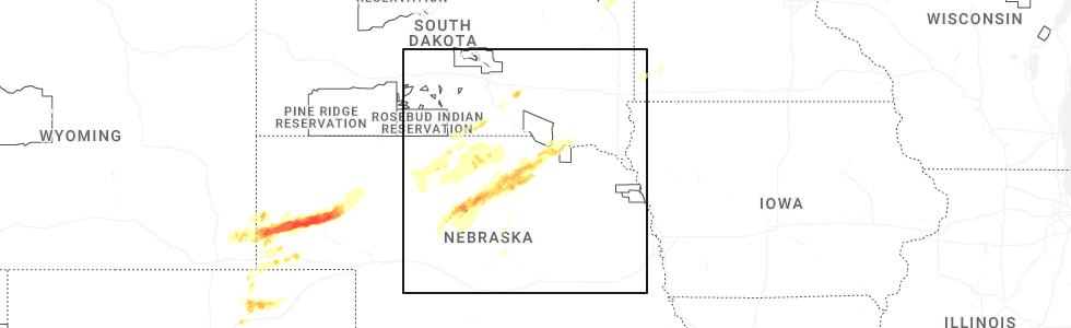
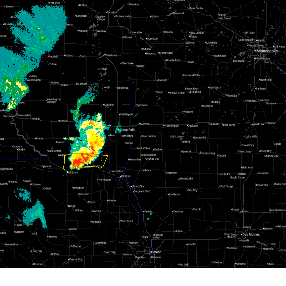
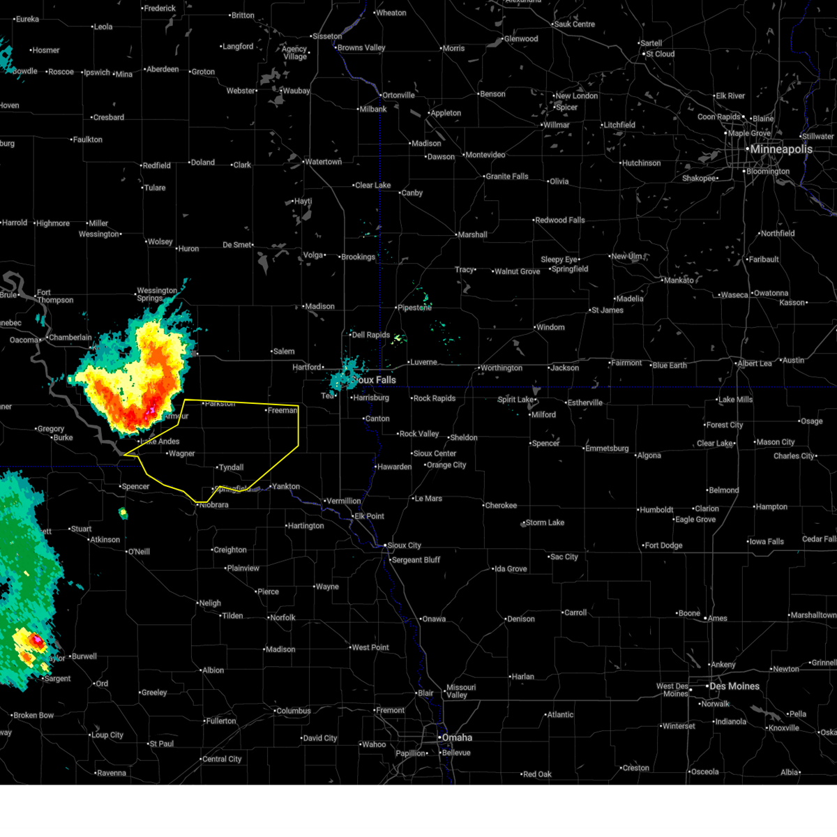
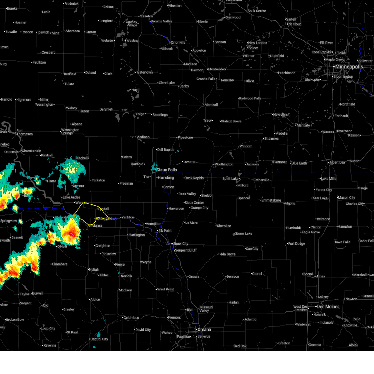
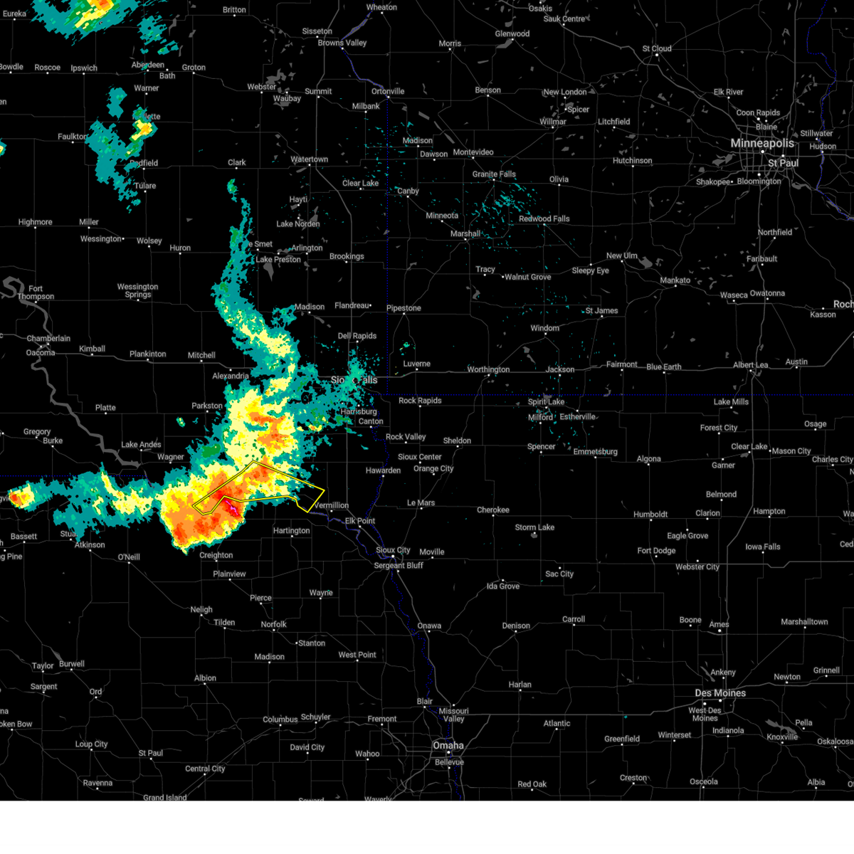
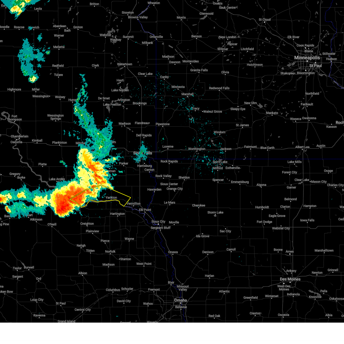
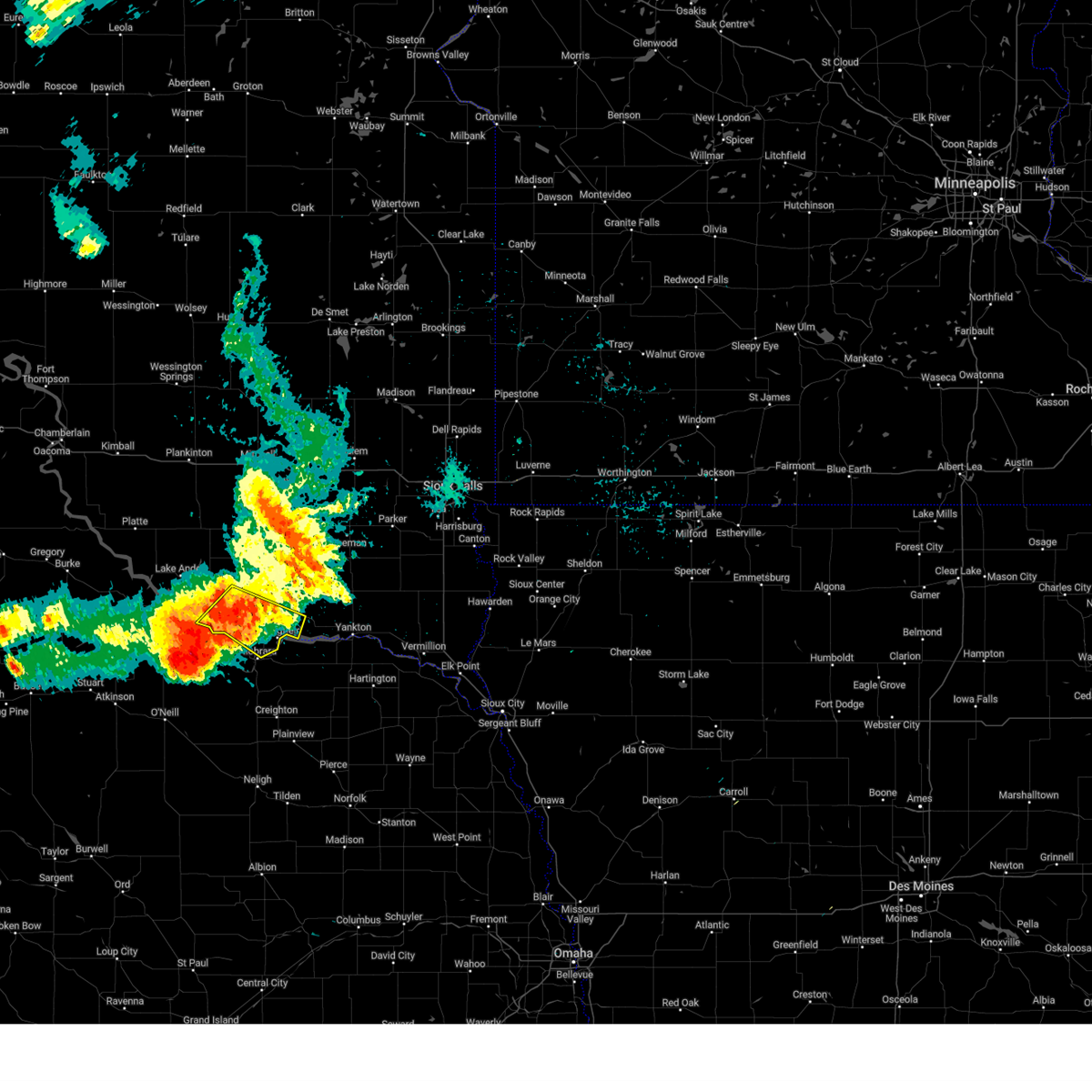
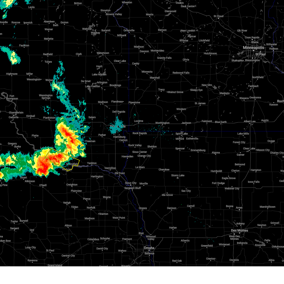
Hail Map for Springfield, SD
The Springfield, SD area has had 19 reports of on-the-ground hail by trained spotters, and has been under severe weather warnings 27 times during the past 12 months. Doppler radar has detected hail at or near Springfield, SD on 66 occasions, including 5 occasions during the past year.
| Name: | Springfield, SD |
| Where Located: | 47.5 miles NE of Oneill, NE |
| Map: | Google Map for Springfield, SD |
| Population: | 1989 |
| Housing Units: | 433 |
| More Info: | Search Google for Springfield, SD |
1
The Top Recent Hail Date for Springfield, SD is Sunday, June 22, 2025 (12th out of 66)
Hail and Wind Damage Spotted near Springfield, SD
| Date / Time | Report Details |
|---|---|
| 7/7/2025 6:12 PM CDT |
 The storm which prompted the warning has weakened below severe limits, and no longer poses an immediate threat to life or property. therefore, the warning will be allowed to expire. however, small hail is still possible with this thunderstorm. a severe thunderstorm watch remains in effect until 1000 pm cdt for south central and southeastern south dakota. The storm which prompted the warning has weakened below severe limits, and no longer poses an immediate threat to life or property. therefore, the warning will be allowed to expire. however, small hail is still possible with this thunderstorm. a severe thunderstorm watch remains in effect until 1000 pm cdt for south central and southeastern south dakota.
|
| 7/7/2025 6:03 PM CDT |
 the severe thunderstorm warning has been cancelled and is no longer in effect the severe thunderstorm warning has been cancelled and is no longer in effect
|
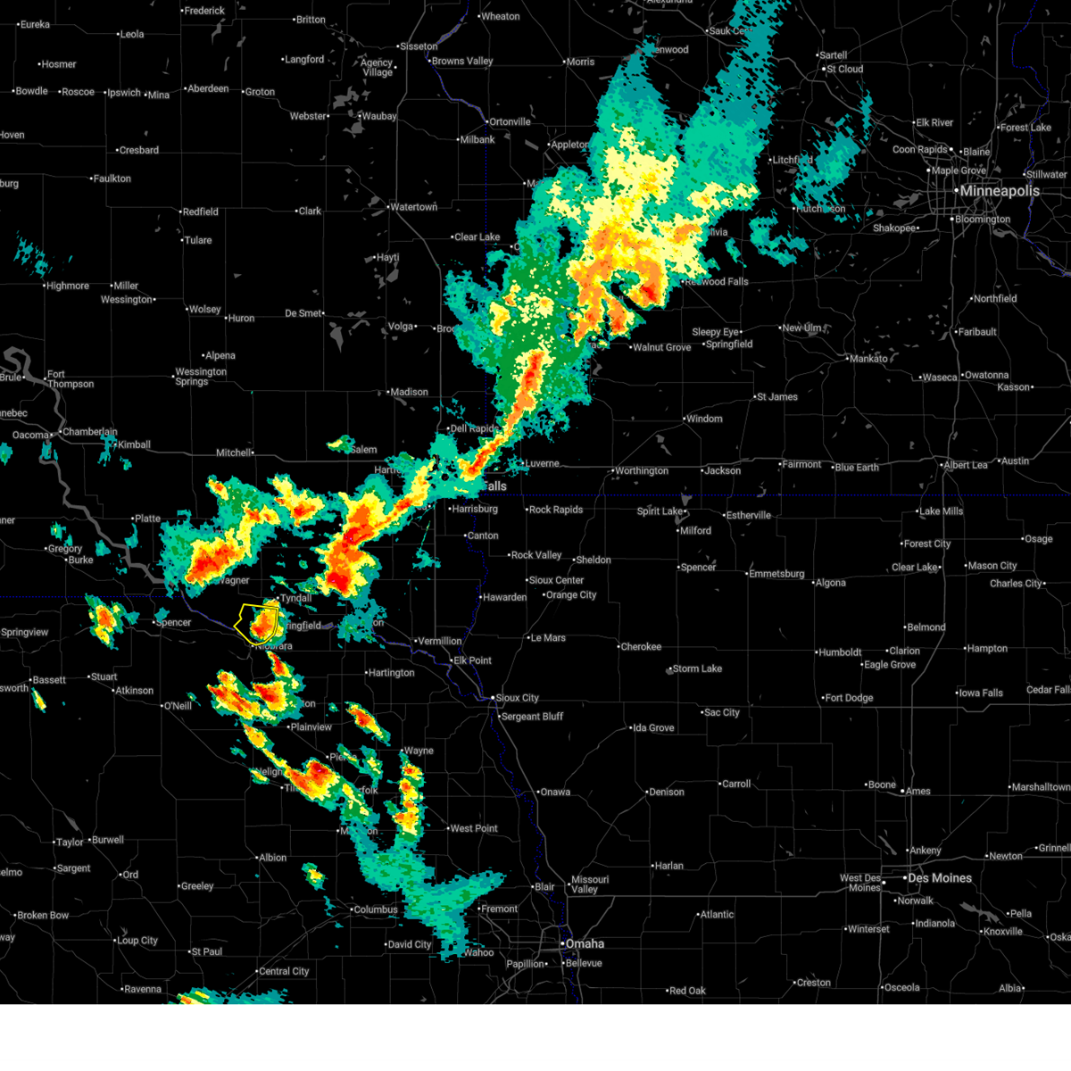
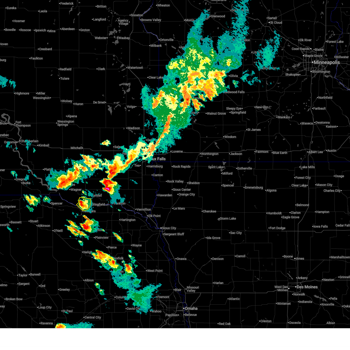
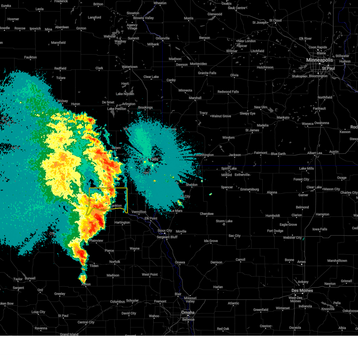
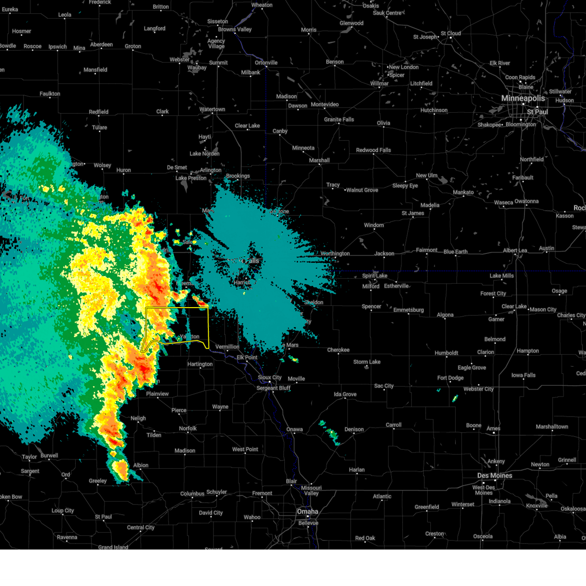
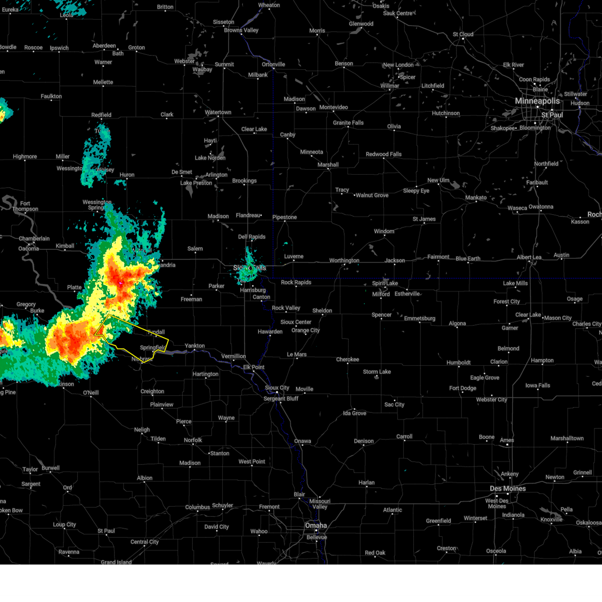
| 7/7/2025 6:03 PM CDT |
 At 603 pm cdt, a severe thunderstorm was located near springfield, or 12 miles southwest of tyndall, moving east at 20 mph (radar indicated). Hazards include 60 mph wind gusts and quarter size hail. Hail damage to vehicles is expected. expect wind damage to roofs, siding, and trees. Locations impacted include, springfield. At 603 pm cdt, a severe thunderstorm was located near springfield, or 12 miles southwest of tyndall, moving east at 20 mph (radar indicated). Hazards include 60 mph wind gusts and quarter size hail. Hail damage to vehicles is expected. expect wind damage to roofs, siding, and trees. Locations impacted include, springfield.
|
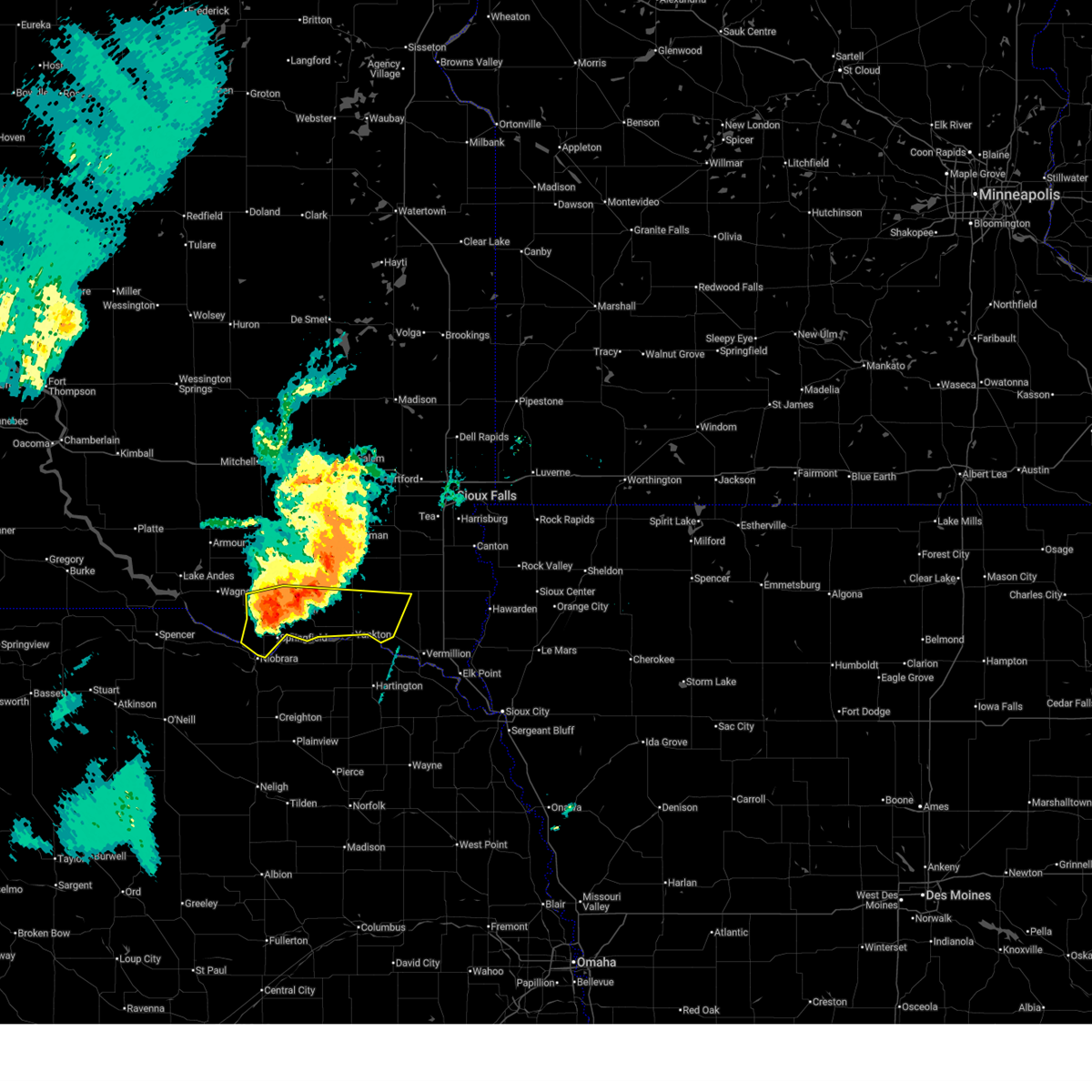
| 7/7/2025 5:35 PM CDT |
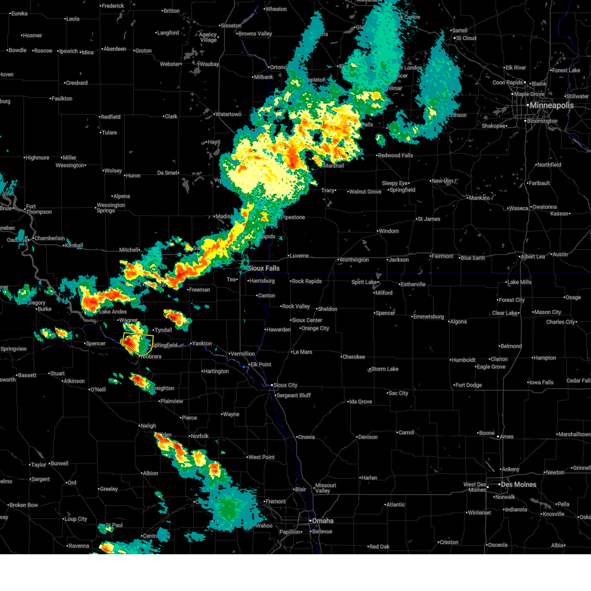 Svrfsd the national weather service in sioux falls has issued a * severe thunderstorm warning for, southeastern charles mix county in south central south dakota, southwestern bon homme county in southeastern south dakota, * until 615 pm cdt. * at 535 pm cdt, a severe thunderstorm was located near verdel, or 16 miles southwest of tyndall, moving east at 10 mph (radar indicated). Hazards include ping pong ball size hail and 60 mph wind gusts. People and animals outdoors will be injured. expect hail damage to roofs, siding, windows, and vehicles. expect wind damage to roofs, siding, and trees. This severe thunderstorm will remain over mainly rural areas of southeastern charles mix and southwestern bon homme counties. Svrfsd the national weather service in sioux falls has issued a * severe thunderstorm warning for, southeastern charles mix county in south central south dakota, southwestern bon homme county in southeastern south dakota, * until 615 pm cdt. * at 535 pm cdt, a severe thunderstorm was located near verdel, or 16 miles southwest of tyndall, moving east at 10 mph (radar indicated). Hazards include ping pong ball size hail and 60 mph wind gusts. People and animals outdoors will be injured. expect hail damage to roofs, siding, windows, and vehicles. expect wind damage to roofs, siding, and trees. This severe thunderstorm will remain over mainly rural areas of southeastern charles mix and southwestern bon homme counties.
|
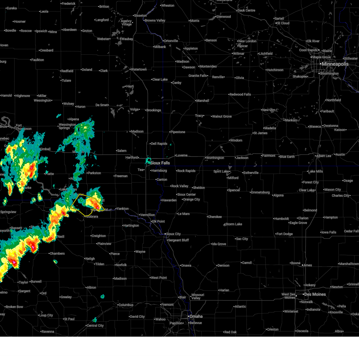
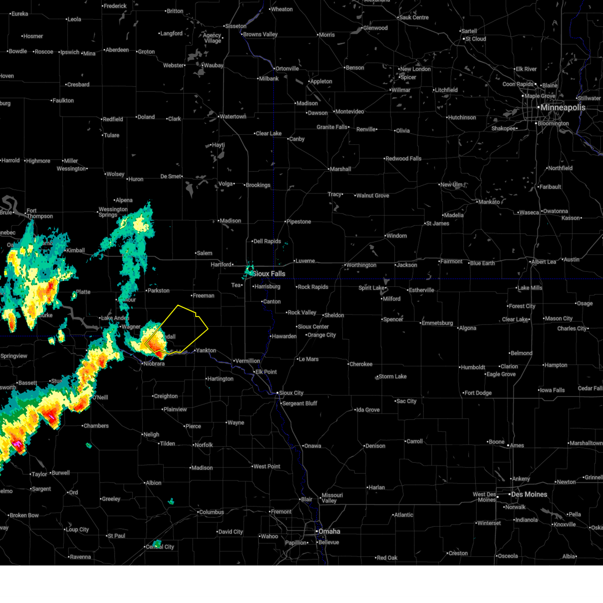
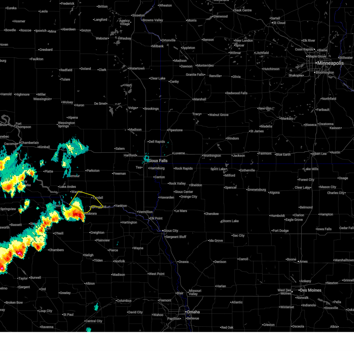
| 6/27/2025 11:26 PM CDT |
 The storms which prompted the warning have weakened below severe limits, and are exiting the warned area. therefore, the warning will be allowed to expire. however, small hail to dime size and gusty winds to 45 mph are still possible with these thunderstorms. a severe thunderstorm watch remains in effect until midnight cdt for south central and southeastern south dakota. remember, a severe thunderstorm warning still remains in effect for portions of bon homme, yankton, and clay counties until 1145 pm cdt. The storms which prompted the warning have weakened below severe limits, and are exiting the warned area. therefore, the warning will be allowed to expire. however, small hail to dime size and gusty winds to 45 mph are still possible with these thunderstorms. a severe thunderstorm watch remains in effect until midnight cdt for south central and southeastern south dakota. remember, a severe thunderstorm warning still remains in effect for portions of bon homme, yankton, and clay counties until 1145 pm cdt.
|
| 6/27/2025 11:11 PM CDT |
 the severe thunderstorm warning has been cancelled and is no longer in effect the severe thunderstorm warning has been cancelled and is no longer in effect
|
| 6/27/2025 11:11 PM CDT |
 At 1111 pm cdt, severe thunderstorms were located along a line extending from near mayfield to near yankton to springfield, moving east at 45 mph (radar indicated). Hazards include 60 mph wind gusts. Expect damage to roofs, siding, and trees. These severe storms will be near, yankton, lewis and clark state recreation area, wakonda, mission hill, and volin around 1115 pm cdt. At 1111 pm cdt, severe thunderstorms were located along a line extending from near mayfield to near yankton to springfield, moving east at 45 mph (radar indicated). Hazards include 60 mph wind gusts. Expect damage to roofs, siding, and trees. These severe storms will be near, yankton, lewis and clark state recreation area, wakonda, mission hill, and volin around 1115 pm cdt.
|
| 6/27/2025 10:58 PM CDT |
 Svrfsd the national weather service in sioux falls has issued a * severe thunderstorm warning for, northwestern clay county in southeastern south dakota, southeastern charles mix county in south central south dakota, bon homme county in southeastern south dakota, yankton county in southeastern south dakota, southern turner county in southeastern south dakota, * until 1130 pm cdt. * at 1057 pm cdt, severe thunderstorms were located along a line extending from 8 miles north of utica to near tabor to 7 miles west of springfield, moving east at 45 mph (radar indicated). Hazards include 60 mph wind gusts. Expect damage to roofs, siding, and trees. severe thunderstorms will be near, yankton, lewis and clark state recreation area, springfield, tabor, mayfield, and utica around 1105 pm cdt. mission hill around 1110 pm cdt. irene and volin around 1115 pm cdt. Other locations in the path of these severe thunderstorms include wakonda. Svrfsd the national weather service in sioux falls has issued a * severe thunderstorm warning for, northwestern clay county in southeastern south dakota, southeastern charles mix county in south central south dakota, bon homme county in southeastern south dakota, yankton county in southeastern south dakota, southern turner county in southeastern south dakota, * until 1130 pm cdt. * at 1057 pm cdt, severe thunderstorms were located along a line extending from 8 miles north of utica to near tabor to 7 miles west of springfield, moving east at 45 mph (radar indicated). Hazards include 60 mph wind gusts. Expect damage to roofs, siding, and trees. severe thunderstorms will be near, yankton, lewis and clark state recreation area, springfield, tabor, mayfield, and utica around 1105 pm cdt. mission hill around 1110 pm cdt. irene and volin around 1115 pm cdt. Other locations in the path of these severe thunderstorms include wakonda.
|
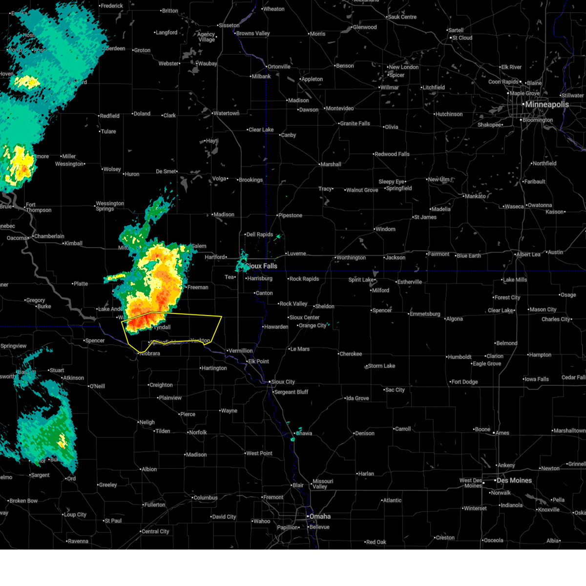
| 6/27/2025 10:25 PM CDT |
 At 1023 pm cdt, severe thunderstorms were located along a line extending from 7 miles south of milltown to near tripp to near wagner, moving southeast at 40 mph (automated equipment. at 1013 pm cdt a 69 mph wind gust was reported 1 mile north of tripp). Hazards include 70 mph wind gusts. Expect considerable tree damage. damage is likely to mobile homes, roofs, and outbuildings. Locations impacted include, scotland, avon, kaylor, dante, tyndall, menno, springfield, tabor, utica and lewis and clark state recreation area. At 1023 pm cdt, severe thunderstorms were located along a line extending from 7 miles south of milltown to near tripp to near wagner, moving southeast at 40 mph (automated equipment. at 1013 pm cdt a 69 mph wind gust was reported 1 mile north of tripp). Hazards include 70 mph wind gusts. Expect considerable tree damage. damage is likely to mobile homes, roofs, and outbuildings. Locations impacted include, scotland, avon, kaylor, dante, tyndall, menno, springfield, tabor, utica and lewis and clark state recreation area.
|
| 6/27/2025 10:06 PM CDT |
 Svrfsd the national weather service in sioux falls has issued a * severe thunderstorm warning for, southeastern charles mix county in south central south dakota, bon homme county in southeastern south dakota, southeastern douglas county in south central south dakota, northern yankton county in southeastern south dakota, southwestern turner county in southeastern south dakota, hutchinson county in southeastern south dakota, * until 1100 pm cdt. * at 1005 pm cdt, severe thunderstorms were located along a line extending from near parkston to near delmont to ravinia, moving east at 45 mph (automated weather stations reported). Hazards include 70 mph wind gusts. Expect considerable tree damage. damage is likely to mobile homes, roofs, and outbuildings. severe thunderstorms will be near, parkston, wagner, and tripp around 1010 pm cdt. dante around 1015 pm cdt. kaylor around 1020 pm cdt. scotland and avon around 1025 pm cdt. Other locations in the path of these severe thunderstorms include tyndall, menno, tabor and utica. Svrfsd the national weather service in sioux falls has issued a * severe thunderstorm warning for, southeastern charles mix county in south central south dakota, bon homme county in southeastern south dakota, southeastern douglas county in south central south dakota, northern yankton county in southeastern south dakota, southwestern turner county in southeastern south dakota, hutchinson county in southeastern south dakota, * until 1100 pm cdt. * at 1005 pm cdt, severe thunderstorms were located along a line extending from near parkston to near delmont to ravinia, moving east at 45 mph (automated weather stations reported). Hazards include 70 mph wind gusts. Expect considerable tree damage. damage is likely to mobile homes, roofs, and outbuildings. severe thunderstorms will be near, parkston, wagner, and tripp around 1010 pm cdt. dante around 1015 pm cdt. kaylor around 1020 pm cdt. scotland and avon around 1025 pm cdt. Other locations in the path of these severe thunderstorms include tyndall, menno, tabor and utica.
|
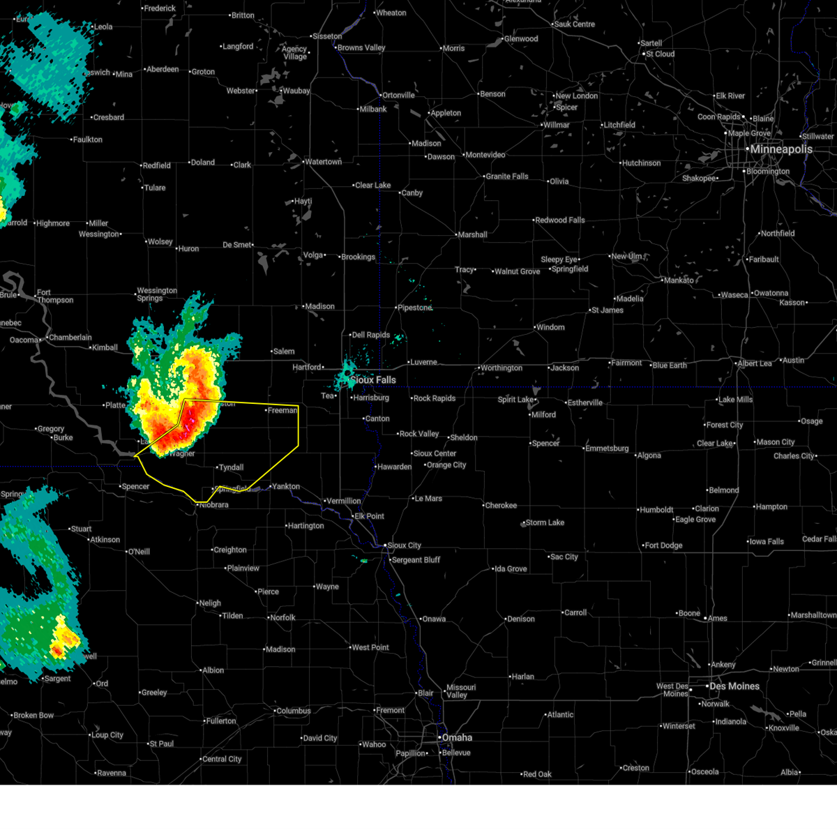
| 6/22/2025 8:36 PM CDT |
 The storm which prompted the warning has moved out of the area. therefore, the warning will be allowed to expire. a severe thunderstorm watch remains in effect until 1100 pm cdt for south central and southeastern south dakota. to report severe weather, contact your nearest law enforcement agency. they will relay your report to the national weather service sioux falls. remember, a severe thunderstorm warning still remains in effect for northeastern bon homme county until 915 pm cdt. The storm which prompted the warning has moved out of the area. therefore, the warning will be allowed to expire. a severe thunderstorm watch remains in effect until 1100 pm cdt for south central and southeastern south dakota. to report severe weather, contact your nearest law enforcement agency. they will relay your report to the national weather service sioux falls. remember, a severe thunderstorm warning still remains in effect for northeastern bon homme county until 915 pm cdt.
|
| 6/22/2025 8:34 PM CDT |
 Svrfsd the national weather service in sioux falls has issued a * severe thunderstorm warning for, northeastern bon homme county in southeastern south dakota, northwestern yankton county in southeastern south dakota, southeastern hutchinson county in southeastern south dakota, * until 915 pm cdt. * at 834 pm cdt, severe thunderstorms were located along a line extending from near tyndall to near tabor to 7 miles east of santee, moving northeast at 40 mph (radar indicated). Hazards include 60 mph wind gusts and half dollar size hail. Hail damage to vehicles is expected. expect wind damage to roofs, siding, and trees. severe thunderstorms will be near, lewis and clark state recreation area and tabor around 840 pm cdt. scotland and utica around 845 pm cdt. Other locations in the path of these severe thunderstorms include menno and mayfield. Svrfsd the national weather service in sioux falls has issued a * severe thunderstorm warning for, northeastern bon homme county in southeastern south dakota, northwestern yankton county in southeastern south dakota, southeastern hutchinson county in southeastern south dakota, * until 915 pm cdt. * at 834 pm cdt, severe thunderstorms were located along a line extending from near tyndall to near tabor to 7 miles east of santee, moving northeast at 40 mph (radar indicated). Hazards include 60 mph wind gusts and half dollar size hail. Hail damage to vehicles is expected. expect wind damage to roofs, siding, and trees. severe thunderstorms will be near, lewis and clark state recreation area and tabor around 840 pm cdt. scotland and utica around 845 pm cdt. Other locations in the path of these severe thunderstorms include menno and mayfield.
|
| 6/22/2025 8:08 PM CDT |
 At 808 pm cdt, a severe thunderstorm was located near verdel, or 23 miles southwest of tyndall, moving northeast at 40 mph (radar indicated). Hazards include golf ball size hail and 60 mph wind gusts. People and animals outdoors will be injured. expect hail damage to roofs, siding, windows, and vehicles. expect wind damage to roofs, siding, and trees. Locations impacted include, tyndall, springfield, avon, and dante. At 808 pm cdt, a severe thunderstorm was located near verdel, or 23 miles southwest of tyndall, moving northeast at 40 mph (radar indicated). Hazards include golf ball size hail and 60 mph wind gusts. People and animals outdoors will be injured. expect hail damage to roofs, siding, windows, and vehicles. expect wind damage to roofs, siding, and trees. Locations impacted include, tyndall, springfield, avon, and dante.
|
| 6/22/2025 7:57 PM CDT |
 Svrfsd the national weather service in sioux falls has issued a * severe thunderstorm warning for, southeastern charles mix county in south central south dakota, central bon homme county in southeastern south dakota, * until 845 pm cdt. * at 756 pm cdt, a severe thunderstorm was located 11 miles southwest of verdel, or 21 miles northeast of o'neill, moving northeast at 40 mph (radar indicated). Hazards include ping pong ball size hail and 60 mph wind gusts. People and animals outdoors will be injured. expect hail damage to roofs, siding, windows, and vehicles. Expect wind damage to roofs, siding, and trees. Svrfsd the national weather service in sioux falls has issued a * severe thunderstorm warning for, southeastern charles mix county in south central south dakota, central bon homme county in southeastern south dakota, * until 845 pm cdt. * at 756 pm cdt, a severe thunderstorm was located 11 miles southwest of verdel, or 21 miles northeast of o'neill, moving northeast at 40 mph (radar indicated). Hazards include ping pong ball size hail and 60 mph wind gusts. People and animals outdoors will be injured. expect hail damage to roofs, siding, windows, and vehicles. Expect wind damage to roofs, siding, and trees.
|
| 5/15/2025 1:14 AM CDT |
 The storms which prompted the warning have weakened below severe limits, and no longer pose an immediate threat to life or property. therefore, the warning will be allowed to expire. however, gusty winds and heavy rain are still possible with these thunderstorms. a severe thunderstorm watch remains in effect until 300 am cdt for southeastern south dakota. to report severe weather, contact your nearest law enforcement agency. they will relay your report to the national weather service sioux falls. The storms which prompted the warning have weakened below severe limits, and no longer pose an immediate threat to life or property. therefore, the warning will be allowed to expire. however, gusty winds and heavy rain are still possible with these thunderstorms. a severe thunderstorm watch remains in effect until 300 am cdt for southeastern south dakota. to report severe weather, contact your nearest law enforcement agency. they will relay your report to the national weather service sioux falls.
|
| 5/15/2025 12:47 AM CDT |
 At 1246 am cdt, severe thunderstorms were located along a line extending from near clayton to near menno to 6 miles northwest of utica to 6 miles east of santee, moving east at 20 mph (public. at 1236 am, a personal weather station recorded a 60 mph wind gusts 8 miles southeast of tabor, sd). Hazards include 60 mph wind gusts. Expect damage to roofs, siding, and trees. Locations impacted include, lewis and clark state recreation area, tabor, utica, yankton and mayfield. At 1246 am cdt, severe thunderstorms were located along a line extending from near clayton to near menno to 6 miles northwest of utica to 6 miles east of santee, moving east at 20 mph (public. at 1236 am, a personal weather station recorded a 60 mph wind gusts 8 miles southeast of tabor, sd). Hazards include 60 mph wind gusts. Expect damage to roofs, siding, and trees. Locations impacted include, lewis and clark state recreation area, tabor, utica, yankton and mayfield.
|
| 5/15/2025 12:12 AM CDT |
 Svrfsd the national weather service in sioux falls has issued a * severe thunderstorm warning for, bon homme county in southeastern south dakota, yankton county in southeastern south dakota, * until 115 am cdt. * at 1211 am cdt, severe thunderstorms were located along a line extending from 6 miles south of milltown to near scotland to near tyndall to near santee, moving east at 30 mph (radar indicated). Hazards include 60 mph wind gusts. Expect damage to roofs, siding, and trees. severe thunderstorms will be near, scotland and tabor around 1215 am cdt. lewis and clark state recreation area around 1225 am cdt. utica around 1230 am cdt. Other locations in the path of these severe thunderstorms include yankton, mayfield, mission hill and volin. Svrfsd the national weather service in sioux falls has issued a * severe thunderstorm warning for, bon homme county in southeastern south dakota, yankton county in southeastern south dakota, * until 115 am cdt. * at 1211 am cdt, severe thunderstorms were located along a line extending from 6 miles south of milltown to near scotland to near tyndall to near santee, moving east at 30 mph (radar indicated). Hazards include 60 mph wind gusts. Expect damage to roofs, siding, and trees. severe thunderstorms will be near, scotland and tabor around 1215 am cdt. lewis and clark state recreation area around 1225 am cdt. utica around 1230 am cdt. Other locations in the path of these severe thunderstorms include yankton, mayfield, mission hill and volin.
|
| 5/14/2025 11:52 PM CDT | Personal wether statio in bon homme county SD, 2 miles SSE of Springfield, SD |
| 7/29/2024 10:18 PM CDT |
 At 1018 pm cdt, severe thunderstorms were located along a line extending from near volin to 6 miles west of lewis and clark state recreation area to near center, moving east at 30 mph (radar indicated). Hazards include 60 mph wind gusts and half dollar size hail. Hail damage to vehicles is expected. expect wind damage to roofs, siding, and trees. Locations impacted include, yankton, lewis and clark state recreation area, mission hill, volin and meckling. At 1018 pm cdt, severe thunderstorms were located along a line extending from near volin to 6 miles west of lewis and clark state recreation area to near center, moving east at 30 mph (radar indicated). Hazards include 60 mph wind gusts and half dollar size hail. Hail damage to vehicles is expected. expect wind damage to roofs, siding, and trees. Locations impacted include, yankton, lewis and clark state recreation area, mission hill, volin and meckling.
|
| 7/29/2024 10:18 PM CDT |
 the severe thunderstorm warning has been cancelled and is no longer in effect the severe thunderstorm warning has been cancelled and is no longer in effect
|
| 7/29/2024 9:53 PM CDT |
 Svrfsd the national weather service in sioux falls has issued a * severe thunderstorm warning for, west central clay county in southeastern south dakota, southeastern charles mix county in south central south dakota, bon homme county in southeastern south dakota, central yankton county in southeastern south dakota, * until 1045 pm cdt. * at 953 pm cdt, a severe thunderstorm was located over santee, or 7 miles south of tyndall, moving east at 50 mph (radar indicated). Hazards include 60 mph wind gusts. Expect damage to roofs, siding, and trees. this severe thunderstorm will be near, lewis and clark state recreation area and tabor around 1000 pm cdt. Yankton around 1010 pm cdt. Svrfsd the national weather service in sioux falls has issued a * severe thunderstorm warning for, west central clay county in southeastern south dakota, southeastern charles mix county in south central south dakota, bon homme county in southeastern south dakota, central yankton county in southeastern south dakota, * until 1045 pm cdt. * at 953 pm cdt, a severe thunderstorm was located over santee, or 7 miles south of tyndall, moving east at 50 mph (radar indicated). Hazards include 60 mph wind gusts. Expect damage to roofs, siding, and trees. this severe thunderstorm will be near, lewis and clark state recreation area and tabor around 1000 pm cdt. Yankton around 1010 pm cdt.
|
| 7/29/2024 9:49 PM CDT |
 the severe thunderstorm warning has been cancelled and is no longer in effect the severe thunderstorm warning has been cancelled and is no longer in effect
|
| 7/29/2024 9:49 PM CDT |
 At 949 pm cdt, a severe thunderstorm was located over springfield, or 9 miles south of tyndall, moving southeast at 55 mph (radar indicated). Hazards include 60 mph wind gusts. Expect damage to roofs, siding, and trees. Locations impacted include, tyndall, springfield, avon, dante, and southeastern yankton sioux tribal nation. At 949 pm cdt, a severe thunderstorm was located over springfield, or 9 miles south of tyndall, moving southeast at 55 mph (radar indicated). Hazards include 60 mph wind gusts. Expect damage to roofs, siding, and trees. Locations impacted include, tyndall, springfield, avon, dante, and southeastern yankton sioux tribal nation.
|
| 7/29/2024 9:42 PM CDT |
 At 941 pm cdt, a severe thunderstorm was located near avon, or 13 miles west of tyndall, moving east at 40 mph (trained weather spotters). Hazards include 60 mph wind gusts. Expect damage to roofs, siding, and trees. Locations impacted include, springfield and avon. At 941 pm cdt, a severe thunderstorm was located near avon, or 13 miles west of tyndall, moving east at 40 mph (trained weather spotters). Hazards include 60 mph wind gusts. Expect damage to roofs, siding, and trees. Locations impacted include, springfield and avon.
|
| 7/29/2024 9:19 PM CDT |
 Svrfsd the national weather service in sioux falls has issued a * severe thunderstorm warning for, southeastern charles mix county in south central south dakota, southeastern gregory county in south central south dakota, central bon homme county in southeastern south dakota, * until 1000 pm cdt. * at 918 pm cdt, a severe thunderstorm was located over marty, or near pickstown, moving east at 30 mph (trained weather spotters). Hazards include 60 mph wind gusts and penny size hail. at 907 pm cdt a 64 mph wind gust was reported at the fort randall dam. Expect damage to roofs, siding, and trees. this severe thunderstorm will be near, wagner and marty around 925 pm cdt. dante around 935 pm cdt. Other locations in the path of this severe thunderstorm include avon. Svrfsd the national weather service in sioux falls has issued a * severe thunderstorm warning for, southeastern charles mix county in south central south dakota, southeastern gregory county in south central south dakota, central bon homme county in southeastern south dakota, * until 1000 pm cdt. * at 918 pm cdt, a severe thunderstorm was located over marty, or near pickstown, moving east at 30 mph (trained weather spotters). Hazards include 60 mph wind gusts and penny size hail. at 907 pm cdt a 64 mph wind gust was reported at the fort randall dam. Expect damage to roofs, siding, and trees. this severe thunderstorm will be near, wagner and marty around 925 pm cdt. dante around 935 pm cdt. Other locations in the path of this severe thunderstorm include avon.
|
| 7/14/2024 4:15 AM CDT |
 The storms which prompted the warning have weakened below severe limits, and no longer pose an immediate threat to life or property. therefore, the warning will be allowed to expire. however, gusty winds and heavy rain are still possible with these thunderstorms. a severe thunderstorm watch remains in effect until 800 am cdt for south central and southeastern south dakota. The storms which prompted the warning have weakened below severe limits, and no longer pose an immediate threat to life or property. therefore, the warning will be allowed to expire. however, gusty winds and heavy rain are still possible with these thunderstorms. a severe thunderstorm watch remains in effect until 800 am cdt for south central and southeastern south dakota.
|
| 7/14/2024 4:04 AM CDT |
 At 402 am cdt, severe thunderstorms were located along a line extending from mount vernon to near armour to near lynch, moving east at 55 mph (trained weather spotters. at 333 am, the sddot site at the platte-winner bridge recorded a 68 mph wind gust). Hazards include 60 mph wind gusts. Expect damage to roofs, siding, and trees. Locations impacted include, wagner, marty, delmont, dante, parkston, dimock, tripp, avon, kaylor, milltown, tyndall, springfield, scotland and clayton. At 402 am cdt, severe thunderstorms were located along a line extending from mount vernon to near armour to near lynch, moving east at 55 mph (trained weather spotters. at 333 am, the sddot site at the platte-winner bridge recorded a 68 mph wind gust). Hazards include 60 mph wind gusts. Expect damage to roofs, siding, and trees. Locations impacted include, wagner, marty, delmont, dante, parkston, dimock, tripp, avon, kaylor, milltown, tyndall, springfield, scotland and clayton.
|
| 7/14/2024 3:28 AM CDT |
 Svrfsd the national weather service in sioux falls has issued a * severe thunderstorm warning for, charles mix county in south central south dakota, gregory county in south central south dakota, bon homme county in southeastern south dakota, douglas county in south central south dakota, yankton county in southeastern south dakota, turner county in southeastern south dakota, hutchinson county in southeastern south dakota, * until 415 am cdt. * at 328 am cdt, severe thunderstorms were located along a line extending from alexandria to near tripp to near verdel, moving east at 65 mph (radar indicated). Hazards include 60 mph wind gusts. Expect damage to roofs, siding, and trees. severe thunderstorms will be near, tyndall, springfield, scotland, menno, kaylor, and clayton around 335 am cdt. freeman, tabor, and dolton around 345 am cdt. Other locations in the path of these severe thunderstorms include lewis and clark state recreation area, marion, utica, yankton, parker, mayfield, monroe, viborg, irene, hurley, mission hill, chancellor, volin and davis. Svrfsd the national weather service in sioux falls has issued a * severe thunderstorm warning for, charles mix county in south central south dakota, gregory county in south central south dakota, bon homme county in southeastern south dakota, douglas county in south central south dakota, yankton county in southeastern south dakota, turner county in southeastern south dakota, hutchinson county in southeastern south dakota, * until 415 am cdt. * at 328 am cdt, severe thunderstorms were located along a line extending from alexandria to near tripp to near verdel, moving east at 65 mph (radar indicated). Hazards include 60 mph wind gusts. Expect damage to roofs, siding, and trees. severe thunderstorms will be near, tyndall, springfield, scotland, menno, kaylor, and clayton around 335 am cdt. freeman, tabor, and dolton around 345 am cdt. Other locations in the path of these severe thunderstorms include lewis and clark state recreation area, marion, utica, yankton, parker, mayfield, monroe, viborg, irene, hurley, mission hill, chancellor, volin and davis.
|
| 10/3/2023 6:00 PM CDT |
 At 600 pm cdt, severe thunderstorms were located along a line extending from 7 miles east of avon to near tyndall to near santee, moving east at 50 mph (radar indicated). Hazards include 60 mph wind gusts and penny size hail. Expect damage to roofs, siding, and trees. severe thunderstorms will be near, tabor around 605 pm cdt. lewis and clark state recreation area and scotland around 610 pm cdt. utica around 615 pm cdt. yankton around 620 pm cdt. other locations in the path of these severe thunderstorms include mayfield and mission hill. hail threat, radar indicated max hail size, 0. 75 in wind threat, radar indicated max wind gust, 60 mph. At 600 pm cdt, severe thunderstorms were located along a line extending from 7 miles east of avon to near tyndall to near santee, moving east at 50 mph (radar indicated). Hazards include 60 mph wind gusts and penny size hail. Expect damage to roofs, siding, and trees. severe thunderstorms will be near, tabor around 605 pm cdt. lewis and clark state recreation area and scotland around 610 pm cdt. utica around 615 pm cdt. yankton around 620 pm cdt. other locations in the path of these severe thunderstorms include mayfield and mission hill. hail threat, radar indicated max hail size, 0. 75 in wind threat, radar indicated max wind gust, 60 mph.
|
| 7/24/2023 2:13 AM CDT |
 At 213 am cdt, a severe thunderstorm was located near springfield, or 7 miles southwest of tyndall, moving southeast at 25 mph (radar indicated). Hazards include quarter size hail. Damage to vehicles is expected. locations impacted include, springfield. hail threat, radar indicated max hail size, 1. 00 in wind threat, radar indicated max wind gust, <50 mph. At 213 am cdt, a severe thunderstorm was located near springfield, or 7 miles southwest of tyndall, moving southeast at 25 mph (radar indicated). Hazards include quarter size hail. Damage to vehicles is expected. locations impacted include, springfield. hail threat, radar indicated max hail size, 1. 00 in wind threat, radar indicated max wind gust, <50 mph.
|
| 7/24/2023 1:55 AM CDT |
 At 155 am cdt, a severe thunderstorm was located over avon, or 9 miles west of tyndall, moving southeast at 25 mph (radar indicated). Hazards include quarter size hail. damage to vehicles is expected At 155 am cdt, a severe thunderstorm was located over avon, or 9 miles west of tyndall, moving southeast at 25 mph (radar indicated). Hazards include quarter size hail. damage to vehicles is expected
|
| 7/22/2023 4:10 PM CDT |
 The severe thunderstorm warning for southwestern bon homme county will expire at 415 pm cdt, the storm which prompted the warning has moved out of the area. therefore, the warning will be allowed to expire. The severe thunderstorm warning for southwestern bon homme county will expire at 415 pm cdt, the storm which prompted the warning has moved out of the area. therefore, the warning will be allowed to expire.
|
| 7/22/2023 3:47 PM CDT |
 At 346 pm cdt, a severe thunderstorm was located near avon, or 9 miles west of tyndall, moving southeast at 25 mph (radar indicated). Hazards include 60 mph wind gusts and quarter size hail. Hail damage to vehicles is expected. expect wind damage to roofs, siding, and trees. locations impacted include, springfield. hail threat, radar indicated max hail size, 1. 00 in wind threat, radar indicated max wind gust, 60 mph. At 346 pm cdt, a severe thunderstorm was located near avon, or 9 miles west of tyndall, moving southeast at 25 mph (radar indicated). Hazards include 60 mph wind gusts and quarter size hail. Hail damage to vehicles is expected. expect wind damage to roofs, siding, and trees. locations impacted include, springfield. hail threat, radar indicated max hail size, 1. 00 in wind threat, radar indicated max wind gust, 60 mph.
|
| 7/22/2023 3:37 PM CDT |
 At 337 pm cdt, a severe thunderstorm was located over avon, or 11 miles west of tyndall, moving southeast at 25 mph (radar indicated). Hazards include 60 mph wind gusts and half dollar size hail. Hail damage to vehicles is expected. expect wind damage to roofs, siding, and trees. this severe thunderstorm will be near, tyndall around 355 pm cdt. other locations in the path of this severe thunderstorm include springfield. hail threat, radar indicated max hail size, 1. 25 in wind threat, radar indicated max wind gust, 60 mph. At 337 pm cdt, a severe thunderstorm was located over avon, or 11 miles west of tyndall, moving southeast at 25 mph (radar indicated). Hazards include 60 mph wind gusts and half dollar size hail. Hail damage to vehicles is expected. expect wind damage to roofs, siding, and trees. this severe thunderstorm will be near, tyndall around 355 pm cdt. other locations in the path of this severe thunderstorm include springfield. hail threat, radar indicated max hail size, 1. 25 in wind threat, radar indicated max wind gust, 60 mph.
|
| 7/12/2023 4:07 AM CDT |
 At 407 am cdt, severe thunderstorms were located along a line extending from near viborg to near niobrara, moving east at 60 mph (radar indicated). Hazards include 70 mph wind gusts. Expect considerable tree damage. damage is likely to mobile homes, roofs, and outbuildings. these severe storms will be near, mayfield around 410 am cdt. other locations in the path of these severe thunderstorms include tabor and lewis and clark state recreation area. thunderstorm damage threat, considerable hail threat, radar indicated max hail size, <. 75 in wind threat, observed max wind gust, 70 mph. At 407 am cdt, severe thunderstorms were located along a line extending from near viborg to near niobrara, moving east at 60 mph (radar indicated). Hazards include 70 mph wind gusts. Expect considerable tree damage. damage is likely to mobile homes, roofs, and outbuildings. these severe storms will be near, mayfield around 410 am cdt. other locations in the path of these severe thunderstorms include tabor and lewis and clark state recreation area. thunderstorm damage threat, considerable hail threat, radar indicated max hail size, <. 75 in wind threat, observed max wind gust, 70 mph.
|
| 7/12/2023 3:54 AM CDT |
 At 353 am cdt, severe thunderstorms were located along a line extending from 8 miles southeast of freeman to near verdel, moving east at 70 mph (radar indicated). Hazards include 70 mph wind gusts. Expect considerable tree damage. damage is likely to mobile homes, roofs, and outbuildings. locations impacted include, mayfield, tyndall, tabor and lewis and clark state recreation area. between 335 and 340 am cdt, winds reached 69 mph at the south dakota road weather information system site just northwest of tripp. thunderstorm damage threat, considerable hail threat, radar indicated max hail size, <. 75 in wind threat, observed max wind gust, 70 mph. At 353 am cdt, severe thunderstorms were located along a line extending from 8 miles southeast of freeman to near verdel, moving east at 70 mph (radar indicated). Hazards include 70 mph wind gusts. Expect considerable tree damage. damage is likely to mobile homes, roofs, and outbuildings. locations impacted include, mayfield, tyndall, tabor and lewis and clark state recreation area. between 335 and 340 am cdt, winds reached 69 mph at the south dakota road weather information system site just northwest of tripp. thunderstorm damage threat, considerable hail threat, radar indicated max hail size, <. 75 in wind threat, observed max wind gust, 70 mph.
|
| 7/12/2023 3:27 AM CDT |
 At 327 am cdt, severe thunderstorms were located along a line extending from near parkston to near butte, moving east at 65 mph (radar indicated). Hazards include 60 mph wind gusts. Expect damage to roofs, siding, and trees. severe thunderstorms will be near, parkston, tripp and dimock around 330 am cdt. kaylor around 335 am cdt. scotland around 340 am cdt. menno and marty around 345 am cdt. other locations in the path of these severe thunderstorms include wagner, dante, mayfield and avon. hail threat, radar indicated max hail size, <. 75 in wind threat, radar indicated max wind gust, 60 mph. At 327 am cdt, severe thunderstorms were located along a line extending from near parkston to near butte, moving east at 65 mph (radar indicated). Hazards include 60 mph wind gusts. Expect damage to roofs, siding, and trees. severe thunderstorms will be near, parkston, tripp and dimock around 330 am cdt. kaylor around 335 am cdt. scotland around 340 am cdt. menno and marty around 345 am cdt. other locations in the path of these severe thunderstorms include wagner, dante, mayfield and avon. hail threat, radar indicated max hail size, <. 75 in wind threat, radar indicated max wind gust, 60 mph.
|
| 7/10/2023 4:12 PM CDT |
 The severe thunderstorm warning for southwestern bon homme county will expire at 415 pm cdt, the storm which prompted the warning has moved out of the area. therefore, the warning will be allowed to expire. a severe thunderstorm watch remains in effect until 1000 pm cdt for southeastern south dakota. The severe thunderstorm warning for southwestern bon homme county will expire at 415 pm cdt, the storm which prompted the warning has moved out of the area. therefore, the warning will be allowed to expire. a severe thunderstorm watch remains in effect until 1000 pm cdt for southeastern south dakota.
|
| 7/10/2023 3:59 PM CDT |
 At 359 pm cdt, a severe thunderstorm was located over niobrara, or 16 miles southwest of tyndall, moving southeast at 25 mph (radar indicated). Hazards include 60 mph wind gusts and quarter size hail. Hail damage to vehicles is expected. expect wind damage to roofs, siding, and trees. this severe thunderstorm will remain over mainly rural areas of southwestern bon homme county, including the following locations, niobrara state park. hail threat, radar indicated max hail size, 1. 00 in wind threat, radar indicated max wind gust, 60 mph. At 359 pm cdt, a severe thunderstorm was located over niobrara, or 16 miles southwest of tyndall, moving southeast at 25 mph (radar indicated). Hazards include 60 mph wind gusts and quarter size hail. Hail damage to vehicles is expected. expect wind damage to roofs, siding, and trees. this severe thunderstorm will remain over mainly rural areas of southwestern bon homme county, including the following locations, niobrara state park. hail threat, radar indicated max hail size, 1. 00 in wind threat, radar indicated max wind gust, 60 mph.
|
| 7/10/2023 3:52 PM CDT |
 At 352 pm cdt, a severe thunderstorm was located near niobrara, or 15 miles southwest of tyndall, moving southeast at 25 mph (radar indicated). Hazards include 60 mph wind gusts and quarter size hail. Hail damage to vehicles is expected. expect wind damage to roofs, siding, and trees. this severe thunderstorm will be near, springfield around 400 pm cdt. hail threat, radar indicated max hail size, 1. 00 in wind threat, radar indicated max wind gust, 60 mph. At 352 pm cdt, a severe thunderstorm was located near niobrara, or 15 miles southwest of tyndall, moving southeast at 25 mph (radar indicated). Hazards include 60 mph wind gusts and quarter size hail. Hail damage to vehicles is expected. expect wind damage to roofs, siding, and trees. this severe thunderstorm will be near, springfield around 400 pm cdt. hail threat, radar indicated max hail size, 1. 00 in wind threat, radar indicated max wind gust, 60 mph.
|
| 7/10/2023 3:49 PM CDT | Quarter sized hail reported 8.3 miles E of Springfield, SD, corrects previous hail report from 8 w springfield. |
| 7/10/2023 3:47 PM CDT |
 At 347 pm cdt, a severe thunderstorm was located near verdel, or 14 miles southwest of tyndall, moving southeast at 30 mph (radar indicated). Hazards include 60 mph wind gusts and quarter size hail. Hail damage to vehicles is expected. expect wind damage to roofs, siding, and trees. locations impacted include, springfield. hail threat, radar indicated max hail size, 1. 00 in wind threat, radar indicated max wind gust, 60 mph. At 347 pm cdt, a severe thunderstorm was located near verdel, or 14 miles southwest of tyndall, moving southeast at 30 mph (radar indicated). Hazards include 60 mph wind gusts and quarter size hail. Hail damage to vehicles is expected. expect wind damage to roofs, siding, and trees. locations impacted include, springfield. hail threat, radar indicated max hail size, 1. 00 in wind threat, radar indicated max wind gust, 60 mph.
|
| 7/10/2023 3:41 PM CDT | Quarter sized hail reported 8.3 miles E of Springfield, SD |
| 7/10/2023 3:34 PM CDT |
 At 334 pm cdt, a severe thunderstorm was located 7 miles north of verdel, or 16 miles west of tyndall, moving southeast at 30 mph (radar indicated). Hazards include 60 mph wind gusts and quarter size hail. Hail damage to vehicles is expected. Expect wind damage to roofs, siding, and trees. At 334 pm cdt, a severe thunderstorm was located 7 miles north of verdel, or 16 miles west of tyndall, moving southeast at 30 mph (radar indicated). Hazards include 60 mph wind gusts and quarter size hail. Hail damage to vehicles is expected. Expect wind damage to roofs, siding, and trees.
|
| 6/24/2023 5:12 PM CDT | The severe thunderstorm warning for southwestern bon homme county will expire at 515 pm cdt, the storm which prompted the warning has moved out of the area. therefore, the warning will be allowed to expire. |
| 6/24/2023 5:00 PM CDT | Half Dollar sized hail reported 6.1 miles NNE of Springfield, SD |
| 6/24/2023 4:59 PM CDT | At 459 pm cdt, a severe thunderstorm was located near niobrara, or 15 miles south of tyndall, moving east at 45 mph (radar indicated). Hazards include golf ball size hail and 60 mph wind gusts. People and animals outdoors will be injured. expect hail damage to roofs, siding, windows, and vehicles. expect wind damage to roofs, siding, and trees. this severe thunderstorm will remain over mainly rural areas of southwestern bon homme county. thunderstorm damage threat, considerable hail threat, radar indicated max hail size, 1. 75 in wind threat, radar indicated max wind gust, 60 mph. |
| 6/24/2023 4:49 PM CDT | At 448 pm cdt, a severe thunderstorm was located near niobrara, or 17 miles southwest of tyndall, moving east at 45 mph (radar indicated). Hazards include golf ball size hail and 60 mph wind gusts. People and animals outdoors will be injured. expect hail damage to roofs, siding, windows, and vehicles. expect wind damage to roofs, siding, and trees. this severe storm will be near, springfield around 500 pm cdt. thunderstorm damage threat, considerable hail threat, radar indicated max hail size, 1. 75 in wind threat, radar indicated max wind gust, 60 mph. |
| 6/24/2023 4:25 PM CDT | At 425 pm cdt, a severe thunderstorm was located near lynch, or 16 miles southeast of pickstown, moving east at 45 mph (radar indicated). Hazards include 60 mph wind gusts and half dollar size hail. Hail damage to vehicles is expected. expect wind damage to roofs, siding, and trees. this severe thunderstorm will be near, springfield around 455 pm cdt. hail threat, radar indicated max hail size, 1. 25 in wind threat, radar indicated max wind gust, 60 mph. |
| 6/24/2023 3:24 AM CDT | Personal weather statio in bon homme county SD, 0.6 miles NW of Springfield, SD |
| 6/24/2023 3:20 AM CDT |
 At 319 am cdt, severe thunderstorms were located along a line extending from near avon to near springfield to near santee, moving northeast at 65 mph (radar indicated). Hazards include 70 mph wind gusts. Expect considerable tree damage. damage is likely to mobile homes, roofs, and outbuildings. these severe storms will be near, tyndall around 325 am cdt. tabor around 335 am cdt. lewis and clark state recreation area around 340 am cdt. other locations impacted by these severe thunderstorms include yankton sioux tribal nation and santee reservation. thunderstorm damage threat, considerable hail threat, radar indicated max hail size, <. 75 in wind threat, radar indicated max wind gust, 70 mph. At 319 am cdt, severe thunderstorms were located along a line extending from near avon to near springfield to near santee, moving northeast at 65 mph (radar indicated). Hazards include 70 mph wind gusts. Expect considerable tree damage. damage is likely to mobile homes, roofs, and outbuildings. these severe storms will be near, tyndall around 325 am cdt. tabor around 335 am cdt. lewis and clark state recreation area around 340 am cdt. other locations impacted by these severe thunderstorms include yankton sioux tribal nation and santee reservation. thunderstorm damage threat, considerable hail threat, radar indicated max hail size, <. 75 in wind threat, radar indicated max wind gust, 70 mph.
|
| 6/24/2023 2:52 AM CDT |
 At 252 am cdt, severe thunderstorms were located along a line extending from near pickstown to 8 miles south of lynch to 9 miles northeast of page, moving northeast at 45 mph (radar indicated). Hazards include 70 mph wind gusts. Expect considerable tree damage. damage is likely to mobile homes, roofs, and outbuildings. severe thunderstorms will be near, pickstown around 255 am cdt. lake andes and marty around 300 am cdt. ravinia around 305 am cdt. wagner around 310 am cdt. dante around 315 am cdt. tyndall, springfield and avon around 330 am cdt. other locations impacted by these severe thunderstorms include yankton sioux tribal nation and santee reservation. thunderstorm damage threat, considerable hail threat, radar indicated max hail size, <. 75 in wind threat, radar indicated max wind gust, 70 mph. At 252 am cdt, severe thunderstorms were located along a line extending from near pickstown to 8 miles south of lynch to 9 miles northeast of page, moving northeast at 45 mph (radar indicated). Hazards include 70 mph wind gusts. Expect considerable tree damage. damage is likely to mobile homes, roofs, and outbuildings. severe thunderstorms will be near, pickstown around 255 am cdt. lake andes and marty around 300 am cdt. ravinia around 305 am cdt. wagner around 310 am cdt. dante around 315 am cdt. tyndall, springfield and avon around 330 am cdt. other locations impacted by these severe thunderstorms include yankton sioux tribal nation and santee reservation. thunderstorm damage threat, considerable hail threat, radar indicated max hail size, <. 75 in wind threat, radar indicated max wind gust, 70 mph.
|
| 5/11/2023 4:58 PM CDT |
 The severe thunderstorm warning for southeastern charles mix and southwestern bon homme counties will expire at 500 pm cdt, the storm which prompted the warning has moved out of the area. therefore, the warning will be allowed to expire. however small hail and gusty winds are still possible with this thunderstorm. The severe thunderstorm warning for southeastern charles mix and southwestern bon homme counties will expire at 500 pm cdt, the storm which prompted the warning has moved out of the area. therefore, the warning will be allowed to expire. however small hail and gusty winds are still possible with this thunderstorm.
|
| 5/11/2023 4:46 PM CDT |
 At 446 pm cdt, a severe thunderstorm was located near springfield, or 7 miles southwest of tyndall, moving northwest at 40 mph (radar indicated). Hazards include 60 mph wind gusts and quarter size hail. Hail damage to vehicles is expected. expect wind damage to roofs, siding, and trees. locations impacted include, avon. hail threat, radar indicated max hail size, 1. 00 in wind threat, radar indicated max wind gust, 60 mph. At 446 pm cdt, a severe thunderstorm was located near springfield, or 7 miles southwest of tyndall, moving northwest at 40 mph (radar indicated). Hazards include 60 mph wind gusts and quarter size hail. Hail damage to vehicles is expected. expect wind damage to roofs, siding, and trees. locations impacted include, avon. hail threat, radar indicated max hail size, 1. 00 in wind threat, radar indicated max wind gust, 60 mph.
|
| 5/11/2023 4:41 PM CDT | Flag pole snapped off by thunderstorm wind gust. also had heavy rain... pea sized hail... and numerous branches broken in yar in bon homme county SD, 0.4 miles NNE of Springfield, SD |
| 5/11/2023 4:35 PM CDT | Golf Ball sized hail reported 1.1 miles NNW of Springfield, SD, corrects previous hail report from springfield. report via social media. |
| 5/11/2023 4:32 PM CDT |
 At 431 pm cdt, a severe thunderstorm was located near santee, or 14 miles south of tyndall, moving northwest at 30 mph (radar indicated). Hazards include 60 mph wind gusts and quarter size hail. Hail damage to vehicles is expected. expect wind damage to roofs, siding, and trees. this severe thunderstorm will be near, springfield around 445 pm cdt. other locations in the path of this severe thunderstorm include avon. hail threat, radar indicated max hail size, 1. 00 in wind threat, radar indicated max wind gust, 60 mph. At 431 pm cdt, a severe thunderstorm was located near santee, or 14 miles south of tyndall, moving northwest at 30 mph (radar indicated). Hazards include 60 mph wind gusts and quarter size hail. Hail damage to vehicles is expected. expect wind damage to roofs, siding, and trees. this severe thunderstorm will be near, springfield around 445 pm cdt. other locations in the path of this severe thunderstorm include avon. hail threat, radar indicated max hail size, 1. 00 in wind threat, radar indicated max wind gust, 60 mph.
|
| 3/30/2023 10:03 PM CDT |
 At 1002 pm cdt, a severe thunderstorm was located near santee, or near tyndall, moving northeast at 45 mph (trained weather spotters). Hazards include ping pong ball size hail. at 958 pm, ping pong size hail was reported in springfield. People and animals outdoors will be injured. expect damage to roofs, siding, windows, and vehicles. locations impacted include, tabor, lewis and clark state recreation area and scotland. hail threat, radar indicated max hail size, 1. 50 in wind threat, radar indicated max wind gust, <50 mph. At 1002 pm cdt, a severe thunderstorm was located near santee, or near tyndall, moving northeast at 45 mph (trained weather spotters). Hazards include ping pong ball size hail. at 958 pm, ping pong size hail was reported in springfield. People and animals outdoors will be injured. expect damage to roofs, siding, windows, and vehicles. locations impacted include, tabor, lewis and clark state recreation area and scotland. hail threat, radar indicated max hail size, 1. 50 in wind threat, radar indicated max wind gust, <50 mph.
|
| 3/30/2023 9:58 PM CDT | Ping Pong Ball sized hail reported 0.6 miles NW of Springfield, SD |
| 3/30/2023 9:41 PM CDT |
 At 940 pm cdt, a severe thunderstorm was located over niobrara, or 20 miles southwest of tyndall, moving northeast at 45 mph (radar indicated). Hazards include quarter size hail. Damage to vehicles is expected. this severe thunderstorm will be near, springfield around 955 pm cdt. other locations in the path of this severe thunderstorm include tyndall, lewis and clark state recreation area, tabor and scotland. hail threat, radar indicated max hail size, 1. 00 in wind threat, radar indicated max wind gust, <50 mph. At 940 pm cdt, a severe thunderstorm was located over niobrara, or 20 miles southwest of tyndall, moving northeast at 45 mph (radar indicated). Hazards include quarter size hail. Damage to vehicles is expected. this severe thunderstorm will be near, springfield around 955 pm cdt. other locations in the path of this severe thunderstorm include tyndall, lewis and clark state recreation area, tabor and scotland. hail threat, radar indicated max hail size, 1. 00 in wind threat, radar indicated max wind gust, <50 mph.
|
| 8/1/2022 9:43 PM CDT |
 The severe thunderstorm warning for bon homme county will expire at 945 pm cdt, the storm which prompted the warning has weakened below severe limits, and has exited the warned area. therefore, the warning will be allowed to expire. however hail up to nickel size and gusty winds to 55 mph are still possible with this thunderstorm. The severe thunderstorm warning for bon homme county will expire at 945 pm cdt, the storm which prompted the warning has weakened below severe limits, and has exited the warned area. therefore, the warning will be allowed to expire. however hail up to nickel size and gusty winds to 55 mph are still possible with this thunderstorm.
|
| 8/1/2022 9:18 PM CDT |
 At 918 pm cdt, a severe thunderstorm was located near springfield, or 10 miles southwest of tyndall, moving northeast at 25 mph (radar indicated). Hazards include 60 mph wind gusts and half dollar size hail. Hail damage to vehicles is expected. expect wind damage to roofs, siding, and trees. this severe storm will be near, springfield around 930 pm cdt. other locations in the path of this severe thunderstorm include tyndall. hail threat, radar indicated max hail size, 1. 25 in wind threat, radar indicated max wind gust, 60 mph. At 918 pm cdt, a severe thunderstorm was located near springfield, or 10 miles southwest of tyndall, moving northeast at 25 mph (radar indicated). Hazards include 60 mph wind gusts and half dollar size hail. Hail damage to vehicles is expected. expect wind damage to roofs, siding, and trees. this severe storm will be near, springfield around 930 pm cdt. other locations in the path of this severe thunderstorm include tyndall. hail threat, radar indicated max hail size, 1. 25 in wind threat, radar indicated max wind gust, 60 mph.
|
| 8/1/2022 9:10 PM CDT |
 At 909 pm cdt, a severe thunderstorm was located near niobrara, or 13 miles southwest of tyndall, moving northeast at 30 mph (radar indicated). Hazards include 60 mph wind gusts and half dollar size hail. Hail damage to vehicles is expected. expect wind damage to roofs, siding, and trees. this severe thunderstorm will be near, avon around 920 pm cdt. springfield around 925 pm cdt. tyndall around 940 pm cdt. hail threat, radar indicated max hail size, 1. 25 in wind threat, radar indicated max wind gust, 60 mph. At 909 pm cdt, a severe thunderstorm was located near niobrara, or 13 miles southwest of tyndall, moving northeast at 30 mph (radar indicated). Hazards include 60 mph wind gusts and half dollar size hail. Hail damage to vehicles is expected. expect wind damage to roofs, siding, and trees. this severe thunderstorm will be near, avon around 920 pm cdt. springfield around 925 pm cdt. tyndall around 940 pm cdt. hail threat, radar indicated max hail size, 1. 25 in wind threat, radar indicated max wind gust, 60 mph.
|
| 7/5/2022 3:43 PM CDT |
 The severe thunderstorm warning for southeastern charles mix, bon homme, yankton and south central hutchinson counties will expire at 345 pm cdt, the storms which prompted the warning have moved out of the area. therefore, the warning will be allowed to expire. a severe thunderstorm watch remains in effect until 400 pm cdt for south central and southeastern south dakota. a severe thunderstorm watch also remains in effect until 700 pm cdt for southeastern south dakota. The severe thunderstorm warning for southeastern charles mix, bon homme, yankton and south central hutchinson counties will expire at 345 pm cdt, the storms which prompted the warning have moved out of the area. therefore, the warning will be allowed to expire. a severe thunderstorm watch remains in effect until 400 pm cdt for south central and southeastern south dakota. a severe thunderstorm watch also remains in effect until 700 pm cdt for southeastern south dakota.
|
| 7/5/2022 3:22 PM CDT | Personal weather station: ksdspring in bon homme county SD, 0.6 miles NW of Springfield, SD |
| 7/5/2022 3:13 PM CDT |
 At 312 pm cdt, severe thunderstorms were located along a line extending from near mayfield to near tyndall to near niobrara, moving east at 60 mph (trained weather spotters. at 257 pm cdt, a 64 mph wind gust was reported in tyndall). Hazards include 60 mph wind gusts and penny size hail. Expect damage to roofs, siding, and trees. these severe storms will be near, mayfield around 315 pm cdt. tabor around 320 pm cdt. irene, volin and utica around 325 pm cdt. lewis and clark state recreation area around 330 pm cdt. yankton around 335 pm cdt. mission hill around 340 pm cdt. other locations impacted by these severe thunderstorms include gayville, lesterville and southern yankton sioux tribal nation. hail threat, radar indicated max hail size, 0. 75 in wind threat, radar indicated max wind gust, 60 mph. At 312 pm cdt, severe thunderstorms were located along a line extending from near mayfield to near tyndall to near niobrara, moving east at 60 mph (trained weather spotters. at 257 pm cdt, a 64 mph wind gust was reported in tyndall). Hazards include 60 mph wind gusts and penny size hail. Expect damage to roofs, siding, and trees. these severe storms will be near, mayfield around 315 pm cdt. tabor around 320 pm cdt. irene, volin and utica around 325 pm cdt. lewis and clark state recreation area around 330 pm cdt. yankton around 335 pm cdt. mission hill around 340 pm cdt. other locations impacted by these severe thunderstorms include gayville, lesterville and southern yankton sioux tribal nation. hail threat, radar indicated max hail size, 0. 75 in wind threat, radar indicated max wind gust, 60 mph.
|
| 7/5/2022 2:55 PM CDT |
 At 254 pm cdt, severe thunderstorms were located along a line extending from scotland to near dante to near gross, moving east at 60 mph (trained weather spotters. at 250 pm cdt, a 60 mph wind gust was reported 6 miles northeast of tyndall). Hazards include 60 mph wind gusts and penny size hail. Expect damage to roofs, siding, and trees. these severe storms will be near, scotland around 300 pm cdt. tyndall, springfield and utica around 310 pm cdt. mayfield around 315 pm cdt. tabor and mission hill around 320 pm cdt. irene and volin around 325 pm cdt. yankton and lewis and clark state recreation area around 330 pm cdt. other locations impacted by these severe thunderstorms include gayville, lesterville and yankton sioux tribal nation. hail threat, radar indicated max hail size, 0. 75 in wind threat, radar indicated max wind gust, 60 mph. At 254 pm cdt, severe thunderstorms were located along a line extending from scotland to near dante to near gross, moving east at 60 mph (trained weather spotters. at 250 pm cdt, a 60 mph wind gust was reported 6 miles northeast of tyndall). Hazards include 60 mph wind gusts and penny size hail. Expect damage to roofs, siding, and trees. these severe storms will be near, scotland around 300 pm cdt. tyndall, springfield and utica around 310 pm cdt. mayfield around 315 pm cdt. tabor and mission hill around 320 pm cdt. irene and volin around 325 pm cdt. yankton and lewis and clark state recreation area around 330 pm cdt. other locations impacted by these severe thunderstorms include gayville, lesterville and yankton sioux tribal nation. hail threat, radar indicated max hail size, 0. 75 in wind threat, radar indicated max wind gust, 60 mph.
|
| 7/5/2022 2:43 PM CDT |
 At 243 pm cdt, severe thunderstorms were located along a line extending from near delmont to wagner to near spencer, moving southeast at 60 mph (radar indicated). Hazards include 60 mph wind gusts and penny size hail. Expect damage to roofs, siding, and trees. severe thunderstorms will be near, dante around 250 pm cdt. avon around 255 pm cdt. other locations in the path of these severe thunderstorms include tyndall, springfield, scotland, tabor, lewis and clark state recreation area, utica, yankton, mayfield, irene and mission hill. hail threat, radar indicated max hail size, 0. 75 in wind threat, radar indicated max wind gust, 60 mph. At 243 pm cdt, severe thunderstorms were located along a line extending from near delmont to wagner to near spencer, moving southeast at 60 mph (radar indicated). Hazards include 60 mph wind gusts and penny size hail. Expect damage to roofs, siding, and trees. severe thunderstorms will be near, dante around 250 pm cdt. avon around 255 pm cdt. other locations in the path of these severe thunderstorms include tyndall, springfield, scotland, tabor, lewis and clark state recreation area, utica, yankton, mayfield, irene and mission hill. hail threat, radar indicated max hail size, 0. 75 in wind threat, radar indicated max wind gust, 60 mph.
|
| 7/2/2022 8:56 PM CDT |
 The severe thunderstorm warning for south central bon homme county will expire at 900 pm cdt, the storm which prompted the warning has weakened below severe limits, and has exited the warned area. therefore, the warning will be allowed to expire. to report severe weather, contact your nearest law enforcement agency. they will relay your report to the national weather service sioux falls. The severe thunderstorm warning for south central bon homme county will expire at 900 pm cdt, the storm which prompted the warning has weakened below severe limits, and has exited the warned area. therefore, the warning will be allowed to expire. to report severe weather, contact your nearest law enforcement agency. they will relay your report to the national weather service sioux falls.
|
| 7/2/2022 8:46 PM CDT |
 At 845 pm cdt, a severe thunderstorm was located near springfield, or 12 miles south of tyndall, moving south at 10 mph (trained weather spotters). Hazards include 60 mph wind gusts and half dollar size hail. at 835 pm cdt, quarter size hail was reported northwest of springfield. Hail damage to vehicles is expected. expect wind damage to roofs, siding, and trees. locations impacted include, springfield. hail threat, radar indicated max hail size, 1. 25 in wind threat, radar indicated max wind gust, 60 mph. At 845 pm cdt, a severe thunderstorm was located near springfield, or 12 miles south of tyndall, moving south at 10 mph (trained weather spotters). Hazards include 60 mph wind gusts and half dollar size hail. at 835 pm cdt, quarter size hail was reported northwest of springfield. Hail damage to vehicles is expected. expect wind damage to roofs, siding, and trees. locations impacted include, springfield. hail threat, radar indicated max hail size, 1. 25 in wind threat, radar indicated max wind gust, 60 mph.
|
| 7/2/2022 8:35 PM CDT | Quarter sized hail reported 1.2 miles ESE of Springfield, SD |
| 7/2/2022 8:20 PM CDT |
 At 820 pm cdt, a severe thunderstorm was located near santee, or near tyndall, moving south at 20 mph (radar indicated). Hazards include 60 mph wind gusts and quarter size hail. Hail damage to vehicles is expected. expect wind damage to roofs, siding, and trees. this severe thunderstorm will remain over mainly rural areas of central bon homme county. hail threat, radar indicated max hail size, 1. 00 in wind threat, radar indicated max wind gust, 60 mph. At 820 pm cdt, a severe thunderstorm was located near santee, or near tyndall, moving south at 20 mph (radar indicated). Hazards include 60 mph wind gusts and quarter size hail. Hail damage to vehicles is expected. expect wind damage to roofs, siding, and trees. this severe thunderstorm will remain over mainly rural areas of central bon homme county. hail threat, radar indicated max hail size, 1. 00 in wind threat, radar indicated max wind gust, 60 mph.
|
| 7/2/2022 8:19 PM CDT |
 At 819 pm cdt, a severe thunderstorm was located near springfield, or near tyndall, moving south at 20 mph (radar indicated). Hazards include 60 mph wind gusts and half dollar size hail. Hail damage to vehicles is expected. expect wind damage to roofs, siding, and trees. locations impacted include, springfield. hail threat, radar indicated max hail size, 1. 25 in wind threat, radar indicated max wind gust, 60 mph. At 819 pm cdt, a severe thunderstorm was located near springfield, or near tyndall, moving south at 20 mph (radar indicated). Hazards include 60 mph wind gusts and half dollar size hail. Hail damage to vehicles is expected. expect wind damage to roofs, siding, and trees. locations impacted include, springfield. hail threat, radar indicated max hail size, 1. 25 in wind threat, radar indicated max wind gust, 60 mph.
|
| 7/2/2022 8:07 PM CDT |
 At 807 pm cdt, a severe thunderstorm was located near tyndall, moving south at 25 mph (radar indicated). Hazards include 60 mph wind gusts and half dollar size hail. Hail damage to vehicles is expected. Expect wind damage to roofs, siding, and trees. At 807 pm cdt, a severe thunderstorm was located near tyndall, moving south at 25 mph (radar indicated). Hazards include 60 mph wind gusts and half dollar size hail. Hail damage to vehicles is expected. Expect wind damage to roofs, siding, and trees.
|
| 7/2/2022 8:00 PM CDT |
 At 800 pm cdt, a severe thunderstorm was located over tyndall, moving south at 25 mph (radar indicated). Hazards include 60 mph wind gusts and quarter size hail. Hail damage to vehicles is expected. expect wind damage to roofs, siding, and trees. this severe thunderstorm will remain over mainly rural areas of central bon homme county. hail threat, radar indicated max hail size, 1. 00 in wind threat, radar indicated max wind gust, 60 mph. At 800 pm cdt, a severe thunderstorm was located over tyndall, moving south at 25 mph (radar indicated). Hazards include 60 mph wind gusts and quarter size hail. Hail damage to vehicles is expected. expect wind damage to roofs, siding, and trees. this severe thunderstorm will remain over mainly rural areas of central bon homme county. hail threat, radar indicated max hail size, 1. 00 in wind threat, radar indicated max wind gust, 60 mph.
|
| 7/2/2022 7:53 PM CDT |
 At 753 pm cdt, a severe thunderstorm was located over tyndall, moving south at 20 mph (radar indicated). Hazards include 60 mph wind gusts and quarter size hail. Hail damage to vehicles is expected. expect wind damage to roofs, siding, and trees. locations impacted include, tabor. hail threat, radar indicated max hail size, 1. 00 in wind threat, radar indicated max wind gust, 60 mph. At 753 pm cdt, a severe thunderstorm was located over tyndall, moving south at 20 mph (radar indicated). Hazards include 60 mph wind gusts and quarter size hail. Hail damage to vehicles is expected. expect wind damage to roofs, siding, and trees. locations impacted include, tabor. hail threat, radar indicated max hail size, 1. 00 in wind threat, radar indicated max wind gust, 60 mph.
|
| 7/2/2022 7:41 PM CDT |
 At 741 pm cdt, a severe thunderstorm was located near tyndall, moving south at 15 mph (radar indicated). Hazards include 60 mph wind gusts and half dollar size hail. Hail damage to vehicles is expected. expect wind damage to roofs, siding, and trees. this severe thunderstorm will be near, tyndall around 800 pm cdt. other locations in the path of this severe thunderstorm include tabor. hail threat, radar indicated max hail size, 1. 25 in wind threat, radar indicated max wind gust, 60 mph. At 741 pm cdt, a severe thunderstorm was located near tyndall, moving south at 15 mph (radar indicated). Hazards include 60 mph wind gusts and half dollar size hail. Hail damage to vehicles is expected. expect wind damage to roofs, siding, and trees. this severe thunderstorm will be near, tyndall around 800 pm cdt. other locations in the path of this severe thunderstorm include tabor. hail threat, radar indicated max hail size, 1. 25 in wind threat, radar indicated max wind gust, 60 mph.
|
| 5/30/2022 12:38 PM CDT |
 At 1238 pm cdt, a severe thunderstorm was located over avon, or 12 miles west of tyndall, moving north at 45 mph (radar indicated). Hazards include 70 mph wind gusts and nickel size hail. Expect considerable tree damage. damage is likely to mobile homes, roofs, and outbuildings. locations impacted include, tripp, delmont, kaylor, parkston, milltown and dimock. thunderstorm damage threat, considerable hail threat, radar indicated max hail size, 0. 88 in wind threat, radar indicated max wind gust, 70 mph. At 1238 pm cdt, a severe thunderstorm was located over avon, or 12 miles west of tyndall, moving north at 45 mph (radar indicated). Hazards include 70 mph wind gusts and nickel size hail. Expect considerable tree damage. damage is likely to mobile homes, roofs, and outbuildings. locations impacted include, tripp, delmont, kaylor, parkston, milltown and dimock. thunderstorm damage threat, considerable hail threat, radar indicated max hail size, 0. 88 in wind threat, radar indicated max wind gust, 70 mph.
|
| 5/30/2022 12:25 PM CDT |
 At 1224 pm cdt, a severe thunderstorm was located 9 miles northwest of niobrara, or 16 miles southwest of tyndall, moving north at 45 mph (radar indicated). Hazards include 70 mph wind gusts and nickel size hail. Expect considerable tree damage. damage is likely to mobile homes, roofs, and outbuildings. this severe thunderstorm will be near, tyndall, avon and dante around 1240 pm cdt. other locations in the path of this severe thunderstorm include tripp, delmont, kaylor, parkston, dimock and milltown. thunderstorm damage threat, considerable hail threat, radar indicated max hail size, 0. 88 in wind threat, radar indicated max wind gust, 70 mph. At 1224 pm cdt, a severe thunderstorm was located 9 miles northwest of niobrara, or 16 miles southwest of tyndall, moving north at 45 mph (radar indicated). Hazards include 70 mph wind gusts and nickel size hail. Expect considerable tree damage. damage is likely to mobile homes, roofs, and outbuildings. this severe thunderstorm will be near, tyndall, avon and dante around 1240 pm cdt. other locations in the path of this severe thunderstorm include tripp, delmont, kaylor, parkston, dimock and milltown. thunderstorm damage threat, considerable hail threat, radar indicated max hail size, 0. 88 in wind threat, radar indicated max wind gust, 70 mph.
|
| 5/12/2022 4:30 PM CDT |
 At 428 pm cdt, severe thunderstorms were located along a line extending from near armour to kaylor to near mission hill, moving northeast at 80 mph. these are destructive storms for parkston, freeman, irene and surrounding areas (observed. at 421 pm cdt, yankton automated equipment gusted to 71 mph. this gust was ahead of the main line). Hazards include 80 mph wind gusts and quarter size hail. Flying debris will be dangerous to those caught without shelter. mobile homes will be heavily damaged. expect considerable damage to roofs, windows, and vehicles. extensive tree damage and power outages are likely. these severe storms will be near, menno, mayfield and volin around 435 pm cdt. irene, wakonda and milltown around 440 pm cdt. freeman, centerville, viborg, dimock and clayton around 445 pm cdt. ethan around 450 pm cdt. Other locations impacted by these severe thunderstorms include gayville, lesterville, olivet and yankton sioux tribal nation. At 428 pm cdt, severe thunderstorms were located along a line extending from near armour to kaylor to near mission hill, moving northeast at 80 mph. these are destructive storms for parkston, freeman, irene and surrounding areas (observed. at 421 pm cdt, yankton automated equipment gusted to 71 mph. this gust was ahead of the main line). Hazards include 80 mph wind gusts and quarter size hail. Flying debris will be dangerous to those caught without shelter. mobile homes will be heavily damaged. expect considerable damage to roofs, windows, and vehicles. extensive tree damage and power outages are likely. these severe storms will be near, menno, mayfield and volin around 435 pm cdt. irene, wakonda and milltown around 440 pm cdt. freeman, centerville, viborg, dimock and clayton around 445 pm cdt. ethan around 450 pm cdt. Other locations impacted by these severe thunderstorms include gayville, lesterville, olivet and yankton sioux tribal nation.
|
| 5/12/2022 4:10 PM CDT | Trained spotter reports multiple branches (estimated 2 ft in diameter) on the groun in bon homme county SD, 1.1 miles NNW of Springfield, SD |
| 5/12/2022 3:59 PM CDT |
 At 359 pm cdt, severe thunderstorms were located along a line extending from 10 miles northeast of butte to 10 miles east of lynch to near osmond, moving northeast at 80 mph (radar indicated). Hazards include 70 mph wind gusts and quarter size hail. Hail damage to vehicles is expected. expect considerable tree damage. wind damage is also likely to mobile homes, roofs, and outbuildings. severe thunderstorms will be near, lake andes, springfield, wagner and ravinia around 410 pm cdt. avon and dante around 415 pm cdt. tyndall, lewis and clark state recreation area, armour and delmont around 420 pm cdt. yankton, tripp, corsica and kaylor around 425 pm cdt. parkston, scotland, meckling, mission hill and volin around 430 pm cdt. menno, wakonda, mayfield and dimock around 435 pm cdt. irene, ethan, milltown and clayton around 440 pm cdt. mitchell, beresford, freeman, centerville and viborg around 445 pm cdt. Other locations impacted by these severe thunderstorms include gayville, lesterville, olivet and yankton sioux tribal nation. At 359 pm cdt, severe thunderstorms were located along a line extending from 10 miles northeast of butte to 10 miles east of lynch to near osmond, moving northeast at 80 mph (radar indicated). Hazards include 70 mph wind gusts and quarter size hail. Hail damage to vehicles is expected. expect considerable tree damage. wind damage is also likely to mobile homes, roofs, and outbuildings. severe thunderstorms will be near, lake andes, springfield, wagner and ravinia around 410 pm cdt. avon and dante around 415 pm cdt. tyndall, lewis and clark state recreation area, armour and delmont around 420 pm cdt. yankton, tripp, corsica and kaylor around 425 pm cdt. parkston, scotland, meckling, mission hill and volin around 430 pm cdt. menno, wakonda, mayfield and dimock around 435 pm cdt. irene, ethan, milltown and clayton around 440 pm cdt. mitchell, beresford, freeman, centerville and viborg around 445 pm cdt. Other locations impacted by these severe thunderstorms include gayville, lesterville, olivet and yankton sioux tribal nation.
|
| 9/16/2021 11:58 PM CDT |
 The severe thunderstorm warning for bon homme, western yankton and south central hutchinson counties will expire at midnight cdt, the storm which prompted the warning has weakened below severe limits, and no longer poses an immediate threat to life or property. therefore, the warning will be allowed to expire. however gusty winds are still possible with this thunderstorm. The severe thunderstorm warning for bon homme, western yankton and south central hutchinson counties will expire at midnight cdt, the storm which prompted the warning has weakened below severe limits, and no longer poses an immediate threat to life or property. therefore, the warning will be allowed to expire. however gusty winds are still possible with this thunderstorm.
|
| 9/16/2021 11:44 PM CDT |
 At 1143 pm cdt, a severe thunderstorm was located over tyndall, moving northeast at 55 mph (radar indicated). Hazards include 60 mph wind gusts and quarter size hail. Hail damage to vehicles is expected. expect wind damage to roofs, siding, and trees. this severe storm will be near, tabor around 1150 pm cdt. scotland around 1155 pm cdt. other locations impacted by this severe thunderstorm include lesterville. hail threat, radar indicated max hail size, 1. 00 in wind threat, radar indicated max wind gust, 60 mph. At 1143 pm cdt, a severe thunderstorm was located over tyndall, moving northeast at 55 mph (radar indicated). Hazards include 60 mph wind gusts and quarter size hail. Hail damage to vehicles is expected. expect wind damage to roofs, siding, and trees. this severe storm will be near, tabor around 1150 pm cdt. scotland around 1155 pm cdt. other locations impacted by this severe thunderstorm include lesterville. hail threat, radar indicated max hail size, 1. 00 in wind threat, radar indicated max wind gust, 60 mph.
|
| 9/16/2021 11:31 PM CDT |
 At 1130 pm cdt, a severe thunderstorm was located near avon, or 9 miles southwest of tyndall, moving northeast at 60 mph (radar indicated). Hazards include 60 mph wind gusts and half dollar size hail. Hail damage to vehicles is expected. expect wind damage to roofs, siding, and trees. this severe thunderstorm will be near, springfield around 1135 pm cdt. tyndall around 1140 pm cdt. tabor around 1150 pm cdt. scotland around 1155 pm cdt. other locations impacted by this severe thunderstorm include lesterville. hail threat, radar indicated max hail size, 1. 25 in wind threat, radar indicated max wind gust, 60 mph. At 1130 pm cdt, a severe thunderstorm was located near avon, or 9 miles southwest of tyndall, moving northeast at 60 mph (radar indicated). Hazards include 60 mph wind gusts and half dollar size hail. Hail damage to vehicles is expected. expect wind damage to roofs, siding, and trees. this severe thunderstorm will be near, springfield around 1135 pm cdt. tyndall around 1140 pm cdt. tabor around 1150 pm cdt. scotland around 1155 pm cdt. other locations impacted by this severe thunderstorm include lesterville. hail threat, radar indicated max hail size, 1. 25 in wind threat, radar indicated max wind gust, 60 mph.
|
| 8/31/2021 2:35 AM CDT |
 At 235 am cdt, a severe thunderstorm was located near niobrara, or 14 miles southwest of tyndall, moving southeast at 25 mph (radar indicated). Hazards include 60 mph wind gusts and quarter size hail. Hail damage to vehicles is expected. expect wind damage to roofs, siding, and trees. locations impacted include, springfield. hail threat, radar indicated max hail size, 1. 00 in wind threat, radar indicated max wind gust, 60 mph. At 235 am cdt, a severe thunderstorm was located near niobrara, or 14 miles southwest of tyndall, moving southeast at 25 mph (radar indicated). Hazards include 60 mph wind gusts and quarter size hail. Hail damage to vehicles is expected. expect wind damage to roofs, siding, and trees. locations impacted include, springfield. hail threat, radar indicated max hail size, 1. 00 in wind threat, radar indicated max wind gust, 60 mph.
|
| 8/31/2021 2:14 AM CDT |
 At 214 am cdt, a severe thunderstorm was located near avon, or 12 miles southwest of tyndall, moving southeast at 25 mph (radar indicated). Hazards include 60 mph wind gusts and quarter size hail. Hail damage to vehicles is expected. Expect wind damage to roofs, siding, and trees. At 214 am cdt, a severe thunderstorm was located near avon, or 12 miles southwest of tyndall, moving southeast at 25 mph (radar indicated). Hazards include 60 mph wind gusts and quarter size hail. Hail damage to vehicles is expected. Expect wind damage to roofs, siding, and trees.
|
| 8/31/2021 2:01 AM CDT |
 At 201 am cdt, severe thunderstorms were located along a line extending from near avon to near gross to 7 miles northeast of butte, moving southeast at 40 mph (radar indicated). Hazards include 60 mph wind gusts and quarter size hail. Hail damage to vehicles is expected. expect wind damage to roofs, siding, and trees. these severe storms will be near, avon and dante around 205 am cdt. marty around 210 am cdt. springfield around 225 am cdt. other locations impacted by these severe thunderstorms include yankton sioux tribal nation. hail threat, radar indicated max hail size, 1. 00 in wind threat, radar indicated max wind gust, 60 mph. At 201 am cdt, severe thunderstorms were located along a line extending from near avon to near gross to 7 miles northeast of butte, moving southeast at 40 mph (radar indicated). Hazards include 60 mph wind gusts and quarter size hail. Hail damage to vehicles is expected. expect wind damage to roofs, siding, and trees. these severe storms will be near, avon and dante around 205 am cdt. marty around 210 am cdt. springfield around 225 am cdt. other locations impacted by these severe thunderstorms include yankton sioux tribal nation. hail threat, radar indicated max hail size, 1. 00 in wind threat, radar indicated max wind gust, 60 mph.
|
| 8/31/2021 1:26 AM CDT |
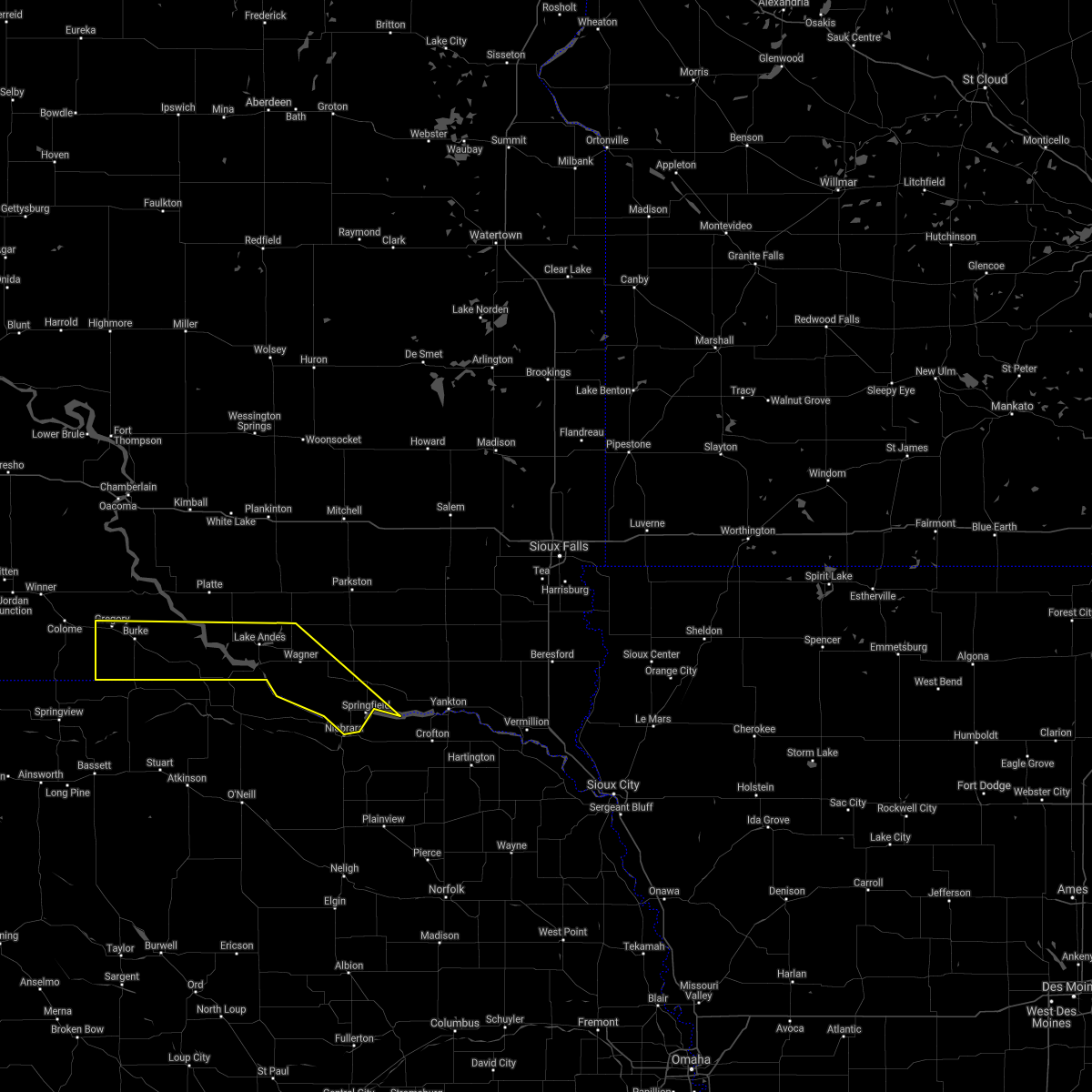 At 125 am cdt, severe thunderstorms were located along a line extending from 6 miles north of ravinia to 8 miles north of bonesteel to near gregory, moving southeast at 40 mph (radar indicated). Hazards include 60 mph wind gusts and quarter size hail. Hail damage to vehicles is expected. expect wind damage to roofs, siding, and trees. severe thunderstorms will be near, lake andes and ravinia around 130 am cdt. bonesteel around 135 am cdt. wagner and herrick around 145 am cdt. dante and st. charles around 150 am cdt. pickstown around 155 am cdt. avon around 200 am cdt. springfield around 215 am cdt. other locations impacted by these severe thunderstorms include fairfax and yankton sioux tribal nation. hail threat, radar indicated max hail size, 1. 00 in wind threat, radar indicated max wind gust, 60 mph. At 125 am cdt, severe thunderstorms were located along a line extending from 6 miles north of ravinia to 8 miles north of bonesteel to near gregory, moving southeast at 40 mph (radar indicated). Hazards include 60 mph wind gusts and quarter size hail. Hail damage to vehicles is expected. expect wind damage to roofs, siding, and trees. severe thunderstorms will be near, lake andes and ravinia around 130 am cdt. bonesteel around 135 am cdt. wagner and herrick around 145 am cdt. dante and st. charles around 150 am cdt. pickstown around 155 am cdt. avon around 200 am cdt. springfield around 215 am cdt. other locations impacted by these severe thunderstorms include fairfax and yankton sioux tribal nation. hail threat, radar indicated max hail size, 1. 00 in wind threat, radar indicated max wind gust, 60 mph.
|
| 8/28/2021 7:50 PM CDT |
 At 749 pm cdt, a severe thunderstorm was located over tabor, or 8 miles northwest of lewis and clark state recreation area, moving northeast at 50 mph (radar indicated). Hazards include 60 mph wind gusts and half dollar size hail. Hail damage to vehicles is expected. expect wind damage to roofs, siding, and trees. this severe thunderstorm will be near, utica around 800 pm cdt. other locations in the path of this severe thunderstorm include mayfield, irene, viborg and hurley. hail threat, radar indicated max hail size, 1. 25 in wind threat, radar indicated max wind gust, 60 mph. At 749 pm cdt, a severe thunderstorm was located over tabor, or 8 miles northwest of lewis and clark state recreation area, moving northeast at 50 mph (radar indicated). Hazards include 60 mph wind gusts and half dollar size hail. Hail damage to vehicles is expected. expect wind damage to roofs, siding, and trees. this severe thunderstorm will be near, utica around 800 pm cdt. other locations in the path of this severe thunderstorm include mayfield, irene, viborg and hurley. hail threat, radar indicated max hail size, 1. 25 in wind threat, radar indicated max wind gust, 60 mph.
|
| 8/25/2021 4:13 PM CDT |
 The severe thunderstorm warning for southern bon homme county will expire at 415 pm cdt, the storm which prompted the warning has moved out of the area. therefore, the warning will be allowed to expire. however dime sized hail and gusty winds to 50 mph are still possible with this thunderstorm. additional gusty winds to 50 mph may occur once the storm has passed. The severe thunderstorm warning for southern bon homme county will expire at 415 pm cdt, the storm which prompted the warning has moved out of the area. therefore, the warning will be allowed to expire. however dime sized hail and gusty winds to 50 mph are still possible with this thunderstorm. additional gusty winds to 50 mph may occur once the storm has passed.
|
| 8/25/2021 4:06 PM CDT |
 At 405 pm cdt, a severe thunderstorm was located near santee, or 11 miles south of tyndall, moving east at 30 mph (radar indicated. at 401 pm, ping-pong ball sized hail was reported in springfield by law enforcement). Hazards include 60 mph wind gusts and half dollar size hail. Hail damage to vehicles is expected. expect wind damage to roofs, siding, and trees. this severe thunderstorm will remain over mainly rural areas of southern bon homme county. hail threat, radar indicated max hail size, 1. 25 in wind threat, radar indicated max wind gust, 60 mph. At 405 pm cdt, a severe thunderstorm was located near santee, or 11 miles south of tyndall, moving east at 30 mph (radar indicated. at 401 pm, ping-pong ball sized hail was reported in springfield by law enforcement). Hazards include 60 mph wind gusts and half dollar size hail. Hail damage to vehicles is expected. expect wind damage to roofs, siding, and trees. this severe thunderstorm will remain over mainly rural areas of southern bon homme county. hail threat, radar indicated max hail size, 1. 25 in wind threat, radar indicated max wind gust, 60 mph.
|
| 8/25/2021 4:01 PM CDT | Ping Pong Ball sized hail reported 0.4 miles NNE of Springfield, SD, spotter reported ongoing heavy rain... strong winds... dime sized hail with occasional ping pong sized hail. |
| 8/25/2021 3:39 PM CDT |
 At 338 pm cdt, a severe thunderstorm was located 7 miles north of niobrara, or 13 miles southwest of tyndall, moving east at 45 mph (radar indicated). Hazards include 60 mph wind gusts and quarter size hail. Hail damage to vehicles is expected. expect wind damage to roofs, siding, and trees. this severe thunderstorm will be near, springfield around 350 pm cdt. other locations in the path of this severe thunderstorm include tabor. hail threat, radar indicated max hail size, 1. 00 in wind threat, radar indicated max wind gust, 60 mph. At 338 pm cdt, a severe thunderstorm was located 7 miles north of niobrara, or 13 miles southwest of tyndall, moving east at 45 mph (radar indicated). Hazards include 60 mph wind gusts and quarter size hail. Hail damage to vehicles is expected. expect wind damage to roofs, siding, and trees. this severe thunderstorm will be near, springfield around 350 pm cdt. other locations in the path of this severe thunderstorm include tabor. hail threat, radar indicated max hail size, 1. 00 in wind threat, radar indicated max wind gust, 60 mph.
|
| 6/23/2021 8:42 PM CDT |
 At 841 pm cdt, severe thunderstorms were located along a line extending from near clayton to 7 miles southeast of santee, moving east at 40 mph (trained weather spotters. a gust to 68 mph was reported earlier at the fort randall dam). Hazards include 60 mph wind gusts and quarter size hail. Hail damage to vehicles is expected. expect wind damage to roofs, siding, and trees. these severe storms will be near, freeman and dolton around 905 pm cdt. marion around 915 pm cdt. Other locations impacted by these severe thunderstorms include gayville, lesterville, olivet and yankton sioux tribal nation. At 841 pm cdt, severe thunderstorms were located along a line extending from near clayton to 7 miles southeast of santee, moving east at 40 mph (trained weather spotters. a gust to 68 mph was reported earlier at the fort randall dam). Hazards include 60 mph wind gusts and quarter size hail. Hail damage to vehicles is expected. expect wind damage to roofs, siding, and trees. these severe storms will be near, freeman and dolton around 905 pm cdt. marion around 915 pm cdt. Other locations impacted by these severe thunderstorms include gayville, lesterville, olivet and yankton sioux tribal nation.
|
| 6/23/2021 8:28 PM CDT |
 At 827 pm cdt, severe thunderstorms were located along a line extending from near clayton to near springfield, moving east at 50 mph (trained weather spotters. a gust to 63 mph was reported at the fort randall dam at 814 pm). Hazards include 60 mph wind gusts. Expect damage to roofs, siding, and trees. these severe storms will be near, freeman and dolton around 845 pm cdt. marion around 855 pm cdt. Other locations impacted by these severe thunderstorms include gayville, lesterville, olivet and yankton sioux tribal nation. At 827 pm cdt, severe thunderstorms were located along a line extending from near clayton to near springfield, moving east at 50 mph (trained weather spotters. a gust to 63 mph was reported at the fort randall dam at 814 pm). Hazards include 60 mph wind gusts. Expect damage to roofs, siding, and trees. these severe storms will be near, freeman and dolton around 845 pm cdt. marion around 855 pm cdt. Other locations impacted by these severe thunderstorms include gayville, lesterville, olivet and yankton sioux tribal nation.
|
| 6/23/2021 8:20 PM CDT |
 At 820 pm cdt, severe thunderstorms were located along a line extending from near milltown to near springfield, moving east at 50 mph (radar indicated). Hazards include 60 mph wind gusts. Expect damage to roofs, siding, and trees. severe thunderstorms will be near, springfield around 825 pm cdt. clayton around 830 pm cdt. freeman and dolton around 845 pm cdt. marion around 850 pm cdt. Other locations impacted by these severe thunderstorms include gayville, lesterville, olivet and yankton sioux tribal nation. At 820 pm cdt, severe thunderstorms were located along a line extending from near milltown to near springfield, moving east at 50 mph (radar indicated). Hazards include 60 mph wind gusts. Expect damage to roofs, siding, and trees. severe thunderstorms will be near, springfield around 825 pm cdt. clayton around 830 pm cdt. freeman and dolton around 845 pm cdt. marion around 850 pm cdt. Other locations impacted by these severe thunderstorms include gayville, lesterville, olivet and yankton sioux tribal nation.
|
| 6/11/2021 5:30 AM CDT |
 At 529 am cdt, severe thunderstorms were located along a line extending from 6 miles northeast of tyndall to near santee to 6 miles west of springfield to 8 miles northwest of niobrara, moving southeast at 35 mph (radar indicated). Hazards include 60 mph wind gusts and half dollar size hail. Hail damage to vehicles is expected. expect wind damage to roofs, siding, and trees. these severe storms will be near, springfield around 540 am cdt. Tabor around 545 am cdt. At 529 am cdt, severe thunderstorms were located along a line extending from 6 miles northeast of tyndall to near santee to 6 miles west of springfield to 8 miles northwest of niobrara, moving southeast at 35 mph (radar indicated). Hazards include 60 mph wind gusts and half dollar size hail. Hail damage to vehicles is expected. expect wind damage to roofs, siding, and trees. these severe storms will be near, springfield around 540 am cdt. Tabor around 545 am cdt.
|
| 6/11/2021 5:06 AM CDT |
 At 506 am cdt, severe thunderstorms were located along a line extending from near tripp to near avon to near lynch, moving southeast at 40 mph (radar indicated). Hazards include 60 mph wind gusts and quarter size hail. Hail damage to vehicles is expected. expect wind damage to roofs, siding, and trees. these severe storms will be near, avon around 510 am cdt. tyndall around 525 am cdt. springfield around 530 am cdt. tabor around 540 am cdt. Other locations impacted by these severe thunderstorms include southeastern yankton sioux tribal nation. At 506 am cdt, severe thunderstorms were located along a line extending from near tripp to near avon to near lynch, moving southeast at 40 mph (radar indicated). Hazards include 60 mph wind gusts and quarter size hail. Hail damage to vehicles is expected. expect wind damage to roofs, siding, and trees. these severe storms will be near, avon around 510 am cdt. tyndall around 525 am cdt. springfield around 530 am cdt. tabor around 540 am cdt. Other locations impacted by these severe thunderstorms include southeastern yankton sioux tribal nation.
|
| 6/11/2021 4:59 AM CDT |
 At 459 am cdt, severe thunderstorms were located along a line extending from 6 miles southeast of delmont to near dante to near gross, moving southeast at 40 mph (radar indicated). Hazards include 60 mph wind gusts. Expect damage to roofs, siding, and trees. severe thunderstorms will be near, avon around 510 am cdt. tyndall around 525 am cdt. springfield around 530 am cdt. tabor around 540 am cdt. Other locations impacted by these severe thunderstorms include southeastern yankton sioux tribal nation. At 459 am cdt, severe thunderstorms were located along a line extending from 6 miles southeast of delmont to near dante to near gross, moving southeast at 40 mph (radar indicated). Hazards include 60 mph wind gusts. Expect damage to roofs, siding, and trees. severe thunderstorms will be near, avon around 510 am cdt. tyndall around 525 am cdt. springfield around 530 am cdt. tabor around 540 am cdt. Other locations impacted by these severe thunderstorms include southeastern yankton sioux tribal nation.
|
| 8/10/2020 6:32 AM CDT |
 At 631 am cdt, severe thunderstorms were located along a line extending from near menno to near tabor to 6 miles south of santee, moving east at 50 mph (radar indicated). Hazards include 60 mph wind gusts and quarter size hail. Hail damage to vehicles is expected. expect wind damage to roofs, siding, and trees. severe thunderstorms will be near, menno and tabor around 635 am cdt. utica around 645 am cdt. yankton around 650 am cdt. mayfield and mission hill around 655 am cdt. viborg, irene and volin around 705 am cdt. wakonda around 710 am cdt. centerville around 715 am cdt. Other locations impacted by these severe thunderstorms include gayville, lesterville and olivet. At 631 am cdt, severe thunderstorms were located along a line extending from near menno to near tabor to 6 miles south of santee, moving east at 50 mph (radar indicated). Hazards include 60 mph wind gusts and quarter size hail. Hail damage to vehicles is expected. expect wind damage to roofs, siding, and trees. severe thunderstorms will be near, menno and tabor around 635 am cdt. utica around 645 am cdt. yankton around 650 am cdt. mayfield and mission hill around 655 am cdt. viborg, irene and volin around 705 am cdt. wakonda around 710 am cdt. centerville around 715 am cdt. Other locations impacted by these severe thunderstorms include gayville, lesterville and olivet.
|
| 8/10/2020 5:49 AM CDT |
 At 549 am cdt, severe thunderstorms were located along a line extending from near armour to near lynch, moving east at 45 mph (trained weather spotters). Hazards include 70 mph wind gusts. Expect considerable tree damage. damage is likely to mobile homes, roofs, and outbuildings. severe thunderstorms will be near, delmont around 605 am cdt. tripp around 620 am cdt. springfield and kaylor around 630 am cdt. scotland around 635 am cdt. Other locations impacted by these severe thunderstorms include olivet. At 549 am cdt, severe thunderstorms were located along a line extending from near armour to near lynch, moving east at 45 mph (trained weather spotters). Hazards include 70 mph wind gusts. Expect considerable tree damage. damage is likely to mobile homes, roofs, and outbuildings. severe thunderstorms will be near, delmont around 605 am cdt. tripp around 620 am cdt. springfield and kaylor around 630 am cdt. scotland around 635 am cdt. Other locations impacted by these severe thunderstorms include olivet.
|
| 8/9/2020 1:11 AM CDT |
 At 111 am cdt, severe thunderstorms were located along a line extending from near letcher to near clayton to near tabor, moving east at 50 mph (radar indicated). Hazards include 70 mph wind gusts and penny size hail. Expect considerable tree damage. damage is likely to mobile homes, roofs, and outbuildings. these severe storms will be near, emery and clayton around 115 am cdt. yankton, bridgewater and utica around 120 am cdt. dolton around 125 am cdt. mayfield, mission hill and fedora around 130 am cdt. canistota around 135 am cdt. Other locations impacted by these severe thunderstorms include lesterville and olivet. At 111 am cdt, severe thunderstorms were located along a line extending from near letcher to near clayton to near tabor, moving east at 50 mph (radar indicated). Hazards include 70 mph wind gusts and penny size hail. Expect considerable tree damage. damage is likely to mobile homes, roofs, and outbuildings. these severe storms will be near, emery and clayton around 115 am cdt. yankton, bridgewater and utica around 120 am cdt. dolton around 125 am cdt. mayfield, mission hill and fedora around 130 am cdt. canistota around 135 am cdt. Other locations impacted by these severe thunderstorms include lesterville and olivet.
|
| 8/9/2020 12:47 AM CDT |
 At 1247 am cdt, severe thunderstorms were located along a line extending from 6 miles west of storla to near parkston to near springfield, moving east at 50 mph (radar indicated). Hazards include 60 mph wind gusts and penny size hail. Expect damage to roofs, siding, and trees. severe thunderstorms will be near, parkston and dimock around 1255 am cdt. milltown around 100 am cdt. tabor, letcher and clayton around 110 am cdt. lewis and clark state recreation area and emery around 115 am cdt. yankton, bridgewater and utica around 120 am cdt. artesian and dolton around 125 am cdt. canistota, mayfield, mission hill and fedora around 130 am cdt. Other locations impacted by these severe thunderstorms include lesterville and olivet. At 1247 am cdt, severe thunderstorms were located along a line extending from 6 miles west of storla to near parkston to near springfield, moving east at 50 mph (radar indicated). Hazards include 60 mph wind gusts and penny size hail. Expect damage to roofs, siding, and trees. severe thunderstorms will be near, parkston and dimock around 1255 am cdt. milltown around 100 am cdt. tabor, letcher and clayton around 110 am cdt. lewis and clark state recreation area and emery around 115 am cdt. yankton, bridgewater and utica around 120 am cdt. artesian and dolton around 125 am cdt. canistota, mayfield, mission hill and fedora around 130 am cdt. Other locations impacted by these severe thunderstorms include lesterville and olivet.
|
| 8/9/2020 12:37 AM CDT |
 At 1237 am cdt, severe thunderstorms were located along a line extending from near white lake to 7 miles northeast of armour to near avon, moving east at 55 mph (radar indicated). Hazards include 60 mph wind gusts and penny size hail. Expect damage to roofs, siding, and trees. these severe storms will be near, avon around 1240 am cdt. springfield around 1245 am cdt. parkston, tyndall, plankinton and dimock around 1250 am cdt. storla around 1255 am cdt. Mount vernon around 100 am cdt. At 1237 am cdt, severe thunderstorms were located along a line extending from near white lake to 7 miles northeast of armour to near avon, moving east at 55 mph (radar indicated). Hazards include 60 mph wind gusts and penny size hail. Expect damage to roofs, siding, and trees. these severe storms will be near, avon around 1240 am cdt. springfield around 1245 am cdt. parkston, tyndall, plankinton and dimock around 1250 am cdt. storla around 1255 am cdt. Mount vernon around 100 am cdt.
|
| 8/9/2020 12:19 AM CDT |
 At 1218 am cdt, severe thunderstorms were located along a line extending from near kimball to near harrison to 6 miles southeast of marty, moving east at 55 mph (radar indicated). Hazards include 60 mph wind gusts and penny size hail. Expect damage to roofs, siding, and trees. severe thunderstorms will be near, corsica around 1225 am cdt. armour and dante around 1230 am cdt. avon and white lake around 1235 am cdt. tyndall, plankinton and springfield around 1245 am cdt. parkston and dimock around 1250 am cdt. storla around 1255 am cdt. Mount vernon around 100 am cdt. At 1218 am cdt, severe thunderstorms were located along a line extending from near kimball to near harrison to 6 miles southeast of marty, moving east at 55 mph (radar indicated). Hazards include 60 mph wind gusts and penny size hail. Expect damage to roofs, siding, and trees. severe thunderstorms will be near, corsica around 1225 am cdt. armour and dante around 1230 am cdt. avon and white lake around 1235 am cdt. tyndall, plankinton and springfield around 1245 am cdt. parkston and dimock around 1250 am cdt. storla around 1255 am cdt. Mount vernon around 100 am cdt.
|
| 7/17/2020 8:44 AM CDT |
 At 843 am cdt, a severe thunderstorm was located near santee, or 8 miles southeast of tyndall, moving east at 20 mph (trained weather spotters. at 826 am cdt tree damage along with nickel size hail was reported 2 miles northwest of springfield). Hazards include two inch hail and 60 mph wind gusts. People and animals outdoors will be injured. expect hail damage to roofs, siding, windows, and vehicles. expect wind damage to roofs, siding, and trees. this severe storm will be near, tabor around 910 am cdt. Lewis and clark state recreation area around 930 am cdt. At 843 am cdt, a severe thunderstorm was located near santee, or 8 miles southeast of tyndall, moving east at 20 mph (trained weather spotters. at 826 am cdt tree damage along with nickel size hail was reported 2 miles northwest of springfield). Hazards include two inch hail and 60 mph wind gusts. People and animals outdoors will be injured. expect hail damage to roofs, siding, windows, and vehicles. expect wind damage to roofs, siding, and trees. this severe storm will be near, tabor around 910 am cdt. Lewis and clark state recreation area around 930 am cdt.
|
| 7/17/2020 8:33 AM CDT |
 At 833 am cdt, a severe thunderstorm was located over springfield, or 8 miles south of tyndall, moving east at 10 mph (radar indicated). Hazards include two inch hail. People and animals outdoors will be injured. expect damage to roofs, siding, windows, and vehicles. this severe storm will be near, tabor around 930 am cdt. Other locations impacted by this severe thunderstorm include lesterville. At 833 am cdt, a severe thunderstorm was located over springfield, or 8 miles south of tyndall, moving east at 10 mph (radar indicated). Hazards include two inch hail. People and animals outdoors will be injured. expect damage to roofs, siding, windows, and vehicles. this severe storm will be near, tabor around 930 am cdt. Other locations impacted by this severe thunderstorm include lesterville.
|
| 7/17/2020 8:29 AM CDT | Half Dollar sized hail reported 0.6 miles NW of Springfield, SD |
| 7/17/2020 8:29 AM CDT | Hen Egg sized hail reported 1.1 miles NNW of Springfield, SD, hail slightly larger than 2 inches in diameter. picture relayed via social media. |
| 7/17/2020 8:26 AM CDT | Several tree branches down... some around 3 to 4 inches in diameter. nickel size hail also observe in bon homme county SD, 1.2 miles ESE of Springfield, SD |
| 7/17/2020 8:26 AM CDT |
 At 825 am cdt, a severe thunderstorm was located over springfield, or 8 miles south of tyndall, moving east at 20 mph (radar indicated). Hazards include ping pong ball size hail. People and animals outdoors will be injured. expect damage to roofs, siding, windows, and vehicles. this severe thunderstorm will be near, tabor around 900 am cdt. lewis and clark state recreation area around 915 am cdt. Other locations impacted by this severe thunderstorm include lesterville. At 825 am cdt, a severe thunderstorm was located over springfield, or 8 miles south of tyndall, moving east at 20 mph (radar indicated). Hazards include ping pong ball size hail. People and animals outdoors will be injured. expect damage to roofs, siding, windows, and vehicles. this severe thunderstorm will be near, tabor around 900 am cdt. lewis and clark state recreation area around 915 am cdt. Other locations impacted by this severe thunderstorm include lesterville.
|
| 7/17/2020 8:21 AM CDT |
 At 821 am cdt, a severe thunderstorm was located near springfield, or near tyndall, moving northeast at 30 mph (radar indicated). Hazards include ping pong ball size hail. People and animals outdoors will be injured. expect damage to roofs, siding, windows, and vehicles. This severe storm will be near, tyndall around 830 am cdt. At 821 am cdt, a severe thunderstorm was located near springfield, or near tyndall, moving northeast at 30 mph (radar indicated). Hazards include ping pong ball size hail. People and animals outdoors will be injured. expect damage to roofs, siding, windows, and vehicles. This severe storm will be near, tyndall around 830 am cdt.
|
| 7/17/2020 8:11 AM CDT |
 At 811 am cdt, a severe thunderstorm was located near springfield, or 7 miles southwest of tyndall, moving northeast at 20 mph (radar indicated). Hazards include ping pong ball size hail. People and animals outdoors will be injured. expect damage to roofs, siding, windows, and vehicles. this severe storm will be near, springfield around 815 am cdt. Tyndall around 835 am cdt. At 811 am cdt, a severe thunderstorm was located near springfield, or 7 miles southwest of tyndall, moving northeast at 20 mph (radar indicated). Hazards include ping pong ball size hail. People and animals outdoors will be injured. expect damage to roofs, siding, windows, and vehicles. this severe storm will be near, springfield around 815 am cdt. Tyndall around 835 am cdt.
|
| 7/17/2020 8:01 AM CDT |
 The national weather service in sioux falls has issued a * severe thunderstorm warning for. central bon homme county in southeastern south dakota. until 830 am cdt. At 801 am cdt, a severe thunderstorm was located near springfield, or 9 miles southwest of tyndall, moving northeast at 15 mph. The national weather service in sioux falls has issued a * severe thunderstorm warning for. central bon homme county in southeastern south dakota. until 830 am cdt. At 801 am cdt, a severe thunderstorm was located near springfield, or 9 miles southwest of tyndall, moving northeast at 15 mph.
|
| 7/8/2020 9:53 PM CDT |
 At 952 pm cdt, severe thunderstorms were located along a line extending from near delmont to 6 miles northeast of avon to near springfield, moving east at 35 mph (radar indicated). Hazards include 60 mph wind gusts. Expect damage to roofs, siding, and trees. these severe storms will be near, tyndall and springfield around 1000 pm cdt. scotland and tripp around 1015 pm cdt. Kaylor around 1025 pm cdt. At 952 pm cdt, severe thunderstorms were located along a line extending from near delmont to 6 miles northeast of avon to near springfield, moving east at 35 mph (radar indicated). Hazards include 60 mph wind gusts. Expect damage to roofs, siding, and trees. these severe storms will be near, tyndall and springfield around 1000 pm cdt. scotland and tripp around 1015 pm cdt. Kaylor around 1025 pm cdt.
|
| 7/8/2020 9:28 PM CDT |
 At 927 pm cdt, severe thunderstorms were located along a line extending from near lake andes to dante to 9 miles west of niobrara, moving east at 35 mph (radar indicated). Hazards include 60 mph wind gusts. Expect damage to roofs, siding, and trees. severe thunderstorms will be near, dante around 935 pm cdt. avon around 940 pm cdt. springfield and delmont around 955 pm cdt. tyndall around 1000 pm cdt. Scotland, tripp and kaylor around 1015 pm cdt. At 927 pm cdt, severe thunderstorms were located along a line extending from near lake andes to dante to 9 miles west of niobrara, moving east at 35 mph (radar indicated). Hazards include 60 mph wind gusts. Expect damage to roofs, siding, and trees. severe thunderstorms will be near, dante around 935 pm cdt. avon around 940 pm cdt. springfield and delmont around 955 pm cdt. tyndall around 1000 pm cdt. Scotland, tripp and kaylor around 1015 pm cdt.
|
| 7/7/2020 2:28 AM CDT |
 The severe thunderstorm warning for southeastern charles mix, bon homme, douglas and western hutchinson counties will expire at 230 am cdt, the storms which prompted the warning have weakened below severe limits, and no longer pose an immediate threat to life or property. therefore, the warning will be allowed to expire. however gusty winds up to 50 mph and heavy rain are still likely with these thunderstorms through 300 am cdt. a severe thunderstorm watch remains in effect until 500 am cdt for south central and southeastern south dakota. The severe thunderstorm warning for southeastern charles mix, bon homme, douglas and western hutchinson counties will expire at 230 am cdt, the storms which prompted the warning have weakened below severe limits, and no longer pose an immediate threat to life or property. therefore, the warning will be allowed to expire. however gusty winds up to 50 mph and heavy rain are still likely with these thunderstorms through 300 am cdt. a severe thunderstorm watch remains in effect until 500 am cdt for south central and southeastern south dakota.
|
| 7/7/2020 2:18 AM CDT |
 At 216 am cdt, severe thunderstorms were located along a line extending from 7 miles northeast of corsica to near dante to 11 miles east of lynch, moving east at 40 mph (radar indicated). Hazards include 65 to 70 mph wind gusts. Expect considerable tree damage. damage is likely to mobile homes, roofs, and outbuildings. these severe storms will be near, dante around 220 am cdt. avon around 230 am cdt. dimock around 235 am cdt. parkston and tyndall around 240 am cdt. Springfield around 245 am cdt. At 216 am cdt, severe thunderstorms were located along a line extending from 7 miles northeast of corsica to near dante to 11 miles east of lynch, moving east at 40 mph (radar indicated). Hazards include 65 to 70 mph wind gusts. Expect considerable tree damage. damage is likely to mobile homes, roofs, and outbuildings. these severe storms will be near, dante around 220 am cdt. avon around 230 am cdt. dimock around 235 am cdt. parkston and tyndall around 240 am cdt. Springfield around 245 am cdt.
|
| 7/7/2020 1:45 AM CDT |
 At 145 am cdt, severe thunderstorms were located along a line extending from near aurora center to near lake andes to near gross, moving east at 50 mph (radar indicated). Hazards include 70 mph wind gusts. Expect considerable tree damage. damage is likely to mobile homes, roofs, and outbuildings. severe thunderstorms will be near, ravinia around 150 am cdt. marty around 155 am cdt. wagner and corsica around 200 am cdt. dante around 205 am cdt. avon around 215 am cdt. Parkston, tyndall, springfield, kaylor and dimock around 225 am cdt. At 145 am cdt, severe thunderstorms were located along a line extending from near aurora center to near lake andes to near gross, moving east at 50 mph (radar indicated). Hazards include 70 mph wind gusts. Expect considerable tree damage. damage is likely to mobile homes, roofs, and outbuildings. severe thunderstorms will be near, ravinia around 150 am cdt. marty around 155 am cdt. wagner and corsica around 200 am cdt. dante around 205 am cdt. avon around 215 am cdt. Parkston, tyndall, springfield, kaylor and dimock around 225 am cdt.
|
| 7/3/2020 2:04 AM CDT |
 At 203 am cdt, severe thunderstorms were located along a line extending from near freeman to near scotland to 9 miles south of avon, moving east at 50 mph (ground observation stations). Hazards include 60 mph wind gusts. Expect damage to roofs, siding, and trees. These severe thunderstorms will remain over mainly rural areas of southeastern charles mix, southeastern gregory, bon homme, eastern douglas and hutchinson counties, including the following locations, olivet. At 203 am cdt, severe thunderstorms were located along a line extending from near freeman to near scotland to 9 miles south of avon, moving east at 50 mph (ground observation stations). Hazards include 60 mph wind gusts. Expect damage to roofs, siding, and trees. These severe thunderstorms will remain over mainly rural areas of southeastern charles mix, southeastern gregory, bon homme, eastern douglas and hutchinson counties, including the following locations, olivet.
|
| 7/3/2020 1:29 AM CDT |
 At 129 am cdt, severe thunderstorms were located along a line extending from near parkston to near delmont to 7 miles west of pickstown, moving east at 50 mph (radar indicated). Hazards include 60 mph wind gusts. Expect damage to roofs, siding, and trees. severe thunderstorms will be near, parkston and delmont around 135 am cdt. milltown around 140 am cdt. tripp, marty and clayton around 145 am cdt. kaylor around 150 am cdt. menno around 155 am cdt. scotland around 200 am cdt. springfield around 215 am cdt. Other locations impacted by these severe thunderstorms include olivet. At 129 am cdt, severe thunderstorms were located along a line extending from near parkston to near delmont to 7 miles west of pickstown, moving east at 50 mph (radar indicated). Hazards include 60 mph wind gusts. Expect damage to roofs, siding, and trees. severe thunderstorms will be near, parkston and delmont around 135 am cdt. milltown around 140 am cdt. tripp, marty and clayton around 145 am cdt. kaylor around 150 am cdt. menno around 155 am cdt. scotland around 200 am cdt. springfield around 215 am cdt. Other locations impacted by these severe thunderstorms include olivet.
|
| 8/7/2019 11:08 PM CDT |
 The severe thunderstorm warning for central bon homme county will expire at 1115 pm cdt, the storm which prompted the warning has moved out of the area. therefore, the warning will be allowed to expire. The severe thunderstorm warning for central bon homme county will expire at 1115 pm cdt, the storm which prompted the warning has moved out of the area. therefore, the warning will be allowed to expire.
|
| 8/7/2019 11:02 PM CDT |
 At 1102 pm cdt, a severe thunderstorm was located near santee, or 10 miles west of lewis and clark state recreation area, moving southeast at 45 mph (radar indicated). Hazards include golf ball size hail. People and animals outdoors will be injured. expect damage to roofs, siding, windows, and vehicles. Locations impacted include, tyndall and springfield. At 1102 pm cdt, a severe thunderstorm was located near santee, or 10 miles west of lewis and clark state recreation area, moving southeast at 45 mph (radar indicated). Hazards include golf ball size hail. People and animals outdoors will be injured. expect damage to roofs, siding, windows, and vehicles. Locations impacted include, tyndall and springfield.
|
| 8/7/2019 10:53 PM CDT |
 At 1053 pm cdt, a severe thunderstorm was located near santee, or near tyndall, moving southeast at 45 mph (radar indicated). Hazards include ping pong ball size hail and 60 mph wind gusts. People and animals outdoors will be injured. expect hail damage to roofs, siding, windows, and vehicles. expect wind damage to roofs, siding, and trees. This severe thunderstorm will remain over mainly rural areas of central bon homme county. At 1053 pm cdt, a severe thunderstorm was located near santee, or near tyndall, moving southeast at 45 mph (radar indicated). Hazards include ping pong ball size hail and 60 mph wind gusts. People and animals outdoors will be injured. expect hail damage to roofs, siding, windows, and vehicles. expect wind damage to roofs, siding, and trees. This severe thunderstorm will remain over mainly rural areas of central bon homme county.
|
| 8/7/2019 10:46 PM CDT |
 At 1046 pm cdt, a severe thunderstorm was located over tyndall, moving southeast at 45 mph (radar indicated). Hazards include 60 mph wind gusts and half dollar size hail. Hail damage to vehicles is expected. expect wind damage to roofs, siding, and trees. This severe thunderstorm will be near, springfield around 1055 pm cdt. At 1046 pm cdt, a severe thunderstorm was located over tyndall, moving southeast at 45 mph (radar indicated). Hazards include 60 mph wind gusts and half dollar size hail. Hail damage to vehicles is expected. expect wind damage to roofs, siding, and trees. This severe thunderstorm will be near, springfield around 1055 pm cdt.
|
| 7/17/2019 6:12 AM CDT |
 At 611 am cdt, severe thunderstorms were located along a line extending from near monroe to lewis and clark state recreation area, moving east at 45 mph. these are very dangerous storms (trained weather spotters. these storms have a history of producing 80-90 mph winds). Hazards include 90 mph wind gusts and quarter size hail. You are in a life-threatening situation. flying debris may be deadly to those caught without shelter. mobile homes will be heavily damaged or destroyed. homes and businesses will have substantial roof and window damage. expect extensive tree damage and power outages. these severe storms will be near, marion and monroe around 615 am cdt. yankton and parker around 620 am cdt. mission hill around 625 am cdt. wall lake and chancellor around 630 am cdt. Other locations impacted by these severe thunderstorms include gayville, lesterville and olivet. At 611 am cdt, severe thunderstorms were located along a line extending from near monroe to lewis and clark state recreation area, moving east at 45 mph. these are very dangerous storms (trained weather spotters. these storms have a history of producing 80-90 mph winds). Hazards include 90 mph wind gusts and quarter size hail. You are in a life-threatening situation. flying debris may be deadly to those caught without shelter. mobile homes will be heavily damaged or destroyed. homes and businesses will have substantial roof and window damage. expect extensive tree damage and power outages. these severe storms will be near, marion and monroe around 615 am cdt. yankton and parker around 620 am cdt. mission hill around 625 am cdt. wall lake and chancellor around 630 am cdt. Other locations impacted by these severe thunderstorms include gayville, lesterville and olivet.
|
| 7/17/2019 5:42 AM CDT |
 At 542 am cdt, severe thunderstorms were located along a line extending from near emery to near niobrara, moving east at 40 mph. these are very dangerous storms (trained weather spotters. a wind gust of 89 mph was reported near parkston around 5:31 am). Hazards include 90 mph wind gusts and half dollar size hail. You are in a life-threatening situation. flying debris may be deadly to those caught without shelter. mobile homes will be heavily damaged or destroyed. homes and businesses will have substantial roof and window damage. expect extensive tree damage and power outages. these severe storms will be near, emery and clayton around 545 am cdt. bridgewater around 555 am cdt. dolton around 605 am cdt. canistota around 610 am cdt. marion and monroe around 615 am cdt. parker around 625 am cdt. chancellor around 630 am cdt. Other locations impacted by these severe thunderstorms include gayville, lesterville and olivet. At 542 am cdt, severe thunderstorms were located along a line extending from near emery to near niobrara, moving east at 40 mph. these are very dangerous storms (trained weather spotters. a wind gust of 89 mph was reported near parkston around 5:31 am). Hazards include 90 mph wind gusts and half dollar size hail. You are in a life-threatening situation. flying debris may be deadly to those caught without shelter. mobile homes will be heavily damaged or destroyed. homes and businesses will have substantial roof and window damage. expect extensive tree damage and power outages. these severe storms will be near, emery and clayton around 545 am cdt. bridgewater around 555 am cdt. dolton around 605 am cdt. canistota around 610 am cdt. marion and monroe around 615 am cdt. parker around 625 am cdt. chancellor around 630 am cdt. Other locations impacted by these severe thunderstorms include gayville, lesterville and olivet.
|
| 7/17/2019 5:27 AM CDT |
 At 525 am cdt, severe thunderstorms were located along a line extending from near alexandria to 11 miles northwest of niobrara, moving east at 40 mph. these are very dangerous storms (trained weather spotters). Hazards include 80 mph wind gusts and quarter size hail. Flying debris will be dangerous to those caught without shelter. mobile homes will be heavily damaged. expect considerable damage to roofs, windows, and vehicles. extensive tree damage and power outages are likely. severe thunderstorms will be near, alexandria around 530 am cdt. springfield, emery and clayton around 545 am cdt. bridgewater around 555 am cdt. dolton around 605 am cdt. canistota around 610 am cdt. marion and monroe around 615 am cdt. parker around 625 am cdt. chancellor around 630 am cdt. Other locations impacted by these severe thunderstorms include gayville, lesterville and olivet. At 525 am cdt, severe thunderstorms were located along a line extending from near alexandria to 11 miles northwest of niobrara, moving east at 40 mph. these are very dangerous storms (trained weather spotters). Hazards include 80 mph wind gusts and quarter size hail. Flying debris will be dangerous to those caught without shelter. mobile homes will be heavily damaged. expect considerable damage to roofs, windows, and vehicles. extensive tree damage and power outages are likely. severe thunderstorms will be near, alexandria around 530 am cdt. springfield, emery and clayton around 545 am cdt. bridgewater around 555 am cdt. dolton around 605 am cdt. canistota around 610 am cdt. marion and monroe around 615 am cdt. parker around 625 am cdt. chancellor around 630 am cdt. Other locations impacted by these severe thunderstorms include gayville, lesterville and olivet.
|
| 7/17/2019 5:09 AM CDT |
 At 508 am cdt, severe thunderstorms were located along a line extending from 9 miles southeast of mount vernon to marty, moving east at 45 mph. these are very dangerous storms (trained weather spotters. this storm has had a history of producing winds in excess of 70 mph). Hazards include 80 mph wind gusts and half dollar size hail. Flying debris will be dangerous to those caught without shelter. mobile homes will be heavily damaged. expect considerable damage to roofs, windows, and vehicles. extensive tree damage and power outages are likely. these severe storms will be near, ethan, dimock and dante around 525 am cdt. Avon around 530 am cdt. At 508 am cdt, severe thunderstorms were located along a line extending from 9 miles southeast of mount vernon to marty, moving east at 45 mph. these are very dangerous storms (trained weather spotters. this storm has had a history of producing winds in excess of 70 mph). Hazards include 80 mph wind gusts and half dollar size hail. Flying debris will be dangerous to those caught without shelter. mobile homes will be heavily damaged. expect considerable damage to roofs, windows, and vehicles. extensive tree damage and power outages are likely. these severe storms will be near, ethan, dimock and dante around 525 am cdt. Avon around 530 am cdt.
|
| 7/17/2019 4:51 AM CDT |
 At 451 am cdt, severe thunderstorms were located along a line extending from near stickney to 7 miles northwest of gross, moving east at 45 mph (radar indicated). Hazards include 70 mph wind gusts and quarter size hail. Hail damage to vehicles is expected. expect considerable tree damage. wind damage is also likely to mobile homes, roofs, and outbuildings. severe thunderstorms will be near, pickstown around 500 am cdt. marty around 510 am cdt. wagner around 515 am cdt. ethan and dimock around 520 am cdt. dante around 525 am cdt. Avon around 530 am cdt. At 451 am cdt, severe thunderstorms were located along a line extending from near stickney to 7 miles northwest of gross, moving east at 45 mph (radar indicated). Hazards include 70 mph wind gusts and quarter size hail. Hail damage to vehicles is expected. expect considerable tree damage. wind damage is also likely to mobile homes, roofs, and outbuildings. severe thunderstorms will be near, pickstown around 500 am cdt. marty around 510 am cdt. wagner around 515 am cdt. ethan and dimock around 520 am cdt. dante around 525 am cdt. Avon around 530 am cdt.
|
| 9/19/2018 3:26 AM CDT |
 The severe thunderstorm warning for southern bon homme county will expire at 330 am cdt, the storm which prompted the warning has weakened below severe limits, and no longer poses an immediate threat to life or property. therefore, the warning will be allowed to expire. however gusty winds and heavy rain are still possible with this thunderstorm. The severe thunderstorm warning for southern bon homme county will expire at 330 am cdt, the storm which prompted the warning has weakened below severe limits, and no longer poses an immediate threat to life or property. therefore, the warning will be allowed to expire. however gusty winds and heavy rain are still possible with this thunderstorm.
|
| 9/19/2018 3:13 AM CDT |
 At 312 am cdt, a severe thunderstorm was located near springfield, or 9 miles southwest of tyndall, moving east at 45 mph (radar indicated). Hazards include 60 mph wind gusts and nickel size hail. Expect damage to roofs, siding, and trees. This severe storm will be near, springfield around 320 am cdt. At 312 am cdt, a severe thunderstorm was located near springfield, or 9 miles southwest of tyndall, moving east at 45 mph (radar indicated). Hazards include 60 mph wind gusts and nickel size hail. Expect damage to roofs, siding, and trees. This severe storm will be near, springfield around 320 am cdt.
|
| 9/19/2018 2:52 AM CDT |
 At 252 am cdt, a severe thunderstorm was located 8 miles southeast of marty, or 15 miles southeast of pickstown, moving east at 45 mph (radar indicated). Hazards include 60 mph wind gusts and quarter size hail. Hail damage to vehicles is expected. expect wind damage to roofs, siding, and trees. this severe thunderstorm will be near, avon around 310 am cdt. Springfield around 320 am cdt. At 252 am cdt, a severe thunderstorm was located 8 miles southeast of marty, or 15 miles southeast of pickstown, moving east at 45 mph (radar indicated). Hazards include 60 mph wind gusts and quarter size hail. Hail damage to vehicles is expected. expect wind damage to roofs, siding, and trees. this severe thunderstorm will be near, avon around 310 am cdt. Springfield around 320 am cdt.
|
| 8/5/2018 2:12 AM CDT |
 At 212 am cdt, severe thunderstorms were located along a line extending from near viborg to 8 miles northwest of mayfield to near tripp, moving south at 40 mph (radar indicated). Hazards include 70 mph wind gusts and penny size hail. Expect considerable tree damage. damage is likely to mobile homes, roofs, and outbuildings. severe thunderstorms will be near, viborg around 215 am cdt. centerville, irene and mayfield around 225 am cdt. wakonda and utica around 235 am cdt. yankton, mission hill and volin around 240 am cdt. tyndall and lewis and clark state recreation area around 245 am cdt. meckling around 255 am cdt. vermillion and maskell around 300 am cdt. Other locations impacted by these severe thunderstorms include gayville, lesterville and olivet. At 212 am cdt, severe thunderstorms were located along a line extending from near viborg to 8 miles northwest of mayfield to near tripp, moving south at 40 mph (radar indicated). Hazards include 70 mph wind gusts and penny size hail. Expect considerable tree damage. damage is likely to mobile homes, roofs, and outbuildings. severe thunderstorms will be near, viborg around 215 am cdt. centerville, irene and mayfield around 225 am cdt. wakonda and utica around 235 am cdt. yankton, mission hill and volin around 240 am cdt. tyndall and lewis and clark state recreation area around 245 am cdt. meckling around 255 am cdt. vermillion and maskell around 300 am cdt. Other locations impacted by these severe thunderstorms include gayville, lesterville and olivet.
|
| 6/1/2018 8:24 PM CDT |
 At 822 pm cdt, severe thunderstorms were located along a line extending from near parkston to near kaylor to near niobrara, moving east at 45 mph (radar indicated). Hazards include 60 mph wind gusts and penny size hail. Expect damage to roofs, siding, and trees. these severe storms will be near, kaylor and dimock around 825 pm cdt. scotland around 835 pm cdt. milltown around 840 pm cdt. tabor and clayton around 845 pm cdt. other locations impacted by these severe thunderstorms include olivet. Currently, the strongest part of the storm was midway between parkston and tripp. At 822 pm cdt, severe thunderstorms were located along a line extending from near parkston to near kaylor to near niobrara, moving east at 45 mph (radar indicated). Hazards include 60 mph wind gusts and penny size hail. Expect damage to roofs, siding, and trees. these severe storms will be near, kaylor and dimock around 825 pm cdt. scotland around 835 pm cdt. milltown around 840 pm cdt. tabor and clayton around 845 pm cdt. other locations impacted by these severe thunderstorms include olivet. Currently, the strongest part of the storm was midway between parkston and tripp.
|
| 6/1/2018 8:00 PM CDT |
 At 759 pm cdt, severe thunderstorms were located along a line extending from near delmont to near dante, moving east at 35 mph (radar indicated). Hazards include 60 mph wind gusts and penny size hail. Expect damage to roofs, siding, and trees. severe thunderstorms will be near, delmont around 805 pm cdt. avon around 820 pm cdt. parkston and tripp around 825 pm cdt. tyndall around 835 pm cdt. milltown around 845 pm cdt. Other locations impacted by these severe thunderstorms include olivet. At 759 pm cdt, severe thunderstorms were located along a line extending from near delmont to near dante, moving east at 35 mph (radar indicated). Hazards include 60 mph wind gusts and penny size hail. Expect damage to roofs, siding, and trees. severe thunderstorms will be near, delmont around 805 pm cdt. avon around 820 pm cdt. parkston and tripp around 825 pm cdt. tyndall around 835 pm cdt. milltown around 845 pm cdt. Other locations impacted by these severe thunderstorms include olivet.
|
| 5/8/2018 9:24 PM CDT |
 The severe thunderstorm warning for eastern bon homme, yankton, southern turner and southeastern hutchinson counties will expire at 930 pm cdt, the storms which prompted the warning have weakened below severe limits, and no longer pose an immediate threat to life or property. therefore, the warning will be allowed to expire. The severe thunderstorm warning for eastern bon homme, yankton, southern turner and southeastern hutchinson counties will expire at 930 pm cdt, the storms which prompted the warning have weakened below severe limits, and no longer pose an immediate threat to life or property. therefore, the warning will be allowed to expire.
|
| 5/8/2018 9:19 PM CDT |
 At 859 pm cdt, severe thunderstorms were located along a line extending from near menno to 6 miles southeast of tyndall, moving east at 30 mph (radar indicated). Hazards include ping pong ball size hail and 60 mph wind gusts. People and animals outdoors will be injured. expect hail damage to roofs, siding, windows, and vehicles. expect wind damage to roofs, siding, and trees. these severe storms will be near, mayfield around 925 pm cdt. yankton, lewis and clark state recreation area and irene around 930 pm cdt. Other locations impacted by these severe thunderstorms include lesterville. At 859 pm cdt, severe thunderstorms were located along a line extending from near menno to 6 miles southeast of tyndall, moving east at 30 mph (radar indicated). Hazards include ping pong ball size hail and 60 mph wind gusts. People and animals outdoors will be injured. expect hail damage to roofs, siding, windows, and vehicles. expect wind damage to roofs, siding, and trees. these severe storms will be near, mayfield around 925 pm cdt. yankton, lewis and clark state recreation area and irene around 930 pm cdt. Other locations impacted by these severe thunderstorms include lesterville.
|
| 5/8/2018 9:00 PM CDT |
 At 859 pm cdt, severe thunderstorms were located along a line extending from near menno to 6 miles southeast of tyndall, moving east at 30 mph (radar indicated). Hazards include ping pong ball size hail and 60 mph wind gusts. People and animals outdoors will be injured. expect hail damage to roofs, siding, windows, and vehicles. expect wind damage to roofs, siding, and trees. these severe storms will be near, mayfield around 925 pm cdt. yankton, lewis and clark state recreation area and irene around 930 pm cdt. Other locations impacted by these severe thunderstorms include lesterville. At 859 pm cdt, severe thunderstorms were located along a line extending from near menno to 6 miles southeast of tyndall, moving east at 30 mph (radar indicated). Hazards include ping pong ball size hail and 60 mph wind gusts. People and animals outdoors will be injured. expect hail damage to roofs, siding, windows, and vehicles. expect wind damage to roofs, siding, and trees. these severe storms will be near, mayfield around 925 pm cdt. yankton, lewis and clark state recreation area and irene around 930 pm cdt. Other locations impacted by these severe thunderstorms include lesterville.
|
| 5/8/2018 8:53 PM CDT |
 At 853 pm cdt, severe thunderstorms were located along a line extending from near menno to near tyndall, moving east at 30 mph (radar indicated). Hazards include 60 mph wind gusts and quarter size hail. Hail damage to vehicles is expected. expect wind damage to roofs, siding, and trees. severe thunderstorms will be near, menno around 900 pm cdt. tabor around 910 pm cdt. mayfield around 925 pm cdt. yankton, lewis and clark state recreation area and irene around 930 pm cdt. Other locations impacted by these severe thunderstorms include lesterville. At 853 pm cdt, severe thunderstorms were located along a line extending from near menno to near tyndall, moving east at 30 mph (radar indicated). Hazards include 60 mph wind gusts and quarter size hail. Hail damage to vehicles is expected. expect wind damage to roofs, siding, and trees. severe thunderstorms will be near, menno around 900 pm cdt. tabor around 910 pm cdt. mayfield around 925 pm cdt. yankton, lewis and clark state recreation area and irene around 930 pm cdt. Other locations impacted by these severe thunderstorms include lesterville.
|
| 8/21/2017 1:06 PM CDT |
 At 106 pm cdt, severe thunderstorms were located along a line extending from near clayton to near menno to santee, moving east at 45 mph. these are very dangerous storms (radar indicated). Hazards include baseball size hail and 70 mph wind gusts. People and animals outdoors will be severely injured. expect shattered windows, extensive damage to roofs, siding, and vehicles. severe thunderstorms will be near, freeman around 120 pm cdt. lewis and clark state recreation area and mayfield around 125 pm cdt. marion around 130 pm cdt. parker, viborg and irene around 135 pm cdt. wakonda around 140 pm cdt. centerville, hurley, chancellor and davis around 145 pm cdt. Other locations impacted by these severe thunderstorms include gayville and lesterville. At 106 pm cdt, severe thunderstorms were located along a line extending from near clayton to near menno to santee, moving east at 45 mph. these are very dangerous storms (radar indicated). Hazards include baseball size hail and 70 mph wind gusts. People and animals outdoors will be severely injured. expect shattered windows, extensive damage to roofs, siding, and vehicles. severe thunderstorms will be near, freeman around 120 pm cdt. lewis and clark state recreation area and mayfield around 125 pm cdt. marion around 130 pm cdt. parker, viborg and irene around 135 pm cdt. wakonda around 140 pm cdt. centerville, hurley, chancellor and davis around 145 pm cdt. Other locations impacted by these severe thunderstorms include gayville and lesterville.
|
| 8/13/2017 6:45 PM CDT | Quarter sized hail reported 8.5 miles ENE of Springfield, SD, mostly dimes with a few nickels and quarters. |
| 6/29/2017 12:07 PM CDT |
 At 506 pm cdt, a severe thunderstorm was located near scotland, or 17 miles northeast of tyndall, moving east at 25 mph (radar indicated). Hazards include golf ball size hail and 70 mph wind gusts. People and animals outdoors will be injured. expect hail damage to roofs, siding, windows, and vehicles. expect considerable tree damage. wind damage is also likely to mobile homes, roofs, and outbuildings. this severe storm will be near, menno around 520 pm cdt. Other locations impacted by this severe thunderstorm include lesterville and olivet. At 506 pm cdt, a severe thunderstorm was located near scotland, or 17 miles northeast of tyndall, moving east at 25 mph (radar indicated). Hazards include golf ball size hail and 70 mph wind gusts. People and animals outdoors will be injured. expect hail damage to roofs, siding, windows, and vehicles. expect considerable tree damage. wind damage is also likely to mobile homes, roofs, and outbuildings. this severe storm will be near, menno around 520 pm cdt. Other locations impacted by this severe thunderstorm include lesterville and olivet.
|
| 6/29/2017 12:01 PM CDT |
 The national weather service in sioux falls has issued a * severe thunderstorm warning for. bon homme county in southeastern south dakota. northwestern yankton county in southeastern south dakota. southwestern hutchinson county in southeastern south dakota. Until 530 pm cdt. The national weather service in sioux falls has issued a * severe thunderstorm warning for. bon homme county in southeastern south dakota. northwestern yankton county in southeastern south dakota. southwestern hutchinson county in southeastern south dakota. Until 530 pm cdt.
|
| 5/16/2017 12:12 AM CDT |
 The severe thunderstorm warning for bon homme county will expire at 1215 am cdt. the storm which prompted the warning has weakened below severe limits, and has exited the warned area. therefore, the warning will be allowed to expire. However small hail is still possible with this thunderstorm. The severe thunderstorm warning for bon homme county will expire at 1215 am cdt. the storm which prompted the warning has weakened below severe limits, and has exited the warned area. therefore, the warning will be allowed to expire. However small hail is still possible with this thunderstorm.
|
| 5/15/2017 11:49 PM CDT |
 At 1148 pm cdt, a severe thunderstorm was located over tyndall, moving northeast at 55 mph (radar indicated). Hazards include ping pong ball size hail and 60 mph wind gusts. People and animals outdoors will be injured. expect hail damage to roofs, siding, windows, and vehicles. expect wind damage to roofs, siding, and trees. This severe storm will be near, tyndall now scotland around 1205 am cdt. At 1148 pm cdt, a severe thunderstorm was located over tyndall, moving northeast at 55 mph (radar indicated). Hazards include ping pong ball size hail and 60 mph wind gusts. People and animals outdoors will be injured. expect hail damage to roofs, siding, windows, and vehicles. expect wind damage to roofs, siding, and trees. This severe storm will be near, tyndall now scotland around 1205 am cdt.
|
| 5/15/2017 11:29 PM CDT |
 At 1129 pm cdt, a severe thunderstorm was located near niobrara, or 17 miles south of tyndall, moving north at 40 mph (radar indicated). Hazards include 60 mph wind gusts and quarter size hail. Hail damage to vehicles is expected. expect wind damage to roofs, siding, and trees. this severe thunderstorm will be near, springfield around 1140 pm cdt. tyndall around 1155 pm cdt. Scotland around 1215 am cdt. At 1129 pm cdt, a severe thunderstorm was located near niobrara, or 17 miles south of tyndall, moving north at 40 mph (radar indicated). Hazards include 60 mph wind gusts and quarter size hail. Hail damage to vehicles is expected. expect wind damage to roofs, siding, and trees. this severe thunderstorm will be near, springfield around 1140 pm cdt. tyndall around 1155 pm cdt. Scotland around 1215 am cdt.
|
| 9/5/2016 12:15 AM CDT | Trees down and some property damage. extent of damage unknown at this time. report time based on rada in bon homme county SD, 0.6 miles NW of Springfield, SD |
| 8/16/2016 6:52 PM CDT |
 The severe thunderstorm warning for south central bon homme county will expire at 700 pm cdt, the storm which prompted the warning has moved out of the area. therefore, the warning will be allowed to expire. The severe thunderstorm warning for south central bon homme county will expire at 700 pm cdt, the storm which prompted the warning has moved out of the area. therefore, the warning will be allowed to expire.
|
| 8/16/2016 6:45 PM CDT |
 At 645 pm cdt, a severe thunderstorm was located near santee, or 14 miles south of tyndall, moving east at 15 mph (radar indicated). Hazards include ping pong ball size hail. People and animals outdoors will be injured. expect damage to roofs, siding, windows, and vehicles. This severe thunderstorm will remain over mainly rural areas of south central bon homme county. At 645 pm cdt, a severe thunderstorm was located near santee, or 14 miles south of tyndall, moving east at 15 mph (radar indicated). Hazards include ping pong ball size hail. People and animals outdoors will be injured. expect damage to roofs, siding, windows, and vehicles. This severe thunderstorm will remain over mainly rural areas of south central bon homme county.
|
| 8/16/2016 6:33 PM CDT |
 At 632 pm cdt, a severe thunderstorm was located near niobrara, or 14 miles south of tyndall, moving east at 15 mph (radar indicated). Hazards include ping pong ball size hail. People and animals outdoors will be injured. expect damage to roofs, siding, windows, and vehicles. This severe thunderstorm will be near, springfield around 645 pm cdt. At 632 pm cdt, a severe thunderstorm was located near niobrara, or 14 miles south of tyndall, moving east at 15 mph (radar indicated). Hazards include ping pong ball size hail. People and animals outdoors will be injured. expect damage to roofs, siding, windows, and vehicles. This severe thunderstorm will be near, springfield around 645 pm cdt.
|
| 8/11/2016 12:13 PM CDT |
 At 1212 pm cdt, a severe thunderstorm was located near springfield, or near tyndall, moving east at 20 mph (radar indicated). Hazards include 60 mph wind gusts and quarter size hail. Hail damage to vehicles is expected. expect wind damage to roofs, siding, and trees. this severe thunderstorm will be near, tyndall around 1225 pm cdt. Tabor around 1250 pm cdt. At 1212 pm cdt, a severe thunderstorm was located near springfield, or near tyndall, moving east at 20 mph (radar indicated). Hazards include 60 mph wind gusts and quarter size hail. Hail damage to vehicles is expected. expect wind damage to roofs, siding, and trees. this severe thunderstorm will be near, tyndall around 1225 pm cdt. Tabor around 1250 pm cdt.
|
| 7/6/2016 9:27 PM CDT |
 At 926 pm cdt, severe thunderstorms were located along a line extending from 7 miles north of dante to near tyndall to near santee, moving east at 55 mph (radar indicated). Hazards include 70 mph wind gusts and nickel size hail. Expect considerable tree damage. damage is likely to mobile homes, roofs, and outbuildings. these severe storms will be near, tyndall around 930 pm cdt. kaylor around 945 pm cdt. Scotland around 950 pm cdt. At 926 pm cdt, severe thunderstorms were located along a line extending from 7 miles north of dante to near tyndall to near santee, moving east at 55 mph (radar indicated). Hazards include 70 mph wind gusts and nickel size hail. Expect considerable tree damage. damage is likely to mobile homes, roofs, and outbuildings. these severe storms will be near, tyndall around 930 pm cdt. kaylor around 945 pm cdt. Scotland around 950 pm cdt.
|
| 7/6/2016 9:17 PM CDT |
 At 916 pm cdt, severe thunderstorms were located along a line extending from near wagner to near avon to near niobrara, moving east at 50 mph (radar indicated. at 910 pm...a 60 mph wind gust was reported 6 miles southwest of dante). Hazards include 60 mph wind gusts and nickel size hail. Expect damage to roofs. siding. and trees. these severe storms will be near, avon around 920 pm cdt. tyndall and springfield around 930 pm cdt. scotland and tripp around 940 pm cdt. Kaylor around 945 pm cdt. At 916 pm cdt, severe thunderstorms were located along a line extending from near wagner to near avon to near niobrara, moving east at 50 mph (radar indicated. at 910 pm...a 60 mph wind gust was reported 6 miles southwest of dante). Hazards include 60 mph wind gusts and nickel size hail. Expect damage to roofs. siding. and trees. these severe storms will be near, avon around 920 pm cdt. tyndall and springfield around 930 pm cdt. scotland and tripp around 940 pm cdt. Kaylor around 945 pm cdt.
|
| 7/6/2016 9:09 PM CDT |
 At 908 pm cdt, severe thunderstorms were located along a line extending from near ravinia to near dante to 8 miles west of niobrara, moving east at 50 mph (radar indicated). Hazards include 60 mph wind gusts and nickel size hail. Expect damage to roofs. siding. and trees. severe thunderstorms will be near, avon around 920 pm cdt. tyndall and springfield around 930 pm cdt. scotland and tripp around 940 pm cdt. Kaylor around 945 pm cdt. At 908 pm cdt, severe thunderstorms were located along a line extending from near ravinia to near dante to 8 miles west of niobrara, moving east at 50 mph (radar indicated). Hazards include 60 mph wind gusts and nickel size hail. Expect damage to roofs. siding. and trees. severe thunderstorms will be near, avon around 920 pm cdt. tyndall and springfield around 930 pm cdt. scotland and tripp around 940 pm cdt. Kaylor around 945 pm cdt.
|
| 6/17/2016 10:16 PM CDT |
 At 1014 pm cdt, severe thunderstorms were located along a line extending from 8 miles north of bloomfield to hubbard, moving south at 15 mph (trained weather spotters. this storm has had a history of producing tree damage in new castle). Hazards include 70 mph wind gusts and quarter size hail. Hail damage to vehicles is expected. expect considerable tree damage. wind damage is also likely to mobile homes, roofs, and outbuildings. these severe storms will be near, hubbard and jackson in dakota county around 1020 pm cdt. homer around 1030 pm cdt. emerson around 1045 pm cdt. Other locations impacted by these severe thunderstorms include waterbury, lewis and clark state recreation area, gayville, westfield and gavins point dam and campgrounds. At 1014 pm cdt, severe thunderstorms were located along a line extending from 8 miles north of bloomfield to hubbard, moving south at 15 mph (trained weather spotters. this storm has had a history of producing tree damage in new castle). Hazards include 70 mph wind gusts and quarter size hail. Hail damage to vehicles is expected. expect considerable tree damage. wind damage is also likely to mobile homes, roofs, and outbuildings. these severe storms will be near, hubbard and jackson in dakota county around 1020 pm cdt. homer around 1030 pm cdt. emerson around 1045 pm cdt. Other locations impacted by these severe thunderstorms include waterbury, lewis and clark state recreation area, gayville, westfield and gavins point dam and campgrounds.
|
| 6/17/2016 9:53 PM CDT |
 At 952 pm cdt, severe thunderstorms were located along a line extending from 7 miles southwest of lewis and clark state recreation area to jackson in dakota county, moving south at 15 mph (radar indicated). Hazards include 60 mph wind gusts and quarter size hail. Hail damage to vehicles is expected. expect wind damage to roofs, siding, and trees. severe thunderstorms will be near, jackson in dakota county around 1000 pm cdt. hubbard around 1010 pm cdt. homer around 1030 pm cdt. emerson around 1045 pm cdt. Other locations impacted by these severe thunderstorms include waterbury, lewis and clark state recreation area, gayville, westfield and gavins point dam and campgrounds. At 952 pm cdt, severe thunderstorms were located along a line extending from 7 miles southwest of lewis and clark state recreation area to jackson in dakota county, moving south at 15 mph (radar indicated). Hazards include 60 mph wind gusts and quarter size hail. Hail damage to vehicles is expected. expect wind damage to roofs, siding, and trees. severe thunderstorms will be near, jackson in dakota county around 1000 pm cdt. hubbard around 1010 pm cdt. homer around 1030 pm cdt. emerson around 1045 pm cdt. Other locations impacted by these severe thunderstorms include waterbury, lewis and clark state recreation area, gayville, westfield and gavins point dam and campgrounds.
|
| 5/30/2016 1:16 AM CDT |
 At 116 am cdt, a severe thunderstorm was located near tyndall, moving northeast at 30 mph (radar indicated). Hazards include 60 mph wind gusts and quarter size hail. Hail damage to vehicles is expected. expect wind damage to roofs, siding, and trees. This severe storm will be near, tyndall around 125 am cdt. At 116 am cdt, a severe thunderstorm was located near tyndall, moving northeast at 30 mph (radar indicated). Hazards include 60 mph wind gusts and quarter size hail. Hail damage to vehicles is expected. expect wind damage to roofs, siding, and trees. This severe storm will be near, tyndall around 125 am cdt.
|
| 5/30/2016 1:01 AM CDT |
 At 101 am cdt, a severe thunderstorm was located near avon, or 12 miles west of tyndall, moving northeast at 30 mph (radar indicated). Hazards include 60 mph wind gusts and quarter size hail. Hail damage to vehicles is expected. expect wind damage to roofs, siding, and trees. this severe thunderstorm will be near, avon around 110 am cdt. Tyndall around 125 am cdt. At 101 am cdt, a severe thunderstorm was located near avon, or 12 miles west of tyndall, moving northeast at 30 mph (radar indicated). Hazards include 60 mph wind gusts and quarter size hail. Hail damage to vehicles is expected. expect wind damage to roofs, siding, and trees. this severe thunderstorm will be near, avon around 110 am cdt. Tyndall around 125 am cdt.
|
| 5/25/2016 8:37 PM CDT |
 At 837 pm cdt, severe thunderstorms were located along a line extending from tripp to near avon to 9 miles northwest of niobrara, moving east at 30 mph (radar indicated). Hazards include 60 mph wind gusts and quarter size hail. Hail damage to vehicles is expected. expect wind damage to roofs, siding, and trees. severe thunderstorms will be near, tyndall around 850 pm cdt. kaylor around 855 pm cdt. springfield around 900 pm cdt. scotland around 905 pm cdt. tabor around 915 pm cdt. menno around 920 pm cdt. Other locations impacted by these severe thunderstorms include olivet and lesterville. At 837 pm cdt, severe thunderstorms were located along a line extending from tripp to near avon to 9 miles northwest of niobrara, moving east at 30 mph (radar indicated). Hazards include 60 mph wind gusts and quarter size hail. Hail damage to vehicles is expected. expect wind damage to roofs, siding, and trees. severe thunderstorms will be near, tyndall around 850 pm cdt. kaylor around 855 pm cdt. springfield around 900 pm cdt. scotland around 905 pm cdt. tabor around 915 pm cdt. menno around 920 pm cdt. Other locations impacted by these severe thunderstorms include olivet and lesterville.
|
| 5/25/2016 8:22 PM CDT |
 At 822 pm cdt, severe thunderstorms were located along a line extending from near delmont to near dante to 9 miles southwest of avon, moving east at 35 mph (radar indicated). Hazards include 60 mph wind gusts and quarter size hail. Hail damage to vehicles is expected. expect wind damage to roofs, siding, and trees. these severe storms will be near, avon around 830 pm cdt. tripp around 840 pm cdt. Tyndall, springfield and kaylor around 845 pm cdt. At 822 pm cdt, severe thunderstorms were located along a line extending from near delmont to near dante to 9 miles southwest of avon, moving east at 35 mph (radar indicated). Hazards include 60 mph wind gusts and quarter size hail. Hail damage to vehicles is expected. expect wind damage to roofs, siding, and trees. these severe storms will be near, avon around 830 pm cdt. tripp around 840 pm cdt. Tyndall, springfield and kaylor around 845 pm cdt.
|
| 5/25/2016 7:54 PM CDT |
 At 753 pm cdt, severe thunderstorms were located along a line extending from 6 miles northeast of lake andes to near marty to near gross, moving east at 40 mph (trained weather spotters. this storm has had a history of producing golf ball size hail near pickstown). Hazards include ping pong ball size hail and 60 mph wind gusts. People and animals outdoors will be injured. expect hail damage to roofs, siding, windows, and vehicles. expect wind damage to roofs, siding, and trees. severe thunderstorms will be near, wagner around 805 pm cdt. dante around 810 pm cdt. avon around 820 pm cdt. tripp around 830 pm cdt. tyndall around 835 pm cdt. Springfield and kaylor around 840 pm cdt. At 753 pm cdt, severe thunderstorms were located along a line extending from 6 miles northeast of lake andes to near marty to near gross, moving east at 40 mph (trained weather spotters. this storm has had a history of producing golf ball size hail near pickstown). Hazards include ping pong ball size hail and 60 mph wind gusts. People and animals outdoors will be injured. expect hail damage to roofs, siding, windows, and vehicles. expect wind damage to roofs, siding, and trees. severe thunderstorms will be near, wagner around 805 pm cdt. dante around 810 pm cdt. avon around 820 pm cdt. tripp around 830 pm cdt. tyndall around 835 pm cdt. Springfield and kaylor around 840 pm cdt.
|
| 9/9/2015 4:15 PM CDT |
 At 414 pm cdt, a severe thunderstorm was located over springfield, or 7 miles south of tyndall, moving northeast at 30 mph (radar indicated). Hazards include ping pong ball size hail and 60 mph wind gusts. People and animals outdoors will be injured. expect hail damage to roofs, siding, windows and vehicles. expect wind damage to roofs, siding and trees. This severe thunderstorm will remain over mainly rural areas of southeastern bon homme county, mainly to the north and east of springfield. At 414 pm cdt, a severe thunderstorm was located over springfield, or 7 miles south of tyndall, moving northeast at 30 mph (radar indicated). Hazards include ping pong ball size hail and 60 mph wind gusts. People and animals outdoors will be injured. expect hail damage to roofs, siding, windows and vehicles. expect wind damage to roofs, siding and trees. This severe thunderstorm will remain over mainly rural areas of southeastern bon homme county, mainly to the north and east of springfield.
|
| 9/9/2015 4:06 PM CDT |
 At 406 pm cdt, a severe thunderstorm was located near springfield, or 11 miles southwest of tyndall, moving northeast at 25 mph (radar indicated). Hazards include ping pong ball size hail and 60 mph wind gusts. People and animals outdoors will be injured. expect hail damage to roofs, siding, windows and vehicles. expect wind damage to roofs, siding and trees. This severe storm will be near, springfield around 415 pm cdt. At 406 pm cdt, a severe thunderstorm was located near springfield, or 11 miles southwest of tyndall, moving northeast at 25 mph (radar indicated). Hazards include ping pong ball size hail and 60 mph wind gusts. People and animals outdoors will be injured. expect hail damage to roofs, siding, windows and vehicles. expect wind damage to roofs, siding and trees. This severe storm will be near, springfield around 415 pm cdt.
|
| 9/9/2015 3:46 PM CDT |
 At 345 pm cdt, a severe thunderstorm was located near niobrara, or 19 miles southwest of tyndall, moving east at 30 mph (radar indicated). Hazards include ping pong ball size hail and 60 mph wind gusts. People and animals outdoors will be injured. expect hail damage to roofs, siding, windows and vehicles. expect wind damage to roofs, siding and trees. this severe thunderstorm will be near, springfield around 410 pm cdt. spotter reports near niobrara indicated this storm was producing at least quarter size hail and wind damage. This extends the previous warning for bon homme county. At 345 pm cdt, a severe thunderstorm was located near niobrara, or 19 miles southwest of tyndall, moving east at 30 mph (radar indicated). Hazards include ping pong ball size hail and 60 mph wind gusts. People and animals outdoors will be injured. expect hail damage to roofs, siding, windows and vehicles. expect wind damage to roofs, siding and trees. this severe thunderstorm will be near, springfield around 410 pm cdt. spotter reports near niobrara indicated this storm was producing at least quarter size hail and wind damage. This extends the previous warning for bon homme county.
|
| 9/9/2015 3:44 PM CDT | Ping Pong Ball sized hail reported 1.9 miles ENE of Springfield, SD |
| 9/9/2015 3:36 PM CDT |
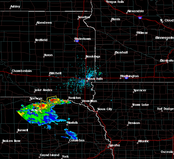 At 335 pm cdt, a severe thunderstorm was located near springfield, or 8 miles south of tyndall, moving east at 15 mph (radar indicated). Hazards include 60 mph wind gusts and quarter size hail. Hail damage to vehicles is expected. expect wind damage to roofs, siding and trees. This severe storm will be near, springfield around 340 pm cdt. At 335 pm cdt, a severe thunderstorm was located near springfield, or 8 miles south of tyndall, moving east at 15 mph (radar indicated). Hazards include 60 mph wind gusts and quarter size hail. Hail damage to vehicles is expected. expect wind damage to roofs, siding and trees. This severe storm will be near, springfield around 340 pm cdt.
|
| 9/9/2015 3:32 PM CDT | Quarter sized hail reported 4.4 miles SE of Springfield, SD |
| 9/9/2015 3:21 PM CDT |
 At 320 pm cdt, a severe thunderstorm was located near springfield, or 10 miles southwest of tyndall, moving east at 15 mph (radar indicated). Hazards include ping pong ball size hail and 60 mph wind gusts. People and animals outdoors will be injured. expect hail damage to roofs, siding, windows and vehicles. expect wind damage to roofs, siding and trees. This severe thunderstorm will be near, springfield around 340 pm cdt. At 320 pm cdt, a severe thunderstorm was located near springfield, or 10 miles southwest of tyndall, moving east at 15 mph (radar indicated). Hazards include ping pong ball size hail and 60 mph wind gusts. People and animals outdoors will be injured. expect hail damage to roofs, siding, windows and vehicles. expect wind damage to roofs, siding and trees. This severe thunderstorm will be near, springfield around 340 pm cdt.
|
| 7/25/2015 11:47 PM CDT |
 At 1147 pm cdt, a severe thunderstorm was located over springfield, or 9 miles south of tyndall, moving southeast at 45 mph (radar indicated). Hazards include 70 mph wind gusts and penny size hail. Expect considerable tree damage. damage is likely to mobile homes, roofs and outbuildings. This severe thunderstorm will remain over mainly rural areas of southeastern bon homme county. At 1147 pm cdt, a severe thunderstorm was located over springfield, or 9 miles south of tyndall, moving southeast at 45 mph (radar indicated). Hazards include 70 mph wind gusts and penny size hail. Expect considerable tree damage. damage is likely to mobile homes, roofs and outbuildings. This severe thunderstorm will remain over mainly rural areas of southeastern bon homme county.
|
| 7/25/2015 11:37 PM CDT |
 At 1136 pm cdt, a severe thunderstorm was located near avon, or 7 miles southwest of tyndall, moving southeast at 25 mph (radar indicated). Hazards include 70 mph wind gusts and nickel size hail. Expect considerable tree damage. damage is likely to mobile homes, roofs and outbuildings. This severe storm will be near, tyndall and springfield around 1145 pm cdt. At 1136 pm cdt, a severe thunderstorm was located near avon, or 7 miles southwest of tyndall, moving southeast at 25 mph (radar indicated). Hazards include 70 mph wind gusts and nickel size hail. Expect considerable tree damage. damage is likely to mobile homes, roofs and outbuildings. This severe storm will be near, tyndall and springfield around 1145 pm cdt.
|
| 7/25/2015 11:22 PM CDT |
 At 1121 pm cdt, a severe thunderstorm was located over avon, or 8 miles west of tyndall, moving southeast at 45 mph (radar indicated). Hazards include 70 mph wind gusts and nickel size hail. Expect considerable tree damage. damage is likely to mobile homes, roofs and outbuildings. this severe storm will be near, tyndall around 1130 pm cdt. Springfield around 1135 pm cdt. At 1121 pm cdt, a severe thunderstorm was located over avon, or 8 miles west of tyndall, moving southeast at 45 mph (radar indicated). Hazards include 70 mph wind gusts and nickel size hail. Expect considerable tree damage. damage is likely to mobile homes, roofs and outbuildings. this severe storm will be near, tyndall around 1130 pm cdt. Springfield around 1135 pm cdt.
|
| 7/25/2015 11:05 PM CDT |
 At 1105 pm cdt, a severe thunderstorm was located over wagner, or 14 miles east of pickstown, moving southeast at 45 mph (radar indicated). Hazards include 70 mph wind gusts and nickel size hail. Expect considerable tree damage. damage is likely to mobile homes, roofs and outbuildings. this severe thunderstorm will be near, dante around 1110 pm cdt. avon around 1120 pm cdt. Springfield around 1135 pm cdt. At 1105 pm cdt, a severe thunderstorm was located over wagner, or 14 miles east of pickstown, moving southeast at 45 mph (radar indicated). Hazards include 70 mph wind gusts and nickel size hail. Expect considerable tree damage. damage is likely to mobile homes, roofs and outbuildings. this severe thunderstorm will be near, dante around 1110 pm cdt. avon around 1120 pm cdt. Springfield around 1135 pm cdt.
|
| 7/17/2015 10:40 PM CDT |
 The severe thunderstorm warning for bon homme, northwestern yankton and southeastern hutchinson counties will expire at 1045 pm cdt, the storms which prompted the warning have weakened below severe limits, and exited the warned area. therefore the warning will be allowed to expire. however, gusty winds of 30 to 40 mph are still possible with these thunderstorms, along with brief heavy rainfall and dangerous lightning. a severe thunderstorm watch remains in effect until 200 am cdt for southeastern south dakota. The severe thunderstorm warning for bon homme, northwestern yankton and southeastern hutchinson counties will expire at 1045 pm cdt, the storms which prompted the warning have weakened below severe limits, and exited the warned area. therefore the warning will be allowed to expire. however, gusty winds of 30 to 40 mph are still possible with these thunderstorms, along with brief heavy rainfall and dangerous lightning. a severe thunderstorm watch remains in effect until 200 am cdt for southeastern south dakota.
|
| 7/17/2015 10:07 PM CDT |
 At 1006 pm cdt, severe thunderstorms were located along a line extending from near kaylor to near tyndall, moving northeast at 35 mph (radar indicated). Hazards include 60 mph wind gusts. Expect damage to roofs. siding and trees. these severe storms will be near, scotland around 1015 pm cdt. tabor around 1020 pm cdt. menno around 1030 pm cdt. Other locations impacted by these severe thunderstorms include olivet and lesterville. At 1006 pm cdt, severe thunderstorms were located along a line extending from near kaylor to near tyndall, moving northeast at 35 mph (radar indicated). Hazards include 60 mph wind gusts. Expect damage to roofs. siding and trees. these severe storms will be near, scotland around 1015 pm cdt. tabor around 1020 pm cdt. menno around 1030 pm cdt. Other locations impacted by these severe thunderstorms include olivet and lesterville.
|
| 7/17/2015 9:58 PM CDT |
 At 958 pm cdt, severe thunderstorms were located along a line extending from 7 miles southwest of kaylor to near tyndall, moving northeast at 25 mph (radar indicated). Hazards include 60 mph wind gusts. Expect damage to roofs. siding and trees. severe thunderstorms will be near, kaylor around 1015 pm cdt. scotland around 1025 pm cdt. tabor around 1030 pm cdt. menno around 1045 pm cdt. Other locations impacted by these severe thunderstorms include olivet and lesterville. At 958 pm cdt, severe thunderstorms were located along a line extending from 7 miles southwest of kaylor to near tyndall, moving northeast at 25 mph (radar indicated). Hazards include 60 mph wind gusts. Expect damage to roofs. siding and trees. severe thunderstorms will be near, kaylor around 1015 pm cdt. scotland around 1025 pm cdt. tabor around 1030 pm cdt. menno around 1045 pm cdt. Other locations impacted by these severe thunderstorms include olivet and lesterville.
|
| 6/20/2015 2:45 AM CDT |
 At 244 am cdt, severe thunderstorms were located along a line extending from near milltown to near tyndall to scottville, moving east at 65 mph (radar indicated). Hazards include 60 mph wind gusts. Expect damage to roofs. siding and trees. these severe storms will be near, milltown and clayton around 250 am cdt. tabor around 255 am cdt. Other locations impacted by these severe thunderstorms include olivet and lesterville. At 244 am cdt, severe thunderstorms were located along a line extending from near milltown to near tyndall to scottville, moving east at 65 mph (radar indicated). Hazards include 60 mph wind gusts. Expect damage to roofs. siding and trees. these severe storms will be near, milltown and clayton around 250 am cdt. tabor around 255 am cdt. Other locations impacted by these severe thunderstorms include olivet and lesterville.
|
| 6/20/2015 2:32 AM CDT |
 At 231 am cdt, severe thunderstorms were located along a line extending from near ethan to near avon to near anncar, moving east at 65 mph (radar indicated). Hazards include 70 mph wind gusts. Expect considerable tree damage. damage is likely to mobile homes, roofs and outbuildings. these severe storms will be near, parkston, avon and dimock around 235 am cdt. tyndall and milltown around 245 am cdt. clayton around 250 am cdt. tabor around 255 am cdt. Other locations impacted by these severe thunderstorms include olivet and lesterville. At 231 am cdt, severe thunderstorms were located along a line extending from near ethan to near avon to near anncar, moving east at 65 mph (radar indicated). Hazards include 70 mph wind gusts. Expect considerable tree damage. damage is likely to mobile homes, roofs and outbuildings. these severe storms will be near, parkston, avon and dimock around 235 am cdt. tyndall and milltown around 245 am cdt. clayton around 250 am cdt. tabor around 255 am cdt. Other locations impacted by these severe thunderstorms include olivet and lesterville.
|
| 6/20/2015 2:17 AM CDT |
 At 216 am cdt, severe thunderstorms were located along a line extending from near stickney to near ravinia to near dustin, moving east at 65 mph (radar indicated). Hazards include 70 mph wind gusts. Expect considerable tree damage. damage is likely to mobile homes, roofs and outbuildings. severe thunderstorms will be near, wagner and ravinia around 220 am cdt. dante around 225 am cdt. parkston, avon and dimock around 235 am cdt. tyndall around 240 am cdt. milltown around 245 am cdt. tabor and clayton around 250 am cdt. Other locations impacted by these severe thunderstorms include olivet and lesterville. At 216 am cdt, severe thunderstorms were located along a line extending from near stickney to near ravinia to near dustin, moving east at 65 mph (radar indicated). Hazards include 70 mph wind gusts. Expect considerable tree damage. damage is likely to mobile homes, roofs and outbuildings. severe thunderstorms will be near, wagner and ravinia around 220 am cdt. dante around 225 am cdt. parkston, avon and dimock around 235 am cdt. tyndall around 240 am cdt. milltown around 245 am cdt. tabor and clayton around 250 am cdt. Other locations impacted by these severe thunderstorms include olivet and lesterville.
|
| 6/21/2013 9:27 PM CDT | Quarter sized hail reported 3.5 miles W of Springfield, SD |
| 8/28/2011 6:30 AM CDT | Quarter sized hail reported 1.1 miles NNW of Springfield, SD |
| 1/1/0001 12:00 AM | Quarter sized hail reported 7.8 miles E of Springfield, SD, also gusty thunderstorm winds from 40 to 45 miles an hour. |
| 1/1/0001 12:00 AM | Golf Ball sized hail reported 7.8 miles E of Springfield, SD |
| 1/1/0001 12:00 AM | Quarter sized hail reported 7.8 miles E of Springfield, SD, also gusty thunderstorm winds from 40 to 45 miles an hour. |
| 8/18/2011 12:30 AM CDT | Quarter sized hail reported 7.8 miles E of Springfield, SD, also gusty thunderstorm winds from 40 to 45 miles an hour. |
| 1/1/0001 12:00 AM | Golf Ball sized hail reported 1.1 miles NNW of Springfield, SD |
Hail Maps for Springfield, SD

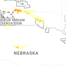
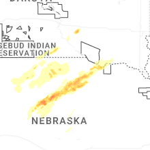


Connect with Interactive Hail Maps