

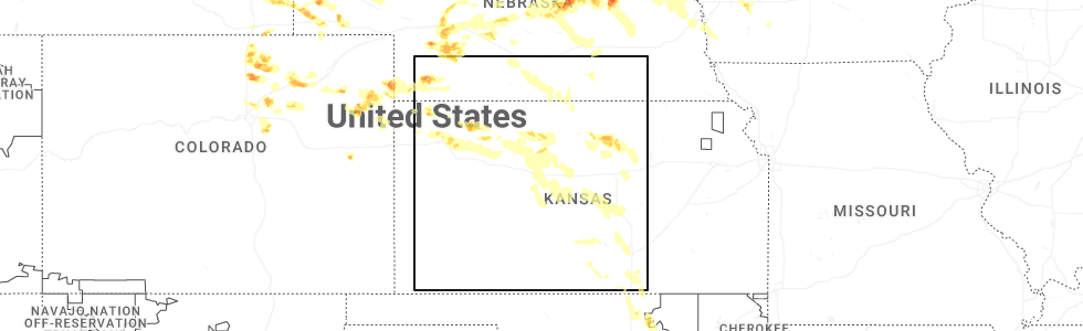
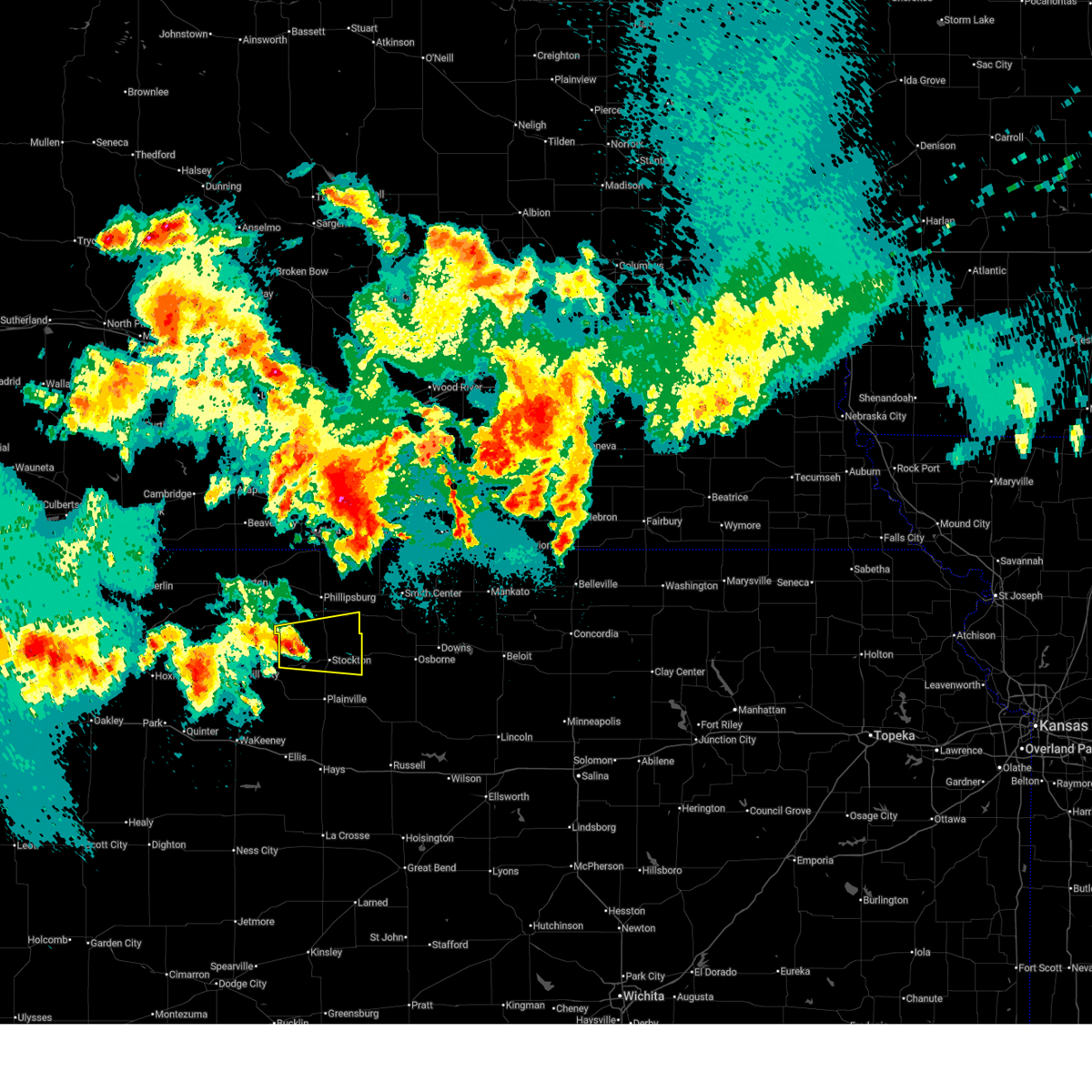
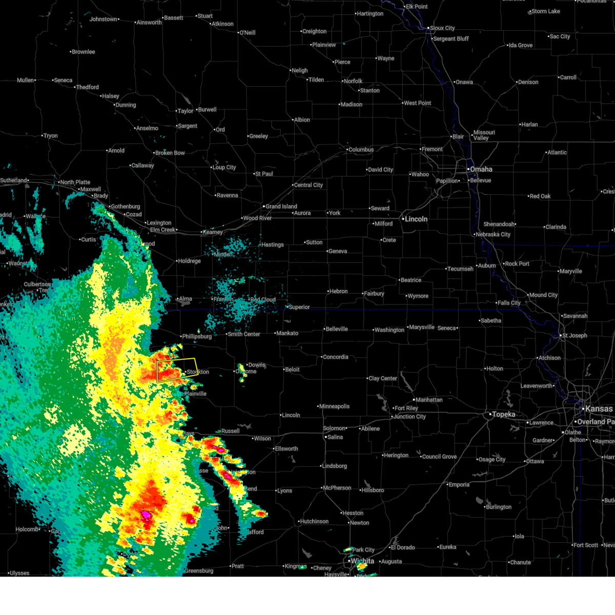
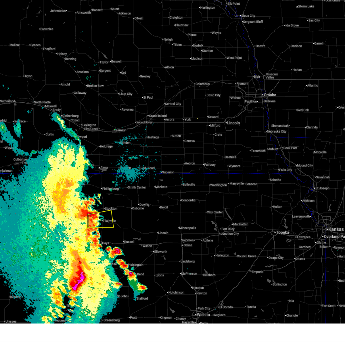
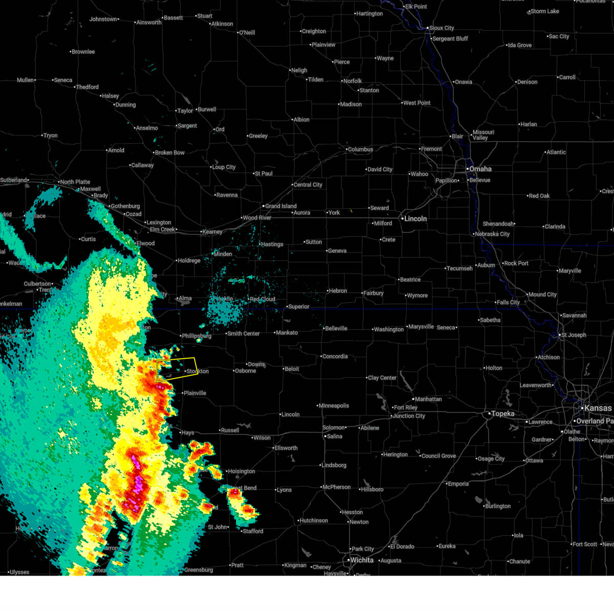
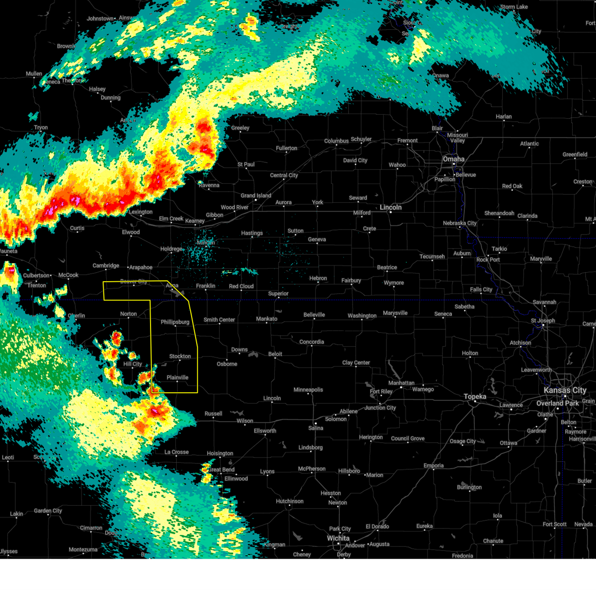
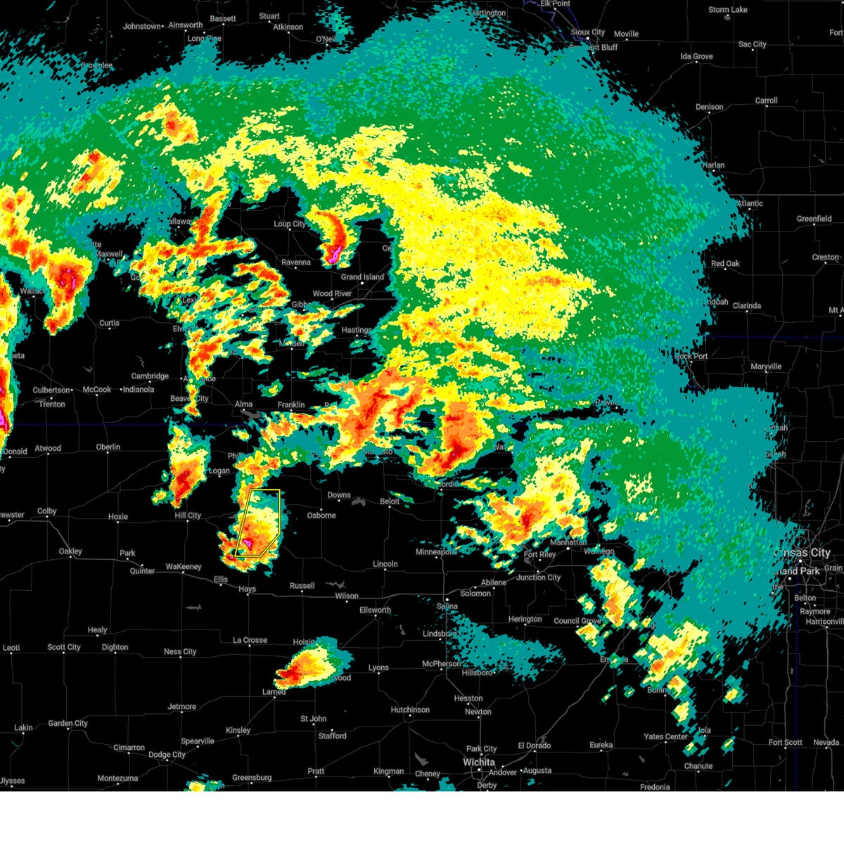
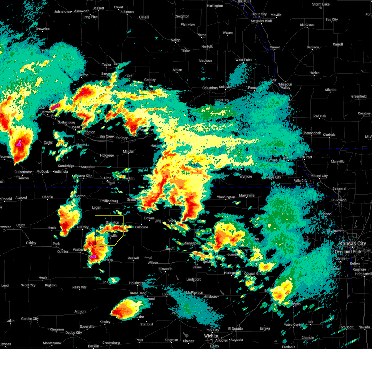
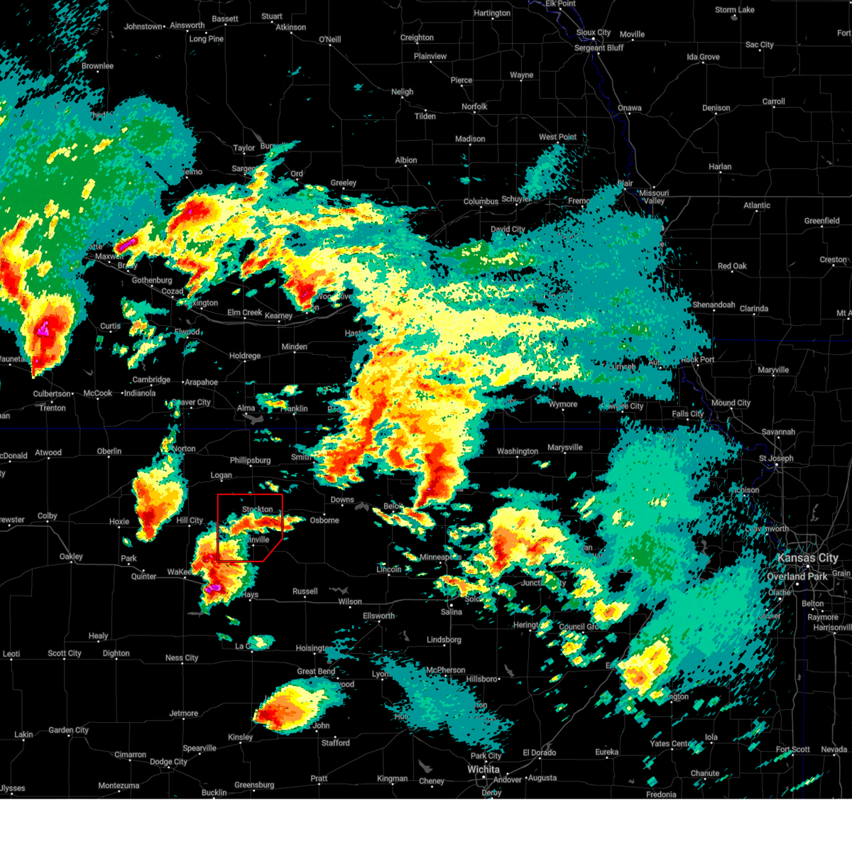
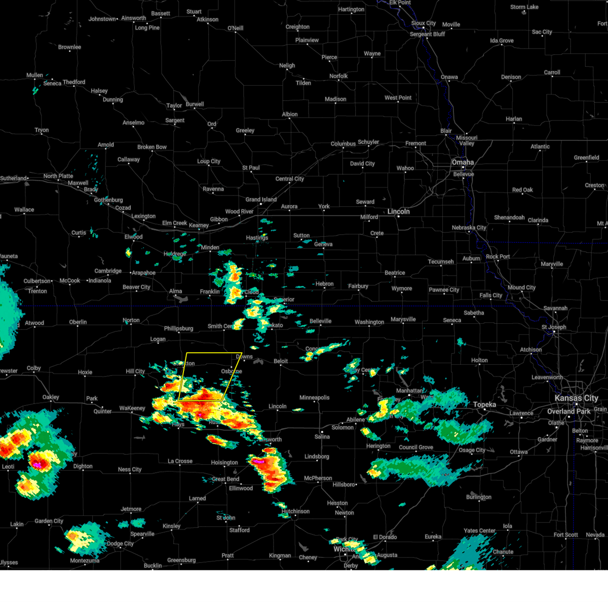
Hail Map for Stockton, KS
The Stockton, KS area has had 27 reports of on-the-ground hail by trained spotters, and has been under severe weather warnings 29 times during the past 12 months. Doppler radar has detected hail at or near Stockton, KS on 130 occasions, including 5 occasions during the past year.
| Name: | Stockton, KS |
| Where Located: | 38.2 miles N of Hays, KS |
| Map: | Google Map for Stockton, KS |
| Population: | 1329 |
| Housing Units: | 743 |
| More Info: | Search Google for Stockton, KS |
1
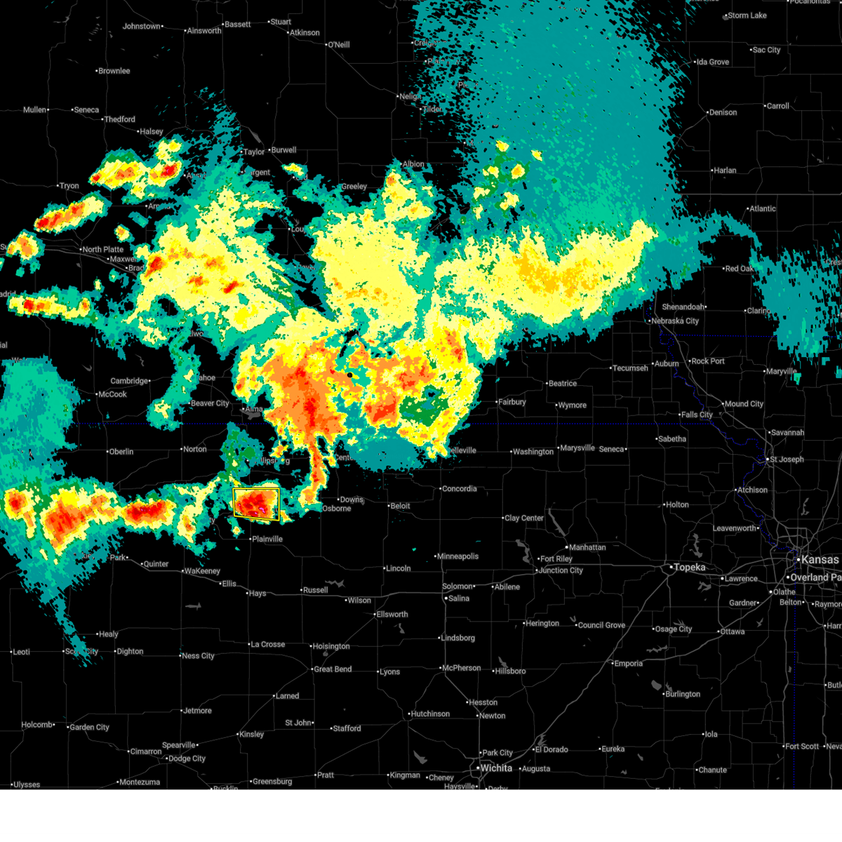
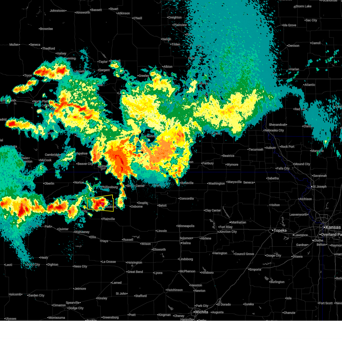
The Top Recent Hail Date for Stockton, KS is Monday, June 16, 2025 (26th out of 130)
Hail and Wind Damage Spotted near Stockton, KS
| Date / Time | Report Details |
|---|---|
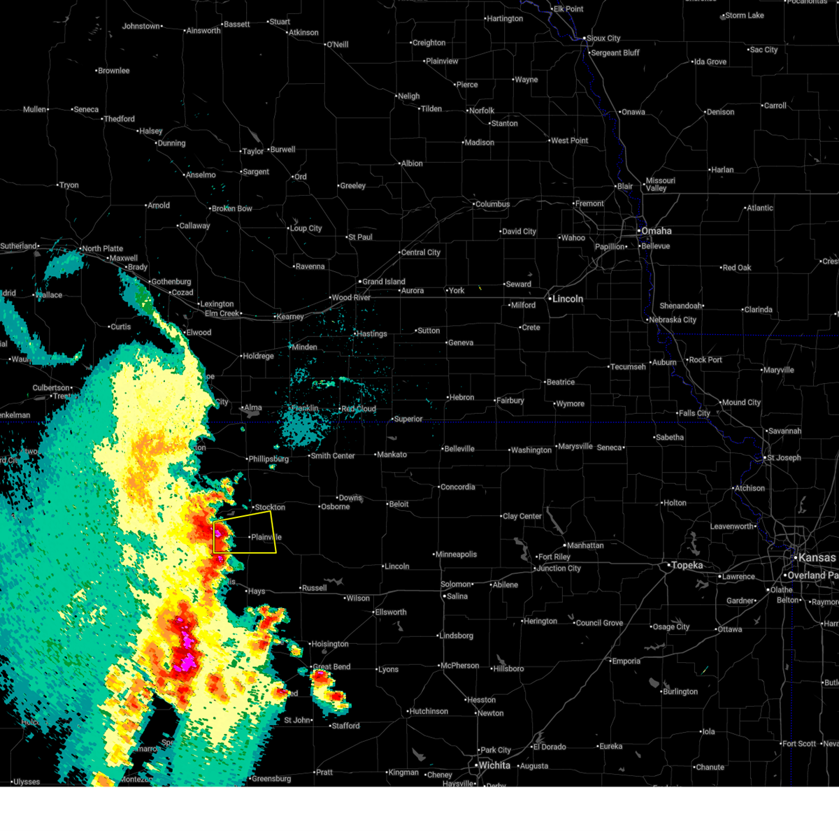
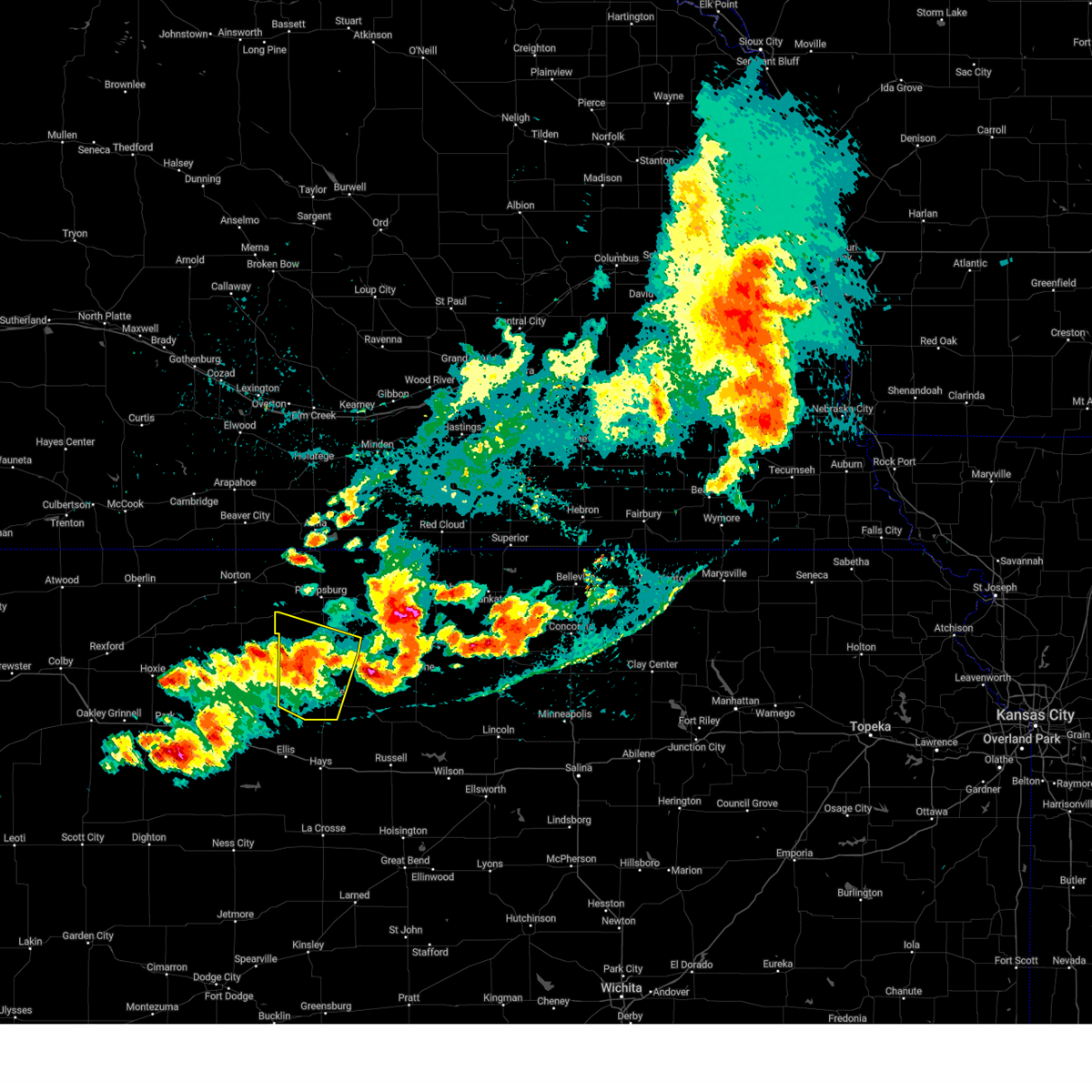
| 6/16/2025 11:40 PM CDT | Quarter sized hail reported 1.2 miles SSW of Stockton, KS, dispatch reports a few stones up to 1 inch diameter... most smaller. |
| 6/16/2025 11:39 PM CDT |
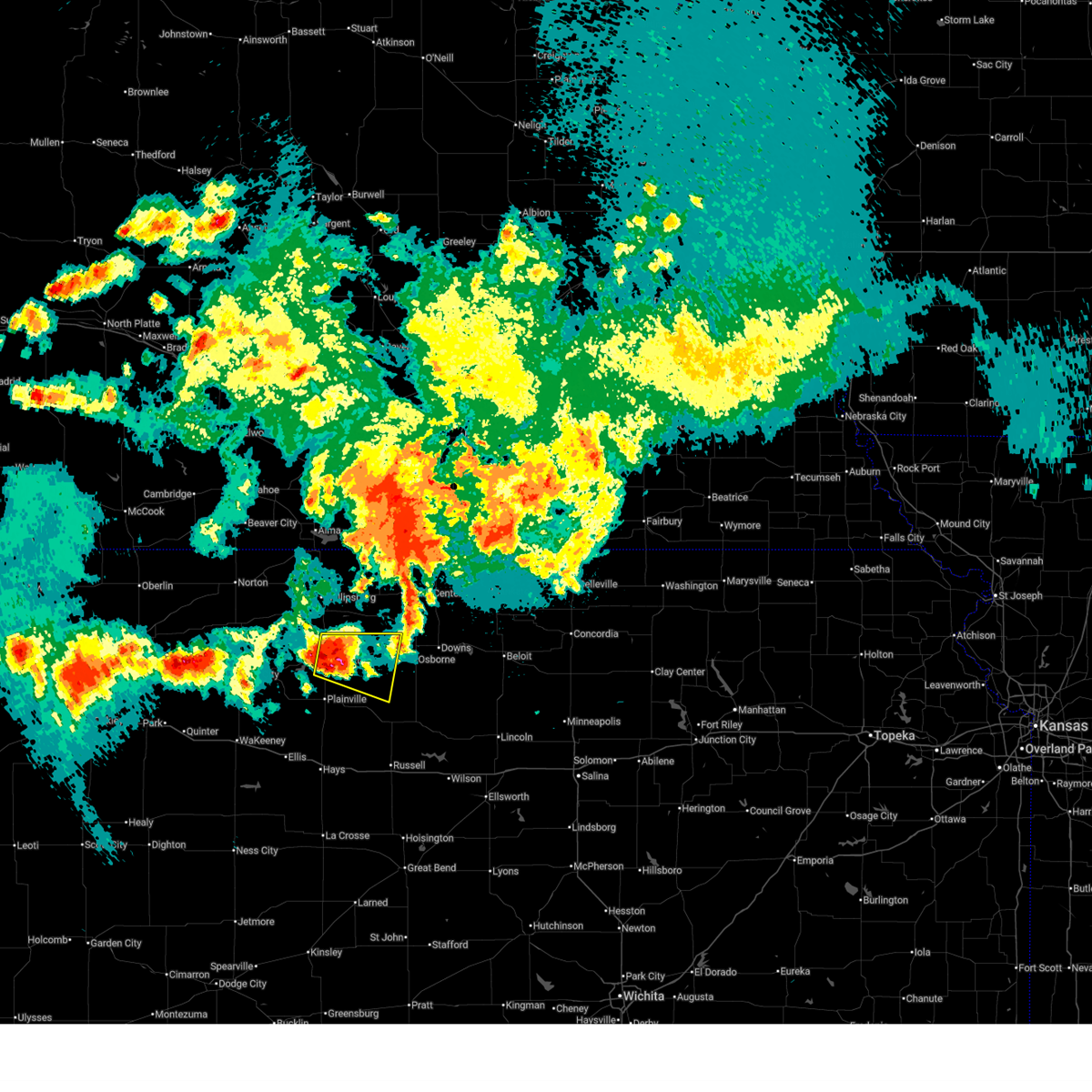 Svrgid the national weather service in hastings has issued a * severe thunderstorm warning for, northeastern rooks county in north central kansas, western osborne county in north central kansas, * until 1230 am cdt. * at 1138 pm cdt, a severe thunderstorm was located near stockton, or 22 miles south of phillipsburg, moving east at 25 mph (radar indicated). Hazards include 60 mph wind gusts and quarter size hail. Hail damage to vehicles is expected. expect wind damage to roofs, siding, and trees. this severe thunderstorm will be near, woodston around 1145 pm cdt. Other locations in the path of this severe thunderstorm include alton. Svrgid the national weather service in hastings has issued a * severe thunderstorm warning for, northeastern rooks county in north central kansas, western osborne county in north central kansas, * until 1230 am cdt. * at 1138 pm cdt, a severe thunderstorm was located near stockton, or 22 miles south of phillipsburg, moving east at 25 mph (radar indicated). Hazards include 60 mph wind gusts and quarter size hail. Hail damage to vehicles is expected. expect wind damage to roofs, siding, and trees. this severe thunderstorm will be near, woodston around 1145 pm cdt. Other locations in the path of this severe thunderstorm include alton.
|
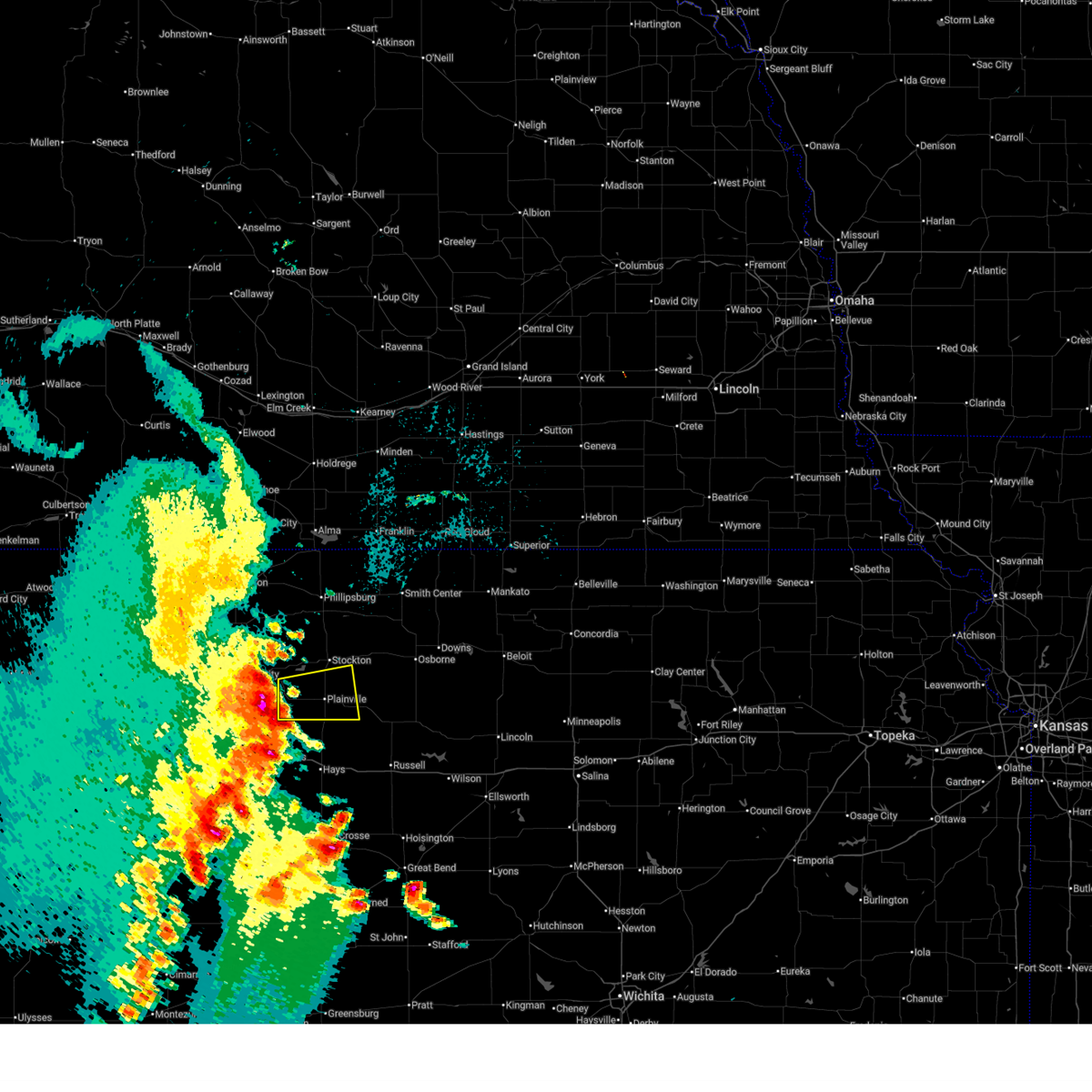
| 6/16/2025 11:34 PM CDT |
 At 1133 pm cdt, a severe thunderstorm was located over stockton, or 21 miles south of phillipsburg, moving east at 25 mph (radar indicated). Hazards include 60 mph wind gusts and quarter size hail. Hail damage to vehicles is expected. expect wind damage to roofs, siding, and trees. Locations impacted include, stockton and woodston. At 1133 pm cdt, a severe thunderstorm was located over stockton, or 21 miles south of phillipsburg, moving east at 25 mph (radar indicated). Hazards include 60 mph wind gusts and quarter size hail. Hail damage to vehicles is expected. expect wind damage to roofs, siding, and trees. Locations impacted include, stockton and woodston.
|
| 6/16/2025 11:34 PM CDT |
 the severe thunderstorm warning has been cancelled and is no longer in effect the severe thunderstorm warning has been cancelled and is no longer in effect
|
| 6/16/2025 11:23 PM CDT |
 At 1123 pm cdt, a severe thunderstorm was located near stockton, or 18 miles south of phillipsburg, moving east at 35 mph (radar indicated). Hazards include 60 mph wind gusts and quarter size hail. Hail damage to vehicles is expected. expect wind damage to roofs, siding, and trees. Locations impacted include, stockton, woodston, and webster state park. At 1123 pm cdt, a severe thunderstorm was located near stockton, or 18 miles south of phillipsburg, moving east at 35 mph (radar indicated). Hazards include 60 mph wind gusts and quarter size hail. Hail damage to vehicles is expected. expect wind damage to roofs, siding, and trees. Locations impacted include, stockton, woodston, and webster state park.
|
| 6/16/2025 11:02 PM CDT |
 Svrgid the national weather service in hastings has issued a * severe thunderstorm warning for, northern rooks county in north central kansas, southern phillips county in north central kansas, * until 1145 pm cdt. * at 1102 pm cdt, a severe thunderstorm was located 7 miles north of webster state park, or 17 miles south of phillipsburg, moving east at 40 mph (radar indicated). Hazards include 60 mph wind gusts and penny size hail. Expect damage to roofs, siding, and trees. This severe thunderstorm will remain over mainly rural areas of northern rooks and southern phillips counties. Svrgid the national weather service in hastings has issued a * severe thunderstorm warning for, northern rooks county in north central kansas, southern phillips county in north central kansas, * until 1145 pm cdt. * at 1102 pm cdt, a severe thunderstorm was located 7 miles north of webster state park, or 17 miles south of phillipsburg, moving east at 40 mph (radar indicated). Hazards include 60 mph wind gusts and penny size hail. Expect damage to roofs, siding, and trees. This severe thunderstorm will remain over mainly rural areas of northern rooks and southern phillips counties.
|
| 6/14/2025 5:13 AM CDT |
 The storm which prompted the warning has weakened below severe limits, and no longer poses an immediate threat to life or property. therefore, the warning will be allowed to expire. however, gusty winds are still possible with this thunderstorm. The storm which prompted the warning has weakened below severe limits, and no longer poses an immediate threat to life or property. therefore, the warning will be allowed to expire. however, gusty winds are still possible with this thunderstorm.
|
| 6/14/2025 5:12 AM CDT |
 The storm which prompted the warning has weakened below severe limits, and no longer poses an immediate threat to life or property. therefore, the warning will be allowed to expire. however, gusty winds are still possible with this thunderstorm. The storm which prompted the warning has weakened below severe limits, and no longer poses an immediate threat to life or property. therefore, the warning will be allowed to expire. however, gusty winds are still possible with this thunderstorm.
|
| 6/14/2025 4:58 AM CDT |
 At 457 am cdt, a severe thunderstorm was located over webster state park, or 20 miles east of hill city, moving northeast at 20 mph (radar indicated). Hazards include 60 mph wind gusts and nickel size hail. Expect damage to roofs, siding, and trees. Locations impacted include, stockton and webster state park. At 457 am cdt, a severe thunderstorm was located over webster state park, or 20 miles east of hill city, moving northeast at 20 mph (radar indicated). Hazards include 60 mph wind gusts and nickel size hail. Expect damage to roofs, siding, and trees. Locations impacted include, stockton and webster state park.
|
| 6/14/2025 4:57 AM CDT |
 At 457 am cdt, a severe thunderstorm was located over webster state park, or 19 miles east of hill city, moving northeast at 20 mph (radar indicated). Hazards include 60 mph wind gusts and nickel size hail. Expect damage to roofs, siding, and trees. This severe thunderstorm will remain over mainly rural areas of southern rooks county. At 457 am cdt, a severe thunderstorm was located over webster state park, or 19 miles east of hill city, moving northeast at 20 mph (radar indicated). Hazards include 60 mph wind gusts and nickel size hail. Expect damage to roofs, siding, and trees. This severe thunderstorm will remain over mainly rural areas of southern rooks county.
|
| 6/14/2025 4:45 AM CDT |
 Svrgid the national weather service in hastings has issued a * severe thunderstorm warning for, northern rooks county in north central kansas, * until 515 am cdt. * at 445 am cdt, a severe thunderstorm was located near palco, or 18 miles east of hill city, moving east at 25 mph (radar indicated). Hazards include 60 mph wind gusts and quarter size hail. Hail damage to vehicles is expected. expect wind damage to roofs, siding, and trees. This severe thunderstorm will remain over mainly rural areas of northern rooks county. Svrgid the national weather service in hastings has issued a * severe thunderstorm warning for, northern rooks county in north central kansas, * until 515 am cdt. * at 445 am cdt, a severe thunderstorm was located near palco, or 18 miles east of hill city, moving east at 25 mph (radar indicated). Hazards include 60 mph wind gusts and quarter size hail. Hail damage to vehicles is expected. expect wind damage to roofs, siding, and trees. This severe thunderstorm will remain over mainly rural areas of northern rooks county.
|
| 6/14/2025 4:40 AM CDT |
 At 440 am cdt, a severe thunderstorm was located near palco, or 20 miles east of hill city, moving east at 25 mph (radar indicated). Hazards include 60 to 65 mph wind gusts and quarter size hail. Hail damage to vehicles is expected. expect wind damage to roofs, siding, and trees. This severe storm will be near, zurich around 445 am cdt. At 440 am cdt, a severe thunderstorm was located near palco, or 20 miles east of hill city, moving east at 25 mph (radar indicated). Hazards include 60 to 65 mph wind gusts and quarter size hail. Hail damage to vehicles is expected. expect wind damage to roofs, siding, and trees. This severe storm will be near, zurich around 445 am cdt.
|
| 6/14/2025 4:25 AM CDT |
 Svrgid the national weather service in hastings has issued a * severe thunderstorm warning for, southern rooks county in north central kansas, * until 515 am cdt. * at 425 am cdt, a severe thunderstorm was located near palco, or 16 miles southeast of hill city, moving east at 25 mph (radar indicated). Hazards include 60 mph wind gusts and quarter size hail. Hail damage to vehicles is expected. expect wind damage to roofs, siding, and trees. this severe thunderstorm will be near, palco around 430 am cdt. zurich around 440 am cdt. Other locations in the path of this severe thunderstorm include plainville. Svrgid the national weather service in hastings has issued a * severe thunderstorm warning for, southern rooks county in north central kansas, * until 515 am cdt. * at 425 am cdt, a severe thunderstorm was located near palco, or 16 miles southeast of hill city, moving east at 25 mph (radar indicated). Hazards include 60 mph wind gusts and quarter size hail. Hail damage to vehicles is expected. expect wind damage to roofs, siding, and trees. this severe thunderstorm will be near, palco around 430 am cdt. zurich around 440 am cdt. Other locations in the path of this severe thunderstorm include plainville.
|
| 6/2/2025 9:27 PM CDT |
 The storms which prompted the warning have weakened below severe limits, and no longer pose an immediate threat to life or property. therefore, the warning will be allowed to expire. however, small hail and gusty winds are still possible with these thunderstorms. a severe thunderstorm watch remains in effect until 100 am cdt for north central kansas, and south central nebraska. remember, a severe thunderstorm warning still remains in effect for northwestern phillips county, eastern furnas county, and harlan county until 1000 pm cdt. The storms which prompted the warning have weakened below severe limits, and no longer pose an immediate threat to life or property. therefore, the warning will be allowed to expire. however, small hail and gusty winds are still possible with these thunderstorms. a severe thunderstorm watch remains in effect until 100 am cdt for north central kansas, and south central nebraska. remember, a severe thunderstorm warning still remains in effect for northwestern phillips county, eastern furnas county, and harlan county until 1000 pm cdt.
|
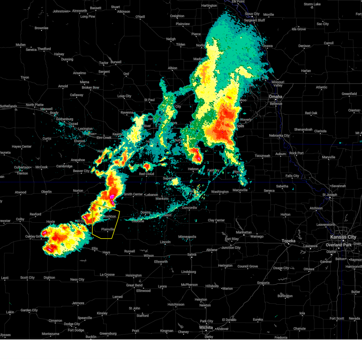
| 6/2/2025 9:05 PM CDT |
 At 904 pm cdt, severe thunderstorms were located along a line extending from near norton to 6 miles north of webster state park to 9 miles south of plainville, moving northeast at 40 mph (radar indicated). Hazards include 60 mph wind gusts and quarter size hail. Hail damage to vehicles is expected. expect wind damage to roofs, siding, and trees. these severe storms will be near, plainville, stockton, and logan around 910 pm cdt. speed and codell around 915 pm cdt. prairie view and glade around 920 pm cdt. phillipsburg around 925 pm cdt. woodston and long island around 930 pm cdt. Kirwin around 935 pm cdt. At 904 pm cdt, severe thunderstorms were located along a line extending from near norton to 6 miles north of webster state park to 9 miles south of plainville, moving northeast at 40 mph (radar indicated). Hazards include 60 mph wind gusts and quarter size hail. Hail damage to vehicles is expected. expect wind damage to roofs, siding, and trees. these severe storms will be near, plainville, stockton, and logan around 910 pm cdt. speed and codell around 915 pm cdt. prairie view and glade around 920 pm cdt. phillipsburg around 925 pm cdt. woodston and long island around 930 pm cdt. Kirwin around 935 pm cdt.
|
| 6/2/2025 8:47 PM CDT |
 Svrgid the national weather service in hastings has issued a * severe thunderstorm warning for, rooks county in north central kansas, phillips county in north central kansas, southern furnas county in south central nebraska, southern harlan county in south central nebraska, * until 930 pm cdt. * at 847 pm cdt, severe thunderstorms were located along a line extending from 6 miles east of clayton to near nicodemus to near yocemento, moving northeast at 40 mph (radar indicated). Hazards include 60 mph wind gusts and quarter size hail. Hail damage to vehicles is expected. expect wind damage to roofs, siding, and trees. severe thunderstorms will be near, zurich and webster state park around 855 pm cdt. plainville and logan around 900 pm cdt. Other locations in the path of these severe thunderstorms include stockton, speed, codell, prairie view and glade. Svrgid the national weather service in hastings has issued a * severe thunderstorm warning for, rooks county in north central kansas, phillips county in north central kansas, southern furnas county in south central nebraska, southern harlan county in south central nebraska, * until 930 pm cdt. * at 847 pm cdt, severe thunderstorms were located along a line extending from 6 miles east of clayton to near nicodemus to near yocemento, moving northeast at 40 mph (radar indicated). Hazards include 60 mph wind gusts and quarter size hail. Hail damage to vehicles is expected. expect wind damage to roofs, siding, and trees. severe thunderstorms will be near, zurich and webster state park around 855 pm cdt. plainville and logan around 900 pm cdt. Other locations in the path of these severe thunderstorms include stockton, speed, codell, prairie view and glade.
|
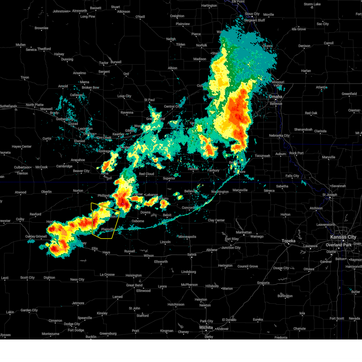
| 5/18/2025 8:32 PM CDT |
 At 831 pm cdt, a severe thunderstorm was located over plainville, or 20 miles northwest of emmeram, moving northeast at 55 mph (radar indicated). Hazards include quarter size hail. Damage to vehicles is expected. this severe storm will be near, plainville around 835 pm cdt. Woodston around 850 pm cdt. At 831 pm cdt, a severe thunderstorm was located over plainville, or 20 miles northwest of emmeram, moving northeast at 55 mph (radar indicated). Hazards include quarter size hail. Damage to vehicles is expected. this severe storm will be near, plainville around 835 pm cdt. Woodston around 850 pm cdt.
|
| 5/18/2025 8:17 PM CDT | At 816 pm cdt, a severe thunderstorm was located over zurich, or 19 miles north of ellis, moving northeast at 50 mph (radar indicated). Hazards include half dollar size hail. Damage to vehicles is expected. this severe storm will be near, zurich around 820 pm cdt. Stockton around 835 pm cdt. |
| 5/18/2025 7:58 PM CDT |
 the tornado warning has been cancelled and is no longer in effect the tornado warning has been cancelled and is no longer in effect
|
| 5/18/2025 7:58 PM CDT |
 Svrgid the national weather service in hastings has issued a * severe thunderstorm warning for, rooks county in north central kansas, * until 900 pm cdt. * at 758 pm cdt, a severe thunderstorm was located near ellis, moving northeast at 50 mph (radar indicated). Hazards include ping pong ball size hail and 60 mph wind gusts. People and animals outdoors will be injured. expect hail damage to roofs, siding, windows, and vehicles. expect wind damage to roofs, siding, and trees. this severe thunderstorm will be near, zurich around 815 pm cdt. Other locations in the path of this severe thunderstorm include stockton. Svrgid the national weather service in hastings has issued a * severe thunderstorm warning for, rooks county in north central kansas, * until 900 pm cdt. * at 758 pm cdt, a severe thunderstorm was located near ellis, moving northeast at 50 mph (radar indicated). Hazards include ping pong ball size hail and 60 mph wind gusts. People and animals outdoors will be injured. expect hail damage to roofs, siding, windows, and vehicles. expect wind damage to roofs, siding, and trees. this severe thunderstorm will be near, zurich around 815 pm cdt. Other locations in the path of this severe thunderstorm include stockton.
|
| 5/18/2025 7:55 PM CDT |
 Torgid the national weather service in hastings has issued a * tornado warning for, rooks county in north central kansas, * until 900 pm cdt. * at 755 pm cdt, a severe thunderstorm capable of producing a tornado was located over riga, moving northeast at 50 mph (radar indicated rotation). Hazards include tornado and ping pong ball size hail. Flying debris will be dangerous to those caught without shelter. mobile homes will be damaged or destroyed. damage to roofs, windows, and vehicles will occur. tree damage is likely. this dangerous storm will be near, zurich around 815 pm cdt. Other locations in the path of this tornadic thunderstorm include stockton. Torgid the national weather service in hastings has issued a * tornado warning for, rooks county in north central kansas, * until 900 pm cdt. * at 755 pm cdt, a severe thunderstorm capable of producing a tornado was located over riga, moving northeast at 50 mph (radar indicated rotation). Hazards include tornado and ping pong ball size hail. Flying debris will be dangerous to those caught without shelter. mobile homes will be damaged or destroyed. damage to roofs, windows, and vehicles will occur. tree damage is likely. this dangerous storm will be near, zurich around 815 pm cdt. Other locations in the path of this tornadic thunderstorm include stockton.
|
| 5/18/2025 5:46 PM CDT | At 545 pm cdt, a severe thunderstorm was located near natoma, or 19 miles northeast of emmeram, moving northeast at 55 mph (radar indicated). Hazards include golf ball size hail and 60 mph wind gusts. People and animals outdoors will be injured. expect hail damage to roofs, siding, windows, and vehicles. expect wind damage to roofs, siding, and trees. this severe storm will be near, osborne around 605 pm cdt. Portis around 610 pm cdt. |
| 5/18/2025 5:36 PM CDT |
 At 535 pm cdt, a severe thunderstorm was located 8 miles south of alton, or 27 miles north of emmeram, moving north at 55 mph (radar indicated). Hazards include golf ball size hail and 60 mph wind gusts. People and animals outdoors will be injured. expect hail damage to roofs, siding, windows, and vehicles. expect wind damage to roofs, siding, and trees. This severe storm will be near, alton around 540 pm cdt. At 535 pm cdt, a severe thunderstorm was located 8 miles south of alton, or 27 miles north of emmeram, moving north at 55 mph (radar indicated). Hazards include golf ball size hail and 60 mph wind gusts. People and animals outdoors will be injured. expect hail damage to roofs, siding, windows, and vehicles. expect wind damage to roofs, siding, and trees. This severe storm will be near, alton around 540 pm cdt.
|
| 5/18/2025 5:18 PM CDT |
 Svrgid the national weather service in hastings has issued a * severe thunderstorm warning for, eastern rooks county in north central kansas, osborne county in north central kansas, * until 600 pm cdt. * at 517 pm cdt, a severe thunderstorm was located near natoma, or 11 miles north of emmeram, moving north at 55 mph (radar indicated). Hazards include 60 mph wind gusts and half dollar size hail. Hail damage to vehicles is expected. expect wind damage to roofs, siding, and trees. this severe thunderstorm will be near, natoma around 525 pm cdt. Other locations in the path of this severe thunderstorm include alton. Svrgid the national weather service in hastings has issued a * severe thunderstorm warning for, eastern rooks county in north central kansas, osborne county in north central kansas, * until 600 pm cdt. * at 517 pm cdt, a severe thunderstorm was located near natoma, or 11 miles north of emmeram, moving north at 55 mph (radar indicated). Hazards include 60 mph wind gusts and half dollar size hail. Hail damage to vehicles is expected. expect wind damage to roofs, siding, and trees. this severe thunderstorm will be near, natoma around 525 pm cdt. Other locations in the path of this severe thunderstorm include alton.
|
| 7/31/2024 5:33 PM CDT |
 The storms which prompted the warning have weakened below severe limits, and no longer pose an immediate threat to life or property. therefore, the warning has been allowed to expire. however, small hail and gusty winds are still possible with these thunderstorms. a severe thunderstorm watch remains in effect until 1000 pm cdt for north central kansas. The storms which prompted the warning have weakened below severe limits, and no longer pose an immediate threat to life or property. therefore, the warning has been allowed to expire. however, small hail and gusty winds are still possible with these thunderstorms. a severe thunderstorm watch remains in effect until 1000 pm cdt for north central kansas.
|
| 7/31/2024 5:17 PM CDT |
 At 517 pm cdt, severe thunderstorms were located along a line extending from 9 miles south of speed to near palco, moving southeast at 25 mph (radar indicated). Hazards include 60 mph wind gusts and half dollar size hail. Hail damage to vehicles is expected. expect wind damage to roofs, siding, and trees. these severe storms will be near, zurich and webster state park around 520 pm cdt. stockton around 525 pm cdt. plainville around 535 pm cdt. Woodston around 545 pm cdt. At 517 pm cdt, severe thunderstorms were located along a line extending from 9 miles south of speed to near palco, moving southeast at 25 mph (radar indicated). Hazards include 60 mph wind gusts and half dollar size hail. Hail damage to vehicles is expected. expect wind damage to roofs, siding, and trees. these severe storms will be near, zurich and webster state park around 520 pm cdt. stockton around 525 pm cdt. plainville around 535 pm cdt. Woodston around 545 pm cdt.
|
| 7/31/2024 5:08 PM CDT | Reports of some power outages north of webster reservoi in rooks county KS, 10.4 miles E of Stockton, KS |
| 7/31/2024 4:52 PM CDT |
 Svrgid the national weather service in hastings has issued a * severe thunderstorm warning for, rooks county in north central kansas, southwestern phillips county in north central kansas, * until 530 pm cdt. * at 452 pm cdt, severe thunderstorms were located along a line extending from near speed to near damar, moving southeast at 20 mph (radar indicated). Hazards include 60 mph wind gusts and quarter size hail. Hail damage to vehicles is expected. expect wind damage to roofs, siding, and trees. severe thunderstorms will be near, damar around 455 pm cdt. palco and webster state park around 500 pm cdt. Other locations in the path of these severe thunderstorms include zurich. Svrgid the national weather service in hastings has issued a * severe thunderstorm warning for, rooks county in north central kansas, southwestern phillips county in north central kansas, * until 530 pm cdt. * at 452 pm cdt, severe thunderstorms were located along a line extending from near speed to near damar, moving southeast at 20 mph (radar indicated). Hazards include 60 mph wind gusts and quarter size hail. Hail damage to vehicles is expected. expect wind damage to roofs, siding, and trees. severe thunderstorms will be near, damar around 455 pm cdt. palco and webster state park around 500 pm cdt. Other locations in the path of these severe thunderstorms include zurich.
|
| 7/16/2024 2:51 AM CDT |
 Svrgid the national weather service in hastings has issued a * severe thunderstorm warning for, rooks county in north central kansas, southwestern osborne county in north central kansas, * until 315 am cdt. * at 251 am cdt, a severe thunderstorm was located 10 miles south of plainville, or 12 miles north of yocemento, moving northeast at 45 mph (radar indicated). Hazards include 70 mph wind gusts and quarter size hail. Hail damage to vehicles is expected. expect considerable tree damage. wind damage is also likely to mobile homes, roofs, and outbuildings. This severe thunderstorm will be near, codell around 300 am cdt. Svrgid the national weather service in hastings has issued a * severe thunderstorm warning for, rooks county in north central kansas, southwestern osborne county in north central kansas, * until 315 am cdt. * at 251 am cdt, a severe thunderstorm was located 10 miles south of plainville, or 12 miles north of yocemento, moving northeast at 45 mph (radar indicated). Hazards include 70 mph wind gusts and quarter size hail. Hail damage to vehicles is expected. expect considerable tree damage. wind damage is also likely to mobile homes, roofs, and outbuildings. This severe thunderstorm will be near, codell around 300 am cdt.
|
| 7/3/2024 10:56 PM CDT |
 At 1055 pm cdt, severe thunderstorms were located along a line extending from 7 miles south of stockton to near hays, moving east at 45 mph (radar indicated). Hazards include 60 mph wind gusts. Expect damage to roofs, siding, and trees. These severe storms will be near, plainville and codell around 1100 pm cdt. At 1055 pm cdt, severe thunderstorms were located along a line extending from 7 miles south of stockton to near hays, moving east at 45 mph (radar indicated). Hazards include 60 mph wind gusts. Expect damage to roofs, siding, and trees. These severe storms will be near, plainville and codell around 1100 pm cdt.
|
| 7/3/2024 10:32 PM CDT |
 Svrgid the national weather service in hastings has issued a * severe thunderstorm warning for, rooks county in north central kansas, * until 1115 pm cdt. * at 1031 pm cdt, severe thunderstorms were located along a line extending from 9 miles southwest of logan to near cedar bluff, moving east at 40 mph (automated weather station). Hazards include 60 mph wind gusts. Expect damage to roofs, siding, and trees. severe thunderstorms will be near, palco and damar around 1035 pm cdt. zurich and webster state park around 1045 pm cdt. Other locations in the path of these severe thunderstorms include plainville and stockton. Svrgid the national weather service in hastings has issued a * severe thunderstorm warning for, rooks county in north central kansas, * until 1115 pm cdt. * at 1031 pm cdt, severe thunderstorms were located along a line extending from 9 miles southwest of logan to near cedar bluff, moving east at 40 mph (automated weather station). Hazards include 60 mph wind gusts. Expect damage to roofs, siding, and trees. severe thunderstorms will be near, palco and damar around 1035 pm cdt. zurich and webster state park around 1045 pm cdt. Other locations in the path of these severe thunderstorms include plainville and stockton.
|
| 6/18/2024 3:29 PM CDT |
 The storms which prompted the warning have weakened below severe limits, and no longer pose an immediate threat to life or property. therefore, the warning will be allowed to expire. however, small hail, gusty winds and heavy rain are still possible with these thunderstorms. a severe thunderstorm watch remains in effect until 800 pm cdt for north central kansas. to report severe weather, contact your nearest law enforcement agency. they will relay your report to the national weather service hastings. The storms which prompted the warning have weakened below severe limits, and no longer pose an immediate threat to life or property. therefore, the warning will be allowed to expire. however, small hail, gusty winds and heavy rain are still possible with these thunderstorms. a severe thunderstorm watch remains in effect until 800 pm cdt for north central kansas. to report severe weather, contact your nearest law enforcement agency. they will relay your report to the national weather service hastings.
|
| 6/18/2024 3:22 PM CDT |
 At 322 pm cdt, severe thunderstorms were located along a line extending from 6 miles north of woodston to near zurich, moving northeast at 35 mph (radar indicated). Hazards include 60 mph wind gusts and nickel size hail. Expect damage to roofs, siding, and trees. These severe storms will be near, plainville, stockton, and zurich around 325 pm cdt. At 322 pm cdt, severe thunderstorms were located along a line extending from 6 miles north of woodston to near zurich, moving northeast at 35 mph (radar indicated). Hazards include 60 mph wind gusts and nickel size hail. Expect damage to roofs, siding, and trees. These severe storms will be near, plainville, stockton, and zurich around 325 pm cdt.
|
| 6/18/2024 3:09 PM CDT |
 At 309 pm cdt, severe thunderstorms were located along a line extending from near stockton to 10 miles south of palco, moving east at 20 mph (radar indicated). Hazards include 60 mph wind gusts and quarter size hail. Hail damage to vehicles is expected. expect wind damage to roofs, siding, and trees. these severe storms will be near, stockton and zurich around 315 pm cdt. woodston around 320 pm cdt. Plainville around 325 pm cdt. At 309 pm cdt, severe thunderstorms were located along a line extending from near stockton to 10 miles south of palco, moving east at 20 mph (radar indicated). Hazards include 60 mph wind gusts and quarter size hail. Hail damage to vehicles is expected. expect wind damage to roofs, siding, and trees. these severe storms will be near, stockton and zurich around 315 pm cdt. woodston around 320 pm cdt. Plainville around 325 pm cdt.
|
| 6/18/2024 2:38 PM CDT |
 Svrgid the national weather service in hastings has issued a * severe thunderstorm warning for, rooks county in north central kansas, * until 330 pm cdt. * at 237 pm cdt, severe thunderstorms were located along a line extending from near webster state park to near ogallah, moving northeast at 35 mph (radar indicated). Hazards include 60 mph wind gusts and quarter size hail. Hail damage to vehicles is expected. expect wind damage to roofs, siding, and trees. severe thunderstorms will be near, palco and zurich around 245 pm cdt. stockton around 250 pm cdt. Other locations in the path of these severe thunderstorms include plainville and woodston. Svrgid the national weather service in hastings has issued a * severe thunderstorm warning for, rooks county in north central kansas, * until 330 pm cdt. * at 237 pm cdt, severe thunderstorms were located along a line extending from near webster state park to near ogallah, moving northeast at 35 mph (radar indicated). Hazards include 60 mph wind gusts and quarter size hail. Hail damage to vehicles is expected. expect wind damage to roofs, siding, and trees. severe thunderstorms will be near, palco and zurich around 245 pm cdt. stockton around 250 pm cdt. Other locations in the path of these severe thunderstorms include plainville and woodston.
|
| 6/4/2024 9:11 AM CDT |
 The storms which prompted the warning have weakened below severe limits, and no longer pose an immediate threat to life or property. therefore, the warning will be allowed to expire. however, small hail and heavy rain are still possible with these thunderstorms. to report severe weather, contact your nearest law enforcement agency. they will relay your report to the national weather service hastings. The storms which prompted the warning have weakened below severe limits, and no longer pose an immediate threat to life or property. therefore, the warning will be allowed to expire. however, small hail and heavy rain are still possible with these thunderstorms. to report severe weather, contact your nearest law enforcement agency. they will relay your report to the national weather service hastings.
|
| 6/4/2024 8:57 AM CDT |
 At 856 am cdt, severe thunderstorms were located along a line extending from near phillipsburg to near nicodemus, moving east at 25 mph (radar indicated). Hazards include quarter size hail. Damage to vehicles is expected. these severe storms will be near, phillipsburg, glade, and speed around 900 am cdt. Webster state park around 905 am cdt. At 856 am cdt, severe thunderstorms were located along a line extending from near phillipsburg to near nicodemus, moving east at 25 mph (radar indicated). Hazards include quarter size hail. Damage to vehicles is expected. these severe storms will be near, phillipsburg, glade, and speed around 900 am cdt. Webster state park around 905 am cdt.
|
| 6/4/2024 8:43 AM CDT |
 Svrgid the national weather service in hastings has issued a * severe thunderstorm warning for, northwestern rooks county in north central kansas, phillips county in north central kansas, * until 915 am cdt. * at 842 am cdt, severe thunderstorms were located along a line extending from near prairie view to near nicodemus, moving east at 25 mph (radar indicated). Hazards include 60 mph wind gusts and quarter size hail. Hail damage to vehicles is expected. expect wind damage to roofs, siding, and trees. severe thunderstorms will be near, speed around 850 am cdt. phillipsburg around 855 am cdt. Glade around 900 am cdt. Svrgid the national weather service in hastings has issued a * severe thunderstorm warning for, northwestern rooks county in north central kansas, phillips county in north central kansas, * until 915 am cdt. * at 842 am cdt, severe thunderstorms were located along a line extending from near prairie view to near nicodemus, moving east at 25 mph (radar indicated). Hazards include 60 mph wind gusts and quarter size hail. Hail damage to vehicles is expected. expect wind damage to roofs, siding, and trees. severe thunderstorms will be near, speed around 850 am cdt. phillipsburg around 855 am cdt. Glade around 900 am cdt.
|
| 5/25/2024 7:09 PM CDT |
 Svrgid the national weather service in hastings has issued a * severe thunderstorm warning for, northern rooks county in north central kansas, southwestern smith county in north central kansas, northwestern osborne county in north central kansas, southeastern phillips county in north central kansas, * until 745 pm cdt. * at 708 pm cdt, a severe thunderstorm was located about 5 miles northwest of stockton, or 15 miles south of phillipsburg, moving east northeast at 40 mph (radar indicated). Hazards include 60 mph wind gusts and quarter size hail. Hail damage to vehicles is expected. Expect wind damage to roofs, siding, and trees. Svrgid the national weather service in hastings has issued a * severe thunderstorm warning for, northern rooks county in north central kansas, southwestern smith county in north central kansas, northwestern osborne county in north central kansas, southeastern phillips county in north central kansas, * until 745 pm cdt. * at 708 pm cdt, a severe thunderstorm was located about 5 miles northwest of stockton, or 15 miles south of phillipsburg, moving east northeast at 40 mph (radar indicated). Hazards include 60 mph wind gusts and quarter size hail. Hail damage to vehicles is expected. Expect wind damage to roofs, siding, and trees.
|
| 5/25/2024 6:23 PM CDT |
 At 622 pm cdt, a severe thunderstorm was located near plainville, or 21 miles north of emmeram, moving northeast at 30 mph (law enforcement. at 617 pm cdt, law enforcement reported ping pong ball size hail in plainville). Hazards include ping pong ball size hail and 60 mph wind gusts. People and animals outdoors will be injured. expect hail damage to roofs, siding, windows, and vehicles. expect wind damage to roofs, siding, and trees. Locations impacted include, plainville, woodston, alton, and codell. At 622 pm cdt, a severe thunderstorm was located near plainville, or 21 miles north of emmeram, moving northeast at 30 mph (law enforcement. at 617 pm cdt, law enforcement reported ping pong ball size hail in plainville). Hazards include ping pong ball size hail and 60 mph wind gusts. People and animals outdoors will be injured. expect hail damage to roofs, siding, windows, and vehicles. expect wind damage to roofs, siding, and trees. Locations impacted include, plainville, woodston, alton, and codell.
|
| 5/25/2024 6:13 PM CDT |
 At 612 pm cdt, a severe thunderstorm was located over plainville, or 21 miles north of emmeram, moving northeast at 30 mph (radar indicated). Hazards include 60 mph wind gusts and half dollar size hail. Hail damage to vehicles is expected. expect wind damage to roofs, siding, and trees. Locations impacted include, plainville, woodston, alton, and codell. At 612 pm cdt, a severe thunderstorm was located over plainville, or 21 miles north of emmeram, moving northeast at 30 mph (radar indicated). Hazards include 60 mph wind gusts and half dollar size hail. Hail damage to vehicles is expected. expect wind damage to roofs, siding, and trees. Locations impacted include, plainville, woodston, alton, and codell.
|
| 5/25/2024 6:00 PM CDT |
 Svrgid the national weather service in hastings has issued a * severe thunderstorm warning for, southern rooks county in north central kansas, west central osborne county in north central kansas, * until 645 pm cdt. * at 559 pm cdt, a severe thunderstorm was located a few miles southwest of plainville, or 19 miles northwest of emmeram, moving northeast at 40 mph (radar indicated). Hazards include 60 mph wind gusts and half dollar size hail. Hail damage to vehicles is expected. Expect wind damage to roofs, siding, and trees. Svrgid the national weather service in hastings has issued a * severe thunderstorm warning for, southern rooks county in north central kansas, west central osborne county in north central kansas, * until 645 pm cdt. * at 559 pm cdt, a severe thunderstorm was located a few miles southwest of plainville, or 19 miles northwest of emmeram, moving northeast at 40 mph (radar indicated). Hazards include 60 mph wind gusts and half dollar size hail. Hail damage to vehicles is expected. Expect wind damage to roofs, siding, and trees.
|
| 5/6/2024 3:10 PM CDT |
 At 309 pm cdt, a severe thunderstorm was located near woodston, or 21 miles southeast of phillipsburg, moving northeast at 45 mph (trained weather spotters). Hazards include 60 mph wind gusts and half dollar size hail. Hail damage to vehicles is expected. expect wind damage to roofs, siding, and trees. Locations impacted include, stockton, kirwin, woodston, and alton. At 309 pm cdt, a severe thunderstorm was located near woodston, or 21 miles southeast of phillipsburg, moving northeast at 45 mph (trained weather spotters). Hazards include 60 mph wind gusts and half dollar size hail. Hail damage to vehicles is expected. expect wind damage to roofs, siding, and trees. Locations impacted include, stockton, kirwin, woodston, and alton.
|
| 5/6/2024 2:57 PM CDT |
 Svrgid the national weather service in hastings has issued a * severe thunderstorm warning for, eastern rooks county in north central kansas, southwestern smith county in north central kansas, northwestern osborne county in north central kansas, southeastern phillips county in north central kansas, * until 330 pm cdt. * at 257 pm cdt, a severe thunderstorm was located over stockton, or 22 miles south of phillipsburg, moving northeast at 45 mph. this warning replaces the previous warning in effect for rooks county kansas (trained weather spotters). Hazards include ping pong ball size hail and 60 mph wind gusts. People and animals outdoors will be injured. expect hail damage to roofs, siding, windows, and vehicles. expect wind damage to roofs, siding, and trees. This severe thunderstorm will remain over mainly rural areas of eastern rooks, southwestern smith, northwestern osborne and southeastern phillips counties. Svrgid the national weather service in hastings has issued a * severe thunderstorm warning for, eastern rooks county in north central kansas, southwestern smith county in north central kansas, northwestern osborne county in north central kansas, southeastern phillips county in north central kansas, * until 330 pm cdt. * at 257 pm cdt, a severe thunderstorm was located over stockton, or 22 miles south of phillipsburg, moving northeast at 45 mph. this warning replaces the previous warning in effect for rooks county kansas (trained weather spotters). Hazards include ping pong ball size hail and 60 mph wind gusts. People and animals outdoors will be injured. expect hail damage to roofs, siding, windows, and vehicles. expect wind damage to roofs, siding, and trees. This severe thunderstorm will remain over mainly rural areas of eastern rooks, southwestern smith, northwestern osborne and southeastern phillips counties.
|
| 5/6/2024 2:50 PM CDT |
 At 249 pm cdt, a severe thunderstorm was located near stockton, or 26 miles south of phillipsburg, moving northeast at 50 mph (radar indicated). Hazards include golf ball size hail and 60 mph wind gusts. People and animals outdoors will be injured. expect hail damage to roofs, siding, windows, and vehicles. expect wind damage to roofs, siding, and trees. This severe storm will be near, stockton around 255 pm cdt. At 249 pm cdt, a severe thunderstorm was located near stockton, or 26 miles south of phillipsburg, moving northeast at 50 mph (radar indicated). Hazards include golf ball size hail and 60 mph wind gusts. People and animals outdoors will be injured. expect hail damage to roofs, siding, windows, and vehicles. expect wind damage to roofs, siding, and trees. This severe storm will be near, stockton around 255 pm cdt.
|
| 5/6/2024 2:42 PM CDT |
 At 241 pm cdt, a severe thunderstorm was located near plainville, or 25 miles northwest of emmeram, moving northeast at 40 mph (radar indicated. at 12:38 pm up to golfball size hail was reported in zurich, ks). Hazards include golf ball size hail and 60 mph wind gusts. People and animals outdoors will be injured. expect hail damage to roofs, siding, windows, and vehicles. expect wind damage to roofs, siding, and trees. This severe storm will be near, stockton around 250 pm cdt. At 241 pm cdt, a severe thunderstorm was located near plainville, or 25 miles northwest of emmeram, moving northeast at 40 mph (radar indicated. at 12:38 pm up to golfball size hail was reported in zurich, ks). Hazards include golf ball size hail and 60 mph wind gusts. People and animals outdoors will be injured. expect hail damage to roofs, siding, windows, and vehicles. expect wind damage to roofs, siding, and trees. This severe storm will be near, stockton around 250 pm cdt.
|
| 5/6/2024 2:29 PM CDT |
 At 229 pm cdt, a severe thunderstorm was located over zurich, or 21 miles north of ellis, moving northeast at 50 mph (radar indicated). Hazards include ping pong ball size hail and 60 mph wind gusts. People and animals outdoors will be injured. expect hail damage to roofs, siding, windows, and vehicles. expect wind damage to roofs, siding, and trees. This severe storm will be near, stockton around 245 pm cdt. At 229 pm cdt, a severe thunderstorm was located over zurich, or 21 miles north of ellis, moving northeast at 50 mph (radar indicated). Hazards include ping pong ball size hail and 60 mph wind gusts. People and animals outdoors will be injured. expect hail damage to roofs, siding, windows, and vehicles. expect wind damage to roofs, siding, and trees. This severe storm will be near, stockton around 245 pm cdt.
|
| 5/6/2024 2:19 PM CDT |
 the severe thunderstorm warning has been cancelled and is no longer in effect the severe thunderstorm warning has been cancelled and is no longer in effect
|
| 5/6/2024 2:19 PM CDT |
 At 218 pm cdt, a severe thunderstorm was located 7 miles south of palco, or 14 miles north of ellis, moving northeast at 50 mph (radar indicated). Hazards include 60 mph wind gusts and quarter size hail. Hail damage to vehicles is expected. expect wind damage to roofs, siding, and trees. this severe storm will be near, zurich around 225 pm cdt. Stockton around 245 pm cdt. At 218 pm cdt, a severe thunderstorm was located 7 miles south of palco, or 14 miles north of ellis, moving northeast at 50 mph (radar indicated). Hazards include 60 mph wind gusts and quarter size hail. Hail damage to vehicles is expected. expect wind damage to roofs, siding, and trees. this severe storm will be near, zurich around 225 pm cdt. Stockton around 245 pm cdt.
|
| 5/6/2024 2:11 PM CDT |
 Svrgid the national weather service in hastings has issued a * severe thunderstorm warning for, rooks county in north central kansas, west central osborne county in north central kansas, * until 300 pm cdt. * at 211 pm cdt, a severe thunderstorm was located 8 miles northeast of ogallah, moving northeast at 50 mph (radar indicated). Hazards include 60 mph wind gusts and quarter size hail. Hail damage to vehicles is expected. expect wind damage to roofs, siding, and trees. this severe thunderstorm will be near, zurich around 225 pm cdt. Other locations in the path of this severe thunderstorm include stockton. Svrgid the national weather service in hastings has issued a * severe thunderstorm warning for, rooks county in north central kansas, west central osborne county in north central kansas, * until 300 pm cdt. * at 211 pm cdt, a severe thunderstorm was located 8 miles northeast of ogallah, moving northeast at 50 mph (radar indicated). Hazards include 60 mph wind gusts and quarter size hail. Hail damage to vehicles is expected. expect wind damage to roofs, siding, and trees. this severe thunderstorm will be near, zurich around 225 pm cdt. Other locations in the path of this severe thunderstorm include stockton.
|
| 5/6/2024 2:02 PM CDT |
 At 202 pm cdt, a severe thunderstorm was located over webster state park, or 20 miles east of hill city, moving northeast at 55 mph (radar indicated). Hazards include 60 mph wind gusts and quarter size hail. Hail damage to vehicles is expected. expect wind damage to roofs, siding, and trees. This severe thunderstorm will remain over mainly rural areas of western rooks county. At 202 pm cdt, a severe thunderstorm was located over webster state park, or 20 miles east of hill city, moving northeast at 55 mph (radar indicated). Hazards include 60 mph wind gusts and quarter size hail. Hail damage to vehicles is expected. expect wind damage to roofs, siding, and trees. This severe thunderstorm will remain over mainly rural areas of western rooks county.
|
| 5/6/2024 1:45 PM CDT |
 Svrgid the national weather service in hastings has issued a * severe thunderstorm warning for, western rooks county in north central kansas, * until 215 pm cdt. * at 144 pm cdt, a severe thunderstorm was located near palco, or 12 miles southeast of hill city, moving northeast at 35 mph (radar indicated). Hazards include 60 mph wind gusts and quarter size hail. Hail damage to vehicles is expected. expect wind damage to roofs, siding, and trees. this severe thunderstorm will be near, palco and damar around 150 pm cdt. Other locations in the path of this severe thunderstorm include webster state park. Svrgid the national weather service in hastings has issued a * severe thunderstorm warning for, western rooks county in north central kansas, * until 215 pm cdt. * at 144 pm cdt, a severe thunderstorm was located near palco, or 12 miles southeast of hill city, moving northeast at 35 mph (radar indicated). Hazards include 60 mph wind gusts and quarter size hail. Hail damage to vehicles is expected. expect wind damage to roofs, siding, and trees. this severe thunderstorm will be near, palco and damar around 150 pm cdt. Other locations in the path of this severe thunderstorm include webster state park.
|
| 5/2/2024 12:29 AM CDT |
 At 1228 am cdt, severe thunderstorms were located along a line extending from 6 miles northwest of alton to 10 miles northwest of catherine, moving east at 50 mph (automated weather station). Hazards include 70 mph wind gusts and nickel size hail. Expect considerable tree damage. damage is likely to mobile homes, roofs, and outbuildings. these severe storms will be near, alton and codell around 1235 am cdt. natoma around 1240 am cdt. portis around 1245 am cdt. osborne around 1250 am cdt. Downs around 1255 am cdt. At 1228 am cdt, severe thunderstorms were located along a line extending from 6 miles northwest of alton to 10 miles northwest of catherine, moving east at 50 mph (automated weather station). Hazards include 70 mph wind gusts and nickel size hail. Expect considerable tree damage. damage is likely to mobile homes, roofs, and outbuildings. these severe storms will be near, alton and codell around 1235 am cdt. natoma around 1240 am cdt. portis around 1245 am cdt. osborne around 1250 am cdt. Downs around 1255 am cdt.
|
| 5/2/2024 12:13 AM CDT |
 Svrgid the national weather service in hastings has issued a * severe thunderstorm warning for, rooks county in north central kansas, osborne county in north central kansas, * until 100 am cdt. * at 1212 am cdt, severe thunderstorms were located along a line extending from near stockton to near ellis, moving east at 50 mph (automated weather station). Hazards include 70 mph wind gusts and nickel size hail. Expect considerable tree damage. damage is likely to mobile homes, roofs, and outbuildings. severe thunderstorms will be near, plainville and woodston around 1220 am cdt. codell around 1225 am cdt. alton around 1230 am cdt. Other locations in the path of these severe thunderstorms include natoma, portis and osborne. Svrgid the national weather service in hastings has issued a * severe thunderstorm warning for, rooks county in north central kansas, osborne county in north central kansas, * until 100 am cdt. * at 1212 am cdt, severe thunderstorms were located along a line extending from near stockton to near ellis, moving east at 50 mph (automated weather station). Hazards include 70 mph wind gusts and nickel size hail. Expect considerable tree damage. damage is likely to mobile homes, roofs, and outbuildings. severe thunderstorms will be near, plainville and woodston around 1220 am cdt. codell around 1225 am cdt. alton around 1230 am cdt. Other locations in the path of these severe thunderstorms include natoma, portis and osborne.
|
| 5/2/2024 12:09 AM CDT |
 At 1209 am cdt, severe thunderstorms were located along a line extending from kensington to near woodston to 9 miles south of palco, moving east at 45 mph (automated weather station). Hazards include 70 mph wind gusts and quarter size hail. Hail damage to vehicles is expected. expect considerable tree damage. wind damage is also likely to mobile homes, roofs, and outbuildings. these severe storms will be near, plainville, woodston, alton, athol, and cedar around 1215 am cdt. codell around 1220 am cdt. Natoma around 1235 am cdt. At 1209 am cdt, severe thunderstorms were located along a line extending from kensington to near woodston to 9 miles south of palco, moving east at 45 mph (automated weather station). Hazards include 70 mph wind gusts and quarter size hail. Hail damage to vehicles is expected. expect considerable tree damage. wind damage is also likely to mobile homes, roofs, and outbuildings. these severe storms will be near, plainville, woodston, alton, athol, and cedar around 1215 am cdt. codell around 1220 am cdt. Natoma around 1235 am cdt.
|
| 5/1/2024 11:58 PM CDT |
 At 1156 pm cdt, severe thunderstorms were located along a line extending from 9 miles south of harlan county dam to 7 miles southwest of kirwin to near palco, moving east at 40 mph (automated weather station. at 1149 pm cdt, an 83 mph wind gust was reported 5 miles north of plainville). Hazards include 70 mph wind gusts and quarter size hail. Hail damage to vehicles is expected. expect considerable tree damage. wind damage is also likely to mobile homes, roofs, and outbuildings. these severe storms will be near, stockton, agra, kirwin, and zurich around 1200 am cdt. plainville, kensington, and woodston around 1205 am cdt. cedar around 1210 am cdt. alton and athol around 1215 am cdt. codell around 1220 am cdt. Natoma around 1230 am cdt. At 1156 pm cdt, severe thunderstorms were located along a line extending from 9 miles south of harlan county dam to 7 miles southwest of kirwin to near palco, moving east at 40 mph (automated weather station. at 1149 pm cdt, an 83 mph wind gust was reported 5 miles north of plainville). Hazards include 70 mph wind gusts and quarter size hail. Hail damage to vehicles is expected. expect considerable tree damage. wind damage is also likely to mobile homes, roofs, and outbuildings. these severe storms will be near, stockton, agra, kirwin, and zurich around 1200 am cdt. plainville, kensington, and woodston around 1205 am cdt. cedar around 1210 am cdt. alton and athol around 1215 am cdt. codell around 1220 am cdt. Natoma around 1230 am cdt.
|
| 5/1/2024 11:49 PM CDT | Ksu mesone in rooks county KS, 7.2 miles N of Stockton, KS |
| 5/1/2024 11:41 PM CDT |
 At 1139 pm cdt, severe thunderstorms were located along a line extending from near woodruff to 8 miles south of speed to palco, moving east at 55 mph (automated weather station. this storm has a history of producing 55 to 70 mph wind gusts). Hazards include 60 mph wind gusts and quarter size hail. Hail damage to vehicles is expected. expect wind damage to roofs, siding, and trees. these severe storms will be near, phillipsburg, stockton, zurich, and glade around 1145 pm cdt. plainville, agra, and kirwin around 1150 pm cdt. kensington and woodston around 1155 pm cdt. cedar around 1200 am cdt. Alton and athol around 1205 am cdt. At 1139 pm cdt, severe thunderstorms were located along a line extending from near woodruff to 8 miles south of speed to palco, moving east at 55 mph (automated weather station. this storm has a history of producing 55 to 70 mph wind gusts). Hazards include 60 mph wind gusts and quarter size hail. Hail damage to vehicles is expected. expect wind damage to roofs, siding, and trees. these severe storms will be near, phillipsburg, stockton, zurich, and glade around 1145 pm cdt. plainville, agra, and kirwin around 1150 pm cdt. kensington and woodston around 1155 pm cdt. cedar around 1200 am cdt. Alton and athol around 1205 am cdt.
|
| 5/1/2024 11:19 PM CDT |
 Svrgid the national weather service in hastings has issued a * severe thunderstorm warning for, rooks county in north central kansas, western smith county in north central kansas, western osborne county in north central kansas, phillips county in north central kansas, * until 1215 am cdt. * at 1118 pm cdt, severe thunderstorms were located along a line extending from near norton to 9 miles north of bogue to 10 miles south of hill city, moving east at 45 mph (radar indicated). Hazards include 60 mph wind gusts and quarter size hail. Hail damage to vehicles is expected. expect wind damage to roofs, siding, and trees. severe thunderstorms will be near, logan, palco, and damar around 1130 pm cdt. prairie view and webster state park around 1135 pm cdt. Other locations in the path of these severe thunderstorms include zurich, speed, phillipsburg, stockton, glade, plainville, agra, kirwin and woodston. Svrgid the national weather service in hastings has issued a * severe thunderstorm warning for, rooks county in north central kansas, western smith county in north central kansas, western osborne county in north central kansas, phillips county in north central kansas, * until 1215 am cdt. * at 1118 pm cdt, severe thunderstorms were located along a line extending from near norton to 9 miles north of bogue to 10 miles south of hill city, moving east at 45 mph (radar indicated). Hazards include 60 mph wind gusts and quarter size hail. Hail damage to vehicles is expected. expect wind damage to roofs, siding, and trees. severe thunderstorms will be near, logan, palco, and damar around 1130 pm cdt. prairie view and webster state park around 1135 pm cdt. Other locations in the path of these severe thunderstorms include zurich, speed, phillipsburg, stockton, glade, plainville, agra, kirwin and woodston.
|
| 4/27/2024 3:48 PM CDT |
 the severe thunderstorm warning has been cancelled and is no longer in effect the severe thunderstorm warning has been cancelled and is no longer in effect
|
| 4/27/2024 3:37 PM CDT |
 At 335 pm cdt, a severe thunderstorm was located 11 miles south of zurich, or 11 miles north of yocemento, moving northeast at 55 mph. current trends show this storm rapidly weakening, but re-intensification is possible (radar indicated). Hazards include quarter size hail. Damage to vehicles is expected. This severe storm will be near, plainville around 340 pm cdt. At 335 pm cdt, a severe thunderstorm was located 11 miles south of zurich, or 11 miles north of yocemento, moving northeast at 55 mph. current trends show this storm rapidly weakening, but re-intensification is possible (radar indicated). Hazards include quarter size hail. Damage to vehicles is expected. This severe storm will be near, plainville around 340 pm cdt.
|
| 4/27/2024 3:27 PM CDT |
 Svrgid the national weather service in hastings has issued a * severe thunderstorm warning for, eastern rooks county in north central kansas, * until 415 pm cdt. * at 326 pm cdt, a severe thunderstorm was located near ellis, moving northeast at 55 mph (radar indicated). Hazards include ping pong ball size hail. People and animals outdoors will be injured. expect damage to roofs, siding, windows, and vehicles. this severe thunderstorm will be near, plainville around 345 pm cdt. Other locations in the path of this severe thunderstorm include woodston. Svrgid the national weather service in hastings has issued a * severe thunderstorm warning for, eastern rooks county in north central kansas, * until 415 pm cdt. * at 326 pm cdt, a severe thunderstorm was located near ellis, moving northeast at 55 mph (radar indicated). Hazards include ping pong ball size hail. People and animals outdoors will be injured. expect damage to roofs, siding, windows, and vehicles. this severe thunderstorm will be near, plainville around 345 pm cdt. Other locations in the path of this severe thunderstorm include woodston.
|
| 4/16/2024 1:08 AM CDT |
 At 106 am cdt, severe thunderstorms were located along a line extending from near speed to near stockton to 11 miles south of zurich, moving northeast at 40 mph (automated weather station). Hazards include 60 mph wind gusts and quarter size hail. Hail damage to vehicles is expected. expect wind damage to roofs, siding, and trees. these severe storms will be near, plainville, stockton, glade, and speed around 110 am cdt. phillipsburg around 115 am cdt. kirwin around 120 am cdt. Agra and woodston around 130 am cdt. At 106 am cdt, severe thunderstorms were located along a line extending from near speed to near stockton to 11 miles south of zurich, moving northeast at 40 mph (automated weather station). Hazards include 60 mph wind gusts and quarter size hail. Hail damage to vehicles is expected. expect wind damage to roofs, siding, and trees. these severe storms will be near, plainville, stockton, glade, and speed around 110 am cdt. phillipsburg around 115 am cdt. kirwin around 120 am cdt. Agra and woodston around 130 am cdt.
|
| 4/16/2024 12:59 AM CDT | Storm damage reported in rooks county KS, 7.4 miles ESE of Stockton, KS |
| 4/16/2024 12:52 AM CDT |
 Svrgid the national weather service in hastings has issued a * severe thunderstorm warning for, rooks county in north central kansas, phillips county in north central kansas, * until 130 am cdt. * at 1251 am cdt, severe thunderstorms were located along a line extending from 6 miles south of logan to near webster state park to near ellis, moving northeast at 55 mph (radar indicated). Hazards include 60 mph wind gusts and quarter size hail. Hail damage to vehicles is expected. expect wind damage to roofs, siding, and trees. severe thunderstorms will be near, stockton, logan, and zurich around 1255 am cdt. plainville and speed around 100 am cdt. glade around 105 am cdt. phillipsburg around 110 am cdt. Other locations in the path of these severe thunderstorms include kirwin and agra. Svrgid the national weather service in hastings has issued a * severe thunderstorm warning for, rooks county in north central kansas, phillips county in north central kansas, * until 130 am cdt. * at 1251 am cdt, severe thunderstorms were located along a line extending from 6 miles south of logan to near webster state park to near ellis, moving northeast at 55 mph (radar indicated). Hazards include 60 mph wind gusts and quarter size hail. Hail damage to vehicles is expected. expect wind damage to roofs, siding, and trees. severe thunderstorms will be near, stockton, logan, and zurich around 1255 am cdt. plainville and speed around 100 am cdt. glade around 105 am cdt. phillipsburg around 110 am cdt. Other locations in the path of these severe thunderstorms include kirwin and agra.
|
| 3/13/2024 8:14 PM CDT |
 The storm which prompted the warning has been replaced by . another severe thunderstorm warning in effect for rooks and osborne counties. hail to the size of golf balls is still possible with this thunderstorm. a severe thunderstorm watch remains in effect until midnight cdt for north central kansas. remember, a severe thunderstorm warning still remains in effect for rooks and osborne counties. The storm which prompted the warning has been replaced by . another severe thunderstorm warning in effect for rooks and osborne counties. hail to the size of golf balls is still possible with this thunderstorm. a severe thunderstorm watch remains in effect until midnight cdt for north central kansas. remember, a severe thunderstorm warning still remains in effect for rooks and osborne counties.
|
| 3/13/2024 7:57 PM CDT |
 At 756 pm cdt, a severe thunderstorm was located over plainville, or 21 miles north of emmeram, moving east at 30 mph (public. at 750 pm ping pong sized hail was reported 4 miles west of plainville). Hazards include ping pong ball size hail and 60 mph wind gusts. People and animals outdoors will be injured. expect hail damage to roofs, siding, windows, and vehicles. expect wind damage to roofs, siding, and trees. Locations impacted include, plainville and zurich. At 756 pm cdt, a severe thunderstorm was located over plainville, or 21 miles north of emmeram, moving east at 30 mph (public. at 750 pm ping pong sized hail was reported 4 miles west of plainville). Hazards include ping pong ball size hail and 60 mph wind gusts. People and animals outdoors will be injured. expect hail damage to roofs, siding, windows, and vehicles. expect wind damage to roofs, siding, and trees. Locations impacted include, plainville and zurich.
|
| 3/13/2024 7:44 PM CDT |
 Svrgid the national weather service in hastings has issued a * severe thunderstorm warning for, central rooks county in north central kansas, * until 815 pm cdt. * at 744 pm cdt, a severe thunderstorm was located near zurich, or 24 miles east of hill city, moving northeast at 25 mph (radar indicated). Hazards include ping pong ball size hail and 60 mph wind gusts. People and animals outdoors will be injured. expect hail damage to roofs, siding, windows, and vehicles. expect wind damage to roofs, siding, and trees. This severe thunderstorm will remain over mainly rural areas of central rooks county. Svrgid the national weather service in hastings has issued a * severe thunderstorm warning for, central rooks county in north central kansas, * until 815 pm cdt. * at 744 pm cdt, a severe thunderstorm was located near zurich, or 24 miles east of hill city, moving northeast at 25 mph (radar indicated). Hazards include ping pong ball size hail and 60 mph wind gusts. People and animals outdoors will be injured. expect hail damage to roofs, siding, windows, and vehicles. expect wind damage to roofs, siding, and trees. This severe thunderstorm will remain over mainly rural areas of central rooks county.
|
| 3/13/2024 7:27 PM CDT |
 At 726 pm cdt, a severe thunderstorm was located near zurich, or 23 miles east of hill city, moving northeast at 15 mph (radar indicated). Hazards include two inch hail and 60 mph wind gusts. People and animals outdoors will be injured. expect hail damage to roofs, siding, windows, and vehicles. expect wind damage to roofs, siding, and trees. This severe thunderstorm will remain over mainly rural areas of southwestern rooks county. At 726 pm cdt, a severe thunderstorm was located near zurich, or 23 miles east of hill city, moving northeast at 15 mph (radar indicated). Hazards include two inch hail and 60 mph wind gusts. People and animals outdoors will be injured. expect hail damage to roofs, siding, windows, and vehicles. expect wind damage to roofs, siding, and trees. This severe thunderstorm will remain over mainly rural areas of southwestern rooks county.
|
| 3/13/2024 7:11 PM CDT |
 Svrgid the national weather service in hastings has issued a * severe thunderstorm warning for, southwestern rooks county in north central kansas, * until 745 pm cdt. * at 711 pm cdt, a severe thunderstorm was located near palco, or 19 miles north of ellis, moving northeast at 20 mph (radar indicated). Hazards include ping pong ball size hail and 60 mph wind gusts. People and animals outdoors will be injured. expect hail damage to roofs, siding, windows, and vehicles. expect wind damage to roofs, siding, and trees. This severe thunderstorm will be near, zurich around 715 pm cdt. Svrgid the national weather service in hastings has issued a * severe thunderstorm warning for, southwestern rooks county in north central kansas, * until 745 pm cdt. * at 711 pm cdt, a severe thunderstorm was located near palco, or 19 miles north of ellis, moving northeast at 20 mph (radar indicated). Hazards include ping pong ball size hail and 60 mph wind gusts. People and animals outdoors will be injured. expect hail damage to roofs, siding, windows, and vehicles. expect wind damage to roofs, siding, and trees. This severe thunderstorm will be near, zurich around 715 pm cdt.
|
| 3/13/2024 6:25 PM CDT |
 At 624 pm cdt, a severe thunderstorm was located near palco, or 17 miles northeast of ogallah, moving northeast at 20 mph (radar indicated). Hazards include 60 mph wind gusts and quarter size hail. Hail damage to vehicles is expected. expect wind damage to roofs, siding, and trees. this severe storm will be near, palco around 630 pm cdt. Webster state park around 655 pm cdt. At 624 pm cdt, a severe thunderstorm was located near palco, or 17 miles northeast of ogallah, moving northeast at 20 mph (radar indicated). Hazards include 60 mph wind gusts and quarter size hail. Hail damage to vehicles is expected. expect wind damage to roofs, siding, and trees. this severe storm will be near, palco around 630 pm cdt. Webster state park around 655 pm cdt.
|
| 3/13/2024 6:16 PM CDT |
 Svrgid the national weather service in hastings has issued a * severe thunderstorm warning for, rooks county in north central kansas, * until 700 pm cdt. * at 615 pm cdt, a severe thunderstorm was located near palco, or 17 miles north of ellis, moving northeast at 30 mph (trained weather spotters). Hazards include 60 mph wind gusts and quarter size hail. Hail damage to vehicles is expected. expect wind damage to roofs, siding, and trees. this severe thunderstorm will be near, palco and zurich around 620 pm cdt. Other locations in the path of this severe thunderstorm include webster state park and stockton. Svrgid the national weather service in hastings has issued a * severe thunderstorm warning for, rooks county in north central kansas, * until 700 pm cdt. * at 615 pm cdt, a severe thunderstorm was located near palco, or 17 miles north of ellis, moving northeast at 30 mph (trained weather spotters). Hazards include 60 mph wind gusts and quarter size hail. Hail damage to vehicles is expected. expect wind damage to roofs, siding, and trees. this severe thunderstorm will be near, palco and zurich around 620 pm cdt. Other locations in the path of this severe thunderstorm include webster state park and stockton.
|
| 10/3/2023 5:10 PM CDT |
 At 510 pm cdt, a severe thunderstorm was located near codell, or 15 miles northwest of emmeram, moving north at 50 mph (radar indicated). Hazards include ping pong ball size hail and 60 mph wind gusts. People and animals outdoors will be injured. expect hail damage to roofs, siding, windows, and vehicles. expect wind damage to roofs, siding, and trees. this severe thunderstorm will be near, plainville and codell around 515 pm cdt. woodston around 530 pm cdt. hail threat, radar indicated max hail size, 1. 50 in wind threat, radar indicated max wind gust, 60 mph. At 510 pm cdt, a severe thunderstorm was located near codell, or 15 miles northwest of emmeram, moving north at 50 mph (radar indicated). Hazards include ping pong ball size hail and 60 mph wind gusts. People and animals outdoors will be injured. expect hail damage to roofs, siding, windows, and vehicles. expect wind damage to roofs, siding, and trees. this severe thunderstorm will be near, plainville and codell around 515 pm cdt. woodston around 530 pm cdt. hail threat, radar indicated max hail size, 1. 50 in wind threat, radar indicated max wind gust, 60 mph.
|
| 8/25/2023 6:34 PM CDT |
 At 633 pm cdt, a severe thunderstorm was located near plainville, or 27 miles north of emmeram, moving northeast at 10 mph (emergency management. at 631 pm cdt, emergency management reported quarter size hail on highway 183 between plainville and stockton). Hazards include 60 mph wind gusts and quarter size hail. Hail damage to vehicles is expected. Expect wind damage to roofs, siding, and trees. At 633 pm cdt, a severe thunderstorm was located near plainville, or 27 miles north of emmeram, moving northeast at 10 mph (emergency management. at 631 pm cdt, emergency management reported quarter size hail on highway 183 between plainville and stockton). Hazards include 60 mph wind gusts and quarter size hail. Hail damage to vehicles is expected. Expect wind damage to roofs, siding, and trees.
|
| 8/25/2023 6:30 PM CDT | Quarter sized hail reported 6.5 miles N of Stockton, KS, corrects previous hail report from 4 n plainville. on highway 183 between plainville and stockton. |
| 8/5/2023 9:20 PM CDT |
 At 919 pm cdt, severe thunderstorms were located along a line extending from near woodston to 7 miles south of natoma, moving east at 55 mph (automated weather station). Hazards include 70 mph wind gusts and quarter size hail. Hail damage to vehicles is expected. expect considerable tree damage. wind damage is also likely to mobile homes, roofs, and outbuildings. severe thunderstorms will be near, alton around 930 pm cdt. other locations in the path of these severe thunderstorms include osborne, portis and downs. thunderstorm damage threat, considerable hail threat, radar indicated max hail size, 1. 00 in wind threat, observed max wind gust, 70 mph. At 919 pm cdt, severe thunderstorms were located along a line extending from near woodston to 7 miles south of natoma, moving east at 55 mph (automated weather station). Hazards include 70 mph wind gusts and quarter size hail. Hail damage to vehicles is expected. expect considerable tree damage. wind damage is also likely to mobile homes, roofs, and outbuildings. severe thunderstorms will be near, alton around 930 pm cdt. other locations in the path of these severe thunderstorms include osborne, portis and downs. thunderstorm damage threat, considerable hail threat, radar indicated max hail size, 1. 00 in wind threat, observed max wind gust, 70 mph.
|
| 8/5/2023 9:06 PM CDT |
 At 905 pm cdt, severe thunderstorms were located along a line extending from 8 miles north of webster state park to near zurich to 7 miles southwest of plainville, moving east at 40 mph (automated weather station). Hazards include 70 mph wind gusts and penny size hail. Expect considerable tree damage. damage is likely to mobile homes, roofs, and outbuildings. these severe storms will be near, plainville around 905 pm cdt. stockton around 915 pm cdt. codell around 920 pm cdt. woodston around 930 pm cdt. thunderstorm damage threat, considerable hail threat, radar indicated max hail size, 0. 75 in wind threat, observed max wind gust, 70 mph. At 905 pm cdt, severe thunderstorms were located along a line extending from 8 miles north of webster state park to near zurich to 7 miles southwest of plainville, moving east at 40 mph (automated weather station). Hazards include 70 mph wind gusts and penny size hail. Expect considerable tree damage. damage is likely to mobile homes, roofs, and outbuildings. these severe storms will be near, plainville around 905 pm cdt. stockton around 915 pm cdt. codell around 920 pm cdt. woodston around 930 pm cdt. thunderstorm damage threat, considerable hail threat, radar indicated max hail size, 0. 75 in wind threat, observed max wind gust, 70 mph.
|
| 8/5/2023 9:05 PM CDT | Storm damage reported in rooks county KS, 5.2 miles NNE of Stockton, KS |
| 8/5/2023 8:59 PM CDT | Unofficial weather statio in rooks county KS, 7.4 miles ESE of Stockton, KS |
| 8/5/2023 8:37 PM CDT |
 At 837 pm cdt, a severe thunderstorm was located over bogue, or 8 miles east of hill city, moving east at 40 mph (automated weather station). Hazards include 70 mph wind gusts and penny size hail. Expect considerable tree damage. damage is likely to mobile homes, roofs, and outbuildings. this severe thunderstorm will be near, damar around 845 pm cdt. palco around 850 pm cdt. webster state park around 855 pm cdt. other locations in the path of this severe thunderstorm include zurich, plainville and codell. thunderstorm damage threat, considerable hail threat, radar indicated max hail size, 0. 75 in wind threat, observed max wind gust, 70 mph. At 837 pm cdt, a severe thunderstorm was located over bogue, or 8 miles east of hill city, moving east at 40 mph (automated weather station). Hazards include 70 mph wind gusts and penny size hail. Expect considerable tree damage. damage is likely to mobile homes, roofs, and outbuildings. this severe thunderstorm will be near, damar around 845 pm cdt. palco around 850 pm cdt. webster state park around 855 pm cdt. other locations in the path of this severe thunderstorm include zurich, plainville and codell. thunderstorm damage threat, considerable hail threat, radar indicated max hail size, 0. 75 in wind threat, observed max wind gust, 70 mph.
|
| 7/29/2023 1:59 PM CDT | Storm damage reported in rooks county KS, 7.3 miles ENE of Stockton, KS |
| 7/14/2023 12:35 PM CDT |
 At 1234 pm cdt, severe thunderstorms were located along a line extending from near riverton to smith center to 7 miles north of woodston, moving east at 45 mph (radar indicated). Hazards include 60 mph wind gusts and quarter size hail. Hail damage to vehicles is expected. expect wind damage to roofs, siding, and trees. locations impacted include, smith center, kensington, agra, kirwin, athol and cedar. hail threat, radar indicated max hail size, 1. 00 in wind threat, radar indicated max wind gust, 60 mph. At 1234 pm cdt, severe thunderstorms were located along a line extending from near riverton to smith center to 7 miles north of woodston, moving east at 45 mph (radar indicated). Hazards include 60 mph wind gusts and quarter size hail. Hail damage to vehicles is expected. expect wind damage to roofs, siding, and trees. locations impacted include, smith center, kensington, agra, kirwin, athol and cedar. hail threat, radar indicated max hail size, 1. 00 in wind threat, radar indicated max wind gust, 60 mph.
|
| 7/14/2023 12:27 PM CDT |
 At 1225 pm cdt, severe thunderstorms were located along a line extending from franklin to athol to 6 miles southwest of kirwin, moving east at 45 mph (radar indicated). Hazards include ping pong ball size hail and 60 mph wind gusts, although the main area of large hail will affect southeastern phillips county. People and animals outdoors will be injured. expect hail damage to roofs, siding, windows, and vehicles. expect wind damage to roofs, siding, and trees. these severe storms will be near, athol around 1230 pm cdt. smith center and riverton around 1235 pm cdt. hail threat, radar indicated max hail size, 1. 50 in wind threat, radar indicated max wind gust, 60 mph. At 1225 pm cdt, severe thunderstorms were located along a line extending from franklin to athol to 6 miles southwest of kirwin, moving east at 45 mph (radar indicated). Hazards include ping pong ball size hail and 60 mph wind gusts, although the main area of large hail will affect southeastern phillips county. People and animals outdoors will be injured. expect hail damage to roofs, siding, windows, and vehicles. expect wind damage to roofs, siding, and trees. these severe storms will be near, athol around 1230 pm cdt. smith center and riverton around 1235 pm cdt. hail threat, radar indicated max hail size, 1. 50 in wind threat, radar indicated max wind gust, 60 mph.
|
| 7/14/2023 12:12 PM CDT |
 At 1211 pm cdt, severe thunderstorms were located along a line extending from near bloomington to near kensington to near glade, moving east at 45 mph (radar indicated). Hazards include ping pong ball size hail and 60 mph wind gusts, although the main area of large hail is currently over southern phillips county. People and animals outdoors will be injured. expect hail damage to roofs, siding, windows, and vehicles. expect wind damage to roofs, siding, and trees. these severe storms will be near, kensington and agra around 1215 pm cdt. franklin around 1220 pm cdt. kirwin and athol around 1225 pm cdt. smith center around 1230 pm cdt. riverton around 1235 pm cdt. hail threat, radar indicated max hail size, 1. 50 in wind threat, radar indicated max wind gust, 60 mph. At 1211 pm cdt, severe thunderstorms were located along a line extending from near bloomington to near kensington to near glade, moving east at 45 mph (radar indicated). Hazards include ping pong ball size hail and 60 mph wind gusts, although the main area of large hail is currently over southern phillips county. People and animals outdoors will be injured. expect hail damage to roofs, siding, windows, and vehicles. expect wind damage to roofs, siding, and trees. these severe storms will be near, kensington and agra around 1215 pm cdt. franklin around 1220 pm cdt. kirwin and athol around 1225 pm cdt. smith center around 1230 pm cdt. riverton around 1235 pm cdt. hail threat, radar indicated max hail size, 1. 50 in wind threat, radar indicated max wind gust, 60 mph.
|
| 7/14/2023 11:54 AM CDT |
 At 1153 am cdt, severe thunderstorms were located along a line extending from huntley to 9 miles north of phillipsburg to near logan, moving east at 45 mph (radar indicated. in addition, golf ball size hail was reported 6 miles south of long island kansas at 1148 am cdt). Hazards include ping pong ball size hail and 60 mph wind gusts. People and animals outdoors will be injured. expect hail damage to roofs, siding, windows, and vehicles. expect wind damage to roofs, siding, and trees. severe thunderstorms will be near, harlan county dam around 1200 pm cdt. naponee around 1205 pm cdt. phillipsburg, agra, bloomington and glade around 1210 pm cdt. kensington around 1215 pm cdt. franklin and athol around 1220 pm cdt. kirwin around 1225 pm cdt. smith center and riverton around 1230 pm cdt. hail threat, observed max hail size, 1. 50 in wind threat, radar indicated max wind gust, 60 mph. At 1153 am cdt, severe thunderstorms were located along a line extending from huntley to 9 miles north of phillipsburg to near logan, moving east at 45 mph (radar indicated. in addition, golf ball size hail was reported 6 miles south of long island kansas at 1148 am cdt). Hazards include ping pong ball size hail and 60 mph wind gusts. People and animals outdoors will be injured. expect hail damage to roofs, siding, windows, and vehicles. expect wind damage to roofs, siding, and trees. severe thunderstorms will be near, harlan county dam around 1200 pm cdt. naponee around 1205 pm cdt. phillipsburg, agra, bloomington and glade around 1210 pm cdt. kensington around 1215 pm cdt. franklin and athol around 1220 pm cdt. kirwin around 1225 pm cdt. smith center and riverton around 1230 pm cdt. hail threat, observed max hail size, 1. 50 in wind threat, radar indicated max wind gust, 60 mph.
|
| 7/4/2023 7:19 PM CDT |
 At 719 pm cdt, severe thunderstorms were located along a line extending from 6 miles south of wilsonville to 6 miles south of almena to near webster state park, moving northeast at 30 mph (radar indicated). Hazards include 60 mph wind gusts and quarter size hail. Hail damage to vehicles is expected. expect wind damage to roofs, siding, and trees. severe thunderstorms will be near, prairie view around 735 pm cdt. other locations in the path of these severe thunderstorms include stockton, hendley, beaver city, long island, arapahoe, kirwin, glade, woodruff and hollinger. hail threat, radar indicated max hail size, 1. 00 in wind threat, radar indicated max wind gust, 60 mph. At 719 pm cdt, severe thunderstorms were located along a line extending from 6 miles south of wilsonville to 6 miles south of almena to near webster state park, moving northeast at 30 mph (radar indicated). Hazards include 60 mph wind gusts and quarter size hail. Hail damage to vehicles is expected. expect wind damage to roofs, siding, and trees. severe thunderstorms will be near, prairie view around 735 pm cdt. other locations in the path of these severe thunderstorms include stockton, hendley, beaver city, long island, arapahoe, kirwin, glade, woodruff and hollinger. hail threat, radar indicated max hail size, 1. 00 in wind threat, radar indicated max wind gust, 60 mph.
|
| 6/30/2023 8:06 PM CDT |
 At 806 pm cdt, a severe thunderstorm was located 7 miles south of alton, or 29 miles north of emmeram, moving east at 35 mph (radar indicated). Hazards include 60 mph wind gusts and half dollar size hail. Hail damage to vehicles is expected. expect wind damage to roofs, siding, and trees. this severe storm will be near, osborne around 830 pm cdt. hail threat, radar indicated max hail size, 1. 25 in wind threat, radar indicated max wind gust, 60 mph. At 806 pm cdt, a severe thunderstorm was located 7 miles south of alton, or 29 miles north of emmeram, moving east at 35 mph (radar indicated). Hazards include 60 mph wind gusts and half dollar size hail. Hail damage to vehicles is expected. expect wind damage to roofs, siding, and trees. this severe storm will be near, osborne around 830 pm cdt. hail threat, radar indicated max hail size, 1. 25 in wind threat, radar indicated max wind gust, 60 mph.
|
| 6/30/2023 7:40 PM CDT |
 At 739 pm cdt, a severe thunderstorm was located over stockton, or 24 miles south of phillipsburg, moving east at 40 mph (radar indicated). Hazards include ping pong ball size hail and 60 mph wind gusts. People and animals outdoors will be injured. expect hail damage to roofs, siding, windows, and vehicles. expect wind damage to roofs, siding, and trees. this severe thunderstorm will be near, woodston around 750 pm cdt. other locations in the path of this severe thunderstorm include alton and osborne. hail threat, radar indicated max hail size, 1. 50 in wind threat, radar indicated max wind gust, 60 mph. At 739 pm cdt, a severe thunderstorm was located over stockton, or 24 miles south of phillipsburg, moving east at 40 mph (radar indicated). Hazards include ping pong ball size hail and 60 mph wind gusts. People and animals outdoors will be injured. expect hail damage to roofs, siding, windows, and vehicles. expect wind damage to roofs, siding, and trees. this severe thunderstorm will be near, woodston around 750 pm cdt. other locations in the path of this severe thunderstorm include alton and osborne. hail threat, radar indicated max hail size, 1. 50 in wind threat, radar indicated max wind gust, 60 mph.
|
| 6/30/2023 7:28 PM CDT | Camper overturned at webster lak in rooks county KS, 9.3 miles E of Stockton, KS |
| 6/30/2023 7:26 PM CDT |
 At 725 pm cdt, a severe thunderstorm was located near webster state park, or 19 miles south of phillipsburg, moving east at 45 mph (automated weather station). Hazards include golf ball size hail and 70 mph wind gusts. People and animals outdoors will be injured. expect hail damage to roofs, siding, windows, and vehicles. expect considerable tree damage. wind damage is also likely to mobile homes, roofs, and outbuildings. this severe storm will be near, stockton around 735 pm cdt. woodston around 745 pm cdt. kirwin around 750 pm cdt. thunderstorm damage threat, considerable hail threat, radar indicated max hail size, 1. 75 in wind threat, radar indicated max wind gust, 70 mph. At 725 pm cdt, a severe thunderstorm was located near webster state park, or 19 miles south of phillipsburg, moving east at 45 mph (automated weather station). Hazards include golf ball size hail and 70 mph wind gusts. People and animals outdoors will be injured. expect hail damage to roofs, siding, windows, and vehicles. expect considerable tree damage. wind damage is also likely to mobile homes, roofs, and outbuildings. this severe storm will be near, stockton around 735 pm cdt. woodston around 745 pm cdt. kirwin around 750 pm cdt. thunderstorm damage threat, considerable hail threat, radar indicated max hail size, 1. 75 in wind threat, radar indicated max wind gust, 70 mph.
|
| 6/30/2023 7:25 PM CDT | Ping Pong Ball sized hail reported 3 miles N of Stockton, KS, report via twitter of ping pong ball sized hail. time estimated from radar. |
| 6/30/2023 7:05 PM CDT |
 At 703 pm cdt, a severe thunderstorm was located over bogue, or 7 miles east of hill city, moving east at 40 mph (automated weather station). Hazards include 70 mph wind gusts and half dollar size hail. Hail damage to vehicles is expected. expect considerable tree damage. wind damage is also likely to mobile homes, roofs, and outbuildings. this severe thunderstorm will be near, damar around 710 pm cdt. webster state park around 720 pm cdt. other locations in the path of this severe thunderstorm include stockton and woodston. thunderstorm damage threat, considerable hail threat, radar indicated max hail size, 1. 25 in wind threat, radar indicated max wind gust, 70 mph. At 703 pm cdt, a severe thunderstorm was located over bogue, or 7 miles east of hill city, moving east at 40 mph (automated weather station). Hazards include 70 mph wind gusts and half dollar size hail. Hail damage to vehicles is expected. expect considerable tree damage. wind damage is also likely to mobile homes, roofs, and outbuildings. this severe thunderstorm will be near, damar around 710 pm cdt. webster state park around 720 pm cdt. other locations in the path of this severe thunderstorm include stockton and woodston. thunderstorm damage threat, considerable hail threat, radar indicated max hail size, 1. 25 in wind threat, radar indicated max wind gust, 70 mph.
|
| 5/9/2023 11:06 AM CDT |
 At 1106 am cdt, severe thunderstorms were located along a line extending from 8 miles south of riverton to near gaylord to near palco, moving east at 20 mph (trained weather spotters up to quarter size hail in palco and 60 mph winds were reported at smith center). Hazards include 60 mph wind gusts and quarter size hail. Hail damage to vehicles is expected. expect wind damage to roofs, siding, and trees. these severe storms will be near, cedar around 1110 am cdt. gaylord around 1115 am cdt. harlan around 1125 am cdt. portis around 1135 am cdt. plainville around 1140 am cdt. Downs and codell around 1145 am cdt. At 1106 am cdt, severe thunderstorms were located along a line extending from 8 miles south of riverton to near gaylord to near palco, moving east at 20 mph (trained weather spotters up to quarter size hail in palco and 60 mph winds were reported at smith center). Hazards include 60 mph wind gusts and quarter size hail. Hail damage to vehicles is expected. expect wind damage to roofs, siding, and trees. these severe storms will be near, cedar around 1110 am cdt. gaylord around 1115 am cdt. harlan around 1125 am cdt. portis around 1135 am cdt. plainville around 1140 am cdt. Downs and codell around 1145 am cdt.
|
| 5/9/2023 10:58 AM CDT |
 At 1058 am cdt, a severe thunderstorm capable of producing a tornado was located near zurich, or 20 miles east of hill city, moving southeast at 35 mph (radar indicated rotation). Hazards include tornado and quarter size hail. Flying debris will be dangerous to those caught without shelter. mobile homes will be damaged or destroyed. damage to roofs, windows, and vehicles will occur. tree damage is likely. this dangerous storm will be near, zurich around 1105 am cdt. Other locations in the path of this tornadic thunderstorm include plainville and codell. At 1058 am cdt, a severe thunderstorm capable of producing a tornado was located near zurich, or 20 miles east of hill city, moving southeast at 35 mph (radar indicated rotation). Hazards include tornado and quarter size hail. Flying debris will be dangerous to those caught without shelter. mobile homes will be damaged or destroyed. damage to roofs, windows, and vehicles will occur. tree damage is likely. this dangerous storm will be near, zurich around 1105 am cdt. Other locations in the path of this tornadic thunderstorm include plainville and codell.
|
| 5/9/2023 10:47 AM CDT |
 At 1047 am cdt, severe thunderstorms were located along a line extending from near riverton to near athol to damar, moving southeast at 25 mph (radar indicated). Hazards include 60 mph wind gusts and quarter size hail. Hail damage to vehicles is expected. expect wind damage to roofs, siding, and trees. severe thunderstorms will be near, athol and cedar around 1050 am cdt. smith center and riverton around 1055 am cdt. gaylord around 1100 am cdt. inavale around 1105 am cdt. Other locations in the path of these severe thunderstorms include harlan, zurich, portis, plainville and downs. At 1047 am cdt, severe thunderstorms were located along a line extending from near riverton to near athol to damar, moving southeast at 25 mph (radar indicated). Hazards include 60 mph wind gusts and quarter size hail. Hail damage to vehicles is expected. expect wind damage to roofs, siding, and trees. severe thunderstorms will be near, athol and cedar around 1050 am cdt. smith center and riverton around 1055 am cdt. gaylord around 1100 am cdt. inavale around 1105 am cdt. Other locations in the path of these severe thunderstorms include harlan, zurich, portis, plainville and downs.
|
| 5/7/2023 7:46 PM CDT |
 At 744 pm cdt, a cluster of severe thunderstorms were located from 8 miles southwest of kirwin, or 13 miles southeast of phillipsburg, to woodstone or northeast of stockton, moving east at 45 mph (radar indicated). Hazards include 60 mph wind gusts and quarter size hail. Hail damage to vehicles is expected. expect wind damage to roofs, siding, and trees. this severe thunderstorm will be near, kirwin around 750 pm cdt. Other locations in the path of this severe thunderstorm include alton, cedar, gaylord, harlan, portis and downs. At 744 pm cdt, a cluster of severe thunderstorms were located from 8 miles southwest of kirwin, or 13 miles southeast of phillipsburg, to woodstone or northeast of stockton, moving east at 45 mph (radar indicated). Hazards include 60 mph wind gusts and quarter size hail. Hail damage to vehicles is expected. expect wind damage to roofs, siding, and trees. this severe thunderstorm will be near, kirwin around 750 pm cdt. Other locations in the path of this severe thunderstorm include alton, cedar, gaylord, harlan, portis and downs.
|
| 5/7/2023 7:32 PM CDT | Davis watherlin in rooks county KS, 0.6 miles SW of Stockton, KS |
| 5/7/2023 7:26 PM CDT | Ambient weather statio in rooks county KS, 7.4 miles ESE of Stockton, KS |
| 5/7/2023 6:58 PM CDT |
 At 657 pm cdt, a severe thunderstorm was located near edmond, or 17 miles southeast of norton, moving east at 45 mph. blowing dust ahead of the storms may result in reductions to visibility (radar indicated). Hazards include 60 mph wind gusts, quarter size hail and blowing dust. Hail damage to vehicles is expected. expect wind damage to roofs, siding, and trees. this severe thunderstorm will be near, logan around 710 pm cdt. other locations in the path of this severe thunderstorm include speed, phillipsburg, glade, kirwin and agra. hail threat, radar indicated max hail size, 1. 00 in wind threat, radar indicated max wind gust, 60 mph. At 657 pm cdt, a severe thunderstorm was located near edmond, or 17 miles southeast of norton, moving east at 45 mph. blowing dust ahead of the storms may result in reductions to visibility (radar indicated). Hazards include 60 mph wind gusts, quarter size hail and blowing dust. Hail damage to vehicles is expected. expect wind damage to roofs, siding, and trees. this severe thunderstorm will be near, logan around 710 pm cdt. other locations in the path of this severe thunderstorm include speed, phillipsburg, glade, kirwin and agra. hail threat, radar indicated max hail size, 1. 00 in wind threat, radar indicated max wind gust, 60 mph.
|
| 9/20/2022 7:39 PM CDT |
 At 739 pm cdt, severe thunderstorms were located along a line extending from near bellaire to 6 miles south of glade, moving east at 15 mph (radar indicated). Hazards include 60 mph wind gusts and penny size hail. Expect damage to roofs, siding, and trees. these severe storms will be near, smith center around 745 pm cdt. bellaire around 750 pm cdt. lebanon and kirwin around 815 pm cdt. hail threat, radar indicated max hail size, 0. 75 in wind threat, radar indicated max wind gust, 60 mph. At 739 pm cdt, severe thunderstorms were located along a line extending from near bellaire to 6 miles south of glade, moving east at 15 mph (radar indicated). Hazards include 60 mph wind gusts and penny size hail. Expect damage to roofs, siding, and trees. these severe storms will be near, smith center around 745 pm cdt. bellaire around 750 pm cdt. lebanon and kirwin around 815 pm cdt. hail threat, radar indicated max hail size, 0. 75 in wind threat, radar indicated max wind gust, 60 mph.
|
| 9/20/2022 7:26 PM CDT |
 At 725 pm cdt, severe thunderstorms were located along a line extending from near smith center to 6 miles southeast of speed, moving east at 15 mph (radar indicated). Hazards include 60 mph wind gusts and penny size hail. Expect damage to roofs, siding, and trees. severe thunderstorms will be near, smith center around 730 pm cdt. other locations in the path of these severe thunderstorms include bellaire, lebanon and kirwin. hail threat, radar indicated max hail size, 0. 75 in wind threat, radar indicated max wind gust, 60 mph. At 725 pm cdt, severe thunderstorms were located along a line extending from near smith center to 6 miles southeast of speed, moving east at 15 mph (radar indicated). Hazards include 60 mph wind gusts and penny size hail. Expect damage to roofs, siding, and trees. severe thunderstorms will be near, smith center around 730 pm cdt. other locations in the path of these severe thunderstorms include bellaire, lebanon and kirwin. hail threat, radar indicated max hail size, 0. 75 in wind threat, radar indicated max wind gust, 60 mph.
|
| 8/31/2022 8:13 PM CDT |
 The severe thunderstorm warning for western rooks and southwestern phillips counties will expire at 815 pm cdt, the storms which prompted the warning have weakened below severe limits, and no longer pose an immediate threat to life or property. therefore, the warning will be allowed to expire. however gusty winds are still possible with these thunderstorms. The severe thunderstorm warning for western rooks and southwestern phillips counties will expire at 815 pm cdt, the storms which prompted the warning have weakened below severe limits, and no longer pose an immediate threat to life or property. therefore, the warning will be allowed to expire. however gusty winds are still possible with these thunderstorms.
|
| 8/31/2022 7:58 PM CDT |
 At 758 pm cdt, severe thunderstorms were located along a line extending from logan to near palco, moving east at 25 mph (radar indicated). Hazards include 60 mph wind gusts and penny size hail. Expect damage to roofs, siding, and trees. locations impacted include, plainville, stockton, logan, palco, damar, zurich, glade, speed and webster state park. hail threat, radar indicated max hail size, 0. 75 in wind threat, radar indicated max wind gust, 60 mph. At 758 pm cdt, severe thunderstorms were located along a line extending from logan to near palco, moving east at 25 mph (radar indicated). Hazards include 60 mph wind gusts and penny size hail. Expect damage to roofs, siding, and trees. locations impacted include, plainville, stockton, logan, palco, damar, zurich, glade, speed and webster state park. hail threat, radar indicated max hail size, 0. 75 in wind threat, radar indicated max wind gust, 60 mph.
|
| 8/31/2022 7:45 PM CDT |
 At 745 pm cdt, severe thunderstorms were located along a line extending from near logan to 8 miles southwest of bogue, moving southeast at 25 mph (radar indicated). Hazards include 60 mph wind gusts and penny size hail. expect damage to roofs, siding, and trees At 745 pm cdt, severe thunderstorms were located along a line extending from near logan to 8 miles southwest of bogue, moving southeast at 25 mph (radar indicated). Hazards include 60 mph wind gusts and penny size hail. expect damage to roofs, siding, and trees
|
| 6/12/2022 10:58 PM CDT |
 At 1058 pm cdt, severe thunderstorms were located along a line extending from near woodston to 9 miles north of natoma, moving northeast at 50 mph (radar indicated). Hazards include 60 mph wind gusts and quarter size hail. Hail damage to vehicles is expected. expect wind damage to roofs, siding, and trees. severe thunderstorms will be near, kirwin and alton around 1110 pm cdt. other locations in the path of these severe thunderstorms include gaylord and cedar. hail threat, radar indicated max hail size, 1. 00 in wind threat, radar indicated max wind gust, 60 mph. At 1058 pm cdt, severe thunderstorms were located along a line extending from near woodston to 9 miles north of natoma, moving northeast at 50 mph (radar indicated). Hazards include 60 mph wind gusts and quarter size hail. Hail damage to vehicles is expected. expect wind damage to roofs, siding, and trees. severe thunderstorms will be near, kirwin and alton around 1110 pm cdt. other locations in the path of these severe thunderstorms include gaylord and cedar. hail threat, radar indicated max hail size, 1. 00 in wind threat, radar indicated max wind gust, 60 mph.
|
| 6/12/2022 10:42 PM CDT |
 At 1042 pm cdt, severe thunderstorms were located along a line extending from near logan to near stockton to near plainville, moving northeast at 50 mph (radar indicated). Hazards include 60 mph wind gusts and quarter size hail. Hail damage to vehicles is expected. expect wind damage to roofs, siding, and trees. these severe storms will be near, stockton and logan around 1050 pm cdt. woodston and speed around 1055 pm cdt. glade around 1100 pm cdt. phillipsburg around 1105 pm cdt. kirwin around 1110 pm cdt. kensington, alton and cedar around 1115 pm cdt. hail threat, radar indicated max hail size, 1. 00 in wind threat, radar indicated max wind gust, 60 mph. At 1042 pm cdt, severe thunderstorms were located along a line extending from near logan to near stockton to near plainville, moving northeast at 50 mph (radar indicated). Hazards include 60 mph wind gusts and quarter size hail. Hail damage to vehicles is expected. expect wind damage to roofs, siding, and trees. these severe storms will be near, stockton and logan around 1050 pm cdt. woodston and speed around 1055 pm cdt. glade around 1100 pm cdt. phillipsburg around 1105 pm cdt. kirwin around 1110 pm cdt. kensington, alton and cedar around 1115 pm cdt. hail threat, radar indicated max hail size, 1. 00 in wind threat, radar indicated max wind gust, 60 mph.
|
| 6/12/2022 10:27 PM CDT |
 At 1027 pm cdt, severe thunderstorms were located along a line extending from 9 miles north of bogue to near damar to 10 miles south of zurich, moving northeast at 45 mph (radar indicated). Hazards include 60 mph wind gusts and quarter size hail. Hail damage to vehicles is expected. expect wind damage to roofs, siding, and trees. severe thunderstorms will be near, webster state park around 1035 pm cdt. plainville around 1040 pm cdt. stockton, logan and codell around 1045 pm cdt. other locations in the path of these severe thunderstorms include woodston, speed, phillipsburg, kirwin and glade. hail threat, radar indicated max hail size, 1. 00 in wind threat, radar indicated max wind gust, 60 mph. At 1027 pm cdt, severe thunderstorms were located along a line extending from 9 miles north of bogue to near damar to 10 miles south of zurich, moving northeast at 45 mph (radar indicated). Hazards include 60 mph wind gusts and quarter size hail. Hail damage to vehicles is expected. expect wind damage to roofs, siding, and trees. severe thunderstorms will be near, webster state park around 1035 pm cdt. plainville around 1040 pm cdt. stockton, logan and codell around 1045 pm cdt. other locations in the path of these severe thunderstorms include woodston, speed, phillipsburg, kirwin and glade. hail threat, radar indicated max hail size, 1. 00 in wind threat, radar indicated max wind gust, 60 mph.
|
| 6/9/2022 11:55 PM CDT |
 At 1155 pm cdt, severe thunderstorms were located along a line extending from near bogue to near plainville, moving southeast at 25 mph (radar indicated). Hazards include quarter size hail. Damage to vehicles is expected. severe thunderstorms will be near, plainville around 1200 am cdt. codell around 1210 am cdt. other locations in the path of these severe thunderstorms include zurich. hail threat, radar indicated max hail size, 1. 00 in wind threat, radar indicated max wind gust, <50 mph. At 1155 pm cdt, severe thunderstorms were located along a line extending from near bogue to near plainville, moving southeast at 25 mph (radar indicated). Hazards include quarter size hail. Damage to vehicles is expected. severe thunderstorms will be near, plainville around 1200 am cdt. codell around 1210 am cdt. other locations in the path of these severe thunderstorms include zurich. hail threat, radar indicated max hail size, 1. 00 in wind threat, radar indicated max wind gust, <50 mph.
|
| 6/9/2022 11:09 PM CDT |
 At 1108 pm cdt, severe thunderstorms were located along a line extending from 6 miles southeast of lenora to near nicodemus to near zurich, moving east at 30 mph (radar indicated). Hazards include quarter size hail. Damage to vehicles is expected. severe thunderstorms will be near, zurich around 1115 pm cdt. damar around 1120 pm cdt. plainville around 1125 pm cdt. other locations in the path of these severe thunderstorms include webster state park, codell and stockton. hail threat, radar indicated max hail size, 1. 00 in wind threat, radar indicated max wind gust, <50 mph. At 1108 pm cdt, severe thunderstorms were located along a line extending from 6 miles southeast of lenora to near nicodemus to near zurich, moving east at 30 mph (radar indicated). Hazards include quarter size hail. Damage to vehicles is expected. severe thunderstorms will be near, zurich around 1115 pm cdt. damar around 1120 pm cdt. plainville around 1125 pm cdt. other locations in the path of these severe thunderstorms include webster state park, codell and stockton. hail threat, radar indicated max hail size, 1. 00 in wind threat, radar indicated max wind gust, <50 mph.
|
| 6/5/2022 11:26 PM CDT |
 At 1125 pm cdt, a severe thunderstorm was located near stockton, or 27 miles south of phillipsburg, moving southeast at 30 mph (radar indicated). Hazards include quarter size hail. Damage to vehicles is expected. this severe storm will be near, codell around 1150 pm cdt. natoma around 1200 am cdt. hail threat, radar indicated max hail size, 1. 00 in wind threat, radar indicated max wind gust, <50 mph. At 1125 pm cdt, a severe thunderstorm was located near stockton, or 27 miles south of phillipsburg, moving southeast at 30 mph (radar indicated). Hazards include quarter size hail. Damage to vehicles is expected. this severe storm will be near, codell around 1150 pm cdt. natoma around 1200 am cdt. hail threat, radar indicated max hail size, 1. 00 in wind threat, radar indicated max wind gust, <50 mph.
|
| 6/5/2022 11:10 PM CDT |
 At 1109 pm cdt, a severe thunderstorm was located near stockton, or 19 miles south of phillipsburg, moving southeast at 30 mph (radar indicated). Hazards include quarter size hail. Damage to vehicles is expected. this severe thunderstorm will be near, stockton around 1115 pm cdt. other locations in the path of this severe thunderstorm include woodston and natoma. hail threat, radar indicated max hail size, 1. 00 in wind threat, radar indicated max wind gust, <50 mph. At 1109 pm cdt, a severe thunderstorm was located near stockton, or 19 miles south of phillipsburg, moving southeast at 30 mph (radar indicated). Hazards include quarter size hail. Damage to vehicles is expected. this severe thunderstorm will be near, stockton around 1115 pm cdt. other locations in the path of this severe thunderstorm include woodston and natoma. hail threat, radar indicated max hail size, 1. 00 in wind threat, radar indicated max wind gust, <50 mph.
|
| 6/5/2022 5:09 PM CDT |
 At 508 pm cdt, severe thunderstorms were located along a line extending from near logan to 8 miles north of webster state park to near stockton, and are nearly stationary (radar indicated). Hazards include 60 mph wind gusts and quarter size hail. Hail damage to vehicles is expected. expect wind damage to roofs, siding, and trees. locations impacted include, stockton, logan and speed. hail threat, radar indicated max hail size, 1. 00 in wind threat, radar indicated max wind gust, 60 mph. At 508 pm cdt, severe thunderstorms were located along a line extending from near logan to 8 miles north of webster state park to near stockton, and are nearly stationary (radar indicated). Hazards include 60 mph wind gusts and quarter size hail. Hail damage to vehicles is expected. expect wind damage to roofs, siding, and trees. locations impacted include, stockton, logan and speed. hail threat, radar indicated max hail size, 1. 00 in wind threat, radar indicated max wind gust, 60 mph.
|
| 6/5/2022 4:45 PM CDT |
 At 445 pm cdt, severe thunderstorms were located along a line extending from near logan to 6 miles north of webster state park to near stockton, and are nearly stationary (radar indicated). Hazards include 60 mph wind gusts and half dollar size hail. Hail damage to vehicles is expected. Expect wind damage to roofs, siding, and trees. At 445 pm cdt, severe thunderstorms were located along a line extending from near logan to 6 miles north of webster state park to near stockton, and are nearly stationary (radar indicated). Hazards include 60 mph wind gusts and half dollar size hail. Hail damage to vehicles is expected. Expect wind damage to roofs, siding, and trees.
|
| 6/5/2022 4:28 PM CDT |
 At 428 pm cdt, severe thunderstorms were located along a line extending from near logan to near stockton to near woodston, moving east at 10 mph (radar indicated). Hazards include 60 mph wind gusts and quarter size hail. Hail damage to vehicles is expected. expect wind damage to roofs, siding, and trees. these severe storms will be near, woodston hail threat, radar indicated max hail size, 1. 00 in wind threat, radar indicated max wind gust, 60 mph. At 428 pm cdt, severe thunderstorms were located along a line extending from near logan to near stockton to near woodston, moving east at 10 mph (radar indicated). Hazards include 60 mph wind gusts and quarter size hail. Hail damage to vehicles is expected. expect wind damage to roofs, siding, and trees. these severe storms will be near, woodston hail threat, radar indicated max hail size, 1. 00 in wind threat, radar indicated max wind gust, 60 mph.
|
| 6/5/2022 4:04 PM CDT |
 At 403 pm cdt, severe thunderstorms were located along a line extending from logan to near stockton to woodston, moving east at 10 mph (radar indicated). Hazards include 60 mph wind gusts and quarter size hail. Hail damage to vehicles is expected. expect wind damage to roofs, siding, and trees. severe thunderstorms will be near, woodston around 410 pm cdt. other locations in the path of these severe thunderstorms include alton and speed. hail threat, radar indicated max hail size, 1. 00 in wind threat, radar indicated max wind gust, 60 mph. At 403 pm cdt, severe thunderstorms were located along a line extending from logan to near stockton to woodston, moving east at 10 mph (radar indicated). Hazards include 60 mph wind gusts and quarter size hail. Hail damage to vehicles is expected. expect wind damage to roofs, siding, and trees. severe thunderstorms will be near, woodston around 410 pm cdt. other locations in the path of these severe thunderstorms include alton and speed. hail threat, radar indicated max hail size, 1. 00 in wind threat, radar indicated max wind gust, 60 mph.
|
| 6/5/2022 3:53 PM CDT |
 At 352 pm cdt, a severe thunderstorm was located over woodston, or 23 miles southeast of phillipsburg, moving east at 15 mph (emergency management). Hazards include two inch hail and 60 mph wind gusts. People and animals outdoors will be injured. expect hail damage to roofs, siding, windows, and vehicles. expect wind damage to roofs, siding, and trees. locations impacted include, woodston. thunderstorm damage threat, considerable hail threat, observed max hail size, 2. 00 in wind threat, radar indicated max wind gust, 60 mph. At 352 pm cdt, a severe thunderstorm was located over woodston, or 23 miles southeast of phillipsburg, moving east at 15 mph (emergency management). Hazards include two inch hail and 60 mph wind gusts. People and animals outdoors will be injured. expect hail damage to roofs, siding, windows, and vehicles. expect wind damage to roofs, siding, and trees. locations impacted include, woodston. thunderstorm damage threat, considerable hail threat, observed max hail size, 2. 00 in wind threat, radar indicated max wind gust, 60 mph.
|
| 6/5/2022 3:32 PM CDT |
 At 331 pm cdt, a severe thunderstorm was located over stockton, or 22 miles south of phillipsburg, moving east at 15 mph (emergency management. at 327 pm cdt golf ball size hail was reported in stockton, kansas). Hazards include two inch hail. People and animals outdoors will be injured. expect damage to roofs, siding, windows, and vehicles. locations impacted include, stockton and woodston. thunderstorm damage threat, considerable hail threat, observed max hail size, 2. 00 in wind threat, radar indicated max wind gust, <50 mph. At 331 pm cdt, a severe thunderstorm was located over stockton, or 22 miles south of phillipsburg, moving east at 15 mph (emergency management. at 327 pm cdt golf ball size hail was reported in stockton, kansas). Hazards include two inch hail. People and animals outdoors will be injured. expect damage to roofs, siding, windows, and vehicles. locations impacted include, stockton and woodston. thunderstorm damage threat, considerable hail threat, observed max hail size, 2. 00 in wind threat, radar indicated max wind gust, <50 mph.
|
| 6/5/2022 3:27 PM CDT | Golf Ball sized hail reported 0.4 miles WNW of Stockton, KS, quarter to golf ball size. |
| 6/5/2022 3:25 PM CDT |
 At 324 pm cdt, a severe thunderstorm was located over stockton, or 21 miles south of phillipsburg, moving east at 15 mph (radar indicated). Hazards include two inch hail. People and animals outdoors will be injured. Expect damage to roofs, siding, windows, and vehicles. At 324 pm cdt, a severe thunderstorm was located over stockton, or 21 miles south of phillipsburg, moving east at 15 mph (radar indicated). Hazards include two inch hail. People and animals outdoors will be injured. Expect damage to roofs, siding, windows, and vehicles.
|
| 6/5/2022 3:14 PM CDT |
 At 314 pm cdt, a severe thunderstorm was located over stockton, or 20 miles south of phillipsburg, moving east at 15 mph (radar indicated). Hazards include ping pong ball size hail. People and animals outdoors will be injured. expect damage to roofs, siding, windows, and vehicles. this severe storm will be near, woodston around 350 pm cdt. alton around 400 pm cdt. hail threat, radar indicated max hail size, 1. 50 in wind threat, radar indicated max wind gust, <50 mph. At 314 pm cdt, a severe thunderstorm was located over stockton, or 20 miles south of phillipsburg, moving east at 15 mph (radar indicated). Hazards include ping pong ball size hail. People and animals outdoors will be injured. expect damage to roofs, siding, windows, and vehicles. this severe storm will be near, woodston around 350 pm cdt. alton around 400 pm cdt. hail threat, radar indicated max hail size, 1. 50 in wind threat, radar indicated max wind gust, <50 mph.
|
| 6/5/2022 3:02 PM CDT |
 At 300 pm cdt, severe thunderstorms were located along a line extending from near agra to 6 miles north of woodston to stockton, moving east at 20 mph (radar indicated). Hazards include ping pong ball size hail and 60 mph wind gusts. People and animals outdoors will be injured. expect hail damage to roofs, siding, windows, and vehicles. expect wind damage to roofs, siding, and trees. these severe storms will be near, woodston around 330 pm cdt. hail threat, radar indicated max hail size, 1. 50 in wind threat, radar indicated max wind gust, 60 mph. At 300 pm cdt, severe thunderstorms were located along a line extending from near agra to 6 miles north of woodston to stockton, moving east at 20 mph (radar indicated). Hazards include ping pong ball size hail and 60 mph wind gusts. People and animals outdoors will be injured. expect hail damage to roofs, siding, windows, and vehicles. expect wind damage to roofs, siding, and trees. these severe storms will be near, woodston around 330 pm cdt. hail threat, radar indicated max hail size, 1. 50 in wind threat, radar indicated max wind gust, 60 mph.
|
| 6/5/2022 2:43 PM CDT |
 At 242 pm cdt, severe thunderstorms were located along a line extending from near phillipsburg to 8 miles southwest of kirwin to near webster state park, moving east at 20 mph (trained weather spotters). Hazards include two inch hail and 60 mph wind gusts. People and animals outdoors will be injured. expect hail damage to roofs, siding, windows, and vehicles. expect wind damage to roofs, siding, and trees. severe thunderstorms will be near, kirwin around 300 pm cdt. other locations in the path of these severe thunderstorms include alton, stockton, woodston. thunderstorm damage threat, considerable hail threat, observed max hail size, 2. 00 in wind threat, radar indicated max wind gust, 60 mph. At 242 pm cdt, severe thunderstorms were located along a line extending from near phillipsburg to 8 miles southwest of kirwin to near webster state park, moving east at 20 mph (trained weather spotters). Hazards include two inch hail and 60 mph wind gusts. People and animals outdoors will be injured. expect hail damage to roofs, siding, windows, and vehicles. expect wind damage to roofs, siding, and trees. severe thunderstorms will be near, kirwin around 300 pm cdt. other locations in the path of these severe thunderstorms include alton, stockton, woodston. thunderstorm damage threat, considerable hail threat, observed max hail size, 2. 00 in wind threat, radar indicated max wind gust, 60 mph.
|
| 5/14/2022 5:33 PM CDT |
 At 532 pm cdt, a severe thunderstorm was located over webster state park, or 22 miles south of phillipsburg, moving southeast at 25 mph (radar indicated). Hazards include 60 mph wind gusts and quarter size hail. Hail damage to vehicles is expected. expect wind damage to roofs, siding, and trees. locations impacted include, stockton and webster state park. hail threat, radar indicated max hail size, 1. 00 in wind threat, radar indicated max wind gust, 60 mph. At 532 pm cdt, a severe thunderstorm was located over webster state park, or 22 miles south of phillipsburg, moving southeast at 25 mph (radar indicated). Hazards include 60 mph wind gusts and quarter size hail. Hail damage to vehicles is expected. expect wind damage to roofs, siding, and trees. locations impacted include, stockton and webster state park. hail threat, radar indicated max hail size, 1. 00 in wind threat, radar indicated max wind gust, 60 mph.
|
| 5/14/2022 5:30 PM CDT |
 At 529 pm cdt, a severe thunderstorm was located near webster state park, or 22 miles south of phillipsburg, moving southeast at 25 mph (radar indicated). Hazards include 60 mph wind gusts and quarter size hail. Hail damage to vehicles is expected. expect wind damage to roofs, siding, and trees. locations impacted include, stockton and webster state park. hail threat, radar indicated max hail size, 1. 00 in wind threat, radar indicated max wind gust, 60 mph. At 529 pm cdt, a severe thunderstorm was located near webster state park, or 22 miles south of phillipsburg, moving southeast at 25 mph (radar indicated). Hazards include 60 mph wind gusts and quarter size hail. Hail damage to vehicles is expected. expect wind damage to roofs, siding, and trees. locations impacted include, stockton and webster state park. hail threat, radar indicated max hail size, 1. 00 in wind threat, radar indicated max wind gust, 60 mph.
|
| 5/14/2022 5:23 PM CDT |
 At 522 pm cdt, a severe thunderstorm was located near stockton, or 18 miles south of phillipsburg, moving southeast at 25 mph (trained weather spotters). Hazards include two inch hail and 60 mph wind gusts. People and animals outdoors will be injured. expect hail damage to roofs, siding, windows, and vehicles. expect wind damage to roofs, siding, and trees. locations impacted include, stockton. thunderstorm damage threat, considerable hail threat, observed max hail size, 2. 00 in wind threat, radar indicated max wind gust, 60 mph. At 522 pm cdt, a severe thunderstorm was located near stockton, or 18 miles south of phillipsburg, moving southeast at 25 mph (trained weather spotters). Hazards include two inch hail and 60 mph wind gusts. People and animals outdoors will be injured. expect hail damage to roofs, siding, windows, and vehicles. expect wind damage to roofs, siding, and trees. locations impacted include, stockton. thunderstorm damage threat, considerable hail threat, observed max hail size, 2. 00 in wind threat, radar indicated max wind gust, 60 mph.
|
| 5/14/2022 5:20 PM CDT |
 At 520 pm cdt, a severe thunderstorm was located near stockton, or 17 miles south of phillipsburg, moving southeast at 30 mph (trained weather spotters). Hazards include two inch hail and 60 mph wind gusts. People and animals outdoors will be injured. expect hail damage to roofs, siding, windows, and vehicles. expect wind damage to roofs, siding, and trees. this severe thunderstorm will be near, woodston around 535 pm cdt. other locations in the path of this severe thunderstorm include alton. thunderstorm damage threat, considerable hail threat, observed max hail size, 2. 00 in wind threat, radar indicated max wind gust, 60 mph. At 520 pm cdt, a severe thunderstorm was located near stockton, or 17 miles south of phillipsburg, moving southeast at 30 mph (trained weather spotters). Hazards include two inch hail and 60 mph wind gusts. People and animals outdoors will be injured. expect hail damage to roofs, siding, windows, and vehicles. expect wind damage to roofs, siding, and trees. this severe thunderstorm will be near, woodston around 535 pm cdt. other locations in the path of this severe thunderstorm include alton. thunderstorm damage threat, considerable hail threat, observed max hail size, 2. 00 in wind threat, radar indicated max wind gust, 60 mph.
|
| 5/14/2022 5:14 PM CDT |
 At 514 pm cdt, a severe thunderstorm was located near stockton, or 15 miles south of phillipsburg, moving southeast at 25 mph (trained weather spotters). Hazards include two inch hail and 60 mph wind gusts. People and animals outdoors will be injured. expect hail damage to roofs, siding, windows, and vehicles. expect wind damage to roofs, siding, and trees. locations impacted include, stockton. thunderstorm damage threat, considerable hail threat, observed max hail size, 2. 00 in wind threat, radar indicated max wind gust, 60 mph. At 514 pm cdt, a severe thunderstorm was located near stockton, or 15 miles south of phillipsburg, moving southeast at 25 mph (trained weather spotters). Hazards include two inch hail and 60 mph wind gusts. People and animals outdoors will be injured. expect hail damage to roofs, siding, windows, and vehicles. expect wind damage to roofs, siding, and trees. locations impacted include, stockton. thunderstorm damage threat, considerable hail threat, observed max hail size, 2. 00 in wind threat, radar indicated max wind gust, 60 mph.
|
| 5/14/2022 5:03 PM CDT |
 At 503 pm cdt, a severe thunderstorm was located near nicodemus, or 14 miles northeast of hill city, moving southeast at 20 mph (radar indicated). Hazards include golf ball size hail and 60 mph wind gusts. People and animals outdoors will be injured. expect hail damage to roofs, siding, windows, and vehicles. Expect wind damage to roofs, siding, and trees. At 503 pm cdt, a severe thunderstorm was located near nicodemus, or 14 miles northeast of hill city, moving southeast at 20 mph (radar indicated). Hazards include golf ball size hail and 60 mph wind gusts. People and animals outdoors will be injured. expect hail damage to roofs, siding, windows, and vehicles. Expect wind damage to roofs, siding, and trees.
|
| 5/14/2022 5:01 PM CDT |
 At 500 pm cdt, a severe thunderstorm was located 8 miles south of glade, or 13 miles south of phillipsburg, moving southeast at 25 mph (emergency management. this storm has a history of producing large hail). Hazards include two inch hail and 60 mph wind gusts. People and animals outdoors will be injured. expect hail damage to roofs, siding, windows, and vehicles. expect wind damage to roofs, siding, and trees. locations impacted include, stockton. thunderstorm damage threat, considerable hail threat, observed max hail size, 2. 00 in wind threat, radar indicated max wind gust, 60 mph. At 500 pm cdt, a severe thunderstorm was located 8 miles south of glade, or 13 miles south of phillipsburg, moving southeast at 25 mph (emergency management. this storm has a history of producing large hail). Hazards include two inch hail and 60 mph wind gusts. People and animals outdoors will be injured. expect hail damage to roofs, siding, windows, and vehicles. expect wind damage to roofs, siding, and trees. locations impacted include, stockton. thunderstorm damage threat, considerable hail threat, observed max hail size, 2. 00 in wind threat, radar indicated max wind gust, 60 mph.
|
| 5/14/2022 4:51 PM CDT |
 At 450 pm cdt, a severe thunderstorm was located near speed, or 11 miles south of phillipsburg, moving southeast at 25 mph (emergency management. this storm has a history of producing golf ball to baseball size hail in and near logan kansas). Hazards include tennis ball size hail and 60 mph wind gusts. People and animals outdoors will be injured. expect hail damage to roofs, siding, windows, and vehicles. expect wind damage to roofs, siding, and trees. locations impacted include, stockton and speed. thunderstorm damage threat, considerable hail threat, observed max hail size, 2. 50 in wind threat, radar indicated max wind gust, 60 mph. At 450 pm cdt, a severe thunderstorm was located near speed, or 11 miles south of phillipsburg, moving southeast at 25 mph (emergency management. this storm has a history of producing golf ball to baseball size hail in and near logan kansas). Hazards include tennis ball size hail and 60 mph wind gusts. People and animals outdoors will be injured. expect hail damage to roofs, siding, windows, and vehicles. expect wind damage to roofs, siding, and trees. locations impacted include, stockton and speed. thunderstorm damage threat, considerable hail threat, observed max hail size, 2. 50 in wind threat, radar indicated max wind gust, 60 mph.
|
| 5/14/2022 4:39 PM CDT |
 At 438 pm cdt, a severe thunderstorm was located near logan, or 12 miles southwest of phillipsburg, moving southeast at 25 mph (radar indicated). Hazards include two inch hail and 60 mph wind gusts. People and animals outdoors will be injured. expect hail damage to roofs, siding, windows, and vehicles. Expect wind damage to roofs, siding, and trees. At 438 pm cdt, a severe thunderstorm was located near logan, or 12 miles southwest of phillipsburg, moving southeast at 25 mph (radar indicated). Hazards include two inch hail and 60 mph wind gusts. People and animals outdoors will be injured. expect hail damage to roofs, siding, windows, and vehicles. Expect wind damage to roofs, siding, and trees.
|
| 5/12/2022 7:07 PM CDT |
 At 707 pm cdt, a severe thunderstorm was located near webster state park, or 26 miles east of hill city, moving northeast at 45 mph (radar indicated). Hazards include 60 mph wind gusts and quarter size hail. Hail damage to vehicles is expected. expect wind damage to roofs, siding, and trees. this severe thunderstorm will be near, stockton around 715 pm cdt. woodston around 725 pm cdt. other locations in the path of this severe thunderstorm include cedar. hail threat, radar indicated max hail size, 1. 00 in wind threat, radar indicated max wind gust, 60 mph. At 707 pm cdt, a severe thunderstorm was located near webster state park, or 26 miles east of hill city, moving northeast at 45 mph (radar indicated). Hazards include 60 mph wind gusts and quarter size hail. Hail damage to vehicles is expected. expect wind damage to roofs, siding, and trees. this severe thunderstorm will be near, stockton around 715 pm cdt. woodston around 725 pm cdt. other locations in the path of this severe thunderstorm include cedar. hail threat, radar indicated max hail size, 1. 00 in wind threat, radar indicated max wind gust, 60 mph.
|
| 5/12/2022 3:28 PM CDT |
 At 328 pm cdt, a severe thunderstorm was located near codell, or 11 miles north of emmeram, moving north at 25 mph (radar indicated). Hazards include 60 mph wind gusts and quarter size hail. Hail damage to vehicles is expected. expect wind damage to roofs, siding, and trees. this severe thunderstorm will be near, codell around 340 pm cdt. natoma around 345 pm cdt. other locations in the path of this severe thunderstorm include woodston and alton. hail threat, radar indicated max hail size, 1. 00 in wind threat, radar indicated max wind gust, 60 mph. At 328 pm cdt, a severe thunderstorm was located near codell, or 11 miles north of emmeram, moving north at 25 mph (radar indicated). Hazards include 60 mph wind gusts and quarter size hail. Hail damage to vehicles is expected. expect wind damage to roofs, siding, and trees. this severe thunderstorm will be near, codell around 340 pm cdt. natoma around 345 pm cdt. other locations in the path of this severe thunderstorm include woodston and alton. hail threat, radar indicated max hail size, 1. 00 in wind threat, radar indicated max wind gust, 60 mph.
|
| 4/29/2022 6:12 PM CDT |
 At 612 pm cdt, a severe thunderstorm was located near palco, or 18 miles northeast of ogallah, moving northeast at 35 mph (radar indicated). Hazards include 60 mph wind gusts and half dollar size hail. Hail damage to vehicles is expected. expect wind damage to roofs, siding, and trees. this severe thunderstorm will be near, zurich around 620 pm cdt. other locations in the path of this severe thunderstorm include stockton and woodston. hail threat, radar indicated max hail size, 1. 25 in wind threat, radar indicated max wind gust, 60 mph. At 612 pm cdt, a severe thunderstorm was located near palco, or 18 miles northeast of ogallah, moving northeast at 35 mph (radar indicated). Hazards include 60 mph wind gusts and half dollar size hail. Hail damage to vehicles is expected. expect wind damage to roofs, siding, and trees. this severe thunderstorm will be near, zurich around 620 pm cdt. other locations in the path of this severe thunderstorm include stockton and woodston. hail threat, radar indicated max hail size, 1. 25 in wind threat, radar indicated max wind gust, 60 mph.
|
| 4/23/2022 3:27 AM CDT |
 At 326 am cdt, severe thunderstorms were located along a line extending from near upland to near cedar to near codell, moving east at 45 mph (radar indicated). Hazards include 60 mph wind gusts. Expect damage to roofs, siding, and trees. severe thunderstorms will be near, upland and athol around 330 am cdt. gaylord around 335 am cdt. smith center, campbell and harlan around 340 am cdt. other locations in the path of these severe thunderstorms include bladen, bellaire, lebanon, blue hill, esbon, ayr and rosemont. please note that a high wind warning for non-thunderstorm winds remains in effect across the area, and isolated damaging wind gusts could still occur behind this line of thunderstorms. hail threat, radar indicated max hail size, <. 75 in wind threat, radar indicated max wind gust, 60 mph. At 326 am cdt, severe thunderstorms were located along a line extending from near upland to near cedar to near codell, moving east at 45 mph (radar indicated). Hazards include 60 mph wind gusts. Expect damage to roofs, siding, and trees. severe thunderstorms will be near, upland and athol around 330 am cdt. gaylord around 335 am cdt. smith center, campbell and harlan around 340 am cdt. other locations in the path of these severe thunderstorms include bladen, bellaire, lebanon, blue hill, esbon, ayr and rosemont. please note that a high wind warning for non-thunderstorm winds remains in effect across the area, and isolated damaging wind gusts could still occur behind this line of thunderstorms. hail threat, radar indicated max hail size, <. 75 in wind threat, radar indicated max wind gust, 60 mph.
|
| 4/23/2022 3:21 AM CDT |
 At 320 am cdt, severe thunderstorms were located along a line extending from near kirwin to 7 miles southwest of woodston to near codell, moving east at 40 mph (radar indicated. in addition, a 67 mph wind gusts was recorded by a mesonet station in stockton at 309 am cdt). Hazards include 70 mph wind gusts. Expect considerable tree damage. damage is likely to mobile homes, roofs, and outbuildings. locations impacted include, plainville, stockton, natoma, woodston, alton, zurich and codell. thunderstorm damage threat, considerable hail threat, radar indicated max hail size, <. 75 in wind threat, radar indicated max wind gust, 70 mph. At 320 am cdt, severe thunderstorms were located along a line extending from near kirwin to 7 miles southwest of woodston to near codell, moving east at 40 mph (radar indicated. in addition, a 67 mph wind gusts was recorded by a mesonet station in stockton at 309 am cdt). Hazards include 70 mph wind gusts. Expect considerable tree damage. damage is likely to mobile homes, roofs, and outbuildings. locations impacted include, plainville, stockton, natoma, woodston, alton, zurich and codell. thunderstorm damage threat, considerable hail threat, radar indicated max hail size, <. 75 in wind threat, radar indicated max wind gust, 70 mph.
|
| 4/23/2022 3:09 AM CDT | Corrects previous non-tstm wnd gst report from 1 ssw stockton. davis weatherlink station at rooks county sheriff. coincided with arrival of thunderstorm in rooks county KS, 0.6 miles SW of Stockton, KS |
| 4/23/2022 3:01 AM CDT |
 At 300 am cdt, severe thunderstorms were located along a line extending from 7 miles south of glade to near stockton to 7 miles southwest of zurich, moving east at 60 mph (radar indicated). Hazards include 70 mph wind gusts. Expect considerable tree damage. damage is likely to mobile homes, roofs, and outbuildings. severe thunderstorms will be near, stockton around 305 am cdt. woodston around 315 am cdt. alton and codell around 320 am cdt. other locations in the path of these severe thunderstorms include natoma. thunderstorm damage threat, considerable hail threat, radar indicated max hail size, <. 75 in wind threat, radar indicated max wind gust, 70 mph. At 300 am cdt, severe thunderstorms were located along a line extending from 7 miles south of glade to near stockton to 7 miles southwest of zurich, moving east at 60 mph (radar indicated). Hazards include 70 mph wind gusts. Expect considerable tree damage. damage is likely to mobile homes, roofs, and outbuildings. severe thunderstorms will be near, stockton around 305 am cdt. woodston around 315 am cdt. alton and codell around 320 am cdt. other locations in the path of these severe thunderstorms include natoma. thunderstorm damage threat, considerable hail threat, radar indicated max hail size, <. 75 in wind threat, radar indicated max wind gust, 70 mph.
|
| 4/23/2022 2:36 AM CDT |
 At 236 am cdt, severe thunderstorms were located along a line extending from 9 miles southwest of logan to 10 miles north of ogallah, moving east at 35 mph (radar indicated). Hazards include 70 mph wind gusts. Expect considerable tree damage. Damage is likely to mobile homes, roofs, and outbuildings. At 236 am cdt, severe thunderstorms were located along a line extending from 9 miles southwest of logan to 10 miles north of ogallah, moving east at 35 mph (radar indicated). Hazards include 70 mph wind gusts. Expect considerable tree damage. Damage is likely to mobile homes, roofs, and outbuildings.
|
| 12/15/2021 12:54 PM CST |
 At 1250 pm cst, severe thunderstorms were located along a line extending from near stamford to phillipsburg to plainville, moving northeast at 75 mph (radar indicated). Hazards include 70 mph wind gusts. Expect considerable tree damage. damage is likely to mobile homes, roofs, and outbuildings. severe thunderstorms will be near, phillipsburg, agra and stamford around 1255 pm cst. stockton and orleans around 100 pm cst. woodston and huntley around 105 pm cst. atlanta, naponee, alton and ragan around 110 pm cst. other locations in the path of these severe thunderstorms include holdrege, franklin, wilcox, bloomington, axtell, funk, gaylord, riverton, harlan, cedar, smith center, upland, athol, campbell, bladen and bellaire. thunderstorm damage threat, considerable hail threat, radar indicated max hail size, <. 75 in wind threat, radar indicated max wind gust, 70 mph. At 1250 pm cst, severe thunderstorms were located along a line extending from near stamford to phillipsburg to plainville, moving northeast at 75 mph (radar indicated). Hazards include 70 mph wind gusts. Expect considerable tree damage. damage is likely to mobile homes, roofs, and outbuildings. severe thunderstorms will be near, phillipsburg, agra and stamford around 1255 pm cst. stockton and orleans around 100 pm cst. woodston and huntley around 105 pm cst. atlanta, naponee, alton and ragan around 110 pm cst. other locations in the path of these severe thunderstorms include holdrege, franklin, wilcox, bloomington, axtell, funk, gaylord, riverton, harlan, cedar, smith center, upland, athol, campbell, bladen and bellaire. thunderstorm damage threat, considerable hail threat, radar indicated max hail size, <. 75 in wind threat, radar indicated max wind gust, 70 mph.
|
| 10/26/2021 9:38 PM CDT |
 At 938 pm cdt, severe thunderstorms were located along a line extending from near speed to near stockton, moving northeast at 35 mph (radar indicated). Hazards include 60 mph wind gusts and penny size hail. Expect damage to roofs, siding, and trees. these severe storms will be near, speed around 945 pm cdt. glade around 950 pm cdt. hail threat, radar indicated max hail size, 0. 75 in wind threat, radar indicated max wind gust, 60 mph. At 938 pm cdt, severe thunderstorms were located along a line extending from near speed to near stockton, moving northeast at 35 mph (radar indicated). Hazards include 60 mph wind gusts and penny size hail. Expect damage to roofs, siding, and trees. these severe storms will be near, speed around 945 pm cdt. glade around 950 pm cdt. hail threat, radar indicated max hail size, 0. 75 in wind threat, radar indicated max wind gust, 60 mph.
|
| 10/26/2021 9:24 PM CDT |
 At 924 pm cdt, severe thunderstorms were located along a line extending from near speed to 6 miles northeast of webster state park to near zurich, moving northeast at 30 mph (radar indicated). Hazards include 60 mph wind gusts and penny size hail. Expect damage to roofs, siding, and trees. these severe storms will be near, stockton and speed around 930 pm cdt. glade around 940 pm cdt. hail threat, radar indicated max hail size, 0. 75 in wind threat, radar indicated max wind gust, 60 mph. At 924 pm cdt, severe thunderstorms were located along a line extending from near speed to 6 miles northeast of webster state park to near zurich, moving northeast at 30 mph (radar indicated). Hazards include 60 mph wind gusts and penny size hail. Expect damage to roofs, siding, and trees. these severe storms will be near, stockton and speed around 930 pm cdt. glade around 940 pm cdt. hail threat, radar indicated max hail size, 0. 75 in wind threat, radar indicated max wind gust, 60 mph.
|
| 10/26/2021 8:53 PM CDT |
 At 853 pm cdt, severe thunderstorms were located along a line extending from 7 miles southeast of edmond to near bogue to 10 miles southwest of palco, moving northeast at 30 mph (radar indicated). Hazards include 70 mph wind gusts and penny size hail. Expect considerable tree damage. damage is likely to mobile homes, roofs, and outbuildings. severe thunderstorms will be near, damar around 900 pm cdt. other locations in the path of these severe thunderstorms include logan, webster state park, zurich, plainville, stockton, speed and glade. thunderstorm damage threat, considerable hail threat, radar indicated max hail size, 0. 75 in wind threat, radar indicated max wind gust, 70 mph. At 853 pm cdt, severe thunderstorms were located along a line extending from 7 miles southeast of edmond to near bogue to 10 miles southwest of palco, moving northeast at 30 mph (radar indicated). Hazards include 70 mph wind gusts and penny size hail. Expect considerable tree damage. damage is likely to mobile homes, roofs, and outbuildings. severe thunderstorms will be near, damar around 900 pm cdt. other locations in the path of these severe thunderstorms include logan, webster state park, zurich, plainville, stockton, speed and glade. thunderstorm damage threat, considerable hail threat, radar indicated max hail size, 0. 75 in wind threat, radar indicated max wind gust, 70 mph.
|
| 10/12/2021 11:28 PM CDT |
 The severe thunderstorm warning for northeastern rooks, western smith, northwestern osborne and phillips counties will expire at 1130 pm cdt, the storms which prompted the warning have weakened below severe limits, and no longer pose an immediate threat to life or property. therefore, the warning will be allowed to expire. however small hail and gusty winds are still possible with these thunderstorms. a severe thunderstorm watch remains in effect until 500 am cdt for north central kansas. The severe thunderstorm warning for northeastern rooks, western smith, northwestern osborne and phillips counties will expire at 1130 pm cdt, the storms which prompted the warning have weakened below severe limits, and no longer pose an immediate threat to life or property. therefore, the warning will be allowed to expire. however small hail and gusty winds are still possible with these thunderstorms. a severe thunderstorm watch remains in effect until 500 am cdt for north central kansas.
|
| 10/12/2021 11:16 PM CDT |
 At 1116 pm cdt, severe thunderstorms were located along a line extending from 8 miles north of phillipsburg to kirwin to near woodston, moving northeast at 45 mph (radar indicated). Hazards include 60 mph wind gusts and penny size hail. Expect damage to roofs, siding, and trees. these severe storms will be near, agra and kirwin around 1120 pm cdt. kensington, alton and cedar around 1130 pm cdt. athol around 1135 pm cdt. smith center and gaylord around 1145 pm cdt. hail threat, radar indicated max hail size, 0. 75 in wind threat, radar indicated max wind gust, 60 mph. At 1116 pm cdt, severe thunderstorms were located along a line extending from 8 miles north of phillipsburg to kirwin to near woodston, moving northeast at 45 mph (radar indicated). Hazards include 60 mph wind gusts and penny size hail. Expect damage to roofs, siding, and trees. these severe storms will be near, agra and kirwin around 1120 pm cdt. kensington, alton and cedar around 1130 pm cdt. athol around 1135 pm cdt. smith center and gaylord around 1145 pm cdt. hail threat, radar indicated max hail size, 0. 75 in wind threat, radar indicated max wind gust, 60 mph.
|
| 10/12/2021 10:48 PM CDT |
 At 1048 pm cdt, severe thunderstorms were located along a line extending from 6 miles southwest of prairie view to 9 miles north of webster state park to near nicodemus, moving northeast at 45 mph (radar indicated). Hazards include 60 mph wind gusts and penny size hail. Expect damage to roofs, siding, and trees. severe thunderstorms will be near, speed around 1100 pm cdt. glade around 1105 pm cdt. other locations in the path of these severe thunderstorms include phillipsburg, stockton, kirwin, agra, woodston, kensington, gaylord, alton, athol and cedar. hail threat, radar indicated max hail size, 0. 75 in wind threat, radar indicated max wind gust, 60 mph. At 1048 pm cdt, severe thunderstorms were located along a line extending from 6 miles southwest of prairie view to 9 miles north of webster state park to near nicodemus, moving northeast at 45 mph (radar indicated). Hazards include 60 mph wind gusts and penny size hail. Expect damage to roofs, siding, and trees. severe thunderstorms will be near, speed around 1100 pm cdt. glade around 1105 pm cdt. other locations in the path of these severe thunderstorms include phillipsburg, stockton, kirwin, agra, woodston, kensington, gaylord, alton, athol and cedar. hail threat, radar indicated max hail size, 0. 75 in wind threat, radar indicated max wind gust, 60 mph.
|
| 8/10/2021 1:43 AM CDT |
 At 143 am cdt, a severe thunderstorm was located near woodston, or 17 miles southeast of phillipsburg, moving east at 30 mph (radar indicated). Hazards include 60 mph wind gusts and half dollar size hail. Hail damage to vehicles is expected. Expect wind damage to roofs, siding, and trees. At 143 am cdt, a severe thunderstorm was located near woodston, or 17 miles southeast of phillipsburg, moving east at 30 mph (radar indicated). Hazards include 60 mph wind gusts and half dollar size hail. Hail damage to vehicles is expected. Expect wind damage to roofs, siding, and trees.
|
| 8/10/2021 1:35 AM CDT | Mesonet station wl-stockton0.52ss in rooks county KS, 1.2 miles S of Stockton, KS |
| 8/10/2021 1:29 AM CDT | Measured 52kt wind gust at stockton airpor in rooks county KS, 3.1 miles NNE of Stockton, KS |
| 8/10/2021 1:27 AM CDT |
 At 126 am cdt, a severe thunderstorm was located near stockton, or 17 miles south of phillipsburg, moving east at 40 mph (radar indicated). Hazards include golf ball size hail and 60 mph wind gusts. People and animals outdoors will be injured. expect hail damage to roofs, siding, windows, and vehicles. expect wind damage to roofs, siding, and trees. this severe storm will be near, woodston around 140 am cdt. alton around 150 am cdt. thunderstorm damage threat, considerable hail threat, radar indicated max hail size, 1. 75 in wind threat, radar indicated max wind gust, 60 mph. At 126 am cdt, a severe thunderstorm was located near stockton, or 17 miles south of phillipsburg, moving east at 40 mph (radar indicated). Hazards include golf ball size hail and 60 mph wind gusts. People and animals outdoors will be injured. expect hail damage to roofs, siding, windows, and vehicles. expect wind damage to roofs, siding, and trees. this severe storm will be near, woodston around 140 am cdt. alton around 150 am cdt. thunderstorm damage threat, considerable hail threat, radar indicated max hail size, 1. 75 in wind threat, radar indicated max wind gust, 60 mph.
|
| 8/10/2021 1:06 AM CDT |
 At 106 am cdt, a severe thunderstorm was located near webster state park, or 19 miles south of phillipsburg, moving east at 35 mph (radar indicated). Hazards include golf ball size hail and 70 mph wind gusts. People and animals outdoors will be injured. expect hail damage to roofs, siding, windows, and vehicles. expect considerable tree damage. wind damage is also likely to mobile homes, roofs, and outbuildings. this severe thunderstorm will be near, stockton around 120 am cdt. other locations in the path of this severe thunderstorm include woodston and alton. thunderstorm damage threat, considerable hail threat, radar indicated max hail size, 1. 75 in wind threat, observed max wind gust, 70 mph. At 106 am cdt, a severe thunderstorm was located near webster state park, or 19 miles south of phillipsburg, moving east at 35 mph (radar indicated). Hazards include golf ball size hail and 70 mph wind gusts. People and animals outdoors will be injured. expect hail damage to roofs, siding, windows, and vehicles. expect considerable tree damage. wind damage is also likely to mobile homes, roofs, and outbuildings. this severe thunderstorm will be near, stockton around 120 am cdt. other locations in the path of this severe thunderstorm include woodston and alton. thunderstorm damage threat, considerable hail threat, radar indicated max hail size, 1. 75 in wind threat, observed max wind gust, 70 mph.
|
| 8/7/2021 6:44 PM CDT |
 At 644 pm cdt, severe thunderstorms were located along a line extending from nicodemus to 9 miles southwest of palco to 9 miles north of yocemento, moving west at 35 mph (radar indicated). Hazards include 60 mph wind gusts and half dollar size hail. Hail damage to vehicles is expected. expect wind damage to roofs, siding, and trees. these severe thunderstorms will remain over mainly rural areas of rooks and osborne counties. hail threat, radar indicated max hail size, 1. 25 in wind threat, radar indicated max wind gust, 60 mph. At 644 pm cdt, severe thunderstorms were located along a line extending from nicodemus to 9 miles southwest of palco to 9 miles north of yocemento, moving west at 35 mph (radar indicated). Hazards include 60 mph wind gusts and half dollar size hail. Hail damage to vehicles is expected. expect wind damage to roofs, siding, and trees. these severe thunderstorms will remain over mainly rural areas of rooks and osborne counties. hail threat, radar indicated max hail size, 1. 25 in wind threat, radar indicated max wind gust, 60 mph.
|
| 7/10/2021 3:04 AM CDT |
 At 304 am cdt, a severe thunderstorm was located over agra, or 10 miles east of phillipsburg, moving southeast at 60 mph (radar indicated). Hazards include 60 mph wind gusts and quarter size hail. Hail damage to vehicles is expected. expect wind damage to roofs, siding, and trees. Locations impacted include, phillipsburg, stockton, kensington, agra, kirwin, glade and athol. At 304 am cdt, a severe thunderstorm was located over agra, or 10 miles east of phillipsburg, moving southeast at 60 mph (radar indicated). Hazards include 60 mph wind gusts and quarter size hail. Hail damage to vehicles is expected. expect wind damage to roofs, siding, and trees. Locations impacted include, phillipsburg, stockton, kensington, agra, kirwin, glade and athol.
|
| 7/10/2021 2:40 AM CDT |
 At 240 am cdt, a severe thunderstorm was located near long island, or 18 miles northwest of phillipsburg, moving southeast at 45 mph (radar indicated). Hazards include 60 mph wind gusts and quarter size hail. Hail damage to vehicles is expected. Expect wind damage to roofs, siding, and trees. At 240 am cdt, a severe thunderstorm was located near long island, or 18 miles northwest of phillipsburg, moving southeast at 45 mph (radar indicated). Hazards include 60 mph wind gusts and quarter size hail. Hail damage to vehicles is expected. Expect wind damage to roofs, siding, and trees.
|
| 7/9/2021 11:38 PM CDT |
 At 1138 pm cdt, severe thunderstorms were located along a line extending from hardy to 7 miles southeast of stockton, moving southeast at 55 mph (radar indicated). Hazards include 60 mph wind gusts and nickel size hail. Expect damage to roofs, siding, and trees. These severe thunderstorms will remain over mainly rural areas of mitchell, eastern rooks, jewell, southeastern smith and osborne counties. At 1138 pm cdt, severe thunderstorms were located along a line extending from hardy to 7 miles southeast of stockton, moving southeast at 55 mph (radar indicated). Hazards include 60 mph wind gusts and nickel size hail. Expect damage to roofs, siding, and trees. These severe thunderstorms will remain over mainly rural areas of mitchell, eastern rooks, jewell, southeastern smith and osborne counties.
|
| 6/19/2021 10:15 PM CDT |
 At 1015 pm cdt, severe thunderstorms were located along a line extending from 6 miles southeast of prairie view to near plainville, moving northeast at 40 mph. this warning replaces the previous warning for the warned area (radar indicated). Hazards include 70 mph wind gusts. Expect considerable tree damage. damage is likely to mobile homes, roofs, and outbuildings. severe thunderstorms will be near, speed around 1020 pm cdt. Phillipsburg around 1030 pm cdt. At 1015 pm cdt, severe thunderstorms were located along a line extending from 6 miles southeast of prairie view to near plainville, moving northeast at 40 mph. this warning replaces the previous warning for the warned area (radar indicated). Hazards include 70 mph wind gusts. Expect considerable tree damage. damage is likely to mobile homes, roofs, and outbuildings. severe thunderstorms will be near, speed around 1020 pm cdt. Phillipsburg around 1030 pm cdt.
|
| 6/19/2021 9:57 PM CDT | Rooks co. sheriffs offic in rooks county KS, 1.2 miles S of Stockton, KS |
| 6/19/2021 9:48 PM CDT |
 At 948 pm cdt, severe thunderstorms were located along a line extending from near stamford to near speed to near webster state park, moving east at 65 mph. these are very dangerous storms (radar indicated). Hazards include 80 mph wind gusts and half dollar size hail. Flying debris will be dangerous to those caught without shelter. mobile homes will be heavily damaged. expect considerable damage to roofs, windows, and vehicles. extensive tree damage and power outages are likely. Locations impacted include, phillipsburg, glade, woodruff, stockton, agra and woodston. At 948 pm cdt, severe thunderstorms were located along a line extending from near stamford to near speed to near webster state park, moving east at 65 mph. these are very dangerous storms (radar indicated). Hazards include 80 mph wind gusts and half dollar size hail. Flying debris will be dangerous to those caught without shelter. mobile homes will be heavily damaged. expect considerable damage to roofs, windows, and vehicles. extensive tree damage and power outages are likely. Locations impacted include, phillipsburg, glade, woodruff, stockton, agra and woodston.
|
| 6/19/2021 9:33 PM CDT |
 At 932 pm cdt, severe thunderstorms were located along a line extending from 8 miles south of hollinger to near edmond to 10 miles southwest of palco, moving east at 65 mph. these are very dangerous storms (radar indicated. at 9:28pm a wind gust of 79 mph was reported at the hill city airport in kansas). Hazards include 80 mph wind gusts. Flying debris will be dangerous to those caught without shelter. mobile homes will be heavily damaged. expect considerable damage to roofs, windows, and vehicles. extensive tree damage and power outages are likely. severe thunderstorms will be near, logan and long island around 940 pm cdt. zurich and woodruff around 945 pm cdt. plainville and speed around 950 pm cdt. Other locations in the path of these severe thunderstorms include phillipsburg, glade, kirwin, codell and agra. At 932 pm cdt, severe thunderstorms were located along a line extending from 8 miles south of hollinger to near edmond to 10 miles southwest of palco, moving east at 65 mph. these are very dangerous storms (radar indicated. at 9:28pm a wind gust of 79 mph was reported at the hill city airport in kansas). Hazards include 80 mph wind gusts. Flying debris will be dangerous to those caught without shelter. mobile homes will be heavily damaged. expect considerable damage to roofs, windows, and vehicles. extensive tree damage and power outages are likely. severe thunderstorms will be near, logan and long island around 940 pm cdt. zurich and woodruff around 945 pm cdt. plainville and speed around 950 pm cdt. Other locations in the path of these severe thunderstorms include phillipsburg, glade, kirwin, codell and agra.
|
| 5/26/2021 11:08 PM CDT |
 The severe thunderstorm warning for northeastern rooks, southwestern smith, northwestern osborne and southeastern phillips counties will expire at 1115 pm cdt, this warning area has been replaced and expanded eastward by a new warning valid until 1130 pm cdt for portions of rooks, smith, osborne, jewell and mitchell counties. a severe thunderstorm watch remains in effect until 200 am cdt for north central kansas. The severe thunderstorm warning for northeastern rooks, southwestern smith, northwestern osborne and southeastern phillips counties will expire at 1115 pm cdt, this warning area has been replaced and expanded eastward by a new warning valid until 1130 pm cdt for portions of rooks, smith, osborne, jewell and mitchell counties. a severe thunderstorm watch remains in effect until 200 am cdt for north central kansas.
|
| 5/26/2021 10:57 PM CDT |
 At 1056 pm cdt, severe thunderstorms were located along a line extending from cedar to near alton to near woodston, moving east-northeast at 45 mph (radar indicated). Hazards include 60 mph wind gusts and quarter size hail. Hail damage to vehicles is expected. expect wind damage to roofs, siding, and trees. Locations impacted include, stockton, kirwin, woodston, alton and cedar. At 1056 pm cdt, severe thunderstorms were located along a line extending from cedar to near alton to near woodston, moving east-northeast at 45 mph (radar indicated). Hazards include 60 mph wind gusts and quarter size hail. Hail damage to vehicles is expected. expect wind damage to roofs, siding, and trees. Locations impacted include, stockton, kirwin, woodston, alton and cedar.
|
| 5/26/2021 10:46 PM CDT | Ping Pong Ball sized hail reported 0.9 miles NNE of Stockton, KS, via twitter. |
| 5/26/2021 10:40 PM CDT |
 At 1038 pm cdt, severe thunderstorms were located along a line extending from 7 miles south of kirwin to near stockton to near webster state park, moving east at 35 mph (radar indicated). Hazards include ping pong ball size hail and 60 mph wind gusts. People and animals outdoors will be injured. expect hail damage to roofs, siding, windows, and vehicles. expect wind damage to roofs, siding, and trees. severe thunderstorms will be near, kirwin around 1045 pm cdt. woodston around 1050 pm cdt. other locations in the path of these severe thunderstorms include cedar and alton. Radar indicates that the greatest threat for large hail is currently centered in the webster state park and stockton areas. At 1038 pm cdt, severe thunderstorms were located along a line extending from 7 miles south of kirwin to near stockton to near webster state park, moving east at 35 mph (radar indicated). Hazards include ping pong ball size hail and 60 mph wind gusts. People and animals outdoors will be injured. expect hail damage to roofs, siding, windows, and vehicles. expect wind damage to roofs, siding, and trees. severe thunderstorms will be near, kirwin around 1045 pm cdt. woodston around 1050 pm cdt. other locations in the path of these severe thunderstorms include cedar and alton. Radar indicates that the greatest threat for large hail is currently centered in the webster state park and stockton areas.
|
| 5/26/2021 10:24 PM CDT | Quarter sized hail reported 9.4 miles E of Stockton, KS |
| 5/26/2021 10:05 PM CDT |
 At 954 pm cdt, a severe thunderstorm was centered about 5 miles north-northwest of plainville, or 27 miles east of hill city, moving east at 30 mph (radar indicated). Hazards include 60 mph wind gusts and quarter size hail. Hail damage to vehicles is expected. expect wind damage to roofs, siding, and trees. locations impacted include, plainville, stockton and webster state park. Radar has indicated some weak rotation along the west edge of this storm. At 954 pm cdt, a severe thunderstorm was centered about 5 miles north-northwest of plainville, or 27 miles east of hill city, moving east at 30 mph (radar indicated). Hazards include 60 mph wind gusts and quarter size hail. Hail damage to vehicles is expected. expect wind damage to roofs, siding, and trees. locations impacted include, plainville, stockton and webster state park. Radar has indicated some weak rotation along the west edge of this storm.
|
| 5/26/2021 9:56 PM CDT |
 At 954 pm cdt, a severe thunderstorm was centered about 5 miles north-northwest of plainville, or 27 miles east of hill city, moving east at 30 mph (radar indicated). Hazards include 60 mph wind gusts and quarter size hail. Hail damage to vehicles is expected. expect wind damage to roofs, siding, and trees. locations impacted include, plainville, stockton and webster state park. Radar has indicated some weak rotation along the west edge of this storm. At 954 pm cdt, a severe thunderstorm was centered about 5 miles north-northwest of plainville, or 27 miles east of hill city, moving east at 30 mph (radar indicated). Hazards include 60 mph wind gusts and quarter size hail. Hail damage to vehicles is expected. expect wind damage to roofs, siding, and trees. locations impacted include, plainville, stockton and webster state park. Radar has indicated some weak rotation along the west edge of this storm.
|
| 5/26/2021 9:41 PM CDT |
 At 941 pm cdt, a severe thunderstorm was located near zurich, or 21 miles east of hill city, moving east at 25 mph (radar indicated). Hazards include ping pong ball size hail and 60 mph wind gusts. People and animals outdoors will be injured. expect hail damage to roofs, siding, windows, and vehicles. expect wind damage to roofs, siding, and trees. Locations impacted include, plainville, stockton, zurich and webster state park. At 941 pm cdt, a severe thunderstorm was located near zurich, or 21 miles east of hill city, moving east at 25 mph (radar indicated). Hazards include ping pong ball size hail and 60 mph wind gusts. People and animals outdoors will be injured. expect hail damage to roofs, siding, windows, and vehicles. expect wind damage to roofs, siding, and trees. Locations impacted include, plainville, stockton, zurich and webster state park.
|
| 5/26/2021 9:28 PM CDT |
 At 927 pm cdt, a severe thunderstorm was located near palco, or 17 miles southeast of hill city, moving east at 30 mph (radar indicated). Hazards include ping pong ball size hail and 60 mph wind gusts. People and animals outdoors will be injured. expect hail damage to roofs, siding, windows, and vehicles. expect wind damage to roofs, siding, and trees. this severe thunderstorm will be near, zurich around 940 pm cdt. webster state park around 945 pm cdt. Other locations in the path of this severe thunderstorm include stockton and plainville. At 927 pm cdt, a severe thunderstorm was located near palco, or 17 miles southeast of hill city, moving east at 30 mph (radar indicated). Hazards include ping pong ball size hail and 60 mph wind gusts. People and animals outdoors will be injured. expect hail damage to roofs, siding, windows, and vehicles. expect wind damage to roofs, siding, and trees. this severe thunderstorm will be near, zurich around 940 pm cdt. webster state park around 945 pm cdt. Other locations in the path of this severe thunderstorm include stockton and plainville.
|
| 5/2/2021 10:02 PM CDT |
 At 1002 pm cdt, severe thunderstorms were located along a line extending from near upland to near athol to 6 miles south of codell, moving east at 35 mph (radar indicated). Hazards include 60 mph wind gusts and penny size hail. Expect damage to roofs, siding, and trees. Locations impacted include, plainville, smith center, osborne, stockton, red cloud, franklin, blue hill, downs, kensington, hildreth, campbell, natoma, agra, bladen, lebanon, kirwin, upland, woodston, gaylord and naponee. At 1002 pm cdt, severe thunderstorms were located along a line extending from near upland to near athol to 6 miles south of codell, moving east at 35 mph (radar indicated). Hazards include 60 mph wind gusts and penny size hail. Expect damage to roofs, siding, and trees. Locations impacted include, plainville, smith center, osborne, stockton, red cloud, franklin, blue hill, downs, kensington, hildreth, campbell, natoma, agra, bladen, lebanon, kirwin, upland, woodston, gaylord and naponee.
|
| 5/2/2021 9:45 PM CDT |
 At 945 pm cdt, severe thunderstorms were located along a line extending from near hildreth to kensington to 9 miles north of yocemento, moving east at 35 mph (radar indicated). Hazards include 60 mph wind gusts and penny size hail. expect damage to roofs, siding, and trees At 945 pm cdt, severe thunderstorms were located along a line extending from near hildreth to kensington to 9 miles north of yocemento, moving east at 35 mph (radar indicated). Hazards include 60 mph wind gusts and penny size hail. expect damage to roofs, siding, and trees
|
| 5/2/2021 9:36 PM CDT |
 At 935 pm cdt, severe thunderstorms were located along a line extending from 7 miles northwest of bloomington to 7 miles northwest of woodston to 7 miles south of zurich, moving east at 30 mph (radar indicated). Hazards include 70 mph wind gusts and penny size hail. Expect considerable tree damage. damage is likely to mobile homes, roofs, and outbuildings. Locations impacted include, phillipsburg, plainville, stockton, alma, franklin, kensington, natoma, palco, agra, kirwin, republican city, woodston, naponee, bloomington, alton, zurich, glade, athol, huntley and speed. At 935 pm cdt, severe thunderstorms were located along a line extending from 7 miles northwest of bloomington to 7 miles northwest of woodston to 7 miles south of zurich, moving east at 30 mph (radar indicated). Hazards include 70 mph wind gusts and penny size hail. Expect considerable tree damage. damage is likely to mobile homes, roofs, and outbuildings. Locations impacted include, phillipsburg, plainville, stockton, alma, franklin, kensington, natoma, palco, agra, kirwin, republican city, woodston, naponee, bloomington, alton, zurich, glade, athol, huntley and speed.
|
| 5/2/2021 8:54 PM CDT |
 At 853 pm cdt, severe thunderstorms were located along a line extending from near stamford to near logan to 9 miles west of palco, moving east at 40 mph (radar indicated). Hazards include 70 mph wind gusts. Expect considerable tree damage. Damage is likely to mobile homes, roofs, and outbuildings. At 853 pm cdt, severe thunderstorms were located along a line extending from near stamford to near logan to 9 miles west of palco, moving east at 40 mph (radar indicated). Hazards include 70 mph wind gusts. Expect considerable tree damage. Damage is likely to mobile homes, roofs, and outbuildings.
|
| 5/2/2021 8:41 PM CDT |
 At 841 pm cdt, severe thunderstorms were located along a line extending from 6 miles south of hollinger to 6 miles northeast of edmond to near morland, moving east at 20 mph (radar indicated). Hazards include 60 mph wind gusts and quarter size hail. Hail damage to vehicles is expected. expect wind damage to roofs, siding, and trees. Locations impacted include, phillipsburg, plainville, stockton, logan, palco, agra, kirwin, woodston, long island, prairie view, damar, zurich, glade, nicodemus, speed, woodruff, webster state park and codell. At 841 pm cdt, severe thunderstorms were located along a line extending from 6 miles south of hollinger to 6 miles northeast of edmond to near morland, moving east at 20 mph (radar indicated). Hazards include 60 mph wind gusts and quarter size hail. Hail damage to vehicles is expected. expect wind damage to roofs, siding, and trees. Locations impacted include, phillipsburg, plainville, stockton, logan, palco, agra, kirwin, woodston, long island, prairie view, damar, zurich, glade, nicodemus, speed, woodruff, webster state park and codell.
|
| 5/2/2021 8:13 PM CDT |
 At 813 pm cdt, severe thunderstorms were located along a line extending from 6 miles south of beaver city to 6 miles north of edmond to 6 miles southwest of morland, moving east at 60 mph (radar indicated). Hazards include 60 mph wind gusts and quarter size hail. Hail damage to vehicles is expected. Expect wind damage to roofs, siding, and trees. At 813 pm cdt, severe thunderstorms were located along a line extending from 6 miles south of beaver city to 6 miles north of edmond to 6 miles southwest of morland, moving east at 60 mph (radar indicated). Hazards include 60 mph wind gusts and quarter size hail. Hail damage to vehicles is expected. Expect wind damage to roofs, siding, and trees.
|
| 5/2/2021 6:55 PM CDT |
 A severe thunderstorm warning remains in effect until 715 pm cdt for northeastern rooks county. at 655 pm cdt, a severe thunderstorm was located near stockton, or 17 miles south of phillipsburg, and is nearly stationary. hazard. 60 mph wind gusts and quarter size hail. source. Radar indicated. A severe thunderstorm warning remains in effect until 715 pm cdt for northeastern rooks county. at 655 pm cdt, a severe thunderstorm was located near stockton, or 17 miles south of phillipsburg, and is nearly stationary. hazard. 60 mph wind gusts and quarter size hail. source. Radar indicated.
|
| 5/2/2021 6:37 PM CDT | Quarter sized hail reported 9.5 miles S of Stockton, KS, hail visible on highway camera at bow creek bridge. estimated to be around quarter size. |
| 5/2/2021 6:29 PM CDT |
 At 629 pm cdt, a severe thunderstorm was located near stockton, or 17 miles south of phillipsburg, and is nearly stationary (radar indicated). Hazards include 60 mph wind gusts and quarter size hail. Hail damage to vehicles is expected. Expect wind damage to roofs, siding, and trees. At 629 pm cdt, a severe thunderstorm was located near stockton, or 17 miles south of phillipsburg, and is nearly stationary (radar indicated). Hazards include 60 mph wind gusts and quarter size hail. Hail damage to vehicles is expected. Expect wind damage to roofs, siding, and trees.
|
| 5/2/2021 5:49 PM CDT |
 At 549 pm cdt, a severe thunderstorm was located near stockton, or 17 miles south of phillipsburg, moving northeast at 15 mph (radar indicated). Hazards include two inch hail and 60 mph wind gusts. People and animals outdoors will be injured. expect hail damage to roofs, siding, windows, and vehicles. expect wind damage to roofs, siding, and trees. Locations impacted include, stockton and kirwin. At 549 pm cdt, a severe thunderstorm was located near stockton, or 17 miles south of phillipsburg, moving northeast at 15 mph (radar indicated). Hazards include two inch hail and 60 mph wind gusts. People and animals outdoors will be injured. expect hail damage to roofs, siding, windows, and vehicles. expect wind damage to roofs, siding, and trees. Locations impacted include, stockton and kirwin.
|
| 5/2/2021 5:41 PM CDT |
 At 541 pm cdt, a severe thunderstorm was located near stockton, or 18 miles south of phillipsburg, moving northeast at 15 mph (radar indicated). Hazards include 60 mph wind gusts and quarter size hail. Hail damage to vehicles is expected. Expect wind damage to roofs, siding, and trees. At 541 pm cdt, a severe thunderstorm was located near stockton, or 18 miles south of phillipsburg, moving northeast at 15 mph (radar indicated). Hazards include 60 mph wind gusts and quarter size hail. Hail damage to vehicles is expected. Expect wind damage to roofs, siding, and trees.
|
| 7/30/2020 12:41 AM CDT |
 The national weather service in hastings has issued a * severe thunderstorm warning for. rooks county in north central kansas. until 130 am cdt. At 1241 am cdt, severe thunderstorms were located along a line extending from 8 miles south of logan to 6 miles northeast of. The national weather service in hastings has issued a * severe thunderstorm warning for. rooks county in north central kansas. until 130 am cdt. At 1241 am cdt, severe thunderstorms were located along a line extending from 8 miles south of logan to 6 miles northeast of.
|
| 7/18/2020 9:24 PM CDT |
 The severe thunderstorm warning for northeastern rooks, southwestern smith, northwestern osborne and southeastern phillips counties will expire at 930 pm cdt, the storm which prompted the warning has weakened below severe limits, and no longer poses an immediate threat to life or property. therefore, the warning will be allowed to expire. however gusty winds are still possible with this thunderstorm. The severe thunderstorm warning for northeastern rooks, southwestern smith, northwestern osborne and southeastern phillips counties will expire at 930 pm cdt, the storm which prompted the warning has weakened below severe limits, and no longer poses an immediate threat to life or property. therefore, the warning will be allowed to expire. however gusty winds are still possible with this thunderstorm.
|
| 7/18/2020 8:44 PM CDT |
 At 844 pm cdt, a severe thunderstorm was located near stockton, or 17 miles south of phillipsburg, moving east at 25 mph (radar indicated). Hazards include 60 mph wind gusts and penny size hail. expect damage to roofs, siding, and trees At 844 pm cdt, a severe thunderstorm was located near stockton, or 17 miles south of phillipsburg, moving east at 25 mph (radar indicated). Hazards include 60 mph wind gusts and penny size hail. expect damage to roofs, siding, and trees
|
| 7/18/2020 8:14 PM CDT | Est 50 to 60mph winds... lawn furniture blowing around and rain is horizonta in rooks county KS, 14.1 miles E of Stockton, KS |
| 7/18/2020 8:05 PM CDT | Wind damage to a couple of campers at webster state par in rooks county KS, 8.8 miles E of Stockton, KS |
| 7/18/2020 8:01 PM CDT |
 At 801 pm cdt, a severe thunderstorm was located near nicodemus, or 16 miles east of hill city, moving northeast at 55 mph (radar indicated). Hazards include 60 mph wind gusts and quarter size hail. Hail damage to vehicles is expected. Expect wind damage to roofs, siding, and trees. At 801 pm cdt, a severe thunderstorm was located near nicodemus, or 16 miles east of hill city, moving northeast at 55 mph (radar indicated). Hazards include 60 mph wind gusts and quarter size hail. Hail damage to vehicles is expected. Expect wind damage to roofs, siding, and trees.
|
| 7/2/2020 9:25 PM CDT |
 At 923 pm cdt, severe thunderstorms were located along a line extending from 7 miles southwest of riverton to near bellaire to 6 miles southeast of natoma, moving east at 50 mph (trained weather spotters and automated observations. 60 to 70 mph wind gusts were observed from phillipsburg to plainville with this line of thunderstorms). Hazards include 70 mph wind gusts. Expect considerable tree damage. damage is likely to mobile homes, roofs, and outbuildings. locations impacted include, plainville, smith center, osborne, stockton, downs, mankato, kensington, cawker city, glen elder, jewell, natoma, agra, lebanon, tipton, burr oak, kirwin, woodston, gaylord, portis and alton. People attending waconda lake, and downs should seek safe shelter immediately!. At 923 pm cdt, severe thunderstorms were located along a line extending from 7 miles southwest of riverton to near bellaire to 6 miles southeast of natoma, moving east at 50 mph (trained weather spotters and automated observations. 60 to 70 mph wind gusts were observed from phillipsburg to plainville with this line of thunderstorms). Hazards include 70 mph wind gusts. Expect considerable tree damage. damage is likely to mobile homes, roofs, and outbuildings. locations impacted include, plainville, smith center, osborne, stockton, downs, mankato, kensington, cawker city, glen elder, jewell, natoma, agra, lebanon, tipton, burr oak, kirwin, woodston, gaylord, portis and alton. People attending waconda lake, and downs should seek safe shelter immediately!.
|
| 7/2/2020 9:12 PM CDT |
 At 912 pm cdt, severe thunderstorms were located along a line extending from 8 miles north of bloomington to near athol to near codell, moving east at 50 mph (radar indicated). Hazards include 60 mph wind gusts. Expect damage to roofs, siding, and trees. locations impacted include, plainville, smith center, osborne, stockton, red cloud, franklin, blue hill, downs, mankato, kensington, cawker city, glen elder, jewell, campbell, natoma, agra, guide rock, lebanon, tipton and burr oak. People attending waconda lake, and downs should seek safe shelter immediately!. At 912 pm cdt, severe thunderstorms were located along a line extending from 8 miles north of bloomington to near athol to near codell, moving east at 50 mph (radar indicated). Hazards include 60 mph wind gusts. Expect damage to roofs, siding, and trees. locations impacted include, plainville, smith center, osborne, stockton, red cloud, franklin, blue hill, downs, mankato, kensington, cawker city, glen elder, jewell, campbell, natoma, agra, guide rock, lebanon, tipton and burr oak. People attending waconda lake, and downs should seek safe shelter immediately!.
|
| 7/2/2020 8:54 PM CDT |
 At 854 pm cdt, severe thunderstorms were located along a line extending from near funk to 6 miles north of athol to near natoma, moving east at 50 mph (radar indicated). Hazards include 60 mph wind gusts. expect damage to roofs, siding, and trees At 854 pm cdt, severe thunderstorms were located along a line extending from near funk to 6 miles north of athol to near natoma, moving east at 50 mph (radar indicated). Hazards include 60 mph wind gusts. expect damage to roofs, siding, and trees
|
| 7/2/2020 8:41 PM CDT | Storm damage reported in rooks county KS, 9.5 miles S of Stockton, KS |
| 7/2/2020 8:41 PM CDT |
 At 839 pm cdt, severe thunderstorms were located along a line extending from near loomis to 8 miles north of agra to near codell, moving east at 55 mph (trained weather spotters and mesonet stations have reported several wind gusts of 60 to 70 mph along the leading edge of this line of thunderstorms). Hazards include 70 mph wind gusts and nickel size hail. Expect considerable tree damage. damage is likely to mobile homes, roofs, and outbuildings. Locations impacted include, holdrege, phillipsburg, plainville, smith center, stockton, alma, arapahoe, franklin, oxford, axtell, beaver city, logan, kensington, orleans, loomis, hildreth, wilcox, natoma, palco and agra. At 839 pm cdt, severe thunderstorms were located along a line extending from near loomis to 8 miles north of agra to near codell, moving east at 55 mph (trained weather spotters and mesonet stations have reported several wind gusts of 60 to 70 mph along the leading edge of this line of thunderstorms). Hazards include 70 mph wind gusts and nickel size hail. Expect considerable tree damage. damage is likely to mobile homes, roofs, and outbuildings. Locations impacted include, holdrege, phillipsburg, plainville, smith center, stockton, alma, arapahoe, franklin, oxford, axtell, beaver city, logan, kensington, orleans, loomis, hildreth, wilcox, natoma, palco and agra.
|
| 7/2/2020 8:23 PM CDT |
 At 820 pm cdt, severe thunderstorms were located along a line extending from 7 miles southwest of smithfield to near long island to 9 miles southwest of palco, moving east at 60 mph (trained weather spotters. multiple trained spotters and mesonet stations are reporting wind gusts near 70 mph all along the leading edge of the line of thunderstorms). Hazards include 70 mph wind gusts and quarter size hail. Hail damage to vehicles is expected. expect considerable tree damage. wind damage is also likely to mobile homes, roofs, and outbuildings. Locations impacted include, holdrege, phillipsburg, plainville, smith center, stockton, alma, arapahoe, franklin, oxford, axtell, beaver city, logan, kensington, orleans, loomis, hildreth, wilcox, natoma, palco and agra. At 820 pm cdt, severe thunderstorms were located along a line extending from 7 miles southwest of smithfield to near long island to 9 miles southwest of palco, moving east at 60 mph (trained weather spotters. multiple trained spotters and mesonet stations are reporting wind gusts near 70 mph all along the leading edge of the line of thunderstorms). Hazards include 70 mph wind gusts and quarter size hail. Hail damage to vehicles is expected. expect considerable tree damage. wind damage is also likely to mobile homes, roofs, and outbuildings. Locations impacted include, holdrege, phillipsburg, plainville, smith center, stockton, alma, arapahoe, franklin, oxford, axtell, beaver city, logan, kensington, orleans, loomis, hildreth, wilcox, natoma, palco and agra.
|
| 7/2/2020 8:03 PM CDT |
 At 803 pm cdt, severe thunderstorms were located along a line extending from 11 miles southwest of elwood to near beaver city to 11 miles southwest of hill city, moving east at 55 mph (radar indicated). Hazards include 70 mph wind gusts and quarter size hail. Hail damage to vehicles is expected. expect considerable tree damage. Wind damage is also likely to mobile homes, roofs, and outbuildings. At 803 pm cdt, severe thunderstorms were located along a line extending from 11 miles southwest of elwood to near beaver city to 11 miles southwest of hill city, moving east at 55 mph (radar indicated). Hazards include 70 mph wind gusts and quarter size hail. Hail damage to vehicles is expected. expect considerable tree damage. Wind damage is also likely to mobile homes, roofs, and outbuildings.
|
| 6/27/2020 2:37 AM CDT |
 At 236 am cdt, severe thunderstorms were located along a line extending from near kirwin to near alton to 6 miles north of luray, moving east at 35 mph (radar indicated). Hazards include 70 mph wind gusts. Expect considerable tree damage. damage is likely to mobile homes, roofs, and outbuildings. Locations impacted include, phillipsburg, smith center, osborne, stockton, downs, kensington, natoma, agra, kirwin, woodston, gaylord, alton, portis, glade, athol, speed, harlan and cedar. At 236 am cdt, severe thunderstorms were located along a line extending from near kirwin to near alton to 6 miles north of luray, moving east at 35 mph (radar indicated). Hazards include 70 mph wind gusts. Expect considerable tree damage. damage is likely to mobile homes, roofs, and outbuildings. Locations impacted include, phillipsburg, smith center, osborne, stockton, downs, kensington, natoma, agra, kirwin, woodston, gaylord, alton, portis, glade, athol, speed, harlan and cedar.
|
| 6/27/2020 2:24 AM CDT |
 At 223 am cdt, severe thunderstorms were located along a line extending from glade to 6 miles north of natoma, moving east at 40 mph (radar indicated). Hazards include 70 mph wind gusts. Expect considerable tree damage. damage is likely to mobile homes, roofs, and outbuildings. Locations impacted include, phillipsburg, smith center, osborne, stockton, downs, kensington, natoma, agra, kirwin, woodston, gaylord, alton, portis, glade, athol, speed, harlan and cedar. At 223 am cdt, severe thunderstorms were located along a line extending from glade to 6 miles north of natoma, moving east at 40 mph (radar indicated). Hazards include 70 mph wind gusts. Expect considerable tree damage. damage is likely to mobile homes, roofs, and outbuildings. Locations impacted include, phillipsburg, smith center, osborne, stockton, downs, kensington, natoma, agra, kirwin, woodston, gaylord, alton, portis, glade, athol, speed, harlan and cedar.
|
| 6/27/2020 2:15 AM CDT | Davis weatherlink statio in rooks county KS, 0.6 miles SW of Stockton, KS |
| 6/27/2020 2:12 AM CDT |
 At 212 am cdt, severe thunderstorms were located along a line extending from near speed to 7 miles north of codell, moving northeast at 45 mph (radar indicated). Hazards include 60 mph wind gusts. expect damage to roofs, siding, and trees At 212 am cdt, severe thunderstorms were located along a line extending from near speed to 7 miles north of codell, moving northeast at 45 mph (radar indicated). Hazards include 60 mph wind gusts. expect damage to roofs, siding, and trees
|
| 6/27/2020 2:09 AM CDT |
 At 209 am cdt, severe thunderstorms were located along a line extending from near logan to near plainville, moving northeast at 40 mph (radar indicated). Hazards include 60 mph wind gusts. Expect damage to roofs, siding, and trees. Locations impacted include, phillipsburg, plainville, stockton, logan, palco, damar, zurich, glade, speed, codell and webster state park. At 209 am cdt, severe thunderstorms were located along a line extending from near logan to near plainville, moving northeast at 40 mph (radar indicated). Hazards include 60 mph wind gusts. Expect damage to roofs, siding, and trees. Locations impacted include, phillipsburg, plainville, stockton, logan, palco, damar, zurich, glade, speed, codell and webster state park.
|
| 6/27/2020 2:03 AM CDT | Storm damage reported in rooks county KS, 3.1 miles NNE of Stockton, KS |
| 6/27/2020 1:45 AM CDT |
 At 144 am cdt, severe thunderstorms were located along a line extending from near edmond to 7 miles southwest of palco, moving east at 30 mph (radar indicated. at 141 am cdt 66 mph wind was reported at hill city, kansas). Hazards include 60 mph wind gusts. expect damage to roofs, siding, and trees At 144 am cdt, severe thunderstorms were located along a line extending from near edmond to 7 miles southwest of palco, moving east at 30 mph (radar indicated. at 141 am cdt 66 mph wind was reported at hill city, kansas). Hazards include 60 mph wind gusts. expect damage to roofs, siding, and trees
|
| 6/27/2020 12:20 AM CDT |
 At 1220 am cdt, a severe thunderstorm was located 8 miles southwest of kirwin, or 14 miles southeast of phillipsburg, moving east at 15 mph (radar indicated). Hazards include 60 mph wind gusts and quarter size hail. Hail damage to vehicles is expected. expect wind damage to roofs, siding, and trees. Locations impacted include, stockton, kirwin, woodston and alton. At 1220 am cdt, a severe thunderstorm was located 8 miles southwest of kirwin, or 14 miles southeast of phillipsburg, moving east at 15 mph (radar indicated). Hazards include 60 mph wind gusts and quarter size hail. Hail damage to vehicles is expected. expect wind damage to roofs, siding, and trees. Locations impacted include, stockton, kirwin, woodston and alton.
|
| 6/26/2020 11:57 PM CDT |
 The national weather service in hastings has issued a * severe thunderstorm warning for. northeastern rooks county in north central kansas. southwestern smith county in north central kansas. northwestern osborne county in north central kansas. Southeastern phillips county in north central kansas. The national weather service in hastings has issued a * severe thunderstorm warning for. northeastern rooks county in north central kansas. southwestern smith county in north central kansas. northwestern osborne county in north central kansas. Southeastern phillips county in north central kansas.
|
| 6/22/2020 8:31 PM CDT |
 At 831 pm cdt, a severe thunderstorm was located near stockton, or 27 miles south of phillipsburg, moving southeast at 45 mph (radar indicated). Hazards include 60 mph wind gusts. Expect damage to roofs, siding, and trees. Locations impacted include, plainville, stockton, zurich and codell. At 831 pm cdt, a severe thunderstorm was located near stockton, or 27 miles south of phillipsburg, moving southeast at 45 mph (radar indicated). Hazards include 60 mph wind gusts. Expect damage to roofs, siding, and trees. Locations impacted include, plainville, stockton, zurich and codell.
|
| 6/22/2020 8:17 PM CDT |
 At 817 pm cdt, a severe thunderstorm was located near stockton, or 23 miles south of phillipsburg, moving southeast at 50 mph (radar indicated). Hazards include 60 mph wind gusts. Expect damage to roofs, siding, and trees. Locations impacted include, plainville, stockton, zurich, codell and webster state park. At 817 pm cdt, a severe thunderstorm was located near stockton, or 23 miles south of phillipsburg, moving southeast at 50 mph (radar indicated). Hazards include 60 mph wind gusts. Expect damage to roofs, siding, and trees. Locations impacted include, plainville, stockton, zurich, codell and webster state park.
|
| 6/22/2020 7:58 PM CDT |
 The national weather service in hastings has issued a * severe thunderstorm warning for. rooks county in north central kansas. southwestern phillips county in north central kansas. until 845 pm cdt. At 758 pm cdt, a severe thunderstorm was located 7 miles south of. The national weather service in hastings has issued a * severe thunderstorm warning for. rooks county in north central kansas. southwestern phillips county in north central kansas. until 845 pm cdt. At 758 pm cdt, a severe thunderstorm was located 7 miles south of.
|
| 6/21/2020 4:40 PM CDT |
 The severe thunderstorm warning for rooks and western osborne counties will expire at 445 pm cdt, the storms which prompted the warning have weakened below severe limits, and no longer pose an immediate threat to life or property. therefore, the warning will be allowed to expire. however small hail, gusty winds and heavy rain are still possible with these thunderstorms. a severe thunderstorm watch remains in effect until 1000 pm cdt for north central kansas. The severe thunderstorm warning for rooks and western osborne counties will expire at 445 pm cdt, the storms which prompted the warning have weakened below severe limits, and no longer pose an immediate threat to life or property. therefore, the warning will be allowed to expire. however small hail, gusty winds and heavy rain are still possible with these thunderstorms. a severe thunderstorm watch remains in effect until 1000 pm cdt for north central kansas.
|
| 6/21/2020 4:17 PM CDT |
 At 416 pm cdt, severe thunderstorms were located along a line extending from 6 miles southeast of webster state park to 6 miles northwest of luray, moving east at 10 mph (radar indicated). Hazards include 60 mph wind gusts and quarter size hail. Hail damage to vehicles is expected. expect wind damage to roofs, siding, and trees. Locations impacted include, plainville, stockton, natoma, palco, woodston, damar, alton, zurich, codell and webster state park. At 416 pm cdt, severe thunderstorms were located along a line extending from 6 miles southeast of webster state park to 6 miles northwest of luray, moving east at 10 mph (radar indicated). Hazards include 60 mph wind gusts and quarter size hail. Hail damage to vehicles is expected. expect wind damage to roofs, siding, and trees. Locations impacted include, plainville, stockton, natoma, palco, woodston, damar, alton, zurich, codell and webster state park.
|
| 6/21/2020 3:57 PM CDT |
 At 357 pm cdt, a cluster of severe thunderstorms were located along a line extending from near webster state park to 7 miles northwest of luray, moving east at 10 mph. this warning replaces the previous warning in effect for rooks nd osborne counties (radar indicated). Hazards include ping pong ball size hail and 60 mph wind gusts. People and animals outdoors will be injured. expect hail damage to roofs, siding, windows, and vehicles. Expect wind damage to roofs, siding, and trees. At 357 pm cdt, a cluster of severe thunderstorms were located along a line extending from near webster state park to 7 miles northwest of luray, moving east at 10 mph. this warning replaces the previous warning in effect for rooks nd osborne counties (radar indicated). Hazards include ping pong ball size hail and 60 mph wind gusts. People and animals outdoors will be injured. expect hail damage to roofs, siding, windows, and vehicles. Expect wind damage to roofs, siding, and trees.
|
| 6/21/2020 3:46 PM CDT |
 At 346 pm cdt, severe thunderstorms were located along a line extending from near webster state park to 8 miles west of luray, moving east at 5 mph (radar indicated). Hazards include ping pong ball size hail and 60 mph wind gusts. People and animals outdoors will be injured. expect hail damage to roofs, siding, windows, and vehicles. expect wind damage to roofs, siding, and trees. Locations impacted include, plainville, stockton, natoma, palco, woodston, damar, alton, zurich, codell and webster state park. At 346 pm cdt, severe thunderstorms were located along a line extending from near webster state park to 8 miles west of luray, moving east at 5 mph (radar indicated). Hazards include ping pong ball size hail and 60 mph wind gusts. People and animals outdoors will be injured. expect hail damage to roofs, siding, windows, and vehicles. expect wind damage to roofs, siding, and trees. Locations impacted include, plainville, stockton, natoma, palco, woodston, damar, alton, zurich, codell and webster state park.
|
| 6/21/2020 3:32 PM CDT |
 At 332 pm cdt, severe thunderstorms were located along a line extending from near webster state park to 7 miles west of luray, moving east at 10 mph (radar indicated). Hazards include 60 mph wind gusts and half dollar size hail. Hail damage to vehicles is expected. expect wind damage to roofs, siding, and trees. Locations impacted include, plainville, stockton, natoma, palco, woodston, damar, alton, zurich, codell and webster state park. At 332 pm cdt, severe thunderstorms were located along a line extending from near webster state park to 7 miles west of luray, moving east at 10 mph (radar indicated). Hazards include 60 mph wind gusts and half dollar size hail. Hail damage to vehicles is expected. expect wind damage to roofs, siding, and trees. Locations impacted include, plainville, stockton, natoma, palco, woodston, damar, alton, zurich, codell and webster state park.
|
| 6/21/2020 3:11 PM CDT |
 At 311 pm cdt, severe thunderstorms were located along a line extending from near webster state park to 8 miles southeast of natoma, moving east at 10 mph (radar indicated). Hazards include 60 mph wind gusts and half dollar size hail. Hail damage to vehicles is expected. Expect wind damage to roofs, siding, and trees. At 311 pm cdt, severe thunderstorms were located along a line extending from near webster state park to 8 miles southeast of natoma, moving east at 10 mph (radar indicated). Hazards include 60 mph wind gusts and half dollar size hail. Hail damage to vehicles is expected. Expect wind damage to roofs, siding, and trees.
|
| 6/20/2020 8:00 PM CDT |
 At 738 pm cdt, a severe thunderstorm was located 9 miles south of palco, or 11 miles northeast of ogallah, moving northeast at 35 mph (radar indicated). Hazards include golf ball size hail and 60 mph wind gusts. People and animals outdoors will be injured. expect hail damage to roofs, siding, windows, and vehicles. Expect wind damage to roofs, siding, and trees. At 738 pm cdt, a severe thunderstorm was located 9 miles south of palco, or 11 miles northeast of ogallah, moving northeast at 35 mph (radar indicated). Hazards include golf ball size hail and 60 mph wind gusts. People and animals outdoors will be injured. expect hail damage to roofs, siding, windows, and vehicles. Expect wind damage to roofs, siding, and trees.
|
| 6/20/2020 7:38 PM CDT |
 At 738 pm cdt, a severe thunderstorm was located 9 miles south of palco, or 11 miles northeast of ogallah, moving northeast at 35 mph (radar indicated). Hazards include golf ball size hail and 60 mph wind gusts. People and animals outdoors will be injured. expect hail damage to roofs, siding, windows, and vehicles. Expect wind damage to roofs, siding, and trees. At 738 pm cdt, a severe thunderstorm was located 9 miles south of palco, or 11 miles northeast of ogallah, moving northeast at 35 mph (radar indicated). Hazards include golf ball size hail and 60 mph wind gusts. People and animals outdoors will be injured. expect hail damage to roofs, siding, windows, and vehicles. Expect wind damage to roofs, siding, and trees.
|
| 6/4/2020 9:39 PM CDT |
 The severe thunderstorm warning for rooks and phillips counties will expire at 945 pm cdt, the storms which prompted the warning have weakened below severe limits, and no longer pose an immediate threat to life or property. therefore, the warning will be allowed to expire. however gusty winds are still possible with these thunderstorms. a severe thunderstorm watch remains in effect until 200 am cdt for north central kansas. The severe thunderstorm warning for rooks and phillips counties will expire at 945 pm cdt, the storms which prompted the warning have weakened below severe limits, and no longer pose an immediate threat to life or property. therefore, the warning will be allowed to expire. however gusty winds are still possible with these thunderstorms. a severe thunderstorm watch remains in effect until 200 am cdt for north central kansas.
|
| 6/4/2020 9:23 PM CDT |
 At 923 pm cdt, severe thunderstorms were located along a line extending from near prairie view to 6 miles southeast of logan to near palco, moving east at 35 mph (radar indicated). Hazards include 70 mph wind gusts. Expect considerable tree damage. damage is likely to mobile homes, roofs, and outbuildings. Locations impacted include, phillipsburg, plainville, stockton, logan, palco, long island, prairie view, damar, zurich, glade, speed, woodruff and webster state park. At 923 pm cdt, severe thunderstorms were located along a line extending from near prairie view to 6 miles southeast of logan to near palco, moving east at 35 mph (radar indicated). Hazards include 70 mph wind gusts. Expect considerable tree damage. damage is likely to mobile homes, roofs, and outbuildings. Locations impacted include, phillipsburg, plainville, stockton, logan, palco, long island, prairie view, damar, zurich, glade, speed, woodruff and webster state park.
|
| 6/4/2020 9:03 PM CDT |
 At 902 pm cdt, severe thunderstorms were located along a line extending from near norton to near edmond to 7 miles south of hill city, moving east at 30 mph (radar indicated. at 856 pm 67 mph winds were reported in hill city, ks). Hazards include 70 mph wind gusts. Expect considerable tree damage. Damage is likely to mobile homes, roofs, and outbuildings. At 902 pm cdt, severe thunderstorms were located along a line extending from near norton to near edmond to 7 miles south of hill city, moving east at 30 mph (radar indicated. at 856 pm 67 mph winds were reported in hill city, ks). Hazards include 70 mph wind gusts. Expect considerable tree damage. Damage is likely to mobile homes, roofs, and outbuildings.
|
| 8/29/2019 10:02 PM CDT |
 At 1001 pm cdt, severe thunderstorms were located along a line extending from near luray to 6 miles south of gorham, moving southeast at 40 mph (radar indicated. in addition, at 919 pm cdt, a 71 mph wind gust was measured in plainville, with reports of power lines down and some roof damage in town). Hazards include 70 mph wind gusts. Expect considerable tree damage. damage is likely to mobile homes, roofs, and outbuildings. Locations impacted include, plainville, natoma, zurich and codell. At 1001 pm cdt, severe thunderstorms were located along a line extending from near luray to 6 miles south of gorham, moving southeast at 40 mph (radar indicated. in addition, at 919 pm cdt, a 71 mph wind gust was measured in plainville, with reports of power lines down and some roof damage in town). Hazards include 70 mph wind gusts. Expect considerable tree damage. damage is likely to mobile homes, roofs, and outbuildings. Locations impacted include, plainville, natoma, zurich and codell.
|
| 8/29/2019 9:30 PM CDT |
 At 930 pm cdt, severe thunderstorms were located along a line extending from near natoma to near hays, moving southeast at 40 mph (radar indicated). Hazards include 70 mph wind gusts and penny size hail. Expect considerable tree damage. Damage is likely to mobile homes, roofs, and outbuildings. At 930 pm cdt, severe thunderstorms were located along a line extending from near natoma to near hays, moving southeast at 40 mph (radar indicated). Hazards include 70 mph wind gusts and penny size hail. Expect considerable tree damage. Damage is likely to mobile homes, roofs, and outbuildings.
|
| 8/29/2019 9:15 PM CDT |
 At 914 pm cdt, severe thunderstorms were located along a line extending from near webster state park to near zurich to near ogallah, moving southeast at 25 mph (law enforcement. at 909 pm cdt, law enforcement estimated 70 to 80 mph winds in zurich). Hazards include 70 mph wind gusts and quarter size hail. Hail damage to vehicles is expected. expect considerable tree damage. wind damage is also likely to mobile homes, roofs, and outbuildings. Locations impacted include, plainville, palco, damar, zurich, codell and webster state park, but especially locations southwest of a damar-codell line. At 914 pm cdt, severe thunderstorms were located along a line extending from near webster state park to near zurich to near ogallah, moving southeast at 25 mph (law enforcement. at 909 pm cdt, law enforcement estimated 70 to 80 mph winds in zurich). Hazards include 70 mph wind gusts and quarter size hail. Hail damage to vehicles is expected. expect considerable tree damage. wind damage is also likely to mobile homes, roofs, and outbuildings. Locations impacted include, plainville, palco, damar, zurich, codell and webster state park, but especially locations southwest of a damar-codell line.
|
| 8/29/2019 8:55 PM CDT |
 At 854 pm cdt, severe thunderstorms were located along a line extending from near webster state park to palco to near wakeeney, moving southeast at 35 mph (radar indicated). Hazards include 70 mph wind gusts and ping pong ball size hail. People and animals outdoors will be injured. expect hail damage to roofs, siding, windows, and vehicles. expect considerable tree damage. wind damage is also likely to mobile homes, roofs, and outbuildings. Locations impacted include, plainville, palco, damar, zurich, codell and webster state park, but with the greatest concern for areas southwest of a damar-plainville line. At 854 pm cdt, severe thunderstorms were located along a line extending from near webster state park to palco to near wakeeney, moving southeast at 35 mph (radar indicated). Hazards include 70 mph wind gusts and ping pong ball size hail. People and animals outdoors will be injured. expect hail damage to roofs, siding, windows, and vehicles. expect considerable tree damage. wind damage is also likely to mobile homes, roofs, and outbuildings. Locations impacted include, plainville, palco, damar, zurich, codell and webster state park, but with the greatest concern for areas southwest of a damar-plainville line.
|
| 8/29/2019 8:40 PM CDT |
 At 839 pm cdt, severe thunderstorms were located along a line extending from near nicodemus to 9 miles northeast of voda, moving southeast at 25 mph (radar indicated). Hazards include 70 mph wind gusts and ping pong ball size hail. People and animals outdoors will be injured. expect hail damage to roofs, siding, windows, and vehicles. expect considerable tree damage. Wind damage is also likely to mobile homes, roofs, and outbuildings. At 839 pm cdt, severe thunderstorms were located along a line extending from near nicodemus to 9 miles northeast of voda, moving southeast at 25 mph (radar indicated). Hazards include 70 mph wind gusts and ping pong ball size hail. People and animals outdoors will be injured. expect hail damage to roofs, siding, windows, and vehicles. expect considerable tree damage. Wind damage is also likely to mobile homes, roofs, and outbuildings.
|
| 8/24/2019 10:13 PM CDT |
 At 1013 pm cdt, a severe thunderstorm was located near woodston, or 17 miles southeast of phillipsburg, and is nearly stationary (radar indicated). Hazards include half dollar size hail. Damage to vehicles is expected. this severe storm will be near, stockton and woodston around 1045 pm cdt. A tornado watch remains in effect until midnight cdt for north central kansas. At 1013 pm cdt, a severe thunderstorm was located near woodston, or 17 miles southeast of phillipsburg, and is nearly stationary (radar indicated). Hazards include half dollar size hail. Damage to vehicles is expected. this severe storm will be near, stockton and woodston around 1045 pm cdt. A tornado watch remains in effect until midnight cdt for north central kansas.
|
| 8/24/2019 9:58 PM CDT |
 At 958 pm cdt, a severe thunderstorm was located near webster state park, or 19 miles northeast of hill city, moving southeast at 15 mph (radar indicated). Hazards include half dollar size hail. Damage to vehicles is expected. this severe thunderstorm will be near, webster state park around 1025 pm cdt. stockton around 1040 pm cdt. A tornado watch remains in effect until midnight cdt for north central kansas. At 958 pm cdt, a severe thunderstorm was located near webster state park, or 19 miles northeast of hill city, moving southeast at 15 mph (radar indicated). Hazards include half dollar size hail. Damage to vehicles is expected. this severe thunderstorm will be near, webster state park around 1025 pm cdt. stockton around 1040 pm cdt. A tornado watch remains in effect until midnight cdt for north central kansas.
|
| 8/12/2019 12:16 AM CDT |
 At 1216 am cdt, severe thunderstorms were located along a line extending from near campbell to near cowles to 7 miles southwest of guide rock to near portis, moving east at 45 mph (radar indicated). Hazards include 70 mph wind gusts. Expect considerable tree damage. damage is likely to mobile homes, roofs, and outbuildings. Locations impacted include, phillipsburg, plainville, smith center, osborne, stockton, red cloud, franklin, blue hill, downs, kensington, hildreth, wilcox, campbell, natoma, palco, agra, bladen, guide rock, lebanon and holstein. At 1216 am cdt, severe thunderstorms were located along a line extending from near campbell to near cowles to 7 miles southwest of guide rock to near portis, moving east at 45 mph (radar indicated). Hazards include 70 mph wind gusts. Expect considerable tree damage. damage is likely to mobile homes, roofs, and outbuildings. Locations impacted include, phillipsburg, plainville, smith center, osborne, stockton, red cloud, franklin, blue hill, downs, kensington, hildreth, wilcox, campbell, natoma, palco, agra, bladen, guide rock, lebanon and holstein.
|
| 8/12/2019 12:08 AM CDT | Pws station kksstock in rooks county KS, 3.9 miles NNE of Stockton, KS |
| 8/12/2019 12:06 AM CDT |
 At 1206 am cdt, severe thunderstorms were located along a line extending from near upland to near inavale to 8 miles south of red cloud to near portis, moving east at 45 mph (radar indicated). Hazards include 70 mph wind gusts. Expect considerable tree damage. damage is likely to mobile homes, roofs, and outbuildings. Locations impacted include, phillipsburg, plainville, smith center, osborne, stockton, alma, red cloud, franklin, blue hill, downs, oxford, logan, kensington, orleans, hildreth, wilcox, campbell, natoma, palco and agra. At 1206 am cdt, severe thunderstorms were located along a line extending from near upland to near inavale to 8 miles south of red cloud to near portis, moving east at 45 mph (radar indicated). Hazards include 70 mph wind gusts. Expect considerable tree damage. damage is likely to mobile homes, roofs, and outbuildings. Locations impacted include, phillipsburg, plainville, smith center, osborne, stockton, alma, red cloud, franklin, blue hill, downs, oxford, logan, kensington, orleans, hildreth, wilcox, campbell, natoma, palco and agra.
|
| 8/11/2019 11:43 PM CDT |
 At 1142 pm cdt, severe thunderstorms were located along a line extending from near wilcox to franklin to 9 miles northwest of smith center to woodston, moving east at 45 mph. this warning replaces the previous warning in effect for harlan, franklin, phillips, smith, rooks and osborne counties (radar indicated). Hazards include 70 mph wind gusts. Expect considerable tree damage. Damage is likely to mobile homes, roofs, and outbuildings. At 1142 pm cdt, severe thunderstorms were located along a line extending from near wilcox to franklin to 9 miles northwest of smith center to woodston, moving east at 45 mph. this warning replaces the previous warning in effect for harlan, franklin, phillips, smith, rooks and osborne counties (radar indicated). Hazards include 70 mph wind gusts. Expect considerable tree damage. Damage is likely to mobile homes, roofs, and outbuildings.
|
| 8/11/2019 11:35 PM CDT |
 At 1135 pm cdt, severe thunderstorms were located along a line extending from near ragan to bloomington to 8 miles north of kensington to near stockton, moving east at 45 mph (radar indicated). Hazards include 70 mph wind gusts. Expect considerable tree damage. damage is likely to mobile homes, roofs, and outbuildings. Locations impacted include, phillipsburg, plainville, stockton, alma, franklin, oxford, logan, kensington, orleans, hildreth, natoma, palco, agra, stamford, kirwin, republican city, woodston, prairie view, long island and damar. At 1135 pm cdt, severe thunderstorms were located along a line extending from near ragan to bloomington to 8 miles north of kensington to near stockton, moving east at 45 mph (radar indicated). Hazards include 70 mph wind gusts. Expect considerable tree damage. damage is likely to mobile homes, roofs, and outbuildings. Locations impacted include, phillipsburg, plainville, stockton, alma, franklin, oxford, logan, kensington, orleans, hildreth, natoma, palco, agra, stamford, kirwin, republican city, woodston, prairie view, long island and damar.
|
| 8/11/2019 11:22 PM CDT |
 At 1122 pm cdt, severe thunderstorms were located along a line extending from 8 miles west of huntley to harlan county dam to 6 miles north of agra to near webster state park, moving east at 45 mph (radar indicated). Hazards include 60 mph wind gusts. Expect damage to roofs, siding, and trees. Locations impacted include, phillipsburg, plainville, stockton, alma, cambridge, arapahoe, franklin, oxford, beaver city, logan, kensington, orleans, hildreth, natoma, palco, agra, holbrook, stamford, kirwin and republican city. At 1122 pm cdt, severe thunderstorms were located along a line extending from 8 miles west of huntley to harlan county dam to 6 miles north of agra to near webster state park, moving east at 45 mph (radar indicated). Hazards include 60 mph wind gusts. Expect damage to roofs, siding, and trees. Locations impacted include, phillipsburg, plainville, stockton, alma, cambridge, arapahoe, franklin, oxford, beaver city, logan, kensington, orleans, hildreth, natoma, palco, agra, holbrook, stamford, kirwin and republican city.
|
| 8/11/2019 11:16 PM CDT |
 At 1116 pm cdt, severe thunderstorms were located along a line extending from 6 miles east of oxford to near alma to 7 miles northeast of phillipsburg to webster state park, moving east at 45 mph (radar indicated). Hazards include 70 mph wind gusts. Expect considerable tree damage. damage is likely to mobile homes, roofs, and outbuildings. Locations impacted include, phillipsburg, plainville, stockton, alma, cambridge, arapahoe, franklin, oxford, beaver city, logan, kensington, orleans, hildreth, natoma, palco, agra, holbrook, stamford, kirwin and republican city. At 1116 pm cdt, severe thunderstorms were located along a line extending from 6 miles east of oxford to near alma to 7 miles northeast of phillipsburg to webster state park, moving east at 45 mph (radar indicated). Hazards include 70 mph wind gusts. Expect considerable tree damage. damage is likely to mobile homes, roofs, and outbuildings. Locations impacted include, phillipsburg, plainville, stockton, alma, cambridge, arapahoe, franklin, oxford, beaver city, logan, kensington, orleans, hildreth, natoma, palco, agra, holbrook, stamford, kirwin and republican city.
|
| 8/11/2019 10:59 PM CDT |
 At 1058 pm cdt, severe thunderstorms were located along a line extending from near hollinger to near long island to logan to near bogue, moving east at 50 mph. this warning replaces the previous warning for furnas, harlan, phillips and rooks counties (radar indicated). Hazards include 70 mph wind gusts. Expect considerable tree damage. Damage is likely to mobile homes, roofs, and outbuildings. At 1058 pm cdt, severe thunderstorms were located along a line extending from near hollinger to near long island to logan to near bogue, moving east at 50 mph. this warning replaces the previous warning for furnas, harlan, phillips and rooks counties (radar indicated). Hazards include 70 mph wind gusts. Expect considerable tree damage. Damage is likely to mobile homes, roofs, and outbuildings.
|
| 8/11/2019 10:59 PM CDT |
 The national weather service in hastings has issued a * severe thunderstorm warning for. rooks county in north central kansas. western smith county in north central kansas. western osborne county in north central kansas. Phillips county in north central kansas. The national weather service in hastings has issued a * severe thunderstorm warning for. rooks county in north central kansas. western smith county in north central kansas. western osborne county in north central kansas. Phillips county in north central kansas.
|
| 8/11/2019 1:48 AM CDT |
 At 148 am cdt, severe thunderstorms were located along a line extending from kirwin to near woodston to near codell, moving east at 45 mph (radar indicated). Hazards include 60 mph wind gusts and penny size hail. Expect damage to roofs, siding, and trees. Locations impacted include, plainville, osborne, stockton, natoma, kirwin, woodston, gaylord, alton, portis, glade, harlan, cedar and codell. At 148 am cdt, severe thunderstorms were located along a line extending from kirwin to near woodston to near codell, moving east at 45 mph (radar indicated). Hazards include 60 mph wind gusts and penny size hail. Expect damage to roofs, siding, and trees. Locations impacted include, plainville, osborne, stockton, natoma, kirwin, woodston, gaylord, alton, portis, glade, harlan, cedar and codell.
|
| 8/11/2019 1:36 AM CDT |
 At 135 am cdt, severe thunderstorms were located along a line extending from near glade to 6 miles north of plainville to 10 miles south of zurich, moving east at 40 mph (radar indicated. at 130 am cdt, a 59 mph wind gust was reported in stockton). Hazards include 60 mph wind gusts and penny size hail. expect damage to roofs, siding, and trees At 135 am cdt, severe thunderstorms were located along a line extending from near glade to 6 miles north of plainville to 10 miles south of zurich, moving east at 40 mph (radar indicated. at 130 am cdt, a 59 mph wind gust was reported in stockton). Hazards include 60 mph wind gusts and penny size hail. expect damage to roofs, siding, and trees
|
| 8/11/2019 1:30 AM CDT | Storm damage reported in rooks county KS, 0.6 miles SW of Stockton, KS |
| 6/22/2019 12:05 AM CDT |
 At 1205 am cdt, a severe thunderstorm was located 7 miles southwest of palco, or 13 miles north of ogallah, moving east at 45 mph (radar indicated). Hazards include 60 mph wind gusts and half dollar size hail. Hail damage to vehicles is expected. Expect wind damage to roofs, siding, and trees. At 1205 am cdt, a severe thunderstorm was located 7 miles southwest of palco, or 13 miles north of ogallah, moving east at 45 mph (radar indicated). Hazards include 60 mph wind gusts and half dollar size hail. Hail damage to vehicles is expected. Expect wind damage to roofs, siding, and trees.
|
| 6/3/2019 11:41 PM CDT |
 At 1124 pm cdt, severe thunderstorms were located along a line extending from near woodruff to near phillipsburg to near damar, moving east at 40 mph (radar indicated). Hazards include 60 mph wind gusts and nickel size hail. Expect damage to roofs, siding, and trees. Locations impacted include, phillipsburg, plainville, stockton, logan, palco, agra, kirwin, woodston, long island, prairie view, damar, zurich, glade, nicodemus, speed, woodruff, webster state park and codell. At 1124 pm cdt, severe thunderstorms were located along a line extending from near woodruff to near phillipsburg to near damar, moving east at 40 mph (radar indicated). Hazards include 60 mph wind gusts and nickel size hail. Expect damage to roofs, siding, and trees. Locations impacted include, phillipsburg, plainville, stockton, logan, palco, agra, kirwin, woodston, long island, prairie view, damar, zurich, glade, nicodemus, speed, woodruff, webster state park and codell.
|
| 6/3/2019 11:25 PM CDT |
 At 1124 pm cdt, severe thunderstorms were located along a line extending from near woodruff to near phillipsburg to near damar, moving east at 40 mph (radar indicated). Hazards include 60 mph wind gusts and nickel size hail. Expect damage to roofs, siding, and trees. Locations impacted include, phillipsburg, plainville, stockton, logan, palco, agra, kirwin, woodston, long island, prairie view, damar, zurich, glade, nicodemus, speed, woodruff, webster state park and codell. At 1124 pm cdt, severe thunderstorms were located along a line extending from near woodruff to near phillipsburg to near damar, moving east at 40 mph (radar indicated). Hazards include 60 mph wind gusts and nickel size hail. Expect damage to roofs, siding, and trees. Locations impacted include, phillipsburg, plainville, stockton, logan, palco, agra, kirwin, woodston, long island, prairie view, damar, zurich, glade, nicodemus, speed, woodruff, webster state park and codell.
|
| 6/3/2019 11:02 PM CDT |
 At 1102 pm cdt, severe thunderstorms were located along a line extending from 6 miles south of stamford to near logan to 8 miles southeast of hill city, moving east at 40 mph (radar indicated). Hazards include 60 mph wind gusts and quarter size hail. Hail damage to vehicles is expected. Expect wind damage to roofs, siding, and trees. At 1102 pm cdt, severe thunderstorms were located along a line extending from 6 miles south of stamford to near logan to 8 miles southeast of hill city, moving east at 40 mph (radar indicated). Hazards include 60 mph wind gusts and quarter size hail. Hail damage to vehicles is expected. Expect wind damage to roofs, siding, and trees.
|
| 5/28/2019 7:05 PM CDT |
 At 705 pm cdt, a severe thunderstorm was located over codell, or 16 miles north of emmeram, moving east at 40 mph (radar indicated). Hazards include 60 mph wind gusts and quarter size hail. Hail damage to vehicles is expected. expect wind damage to roofs, siding, and trees. locations impacted include, plainville, woodston and codell. A tornado watch remains in effect until 1000 pm cdt for north central kansas. At 705 pm cdt, a severe thunderstorm was located over codell, or 16 miles north of emmeram, moving east at 40 mph (radar indicated). Hazards include 60 mph wind gusts and quarter size hail. Hail damage to vehicles is expected. expect wind damage to roofs, siding, and trees. locations impacted include, plainville, woodston and codell. A tornado watch remains in effect until 1000 pm cdt for north central kansas.
|
| 5/28/2019 7:00 PM CDT |
 At 700 pm cdt, severe thunderstorms were located along a line extending from 6 miles northeast of plainville to near codell to 7 miles southwest of natoma, moving northeast at 35 mph (radar indicated). Hazards include 60 mph wind gusts and quarter size hail. Hail damage to vehicles is expected. Expect wind damage to roofs, siding, and trees. At 700 pm cdt, severe thunderstorms were located along a line extending from 6 miles northeast of plainville to near codell to 7 miles southwest of natoma, moving northeast at 35 mph (radar indicated). Hazards include 60 mph wind gusts and quarter size hail. Hail damage to vehicles is expected. Expect wind damage to roofs, siding, and trees.
|
| 5/28/2019 6:27 PM CDT |
 At 627 pm cdt, a severe thunderstorm was located 9 miles south of palco, or 12 miles northeast of ogallah, moving northeast at 45 mph (radar indicated). Hazards include 60 mph wind gusts and half dollar size hail. Hail damage to vehicles is expected. Expect wind damage to roofs, siding, and trees. At 627 pm cdt, a severe thunderstorm was located 9 miles south of palco, or 12 miles northeast of ogallah, moving northeast at 45 mph (radar indicated). Hazards include 60 mph wind gusts and half dollar size hail. Hail damage to vehicles is expected. Expect wind damage to roofs, siding, and trees.
|
| 5/28/2019 6:24 PM CDT |
 At 624 pm cdt, a severe thunderstorm was located over stockton, or 21 miles south of phillipsburg, moving north at 20 mph (radar indicated). Hazards include golf ball size hail and 60 mph wind gusts. People and animals outdoors will be injured. expect hail damage to roofs, siding, windows, and vehicles. expect wind damage to roofs, siding, and trees. locations impacted include, stockton, kirwin and woodston. A tornado watch remains in effect until 1000 pm cdt for north central kansas. At 624 pm cdt, a severe thunderstorm was located over stockton, or 21 miles south of phillipsburg, moving north at 20 mph (radar indicated). Hazards include golf ball size hail and 60 mph wind gusts. People and animals outdoors will be injured. expect hail damage to roofs, siding, windows, and vehicles. expect wind damage to roofs, siding, and trees. locations impacted include, stockton, kirwin and woodston. A tornado watch remains in effect until 1000 pm cdt for north central kansas.
|
| 5/28/2019 6:08 PM CDT |
 At 607 pm cdt, a severe thunderstorm was located near stockton, or 25 miles south of phillipsburg, moving northeast at 25 mph (radar indicated). Hazards include golf ball size hail and 60 mph wind gusts. People and animals outdoors will be injured. expect hail damage to roofs, siding, windows, and vehicles. Expect wind damage to roofs, siding, and trees. At 607 pm cdt, a severe thunderstorm was located near stockton, or 25 miles south of phillipsburg, moving northeast at 25 mph (radar indicated). Hazards include golf ball size hail and 60 mph wind gusts. People and animals outdoors will be injured. expect hail damage to roofs, siding, windows, and vehicles. Expect wind damage to roofs, siding, and trees.
|
| 5/28/2019 6:02 PM CDT |
 At 602 pm cdt, a severe thunderstorm was located near stockton, or 27 miles south of phillipsburg, moving north at 20 mph (radar indicated). Hazards include 70 mph wind gusts and half dollar size hail. Hail damage to vehicles is expected. expect considerable tree damage. wind damage is also likely to mobile homes, roofs, and outbuildings. locations impacted include, stockton and woodston. A tornado watch remains in effect until 1000 pm cdt for north central kansas. At 602 pm cdt, a severe thunderstorm was located near stockton, or 27 miles south of phillipsburg, moving north at 20 mph (radar indicated). Hazards include 70 mph wind gusts and half dollar size hail. Hail damage to vehicles is expected. expect considerable tree damage. wind damage is also likely to mobile homes, roofs, and outbuildings. locations impacted include, stockton and woodston. A tornado watch remains in effect until 1000 pm cdt for north central kansas.
|
| 5/28/2019 5:48 PM CDT |
 At 547 pm cdt, a severe thunderstorm was located near plainville, or 24 miles north of emmeram, moving north at 25 mph (radar indicated). Hazards include 70 mph wind gusts and half dollar size hail. Hail damage to vehicles is expected. expect considerable tree damage. wind damage is also likely to mobile homes, roofs, and outbuildings. locations impacted include, plainville, stockton, woodston and codell. A tornado watch remains in effect until 1000 pm cdt for north central kansas. At 547 pm cdt, a severe thunderstorm was located near plainville, or 24 miles north of emmeram, moving north at 25 mph (radar indicated). Hazards include 70 mph wind gusts and half dollar size hail. Hail damage to vehicles is expected. expect considerable tree damage. wind damage is also likely to mobile homes, roofs, and outbuildings. locations impacted include, plainville, stockton, woodston and codell. A tornado watch remains in effect until 1000 pm cdt for north central kansas.
|
| 5/28/2019 5:28 PM CDT |
 At 527 pm cdt, a severe thunderstorm was located over codell, or 19 miles north of emmeram, moving north at 35 mph (radar indicated). Hazards include 60 mph wind gusts and half dollar size hail. Hail damage to vehicles is expected. Expect wind damage to roofs, siding, and trees. At 527 pm cdt, a severe thunderstorm was located over codell, or 19 miles north of emmeram, moving north at 35 mph (radar indicated). Hazards include 60 mph wind gusts and half dollar size hail. Hail damage to vehicles is expected. Expect wind damage to roofs, siding, and trees.
|
| 5/27/2019 8:18 PM CDT |
 At 818 pm cdt, a severe thunderstorm capable of producing a tornado was located near plainville, or 17 miles northwest of emmeram, moving east at 35 mph (radar indicated rotation). Hazards include tornado and two inch hail. Flying debris will be dangerous to those caught without shelter. mobile homes will be damaged or destroyed. damage to roofs, windows, and vehicles will occur. tree damage is likely. This dangerous storm will be near, codell around 825 pm cdt. At 818 pm cdt, a severe thunderstorm capable of producing a tornado was located near plainville, or 17 miles northwest of emmeram, moving east at 35 mph (radar indicated rotation). Hazards include tornado and two inch hail. Flying debris will be dangerous to those caught without shelter. mobile homes will be damaged or destroyed. damage to roofs, windows, and vehicles will occur. tree damage is likely. This dangerous storm will be near, codell around 825 pm cdt.
|
| 5/27/2019 8:06 PM CDT |
 At 806 pm cdt, a severe thunderstorm capable of producing a tornado was located near zurich, or 16 miles north of yocemento, moving northeast at 25 mph (radar indicated rotation). Hazards include tornado and golf ball size hail. Flying debris will be dangerous to those caught without shelter. mobile homes will be damaged or destroyed. damage to roofs, windows, and vehicles will occur. tree damage is likely. this dangerous storm will be near, zurich around 815 pm cdt. plainville around 820 pm cdt. Codell around 830 pm cdt. At 806 pm cdt, a severe thunderstorm capable of producing a tornado was located near zurich, or 16 miles north of yocemento, moving northeast at 25 mph (radar indicated rotation). Hazards include tornado and golf ball size hail. Flying debris will be dangerous to those caught without shelter. mobile homes will be damaged or destroyed. damage to roofs, windows, and vehicles will occur. tree damage is likely. this dangerous storm will be near, zurich around 815 pm cdt. plainville around 820 pm cdt. Codell around 830 pm cdt.
|
| 5/27/2019 7:44 PM CDT |
 At 743 pm cdt, a severe thunderstorm was located near zurich, or 17 miles north of ellis, moving northeast at 40 mph (radar indicated). Hazards include 70 mph wind gusts and ping pong ball size hail. People and animals outdoors will be injured. expect hail damage to roofs, siding, windows, and vehicles. expect considerable tree damage. Wind damage is also likely to mobile homes, roofs, and outbuildings. At 743 pm cdt, a severe thunderstorm was located near zurich, or 17 miles north of ellis, moving northeast at 40 mph (radar indicated). Hazards include 70 mph wind gusts and ping pong ball size hail. People and animals outdoors will be injured. expect hail damage to roofs, siding, windows, and vehicles. expect considerable tree damage. Wind damage is also likely to mobile homes, roofs, and outbuildings.
|
| 5/23/2019 5:12 PM CDT |
 At 512 pm cdt, a severe thunderstorm was located over kirwin, or 11 miles southeast of phillipsburg, moving northeast at 60 mph (radar indicated). Hazards include 60 mph wind gusts and quarter size hail. Hail damage to vehicles is expected. expect wind damage to roofs, siding, and trees. Locations impacted include, phillipsburg, stockton, kensington, agra, kirwin, glade, athol, speed and cedar. At 512 pm cdt, a severe thunderstorm was located over kirwin, or 11 miles southeast of phillipsburg, moving northeast at 60 mph (radar indicated). Hazards include 60 mph wind gusts and quarter size hail. Hail damage to vehicles is expected. expect wind damage to roofs, siding, and trees. Locations impacted include, phillipsburg, stockton, kensington, agra, kirwin, glade, athol, speed and cedar.
|
| 5/23/2019 5:07 PM CDT |
 At 507 pm cdt, a severe thunderstorm was located near stockton, or 15 miles south of phillipsburg, moving northeast at 50 mph (radar indicated). Hazards include 60 mph wind gusts and quarter size hail. Hail damage to vehicles is expected. expect wind damage to roofs, siding, and trees. Locations impacted include, stockton. At 507 pm cdt, a severe thunderstorm was located near stockton, or 15 miles south of phillipsburg, moving northeast at 50 mph (radar indicated). Hazards include 60 mph wind gusts and quarter size hail. Hail damage to vehicles is expected. expect wind damage to roofs, siding, and trees. Locations impacted include, stockton.
|
| 5/23/2019 5:02 PM CDT |
 At 501 pm cdt, a severe thunderstorm was located near stockton, or 19 miles south of phillipsburg, moving northeast at 50 mph (radar indicated). Hazards include 60 mph wind gusts and quarter size hail. Hail damage to vehicles is expected. expect wind damage to roofs, siding, and trees. Locations impacted include, stockton, damar and webster state park. At 501 pm cdt, a severe thunderstorm was located near stockton, or 19 miles south of phillipsburg, moving northeast at 50 mph (radar indicated). Hazards include 60 mph wind gusts and quarter size hail. Hail damage to vehicles is expected. expect wind damage to roofs, siding, and trees. Locations impacted include, stockton, damar and webster state park.
|
| 5/23/2019 5:01 PM CDT |
 At 501 pm cdt, a severe thunderstorm was located near stockton, or 16 miles south of phillipsburg, moving northeast at 60 mph (radar indicated). Hazards include 60 mph wind gusts and quarter size hail. Hail damage to vehicles is expected. Expect wind damage to roofs, siding, and trees. At 501 pm cdt, a severe thunderstorm was located near stockton, or 16 miles south of phillipsburg, moving northeast at 60 mph (radar indicated). Hazards include 60 mph wind gusts and quarter size hail. Hail damage to vehicles is expected. Expect wind damage to roofs, siding, and trees.
|
| 5/23/2019 4:57 PM CDT |
 At 457 pm cdt, a severe thunderstorm was located near stockton, or 22 miles south of phillipsburg, moving northeast at 50 mph (radar indicated). Hazards include 60 mph wind gusts and quarter size hail. Hail damage to vehicles is expected. expect wind damage to roofs, siding, and trees. Locations impacted include, stockton, palco, damar, zurich and webster state park. At 457 pm cdt, a severe thunderstorm was located near stockton, or 22 miles south of phillipsburg, moving northeast at 50 mph (radar indicated). Hazards include 60 mph wind gusts and quarter size hail. Hail damage to vehicles is expected. expect wind damage to roofs, siding, and trees. Locations impacted include, stockton, palco, damar, zurich and webster state park.
|
| 5/23/2019 4:49 PM CDT |
 At 448 pm cdt, a severe thunderstorm was located near webster state park, or 20 miles east of hill city, moving northeast at 50 mph (radar indicated). Hazards include 60 mph wind gusts and quarter size hail. Hail damage to vehicles is expected. expect wind damage to roofs, siding, and trees. Locations impacted include, stockton, palco, damar, zurich and webster state park. At 448 pm cdt, a severe thunderstorm was located near webster state park, or 20 miles east of hill city, moving northeast at 50 mph (radar indicated). Hazards include 60 mph wind gusts and quarter size hail. Hail damage to vehicles is expected. expect wind damage to roofs, siding, and trees. Locations impacted include, stockton, palco, damar, zurich and webster state park.
|
| 5/23/2019 4:39 PM CDT |
 At 439 pm cdt, a severe thunderstorm was located over palco, or 18 miles southeast of hill city, moving northeast at 50 mph (radar indicated). Hazards include 60 mph wind gusts and quarter size hail. Hail damage to vehicles is expected. Expect wind damage to roofs, siding, and trees. At 439 pm cdt, a severe thunderstorm was located over palco, or 18 miles southeast of hill city, moving northeast at 50 mph (radar indicated). Hazards include 60 mph wind gusts and quarter size hail. Hail damage to vehicles is expected. Expect wind damage to roofs, siding, and trees.
|
| 5/17/2019 3:40 PM CDT |
 At 339 pm cdt, severe thunderstorms were located along a line extending from 6 miles northwest of phillipsburg to 7 miles north of stockton to 6 miles north of codell, moving northeast at 45 mph (radar indicated). Hazards include 60 mph wind gusts and quarter size hail. Hail damage to vehicles is expected. expect wind damage to roofs, siding, and trees. Locations impacted include, phillipsburg, stockton, agra, kirwin, woodston, glade, speed and codell. At 339 pm cdt, severe thunderstorms were located along a line extending from 6 miles northwest of phillipsburg to 7 miles north of stockton to 6 miles north of codell, moving northeast at 45 mph (radar indicated). Hazards include 60 mph wind gusts and quarter size hail. Hail damage to vehicles is expected. expect wind damage to roofs, siding, and trees. Locations impacted include, phillipsburg, stockton, agra, kirwin, woodston, glade, speed and codell.
|
| 5/17/2019 3:30 PM CDT |
 At 330 pm cdt, severe thunderstorms were located along a line extending from near speed to near webster state park to near codell, moving northeast at 50 mph (radar indicated). Hazards include 60 mph wind gusts and quarter size hail. Hail damage to vehicles is expected. expect wind damage to roofs, siding, and trees. Locations impacted include, phillipsburg, plainville, stockton, logan, agra, kirwin, woodston, glade, speed, codell and webster state park. At 330 pm cdt, severe thunderstorms were located along a line extending from near speed to near webster state park to near codell, moving northeast at 50 mph (radar indicated). Hazards include 60 mph wind gusts and quarter size hail. Hail damage to vehicles is expected. expect wind damage to roofs, siding, and trees. Locations impacted include, phillipsburg, plainville, stockton, logan, agra, kirwin, woodston, glade, speed, codell and webster state park.
|
| 5/17/2019 3:17 PM CDT |
 At 316 pm cdt, severe thunderstorms were located along a line extending from 7 miles south of logan to near zurich to 10 miles southwest of plainville, moving northeast at 60 mph (radar indicated). Hazards include 60 mph wind gusts and quarter size hail. Hail damage to vehicles is expected. Expect wind damage to roofs, siding, and trees. At 316 pm cdt, severe thunderstorms were located along a line extending from 7 miles south of logan to near zurich to 10 miles southwest of plainville, moving northeast at 60 mph (radar indicated). Hazards include 60 mph wind gusts and quarter size hail. Hail damage to vehicles is expected. Expect wind damage to roofs, siding, and trees.
|
| 4/21/2019 8:11 PM CDT |
 At 810 pm cdt, severe thunderstorms were located along a line extending from near long island to glade to near kirwin to 11 miles southwest of osborne, moving northeast at 40 mph (radar indicated). Hazards include 70 mph wind gusts and quarter size hail. Hail damage to vehicles is expected. expect considerable tree damage. wind damage is also likely to mobile homes, roofs, and outbuildings. Locations impacted include, phillipsburg, smith center, osborne, stockton, alma, downs, logan, kensington, orleans, natoma, agra, kirwin, republican city, woodston, prairie view, long island, gaylord, portis, alton and glade. At 810 pm cdt, severe thunderstorms were located along a line extending from near long island to glade to near kirwin to 11 miles southwest of osborne, moving northeast at 40 mph (radar indicated). Hazards include 70 mph wind gusts and quarter size hail. Hail damage to vehicles is expected. expect considerable tree damage. wind damage is also likely to mobile homes, roofs, and outbuildings. Locations impacted include, phillipsburg, smith center, osborne, stockton, alma, downs, logan, kensington, orleans, natoma, agra, kirwin, republican city, woodston, prairie view, long island, gaylord, portis, alton and glade.
|
| 4/21/2019 7:59 PM CDT | Two power poles confirmed down on elm st in stockto in rooks county KS, 0.6 miles SW of Stockton, KS |
| 4/21/2019 7:50 PM CDT |
 At 749 pm cdt, severe thunderstorms were located along a line extending from 7 miles northwest of logan to 8 miles north of webster state park to near stockton to 6 miles southeast of natoma, moving northeast at 40 mph (radar indicated). Hazards include 70 mph wind gusts and quarter size hail. Hail damage to vehicles is expected. expect considerable tree damage. Wind damage is also likely to mobile homes, roofs, and outbuildings. At 749 pm cdt, severe thunderstorms were located along a line extending from 7 miles northwest of logan to 8 miles north of webster state park to near stockton to 6 miles southeast of natoma, moving northeast at 40 mph (radar indicated). Hazards include 70 mph wind gusts and quarter size hail. Hail damage to vehicles is expected. expect considerable tree damage. Wind damage is also likely to mobile homes, roofs, and outbuildings.
|
| 4/21/2019 7:41 PM CDT |
 At 740 pm cdt, severe thunderstorms were located along a line extending from 6 miles southwest of logan to near codell, moving northeast at 45 mph (radar indicated). Hazards include 70 mph wind gusts and half dollar size hail. Hail damage to vehicles is expected. expect considerable tree damage. wind damage is also likely to mobile homes, roofs, and outbuildings. Locations impacted include, plainville, stockton, natoma, palco, woodston, damar, alton, zurich, glade, speed, codell and webster state park. At 740 pm cdt, severe thunderstorms were located along a line extending from 6 miles southwest of logan to near codell, moving northeast at 45 mph (radar indicated). Hazards include 70 mph wind gusts and half dollar size hail. Hail damage to vehicles is expected. expect considerable tree damage. wind damage is also likely to mobile homes, roofs, and outbuildings. Locations impacted include, plainville, stockton, natoma, palco, woodston, damar, alton, zurich, glade, speed, codell and webster state park.
|
| 4/21/2019 7:37 PM CDT | Pws station kksstock in rooks county KS, 3.9 miles NNE of Stockton, KS |
| 4/21/2019 7:26 PM CDT |
 At 725 pm cdt, severe thunderstorms were located along a line extending from 6 miles northwest of bogue to 6 miles southwest of plainville, moving northeast at 45 mph (radar indicated). Hazards include 60 mph wind gusts and half dollar size hail. Hail damage to vehicles is expected. Expect wind damage to roofs, siding, and trees. At 725 pm cdt, severe thunderstorms were located along a line extending from 6 miles northwest of bogue to 6 miles southwest of plainville, moving northeast at 45 mph (radar indicated). Hazards include 60 mph wind gusts and half dollar size hail. Hail damage to vehicles is expected. Expect wind damage to roofs, siding, and trees.
|
| 9/20/2018 5:26 PM CDT |
 The severe thunderstorm warning for northern rooks and south central phillips counties will expire at 530 pm cdt, the severe thunderstorm which prompted the warning continues to affect portions of rooks and phillips counties, and a new severe thunderstorm warning has been issued to include the areas being affected. a severe thunderstorm watch remains in effect until 1100 pm cdt for north central kansas. The severe thunderstorm warning for northern rooks and south central phillips counties will expire at 530 pm cdt, the severe thunderstorm which prompted the warning continues to affect portions of rooks and phillips counties, and a new severe thunderstorm warning has been issued to include the areas being affected. a severe thunderstorm watch remains in effect until 1100 pm cdt for north central kansas.
|
| 9/20/2018 5:20 PM CDT | Power line dow in rooks county KS, 2.6 miles NNE of Stockton, KS |
| 9/20/2018 5:13 PM CDT |
 At 512 pm cdt, a severe thunderstorm was located near woodston, or 19 miles southeast of phillipsburg, moving northeast at 35 mph (radar indicated). Hazards include 70 mph wind gusts and penny size hail. Expect considerable tree damage. Damage is likely to mobile homes, roofs, and outbuildings. At 512 pm cdt, a severe thunderstorm was located near woodston, or 19 miles southeast of phillipsburg, moving northeast at 35 mph (radar indicated). Hazards include 70 mph wind gusts and penny size hail. Expect considerable tree damage. Damage is likely to mobile homes, roofs, and outbuildings.
|
| 9/20/2018 5:10 PM CDT | Corrects previous tstm wnd dmg report from 3 ssw stockton. adjusted time. power line dow in rooks county KS, 2.6 miles NNE of Stockton, KS |
| 9/20/2018 5:10 PM CDT | Power lines down in tow in rooks county KS, 1.2 miles SSW of Stockton, KS |
| 9/20/2018 5:09 PM CDT |
 At 447 pm cdt, a severe thunderstorm was located over nicodemus, or 14 miles east of hill city, moving northeast at 35 mph (radar indicated). Hazards include 60 mph wind gusts and quarter size hail. Hail damage to vehicles is expected. Expect wind damage to roofs, siding, and trees. At 447 pm cdt, a severe thunderstorm was located over nicodemus, or 14 miles east of hill city, moving northeast at 35 mph (radar indicated). Hazards include 60 mph wind gusts and quarter size hail. Hail damage to vehicles is expected. Expect wind damage to roofs, siding, and trees.
|
| 9/20/2018 4:59 PM CDT | Storm damage reported in rooks county KS, 3.1 miles NNE of Stockton, KS |
| 9/20/2018 4:47 PM CDT |
 At 447 pm cdt, a severe thunderstorm was located over nicodemus, or 14 miles east of hill city, moving northeast at 35 mph (radar indicated). Hazards include 60 mph wind gusts and quarter size hail. Hail damage to vehicles is expected. Expect wind damage to roofs, siding, and trees. At 447 pm cdt, a severe thunderstorm was located over nicodemus, or 14 miles east of hill city, moving northeast at 35 mph (radar indicated). Hazards include 60 mph wind gusts and quarter size hail. Hail damage to vehicles is expected. Expect wind damage to roofs, siding, and trees.
|
| 7/30/2018 12:06 AM CDT |
 The severe thunderstorm warning for northwestern rooks and southwestern phillips counties will expire at 1215 am cdt, the storm which prompted the warning has weakened below severe limits, and no longer poses an immediate threat to life or property. therefore, the warning will be allowed to expire. however gusty winds are still possible with this thunderstorm. The severe thunderstorm warning for northwestern rooks and southwestern phillips counties will expire at 1215 am cdt, the storm which prompted the warning has weakened below severe limits, and no longer poses an immediate threat to life or property. therefore, the warning will be allowed to expire. however gusty winds are still possible with this thunderstorm.
|
| 7/29/2018 11:49 PM CDT |
 At 1128 pm cdt, a severe thunderstorm was located near logan, or 12 miles west of phillipsburg, moving south at 25 mph (radar indicated). Hazards include 60 mph wind gusts and quarter size hail. Hail damage to vehicles is expected. Expect wind damage to roofs, siding, and trees. At 1128 pm cdt, a severe thunderstorm was located near logan, or 12 miles west of phillipsburg, moving south at 25 mph (radar indicated). Hazards include 60 mph wind gusts and quarter size hail. Hail damage to vehicles is expected. Expect wind damage to roofs, siding, and trees.
|
| 7/29/2018 11:29 PM CDT |
 At 1128 pm cdt, a severe thunderstorm was located near logan, or 12 miles west of phillipsburg, moving south at 25 mph (radar indicated). Hazards include 60 mph wind gusts and quarter size hail. Hail damage to vehicles is expected. Expect wind damage to roofs, siding, and trees. At 1128 pm cdt, a severe thunderstorm was located near logan, or 12 miles west of phillipsburg, moving south at 25 mph (radar indicated). Hazards include 60 mph wind gusts and quarter size hail. Hail damage to vehicles is expected. Expect wind damage to roofs, siding, and trees.
|
| 7/19/2018 11:35 AM CDT |
 At 1135 am cdt, a severe thunderstorm was located near speed, or 12 miles southwest of phillipsburg, moving southeast at 30 mph (radar indicated). Hazards include ping pong ball size hail and 60 mph wind gusts. People and animals outdoors will be injured. expect hail damage to roofs, siding, windows, and vehicles. Expect wind damage to roofs, siding, and trees. At 1135 am cdt, a severe thunderstorm was located near speed, or 12 miles southwest of phillipsburg, moving southeast at 30 mph (radar indicated). Hazards include ping pong ball size hail and 60 mph wind gusts. People and animals outdoors will be injured. expect hail damage to roofs, siding, windows, and vehicles. Expect wind damage to roofs, siding, and trees.
|
| 6/30/2018 10:06 PM CDT |
 At 952 pm cdt, a severe thunderstorm was located near stockton, or 26 miles south of phillipsburg, moving east at 25 mph (radar indicated). Hazards include 60 mph wind gusts and quarter size hail. Hail damage to vehicles is expected. expect wind damage to roofs, siding, and trees. Locations impacted include, stockton and woodston. At 952 pm cdt, a severe thunderstorm was located near stockton, or 26 miles south of phillipsburg, moving east at 25 mph (radar indicated). Hazards include 60 mph wind gusts and quarter size hail. Hail damage to vehicles is expected. expect wind damage to roofs, siding, and trees. Locations impacted include, stockton and woodston.
|
| 6/30/2018 9:52 PM CDT |
 At 952 pm cdt, a severe thunderstorm was located near stockton, or 26 miles south of phillipsburg, moving east at 25 mph (radar indicated). Hazards include 60 mph wind gusts and quarter size hail. Hail damage to vehicles is expected. expect wind damage to roofs, siding, and trees. Locations impacted include, stockton and woodston. At 952 pm cdt, a severe thunderstorm was located near stockton, or 26 miles south of phillipsburg, moving east at 25 mph (radar indicated). Hazards include 60 mph wind gusts and quarter size hail. Hail damage to vehicles is expected. expect wind damage to roofs, siding, and trees. Locations impacted include, stockton and woodston.
|
| 6/30/2018 9:28 PM CDT |
 At 928 pm cdt, a severe thunderstorm was located near webster state park, or 19 miles east of hill city, moving east at 25 mph (radar indicated). Hazards include 60 mph wind gusts and quarter size hail. Hail damage to vehicles is expected. Expect wind damage to roofs, siding, and trees. At 928 pm cdt, a severe thunderstorm was located near webster state park, or 19 miles east of hill city, moving east at 25 mph (radar indicated). Hazards include 60 mph wind gusts and quarter size hail. Hail damage to vehicles is expected. Expect wind damage to roofs, siding, and trees.
|
| 6/30/2018 9:05 PM CDT |
 At 905 pm cdt, a severe thunderstorm was located near damar, or 18 miles east of hill city, moving east at 20 mph (radar indicated). Hazards include 60 mph wind gusts and quarter size hail. Hail damage to vehicles is expected. expect wind damage to roofs, siding, and trees. Locations impacted include, plainville, stockton, palco, woodston, damar, zurich and webster state park. At 905 pm cdt, a severe thunderstorm was located near damar, or 18 miles east of hill city, moving east at 20 mph (radar indicated). Hazards include 60 mph wind gusts and quarter size hail. Hail damage to vehicles is expected. expect wind damage to roofs, siding, and trees. Locations impacted include, plainville, stockton, palco, woodston, damar, zurich and webster state park.
|
| 6/30/2018 8:43 PM CDT |
 The national weather service in hastings has issued a * severe thunderstorm warning for. central rooks county in north central kansas. until 930 pm cdt. At 843 pm cdt, a severe thunderstorm was located over damar, or 12 miles east of hill city, moving east at 30 mph. The national weather service in hastings has issued a * severe thunderstorm warning for. central rooks county in north central kansas. until 930 pm cdt. At 843 pm cdt, a severe thunderstorm was located over damar, or 12 miles east of hill city, moving east at 30 mph.
|
| 6/19/2018 8:16 PM CDT |
 At 816 pm cdt, a severe thunderstorm was located near natoma, or 21 miles north of emmeram, moving northeast at 30 mph (radar indicated). Hazards include 60 mph wind gusts. Expect damage to roofs, siding, and trees. This severe thunderstorm will remain over mainly rural areas of northeastern rooks and western osborne counties. At 816 pm cdt, a severe thunderstorm was located near natoma, or 21 miles north of emmeram, moving northeast at 30 mph (radar indicated). Hazards include 60 mph wind gusts. Expect damage to roofs, siding, and trees. This severe thunderstorm will remain over mainly rural areas of northeastern rooks and western osborne counties.
|
| 6/19/2018 7:49 PM CDT |
 At 749 pm cdt, a severe thunderstorm was located 7 miles southwest of codell, or 12 miles north of catherine, moving northeast at 30 mph (automated weather stations around hays reported wind gusts as high as 62 mph at 725 pm). Hazards include 60 mph wind gusts. Expect damage to roofs, siding, and trees. this severe thunderstorm will be near, plainville around 755 pm cdt. codell around 805 pm cdt. Natoma around 815 pm cdt. At 749 pm cdt, a severe thunderstorm was located 7 miles southwest of codell, or 12 miles north of catherine, moving northeast at 30 mph (automated weather stations around hays reported wind gusts as high as 62 mph at 725 pm). Hazards include 60 mph wind gusts. Expect damage to roofs, siding, and trees. this severe thunderstorm will be near, plainville around 755 pm cdt. codell around 805 pm cdt. Natoma around 815 pm cdt.
|
| 6/13/2018 10:26 AM CDT |
 At 1018 am cdt, a severe thunderstorm was located over zurich, or 21 miles north of ellis, moving northeast at 15 mph (radar indicated). Hazards include 60 mph wind gusts and half dollar size hail. Hail damage to vehicles is expected. expect wind damage to roofs, siding, and trees. Locations impacted include, plainville, stockton, palco, zurich, codell and webster state park. At 1018 am cdt, a severe thunderstorm was located over zurich, or 21 miles north of ellis, moving northeast at 15 mph (radar indicated). Hazards include 60 mph wind gusts and half dollar size hail. Hail damage to vehicles is expected. expect wind damage to roofs, siding, and trees. Locations impacted include, plainville, stockton, palco, zurich, codell and webster state park.
|
| 6/13/2018 10:18 AM CDT |
 At 1018 am cdt, a severe thunderstorm was located over zurich, or 21 miles north of ellis, moving northeast at 15 mph (radar indicated). Hazards include 60 mph wind gusts and half dollar size hail. Hail damage to vehicles is expected. expect wind damage to roofs, siding, and trees. Locations impacted include, plainville, stockton, palco, zurich, codell and webster state park. At 1018 am cdt, a severe thunderstorm was located over zurich, or 21 miles north of ellis, moving northeast at 15 mph (radar indicated). Hazards include 60 mph wind gusts and half dollar size hail. Hail damage to vehicles is expected. expect wind damage to roofs, siding, and trees. Locations impacted include, plainville, stockton, palco, zurich, codell and webster state park.
|
| 6/13/2018 10:05 AM CDT |
 At 1005 am cdt, a severe thunderstorm was located near zurich, or 17 miles north of ellis, moving northeast at 10 mph (radar indicated). Hazards include 60 mph wind gusts and half dollar size hail. Hail damage to vehicles is expected. Expect wind damage to roofs, siding, and trees. At 1005 am cdt, a severe thunderstorm was located near zurich, or 17 miles north of ellis, moving northeast at 10 mph (radar indicated). Hazards include 60 mph wind gusts and half dollar size hail. Hail damage to vehicles is expected. Expect wind damage to roofs, siding, and trees.
|
| 6/7/2018 2:56 AM CDT |
 The severe thunderstorm warning for eastern rooks and eastern phillips counties will expire at 300 am cdt, the storms which prompted the warning have moved out of the area. therefore the warning will be allowed to expire. however gusty winds are still possible with these thunderstorms. a severe thunderstorm watch remains in effect until 700 am cdt for north central kansas. The severe thunderstorm warning for eastern rooks and eastern phillips counties will expire at 300 am cdt, the storms which prompted the warning have moved out of the area. therefore the warning will be allowed to expire. however gusty winds are still possible with these thunderstorms. a severe thunderstorm watch remains in effect until 700 am cdt for north central kansas.
|
| 6/7/2018 2:40 AM CDT | Storm damage reported in rooks county KS, 9.5 miles S of Stockton, KS |
| 6/7/2018 2:36 AM CDT |
 At 236 am cdt, severe thunderstorms were located along a line extending from near woodruff to near glade to 9 miles north of ellis, moving east at 35 mph (radar indicated). Hazards include 60 mph wind gusts and nickel size hail. Expect damage to roofs, siding, and trees. Locations impacted include, phillipsburg, plainville, stockton, logan, palco, agra, kirwin, woodston, long island, prairie view, damar, zurich, glade, speed, woodruff, webster state park and codell. At 236 am cdt, severe thunderstorms were located along a line extending from near woodruff to near glade to 9 miles north of ellis, moving east at 35 mph (radar indicated). Hazards include 60 mph wind gusts and nickel size hail. Expect damage to roofs, siding, and trees. Locations impacted include, phillipsburg, plainville, stockton, logan, palco, agra, kirwin, woodston, long island, prairie view, damar, zurich, glade, speed, woodruff, webster state park and codell.
|
| 6/7/2018 2:12 AM CDT |
 At 212 am cdt, severe thunderstorms were located along a line extending from near long island to logan to 9 miles north of ogallah, moving east at 35 mph (radar indicated). Hazards include 60 mph wind gusts and penny size hail. expect damage to roofs, siding, and trees At 212 am cdt, severe thunderstorms were located along a line extending from near long island to logan to 9 miles north of ogallah, moving east at 35 mph (radar indicated). Hazards include 60 mph wind gusts and penny size hail. expect damage to roofs, siding, and trees
|
| 5/29/2018 6:57 PM CDT |
 At 633 pm cdt, severe thunderstorms were located along a line extending from 7 miles west of osborne to near alton to 9 miles south of woodston to near plainville, moving northeast at 40 mph (radar indicated). Hazards include 60 mph wind gusts and half dollar size hail. Hail damage to vehicles is expected. expect wind damage to roofs, siding, and trees. Locations impacted include, plainville, osborne, stockton, natoma, palco, woodston, alton, portis, zurich and codell. At 633 pm cdt, severe thunderstorms were located along a line extending from 7 miles west of osborne to near alton to 9 miles south of woodston to near plainville, moving northeast at 40 mph (radar indicated). Hazards include 60 mph wind gusts and half dollar size hail. Hail damage to vehicles is expected. expect wind damage to roofs, siding, and trees. Locations impacted include, plainville, osborne, stockton, natoma, palco, woodston, alton, portis, zurich and codell.
|
| 5/29/2018 6:34 PM CDT |
 At 633 pm cdt, severe thunderstorms were located along a line extending from 7 miles west of osborne to near alton to 9 miles south of woodston to near plainville, moving northeast at 40 mph (radar indicated). Hazards include 60 mph wind gusts and half dollar size hail. Hail damage to vehicles is expected. expect wind damage to roofs, siding, and trees. Locations impacted include, plainville, osborne, stockton, natoma, palco, woodston, alton, portis, zurich and codell. At 633 pm cdt, severe thunderstorms were located along a line extending from 7 miles west of osborne to near alton to 9 miles south of woodston to near plainville, moving northeast at 40 mph (radar indicated). Hazards include 60 mph wind gusts and half dollar size hail. Hail damage to vehicles is expected. expect wind damage to roofs, siding, and trees. Locations impacted include, plainville, osborne, stockton, natoma, palco, woodston, alton, portis, zurich and codell.
|
| 5/29/2018 6:14 PM CDT |
 At 613 pm cdt, severe thunderstorms were located along a line extending from near alton to 6 miles north of codell to near plainville to 10 miles north of ellis, moving northeast at 25 mph (radar indicated). Hazards include 60 mph wind gusts and half dollar size hail. Hail damage to vehicles is expected. Expect wind damage to roofs, siding, and trees. At 613 pm cdt, severe thunderstorms were located along a line extending from near alton to 6 miles north of codell to near plainville to 10 miles north of ellis, moving northeast at 25 mph (radar indicated). Hazards include 60 mph wind gusts and half dollar size hail. Hail damage to vehicles is expected. Expect wind damage to roofs, siding, and trees.
|
| 5/29/2018 6:01 PM CDT |
 At 546 pm cdt, a severe thunderstorm was located 9 miles south of woodston, or 25 miles north of emmeram, moving northeast at 35 mph (trained weather spotters). Hazards include ping pong ball size hail and 60 mph wind gusts. People and animals outdoors will be injured. expect hail damage to roofs, siding, windows, and vehicles. expect wind damage to roofs, siding, and trees. Locations impacted include, plainville, stockton, woodston, alton, zurich and codell. At 546 pm cdt, a severe thunderstorm was located 9 miles south of woodston, or 25 miles north of emmeram, moving northeast at 35 mph (trained weather spotters). Hazards include ping pong ball size hail and 60 mph wind gusts. People and animals outdoors will be injured. expect hail damage to roofs, siding, windows, and vehicles. expect wind damage to roofs, siding, and trees. Locations impacted include, plainville, stockton, woodston, alton, zurich and codell.
|
| 5/29/2018 5:46 PM CDT |
 At 546 pm cdt, a severe thunderstorm was located 9 miles south of woodston, or 25 miles north of emmeram, moving northeast at 35 mph (trained weather spotters). Hazards include ping pong ball size hail and 60 mph wind gusts. People and animals outdoors will be injured. expect hail damage to roofs, siding, windows, and vehicles. expect wind damage to roofs, siding, and trees. Locations impacted include, plainville, stockton, woodston, alton, zurich and codell. At 546 pm cdt, a severe thunderstorm was located 9 miles south of woodston, or 25 miles north of emmeram, moving northeast at 35 mph (trained weather spotters). Hazards include ping pong ball size hail and 60 mph wind gusts. People and animals outdoors will be injured. expect hail damage to roofs, siding, windows, and vehicles. expect wind damage to roofs, siding, and trees. Locations impacted include, plainville, stockton, woodston, alton, zurich and codell.
|
| 5/29/2018 5:31 PM CDT |
 The national weather service in hastings has issued a * severe thunderstorm warning for. southeastern rooks county in north central kansas. northwestern osborne county in north central kansas. Until 615 pm cdt * at 530 pm cdt, a severe thunderstorm was located over plainville,. The national weather service in hastings has issued a * severe thunderstorm warning for. southeastern rooks county in north central kansas. northwestern osborne county in north central kansas. Until 615 pm cdt * at 530 pm cdt, a severe thunderstorm was located over plainville,.
|
| 5/28/2018 3:56 PM CDT |
 The severe thunderstorm warning for northwestern rooks county will expire at 400 pm cdt, a tornado warning remains in effect for north central rooks county until 415 pm. a tornado watch remains in effect until 1000 pm cdt for north central kansas. to report severe weather, contact your nearest law enforcement agency. they will relay your report to the national weather service hastings. The severe thunderstorm warning for northwestern rooks county will expire at 400 pm cdt, a tornado warning remains in effect for north central rooks county until 415 pm. a tornado watch remains in effect until 1000 pm cdt for north central kansas. to report severe weather, contact your nearest law enforcement agency. they will relay your report to the national weather service hastings.
|
| 5/28/2018 3:39 PM CDT |
 At 338 pm cdt, severe thunderstorms were located along a line extending from 9 miles south of logan to near webster state park, moving northeast at 25 mph (radar indicated). Hazards include 60 mph wind gusts and quarter size hail. Hail damage to vehicles is expected. expect wind damage to roofs, siding, and trees. locations impacted include, stockton, damar and webster state park. A tornado watch remains in effect until 1000 pm cdt for north central kansas. At 338 pm cdt, severe thunderstorms were located along a line extending from 9 miles south of logan to near webster state park, moving northeast at 25 mph (radar indicated). Hazards include 60 mph wind gusts and quarter size hail. Hail damage to vehicles is expected. expect wind damage to roofs, siding, and trees. locations impacted include, stockton, damar and webster state park. A tornado watch remains in effect until 1000 pm cdt for north central kansas.
|
| 5/28/2018 3:13 PM CDT |
 At 312 pm cdt, severe thunderstorms were located along a line extending from near nicodemus to near damar, moving east at 25 mph (radar indicated). Hazards include 60 mph wind gusts and quarter size hail. Hail damage to vehicles is expected. Expect wind damage to roofs, siding, and trees. At 312 pm cdt, severe thunderstorms were located along a line extending from near nicodemus to near damar, moving east at 25 mph (radar indicated). Hazards include 60 mph wind gusts and quarter size hail. Hail damage to vehicles is expected. Expect wind damage to roofs, siding, and trees.
|
| 5/24/2018 10:07 PM CDT |
 At 1007 pm cdt, a severe thunderstorm was located near stockton, or 26 miles south of phillipsburg, moving east at 40 mph (radar indicated). Hazards include 60 mph wind gusts and quarter size hail. Hail damage to vehicles is expected. Expect wind damage to roofs, siding, and trees. At 1007 pm cdt, a severe thunderstorm was located near stockton, or 26 miles south of phillipsburg, moving east at 40 mph (radar indicated). Hazards include 60 mph wind gusts and quarter size hail. Hail damage to vehicles is expected. Expect wind damage to roofs, siding, and trees.
|
| 5/24/2018 10:00 PM CDT |
 At 959 pm cdt, severe thunderstorms were located along a line extending from 8 miles north of stockton to 6 miles north of plainville, moving east at 50 mph (radar indicated. in addition, at 954 pm cdt, law enforcement reported quarter size hail at webster state park). Hazards include 60 mph wind gusts and half dollar size hail. Hail damage to vehicles is expected. expect wind damage to roofs, siding, and trees. Locations impacted include, stockton and webster state park. At 959 pm cdt, severe thunderstorms were located along a line extending from 8 miles north of stockton to 6 miles north of plainville, moving east at 50 mph (radar indicated. in addition, at 954 pm cdt, law enforcement reported quarter size hail at webster state park). Hazards include 60 mph wind gusts and half dollar size hail. Hail damage to vehicles is expected. expect wind damage to roofs, siding, and trees. Locations impacted include, stockton and webster state park.
|
| 5/24/2018 9:54 PM CDT | Quarter sized hail reported 9.4 miles E of Stockton, KS, nickel to quarter size hail ongoing at webster state park. |
| 5/24/2018 9:48 PM CDT |
 At 947 pm cdt, a severe thunderstorm was located over webster state park, or 20 miles east of hill city, moving east at 40 mph (radar indicated). Hazards include 60 mph wind gusts and half dollar size hail. Hail damage to vehicles is expected. expect wind damage to roofs, siding, and trees. Locations impacted include, stockton, damar and webster state park. At 947 pm cdt, a severe thunderstorm was located over webster state park, or 20 miles east of hill city, moving east at 40 mph (radar indicated). Hazards include 60 mph wind gusts and half dollar size hail. Hail damage to vehicles is expected. expect wind damage to roofs, siding, and trees. Locations impacted include, stockton, damar and webster state park.
|
| 5/24/2018 9:36 PM CDT |
 At 936 pm cdt, a severe thunderstorm was located over nicodemus, or 13 miles east of hill city, moving east at 40 mph (radar indicated). Hazards include 60 mph wind gusts and quarter size hail. Hail damage to vehicles is expected. Expect wind damage to roofs, siding, and trees. At 936 pm cdt, a severe thunderstorm was located over nicodemus, or 13 miles east of hill city, moving east at 40 mph (radar indicated). Hazards include 60 mph wind gusts and quarter size hail. Hail damage to vehicles is expected. Expect wind damage to roofs, siding, and trees.
|
| 5/1/2018 3:46 PM CDT |
 At 346 pm cdt, severe thunderstorms were located along a line extending from 6 miles northwest of alton to near codell, moving northeast at 40 mph (radar indicated). Hazards include golf ball size hail and 60 mph wind gusts. People and animals outdoors will be injured. expect hail damage to roofs, siding, windows, and vehicles. expect wind damage to roofs, siding, and trees. locations impacted include, plainville, stockton, woodston and codell. A tornado watch remains in effect until 1000 pm cdt for north central kansas. At 346 pm cdt, severe thunderstorms were located along a line extending from 6 miles northwest of alton to near codell, moving northeast at 40 mph (radar indicated). Hazards include golf ball size hail and 60 mph wind gusts. People and animals outdoors will be injured. expect hail damage to roofs, siding, windows, and vehicles. expect wind damage to roofs, siding, and trees. locations impacted include, plainville, stockton, woodston and codell. A tornado watch remains in effect until 1000 pm cdt for north central kansas.
|
| 5/1/2018 3:20 PM CDT |
 At 319 pm cdt, a severe thunderstorm was located near stockton, or 27 miles south of phillipsburg, moving northeast at 35 mph (radar indicated). Hazards include ping pong ball size hail and 60 mph wind gusts. People and animals outdoors will be injured. expect hail damage to roofs, siding, windows, and vehicles. Expect wind damage to roofs, siding, and trees. At 319 pm cdt, a severe thunderstorm was located near stockton, or 27 miles south of phillipsburg, moving northeast at 35 mph (radar indicated). Hazards include ping pong ball size hail and 60 mph wind gusts. People and animals outdoors will be injured. expect hail damage to roofs, siding, windows, and vehicles. Expect wind damage to roofs, siding, and trees.
|
| 10/1/2017 6:34 PM CDT |
 At 633 pm cdt, a severe thunderstorm was located 7 miles north of nicodemus, or 14 miles northeast of hill city, moving east at 45 mph (radar indicated). Hazards include two inch hail and 70 mph wind gusts. People and animals outdoors will be injured. expect hail damage to roofs, siding, windows, and vehicles. expect considerable tree damage. Wind damage is also likely to mobile homes, roofs, and outbuildings. At 633 pm cdt, a severe thunderstorm was located 7 miles north of nicodemus, or 14 miles northeast of hill city, moving east at 45 mph (radar indicated). Hazards include two inch hail and 70 mph wind gusts. People and animals outdoors will be injured. expect hail damage to roofs, siding, windows, and vehicles. expect considerable tree damage. Wind damage is also likely to mobile homes, roofs, and outbuildings.
|
| 8/16/2017 3:38 AM CDT |
 At 337 am cdt, severe thunderstorms were located along a line extending from near upland to 11 miles south of franklin to near woodston to near zurich, moving east at 40 mph (radar indicated). Hazards include 60 to 65 mph wind gusts. expect damage to roofs, siding, and trees At 337 am cdt, severe thunderstorms were located along a line extending from near upland to 11 miles south of franklin to near woodston to near zurich, moving east at 40 mph (radar indicated). Hazards include 60 to 65 mph wind gusts. expect damage to roofs, siding, and trees
|
| 7/22/2017 4:47 PM CDT |
 At 447 pm cdt, severe thunderstorms were located along a line extending from near woodston to near plainville, moving southeast at 10 mph (radar indicated). Hazards include golf ball size hail and 60 mph wind gusts. People and animals outdoors will be injured. expect hail damage to roofs, siding, windows, and vehicles. expect wind damage to roofs, siding, and trees. Locations impacted include, stockton and woodston. At 447 pm cdt, severe thunderstorms were located along a line extending from near woodston to near plainville, moving southeast at 10 mph (radar indicated). Hazards include golf ball size hail and 60 mph wind gusts. People and animals outdoors will be injured. expect hail damage to roofs, siding, windows, and vehicles. expect wind damage to roofs, siding, and trees. Locations impacted include, stockton and woodston.
|
| 7/22/2017 4:38 PM CDT |
 At 438 pm cdt, severe thunderstorms were located along a line extending from near woodston to damar, and are nearly stationary (radar indicated). Hazards include golf ball size hail and 60 mph wind gusts. People and animals outdoors will be injured. expect hail damage to roofs, siding, windows, and vehicles. expect wind damage to roofs, siding, and trees. Locations impacted include, plainville, stockton, palco, woodston, damar, zurich and webster state park. At 438 pm cdt, severe thunderstorms were located along a line extending from near woodston to damar, and are nearly stationary (radar indicated). Hazards include golf ball size hail and 60 mph wind gusts. People and animals outdoors will be injured. expect hail damage to roofs, siding, windows, and vehicles. expect wind damage to roofs, siding, and trees. Locations impacted include, plainville, stockton, palco, woodston, damar, zurich and webster state park.
|
| 7/22/2017 4:23 PM CDT |
 At 423 pm cdt, severe thunderstorms were located along a line extending from near woodston to damar, and are nearly stationary (radar indicated). Hazards include ping pong ball size hail and 60 mph wind gusts. People and animals outdoors will be injured. expect hail damage to roofs, siding, windows, and vehicles. Locations impacted include, plainville, stockton, palco, woodston, damar, zurich and webster state park. At 423 pm cdt, severe thunderstorms were located along a line extending from near woodston to damar, and are nearly stationary (radar indicated). Hazards include ping pong ball size hail and 60 mph wind gusts. People and animals outdoors will be injured. expect hail damage to roofs, siding, windows, and vehicles. Locations impacted include, plainville, stockton, palco, woodston, damar, zurich and webster state park.
|
| 7/22/2017 4:10 PM CDT |
 At 410 pm cdt, severe thunderstorms were located along a line extending from near woodston to near nicodemus, and are nearly stationary (radar indicated). Hazards include ping pong ball size hail and 60 mph wind gusts. People and animals outdoors will be injured. expect hail damage to roofs, siding, windows, and vehicles. Expect wind damage to roofs, siding, and trees. At 410 pm cdt, severe thunderstorms were located along a line extending from near woodston to near nicodemus, and are nearly stationary (radar indicated). Hazards include ping pong ball size hail and 60 mph wind gusts. People and animals outdoors will be injured. expect hail damage to roofs, siding, windows, and vehicles. Expect wind damage to roofs, siding, and trees.
|
| 7/3/2017 12:14 AM CDT |
 At 1214 am cdt, severe thunderstorms were located along a line extending from 7 miles north of kensington to near cedar to woodston to near plainville, moving east at 25 mph (radar indicated). Hazards include 60 mph wind gusts and nickel size hail. expect damage to roofs, siding, and trees At 1214 am cdt, severe thunderstorms were located along a line extending from 7 miles north of kensington to near cedar to woodston to near plainville, moving east at 25 mph (radar indicated). Hazards include 60 mph wind gusts and nickel size hail. expect damage to roofs, siding, and trees
|
| 7/2/2017 11:35 PM CDT |
 At 1135 pm cdt, severe thunderstorms were located along a line extending from near woodruff to near long island to near logan to 6 miles north of hill city, moving east at 35 mph (radar indicated). Hazards include 60 mph wind gusts and nickel size hail. expect damage to roofs, siding, and trees At 1135 pm cdt, severe thunderstorms were located along a line extending from near woodruff to near long island to near logan to 6 miles north of hill city, moving east at 35 mph (radar indicated). Hazards include 60 mph wind gusts and nickel size hail. expect damage to roofs, siding, and trees
|
| 6/28/2017 11:27 PM CDT |
 At 427 am cdt, severe thunderstorms were located along a line extending from 7 miles south of speed to near woodston to 10 miles north of natoma, moving east at 45 mph (radar indicated). Hazards include 60 mph wind gusts and quarter size hail. Hail damage to vehicles is expected. Expect wind damage to roofs, siding, and trees. At 427 am cdt, severe thunderstorms were located along a line extending from 7 miles south of speed to near woodston to 10 miles north of natoma, moving east at 45 mph (radar indicated). Hazards include 60 mph wind gusts and quarter size hail. Hail damage to vehicles is expected. Expect wind damage to roofs, siding, and trees.
|
| 6/28/2017 11:13 PM CDT |
 At 412 am cdt, severe thunderstorms were located along a line extending from near edmond to 6 miles southeast of logan to stockton, moving northeast at 40 mph (radar indicated). Hazards include 60 mph wind gusts and quarter size hail. Hail damage to vehicles is expected. expect wind damage to roofs, siding, and trees. Locations impacted include, phillipsburg, plainville, stockton, logan, woodston, prairie view, damar, glade, speed and webster state park. At 412 am cdt, severe thunderstorms were located along a line extending from near edmond to 6 miles southeast of logan to stockton, moving northeast at 40 mph (radar indicated). Hazards include 60 mph wind gusts and quarter size hail. Hail damage to vehicles is expected. expect wind damage to roofs, siding, and trees. Locations impacted include, phillipsburg, plainville, stockton, logan, woodston, prairie view, damar, glade, speed and webster state park.
|
| 6/28/2017 10:49 PM CDT |
 At 349 am cdt, severe thunderstorms were located along a line extending from 8 miles south of lenora to near bogue to near zurich, moving northeast at 40 mph (radar indicated). Hazards include 60 mph wind gusts and quarter size hail. Hail damage to vehicles is expected. Expect wind damage to roofs, siding, and trees. At 349 am cdt, severe thunderstorms were located along a line extending from 8 miles south of lenora to near bogue to near zurich, moving northeast at 40 mph (radar indicated). Hazards include 60 mph wind gusts and quarter size hail. Hail damage to vehicles is expected. Expect wind damage to roofs, siding, and trees.
|
| 6/28/2017 1:00 AM CDT | Stockton airpor in rooks county KS, 5.2 miles NNE of Stockton, KS |
| 6/15/2017 4:37 PM CDT |
 The severe thunderstorm warning for central rooks county will expire at 445 pm cdt, the storm which prompted the warning has weakened below severe limits, and no longer poses an immediate threat to life or property. therefore the warning will be allowed to expire. a severe thunderstorm watch remains in effect until 700 pm cdt for north central kansas. The severe thunderstorm warning for central rooks county will expire at 445 pm cdt, the storm which prompted the warning has weakened below severe limits, and no longer poses an immediate threat to life or property. therefore the warning will be allowed to expire. a severe thunderstorm watch remains in effect until 700 pm cdt for north central kansas.
|
| 6/15/2017 4:20 PM CDT |
 At 420 pm cdt, a severe thunderstorm was located near webster state park, or 26 miles south of phillipsburg, moving southeast at 30 mph (radar indicated). Hazards include ping pong ball size hail. People and animals outdoors will be injured. expect damage to roofs, siding, windows, and vehicles. Locations impacted include, stockton, woodston and webster state park. At 420 pm cdt, a severe thunderstorm was located near webster state park, or 26 miles south of phillipsburg, moving southeast at 30 mph (radar indicated). Hazards include ping pong ball size hail. People and animals outdoors will be injured. expect damage to roofs, siding, windows, and vehicles. Locations impacted include, stockton, woodston and webster state park.
|
| 6/15/2017 4:14 PM CDT | Quarter sized hail reported 7.7 miles E of Stockton, KS, nws observer reports quarter size hail below the dam. |
| 6/15/2017 4:11 PM CDT | Ping Pong Ball sized hail reported 9.3 miles E of Stockton, KS, rooks county em relayed a report of ping pong size hail at webster state park. |
| 6/15/2017 4:06 PM CDT |
 At 405 pm cdt, a severe thunderstorm was located near webster state park, or 21 miles south of phillipsburg, moving southeast at 20 mph (radar indicated. at 404 pm, ping pong ball size hail was reported 4 miles north of webster reservoir). Hazards include two inch hail and 60 mph wind gusts. People and animals outdoors will be injured. expect hail damage to roofs, siding, windows, and vehicles. expect wind damage to roofs, siding, and trees. Locations impacted include, stockton, woodston and webster state park. At 405 pm cdt, a severe thunderstorm was located near webster state park, or 21 miles south of phillipsburg, moving southeast at 20 mph (radar indicated. at 404 pm, ping pong ball size hail was reported 4 miles north of webster reservoir). Hazards include two inch hail and 60 mph wind gusts. People and animals outdoors will be injured. expect hail damage to roofs, siding, windows, and vehicles. expect wind damage to roofs, siding, and trees. Locations impacted include, stockton, woodston and webster state park.
|
| 6/15/2017 4:04 PM CDT | Ping Pong Ball sized hail reported 10.3 miles ESE of Stockton, KS, trained spotter reports ping pong ball size hail. |
| 6/15/2017 3:59 PM CDT |
 At 359 pm cdt, a severe thunderstorm was located near webster state park, or 20 miles south of phillipsburg, moving southeast at 35 mph (radar indicated). Hazards include ping pong ball size hail. People and animals outdoors will be injured. Expect damage to roofs, siding, windows, and vehicles. At 359 pm cdt, a severe thunderstorm was located near webster state park, or 20 miles south of phillipsburg, moving southeast at 35 mph (radar indicated). Hazards include ping pong ball size hail. People and animals outdoors will be injured. Expect damage to roofs, siding, windows, and vehicles.
|
| 6/13/2017 7:26 PM CDT |
 At 724 pm cdt, severe thunderstorms were located along a line extending from near bladen to 11 miles south of franklin to near glade, moving northeast at 55 mph (radar indicated. in addition, at 715 pm cdt, quarter size hail was reported in bladen nebraska). Hazards include two inch hail and 60 mph wind gusts. People and animals outdoors will be injured. expect hail damage to roofs, siding, windows, and vehicles. expect wind damage to roofs, siding, and trees. Locations impacted include, phillipsburg, smith center, stockton, franklin, blue hill, kensington, campbell, agra, bladen, kirwin, upland, naponee, bloomington, glade, riverton, athol, speed, cedar and inavale. At 724 pm cdt, severe thunderstorms were located along a line extending from near bladen to 11 miles south of franklin to near glade, moving northeast at 55 mph (radar indicated. in addition, at 715 pm cdt, quarter size hail was reported in bladen nebraska). Hazards include two inch hail and 60 mph wind gusts. People and animals outdoors will be injured. expect hail damage to roofs, siding, windows, and vehicles. expect wind damage to roofs, siding, and trees. Locations impacted include, phillipsburg, smith center, stockton, franklin, blue hill, kensington, campbell, agra, bladen, kirwin, upland, naponee, bloomington, glade, riverton, athol, speed, cedar and inavale.
|
| 6/13/2017 7:26 PM CDT |
 At 708 pm cdt, severe thunderstorms were located along a line extending from near bladen to near kensington to 7 miles northwest of stockton, moving northeast at 45 mph (radar indicated. in addition, at 7 pm cdt, half dollar size hail was reported between campbell and bladen nebraska). Hazards include two inch hail and 60 mph wind gusts. People and animals outdoors will be injured. expect hail damage to roofs, siding, windows, and vehicles. expect wind damage to roofs, siding, and trees. Locations impacted include, phillipsburg, smith center, stockton, franklin, blue hill, kensington, campbell, agra, bladen, kirwin, upland, naponee, bloomington, glade, riverton, athol, speed, cedar, inavale and webster state park. At 708 pm cdt, severe thunderstorms were located along a line extending from near bladen to near kensington to 7 miles northwest of stockton, moving northeast at 45 mph (radar indicated. in addition, at 7 pm cdt, half dollar size hail was reported between campbell and bladen nebraska). Hazards include two inch hail and 60 mph wind gusts. People and animals outdoors will be injured. expect hail damage to roofs, siding, windows, and vehicles. expect wind damage to roofs, siding, and trees. Locations impacted include, phillipsburg, smith center, stockton, franklin, blue hill, kensington, campbell, agra, bladen, kirwin, upland, naponee, bloomington, glade, riverton, athol, speed, cedar, inavale and webster state park.
|
| 6/13/2017 7:10 PM CDT |
 At 708 pm cdt, severe thunderstorms were located along a line extending from near bladen to near kensington to 7 miles northwest of stockton, moving northeast at 45 mph (radar indicated. in addition, at 7 pm cdt, half dollar size hail was reported between campbell and bladen nebraska). Hazards include two inch hail and 60 mph wind gusts. People and animals outdoors will be injured. expect hail damage to roofs, siding, windows, and vehicles. expect wind damage to roofs, siding, and trees. Locations impacted include, phillipsburg, smith center, stockton, franklin, blue hill, kensington, campbell, agra, bladen, kirwin, upland, naponee, bloomington, glade, riverton, athol, speed, cedar, inavale and webster state park. At 708 pm cdt, severe thunderstorms were located along a line extending from near bladen to near kensington to 7 miles northwest of stockton, moving northeast at 45 mph (radar indicated. in addition, at 7 pm cdt, half dollar size hail was reported between campbell and bladen nebraska). Hazards include two inch hail and 60 mph wind gusts. People and animals outdoors will be injured. expect hail damage to roofs, siding, windows, and vehicles. expect wind damage to roofs, siding, and trees. Locations impacted include, phillipsburg, smith center, stockton, franklin, blue hill, kensington, campbell, agra, bladen, kirwin, upland, naponee, bloomington, glade, riverton, athol, speed, cedar, inavale and webster state park.
|
| 6/13/2017 6:58 PM CDT |
 At 657 pm cdt, severe thunderstorms were located along a line extending from bladen to 10 miles north of athol to 8 miles northwest of stockton, moving northeast at 65 mph (radar indicated). Hazards include ping pong ball size hail and 60 mph wind gusts. People and animals outdoors will be injured. expect hail damage to roofs, siding, windows, and vehicles. Expect wind damage to roofs, siding, and trees. At 657 pm cdt, severe thunderstorms were located along a line extending from bladen to 10 miles north of athol to 8 miles northwest of stockton, moving northeast at 65 mph (radar indicated). Hazards include ping pong ball size hail and 60 mph wind gusts. People and animals outdoors will be injured. expect hail damage to roofs, siding, windows, and vehicles. Expect wind damage to roofs, siding, and trees.
|
| 5/27/2017 2:30 AM CDT |
 At 230 am cdt, severe thunderstorms were located along a line extending from near speed to near webster state park to near zurich to 9 miles north of yocemento, moving east at 35 mph (radar indicated). Hazards include 60 mph wind gusts and quarter size hail. Hail damage to vehicles is expected. Expect wind damage to roofs, siding, and trees. At 230 am cdt, severe thunderstorms were located along a line extending from near speed to near webster state park to near zurich to 9 miles north of yocemento, moving east at 35 mph (radar indicated). Hazards include 60 mph wind gusts and quarter size hail. Hail damage to vehicles is expected. Expect wind damage to roofs, siding, and trees.
|
| 5/27/2017 2:22 AM CDT |
 At 222 am cdt, severe thunderstorms were located along a line extending from near logan to webster state park to zurich to 7 miles northeast of ellis, moving southeast at 20 mph (radar indicated). Hazards include 60 mph wind gusts and quarter size hail are possible with these storms. Hail damage to vehicles is expected. expect wind damage to roofs, siding, and trees. Locations impacted include, plainville, stockton, logan, palco, woodston, damar, zurich, glade, speed, codell and webster state park. At 222 am cdt, severe thunderstorms were located along a line extending from near logan to webster state park to zurich to 7 miles northeast of ellis, moving southeast at 20 mph (radar indicated). Hazards include 60 mph wind gusts and quarter size hail are possible with these storms. Hail damage to vehicles is expected. expect wind damage to roofs, siding, and trees. Locations impacted include, plainville, stockton, logan, palco, woodston, damar, zurich, glade, speed, codell and webster state park.
|
| 5/27/2017 1:37 AM CDT |
 At 137 am cdt, severe thunderstorms were located along a line extending from near lenora to near hill city to 10 miles southwest of bogue to near voda, moving east at 40 mph (radar indicated). Hazards include 70 mph wind gusts and ping pong ball size hail. People and animals outdoors will be injured. expect hail damage to roofs, siding, windows, and vehicles. expect considerable tree damage. Wind damage is also likely to mobile homes, roofs, and outbuildings. At 137 am cdt, severe thunderstorms were located along a line extending from near lenora to near hill city to 10 miles southwest of bogue to near voda, moving east at 40 mph (radar indicated). Hazards include 70 mph wind gusts and ping pong ball size hail. People and animals outdoors will be injured. expect hail damage to roofs, siding, windows, and vehicles. expect considerable tree damage. Wind damage is also likely to mobile homes, roofs, and outbuildings.
|
| 5/18/2017 6:41 PM CDT |
 The severe thunderstorm warning for western rooks county will expire at 645 pm cdt, the storm which prompted the warning has weakened below severe limits, and no longer poses an immediate threat to life or property. therefore the warning will be allowed to expire. The severe thunderstorm warning for western rooks county will expire at 645 pm cdt, the storm which prompted the warning has weakened below severe limits, and no longer poses an immediate threat to life or property. therefore the warning will be allowed to expire.
|
| 5/18/2017 6:32 PM CDT |
 At 632 pm cdt, a severe thunderstorm was located near zurich, or 22 miles east of hill city, moving north at 30 mph (radar indicated). Hazards include half dollar size hail. Damage to vehicles is expected. This severe storm will be near, webster state park around 645 pm cdt. At 632 pm cdt, a severe thunderstorm was located near zurich, or 22 miles east of hill city, moving north at 30 mph (radar indicated). Hazards include half dollar size hail. Damage to vehicles is expected. This severe storm will be near, webster state park around 645 pm cdt.
|
| 5/18/2017 6:20 PM CDT |
 At 619 pm cdt, a severe thunderstorm was located over palco, or 17 miles east of hill city, moving north at 50 mph (radar indicated). Hazards include quarter size hail and 60 mph wind gusts. Hail damage to vehicles is expected. expect wind damage to roofs, siding, and trees. This severe storm will be near, webster state park around 630 pm cdt. At 619 pm cdt, a severe thunderstorm was located over palco, or 17 miles east of hill city, moving north at 50 mph (radar indicated). Hazards include quarter size hail and 60 mph wind gusts. Hail damage to vehicles is expected. expect wind damage to roofs, siding, and trees. This severe storm will be near, webster state park around 630 pm cdt.
|
| 5/18/2017 6:08 PM CDT |
 At 608 pm cdt, a severe thunderstorm was located 8 miles south of palco, or 13 miles north of ellis, moving north at 35 mph (radar indicated). Hazards include quarter size hail and 60 mph wind gusts. Hail damage to vehicles is expected. expect wind damage to roofs, siding, and trees. this severe storm will be near, palco and zurich around 620 pm cdt. damar around 630 pm cdt. Webster state park around 635 pm cdt. At 608 pm cdt, a severe thunderstorm was located 8 miles south of palco, or 13 miles north of ellis, moving north at 35 mph (radar indicated). Hazards include quarter size hail and 60 mph wind gusts. Hail damage to vehicles is expected. expect wind damage to roofs, siding, and trees. this severe storm will be near, palco and zurich around 620 pm cdt. damar around 630 pm cdt. Webster state park around 635 pm cdt.
|
| 5/18/2017 5:53 PM CDT |
 At 552 pm cdt, a severe thunderstorm was located 8 miles northeast of ellis, moving north at 50 mph (radar indicated). Hazards include quarter size hail and 60 mph wind gusts. Hail damage to vehicles is expected. expect wind damage to roofs, siding, and trees. this severe thunderstorm will be near, palco and zurich around 610 pm cdt. damar around 615 pm cdt. Webster state park around 620 pm cdt. At 552 pm cdt, a severe thunderstorm was located 8 miles northeast of ellis, moving north at 50 mph (radar indicated). Hazards include quarter size hail and 60 mph wind gusts. Hail damage to vehicles is expected. expect wind damage to roofs, siding, and trees. this severe thunderstorm will be near, palco and zurich around 610 pm cdt. damar around 615 pm cdt. Webster state park around 620 pm cdt.
|
| 9/6/2016 7:39 PM CDT |
 The severe thunderstorm warning for rooks county will expire at 745 pm cdt, the storm which prompted the warning has weakened below severe limits, and no longer poses an immediate threat to life or property. therefore, the warning will be allowed to expire. however gusty winds to 45 mph, small hail, and heavy rain are still possible with this thunderstorm in rooks county. The severe thunderstorm warning for rooks county will expire at 745 pm cdt, the storm which prompted the warning has weakened below severe limits, and no longer poses an immediate threat to life or property. therefore, the warning will be allowed to expire. however gusty winds to 45 mph, small hail, and heavy rain are still possible with this thunderstorm in rooks county.
|
| 9/6/2016 7:18 PM CDT |
 At 717 pm cdt, a severe thunderstorm was located near webster state park, or 21 miles east of hill city, moving northeast at 20 mph (radar indicated). Hazards include quarter size hail. Damage to vehicles is expected. heavy rain with these thunderstorms may cause minor lowland flooding for a short time this evening. move to higher ground if flood water threaten your area. Locations impacted include, plainville, stockton, palco, damar, zurich and webster state park. At 717 pm cdt, a severe thunderstorm was located near webster state park, or 21 miles east of hill city, moving northeast at 20 mph (radar indicated). Hazards include quarter size hail. Damage to vehicles is expected. heavy rain with these thunderstorms may cause minor lowland flooding for a short time this evening. move to higher ground if flood water threaten your area. Locations impacted include, plainville, stockton, palco, damar, zurich and webster state park.
|
| 9/6/2016 6:57 PM CDT |
 At 656 pm cdt, a severe thunderstorm was located over palco, or 16 miles southeast of hill city, moving northeast at 20 mph (radar indicated). Hazards include half dollar size hail. damage to vehicles is expected At 656 pm cdt, a severe thunderstorm was located over palco, or 16 miles southeast of hill city, moving northeast at 20 mph (radar indicated). Hazards include half dollar size hail. damage to vehicles is expected
|
| 9/4/2016 12:11 AM CDT |
 At 1211 am cdt, a severe thunderstorm was located over stockton, or 23 miles south of phillipsburg, moving east at 30 mph (radar indicated). Hazards include 60 mph wind gusts and nickel size hail. Expect damage to roofs. siding. and trees. Locations impacted include, stockton, woodston, damar and webster state park. At 1211 am cdt, a severe thunderstorm was located over stockton, or 23 miles south of phillipsburg, moving east at 30 mph (radar indicated). Hazards include 60 mph wind gusts and nickel size hail. Expect damage to roofs. siding. and trees. Locations impacted include, stockton, woodston, damar and webster state park.
|
| 9/3/2016 11:35 PM CDT |
 At 1134 pm cdt, a severe thunderstorm was located near nicodemus, or 15 miles northeast of hill city, moving east at 35 mph (radar indicated). Hazards include golf ball size hail and 60 mph wind gusts. People and animals outdoors will be injured. expect hail damage to roofs, siding, windows, and vehicles. Expect wind damage to roofs, siding, and trees. At 1134 pm cdt, a severe thunderstorm was located near nicodemus, or 15 miles northeast of hill city, moving east at 35 mph (radar indicated). Hazards include golf ball size hail and 60 mph wind gusts. People and animals outdoors will be injured. expect hail damage to roofs, siding, windows, and vehicles. Expect wind damage to roofs, siding, and trees.
|
| 7/31/2016 1:35 AM CDT | Ping Pong Ball sized hail reported 4.6 miles S of Stockton, KS, deputy reported quarter to ping pong ball size hail along highway 183. |
| 7/13/2016 5:54 AM CDT |
 The severe thunderstorm warning for rooks county will expire at 600 am cdt, the storm which prompted the warning has weakened below severe limits, and no longer poses an immediate threat to life or property. therefore the warning will be allowed to expire. however small hail and gusty winds are still possible with this thunderstorm. a severe thunderstorm watch remains in effect until 1000 am cdt for north central kansas. The severe thunderstorm warning for rooks county will expire at 600 am cdt, the storm which prompted the warning has weakened below severe limits, and no longer poses an immediate threat to life or property. therefore the warning will be allowed to expire. however small hail and gusty winds are still possible with this thunderstorm. a severe thunderstorm watch remains in effect until 1000 am cdt for north central kansas.
|
| 7/13/2016 5:31 AM CDT |
 At 530 am cdt, a severe thunderstorm was located near webster state park, or 24 miles south of phillipsburg, moving east at 40 mph (radar indicated). Hazards include 60 mph wind gusts and penny size hail. Expect damage to roofs. siding. and trees. Locations impacted include, plainville, stockton, palco, damar, zurich, codell and webster state park. At 530 am cdt, a severe thunderstorm was located near webster state park, or 24 miles south of phillipsburg, moving east at 40 mph (radar indicated). Hazards include 60 mph wind gusts and penny size hail. Expect damage to roofs. siding. and trees. Locations impacted include, plainville, stockton, palco, damar, zurich, codell and webster state park.
|
| 7/13/2016 5:01 AM CDT |
 At 501 am cdt, a severe thunderstorm was located 8 miles west of damar, or 35 miles southwest of phillipsburg, moving east at 40 mph (radar indicated). Hazards include 60 mph wind gusts and quarter size hail. Hail damage to vehicles is expected. Expect wind damage to roofs, siding, and trees. At 501 am cdt, a severe thunderstorm was located 8 miles west of damar, or 35 miles southwest of phillipsburg, moving east at 40 mph (radar indicated). Hazards include 60 mph wind gusts and quarter size hail. Hail damage to vehicles is expected. Expect wind damage to roofs, siding, and trees.
|
| 5/24/2016 2:37 AM CDT |
 At 236 am cdt, a severe thunderstorm was located near damar, or 32 miles southwest of phillipsburg, moving northeast at 25 mph (radar indicated). Hazards include two inch hail and 60 mph wind gusts. People and animals outdoors will be injured. expect hail damage to roofs, siding, windows, and vehicles. Expect wind damage to roofs, siding, and trees. At 236 am cdt, a severe thunderstorm was located near damar, or 32 miles southwest of phillipsburg, moving northeast at 25 mph (radar indicated). Hazards include two inch hail and 60 mph wind gusts. People and animals outdoors will be injured. expect hail damage to roofs, siding, windows, and vehicles. Expect wind damage to roofs, siding, and trees.
|
| 5/8/2016 7:43 PM CDT |
 At 743 pm cdt, severe thunderstorms were located along a line extending from near kirwin to 9 miles east of natoma, moving northeast at 35 mph (radar indicated). Hazards include golf ball size hail and 70 mph wind gusts. People and animals outdoors will be injured. expect hail damage to roofs, siding, windows, and vehicles. expect considerable tree damage. Wind damage is also likely to mobile homes, roofs, and outbuildings. At 743 pm cdt, severe thunderstorms were located along a line extending from near kirwin to 9 miles east of natoma, moving northeast at 35 mph (radar indicated). Hazards include golf ball size hail and 70 mph wind gusts. People and animals outdoors will be injured. expect hail damage to roofs, siding, windows, and vehicles. expect considerable tree damage. Wind damage is also likely to mobile homes, roofs, and outbuildings.
|
| 5/8/2016 7:41 PM CDT |
 The severe thunderstorm warning for northwestern rooks, phillips and southeastern harlan counties will expire at 745 pm cdt, the storms which prompted the warning have weakened below severe limits, and no longer pose an immediate threat to life or property. therefore the warning will be allowed to expire. however small hail and gusty winds are still possible with these thunderstorms. a tornado watch remains in effect until 1000 pm cdt for north central kansas, and south central nebraska. The severe thunderstorm warning for northwestern rooks, phillips and southeastern harlan counties will expire at 745 pm cdt, the storms which prompted the warning have weakened below severe limits, and no longer pose an immediate threat to life or property. therefore the warning will be allowed to expire. however small hail and gusty winds are still possible with these thunderstorms. a tornado watch remains in effect until 1000 pm cdt for north central kansas, and south central nebraska.
|
| 5/8/2016 7:02 PM CDT |
 At 701 pm cdt, severe thunderstorms were located along a line extending from near logan to near webster state park to 8 miles north of zurich, moving north at 55 mph (radar indicated). Hazards include 60 mph wind gusts and quarter size hail. Hail damage to vehicles is expected. Expect wind damage to roofs, siding, and trees. At 701 pm cdt, severe thunderstorms were located along a line extending from near logan to near webster state park to 8 miles north of zurich, moving north at 55 mph (radar indicated). Hazards include 60 mph wind gusts and quarter size hail. Hail damage to vehicles is expected. Expect wind damage to roofs, siding, and trees.
|
| 5/8/2016 6:57 PM CDT |
 At 657 pm cdt, a severe thunderstorm was located 10 miles south of zurich, or 46 miles south of phillipsburg, moving northeast at 40 mph (radar indicated). Hazards include 70 mph wind gusts and ping pong ball size hail. People and animals outdoors will be injured. expect hail damage to roofs, siding, windows, and vehicles. expect considerable tree damage. Wind damage is also likely to mobile homes, roofs, and outbuildings. At 657 pm cdt, a severe thunderstorm was located 10 miles south of zurich, or 46 miles south of phillipsburg, moving northeast at 40 mph (radar indicated). Hazards include 70 mph wind gusts and ping pong ball size hail. People and animals outdoors will be injured. expect hail damage to roofs, siding, windows, and vehicles. expect considerable tree damage. Wind damage is also likely to mobile homes, roofs, and outbuildings.
|
| 5/8/2016 6:35 PM CDT |
 At 635 pm cdt, severe thunderstorms were located along a line extending from near damar to 6 miles south of palco, moving northeast at 60 mph (radar indicated). Hazards include golf ball size hail and 60 mph wind gusts. People and animals outdoors will be injured. expect hail damage to roofs, siding, windows, and vehicles. Expect wind damage to roofs, siding, and trees. At 635 pm cdt, severe thunderstorms were located along a line extending from near damar to 6 miles south of palco, moving northeast at 60 mph (radar indicated). Hazards include golf ball size hail and 60 mph wind gusts. People and animals outdoors will be injured. expect hail damage to roofs, siding, windows, and vehicles. Expect wind damage to roofs, siding, and trees.
|
| 5/7/2016 11:20 PM CDT |
 The severe thunderstorm warning for central rooks county will expire at 1130 pm cdt, the storm which prompted the warning has weakened below severe limits, and no longer pose an immediate threat to life or property. therefore the warning will be allowed to expire. however small hail is still possible with this thunderstorm. The severe thunderstorm warning for central rooks county will expire at 1130 pm cdt, the storm which prompted the warning has weakened below severe limits, and no longer pose an immediate threat to life or property. therefore the warning will be allowed to expire. however small hail is still possible with this thunderstorm.
|
| 5/7/2016 11:11 PM CDT |
 At 1111 pm cdt, a severe thunderstorm was located near plainville, or 29 miles south of phillipsburg, moving northeast at 45 mph (radar indicated). Hazards include 60 mph wind gusts and quarter size hail. Hail damage to vehicles is expected. expect wind damage to roofs, siding, and trees. Locations impacted include, stockton, woodston, damar, zurich and webster state park. At 1111 pm cdt, a severe thunderstorm was located near plainville, or 29 miles south of phillipsburg, moving northeast at 45 mph (radar indicated). Hazards include 60 mph wind gusts and quarter size hail. Hail damage to vehicles is expected. expect wind damage to roofs, siding, and trees. Locations impacted include, stockton, woodston, damar, zurich and webster state park.
|
| 5/7/2016 10:47 PM CDT |
 At 1047 pm cdt, a severe thunderstorm was located over palco, or 37 miles south of phillipsburg, moving northeast at 50 mph (radar indicated). Hazards include ping pong ball size hail and 60 mph wind gusts. People and animals outdoors will be injured. expect hail damage to roofs, siding, windows, and vehicles. Expect wind damage to roofs, siding, and trees. At 1047 pm cdt, a severe thunderstorm was located over palco, or 37 miles south of phillipsburg, moving northeast at 50 mph (radar indicated). Hazards include ping pong ball size hail and 60 mph wind gusts. People and animals outdoors will be injured. expect hail damage to roofs, siding, windows, and vehicles. Expect wind damage to roofs, siding, and trees.
|
| 9/10/2015 7:18 PM CDT |
 At 718 pm cdt, a severe thunderstorm was located 8 miles northwest of webster state park, or 22 miles southwest of phillipsburg, moving southeast at 35 mph (radar indicated). Hazards include 60 mph wind gusts and quarter size hail. Hail damage to vehicles is expected. expect wind damage to roofs, siding and trees. This severe storm will be near, webster state park around 730 pm cdt. At 718 pm cdt, a severe thunderstorm was located 8 miles northwest of webster state park, or 22 miles southwest of phillipsburg, moving southeast at 35 mph (radar indicated). Hazards include 60 mph wind gusts and quarter size hail. Hail damage to vehicles is expected. expect wind damage to roofs, siding and trees. This severe storm will be near, webster state park around 730 pm cdt.
|
| 9/10/2015 7:03 PM CDT |
 At 703 pm cdt, a severe thunderstorm was located 9 miles southwest of logan, or 23 miles southwest of phillipsburg, moving southeast at 40 mph (radar indicated). Hazards include two inch hail and 60 mph wind gusts. People and animals outdoors will be injured. expect hail damage to roofs, siding, windows and vehicles. expect wind damage to roofs, siding and trees. This severe thunderstorm will be near, webster state park around 730 pm cdt. At 703 pm cdt, a severe thunderstorm was located 9 miles southwest of logan, or 23 miles southwest of phillipsburg, moving southeast at 40 mph (radar indicated). Hazards include two inch hail and 60 mph wind gusts. People and animals outdoors will be injured. expect hail damage to roofs, siding, windows and vehicles. expect wind damage to roofs, siding and trees. This severe thunderstorm will be near, webster state park around 730 pm cdt.
|
| 9/10/2015 5:45 PM CDT |
 At 545 pm cdt, a severe thunderstorm was located near woodston, or 28 miles southeast of phillipsburg, moving southeast at 30 mph. this is a very dangerous storm (radar indicated). Hazards include three inch hail and 60 mph wind gusts. People and animals outdoors will be severely injured. expect shattered windows, extensive damage to roofs, siding and vehicles. This severe thunderstorm will remain over mainly rural areas of northwestern osborne and central rooks counties. At 545 pm cdt, a severe thunderstorm was located near woodston, or 28 miles southeast of phillipsburg, moving southeast at 30 mph. this is a very dangerous storm (radar indicated). Hazards include three inch hail and 60 mph wind gusts. People and animals outdoors will be severely injured. expect shattered windows, extensive damage to roofs, siding and vehicles. This severe thunderstorm will remain over mainly rural areas of northwestern osborne and central rooks counties.
|
| 9/10/2015 5:40 PM CDT | Quarter sized hail reported 1.2 miles SSW of Stockton, KS |
| 9/10/2015 5:29 PM CDT |
 At 529 pm cdt, a severe thunderstorm was located over woodston, or 22 miles southeast of phillipsburg, moving southeast at 35 mph (radar indicated). Hazards include tennis ball size hail and 60 mph wind gusts. People and animals outdoors will be injured. expect hail damage to roofs, siding, windows and vehicles. expect wind damage to roofs, siding and trees. This severe storm will be near, alton around 540 pm cdt. At 529 pm cdt, a severe thunderstorm was located over woodston, or 22 miles southeast of phillipsburg, moving southeast at 35 mph (radar indicated). Hazards include tennis ball size hail and 60 mph wind gusts. People and animals outdoors will be injured. expect hail damage to roofs, siding, windows and vehicles. expect wind damage to roofs, siding and trees. This severe storm will be near, alton around 540 pm cdt.
|
| 9/10/2015 5:14 PM CDT |
 At 513 pm cdt, a severe thunderstorm was located 8 miles north of stockton, or 13 miles south of phillipsburg, moving southeast at 25 mph (radar indicated). Hazards include ping pong ball size hail and 60 mph wind gusts. People and animals outdoors will be injured. expect hail damage to roofs, siding, windows and vehicles. expect wind damage to roofs, siding and trees. this severe thunderstorm will be near, stockton around 525 pm cdt. woodston around 545 pm cdt. Alton around 600 pm cdt. At 513 pm cdt, a severe thunderstorm was located 8 miles north of stockton, or 13 miles south of phillipsburg, moving southeast at 25 mph (radar indicated). Hazards include ping pong ball size hail and 60 mph wind gusts. People and animals outdoors will be injured. expect hail damage to roofs, siding, windows and vehicles. expect wind damage to roofs, siding and trees. this severe thunderstorm will be near, stockton around 525 pm cdt. woodston around 545 pm cdt. Alton around 600 pm cdt.
|
| 9/10/2015 5:01 PM CDT |
 At 500 pm cdt, a severe thunderstorm was located near speed, or 9 miles south of phillipsburg, moving southeast at 25 mph. another severe thunderstorm was occurring in logan (radar indicated). Hazards include two inch hail and 70 mph wind gusts. one inch hail was falling in the town of logan. People and animals outdoors will be injured. expect hail damage to roofs, siding, windows and vehicles. expect considerable tree damage. wind damage is also likely to mobile homes, roofs and outbuildings. This severe storm will be near, stockton around 515 pm cdt. At 500 pm cdt, a severe thunderstorm was located near speed, or 9 miles south of phillipsburg, moving southeast at 25 mph. another severe thunderstorm was occurring in logan (radar indicated). Hazards include two inch hail and 70 mph wind gusts. one inch hail was falling in the town of logan. People and animals outdoors will be injured. expect hail damage to roofs, siding, windows and vehicles. expect considerable tree damage. wind damage is also likely to mobile homes, roofs and outbuildings. This severe storm will be near, stockton around 515 pm cdt.
|
| 9/10/2015 4:29 PM CDT |
 At 429 pm cdt, a severe thunderstorm was located near speed, or 8 miles west of phillipsburg, moving southeast at 30 mph. this is a very dangerous storm (radar indicated). Hazards include baseball size hail and 70 mph wind gusts. People and animals outdoors will be severely injured. expect shattered windows, extensive damage to roofs, siding and vehicles. this severe thunderstorm will be near, speed around 435 pm cdt. phillipsburg around 440 pm cdt. glade around 445 pm cdt. stockton around 505 pm cdt. Woodston around 515 pm cdt. At 429 pm cdt, a severe thunderstorm was located near speed, or 8 miles west of phillipsburg, moving southeast at 30 mph. this is a very dangerous storm (radar indicated). Hazards include baseball size hail and 70 mph wind gusts. People and animals outdoors will be severely injured. expect shattered windows, extensive damage to roofs, siding and vehicles. this severe thunderstorm will be near, speed around 435 pm cdt. phillipsburg around 440 pm cdt. glade around 445 pm cdt. stockton around 505 pm cdt. Woodston around 515 pm cdt.
|
| 8/8/2015 1:15 AM CDT |
 At 115 am cdt, severe thunderstorms were located along a line extending from near harlan county dam to near woodston, moving east at 40 mph (radar indicated). Hazards include 60 mph wind gusts and penny size hail. Expect damage to roofs. siding and trees. These severe thunderstorms will remain over mainly rural areas of northeastern rooks and eastern phillips counties. At 115 am cdt, severe thunderstorms were located along a line extending from near harlan county dam to near woodston, moving east at 40 mph (radar indicated). Hazards include 60 mph wind gusts and penny size hail. Expect damage to roofs. siding and trees. These severe thunderstorms will remain over mainly rural areas of northeastern rooks and eastern phillips counties.
|
| 8/8/2015 12:50 AM CDT |
 At 1250 am cdt, severe thunderstorms were located along a line extending from near woodruff to webster state park, moving east at 50 mph (radar indicated). Hazards include 60 mph wind gusts and penny size hail. Expect damage to roofs. siding and trees. these severe storms will be near, woodruff around 1255 am cdt. stockton around 105 am cdt. Woodston around 115 am cdt. At 1250 am cdt, severe thunderstorms were located along a line extending from near woodruff to webster state park, moving east at 50 mph (radar indicated). Hazards include 60 mph wind gusts and penny size hail. Expect damage to roofs. siding and trees. these severe storms will be near, woodruff around 1255 am cdt. stockton around 105 am cdt. Woodston around 115 am cdt.
|
| 8/8/2015 12:37 AM CDT |
 At 1237 am cdt, severe thunderstorms were located along a line extending from 6 miles north of almena to near bogue, moving east at 40 mph (radar indicated). Hazards include 60 mph wind gusts and penny size hail. at 1224 am...the hill city airport measured winds of 61 mph. Expect damage to roofs. siding and trees. severe thunderstorms will be near, long island around 1250 am cdt. woodruff around 1255 am cdt. zurich and webster state park around 100 am cdt. stockton around 115 am cdt. Woodston around 130 am cdt. At 1237 am cdt, severe thunderstorms were located along a line extending from 6 miles north of almena to near bogue, moving east at 40 mph (radar indicated). Hazards include 60 mph wind gusts and penny size hail. at 1224 am...the hill city airport measured winds of 61 mph. Expect damage to roofs. siding and trees. severe thunderstorms will be near, long island around 1250 am cdt. woodruff around 1255 am cdt. zurich and webster state park around 100 am cdt. stockton around 115 am cdt. Woodston around 130 am cdt.
|
| 7/24/2015 9:31 PM CDT |
 At 930 pm cdt, a severe thunderstorm was located over stockton, or 22 miles south of phillipsburg, moving northeast at 25 mph (radar indicated). Hazards include 60 mph wind gusts and quarter size hail. Hail damage to vehicles is expected. expect wind damage to roofs, siding and trees. Locations impacted include, stockton, agra, kirwin, woodston and cedar. At 930 pm cdt, a severe thunderstorm was located over stockton, or 22 miles south of phillipsburg, moving northeast at 25 mph (radar indicated). Hazards include 60 mph wind gusts and quarter size hail. Hail damage to vehicles is expected. expect wind damage to roofs, siding and trees. Locations impacted include, stockton, agra, kirwin, woodston and cedar.
|
| 7/24/2015 9:04 PM CDT | Quarter sized hail reported 1.2 miles SSW of Stockton, KS |
| 7/24/2015 9:04 PM CDT |
 At 904 pm cdt, a severe thunderstorm was located over stockton, or 21 miles south of phillipsburg, moving northeast at 25 mph (radar indicated). Hazards include 60 mph wind gusts and quarter size hail. Hail damage to vehicles is expected. Expect wind damage to roofs, siding and trees. At 904 pm cdt, a severe thunderstorm was located over stockton, or 21 miles south of phillipsburg, moving northeast at 25 mph (radar indicated). Hazards include 60 mph wind gusts and quarter size hail. Hail damage to vehicles is expected. Expect wind damage to roofs, siding and trees.
|
| 7/24/2015 8:24 PM CDT |
 The severe thunderstorm warning for northeastern rooks county will expire at 830 pm cdt, the storm which prompted the warning has weakened below severe limits, and no longer poses an immediate threat to life or property. therefore the warning will be allowed to expire. The severe thunderstorm warning for northeastern rooks county will expire at 830 pm cdt, the storm which prompted the warning has weakened below severe limits, and no longer poses an immediate threat to life or property. therefore the warning will be allowed to expire.
|
| 7/24/2015 8:20 PM CDT |
 At 819 pm cdt, a severe thunderstorm was located over alton, or 28 miles southeast of phillipsburg, moving east at 25 mph (radar indicated). Hazards include 60 mph wind gusts and quarter size hail. Hail damage to vehicles is expected. expect wind damage to roofs, siding and trees. Locations impacted include, stockton and woodston. At 819 pm cdt, a severe thunderstorm was located over alton, or 28 miles southeast of phillipsburg, moving east at 25 mph (radar indicated). Hazards include 60 mph wind gusts and quarter size hail. Hail damage to vehicles is expected. expect wind damage to roofs, siding and trees. Locations impacted include, stockton and woodston.
|
| 7/24/2015 7:46 PM CDT |
 At 746 pm cdt, a severe thunderstorm was located near woodston, or 19 miles southeast of phillipsburg, moving east at 25 mph (radar indicated). Hazards include 60 mph wind gusts and quarter size hail. Hail damage to vehicles is expected. Expect wind damage to roofs, siding and trees. At 746 pm cdt, a severe thunderstorm was located near woodston, or 19 miles southeast of phillipsburg, moving east at 25 mph (radar indicated). Hazards include 60 mph wind gusts and quarter size hail. Hail damage to vehicles is expected. Expect wind damage to roofs, siding and trees.
|
| 7/19/2015 3:27 AM CDT | The severe thunderstorm warning for western rooks and southwestern phillips counties will expire at 330 am cdt, the storms which prompted the warning have weakened below severe limits, and no longer poses an immediate threat to life or property. therefore the warning will be allowed to expire. however gusty winds are still possible with these thunderstorms. a severe thunderstorm watch remains in effect until 900 am cdt for north central kansas. |
| 7/19/2015 3:15 AM CDT |
 At 315 am cdt, severe thunderstorms were located along a line extending from near logan to 6 miles northwest of webster state park to near damar, moving east at 35 mph (radar indicated). Hazards include 60 mph wind gusts and nickel size hail. Expect damage to roofs. siding and trees. Locations impacted include, stockton, logan, palco, damar, glade, speed and webster state park. At 315 am cdt, severe thunderstorms were located along a line extending from near logan to 6 miles northwest of webster state park to near damar, moving east at 35 mph (radar indicated). Hazards include 60 mph wind gusts and nickel size hail. Expect damage to roofs. siding and trees. Locations impacted include, stockton, logan, palco, damar, glade, speed and webster state park.
|
| 7/19/2015 3:02 AM CDT |
 At 301 am cdt, severe thunderstorms were located along a line extending from near edmond to near nicodemus to near palco, moving northeast at 35 mph (radar indicated). Hazards include 70 mph wind gusts and nickel size hail. Expect considerable tree damage. damage is likely to mobile homes, roofs and outbuildings. Locations impacted include, phillipsburg, stockton, logan, palco, prairie view, damar, glade, speed and webster state park. At 301 am cdt, severe thunderstorms were located along a line extending from near edmond to near nicodemus to near palco, moving northeast at 35 mph (radar indicated). Hazards include 70 mph wind gusts and nickel size hail. Expect considerable tree damage. damage is likely to mobile homes, roofs and outbuildings. Locations impacted include, phillipsburg, stockton, logan, palco, prairie view, damar, glade, speed and webster state park.
|
| 7/19/2015 2:43 AM CDT |
 At 243 am cdt, severe thunderstorms were located along a line extending from 8 miles north of hill city to near bogue to 11 miles north of ogallah, moving northeast at 35 mph (radar indicated). Hazards include 70 mph wind gusts and nickel size hail. Expect considerable tree damage. Damage is likely to mobile homes, roofs and outbuildings. At 243 am cdt, severe thunderstorms were located along a line extending from 8 miles north of hill city to near bogue to 11 miles north of ogallah, moving northeast at 35 mph (radar indicated). Hazards include 70 mph wind gusts and nickel size hail. Expect considerable tree damage. Damage is likely to mobile homes, roofs and outbuildings.
|
| 6/3/2015 10:29 PM CDT | At 1028 pm cdt, a severe thunderstorm was located 7 miles southeast of stockton, or 27 miles north of emmeram, moving northeast at 10 mph (radar indicated). Hazards include quarter size hail. damage to vehicles is expected |
| 6/3/2015 10:10 PM CDT | At 1010 pm cdt, a severe thunderstorm was located near stockton, or 27 miles north of emmeram, moving northeast at 10 mph (trained weather spotters). Hazards include quarter size hail. Damage to vehicles is expected. this severe thunderstorm will remain over mainly rural areas of east central rooks county. A tornado watch remains in effect until 200 am cdt for north central kansas. |
| 6/3/2015 10:03 PM CDT | Quarter sized hail reported 6.4 miles N of Stockton, KS, very little wind. 0.91 inches of rain so far. |
| 6/3/2015 9:58 PM CDT | At 958 pm cdt, a severe thunderstorm was located near stockton, or 27 miles north of emmeram, moving northeast at 10 mph (radar indicated). Hazards include quarter size hail. Damage to vehicles is expected. this severe thunderstorm will remain over mainly rural areas of east central rooks county. A tornado watch remains in effect until 200 am cdt for north central kansas. |
| 6/3/2015 9:38 PM CDT | At 937 pm cdt, a severe thunderstorm was located near plainville, or 26 miles north of emmeram, moving northeast at 10 mph (radar indicated). Hazards include quarter size hail. damage to vehicles is expected |
| 6/3/2015 8:08 PM CDT | At 807 pm cdt, a severe thunderstorm was located near natoma, or 17 miles north of emmeram, moving east at 10 mph (radar indicated). Hazards include ping pong ball size hail and 60 mph wind gusts. People and animals outdoors will be injured. expect hail damage to roofs, siding, windows and vehicles. expect wind damage to roofs, siding and trees. locations impacted include, codell and rural southeastern rooks county. A tornado watch remains in effect until 200 am cdt for north central kansas. |
| 6/3/2015 7:45 PM CDT | At 744 pm cdt, a severe thunderstorm was located over codell, or 18 miles north of emmeram, moving north at 5 mph (radar indicated). Hazards include 60 mph wind gusts and quarter size hail. Hail damage to vehicles is expected. Expect wind damage to roofs, siding and trees. |
| 4/24/2015 5:20 PM CDT | Quarter sized hail reported 9.4 miles E of Stockton, KS, nws observer reports mostly nickle size hail with some up to the size of quarters. |
| 4/24/2015 5:19 PM CDT | At 519 pm cdt, a severe thunderstorm was located 7 miles north of webster state park, or 12 miles northeast of nicodemus, moving north at 25 mph (radar indicated). Hazards include golf ball size hail and 60 mph wind gusts. People and animals outdoors will be injured. expect hail damage to roofs, siding, windows and vehicles. expect wind damage to roofs, siding and trees. locations impacted include, stockton and webster state park. a tornado watch remains in effect until 1100 pm cdt for north central kansas. Possible. |
| 4/24/2015 5:05 PM CDT | At 505 pm cdt, a severe thunderstorm was located near webster state park, or 9 miles northeast of nicodemus, moving north at 30 mph (radar indicated). Hazards include two inch hail and 60 mph wind gusts. People and animals outdoors will be injured. expect hail damage to roofs, siding, windows and vehicles. expect wind damage to roofs, siding and trees. locations impacted include, stockton and webster state park. a tornado watch remains in effect until 1100 pm cdt for north central kansas. Possible. |
| 4/24/2015 4:57 PM CDT | The severe thunderstorm warning for central rooks county will expire at 500 pm cdt, the severe thunderstorm which prompted the warning has moved out of a portion of the warned area. this severe thunderstorms has been replaced by a new severe thunderstorm warning for northwestern rooks county until 530 pm cdt. a tornado watch remains in effect until 1100 pm cdt for north central kansas. |
| 4/24/2015 4:55 PM CDT | At 454 pm cdt, a severe thunderstorm was located over webster state park, or 9 miles east of nicodemus, moving north at 30 mph (radar indicated). Hazards include two inch hail and 60 mph wind gusts. People and animals outdoors will be injured. expect hail damage to roofs, siding, windows and vehicles. Expect wind damage to roofs, siding and trees. |
| 4/24/2015 4:48 PM CDT | At 447 pm cdt, a severe thunderstorm was located near webster state park, or 10 miles southeast of nicodemus, moving north at 30 mph (radar indicated. at 437 pm cdt...half dollar size hail was reported in zurich). Hazards include golf ball size hail and 60 mph wind gusts. People and animals outdoors will be injured. expect hail damage to roofs, siding, windows and vehicles. expect wind damage to roofs, siding and trees. locations impacted include, plainville, stockton, palco, zurich and webster state park. a tornado watch remains in effect until 1100 pm cdt for north central kansas. Possible. |
| 4/24/2015 4:36 PM CDT | At 436 pm cdt, a severe thunderstorm was located over zurich, or 13 miles southeast of nicodemus, moving northeast at 30 mph (radar indicated). Hazards include golf ball size hail and 60 mph wind gusts. People and animals outdoors will be injured. expect hail damage to roofs, siding, windows and vehicles. expect wind damage to roofs, siding and trees. locations impacted include, plainville, stockton, palco, zurich and webster state park. a tornado watch remains in effect until 1100 pm cdt for north central kansas. Possible. |
| 4/24/2015 4:28 PM CDT | At 427 pm cdt, a severe thunderstorm was located over zurich, or 17 miles southeast of nicodemus, moving northeast at 35 mph (radar indicated). Hazards include golf ball size hail and 60 mph wind gusts. People and animals outdoors will be injured. expect hail damage to roofs, siding, windows and vehicles. Expect wind damage to roofs, siding and trees. |
| 4/18/2015 5:50 PM CDT | At 550 pm cdt, a severe thunderstorm was located near webster state park, or 9 miles northeast of nicodemus, moving north at 25 mph (radar indicated). Hazards include 60 mph wind gusts and quarter size hail. Hail damage to vehicles is expected. expect wind damage to roofs, siding and trees. locations impacted include, stockton, damar and webster state park. 1. 00in. |
| 4/18/2015 5:26 PM CDT | At 526 pm cdt, a severe thunderstorm was located near webster state park, or 9 miles southeast of nicodemus, moving north at 25 mph (radar indicated). Hazards include ping pong ball size hail and 60 mph wind gusts. People and animals outdoors will be injured. expect hail damage to roofs, siding, windows and vehicles. Expect wind damage to roofs, siding and trees. |
| 4/18/2015 5:16 PM CDT | At 516 pm cdt, a severe thunderstorm was located near plainville, or 16 miles southeast of nicodemus, moving north at 25 mph (radar indicated). Hazards include ping pong ball size hail and 60 mph wind gusts. People and animals outdoors will be injured. expect hail damage to roofs, siding, windows and vehicles. expect wind damage to roofs, siding and trees. locations impacted include, plainville and zurich. 1. 50in. |
| 4/18/2015 5:11 PM CDT | At 511 pm cdt, a severe thunderstorm was located near plainville, or 18 miles southeast of nicodemus, moving north at 25 mph (radar indicated). Hazards include 60 mph wind gusts and quarter size hail. Hail damage to vehicles is expected. expect wind damage to roofs, siding and trees. locations impacted include, plainville and zurich. 1. 00in. |
| 4/18/2015 5:00 PM CDT | At 500 pm cdt, a severe thunderstorm was located 7 miles southwest of plainville, or 16 miles north of yocemento, moving north at 25 mph (radar indicated). Hazards include 60 mph wind gusts and quarter size hail. Hail damage to vehicles is expected. Expect wind damage to roofs, siding and trees. |
| 9/3/2014 7:53 PM CDT | Quarter sized hail reported 5.7 miles SE of Stockton, KS, trained spotter reported dime to quarter size hail fell 5.7 miles nw of stockton with no rain. |
| 8/18/2014 10:51 PM CDT | Thunderstorm outflow of 71mph per awos in rooks county KS, 1.2 miles SSW of Stockton, KS |
| 6/14/2014 10:40 PM CDT | Delayed report of wind damage...campers blown over and roof blown off 1 cabin. time adjusted to radar dat in rooks county KS, 9.4 miles E of Stockton, KS |
| 6/1/2014 4:28 PM CDT | Quarter sized hail reported 1.2 miles SSW of Stockton, KS |
| 10/14/2013 3:30 PM CDT | Quarter sized hail reported 16.3 miles E of Stockton, KS, hail covered the ground for a half hour after the hail stopped |
| 5/29/2013 8:30 PM CDT | Estimated 50-60 mph winds in rooks county KS, 9.4 miles E of Stockton, KS |
| 4/22/2013 10:07 AM CDT | Quarter sized hail reported 5.1 miles ESE of Stockton, KS, ground covered with hail...some up to quarter size |
| 9/6/2012 6:36 PM CDT | Estimated 60-65 mph winds with small limbs down in rooks county KS, 9.4 miles E of Stockton, KS |
| 9/4/2012 5:50 PM CDT | Garage roof ripped off. shed knocked over. trees uprooted. all events occured in tow in rooks county KS, 1.2 miles SSW of Stockton, KS |
| 8/23/2012 5:50 PM CDT | Nickle sized hail and wind gusts up to 60 mp in rooks county KS, 5.2 miles W of Stockton, KS |
| 7/26/2012 12:15 AM CDT | Awos located at the stockton airport measured a gust of 69 mph. wind damage was reported approximately 14 miles west-southwest of stockton. 4 power poles were damaged in rooks county KS, 3 miles N of Stockton, KS |
| 6/14/2012 7:20 PM CDT | Measured gust at rooks co airport in rooks county KS, 3 miles N of Stockton, KS |
| 6/14/2012 7:20 PM CDT | Measured gust at rooks county airport in rooks county KS, 3 miles N of Stockton, KS |
| 5/27/2012 7:09 PM CDT | Golf Ball sized hail reported 4.2 miles WNW of Stockton, KS |
| 5/27/2012 7:07 PM CDT | Quarter sized hail reported 1.2 miles SSW of Stockton, KS |
| 5/27/2012 7:04 PM CDT | Ping Pong Ball sized hail reported 1 miles NNW of Stockton, KS |
| 5/27/2012 6:24 PM CDT | Golf Ball sized hail reported 9.9 miles ESE of Stockton, KS |
| 1/1/0001 12:00 AM | Ping Pong Ball sized hail reported 4.6 miles SSE of Stockton, KS |
| 1/1/0001 12:00 AM | Storm damage reported in rooks county KS, 2.3 miles N of Stockton, KS |
| 1/1/0001 12:00 AM | Storm damage reported in rooks county KS, 5.7 miles SE of Stockton, KS |
| 1/1/0001 12:00 AM | Hen Egg sized hail reported 1.2 miles SSW of Stockton, KS |
| 1/1/0001 12:00 AM | Ping Pong Ball sized hail reported 5.1 miles N of Stockton, KS, ping pong size |
Hail Maps for Stockton, KS
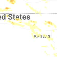


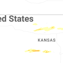


Connect with Interactive Hail Maps