

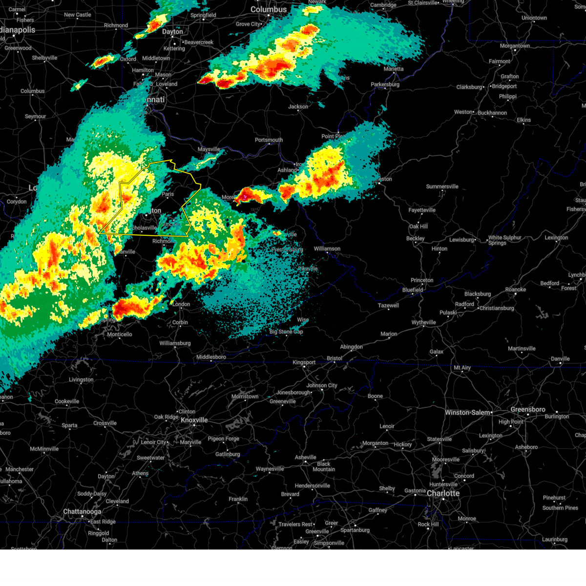
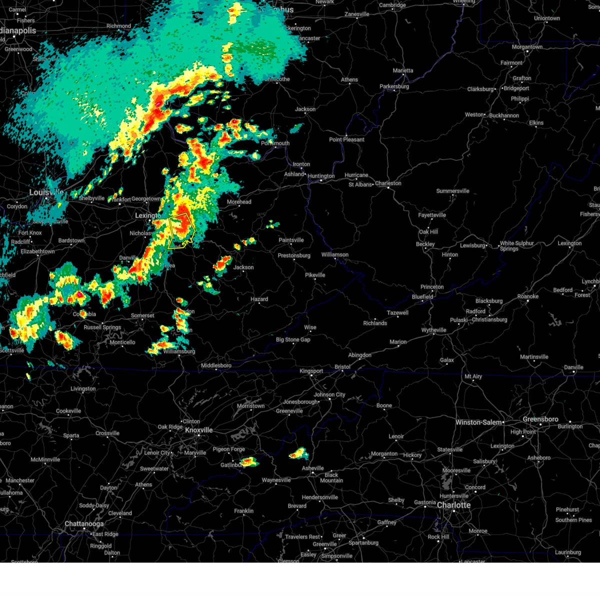
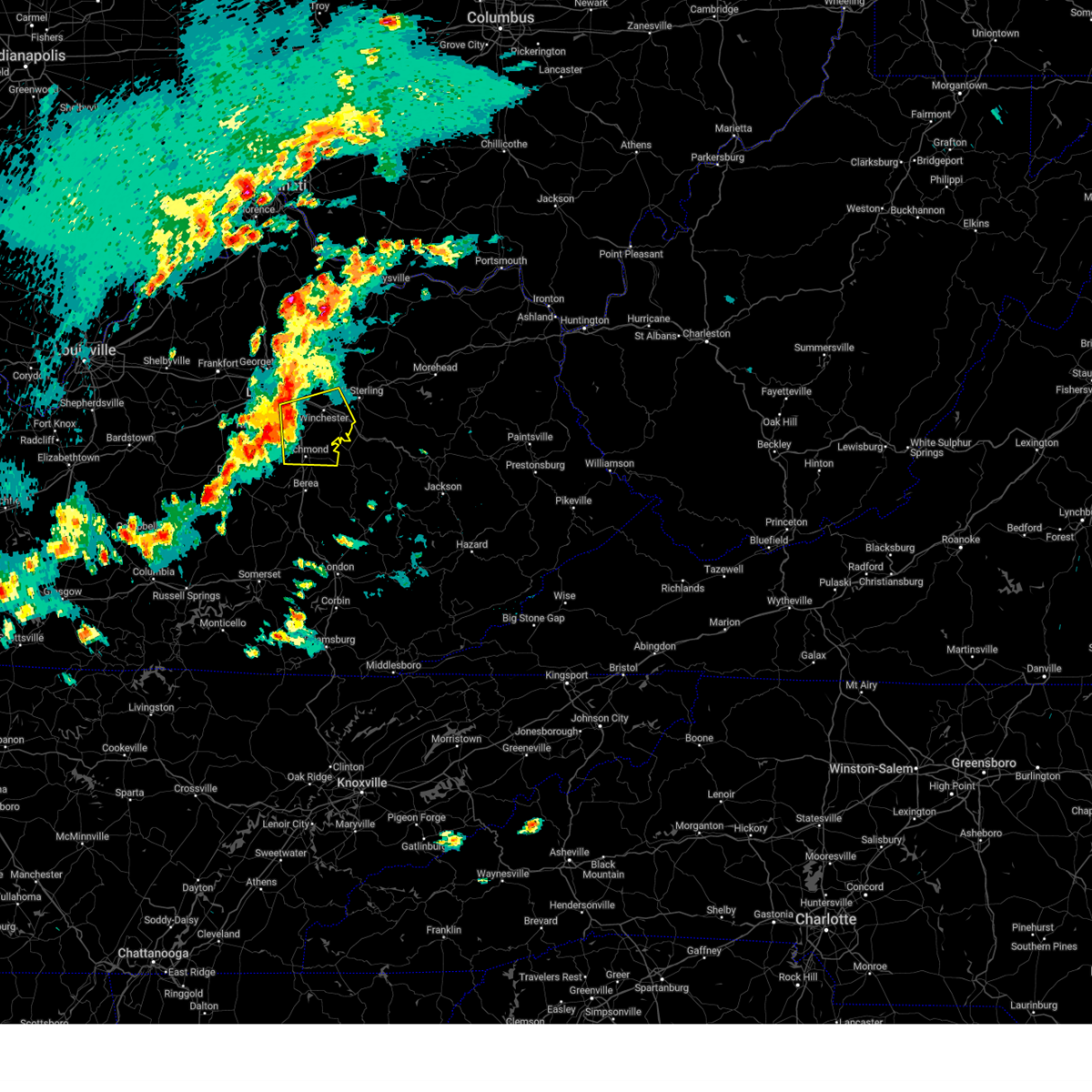
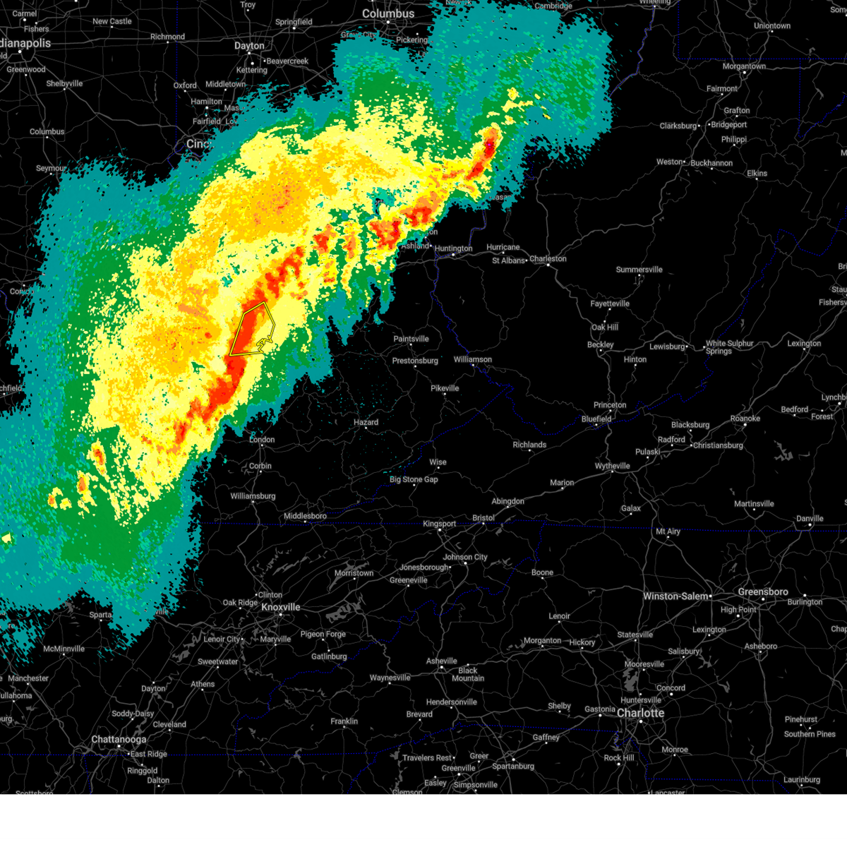
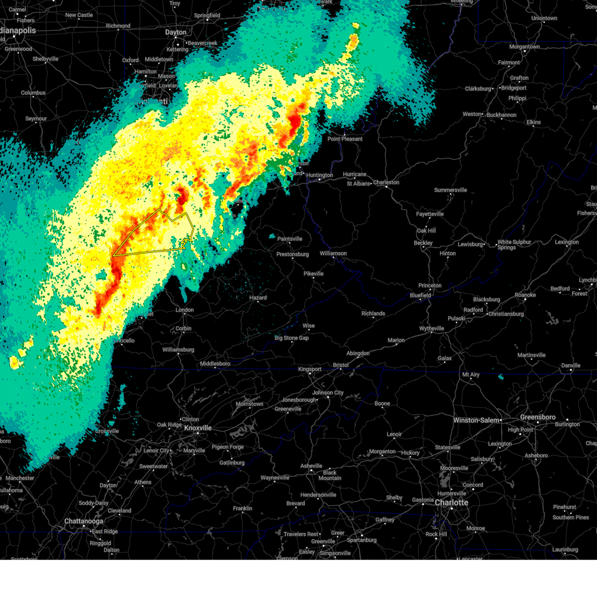
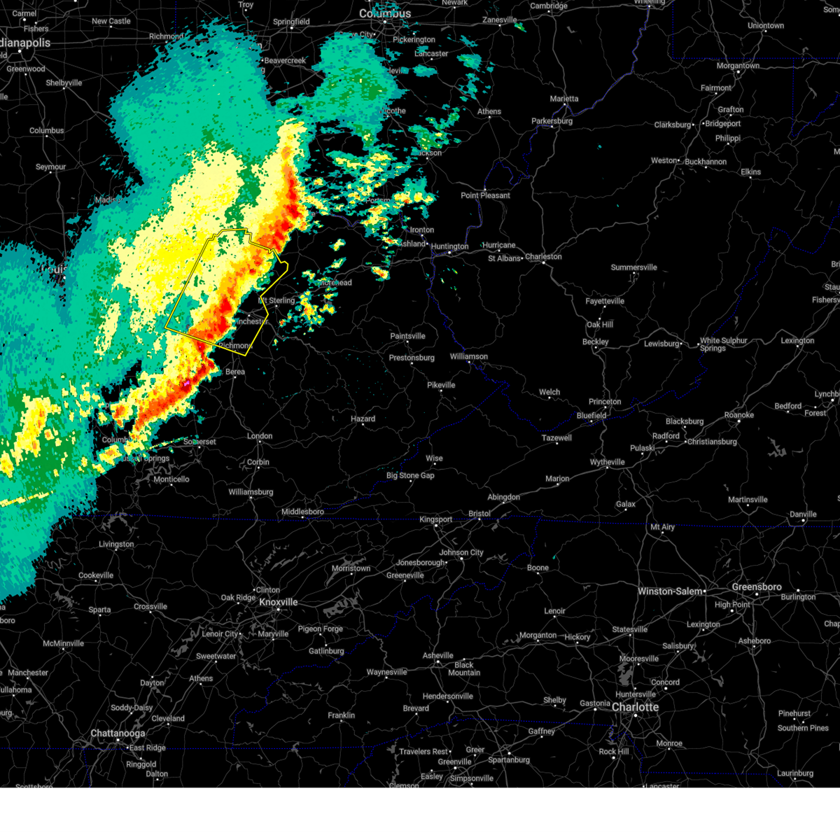
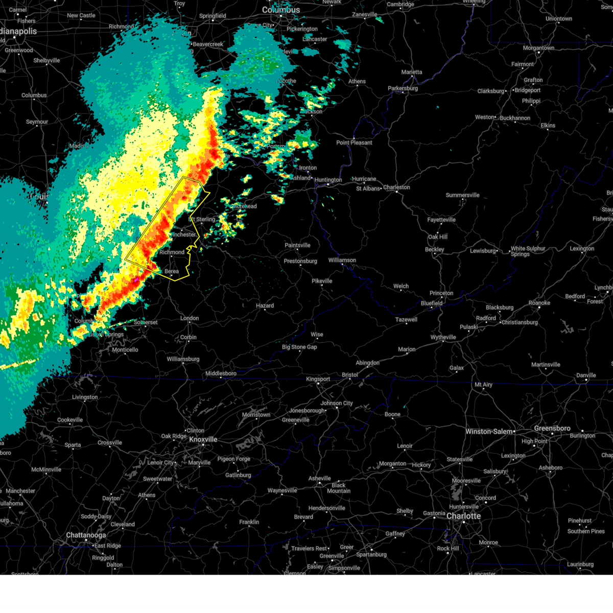
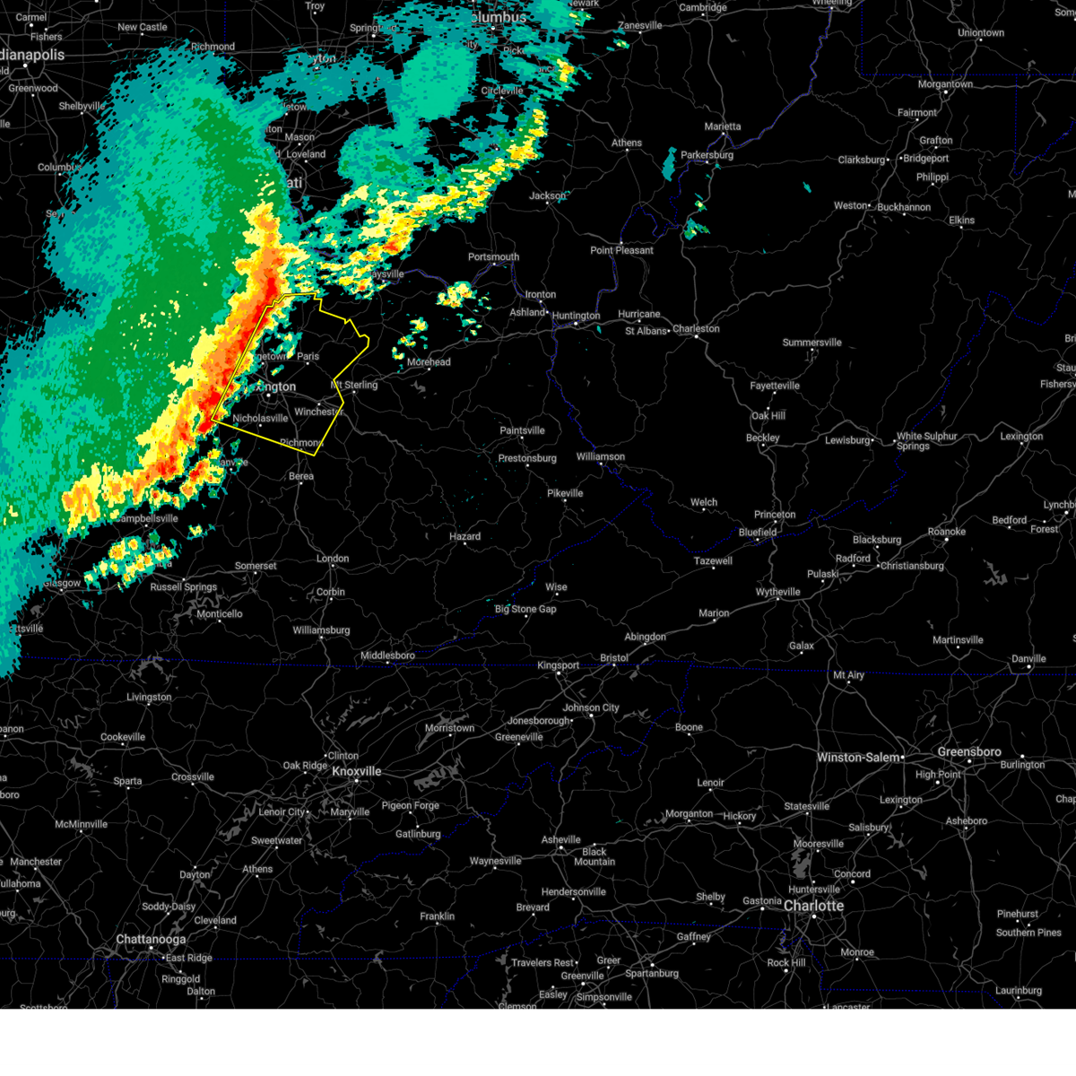
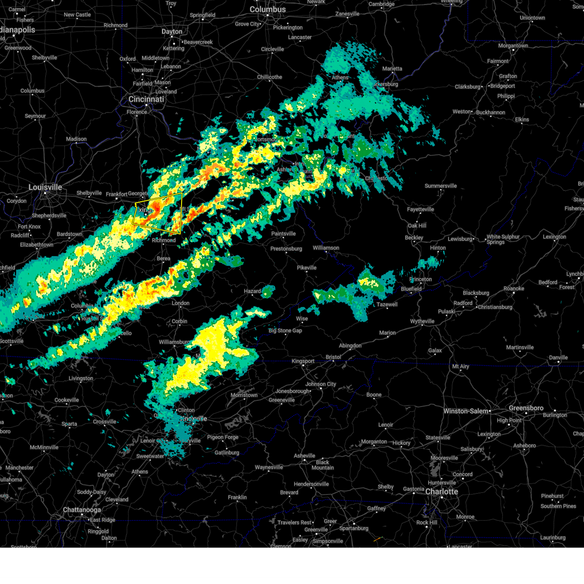
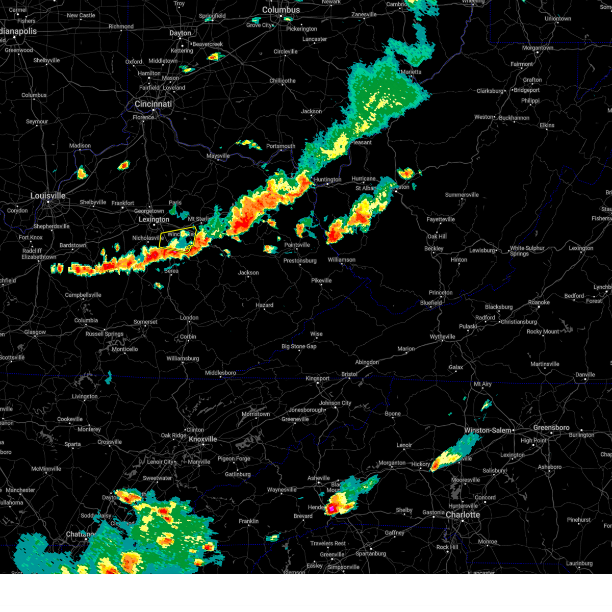
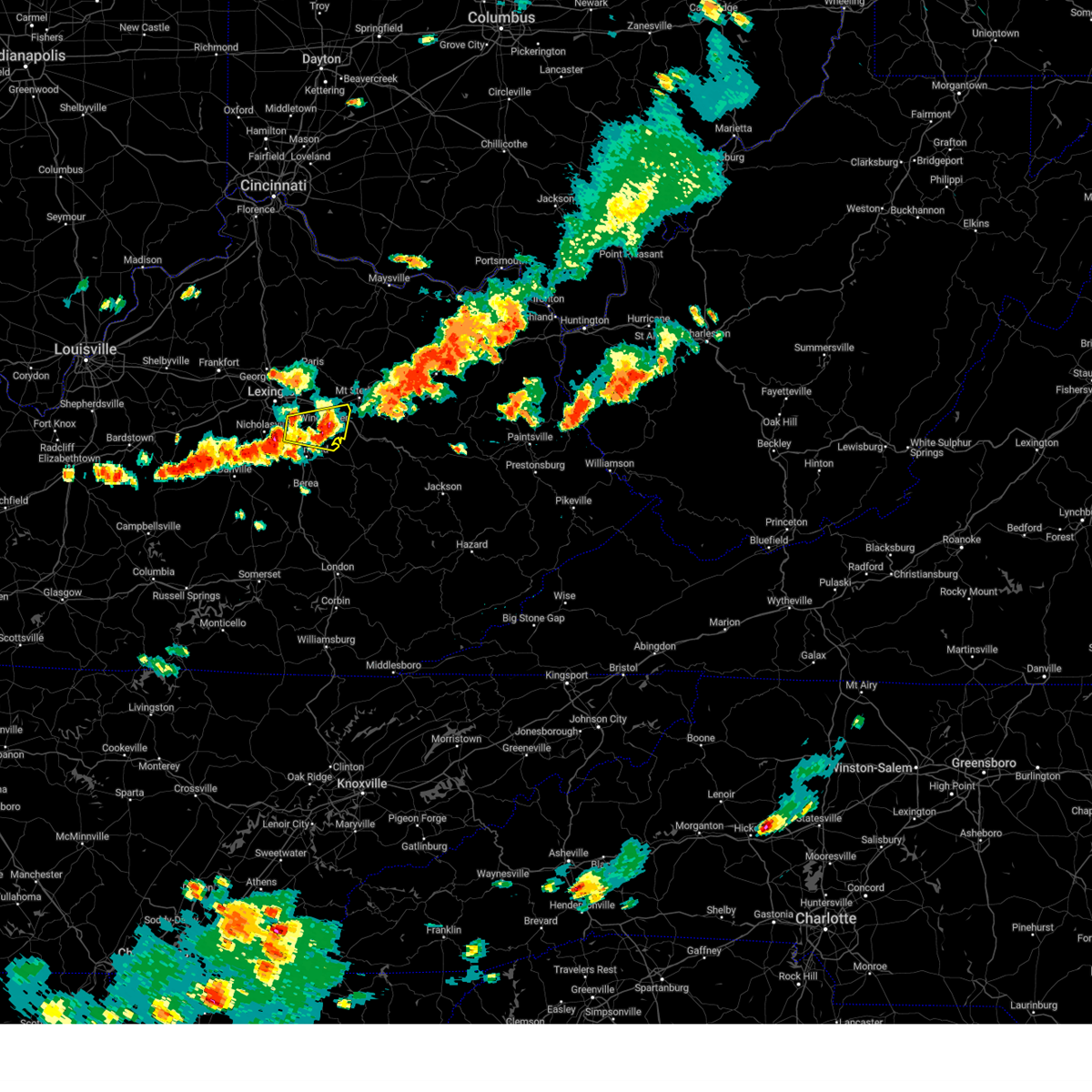
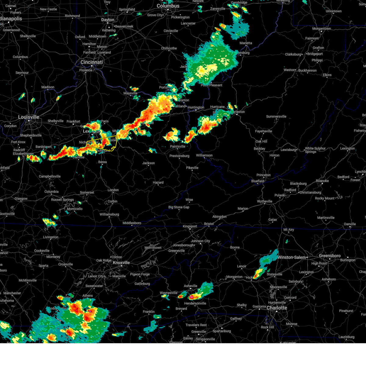
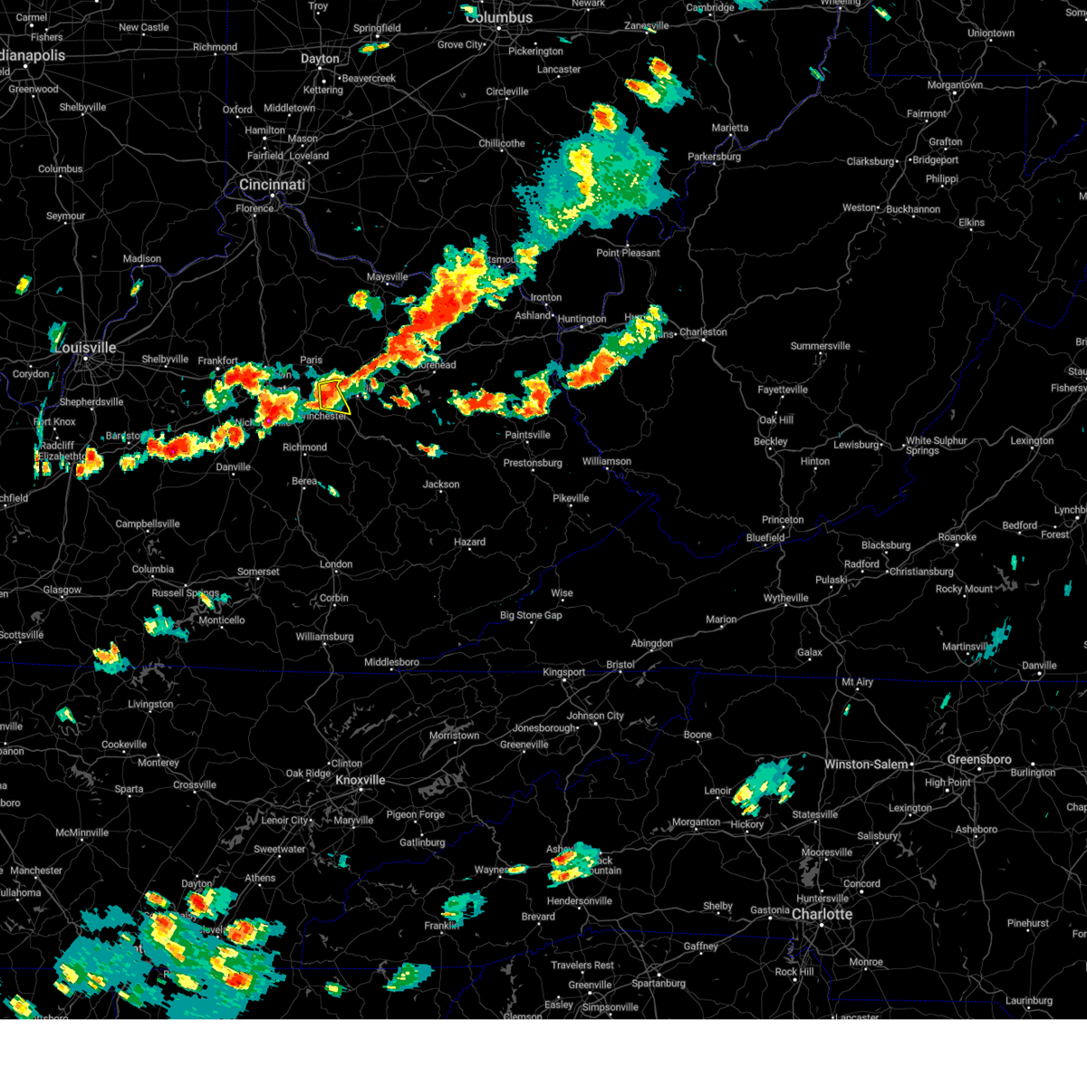
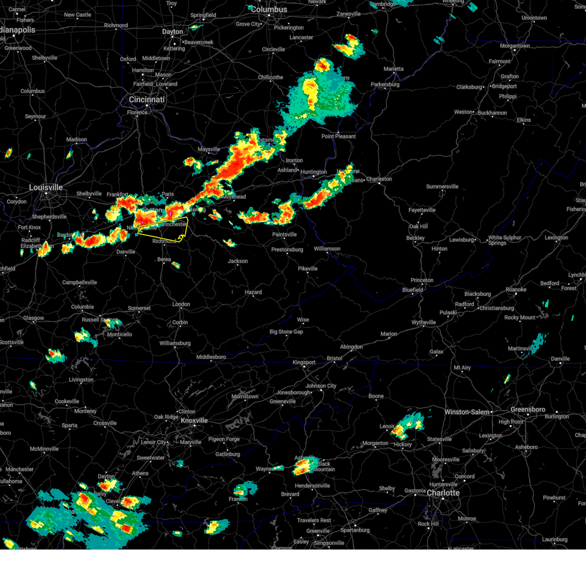
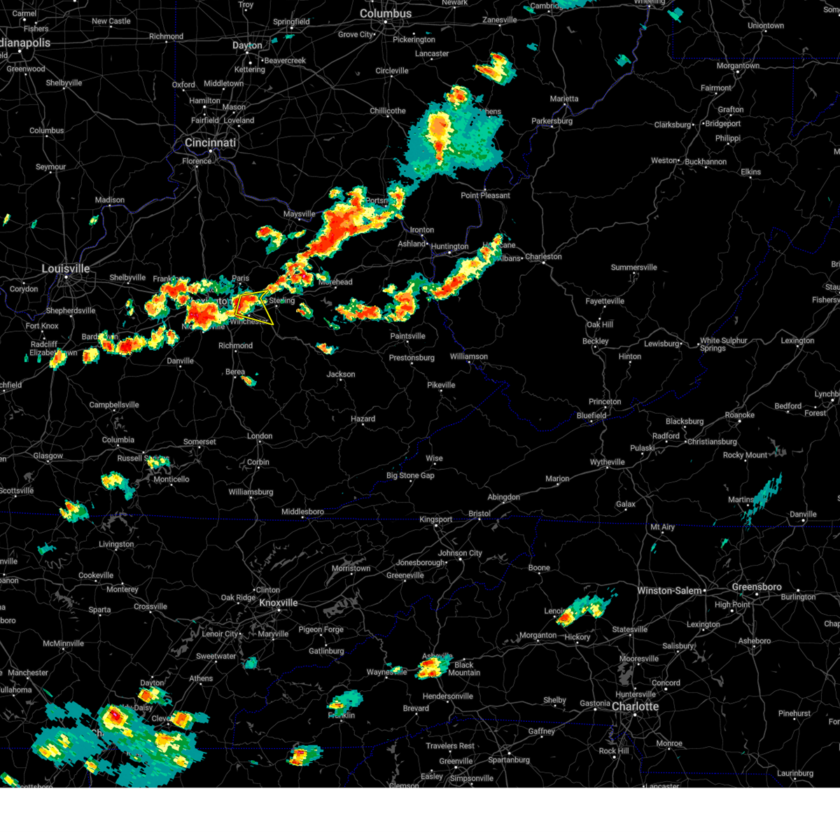
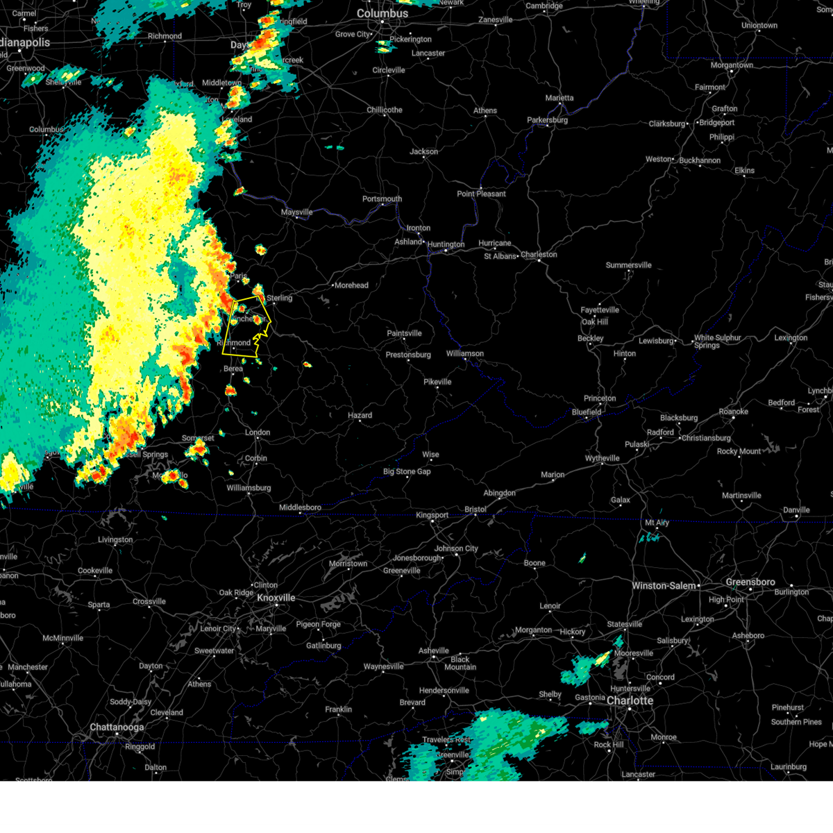
Hail Map for Winchester, KY
The Winchester, KY area has had 5 reports of on-the-ground hail by trained spotters, and has been under severe weather warnings 36 times during the past 12 months. Doppler radar has detected hail at or near Winchester, KY on 47 occasions, including 4 occasions during the past year.
| Name: | Winchester, KY |
| Where Located: | 23.7 miles NNW of Irvine, KY |
| Map: | Google Map for Winchester, KY |
| Population: | 18368 |
| Housing Units: | 8454 |
| More Info: | Search Google for Winchester, KY |
1
The Top Recent Hail Date for Winchester, KY is Saturday, August 17, 2024 (16th out of 47)

Hail and Wind Damage Spotted near Winchester, KY
| Date / Time | Report Details |
|---|---|
| 5/16/2025 10:43 PM EDT |
 Svrlmk the national weather service in louisville has issued a * severe thunderstorm warning for, southeastern anderson county in central kentucky, clark county in central kentucky, jessamine county in central kentucky, nicholas county in central kentucky, harrison county in central kentucky, northeastern franklin county in central kentucky, northern mercer county in central kentucky, woodford county in central kentucky, scott county in central kentucky, bourbon county in central kentucky, northeastern washington county in central kentucky, northern madison county in central kentucky, fayette county in central kentucky, * until 1130 pm edt. * at 1042 pm edt, severe thunderstorms were located along a line extending from 8 miles northwest of owenton to 7 miles northwest of lawrenceburg to 12 miles north of springfield, moving east at 70 mph (radar indicated). Hazards include 70 mph wind gusts and penny size hail. Expect considerable tree damage. Damage is likely to mobile homes, roofs, and outbuildings. Svrlmk the national weather service in louisville has issued a * severe thunderstorm warning for, southeastern anderson county in central kentucky, clark county in central kentucky, jessamine county in central kentucky, nicholas county in central kentucky, harrison county in central kentucky, northeastern franklin county in central kentucky, northern mercer county in central kentucky, woodford county in central kentucky, scott county in central kentucky, bourbon county in central kentucky, northeastern washington county in central kentucky, northern madison county in central kentucky, fayette county in central kentucky, * until 1130 pm edt. * at 1042 pm edt, severe thunderstorms were located along a line extending from 8 miles northwest of owenton to 7 miles northwest of lawrenceburg to 12 miles north of springfield, moving east at 70 mph (radar indicated). Hazards include 70 mph wind gusts and penny size hail. Expect considerable tree damage. Damage is likely to mobile homes, roofs, and outbuildings.
|
| 4/29/2025 7:17 PM EDT | Multiple trees reported down around winchester... k in clark county KY, 2.6 miles SW of Winchester, KY |
| 4/29/2025 7:14 PM EDT |
 the severe thunderstorm warning has been cancelled and is no longer in effect the severe thunderstorm warning has been cancelled and is no longer in effect
|
| 4/29/2025 7:14 PM EDT |
 At 713 pm edt, severe thunderstorms were located along a line extending from winchester to 6 miles northwest of harris ferry to near richmond, moving east at 45 mph (radar indicated). Hazards include 60 mph wind gusts. Expect damage to roofs, siding, and trees. Locations impacted include, winchester, harris ferry, goffs corner, constant station, vianna, renick, lyndale, jackson ferry, mina, and judianne estates. At 713 pm edt, severe thunderstorms were located along a line extending from winchester to 6 miles northwest of harris ferry to near richmond, moving east at 45 mph (radar indicated). Hazards include 60 mph wind gusts. Expect damage to roofs, siding, and trees. Locations impacted include, winchester, harris ferry, goffs corner, constant station, vianna, renick, lyndale, jackson ferry, mina, and judianne estates.
|
| 4/29/2025 6:46 PM EDT | Svrlmk the national weather service in louisville has issued a * severe thunderstorm warning for, clark county in central kentucky, east central jessamine county in central kentucky, northern madison county in central kentucky, southeastern fayette county in central kentucky, * until 730 pm edt. * at 646 pm edt, severe thunderstorms were located along a line extending from fayette mall to near nicholasville to 11 miles north of lancaster, moving east at 45 mph (radar indicated). Hazards include 60 mph wind gusts. expect damage to roofs, siding, and trees |
| 4/29/2025 6:46 PM EDT |
 Svrlmk the national weather service in louisville has issued a * severe thunderstorm warning for, clark county in central kentucky, east central jessamine county in central kentucky, northern madison county in central kentucky, southeastern fayette county in central kentucky, * until 730 pm edt. * at 646 pm edt, severe thunderstorms were located along a line extending from fayette mall to near nicholasville to 11 miles north of lancaster, moving east at 45 mph (radar indicated). Hazards include 60 mph wind gusts. expect damage to roofs, siding, and trees Svrlmk the national weather service in louisville has issued a * severe thunderstorm warning for, clark county in central kentucky, east central jessamine county in central kentucky, northern madison county in central kentucky, southeastern fayette county in central kentucky, * until 730 pm edt. * at 646 pm edt, severe thunderstorms were located along a line extending from fayette mall to near nicholasville to 11 miles north of lancaster, moving east at 45 mph (radar indicated). Hazards include 60 mph wind gusts. expect damage to roofs, siding, and trees
|
| 4/3/2025 3:42 AM EDT | The storm which prompted the warning has moved out of the area. therefore, the warning will be allowed to expire. however, gusty winds and heavy rain are still possible with this thunderstorm. a tornado watch remains in effect until 700 am edt for central kentucky. to report severe weather, contact your nearest law enforcement agency. they will relay your report to the national weather service louisville. |
| 4/3/2025 3:29 AM EDT |
 the severe thunderstorm warning has been cancelled and is no longer in effect the severe thunderstorm warning has been cancelled and is no longer in effect
|
| 4/3/2025 3:29 AM EDT |
 At 329 am edt, a severe thunderstorm was located near klondike, moving east at 60 mph (radar indicated). Hazards include 70 mph wind gusts. Expect considerable tree damage. damage is likely to mobile homes, roofs, and outbuildings. Locations impacted include, richmond, winchester, harris ferry, goffs corner, constant station, lyndale, redhouse, jackson ferry, mina, and union city. At 329 am edt, a severe thunderstorm was located near klondike, moving east at 60 mph (radar indicated). Hazards include 70 mph wind gusts. Expect considerable tree damage. damage is likely to mobile homes, roofs, and outbuildings. Locations impacted include, richmond, winchester, harris ferry, goffs corner, constant station, lyndale, redhouse, jackson ferry, mina, and union city.
|
| 4/3/2025 3:18 AM EDT | At 318 am edt, a severe thunderstorm was located near winchester, moving east at 60 mph (radar indicated). Hazards include 70 mph wind gusts. Expect considerable tree damage. damage is likely to mobile homes, roofs, and outbuildings. Locations impacted include, lexington, richmond, winchester, cadentown, bryan station, harris ferry, goffs corner, chilesburg, lyndale, and valley view. |
| 4/3/2025 3:18 AM EDT | the severe thunderstorm warning has been cancelled and is no longer in effect |
| 4/3/2025 2:53 AM EDT |
 Svrlmk the national weather service in louisville has issued a * severe thunderstorm warning for, southeastern mercer county in central kentucky, southeastern woodford county in central kentucky, northwestern garrard county in central kentucky, clark county in central kentucky, jessamine county in central kentucky, north central boyle county in central kentucky, northern madison county in central kentucky, fayette county in central kentucky, * until 345 am edt. * at 253 am edt, a severe thunderstorm was located near nicholasville, moving east at 60 mph (radar indicated). Hazards include 70 mph wind gusts. Expect considerable tree damage. Damage is likely to mobile homes, roofs, and outbuildings. Svrlmk the national weather service in louisville has issued a * severe thunderstorm warning for, southeastern mercer county in central kentucky, southeastern woodford county in central kentucky, northwestern garrard county in central kentucky, clark county in central kentucky, jessamine county in central kentucky, north central boyle county in central kentucky, northern madison county in central kentucky, fayette county in central kentucky, * until 345 am edt. * at 253 am edt, a severe thunderstorm was located near nicholasville, moving east at 60 mph (radar indicated). Hazards include 70 mph wind gusts. Expect considerable tree damage. Damage is likely to mobile homes, roofs, and outbuildings.
|
| 3/31/2025 12:00 AM EDT | The storms which prompted the warning have moved out of the area. therefore, the warning has been allowed to expire. another warning has been issued downstream. a tornado watch remains in effect until 100 am edt for central kentucky. |
| 3/30/2025 11:59 PM EDT | Svrlmk the national weather service in louisville has issued a * severe thunderstorm warning for, southeastern garrard county in central kentucky, eastern clark county in central kentucky, madison county in central kentucky, * until 1215 am edt. * at 1159 pm edt, severe thunderstorms were located along a line extending from upper spencer to climax, moving east at 65 mph (radar indicated). Hazards include 60 mph wind gusts and penny size hail. expect damage to roofs, siding, and trees |
| 3/30/2025 11:54 PM EDT | the severe thunderstorm warning has been cancelled and is no longer in effect |
| 3/30/2025 11:43 PM EDT | At 1142 pm edt, severe thunderstorms were located along a line extending from near tollesboro to near winchester, moving east at 60 mph (radar indicated). Hazards include 60 mph wind gusts and penny size hail. Expect damage to roofs, siding, and trees. Locations impacted include, lexington, richmond, winchester, lancaster, carlisle, harris ferry, mccreary, berea, north middletown, and goffs corner. |
| 3/30/2025 11:43 PM EDT | the severe thunderstorm warning has been cancelled and is no longer in effect |
| 3/30/2025 11:28 PM EDT |
 The storms which prompted the warning have moved out of the area. therefore, the warning will be allowed to expire. another warning has been issued downstream. a tornado watch remains in effect until 100 am edt for central kentucky. The storms which prompted the warning have moved out of the area. therefore, the warning will be allowed to expire. another warning has been issued downstream. a tornado watch remains in effect until 100 am edt for central kentucky.
|
| 3/30/2025 11:27 PM EDT |
 Svrlmk the national weather service in louisville has issued a * severe thunderstorm warning for, southeastern mercer county in central kentucky, garrard county in central kentucky, clark county in central kentucky, jessamine county in central kentucky, bourbon county in central kentucky, northeastern boyle county in central kentucky, nicholas county in central kentucky, madison county in central kentucky, fayette county in central kentucky, southeastern harrison county in central kentucky, * until midnight edt. * at 1127 pm edt, severe thunderstorms were located along a line extending from near fairview to 6 miles southeast of veterans park, moving east at 60 mph (radar indicated). Hazards include 60 mph wind gusts and penny size hail. expect damage to roofs, siding, and trees Svrlmk the national weather service in louisville has issued a * severe thunderstorm warning for, southeastern mercer county in central kentucky, garrard county in central kentucky, clark county in central kentucky, jessamine county in central kentucky, bourbon county in central kentucky, northeastern boyle county in central kentucky, nicholas county in central kentucky, madison county in central kentucky, fayette county in central kentucky, southeastern harrison county in central kentucky, * until midnight edt. * at 1127 pm edt, severe thunderstorms were located along a line extending from near fairview to 6 miles southeast of veterans park, moving east at 60 mph (radar indicated). Hazards include 60 mph wind gusts and penny size hail. expect damage to roofs, siding, and trees
|
| 3/30/2025 10:50 PM EDT |
 Svrlmk the national weather service in louisville has issued a * severe thunderstorm warning for, northeastern mercer county in central kentucky, woodford county in central kentucky, scott county in central kentucky, east central anderson county in central kentucky, clark county in central kentucky, jessamine county in central kentucky, bourbon county in central kentucky, nicholas county in central kentucky, northern madison county in central kentucky, fayette county in central kentucky, harrison county in central kentucky, * until 1130 pm edt. * at 1050 pm edt, severe thunderstorms were located along a line extending from 10 miles northwest of cynthiana to near georgetown to near lawrenceburg, moving east at 60 mph (radar indicated). Hazards include 60 mph wind gusts and nickel size hail. expect damage to roofs, siding, and trees Svrlmk the national weather service in louisville has issued a * severe thunderstorm warning for, northeastern mercer county in central kentucky, woodford county in central kentucky, scott county in central kentucky, east central anderson county in central kentucky, clark county in central kentucky, jessamine county in central kentucky, bourbon county in central kentucky, nicholas county in central kentucky, northern madison county in central kentucky, fayette county in central kentucky, harrison county in central kentucky, * until 1130 pm edt. * at 1050 pm edt, severe thunderstorms were located along a line extending from 10 miles northwest of cynthiana to near georgetown to near lawrenceburg, moving east at 60 mph (radar indicated). Hazards include 60 mph wind gusts and nickel size hail. expect damage to roofs, siding, and trees
|
| 3/23/2025 9:51 PM EDT |
 The storm which prompted the warning has weakened below severe limits, and no longer poses an immediate threat to life or property. therefore, the warning will be allowed to expire. however, gusty winds and heavy rain are still possible with this thunderstorm. to report severe weather, contact your nearest law enforcement agency. they will relay your report to the national weather service louisville. The storm which prompted the warning has weakened below severe limits, and no longer poses an immediate threat to life or property. therefore, the warning will be allowed to expire. however, gusty winds and heavy rain are still possible with this thunderstorm. to report severe weather, contact your nearest law enforcement agency. they will relay your report to the national weather service louisville.
|
| 3/23/2025 9:44 PM EDT |
 the severe thunderstorm warning has been cancelled and is no longer in effect the severe thunderstorm warning has been cancelled and is no longer in effect
|
| 3/23/2025 9:44 PM EDT |
 At 944 pm edt, a severe thunderstorm was located over chevy chase, moving east at 60 mph (radar indicated). Hazards include 60 mph wind gusts and nickel size hail. Expect damage to roofs, siding, and trees. Locations impacted include, lexington, nicholasville, winchester, paris, meadowthorpe, dunbar high school, thoroughbred acres, cardinal hill, cadentown, and northland. At 944 pm edt, a severe thunderstorm was located over chevy chase, moving east at 60 mph (radar indicated). Hazards include 60 mph wind gusts and nickel size hail. Expect damage to roofs, siding, and trees. Locations impacted include, lexington, nicholasville, winchester, paris, meadowthorpe, dunbar high school, thoroughbred acres, cardinal hill, cadentown, and northland.
|
| 3/23/2025 9:34 PM EDT |
 Svrlmk the national weather service in louisville has issued a * severe thunderstorm warning for, northeastern woodford county in central kentucky, south central scott county in central kentucky, clark county in central kentucky, northern jessamine county in central kentucky, southern bourbon county in central kentucky, northeastern madison county in central kentucky, fayette county in central kentucky, * until 1000 pm edt. * at 934 pm edt, a severe thunderstorm was located near versailles, moving east at 60 mph (radar indicated). Hazards include 60 mph wind gusts and nickel size hail. expect damage to roofs, siding, and trees Svrlmk the national weather service in louisville has issued a * severe thunderstorm warning for, northeastern woodford county in central kentucky, south central scott county in central kentucky, clark county in central kentucky, northern jessamine county in central kentucky, southern bourbon county in central kentucky, northeastern madison county in central kentucky, fayette county in central kentucky, * until 1000 pm edt. * at 934 pm edt, a severe thunderstorm was located near versailles, moving east at 60 mph (radar indicated). Hazards include 60 mph wind gusts and nickel size hail. expect damage to roofs, siding, and trees
|
| 8/31/2024 3:06 PM EDT | Multiple reports of tree damage and limbs down across portions of clark county... including within the city of winchester along meadowbrook driv in clark county KY, 0.6 miles E of Winchester, KY |
| 8/31/2024 2:50 PM EDT |
 Svrlmk the national weather service in louisville has issued a * severe thunderstorm warning for, clark county in central kentucky, * until 315 pm edt. * at 250 pm edt, a severe thunderstorm was located northwest of winchester, moving east at 10 mph (radar indicated). Hazards include 60 mph wind gusts and quarter size hail. Hail damage to vehicles is expected. Expect wind damage to roofs, siding, and trees. Svrlmk the national weather service in louisville has issued a * severe thunderstorm warning for, clark county in central kentucky, * until 315 pm edt. * at 250 pm edt, a severe thunderstorm was located northwest of winchester, moving east at 10 mph (radar indicated). Hazards include 60 mph wind gusts and quarter size hail. Hail damage to vehicles is expected. Expect wind damage to roofs, siding, and trees.
|
| 8/17/2024 4:45 PM EDT |
 The storm which prompted the warning has moved out of the area. therefore, the warning has been allowed to expire. to report severe weather, contact your nearest law enforcement agency. they will relay your report to the national weather service louisville. The storm which prompted the warning has moved out of the area. therefore, the warning has been allowed to expire. to report severe weather, contact your nearest law enforcement agency. they will relay your report to the national weather service louisville.
|
| 8/17/2024 4:31 PM EDT |
 At 430 pm edt, a severe thunderstorm was located near harris ferry, moving east at 35 mph (radar indicated). Hazards include 70 mph wind gusts and quarter size hail. Hail damage to vehicles is expected. expect considerable tree damage. wind damage is also likely to mobile homes, roofs, and outbuildings. Locations impacted include, winchester, harris ferry, lyndale, redhouse, valley view, jackson ferry, mina, union city, locust grove, and hunt. At 430 pm edt, a severe thunderstorm was located near harris ferry, moving east at 35 mph (radar indicated). Hazards include 70 mph wind gusts and quarter size hail. Hail damage to vehicles is expected. expect considerable tree damage. wind damage is also likely to mobile homes, roofs, and outbuildings. Locations impacted include, winchester, harris ferry, lyndale, redhouse, valley view, jackson ferry, mina, union city, locust grove, and hunt.
|
| 8/17/2024 4:31 PM EDT |
 the severe thunderstorm warning has been cancelled and is no longer in effect the severe thunderstorm warning has been cancelled and is no longer in effect
|
| 8/17/2024 4:20 PM EDT |
 At 420 pm edt, a severe thunderstorm was located near winchester, moving east at 35 mph (radar indicated). Hazards include 70 mph wind gusts and quarter size hail. Hail damage to vehicles is expected. expect considerable tree damage. wind damage is also likely to mobile homes, roofs, and outbuildings. Locations impacted include, lexington, nicholasville, winchester, harris ferry, coletown, lyndale, redhouse, valley view, jackson ferry, and mina. At 420 pm edt, a severe thunderstorm was located near winchester, moving east at 35 mph (radar indicated). Hazards include 70 mph wind gusts and quarter size hail. Hail damage to vehicles is expected. expect considerable tree damage. wind damage is also likely to mobile homes, roofs, and outbuildings. Locations impacted include, lexington, nicholasville, winchester, harris ferry, coletown, lyndale, redhouse, valley view, jackson ferry, and mina.
|
| 8/17/2024 4:19 PM EDT | Twitter report of power lines snapped near the taco bell in wincheste in clark county KY, 1.3 miles ENE of Winchester, KY |
| 8/17/2024 4:10 PM EDT | The storm which prompted the warning has moved out of the area. therefore, the warning will be allowed to expire. however, gusty winds are still possible with this thunderstorm. |
| 8/17/2024 3:56 PM EDT |
 Svrlmk the national weather service in louisville has issued a * severe thunderstorm warning for, northeastern clark county in central kentucky, southeastern bourbon county in central kentucky, * until 415 pm edt. * at 356 pm edt, a severe thunderstorm was located near grassy lick, moving east at 35 mph. this is a destructive storm for clark county (radar indicated). Hazards include 80 mph wind gusts. Flying debris will be dangerous to those caught without shelter. mobile homes will be heavily damaged. expect considerable damage to roofs, windows, and vehicles. Extensive tree damage and power outages are likely. Svrlmk the national weather service in louisville has issued a * severe thunderstorm warning for, northeastern clark county in central kentucky, southeastern bourbon county in central kentucky, * until 415 pm edt. * at 356 pm edt, a severe thunderstorm was located near grassy lick, moving east at 35 mph. this is a destructive storm for clark county (radar indicated). Hazards include 80 mph wind gusts. Flying debris will be dangerous to those caught without shelter. mobile homes will be heavily damaged. expect considerable damage to roofs, windows, and vehicles. Extensive tree damage and power outages are likely.
|
| 8/17/2024 3:55 PM EDT |
 Svrlmk the national weather service in louisville has issued a * severe thunderstorm warning for, southern clark county in central kentucky, northeastern jessamine county in central kentucky, northern madison county in central kentucky, southeastern fayette county in central kentucky, * until 445 pm edt. * at 355 pm edt, a severe thunderstorm was located near veterans park, moving east at 35 mph (radar indicated). Hazards include 70 mph wind gusts and quarter size hail. Hail damage to vehicles is expected. expect considerable tree damage. Wind damage is also likely to mobile homes, roofs, and outbuildings. Svrlmk the national weather service in louisville has issued a * severe thunderstorm warning for, southern clark county in central kentucky, northeastern jessamine county in central kentucky, northern madison county in central kentucky, southeastern fayette county in central kentucky, * until 445 pm edt. * at 355 pm edt, a severe thunderstorm was located near veterans park, moving east at 35 mph (radar indicated). Hazards include 70 mph wind gusts and quarter size hail. Hail damage to vehicles is expected. expect considerable tree damage. Wind damage is also likely to mobile homes, roofs, and outbuildings.
|
| 8/17/2024 3:50 PM EDT | Mesonet station wnch winchester 3 n in clark county KY, 2.5 miles SSE of Winchester, KY |
| 8/17/2024 3:50 PM EDT |
 At 349 pm edt, a severe thunderstorm was located near winchester, moving east at 35 mph (radar indicated). Hazards include 60 mph wind gusts and quarter size hail. Hail damage to vehicles is expected. expect wind damage to roofs, siding, and trees. Locations impacted include, winchester, north middletown, pretty run, constant station, renick, stony point, judianne estates, silver lake, thomson, and colby. At 349 pm edt, a severe thunderstorm was located near winchester, moving east at 35 mph (radar indicated). Hazards include 60 mph wind gusts and quarter size hail. Hail damage to vehicles is expected. expect wind damage to roofs, siding, and trees. Locations impacted include, winchester, north middletown, pretty run, constant station, renick, stony point, judianne estates, silver lake, thomson, and colby.
|
| 8/17/2024 3:50 PM EDT |
 the severe thunderstorm warning has been cancelled and is no longer in effect the severe thunderstorm warning has been cancelled and is no longer in effect
|
| 8/17/2024 3:49 PM EDT | Power outage reported at a busines in clark county KY, 1.9 miles ESE of Winchester, KY |
| 8/17/2024 3:44 PM EDT | Large tree down on clintonville rd at van meter rd. time estimated from rada in clark county KY, 5.7 miles SE of Winchester, KY |
| 8/17/2024 3:37 PM EDT | Svrlmk the national weather service in louisville has issued a * severe thunderstorm warning for, northern clark county in central kentucky, southeastern bourbon county in central kentucky, east central fayette county in central kentucky, * until 400 pm edt. * at 337 pm edt, a severe thunderstorm was located near bryan station, moving east at 35 mph (radar indicated). Hazards include 60 mph wind gusts and quarter size hail. Hail damage to vehicles is expected. Expect wind damage to roofs, siding, and trees. |
| 8/1/2024 7:18 PM EDT | County dispatch reported tree blown down onto cooperas creek road. event time estimated from rada in powell county KY, 12.8 miles WNW of Winchester, KY |
| 8/1/2024 7:08 PM EDT |
 Svrlmk the national weather service in louisville has issued a * severe thunderstorm warning for, clark county in central kentucky, northeastern madison county in central kentucky, southeastern fayette county in central kentucky, * until 745 pm edt. * at 708 pm edt, a severe thunderstorm was located near winchester, moving east at 55 mph (radar indicated). Hazards include 60 mph wind gusts. expect damage to roofs, siding, and trees Svrlmk the national weather service in louisville has issued a * severe thunderstorm warning for, clark county in central kentucky, northeastern madison county in central kentucky, southeastern fayette county in central kentucky, * until 745 pm edt. * at 708 pm edt, a severe thunderstorm was located near winchester, moving east at 55 mph (radar indicated). Hazards include 60 mph wind gusts. expect damage to roofs, siding, and trees
|
| 8/1/2024 6:30 PM EDT |
 Svrlmk the national weather service in louisville has issued a * severe thunderstorm warning for, southeastern mercer county in central kentucky, southeastern woodford county in central kentucky, northwestern garrard county in central kentucky, clark county in central kentucky, jessamine county in central kentucky, northern madison county in central kentucky, fayette county in central kentucky, * until 715 pm edt. * at 630 pm edt, a severe thunderstorm was located near dunbar high school, moving east at 50 mph (radar indicated). Hazards include 60 mph wind gusts. expect damage to roofs, siding, and trees Svrlmk the national weather service in louisville has issued a * severe thunderstorm warning for, southeastern mercer county in central kentucky, southeastern woodford county in central kentucky, northwestern garrard county in central kentucky, clark county in central kentucky, jessamine county in central kentucky, northern madison county in central kentucky, fayette county in central kentucky, * until 715 pm edt. * at 630 pm edt, a severe thunderstorm was located near dunbar high school, moving east at 50 mph (radar indicated). Hazards include 60 mph wind gusts. expect damage to roofs, siding, and trees
|
| 6/25/2024 7:55 PM EDT | Tree down on kidville road. time estimated from rada in montgomery county KY, 11 miles W of Winchester, KY |
| 5/26/2024 1:56 PM EDT |
 The storms which prompted the warning have moved out of the area. therefore, the warning will be allowed to expire. a tornado watch remains in effect until 400 pm edt for central kentucky. a severe thunderstorm watch remains in effect until 800 pm edt for central kentucky. The storms which prompted the warning have moved out of the area. therefore, the warning will be allowed to expire. a tornado watch remains in effect until 400 pm edt for central kentucky. a severe thunderstorm watch remains in effect until 800 pm edt for central kentucky.
|
| 5/26/2024 1:49 PM EDT |
 At 148 pm edt, severe thunderstorms were located along a line extending from 10 miles south of brooksville to doe creek, moving east at 40 mph (radar indicated). Hazards include 60 mph wind gusts. Expect damage to roofs, siding, and trees. Locations impacted include, richmond, winchester, paris, cynthiana, carlisle, harris ferry, breckinridge, berea, millersburg, and north middletown. At 148 pm edt, severe thunderstorms were located along a line extending from 10 miles south of brooksville to doe creek, moving east at 40 mph (radar indicated). Hazards include 60 mph wind gusts. Expect damage to roofs, siding, and trees. Locations impacted include, richmond, winchester, paris, cynthiana, carlisle, harris ferry, breckinridge, berea, millersburg, and north middletown.
|
| 5/26/2024 1:49 PM EDT |
 the severe thunderstorm warning has been cancelled and is no longer in effect the severe thunderstorm warning has been cancelled and is no longer in effect
|
| 5/26/2024 1:26 PM EDT | Tree down on cars at the winchester country clu in clark county KY, 1.3 miles N of Winchester, KY |
| 5/26/2024 1:11 PM EDT |
 Svrlmk the national weather service in louisville has issued a * severe thunderstorm warning for, northeastern lincoln county in central kentucky, eastern scott county in central kentucky, eastern garrard county in central kentucky, clark county in central kentucky, eastern jessamine county in central kentucky, bourbon county in central kentucky, nicholas county in central kentucky, madison county in central kentucky, fayette county in central kentucky, harrison county in central kentucky, * until 200 pm edt. * at 111 pm edt, severe thunderstorms were located along a line extending from 12 miles west of cynthiana to near boone, moving east at 40 mph (radar indicated). Hazards include 60 mph wind gusts. expect damage to roofs, siding, and trees Svrlmk the national weather service in louisville has issued a * severe thunderstorm warning for, northeastern lincoln county in central kentucky, eastern scott county in central kentucky, eastern garrard county in central kentucky, clark county in central kentucky, eastern jessamine county in central kentucky, bourbon county in central kentucky, nicholas county in central kentucky, madison county in central kentucky, fayette county in central kentucky, harrison county in central kentucky, * until 200 pm edt. * at 111 pm edt, severe thunderstorms were located along a line extending from 12 miles west of cynthiana to near boone, moving east at 40 mph (radar indicated). Hazards include 60 mph wind gusts. expect damage to roofs, siding, and trees
|
| 5/26/2024 1:03 PM EDT |
 At 102 pm edt, a severe thunderstorm was located near thoroughbred acres, moving northeast at 60 mph (radar indicated). Hazards include 70 mph wind gusts. Expect considerable tree damage. damage is likely to mobile homes, roofs, and outbuildings. Locations impacted include, lexington, richmond, georgetown, frankfort, nicholasville, winchester, danville, lawrenceburg, versailles, and paris. At 102 pm edt, a severe thunderstorm was located near thoroughbred acres, moving northeast at 60 mph (radar indicated). Hazards include 70 mph wind gusts. Expect considerable tree damage. damage is likely to mobile homes, roofs, and outbuildings. Locations impacted include, lexington, richmond, georgetown, frankfort, nicholasville, winchester, danville, lawrenceburg, versailles, and paris.
|
| 5/26/2024 12:22 PM EDT |
 Svrlmk the national weather service in louisville has issued a * severe thunderstorm warning for, eastern anderson county in central kentucky, garrard county in central kentucky, clark county in central kentucky, jessamine county in central kentucky, nicholas county in central kentucky, harrison county in central kentucky, franklin county in central kentucky, northern lincoln county in central kentucky, mercer county in central kentucky, woodford county in central kentucky, scott county in central kentucky, bourbon county in central kentucky, boyle county in central kentucky, madison county in central kentucky, fayette county in central kentucky, * until 115 pm edt. * at 1222 pm edt, a severe thunderstorm was located 14 miles southwest of lawrenceburg, moving northeast at 60 mph (radar indicated). Hazards include 70 mph wind gusts. Expect considerable tree damage. Damage is likely to mobile homes, roofs, and outbuildings. Svrlmk the national weather service in louisville has issued a * severe thunderstorm warning for, eastern anderson county in central kentucky, garrard county in central kentucky, clark county in central kentucky, jessamine county in central kentucky, nicholas county in central kentucky, harrison county in central kentucky, franklin county in central kentucky, northern lincoln county in central kentucky, mercer county in central kentucky, woodford county in central kentucky, scott county in central kentucky, bourbon county in central kentucky, boyle county in central kentucky, madison county in central kentucky, fayette county in central kentucky, * until 115 pm edt. * at 1222 pm edt, a severe thunderstorm was located 14 miles southwest of lawrenceburg, moving northeast at 60 mph (radar indicated). Hazards include 70 mph wind gusts. Expect considerable tree damage. Damage is likely to mobile homes, roofs, and outbuildings.
|
| 4/2/2024 9:41 AM EDT |
 At 940 am edt, severe thunderstorms were located along a line extending from near winchester to near richmond to 10 miles northeast of lancaster, moving east at 45 mph (radar indicated). Hazards include 60 mph wind gusts. Expect damage to roofs, siding, and trees. Locations impacted include, richmond, winchester, mccreary, goffs corner, peytontown, lyndale, jackson ferry, buggytown, stone, and toddville. At 940 am edt, severe thunderstorms were located along a line extending from near winchester to near richmond to 10 miles northeast of lancaster, moving east at 45 mph (radar indicated). Hazards include 60 mph wind gusts. Expect damage to roofs, siding, and trees. Locations impacted include, richmond, winchester, mccreary, goffs corner, peytontown, lyndale, jackson ferry, buggytown, stone, and toddville.
|
| 4/2/2024 9:38 AM EDT |
 the severe thunderstorm warning has been cancelled and is no longer in effect the severe thunderstorm warning has been cancelled and is no longer in effect
|
| 4/2/2024 9:38 AM EDT |
 At 937 am edt, severe thunderstorms were located along a line extending from near winchester to near richmond to 9 miles northeast of lancaster, moving southeast at 55 mph (radar indicated). Hazards include 60 mph wind gusts. Expect damage to roofs, siding, and trees. Locations impacted include, richmond, winchester, harris ferry, mccreary, goffs corner, peytontown, lyndale, jackson ferry, buggytown, and stone. At 937 am edt, severe thunderstorms were located along a line extending from near winchester to near richmond to 9 miles northeast of lancaster, moving southeast at 55 mph (radar indicated). Hazards include 60 mph wind gusts. Expect damage to roofs, siding, and trees. Locations impacted include, richmond, winchester, harris ferry, mccreary, goffs corner, peytontown, lyndale, jackson ferry, buggytown, and stone.
|
| 4/2/2024 9:35 AM EDT |
 the tornado warning has been cancelled and is no longer in effect the tornado warning has been cancelled and is no longer in effect
|
| 4/2/2024 9:35 AM EDT |
 At 935 am edt, severe thunderstorms were located along a line extending from near cadentown to 8 miles southeast of nicholasville to 9 miles north of lancaster, moving east at 45 mph (radar indicated). Hazards include 60 mph wind gusts. Expect damage to roofs, siding, and trees. Locations impacted include, lexington, richmond, nicholasville, winchester, cadentown, harris ferry, mccreary, goffs corner, chilesburg, and peytontown. At 935 am edt, severe thunderstorms were located along a line extending from near cadentown to 8 miles southeast of nicholasville to 9 miles north of lancaster, moving east at 45 mph (radar indicated). Hazards include 60 mph wind gusts. Expect damage to roofs, siding, and trees. Locations impacted include, lexington, richmond, nicholasville, winchester, cadentown, harris ferry, mccreary, goffs corner, chilesburg, and peytontown.
|
| 4/2/2024 9:35 AM EDT |
 At 935 am edt, a severe squall line capable of producing both tornadoes and extensive straight line wind damage was located along a line extending from near sideview to near winchester, moving east at 55 mph (radar indicated rotation). Hazards include tornado. Flying debris will be dangerous to those caught without shelter. mobile homes will be damaged or destroyed. damage to roofs, windows, and vehicles will occur. tree damage is likely. these dangerous storms will be near, winchester around 940 am edt. Other locations impacted by these tornadic storms include goffs corner, constant station, renick, lyndale, bunker hill, judianne estates, locust grove, hunt, flanagan, and colby. At 935 am edt, a severe squall line capable of producing both tornadoes and extensive straight line wind damage was located along a line extending from near sideview to near winchester, moving east at 55 mph (radar indicated rotation). Hazards include tornado. Flying debris will be dangerous to those caught without shelter. mobile homes will be damaged or destroyed. damage to roofs, windows, and vehicles will occur. tree damage is likely. these dangerous storms will be near, winchester around 940 am edt. Other locations impacted by these tornadic storms include goffs corner, constant station, renick, lyndale, bunker hill, judianne estates, locust grove, hunt, flanagan, and colby.
|
| 4/2/2024 9:32 AM EDT |
 Torlmk the national weather service in louisville has issued a * tornado warning for, clark county in central kentucky, southeastern bourbon county in central kentucky, southeastern fayette county in central kentucky, * until 1000 am edt. * at 932 am edt, severe thunderstorms capable of producing both tornadoes and extensive straight line wind damage were located along a line extending from near sideview to near winchester, moving east at 55 mph (radar indicated rotation). Hazards include tornado. Flying debris will be dangerous to those caught without shelter. mobile homes will be damaged or destroyed. damage to roofs, windows, and vehicles will occur. tree damage is likely. these dangerous storms will be near, winchester around 935 am edt. Other locations impacted by these tornadic storms include goffs corner, constant station, renick, lyndale, bunker hill, tebbs, judianne estates, locust grove, hunt, and flanagan. Torlmk the national weather service in louisville has issued a * tornado warning for, clark county in central kentucky, southeastern bourbon county in central kentucky, southeastern fayette county in central kentucky, * until 1000 am edt. * at 932 am edt, severe thunderstorms capable of producing both tornadoes and extensive straight line wind damage were located along a line extending from near sideview to near winchester, moving east at 55 mph (radar indicated rotation). Hazards include tornado. Flying debris will be dangerous to those caught without shelter. mobile homes will be damaged or destroyed. damage to roofs, windows, and vehicles will occur. tree damage is likely. these dangerous storms will be near, winchester around 935 am edt. Other locations impacted by these tornadic storms include goffs corner, constant station, renick, lyndale, bunker hill, tebbs, judianne estates, locust grove, hunt, and flanagan.
|
| 4/2/2024 9:15 AM EDT |
 Svrlmk the national weather service in louisville has issued a * severe thunderstorm warning for, southern mercer county in central kentucky, northern garrard county in central kentucky, clark county in central kentucky, jessamine county in central kentucky, madison county in central kentucky, fayette county in central kentucky, * until 1015 am edt. * at 915 am edt, severe thunderstorms were located along a line extending from dunbar high school to 6 miles west of nicholasville to near harrodsburg, moving east at 50 mph (radar indicated). Hazards include 60 mph wind gusts. expect damage to roofs, siding, and trees Svrlmk the national weather service in louisville has issued a * severe thunderstorm warning for, southern mercer county in central kentucky, northern garrard county in central kentucky, clark county in central kentucky, jessamine county in central kentucky, madison county in central kentucky, fayette county in central kentucky, * until 1015 am edt. * at 915 am edt, severe thunderstorms were located along a line extending from dunbar high school to 6 miles west of nicholasville to near harrodsburg, moving east at 50 mph (radar indicated). Hazards include 60 mph wind gusts. expect damage to roofs, siding, and trees
|
| 3/6/2024 10:06 AM EST |
 Torlmk the national weather service in louisville has issued a * this is a test message. tornado warning for, meade county in central kentucky, larue county in central kentucky, jessamine county in central kentucky, nicholas county in central kentucky, adair county in south central kentucky, bourbon county in central kentucky, warren county in south central kentucky, cumberland county in south central kentucky, henry county in central kentucky, russell county in south central kentucky, taylor county in central kentucky, jefferson county in central kentucky, hardin county in central kentucky, spencer county in central kentucky, scott county in central kentucky, hancock county in central kentucky, trimble county in central kentucky, monroe county in south central kentucky, metcalfe county in south central kentucky, shelby county in central kentucky, logan county in south central kentucky, nelson county in central kentucky, anderson county in central kentucky, clark county in central kentucky, marion county in central kentucky, simpson county in south central kentucky, grayson county in central kentucky, casey county in central kentucky, franklin county in central kentucky, edmonson county in south central kentucky, lincoln county in central kentucky, woodford county in central kentucky, butler county in south central kentucky, madison county in central kentucky, barren county in south central kentucky, ohio county in central kentucky, oldham county in central kentucky, garrard county in central kentucky, hart county in central kentucky, bullitt county in central kentucky, harrison county in central kentucky, mercer county in central kentucky, clinton county in south central kentucky, green county in central kentucky, allen county in south central kentucky, washington county in central kentucky, boyle county in central kentucky, breckinridge county in central kentucky, fayette county in central kentucky, * this is a test message. until 1030 am est/930 am cst/. * this is a test message. Torlmk the national weather service in louisville has issued a * this is a test message. tornado warning for, meade county in central kentucky, larue county in central kentucky, jessamine county in central kentucky, nicholas county in central kentucky, adair county in south central kentucky, bourbon county in central kentucky, warren county in south central kentucky, cumberland county in south central kentucky, henry county in central kentucky, russell county in south central kentucky, taylor county in central kentucky, jefferson county in central kentucky, hardin county in central kentucky, spencer county in central kentucky, scott county in central kentucky, hancock county in central kentucky, trimble county in central kentucky, monroe county in south central kentucky, metcalfe county in south central kentucky, shelby county in central kentucky, logan county in south central kentucky, nelson county in central kentucky, anderson county in central kentucky, clark county in central kentucky, marion county in central kentucky, simpson county in south central kentucky, grayson county in central kentucky, casey county in central kentucky, franklin county in central kentucky, edmonson county in south central kentucky, lincoln county in central kentucky, woodford county in central kentucky, butler county in south central kentucky, madison county in central kentucky, barren county in south central kentucky, ohio county in central kentucky, oldham county in central kentucky, garrard county in central kentucky, hart county in central kentucky, bullitt county in central kentucky, harrison county in central kentucky, mercer county in central kentucky, clinton county in south central kentucky, green county in central kentucky, allen county in south central kentucky, washington county in central kentucky, boyle county in central kentucky, breckinridge county in central kentucky, fayette county in central kentucky, * this is a test message. until 1030 am est/930 am cst/. * this is a test message.
|
| 2/28/2024 7:36 AM EST |
 At 735 am est, severe thunderstorms were located along a line extending from goddard to 8 miles south of nicholasville, moving east at 60 mph (doppler radar indicated). Hazards include 60 mph wind gusts and half dollar size hail. Hail damage to vehicles is expected. expect wind damage to roofs, siding, and trees. Locations impacted include, richmond, nicholasville, winchester, danville, lancaster, harris ferry, mccreary, berea, goffs corner, and valley view. At 735 am est, severe thunderstorms were located along a line extending from goddard to 8 miles south of nicholasville, moving east at 60 mph (doppler radar indicated). Hazards include 60 mph wind gusts and half dollar size hail. Hail damage to vehicles is expected. expect wind damage to roofs, siding, and trees. Locations impacted include, richmond, nicholasville, winchester, danville, lancaster, harris ferry, mccreary, berea, goffs corner, and valley view.
|
| 2/28/2024 7:23 AM EST | Half Dollar sized hail reported 0.1 miles SE of Winchester, KY |
| 2/28/2024 7:20 AM EST | Large tree limbs down near hom in clark county KY, 1.3 miles ENE of Winchester, KY |
| 2/28/2024 7:18 AM EST |
 At 716 am est, severe thunderstorms were located along a line extending from near bethel to near danville, moving east at 60 mph (public. at 706 am est, one inch hail was reported 4 miles northeast of keene, kentucky). Hazards include 60 mph wind gusts and half dollar size hail. Hail damage to vehicles is expected. expect wind damage to roofs, siding, and trees. Locations impacted include, lexington, richmond, nicholasville, winchester, danville, lancaster, harris ferry, mccreary, berea, and junction city. At 716 am est, severe thunderstorms were located along a line extending from near bethel to near danville, moving east at 60 mph (public. at 706 am est, one inch hail was reported 4 miles northeast of keene, kentucky). Hazards include 60 mph wind gusts and half dollar size hail. Hail damage to vehicles is expected. expect wind damage to roofs, siding, and trees. Locations impacted include, lexington, richmond, nicholasville, winchester, danville, lancaster, harris ferry, mccreary, berea, and junction city.
|
| 2/28/2024 7:09 AM EST |
 Svrlmk the national weather service in louisville has issued a * severe thunderstorm warning for, north central lincoln county in central kentucky, southeastern mercer county in central kentucky, garrard county in central kentucky, clark county in central kentucky, southern jessamine county in central kentucky, southeastern bourbon county in central kentucky, northeastern boyle county in central kentucky, south central nicholas county in central kentucky, madison county in central kentucky, southeastern fayette county in central kentucky, * until 745 am est. * at 709 am est, severe thunderstorms were located along a line extending from near carlisle to 6 miles southwest of harrodsburg, moving east at 60 mph (kentucky mesonet). Hazards include 60 mph wind gusts and half dollar size hail. Hail damage to vehicles is expected. Expect wind damage to roofs, siding, and trees. Svrlmk the national weather service in louisville has issued a * severe thunderstorm warning for, north central lincoln county in central kentucky, southeastern mercer county in central kentucky, garrard county in central kentucky, clark county in central kentucky, southern jessamine county in central kentucky, southeastern bourbon county in central kentucky, northeastern boyle county in central kentucky, south central nicholas county in central kentucky, madison county in central kentucky, southeastern fayette county in central kentucky, * until 745 am est. * at 709 am est, severe thunderstorms were located along a line extending from near carlisle to 6 miles southwest of harrodsburg, moving east at 60 mph (kentucky mesonet). Hazards include 60 mph wind gusts and half dollar size hail. Hail damage to vehicles is expected. Expect wind damage to roofs, siding, and trees.
|
| 2/28/2024 5:30 AM EST |
 Svrlmk the national weather service in louisville has issued a * severe thunderstorm warning for, northern clark county in central kentucky, bourbon county in central kentucky, nicholas county in central kentucky, northeastern fayette county in central kentucky, * until 600 am est. * at 530 am est, severe thunderstorms were located along a line extending from 7 miles west of fairview to chevy chase, moving east at 50 mph (kentucky mesonet). Hazards include 70 mph wind gusts. Expect considerable tree damage. Damage is likely to mobile homes, roofs, and outbuildings. Svrlmk the national weather service in louisville has issued a * severe thunderstorm warning for, northern clark county in central kentucky, bourbon county in central kentucky, nicholas county in central kentucky, northeastern fayette county in central kentucky, * until 600 am est. * at 530 am est, severe thunderstorms were located along a line extending from 7 miles west of fairview to chevy chase, moving east at 50 mph (kentucky mesonet). Hazards include 70 mph wind gusts. Expect considerable tree damage. Damage is likely to mobile homes, roofs, and outbuildings.
|
| 8/25/2023 5:54 PM EDT |
 At 554 pm edt, a severe thunderstorm was located near paris, moving southeast at 20 mph (radar indicated). Hazards include 60 mph wind gusts. expect damage to roofs, siding, and trees At 554 pm edt, a severe thunderstorm was located near paris, moving southeast at 20 mph (radar indicated). Hazards include 60 mph wind gusts. expect damage to roofs, siding, and trees
|
| 8/7/2023 1:35 PM EDT |
 The severe thunderstorm warning for northeastern clark county will expire at 145 pm edt, the storm which prompted the warning has weakened below severe limits, and no longer poses an immediate threat to life or property. therefore, the warning will be allowed to expire. however, gusty winds and heavy rain are still possible with this thunderstorm. a tornado watch remains in effect until 600 pm edt for central kentucky. The severe thunderstorm warning for northeastern clark county will expire at 145 pm edt, the storm which prompted the warning has weakened below severe limits, and no longer poses an immediate threat to life or property. therefore, the warning will be allowed to expire. however, gusty winds and heavy rain are still possible with this thunderstorm. a tornado watch remains in effect until 600 pm edt for central kentucky.
|
| 8/7/2023 1:27 PM EDT |
 At 126 pm edt, a severe thunderstorm was located over winchester, moving east at 35 mph (radar indicated). Hazards include 60 mph wind gusts. Expect damage to roofs, siding, and trees. Locations impacted include, winchester, pretty run, thomson, constant station, hedges, pilot view and sewell shop. At 126 pm edt, a severe thunderstorm was located over winchester, moving east at 35 mph (radar indicated). Hazards include 60 mph wind gusts. Expect damage to roofs, siding, and trees. Locations impacted include, winchester, pretty run, thomson, constant station, hedges, pilot view and sewell shop.
|
| 8/7/2023 1:11 PM EDT |
 At 111 pm edt, a severe thunderstorm was located near cadentown, moving east at 35 mph (radar indicated). Hazards include 60 mph wind gusts. expect damage to roofs, siding, and trees At 111 pm edt, a severe thunderstorm was located near cadentown, moving east at 35 mph (radar indicated). Hazards include 60 mph wind gusts. expect damage to roofs, siding, and trees
|
| 7/18/2023 3:37 PM EDT |
 At 337 pm edt, severe thunderstorms were located along a line extending from near paris to near sideview to richmond, moving east at 30 mph (radar indicated). Hazards include 60 mph wind gusts and quarter size hail. Hail damage to vehicles is expected. Expect wind damage to roofs, siding, and trees. At 337 pm edt, severe thunderstorms were located along a line extending from near paris to near sideview to richmond, moving east at 30 mph (radar indicated). Hazards include 60 mph wind gusts and quarter size hail. Hail damage to vehicles is expected. Expect wind damage to roofs, siding, and trees.
|
| 7/2/2023 4:54 PM EDT | Trees down over multiple road in clark county KY, 0.8 miles NW of Winchester, KY |
| 7/2/2023 4:54 PM EDT | Multiple trees dow in clark county KY, 4.6 miles NNE of Winchester, KY |
| 7/2/2023 4:54 PM EDT |
 At 454 pm edt, a severe thunderstorm was located near harris ferry, moving east at 45 mph (radar indicated). Hazards include 70 mph wind gusts and quarter size hail. Hail damage to vehicles is expected. expect considerable tree damage. wind damage is also likely to mobile homes, roofs, and outbuildings. Locations impacted include, lexington, richmond, winchester, goffs corner, chilesburg, renick, lyndale, valley view, jackson ferry and locust grove. At 454 pm edt, a severe thunderstorm was located near harris ferry, moving east at 45 mph (radar indicated). Hazards include 70 mph wind gusts and quarter size hail. Hail damage to vehicles is expected. expect considerable tree damage. wind damage is also likely to mobile homes, roofs, and outbuildings. Locations impacted include, lexington, richmond, winchester, goffs corner, chilesburg, renick, lyndale, valley view, jackson ferry and locust grove.
|
| 7/2/2023 4:30 PM EDT |
 At 429 pm edt, a severe thunderstorm was located near nicholasville, moving east at 45 mph (radar indicated). Hazards include 70 mph wind gusts and quarter size hail. Hail damage to vehicles is expected. expect considerable tree damage. Wind damage is also likely to mobile homes, roofs, and outbuildings. At 429 pm edt, a severe thunderstorm was located near nicholasville, moving east at 45 mph (radar indicated). Hazards include 70 mph wind gusts and quarter size hail. Hail damage to vehicles is expected. expect considerable tree damage. Wind damage is also likely to mobile homes, roofs, and outbuildings.
|
| 5/7/2023 10:57 AM EDT |
 The severe thunderstorm warning for clark, northeastern madison and southeastern fayette counties will expire at 1100 am edt, the storm which prompted the warning has weakened below severe limits, and no longer poses an immediate threat to life or property. therefore, the warning will be allowed to expire. however gusty winds and heavy rain are still possible with this thunderstorm. The severe thunderstorm warning for clark, northeastern madison and southeastern fayette counties will expire at 1100 am edt, the storm which prompted the warning has weakened below severe limits, and no longer poses an immediate threat to life or property. therefore, the warning will be allowed to expire. however gusty winds and heavy rain are still possible with this thunderstorm.
|
| 5/7/2023 10:39 AM EDT |
 At 1038 am edt, a severe thunderstorm was located near winchester, moving southeast at 30 mph (radar indicated). Hazards include 60 mph wind gusts and penny size hail. Expect damage to roofs, siding, and trees. locations impacted include, richmond, winchester, goffs corner, constant station, lyndale, redhouse, jackson ferry, mina, tebbs and judianne estates. hail threat, radar indicated max hail size, 0. 75 in wind threat, radar indicated max wind gust, 60 mph. At 1038 am edt, a severe thunderstorm was located near winchester, moving southeast at 30 mph (radar indicated). Hazards include 60 mph wind gusts and penny size hail. Expect damage to roofs, siding, and trees. locations impacted include, richmond, winchester, goffs corner, constant station, lyndale, redhouse, jackson ferry, mina, tebbs and judianne estates. hail threat, radar indicated max hail size, 0. 75 in wind threat, radar indicated max wind gust, 60 mph.
|
| 5/7/2023 10:26 AM EDT | Trees down along gay evans road. time estimated by rada in clark county KY, 5 miles SSW of Winchester, KY |
| 5/7/2023 10:18 AM EDT |
 At 1018 am edt, a severe thunderstorm was located over bryan station, moving southeast at 30 mph (radar indicated). Hazards include 60 mph wind gusts and penny size hail. expect damage to roofs, siding, and trees At 1018 am edt, a severe thunderstorm was located over bryan station, moving southeast at 30 mph (radar indicated). Hazards include 60 mph wind gusts and penny size hail. expect damage to roofs, siding, and trees
|
| 4/5/2023 6:58 PM EDT |
 The severe thunderstorm warning for clark, bourbon, nicholas, madison, eastern fayette and harrison counties will expire at 700 pm edt, the storms which prompted the warning have moved out of the area. therefore, the warning will be allowed to expire. a severe thunderstorm watch remains in effect until 1000 pm edt for central kentucky. The severe thunderstorm warning for clark, bourbon, nicholas, madison, eastern fayette and harrison counties will expire at 700 pm edt, the storms which prompted the warning have moved out of the area. therefore, the warning will be allowed to expire. a severe thunderstorm watch remains in effect until 1000 pm edt for central kentucky.
|
| 4/5/2023 6:42 PM EDT |
 At 642 pm edt, severe thunderstorms were located along a line extending from near cynthiana to 6 miles northwest of winchester to near lancaster, moving east at 45 mph (radar indicated). Hazards include 60 mph wind gusts. Expect damage to roofs, siding, and trees. locations impacted include, lexington, richmond, winchester, paris, cynthiana, carlisle, cadentown, bryan station, harris ferry and breckinridge. hail threat, radar indicated max hail size, <. 75 in wind threat, radar indicated max wind gust, 60 mph. At 642 pm edt, severe thunderstorms were located along a line extending from near cynthiana to 6 miles northwest of winchester to near lancaster, moving east at 45 mph (radar indicated). Hazards include 60 mph wind gusts. Expect damage to roofs, siding, and trees. locations impacted include, lexington, richmond, winchester, paris, cynthiana, carlisle, cadentown, bryan station, harris ferry and breckinridge. hail threat, radar indicated max hail size, <. 75 in wind threat, radar indicated max wind gust, 60 mph.
|
| 4/5/2023 6:39 PM EDT |
 At 638 pm edt, severe thunderstorms were located along a line extending from cynthiana to near bryan station to near lancaster, moving east at 45 mph (radar indicated). Hazards include 60 mph wind gusts. Expect damage to roofs, siding, and trees. locations impacted include, lexington, richmond, georgetown, nicholasville, winchester, danville, paris, cynthiana, lancaster and carlisle. hail threat, radar indicated max hail size, <. 75 in wind threat, radar indicated max wind gust, 60 mph. At 638 pm edt, severe thunderstorms were located along a line extending from cynthiana to near bryan station to near lancaster, moving east at 45 mph (radar indicated). Hazards include 60 mph wind gusts. Expect damage to roofs, siding, and trees. locations impacted include, lexington, richmond, georgetown, nicholasville, winchester, danville, paris, cynthiana, lancaster and carlisle. hail threat, radar indicated max hail size, <. 75 in wind threat, radar indicated max wind gust, 60 mph.
|
| 4/5/2023 6:12 PM EDT |
 At 612 pm edt, severe thunderstorms were located along a line extending from 9 miles northwest of cynthiana to 8 miles southwest of danville, moving east at 50 mph (radar indicated). Hazards include 60 mph wind gusts. expect damage to roofs, siding, and trees At 612 pm edt, severe thunderstorms were located along a line extending from 9 miles northwest of cynthiana to 8 miles southwest of danville, moving east at 50 mph (radar indicated). Hazards include 60 mph wind gusts. expect damage to roofs, siding, and trees
|
| 8/4/2022 6:00 PM EDT |
 At 559 pm edt, a severe thunderstorm was located over cadentown, moving northeast at 25 mph (radar indicated). Hazards include 60 mph wind gusts and penny size hail. expect damage to roofs, siding, and trees At 559 pm edt, a severe thunderstorm was located over cadentown, moving northeast at 25 mph (radar indicated). Hazards include 60 mph wind gusts and penny size hail. expect damage to roofs, siding, and trees
|
| 7/6/2022 5:10 PM EDT |
 At 510 pm edt, severe thunderstorms were located along a line extending from reynoldsville to near harris ferry, moving east at 60 mph (radar indicated). Hazards include 70 mph wind gusts and penny size hail. Expect considerable tree damage. damage is likely to mobile homes, roofs, and outbuildings. locations impacted include, winchester, harris ferry, north middletown, goffs corner, lyndale, redhouse, jackson ferry, mina, locust grove and hunt. thunderstorm damage threat, considerable hail threat, radar indicated max hail size, 0. 75 in wind threat, radar indicated max wind gust, 70 mph. At 510 pm edt, severe thunderstorms were located along a line extending from reynoldsville to near harris ferry, moving east at 60 mph (radar indicated). Hazards include 70 mph wind gusts and penny size hail. Expect considerable tree damage. damage is likely to mobile homes, roofs, and outbuildings. locations impacted include, winchester, harris ferry, north middletown, goffs corner, lyndale, redhouse, jackson ferry, mina, locust grove and hunt. thunderstorm damage threat, considerable hail threat, radar indicated max hail size, 0. 75 in wind threat, radar indicated max wind gust, 70 mph.
|
| 7/6/2022 5:01 PM EDT | Widespread reports of trees down across the county. locations include winchester... kentuck in clark county KY, 0.1 miles SE of Winchester, KY |
| 7/6/2022 4:54 PM EDT |
 At 453 pm edt, severe thunderstorms were located along a line extending from 7 miles southwest of carlisle to near cadentown, moving east at 30 mph (radar indicated). Hazards include 60 mph wind gusts and penny size hail. Expect damage to roofs, siding, and trees. locations impacted include, lexington, winchester, north middletown, goffs corner, chilesburg, blacks crossroads, renick, lyndale, jackson ferry and stony point. hail threat, radar indicated max hail size, 0. 75 in wind threat, radar indicated max wind gust, 60 mph. At 453 pm edt, severe thunderstorms were located along a line extending from 7 miles southwest of carlisle to near cadentown, moving east at 30 mph (radar indicated). Hazards include 60 mph wind gusts and penny size hail. Expect damage to roofs, siding, and trees. locations impacted include, lexington, winchester, north middletown, goffs corner, chilesburg, blacks crossroads, renick, lyndale, jackson ferry and stony point. hail threat, radar indicated max hail size, 0. 75 in wind threat, radar indicated max wind gust, 60 mph.
|
| 6/17/2022 12:37 PM EDT |
 The severe thunderstorm warning for clark, central bourbon, nicholas and southeastern harrison counties will expire at 1245 pm edt, the storms which prompted the warning have moved out of the area. therefore, the warning will be allowed to expire. a severe thunderstorm watch remains in effect until 300 pm edt for central kentucky. The severe thunderstorm warning for clark, central bourbon, nicholas and southeastern harrison counties will expire at 1245 pm edt, the storms which prompted the warning have moved out of the area. therefore, the warning will be allowed to expire. a severe thunderstorm watch remains in effect until 300 pm edt for central kentucky.
|
| 6/17/2022 12:26 PM EDT |
 At 1225 pm edt, severe thunderstorms were located along a line extending from near fairview to sharpsburg to near winchester, moving east at 75 mph (radar indicated). Hazards include 60 mph wind gusts and penny size hail. Expect damage to roofs, siding, and trees. locations impacted include, winchester, carlisle, millersburg, north middletown, goffs corner, blacks crossroads, renick, lyndale, jackson ferry and stony point. hail threat, radar indicated max hail size, 0. 75 in wind threat, radar indicated max wind gust, 60 mph. At 1225 pm edt, severe thunderstorms were located along a line extending from near fairview to sharpsburg to near winchester, moving east at 75 mph (radar indicated). Hazards include 60 mph wind gusts and penny size hail. Expect damage to roofs, siding, and trees. locations impacted include, winchester, carlisle, millersburg, north middletown, goffs corner, blacks crossroads, renick, lyndale, jackson ferry and stony point. hail threat, radar indicated max hail size, 0. 75 in wind threat, radar indicated max wind gust, 60 mph.
|
| 6/17/2022 12:17 PM EDT | Roughly 20 trees reported down due to wind around the county. 3 transformer fires and numerous power outages were also reported. time estimated from rada in clark county KY, 2.9 miles SSE of Winchester, KY |
| 6/17/2022 11:59 AM EDT |
 At 1159 am edt, severe thunderstorms were located along a line extending from 7 miles east of owenton to 6 miles northwest of georgetown to near lawrenceburg, moving east at 50 mph (radar indicated). Hazards include 60 mph wind gusts and penny size hail. expect damage to roofs, siding, and trees At 1159 am edt, severe thunderstorms were located along a line extending from 7 miles east of owenton to 6 miles northwest of georgetown to near lawrenceburg, moving east at 50 mph (radar indicated). Hazards include 60 mph wind gusts and penny size hail. expect damage to roofs, siding, and trees
|
| 5/26/2022 5:51 PM EDT | A tree was reported down to local dispatc in clark county KY, 12.3 miles WNW of Winchester, KY |
| 5/26/2022 5:45 PM EDT | A tree was reported down on log lick road to county dispatch. time estimated from rada in clark county KY, 12.4 miles NW of Winchester, KY |
| 5/26/2022 5:44 PM EDT |
 At 543 pm edt, a severe thunderstorm was located near winchester, moving northeast at 35 mph (radar indicated). Hazards include 60 mph wind gusts. Expect damage to roofs, siding, and trees. this severe thunderstorm will remain over mainly rural areas of clark and southeastern bourbon counties, including the following locations, goffs corner, pretty run, rightangle, constant station, lyndale, mina, bunker hill, agawam, ruckerville and hunt. hail threat, radar indicated max hail size, <. 75 in wind threat, radar indicated max wind gust, 60 mph. At 543 pm edt, a severe thunderstorm was located near winchester, moving northeast at 35 mph (radar indicated). Hazards include 60 mph wind gusts. Expect damage to roofs, siding, and trees. this severe thunderstorm will remain over mainly rural areas of clark and southeastern bourbon counties, including the following locations, goffs corner, pretty run, rightangle, constant station, lyndale, mina, bunker hill, agawam, ruckerville and hunt. hail threat, radar indicated max hail size, <. 75 in wind threat, radar indicated max wind gust, 60 mph.
|
| 5/26/2022 5:40 PM EDT |
 At 539 pm edt, severe thunderstorms were located along a line extending from near winchester to pryse, moving east at 45 mph (radar indicated). Hazards include 60 mph wind gusts. Expect damage to roofs, siding, and trees. these severe thunderstorms will remain over mainly rural areas of clark and northeastern madison counties, including the following locations, goffs corner, lyndale, jackson ferry, mina, hunt, flanagan, college hill, cotton branch, hedges and elkin. hail threat, radar indicated max hail size, <. 75 in wind threat, radar indicated max wind gust, 60 mph. At 539 pm edt, severe thunderstorms were located along a line extending from near winchester to pryse, moving east at 45 mph (radar indicated). Hazards include 60 mph wind gusts. Expect damage to roofs, siding, and trees. these severe thunderstorms will remain over mainly rural areas of clark and northeastern madison counties, including the following locations, goffs corner, lyndale, jackson ferry, mina, hunt, flanagan, college hill, cotton branch, hedges and elkin. hail threat, radar indicated max hail size, <. 75 in wind threat, radar indicated max wind gust, 60 mph.
|
| 5/26/2022 5:21 PM EDT |
 At 520 pm edt, severe thunderstorms were located along a line extending from 8 miles northwest of richmond to near locust branch, moving east at 45 mph (radar indicated). Hazards include 60 mph wind gusts. Expect damage to roofs, siding, and trees. severe thunderstorms will be near, winchester and harris ferry around 540 pm edt. hail threat, radar indicated max hail size, <. 75 in wind threat, radar indicated max wind gust, 60 mph. At 520 pm edt, severe thunderstorms were located along a line extending from 8 miles northwest of richmond to near locust branch, moving east at 45 mph (radar indicated). Hazards include 60 mph wind gusts. Expect damage to roofs, siding, and trees. severe thunderstorms will be near, winchester and harris ferry around 540 pm edt. hail threat, radar indicated max hail size, <. 75 in wind threat, radar indicated max wind gust, 60 mph.
|
| 5/19/2022 10:31 PM EDT |
 At 1030 pm edt, a severe thunderstorm was located near winchester, moving northeast at 30 mph (trained weather spotters). Hazards include golf ball size hail and 60 mph wind gusts. People and animals outdoors will be injured. expect hail damage to roofs, siding, windows, and vehicles. expect wind damage to roofs, siding, and trees. this severe thunderstorm will remain over mainly rural areas of northeastern clark, southeastern bourbon and southern nicholas counties, including the following locations, pretty run, constant station, renick, stony point, bunker hill, judianne estates, clintonville, silver lake, thomson and plum. thunderstorm damage threat, considerable hail threat, observed max hail size, 1. 75 in wind threat, radar indicated max wind gust, 60 mph. At 1030 pm edt, a severe thunderstorm was located near winchester, moving northeast at 30 mph (trained weather spotters). Hazards include golf ball size hail and 60 mph wind gusts. People and animals outdoors will be injured. expect hail damage to roofs, siding, windows, and vehicles. expect wind damage to roofs, siding, and trees. this severe thunderstorm will remain over mainly rural areas of northeastern clark, southeastern bourbon and southern nicholas counties, including the following locations, pretty run, constant station, renick, stony point, bunker hill, judianne estates, clintonville, silver lake, thomson and plum. thunderstorm damage threat, considerable hail threat, observed max hail size, 1. 75 in wind threat, radar indicated max wind gust, 60 mph.
|
| 5/19/2022 10:29 PM EDT | Ping Pong Ball sized hail reported 1.9 miles SE of Winchester, KY, public reports ping pong ball sized hail near winchester. report received via social media picture with measurement. time estimated from radar. |
| 5/19/2022 10:23 PM EDT |
 At 1022 pm edt, a severe thunderstorm was located over winchester, moving northeast at 30 mph (trained weather spotters). Hazards include golf ball size hail and 60 mph wind gusts. People and animals outdoors will be injured. expect hail damage to roofs, siding, windows, and vehicles. expect wind damage to roofs, siding, and trees. this severe thunderstorm will remain over mainly rural areas of clark and east central fayette counties, including the following locations, hootentown, goffs corner, pretty run, constant station, renick, lyndale, tebbs, judianne estates, ruckerville and silver lake. thunderstorm damage threat, considerable hail threat, observed max hail size, 1. 75 in wind threat, radar indicated max wind gust, 60 mph. At 1022 pm edt, a severe thunderstorm was located over winchester, moving northeast at 30 mph (trained weather spotters). Hazards include golf ball size hail and 60 mph wind gusts. People and animals outdoors will be injured. expect hail damage to roofs, siding, windows, and vehicles. expect wind damage to roofs, siding, and trees. this severe thunderstorm will remain over mainly rural areas of clark and east central fayette counties, including the following locations, hootentown, goffs corner, pretty run, constant station, renick, lyndale, tebbs, judianne estates, ruckerville and silver lake. thunderstorm damage threat, considerable hail threat, observed max hail size, 1. 75 in wind threat, radar indicated max wind gust, 60 mph.
|
| 5/19/2022 10:12 PM EDT | Tea Cup sized hail reported 9.4 miles E of Winchester, KY, email from local media shows hail up to 3 inches in the chilesburg community. |
| 5/19/2022 10:03 PM EDT |
 At 1003 pm edt, a severe thunderstorm was located near cadentown, moving northeast at 30 mph (radar indicated). Hazards include 60 mph wind gusts and half dollar size hail. Hail damage to vehicles is expected. expect wind damage to roofs, siding, and trees. this severe thunderstorm will be near, winchester around 1020 pm edt. hail threat, radar indicated max hail size, 1. 25 in wind threat, radar indicated max wind gust, 60 mph. At 1003 pm edt, a severe thunderstorm was located near cadentown, moving northeast at 30 mph (radar indicated). Hazards include 60 mph wind gusts and half dollar size hail. Hail damage to vehicles is expected. expect wind damage to roofs, siding, and trees. this severe thunderstorm will be near, winchester around 1020 pm edt. hail threat, radar indicated max hail size, 1. 25 in wind threat, radar indicated max wind gust, 60 mph.
|
| 5/3/2022 7:49 PM EDT | Broadcast media relayed social media report of a softwood tree down about 5 miles nw of winchester. nearby clark county mesonet (wnch) reported 38 mph gust. time estima in clark county KY, 4.5 miles ESE of Winchester, KY |
| 4/13/2022 9:13 PM EDT |
 At 912 pm edt, severe thunderstorms were located along a line extending from 7 miles south of owenton to 7 miles east of frankfort to near harrodsburg, moving east at 60 mph (radar indicated). Hazards include 70 mph wind gusts and penny size hail. Expect considerable tree damage. damage is likely to mobile homes, roofs, and outbuildings. severe thunderstorms will be near, georgetown and lexington around 925 pm edt. Other locations in the path of these severe thunderstorms include richmond, paris, cynthiana, carlisle and harris ferry. At 912 pm edt, severe thunderstorms were located along a line extending from 7 miles south of owenton to 7 miles east of frankfort to near harrodsburg, moving east at 60 mph (radar indicated). Hazards include 70 mph wind gusts and penny size hail. Expect considerable tree damage. damage is likely to mobile homes, roofs, and outbuildings. severe thunderstorms will be near, georgetown and lexington around 925 pm edt. Other locations in the path of these severe thunderstorms include richmond, paris, cynthiana, carlisle and harris ferry.
|
| 12/11/2021 4:38 AM EST |
 At 438 am est, severe thunderstorms were located along a line extending from near winchester to 6 miles north of rockford, moving northeast at 25 mph (radar indicated). Hazards include 60 mph wind gusts. Expect damage to roofs, siding, and trees. severe thunderstorms will be near, winchester around 445 am est. Other locations in the path of these severe thunderstorms include harris ferry. At 438 am est, severe thunderstorms were located along a line extending from near winchester to 6 miles north of rockford, moving northeast at 25 mph (radar indicated). Hazards include 60 mph wind gusts. Expect damage to roofs, siding, and trees. severe thunderstorms will be near, winchester around 445 am est. Other locations in the path of these severe thunderstorms include harris ferry.
|
| 6/21/2021 2:14 PM EDT |
 At 214 pm edt, a severe thunderstorm was located near winchester, moving east at 35 mph (radar indicated). Hazards include 60 mph wind gusts. Expect damage to roofs, siding, and trees. this severe storm will be near, winchester around 220 pm edt. Other locations impacted by this severe thunderstorm include pretty run, silver lake, constant station, renick, fenwick, old pine grove, avon, wyandotte, judianne estates and yorktown. At 214 pm edt, a severe thunderstorm was located near winchester, moving east at 35 mph (radar indicated). Hazards include 60 mph wind gusts. Expect damage to roofs, siding, and trees. this severe storm will be near, winchester around 220 pm edt. Other locations impacted by this severe thunderstorm include pretty run, silver lake, constant station, renick, fenwick, old pine grove, avon, wyandotte, judianne estates and yorktown.
|
| 6/21/2021 1:55 PM EDT |
 At 154 pm edt, a severe thunderstorm was located over u k arboretum, moving east at 35 mph (radar indicated). Hazards include 60 mph wind gusts. Expect damage to roofs, siding, and trees. this severe thunderstorm will be near, cadentown around 200 pm edt. bryan station around 205 pm edt. Other locations in the path of this severe thunderstorm include winchester. At 154 pm edt, a severe thunderstorm was located over u k arboretum, moving east at 35 mph (radar indicated). Hazards include 60 mph wind gusts. Expect damage to roofs, siding, and trees. this severe thunderstorm will be near, cadentown around 200 pm edt. bryan station around 205 pm edt. Other locations in the path of this severe thunderstorm include winchester.
|
| 6/12/2021 3:11 PM EDT | Tree dow in clark county KY, 0.6 miles N of Winchester, KY |
| 6/10/2020 6:18 PM EDT |
 At 617 pm edt, a severe thunderstorm was located over richmond, moving northeast at 50 mph (radar indicated). Hazards include 60 mph wind gusts. expect damage to roofs, siding, and trees At 617 pm edt, a severe thunderstorm was located over richmond, moving northeast at 50 mph (radar indicated). Hazards include 60 mph wind gusts. expect damage to roofs, siding, and trees
|
| 6/10/2020 5:58 PM EDT |
 At 558 pm edt, severe thunderstorms were located along a line extending from near washington to winchester, moving northeast at 40 mph (radar indicated). Hazards include 60 mph wind gusts. Expect damage to roofs, siding, and trees. Locations impacted include, winchester, carlisle, north middletown, pretty run, jackstown, pleasant valley, sewell shop, moorefield, myers and blue licks springs. At 558 pm edt, severe thunderstorms were located along a line extending from near washington to winchester, moving northeast at 40 mph (radar indicated). Hazards include 60 mph wind gusts. Expect damage to roofs, siding, and trees. Locations impacted include, winchester, carlisle, north middletown, pretty run, jackstown, pleasant valley, sewell shop, moorefield, myers and blue licks springs.
|
| 6/10/2020 5:42 PM EDT |
 At 542 pm edt, severe thunderstorms were located along a line extending from near fairview to 8 miles southwest of winchester, moving northeast at 50 mph (radar indicated). Hazards include 60 mph wind gusts and penny size hail. expect damage to roofs, siding, and trees At 542 pm edt, severe thunderstorms were located along a line extending from near fairview to 8 miles southwest of winchester, moving northeast at 50 mph (radar indicated). Hazards include 60 mph wind gusts and penny size hail. expect damage to roofs, siding, and trees
|
| 6/10/2020 5:27 PM EDT | Multiple trees and power lines down along pretty run roa in clark county KY, 6.2 miles SSW of Winchester, KY |
| 6/10/2020 5:25 PM EDT | Measured gust at clark county mesone in clark county KY, 2.9 miles SSE of Winchester, KY |
| 6/10/2020 5:23 PM EDT |
 At 523 pm edt, a severe thunderstorm was located near paris, moving northeast at 55 mph (radar indicated). Hazards include 70 mph wind gusts and quarter size hail. Hail damage to vehicles is expected. expect considerable tree damage. wind damage is also likely to mobile homes, roofs, and outbuildings. Locations impacted include, paris, north middletown, blacks crossroads, constant station, renick, stony point, tebbs, judianne estates, clintonville and plum. At 523 pm edt, a severe thunderstorm was located near paris, moving northeast at 55 mph (radar indicated). Hazards include 70 mph wind gusts and quarter size hail. Hail damage to vehicles is expected. expect considerable tree damage. wind damage is also likely to mobile homes, roofs, and outbuildings. Locations impacted include, paris, north middletown, blacks crossroads, constant station, renick, stony point, tebbs, judianne estates, clintonville and plum.
|
| 6/10/2020 5:16 PM EDT |
 At 516 pm edt, a severe thunderstorm was located near bryan station, moving northeast at 50 mph (radar indicated). Hazards include 70 mph wind gusts and quarter size hail. Hail damage to vehicles is expected. expect considerable tree damage. wind damage is also likely to mobile homes, roofs, and outbuildings. Locations impacted include, lexington, winchester, paris, cadentown, north middletown, chilesburg, blacks crossroads, constant station, hutchison and renick. At 516 pm edt, a severe thunderstorm was located near bryan station, moving northeast at 50 mph (radar indicated). Hazards include 70 mph wind gusts and quarter size hail. Hail damage to vehicles is expected. expect considerable tree damage. wind damage is also likely to mobile homes, roofs, and outbuildings. Locations impacted include, lexington, winchester, paris, cadentown, north middletown, chilesburg, blacks crossroads, constant station, hutchison and renick.
|
| 6/10/2020 5:09 PM EDT |
 At 508 pm edt, a severe thunderstorm was located over cadentown, moving northeast at 55 mph (radar indicated). Hazards include 60 mph wind gusts. expect damage to roofs, siding, and trees At 508 pm edt, a severe thunderstorm was located over cadentown, moving northeast at 55 mph (radar indicated). Hazards include 60 mph wind gusts. expect damage to roofs, siding, and trees
|
| 4/8/2020 11:41 PM EDT |
 At 1140 pm edt, severe thunderstorms were located along a line extending from near pecks ridge to near sideview to north of blue grass airport, moving southeast at 45 mph (radar indicated). Hazards include 60 mph wind gusts. expect damage to roofs, siding, and trees At 1140 pm edt, severe thunderstorms were located along a line extending from near pecks ridge to near sideview to north of blue grass airport, moving southeast at 45 mph (radar indicated). Hazards include 60 mph wind gusts. expect damage to roofs, siding, and trees
|
| 4/8/2020 4:19 PM EDT |
 At 419 pm edt, a severe thunderstorm was located near cadentown, moving east at 30 mph (radar indicated). Hazards include half dollar size hail. damage to vehicles is expected At 419 pm edt, a severe thunderstorm was located near cadentown, moving east at 30 mph (radar indicated). Hazards include half dollar size hail. damage to vehicles is expected
|
| 1/11/2020 1:54 PM EST |
 The severe thunderstorm warning for central clark county will expire at 200 pm est, the storm which prompted the warning has moved out of the area. therefore, the warning will be allowed to expire. The severe thunderstorm warning for central clark county will expire at 200 pm est, the storm which prompted the warning has moved out of the area. therefore, the warning will be allowed to expire.
|
| 1/11/2020 1:36 PM EST |
 At 136 pm est, a severe thunderstorm was located over winchester, moving northeast at 55 mph (radar indicated). Hazards include 60 mph wind gusts. Expect damage to roofs, siding, and trees. Locations impacted include, winchester, lyndale, ruckerville, hunt, thomson, flanagan, forest grove, hedges, pilot view and haggard. At 136 pm est, a severe thunderstorm was located over winchester, moving northeast at 55 mph (radar indicated). Hazards include 60 mph wind gusts. Expect damage to roofs, siding, and trees. Locations impacted include, winchester, lyndale, ruckerville, hunt, thomson, flanagan, forest grove, hedges, pilot view and haggard.
|
| 1/11/2020 1:26 PM EST |
 At 126 pm est, a severe thunderstorm was located 9 miles southeast of cadentown, moving northeast at 50 mph (radar indicated). Hazards include 60 mph wind gusts. expect damage to roofs, siding, and trees At 126 pm est, a severe thunderstorm was located 9 miles southeast of cadentown, moving northeast at 50 mph (radar indicated). Hazards include 60 mph wind gusts. expect damage to roofs, siding, and trees
|
| 7/11/2019 4:34 PM EDT |
 A severe thunderstorm warning remains in effect until 445 pm edt for southwestern clark and north central madison counties. at 434 pm edt, a severe thunderstorm was located 9 miles north of richmond, moving east at 15 mph. hazard. 60 mph wind gusts. source. Radar indicated. A severe thunderstorm warning remains in effect until 445 pm edt for southwestern clark and north central madison counties. at 434 pm edt, a severe thunderstorm was located 9 miles north of richmond, moving east at 15 mph. hazard. 60 mph wind gusts. source. Radar indicated.
|
| 7/11/2019 4:10 PM EDT |
 At 409 pm edt, a severe thunderstorm was located near veterans park, moving southeast at 15 mph (radar indicated). Hazards include 60 mph wind gusts and penny size hail. expect damage to roofs, siding, and trees At 409 pm edt, a severe thunderstorm was located near veterans park, moving southeast at 15 mph (radar indicated). Hazards include 60 mph wind gusts and penny size hail. expect damage to roofs, siding, and trees
|
| 6/23/2019 7:36 PM EDT |
 The severe thunderstorm warning for northeastern clark and southeastern bourbon counties will expire at 745 pm edt, the storm which prompted the warning are moving out of the area. therefore, the warning will be allowed to expire. however gusty winds are still possible with this thunderstorm. The severe thunderstorm warning for northeastern clark and southeastern bourbon counties will expire at 745 pm edt, the storm which prompted the warning are moving out of the area. therefore, the warning will be allowed to expire. however gusty winds are still possible with this thunderstorm.
|
| 6/23/2019 7:32 PM EDT |
 At 731 pm edt, a severe thunderstorm was located over sideview, moving northeast at 35 mph (radar indicated). Hazards include 60 mph wind gusts. Expect damage to roofs, siding, and trees. at 720 pm edt, the clark county kentucky mesonet station 3 miles northwest of winchester had a 50 mph wind gust. Locations impacted include, winchester, north middletown, pretty run, thomson, hedges, pilot view, sewell shop and little rock. At 731 pm edt, a severe thunderstorm was located over sideview, moving northeast at 35 mph (radar indicated). Hazards include 60 mph wind gusts. Expect damage to roofs, siding, and trees. at 720 pm edt, the clark county kentucky mesonet station 3 miles northwest of winchester had a 50 mph wind gust. Locations impacted include, winchester, north middletown, pretty run, thomson, hedges, pilot view, sewell shop and little rock.
|
| 6/23/2019 7:15 PM EDT | Several trees down across clark count in clark county KY, 2.9 miles NW of Winchester, KY |
| 6/23/2019 7:12 PM EDT |
 The national weather service in louisville has issued a * severe thunderstorm warning for. clark county in central kentucky. southeastern bourbon county in central kentucky. east central fayette county in central kentucky. Until 745 pm edt. The national weather service in louisville has issued a * severe thunderstorm warning for. clark county in central kentucky. southeastern bourbon county in central kentucky. east central fayette county in central kentucky. Until 745 pm edt.
|
| 6/16/2019 6:24 PM EDT |
 The severe thunderstorm warning for western clark, northeastern jessamine, northwestern madison and southeastern fayette counties will expire at 630 pm edt, the storm which prompted the warning has weakened below severe limits, and no longer poses an immediate threat to life or property. therefore, the warning will be allowed to expire. however gusty winds and heavy rain are still possible with this thunderstorm. a severe thunderstorm watch remains in effect until 1100 pm edt for central kentucky. The severe thunderstorm warning for western clark, northeastern jessamine, northwestern madison and southeastern fayette counties will expire at 630 pm edt, the storm which prompted the warning has weakened below severe limits, and no longer poses an immediate threat to life or property. therefore, the warning will be allowed to expire. however gusty winds and heavy rain are still possible with this thunderstorm. a severe thunderstorm watch remains in effect until 1100 pm edt for central kentucky.
|
| 6/16/2019 6:05 PM EDT |
 At 605 pm edt, a severe thunderstorm was located near veterans park, moving northeast at 40 mph (radar indicated). Hazards include 60 mph wind gusts and quarter size hail. Hail damage to vehicles is expected. Expect wind damage to roofs, siding, and trees. At 605 pm edt, a severe thunderstorm was located near veterans park, moving northeast at 40 mph (radar indicated). Hazards include 60 mph wind gusts and quarter size hail. Hail damage to vehicles is expected. Expect wind damage to roofs, siding, and trees.
|
| 8/11/2018 6:21 PM EDT |
 At 553 pm edt, a severe thunderstorm was located over paris, moving southeast at 25 mph (radar indicated). Hazards include 60 mph wind gusts and penny size hail. expect damage to roofs, siding, and trees At 553 pm edt, a severe thunderstorm was located over paris, moving southeast at 25 mph (radar indicated). Hazards include 60 mph wind gusts and penny size hail. expect damage to roofs, siding, and trees
|
| 8/11/2018 5:53 PM EDT |
 At 553 pm edt, a severe thunderstorm was located over paris, moving southeast at 25 mph (radar indicated). Hazards include 60 mph wind gusts and penny size hail. expect damage to roofs, siding, and trees At 553 pm edt, a severe thunderstorm was located over paris, moving southeast at 25 mph (radar indicated). Hazards include 60 mph wind gusts and penny size hail. expect damage to roofs, siding, and trees
|
| 7/30/2018 6:46 PM EDT | 4 large trees down in trap in clark county KY, 11.1 miles NW of Winchester, KY |
| 7/30/2018 6:26 PM EDT |
 At 626 pm edt, a severe thunderstorm was located near winchester, moving east at 15 mph (radar indicated). Hazards include 60 mph wind gusts and quarter size hail. Hail damage to vehicles is expected. Expect wind damage to roofs, siding, and trees. At 626 pm edt, a severe thunderstorm was located near winchester, moving east at 15 mph (radar indicated). Hazards include 60 mph wind gusts and quarter size hail. Hail damage to vehicles is expected. Expect wind damage to roofs, siding, and trees.
|
| 7/20/2018 4:52 PM EDT |
 At 452 pm edt, a severe thunderstorm was located 7 miles southeast of veterans park, moving east at 30 mph (radar indicated). Hazards include 70 mph wind gusts and half dollar size hail. Hail damage to vehicles is expected. expect considerable tree damage. Wind damage is also likely to mobile homes, roofs, and outbuildings. At 452 pm edt, a severe thunderstorm was located 7 miles southeast of veterans park, moving east at 30 mph (radar indicated). Hazards include 70 mph wind gusts and half dollar size hail. Hail damage to vehicles is expected. expect considerable tree damage. Wind damage is also likely to mobile homes, roofs, and outbuildings.
|
| 7/20/2018 4:19 PM EDT |
 At 419 pm edt, severe thunderstorms were located along a line extending from 6 miles east of bryan station to near cadentown to veterans park, moving east at 50 mph (radar indicated). Hazards include 70 mph wind gusts and half dollar size hail. Hail damage to vehicles is expected. expect considerable tree damage. Wind damage is also likely to mobile homes, roofs, and outbuildings. At 419 pm edt, severe thunderstorms were located along a line extending from 6 miles east of bryan station to near cadentown to veterans park, moving east at 50 mph (radar indicated). Hazards include 70 mph wind gusts and half dollar size hail. Hail damage to vehicles is expected. expect considerable tree damage. Wind damage is also likely to mobile homes, roofs, and outbuildings.
|
| 7/5/2018 6:44 PM EDT | Relayed twitter report from powell county 911 dispatch of trees down along mountain pkwy on the clark county side. time estimated based on rada in clark county KY, 12.3 miles WNW of Winchester, KY |
| 7/5/2018 6:30 PM EDT | Trees down reported at l e junction rd and schollsville rd clark county... k in clark county KY, 8.1 miles W of Winchester, KY |
| 7/5/2018 6:27 PM EDT | Trees down reported at 37 sterling st clark county ky. time estimated based on rada in clark county KY, 1 miles W of Winchester, KY |
| 7/5/2018 6:26 PM EDT |
 At 626 pm edt, a severe thunderstorm was located near klondike, moving southeast at 25 mph (radar indicated). Hazards include 60 mph wind gusts. expect damage to roofs, siding, and trees At 626 pm edt, a severe thunderstorm was located near klondike, moving southeast at 25 mph (radar indicated). Hazards include 60 mph wind gusts. expect damage to roofs, siding, and trees
|
| 6/26/2018 3:09 PM EDT |
 At 308 pm edt, severe thunderstorms were located along a line extending from near bryan station to near winchester to 6 miles north of richmond, moving east at 45 mph (radar indicated). Hazards include 60 mph wind gusts. Expect damage to roofs, siding, and trees. Locations impacted include, lexington, nicholasville, winchester, cadentown, bryan station, chilesburg, hutchison, coletown, redhouse and valley view. At 308 pm edt, severe thunderstorms were located along a line extending from near bryan station to near winchester to 6 miles north of richmond, moving east at 45 mph (radar indicated). Hazards include 60 mph wind gusts. Expect damage to roofs, siding, and trees. Locations impacted include, lexington, nicholasville, winchester, cadentown, bryan station, chilesburg, hutchison, coletown, redhouse and valley view.
|
| 6/26/2018 2:41 PM EDT |
 At 240 pm edt, severe thunderstorms were located along a line extending from near versailles to near dunbar high school to 7 miles southwest of nicholasville, moving east at 45 mph (radar indicated). Hazards include 60 mph wind gusts. expect damage to roofs, siding, and trees At 240 pm edt, severe thunderstorms were located along a line extending from near versailles to near dunbar high school to 7 miles southwest of nicholasville, moving east at 45 mph (radar indicated). Hazards include 60 mph wind gusts. expect damage to roofs, siding, and trees
|
| 5/31/2018 4:31 PM EDT |
 At 431 pm edt, severe thunderstorms were located along a line extending from near fairview to cat creek to 6 miles west of blackburn, moving east at 50 mph (radar indicated). Hazards include 60 mph wind gusts. Expect damage to roofs, siding, and trees. Locations impacted include, richmond, winchester, paris, cynthiana, carlisle, harris ferry, breckinridge, millersburg, north middletown and berry. At 431 pm edt, severe thunderstorms were located along a line extending from near fairview to cat creek to 6 miles west of blackburn, moving east at 50 mph (radar indicated). Hazards include 60 mph wind gusts. Expect damage to roofs, siding, and trees. Locations impacted include, richmond, winchester, paris, cynthiana, carlisle, harris ferry, breckinridge, millersburg, north middletown and berry.
|
| 5/31/2018 4:08 PM EDT |
 At 408 pm edt, severe thunderstorms were located along a line extending from 8 miles south of falmouth to near winchester to 7 miles northeast of lancaster, moving east at 50 mph (radar indicated). Hazards include 60 mph wind gusts. expect damage to roofs, siding, and trees At 408 pm edt, severe thunderstorms were located along a line extending from 8 miles south of falmouth to near winchester to 7 miles northeast of lancaster, moving east at 50 mph (radar indicated). Hazards include 60 mph wind gusts. expect damage to roofs, siding, and trees
|
| 5/31/2018 3:40 PM EDT |
 At 340 pm edt, severe thunderstorms were located along a line extending from 12 miles northwest of georgetown to 7 miles south of versailles to 8 miles northeast of springfield, moving east at 45 mph (radar indicated). Hazards include 60 mph wind gusts. expect damage to roofs, siding, and trees At 340 pm edt, severe thunderstorms were located along a line extending from 12 miles northwest of georgetown to 7 miles south of versailles to 8 miles northeast of springfield, moving east at 45 mph (radar indicated). Hazards include 60 mph wind gusts. expect damage to roofs, siding, and trees
|
| 5/31/2018 2:36 PM EDT |
 The severe thunderstorm warning for clark, northern madison and southeastern fayette counties will expire at 245 pm edt, the storm which prompted the warning has weakened below severe limits, and no longer poses an immediate threat to life or property. therefore the warning will be allowed to expire. however gusty winds in excess of 40 mph are still possible with this thunderstorm. a severe thunderstorm watch remains in effect until 600 pm edt for central kentucky. report severe weather to local law enforcement, post your report to the national weather service louisville facebook page, or tweet your report using hashtag l, m, k, spotter. The severe thunderstorm warning for clark, northern madison and southeastern fayette counties will expire at 245 pm edt, the storm which prompted the warning has weakened below severe limits, and no longer poses an immediate threat to life or property. therefore the warning will be allowed to expire. however gusty winds in excess of 40 mph are still possible with this thunderstorm. a severe thunderstorm watch remains in effect until 600 pm edt for central kentucky. report severe weather to local law enforcement, post your report to the national weather service louisville facebook page, or tweet your report using hashtag l, m, k, spotter.
|
| 5/31/2018 2:21 PM EDT |
 At 221 pm edt, a severe thunderstorm was located 8 miles southeast of veterans park, moving east at 40 mph (radar indicated). Hazards include 60 mph wind gusts. expect damage to roofs, siding, and trees At 221 pm edt, a severe thunderstorm was located 8 miles southeast of veterans park, moving east at 40 mph (radar indicated). Hazards include 60 mph wind gusts. expect damage to roofs, siding, and trees
|
| 5/31/2018 12:29 PM EDT |
 At 1229 pm edt, a severe thunderstorm was located near winchester, moving east at 50 mph (radar indicated). Hazards include 60 mph wind gusts and nickel size hail. expect damage to roofs, siding, and trees At 1229 pm edt, a severe thunderstorm was located near winchester, moving east at 50 mph (radar indicated). Hazards include 60 mph wind gusts and nickel size hail. expect damage to roofs, siding, and trees
|
| 4/3/2018 9:46 PM EDT |
 At 945 pm edt, a severe thunderstorm was located over chevy chase, moving east at 55 mph (radar indicated). Hazards include 70 mph wind gusts. Expect considerable tree damage. damage is likely to mobile homes, roofs, and outbuildings. this is a dangerous storm. take cover now. locations impacted include, lexington, nicholasville, winchester, paris, meadowthorpe, dunbar high school, thoroughbred acres, veterans park, cardinal hill and cadentown. A tornado watch remains in effect until 100 am edt for central kentucky. At 945 pm edt, a severe thunderstorm was located over chevy chase, moving east at 55 mph (radar indicated). Hazards include 70 mph wind gusts. Expect considerable tree damage. damage is likely to mobile homes, roofs, and outbuildings. this is a dangerous storm. take cover now. locations impacted include, lexington, nicholasville, winchester, paris, meadowthorpe, dunbar high school, thoroughbred acres, veterans park, cardinal hill and cadentown. A tornado watch remains in effect until 100 am edt for central kentucky.
|
| 4/3/2018 9:37 PM EDT |
 At 937 pm edt, a severe thunderstorm was located near dunbar high school, moving east at 55 mph (radar indicated). Hazards include 60 mph wind gusts. expect damage to roofs, siding, and trees At 937 pm edt, a severe thunderstorm was located near dunbar high school, moving east at 55 mph (radar indicated). Hazards include 60 mph wind gusts. expect damage to roofs, siding, and trees
|
| 8/22/2017 6:49 PM EDT |
 At 649 pm edt, a severe thunderstorm was located over wades mill, moving east at 55 mph (radar indicated). Hazards include 60 mph wind gusts. Expect damage to roofs, siding, and trees. Locations impacted include, winchester, goffs corner, constant station, renick, lyndale, tebbs, judianne estates, locust grove, hunt and flanagan. At 649 pm edt, a severe thunderstorm was located over wades mill, moving east at 55 mph (radar indicated). Hazards include 60 mph wind gusts. Expect damage to roofs, siding, and trees. Locations impacted include, winchester, goffs corner, constant station, renick, lyndale, tebbs, judianne estates, locust grove, hunt and flanagan.
|
| 8/22/2017 6:40 PM EDT |
 At 639 pm edt, a severe thunderstorm was located near winchester, moving east at 50 mph (radar indicated). Hazards include 60 mph wind gusts. Expect damage to roofs, siding, and trees. Locations impacted include, lexington, winchester, cadentown, veterans park, bryan station, north middletown, goffs corner, chilesburg, renick and lyndale. At 639 pm edt, a severe thunderstorm was located near winchester, moving east at 50 mph (radar indicated). Hazards include 60 mph wind gusts. Expect damage to roofs, siding, and trees. Locations impacted include, lexington, winchester, cadentown, veterans park, bryan station, north middletown, goffs corner, chilesburg, renick and lyndale.
|
| 8/22/2017 6:27 PM EDT |
 At 626 pm edt, a severe thunderstorm was located over chevy chase, moving east at 50 mph (radar indicated). Hazards include 60 mph wind gusts. expect damage to roofs, siding, and trees At 626 pm edt, a severe thunderstorm was located over chevy chase, moving east at 50 mph (radar indicated). Hazards include 60 mph wind gusts. expect damage to roofs, siding, and trees
|
| 8/2/2017 4:12 PM EDT |
 The severe thunderstorm warning for northwestern clark, south central bourbon and eastern fayette counties will expire at 415 pm edt, the storm which prompted the warning has weakened below severe limits, and no longer poses an immediate threat to life or property. therefore the warning will be allowed to expire. however small hail and gusty winds are still possible with this thunderstorm. report severe weather to local law enforcement, post your report to the national weather service louisville facebook page, or tweet your report using hashtag l, m, k, spotter. The severe thunderstorm warning for northwestern clark, south central bourbon and eastern fayette counties will expire at 415 pm edt, the storm which prompted the warning has weakened below severe limits, and no longer poses an immediate threat to life or property. therefore the warning will be allowed to expire. however small hail and gusty winds are still possible with this thunderstorm. report severe weather to local law enforcement, post your report to the national weather service louisville facebook page, or tweet your report using hashtag l, m, k, spotter.
|
| 8/2/2017 3:56 PM EDT |
 At 356 pm edt, a severe thunderstorm was located near winchester, moving east at 10 mph (radar indicated). Hazards include 60 mph wind gusts. Expect damage to roofs, siding, and trees. Locations impacted include, winchester, sidville, pretty run, constant station, renick, stony point, avon, judianne estates, clintonville and silver lake. At 356 pm edt, a severe thunderstorm was located near winchester, moving east at 10 mph (radar indicated). Hazards include 60 mph wind gusts. Expect damage to roofs, siding, and trees. Locations impacted include, winchester, sidville, pretty run, constant station, renick, stony point, avon, judianne estates, clintonville and silver lake.
|
| 8/2/2017 3:44 PM EDT |
 At 343 pm edt, a severe thunderstorm was located 7 miles east of bryan station, moving east at 10 mph (radar indicated). Hazards include 60 mph wind gusts and penny size hail. expect damage to roofs, siding, and trees At 343 pm edt, a severe thunderstorm was located 7 miles east of bryan station, moving east at 10 mph (radar indicated). Hazards include 60 mph wind gusts and penny size hail. expect damage to roofs, siding, and trees
|
| 6/18/2017 6:22 PM EDT |
 The severe thunderstorm warning for clark and eastern madison counties will expire at 630 pm edt, the storms which prompted the warning have moved out of the area. therefore the warning will be allowed to expire. report severe weather to local law enforcement, post your report to the national weather service louisville facebook page, or tweet your report using hashtag l, m, k, spotter. The severe thunderstorm warning for clark and eastern madison counties will expire at 630 pm edt, the storms which prompted the warning have moved out of the area. therefore the warning will be allowed to expire. report severe weather to local law enforcement, post your report to the national weather service louisville facebook page, or tweet your report using hashtag l, m, k, spotter.
|
| 6/18/2017 6:01 PM EDT |
 At 601 pm edt, severe thunderstorms were located along a line extending from winchester to 6 miles northwest of shirley, moving northeast at 30 mph (radar indicated). Hazards include 60 mph wind gusts. expect damage to roofs, siding, and trees At 601 pm edt, severe thunderstorms were located along a line extending from winchester to 6 miles northwest of shirley, moving northeast at 30 mph (radar indicated). Hazards include 60 mph wind gusts. expect damage to roofs, siding, and trees
|
| 6/18/2017 5:50 PM EDT | Downed tree blocking hwy 627 near the bourbon county lin in clark county KY, 6.3 miles S of Winchester, KY |
| 6/18/2017 5:37 PM EDT |
 At 537 pm edt, a severe thunderstorm was located 7 miles north of richmond, moving northeast at 40 mph (radar indicated). Hazards include 60 mph wind gusts. expect damage to roofs, siding, and trees At 537 pm edt, a severe thunderstorm was located 7 miles north of richmond, moving northeast at 40 mph (radar indicated). Hazards include 60 mph wind gusts. expect damage to roofs, siding, and trees
|
| 6/18/2017 4:59 PM EDT |
 At 459 pm edt, a severe thunderstorm was located near highlands, moving northeast at 40 mph (radar indicated). Hazards include 60 mph wind gusts. expect damage to roofs, siding, and trees At 459 pm edt, a severe thunderstorm was located near highlands, moving northeast at 40 mph (radar indicated). Hazards include 60 mph wind gusts. expect damage to roofs, siding, and trees
|
| 4/5/2017 8:27 PM EDT |
 At 826 pm edt, a severe squall line capable of producing both tornadoes and extensive straight line wind damage was located near winchester, moving northeast at 40 mph. winds in excess of 70 mph will be possible across all of clark county and northern madison county (radar indicated rotation). Hazards include tornado and quarter size hail. Flying debris will be dangerous to those caught without shelter. mobile homes will be damaged or destroyed. damage to roofs, windows, and vehicles will occur. tree damage is likely. Locations impacted include, winchester, harris ferry, goffs corner, constant station, vianna, lyndale, jackson ferry, mina, hunt and flanagan. At 826 pm edt, a severe squall line capable of producing both tornadoes and extensive straight line wind damage was located near winchester, moving northeast at 40 mph. winds in excess of 70 mph will be possible across all of clark county and northern madison county (radar indicated rotation). Hazards include tornado and quarter size hail. Flying debris will be dangerous to those caught without shelter. mobile homes will be damaged or destroyed. damage to roofs, windows, and vehicles will occur. tree damage is likely. Locations impacted include, winchester, harris ferry, goffs corner, constant station, vianna, lyndale, jackson ferry, mina, hunt and flanagan.
|
| 4/5/2017 8:17 PM EDT | Power lines down. tree on a hous in clark county KY, 0.1 miles SE of Winchester, KY |
| 4/5/2017 8:15 PM EDT |
 At 815 pm edt, a severe thunderstorm capable of producing a tornado was located near winchester, moving northeast at 40 mph (radar indicated rotation). Hazards include tornado and golf ball size hail. Flying debris will be dangerous to those caught without shelter. mobile homes will be damaged or destroyed. damage to roofs, windows, and vehicles will occur. Tree damage is likely. At 815 pm edt, a severe thunderstorm capable of producing a tornado was located near winchester, moving northeast at 40 mph (radar indicated rotation). Hazards include tornado and golf ball size hail. Flying debris will be dangerous to those caught without shelter. mobile homes will be damaged or destroyed. damage to roofs, windows, and vehicles will occur. Tree damage is likely.
|
| 4/5/2017 8:07 PM EDT |
 At 807 pm edt, a severe thunderstorm capable of producing a tornado was located 8 miles north of richmond, moving northeast at 40 mph (radar indicated rotation). Hazards include tornado and ping pong ball size hail. Flying debris will be dangerous to those caught without shelter. mobile homes will be damaged or destroyed. damage to roofs, windows, and vehicles will occur. tree damage is likely. Locations impacted include, richmond, winchester, constant station, lyndale, redhouse, jackson ferry, tebbs, judianne estates, locust grove and hunt. At 807 pm edt, a severe thunderstorm capable of producing a tornado was located 8 miles north of richmond, moving northeast at 40 mph (radar indicated rotation). Hazards include tornado and ping pong ball size hail. Flying debris will be dangerous to those caught without shelter. mobile homes will be damaged or destroyed. damage to roofs, windows, and vehicles will occur. tree damage is likely. Locations impacted include, richmond, winchester, constant station, lyndale, redhouse, jackson ferry, tebbs, judianne estates, locust grove and hunt.
|
| 4/5/2017 8:01 PM EDT |
 At 801 pm edt, a severe thunderstorm capable of producing a tornado was located 7 miles northwest of richmond, moving northeast at 40 mph (radar indicated rotation). Hazards include tornado and quarter size hail. Flying debris will be dangerous to those caught without shelter. mobile homes will be damaged or destroyed. damage to roofs, windows, and vehicles will occur. Tree damage is likely. At 801 pm edt, a severe thunderstorm capable of producing a tornado was located 7 miles northwest of richmond, moving northeast at 40 mph (radar indicated rotation). Hazards include tornado and quarter size hail. Flying debris will be dangerous to those caught without shelter. mobile homes will be damaged or destroyed. damage to roofs, windows, and vehicles will occur. Tree damage is likely.
|
| 3/27/2017 8:08 PM EDT |
 The severe thunderstorm warning for northeastern clark, central bourbon and south central harrison counties will expire at 815 pm edt, the storms which prompted the warning have weakened below severe limits, and have exited the warned area. therefore the warning will be allowed to expire. a severe thunderstorm watch remains in effect until 1100 pm edt for central kentucky. report severe weather to local law enforcement, post your report to the national weather service louisville facebook page, or tweet your report using hashtag l, m, k, spotter. The severe thunderstorm warning for northeastern clark, central bourbon and south central harrison counties will expire at 815 pm edt, the storms which prompted the warning have weakened below severe limits, and have exited the warned area. therefore the warning will be allowed to expire. a severe thunderstorm watch remains in effect until 1100 pm edt for central kentucky. report severe weather to local law enforcement, post your report to the national weather service louisville facebook page, or tweet your report using hashtag l, m, k, spotter.
|
| 3/27/2017 8:04 PM EDT |
 At 803 pm edt, severe thunderstorms were located along a line extending from near cynthiana to near sideview to near wades mill, moving east at 60 mph (radar indicated). Hazards include 60 mph wind gusts. Expect damage to roofs, siding, and trees. Locations impacted include, winchester, paris, north middletown, sidville, pretty run, shawhan, constant station, ruddels mills, leesburg and renick. At 803 pm edt, severe thunderstorms were located along a line extending from near cynthiana to near sideview to near wades mill, moving east at 60 mph (radar indicated). Hazards include 60 mph wind gusts. Expect damage to roofs, siding, and trees. Locations impacted include, winchester, paris, north middletown, sidville, pretty run, shawhan, constant station, ruddels mills, leesburg and renick.
|
| 3/27/2017 7:47 PM EDT |
 At 746 pm edt, severe thunderstorms were located along a line extending from near georgetown to 6 miles east of bryan station to near winchester, moving east at 60 mph (radar indicated). Hazards include 60 mph wind gusts. Expect damage to roofs, siding, and trees. Locations impacted include, lexington, georgetown, winchester, paris, meadowthorpe, thoroughbred acres, cadentown, northland, highlands and bryan station. At 746 pm edt, severe thunderstorms were located along a line extending from near georgetown to 6 miles east of bryan station to near winchester, moving east at 60 mph (radar indicated). Hazards include 60 mph wind gusts. Expect damage to roofs, siding, and trees. Locations impacted include, lexington, georgetown, winchester, paris, meadowthorpe, thoroughbred acres, cadentown, northland, highlands and bryan station.
|
| 3/27/2017 7:46 PM EDT |
 At 746 pm edt, severe thunderstorms were located along a line extending from near winchester to near richmond to snider, moving east at 45 mph (radar indicated). Hazards include 60 mph wind gusts. expect damage to roofs, siding, and trees At 746 pm edt, severe thunderstorms were located along a line extending from near winchester to near richmond to snider, moving east at 45 mph (radar indicated). Hazards include 60 mph wind gusts. expect damage to roofs, siding, and trees
|
| 3/27/2017 7:30 PM EDT |
 At 729 pm edt, severe thunderstorms were located along a line extending from near frankfort to dunbar high school to near veterans park, moving east at 60 mph (radar indicated). Hazards include 60 mph wind gusts. expect damage to roofs, siding, and trees At 729 pm edt, severe thunderstorms were located along a line extending from near frankfort to dunbar high school to near veterans park, moving east at 60 mph (radar indicated). Hazards include 60 mph wind gusts. expect damage to roofs, siding, and trees
|
| 3/1/2017 8:21 AM EST |
 At 820 am est, severe thunderstorms were located along a line extending from near grassy lick to richmond, moving east at 70 mph (radar indicated). Hazards include 60 mph wind gusts. Expect damage to roofs, siding, and trees. locations impacted include, richmond, winchester, goffs corner, renick, lyndale, jackson ferry, locust grove, hunt, flanagan and cotton branch. a tornado watch remains in effect until 900 am est for central kentucky. A tornado watch also remains in effect until 1100 am est for central kentucky. At 820 am est, severe thunderstorms were located along a line extending from near grassy lick to richmond, moving east at 70 mph (radar indicated). Hazards include 60 mph wind gusts. Expect damage to roofs, siding, and trees. locations impacted include, richmond, winchester, goffs corner, renick, lyndale, jackson ferry, locust grove, hunt, flanagan and cotton branch. a tornado watch remains in effect until 900 am est for central kentucky. A tornado watch also remains in effect until 1100 am est for central kentucky.
|
| 3/1/2017 8:14 AM EST |
 At 813 am est, severe thunderstorms were located along a line extending from near sideview to 7 miles northwest of richmond, moving east at 70 mph (radar indicated). Hazards include 60 mph wind gusts. expect damage to roofs, siding, and trees At 813 am est, severe thunderstorms were located along a line extending from near sideview to 7 miles northwest of richmond, moving east at 70 mph (radar indicated). Hazards include 60 mph wind gusts. expect damage to roofs, siding, and trees
|
| 3/1/2017 8:06 AM EST |
 At 806 am est, severe thunderstorms were located along a line extending from 6 miles north of winchester to near veterans park, moving east at 60 mph (radar indicated). Hazards include 60 mph wind gusts. Expect damage to roofs, siding, and trees. locations impacted include, lexington, richmond, nicholasville, winchester, paris, cardinal hill, cadentown, fayette mall, veterans park and bryan station. a tornado watch remains in effect until 900 am est for central kentucky. A tornado watch also remains in effect until 1100 am est for central kentucky. At 806 am est, severe thunderstorms were located along a line extending from 6 miles north of winchester to near veterans park, moving east at 60 mph (radar indicated). Hazards include 60 mph wind gusts. Expect damage to roofs, siding, and trees. locations impacted include, lexington, richmond, nicholasville, winchester, paris, cardinal hill, cadentown, fayette mall, veterans park and bryan station. a tornado watch remains in effect until 900 am est for central kentucky. A tornado watch also remains in effect until 1100 am est for central kentucky.
|
| 3/1/2017 7:28 AM EST |
 At 727 am est, severe thunderstorms were located along a line extending from near georgetown to near lawrenceburg, moving southeast at 55 mph (radar indicated). Hazards include 60 mph wind gusts and penny size hail. expect damage to roofs, siding, and trees At 727 am est, severe thunderstorms were located along a line extending from near georgetown to near lawrenceburg, moving southeast at 55 mph (radar indicated). Hazards include 60 mph wind gusts and penny size hail. expect damage to roofs, siding, and trees
|
| 7/8/2016 12:34 PM EDT |
 At 1233 pm edt, severe thunderstorms were located along a line extending from 7 miles southeast of paris to 6 miles southeast of winchester, moving east at 55 mph (radar indicated). Hazards include 60 mph wind gusts. Expect damage to roofs. siding. and trees. Locations impacted include, winchester, north middletown, austerlitz, bunker hill, thomson, kiddville, ruckerville, constant station, renick and hedges. At 1233 pm edt, severe thunderstorms were located along a line extending from 7 miles southeast of paris to 6 miles southeast of winchester, moving east at 55 mph (radar indicated). Hazards include 60 mph wind gusts. Expect damage to roofs. siding. and trees. Locations impacted include, winchester, north middletown, austerlitz, bunker hill, thomson, kiddville, ruckerville, constant station, renick and hedges.
|
| 7/8/2016 12:23 PM EDT | Trees and power lines down in clark county KY, 0.1 miles SE of Winchester, KY |
| 7/8/2016 12:18 PM EDT |
 At 1218 pm edt, a severe thunderstorm was located near winchester, moving east at 35 mph (radar indicated). Hazards include 60 mph wind gusts. Expect damage to roofs. siding. And trees. At 1218 pm edt, a severe thunderstorm was located near winchester, moving east at 35 mph (radar indicated). Hazards include 60 mph wind gusts. Expect damage to roofs. siding. And trees.
|
| 7/4/2016 1:32 PM EDT |
 At 131 pm edt, a severe thunderstorm was located near sideview, moving east at 35 mph (radar indicated). Hazards include 60 mph wind gusts. Expect damage to roofs. siding. and trees. Locations impacted include, winchester, paris, north middletown, clintonville, old pine grove, thomson, judianne estates, silver lake, constant station and sewell shop. At 131 pm edt, a severe thunderstorm was located near sideview, moving east at 35 mph (radar indicated). Hazards include 60 mph wind gusts. Expect damage to roofs. siding. and trees. Locations impacted include, winchester, paris, north middletown, clintonville, old pine grove, thomson, judianne estates, silver lake, constant station and sewell shop.
|
| 7/4/2016 1:25 PM EDT |
 At 125 pm edt, a severe thunderstorm was located 7 miles south of paris, moving east at 35 mph (radar indicated). Hazards include 60 mph wind gusts. Expect damage to roofs. siding. and trees. Locations impacted include, winchester, paris, north middletown, clintonville, old pine grove, thomson, fenwick, judianne estates, silver lake and constant station. At 125 pm edt, a severe thunderstorm was located 7 miles south of paris, moving east at 35 mph (radar indicated). Hazards include 60 mph wind gusts. Expect damage to roofs. siding. and trees. Locations impacted include, winchester, paris, north middletown, clintonville, old pine grove, thomson, fenwick, judianne estates, silver lake and constant station.
|
| 7/4/2016 1:11 PM EDT |
 At 111 pm edt, a severe thunderstorm was located over bryan station, moving east at 35 mph (radar indicated). Hazards include 60 mph wind gusts. Expect damage to roofs. siding. And trees. At 111 pm edt, a severe thunderstorm was located over bryan station, moving east at 35 mph (radar indicated). Hazards include 60 mph wind gusts. Expect damage to roofs. siding. And trees.
|
| 6/21/2016 2:36 PM EDT |
 At 236 pm edt, severe thunderstorms were located along a line extending from near wades mill to 6 miles north of harris ferry, moving south at 50 mph (radar indicated). Hazards include 60 mph wind gusts and quarter size hail. Hail damage to vehicles is expected. expect wind damage to roofs, siding, and trees. Locations impacted include, winchester, old pine grove, thomson, judianne estates, silver lake, ruckerville, constant station, pinchem, forest grove and lyndale. At 236 pm edt, severe thunderstorms were located along a line extending from near wades mill to 6 miles north of harris ferry, moving south at 50 mph (radar indicated). Hazards include 60 mph wind gusts and quarter size hail. Hail damage to vehicles is expected. expect wind damage to roofs, siding, and trees. Locations impacted include, winchester, old pine grove, thomson, judianne estates, silver lake, ruckerville, constant station, pinchem, forest grove and lyndale.
|
| 6/21/2016 2:31 PM EDT |
 At 231 pm edt, severe thunderstorms were located along a line extending from near sharpsburg to near winchester, moving southeast at 40 mph (radar indicated). Hazards include 60 mph wind gusts and quarter size hail. Hail damage to vehicles is expected. expect wind damage to roofs, siding, and trees. Locations impacted include, winchester, north middletown, old pine grove, thomson, judianne estates, silver lake, ruckerville, moorefield, constant station and sewell shop. At 231 pm edt, severe thunderstorms were located along a line extending from near sharpsburg to near winchester, moving southeast at 40 mph (radar indicated). Hazards include 60 mph wind gusts and quarter size hail. Hail damage to vehicles is expected. expect wind damage to roofs, siding, and trees. Locations impacted include, winchester, north middletown, old pine grove, thomson, judianne estates, silver lake, ruckerville, moorefield, constant station and sewell shop.
|
| 6/21/2016 2:30 PM EDT | Several large trees down along winchester road in fayette and clark counties. in clark county KY, 5.9 miles ESE of Winchester, KY |
| 6/21/2016 2:24 PM EDT |
 At 224 pm edt, severe thunderstorms were located along a line extending from near carlisle to near winchester, moving east at 40 mph (radar indicated). Hazards include 60 mph wind gusts and quarter size hail. Hail damage to vehicles is expected. expect wind damage to roofs, siding, and trees. Locations impacted include, lexington, winchester, north middletown, clintonville, old pine grove, thomson, judianne estates, silver lake, ruckerville and moorefield. At 224 pm edt, severe thunderstorms were located along a line extending from near carlisle to near winchester, moving east at 40 mph (radar indicated). Hazards include 60 mph wind gusts and quarter size hail. Hail damage to vehicles is expected. expect wind damage to roofs, siding, and trees. Locations impacted include, lexington, winchester, north middletown, clintonville, old pine grove, thomson, judianne estates, silver lake, ruckerville and moorefield.
|
| 6/21/2016 2:18 PM EDT |
 At 218 pm edt, severe thunderstorms were located along a line extending from near carlisle to near winchester, moving southeast at 40 mph (radar indicated). Hazards include 60 mph wind gusts and quarter size hail. Hail damage to vehicles is expected. expect wind damage to roofs, siding, and trees. Locations impacted include, lexington, winchester, paris, carlisle, millersburg, north middletown, clintonville, ruckerville, moorefield and sewell shop. At 218 pm edt, severe thunderstorms were located along a line extending from near carlisle to near winchester, moving southeast at 40 mph (radar indicated). Hazards include 60 mph wind gusts and quarter size hail. Hail damage to vehicles is expected. expect wind damage to roofs, siding, and trees. Locations impacted include, lexington, winchester, paris, carlisle, millersburg, north middletown, clintonville, ruckerville, moorefield and sewell shop.
|
| 6/21/2016 2:13 PM EDT |
 At 212 pm edt, severe thunderstorms were located along a line extending from 6 miles west of carlisle to near cadentown, moving southeast at 40 mph (radar indicated). Hazards include 60 mph wind gusts and quarter size hail. Hail damage to vehicles is expected. Expect wind damage to roofs, siding, and trees. At 212 pm edt, severe thunderstorms were located along a line extending from 6 miles west of carlisle to near cadentown, moving southeast at 40 mph (radar indicated). Hazards include 60 mph wind gusts and quarter size hail. Hail damage to vehicles is expected. Expect wind damage to roofs, siding, and trees.
|
| 6/15/2016 9:08 PM EDT | Several downed trees across clark county blocking road in clark county KY, 0.5 miles W of Winchester, KY |
| 6/15/2016 9:05 PM EDT | Several power lines down across the count in clark county KY, 0.1 miles SE of Winchester, KY |
| 5/1/2016 5:03 PM EDT |
 At 502 pm edt, a severe thunderstorm was located near harris ferry, moving east at 40 mph (radar indicated). Hazards include 60 mph wind gusts and quarter size hail. Hail damage to vehicles is expected. expect wind damage to roofs, siding, and trees. Locations impacted include, winchester, harris ferry, doylesville, log lick, thomson, olivers, ruckerville, sewell shop, pinchem and forest grove. At 502 pm edt, a severe thunderstorm was located near harris ferry, moving east at 40 mph (radar indicated). Hazards include 60 mph wind gusts and quarter size hail. Hail damage to vehicles is expected. expect wind damage to roofs, siding, and trees. Locations impacted include, winchester, harris ferry, doylesville, log lick, thomson, olivers, ruckerville, sewell shop, pinchem and forest grove.
|
| 5/1/2016 4:48 PM EDT |
 At 447 pm edt, severe thunderstorms were located along a line extending from near cadentown to 7 miles southeast of veterans park, moving east at 40 mph (radar indicated). Hazards include 60 mph wind gusts and quarter size hail. Hail damage to vehicles is expected. Expect wind damage to roofs, siding, and trees. At 447 pm edt, severe thunderstorms were located along a line extending from near cadentown to 7 miles southeast of veterans park, moving east at 40 mph (radar indicated). Hazards include 60 mph wind gusts and quarter size hail. Hail damage to vehicles is expected. Expect wind damage to roofs, siding, and trees.
|
| 7/13/2015 4:00 PM EDT | Trees reported dow in clark county KY, 0.1 miles SE of Winchester, KY |
| 7/13/2015 3:02 PM EDT |
 At 300 pm edt, severe thunderstorms were located along a line extending from bethel to 7 miles south of paris to 5 miles northwest of highlands, and moving southeast at 45 mph (radar indicated). Hazards include 60 mph wind gusts. Expect damage to roofs. Siding and trees. At 300 pm edt, severe thunderstorms were located along a line extending from bethel to 7 miles south of paris to 5 miles northwest of highlands, and moving southeast at 45 mph (radar indicated). Hazards include 60 mph wind gusts. Expect damage to roofs. Siding and trees.
|
| 7/10/2015 12:45 PM EDT | Power lines down in the city of winchester. trees down out in the county in clark county KY, 0.8 miles NW of Winchester, KY |
| 7/10/2015 12:44 PM EDT |
 At 1240 pm edt, severe thunderstorms were located along a line extending from 12 miles southeast of owenton to paris to 7 miles north of winchester to 7 miles south of winchester, and moving east at 30 mph (radar indicated). Hazards include 60 mph wind gusts. Expect damage to roofs. siding and trees. Locations impacted include, cynthiana, lair, north middletown, ruddels mills, hinton, hunt, franklin, pinchem, blacks crossroads, bloomingdale, haggard, mount zion, rutland, millersburg, cotton branch, little rock, renaker, ruckerville, breckinridge and colville. At 1240 pm edt, severe thunderstorms were located along a line extending from 12 miles southeast of owenton to paris to 7 miles north of winchester to 7 miles south of winchester, and moving east at 30 mph (radar indicated). Hazards include 60 mph wind gusts. Expect damage to roofs. siding and trees. Locations impacted include, cynthiana, lair, north middletown, ruddels mills, hinton, hunt, franklin, pinchem, blacks crossroads, bloomingdale, haggard, mount zion, rutland, millersburg, cotton branch, little rock, renaker, ruckerville, breckinridge and colville.
|
| 7/10/2015 12:19 PM EDT |
 At 1217 pm edt, severe thunderstorms were located along a line extending from 9 miles south of owenton to 7 miles east of georgetown to bryan station to 6 miles west of danville, and moving east at 30 mph (radar indicated). Hazards include 60 mph wind gusts. Expect damage to roofs. Siding and trees. At 1217 pm edt, severe thunderstorms were located along a line extending from 9 miles south of owenton to 7 miles east of georgetown to bryan station to 6 miles west of danville, and moving east at 30 mph (radar indicated). Hazards include 60 mph wind gusts. Expect damage to roofs. Siding and trees.
|
| 7/10/2015 11:55 AM EDT |
 At 1152 am edt, severe thunderstorms were located along a line extending from 7 miles east of new castle to versailles to 6 miles southeast of springfield, and moving east at 35 mph (radar indicated). Hazards include 70 mph wind gusts. Expect considerable tree damage. Damage is likely to mobile homes, roofs and outbuildings. At 1152 am edt, severe thunderstorms were located along a line extending from 7 miles east of new castle to versailles to 6 miles southeast of springfield, and moving east at 35 mph (radar indicated). Hazards include 70 mph wind gusts. Expect considerable tree damage. Damage is likely to mobile homes, roofs and outbuildings.
|
| 7/7/2015 8:07 PM EDT |
 At 805 pm edt, severe thunderstorms were located along a line extending from 5 miles northwest of winchester to 5 miles east of richmond to 7 miles west of sandgap, and moving east at 35 mph (radar indicated). Hazards include 60 mph wind gusts. Expect damage to roofs. siding and trees. Locations impacted include, winchester, elliston, lyndale, brassfield, constant station, doylesville, bybee, college hill, panola, hunt, pinchem, cotton branch, bloomingdale, combs, haggard and franklin. At 805 pm edt, severe thunderstorms were located along a line extending from 5 miles northwest of winchester to 5 miles east of richmond to 7 miles west of sandgap, and moving east at 35 mph (radar indicated). Hazards include 60 mph wind gusts. Expect damage to roofs. siding and trees. Locations impacted include, winchester, elliston, lyndale, brassfield, constant station, doylesville, bybee, college hill, panola, hunt, pinchem, cotton branch, bloomingdale, combs, haggard and franklin.
|
| 7/7/2015 7:49 PM EDT |
 At 747 pm edt, severe thunderstorms were located along a line extending from lexington to 5 miles west of richmond to brodhead, and moving east at 35 mph (radar indicated). Hazards include 60 mph wind gusts. Expect damage to roofs. Siding and trees. At 747 pm edt, severe thunderstorms were located along a line extending from lexington to 5 miles west of richmond to brodhead, and moving east at 35 mph (radar indicated). Hazards include 60 mph wind gusts. Expect damage to roofs. Siding and trees.
|
| 6/18/2015 7:04 PM EDT | At 702 pm edt, severe thunderstorms were located along a line extending from 7 miles northeast of winchester to 6 miles southwest of winchester, and moving east at 40 mph (radar indicated). Hazards include 60 mph wind gusts. Expect damage to roofs. Siding and trees. |
| 5/11/2015 3:57 PM EDT | 2 trees down in the county in clark county KY, 3.8 miles NW of Winchester, KY |
| 5/11/2015 3:45 PM EDT | 64 mph gust measured at ky mesonet sit in clark county KY, 3.1 miles SE of Winchester, KY |
| 5/11/2015 3:37 PM EDT | At 336 pm edt, a severe thunderstorm was located near winchester, and moving northeast at 35 mph (radar indicated). Hazards include 60 mph wind gusts. Expect damage to roofs. Siding and trees. |
| 4/7/2015 7:15 PM EDT | The national weather service in louisville has issued a * severe thunderstorm warning for. clark county in east central kentucky. northern madison county in east central kentucky. until 745 pm edt * at 713 pm edt. Severe thunderstorms were located along a line. |
| 4/2/2015 6:33 PM EDT | The severe thunderstorm warning for clark and southeastern bourbon counties will expire at 635 pm edt/535 pm cdt/. the line of storms which prompted the warning is moving out of the warned area. however. Gusty winds and heavy rain are still likely with these thunderstorms. |
| 4/2/2015 6:27 PM EDT | A severe thunderstorm warning remains in effect for clark and southeastern bourbon counties until 635 pm edt. at 625 pm edt. severe thunderstorms were located along a line extending from sharpsburg to camargo to 9 miles southeast of winchester. and moving east at 55 mph. hazard. 60 mph wind gusts and quarter size hail. |
| 4/2/2015 6:17 PM EDT | The national weather service in louisville has issued a * severe thunderstorm warning for. eastern bourbon county in east central kentucky. clark county in east central kentucky. southern nicholas county in east central kentucky. Until 635 pm edt. |
| 4/2/2015 5:10 PM EST | Trees down with 53 mile per hour wind gust in clark county KY, 0.1 miles SE of Winchester, KY |
| 11/1/2013 12:50 AM EDT | Garage door damaged...storm doors blown off...large limbs down...power outages in clark county KY, 0.1 miles SE of Winchester, KY |
| 11/1/2013 12:50 AM EDT | Garage door damaged...storm doors blown off...large limbs... trees... and power lines down...power outages in clark county KY, 0.1 miles SE of Winchester, KY |
| 7/10/2013 4:15 PM EDT | Law enforcement was called to remove a tree from the intersection of kidville ln and jacks creek pik in fayette county KY, 9.7 miles ENE of Winchester, KY |
| 1/30/2013 6:40 AM EST | Few trees reported down in the cit in clark county KY, 0.1 miles SE of Winchester, KY |
| 1/30/2013 6:40 AM EST | Few treest reported down in the cit in clark county KY, 0.1 miles SE of Winchester, KY |
| 7/26/2012 6:51 PM EDT | Tree down on hwy 1923 near todds road in clark county KY, 7.2 miles E of Winchester, KY |
| 7/19/2012 2:20 PM EDT | At winchester mesonet sit in clark county KY, 3.1 miles SSE of Winchester, KY |
| 7/5/2012 2:06 PM EDT | Trees down on stoner roa in clark county KY, 5 miles WSW of Winchester, KY |
| 7/5/2012 1:40 PM EDT | Tree down near l and e junction at ecton roa in clark county KY, 5.9 miles W of Winchester, KY |
| 7/5/2012 1:33 PM EDT | Many trees down in the hedges station area... thomson station area... and miller hunt are in clark county KY, 7 miles W of Winchester, KY |
| 6/29/2012 7:10 PM EDT | Observed at the clark county mesonet station 3 miles northwest of wincheste in clark county KY, 2.5 miles SSE of Winchester, KY |
| 6/29/2012 7:10 PM EDT | Trees and power lines down across the count in clark county KY, 0.1 miles SE of Winchester, KY |
| 3/2/2012 5:15 PM EST | Baseball sized hail reported 11.1 miles NW of Winchester, KY |
| 1/1/0001 12:00 AM | Power line down in clark county KY, 0.1 miles SE of Winchester, KY |
| 1/1/0001 12:00 AM | Storm damage reported in clark county KY, 3.1 miles SE of Winchester, KY |
| 1/1/0001 12:00 AM | Tobacco barn damage along highway 627 in clark county KY, 8.5 miles NNE of Winchester, KY |
| 1/1/0001 12:00 AM | Golf Ball sized hail reported 7.1 miles SW of Winchester, KY, golf ball sized hail reported on the border between clark... bourbon... and montgomery counties. |
| 1/1/0001 12:00 AM | Trees reported dow in clark county KY, 3.2 miles W of Winchester, KY |
Hail Maps for Winchester, KY

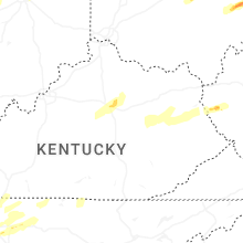


Connect with Interactive Hail Maps