

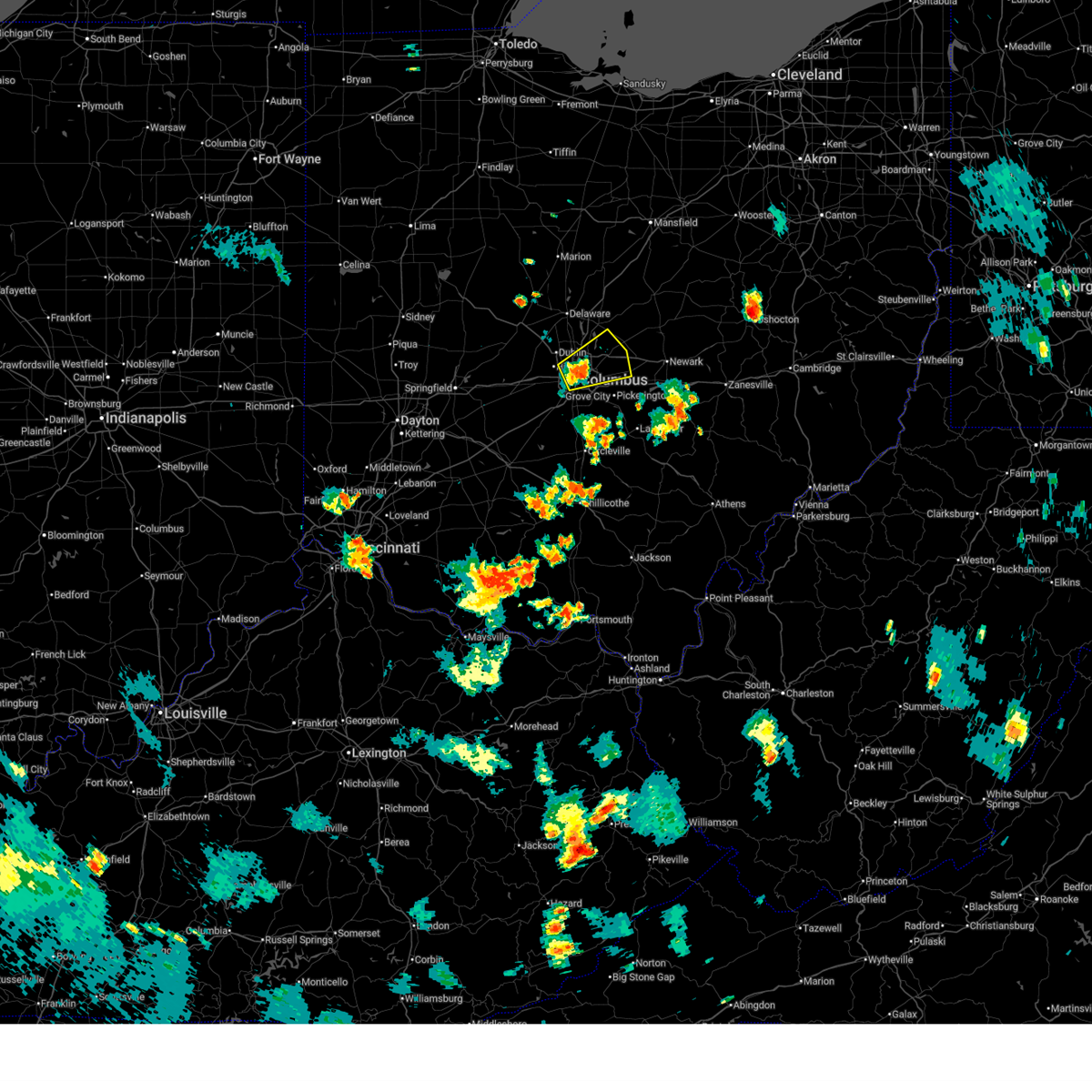
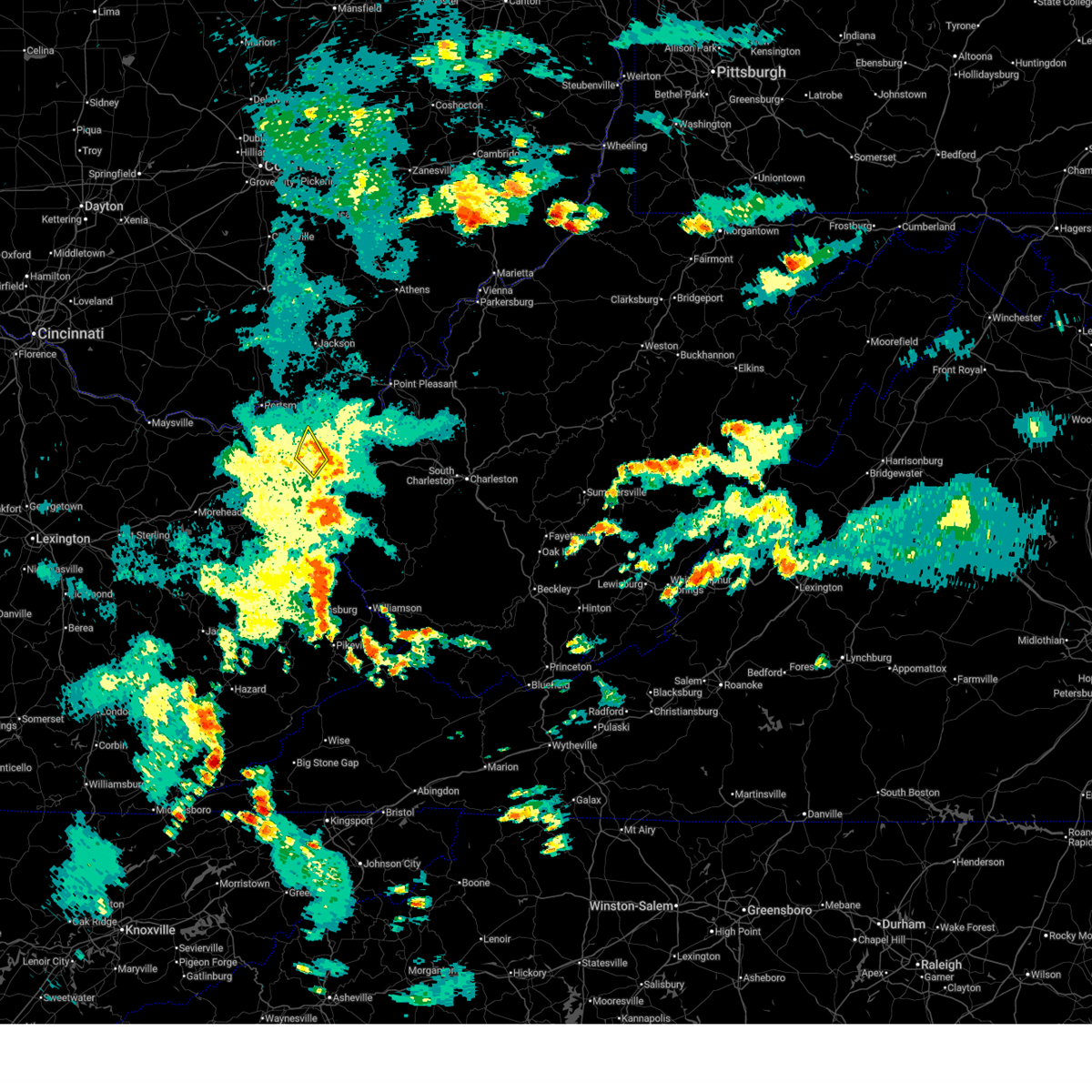
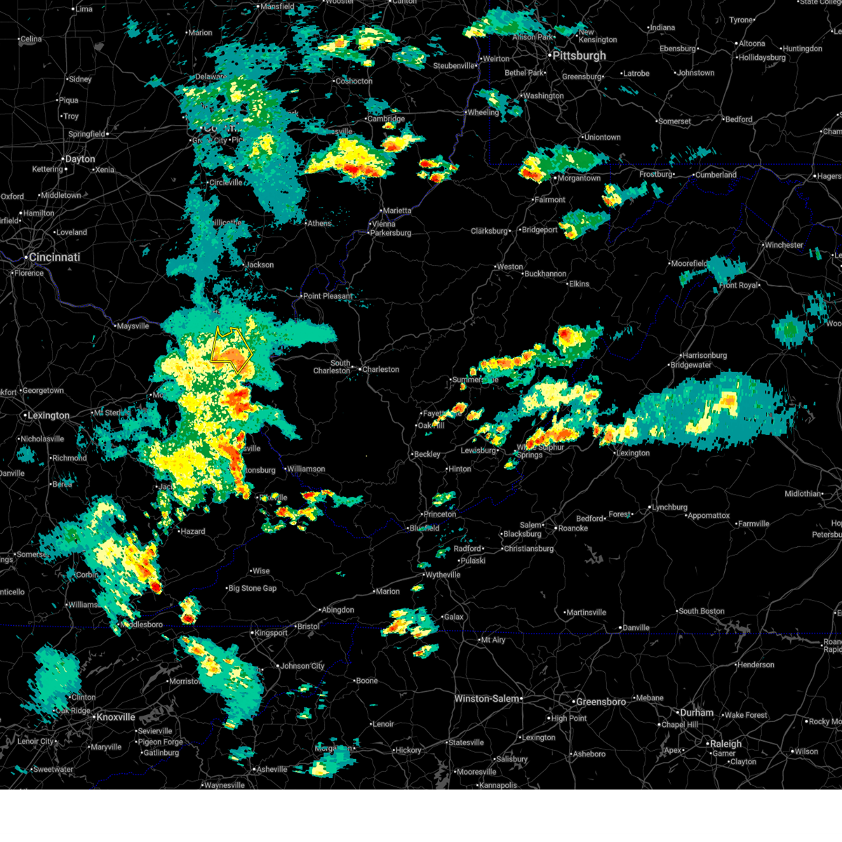
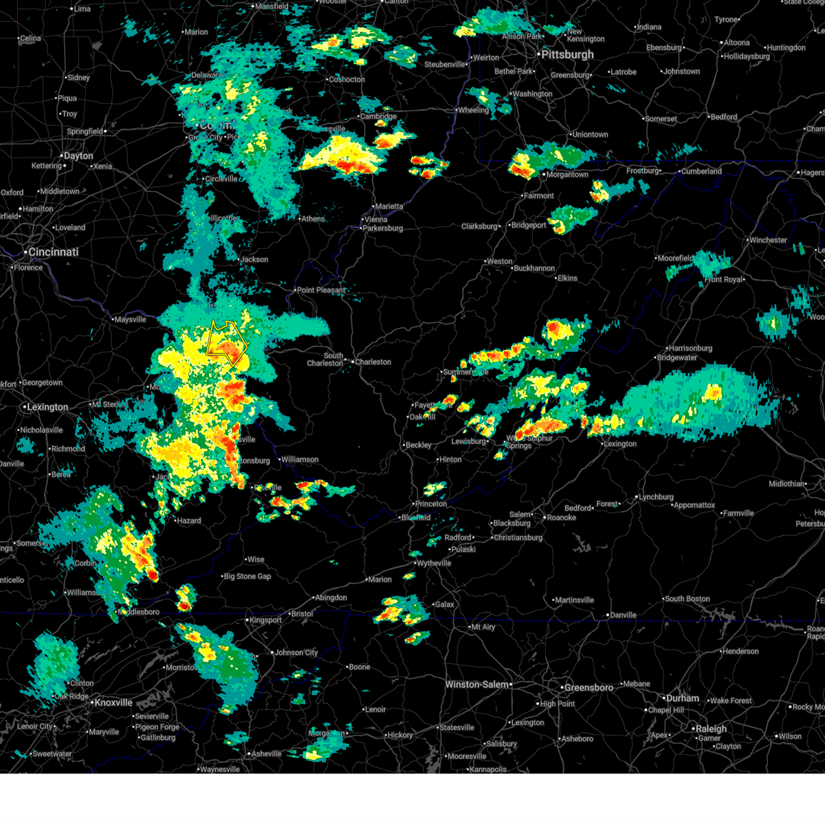
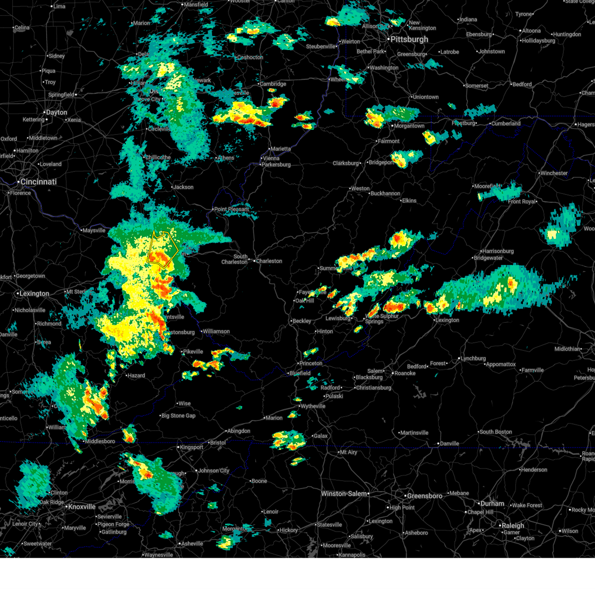
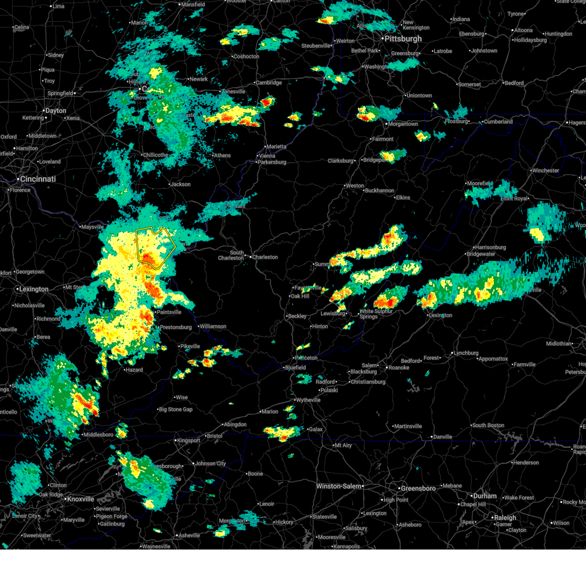
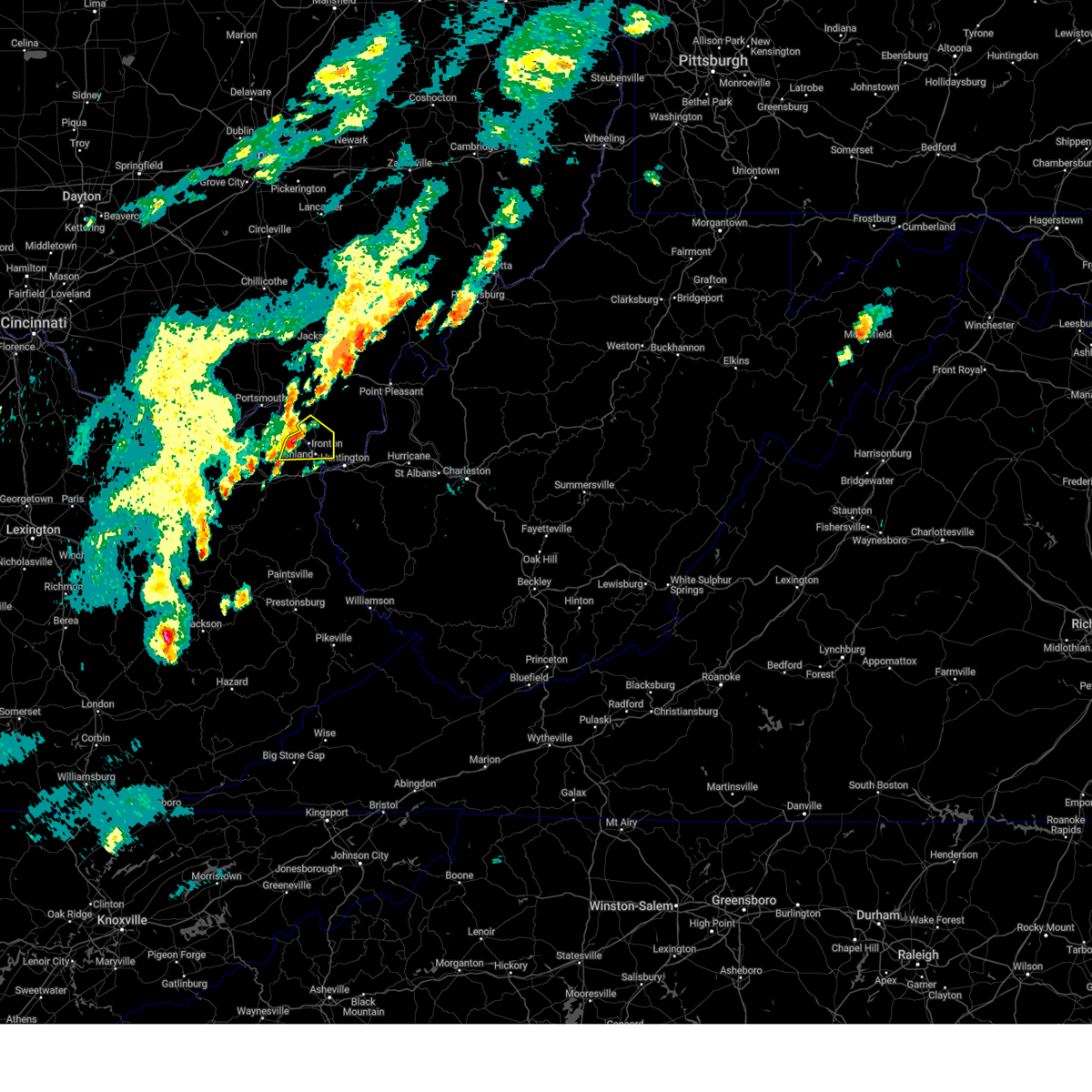
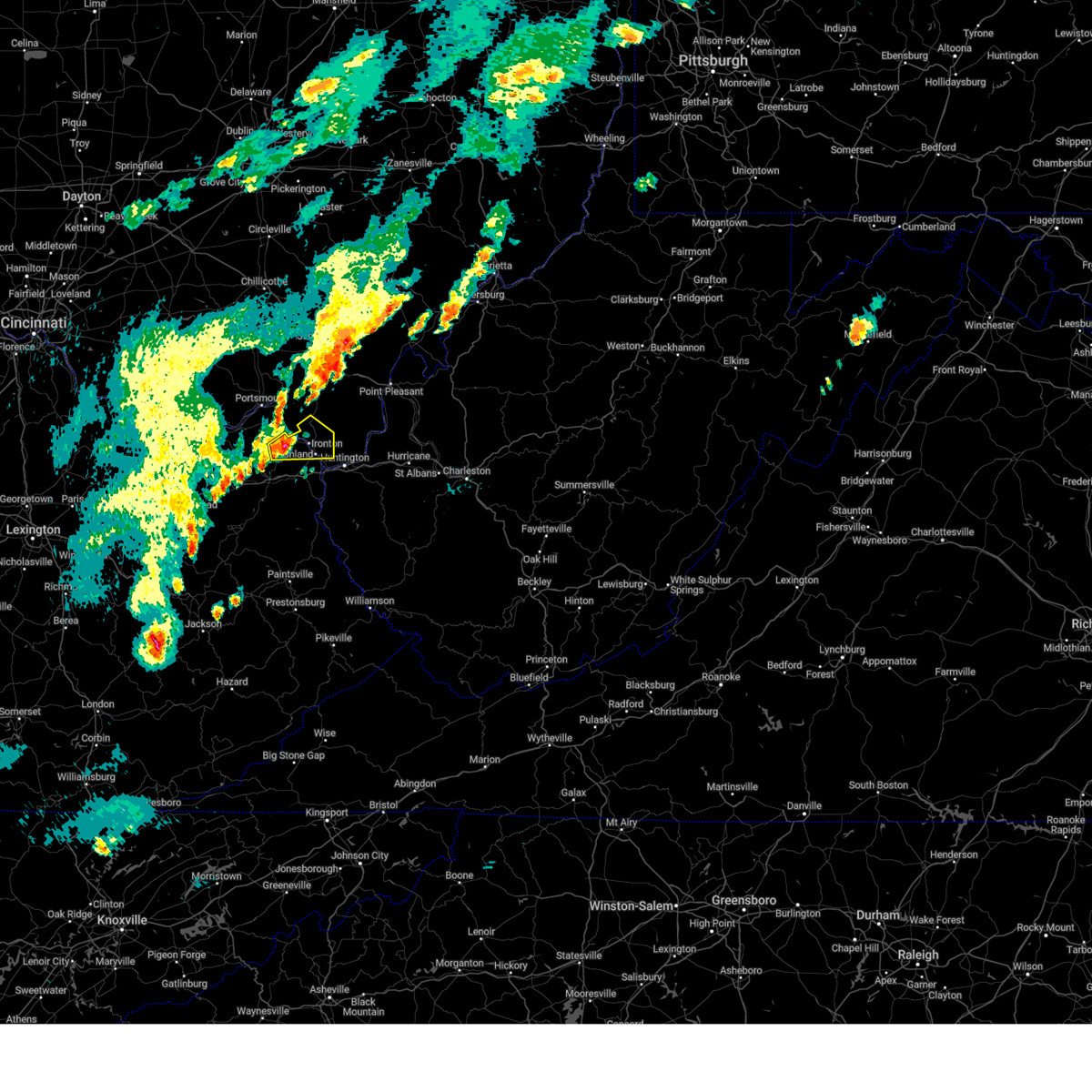
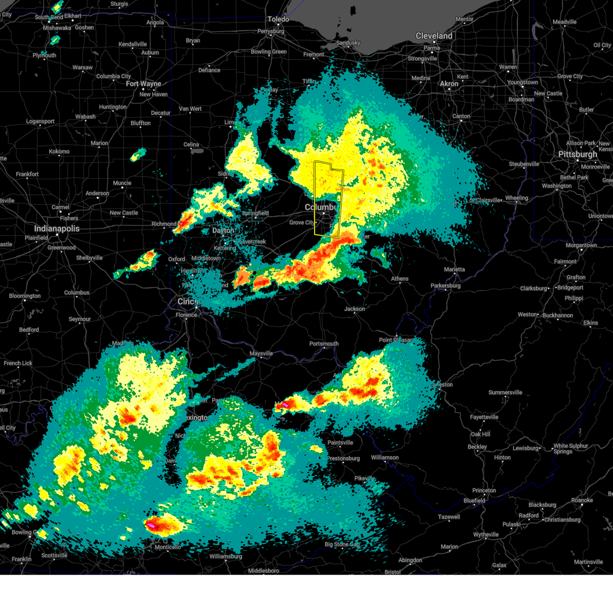
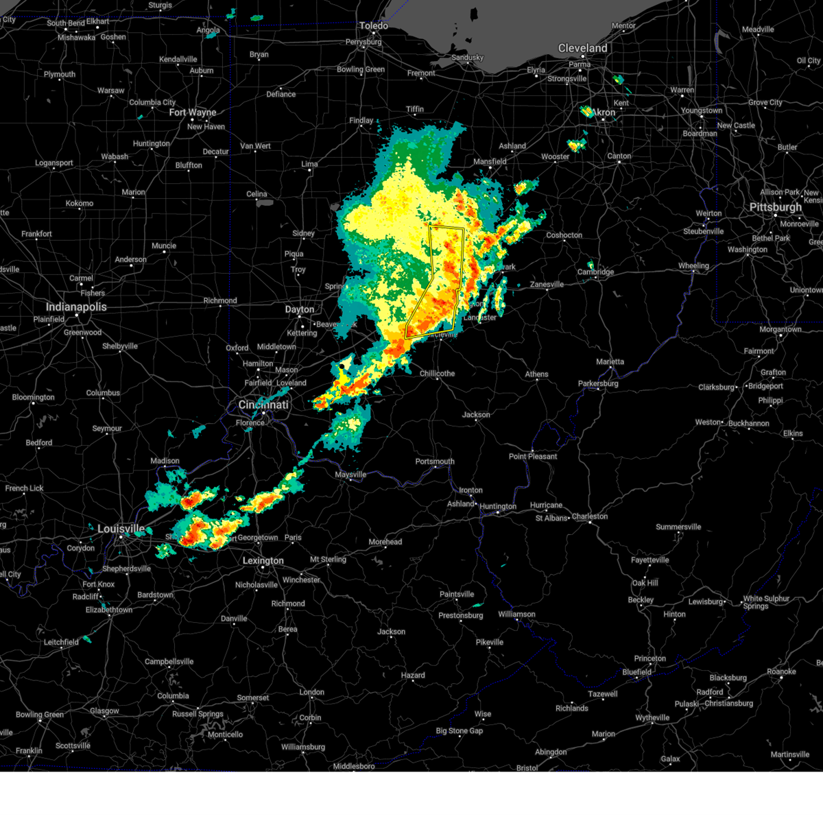
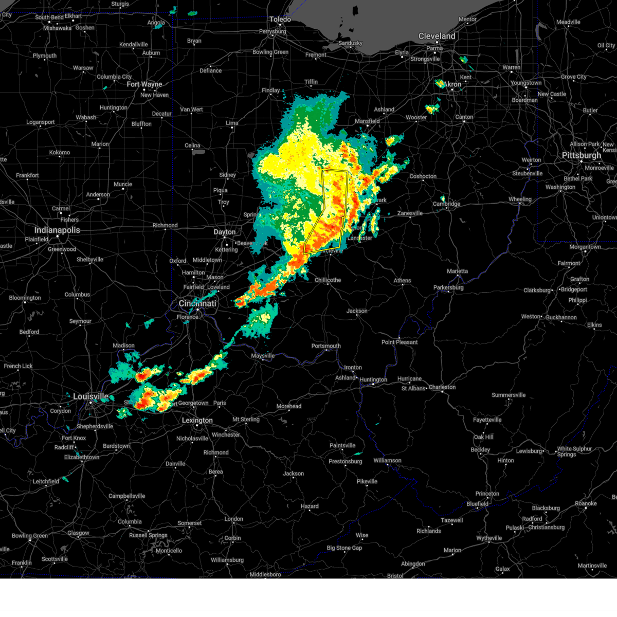
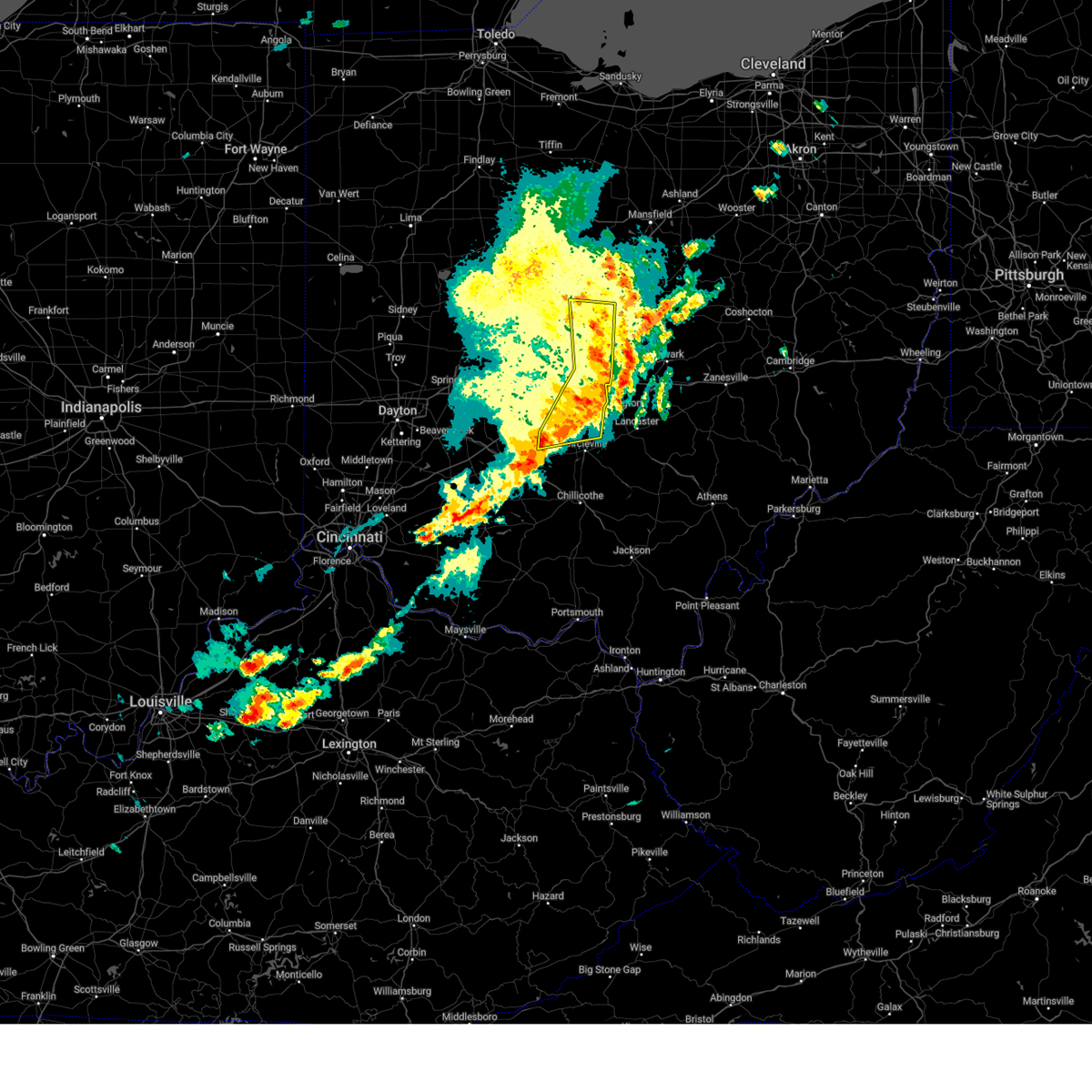
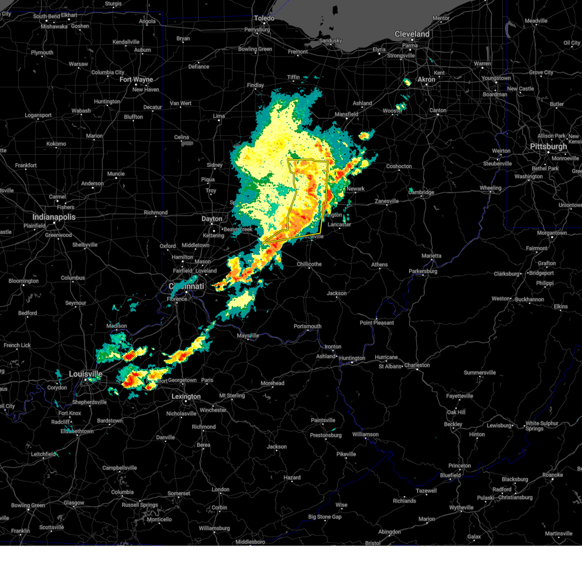
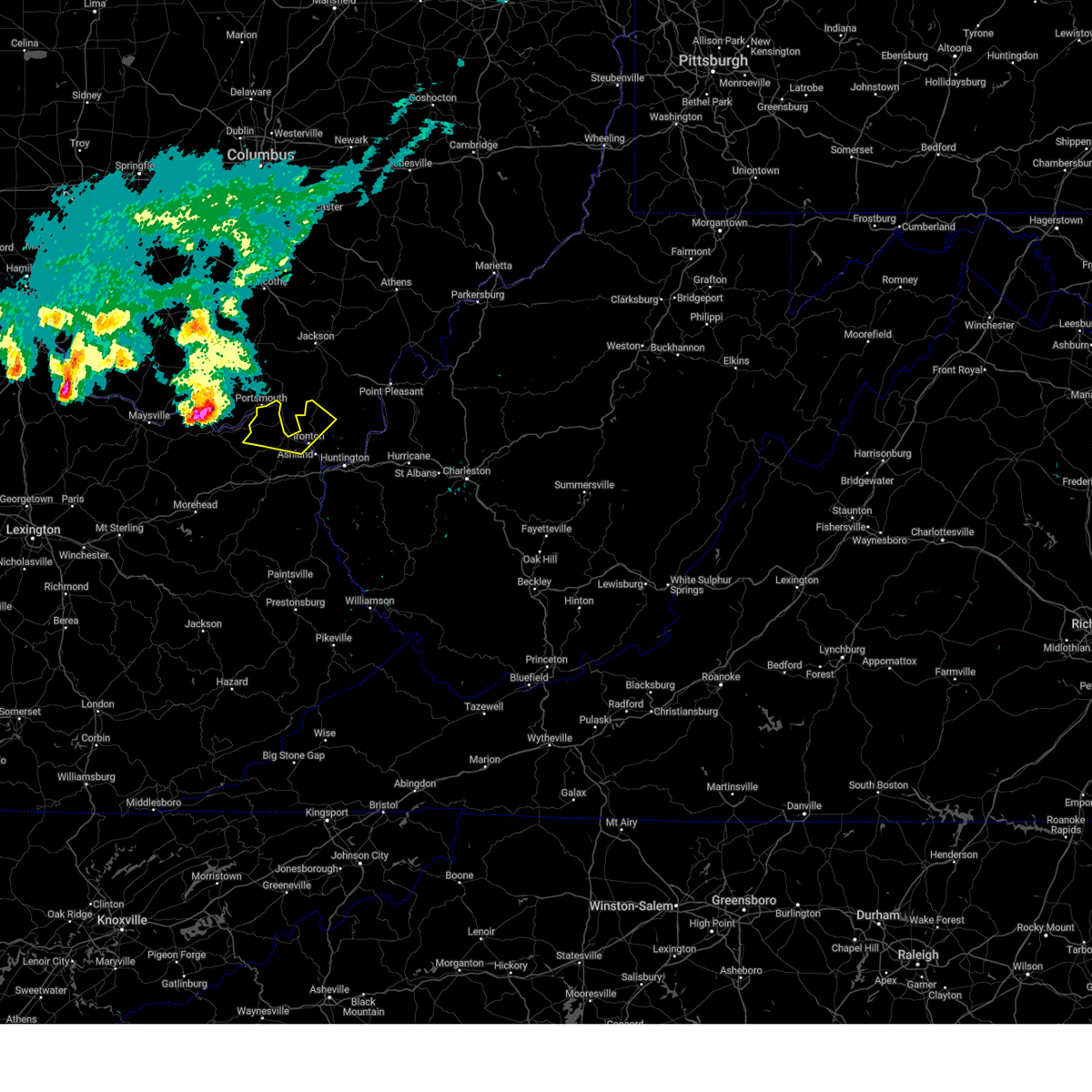
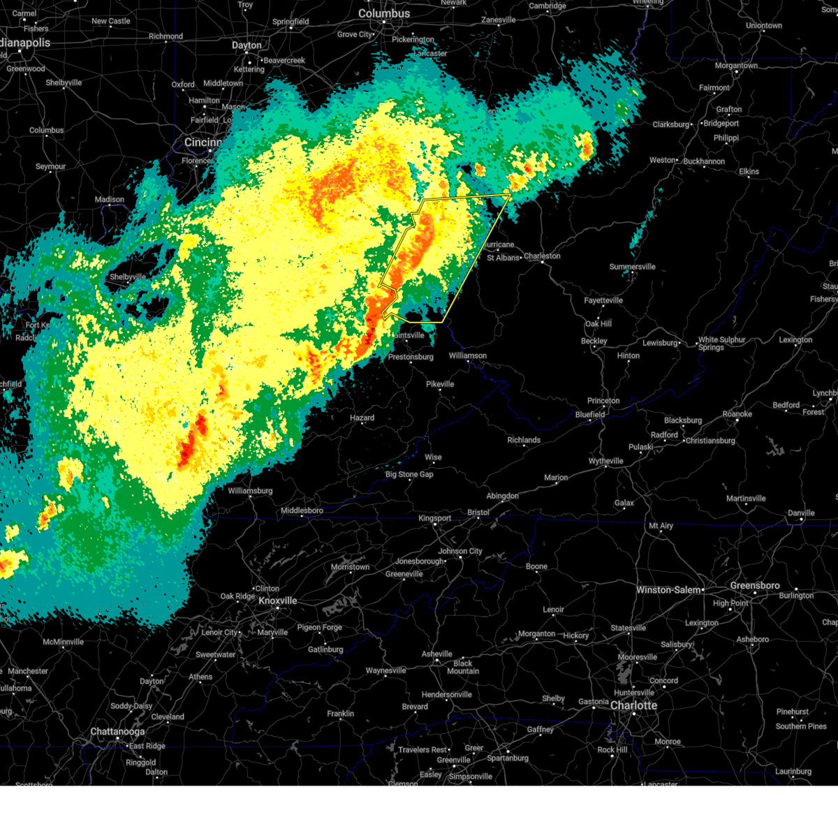
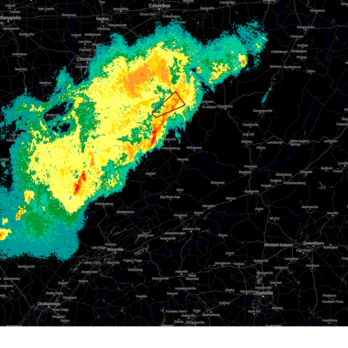
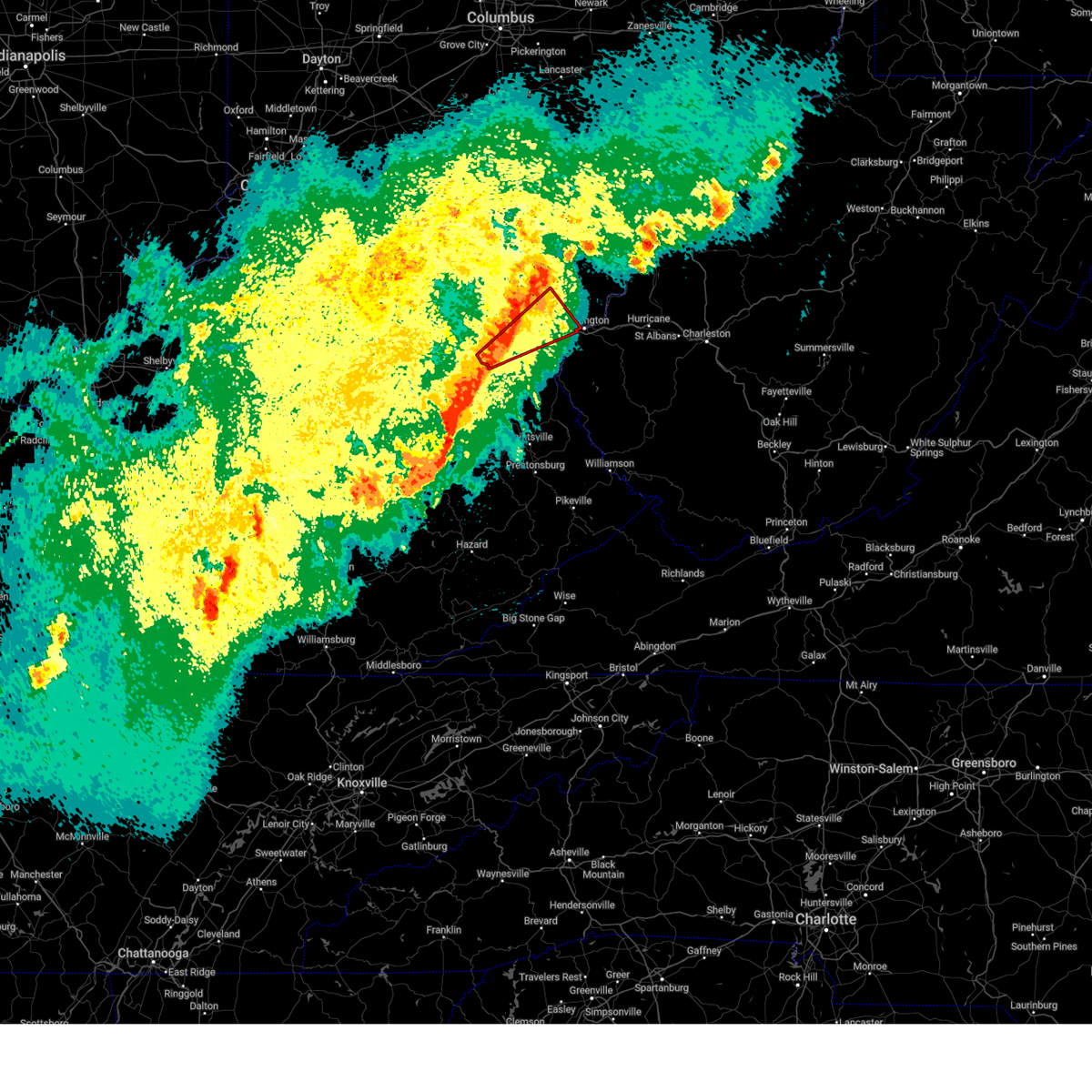
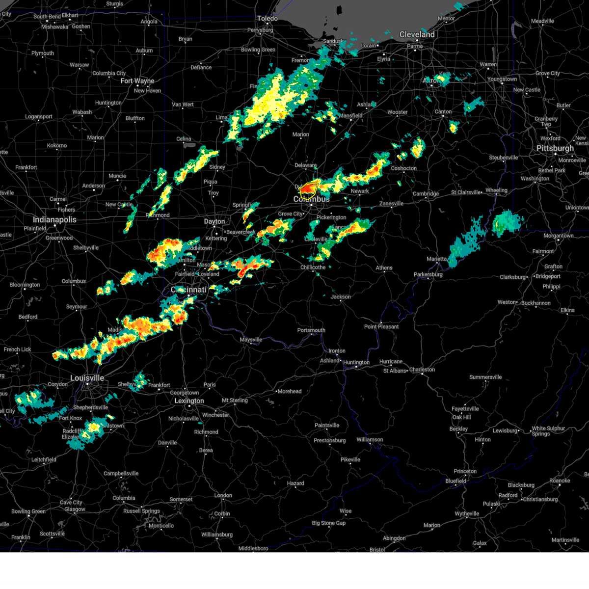
Hail Map for Worthington, OH
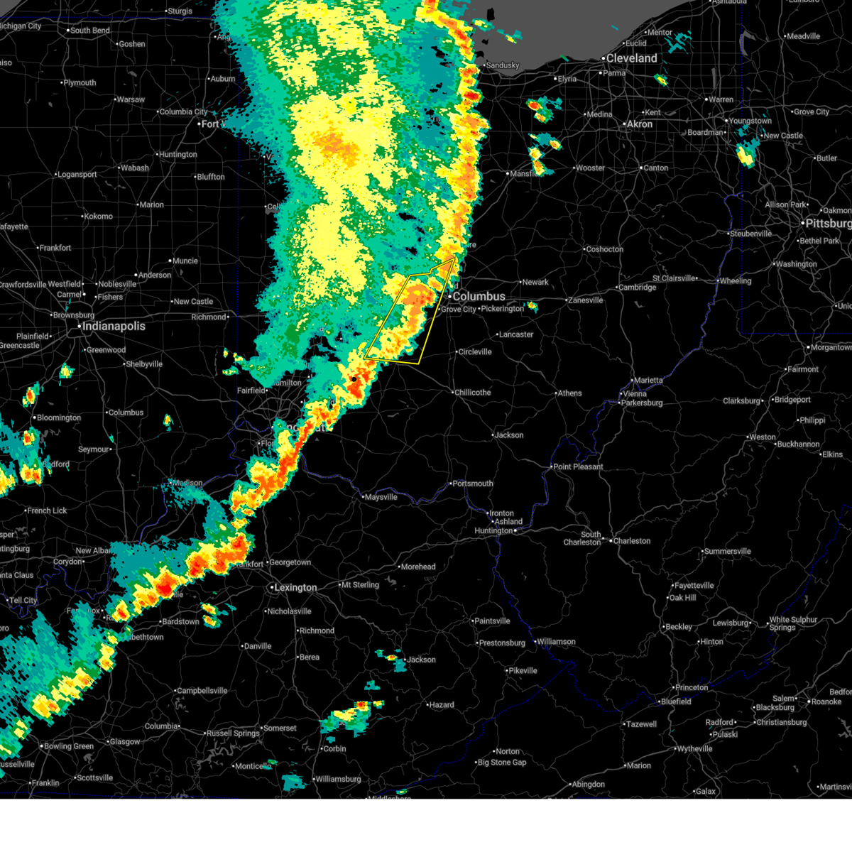
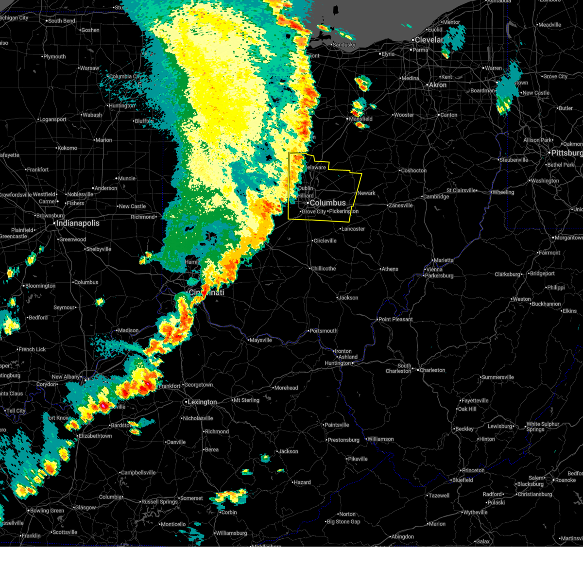
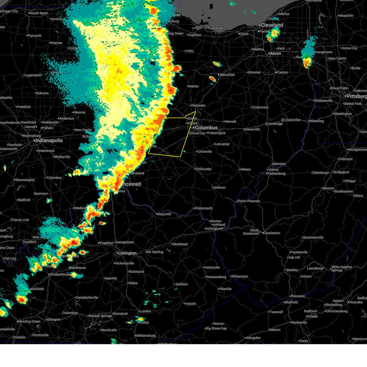
The Worthington, OH area has had 1 report of on-the-ground hail by trained spotters, and has been under severe weather warnings 80 times during the past 12 months. Doppler radar has detected hail at or near Worthington, OH on 89 occasions, including 5 occasions during the past year.
| Name: | Worthington, OH |
| Where Located: | 9 miles N of Columbus, OH |
| Map: | Google Map for Worthington, OH |
| Population: | 13575 |
| Housing Units: | 5940 |
| More Info: | Search Google for Worthington, OH |
1
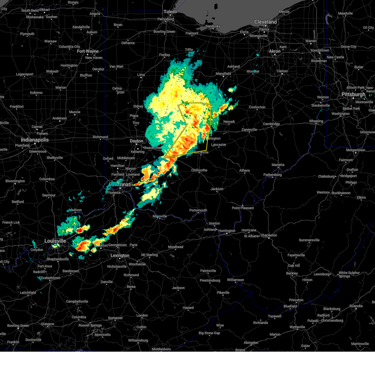
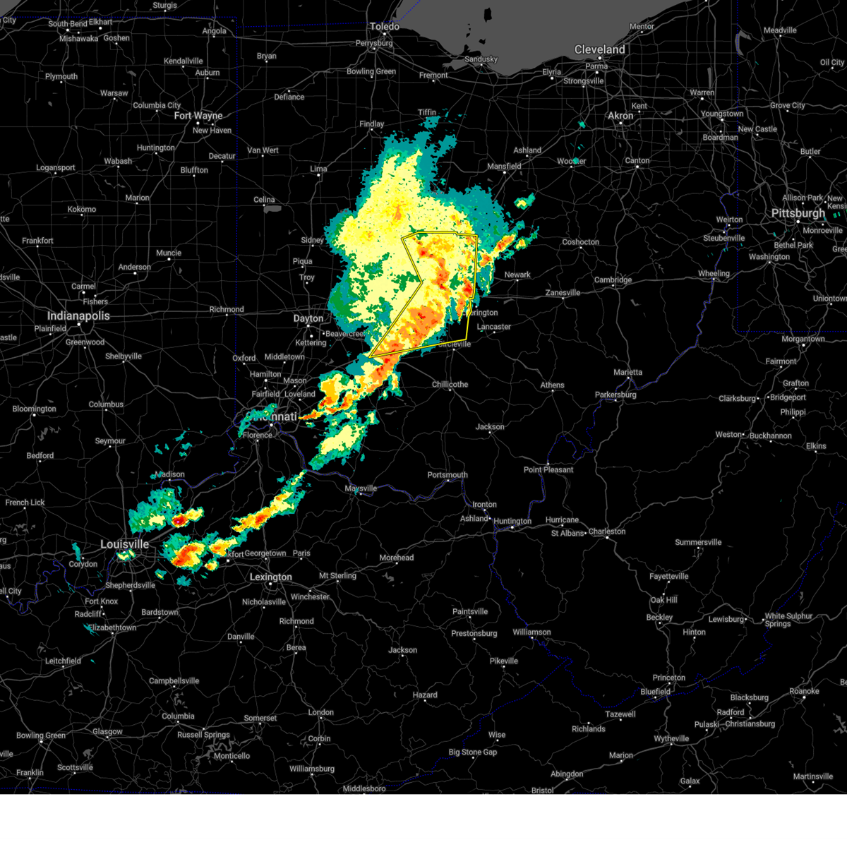
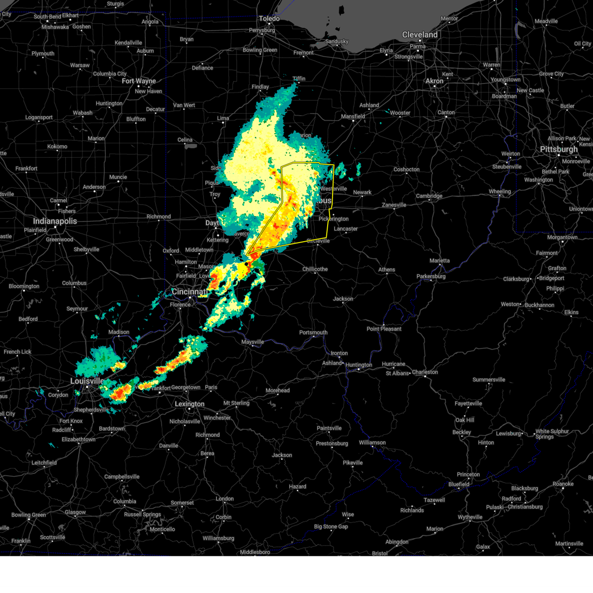
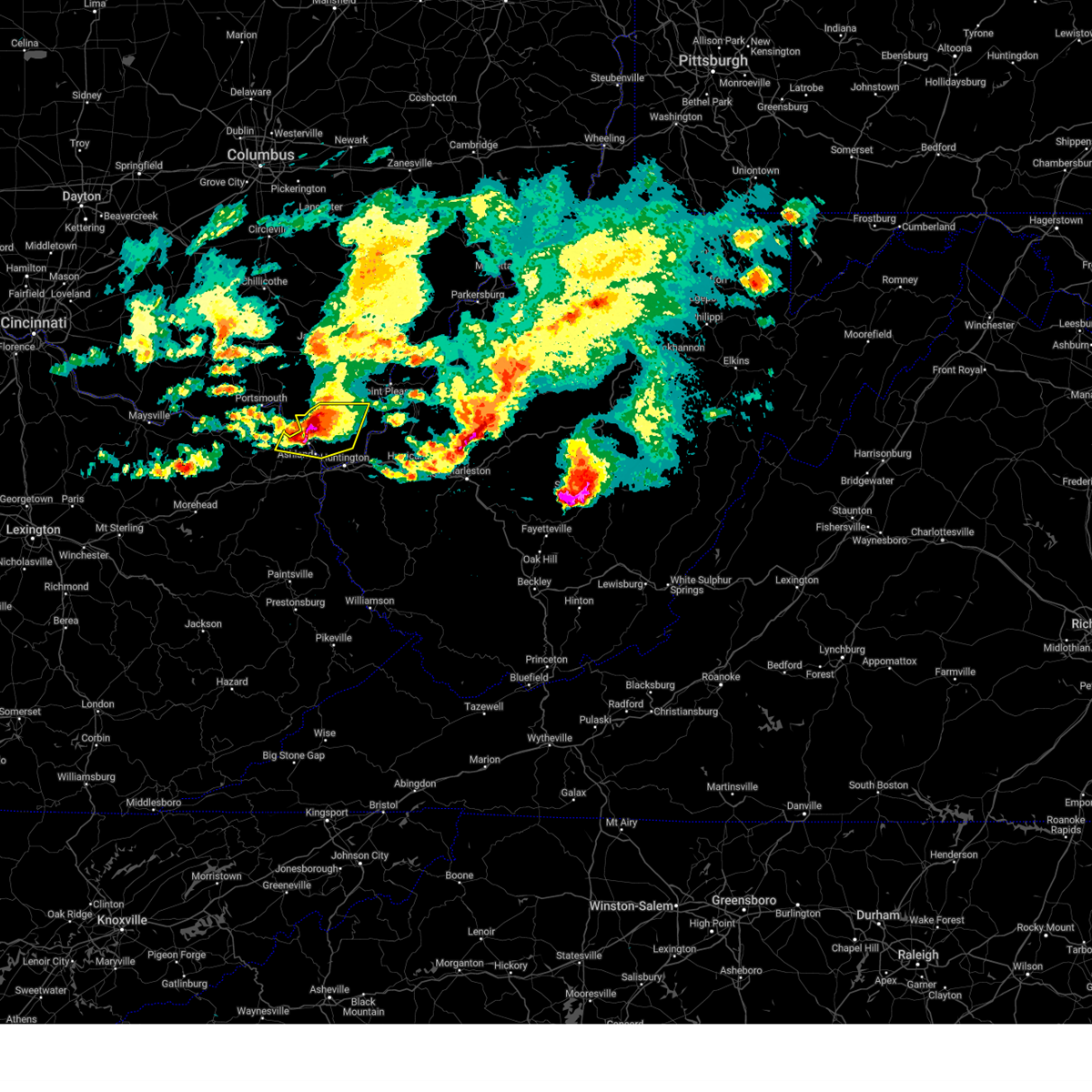
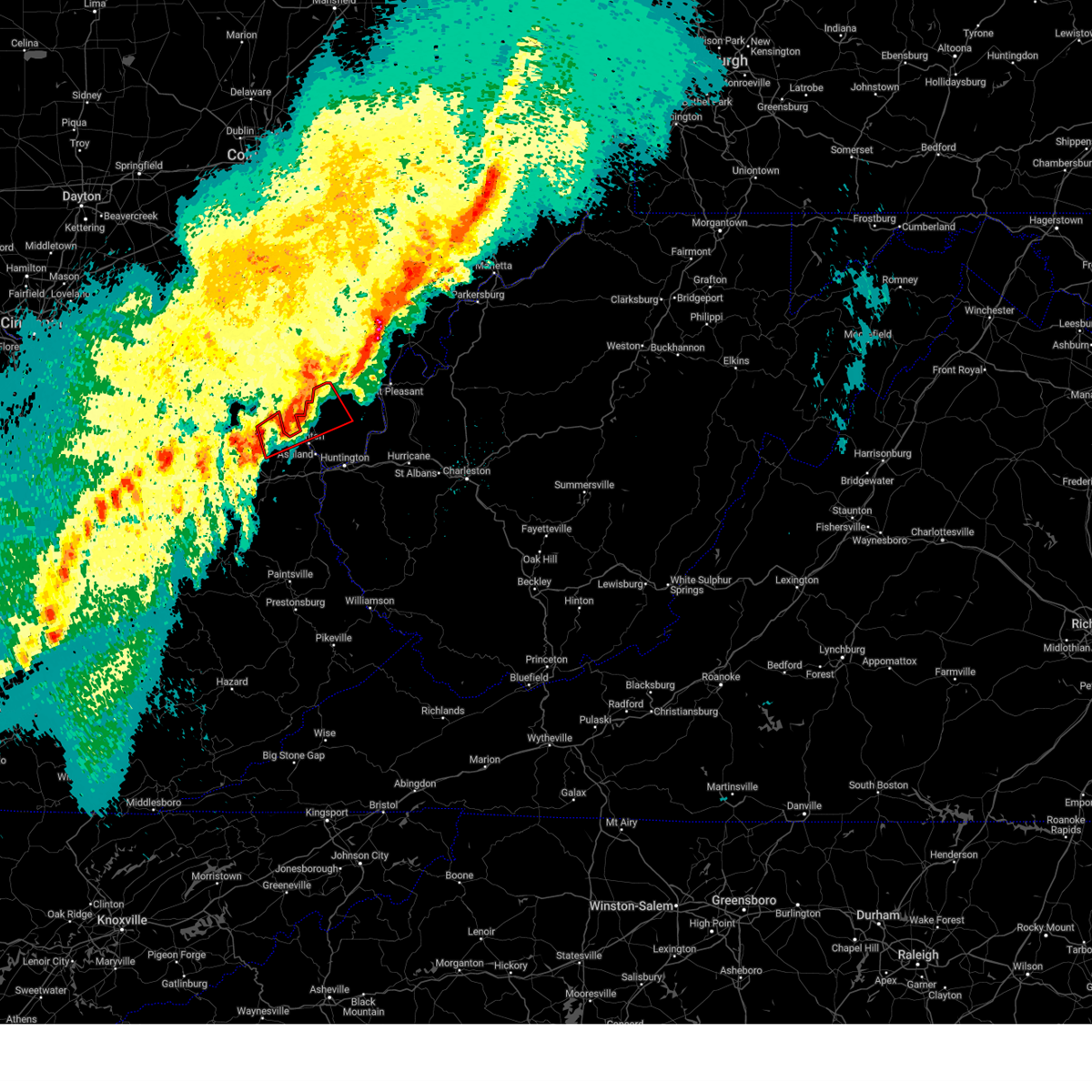
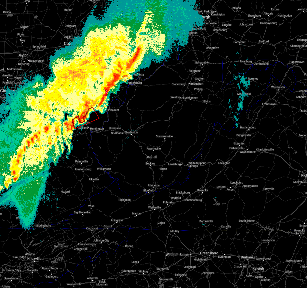
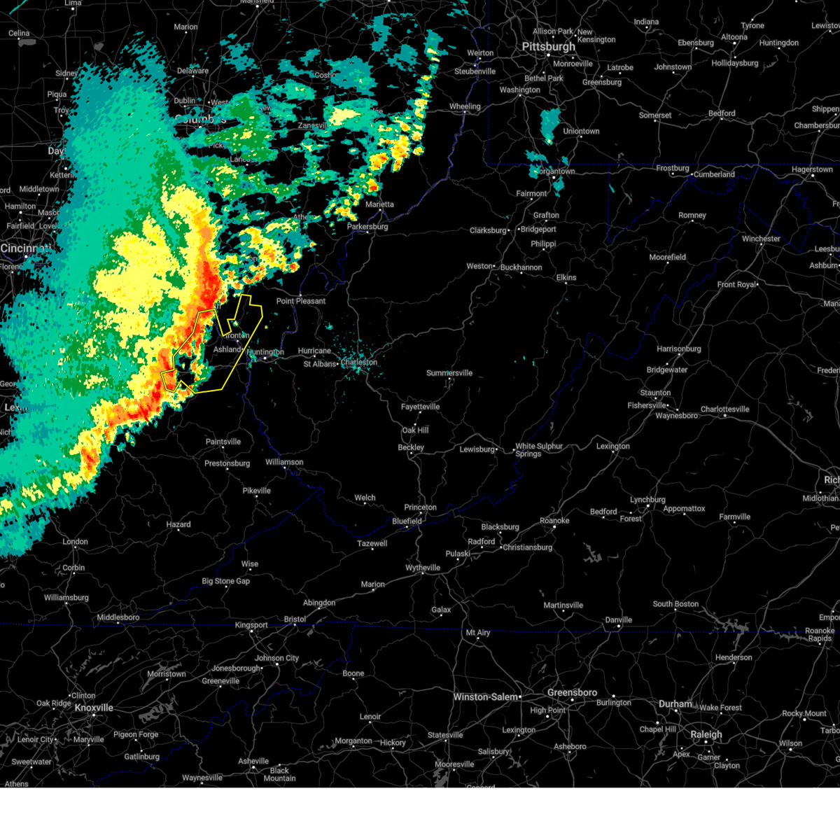
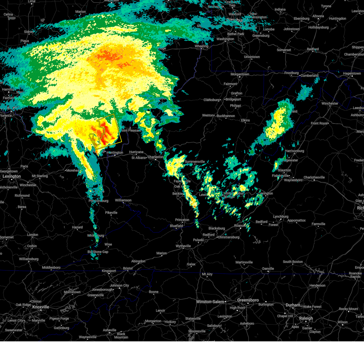
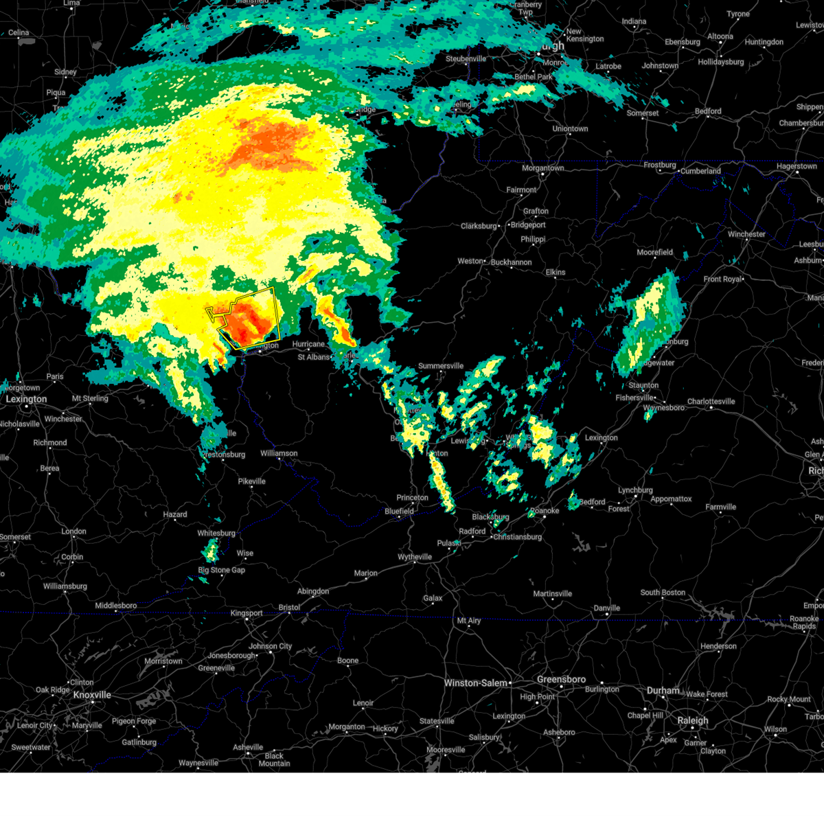
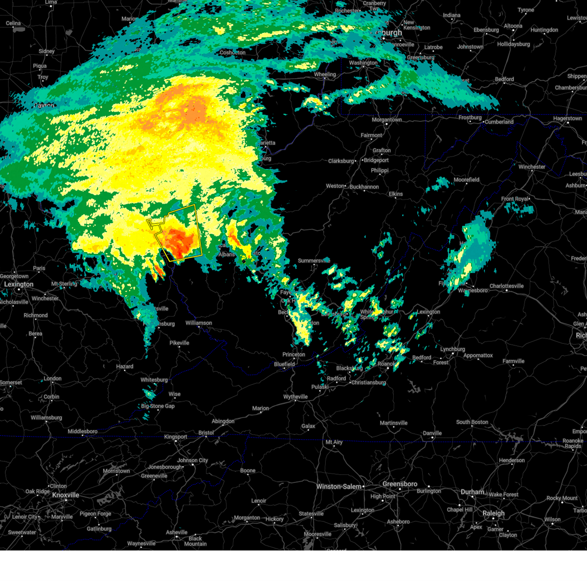
The Top Recent Hail Date for Worthington, OH is Friday, September 6, 2024 (13th out of 89)

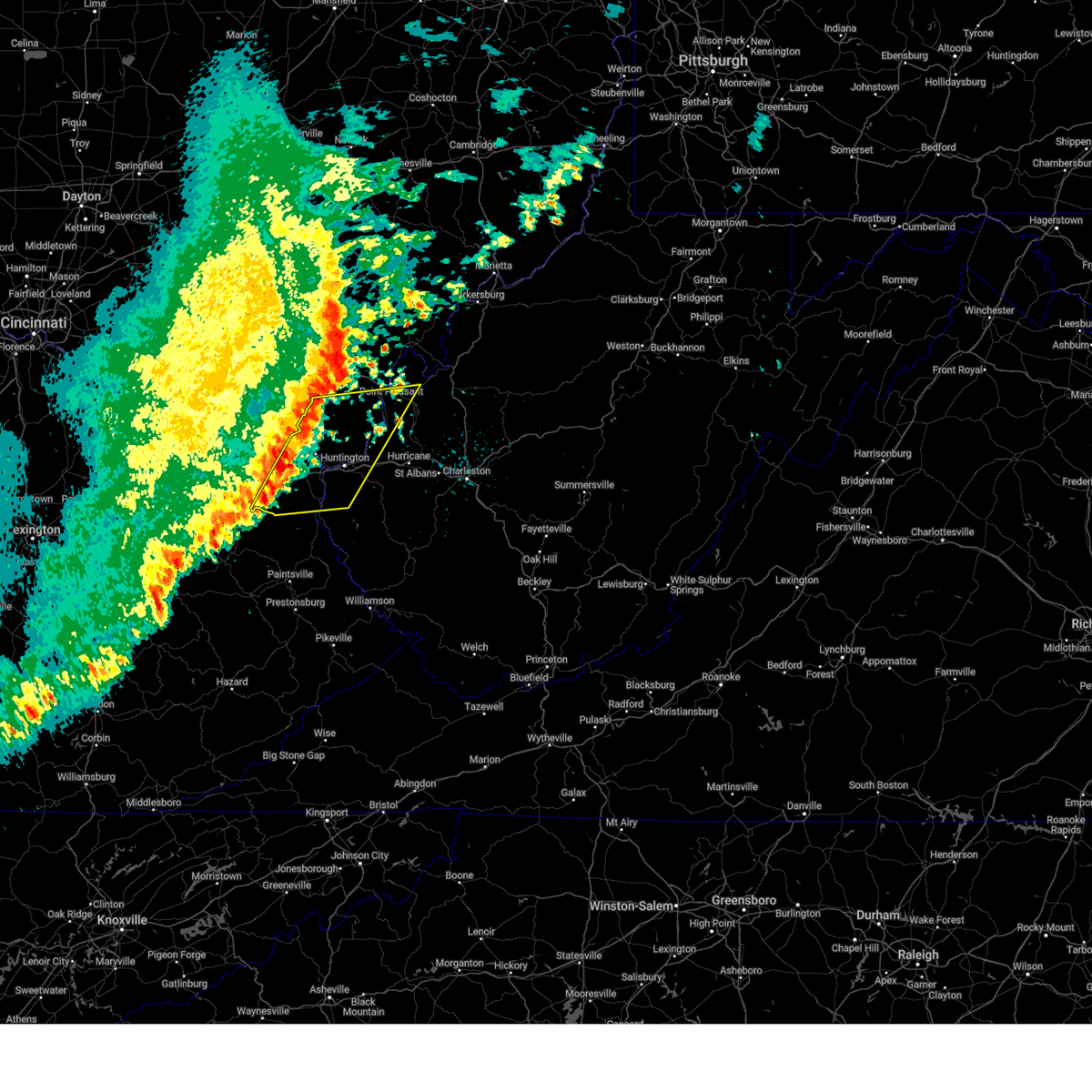
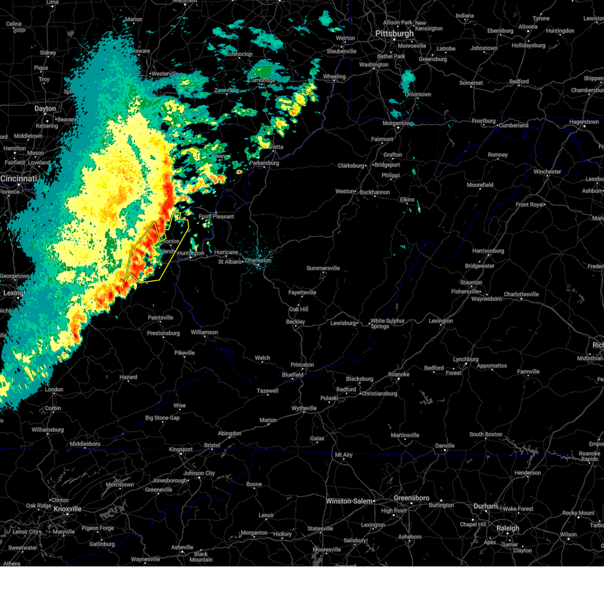
Hail and Wind Damage Spotted near Worthington, OH
| Date / Time | Report Details |
|---|---|
| 6/27/2025 6:16 PM EDT |
 Svriln the national weather service in wilmington has issued a * severe thunderstorm warning for, northeastern franklin county in central ohio, southeastern delaware county in central ohio, southwestern licking county in central ohio, * until 645 pm edt. * at 616 pm edt, a severe thunderstorm was located over ohio state university, moving east at 25 mph (radar indicated). Hazards include 60 mph wind gusts. expect damage to trees and power lines Svriln the national weather service in wilmington has issued a * severe thunderstorm warning for, northeastern franklin county in central ohio, southeastern delaware county in central ohio, southwestern licking county in central ohio, * until 645 pm edt. * at 616 pm edt, a severe thunderstorm was located over ohio state university, moving east at 25 mph (radar indicated). Hazards include 60 mph wind gusts. expect damage to trees and power lines
|
| 6/18/2025 8:22 PM EDT |
 the severe thunderstorm warning has been cancelled and is no longer in effect the severe thunderstorm warning has been cancelled and is no longer in effect
|
| 6/18/2025 8:22 PM EDT |
 At 822 pm edt, severe thunderstorms were located along a line extending from near ashley to near grove city, moving east at 30 mph (radar indicated). Hazards include 60 mph wind gusts. Expect damage to trees and power lines. locations impacted include, columbus, newark, dublin, westerville, reynoldsburg, grove city, upper arlington, gahanna, hilliard, pickerington, worthington, bexley, heath, granville, pataskala, powell, canal winchester, groveport, johnstown, and sunbury. this includes the following interstates, i-70 in ohio between mile markers 87 and 131. I-71 in ohio between mile markers 91 and 138. At 822 pm edt, severe thunderstorms were located along a line extending from near ashley to near grove city, moving east at 30 mph (radar indicated). Hazards include 60 mph wind gusts. Expect damage to trees and power lines. locations impacted include, columbus, newark, dublin, westerville, reynoldsburg, grove city, upper arlington, gahanna, hilliard, pickerington, worthington, bexley, heath, granville, pataskala, powell, canal winchester, groveport, johnstown, and sunbury. this includes the following interstates, i-70 in ohio between mile markers 87 and 131. I-71 in ohio between mile markers 91 and 138.
|
| 6/18/2025 8:21 PM EDT |
 the severe thunderstorm warning has been cancelled and is no longer in effect the severe thunderstorm warning has been cancelled and is no longer in effect
|
| 6/18/2025 8:21 PM EDT |
 At 820 pm edt, severe thunderstorms were located along a line extending from powell to near bloomingburg, moving east at 35 mph (radar indicated). Hazards include 60 mph wind gusts. Expect damage to trees and power lines. locations impacted include, columbus, dublin, grove city, upper arlington, hilliard, washington court house, worthington, jefferson, powell, west jefferson, mount sterling, jeffersonville, bloomingburg, new holland, lake darby, valleyview, marble cliff, riverlea, harrisburg, and orient. this includes the following interstates, i-70 in ohio between mile markers 84 and 95. I-71 in ohio between mile markers 72 and 94. At 820 pm edt, severe thunderstorms were located along a line extending from powell to near bloomingburg, moving east at 35 mph (radar indicated). Hazards include 60 mph wind gusts. Expect damage to trees and power lines. locations impacted include, columbus, dublin, grove city, upper arlington, hilliard, washington court house, worthington, jefferson, powell, west jefferson, mount sterling, jeffersonville, bloomingburg, new holland, lake darby, valleyview, marble cliff, riverlea, harrisburg, and orient. this includes the following interstates, i-70 in ohio between mile markers 84 and 95. I-71 in ohio between mile markers 72 and 94.
|
| 6/18/2025 8:13 PM EDT |
 At 812 pm edt, severe thunderstorms were located along a line extending from ashley to 6 miles southwest of grove city, moving east at 30 mph (a 56 mph wind gust was reported at columbus ohio state university aiport at 759 pm). Hazards include 60 mph wind gusts. Expect damage to trees and power lines. locations impacted include, columbus, newark, dublin, westerville, reynoldsburg, grove city, delaware, upper arlington, gahanna, hilliard, pickerington, worthington, bexley, heath, granville, pataskala, powell, canal winchester, groveport, and johnstown. this includes the following interstates, i-70 in ohio between mile markers 87 and 131. I-71 in ohio between mile markers 91 and 138. At 812 pm edt, severe thunderstorms were located along a line extending from ashley to 6 miles southwest of grove city, moving east at 30 mph (a 56 mph wind gust was reported at columbus ohio state university aiport at 759 pm). Hazards include 60 mph wind gusts. Expect damage to trees and power lines. locations impacted include, columbus, newark, dublin, westerville, reynoldsburg, grove city, delaware, upper arlington, gahanna, hilliard, pickerington, worthington, bexley, heath, granville, pataskala, powell, canal winchester, groveport, and johnstown. this includes the following interstates, i-70 in ohio between mile markers 87 and 131. I-71 in ohio between mile markers 91 and 138.
|
| 6/18/2025 8:11 PM EDT |
 the severe thunderstorm warning has been cancelled and is no longer in effect the severe thunderstorm warning has been cancelled and is no longer in effect
|
| 6/18/2025 8:11 PM EDT |
 At 810 pm edt, severe thunderstorms were located along a line extending from new california to jeffersonville, moving east at 35 mph (a 56 mph wind gust was reported at columbus ohio state university aiport at 759 pm). Hazards include 60 mph wind gusts. Expect damage to trees and power lines. locations impacted include, columbus, dublin, grove city, upper arlington, hilliard, washington court house, worthington, london, jefferson, powell, plain city, west jefferson, mount sterling, jeffersonville, bloomingburg, new holland, lake darby, valleyview, marble cliff, and riverlea. this includes the following interstates, i-70 in ohio between mile markers 75 and 95. I-71 in ohio between mile markers 59 and 94. At 810 pm edt, severe thunderstorms were located along a line extending from new california to jeffersonville, moving east at 35 mph (a 56 mph wind gust was reported at columbus ohio state university aiport at 759 pm). Hazards include 60 mph wind gusts. Expect damage to trees and power lines. locations impacted include, columbus, dublin, grove city, upper arlington, hilliard, washington court house, worthington, london, jefferson, powell, plain city, west jefferson, mount sterling, jeffersonville, bloomingburg, new holland, lake darby, valleyview, marble cliff, and riverlea. this includes the following interstates, i-70 in ohio between mile markers 75 and 95. I-71 in ohio between mile markers 59 and 94.
|
| 6/18/2025 7:55 PM EDT |
 Svriln the national weather service in wilmington has issued a * severe thunderstorm warning for, franklin county in central ohio, northwestern fairfield county in central ohio, delaware county in central ohio, licking county in central ohio, southeastern union county in central ohio, northeastern madison county in central ohio, * until 915 pm edt. * at 755 pm edt, severe thunderstorms were located along a line extending from near waldo to 7 miles north of mount sterling, moving east at 30 mph (radar indicated). Hazards include 60 mph wind gusts. expect damage to trees and power lines Svriln the national weather service in wilmington has issued a * severe thunderstorm warning for, franklin county in central ohio, northwestern fairfield county in central ohio, delaware county in central ohio, licking county in central ohio, southeastern union county in central ohio, northeastern madison county in central ohio, * until 915 pm edt. * at 755 pm edt, severe thunderstorms were located along a line extending from near waldo to 7 miles north of mount sterling, moving east at 30 mph (radar indicated). Hazards include 60 mph wind gusts. expect damage to trees and power lines
|
| 6/18/2025 7:35 PM EDT | At 735 pm edt, severe thunderstorms were located along a line extending from mechanicsburg to 6 miles southeast of xenia, moving east at 35 mph (radar indicated). Hazards include 60 mph wind gusts. Expect damage to trees and power lines. locations impacted include, columbus, springfield, dublin, grove city, upper arlington, hilliard, washington court house, worthington, london, jefferson, powell, plain city, west jefferson, cedarville, jamestown, mount sterling, south charleston, mechanicsburg, jeffersonville, and bloomingburg. this includes the following interstates, i-70 in ohio between mile markers 59 and 95. I-71 in ohio between mile markers 58 and 94. |
| 6/18/2025 7:26 PM EDT |
 Svriln the national weather service in wilmington has issued a * severe thunderstorm warning for, southeastern champaign county in west central ohio, western franklin county in central ohio, fayette county in central ohio, northwestern pickaway county in central ohio, south central delaware county in central ohio, eastern greene county in west central ohio, eastern clark county in west central ohio, madison county in central ohio, * until 830 pm edt. * at 725 pm edt, severe thunderstorms were located along a line extending from near mechanicsburg to 6 miles south of xenia, moving east at 35 mph (a 69 mph wind gust was reported at dayton airport at 654 pm). Hazards include 70 mph wind gusts. Expect considerable tree damage. Damage is likely to mobile homes, roofs, and outbuildings. Svriln the national weather service in wilmington has issued a * severe thunderstorm warning for, southeastern champaign county in west central ohio, western franklin county in central ohio, fayette county in central ohio, northwestern pickaway county in central ohio, south central delaware county in central ohio, eastern greene county in west central ohio, eastern clark county in west central ohio, madison county in central ohio, * until 830 pm edt. * at 725 pm edt, severe thunderstorms were located along a line extending from near mechanicsburg to 6 miles south of xenia, moving east at 35 mph (a 69 mph wind gust was reported at dayton airport at 654 pm). Hazards include 70 mph wind gusts. Expect considerable tree damage. Damage is likely to mobile homes, roofs, and outbuildings.
|
| 6/13/2025 7:50 PM EDT |
 The storms which prompted the warning have moved out of the area. therefore, the warning will be allowed to expire. however, gusty winds and heavy rain are still possible with these thunderstorms. The storms which prompted the warning have moved out of the area. therefore, the warning will be allowed to expire. however, gusty winds and heavy rain are still possible with these thunderstorms.
|
| 6/13/2025 7:47 PM EDT |
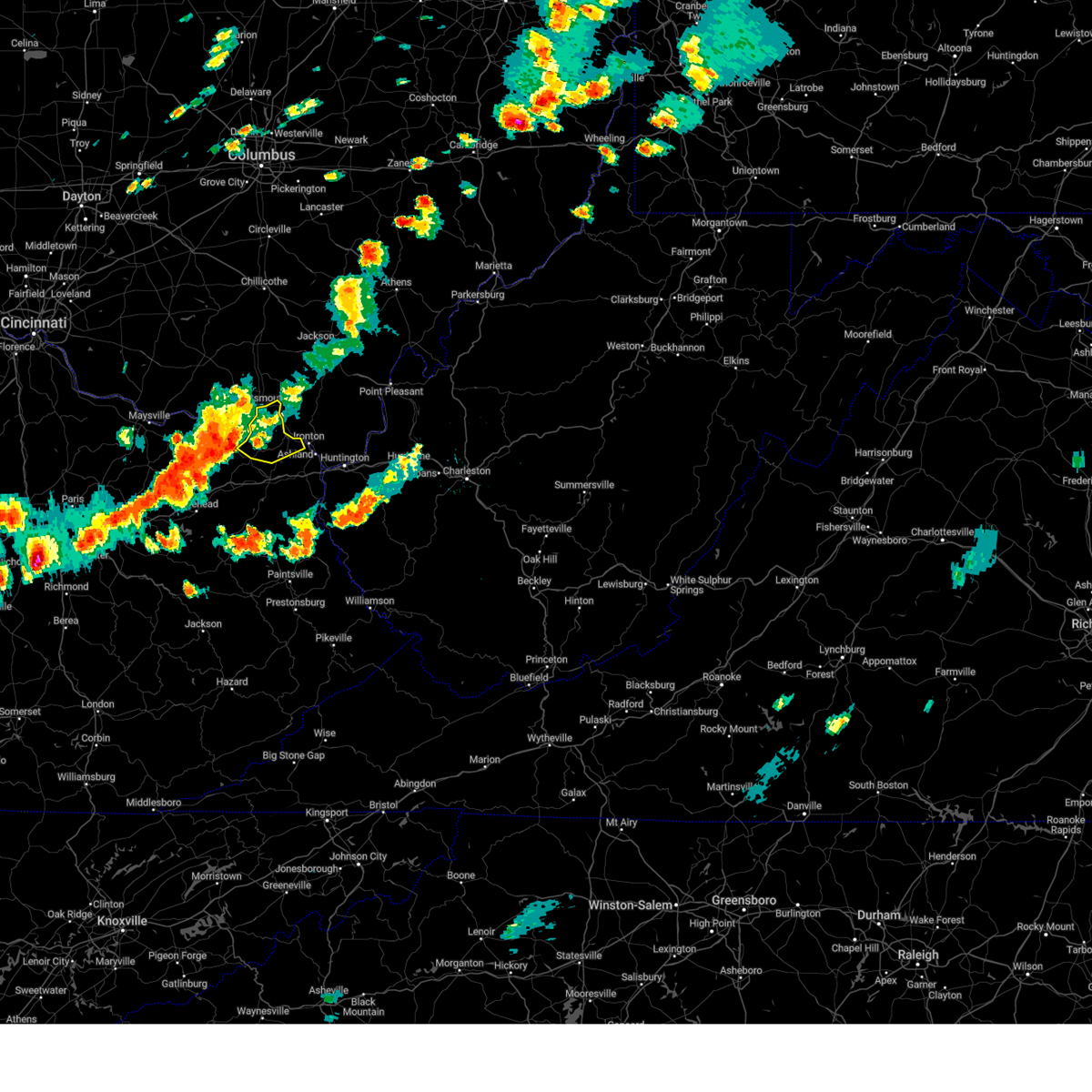
 At 746 pm edt, severe thunderstorms were located along a line extending from near ironton to near lake vesuvius to near coal grove, moving northeast at 30 mph (radar indicated). Hazards include 60 mph wind gusts. Expect damage to roofs, siding, and trees. Locations impacted include, ashland, ironton, coal grove, kenova, catlettsburg, flatwoods, south point, russell, raceland, worthington, bellefonte, westwood, hanging rock, and summit. At 746 pm edt, severe thunderstorms were located along a line extending from near ironton to near lake vesuvius to near coal grove, moving northeast at 30 mph (radar indicated). Hazards include 60 mph wind gusts. Expect damage to roofs, siding, and trees. Locations impacted include, ashland, ironton, coal grove, kenova, catlettsburg, flatwoods, south point, russell, raceland, worthington, bellefonte, westwood, hanging rock, and summit.
|
| 6/13/2025 7:47 PM EDT |
 At 746 pm edt, severe thunderstorms were located along a line extending from near ironton to near lake vesuvius to near coal grove, moving northeast at 30 mph (radar indicated). Hazards include 60 mph wind gusts. Expect damage to roofs, siding, and trees. Locations impacted include, ashland, ironton, coal grove, kenova, catlettsburg, flatwoods, south point, russell, raceland, worthington, bellefonte, westwood, hanging rock, and summit. At 746 pm edt, severe thunderstorms were located along a line extending from near ironton to near lake vesuvius to near coal grove, moving northeast at 30 mph (radar indicated). Hazards include 60 mph wind gusts. Expect damage to roofs, siding, and trees. Locations impacted include, ashland, ironton, coal grove, kenova, catlettsburg, flatwoods, south point, russell, raceland, worthington, bellefonte, westwood, hanging rock, and summit.
|
| 6/13/2025 7:33 PM EDT |
 At 732 pm edt, severe thunderstorms were located along a line extending from oldtown to near naples to catlettsburg, moving north at 30 mph (radar indicated). Hazards include 60 mph wind gusts. Expect damage to roofs, siding, and trees. Locations impacted include, ashland, ironton, coal grove, cannonsburg, kenova, catlettsburg, greenup, oldtown, naples, flatwoods, south point, russell, raceland, worthington, wurtland, bellefonte, westwood, hanging rock, hopewell, and summit. At 732 pm edt, severe thunderstorms were located along a line extending from oldtown to near naples to catlettsburg, moving north at 30 mph (radar indicated). Hazards include 60 mph wind gusts. Expect damage to roofs, siding, and trees. Locations impacted include, ashland, ironton, coal grove, cannonsburg, kenova, catlettsburg, greenup, oldtown, naples, flatwoods, south point, russell, raceland, worthington, wurtland, bellefonte, westwood, hanging rock, hopewell, and summit.
|
| 6/13/2025 7:33 PM EDT |
 the severe thunderstorm warning has been cancelled and is no longer in effect the severe thunderstorm warning has been cancelled and is no longer in effect
|
| 6/13/2025 7:23 PM EDT |
 At 722 pm edt, severe thunderstorms were located along a line extending from near oldtown to naples to near cannonsburg, moving northeast at 30 mph (radar indicated). Hazards include 60 mph wind gusts. Expect damage to roofs, siding, and trees. Locations impacted include, ashland, ironton, grayson, coal grove, cannonsburg, kenova, catlettsburg, greenup, princess, coalton, oldtown, naples, rush, flatwoods, south point, russell, raceland, worthington, wurtland, and bellefonte. At 722 pm edt, severe thunderstorms were located along a line extending from near oldtown to naples to near cannonsburg, moving northeast at 30 mph (radar indicated). Hazards include 60 mph wind gusts. Expect damage to roofs, siding, and trees. Locations impacted include, ashland, ironton, grayson, coal grove, cannonsburg, kenova, catlettsburg, greenup, princess, coalton, oldtown, naples, rush, flatwoods, south point, russell, raceland, worthington, wurtland, and bellefonte.
|
| 6/13/2025 7:08 PM EDT |
 Svrrlx the national weather service in charleston west virginia has issued a * severe thunderstorm warning for, boyd county in northeastern kentucky, greenup county in northeastern kentucky, northeastern carter county in northeastern kentucky, southwestern lawrence county in southeastern ohio, * until 800 pm edt. * at 707 pm edt, severe thunderstorms were located along a line extending from near carter caves state park to near grayson to near denton, moving north at 30 mph (radar indicated). Hazards include 60 mph wind gusts. expect damage to roofs, siding, and trees Svrrlx the national weather service in charleston west virginia has issued a * severe thunderstorm warning for, boyd county in northeastern kentucky, greenup county in northeastern kentucky, northeastern carter county in northeastern kentucky, southwestern lawrence county in southeastern ohio, * until 800 pm edt. * at 707 pm edt, severe thunderstorms were located along a line extending from near carter caves state park to near grayson to near denton, moving north at 30 mph (radar indicated). Hazards include 60 mph wind gusts. expect damage to roofs, siding, and trees
|
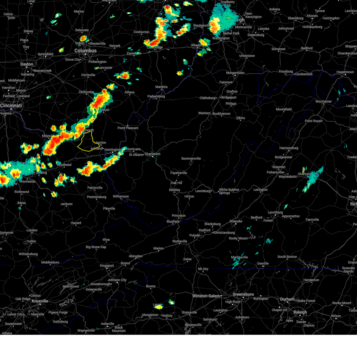
| 6/9/2025 4:05 PM EDT |
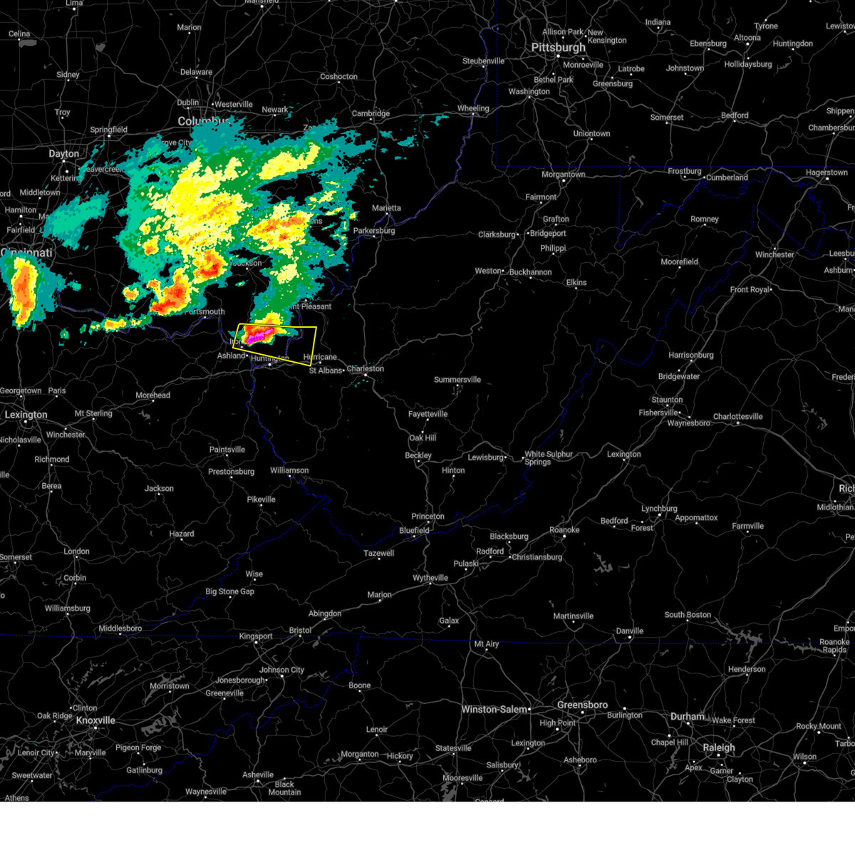
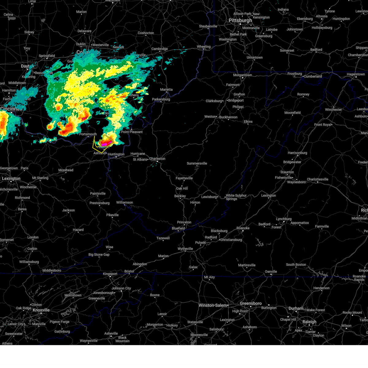
 At 405 pm edt, a severe thunderstorm was located near ironton, moving east at 20 mph (radar indicated). Hazards include 60 mph wind gusts and quarter size hail. Hail damage to vehicles is expected. expect wind damage to roofs, siding, and trees. Locations impacted include, ashland, ironton, coal grove, lake vesuvius, flatwoods, russell, raceland, worthington, wurtland, bellefonte, westwood, hanging rock, and pedro. At 405 pm edt, a severe thunderstorm was located near ironton, moving east at 20 mph (radar indicated). Hazards include 60 mph wind gusts and quarter size hail. Hail damage to vehicles is expected. expect wind damage to roofs, siding, and trees. Locations impacted include, ashland, ironton, coal grove, lake vesuvius, flatwoods, russell, raceland, worthington, wurtland, bellefonte, westwood, hanging rock, and pedro.
|
| 6/9/2025 3:52 PM EDT |
 Svrrlx the national weather service in charleston west virginia has issued a * severe thunderstorm warning for, northeastern boyd county in northeastern kentucky, southeastern greenup county in northeastern kentucky, southwestern lawrence county in southeastern ohio, * until 445 pm edt. * at 352 pm edt, a severe thunderstorm was located near greenup, or 7 miles west of ironton, moving east at 20 mph (radar indicated). Hazards include 60 mph wind gusts and nickel size hail. expect damage to roofs, siding, and trees Svrrlx the national weather service in charleston west virginia has issued a * severe thunderstorm warning for, northeastern boyd county in northeastern kentucky, southeastern greenup county in northeastern kentucky, southwestern lawrence county in southeastern ohio, * until 445 pm edt. * at 352 pm edt, a severe thunderstorm was located near greenup, or 7 miles west of ironton, moving east at 20 mph (radar indicated). Hazards include 60 mph wind gusts and nickel size hail. expect damage to roofs, siding, and trees
|
| 5/16/2025 10:27 PM EDT |
 The storms which prompted the warning have moved out of the area. therefore, the warning will be allowed to expire. a tornado watch remains in effect until 300 am edt for central ohio. please report previous wind damage or hail to the national weather service by going to our website at weather.gov/iln and submitting your report via social media. The storms which prompted the warning have moved out of the area. therefore, the warning will be allowed to expire. a tornado watch remains in effect until 300 am edt for central ohio. please report previous wind damage or hail to the national weather service by going to our website at weather.gov/iln and submitting your report via social media.
|
| 5/16/2025 10:03 PM EDT | At 1003 pm edt, severe thunderstorms were located along a line extending from near waldo to near grove city, moving east at 45 mph (radar indicated). Hazards include 60 mph wind gusts. Expect damage to trees and power lines. locations impacted include, port columbus airport, groveport, alum creek state park, delaware state park, olive green, gahanna, upper arlington, brice, grove city, slate run metro park, sunbury, clintonville, westerville, center village, galena, valleyview, worthington, kilbourne, grandview heights, and whitehall. this includes the following interstates, i-70 in ohio between mile markers 94 and 110. I-71 in ohio between mile markers 96 and 138. |
| 5/16/2025 10:03 PM EDT | the severe thunderstorm warning has been cancelled and is no longer in effect |
| 5/16/2025 9:55 PM EDT | the severe thunderstorm warning has been cancelled and is no longer in effect |
| 5/16/2025 9:55 PM EDT | At 954 pm edt, severe thunderstorms were located along a line extending from near prospect to near mount sterling, moving east at 45 mph (radar indicated). Hazards include 60 mph wind gusts. Expect damage to trees and power lines. locations impacted include, port columbus airport, alum creek state park, dublin, gahanna, upper arlington, sunbury, clintonville, westerville, warrensburg, center village, worthington, kilbourne, hilliard, new california, grandview heights, whitehall, commercial point, orient, amity, and lilly chapel. this includes the following interstates, i-70 in ohio between mile markers 82 and 110. I-71 in ohio between mile markers 89 and 138. |
| 5/16/2025 9:26 PM EDT | Svriln the national weather service in wilmington has issued a * severe thunderstorm warning for, eastern champaign county in west central ohio, franklin county in central ohio, southeastern logan county in west central ohio, northern pickaway county in central ohio, delaware county in central ohio, eastern clark county in west central ohio, union county in central ohio, madison county in central ohio, * until 1030 pm edt. * at 926 pm edt, severe thunderstorms were located along a line extending from near west mansfield to near south charleston, moving east at 50 mph (radar indicated). Hazards include 60 mph wind gusts. expect damage to trees and power lines |
| 4/29/2025 2:59 PM EDT |
 The storm which prompted the warning has moved out of the area. therefore, the warning will be allowed to expire. however, gusty winds and heavy rain are still possible with this thunderstorm. a severe thunderstorm watch remains in effect until 700 pm edt for central ohio. please report previous wind damage or hail to the national weather service by going to our website at weather.gov/iln and submitting your report via social media. remember, a severe thunderstorm warning still remains in effect for part of pickaway county. The storm which prompted the warning has moved out of the area. therefore, the warning will be allowed to expire. however, gusty winds and heavy rain are still possible with this thunderstorm. a severe thunderstorm watch remains in effect until 700 pm edt for central ohio. please report previous wind damage or hail to the national weather service by going to our website at weather.gov/iln and submitting your report via social media. remember, a severe thunderstorm warning still remains in effect for part of pickaway county.
|
| 4/29/2025 2:54 PM EDT |
 At 254 pm edt, a severe thunderstorm was located near gahanna, moving east at 55 mph (radar indicated). Hazards include 60 mph wind gusts and penny size hail. Expect damage to trees and power lines. locations impacted include, port columbus airport, east ringgold, alum creek state park, gahanna, sunbury, clintonville, westerville, center village, worthington, kilbourne, grandview heights, whitehall, commercial point, orient, blacklick estates, duvall, riverlea, polaris, south bloomfield, and reynoldsburg. this includes the following interstates, i-70 in ohio between mile markers 97 and 111. I-71 in ohio between mile markers 94 and 138. At 254 pm edt, a severe thunderstorm was located near gahanna, moving east at 55 mph (radar indicated). Hazards include 60 mph wind gusts and penny size hail. Expect damage to trees and power lines. locations impacted include, port columbus airport, east ringgold, alum creek state park, gahanna, sunbury, clintonville, westerville, center village, worthington, kilbourne, grandview heights, whitehall, commercial point, orient, blacklick estates, duvall, riverlea, polaris, south bloomfield, and reynoldsburg. this includes the following interstates, i-70 in ohio between mile markers 97 and 111. I-71 in ohio between mile markers 94 and 138.
|
| 4/29/2025 2:54 PM EDT |
 the severe thunderstorm warning has been cancelled and is no longer in effect the severe thunderstorm warning has been cancelled and is no longer in effect
|
| 4/29/2025 2:49 PM EDT |
 At 248 pm edt, a severe thunderstorm was located over easton, moving east at 55 mph (radar indicated). Hazards include 60 mph wind gusts and penny size hail. Expect damage to trees and power lines. locations impacted include, port columbus airport, east ringgold, alum creek state park, dublin, gahanna, upper arlington, sunbury, clintonville, westerville, warrensburg, center village, madison mills, worthington, kilbourne, grandview heights, whitehall, commercial point, orient, ostrander, and blacklick estates. this includes the following interstates, i-70 in ohio between mile markers 90 and 111. I-71 in ohio between mile markers 88 and 138. At 248 pm edt, a severe thunderstorm was located over easton, moving east at 55 mph (radar indicated). Hazards include 60 mph wind gusts and penny size hail. Expect damage to trees and power lines. locations impacted include, port columbus airport, east ringgold, alum creek state park, dublin, gahanna, upper arlington, sunbury, clintonville, westerville, warrensburg, center village, madison mills, worthington, kilbourne, grandview heights, whitehall, commercial point, orient, ostrander, and blacklick estates. this includes the following interstates, i-70 in ohio between mile markers 90 and 111. I-71 in ohio between mile markers 88 and 138.
|
| 4/29/2025 2:49 PM EDT |
 the severe thunderstorm warning has been cancelled and is no longer in effect the severe thunderstorm warning has been cancelled and is no longer in effect
|
| 4/29/2025 2:41 PM EDT |
 the severe thunderstorm warning has been cancelled and is no longer in effect the severe thunderstorm warning has been cancelled and is no longer in effect
|
| 4/29/2025 2:41 PM EDT |
 At 241 pm edt, a severe thunderstorm was located over upper arlington, moving east at 55 mph (radar indicated). Hazards include 60 mph wind gusts and penny size hail. Expect damage to trees and power lines. locations impacted include, port columbus airport, east ringgold, alum creek state park, interstate 71 at state route 38, dublin, gahanna, upper arlington, sunbury, clintonville, westerville, warrensburg, center village, madison mills, worthington, kilbourne, hilliard, midway, new california, grandview heights, and whitehall. this includes the following interstates, i-70 in ohio between mile markers 85 and 111. I-71 in ohio between mile markers 66 and 138. At 241 pm edt, a severe thunderstorm was located over upper arlington, moving east at 55 mph (radar indicated). Hazards include 60 mph wind gusts and penny size hail. Expect damage to trees and power lines. locations impacted include, port columbus airport, east ringgold, alum creek state park, interstate 71 at state route 38, dublin, gahanna, upper arlington, sunbury, clintonville, westerville, warrensburg, center village, madison mills, worthington, kilbourne, hilliard, midway, new california, grandview heights, and whitehall. this includes the following interstates, i-70 in ohio between mile markers 85 and 111. I-71 in ohio between mile markers 66 and 138.
|
| 4/29/2025 2:35 PM EDT |
 At 235 pm edt, a severe thunderstorm was located over hilliard, moving east at 55 mph (radar indicated). Hazards include 60 mph wind gusts and penny size hail. Expect damage to trees and power lines. locations impacted include, port columbus airport, east ringgold, interstate 71 at state route 38, rosemoor, gahanna, center village, madison mills, worthington, kilbourne, hilliard, new california, grandview heights, whitehall, orient, amity, ostrander, south solon, delaware, duvall, and riverlea. this includes the following interstates, i-70 in ohio between mile markers 77 and 111. I-71 in ohio between mile markers 54 and 138. At 235 pm edt, a severe thunderstorm was located over hilliard, moving east at 55 mph (radar indicated). Hazards include 60 mph wind gusts and penny size hail. Expect damage to trees and power lines. locations impacted include, port columbus airport, east ringgold, interstate 71 at state route 38, rosemoor, gahanna, center village, madison mills, worthington, kilbourne, hilliard, new california, grandview heights, whitehall, orient, amity, ostrander, south solon, delaware, duvall, and riverlea. this includes the following interstates, i-70 in ohio between mile markers 77 and 111. I-71 in ohio between mile markers 54 and 138.
|
| 4/29/2025 2:17 PM EDT |
 At 216 pm edt, a severe thunderstorm was located over choctaw lake, moving east at 60 mph (radar indicated). Hazards include 60 mph wind gusts and penny size hail. Expect damage to trees and power lines. locations impacted include, port columbus airport, paintersville, east ringgold, interstate 71 at state route 38, rosemoor, gahanna, lumberton, center village, madison mills, worthington, kilbourne, hilliard, new california, grandview heights, whitehall, orient, amity, ostrander, south solon, and delaware. this includes the following interstates, i-70 in ohio between mile markers 71 and 111. I-71 in ohio between mile markers 47 and 138. At 216 pm edt, a severe thunderstorm was located over choctaw lake, moving east at 60 mph (radar indicated). Hazards include 60 mph wind gusts and penny size hail. Expect damage to trees and power lines. locations impacted include, port columbus airport, paintersville, east ringgold, interstate 71 at state route 38, rosemoor, gahanna, lumberton, center village, madison mills, worthington, kilbourne, hilliard, new california, grandview heights, whitehall, orient, amity, ostrander, south solon, and delaware. this includes the following interstates, i-70 in ohio between mile markers 71 and 111. I-71 in ohio between mile markers 47 and 138.
|
| 4/29/2025 2:03 PM EDT |
 Svriln the national weather service in wilmington has issued a * severe thunderstorm warning for, franklin county in central ohio, northern fayette county in central ohio, northwestern clinton county in southwestern ohio, northern pickaway county in central ohio, delaware county in central ohio, southeastern greene county in west central ohio, southern union county in central ohio, madison county in central ohio, * until 300 pm edt. * at 202 pm edt, a severe thunderstorm was located near springfield, moving east at 55 mph (radar indicated). Hazards include 60 mph wind gusts and penny size hail. expect damage to trees and power lines Svriln the national weather service in wilmington has issued a * severe thunderstorm warning for, franklin county in central ohio, northern fayette county in central ohio, northwestern clinton county in southwestern ohio, northern pickaway county in central ohio, delaware county in central ohio, southeastern greene county in west central ohio, southern union county in central ohio, madison county in central ohio, * until 300 pm edt. * at 202 pm edt, a severe thunderstorm was located near springfield, moving east at 55 mph (radar indicated). Hazards include 60 mph wind gusts and penny size hail. expect damage to trees and power lines
|
| 4/14/2025 6:47 PM EDT |
 the severe thunderstorm warning has been cancelled and is no longer in effect the severe thunderstorm warning has been cancelled and is no longer in effect
|
| 4/14/2025 6:24 PM EDT |
 the severe thunderstorm warning has been cancelled and is no longer in effect the severe thunderstorm warning has been cancelled and is no longer in effect
|
| 4/14/2025 6:24 PM EDT |
 At 624 pm edt, a severe thunderstorm was located over lake vesuvius, moving east at 70 mph (radar indicated). Hazards include 70 mph wind gusts and quarter size hail. Hail damage to vehicles is expected. expect considerable tree damage. wind damage is also likely to mobile homes, roofs, and outbuildings. Locations impacted include, lake vesuvius, flatwoods, scottown, waterloo, bellefonte, westwood, vernon, raceland, russell, ironton, greenbo lake, wurtland, worthington, coal grove, pedro, aid, hanging rock, greenup, and ashland. At 624 pm edt, a severe thunderstorm was located over lake vesuvius, moving east at 70 mph (radar indicated). Hazards include 70 mph wind gusts and quarter size hail. Hail damage to vehicles is expected. expect considerable tree damage. wind damage is also likely to mobile homes, roofs, and outbuildings. Locations impacted include, lake vesuvius, flatwoods, scottown, waterloo, bellefonte, westwood, vernon, raceland, russell, ironton, greenbo lake, wurtland, worthington, coal grove, pedro, aid, hanging rock, greenup, and ashland.
|
| 4/14/2025 5:57 PM EDT |
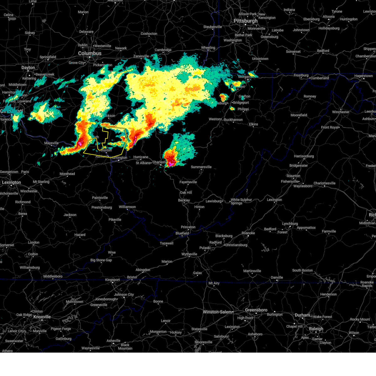 Svrrlx the national weather service in charleston west virginia has issued a * severe thunderstorm warning for, northeastern boyd county in northeastern kentucky, greenup county in northeastern kentucky, southwestern gallia county in southeastern ohio, southern jackson county in southeastern ohio, lawrence county in southeastern ohio, * until 700 pm edt. * at 555 pm edt, a severe thunderstorm was located 7 miles northeast of vanceburg, or 15 miles southwest of portsmouth, moving east at 55 mph (radar indicated). Hazards include 70 mph wind gusts and half dollar size hail. Hail damage to vehicles is expected. expect considerable tree damage. Wind damage is also likely to mobile homes, roofs, and outbuildings. Svrrlx the national weather service in charleston west virginia has issued a * severe thunderstorm warning for, northeastern boyd county in northeastern kentucky, greenup county in northeastern kentucky, southwestern gallia county in southeastern ohio, southern jackson county in southeastern ohio, lawrence county in southeastern ohio, * until 700 pm edt. * at 555 pm edt, a severe thunderstorm was located 7 miles northeast of vanceburg, or 15 miles southwest of portsmouth, moving east at 55 mph (radar indicated). Hazards include 70 mph wind gusts and half dollar size hail. Hail damage to vehicles is expected. expect considerable tree damage. Wind damage is also likely to mobile homes, roofs, and outbuildings.
|
| 4/14/2025 4:44 PM EDT |
 Svrrlx the national weather service in charleston west virginia has issued a * severe thunderstorm warning for, eastern greenup county in northeastern kentucky, south central gallia county in southeastern ohio, lawrence county in southeastern ohio, southwestern mason county in western west virginia, northeastern cabell county in central west virginia, * until 530 pm edt. * at 443 pm edt, a severe thunderstorm was located over lake vesuvius, moving east at 50 mph (radar indicated). Hazards include 60 mph wind gusts and quarter size hail. Hail damage to vehicles is expected. Expect wind damage to roofs, siding, and trees. Svrrlx the national weather service in charleston west virginia has issued a * severe thunderstorm warning for, eastern greenup county in northeastern kentucky, south central gallia county in southeastern ohio, lawrence county in southeastern ohio, southwestern mason county in western west virginia, northeastern cabell county in central west virginia, * until 530 pm edt. * at 443 pm edt, a severe thunderstorm was located over lake vesuvius, moving east at 50 mph (radar indicated). Hazards include 60 mph wind gusts and quarter size hail. Hail damage to vehicles is expected. Expect wind damage to roofs, siding, and trees.
|
| 4/14/2025 4:40 PM EDT | Trees down. time estimated based on rada in greenup county KY, 0.7 miles E of Worthington, OH |
| 4/14/2025 4:39 PM EDT |
 At 439 pm edt, a severe thunderstorm was located over lake vesuvius, moving east at 60 mph (radar indicated). Hazards include 60 mph wind gusts and quarter size hail. Hail damage to vehicles is expected. expect wind damage to roofs, siding, and trees. Locations impacted include, lake vesuvius, raceland, russell, ironton, wurtland, flatwoods, worthington, grays branch, pedro, hanging rock, vernon, and greenup. At 439 pm edt, a severe thunderstorm was located over lake vesuvius, moving east at 60 mph (radar indicated). Hazards include 60 mph wind gusts and quarter size hail. Hail damage to vehicles is expected. expect wind damage to roofs, siding, and trees. Locations impacted include, lake vesuvius, raceland, russell, ironton, wurtland, flatwoods, worthington, grays branch, pedro, hanging rock, vernon, and greenup.
|
| 4/14/2025 4:38 PM EDT | Trees down. time estimated based on rada in greenup county KY, 1 miles W of Worthington, OH |
| 4/14/2025 4:17 PM EDT | At 416 pm edt, a severe thunderstorm was located over letitia, or 7 miles southwest of portsmouth, moving east at 60 mph (radar indicated). Hazards include 60 mph wind gusts and quarter size hail. Hail damage to vehicles is expected. expect wind damage to roofs, siding, and trees. Locations impacted include, lake vesuvius, load, south shore, flatwoods, vernon, raceland, russell, ironton, wurtland, letitia, worthington, grays branch, pedro, south portsmouth, hanging rock, and greenup. |
| 4/14/2025 4:02 PM EDT |
 Svrrlx the national weather service in charleston west virginia has issued a * severe thunderstorm warning for, central greenup county in northeastern kentucky, northwestern lawrence county in southeastern ohio, * until 445 pm edt. * at 400 pm edt, a severe thunderstorm was located near rome, or 20 miles west of portsmouth, moving east at 60 mph (radar indicated). Hazards include 60 mph wind gusts and quarter size hail. Hail damage to vehicles is expected. Expect wind damage to roofs, siding, and trees. Svrrlx the national weather service in charleston west virginia has issued a * severe thunderstorm warning for, central greenup county in northeastern kentucky, northwestern lawrence county in southeastern ohio, * until 445 pm edt. * at 400 pm edt, a severe thunderstorm was located near rome, or 20 miles west of portsmouth, moving east at 60 mph (radar indicated). Hazards include 60 mph wind gusts and quarter size hail. Hail damage to vehicles is expected. Expect wind damage to roofs, siding, and trees.
|
| 4/3/2025 4:33 AM EDT |
 At 433 am edt, severe thunderstorms were located along a line extending from 8 miles northeast of lake vesuvius to keaton, moving east at 60 mph (radar indicated). Hazards include 60 mph wind gusts. Expect damage to roofs, siding, and trees. Locations impacted include, louisa, crown city, barboursville, coalton, denton, summit, waterloo, hitchins, burnaugh, pea ridge, ironton, kenova, worthington, ceredo, genoa, leon, aid, martha, gallup, and lavalette. At 433 am edt, severe thunderstorms were located along a line extending from 8 miles northeast of lake vesuvius to keaton, moving east at 60 mph (radar indicated). Hazards include 60 mph wind gusts. Expect damage to roofs, siding, and trees. Locations impacted include, louisa, crown city, barboursville, coalton, denton, summit, waterloo, hitchins, burnaugh, pea ridge, ironton, kenova, worthington, ceredo, genoa, leon, aid, martha, gallup, and lavalette.
|
| 4/3/2025 4:30 AM EDT |
 the tornado warning has been cancelled and is no longer in effect the tornado warning has been cancelled and is no longer in effect
|
| 4/3/2025 4:16 AM EDT |
 Torrlx the national weather service in charleston west virginia has issued a * tornado warning for, central boyd county in northeastern kentucky, southeastern greenup county in northeastern kentucky, southeastern carter county in northeastern kentucky, southwestern lawrence county in southeastern ohio, northern wayne county in western west virginia, * until 445 am edt. * at 415 am edt, a severe thunderstorm capable of producing a tornado was located near grayson lake state park, moving northeast at 85 mph (radar indicated rotation). Hazards include tornado. Flying debris will be dangerous to those caught without shelter. mobile homes will be damaged or destroyed. damage to roofs, windows, and vehicles will occur. tree damage is likely. this dangerous storm will be near, princess, rush, oldtown, coalton, and grayson around 420 am edt. ashland, naples, and cannonsburg around 425 am edt. coal grove, kenova, ironton, ceredo, and catlettsburg around 430 am edt. Other locations impacted by this tornadic thunderstorm include grahn, hopewell, flatwoods, summit, bellefonte, westwood, hitchins, raceland, russell, and burlington. Torrlx the national weather service in charleston west virginia has issued a * tornado warning for, central boyd county in northeastern kentucky, southeastern greenup county in northeastern kentucky, southeastern carter county in northeastern kentucky, southwestern lawrence county in southeastern ohio, northern wayne county in western west virginia, * until 445 am edt. * at 415 am edt, a severe thunderstorm capable of producing a tornado was located near grayson lake state park, moving northeast at 85 mph (radar indicated rotation). Hazards include tornado. Flying debris will be dangerous to those caught without shelter. mobile homes will be damaged or destroyed. damage to roofs, windows, and vehicles will occur. tree damage is likely. this dangerous storm will be near, princess, rush, oldtown, coalton, and grayson around 420 am edt. ashland, naples, and cannonsburg around 425 am edt. coal grove, kenova, ironton, ceredo, and catlettsburg around 430 am edt. Other locations impacted by this tornadic thunderstorm include grahn, hopewell, flatwoods, summit, bellefonte, westwood, hitchins, raceland, russell, and burlington.
|
| 4/3/2025 4:13 AM EDT | Svrrlx the national weather service in charleston west virginia has issued a * severe thunderstorm warning for, boyd county in northeastern kentucky, greenup county in northeastern kentucky, lawrence county in northeastern kentucky, carter county in northeastern kentucky, southern gallia county in southeastern ohio, lawrence county in southeastern ohio, southwestern mason county in western west virginia, cabell county in central west virginia, wayne county in western west virginia, * until 445 am edt. * at 412 am edt, severe thunderstorms were located along a line extending from near wheelersburg to wrigley, moving east at 60 mph (radar indicated). Hazards include 60 mph wind gusts. expect damage to roofs, siding, and trees |
| 4/3/2025 3:53 AM EDT | Svrrlx the national weather service in charleston west virginia has issued a * severe thunderstorm warning for, west central boyd county in northeastern kentucky, greenup county in northeastern kentucky, carter county in northeastern kentucky, west central lawrence county in southeastern ohio, * until 415 am edt. * at 352 am edt, severe thunderstorms were located along a line extending from rome to clearfield, moving northeast at 60 mph (radar indicated). Hazards include 60 mph wind gusts and penny size hail. expect damage to roofs, siding, and trees |
| 4/3/2025 3:42 AM EDT | Svrrlx the national weather service in charleston west virginia has issued a * severe thunderstorm warning for, southeastern greenup county in northeastern kentucky, southeastern meigs county in southeastern ohio, southern gallia county in southeastern ohio, central lawrence county in southeastern ohio, mason county in western west virginia, north central cabell county in central west virginia, northwestern putnam county in western west virginia, central jackson county in northwestern west virginia, * until 415 am edt. * at 341 am edt, severe thunderstorms were located along a line extending from near rio grande to near ironton, moving east at 65 mph (radar indicated). Hazards include 60 mph wind gusts. expect damage to roofs, siding, and trees |
| 4/3/2025 3:28 AM EDT | the severe thunderstorm warning has been cancelled and is no longer in effect |
| 4/3/2025 3:28 AM EDT | At 328 am edt, a severe thunderstorm was located near greenup, or 11 miles south of wheelersburg, moving northeast at 65 mph (radar indicated). Hazards include 60 mph wind gusts. Expect damage to roofs, siding, and trees. Locations impacted include, flatwoods, brushart, westwood, warnock, raceland, ironton, greenbo lake, oldtown, worthington, grays branch, coal grove, aid, greenup, lake vesuvius, load, hopewell, bellefonte, vernon, russell, and wurtland. |
| 4/3/2025 3:26 AM EDT |
 At 325 am edt, a severe thunderstorm capable of producing a tornado was located over load, or 12 miles south of wheelersburg, moving northeast at 60 mph (radar indicated rotation). Hazards include tornado. Flying debris will be dangerous to those caught without shelter. mobile homes will be damaged or destroyed. damage to roofs, windows, and vehicles will occur. tree damage is likely. this dangerous storm will be near, ironton, greenup, greenup, and franklin furnace around 330 am edt. lake vesuvius around 335 am edt. Other locations impacted by this tornadic thunderstorm include wurtland, worthington, grays branch, pedro, waterloo, hanging rock, vernon, warnock, raceland, and flatwoods. At 325 am edt, a severe thunderstorm capable of producing a tornado was located over load, or 12 miles south of wheelersburg, moving northeast at 60 mph (radar indicated rotation). Hazards include tornado. Flying debris will be dangerous to those caught without shelter. mobile homes will be damaged or destroyed. damage to roofs, windows, and vehicles will occur. tree damage is likely. this dangerous storm will be near, ironton, greenup, greenup, and franklin furnace around 330 am edt. lake vesuvius around 335 am edt. Other locations impacted by this tornadic thunderstorm include wurtland, worthington, grays branch, pedro, waterloo, hanging rock, vernon, warnock, raceland, and flatwoods.
|
| 4/3/2025 3:26 AM EDT |
 the tornado warning has been cancelled and is no longer in effect the tornado warning has been cancelled and is no longer in effect
|
| 4/3/2025 3:16 AM EDT | Torrlx the national weather service in charleston west virginia has issued a * tornado warning for, greenup county in northeastern kentucky, north central carter county in northeastern kentucky, southwestern gallia county in southeastern ohio, central lawrence county in southeastern ohio, * until 345 am edt. * at 316 am edt, a severe thunderstorm capable of producing a tornado was located near gesling, or 8 miles north of carter caves state park, moving northeast at 60 mph (radar indicated rotation). Hazards include tornado. Flying debris will be dangerous to those caught without shelter. mobile homes will be damaged or destroyed. damage to roofs, windows, and vehicles will occur. tree damage is likely. this dangerous storm will be near, load, letitia, greenbo lake, and greenup around 320 am edt. greenup and franklin furnace around 325 am edt. ironton around 330 am edt. lake vesuvius around 335 am edt. Other locations impacted by this tornadic thunderstorm include flatwoods, brushart, waterloo, carter, vernon, warnock, raceland, wurtland, worthington, and grays branch. |
| 4/3/2025 3:06 AM EDT | Svrrlx the national weather service in charleston west virginia has issued a * severe thunderstorm warning for, north central boyd county in northeastern kentucky, greenup county in northeastern kentucky, northwestern carter county in northeastern kentucky, west central gallia county in southeastern ohio, lawrence county in southeastern ohio, * until 345 am edt. * at 305 am edt, a severe thunderstorm was located near camp dix, or 7 miles northwest of carter caves state park, moving northeast at 65 mph (radar indicated). Hazards include 60 mph wind gusts. expect damage to roofs, siding, and trees |
| 4/3/2025 2:07 AM EDT | the severe thunderstorm warning has been cancelled and is no longer in effect |
| 4/3/2025 2:07 AM EDT | At 207 am edt, a severe thunderstorm was located over reynoldsburg, moving northeast at 65 mph (radar indicated). Hazards include 60 mph wind gusts. Expect damage to trees and power lines. locations impacted include, port columbus airport, east ringgold, us route 22 at state route 159, johnstown, gahanna, austin, lithopolis, clintonville, westerville, knockemstiff, center village, bainbridge, highland holiday, williamsport, alexandria, jersey, south salem, whitehall, rocky fork lake, and bourneville. this includes the following interstates, i-70 in ohio between mile markers 98 and 122. I-71 in ohio between mile markers 99 and 120. |
| 4/3/2025 1:40 AM EDT | Svriln the national weather service in wilmington has issued a * severe thunderstorm warning for, franklin county in central ohio, western fairfield county in central ohio, eastern fayette county in central ohio, pickaway county in central ohio, southeastern delaware county in central ohio, western licking county in central ohio, eastern highland county in south central ohio, eastern madison county in central ohio, ross county in south central ohio, * until 230 am edt. * at 140 am edt, a severe thunderstorm was located over mount sterling, moving northeast at 65 mph (radar indicated). Hazards include 60 mph wind gusts. expect damage to trees and power lines |
| 3/31/2025 12:45 AM EDT |
 Svrrlx the national weather service in charleston west virginia has issued a * severe thunderstorm warning for, boyd county in northeastern kentucky, southeastern greenup county in northeastern kentucky, northwestern lawrence county in northeastern kentucky, southeastern carter county in northeastern kentucky, southern gallia county in southeastern ohio, lawrence county in southeastern ohio, west central mason county in western west virginia, central cabell county in central west virginia, northwestern wayne county in western west virginia, * until 115 am edt. * at 1245 am edt, severe thunderstorms were located along a line extending from 8 miles east of south webster to near denton, moving east at 50 mph (radar indicated). Hazards include 60 mph wind gusts and penny size hail. expect damage to roofs, siding, and trees Svrrlx the national weather service in charleston west virginia has issued a * severe thunderstorm warning for, boyd county in northeastern kentucky, southeastern greenup county in northeastern kentucky, northwestern lawrence county in northeastern kentucky, southeastern carter county in northeastern kentucky, southern gallia county in southeastern ohio, lawrence county in southeastern ohio, west central mason county in western west virginia, central cabell county in central west virginia, northwestern wayne county in western west virginia, * until 115 am edt. * at 1245 am edt, severe thunderstorms were located along a line extending from 8 miles east of south webster to near denton, moving east at 50 mph (radar indicated). Hazards include 60 mph wind gusts and penny size hail. expect damage to roofs, siding, and trees
|
| 3/31/2025 12:35 AM EDT |
 At 1234 am edt, severe thunderstorms were located along a line extending from near south webster to near olive hill, moving east at 55 mph (radar indicated). Hazards include 60 mph wind gusts. Expect damage to roofs, siding, and trees. Locations impacted include, princess, flatwoods, coalton, brushart, denton, summit, waterloo, carter, westwood, hitchins, warnock, gesling, raceland, ironton, greenbo lake, oldtown, naples, worthington, grays branch, and coal grove. At 1234 am edt, severe thunderstorms were located along a line extending from near south webster to near olive hill, moving east at 55 mph (radar indicated). Hazards include 60 mph wind gusts. Expect damage to roofs, siding, and trees. Locations impacted include, princess, flatwoods, coalton, brushart, denton, summit, waterloo, carter, westwood, hitchins, warnock, gesling, raceland, ironton, greenbo lake, oldtown, naples, worthington, grays branch, and coal grove.
|
| 3/31/2025 12:18 AM EDT |
 Svrrlx the national weather service in charleston west virginia has issued a * severe thunderstorm warning for, western boyd county in northeastern kentucky, greenup county in northeastern kentucky, carter county in northeastern kentucky, western lawrence county in southeastern ohio, * until 1245 am edt. * at 1217 am edt, severe thunderstorms were located along a line extending from near south shore to christy, moving east at 55 mph (radar indicated). Hazards include 60 mph wind gusts. expect damage to roofs, siding, and trees Svrrlx the national weather service in charleston west virginia has issued a * severe thunderstorm warning for, western boyd county in northeastern kentucky, greenup county in northeastern kentucky, carter county in northeastern kentucky, western lawrence county in southeastern ohio, * until 1245 am edt. * at 1217 am edt, severe thunderstorms were located along a line extending from near south shore to christy, moving east at 55 mph (radar indicated). Hazards include 60 mph wind gusts. expect damage to roofs, siding, and trees
|
| 3/30/2025 10:06 PM EDT | the severe thunderstorm warning has been cancelled and is no longer in effect |
| 3/30/2025 10:06 PM EDT | At 1005 pm edt, severe thunderstorms were located along a line extending from near powell to 7 miles east of greenfield, moving east at 55 mph (radar indicated). Hazards include 60 mph wind gusts and penny size hail. Expect damage to trees and power lines. locations impacted include, port columbus airport, east ringgold, johnstown, gahanna, austin, lithopolis, knockemstiff, center village, williamsport, worthington, hilliard, grandview heights, whitehall, orient, clarksburg, duvall, riverlea, state route 138 at us route 22, columbus, and frankfort. this includes the following interstates, i-70 in ohio between mile markers 88 and 118. I-71 in ohio between mile markers 89 and 133. |
| 3/30/2025 9:46 PM EDT | Svriln the national weather service in wilmington has issued a * severe thunderstorm warning for, franklin county in central ohio, western fairfield county in central ohio, eastern fayette county in central ohio, pickaway county in central ohio, southern delaware county in central ohio, western licking county in central ohio, northeastern highland county in south central ohio, southeastern union county in central ohio, madison county in central ohio, ross county in south central ohio, * until 1045 pm edt. * at 945 pm edt, severe thunderstorms were located along a line extending from near mechanicsburg to near lynchburg, moving east at 65 mph (radar indicated). Hazards include 60 mph wind gusts and quarter size hail. Minor hail damage to vehicles is possible. Expect wind damage to trees and power lines. |
| 9/27/2024 3:11 PM EDT |
 Svrrlx the national weather service in charleston west virginia has issued a * severe thunderstorm warning for, northeastern greenup county in northeastern kentucky, western gallia county in southeastern ohio, southern jackson county in southeastern ohio, central lawrence county in southeastern ohio, * until 400 pm edt. * at 310 pm edt, a severe thunderstorm was located near lake vesuvius, moving northwest at 20 mph (radar indicated). Hazards include 60 mph wind gusts. expect damage to roofs, siding, and trees Svrrlx the national weather service in charleston west virginia has issued a * severe thunderstorm warning for, northeastern greenup county in northeastern kentucky, western gallia county in southeastern ohio, southern jackson county in southeastern ohio, central lawrence county in southeastern ohio, * until 400 pm edt. * at 310 pm edt, a severe thunderstorm was located near lake vesuvius, moving northwest at 20 mph (radar indicated). Hazards include 60 mph wind gusts. expect damage to roofs, siding, and trees
|
| 9/27/2024 2:53 PM EDT |
 Torrlx the national weather service in charleston west virginia has issued a * tornado warning for, northeastern boyd county in northeastern kentucky, eastern greenup county in northeastern kentucky, southwestern lawrence county in southeastern ohio, * until 330 pm edt. * at 253 pm edt, a severe thunderstorm capable of producing a tornado was located over coal grove, moving north at 20 mph (radar indicated rotation). Hazards include tornado. Flying debris will be dangerous to those caught without shelter. mobile homes will be damaged or destroyed. damage to roofs, windows, and vehicles will occur. tree damage is likely. this dangerous storm will be near, ironton, coal grove, and lake vesuvius around 300 pm edt. Other locations impacted by this tornadic thunderstorm include raceland, russell, flatwoods, worthington, pedro, bellefonte, hanging rock, westwood, and wurtland. Torrlx the national weather service in charleston west virginia has issued a * tornado warning for, northeastern boyd county in northeastern kentucky, eastern greenup county in northeastern kentucky, southwestern lawrence county in southeastern ohio, * until 330 pm edt. * at 253 pm edt, a severe thunderstorm capable of producing a tornado was located over coal grove, moving north at 20 mph (radar indicated rotation). Hazards include tornado. Flying debris will be dangerous to those caught without shelter. mobile homes will be damaged or destroyed. damage to roofs, windows, and vehicles will occur. tree damage is likely. this dangerous storm will be near, ironton, coal grove, and lake vesuvius around 300 pm edt. Other locations impacted by this tornadic thunderstorm include raceland, russell, flatwoods, worthington, pedro, bellefonte, hanging rock, westwood, and wurtland.
|
| 9/27/2024 2:47 PM EDT |
 At 246 pm edt, a severe thunderstorm was located over ironton, moving northwest at 25 mph (radar indicated). Hazards include 70 mph wind gusts. Expect considerable tree damage. damage is likely to mobile homes, roofs, and outbuildings. Locations impacted include, ashland, ironton, coal grove, lake vesuvius, catlettsburg, flatwoods, russell, vernon, waterloo, raceland, worthington, wurtland, bellefonte, aid, westwood, crown city, athalia, hanging rock, scottown, and gage. At 246 pm edt, a severe thunderstorm was located over ironton, moving northwest at 25 mph (radar indicated). Hazards include 70 mph wind gusts. Expect considerable tree damage. damage is likely to mobile homes, roofs, and outbuildings. Locations impacted include, ashland, ironton, coal grove, lake vesuvius, catlettsburg, flatwoods, russell, vernon, waterloo, raceland, worthington, wurtland, bellefonte, aid, westwood, crown city, athalia, hanging rock, scottown, and gage.
|
| 9/27/2024 2:47 PM EDT |
 the severe thunderstorm warning has been cancelled and is no longer in effect the severe thunderstorm warning has been cancelled and is no longer in effect
|
| 9/27/2024 2:24 PM EDT |
 Svrrlx the national weather service in charleston west virginia has issued a * severe thunderstorm warning for, northeastern boyd county in northeastern kentucky, northeastern greenup county in northeastern kentucky, southwestern gallia county in southeastern ohio, lawrence county in southeastern ohio, northwestern cabell county in central west virginia, northwestern wayne county in western west virginia, * until 330 pm edt. * at 223 pm edt, a severe thunderstorm was located over catlettsburg, or near ashland, moving northwest at 25 mph (radar indicated). Hazards include 70 mph wind gusts. Expect considerable tree damage. Damage is likely to mobile homes, roofs, and outbuildings. Svrrlx the national weather service in charleston west virginia has issued a * severe thunderstorm warning for, northeastern boyd county in northeastern kentucky, northeastern greenup county in northeastern kentucky, southwestern gallia county in southeastern ohio, lawrence county in southeastern ohio, northwestern cabell county in central west virginia, northwestern wayne county in western west virginia, * until 330 pm edt. * at 223 pm edt, a severe thunderstorm was located over catlettsburg, or near ashland, moving northwest at 25 mph (radar indicated). Hazards include 70 mph wind gusts. Expect considerable tree damage. Damage is likely to mobile homes, roofs, and outbuildings.
|
| 9/6/2024 4:44 PM EDT |
 The storm which prompted the warning has weakened below severe limits and no longer poses an immediate threat to life or property. therefore, the warning will be allowed to expire. however, small hail, gusty winds and heavy rain are still possible with this thunderstorm. please report previous wind damage or hail to the national weather service by going to our website at weather.gov/iln and submitting your report via social media. The storm which prompted the warning has weakened below severe limits and no longer poses an immediate threat to life or property. therefore, the warning will be allowed to expire. however, small hail, gusty winds and heavy rain are still possible with this thunderstorm. please report previous wind damage or hail to the national weather service by going to our website at weather.gov/iln and submitting your report via social media.
|
| 9/6/2024 4:33 PM EDT |
 At 433 pm edt, a severe thunderstorm was located over dublin, moving northeast at 15 mph (radar indicated). Hazards include 60 mph wind gusts and quarter size hail. Minor hail damage to vehicles is possible. expect wind damage to trees and power lines. locations impacted include, columbus, dublin, westerville, upper arlington, hilliard, worthington, powell, polaris, riverlea, and clintonville. This includes i-71 in ohio between mile markers 114 and 122. At 433 pm edt, a severe thunderstorm was located over dublin, moving northeast at 15 mph (radar indicated). Hazards include 60 mph wind gusts and quarter size hail. Minor hail damage to vehicles is possible. expect wind damage to trees and power lines. locations impacted include, columbus, dublin, westerville, upper arlington, hilliard, worthington, powell, polaris, riverlea, and clintonville. This includes i-71 in ohio between mile markers 114 and 122.
|
| 9/6/2024 4:15 PM EDT |
 At 414 pm edt, a severe thunderstorm was located over minerva park, moving east at 35 mph (public). Hazards include 60 mph wind gusts and quarter size hail. Minor hail damage to vehicles is possible. expect wind damage to trees and power lines. locations impacted include, columbus, dublin, westerville, reynoldsburg, upper arlington, gahanna, hilliard, worthington, bexley, powell, minerva park, ohio state university, polaris, easton, whitehall, new albany, grandview heights, valleyview, marble cliff, and riverlea. this includes the following interstates, i-70 in ohio between mile markers 96 and 103. I-71 in ohio between mile markers 106 and 123. At 414 pm edt, a severe thunderstorm was located over minerva park, moving east at 35 mph (public). Hazards include 60 mph wind gusts and quarter size hail. Minor hail damage to vehicles is possible. expect wind damage to trees and power lines. locations impacted include, columbus, dublin, westerville, reynoldsburg, upper arlington, gahanna, hilliard, worthington, bexley, powell, minerva park, ohio state university, polaris, easton, whitehall, new albany, grandview heights, valleyview, marble cliff, and riverlea. this includes the following interstates, i-70 in ohio between mile markers 96 and 103. I-71 in ohio between mile markers 106 and 123.
|
| 9/6/2024 3:58 PM EDT |
 Svriln the national weather service in wilmington has issued a * severe thunderstorm warning for, northern franklin county in central ohio, southeastern delaware county in central ohio, * until 445 pm edt. * at 358 pm edt, a severe thunderstorm was located over hilliard, moving east at 35 mph (radar indicated). Hazards include 60 mph wind gusts and quarter size hail. Minor hail damage to vehicles is possible. Expect wind damage to trees and power lines. Svriln the national weather service in wilmington has issued a * severe thunderstorm warning for, northern franklin county in central ohio, southeastern delaware county in central ohio, * until 445 pm edt. * at 358 pm edt, a severe thunderstorm was located over hilliard, moving east at 35 mph (radar indicated). Hazards include 60 mph wind gusts and quarter size hail. Minor hail damage to vehicles is possible. Expect wind damage to trees and power lines.
|
| 8/17/2024 4:06 PM EDT |
 The storm which prompted the warning has weakened below severe limits, and no longer poses an immediate threat to life or property. therefore, the warning will be allowed to expire. however, gusty winds are still possible with this thunderstorm. The storm which prompted the warning has weakened below severe limits, and no longer poses an immediate threat to life or property. therefore, the warning will be allowed to expire. however, gusty winds are still possible with this thunderstorm.
|
| 8/17/2024 4:02 PM EDT |
 At 402 pm edt, a severe thunderstorm was located near wheelersburg, moving east at 30 mph (radar indicated). Hazards include 60 mph wind gusts and quarter size hail. Hail damage to vehicles is expected. expect wind damage to roofs, siding, and trees. Locations impacted include, greenup, load, greenbo lake, letitia, flatwoods, russell, raceland, worthington, south shore, wurtland, hanging rock, brushart, warnock, grays branch, and south portsmouth. At 402 pm edt, a severe thunderstorm was located near wheelersburg, moving east at 30 mph (radar indicated). Hazards include 60 mph wind gusts and quarter size hail. Hail damage to vehicles is expected. expect wind damage to roofs, siding, and trees. Locations impacted include, greenup, load, greenbo lake, letitia, flatwoods, russell, raceland, worthington, south shore, wurtland, hanging rock, brushart, warnock, grays branch, and south portsmouth.
|
| 8/17/2024 3:28 PM EDT |
 Svrrlx the national weather service in charleston west virginia has issued a * severe thunderstorm warning for, greenup county in northeastern kentucky, * until 415 pm edt. * at 327 pm edt, a severe thunderstorm was located 8 miles west of south shore, or 10 miles west of portsmouth, moving southeast at 30 mph (radar indicated). Hazards include 60 mph wind gusts and quarter size hail. Hail damage to vehicles is expected. Expect wind damage to roofs, siding, and trees. Svrrlx the national weather service in charleston west virginia has issued a * severe thunderstorm warning for, greenup county in northeastern kentucky, * until 415 pm edt. * at 327 pm edt, a severe thunderstorm was located 8 miles west of south shore, or 10 miles west of portsmouth, moving southeast at 30 mph (radar indicated). Hazards include 60 mph wind gusts and quarter size hail. Hail damage to vehicles is expected. Expect wind damage to roofs, siding, and trees.
|
| 7/17/2024 3:47 PM EDT |
 Svriln the national weather service in wilmington has issued a * severe thunderstorm warning for, northeastern franklin county in central ohio, southeastern delaware county in central ohio, * until 415 pm edt. * at 346 pm edt, a severe thunderstorm was located over worthington, moving east at 40 mph (radar indicated). Hazards include 60 mph wind gusts. expect damage to trees and power lines Svriln the national weather service in wilmington has issued a * severe thunderstorm warning for, northeastern franklin county in central ohio, southeastern delaware county in central ohio, * until 415 pm edt. * at 346 pm edt, a severe thunderstorm was located over worthington, moving east at 40 mph (radar indicated). Hazards include 60 mph wind gusts. expect damage to trees and power lines
|
| 7/14/2024 6:03 PM EDT |
 At 602 pm edt, severe thunderstorms were located along a line extending from near new haven to 9 miles south of gallipolis to near chesapeake, moving southeast at 45 mph (radar indicated). Hazards include 60 mph wind gusts. Expect damage to roofs, siding, and trees. Locations impacted include, huntington, ashland, ironton, point pleasant, gallipolis, coal grove, pomeroy, rio grande, chesapeake, racine, proctorville, rutland, beech fork state park, lake vesuvius, barboursville, ravenswood, kenova, catlettsburg, new haven, and ceredo. At 602 pm edt, severe thunderstorms were located along a line extending from near new haven to 9 miles south of gallipolis to near chesapeake, moving southeast at 45 mph (radar indicated). Hazards include 60 mph wind gusts. Expect damage to roofs, siding, and trees. Locations impacted include, huntington, ashland, ironton, point pleasant, gallipolis, coal grove, pomeroy, rio grande, chesapeake, racine, proctorville, rutland, beech fork state park, lake vesuvius, barboursville, ravenswood, kenova, catlettsburg, new haven, and ceredo.
|
| 7/14/2024 5:35 PM EDT |
 Svrrlx the national weather service in charleston west virginia has issued a * severe thunderstorm warning for, northeastern boyd county in northeastern kentucky, central greenup county in northeastern kentucky, meigs county in southeastern ohio, gallia county in southeastern ohio, lawrence county in southeastern ohio, mason county in western west virginia, cabell county in central west virginia, northwestern putnam county in western west virginia, northwestern jackson county in northwestern west virginia, north central wayne county in western west virginia, * until 615 pm edt. * at 534 pm edt, severe thunderstorms were located along a line extending from 10 miles southwest of albany to near rio grande to 6 miles northwest of lake vesuvius, moving southeast at 45 mph (radar indicated). Hazards include 60 mph wind gusts. expect damage to roofs, siding, and trees Svrrlx the national weather service in charleston west virginia has issued a * severe thunderstorm warning for, northeastern boyd county in northeastern kentucky, central greenup county in northeastern kentucky, meigs county in southeastern ohio, gallia county in southeastern ohio, lawrence county in southeastern ohio, mason county in western west virginia, cabell county in central west virginia, northwestern putnam county in western west virginia, northwestern jackson county in northwestern west virginia, north central wayne county in western west virginia, * until 615 pm edt. * at 534 pm edt, severe thunderstorms were located along a line extending from 10 miles southwest of albany to near rio grande to 6 miles northwest of lake vesuvius, moving southeast at 45 mph (radar indicated). Hazards include 60 mph wind gusts. expect damage to roofs, siding, and trees
|
| 6/29/2024 9:43 PM EDT |
 At 942 pm edt, severe thunderstorms were located along a line extending from 8 miles east of lake vesuvius to 7 miles north of chesapeake to catlettsburg, moving east at 35 mph (radar indicated). Hazards include 60 mph wind gusts and penny size hail. Expect damage to roofs, siding, and trees. Locations impacted include, huntington, ashland, ironton, coal grove, chesapeake, proctorville, lake vesuvius, kenova, catlettsburg, ceredo, naples, flatwoods, south point, russell, vernon, waterloo, raceland, worthington, burlington, and bellefonte. At 942 pm edt, severe thunderstorms were located along a line extending from 8 miles east of lake vesuvius to 7 miles north of chesapeake to catlettsburg, moving east at 35 mph (radar indicated). Hazards include 60 mph wind gusts and penny size hail. Expect damage to roofs, siding, and trees. Locations impacted include, huntington, ashland, ironton, coal grove, chesapeake, proctorville, lake vesuvius, kenova, catlettsburg, ceredo, naples, flatwoods, south point, russell, vernon, waterloo, raceland, worthington, burlington, and bellefonte.
|
| 6/29/2024 9:28 PM EDT |
 Svrrlx the national weather service in charleston west virginia has issued a * severe thunderstorm warning for, northern boyd county in northeastern kentucky, southeastern greenup county in northeastern kentucky, southern gallia county in southeastern ohio, lawrence county in southeastern ohio, northwestern cabell county in central west virginia, * until 1000 pm edt. * at 928 pm edt, severe thunderstorms were located along a line extending from near lake vesuvius to near ironton to near naples, moving east at 25 mph (radar indicated). Hazards include 60 mph wind gusts. expect damage to roofs, siding, and trees Svrrlx the national weather service in charleston west virginia has issued a * severe thunderstorm warning for, northern boyd county in northeastern kentucky, southeastern greenup county in northeastern kentucky, southern gallia county in southeastern ohio, lawrence county in southeastern ohio, northwestern cabell county in central west virginia, * until 1000 pm edt. * at 928 pm edt, severe thunderstorms were located along a line extending from near lake vesuvius to near ironton to near naples, moving east at 25 mph (radar indicated). Hazards include 60 mph wind gusts. expect damage to roofs, siding, and trees
|
| 5/26/2024 3:13 PM EDT |
 Svrrlx the national weather service in charleston west virginia has issued a * severe thunderstorm warning for, boyd county in northeastern kentucky, central greenup county in northeastern kentucky, lawrence county in northeastern kentucky, southeastern carter county in northeastern kentucky, southern lawrence county in southeastern ohio, southwestern cabell county in central west virginia, northwestern lincoln county in central west virginia, wayne county in western west virginia, * until 430 pm edt. * at 313 pm edt, a severe thunderstorm was located over rush, or near cannonsburg, moving east at 45 mph (radar indicated). Hazards include 60 mph wind gusts and quarter size hail. Hail damage to vehicles is expected. Expect wind damage to roofs, siding, and trees. Svrrlx the national weather service in charleston west virginia has issued a * severe thunderstorm warning for, boyd county in northeastern kentucky, central greenup county in northeastern kentucky, lawrence county in northeastern kentucky, southeastern carter county in northeastern kentucky, southern lawrence county in southeastern ohio, southwestern cabell county in central west virginia, northwestern lincoln county in central west virginia, wayne county in western west virginia, * until 430 pm edt. * at 313 pm edt, a severe thunderstorm was located over rush, or near cannonsburg, moving east at 45 mph (radar indicated). Hazards include 60 mph wind gusts and quarter size hail. Hail damage to vehicles is expected. Expect wind damage to roofs, siding, and trees.
|
| 5/26/2024 3:13 PM EDT |
 The storm which prompted the warning has moved out of the area. therefore, the warning will be allowed to expire. however, small hail and gusty winds are still possible with this thunderstorm. a severe thunderstorm watch remains in effect until 800 pm edt for northeastern kentucky, southeastern ohio, and western west virginia. The storm which prompted the warning has moved out of the area. therefore, the warning will be allowed to expire. however, small hail and gusty winds are still possible with this thunderstorm. a severe thunderstorm watch remains in effect until 800 pm edt for northeastern kentucky, southeastern ohio, and western west virginia.
|
| 5/26/2024 2:55 PM EDT |
 At 255 pm edt, a severe thunderstorm was located near carter caves state park, moving east at 45 mph (radar indicated). Hazards include 60 mph wind gusts and quarter size hail. Hail damage to vehicles is expected. expect wind damage to roofs, siding, and trees. Locations impacted include, ashland, ironton, grayson, louisa, olive hill, blaine, cannonsburg, grayson lake state park, yatesville lake state park, carter caves state park, greenup, fort gay, coalton, denton, burnaugh, gesling, greenbo lake, oldtown, martha, and load. At 255 pm edt, a severe thunderstorm was located near carter caves state park, moving east at 45 mph (radar indicated). Hazards include 60 mph wind gusts and quarter size hail. Hail damage to vehicles is expected. expect wind damage to roofs, siding, and trees. Locations impacted include, ashland, ironton, grayson, louisa, olive hill, blaine, cannonsburg, grayson lake state park, yatesville lake state park, carter caves state park, greenup, fort gay, coalton, denton, burnaugh, gesling, greenbo lake, oldtown, martha, and load.
|
| 5/26/2024 2:00 PM EDT |
 Svrrlx the national weather service in charleston west virginia has issued a * severe thunderstorm warning for, boyd county in northeastern kentucky, greenup county in northeastern kentucky, lawrence county in northeastern kentucky, carter county in northeastern kentucky, southwestern lawrence county in southeastern ohio, northwestern wayne county in western west virginia, * until 315 pm edt. * at 159 pm edt, a severe thunderstorm was located over bethel, or 8 miles northwest of owingsville, moving east at 45 mph (radar indicated). Hazards include 60 mph wind gusts and quarter size hail. Hail damage to vehicles is expected. Expect wind damage to roofs, siding, and trees. Svrrlx the national weather service in charleston west virginia has issued a * severe thunderstorm warning for, boyd county in northeastern kentucky, greenup county in northeastern kentucky, lawrence county in northeastern kentucky, carter county in northeastern kentucky, southwestern lawrence county in southeastern ohio, northwestern wayne county in western west virginia, * until 315 pm edt. * at 159 pm edt, a severe thunderstorm was located over bethel, or 8 miles northwest of owingsville, moving east at 45 mph (radar indicated). Hazards include 60 mph wind gusts and quarter size hail. Hail damage to vehicles is expected. Expect wind damage to roofs, siding, and trees.
|
| 5/22/2024 1:45 PM EDT |
 Svrrlx the national weather service in charleston west virginia has issued a * severe thunderstorm warning for, northeastern boyd county in northeastern kentucky, east central greenup county in northeastern kentucky, southeastern gallia county in southeastern ohio, lawrence county in southeastern ohio, north central cabell county in central west virginia, * until 215 pm edt. * at 144 pm edt, a severe thunderstorm was located over ironton, moving east at 35 mph (radar indicated). Hazards include 60 mph wind gusts and quarter size hail. Hail damage to vehicles is expected. Expect wind damage to roofs, siding, and trees. Svrrlx the national weather service in charleston west virginia has issued a * severe thunderstorm warning for, northeastern boyd county in northeastern kentucky, east central greenup county in northeastern kentucky, southeastern gallia county in southeastern ohio, lawrence county in southeastern ohio, north central cabell county in central west virginia, * until 215 pm edt. * at 144 pm edt, a severe thunderstorm was located over ironton, moving east at 35 mph (radar indicated). Hazards include 60 mph wind gusts and quarter size hail. Hail damage to vehicles is expected. Expect wind damage to roofs, siding, and trees.
|
| 5/22/2024 1:24 PM EDT | Trees down along stewart ave and pond run roa in greenup county KY, 0.4 miles W of Worthington, OH |
| 5/7/2024 10:42 PM EDT |
 The tornado warning that was previously in effect has been reissued for franklin, delaware, and licking counties and is in effect until 1115 pm. please refer to that bulletin for the latest severe weather information. a tornado watch remains in effect until 100 am edt for central ohio. please report previous tornadoes, wind damage or hail to the national weather service by going to our website at weather.gov/iln and submitting your report via social media. The tornado warning that was previously in effect has been reissued for franklin, delaware, and licking counties and is in effect until 1115 pm. please refer to that bulletin for the latest severe weather information. a tornado watch remains in effect until 100 am edt for central ohio. please report previous tornadoes, wind damage or hail to the national weather service by going to our website at weather.gov/iln and submitting your report via social media.
|
| 5/7/2024 10:39 PM EDT |
 Toriln the national weather service in wilmington has issued a * tornado warning for, northern franklin county in central ohio, southeastern delaware county in central ohio, western licking county in central ohio, * until 1115 pm edt. * at 1039 pm edt, a severe thunderstorm capable of producing a tornado was located over dublin, moving east at 35 mph (radar indicated rotation). Hazards include tornado and quarter size hail. Flying debris will be dangerous to those caught without shelter. mobile homes will be damaged or destroyed. damage to roofs, windows, and vehicles will occur. Tree damage is likely. Toriln the national weather service in wilmington has issued a * tornado warning for, northern franklin county in central ohio, southeastern delaware county in central ohio, western licking county in central ohio, * until 1115 pm edt. * at 1039 pm edt, a severe thunderstorm capable of producing a tornado was located over dublin, moving east at 35 mph (radar indicated rotation). Hazards include tornado and quarter size hail. Flying debris will be dangerous to those caught without shelter. mobile homes will be damaged or destroyed. damage to roofs, windows, and vehicles will occur. Tree damage is likely.
|
| 5/7/2024 10:35 PM EDT |
 At 1034 pm edt, a severe thunderstorm capable of producing a tornado was located over dublin, moving east at 40 mph (radar indicated rotation). Hazards include tornado and quarter size hail. Flying debris will be dangerous to those caught without shelter. mobile homes will be damaged or destroyed. damage to roofs, windows, and vehicles will occur. tree damage is likely. locations impacted include, columbus, dublin, upper arlington, hilliard, worthington, powell, plain city, new california, lake darby, grandview heights, shawnee hills, valleyview, marble cliff, riverlea, amity, us route 33 at us route 42, columbus zoo, lewis center, and lincoln village. This includes i-70 in ohio between mile markers 86 and 97. At 1034 pm edt, a severe thunderstorm capable of producing a tornado was located over dublin, moving east at 40 mph (radar indicated rotation). Hazards include tornado and quarter size hail. Flying debris will be dangerous to those caught without shelter. mobile homes will be damaged or destroyed. damage to roofs, windows, and vehicles will occur. tree damage is likely. locations impacted include, columbus, dublin, upper arlington, hilliard, worthington, powell, plain city, new california, lake darby, grandview heights, shawnee hills, valleyview, marble cliff, riverlea, amity, us route 33 at us route 42, columbus zoo, lewis center, and lincoln village. This includes i-70 in ohio between mile markers 86 and 97.
|
| 5/7/2024 10:12 PM EDT |
 Toriln the national weather service in wilmington has issued a * tornado warning for, northwestern franklin county in central ohio, southwestern delaware county in central ohio, southern union county in central ohio, northeastern madison county in central ohio, * until 1045 pm edt. * at 1011 pm edt, a severe thunderstorm capable of producing a tornado was located near mechanicsburg, moving east at 40 mph (radar indicated rotation). Hazards include tornado. Flying debris will be dangerous to those caught without shelter. mobile homes will be damaged or destroyed. damage to roofs, windows, and vehicles will occur. Tree damage is likely. Toriln the national weather service in wilmington has issued a * tornado warning for, northwestern franklin county in central ohio, southwestern delaware county in central ohio, southern union county in central ohio, northeastern madison county in central ohio, * until 1045 pm edt. * at 1011 pm edt, a severe thunderstorm capable of producing a tornado was located near mechanicsburg, moving east at 40 mph (radar indicated rotation). Hazards include tornado. Flying debris will be dangerous to those caught without shelter. mobile homes will be damaged or destroyed. damage to roofs, windows, and vehicles will occur. Tree damage is likely.
|
| 4/17/2024 5:36 PM EDT |
 At 536 pm edt, severe thunderstorms were located along a line extending from johnstown to columbus, moving east at 30 mph (radar indicated). Hazards include 60 mph wind gusts and half dollar size hail. Minor hail damage to vehicles is possible. expect wind damage to trees and power lines. locations impacted include, columbus, newark, dublin, westerville, reynoldsburg, upper arlington, gahanna, hilliard, worthington, bexley, heath, granville, pataskala, johnstown, hebron, utica, minerva park, granville south, ohio state university, and beechwood trails. this includes the following interstates, i-70 in ohio between mile markers 127 and 128. I-71 in ohio between mile markers 110 and 121. At 536 pm edt, severe thunderstorms were located along a line extending from johnstown to columbus, moving east at 30 mph (radar indicated). Hazards include 60 mph wind gusts and half dollar size hail. Minor hail damage to vehicles is possible. expect wind damage to trees and power lines. locations impacted include, columbus, newark, dublin, westerville, reynoldsburg, upper arlington, gahanna, hilliard, worthington, bexley, heath, granville, pataskala, johnstown, hebron, utica, minerva park, granville south, ohio state university, and beechwood trails. this includes the following interstates, i-70 in ohio between mile markers 127 and 128. I-71 in ohio between mile markers 110 and 121.
|
| 4/17/2024 5:36 PM EDT |
 the severe thunderstorm warning has been cancelled and is no longer in effect the severe thunderstorm warning has been cancelled and is no longer in effect
|
| 4/17/2024 5:24 PM EDT |
 The warning will be allowed to expire, but a severe thunderstorm warning remains in effect for southeastern delaware and northern franklin counties. a tornado watch remains in effect until 700 pm edt for central ohio. please report previous wind damage or hail to the national weather service by going to our website at weather.gov/iln and submitting your report via social media. remember, a severe thunderstorm warning still remains in effect. The warning will be allowed to expire, but a severe thunderstorm warning remains in effect for southeastern delaware and northern franklin counties. a tornado watch remains in effect until 700 pm edt for central ohio. please report previous wind damage or hail to the national weather service by going to our website at weather.gov/iln and submitting your report via social media. remember, a severe thunderstorm warning still remains in effect.
|
| 4/17/2024 5:18 PM EDT |
 the severe thunderstorm warning has been cancelled and is no longer in effect the severe thunderstorm warning has been cancelled and is no longer in effect
|
| 4/17/2024 5:18 PM EDT |
 At 517 pm edt, severe thunderstorms were located along a line extending from near centerburg to upper arlington, moving east at 45 mph (radar indicated). Hazards include 60 mph wind gusts and quarter size hail. Minor hail damage to vehicles is possible. expect wind damage to trees and power lines. locations impacted include, columbus, dublin, westerville, upper arlington, gahanna, hilliard, worthington, powell, sunbury, minerva park, polaris, easton, new albany, galena, riverlea, clintonville, huber ridge, and center village. This includes i-71 in ohio between mile markers 114 and 126. At 517 pm edt, severe thunderstorms were located along a line extending from near centerburg to upper arlington, moving east at 45 mph (radar indicated). Hazards include 60 mph wind gusts and quarter size hail. Minor hail damage to vehicles is possible. expect wind damage to trees and power lines. locations impacted include, columbus, dublin, westerville, upper arlington, gahanna, hilliard, worthington, powell, sunbury, minerva park, polaris, easton, new albany, galena, riverlea, clintonville, huber ridge, and center village. This includes i-71 in ohio between mile markers 114 and 126.
|
| 4/17/2024 5:15 PM EDT |
 Svriln the national weather service in wilmington has issued a * severe thunderstorm warning for, northern franklin county in central ohio, southeastern delaware county in central ohio, licking county in central ohio, * until 615 pm edt. * at 514 pm edt, severe thunderstorms were located along a line extending from near sunbury to near hilliard, moving east at 50 mph (radar indicated). Hazards include 60 mph wind gusts and quarter size hail. a 59 mph wind gust was recently observed at ohio state airport. Minor hail damage to vehicles is possible. Expect wind damage to trees and power lines. Svriln the national weather service in wilmington has issued a * severe thunderstorm warning for, northern franklin county in central ohio, southeastern delaware county in central ohio, licking county in central ohio, * until 615 pm edt. * at 514 pm edt, severe thunderstorms were located along a line extending from near sunbury to near hilliard, moving east at 50 mph (radar indicated). Hazards include 60 mph wind gusts and quarter size hail. a 59 mph wind gust was recently observed at ohio state airport. Minor hail damage to vehicles is possible. Expect wind damage to trees and power lines.
|
| 4/17/2024 4:57 PM EDT |
 At 457 pm edt, severe thunderstorms were located along a line extending from near sunbury to 7 miles southwest of plain city, moving east at 45 mph (radar indicated). Hazards include 60 mph wind gusts and quarter size hail. Minor hail damage to vehicles is possible. expect wind damage to trees and power lines. locations impacted include, columbus, dublin, westerville, delaware, upper arlington, gahanna, hilliard, marysville, worthington, powell, sunbury, plain city, minerva park, new california, polaris, easton, new albany, shawnee hills, galena, and riverlea. This includes i-71 in ohio between mile markers 114 and 133. At 457 pm edt, severe thunderstorms were located along a line extending from near sunbury to 7 miles southwest of plain city, moving east at 45 mph (radar indicated). Hazards include 60 mph wind gusts and quarter size hail. Minor hail damage to vehicles is possible. expect wind damage to trees and power lines. locations impacted include, columbus, dublin, westerville, delaware, upper arlington, gahanna, hilliard, marysville, worthington, powell, sunbury, plain city, minerva park, new california, polaris, easton, new albany, shawnee hills, galena, and riverlea. This includes i-71 in ohio between mile markers 114 and 133.
|
| 4/17/2024 4:40 PM EDT |
 Svriln the national weather service in wilmington has issued a * severe thunderstorm warning for, northern franklin county in central ohio, southern delaware county in central ohio, southern union county in central ohio, northeastern madison county in central ohio, * until 530 pm edt. * at 440 pm edt, a severe thunderstorm was located near plain city, moving east at 45 mph (radar indicated). Hazards include 60 mph wind gusts and quarter size hail. Minor hail damage to vehicles is possible. Expect wind damage to trees and power lines. Svriln the national weather service in wilmington has issued a * severe thunderstorm warning for, northern franklin county in central ohio, southern delaware county in central ohio, southern union county in central ohio, northeastern madison county in central ohio, * until 530 pm edt. * at 440 pm edt, a severe thunderstorm was located near plain city, moving east at 45 mph (radar indicated). Hazards include 60 mph wind gusts and quarter size hail. Minor hail damage to vehicles is possible. Expect wind damage to trees and power lines.
|
| 4/2/2024 10:15 AM EDT |
 At 1014 am edt, severe thunderstorms were located along a line extending from near lake vesuvius to stark, moving east at 60 mph (radar indicated). Hazards include 60 mph wind gusts. Expect damage to roofs, siding, and trees. Locations impacted include, ashland, ironton, grayson, coal grove, cannonsburg, lake vesuvius, grayson lake state park, catlettsburg, greenup, princess, coalton, denton, greenbo lake, oldtown, naples, rush, flatwoods, south point, russell, and raceland. At 1014 am edt, severe thunderstorms were located along a line extending from near lake vesuvius to stark, moving east at 60 mph (radar indicated). Hazards include 60 mph wind gusts. Expect damage to roofs, siding, and trees. Locations impacted include, ashland, ironton, grayson, coal grove, cannonsburg, lake vesuvius, grayson lake state park, catlettsburg, greenup, princess, coalton, denton, greenbo lake, oldtown, naples, rush, flatwoods, south point, russell, and raceland.
|
| 4/2/2024 10:00 AM EDT |
 At 959 am edt, severe thunderstorms were located along a line extending from letitia to brandy, moving east at 60 mph (radar indicated). Hazards include 60 mph wind gusts. Expect damage to roofs, siding, and trees. Locations impacted include, ashland, ironton, grayson, coal grove, olive hill, cannonsburg, lake vesuvius, grayson lake state park, carter caves state park, catlettsburg, greenup, princess, coalton, denton, gesling, greenbo lake, oldtown, naples, rush, and load. At 959 am edt, severe thunderstorms were located along a line extending from letitia to brandy, moving east at 60 mph (radar indicated). Hazards include 60 mph wind gusts. Expect damage to roofs, siding, and trees. Locations impacted include, ashland, ironton, grayson, coal grove, olive hill, cannonsburg, lake vesuvius, grayson lake state park, carter caves state park, catlettsburg, greenup, princess, coalton, denton, gesling, greenbo lake, oldtown, naples, rush, and load.
|
| 4/2/2024 9:49 AM EDT |
 Svrrlx the national weather service in charleston west virginia has issued a * severe thunderstorm warning for, central boyd county in northeastern kentucky, greenup county in northeastern kentucky, carter county in northeastern kentucky, southern lawrence county in southeastern ohio, * until 1030 am edt. * at 949 am edt, severe thunderstorms were located along a line extending from near vanceburg to owingsville, moving east at 60 mph (radar indicated). Hazards include 60 mph wind gusts. expect damage to roofs, siding, and trees Svrrlx the national weather service in charleston west virginia has issued a * severe thunderstorm warning for, central boyd county in northeastern kentucky, greenup county in northeastern kentucky, carter county in northeastern kentucky, southern lawrence county in southeastern ohio, * until 1030 am edt. * at 949 am edt, severe thunderstorms were located along a line extending from near vanceburg to owingsville, moving east at 60 mph (radar indicated). Hazards include 60 mph wind gusts. expect damage to roofs, siding, and trees
|
| 3/30/2024 6:07 PM EDT |
 Svriln the national weather service in wilmington has issued a * severe thunderstorm warning for, northeastern franklin county in central ohio, north central fairfield county in central ohio, southern licking county in central ohio, * until 645 pm edt. * at 606 pm edt, a severe thunderstorm was located over westerville, moving east at 50 mph (radar indicated). Hazards include 60 mph wind gusts and quarter size hail. Minor hail damage to vehicles is possible. Expect wind damage to trees and power lines. Svriln the national weather service in wilmington has issued a * severe thunderstorm warning for, northeastern franklin county in central ohio, north central fairfield county in central ohio, southern licking county in central ohio, * until 645 pm edt. * at 606 pm edt, a severe thunderstorm was located over westerville, moving east at 50 mph (radar indicated). Hazards include 60 mph wind gusts and quarter size hail. Minor hail damage to vehicles is possible. Expect wind damage to trees and power lines.
|
| 3/14/2024 10:57 PM EDT |
 The storm which prompted the warning has moved out of the area. therefore, the warning will be allowed to expire. a tornado watch remains in effect until midnight edt for central ohio. please report previous wind damage or hail to the national weather service by going to our website at weather.gov/iln and submitting your report via social media. remember, a severe thunderstorm warning still remains in effect for portions of licking and fairfield counties until 11:30pm. The storm which prompted the warning has moved out of the area. therefore, the warning will be allowed to expire. a tornado watch remains in effect until midnight edt for central ohio. please report previous wind damage or hail to the national weather service by going to our website at weather.gov/iln and submitting your report via social media. remember, a severe thunderstorm warning still remains in effect for portions of licking and fairfield counties until 11:30pm.
|
| 3/14/2024 10:33 PM EDT |
 the severe thunderstorm warning has been cancelled and is no longer in effect the severe thunderstorm warning has been cancelled and is no longer in effect
|
| 3/14/2024 10:33 PM EDT |
 At 1032 pm edt, a severe thunderstorm was located over ohio state university, moving east at 45 mph (radar indicated). Hazards include 60 mph wind gusts and quarter size hail. Minor hail damage to vehicles is possible. expect wind damage to trees and power lines. locations impacted include, columbus, westerville, reynoldsburg, grove city, upper arlington, gahanna, hilliard, worthington, bexley, canal winchester, groveport, minerva park, ohio state university, easton, lake darby, whitehall, new albany, grandview heights, obetz, and lithopolis. this includes the following interstates, i-70 in ohio between mile markers 90 and 111. I-71 in ohio between mile markers 94 and 118. At 1032 pm edt, a severe thunderstorm was located over ohio state university, moving east at 45 mph (radar indicated). Hazards include 60 mph wind gusts and quarter size hail. Minor hail damage to vehicles is possible. expect wind damage to trees and power lines. locations impacted include, columbus, westerville, reynoldsburg, grove city, upper arlington, gahanna, hilliard, worthington, bexley, canal winchester, groveport, minerva park, ohio state university, easton, lake darby, whitehall, new albany, grandview heights, obetz, and lithopolis. this includes the following interstates, i-70 in ohio between mile markers 90 and 111. I-71 in ohio between mile markers 94 and 118.
|
| 3/14/2024 10:17 PM EDT |
 Svriln the national weather service in wilmington has issued a * severe thunderstorm warning for, franklin county in central ohio, northeastern madison county in central ohio, * until 1100 pm edt. * at 1017 pm edt, a severe thunderstorm was located near lake darby, moving east at 45 mph (radar indicated). Hazards include 60 mph wind gusts and quarter size hail. Minor hail damage to vehicles is possible. Expect wind damage to trees and power lines. Svriln the national weather service in wilmington has issued a * severe thunderstorm warning for, franklin county in central ohio, northeastern madison county in central ohio, * until 1100 pm edt. * at 1017 pm edt, a severe thunderstorm was located near lake darby, moving east at 45 mph (radar indicated). Hazards include 60 mph wind gusts and quarter size hail. Minor hail damage to vehicles is possible. Expect wind damage to trees and power lines.
|
| 2/28/2024 3:50 AM EST |
 Svrrlx the national weather service in charleston west virginia has issued a * severe thunderstorm warning for, northeastern boyd county in northeastern kentucky, southeastern greenup county in northeastern kentucky, southern gallia county in southeastern ohio, lawrence county in southeastern ohio, southwestern mason county in western west virginia, northern cabell county in central west virginia, west central putnam county in western west virginia, northern wayne county in western west virginia, * until 415 am est. * at 349 am est, a severe thunderstorm was located over ashland, moving northeast at 70 mph (radar indicated). Hazards include 60 mph wind gusts. expect damage to roofs, siding, and trees Svrrlx the national weather service in charleston west virginia has issued a * severe thunderstorm warning for, northeastern boyd county in northeastern kentucky, southeastern greenup county in northeastern kentucky, southern gallia county in southeastern ohio, lawrence county in southeastern ohio, southwestern mason county in western west virginia, northern cabell county in central west virginia, west central putnam county in western west virginia, northern wayne county in western west virginia, * until 415 am est. * at 349 am est, a severe thunderstorm was located over ashland, moving northeast at 70 mph (radar indicated). Hazards include 60 mph wind gusts. expect damage to roofs, siding, and trees
|
| 8/7/2023 2:27 PM EDT |
 The severe thunderstorm warning for southern greenup, northwestern carter and western lawrence counties will expire at 230 pm edt, the storm which prompted the warning has moved out of the area. therefore, the warning will be allowed to expire. a tornado watch remains in effect until 600 pm edt for northeastern kentucky, and southeastern ohio. The severe thunderstorm warning for southern greenup, northwestern carter and western lawrence counties will expire at 230 pm edt, the storm which prompted the warning has moved out of the area. therefore, the warning will be allowed to expire. a tornado watch remains in effect until 600 pm edt for northeastern kentucky, and southeastern ohio.
|
| 8/7/2023 2:05 PM EDT |
 At 205 pm edt, a severe thunderstorm was located over greenbo lake, or 9 miles north of grayson, moving east at 80 mph (radar indicated). Hazards include 60 mph wind gusts and quarter size hail. Hail damage to vehicles is expected. Expect wind damage to roofs, siding, and trees. At 205 pm edt, a severe thunderstorm was located over greenbo lake, or 9 miles north of grayson, moving east at 80 mph (radar indicated). Hazards include 60 mph wind gusts and quarter size hail. Hail damage to vehicles is expected. Expect wind damage to roofs, siding, and trees.
|
| 7/28/2023 1:46 PM EDT |
 At 146 pm edt, a severe thunderstorm was located near grayson, moving southeast at 45 mph (radar indicated). Hazards include 60 mph wind gusts. expect damage to roofs, siding, and trees At 146 pm edt, a severe thunderstorm was located near grayson, moving southeast at 45 mph (radar indicated). Hazards include 60 mph wind gusts. expect damage to roofs, siding, and trees
|
| 7/24/2023 8:22 PM EDT |
 The severe thunderstorm warning for northwestern franklin, southwestern delaware, northeastern madison and southeastern union counties in central ohio will expire at 830 pm edt, the storm which prompted the warning has weakened below severe limits, and has exited the warned area. therefore, the warning will be allowed to expire. however heavy rain is still possible with this thunderstorm. a severe thunderstorm watch remains in effect until 1000 pm edt for central ohio. please report previous wind damage or hail to the national weather service by going to our website at weather.gov/iln and submitting your report via social media. The severe thunderstorm warning for northwestern franklin, southwestern delaware, northeastern madison and southeastern union counties in central ohio will expire at 830 pm edt, the storm which prompted the warning has weakened below severe limits, and has exited the warned area. therefore, the warning will be allowed to expire. however heavy rain is still possible with this thunderstorm. a severe thunderstorm watch remains in effect until 1000 pm edt for central ohio. please report previous wind damage or hail to the national weather service by going to our website at weather.gov/iln and submitting your report via social media.
|
| 7/24/2023 8:09 PM EDT |
 At 809 pm edt, a severe thunderstorm was located over gahanna, moving southeast at 10 mph (radar indicated). Hazards include quarter size hail. Minor damage to vehicles is possible. locations impacted include, columbus, westerville, gahanna, worthington, minerva park, easton, new albany and huber ridge. this includes i-71 in ohio between mile markers 118 and 121. hail threat, radar indicated max hail size, 1. 00 in wind threat, radar indicated max wind gust, <50 mph. At 809 pm edt, a severe thunderstorm was located over gahanna, moving southeast at 10 mph (radar indicated). Hazards include quarter size hail. Minor damage to vehicles is possible. locations impacted include, columbus, westerville, gahanna, worthington, minerva park, easton, new albany and huber ridge. this includes i-71 in ohio between mile markers 118 and 121. hail threat, radar indicated max hail size, 1. 00 in wind threat, radar indicated max wind gust, <50 mph.
|
| 7/24/2023 7:40 PM EDT |
 At 740 pm edt, a severe thunderstorm was located over dublin, moving southeast at 15 mph (radar indicated). Hazards include 60 mph wind gusts and quarter size hail. Minor hail damage to vehicles is possible. Expect wind damage to trees and power lines. At 740 pm edt, a severe thunderstorm was located over dublin, moving southeast at 15 mph (radar indicated). Hazards include 60 mph wind gusts and quarter size hail. Minor hail damage to vehicles is possible. Expect wind damage to trees and power lines.
|
| 7/24/2023 7:35 PM EDT |
 At 735 pm edt, a severe thunderstorm was located over westerville, moving southeast at 10 mph (radar indicated). Hazards include quarter size hail. minor damage to vehicles is possible At 735 pm edt, a severe thunderstorm was located over westerville, moving southeast at 10 mph (radar indicated). Hazards include quarter size hail. minor damage to vehicles is possible
|
| 7/23/2023 5:13 PM EDT |
 At 513 pm edt, a severe thunderstorm was located over minerva park, moving northeast at 20 mph (radar indicated). Hazards include 60 mph wind gusts and quarter size hail. Minor hail damage to vehicles is possible. expect wind damage to trees and power lines. locations impacted include, columbus, westerville, gahanna, worthington, powell, minerva park, polaris, easton, new albany, galena, riverlea, clintonville, huber ridge, center village and lewis center. this includes i-71 in ohio between mile markers 114 and 128. hail threat, radar indicated max hail size, 1. 00 in wind threat, observed max wind gust, 60 mph. At 513 pm edt, a severe thunderstorm was located over minerva park, moving northeast at 20 mph (radar indicated). Hazards include 60 mph wind gusts and quarter size hail. Minor hail damage to vehicles is possible. expect wind damage to trees and power lines. locations impacted include, columbus, westerville, gahanna, worthington, powell, minerva park, polaris, easton, new albany, galena, riverlea, clintonville, huber ridge, center village and lewis center. this includes i-71 in ohio between mile markers 114 and 128. hail threat, radar indicated max hail size, 1. 00 in wind threat, observed max wind gust, 60 mph.
|
| 7/23/2023 5:00 PM EDT |
 At 459 pm edt, a severe thunderstorm was located over upper arlington, moving northeast at 20 mph (radar indicated). Hazards include 60 mph wind gusts and quarter size hail. Minor hail damage to vehicles is possible. expect wind damage to trees and power lines. locations impacted include, columbus, dublin, westerville, upper arlington, gahanna, worthington, bexley, powell, minerva park, ohio state university, polaris, easton, new albany, grandview heights, shawnee hills, galena, marble cliff, riverlea, clintonville and huber ridge. this includes the following interstates, i-70 in ohio between mile markers 98 and 101. i-71 in ohio between mile markers 106 and 128. hail threat, observed max hail size, 1. 00 in wind threat, observed max wind gust, 60 mph. At 459 pm edt, a severe thunderstorm was located over upper arlington, moving northeast at 20 mph (radar indicated). Hazards include 60 mph wind gusts and quarter size hail. Minor hail damage to vehicles is possible. expect wind damage to trees and power lines. locations impacted include, columbus, dublin, westerville, upper arlington, gahanna, worthington, bexley, powell, minerva park, ohio state university, polaris, easton, new albany, grandview heights, shawnee hills, galena, marble cliff, riverlea, clintonville and huber ridge. this includes the following interstates, i-70 in ohio between mile markers 98 and 101. i-71 in ohio between mile markers 106 and 128. hail threat, observed max hail size, 1. 00 in wind threat, observed max wind gust, 60 mph.
|
| 7/23/2023 4:55 PM EDT |
 At 455 pm edt, a severe thunderstorm was located over upper arlington, moving northeast at 20 mph (radar indicated). Hazards include 60 mph wind gusts and quarter size hail. Minor hail damage to vehicles is possible. Expect wind damage to trees and power lines. At 455 pm edt, a severe thunderstorm was located over upper arlington, moving northeast at 20 mph (radar indicated). Hazards include 60 mph wind gusts and quarter size hail. Minor hail damage to vehicles is possible. Expect wind damage to trees and power lines.
|
| 7/20/2023 9:11 PM EDT |
 The severe thunderstorm warning for northern franklin county will expire at 915 pm edt, the storm which prompted the warning has weakened below severe limits, and no longer poses an immediate threat to life or property. therefore, the warning will be allowed to expire. however gusty winds are still possible with this thunderstorm. a severe thunderstorm watch remains in effect until 1100 pm edt for central ohio. please report previous wind damage or hail to the national weather service by going to our website at weather.gov/iln and submitting your report via social media. remember, a severe thunderstorm warning still remains in effect for northeastern franklin county until 9:30 pm edt. The severe thunderstorm warning for northern franklin county will expire at 915 pm edt, the storm which prompted the warning has weakened below severe limits, and no longer poses an immediate threat to life or property. therefore, the warning will be allowed to expire. however gusty winds are still possible with this thunderstorm. a severe thunderstorm watch remains in effect until 1100 pm edt for central ohio. please report previous wind damage or hail to the national weather service by going to our website at weather.gov/iln and submitting your report via social media. remember, a severe thunderstorm warning still remains in effect for northeastern franklin county until 9:30 pm edt.
|
| 7/20/2023 8:54 PM EDT |
 At 853 pm edt, a severe thunderstorm was located near dublin, moving east at 35 mph (radar indicated). Hazards include 60 mph wind gusts and quarter size hail. Minor hail damage to vehicles is possible. expect wind damage to trees and power lines. locations impacted include, columbus, dublin, westerville, upper arlington, gahanna, hilliard, worthington, bexley, minerva park, ohio state university, easton, lake darby, whitehall, new albany, grandview heights, obetz, valleyview, marble cliff, riverlea and port columbus airport. this includes the following interstates, i-70 in ohio between mile markers 87 and 107. i-71 in ohio between mile markers 103 and 120. hail threat, radar indicated max hail size, 1. 00 in wind threat, radar indicated max wind gust, 60 mph. At 853 pm edt, a severe thunderstorm was located near dublin, moving east at 35 mph (radar indicated). Hazards include 60 mph wind gusts and quarter size hail. Minor hail damage to vehicles is possible. expect wind damage to trees and power lines. locations impacted include, columbus, dublin, westerville, upper arlington, gahanna, hilliard, worthington, bexley, minerva park, ohio state university, easton, lake darby, whitehall, new albany, grandview heights, obetz, valleyview, marble cliff, riverlea and port columbus airport. this includes the following interstates, i-70 in ohio between mile markers 87 and 107. i-71 in ohio between mile markers 103 and 120. hail threat, radar indicated max hail size, 1. 00 in wind threat, radar indicated max wind gust, 60 mph.
|
| 7/20/2023 8:35 PM EDT |
 At 835 pm edt, a severe thunderstorm was located near plain city, moving east at 35 mph (radar indicated). Hazards include 60 mph wind gusts and quarter size hail. Minor hail damage to vehicles is possible. expect wind damage to trees and power lines. locations impacted include, columbus, dublin, westerville, upper arlington, gahanna, hilliard, marysville, worthington, bexley, plain city, west jefferson, minerva park, new california, ohio state university, easton, lake darby, whitehall, new albany, grandview heights and obetz. this includes the following interstates, i-70 in ohio between mile markers 85 and 107. i-71 in ohio between mile markers 103 and 120. hail threat, radar indicated max hail size, 1. 00 in wind threat, radar indicated max wind gust, 60 mph. At 835 pm edt, a severe thunderstorm was located near plain city, moving east at 35 mph (radar indicated). Hazards include 60 mph wind gusts and quarter size hail. Minor hail damage to vehicles is possible. expect wind damage to trees and power lines. locations impacted include, columbus, dublin, westerville, upper arlington, gahanna, hilliard, marysville, worthington, bexley, plain city, west jefferson, minerva park, new california, ohio state university, easton, lake darby, whitehall, new albany, grandview heights and obetz. this includes the following interstates, i-70 in ohio between mile markers 85 and 107. i-71 in ohio between mile markers 103 and 120. hail threat, radar indicated max hail size, 1. 00 in wind threat, radar indicated max wind gust, 60 mph.
|
| 7/20/2023 8:27 PM EDT |
 At 827 pm edt, a severe thunderstorm was located near marysville, moving east at 35 mph (radar indicated). Hazards include 60 mph wind gusts and quarter size hail. Minor hail damage to vehicles is possible. Expect wind damage to trees and power lines. At 827 pm edt, a severe thunderstorm was located near marysville, moving east at 35 mph (radar indicated). Hazards include 60 mph wind gusts and quarter size hail. Minor hail damage to vehicles is possible. Expect wind damage to trees and power lines.
|
| 7/20/2023 8:04 PM EDT |
 At 804 pm edt, a severe thunderstorm was located near marysville, moving southeast at 55 mph (radar indicated). Hazards include 70 mph wind gusts and penny size hail. Expect considerable tree damage. damage is likely to mobile homes, roofs, and outbuildings. locations impacted include, columbus, dublin, delaware, upper arlington, hilliard, marysville, worthington, powell, sunbury, plain city, richwood, new california, polaris, radnor, shawnee hills, ostrander, riverlea, magnetic springs, unionville center and alum creek state park. this includes i-71 in ohio between mile markers 122 and 134. thunderstorm damage threat, considerable hail threat, radar indicated max hail size, 0. 75 in wind threat, radar indicated max wind gust, 70 mph. At 804 pm edt, a severe thunderstorm was located near marysville, moving southeast at 55 mph (radar indicated). Hazards include 70 mph wind gusts and penny size hail. Expect considerable tree damage. damage is likely to mobile homes, roofs, and outbuildings. locations impacted include, columbus, dublin, delaware, upper arlington, hilliard, marysville, worthington, powell, sunbury, plain city, richwood, new california, polaris, radnor, shawnee hills, ostrander, riverlea, magnetic springs, unionville center and alum creek state park. this includes i-71 in ohio between mile markers 122 and 134. thunderstorm damage threat, considerable hail threat, radar indicated max hail size, 0. 75 in wind threat, radar indicated max wind gust, 70 mph.
|
| 7/20/2023 7:57 PM EDT |
 At 757 pm edt, a severe thunderstorm was located near west mansfield, moving southeast at 55 mph (radar indicated). Hazards include 60 mph wind gusts and penny size hail. expect damage to trees and power lines At 757 pm edt, a severe thunderstorm was located near west mansfield, moving southeast at 55 mph (radar indicated). Hazards include 60 mph wind gusts and penny size hail. expect damage to trees and power lines
|
| 7/18/2023 5:54 PM EDT |
 The severe thunderstorm warning for western boyd, greenup, lawrence and eastern carter counties will expire at 600 pm edt, the storms which prompted the warning have weakened below severe limits, and no longer pose an immediate threat to life or property. therefore, the warning will be allowed to expire. however small hail, gusty winds and heavy rain are still possible with these thunderstorms. The severe thunderstorm warning for western boyd, greenup, lawrence and eastern carter counties will expire at 600 pm edt, the storms which prompted the warning have weakened below severe limits, and no longer pose an immediate threat to life or property. therefore, the warning will be allowed to expire. however small hail, gusty winds and heavy rain are still possible with these thunderstorms.
|
| 7/18/2023 5:36 PM EDT |
 At 536 pm edt, severe thunderstorms were located along a line extending from near letitia to near blaine, moving east at 30 mph (radar indicated). Hazards include 60 mph wind gusts and quarter size hail. Hail damage to vehicles is expected. expect wind damage to roofs, siding, and trees. locations impacted include, grayson, blaine, cannonsburg, yatesville lake state park, greenup, webbville, princess, coalton, denton, greenbo lake, oldtown, naples, rush, load, letitia, flatwoods, raceland, south shore, wurtland and brushart. hail threat, radar indicated max hail size, 1. 00 in wind threat, radar indicated max wind gust, 60 mph. At 536 pm edt, severe thunderstorms were located along a line extending from near letitia to near blaine, moving east at 30 mph (radar indicated). Hazards include 60 mph wind gusts and quarter size hail. Hail damage to vehicles is expected. expect wind damage to roofs, siding, and trees. locations impacted include, grayson, blaine, cannonsburg, yatesville lake state park, greenup, webbville, princess, coalton, denton, greenbo lake, oldtown, naples, rush, load, letitia, flatwoods, raceland, south shore, wurtland and brushart. hail threat, radar indicated max hail size, 1. 00 in wind threat, radar indicated max wind gust, 60 mph.
|
| 7/18/2023 5:13 PM EDT |
 At 512 pm edt, severe thunderstorms were located across eastern kentucky and southeast ohio, moving east at 35 mph (radar indicated). Hazards include 60 mph wind gusts and quarter size hail. Hail damage to vehicles is expected. Expect wind damage to roofs, siding, and trees. At 512 pm edt, severe thunderstorms were located across eastern kentucky and southeast ohio, moving east at 35 mph (radar indicated). Hazards include 60 mph wind gusts and quarter size hail. Hail damage to vehicles is expected. Expect wind damage to roofs, siding, and trees.
|
| 7/9/2023 12:01 PM EDT | Tree down across riverside drive at 4th av in greenup county KY, 0.1 miles ENE of Worthington, OH |
| 7/2/2023 8:07 PM EDT |
 At 807 pm edt, a severe thunderstorm was located near easton, moving east at 40 mph (radar indicated). Hazards include 60 mph wind gusts. Expect damage to trees and power lines. locations impacted include, columbus, newark, westerville, reynoldsburg, gahanna, pickerington, bexley, heath, granville, pataskala, canal winchester, groveport, johnstown, buckeye lake, hebron, utica, minerva park, millersport, harbor hills and granville south. this includes the following interstates, i-70 in ohio between mile markers 105 and 131. i-71 in ohio between mile markers 119 and 125. hail threat, radar indicated max hail size, <. 75 in wind threat, radar indicated max wind gust, 60 mph. At 807 pm edt, a severe thunderstorm was located near easton, moving east at 40 mph (radar indicated). Hazards include 60 mph wind gusts. Expect damage to trees and power lines. locations impacted include, columbus, newark, westerville, reynoldsburg, gahanna, pickerington, bexley, heath, granville, pataskala, canal winchester, groveport, johnstown, buckeye lake, hebron, utica, minerva park, millersport, harbor hills and granville south. this includes the following interstates, i-70 in ohio between mile markers 105 and 131. i-71 in ohio between mile markers 119 and 125. hail threat, radar indicated max hail size, <. 75 in wind threat, radar indicated max wind gust, 60 mph.
|
| 7/2/2023 7:52 PM EDT |
 At 752 pm edt, a severe thunderstorm was located over upper arlington, moving northeast at 40 mph (radar indicated). Hazards include 60 mph wind gusts. expect damage to trees and power lines At 752 pm edt, a severe thunderstorm was located over upper arlington, moving northeast at 40 mph (radar indicated). Hazards include 60 mph wind gusts. expect damage to trees and power lines
|
| 4/21/2023 4:52 PM EDT |
 The severe thunderstorm warning for northwestern franklin, southwestern delaware, northeastern madison and southeastern union counties in central ohio will expire at 500 pm edt, the storm which prompted the warning has moved out of the area. therefore, the warning will be allowed to expire. please report previous wind damage or hail to the national weather service by going to our website at weather.gov/iln and submitting your report via social media. remember, a severe thunderstorm warning still remains in effect for delaware, east central union and northwest licking counties until 515 pm edt. The severe thunderstorm warning for northwestern franklin, southwestern delaware, northeastern madison and southeastern union counties in central ohio will expire at 500 pm edt, the storm which prompted the warning has moved out of the area. therefore, the warning will be allowed to expire. please report previous wind damage or hail to the national weather service by going to our website at weather.gov/iln and submitting your report via social media. remember, a severe thunderstorm warning still remains in effect for delaware, east central union and northwest licking counties until 515 pm edt.
|
| 4/21/2023 4:37 PM EDT |
 At 435 pm edt, a severe thunderstorm was located over plain city, moving northeast at 45 mph (radar indicated). Hazards include 60 mph wind gusts and quarter size hail. Minor hail damage to vehicles is possible. expect wind damage to trees and power lines. locations impacted include, columbus, dublin, westerville, delaware, hilliard, marysville, worthington, powell, plain city, new california, polaris, milford center, shawnee hills, ostrander, riverlea, unionville center, alum creek state park, us route 33 at us route 42, warrensburg and columbus zoo. this includes i-71 in ohio between mile markers 118 and 124. hail threat, observed max hail size, 1. 00 in wind threat, radar indicated max wind gust, 60 mph. At 435 pm edt, a severe thunderstorm was located over plain city, moving northeast at 45 mph (radar indicated). Hazards include 60 mph wind gusts and quarter size hail. Minor hail damage to vehicles is possible. expect wind damage to trees and power lines. locations impacted include, columbus, dublin, westerville, delaware, hilliard, marysville, worthington, powell, plain city, new california, polaris, milford center, shawnee hills, ostrander, riverlea, unionville center, alum creek state park, us route 33 at us route 42, warrensburg and columbus zoo. this includes i-71 in ohio between mile markers 118 and 124. hail threat, observed max hail size, 1. 00 in wind threat, radar indicated max wind gust, 60 mph.
|
| 4/21/2023 4:23 PM EDT |
 At 423 pm edt, a severe thunderstorm was located near choctaw lake, moving northeast at 45 mph (radar indicated). Hazards include 60 mph wind gusts and quarter size hail. Minor hail damage to vehicles is possible. expect wind damage to trees and power lines. locations impacted include, columbus, dublin, westerville, delaware, upper arlington, hilliard, marysville, worthington, powell, plain city, mechanicsburg, choctaw lake, new california, polaris, milford center, shawnee hills, ostrander, riverlea, unionville center and alum creek state park. this includes the following interstates, i-70 in ohio between mile markers 72 and 74. i-71 in ohio between mile markers 114 and 124. hail threat, radar indicated max hail size, 1. 00 in wind threat, radar indicated max wind gust, 60 mph. At 423 pm edt, a severe thunderstorm was located near choctaw lake, moving northeast at 45 mph (radar indicated). Hazards include 60 mph wind gusts and quarter size hail. Minor hail damage to vehicles is possible. expect wind damage to trees and power lines. locations impacted include, columbus, dublin, westerville, delaware, upper arlington, hilliard, marysville, worthington, powell, plain city, mechanicsburg, choctaw lake, new california, polaris, milford center, shawnee hills, ostrander, riverlea, unionville center and alum creek state park. this includes the following interstates, i-70 in ohio between mile markers 72 and 74. i-71 in ohio between mile markers 114 and 124. hail threat, radar indicated max hail size, 1. 00 in wind threat, radar indicated max wind gust, 60 mph.
|
| 4/21/2023 4:15 PM EDT |
 At 414 pm edt, a severe thunderstorm was located near choctaw lake, moving northeast at 45 mph (radar indicated). Hazards include 60 mph wind gusts and penny size hail. expect damage to trees and power lines At 414 pm edt, a severe thunderstorm was located near choctaw lake, moving northeast at 45 mph (radar indicated). Hazards include 60 mph wind gusts and penny size hail. expect damage to trees and power lines
|
| 3/3/2023 4:25 PM EST |
 At 424 pm est, a severe thunderstorm was located near grayson, moving east at 60 mph (radar indicated). Hazards include 60 mph wind gusts. Expect damage to roofs, siding, and trees. locations impacted include, ashland, grayson, olive hill, blaine, cannonsburg, grayson lake state park, yatesville lake state park, carter caves state park, greenup, webbville, princess, coalton, denton, gesling, greenbo lake, oldtown, naples, martha, rush and load. hail threat, radar indicated max hail size, <. 75 in wind threat, radar indicated max wind gust, 60 mph. At 424 pm est, a severe thunderstorm was located near grayson, moving east at 60 mph (radar indicated). Hazards include 60 mph wind gusts. Expect damage to roofs, siding, and trees. locations impacted include, ashland, grayson, olive hill, blaine, cannonsburg, grayson lake state park, yatesville lake state park, carter caves state park, greenup, webbville, princess, coalton, denton, gesling, greenbo lake, oldtown, naples, martha, rush and load. hail threat, radar indicated max hail size, <. 75 in wind threat, radar indicated max wind gust, 60 mph.
|
| 3/3/2023 4:07 PM EST |
 At 406 pm est, a severe thunderstorm was located over grayson, moving east at 60 mph (radar indicated). Hazards include 60 mph wind gusts. expect damage to roofs, siding, and trees At 406 pm est, a severe thunderstorm was located over grayson, moving east at 60 mph (radar indicated). Hazards include 60 mph wind gusts. expect damage to roofs, siding, and trees
|
| 2/27/2023 4:13 PM EST |
 The severe thunderstorm warning for northwestern franklin, northeastern madison and southeastern union counties in central ohio will expire at 415 pm est, the storm which prompted the warning has weakened below severe limits, and no longer poses an immediate threat to life or property. therefore, the warning will be allowed to expire. however gusty winds and heavy rain are still possible with this thunderstorm. a tornado watch remains in effect until 600 pm est for central ohio. please report previous wind damage or hail to the national weather service by going to our website at weather.gov/iln and submitting your report via social media. The severe thunderstorm warning for northwestern franklin, northeastern madison and southeastern union counties in central ohio will expire at 415 pm est, the storm which prompted the warning has weakened below severe limits, and no longer poses an immediate threat to life or property. therefore, the warning will be allowed to expire. however gusty winds and heavy rain are still possible with this thunderstorm. a tornado watch remains in effect until 600 pm est for central ohio. please report previous wind damage or hail to the national weather service by going to our website at weather.gov/iln and submitting your report via social media.
|
| 2/27/2023 4:04 PM EST |
 At 404 pm est, a severe thunderstorm was located near plain city, moving northeast at 45 mph (radar indicated). Hazards include 60 mph wind gusts. Expect damage to trees and power lines. locations impacted include, columbus, dublin, upper arlington, hilliard, plain city, new california, amity and us route 33 at us route 42. This includes i-70 in ohio near mile marker 82. At 404 pm est, a severe thunderstorm was located near plain city, moving northeast at 45 mph (radar indicated). Hazards include 60 mph wind gusts. Expect damage to trees and power lines. locations impacted include, columbus, dublin, upper arlington, hilliard, plain city, new california, amity and us route 33 at us route 42. This includes i-70 in ohio near mile marker 82.
|
| 2/27/2023 3:51 PM EST |
 At 351 pm est, a severe thunderstorm was located over choctaw lake, moving northeast at 45 mph (radar indicated). Hazards include 60 mph wind gusts. expect damage to trees and power lines At 351 pm est, a severe thunderstorm was located over choctaw lake, moving northeast at 45 mph (radar indicated). Hazards include 60 mph wind gusts. expect damage to trees and power lines
|
| 10/12/2022 5:00 PM EDT |
 At 500 pm edt, a severe thunderstorm was located over naples, or near cannonsburg, moving northeast at 30 mph (radar indicated). Hazards include 60 mph wind gusts and quarter size hail. Hail damage to vehicles is expected. Expect wind damage to roofs, siding, and trees. At 500 pm edt, a severe thunderstorm was located over naples, or near cannonsburg, moving northeast at 30 mph (radar indicated). Hazards include 60 mph wind gusts and quarter size hail. Hail damage to vehicles is expected. Expect wind damage to roofs, siding, and trees.
|
| 7/20/2022 10:25 PM EDT |
 At 1025 pm edt, severe thunderstorms were located along a line extending from utica to bexley, moving east at 45 mph (radar indicated). Hazards include 60 mph wind gusts. Expect damage to trees and power lines. locations impacted include, columbus, newark, westerville, reynoldsburg, upper arlington, gahanna, hilliard, worthington, bexley, heath, granville, pataskala, johnstown, hebron, utica, minerva park, hanover, granville south, marne and ohio state university. this includes the following interstates, i-70 in ohio between mile markers 92 and 103, and between mile markers 113 and 124. i-71 in ohio between mile markers 106 and 119. hail threat, radar indicated max hail size, <. 75 in wind threat, radar indicated max wind gust, 60 mph. At 1025 pm edt, severe thunderstorms were located along a line extending from utica to bexley, moving east at 45 mph (radar indicated). Hazards include 60 mph wind gusts. Expect damage to trees and power lines. locations impacted include, columbus, newark, westerville, reynoldsburg, upper arlington, gahanna, hilliard, worthington, bexley, heath, granville, pataskala, johnstown, hebron, utica, minerva park, hanover, granville south, marne and ohio state university. this includes the following interstates, i-70 in ohio between mile markers 92 and 103, and between mile markers 113 and 124. i-71 in ohio between mile markers 106 and 119. hail threat, radar indicated max hail size, <. 75 in wind threat, radar indicated max wind gust, 60 mph.
|
| 7/20/2022 10:19 PM EDT |
 At 1018 pm edt, severe thunderstorms were located along a line extending from 6 miles southwest of utica to near upper arlington, moving east at 40 mph (radar indicated). Hazards include 60 mph wind gusts. expect damage to trees and power lines At 1018 pm edt, severe thunderstorms were located along a line extending from 6 miles southwest of utica to near upper arlington, moving east at 40 mph (radar indicated). Hazards include 60 mph wind gusts. expect damage to trees and power lines
|
| 7/6/2022 5:15 PM EDT |
 At 514 pm edt, severe thunderstorms were located along a line extending from 6 miles northeast of oak hill to near lake vesuvius to naples, moving east at 50 mph (radar indicated). Hazards include 60 mph wind gusts. expect damage to roofs, siding, and trees At 514 pm edt, severe thunderstorms were located along a line extending from 6 miles northeast of oak hill to near lake vesuvius to naples, moving east at 50 mph (radar indicated). Hazards include 60 mph wind gusts. expect damage to roofs, siding, and trees
|
| 7/6/2022 5:07 PM EDT |
 At 506 pm edt, severe thunderstorms were located along a line extending from 7 miles north of clarktown to 6 miles southwest of letitia to goddard, and are nearly stationary (radar indicated). Hazards include 60 mph wind gusts and penny size hail. Expect damage to roofs, siding, and trees. locations impacted include, ashland, ironton, jackson, grayson, coal grove, olive hill, oak hill, rio grande, lake vesuvius, carter caves state park, grayson lake state park, greenup, coalton, gesling, greenbo lake, oldtown, naples, load, letitia and gallia. hail threat, radar indicated max hail size, 0. 75 in wind threat, radar indicated max wind gust, 60 mph. At 506 pm edt, severe thunderstorms were located along a line extending from 7 miles north of clarktown to 6 miles southwest of letitia to goddard, and are nearly stationary (radar indicated). Hazards include 60 mph wind gusts and penny size hail. Expect damage to roofs, siding, and trees. locations impacted include, ashland, ironton, jackson, grayson, coal grove, olive hill, oak hill, rio grande, lake vesuvius, carter caves state park, grayson lake state park, greenup, coalton, gesling, greenbo lake, oldtown, naples, load, letitia and gallia. hail threat, radar indicated max hail size, 0. 75 in wind threat, radar indicated max wind gust, 60 mph.
|
| 7/6/2022 4:48 PM EDT |
 At 446 pm edt, severe thunderstorms were located along a line extending from 7 miles north of clarktown to 6 miles southwest of letitia to goddard, moving southeast at 35 mph (radar indicated). Hazards include 60 mph wind gusts and penny size hail. expect damage to roofs, siding, and trees At 446 pm edt, severe thunderstorms were located along a line extending from 7 miles north of clarktown to 6 miles southwest of letitia to goddard, moving southeast at 35 mph (radar indicated). Hazards include 60 mph wind gusts and penny size hail. expect damage to roofs, siding, and trees
|
| 6/22/2022 6:52 PM EDT |
 At 652 pm edt, severe thunderstorms were located along a line extending from near clarktown to stoops, moving south at 45 mph (radar indicated). Hazards include 60 mph wind gusts. expect damage to roofs, siding, and trees At 652 pm edt, severe thunderstorms were located along a line extending from near clarktown to stoops, moving south at 45 mph (radar indicated). Hazards include 60 mph wind gusts. expect damage to roofs, siding, and trees
|
| 6/17/2022 1:51 PM EDT |
 At 151 pm edt, severe thunderstorms were located along a line extending from near south webster to near vanceburg, moving east at 50 mph (radar indicated). Hazards include 60 mph wind gusts. expect damage to roofs, siding, and trees At 151 pm edt, severe thunderstorms were located along a line extending from near south webster to near vanceburg, moving east at 50 mph (radar indicated). Hazards include 60 mph wind gusts. expect damage to roofs, siding, and trees
|
| 6/14/2022 12:54 AM EDT |
 At 1254 am edt, a severe thunderstorm was located near pickerington, moving southeast at 55 mph (radar indicated). Hazards include 60 mph wind gusts and penny size hail. Expect damage to trees and power lines. locations impacted include, columbus, westerville, reynoldsburg, upper arlington, gahanna, hilliard, worthington, bexley, sunbury, west jefferson, minerva park, ohio state university, lake darby, polaris, easton, whitehall, new albany, grandview heights, galena and valleyview. this includes the following interstates, i-70 in ohio between mile markers 82 and 111. i-71 in ohio between mile markers 104 and 138. hail threat, radar indicated max hail size, 0. 75 in wind threat, radar indicated max wind gust, 60 mph. At 1254 am edt, a severe thunderstorm was located near pickerington, moving southeast at 55 mph (radar indicated). Hazards include 60 mph wind gusts and penny size hail. Expect damage to trees and power lines. locations impacted include, columbus, westerville, reynoldsburg, upper arlington, gahanna, hilliard, worthington, bexley, sunbury, west jefferson, minerva park, ohio state university, lake darby, polaris, easton, whitehall, new albany, grandview heights, galena and valleyview. this includes the following interstates, i-70 in ohio between mile markers 82 and 111. i-71 in ohio between mile markers 104 and 138. hail threat, radar indicated max hail size, 0. 75 in wind threat, radar indicated max wind gust, 60 mph.
|
| 6/14/2022 12:45 AM EDT |
 At 1244 am edt, a severe thunderstorm was located over gahanna, moving east at 65 mph (radar indicated). Hazards include 60 mph wind gusts and penny size hail. Expect damage to trees and power lines. locations impacted include, columbus, dublin, westerville, reynoldsburg, delaware, upper arlington, gahanna, hilliard, worthington, bexley, powell, sunbury, plain city, west jefferson, minerva park, new california, polaris, ohio state university, lake darby and easton. this includes the following interstates, i-70 in ohio between mile markers 82 and 111. i-71 in ohio between mile markers 104 and 138. hail threat, radar indicated max hail size, 0. 75 in wind threat, radar indicated max wind gust, 60 mph. At 1244 am edt, a severe thunderstorm was located over gahanna, moving east at 65 mph (radar indicated). Hazards include 60 mph wind gusts and penny size hail. Expect damage to trees and power lines. locations impacted include, columbus, dublin, westerville, reynoldsburg, delaware, upper arlington, gahanna, hilliard, worthington, bexley, powell, sunbury, plain city, west jefferson, minerva park, new california, polaris, ohio state university, lake darby and easton. this includes the following interstates, i-70 in ohio between mile markers 82 and 111. i-71 in ohio between mile markers 104 and 138. hail threat, radar indicated max hail size, 0. 75 in wind threat, radar indicated max wind gust, 60 mph.
|
| 6/14/2022 12:31 AM EDT |
 At 1230 am edt, a severe thunderstorm was located over dublin, moving east at 65 mph (radar indicated). Hazards include 70 mph wind gusts and penny size hail. Expect considerable tree damage. damage is likely to mobile homes, roofs, and outbuildings. locations impacted include, columbus, dublin, westerville, reynoldsburg, delaware, upper arlington, gahanna, hilliard, marysville, worthington, bexley, powell, sunbury, plain city, west jefferson, ashley, minerva park, new california, polaris and ohio state university. this includes the following interstates, i-70 in ohio between mile markers 82 and 111. i-71 in ohio between mile markers 104 and 138. thunderstorm damage threat, considerable hail threat, radar indicated max hail size, 0. 75 in wind threat, radar indicated max wind gust, 70 mph. At 1230 am edt, a severe thunderstorm was located over dublin, moving east at 65 mph (radar indicated). Hazards include 70 mph wind gusts and penny size hail. Expect considerable tree damage. damage is likely to mobile homes, roofs, and outbuildings. locations impacted include, columbus, dublin, westerville, reynoldsburg, delaware, upper arlington, gahanna, hilliard, marysville, worthington, bexley, powell, sunbury, plain city, west jefferson, ashley, minerva park, new california, polaris and ohio state university. this includes the following interstates, i-70 in ohio between mile markers 82 and 111. i-71 in ohio between mile markers 104 and 138. thunderstorm damage threat, considerable hail threat, radar indicated max hail size, 0. 75 in wind threat, radar indicated max wind gust, 70 mph.
|
| 6/14/2022 12:11 AM EDT |
 At 1211 am edt, a severe thunderstorm was located near north lewisburg, moving east at 65 mph (radar indicated). Hazards include 70 mph wind gusts and penny size hail. Expect considerable tree damage. Damage is likely to mobile homes, roofs, and outbuildings. At 1211 am edt, a severe thunderstorm was located near north lewisburg, moving east at 65 mph (radar indicated). Hazards include 70 mph wind gusts and penny size hail. Expect considerable tree damage. Damage is likely to mobile homes, roofs, and outbuildings.
|
| 6/13/2022 11:31 PM EDT |
 At 1131 pm edt, a severe thunderstorm was located over centerburg, moving southeast at 60 mph (radar indicated). Hazards include 70 mph wind gusts and penny size hail. Expect considerable tree damage. Damage is likely to mobile homes, roofs, and outbuildings. At 1131 pm edt, a severe thunderstorm was located over centerburg, moving southeast at 60 mph (radar indicated). Hazards include 70 mph wind gusts and penny size hail. Expect considerable tree damage. Damage is likely to mobile homes, roofs, and outbuildings.
|
| 6/13/2022 10:10 PM EDT | Multiple trees dow in greenup county KY, 0.1 miles ENE of Worthington, OH |
| 6/13/2022 9:45 PM EDT | Corrects previous tstm wnd dmg report from worthington. multiple trees dow in greenup county KY, 0.1 miles ENE of Worthington, OH |
| 6/13/2022 9:30 PM EDT | Corrects previous tstm wnd dmg report from worthington. corrects previous tstm wnd dmg report from worthington. multiple trees dow in greenup county KY, 0.1 miles ENE of Worthington, OH |
| 6/13/2022 7:50 PM EDT | Multiple trees dow in greenup county KY, 0.1 miles ENE of Worthington, OH |
| 6/6/2022 3:09 PM EDT |
 The severe thunderstorm warning for central franklin county will expire at 315 pm edt, the storm which prompted the warning has weakened below severe limits, and no longer poses an immediate threat to life or property. therefore, the warning will be allowed to expire. however gusty winds are still possible with this thunderstorm. please report previous wind damage or hail to the national weather service by going to our website at weather.gov/iln and submitting your report via social media. The severe thunderstorm warning for central franklin county will expire at 315 pm edt, the storm which prompted the warning has weakened below severe limits, and no longer poses an immediate threat to life or property. therefore, the warning will be allowed to expire. however gusty winds are still possible with this thunderstorm. please report previous wind damage or hail to the national weather service by going to our website at weather.gov/iln and submitting your report via social media.
|
| 6/6/2022 3:02 PM EDT |
 At 302 pm edt, a severe thunderstorm was located near minerva park, moving northeast at 45 mph (radar indicated). Hazards include 60 mph wind gusts. Expect damage to trees and power lines. locations impacted include, columbus, dublin, westerville, grove city, upper arlington, gahanna, hilliard, worthington, bexley, canal winchester, groveport, minerva park, ohio state university, easton, whitehall, grandview heights, obetz, urbancrest, valleyview and marble cliff. this includes the following interstates, i-70 in ohio between mile markers 92 and 109. i-71 in ohio between mile markers 98 and 118. hail threat, radar indicated max hail size, <. 75 in wind threat, radar indicated max wind gust, 60 mph. At 302 pm edt, a severe thunderstorm was located near minerva park, moving northeast at 45 mph (radar indicated). Hazards include 60 mph wind gusts. Expect damage to trees and power lines. locations impacted include, columbus, dublin, westerville, grove city, upper arlington, gahanna, hilliard, worthington, bexley, canal winchester, groveport, minerva park, ohio state university, easton, whitehall, grandview heights, obetz, urbancrest, valleyview and marble cliff. this includes the following interstates, i-70 in ohio between mile markers 92 and 109. i-71 in ohio between mile markers 98 and 118. hail threat, radar indicated max hail size, <. 75 in wind threat, radar indicated max wind gust, 60 mph.
|
| 6/6/2022 2:50 PM EDT |
 At 249 pm edt, a severe thunderstorm was located near lake darby, moving northeast at 45 mph (radar indicated). Hazards include 60 mph wind gusts. Expect damage to trees and power lines. locations impacted include, columbus, dublin, westerville, grove city, upper arlington, gahanna, hilliard, worthington, bexley, canal winchester, groveport, minerva park, ohio state university, easton, lake darby, whitehall, grandview heights, obetz, urbancrest and valleyview. this includes the following interstates, i-70 in ohio between mile markers 88 and 109. i-71 in ohio between mile markers 97 and 120. hail threat, radar indicated max hail size, <. 75 in wind threat, radar indicated max wind gust, 60 mph. At 249 pm edt, a severe thunderstorm was located near lake darby, moving northeast at 45 mph (radar indicated). Hazards include 60 mph wind gusts. Expect damage to trees and power lines. locations impacted include, columbus, dublin, westerville, grove city, upper arlington, gahanna, hilliard, worthington, bexley, canal winchester, groveport, minerva park, ohio state university, easton, lake darby, whitehall, grandview heights, obetz, urbancrest and valleyview. this includes the following interstates, i-70 in ohio between mile markers 88 and 109. i-71 in ohio between mile markers 97 and 120. hail threat, radar indicated max hail size, <. 75 in wind threat, radar indicated max wind gust, 60 mph.
|
| 6/6/2022 2:33 PM EDT |
 At 232 pm edt, a severe thunderstorm was located near london, moving northeast at 45 mph (radar indicated). Hazards include 60 mph wind gusts. expect damage to trees and power lines At 232 pm edt, a severe thunderstorm was located near london, moving northeast at 45 mph (radar indicated). Hazards include 60 mph wind gusts. expect damage to trees and power lines
|
| 8/11/2021 5:38 PM EDT |
 The severe thunderstorm warning for northern franklin and southeastern delaware counties will expire at 545 pm edt, the storm which prompted the warning is moving out of the warned area. therefore, the warning will be allowed to expire. a severe thunderstorm watch remains in effect until 800 pm edt for central ohio. please report previous wind damage or hail to the national weather service by going to our website at weather.gov/iln and submitting your report via social media. The severe thunderstorm warning for northern franklin and southeastern delaware counties will expire at 545 pm edt, the storm which prompted the warning is moving out of the warned area. therefore, the warning will be allowed to expire. a severe thunderstorm watch remains in effect until 800 pm edt for central ohio. please report previous wind damage or hail to the national weather service by going to our website at weather.gov/iln and submitting your report via social media.
|
| 8/11/2021 5:28 PM EDT |
 At 528 pm edt, a severe thunderstorm was located over easton, moving east at 45 mph (radar indicated). Hazards include 60 mph wind gusts. Expect damage to trees and power lines. locations impacted include, columbus, dublin, westerville, reynoldsburg, upper arlington, gahanna, hilliard, worthington, bexley, pataskala, powell, minerva park, ohio state university, polaris, easton, whitehall, new albany, grandview heights, shawnee hills and valleyview. this includes the following interstates, i-70 in ohio between mile markers 95 and 111. i-71 in ohio between mile markers 105 and 124. hail threat, radar indicated max hail size, <. 75 in wind threat, radar indicated max wind gust, 60 mph. At 528 pm edt, a severe thunderstorm was located over easton, moving east at 45 mph (radar indicated). Hazards include 60 mph wind gusts. Expect damage to trees and power lines. locations impacted include, columbus, dublin, westerville, reynoldsburg, upper arlington, gahanna, hilliard, worthington, bexley, pataskala, powell, minerva park, ohio state university, polaris, easton, whitehall, new albany, grandview heights, shawnee hills and valleyview. this includes the following interstates, i-70 in ohio between mile markers 95 and 111. i-71 in ohio between mile markers 105 and 124. hail threat, radar indicated max hail size, <. 75 in wind threat, radar indicated max wind gust, 60 mph.
|
| 8/11/2021 5:21 PM EDT |
 At 521 pm edt, a severe thunderstorm was located near worthington, moving east at 30 mph (radar indicated). Hazards include 60 mph wind gusts. Expect damage to trees and power lines. locations impacted include, columbus, dublin, westerville, reynoldsburg, upper arlington, gahanna, hilliard, worthington, bexley, pataskala, powell, west jefferson, minerva park, ohio state university, lake darby, polaris, easton, whitehall, new albany and grandview heights. this includes the following interstates, i-70 in ohio between mile markers 87 and 111. i-71 in ohio between mile markers 103 and 124. hail threat, radar indicated max hail size, <. 75 in wind threat, radar indicated max wind gust, 60 mph. At 521 pm edt, a severe thunderstorm was located near worthington, moving east at 30 mph (radar indicated). Hazards include 60 mph wind gusts. Expect damage to trees and power lines. locations impacted include, columbus, dublin, westerville, reynoldsburg, upper arlington, gahanna, hilliard, worthington, bexley, pataskala, powell, west jefferson, minerva park, ohio state university, lake darby, polaris, easton, whitehall, new albany and grandview heights. this includes the following interstates, i-70 in ohio between mile markers 87 and 111. i-71 in ohio between mile markers 103 and 124. hail threat, radar indicated max hail size, <. 75 in wind threat, radar indicated max wind gust, 60 mph.
|
| 8/11/2021 5:12 PM EDT |
 At 512 pm edt, a severe thunderstorm was located over hilliard, moving east at 35 mph (radar indicated). Hazards include 60 mph wind gusts. Expect damage to trees and power lines. locations impacted include, columbus, dublin, westerville, reynoldsburg, upper arlington, gahanna, hilliard, worthington, bexley, jefferson, pataskala, powell, plain city, west jefferson, minerva park, new california, ohio state university, lake darby, polaris and easton. this includes the following interstates, i-70 in ohio between mile markers 82 and 111. i-71 in ohio between mile markers 103 and 124. hail threat, radar indicated max hail size, <. 75 in wind threat, radar indicated max wind gust, 60 mph. At 512 pm edt, a severe thunderstorm was located over hilliard, moving east at 35 mph (radar indicated). Hazards include 60 mph wind gusts. Expect damage to trees and power lines. locations impacted include, columbus, dublin, westerville, reynoldsburg, upper arlington, gahanna, hilliard, worthington, bexley, jefferson, pataskala, powell, plain city, west jefferson, minerva park, new california, ohio state university, lake darby, polaris and easton. this includes the following interstates, i-70 in ohio between mile markers 82 and 111. i-71 in ohio between mile markers 103 and 124. hail threat, radar indicated max hail size, <. 75 in wind threat, radar indicated max wind gust, 60 mph.
|
| 8/11/2021 5:03 PM EDT |
 At 503 pm edt, a severe thunderstorm was located over worthington, moving east at 35 mph (radar indicated). Hazards include 60 mph wind gusts. expect damage to trees and power lines At 503 pm edt, a severe thunderstorm was located over worthington, moving east at 35 mph (radar indicated). Hazards include 60 mph wind gusts. expect damage to trees and power lines
|
| 7/29/2021 3:53 PM EDT |
 At 353 pm edt, a severe thunderstorm was located over powell, moving east at 35 mph (radar indicated). Hazards include 60 mph wind gusts and quarter size hail. Minor hail damage to vehicles is possible. expect wind damage to trees and power lines. locations impacted include, columbus, dublin, westerville, reynoldsburg, delaware, upper arlington, gahanna, hilliard, worthington, pataskala, powell, johnstown, sunbury, minerva park, polaris, easton, summit station, whitehall, new albany and jersey. This includes i-71 in ohio between mile markers 111 and 132. At 353 pm edt, a severe thunderstorm was located over powell, moving east at 35 mph (radar indicated). Hazards include 60 mph wind gusts and quarter size hail. Minor hail damage to vehicles is possible. expect wind damage to trees and power lines. locations impacted include, columbus, dublin, westerville, reynoldsburg, delaware, upper arlington, gahanna, hilliard, worthington, pataskala, powell, johnstown, sunbury, minerva park, polaris, easton, summit station, whitehall, new albany and jersey. This includes i-71 in ohio between mile markers 111 and 132.
|
| 7/29/2021 3:43 PM EDT |
 At 343 pm edt, a severe thunderstorm was located over powell, moving east at 45 mph (radar indicated). Hazards include 60 mph wind gusts and quarter size hail. Minor hail damage to vehicles is possible. Expect wind damage to trees and power lines. At 343 pm edt, a severe thunderstorm was located over powell, moving east at 45 mph (radar indicated). Hazards include 60 mph wind gusts and quarter size hail. Minor hail damage to vehicles is possible. Expect wind damage to trees and power lines.
|
| 7/29/2021 3:05 PM EDT |
 At 304 pm edt, a severe thunderstorm was located over easton, moving southeast at 40 mph (radar indicated). Hazards include 60 mph wind gusts and quarter size hail. Minor hail damage to vehicles is possible. expect wind damage to trees and power lines. locations impacted include, columbus, westerville, reynoldsburg, upper arlington, gahanna, hilliard, pickerington, worthington, bexley, pataskala, canal winchester, minerva park, ohio state university, beechwood trails, easton, summit station, granville south, whitehall, etna and new albany. this includes the following interstates, i-70 in ohio between mile markers 101 and 121. I-71 in ohio between mile markers 108 and 120. At 304 pm edt, a severe thunderstorm was located over easton, moving southeast at 40 mph (radar indicated). Hazards include 60 mph wind gusts and quarter size hail. Minor hail damage to vehicles is possible. expect wind damage to trees and power lines. locations impacted include, columbus, westerville, reynoldsburg, upper arlington, gahanna, hilliard, pickerington, worthington, bexley, pataskala, canal winchester, minerva park, ohio state university, beechwood trails, easton, summit station, granville south, whitehall, etna and new albany. this includes the following interstates, i-70 in ohio between mile markers 101 and 121. I-71 in ohio between mile markers 108 and 120.
|
| 7/29/2021 2:49 PM EDT |
 At 249 pm edt, a severe thunderstorm was located over powell, moving southeast at 40 mph (radar indicated). Hazards include 60 mph wind gusts. expect damage to trees and power lines At 249 pm edt, a severe thunderstorm was located over powell, moving southeast at 40 mph (radar indicated). Hazards include 60 mph wind gusts. expect damage to trees and power lines
|
| 6/13/2021 4:32 PM EDT |
 At 431 pm edt, severe thunderstorms were located along a line extending from 8 miles northwest of letitia to 6 miles northeast of franklin furnace, moving south at 20 mph (radar indicated). Hazards include 60 mph wind gusts and penny size hail. Expect damage to roofs, siding, and trees. Locations impacted include, ironton, greenup, load, letitia, flatwoods, russell, vernon, raceland, worthington, south shore, wurtland, hanging rock, brushart, grays branch and pedro. At 431 pm edt, severe thunderstorms were located along a line extending from 8 miles northwest of letitia to 6 miles northeast of franklin furnace, moving south at 20 mph (radar indicated). Hazards include 60 mph wind gusts and penny size hail. Expect damage to roofs, siding, and trees. Locations impacted include, ironton, greenup, load, letitia, flatwoods, russell, vernon, raceland, worthington, south shore, wurtland, hanging rock, brushart, grays branch and pedro.
|
| 6/13/2021 4:09 PM EDT |
 At 409 pm edt, severe thunderstorms were located along a line extending from 11 miles southwest of lucasville to near south webster, moving southeast at 25 mph (radar indicated). Hazards include 60 mph wind gusts and quarter size hail. Hail damage to vehicles is expected. Expect wind damage to roofs, siding, and trees. At 409 pm edt, severe thunderstorms were located along a line extending from 11 miles southwest of lucasville to near south webster, moving southeast at 25 mph (radar indicated). Hazards include 60 mph wind gusts and quarter size hail. Hail damage to vehicles is expected. Expect wind damage to roofs, siding, and trees.
|
| 11/15/2020 12:16 PM EST |
 At 1214 pm est, severe thunderstorms were located along a line extending from near chesterville to minerva park to 6 miles west of south bloomfield, moving east at 40 mph (ohio state university airport reported 58 mph). Hazards include 60 mph wind gusts. Expect damage to trees and power lines. locations impacted include, columbus, dublin, westerville, reynoldsburg, grove city, delaware, upper arlington, gahanna, hilliard, worthington, bexley, powell, canal winchester, groveport, sunbury, ashley, minerva park, ohio state university, polaris and easton. this includes the following interstates, i-70 in ohio between mile markers 93 and 111. I-71 in ohio between mile markers 96 and 138. At 1214 pm est, severe thunderstorms were located along a line extending from near chesterville to minerva park to 6 miles west of south bloomfield, moving east at 40 mph (ohio state university airport reported 58 mph). Hazards include 60 mph wind gusts. Expect damage to trees and power lines. locations impacted include, columbus, dublin, westerville, reynoldsburg, grove city, delaware, upper arlington, gahanna, hilliard, worthington, bexley, powell, canal winchester, groveport, sunbury, ashley, minerva park, ohio state university, polaris and easton. this includes the following interstates, i-70 in ohio between mile markers 93 and 111. I-71 in ohio between mile markers 96 and 138.
|
| 11/15/2020 12:00 PM EST |
 At 1200 pm est, severe thunderstorms were located along a line extending from near cardington to upper arlington to mount sterling, moving east at 65 mph (radar indicated). Hazards include 60 mph wind gusts. Expect damage to trees and power lines. locations impacted include, columbus, dublin, westerville, reynoldsburg, grove city, delaware, upper arlington, gahanna, hilliard, marysville, worthington, bexley, jefferson, powell, canal winchester, groveport, sunbury, plain city, west jefferson and mount sterling. this includes the following interstates, i-70 in ohio between mile markers 79 and 111. I-71 in ohio between mile markers 78 and 138. At 1200 pm est, severe thunderstorms were located along a line extending from near cardington to upper arlington to mount sterling, moving east at 65 mph (radar indicated). Hazards include 60 mph wind gusts. Expect damage to trees and power lines. locations impacted include, columbus, dublin, westerville, reynoldsburg, grove city, delaware, upper arlington, gahanna, hilliard, marysville, worthington, bexley, jefferson, powell, canal winchester, groveport, sunbury, plain city, west jefferson and mount sterling. this includes the following interstates, i-70 in ohio between mile markers 79 and 111. I-71 in ohio between mile markers 78 and 138.
|
| 11/15/2020 11:45 AM EST |
 At 1144 am est, severe thunderstorms were located along a line extending from la rue to near plain city to 6 miles southeast of south charleston, moving east at 40 mph (radar indicated). Hazards include 60 mph wind gusts. Expect damage to trees and power lines. locations impacted include, columbus, dublin, westerville, reynoldsburg, grove city, delaware, upper arlington, gahanna, hilliard, marysville, worthington, bexley, london, jefferson, powell, canal winchester, groveport, sunbury, plain city and west jefferson. this includes the following interstates, i-70 in ohio between mile markers 71 and 111. I-71 in ohio between mile markers 76 and 138. At 1144 am est, severe thunderstorms were located along a line extending from la rue to near plain city to 6 miles southeast of south charleston, moving east at 40 mph (radar indicated). Hazards include 60 mph wind gusts. Expect damage to trees and power lines. locations impacted include, columbus, dublin, westerville, reynoldsburg, grove city, delaware, upper arlington, gahanna, hilliard, marysville, worthington, bexley, london, jefferson, powell, canal winchester, groveport, sunbury, plain city and west jefferson. this includes the following interstates, i-70 in ohio between mile markers 71 and 111. I-71 in ohio between mile markers 76 and 138.
|
| 11/15/2020 11:34 AM EST |
 At 1133 am est, severe thunderstorms were located along a line extending from 6 miles southwest of la rue to near mechanicsburg to cedarville, moving east at 40 mph (radar indicated). Hazards include 60 mph wind gusts. expect damage to trees and power lines At 1133 am est, severe thunderstorms were located along a line extending from 6 miles southwest of la rue to near mechanicsburg to cedarville, moving east at 40 mph (radar indicated). Hazards include 60 mph wind gusts. expect damage to trees and power lines
|
| 9/7/2020 5:42 PM EDT |
 The severe thunderstorm warning for northern franklin, delaware and west central licking counties will expire at 545 pm edt, the storm which prompted the warning has moved out of the area. therefore, the warning will be allowed to expire. please report previous wind damage or hail to the national weather service by going to our website at weather.gov/iln and submitting your report via social media. The severe thunderstorm warning for northern franklin, delaware and west central licking counties will expire at 545 pm edt, the storm which prompted the warning has moved out of the area. therefore, the warning will be allowed to expire. please report previous wind damage or hail to the national weather service by going to our website at weather.gov/iln and submitting your report via social media.
|
| 9/7/2020 5:10 PM EDT |
 At 509 pm edt, a severe thunderstorm capable of producing a tornado was located near powell, moving southeast at 45 mph (radar indicated rotation). Hazards include tornado. Flying debris will be dangerous to those caught without shelter. mobile homes will be damaged or destroyed. damage to roofs, windows, and vehicles will occur. tree damage is likely. locations impacted include, columbus, dublin, westerville, reynoldsburg, delaware, gahanna, worthington, pataskala, powell, johnstown, sunbury, minerva park, polaris, easton, whitehall, new albany, jersey, shawnee hills, galena and ostrander. This includes i-71 in ohio between mile markers 114 and 131. At 509 pm edt, a severe thunderstorm capable of producing a tornado was located near powell, moving southeast at 45 mph (radar indicated rotation). Hazards include tornado. Flying debris will be dangerous to those caught without shelter. mobile homes will be damaged or destroyed. damage to roofs, windows, and vehicles will occur. tree damage is likely. locations impacted include, columbus, dublin, westerville, reynoldsburg, delaware, gahanna, worthington, pataskala, powell, johnstown, sunbury, minerva park, polaris, easton, whitehall, new albany, jersey, shawnee hills, galena and ostrander. This includes i-71 in ohio between mile markers 114 and 131.
|
| 9/7/2020 5:07 PM EDT |
 At 506 pm edt, a severe thunderstorm was located 7 miles northeast of marysville, moving east at 40 mph (radar indicated). Hazards include 60 mph wind gusts. Expect damage to trees and power lines. locations impacted include, columbus, dublin, westerville, delaware, gahanna, worthington, pataskala, powell, sunbury, ashley, minerva park, polaris, new albany, radnor, shawnee hills, galena, ostrander, riverlea, alum creek state park and delaware state park. This includes i-71 in ohio between mile markers 116 and 138. At 506 pm edt, a severe thunderstorm was located 7 miles northeast of marysville, moving east at 40 mph (radar indicated). Hazards include 60 mph wind gusts. Expect damage to trees and power lines. locations impacted include, columbus, dublin, westerville, delaware, gahanna, worthington, pataskala, powell, sunbury, ashley, minerva park, polaris, new albany, radnor, shawnee hills, galena, ostrander, riverlea, alum creek state park and delaware state park. This includes i-71 in ohio between mile markers 116 and 138.
|
| 9/7/2020 5:02 PM EDT |
 At 502 pm edt, a severe thunderstorm capable of producing a tornado was located near delaware, moving southeast at 45 mph (radar indicated rotation). Hazards include tornado. Flying debris will be dangerous to those caught without shelter. mobile homes will be damaged or destroyed. damage to roofs, windows, and vehicles will occur. Tree damage is likely. At 502 pm edt, a severe thunderstorm capable of producing a tornado was located near delaware, moving southeast at 45 mph (radar indicated rotation). Hazards include tornado. Flying debris will be dangerous to those caught without shelter. mobile homes will be damaged or destroyed. damage to roofs, windows, and vehicles will occur. Tree damage is likely.
|
| 9/7/2020 4:54 PM EDT |
 At 454 pm edt, a severe thunderstorm was located near marysville, moving east at 40 mph (radar indicated). Hazards include 60 mph wind gusts. expect damage to trees and power lines At 454 pm edt, a severe thunderstorm was located near marysville, moving east at 40 mph (radar indicated). Hazards include 60 mph wind gusts. expect damage to trees and power lines
|
| 8/28/2020 12:52 PM EDT |
 At 1252 pm edt, a severe thunderstorm was located over easton, moving northeast at 45 mph (radar indicated). Hazards include 60 mph wind gusts and penny size hail. expect damage to trees and power lines At 1252 pm edt, a severe thunderstorm was located over easton, moving northeast at 45 mph (radar indicated). Hazards include 60 mph wind gusts and penny size hail. expect damage to trees and power lines
|
| 8/3/2020 10:55 PM EDT |
 The severe thunderstorm warning for central greenup and west central lawrence counties will expire at 1100 pm edt, the storm which prompted the warning has weakened below severe limits, and no longer poses an immediate threat to life or property. therefore, the warning will be allowed to expire. The severe thunderstorm warning for central greenup and west central lawrence counties will expire at 1100 pm edt, the storm which prompted the warning has weakened below severe limits, and no longer poses an immediate threat to life or property. therefore, the warning will be allowed to expire.
|
| 8/3/2020 10:28 PM EDT |
 At 1027 pm edt, a severe thunderstorm was located near load, or 11 miles south of portsmouth, moving east at 20 mph (radar indicated). Hazards include 60 mph wind gusts and penny size hail. expect damage to roofs, siding, and trees At 1027 pm edt, a severe thunderstorm was located near load, or 11 miles south of portsmouth, moving east at 20 mph (radar indicated). Hazards include 60 mph wind gusts and penny size hail. expect damage to roofs, siding, and trees
|
| 8/1/2020 4:18 PM EDT |
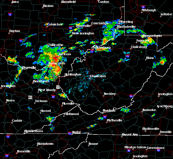 At 417 pm edt, severe thunderstorms were located along a line extending from near clarktown to near south webster to ashland, moving northeast at 40 mph (radar indicated). Hazards include 60 mph wind gusts and penny size hail. Expect damage to roofs, siding, and trees. Locations impacted include, ashland, ironton, jackson, coal grove, oak hill, lake vesuvius, gallia, vernon, worthington, hanging rock, mabee, petersburg and pedro. At 417 pm edt, severe thunderstorms were located along a line extending from near clarktown to near south webster to ashland, moving northeast at 40 mph (radar indicated). Hazards include 60 mph wind gusts and penny size hail. Expect damage to roofs, siding, and trees. Locations impacted include, ashland, ironton, jackson, coal grove, oak hill, lake vesuvius, gallia, vernon, worthington, hanging rock, mabee, petersburg and pedro.
|
| 8/1/2020 3:58 PM EDT |
 At 358 pm edt, severe thunderstorms were located along a line extending from south shore to near greenup to near rush, moving northeast at 40 mph (radar indicated). Hazards include 60 mph wind gusts and penny size hail. expect damage to roofs, siding, and trees At 358 pm edt, severe thunderstorms were located along a line extending from south shore to near greenup to near rush, moving northeast at 40 mph (radar indicated). Hazards include 60 mph wind gusts and penny size hail. expect damage to roofs, siding, and trees
|
| 7/10/2020 3:29 PM EDT |
 At 328 pm edt, severe thunderstorms were located along a line extending from 6 miles southeast of ashley to sunbury to near gahanna, moving east at 30 mph (radar indicated). Hazards include 60 mph wind gusts. Expect damage to trees and power lines. Locations impacted include, columbus, westerville, delaware, gahanna, worthington, sunbury, ashley, minerva park, polaris, easton, new albany, galena, interstate 71 at us route 36/state route 37, alum creek state park, delaware state park, olive green, huber ridge, center village, leonardsburg and kilbourne. At 328 pm edt, severe thunderstorms were located along a line extending from 6 miles southeast of ashley to sunbury to near gahanna, moving east at 30 mph (radar indicated). Hazards include 60 mph wind gusts. Expect damage to trees and power lines. Locations impacted include, columbus, westerville, delaware, gahanna, worthington, sunbury, ashley, minerva park, polaris, easton, new albany, galena, interstate 71 at us route 36/state route 37, alum creek state park, delaware state park, olive green, huber ridge, center village, leonardsburg and kilbourne.
|
| 7/10/2020 3:05 PM EDT |
 At 305 pm edt, severe thunderstorms were located along a line extending from near waldo to near delaware to dublin, moving east at 30 mph (radar indicated). Hazards include 60 mph wind gusts. expect damage to trees and power lines At 305 pm edt, severe thunderstorms were located along a line extending from near waldo to near delaware to dublin, moving east at 30 mph (radar indicated). Hazards include 60 mph wind gusts. expect damage to trees and power lines
|
| 7/10/2020 12:41 PM EDT |
 At 1226 pm edt, a severe thunderstorm was located over westerville, moving northeast at 25 mph (radar indicated). Hazards include 60 mph wind gusts and penny size hail. Expect damage to trees and power lines. locations impacted include, columbus, dublin, westerville, gahanna, worthington, bexley, powell, sunbury, minerva park, polaris, easton, whitehall, new albany, galena, riverlea, port columbus airport, alum creek state park, clintonville and huber ridge. this includes the following interstates, i-70 in ohio near mile marker 102. I-71 in ohio between mile markers 111 and 131. At 1226 pm edt, a severe thunderstorm was located over westerville, moving northeast at 25 mph (radar indicated). Hazards include 60 mph wind gusts and penny size hail. Expect damage to trees and power lines. locations impacted include, columbus, dublin, westerville, gahanna, worthington, bexley, powell, sunbury, minerva park, polaris, easton, whitehall, new albany, galena, riverlea, port columbus airport, alum creek state park, clintonville and huber ridge. this includes the following interstates, i-70 in ohio near mile marker 102. I-71 in ohio between mile markers 111 and 131.
|
| 7/10/2020 12:27 PM EDT |
 At 1226 pm edt, a severe thunderstorm was located over westerville, moving northeast at 25 mph (radar indicated). Hazards include 60 mph wind gusts and penny size hail. Expect damage to trees and power lines. locations impacted include, columbus, dublin, westerville, gahanna, worthington, bexley, powell, sunbury, minerva park, polaris, easton, whitehall, new albany, galena, riverlea, port columbus airport, alum creek state park, clintonville and huber ridge. this includes the following interstates, i-70 in ohio near mile marker 102. I-71 in ohio between mile markers 111 and 131. At 1226 pm edt, a severe thunderstorm was located over westerville, moving northeast at 25 mph (radar indicated). Hazards include 60 mph wind gusts and penny size hail. Expect damage to trees and power lines. locations impacted include, columbus, dublin, westerville, gahanna, worthington, bexley, powell, sunbury, minerva park, polaris, easton, whitehall, new albany, galena, riverlea, port columbus airport, alum creek state park, clintonville and huber ridge. this includes the following interstates, i-70 in ohio near mile marker 102. I-71 in ohio between mile markers 111 and 131.
|
| 7/10/2020 12:12 PM EDT |
 At 1211 pm edt, a severe thunderstorm was located over worthington, moving northeast at 25 mph (radar indicated). Hazards include 60 mph wind gusts and quarter size hail. Minor hail damage to vehicles is possible. expect wind damage to trees and power lines. locations impacted include, columbus, dublin, westerville, upper arlington, gahanna, hilliard, worthington, bexley, powell, sunbury, minerva park, ohio state university, polaris, easton, whitehall, new albany, grandview heights, galena, valleyview and marble cliff. this includes the following interstates, i-70 in ohio between mile markers 94 and 101. I-71 in ohio between mile markers 106 and 131. At 1211 pm edt, a severe thunderstorm was located over worthington, moving northeast at 25 mph (radar indicated). Hazards include 60 mph wind gusts and quarter size hail. Minor hail damage to vehicles is possible. expect wind damage to trees and power lines. locations impacted include, columbus, dublin, westerville, upper arlington, gahanna, hilliard, worthington, bexley, powell, sunbury, minerva park, ohio state university, polaris, easton, whitehall, new albany, grandview heights, galena, valleyview and marble cliff. this includes the following interstates, i-70 in ohio between mile markers 94 and 101. I-71 in ohio between mile markers 106 and 131.
|
| 7/10/2020 11:59 AM EDT |
 The national weather service in wilmington has issued a * severe thunderstorm warning for. northern franklin county in central ohio. southeastern delaware county in central ohio. until 1245 pm edt. At 1159 am edt, a severe thunderstorm was located over upper. The national weather service in wilmington has issued a * severe thunderstorm warning for. northern franklin county in central ohio. southeastern delaware county in central ohio. until 1245 pm edt. At 1159 am edt, a severe thunderstorm was located over upper.
|
| 6/10/2020 8:58 PM EDT |
 The severe thunderstorm warning for northern boyd, southeastern greenup, east central carter, gallia, southeastern jackson, lawrence and northwestern cabell counties will expire at 900 pm edt, the storms which prompted the warning have weakened below severe limits, and no longer pose an immediate threat to life or property. therefore, the warning will be allowed to expire. however gusty winds are still possible with these thunderstorms. a severe thunderstorm watch remains in effect until 100 am edt for northeastern kentucky, southeastern ohio, and central and western west virginia. to report severe weather, contact your nearest law enforcement agency. they will relay your report to the national weather service charleston west virginia. remember, a tornado warning still remains in effect for gallia county until 9 15 pm edt. The severe thunderstorm warning for northern boyd, southeastern greenup, east central carter, gallia, southeastern jackson, lawrence and northwestern cabell counties will expire at 900 pm edt, the storms which prompted the warning have weakened below severe limits, and no longer pose an immediate threat to life or property. therefore, the warning will be allowed to expire. however gusty winds are still possible with these thunderstorms. a severe thunderstorm watch remains in effect until 100 am edt for northeastern kentucky, southeastern ohio, and central and western west virginia. to report severe weather, contact your nearest law enforcement agency. they will relay your report to the national weather service charleston west virginia. remember, a tornado warning still remains in effect for gallia county until 9 15 pm edt.
|
| 6/10/2020 8:35 PM EDT |
 At 835 pm edt, a severe thunderstorm capable of producing a tornado was located near ironton, moving northeast at 40 mph (radar indicated rotation). Hazards include tornado. Flying debris will be dangerous to those caught without shelter. mobile homes will be damaged or destroyed. damage to roofs, windows, and vehicles will occur. tree damage is likely. this dangerous storm will be near, ironton around 840 pm edt. lake vesuvius around 850 pm edt. Other locations impacted by this tornadic thunderstorm include raceland, russell, flatwoods, worthington, pedro, hanging rock and bellefonte. At 835 pm edt, a severe thunderstorm capable of producing a tornado was located near ironton, moving northeast at 40 mph (radar indicated rotation). Hazards include tornado. Flying debris will be dangerous to those caught without shelter. mobile homes will be damaged or destroyed. damage to roofs, windows, and vehicles will occur. tree damage is likely. this dangerous storm will be near, ironton around 840 pm edt. lake vesuvius around 850 pm edt. Other locations impacted by this tornadic thunderstorm include raceland, russell, flatwoods, worthington, pedro, hanging rock and bellefonte.
|
| 6/10/2020 8:24 PM EDT |
 At 824 pm edt, severe thunderstorms were located along a line extending from rio grande to near lake vesuvius to near oldtown, moving northeast at 40 mph (radar indicated). Hazards include 60 mph wind gusts and quarter size hail. Hail damage to vehicles is expected. expect wind damage to roofs, siding, and trees. Locations impacted include, huntington, ashland, ironton, grayson, gallipolis, coal grove, oak hill, rio grande, chesapeake, cannonsburg, lake vesuvius, kenova, catlettsburg, ceredo, princess, coalton, naples, gallia, flatwoods and south point. At 824 pm edt, severe thunderstorms were located along a line extending from rio grande to near lake vesuvius to near oldtown, moving northeast at 40 mph (radar indicated). Hazards include 60 mph wind gusts and quarter size hail. Hail damage to vehicles is expected. expect wind damage to roofs, siding, and trees. Locations impacted include, huntington, ashland, ironton, grayson, gallipolis, coal grove, oak hill, rio grande, chesapeake, cannonsburg, lake vesuvius, kenova, catlettsburg, ceredo, princess, coalton, naples, gallia, flatwoods and south point.
|
| 6/10/2020 7:59 PM EDT |
 At 758 pm edt, severe thunderstorms were located along a line extending from near south webster to near greenbo lake to near olive hill, moving northeast at 45 mph (radar indicated). Hazards include 70 mph wind gusts and half dollar size hail. Hail damage to vehicles is expected. expect considerable tree damage. Wind damage is also likely to mobile homes, roofs, and outbuildings. At 758 pm edt, severe thunderstorms were located along a line extending from near south webster to near greenbo lake to near olive hill, moving northeast at 45 mph (radar indicated). Hazards include 70 mph wind gusts and half dollar size hail. Hail damage to vehicles is expected. expect considerable tree damage. Wind damage is also likely to mobile homes, roofs, and outbuildings.
|
| 6/10/2020 7:36 PM EDT |
 At 736 pm edt, severe thunderstorms were located along a line extending from near mcarthur to 7 miles northeast of oak hill to near lake vesuvius, moving northeast at 50 mph (radar indicated). Hazards include 60 mph wind gusts. Expect damage to roofs, siding, and trees. Locations impacted include, athens, ironton, jackson, wellston, oak hill, rio grande, albany, rutland, lake vesuvius, greenup, gesling, greenbo lake, load, letitia, gallia, carter, flatwoods, russell, vernon and waterloo. At 736 pm edt, severe thunderstorms were located along a line extending from near mcarthur to 7 miles northeast of oak hill to near lake vesuvius, moving northeast at 50 mph (radar indicated). Hazards include 60 mph wind gusts. Expect damage to roofs, siding, and trees. Locations impacted include, athens, ironton, jackson, wellston, oak hill, rio grande, albany, rutland, lake vesuvius, greenup, gesling, greenbo lake, load, letitia, gallia, carter, flatwoods, russell, vernon and waterloo.
|
| 6/10/2020 6:48 PM EDT |
 At 647 pm edt, severe thunderstorms were located along a line extending from 7 miles northwest of lucasville to 7 miles west of south shore to near head of grassy, moving northeast at 50 mph (radar indicated). Hazards include 60 mph wind gusts. expect damage to roofs, siding, and trees At 647 pm edt, severe thunderstorms were located along a line extending from 7 miles northwest of lucasville to 7 miles west of south shore to near head of grassy, moving northeast at 50 mph (radar indicated). Hazards include 60 mph wind gusts. expect damage to roofs, siding, and trees
|
| 6/10/2020 6:03 PM EDT |
 At 603 pm edt, a severe thunderstorm was located over worthington, moving east at 40 mph (radar indicated). Hazards include 70 mph wind gusts. Expect considerable tree damage. Damage is likely to mobile homes, roofs, and outbuildings. At 603 pm edt, a severe thunderstorm was located over worthington, moving east at 40 mph (radar indicated). Hazards include 70 mph wind gusts. Expect considerable tree damage. Damage is likely to mobile homes, roofs, and outbuildings.
|
| 5/14/2020 6:12 PM EDT |
 At 611 pm edt, severe thunderstorms were located along a line extending from near sunbury to near westerville to minerva park, moving east at 45 mph (radar indicated). Hazards include 60 mph wind gusts. expect damage to trees and power lines At 611 pm edt, severe thunderstorms were located along a line extending from near sunbury to near westerville to minerva park, moving east at 45 mph (radar indicated). Hazards include 60 mph wind gusts. expect damage to trees and power lines
|
| 5/14/2020 6:05 PM EDT |
 At 604 pm edt, severe thunderstorms were located along a line extending from near sparta to polaris to near minerva park, moving east at 50 mph (radar indicated). Hazards include 60 mph wind gusts. Expect damage to trees and power lines. locations impacted include, columbus, dublin, westerville, delaware, upper arlington, gahanna, hilliard, worthington, powell, sunbury, minerva park, polaris, easton, new albany, shawnee hills, galena, riverlea, alum creek state park, olive green and clintonville. This includes i-71 in ohio between mile markers 112 and 138. At 604 pm edt, severe thunderstorms were located along a line extending from near sparta to polaris to near minerva park, moving east at 50 mph (radar indicated). Hazards include 60 mph wind gusts. Expect damage to trees and power lines. locations impacted include, columbus, dublin, westerville, delaware, upper arlington, gahanna, hilliard, worthington, powell, sunbury, minerva park, polaris, easton, new albany, shawnee hills, galena, riverlea, alum creek state park, olive green and clintonville. This includes i-71 in ohio between mile markers 112 and 138.
|
| 5/14/2020 5:49 PM EDT |
 At 549 pm edt, severe thunderstorms were located along a line extending from near ashley to near delaware to near lake darby, moving east at 50 mph (radar indicated). Hazards include 60 mph wind gusts. Expect damage to trees and power lines. locations impacted include, columbus, dublin, westerville, delaware, upper arlington, gahanna, hilliard, worthington, bexley, powell, sunbury, plain city, west jefferson, ashley, minerva park, new california, polaris, ohio state university, easton and lake darby. this includes the following interstates, i-70 in ohio between mile markers 81 and 97. I-71 in ohio between mile markers 109 and 138. At 549 pm edt, severe thunderstorms were located along a line extending from near ashley to near delaware to near lake darby, moving east at 50 mph (radar indicated). Hazards include 60 mph wind gusts. Expect damage to trees and power lines. locations impacted include, columbus, dublin, westerville, delaware, upper arlington, gahanna, hilliard, worthington, bexley, powell, sunbury, plain city, west jefferson, ashley, minerva park, new california, polaris, ohio state university, easton and lake darby. this includes the following interstates, i-70 in ohio between mile markers 81 and 97. I-71 in ohio between mile markers 109 and 138.
|
| 5/14/2020 5:26 PM EDT |
 At 526 pm edt, severe thunderstorms were located along a line extending from 6 miles west of richwood to near marysville to near south charleston, moving east at 55 mph (radar indicated). Hazards include 60 mph wind gusts. expect damage to trees and power lines At 526 pm edt, severe thunderstorms were located along a line extending from 6 miles west of richwood to near marysville to near south charleston, moving east at 55 mph (radar indicated). Hazards include 60 mph wind gusts. expect damage to trees and power lines
|
| 5/10/2020 4:58 PM EDT |
 At 457 pm edt, severe thunderstorms were located along a line extending from westerville to near grove city, moving east at 35 mph (radar indicated). Hazards include 70 mph wind gusts. Expect considerable tree damage. damage is likely to mobile homes, roofs, and outbuildings. locations impacted include, columbus, westerville, reynoldsburg, grove city, upper arlington, gahanna, hilliard, worthington, bexley, canal winchester, groveport, ashville, south bloomfield, minerva park, ohio state university, easton, whitehall, new albany, grandview heights and obetz. this includes the following interstates, i-70 in ohio between mile markers 93 and 111. I-71 in ohio between mile markers 89 and 121. At 457 pm edt, severe thunderstorms were located along a line extending from westerville to near grove city, moving east at 35 mph (radar indicated). Hazards include 70 mph wind gusts. Expect considerable tree damage. damage is likely to mobile homes, roofs, and outbuildings. locations impacted include, columbus, westerville, reynoldsburg, grove city, upper arlington, gahanna, hilliard, worthington, bexley, canal winchester, groveport, ashville, south bloomfield, minerva park, ohio state university, easton, whitehall, new albany, grandview heights and obetz. this includes the following interstates, i-70 in ohio between mile markers 93 and 111. I-71 in ohio between mile markers 89 and 121.
|
| 5/10/2020 4:47 PM EDT |
 At 447 pm edt, severe thunderstorms were located along a line extending from powell to near grove city, moving east at 45 mph (radar indicated). Hazards include 70 mph wind gusts. Expect considerable tree damage. damage is likely to mobile homes, roofs, and outbuildings. locations impacted include, columbus, dublin, westerville, reynoldsburg, grove city, delaware, upper arlington, gahanna, hilliard, worthington, bexley, powell, canal winchester, groveport, sunbury, ashville, south bloomfield, minerva park, polaris and ohio state university. this includes the following interstates, i-70 in ohio between mile markers 93 and 111. I-71 in ohio between mile markers 89 and 135. At 447 pm edt, severe thunderstorms were located along a line extending from powell to near grove city, moving east at 45 mph (radar indicated). Hazards include 70 mph wind gusts. Expect considerable tree damage. damage is likely to mobile homes, roofs, and outbuildings. locations impacted include, columbus, dublin, westerville, reynoldsburg, grove city, delaware, upper arlington, gahanna, hilliard, worthington, bexley, powell, canal winchester, groveport, sunbury, ashville, south bloomfield, minerva park, polaris and ohio state university. this includes the following interstates, i-70 in ohio between mile markers 93 and 111. I-71 in ohio between mile markers 89 and 135.
|
| 5/10/2020 4:34 PM EDT |
 At 434 pm edt, severe thunderstorms were located along a line extending from near new california to 6 miles northwest of mount sterling, moving east at 30 mph (radar indicated). Hazards include 60 mph wind gusts. expect damage to trees and power lines At 434 pm edt, severe thunderstorms were located along a line extending from near new california to 6 miles northwest of mount sterling, moving east at 30 mph (radar indicated). Hazards include 60 mph wind gusts. expect damage to trees and power lines
|
| 4/9/2020 12:29 AM EDT |
 At 1228 am edt, severe thunderstorms were located along a line extending from 8 miles south of oak hill to culver, moving southeast at 65 mph (radar indicated). Hazards include 70 mph wind gusts and penny size hail. Expect considerable tree damage. damage is likely to mobile homes, roofs, and outbuildings. Locations impacted include, ashland, ironton, grayson, gallipolis, coal grove, cannonsburg, lake vesuvius, kenova, catlettsburg, greenup, princess, coalton, denton, oldtown, naples, rush, flatwoods, south point, russell and vernon. At 1228 am edt, severe thunderstorms were located along a line extending from 8 miles south of oak hill to culver, moving southeast at 65 mph (radar indicated). Hazards include 70 mph wind gusts and penny size hail. Expect considerable tree damage. damage is likely to mobile homes, roofs, and outbuildings. Locations impacted include, ashland, ironton, grayson, gallipolis, coal grove, cannonsburg, lake vesuvius, kenova, catlettsburg, greenup, princess, coalton, denton, oldtown, naples, rush, flatwoods, south point, russell and vernon.
|
| 4/9/2020 12:12 AM EDT |
 At 1212 am edt, severe thunderstorms were located along a line extending from near jackson to near olive hill, moving east at 60 mph (radar indicated). Hazards include 70 mph wind gusts and penny size hail. Expect considerable tree damage. damage is likely to mobile homes, roofs, and outbuildings. Locations impacted include, ashland, ironton, jackson, wellston, grayson, gallipolis, coal grove, olive hill, cannonsburg, lake vesuvius, carter caves state park, kenova, catlettsburg, greenup, coalton, denton, gesling, greenbo lake, oldtown and load. At 1212 am edt, severe thunderstorms were located along a line extending from near jackson to near olive hill, moving east at 60 mph (radar indicated). Hazards include 70 mph wind gusts and penny size hail. Expect considerable tree damage. damage is likely to mobile homes, roofs, and outbuildings. Locations impacted include, ashland, ironton, jackson, wellston, grayson, gallipolis, coal grove, olive hill, cannonsburg, lake vesuvius, carter caves state park, kenova, catlettsburg, greenup, coalton, denton, gesling, greenbo lake, oldtown and load.
|
| 4/8/2020 11:52 PM EDT |
 At 1151 pm edt, severe thunderstorms were located along a line extending from 10 miles west of lucasville to 8 miles southwest of vanceburg to ewington, moving southeast at 65 mph (radar indicated). Hazards include 70 mph wind gusts and penny size hail. Expect considerable tree damage. Damage is likely to mobile homes, roofs, and outbuildings. At 1151 pm edt, severe thunderstorms were located along a line extending from 10 miles west of lucasville to 8 miles southwest of vanceburg to ewington, moving southeast at 65 mph (radar indicated). Hazards include 70 mph wind gusts and penny size hail. Expect considerable tree damage. Damage is likely to mobile homes, roofs, and outbuildings.
|
| 4/8/2020 2:01 PM EDT |
 At 159 pm edt, severe thunderstorms were located along a line extending from near greenup to 9 miles north of proctorville, moving southeast at 30 mph (radar indicated). Hazards include 60 mph wind gusts and quarter size hail. Hail damage to vehicles is expected. Expect wind damage to roofs, siding, and trees. At 159 pm edt, severe thunderstorms were located along a line extending from near greenup to 9 miles north of proctorville, moving southeast at 30 mph (radar indicated). Hazards include 60 mph wind gusts and quarter size hail. Hail damage to vehicles is expected. Expect wind damage to roofs, siding, and trees.
|
| 1/11/2020 2:55 PM EST |
 At 255 pm est, severe thunderstorms were located along a line extending from new boston to grayson, moving east at 55 mph (radar indicated). Hazards include 60 mph wind gusts. Expect damage to roofs, siding, and trees. Locations impacted include, ashland, ironton, grayson, coal grove, oak hill, cannonsburg, lake vesuvius, grayson lake state park, greenup, princess, coalton, denton, greenbo lake, oldtown, naples, rush, load, letitia, flatwoods and russell. At 255 pm est, severe thunderstorms were located along a line extending from new boston to grayson, moving east at 55 mph (radar indicated). Hazards include 60 mph wind gusts. Expect damage to roofs, siding, and trees. Locations impacted include, ashland, ironton, grayson, coal grove, oak hill, cannonsburg, lake vesuvius, grayson lake state park, greenup, princess, coalton, denton, greenbo lake, oldtown, naples, rush, load, letitia, flatwoods and russell.
|
| 1/11/2020 2:43 PM EST |
 At 243 pm est, severe thunderstorms were located along a line extending from near letitia to near olive hill, moving east at 50 mph (radar indicated). Hazards include 60 mph wind gusts. expect damage to roofs, siding, and trees At 243 pm est, severe thunderstorms were located along a line extending from near letitia to near olive hill, moving east at 50 mph (radar indicated). Hazards include 60 mph wind gusts. expect damage to roofs, siding, and trees
|
| 9/1/2019 6:10 PM EDT |
 The severe thunderstorm warning for northeastern franklin, southeastern delaware and northwestern licking counties will expire at 615 pm edt, this warning has been replaced by another severe thunderstorm warning for franklin, delaware, and licking counties, in effect until 700 pm. please report previous wind damage or hail to the national weather service by going to our website at weather.gov/iln and submitting your report via social media. The severe thunderstorm warning for northeastern franklin, southeastern delaware and northwestern licking counties will expire at 615 pm edt, this warning has been replaced by another severe thunderstorm warning for franklin, delaware, and licking counties, in effect until 700 pm. please report previous wind damage or hail to the national weather service by going to our website at weather.gov/iln and submitting your report via social media.
|
| 9/1/2019 5:53 PM EDT |
 The severe thunderstorm warning for northwestern franklin and south central delaware counties will expire at 600 pm edt, this warning has been replaced by a new severe thunderstorm warning for franklin and delaware counties, which is in effect until 615 pm. please report previous wind damage or hail to the national weather service by going to our website at weather.gov/iln and submitting your report via social media. The severe thunderstorm warning for northwestern franklin and south central delaware counties will expire at 600 pm edt, this warning has been replaced by a new severe thunderstorm warning for franklin and delaware counties, which is in effect until 615 pm. please report previous wind damage or hail to the national weather service by going to our website at weather.gov/iln and submitting your report via social media.
|
| 9/1/2019 5:47 PM EDT |
 At 547 pm edt, a severe thunderstorm was located over powell, moving east at 25 mph (radar indicated). Hazards include 60 mph wind gusts and half dollar size hail. Minor hail damage to vehicles is possible. Expect wind damage to trees and power lines. At 547 pm edt, a severe thunderstorm was located over powell, moving east at 25 mph (radar indicated). Hazards include 60 mph wind gusts and half dollar size hail. Minor hail damage to vehicles is possible. Expect wind damage to trees and power lines.
|
| 9/1/2019 5:44 PM EDT |
 At 543 pm edt, a severe thunderstorm was located over dublin, moving east at 20 mph (radar indicated). Hazards include 60 mph wind gusts and half dollar size hail. Minor hail damage to vehicles is possible. expect wind damage to trees and power lines. locations impacted include, columbus, dublin, westerville, delaware, upper arlington, hilliard, worthington, powell, polaris, shawnee hills, riverlea, alum creek state park, columbus zoo and lewis center. This includes i-71 in ohio between mile markers 118 and 130. At 543 pm edt, a severe thunderstorm was located over dublin, moving east at 20 mph (radar indicated). Hazards include 60 mph wind gusts and half dollar size hail. Minor hail damage to vehicles is possible. expect wind damage to trees and power lines. locations impacted include, columbus, dublin, westerville, delaware, upper arlington, hilliard, worthington, powell, polaris, shawnee hills, riverlea, alum creek state park, columbus zoo and lewis center. This includes i-71 in ohio between mile markers 118 and 130.
|
| 9/1/2019 5:23 PM EDT |
 At 522 pm edt, a severe thunderstorm was located near plain city, moving east at 20 mph (radar indicated). Hazards include 60 mph wind gusts and half dollar size hail. Minor hail damage to vehicles is possible. expect wind damage to trees and power lines. locations impacted include, columbus, dublin, westerville, delaware, upper arlington, hilliard, marysville, worthington, powell, plain city, polaris, new california, shawnee hills, riverlea, unionville center, alum creek state park, amity, stratford and bellepoint. This includes i-71 in ohio between mile markers 118 and 130. At 522 pm edt, a severe thunderstorm was located near plain city, moving east at 20 mph (radar indicated). Hazards include 60 mph wind gusts and half dollar size hail. Minor hail damage to vehicles is possible. expect wind damage to trees and power lines. locations impacted include, columbus, dublin, westerville, delaware, upper arlington, hilliard, marysville, worthington, powell, plain city, polaris, new california, shawnee hills, riverlea, unionville center, alum creek state park, amity, stratford and bellepoint. This includes i-71 in ohio between mile markers 118 and 130.
|
| 9/1/2019 5:09 PM EDT |
 At 508 pm edt, a severe thunderstorm was located near plain city, moving east at 20 mph (radar indicated). Hazards include 60 mph wind gusts and quarter size hail. Minor hail damage to vehicles is possible. Expect wind damage to trees and power lines. At 508 pm edt, a severe thunderstorm was located near plain city, moving east at 20 mph (radar indicated). Hazards include 60 mph wind gusts and quarter size hail. Minor hail damage to vehicles is possible. Expect wind damage to trees and power lines.
|
| 8/18/2019 11:38 PM EDT |
 At 1137 pm edt, a severe thunderstorm was located over sunbury, moving east at 40 mph (radar indicated). Hazards include 60 mph wind gusts. expect damage to trees and power lines At 1137 pm edt, a severe thunderstorm was located over sunbury, moving east at 40 mph (radar indicated). Hazards include 60 mph wind gusts. expect damage to trees and power lines
|
| 7/2/2019 6:22 PM EDT |
 At 622 pm edt, a severe thunderstorm was located over easton, moving southeast at 20 mph (radar indicated). Hazards include 60 mph wind gusts. Expect damage to trees and power lines. locations impacted include, columbus, westerville, reynoldsburg, gahanna, worthington, minerva park, easton, whitehall, new albany, port columbus airport, clintonville and huber ridge. This includes i-71 in ohio between mile markers 114 and 118. At 622 pm edt, a severe thunderstorm was located over easton, moving southeast at 20 mph (radar indicated). Hazards include 60 mph wind gusts. Expect damage to trees and power lines. locations impacted include, columbus, westerville, reynoldsburg, gahanna, worthington, minerva park, easton, whitehall, new albany, port columbus airport, clintonville and huber ridge. This includes i-71 in ohio between mile markers 114 and 118.
|
| 7/2/2019 6:06 PM EDT |
 At 605 pm edt, a severe thunderstorm was located over minerva park, moving southeast at 25 mph (radar indicated). Hazards include 60 mph wind gusts. expect damage to trees and power lines At 605 pm edt, a severe thunderstorm was located over minerva park, moving southeast at 25 mph (radar indicated). Hazards include 60 mph wind gusts. expect damage to trees and power lines
|
| 6/16/2019 8:22 PM EDT |
 At 822 pm edt, severe thunderstorms were located along a line extending from near franklin furnace to near cannonsburg to near martha, moving east at 30 mph (radar indicated). Hazards include 60 mph wind gusts and quarter size hail. Hail damage to vehicles is expected. expect wind damage to roofs, siding, and trees. Locations impacted include, huntington, ashland, ironton, grayson, louisa, coal grove, wayne, chesapeake, proctorville, blaine, beech fork state park, cannonsburg, lake vesuvius, yatesville lake state park, barboursville, kenova, catlettsburg, ceredo, fort gay and coalton. At 822 pm edt, severe thunderstorms were located along a line extending from near franklin furnace to near cannonsburg to near martha, moving east at 30 mph (radar indicated). Hazards include 60 mph wind gusts and quarter size hail. Hail damage to vehicles is expected. expect wind damage to roofs, siding, and trees. Locations impacted include, huntington, ashland, ironton, grayson, louisa, coal grove, wayne, chesapeake, proctorville, blaine, beech fork state park, cannonsburg, lake vesuvius, yatesville lake state park, barboursville, kenova, catlettsburg, ceredo, fort gay and coalton.
|
| 6/16/2019 7:59 PM EDT |
 At 759 pm edt, severe thunderstorms were located along a line extending from near letitia to near grayson to near little sandy, moving east at 30 mph (radar indicated). Hazards include 60 mph wind gusts and quarter size hail. Hail damage to vehicles is expected. Expect wind damage to roofs, siding, and trees. At 759 pm edt, severe thunderstorms were located along a line extending from near letitia to near grayson to near little sandy, moving east at 30 mph (radar indicated). Hazards include 60 mph wind gusts and quarter size hail. Hail damage to vehicles is expected. Expect wind damage to roofs, siding, and trees.
|
| 6/16/2019 1:27 PM EDT |
 At 126 pm edt, a severe thunderstorm was located over naples, or near ironton, moving east at 40 mph (radar indicated). Hazards include 60 mph wind gusts and nickel size hail. expect damage to roofs, siding, and trees At 126 pm edt, a severe thunderstorm was located over naples, or near ironton, moving east at 40 mph (radar indicated). Hazards include 60 mph wind gusts and nickel size hail. expect damage to roofs, siding, and trees
|
| 6/2/2019 1:26 PM EDT |
 At 126 pm edt, a severe thunderstorm was located over ironton, moving southeast at 25 mph (radar indicated). Hazards include 65 mph wind gusts and half dollar size hail. Hail damage to vehicles is expected. Expect wind damage to roofs, siding, and trees. At 126 pm edt, a severe thunderstorm was located over ironton, moving southeast at 25 mph (radar indicated). Hazards include 65 mph wind gusts and half dollar size hail. Hail damage to vehicles is expected. Expect wind damage to roofs, siding, and trees.
|
| 6/2/2019 2:12 AM EDT |
 The severe thunderstorm warning for northeastern franklin, southeastern delaware and western licking counties will expire at 215 am edt, the storm which prompted the warning has weakened below severe limits, and no longer poses an immediate threat to life or property. therefore, the warning will be allowed to expire. please report previous wind damage or hail to the national weather service by going to our website at weather.gov/iln and submitting your report via social media. The severe thunderstorm warning for northeastern franklin, southeastern delaware and western licking counties will expire at 215 am edt, the storm which prompted the warning has weakened below severe limits, and no longer poses an immediate threat to life or property. therefore, the warning will be allowed to expire. please report previous wind damage or hail to the national weather service by going to our website at weather.gov/iln and submitting your report via social media.
|
| 6/2/2019 2:01 AM EDT |
 At 201 am edt, a severe thunderstorm was located near johnstown, moving southeast at 40 mph (radar indicated). Hazards include 60 mph wind gusts. Expect damage to trees and power lines. locations impacted include, columbus, westerville, reynoldsburg, gahanna, worthington, granville, pataskala, johnstown, sunbury, utica, minerva park, granville south, beechwood trails, easton, summit station, etna, new albany, jersey, galena and kirkersville. this includes the following interstates, i-70 in ohio between mile markers 115 and 124. I-71 in ohio between mile markers 117 and 121. At 201 am edt, a severe thunderstorm was located near johnstown, moving southeast at 40 mph (radar indicated). Hazards include 60 mph wind gusts. Expect damage to trees and power lines. locations impacted include, columbus, westerville, reynoldsburg, gahanna, worthington, granville, pataskala, johnstown, sunbury, utica, minerva park, granville south, beechwood trails, easton, summit station, etna, new albany, jersey, galena and kirkersville. this includes the following interstates, i-70 in ohio between mile markers 115 and 124. I-71 in ohio between mile markers 117 and 121.
|
| 6/2/2019 1:44 AM EDT |
 At 144 am edt, a severe thunderstorm was located near sunbury, moving southeast at 40 mph (radar indicated). Hazards include 60 mph wind gusts. expect damage to trees and power lines At 144 am edt, a severe thunderstorm was located near sunbury, moving southeast at 40 mph (radar indicated). Hazards include 60 mph wind gusts. expect damage to trees and power lines
|
| 5/29/2019 11:36 AM EDT |
 At 1136 am edt, a severe thunderstorm was located near south shore, or near portsmouth, moving east at 40 mph (radar indicated). Hazards include 60 mph wind gusts and quarter size hail. Hail damage to vehicles is expected. Expect wind damage to roofs, siding, and trees. At 1136 am edt, a severe thunderstorm was located near south shore, or near portsmouth, moving east at 40 mph (radar indicated). Hazards include 60 mph wind gusts and quarter size hail. Hail damage to vehicles is expected. Expect wind damage to roofs, siding, and trees.
|
| 5/27/2019 11:55 PM EDT |
 At 1155 pm edt, a severe thunderstorm capable of producing a tornado was located over gahanna, moving east at 35 mph (radar indicated rotation). Hazards include tornado and quarter size hail. Flying debris will be dangerous to those caught without shelter. mobile homes will be damaged or destroyed. damage to roofs, windows, and vehicles will occur. tree damage is likely. locations impacted include, columbus, westerville, reynoldsburg, gahanna, worthington, bexley, pataskala, johnstown, minerva park, beechwood trails, easton, summit station, ohio state university, whitehall, etna, new albany, jersey, riverlea, port columbus airport and state route 310 at state route 161. this includes the following interstates, i-70 in ohio between mile markers 100 and 103, and near mile marker 115. I-71 in ohio between mile markers 107 and 118. At 1155 pm edt, a severe thunderstorm capable of producing a tornado was located over gahanna, moving east at 35 mph (radar indicated rotation). Hazards include tornado and quarter size hail. Flying debris will be dangerous to those caught without shelter. mobile homes will be damaged or destroyed. damage to roofs, windows, and vehicles will occur. tree damage is likely. locations impacted include, columbus, westerville, reynoldsburg, gahanna, worthington, bexley, pataskala, johnstown, minerva park, beechwood trails, easton, summit station, ohio state university, whitehall, etna, new albany, jersey, riverlea, port columbus airport and state route 310 at state route 161. this includes the following interstates, i-70 in ohio between mile markers 100 and 103, and near mile marker 115. I-71 in ohio between mile markers 107 and 118.
|
| 5/27/2019 11:41 PM EDT |
 At 1141 pm edt, a severe thunderstorm capable of producing a tornado was located over ohio state university, moving east at 35 mph (radar indicated rotation). Hazards include tornado and quarter size hail. Flying debris will be dangerous to those caught without shelter. mobile homes will be damaged or destroyed. damage to roofs, windows, and vehicles will occur. Tree damage is likely. At 1141 pm edt, a severe thunderstorm capable of producing a tornado was located over ohio state university, moving east at 35 mph (radar indicated rotation). Hazards include tornado and quarter size hail. Flying debris will be dangerous to those caught without shelter. mobile homes will be damaged or destroyed. damage to roofs, windows, and vehicles will occur. Tree damage is likely.
|
| 5/26/2019 7:57 AM EDT |
 The severe thunderstorm warning for northeastern franklin, southeastern delaware and western licking counties will expire at 800 am edt, the storms which prompted the warning have weakened below severe limits, and no longer pose an immediate threat to life or property. therefore, the warning will be allowed to expire. some strong wind gusts will remain possible in licking county with this storm. a severe thunderstorm watch remains in effect until 1000 am edt for central ohio. please report previous wind damage or hail to the national weather service by going to our website at weather.gov/iln and submitting your report via social media. The severe thunderstorm warning for northeastern franklin, southeastern delaware and western licking counties will expire at 800 am edt, the storms which prompted the warning have weakened below severe limits, and no longer pose an immediate threat to life or property. therefore, the warning will be allowed to expire. some strong wind gusts will remain possible in licking county with this storm. a severe thunderstorm watch remains in effect until 1000 am edt for central ohio. please report previous wind damage or hail to the national weather service by going to our website at weather.gov/iln and submitting your report via social media.
|
| 5/26/2019 7:46 AM EDT |
 At 745 am edt, severe thunderstorms were located along a line extending from near centerburg to easton, moving east at 40 mph (radar indicated). Hazards include 60 mph wind gusts. Expect damage to trees and power lines. locations impacted include, columbus, westerville, reynoldsburg, gahanna, worthington, pataskala, johnstown, sunbury, utica, minerva park, easton, summit station, beechwood trails, new albany, jersey, galena, riverlea, alexandria, hartford and us route 62 at state route 661. This includes i-71 in ohio between mile markers 115 and 119. At 745 am edt, severe thunderstorms were located along a line extending from near centerburg to easton, moving east at 40 mph (radar indicated). Hazards include 60 mph wind gusts. Expect damage to trees and power lines. locations impacted include, columbus, westerville, reynoldsburg, gahanna, worthington, pataskala, johnstown, sunbury, utica, minerva park, easton, summit station, beechwood trails, new albany, jersey, galena, riverlea, alexandria, hartford and us route 62 at state route 661. This includes i-71 in ohio between mile markers 115 and 119.
|
| 5/26/2019 7:31 AM EDT |
 At 730 am edt, severe thunderstorms were located along a line extending from near ashley to dublin, moving east at 35 mph (radar indicated). Hazards include 60 mph wind gusts. expect damage to trees and power lines At 730 am edt, severe thunderstorms were located along a line extending from near ashley to dublin, moving east at 35 mph (radar indicated). Hazards include 60 mph wind gusts. expect damage to trees and power lines
|
| 3/15/2019 12:45 AM EDT |
 At 1245 am edt, a severe thunderstorm was located near ironton, moving northeast at 65 mph (radar indicated). Hazards include 60 mph wind gusts. expect damage to roofs, siding, and trees At 1245 am edt, a severe thunderstorm was located near ironton, moving northeast at 65 mph (radar indicated). Hazards include 60 mph wind gusts. expect damage to roofs, siding, and trees
|
| 9/21/2018 6:35 PM EDT |
 The severe thunderstorm warning for western franklin and northwestern pickaway counties will expire at 645 pm edt, the storm which prompted the warning has weakened below severe limits, and has exited the warned area. therefore, the warning will be allowed to expire. please report previous wind damage or hail to the national weather service by going to our website at weather.gov/iln and submitting your report via social media. The severe thunderstorm warning for western franklin and northwestern pickaway counties will expire at 645 pm edt, the storm which prompted the warning has weakened below severe limits, and has exited the warned area. therefore, the warning will be allowed to expire. please report previous wind damage or hail to the national weather service by going to our website at weather.gov/iln and submitting your report via social media.
|
| 9/21/2018 6:22 PM EDT |
 A severe thunderstorm warning remains in effect until 645 pm edt for western franklin and northwestern pickaway counties. at 621 pm edt, a severe thunderstorm was located near grove city, moving east at 45 mph. hazard. 60 mph wind gusts. source. Radar indicated. A severe thunderstorm warning remains in effect until 645 pm edt for western franklin and northwestern pickaway counties. at 621 pm edt, a severe thunderstorm was located near grove city, moving east at 45 mph. hazard. 60 mph wind gusts. source. Radar indicated.
|
| 9/21/2018 6:10 PM EDT |
 A severe thunderstorm warning remains in effect until 645 pm edt for western franklin. northeastern fayette. northwestern pickaway and southeastern madison counties. at 609 pm edt, a severe thunderstorm was located near mount sterling, moving east at 45 mph. hazard. 60 mph wind gusts. A severe thunderstorm warning remains in effect until 645 pm edt for western franklin. northeastern fayette. northwestern pickaway and southeastern madison counties. at 609 pm edt, a severe thunderstorm was located near mount sterling, moving east at 45 mph. hazard. 60 mph wind gusts.
|
| 9/21/2018 6:04 PM EDT |
 The national weather service in wilmington has issued a * severe thunderstorm warning for. western franklin county in central ohio. northeastern fayette county in central ohio. northwestern pickaway county in central ohio. Southeastern madison county in central ohio. The national weather service in wilmington has issued a * severe thunderstorm warning for. western franklin county in central ohio. northeastern fayette county in central ohio. northwestern pickaway county in central ohio. Southeastern madison county in central ohio.
|
| 9/2/2018 4:26 PM EDT |
 At 426 pm edt, a severe thunderstorm was located over naples, or near cannonsburg, and is nearly stationary (radar indicated). Hazards include 60 mph wind gusts and quarter size hail. Minor hail damage to vehicles is possible. expect wind damage to trees and power lines, resulting in some power outages. Locations impacted include, greenup, naples, flatwoods, russell, raceland, worthington, wurtland, bellefonte and hanging rock. At 426 pm edt, a severe thunderstorm was located over naples, or near cannonsburg, and is nearly stationary (radar indicated). Hazards include 60 mph wind gusts and quarter size hail. Minor hail damage to vehicles is possible. expect wind damage to trees and power lines, resulting in some power outages. Locations impacted include, greenup, naples, flatwoods, russell, raceland, worthington, wurtland, bellefonte and hanging rock.
|
| 9/2/2018 4:08 PM EDT |
 At 408 pm edt, a severe thunderstorm was located over naples, or near cannonsburg, and is nearly stationary (radar indicated). Hazards include 60 mph wind gusts and quarter size hail. Minor hail damage to vehicles is possible. Expect wind damage to trees and power lines, resulting in some power outages. At 408 pm edt, a severe thunderstorm was located over naples, or near cannonsburg, and is nearly stationary (radar indicated). Hazards include 60 mph wind gusts and quarter size hail. Minor hail damage to vehicles is possible. Expect wind damage to trees and power lines, resulting in some power outages.
|
| 7/2/2018 7:38 PM EDT |
 The severe thunderstorm warning for western gallia, southern jackson and central lawrence counties will expire at 745 pm edt, the storm which prompted the warning has weakened below severe limits, and no longer poses an immediate threat to life or property. therefore, the warning will be allowed to expire. however heavy rain is still possible with this thunderstorm. The severe thunderstorm warning for western gallia, southern jackson and central lawrence counties will expire at 745 pm edt, the storm which prompted the warning has weakened below severe limits, and no longer poses an immediate threat to life or property. therefore, the warning will be allowed to expire. however heavy rain is still possible with this thunderstorm.
|
| 7/2/2018 7:14 PM EDT |
 At 714 pm edt, a severe thunderstorm was located near south webster, or 8 miles southwest of oak hill, moving southeast at 10 mph (radar indicated). Hazards include 60 mph wind gusts. Expect damage to roofs, siding, and trees. Locations impacted include, ironton, coal grove, oak hill, rio grande, lake vesuvius, gallia, russell, vernon, waterloo, hanging rock, mabee, petersburg, gage, pedro and centerpoint. At 714 pm edt, a severe thunderstorm was located near south webster, or 8 miles southwest of oak hill, moving southeast at 10 mph (radar indicated). Hazards include 60 mph wind gusts. Expect damage to roofs, siding, and trees. Locations impacted include, ironton, coal grove, oak hill, rio grande, lake vesuvius, gallia, russell, vernon, waterloo, hanging rock, mabee, petersburg, gage, pedro and centerpoint.
|
| 7/2/2018 6:44 PM EDT |
 At 644 pm edt, a severe thunderstorm was located near clarktown, or near wheelersburg, moving southeast at 15 mph (radar indicated). Hazards include 60 mph wind gusts. expect damage to roofs, siding, and trees At 644 pm edt, a severe thunderstorm was located near clarktown, or near wheelersburg, moving southeast at 15 mph (radar indicated). Hazards include 60 mph wind gusts. expect damage to roofs, siding, and trees
|
| 6/9/2018 6:30 PM EDT |
 At 630 pm edt, a severe thunderstorm was located over powell, moving east at 35 mph (radar indicated). Hazards include 60 mph wind gusts. expect damage to trees and power lines At 630 pm edt, a severe thunderstorm was located over powell, moving east at 35 mph (radar indicated). Hazards include 60 mph wind gusts. expect damage to trees and power lines
|
| 6/8/2018 4:24 PM EDT |
 The severe thunderstorm warning for northeastern franklin, delaware and northeastern union counties in central ohio will expire at 430 pm edt, the storm which prompted the warning has weakened below severe limits, and no longer poses an immediate threat to life or property. therefore, the warning will be allowed to expire. however gusty winds and heavy rain are still possible with this thunderstorm. please report previous wind damage or hail to the national weather service by going to our website at weather.gov/iln and submitting your report via social media. The severe thunderstorm warning for northeastern franklin, delaware and northeastern union counties in central ohio will expire at 430 pm edt, the storm which prompted the warning has weakened below severe limits, and no longer poses an immediate threat to life or property. therefore, the warning will be allowed to expire. however gusty winds and heavy rain are still possible with this thunderstorm. please report previous wind damage or hail to the national weather service by going to our website at weather.gov/iln and submitting your report via social media.
|
| 6/8/2018 4:03 PM EDT |
 At 403 pm edt, a severe thunderstorm was located near delaware, moving southeast at 25 mph (radar indicated). Hazards include 60 mph wind gusts and quarter size hail. Minor hail damage to vehicles is possible. expect wind damage to trees and power lines. locations impacted include, columbus, westerville, delaware, gahanna, worthington, powell, sunbury, ashley, minerva park, polaris, easton, radnor, shawnee hills, galena, ostrander, riverlea, alum creek state park, delaware state park, olive green and warrensburg. This includes i-71 in ohio between mile markers 116 and 138. At 403 pm edt, a severe thunderstorm was located near delaware, moving southeast at 25 mph (radar indicated). Hazards include 60 mph wind gusts and quarter size hail. Minor hail damage to vehicles is possible. expect wind damage to trees and power lines. locations impacted include, columbus, westerville, delaware, gahanna, worthington, powell, sunbury, ashley, minerva park, polaris, easton, radnor, shawnee hills, galena, ostrander, riverlea, alum creek state park, delaware state park, olive green and warrensburg. This includes i-71 in ohio between mile markers 116 and 138.
|
| 6/8/2018 3:46 PM EDT |
 At 346 pm edt, a severe thunderstorm was located over richwood, moving southeast at 25 mph (radar indicated). Hazards include 60 mph wind gusts and quarter size hail. Minor hail damage to vehicles is possible. Expect wind damage to trees and power lines. At 346 pm edt, a severe thunderstorm was located over richwood, moving southeast at 25 mph (radar indicated). Hazards include 60 mph wind gusts and quarter size hail. Minor hail damage to vehicles is possible. Expect wind damage to trees and power lines.
|
| 5/21/2018 10:13 PM EDT |
 The severe thunderstorm warning for northern franklin. delaware. northwestern licking. northeastern madison and southeastern union counties in central ohio will expire at 1015 pm edt. The storms which prompted the warning have weakened below severe limits, and no longer pose an immediate threat to life or property. The severe thunderstorm warning for northern franklin. delaware. northwestern licking. northeastern madison and southeastern union counties in central ohio will expire at 1015 pm edt. The storms which prompted the warning have weakened below severe limits, and no longer pose an immediate threat to life or property.
|
| 5/21/2018 9:35 PM EDT |
 At 934 pm edt, severe thunderstorms were located along a line extending from near delaware to near west jefferson, moving east at 30 mph (radar indicated). Hazards include 60 mph wind gusts and quarter size hail. Minor hail damage to vehicles is possible. expect wind damage to trees and power lines. locations impacted include, columbus, dublin, westerville, delaware, upper arlington, gahanna, hilliard, marysville, worthington, london, jefferson, powell, sunbury, plain city, west jefferson, ashley, minerva park, choctaw lake, new california and polaris. this includes the following interstates, i-70 in ohio between mile markers 71 and 101. I-71 in ohio between mile markers 106 and 138. At 934 pm edt, severe thunderstorms were located along a line extending from near delaware to near west jefferson, moving east at 30 mph (radar indicated). Hazards include 60 mph wind gusts and quarter size hail. Minor hail damage to vehicles is possible. expect wind damage to trees and power lines. locations impacted include, columbus, dublin, westerville, delaware, upper arlington, gahanna, hilliard, marysville, worthington, london, jefferson, powell, sunbury, plain city, west jefferson, ashley, minerva park, choctaw lake, new california and polaris. this includes the following interstates, i-70 in ohio between mile markers 71 and 101. I-71 in ohio between mile markers 106 and 138.
|
| 5/21/2018 9:15 PM EDT |
 At 914 pm edt, severe thunderstorms were located along a line extending from near delaware to choctaw lake, moving east at 30 mph (radar indicated). Hazards include 60 mph wind gusts and quarter size hail. Minor hail damage to vehicles is possible. Expect wind damage to trees and power lines. At 914 pm edt, severe thunderstorms were located along a line extending from near delaware to choctaw lake, moving east at 30 mph (radar indicated). Hazards include 60 mph wind gusts and quarter size hail. Minor hail damage to vehicles is possible. Expect wind damage to trees and power lines.
|
| 5/21/2018 6:25 PM EDT |
 At 625 pm edt, a severe thunderstorm was located over oldtown, or 8 miles north of grayson, moving north at 15 mph (radar indicated). Hazards include 60 mph wind gusts and quarter size hail. Hail damage to vehicles is expected. Expect wind damage to roofs, siding, and trees. At 625 pm edt, a severe thunderstorm was located over oldtown, or 8 miles north of grayson, moving north at 15 mph (radar indicated). Hazards include 60 mph wind gusts and quarter size hail. Hail damage to vehicles is expected. Expect wind damage to roofs, siding, and trees.
|
| 5/14/2018 1:03 PM EDT |
 At 103 pm edt, severe thunderstorms were located along a line extending from near westerville to 6 miles south of lake darby, moving east at 40 mph (radar indicated). Hazards include 60 mph wind gusts and penny size hail. Expect damage to trees and power lines. locations impacted include, columbus, lancaster, westerville, reynoldsburg, grove city, upper arlington, gahanna, pickerington, worthington, bexley, heath, pataskala, canal winchester, groveport, baltimore, buckeye lake, hebron, bremen, minerva park and millersport. this includes the following interstates, i-70 in ohio between mile markers 92 and 141. I-71 in ohio between mile markers 100 and 120. At 103 pm edt, severe thunderstorms were located along a line extending from near westerville to 6 miles south of lake darby, moving east at 40 mph (radar indicated). Hazards include 60 mph wind gusts and penny size hail. Expect damage to trees and power lines. locations impacted include, columbus, lancaster, westerville, reynoldsburg, grove city, upper arlington, gahanna, pickerington, worthington, bexley, heath, pataskala, canal winchester, groveport, baltimore, buckeye lake, hebron, bremen, minerva park and millersport. this includes the following interstates, i-70 in ohio between mile markers 92 and 141. I-71 in ohio between mile markers 100 and 120.
|
| 5/14/2018 12:53 PM EDT |
 At 1253 pm edt, severe thunderstorms were located along a line extending from worthington to near jefferson, moving east at 40 mph (radar indicated). Hazards include 60 mph wind gusts and penny size hail. expect damage to trees and power lines At 1253 pm edt, severe thunderstorms were located along a line extending from worthington to near jefferson, moving east at 40 mph (radar indicated). Hazards include 60 mph wind gusts and penny size hail. expect damage to trees and power lines
|
| 1/22/2018 11:49 PM EST |
 At 1149 pm est, severe thunderstorms were located along a line extending from ironton to near rush, moving northeast at 65 mph (radar indicated). Hazards include 60 mph wind gusts and quarter size hail. Hail damage to vehicles is expected. Expect wind damage to roofs, siding, and trees. At 1149 pm est, severe thunderstorms were located along a line extending from ironton to near rush, moving northeast at 65 mph (radar indicated). Hazards include 60 mph wind gusts and quarter size hail. Hail damage to vehicles is expected. Expect wind damage to roofs, siding, and trees.
|
| 11/18/2017 6:38 PM EST |
 At 638 pm est, a severe thunderstorm was located near bexley, moving east at 55 mph (radar indicated). Hazards include 60 mph wind gusts. Expect damage to trees and power lines. locations impacted include, columbus, dublin, westerville, upper arlington, gahanna, hilliard, worthington, bexley, minerva park, ohio state university, easton, lake darby, whitehall, grandview heights, valleyview, marble cliff, riverlea, port columbus airport, clintonville and huber ridge. this includes the following interstates, i-70 in ohio between mile markers 89 and 106. I-71 in ohio between mile markers 105 and 118. At 638 pm est, a severe thunderstorm was located near bexley, moving east at 55 mph (radar indicated). Hazards include 60 mph wind gusts. Expect damage to trees and power lines. locations impacted include, columbus, dublin, westerville, upper arlington, gahanna, hilliard, worthington, bexley, minerva park, ohio state university, easton, lake darby, whitehall, grandview heights, valleyview, marble cliff, riverlea, port columbus airport, clintonville and huber ridge. this includes the following interstates, i-70 in ohio between mile markers 89 and 106. I-71 in ohio between mile markers 105 and 118.
|
| 11/18/2017 6:34 PM EST |
 At 633 pm est, a severe thunderstorm was located near grove city, moving east at 55 mph (radar indicated). Hazards include 60 mph wind gusts. Expect damage to trees and power lines. locations impacted include, columbus, dublin, westerville, reynoldsburg, grove city, upper arlington, gahanna, hilliard, worthington, bexley, canal winchester, groveport, west jefferson, minerva park, ohio state university, lake darby, easton, whitehall, new albany and grandview heights. this includes the following interstates, i-70 in ohio between mile markers 86 and 111. I-71 in ohio between mile markers 100 and 117. At 633 pm est, a severe thunderstorm was located near grove city, moving east at 55 mph (radar indicated). Hazards include 60 mph wind gusts. Expect damage to trees and power lines. locations impacted include, columbus, dublin, westerville, reynoldsburg, grove city, upper arlington, gahanna, hilliard, worthington, bexley, canal winchester, groveport, west jefferson, minerva park, ohio state university, lake darby, easton, whitehall, new albany and grandview heights. this includes the following interstates, i-70 in ohio between mile markers 86 and 111. I-71 in ohio between mile markers 100 and 117.
|
| 11/18/2017 6:21 PM EST |
 At 621 pm est, a severe thunderstorm was located over lake darby, moving east at 55 mph (radar indicated). Hazards include 60 mph wind gusts. expect damage to trees and power lines At 621 pm est, a severe thunderstorm was located over lake darby, moving east at 55 mph (radar indicated). Hazards include 60 mph wind gusts. expect damage to trees and power lines
|
| 11/5/2017 7:56 PM EDT |
 The severe thunderstorm warning for northern franklin, southern delaware, northwestern licking, northeastern madison and southeastern union counties in central ohio will expire at 700 pm est, the storm which prompted the warning has moved out of the area. therefore, the warning will be allowed to expire. however gusty winds and heavy rain are still possible with this thunderstorm. a severe thunderstorm watch remains in effect until 100 am est for central ohio. please report previous wind damage or hail to the national weather service by going to our website at weather.gov/iln and submitting your report via social media. The severe thunderstorm warning for northern franklin, southern delaware, northwestern licking, northeastern madison and southeastern union counties in central ohio will expire at 700 pm est, the storm which prompted the warning has moved out of the area. therefore, the warning will be allowed to expire. however gusty winds and heavy rain are still possible with this thunderstorm. a severe thunderstorm watch remains in effect until 100 am est for central ohio. please report previous wind damage or hail to the national weather service by going to our website at weather.gov/iln and submitting your report via social media.
|
| 11/5/2017 7:45 PM EDT |
 At 645 pm est, a severe thunderstorm was located over worthington, moving east at 45 mph (radar indicated). Hazards include 60 mph wind gusts. Expect damage to trees and power lines. locations impacted include, columbus, dublin, westerville, delaware, upper arlington, gahanna, hilliard, worthington, bexley, powell, sunbury, plain city, west jefferson, minerva park, new california, ohio state university, lake darby, polaris, easton and new albany. this includes the following interstates, i-70 in ohio between mile markers 80 and 102. I-71 in ohio between mile markers 105 and 128. At 645 pm est, a severe thunderstorm was located over worthington, moving east at 45 mph (radar indicated). Hazards include 60 mph wind gusts. Expect damage to trees and power lines. locations impacted include, columbus, dublin, westerville, delaware, upper arlington, gahanna, hilliard, worthington, bexley, powell, sunbury, plain city, west jefferson, minerva park, new california, ohio state university, lake darby, polaris, easton and new albany. this includes the following interstates, i-70 in ohio between mile markers 80 and 102. I-71 in ohio between mile markers 105 and 128.
|
| 11/5/2017 7:30 PM EDT |
 At 629 pm est, a severe thunderstorm was located over plain city, moving east at 45 mph (radar indicated). Hazards include 60 mph wind gusts. expect damage to trees and power lines At 629 pm est, a severe thunderstorm was located over plain city, moving east at 45 mph (radar indicated). Hazards include 60 mph wind gusts. expect damage to trees and power lines
|
| 8/22/2017 12:37 PM EDT |
 At 1237 pm edt, a severe thunderstorm was located over worthington, moving east at 35 mph (radar indicated). Hazards include 60 mph wind gusts. expect damage to trees and power lines At 1237 pm edt, a severe thunderstorm was located over worthington, moving east at 35 mph (radar indicated). Hazards include 60 mph wind gusts. expect damage to trees and power lines
|
| 8/17/2017 4:05 PM EDT |
 At 405 pm edt, a severe thunderstorm was located near lake darby, moving east at 35 mph (radar indicated). Hazards include 60 mph wind gusts. expect damage to trees and power lines At 405 pm edt, a severe thunderstorm was located near lake darby, moving east at 35 mph (radar indicated). Hazards include 60 mph wind gusts. expect damage to trees and power lines
|
| 7/10/2017 3:48 PM EDT |
 At 348 pm edt, a severe thunderstorm was located over granville, moving east at 40 mph (radar indicated). Hazards include 70 mph wind gusts and quarter size hail. Minor hail damage to vehicles is possible. expect considerable tree damage. wind damage is also likely to mobile homes, roofs, and outbuildings. locations impacted include, columbus, newark, westerville, reynoldsburg, upper arlington, gahanna, hilliard, pickerington, worthington, bexley, heath, granville, pataskala, johnstown, buckeye lake, hebron, minerva park, harbor hills, granville south and ohio state university. this includes the following interstates, i-70 in ohio between mile markers 93 and 134. I-71 in ohio between mile markers 105 and 123. At 348 pm edt, a severe thunderstorm was located over granville, moving east at 40 mph (radar indicated). Hazards include 70 mph wind gusts and quarter size hail. Minor hail damage to vehicles is possible. expect considerable tree damage. wind damage is also likely to mobile homes, roofs, and outbuildings. locations impacted include, columbus, newark, westerville, reynoldsburg, upper arlington, gahanna, hilliard, pickerington, worthington, bexley, heath, granville, pataskala, johnstown, buckeye lake, hebron, minerva park, harbor hills, granville south and ohio state university. this includes the following interstates, i-70 in ohio between mile markers 93 and 134. I-71 in ohio between mile markers 105 and 123.
|
| 7/10/2017 3:31 PM EDT |
 At 330 pm edt, a severe thunderstorm was located near summit station, moving east at 40 mph. this is a very dangerous storm (radar indicated). Hazards include 80 mph wind gusts and quarter size hail. Flying debris will be dangerous to those caught without shelter. mobile homes will be heavily damaged. expect considerable damage to roofs, windows, and vehicles. extensive tree damage and power outages are likely. locations impacted include, columbus, newark, westerville, reynoldsburg, upper arlington, gahanna, hilliard, pickerington, worthington, bexley, heath, granville, pataskala, johnstown, buckeye lake, hebron, minerva park, harbor hills, granville south and ohio state university. this includes the following interstates, i-70 in ohio between mile markers 93 and 134. I-71 in ohio between mile markers 105 and 123. At 330 pm edt, a severe thunderstorm was located near summit station, moving east at 40 mph. this is a very dangerous storm (radar indicated). Hazards include 80 mph wind gusts and quarter size hail. Flying debris will be dangerous to those caught without shelter. mobile homes will be heavily damaged. expect considerable damage to roofs, windows, and vehicles. extensive tree damage and power outages are likely. locations impacted include, columbus, newark, westerville, reynoldsburg, upper arlington, gahanna, hilliard, pickerington, worthington, bexley, heath, granville, pataskala, johnstown, buckeye lake, hebron, minerva park, harbor hills, granville south and ohio state university. this includes the following interstates, i-70 in ohio between mile markers 93 and 134. I-71 in ohio between mile markers 105 and 123.
|
| 7/10/2017 3:21 PM EDT |
 At 320 pm edt, a severe thunderstorm was located over hilliard, moving east at 20 mph (radar indicated). Hazards include 70 mph wind gusts and quarter size hail. Minor hail damage to vehicles is possible. expect considerable tree damage. wind damage is also likely to mobile homes, roofs, and outbuildings. locations impacted include, columbus, dublin, westerville, upper arlington, hilliard, worthington, bexley, minerva park, ohio state university, polaris, lake darby, grandview heights, valleyview, marble cliff, riverlea, clintonville and lincoln village. this includes the following interstates, i-70 in ohio between mile markers 88 and 97, and between mile markers 101 and 103. I-71 in ohio between mile markers 108 and 124. At 320 pm edt, a severe thunderstorm was located over hilliard, moving east at 20 mph (radar indicated). Hazards include 70 mph wind gusts and quarter size hail. Minor hail damage to vehicles is possible. expect considerable tree damage. wind damage is also likely to mobile homes, roofs, and outbuildings. locations impacted include, columbus, dublin, westerville, upper arlington, hilliard, worthington, bexley, minerva park, ohio state university, polaris, lake darby, grandview heights, valleyview, marble cliff, riverlea, clintonville and lincoln village. this includes the following interstates, i-70 in ohio between mile markers 88 and 97, and between mile markers 101 and 103. I-71 in ohio between mile markers 108 and 124.
|
| 7/10/2017 3:14 PM EDT |
 At 313 pm edt, a severe thunderstorm was located over hilliard, moving east at 35 mph (radar indicated). Hazards include 70 mph wind gusts and quarter size hail. Minor hail damage to vehicles is possible. expect considerable tree damage. wind damage is also likely to mobile homes, roofs, and outbuildings. locations impacted include, columbus, dublin, westerville, upper arlington, hilliard, worthington, bexley, powell, minerva park, ohio state university, polaris, lake darby, grandview heights, shawnee hills, valleyview, marble cliff, riverlea, amity, clintonville and columbus zoo. this includes the following interstates, i-70 in ohio between mile markers 86 and 97, and between mile markers 101 and 103. I-71 in ohio between mile markers 108 and 124. At 313 pm edt, a severe thunderstorm was located over hilliard, moving east at 35 mph (radar indicated). Hazards include 70 mph wind gusts and quarter size hail. Minor hail damage to vehicles is possible. expect considerable tree damage. wind damage is also likely to mobile homes, roofs, and outbuildings. locations impacted include, columbus, dublin, westerville, upper arlington, hilliard, worthington, bexley, powell, minerva park, ohio state university, polaris, lake darby, grandview heights, shawnee hills, valleyview, marble cliff, riverlea, amity, clintonville and columbus zoo. this includes the following interstates, i-70 in ohio between mile markers 86 and 97, and between mile markers 101 and 103. I-71 in ohio between mile markers 108 and 124.
|
| 7/10/2017 3:12 PM EDT |
 At 312 pm edt, a severe thunderstorm was located over minerva park, moving east at 40 mph (radar indicated). Hazards include 70 mph wind gusts and quarter size hail. Minor hail damage to vehicles is possible. expect considerable tree damage. Wind damage is also likely to mobile homes, roofs, and outbuildings. At 312 pm edt, a severe thunderstorm was located over minerva park, moving east at 40 mph (radar indicated). Hazards include 70 mph wind gusts and quarter size hail. Minor hail damage to vehicles is possible. expect considerable tree damage. Wind damage is also likely to mobile homes, roofs, and outbuildings.
|
| 7/10/2017 3:02 PM EDT |
 At 302 pm edt, a severe thunderstorm was located near west jefferson, moving east at 20 mph (trained weather spotters). Hazards include 70 mph wind gusts and quarter size hail. Minor hail damage to vehicles is possible. expect considerable tree damage. wind damage is also likely to mobile homes, roofs, and outbuildings. locations impacted include, columbus, dublin, westerville, upper arlington, hilliard, worthington, bexley, powell, plain city, minerva park, new california, ohio state university, polaris, lake darby, grandview heights, shawnee hills, valleyview, marble cliff, riverlea and unionville center. this includes the following interstates, i-70 in ohio between mile markers 86 and 97, and between mile markers 101 and 103. I-71 in ohio between mile markers 108 and 124. At 302 pm edt, a severe thunderstorm was located near west jefferson, moving east at 20 mph (trained weather spotters). Hazards include 70 mph wind gusts and quarter size hail. Minor hail damage to vehicles is possible. expect considerable tree damage. wind damage is also likely to mobile homes, roofs, and outbuildings. locations impacted include, columbus, dublin, westerville, upper arlington, hilliard, worthington, bexley, powell, plain city, minerva park, new california, ohio state university, polaris, lake darby, grandview heights, shawnee hills, valleyview, marble cliff, riverlea and unionville center. this includes the following interstates, i-70 in ohio between mile markers 86 and 97, and between mile markers 101 and 103. I-71 in ohio between mile markers 108 and 124.
|
| 7/10/2017 2:46 PM EDT |
 At 245 pm edt, a severe thunderstorm was located near choctaw lake, moving east at 20 mph (radar indicated). Hazards include 60 mph wind gusts and quarter size hail. Minor hail damage to vehicles is possible. expect wind damage to trees and power lines. locations impacted include, columbus, dublin, westerville, upper arlington, hilliard, worthington, bexley, powell, plain city, minerva park, new california, ohio state university, polaris, lake darby, grandview heights, shawnee hills, valleyview, marble cliff, riverlea and unionville center. this includes the following interstates, i-70 in ohio between mile markers 86 and 96, and between mile markers 101 and 103. I-71 in ohio between mile markers 108 and 124. At 245 pm edt, a severe thunderstorm was located near choctaw lake, moving east at 20 mph (radar indicated). Hazards include 60 mph wind gusts and quarter size hail. Minor hail damage to vehicles is possible. expect wind damage to trees and power lines. locations impacted include, columbus, dublin, westerville, upper arlington, hilliard, worthington, bexley, powell, plain city, minerva park, new california, ohio state university, polaris, lake darby, grandview heights, shawnee hills, valleyview, marble cliff, riverlea and unionville center. this includes the following interstates, i-70 in ohio between mile markers 86 and 96, and between mile markers 101 and 103. I-71 in ohio between mile markers 108 and 124.
|
| 7/10/2017 2:38 PM EDT |
 At 237 pm edt, a severe thunderstorm was located near mechanicsburg, moving east at 20 mph (radar indicated). Hazards include 60 mph wind gusts and quarter size hail. Minor hail damage to vehicles is possible. Expect wind damage to trees and power lines. At 237 pm edt, a severe thunderstorm was located near mechanicsburg, moving east at 20 mph (radar indicated). Hazards include 60 mph wind gusts and quarter size hail. Minor hail damage to vehicles is possible. Expect wind damage to trees and power lines.
|
| 7/7/2017 8:46 PM EDT |
 At 846 pm edt, severe thunderstorms were located along a line extending from near racine to near rush, moving southeast at 35 mph (radar indicated). Hazards include 60 mph wind gusts and nickel size hail. expect damage to roofs, siding, and trees At 846 pm edt, severe thunderstorms were located along a line extending from near racine to near rush, moving southeast at 35 mph (radar indicated). Hazards include 60 mph wind gusts and nickel size hail. expect damage to roofs, siding, and trees
|
| 7/7/2017 8:32 PM EDT |
 At 832 pm edt, severe thunderstorms were located along a line extending from new haven to near oldtown, moving southeast at 25 mph (radar indicated). Hazards include 60 mph wind gusts and nickel size hail. Expect damage to roofs, siding, and trees. locations impacted include, ashland, ironton, point pleasant, grayson, gallipolis, coal grove, pomeroy, olive hill, rio grande, chesapeake, racine, rutland, cannonsburg, lake vesuvius, carter caves state park, kenova, catlettsburg, new haven, ceredo and greenup. This includes interstate 64 in kentucky between mile markers 151 and 190. At 832 pm edt, severe thunderstorms were located along a line extending from new haven to near oldtown, moving southeast at 25 mph (radar indicated). Hazards include 60 mph wind gusts and nickel size hail. Expect damage to roofs, siding, and trees. locations impacted include, ashland, ironton, point pleasant, grayson, gallipolis, coal grove, pomeroy, olive hill, rio grande, chesapeake, racine, rutland, cannonsburg, lake vesuvius, carter caves state park, kenova, catlettsburg, new haven, ceredo and greenup. This includes interstate 64 in kentucky between mile markers 151 and 190.
|
| 7/7/2017 8:16 PM EDT |
 At 816 pm edt, severe thunderstorms were located along a line extending from near pomeroy to near load, moving southeast at 30 mph (radar indicated). Hazards include 60 mph wind gusts and nickel size hail. Expect damage to roofs, siding, and trees. locations impacted include, ashland, portsmouth, ironton, jackson, wellston, point pleasant, grayson, gallipolis, coal grove, pomeroy, olive hill, oak hill, rio grande, chesapeake, racine, rutland, cannonsburg, lake vesuvius, carter caves state park and kenova. This includes interstate 64 in kentucky between mile markers 151 and 190. At 816 pm edt, severe thunderstorms were located along a line extending from near pomeroy to near load, moving southeast at 30 mph (radar indicated). Hazards include 60 mph wind gusts and nickel size hail. Expect damage to roofs, siding, and trees. locations impacted include, ashland, portsmouth, ironton, jackson, wellston, point pleasant, grayson, gallipolis, coal grove, pomeroy, olive hill, oak hill, rio grande, chesapeake, racine, rutland, cannonsburg, lake vesuvius, carter caves state park and kenova. This includes interstate 64 in kentucky between mile markers 151 and 190.
|
| 7/7/2017 7:47 PM EDT |
 At 747 pm edt, severe thunderstorms were located along a line extending from 8 miles south of chesterhill to near vanceburg, moving southeast at 30 mph (radar indicated). Hazards include 60 mph wind gusts and nickel size hail. expect damage to roofs, siding, and trees At 747 pm edt, severe thunderstorms were located along a line extending from 8 miles south of chesterhill to near vanceburg, moving southeast at 30 mph (radar indicated). Hazards include 60 mph wind gusts and nickel size hail. expect damage to roofs, siding, and trees
|
| 5/24/2017 8:06 PM EDT |
 At 805 pm edt, a thunderstorm capable of producing a tornado was located over ironton, moving northeast at 30 mph (radar indicated rotation). Hazards include tornado. Flying debris will be dangerous to those caught without shelter. mobile homes will be damaged or destroyed. damage to roofs, windows, and vehicles will occur. tree damage is likely. this dangerous storm will be near, lake vesuvius around 820 pm edt. other locations impacted by this tornadic thunderstorm include raceland, russell, flatwoods, worthington, pedro, bellefonte and hanging rock. At 805 pm edt, a thunderstorm capable of producing a tornado was located over ironton, moving northeast at 30 mph (radar indicated rotation). Hazards include tornado. Flying debris will be dangerous to those caught without shelter. mobile homes will be damaged or destroyed. damage to roofs, windows, and vehicles will occur. tree damage is likely. this dangerous storm will be near, lake vesuvius around 820 pm edt. other locations impacted by this tornadic thunderstorm include raceland, russell, flatwoods, worthington, pedro, bellefonte and hanging rock.
|
| 5/1/2017 9:28 AM EDT |
 The severe thunderstorm warning for north central franklin county will expire at 930 am edt, the storm which prompted the warning has weakened below severe limits, and no longer poses an immediate threat to life or property. therefore, the warning will be allowed to expire. please report previous wind damage or hail to the national weather service by going to our website at weather.gov/iln and submitting your report via social media. The severe thunderstorm warning for north central franklin county will expire at 930 am edt, the storm which prompted the warning has weakened below severe limits, and no longer poses an immediate threat to life or property. therefore, the warning will be allowed to expire. please report previous wind damage or hail to the national weather service by going to our website at weather.gov/iln and submitting your report via social media.
|
| 5/1/2017 9:23 AM EDT |
 At 923 am edt, a severe thunderstorm was located over dublin, moving north at 40 mph (radar indicated). Hazards include 60 mph wind gusts. Expect damage to roofs, siding, and trees. locations impacted include, columbus, dublin, westerville, upper arlington, hilliard, worthington and riverlea. This includes i-71 in ohio near mile marker 120. At 923 am edt, a severe thunderstorm was located over dublin, moving north at 40 mph (radar indicated). Hazards include 60 mph wind gusts. Expect damage to roofs, siding, and trees. locations impacted include, columbus, dublin, westerville, upper arlington, hilliard, worthington and riverlea. This includes i-71 in ohio near mile marker 120.
|
| 5/1/2017 9:18 AM EDT |
 At 917 am edt, a severe thunderstorm was located over hilliard, moving north at 40 mph (radar indicated). Hazards include 60 mph wind gusts. Expect damage to roofs, siding, and trees. locations impacted include, columbus, dublin, westerville, upper arlington, hilliard, worthington and riverlea. This includes i-71 in ohio near mile marker 120. At 917 am edt, a severe thunderstorm was located over hilliard, moving north at 40 mph (radar indicated). Hazards include 60 mph wind gusts. Expect damage to roofs, siding, and trees. locations impacted include, columbus, dublin, westerville, upper arlington, hilliard, worthington and riverlea. This includes i-71 in ohio near mile marker 120.
|
| 5/1/2017 9:10 AM EDT |
 At 910 am edt, a severe thunderstorm was located over lake darby, moving north at 40 mph (radar indicated). Hazards include 60 mph wind gusts. expect damage to roofs, siding, and trees At 910 am edt, a severe thunderstorm was located over lake darby, moving north at 40 mph (radar indicated). Hazards include 60 mph wind gusts. expect damage to roofs, siding, and trees
|
| 4/29/2017 3:38 AM EDT |
 At 338 am edt, a severe thunderstorm was located over coal grove, moving east at 60 mph (radar indicated). Hazards include 60 mph wind gusts and penny size hail. Expect damage to roofs, siding, and trees. locations impacted include, huntington, ashland, ironton, coal grove, chesapeake, proctorville, cannonsburg, lake vesuvius, barboursville, kenova, catlettsburg, ceredo, greenup, princess, coalton, greenbo lake, oldtown, naples, rush and durbin. this includes the following highways, interstate 64 in kentucky between mile markers 174 and 191. Interstate 64 in west virginia between mile markers 1 and 15. At 338 am edt, a severe thunderstorm was located over coal grove, moving east at 60 mph (radar indicated). Hazards include 60 mph wind gusts and penny size hail. Expect damage to roofs, siding, and trees. locations impacted include, huntington, ashland, ironton, coal grove, chesapeake, proctorville, cannonsburg, lake vesuvius, barboursville, kenova, catlettsburg, ceredo, greenup, princess, coalton, greenbo lake, oldtown, naples, rush and durbin. this includes the following highways, interstate 64 in kentucky between mile markers 174 and 191. Interstate 64 in west virginia between mile markers 1 and 15.
|
| 4/29/2017 3:10 AM EDT |
 At 310 am edt, a severe thunderstorm was located 7 miles northeast of camp dix, or 12 miles north of carter caves state park, moving east at 60 mph (radar indicated). Hazards include 60 mph wind gusts and penny size hail. expect damage to roofs, siding, and trees At 310 am edt, a severe thunderstorm was located 7 miles northeast of camp dix, or 12 miles north of carter caves state park, moving east at 60 mph (radar indicated). Hazards include 60 mph wind gusts and penny size hail. expect damage to roofs, siding, and trees
|
| 4/5/2017 10:10 PM EDT |
 The severe thunderstorm warning for boyd, southeastern greenup, east central carter and lawrence counties will expire at 1015 pm edt, the storm which prompted the warning has weakened below severe limits, and no longer pose an immediate threat to life or property. therefore the warning will be allowed to expire. however heavy rain is still possible with this thunderstorm. The severe thunderstorm warning for boyd, southeastern greenup, east central carter and lawrence counties will expire at 1015 pm edt, the storm which prompted the warning has weakened below severe limits, and no longer pose an immediate threat to life or property. therefore the warning will be allowed to expire. however heavy rain is still possible with this thunderstorm.
|
| 4/5/2017 10:00 PM EDT |
 At 959 pm edt, a severe thunderstorm was located over coal grove, moving east at 55 mph (radar indicated). Hazards include 60 mph wind gusts. Expect damage to roofs, siding, and trees. locations impacted include, ashland, ironton, coal grove, cannonsburg, lake vesuvius, kenova, catlettsburg, ceredo, greenup, princess, coalton, greenbo lake, naples, rush, franklin furnace, flatwoods, south point, russell, vernon and raceland. This includes interstate 64 in kentucky between mile markers 179 and 191. At 959 pm edt, a severe thunderstorm was located over coal grove, moving east at 55 mph (radar indicated). Hazards include 60 mph wind gusts. Expect damage to roofs, siding, and trees. locations impacted include, ashland, ironton, coal grove, cannonsburg, lake vesuvius, kenova, catlettsburg, ceredo, greenup, princess, coalton, greenbo lake, naples, rush, franklin furnace, flatwoods, south point, russell, vernon and raceland. This includes interstate 64 in kentucky between mile markers 179 and 191.
|
| 4/5/2017 9:43 PM EDT |
 At 942 pm edt, a severe thunderstorm was located over oldtown, or 7 miles north of grayson, moving east at 55 mph (radar indicated). Hazards include 60 mph wind gusts. expect damage to roofs, siding, and trees At 942 pm edt, a severe thunderstorm was located over oldtown, or 7 miles north of grayson, moving east at 55 mph (radar indicated). Hazards include 60 mph wind gusts. expect damage to roofs, siding, and trees
|
| 4/5/2017 7:58 PM EDT |
 At 758 pm edt, a severe thunderstorm was located near powell, moving northeast at 40 mph (radar indicated). Hazards include 60 mph wind gusts. Expect damage to roofs, siding, and trees. locations impacted include, columbus, dublin, westerville, delaware, upper arlington, hilliard, worthington, powell, ashley, polaris, radnor, shawnee hills, ostrander, riverlea, alum creek state park, delaware state park, warrensburg, kilbourne, columbus zoo and lewis center. This includes i-71 in ohio between mile markers 117 and 134. At 758 pm edt, a severe thunderstorm was located near powell, moving northeast at 40 mph (radar indicated). Hazards include 60 mph wind gusts. Expect damage to roofs, siding, and trees. locations impacted include, columbus, dublin, westerville, delaware, upper arlington, hilliard, worthington, powell, ashley, polaris, radnor, shawnee hills, ostrander, riverlea, alum creek state park, delaware state park, warrensburg, kilbourne, columbus zoo and lewis center. This includes i-71 in ohio between mile markers 117 and 134.
|
| 4/5/2017 7:46 PM EDT |
 At 745 pm edt, a severe thunderstorm was located over marysville, moving northeast at 50 mph (radar indicated). Hazards include 60 mph wind gusts and penny size hail. expect damage to roofs, siding, and trees At 745 pm edt, a severe thunderstorm was located over marysville, moving northeast at 50 mph (radar indicated). Hazards include 60 mph wind gusts and penny size hail. expect damage to roofs, siding, and trees
|
| 3/26/2017 8:06 PM EDT |
 At 804 pm edt, a severe thunderstorm was located over easton, moving east at 30 mph (quarter size hail was reported 6 miles southwest of downtown columbus in franklin county ohio at 756 pm). Hazards include 60 mph wind gusts and quarter size hail. Hail damage to vehicles is expected. expect wind damage to roofs, siding, and trees. locations impacted include, columbus, westerville, reynoldsburg, gahanna, worthington, bexley, pataskala, minerva park, polaris, easton, whitehall, new albany, riverlea, port columbus airport, huber ridge and center village. This includes i-71 in ohio between mile markers 114 and 123. At 804 pm edt, a severe thunderstorm was located over easton, moving east at 30 mph (quarter size hail was reported 6 miles southwest of downtown columbus in franklin county ohio at 756 pm). Hazards include 60 mph wind gusts and quarter size hail. Hail damage to vehicles is expected. expect wind damage to roofs, siding, and trees. locations impacted include, columbus, westerville, reynoldsburg, gahanna, worthington, bexley, pataskala, minerva park, polaris, easton, whitehall, new albany, riverlea, port columbus airport, huber ridge and center village. This includes i-71 in ohio between mile markers 114 and 123.
|
| 3/26/2017 8:03 PM EDT |
 At 803 pm edt, a severe thunderstorm capable of producing a tornado was located over minerva park, moving east at 30 mph (radar indicated rotation). Hazards include tornado. Flying debris will be dangerous to those caught without shelter. mobile homes will be damaged or destroyed. damage to roofs, windows, and vehicles will occur. tree damage is likely. locations impacted include, columbus, westerville, gahanna, worthington, minerva park, easton, new albany, riverlea, center village and huber ridge. This includes i-71 in ohio between mile markers 115 and 121. At 803 pm edt, a severe thunderstorm capable of producing a tornado was located over minerva park, moving east at 30 mph (radar indicated rotation). Hazards include tornado. Flying debris will be dangerous to those caught without shelter. mobile homes will be damaged or destroyed. damage to roofs, windows, and vehicles will occur. tree damage is likely. locations impacted include, columbus, westerville, gahanna, worthington, minerva park, easton, new albany, riverlea, center village and huber ridge. This includes i-71 in ohio between mile markers 115 and 121.
|
| 3/26/2017 7:52 PM EDT |
 At 752 pm edt, a severe thunderstorm capable of producing a tornado was located over upper arlington, moving east at 30 mph (radar indicated rotation). Hazards include tornado. Flying debris will be dangerous to those caught without shelter. mobile homes will be damaged or destroyed. damage to roofs, windows, and vehicles will occur. Tree damage is likely. At 752 pm edt, a severe thunderstorm capable of producing a tornado was located over upper arlington, moving east at 30 mph (radar indicated rotation). Hazards include tornado. Flying debris will be dangerous to those caught without shelter. mobile homes will be damaged or destroyed. damage to roofs, windows, and vehicles will occur. Tree damage is likely.
|
| 3/26/2017 7:45 PM EDT |
 At 744 pm edt, a severe thunderstorm was located over upper arlington, moving east at 30 mph (radar indicated. tornado possible). Hazards include 70 mph wind gusts. Expect considerable tree damage. Damage is likely to mobile homes, roofs, and outbuildings. At 744 pm edt, a severe thunderstorm was located over upper arlington, moving east at 30 mph (radar indicated. tornado possible). Hazards include 70 mph wind gusts. Expect considerable tree damage. Damage is likely to mobile homes, roofs, and outbuildings.
|
| 3/1/2017 8:47 AM EST |
 At 846 am est, severe thunderstorms were located along a line extending from near mcarthur to near greenbo lake, moving east at 55 mph (radar indicated). Hazards include 70 mph wind gusts and half dollar size hail. Hail damage to vehicles is expected. expect considerable tree damage. Wind damage is also likely to mobile homes, roofs, and outbuildings. At 846 am est, severe thunderstorms were located along a line extending from near mcarthur to near greenbo lake, moving east at 55 mph (radar indicated). Hazards include 70 mph wind gusts and half dollar size hail. Hail damage to vehicles is expected. expect considerable tree damage. Wind damage is also likely to mobile homes, roofs, and outbuildings.
|
| 3/1/2017 8:31 AM EST |
 At 831 am est, severe thunderstorms were located along a line extending from piketon to 7 miles southwest of letitia, moving east at 60 mph (radar indicated). Hazards include 70 mph wind gusts and half dollar size hail. Hail damage to vehicles is expected. expect considerable tree damage. wind damage is also likely to mobile homes, roofs, and outbuildings. Locations impacted include, portsmouth, ironton, jackson, wellston, coal grove, oak hill, rio grande, lake vesuvius, new boston, greenup, greenbo lake, load, letitia, franklin furnace, gallia, flatwoods, russell, vernon, waterloo and raceland. At 831 am est, severe thunderstorms were located along a line extending from piketon to 7 miles southwest of letitia, moving east at 60 mph (radar indicated). Hazards include 70 mph wind gusts and half dollar size hail. Hail damage to vehicles is expected. expect considerable tree damage. wind damage is also likely to mobile homes, roofs, and outbuildings. Locations impacted include, portsmouth, ironton, jackson, wellston, coal grove, oak hill, rio grande, lake vesuvius, new boston, greenup, greenbo lake, load, letitia, franklin furnace, gallia, flatwoods, russell, vernon, waterloo and raceland.
|
| 3/1/2017 8:22 AM EST |
 At 821 am est, severe thunderstorms were located along a line extending from near piketon to 8 miles northeast of camp dix, moving east at 60 mph (radar indicated). Hazards include 70 mph wind gusts and half dollar size hail. Hail damage to vehicles is expected. expect considerable tree damage. Wind damage is also likely to mobile homes, roofs, and outbuildings. At 821 am est, severe thunderstorms were located along a line extending from near piketon to 8 miles northeast of camp dix, moving east at 60 mph (radar indicated). Hazards include 70 mph wind gusts and half dollar size hail. Hail damage to vehicles is expected. expect considerable tree damage. Wind damage is also likely to mobile homes, roofs, and outbuildings.
|
| 3/1/2017 6:32 AM EST |
 At 632 am est, a severe thunderstorm was located near lake vesuvius, moving east at 70 mph (radar indicated). Hazards include golf ball size hail and 70 mph wind gusts. People and animals outdoors will be injured. expect hail damage to roofs, siding, windows, and vehicles. expect considerable tree damage. wind damage is also likely to mobile homes, roofs, and outbuildings. Locations impacted include, ironton, lake vesuvius, greenup, greenbo lake, franklin furnace, flatwoods, russell, vernon, waterloo, raceland, worthington, wurtland, aid, crown city, hanging rock, haverhill, gage, grays branch and pedro. At 632 am est, a severe thunderstorm was located near lake vesuvius, moving east at 70 mph (radar indicated). Hazards include golf ball size hail and 70 mph wind gusts. People and animals outdoors will be injured. expect hail damage to roofs, siding, windows, and vehicles. expect considerable tree damage. wind damage is also likely to mobile homes, roofs, and outbuildings. Locations impacted include, ironton, lake vesuvius, greenup, greenbo lake, franklin furnace, flatwoods, russell, vernon, waterloo, raceland, worthington, wurtland, aid, crown city, hanging rock, haverhill, gage, grays branch and pedro.
|
| 3/1/2017 6:12 AM EST |
 At 612 am est, a severe thunderstorm was located over load, or 12 miles south of portsmouth, moving east at 70 mph (radar indicated). Hazards include golf ball size hail and 70 mph wind gusts. People and animals outdoors will be injured. expect hail damage to roofs, siding, windows, and vehicles. expect considerable tree damage. Wind damage is also likely to mobile homes, roofs, and outbuildings. At 612 am est, a severe thunderstorm was located over load, or 12 miles south of portsmouth, moving east at 70 mph (radar indicated). Hazards include golf ball size hail and 70 mph wind gusts. People and animals outdoors will be injured. expect hail damage to roofs, siding, windows, and vehicles. expect considerable tree damage. Wind damage is also likely to mobile homes, roofs, and outbuildings.
|
| 2/25/2017 1:07 AM EST |
 The severe thunderstorm warning for boyd, southeastern greenup, southeastern carter and southwestern lawrence counties will expire at 115 am est, the storms which prompted the warning are moving out of the warned area. therefore the warning will be allowed to expire on time. The severe thunderstorm warning for boyd, southeastern greenup, southeastern carter and southwestern lawrence counties will expire at 115 am est, the storms which prompted the warning are moving out of the warned area. therefore the warning will be allowed to expire on time.
|
| 2/25/2017 12:43 AM EST |
 At 1243 am est, severe thunderstorms were located along a line extending from near carter caves state park to grayson lake state park to isonville, moving northeast at 60 mph (radar indicated). Hazards include 60 mph wind gusts and nickel size hail. expect damage to roofs, siding, and trees At 1243 am est, severe thunderstorms were located along a line extending from near carter caves state park to grayson lake state park to isonville, moving northeast at 60 mph (radar indicated). Hazards include 60 mph wind gusts and nickel size hail. expect damage to roofs, siding, and trees
|
| 2/24/2017 10:02 PM EST |
 At 1002 pm est, severe thunderstorms were located along a line extending from near lake darby to 6 miles northeast of mount sterling to near new holland, moving east at 50 mph (radar indicated). Hazards include 60 mph wind gusts. Expect damage to roofs, siding, and trees. locations impacted include, columbus, westerville, grove city, upper arlington, gahanna, hilliard, worthington, circleville, bexley, london, jefferson, canal winchester, groveport, west jefferson, ashville, mount sterling, south bloomfield, minerva park, bloomingburg and choctaw lake. this includes the following interstates, i-70 in ohio between mile markers 74 and 108. I-71 in ohio between mile markers 75 and 120. At 1002 pm est, severe thunderstorms were located along a line extending from near lake darby to 6 miles northeast of mount sterling to near new holland, moving east at 50 mph (radar indicated). Hazards include 60 mph wind gusts. Expect damage to roofs, siding, and trees. locations impacted include, columbus, westerville, grove city, upper arlington, gahanna, hilliard, worthington, circleville, bexley, london, jefferson, canal winchester, groveport, west jefferson, ashville, mount sterling, south bloomfield, minerva park, bloomingburg and choctaw lake. this includes the following interstates, i-70 in ohio between mile markers 74 and 108. I-71 in ohio between mile markers 75 and 120.
|
| 2/24/2017 9:48 PM EST |
 At 948 pm est, severe thunderstorms were located along a line extending from choctaw lake to near mount sterling to near washington court house, moving east at 50 mph (radar indicated). Hazards include 60 mph wind gusts. expect damage to roofs, siding, and trees At 948 pm est, severe thunderstorms were located along a line extending from choctaw lake to near mount sterling to near washington court house, moving east at 50 mph (radar indicated). Hazards include 60 mph wind gusts. expect damage to roofs, siding, and trees
|
| 1/10/2017 10:09 PM EST |
 The severe thunderstorm warning for southeastern union, northwestern pickaway and franklin counties in central ohio, southeastern clark county in west central ohio, southern delaware and madison counties in central ohio will expire at 1015 pm est, the storms which prompted the warning have weakened below severe limits, and are exiting the warned area. therefore, the warning will be allowed to expire. please report previous wind damage or hail to the national weather service by going to our website at weather.gov/iln and submitting your report via social media. The severe thunderstorm warning for southeastern union, northwestern pickaway and franklin counties in central ohio, southeastern clark county in west central ohio, southern delaware and madison counties in central ohio will expire at 1015 pm est, the storms which prompted the warning have weakened below severe limits, and are exiting the warned area. therefore, the warning will be allowed to expire. please report previous wind damage or hail to the national weather service by going to our website at weather.gov/iln and submitting your report via social media.
|
| 1/10/2017 9:55 PM EST |
 At 954 pm est, severe thunderstorms were located along a line extending from worthington to near bloomingburg, moving east at 75 mph (radar indicated). Hazards include 60 mph wind gusts. Expect damage to roofs, siding, and trees. locations impacted include, columbus, dublin, westerville, grove city, delaware, upper arlington, gahanna, hilliard, marysville, worthington, bexley, london, jefferson, powell, sunbury, plain city, west jefferson, mount sterling, south charleston and minerva park. this includes the following interstates, i-70 in ohio between mile markers 69 and 106. I-71 in ohio between mile markers 77 and 129. At 954 pm est, severe thunderstorms were located along a line extending from worthington to near bloomingburg, moving east at 75 mph (radar indicated). Hazards include 60 mph wind gusts. Expect damage to roofs, siding, and trees. locations impacted include, columbus, dublin, westerville, grove city, delaware, upper arlington, gahanna, hilliard, marysville, worthington, bexley, london, jefferson, powell, sunbury, plain city, west jefferson, mount sterling, south charleston and minerva park. this includes the following interstates, i-70 in ohio between mile markers 69 and 106. I-71 in ohio between mile markers 77 and 129.
|
| 1/10/2017 9:39 PM EST |
 At 939 pm est, severe thunderstorms were located along a line extending from near new california to near south charleston, moving east at 105 mph (radar indicated). Hazards include 60 mph wind gusts. expect damage to roofs, siding, and trees At 939 pm est, severe thunderstorms were located along a line extending from near new california to near south charleston, moving east at 105 mph (radar indicated). Hazards include 60 mph wind gusts. expect damage to roofs, siding, and trees
|
| 12/18/2016 1:53 AM EST |
 The severe thunderstorm warning for northwestern carter, greenup, lawrence, gallia, south central vinton, jackson and west central mason counties will expire at 200 am est, the storm which prompted the warning has weakened below severe limits, and no longer pose an immediate threat to life or property. therefore the warning will be allowed to expire. however gusty winds and heavy rain are still possible with this thunderstorm. The severe thunderstorm warning for northwestern carter, greenup, lawrence, gallia, south central vinton, jackson and west central mason counties will expire at 200 am est, the storm which prompted the warning has weakened below severe limits, and no longer pose an immediate threat to life or property. therefore the warning will be allowed to expire. however gusty winds and heavy rain are still possible with this thunderstorm.
|
| 12/18/2016 1:14 AM EST |
 At 114 am est, a severe thunderstorm was located over letitia, or near portsmouth, moving northeast at 55 mph (radar indicated). Hazards include 60 mph wind gusts. expect damage to roofs, siding, and trees At 114 am est, a severe thunderstorm was located over letitia, or near portsmouth, moving northeast at 55 mph (radar indicated). Hazards include 60 mph wind gusts. expect damage to roofs, siding, and trees
|
| 9/10/2016 5:24 PM EDT |
 The severe thunderstorm warning for franklin and southern delaware counties will expire at 530 pm edt, the storm which prompted the warning has weakened below severe limits, and no longer poses an immediate threat to life or property. therefore the warning will be allowed to expire. however gusty winds and heavy rain are still possible with this thunderstorm. a severe thunderstorm watch remains in effect until 900 pm edt for central ohio. please report previous wind damage or hail to the national weather service by going to our website at weather.gov/iln and submitting your report via social media. The severe thunderstorm warning for franklin and southern delaware counties will expire at 530 pm edt, the storm which prompted the warning has weakened below severe limits, and no longer poses an immediate threat to life or property. therefore the warning will be allowed to expire. however gusty winds and heavy rain are still possible with this thunderstorm. a severe thunderstorm watch remains in effect until 900 pm edt for central ohio. please report previous wind damage or hail to the national weather service by going to our website at weather.gov/iln and submitting your report via social media.
|
| 9/10/2016 5:16 PM EDT |
 At 515 pm edt, a severe thunderstorm was located over bexley, moving east at 45 mph (radar indicated). Hazards include 60 mph wind gusts. Expect damage to roofs. siding. and trees. Locations impacted include, columbus, dublin, westerville, reynoldsburg, grove city, upper arlington, gahanna, hilliard, worthington, bexley, groveport, minerva park, easton, ohio state university, whitehall, new albany, grandview heights, obetz, urbancrest and valleyview. At 515 pm edt, a severe thunderstorm was located over bexley, moving east at 45 mph (radar indicated). Hazards include 60 mph wind gusts. Expect damage to roofs. siding. and trees. Locations impacted include, columbus, dublin, westerville, reynoldsburg, grove city, upper arlington, gahanna, hilliard, worthington, bexley, groveport, minerva park, easton, ohio state university, whitehall, new albany, grandview heights, obetz, urbancrest and valleyview.
|
| 9/10/2016 4:58 PM EDT |
 The severe thunderstorm warning for southeastern union, northwestern franklin and delaware counties in central ohio will expire at 500 pm edt, the storm which prompted the warning has weakened below severe limits, and no longer poses an immediate threat to life or property. therefore the warning will be allowed to expire. however, another severe thunderstorm warning from a different storm still remains in effect for far southern delaware county until 530 pm edt. gusty winds and heavy rain are still possible with the expiring storm. please report previous wind damage or hail to the national weather service by going to our website at weather.gov/iln and submitting your report via social media. The severe thunderstorm warning for southeastern union, northwestern franklin and delaware counties in central ohio will expire at 500 pm edt, the storm which prompted the warning has weakened below severe limits, and no longer poses an immediate threat to life or property. therefore the warning will be allowed to expire. however, another severe thunderstorm warning from a different storm still remains in effect for far southern delaware county until 530 pm edt. gusty winds and heavy rain are still possible with the expiring storm. please report previous wind damage or hail to the national weather service by going to our website at weather.gov/iln and submitting your report via social media.
|
| 9/10/2016 4:53 PM EDT |
 At 452 pm edt, a severe thunderstorm was located over lake darby, moving east at 45 mph (radar indicated). Hazards include 60 mph wind gusts. Expect damage to roofs. siding. And trees. At 452 pm edt, a severe thunderstorm was located over lake darby, moving east at 45 mph (radar indicated). Hazards include 60 mph wind gusts. Expect damage to roofs. siding. And trees.
|
| 9/10/2016 4:44 PM EDT |
 At 443 pm edt, a severe thunderstorm was located near delaware, moving east at 40 mph (radar indicated). Hazards include 60 mph wind gusts. Expect damage to roofs. siding. and trees. Locations impacted include, columbus, dublin, westerville, delaware, powell, sunbury, plain city, new california, polaris, shawnee hills, galena, ostrander, bellepoint, warrensburg, alum creek state park, state route 257 at us route 36, kilbourne, stratford, lewis center and interstate 71 at us route 36/state route 37. At 443 pm edt, a severe thunderstorm was located near delaware, moving east at 40 mph (radar indicated). Hazards include 60 mph wind gusts. Expect damage to roofs. siding. and trees. Locations impacted include, columbus, dublin, westerville, delaware, powell, sunbury, plain city, new california, polaris, shawnee hills, galena, ostrander, bellepoint, warrensburg, alum creek state park, state route 257 at us route 36, kilbourne, stratford, lewis center and interstate 71 at us route 36/state route 37.
|
| 7/14/2016 4:51 PM EDT |
 The severe thunderstorm warning for greenup, northeastern carter, northern boyd, lawrence, south central gallia and central cabell counties will expire at 500 pm edt, the storm which prompted the warning has moved out of the area. therefore, the warning will be allowed to expire. however gusty winds are still possible with this thunderstorm. The severe thunderstorm warning for greenup, northeastern carter, northern boyd, lawrence, south central gallia and central cabell counties will expire at 500 pm edt, the storm which prompted the warning has moved out of the area. therefore, the warning will be allowed to expire. however gusty winds are still possible with this thunderstorm.
|
| 7/14/2016 4:03 PM EDT |
 At 402 pm edt, a line of severe thunderstorms were located over greenbo lake, or 10 miles north of grayson, moving east at 40 mph (radar indicated). Hazards include 60 mph wind gusts. Expect damage to roofs. siding. And trees. At 402 pm edt, a line of severe thunderstorms were located over greenbo lake, or 10 miles north of grayson, moving east at 40 mph (radar indicated). Hazards include 60 mph wind gusts. Expect damage to roofs. siding. And trees.
|
| 7/8/2016 2:04 PM EDT |
 At 203 pm edt, a severe thunderstorm was located near lake vesuvius, moving east at 45 mph (radar indicated. these storms have a wind damage history along its path). Hazards include 60 mph wind gusts and nickel size hail. Expect damage to roofs, siding, and trees. Locations impacted include, greenup, load, greenbo lake, naples, oldtown, franklin furnace, flatwoods, russell, raceland, worthington, wurtland, hanging rock, warnock and hopewell. At 203 pm edt, a severe thunderstorm was located near lake vesuvius, moving east at 45 mph (radar indicated. these storms have a wind damage history along its path). Hazards include 60 mph wind gusts and nickel size hail. Expect damage to roofs, siding, and trees. Locations impacted include, greenup, load, greenbo lake, naples, oldtown, franklin furnace, flatwoods, russell, raceland, worthington, wurtland, hanging rock, warnock and hopewell.
|
| 7/8/2016 1:34 PM EDT |
 At 134 pm edt, a severe thunderstorm was located near letitia, or 12 miles southwest of portsmouth, moving east at 50 mph (radar indicated). Hazards include 60 mph wind gusts and nickel size hail. Expect damage to roofs. siding. And trees. At 134 pm edt, a severe thunderstorm was located near letitia, or 12 miles southwest of portsmouth, moving east at 50 mph (radar indicated). Hazards include 60 mph wind gusts and nickel size hail. Expect damage to roofs. siding. And trees.
|
| 6/23/2016 6:17 AM EDT |
 At 616 am edt, severe thunderstorms were located along a line extending from near jackson to 9 miles west of lucasville to near tollesboro, moving southeast at 50 mph (radar indicated). Hazards include 60 mph wind gusts. Expect damage to roofs. siding. And trees. At 616 am edt, severe thunderstorms were located along a line extending from near jackson to 9 miles west of lucasville to near tollesboro, moving southeast at 50 mph (radar indicated). Hazards include 60 mph wind gusts. Expect damage to roofs. siding. And trees.
|
| 9/4/2015 4:29 PM EDT |
 At 429 pm edt, radar indicated severe thunderstorms located along a line extending from 6 miles northeast of marysville to lake darby, moving east at 25 mph. storm hazards include, winds to 60 mph, quarter size hail, locations impacted include, columbus, dublin, grove city, delaware, upper arlington, hilliard, marysville, worthington, jefferson, powell, plain city, west jefferson, richwood, lake darby, ohio state university, grandview heights, radnor, urbancrest, shawnee hills and ostrander. this includes the following interstates, i-70 in ohio between mile markers 81 and 100. i-71 in ohio between mile markers 101 and 108, and near mile marker 113. At 429 pm edt, radar indicated severe thunderstorms located along a line extending from 6 miles northeast of marysville to lake darby, moving east at 25 mph. storm hazards include, winds to 60 mph, quarter size hail, locations impacted include, columbus, dublin, grove city, delaware, upper arlington, hilliard, marysville, worthington, jefferson, powell, plain city, west jefferson, richwood, lake darby, ohio state university, grandview heights, radnor, urbancrest, shawnee hills and ostrander. this includes the following interstates, i-70 in ohio between mile markers 81 and 100. i-71 in ohio between mile markers 101 and 108, and near mile marker 113.
|
| 9/4/2015 4:20 PM EDT |
 At 420 pm edt, radar indicated severe thunderstorms located along a line extending from 6 miles south of richwood to near hilliard, moving east at 30 mph. storm hazards include, winds to 60 mph, quarter size hail,. At 420 pm edt, radar indicated severe thunderstorms located along a line extending from 6 miles south of richwood to near hilliard, moving east at 30 mph. storm hazards include, winds to 60 mph, quarter size hail,.
|
| 7/17/2015 1:24 PM EDT |
 At 124 pm edt, radar indicated a severe thunderstorm located over worthington, moving east at 30 mph. storm hazards include, winds to 60 mph,. At 124 pm edt, radar indicated a severe thunderstorm located over worthington, moving east at 30 mph. storm hazards include, winds to 60 mph,.
|
| 7/14/2015 5:11 PM EDT |
 At 509 pm edt, doppler radar indicated a line of severe thunderstorms capable of producing damaging winds in excess of 60 mph. these storms were located along a line extending from south shore to near vanceburg to near manchester, and moving southeast at 55 mph. At 509 pm edt, doppler radar indicated a line of severe thunderstorms capable of producing damaging winds in excess of 60 mph. these storms were located along a line extending from south shore to near vanceburg to near manchester, and moving southeast at 55 mph.
|
| 7/14/2015 5:05 PM EDT |
 At 504 pm edt, doppler radar indicated a line of severe thunderstorms capable of producing damaging winds in excess of 60 mph. these storms were located along a line extending from 9 miles northeast of lake vesuvius to near letitia, moving southeast at 45 mph. locations impacted include, portsmouth, ironton, coal grove, lake vesuvius, greenup, load, greenbo lake, letitia, franklin furnace, flatwoods, russell, vernon, waterloo, raceland, worthington, south shore, wurtland, bellefonte, aid and crown city. At 504 pm edt, doppler radar indicated a line of severe thunderstorms capable of producing damaging winds in excess of 60 mph. these storms were located along a line extending from 9 miles northeast of lake vesuvius to near letitia, moving southeast at 45 mph. locations impacted include, portsmouth, ironton, coal grove, lake vesuvius, greenup, load, greenbo lake, letitia, franklin furnace, flatwoods, russell, vernon, waterloo, raceland, worthington, south shore, wurtland, bellefonte, aid and crown city.
|
| 7/14/2015 4:27 PM EDT |
 At 427 pm edt, doppler radar indicated a line of severe thunderstorms capable of producing damaging winds in excess of 60 mph. these storms were located along a line extending from 10 miles northeast of lucasville to near peebles, and moving southeast at 45 mph. At 427 pm edt, doppler radar indicated a line of severe thunderstorms capable of producing damaging winds in excess of 60 mph. these storms were located along a line extending from 10 miles northeast of lucasville to near peebles, and moving southeast at 45 mph.
|
| 7/14/2015 2:18 PM EDT |
 At 218 pm edt, radar indicated severe thunderstorms located along a line extending from 6 miles north of summit station to near lake darby, moving southeast at 50 mph. storm hazards include, winds to 60 mph, penny size hail, locations impacted include, columbus, dublin, westerville, reynoldsburg, grove city, upper arlington, gahanna, hilliard, pickerington, worthington, bexley, london, jefferson, pataskala, canal winchester, groveport, johnstown, west jefferson, minerva park and summit station. At 218 pm edt, radar indicated severe thunderstorms located along a line extending from 6 miles north of summit station to near lake darby, moving southeast at 50 mph. storm hazards include, winds to 60 mph, penny size hail, locations impacted include, columbus, dublin, westerville, reynoldsburg, grove city, upper arlington, gahanna, hilliard, pickerington, worthington, bexley, london, jefferson, pataskala, canal winchester, groveport, johnstown, west jefferson, minerva park and summit station.
|
| 7/14/2015 2:01 PM EDT |
 At 201 pm edt, radar indicated severe thunderstorms located along a line extending from near polaris to near choctaw lake, moving east at 60 mph. storm hazards include, winds to 60 mph, penny size hail,. At 201 pm edt, radar indicated severe thunderstorms located along a line extending from near polaris to near choctaw lake, moving east at 60 mph. storm hazards include, winds to 60 mph, penny size hail,.
|
| 7/14/2015 1:59 PM EDT |
 At 159 pm edt, radar indicated severe thunderstorms located along a line extending from powell to 6 miles southwest of plain city, moving east at 65 mph. storm hazards include, winds to 60 mph, penny size hail, locations impacted include, columbus, dublin, upper arlington, hilliard, marysville, worthington, powell, plain city, milford center, shawnee hills, unionville center, bellepoint, amity, us route 33 at us route 42, state route 4 at state route 161, new dover, rosedale, resaca, chuckery and watkins. At 159 pm edt, radar indicated severe thunderstorms located along a line extending from powell to 6 miles southwest of plain city, moving east at 65 mph. storm hazards include, winds to 60 mph, penny size hail, locations impacted include, columbus, dublin, upper arlington, hilliard, marysville, worthington, powell, plain city, milford center, shawnee hills, unionville center, bellepoint, amity, us route 33 at us route 42, state route 4 at state route 161, new dover, rosedale, resaca, chuckery and watkins.
|
| 7/14/2015 1:40 PM EDT |
 At 140 pm edt, radar indicated severe thunderstorms located along a line extending from near marysville to near urbana, moving east at 55 mph. storm hazards include, winds to 60 mph, penny size hail,. At 140 pm edt, radar indicated severe thunderstorms located along a line extending from near marysville to near urbana, moving east at 55 mph. storm hazards include, winds to 60 mph, penny size hail,.
|
| 7/13/2015 3:37 PM EDT |
 At 335 pm edt, doppler radar indicated a line of severe thunderstorms capable of producing damaging winds in excess of 60 mph. these storms were located along a line extending from near chesapeake to near elliottville, moving southeast at 40 mph. locations impacted include, grayson, olive hill, cannonsburg, carter caves state park, grayson lake state park, rush, gesling, garner, princess, greenbo lake, denton, oldtown, coalton, webbville, naples, flatwoods, russell, raceland, worthington and wurtland. At 335 pm edt, doppler radar indicated a line of severe thunderstorms capable of producing damaging winds in excess of 60 mph. these storms were located along a line extending from near chesapeake to near elliottville, moving southeast at 40 mph. locations impacted include, grayson, olive hill, cannonsburg, carter caves state park, grayson lake state park, rush, gesling, garner, princess, greenbo lake, denton, oldtown, coalton, webbville, naples, flatwoods, russell, raceland, worthington and wurtland.
|
| 7/13/2015 3:22 PM EDT |
 At 321 pm edt, doppler radar indicated a line of severe thunderstorms capable of producing damaging winds in excess of 60 mph. these storms were located along a line extending from near lake vesuvius to near triplett, moving southeast at 45 mph. these severe thunderstorms will remain over mainly rural areas of western boyd, northwestern lawrence, greenup and carter counties, including the following locations, brushart, soldier, globe, carter, hitchins, warnock, raceland, hopewell, worthington and willard. At 321 pm edt, doppler radar indicated a line of severe thunderstorms capable of producing damaging winds in excess of 60 mph. these storms were located along a line extending from near lake vesuvius to near triplett, moving southeast at 45 mph. these severe thunderstorms will remain over mainly rural areas of western boyd, northwestern lawrence, greenup and carter counties, including the following locations, brushart, soldier, globe, carter, hitchins, warnock, raceland, hopewell, worthington and willard.
|
| 7/13/2015 2:39 PM EDT |
 At 238 pm edt, doppler radar indicated a line of severe thunderstorms capable of producing damaging winds in excess of 60 mph. these storms were located along a line extending from 6 miles east of lucasville to near manchester, and moving southeast at 45 mph. * severe thunderstorms will be near, portsmouth around 245 pm edt. new boston around 250 pm edt. olive hill around 330 pm edt. other locations impacted by these severe thunderstorms include south shore, sciotoville, brushart, soldier, grays branch, globe, carter, hitchins, warnock and raceland. At 238 pm edt, doppler radar indicated a line of severe thunderstorms capable of producing damaging winds in excess of 60 mph. these storms were located along a line extending from 6 miles east of lucasville to near manchester, and moving southeast at 45 mph. * severe thunderstorms will be near, portsmouth around 245 pm edt. new boston around 250 pm edt. olive hill around 330 pm edt. other locations impacted by these severe thunderstorms include south shore, sciotoville, brushart, soldier, grays branch, globe, carter, hitchins, warnock and raceland.
|
| 6/29/2015 5:30 PM EDT |
 At 530 pm edt, doppler radar indicated a severe thunderstorm capable of producing quarter size hail and damaging winds in excess of 60 mph. this storm was located over greenup, or 11 miles west of ironton, moving east at 20 mph. locations impacted include, ironton, greenup, greenbo lake, naples, franklin furnace, flatwoods, russell, raceland, worthington, wurtland, bellefonte and hanging rock. a tornado watch remains in effect until 900 pm edt for central kentucky and southeastern ohio. At 530 pm edt, doppler radar indicated a severe thunderstorm capable of producing quarter size hail and damaging winds in excess of 60 mph. this storm was located over greenup, or 11 miles west of ironton, moving east at 20 mph. locations impacted include, ironton, greenup, greenbo lake, naples, franklin furnace, flatwoods, russell, raceland, worthington, wurtland, bellefonte and hanging rock. a tornado watch remains in effect until 900 pm edt for central kentucky and southeastern ohio.
|
| 6/29/2015 4:54 PM EDT |
 At 453 pm edt, doppler radar indicated a severe thunderstorm capable of producing quarter size hail and damaging winds in excess of 60 mph. this storm was located 7 miles southwest of letitia, or 14 miles north of carter caves state park, and moving east at 20 mph. At 453 pm edt, doppler radar indicated a severe thunderstorm capable of producing quarter size hail and damaging winds in excess of 60 mph. this storm was located 7 miles southwest of letitia, or 14 miles north of carter caves state park, and moving east at 20 mph.
|
| 6/26/2015 8:19 PM EDT | At 818 pm edt, doppler radar indicated a severe thunderstorm capable of producing half dollar size hail and damaging winds in excess of 60 mph. this storm was located over coal grove, and moving east at 25 mph. |
| 6/26/2015 8:19 PM EDT | At 818 pm edt, doppler radar indicated a severe thunderstorm capable of producing half dollar size hail and damaging winds in excess of 60 mph. this storm was located over coal grove, and moving east at 25 mph. |
| 6/26/2015 8:19 PM EDT | At 818 pm edt, doppler radar indicated a severe thunderstorm capable of producing half dollar size hail and damaging winds in excess of 60 mph. this storm was located over coal grove, and moving east at 25 mph. |
| 5/30/2015 5:30 PM EDT | At 528 pm edt, radar continued to indicate a severe thunderstorm located near downtown columbus, moving northeast at 25 mph. storm hazards include, winds to 60 mph, locations impacted include, easton, westerville, reynoldsburg, new albany and gahanna. in addition, blacklick estates, bexley, clintonville, riverlea, brice, whitehall, port columbus airport and minerva park are near the path of this storm. this includes the following interstates, i-70 between mile markers 97 and 111, i-71 between mile markers 102 and 120,. |
| 5/30/2015 5:11 PM EDT | At 509 pm edt, radar indicated a severe thunderstorm located near urbancrest, moving northeast at 25 mph. storm hazards include, winds to 60 mph,. |
| 5/11/2015 5:17 PM EDT | At 514 pm edt, national weather service doppler radar indicated a severe thunderstorm capable of producing quarter size hail, and damaging winds in excess of 60 mph. this storm was located 12 miles west of carter caves state park, or 11 miles northwest of olive hill, moving east at 35 mph. * other locations in the warning include but are not limited to princess, naples, oldtown, load, greenbo lake, gesling, coalton, catlettsburg and greenup. this will impact the following interstate, i-64 between mile markers 156 and 191 in kentucky. a severe thunderstorm watch remains in effect until 1000 pm edt monday evening for central kentucky and southeast ohio and central west virginia. please report hail or strong wind to the national weather service by calling toll free, 800-401-9535, when you can do so safely. you may also report severe weather by posting your report to the charleston west virginia national weather service facebook page, or by using the twitter hashtag, nwsrlx. |
| 5/11/2015 5:17 PM EDT | At 514 pm edt, national weather service doppler radar indicated a severe thunderstorm capable of producing quarter size hail, and damaging winds in excess of 60 mph. this storm was located 12 miles west of carter caves state park, or 11 miles northwest of olive hill, moving east at 35 mph. * other locations in the warning include but are not limited to princess, naples, oldtown, load, greenbo lake, gesling, coalton, catlettsburg and greenup. this will impact the following interstate, i-64 between mile markers 156 and 191 in kentucky. a severe thunderstorm watch remains in effect until 1000 pm edt monday evening for central kentucky and southeast ohio and central west virginia. please report hail or strong wind to the national weather service by calling toll free, 800-401-9535, when you can do so safely. you may also report severe weather by posting your report to the charleston west virginia national weather service facebook page, or by using the twitter hashtag, nwsrlx. |
| 5/11/2015 4:43 PM EDT | At 441 pm edt, radar continued to indicate severe thunderstorms located along a line extending from polaris to commercial point, moving northeast at 35 mph. storm hazards include, destructive winds to 80 mph, quarter size hail, locations impacted include, downtown columbus, westerville, easton, sunbury, gahanna, new albany, reynoldsburg, pickerington and pataskala. in addition, commercial point, minerva park, huber ridge, duvall, galena, bexley, lockbourne and obetz are near the path of these storms. this includes the following interstates, i-70 between mile markers 93 and 121, i-71 between mile markers 92 and 128, , 1.00in. |
| 5/11/2015 4:34 PM EDT | At 432 pm edt, radar indicated severe thunderstorms located along a line extending from worthington to five points, moving northeast at 35 mph. storm hazards include, winds to 60 mph, quarter size hail,. |
| 4/8/2015 1:35 PM EDT | A severe thunderstorm warning remains in effect until 200 pm edt for southern greenup. carter and boyd counties in kentucky. and eastern meigs. lawrence. southern gallia and extreme southeastern athens counties in southeast ohio. and northern wayne. cabell. northern jackson and mason counties in west virginia. at 122 pm edt. National weather service doppler radar continued to. |
| 4/8/2015 1:35 PM EDT | A severe thunderstorm warning remains in effect until 200 pm edt for southern greenup. carter and boyd counties in kentucky. and eastern meigs. lawrence. southern gallia and extreme southeastern athens counties in southeast ohio. and northern wayne. cabell. northern jackson and mason counties in west virginia. at 122 pm edt. National weather service doppler radar continued to. |
| 4/8/2015 1:35 PM EDT | A severe thunderstorm warning remains in effect until 200 pm edt for southern greenup. carter and boyd counties in kentucky. and eastern meigs. lawrence. southern gallia and extreme southeastern athens counties in southeast ohio. and northern wayne. cabell. northern jackson and mason counties in west virginia. at 122 pm edt. National weather service doppler radar continued to. |
| 4/8/2015 12:56 PM EDT | The national weather service in charleston has issued a * severe thunderstorm warning for. boyd county in kentucky. this includes the cities of. cannonsburg. ashland. carter county in kentucky. this includes the cities of. olive hill. Grayson lake state. |
| 4/8/2015 12:56 PM EDT | The national weather service in charleston has issued a * severe thunderstorm warning for. boyd county in kentucky. this includes the cities of. cannonsburg. ashland. carter county in kentucky. this includes the cities of. olive hill. Grayson lake state. |
| 4/8/2015 12:56 PM EDT | The national weather service in charleston has issued a * severe thunderstorm warning for. boyd county in kentucky. this includes the cities of. cannonsburg. ashland. carter county in kentucky. this includes the cities of. olive hill. Grayson lake state. |
| 4/8/2015 12:29 PM EDT | A severe thunderstorm warning remains in effect until 100 pm edt for greenup county in kentucky. and vinton. western meigs. northern lawrence. jackson. gallia and western athens counties in southeast ohio. at 1221 pm edt. National weather service doppler radar continued to indicate a line of severe thunderstorms capable of producing damaging. |
| 4/8/2015 12:29 PM EDT | A severe thunderstorm warning remains in effect until 100 pm edt for greenup county in kentucky. and vinton. western meigs. northern lawrence. jackson. gallia and western athens counties in southeast ohio. at 1221 pm edt. National weather service doppler radar continued to indicate a line of severe thunderstorms capable of producing damaging. |
| 4/8/2015 12:02 PM EDT | The national weather service in charleston has issued a * severe thunderstorm warning for. greenup county in kentucky. western athens county in southeast ohio. this includes the cities of. nelsonville. albany. Gallia county in southeast ohio. |
| 4/8/2015 12:02 PM EDT | The national weather service in charleston has issued a * severe thunderstorm warning for. greenup county in kentucky. western athens county in southeast ohio. this includes the cities of. nelsonville. albany. Gallia county in southeast ohio. |
| 11/24/2014 11:26 AM EST | One tree downed on new england ave near high stree in franklin county OH, 0.8 miles W of Worthington, OH |
| 7/7/2014 6:05 PM EDT | One tree down in northern worthington. time estimated from rada in franklin county OH, 1 miles SW of Worthington, OH |
| 7/7/2014 6:05 PM EDT | Large limbs down near sr161 and us2 in franklin county OH, 0.8 miles W of Worthington, OH |
| 11/17/2013 7:27 PM EST | Storm damage reported in franklin county OH, 1.5 miles WSW of Worthington, OH |
| 9/21/2012 10:17 PM EDT | Tree branches down and a tree split in half in franklin county OH, 1 miles SW of Worthington, OH |
| 6/29/2012 4:59 PM EDT | Trees down. via broadcast media in franklin county OH, 1 miles SW of Worthington, OH |
| 6/29/2012 4:57 PM EDT | Numerous trees downed on northland and proprietors road in franklin county OH, 1.5 miles WSW of Worthington, OH |
| 6/29/2012 4:57 PM EDT | Numerous trees downed on stafford and clearview street in franklin county OH, 1.3 miles W of Worthington, OH |
| 6/29/2012 4:54 PM EDT | Several trees down in franklin county OH, 1 miles SW of Worthington, OH |
| 3/28/2012 3:30 PM EDT | Half Dollar sized hail reported 0.1 miles ENE of Worthington, OH |
Hail Maps for Worthington, OH

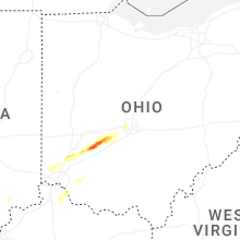


Connect with Interactive Hail Maps