

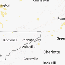
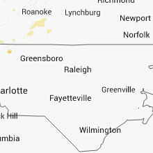
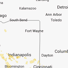
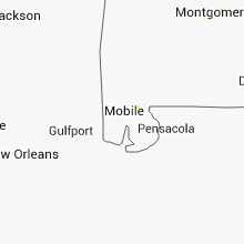
Hail Map for Saturday, August 31, 2013

Number of Impacted Households on 8/31/2013
0
Impacted by 1" or Larger Hail
0
Impacted by 1.75" or Larger Hail
0
Impacted by 2.5" or Larger Hail
Square Miles of Populated Area Impacted on 8/31/2013
0
Impacted by 1" or Larger Hail
0
Impacted by 1.75" or Larger Hail
0
Impacted by 2.5" or Larger Hail


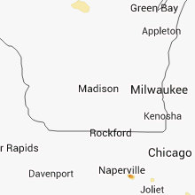


Cities Most Affected by Hail Storms of 8/31/2013
| Hail Size | Demographics of Zip Codes Affected | ||||||
|---|---|---|---|---|---|---|---|
| City | Count | Average | Largest | Pop Density | House Value | Income | Age |
| Sioux Falls, SD | 5 | 2.05 | 2.50 | 1005 | $79k | $32.6k | 34.1 |
| Montevideo, MN | 1 | 2.00 | 2.00 | 30 | $67k | $34.9k | 42.7 |
| Neche, ND | 1 | 1.75 | 1.75 | 4 | $42k | $41.4k | 40.1 |
| Wabasso, MN | 1 | 1.75 | 1.75 | 11 | $52k | $37.0k | 44.3 |
| Grenville, SD | 1 | 1.75 | 1.75 | 6 | $18k | $20.5k | 58.4 |
| North Platte, NE | 1 | 1.75 | 1.75 | 50 | $79k | $36.3k | 38.7 |
| New Effington, SD | 1 | 1.75 | 1.75 | 3 | $22k | $33.5k | 42.5 |
Hail and Wind Damage Spotted on 8/31/2013
Filter by Report Type:Hail ReportsWind Reports
States Impacted
Ohio, Kentucky, Illinois, West Virginia, South Carolina, Massachusetts, Pennsylvania, North Carolina, South Dakota, Minnesota, Virginia, Florida, Indiana, Arkansas, North Dakota, Texas, Colorado, Missouri, Tennessee, Kansas, Nebraska, Iowa, WisconsinOhio
| Local Time | Report Details |
|---|---|
| 8:00 AM EDT | Trees and limbs down. time estimate in clermont county OH, 17.5 miles E of Cincinnati, OH |
| 8:05 AM EDT | Power poles reported down in williamsburg township. time estimate in clermont county OH, 24.8 miles E of Cincinnati, OH |
| 8:07 AM EDT | Tree down on oakland road in brown county OH, 32.8 miles ESE of Cincinnati, OH |
| 8:23 AM EDT | Trees reported down in area between sardinia and winch in brown county OH, 42.7 miles ESE of Cincinnati, OH |
| 5:04 PM EDT | A large tree was downed due to thunderstorm wind in butler county OH, 18.4 miles NNW of Cincinnati, OH |
| 5:27 PM EDT | Half of a tree was down due to thunderstorm wind in butler county OH, 14.1 miles N of Cincinnati, OH |
| 5:45 PM EDT | Multiple trees and power lines were downed in the central part of the county due to thunderstorm wind in hamilton county OH, 8.6 miles N of Cincinnati, OH |
Kentucky
| Local Time | Report Details |
|---|---|
| 9:55 AM EDT | Trees down along old oxford road in scott county KY, 45.6 miles NW of Irvine, KY |
| 9:55 AM EDT | Trees down in scott county KY, 45.6 miles NW of Irvine, KY |
| 10:15 AM EDT | Trees down in fayette county KY, 32.4 miles NW of Irvine, KY |
| 10:34 AM EDT | Roof partially removed from trailer on lisle rd near fayette-scott line in fayette county KY, 43.2 miles NW of Irvine, KY |
| 11:04 AM EDT | Trees down along leestown rd...richmond rd....and spindletop rd in fayette county KY, 35.4 miles NW of Irvine, KY |
| 11:04 AM EDT | Trees down along leestown rd...richmond rd....and spindletop rd in fayette county KY, 35.4 miles NW of Irvine, KY |
| 11:18 AM EDT | Dispatch reports large limbs down on highway 13 in magoffin county KY, 45.5 miles E of Irvine, KY |
| 11:30 AM EDT | Large limbs down on highway 7 at royalto in magoffin county KY, 52.3 miles E of Irvine, KY |
| 3:35 PM EDT | One tree dow in shelby county KY, 26.3 miles ENE of Louisville, KY |
| 3:45 PM EDT | Few trees dow in oldham county KY, 33.8 miles NNE of Louisville, KY |
| 3:45 PM EDT | Trees and power poles down on hwy 146 between buckner and la grang in oldham county KY, 33.8 miles NNE of Louisville, KY |
| 3:50 PM EDT | Three trees dow in shelby county KY, 29.4 miles ENE of Louisville, KY |
| 4:35 PM EDT | Few trees dow in garrard county KY, 33.6 miles W of Irvine, KY |
| 4:43 PM EDT | Trees down two miles east of the cit in scott county KY, 46.7 miles NW of Irvine, KY |
| 5:04 PM EDT | Tree dow in taylor county KY, 48.4 miles SSE of Louisville, KY |
| 5:10 PM EDT | Trees down in fayette county KY, 35.4 miles NW of Irvine, KY |
| 5:26 PM EDT | 3 trees down. one fell along hummel road. one fell along lake linville road. one fell along east fork skegg creek road. all of these were within a couple of miles of mo in rockcastle county KY, 30.9 miles SW of Irvine, KY |
| 5:48 PM EDT | A tree fell on a house near alexandria due to thunderstorm wind in campbell county KY, 12.1 miles SSE of Cincinnati, OH |
| 6:06 PM EDT | Several trees were downed in the southern portions of campbell county due to thunderstorm wind in campbell county KY, 18.6 miles SE of Cincinnati, OH |
| 6:08 PM EDT | Numerous trees down on hazel patch roa in laurel county KY, 33.9 miles SSW of Irvine, KY |
| 7:05 PM EDT | Numerous limbs down at 35 mckee lan in pulaski county KY, 61 miles SSW of Irvine, KY |
| 6:13 PM CDT | Trees reported down in the city in russell county KY, 73.5 miles SSE of Louisville, KY |
| 6:20 PM CDT | Trees reported down in the cit in russell county KY, 77.4 miles SSE of Louisville, KY |
| 7:30 PM EDT | 3 trees down near somerse in pulaski county KY, 55.2 miles SW of Irvine, KY |
| 8:05 PM EDT | Corner of old henry road and evergreen road trees and power lines down in jefferson county KY, 20.4 miles NNE of Louisville, KY |
| 12:34 AM CDT | Several tree limbs reported down along with a few power outage in daviess county KY, 28.5 miles ESE of Evansville, IN |
| 12:40 AM CDT | Storm damage reported in mclean county KY, 29.8 miles SSE of Evansville, IN |
| 12:50 AM CDT | Tree down in hancock county KY, 45.6 miles ESE of Evansville, IN |
| 1:24 AM CDT | A few trees down with one of them on a powerline. also...a few trees down in greenville in muhlenberg county KY, 46.5 miles SSE of Evansville, IN |
Illinois
| Local Time | Report Details |
|---|---|
| 11:22 AM CDT | Quarter sized hail reported near Sandwich, IL, 53.5 miles WSW of Chicago, IL |
| 11:22 AM CDT | Ping Pong Ball sized hail reported near Sandwich, IL, 53.5 miles WSW of Chicago, IL, hail ranged from quarter to ping pong ball size hail for 3 to 4 minutes. |
| 11:30 AM CDT | Quarter sized hail reported near Sandwich, IL, 53.2 miles WSW of Chicago, IL |
| 5:58 PM CDT | Storm damage reported in vermilion county IL, 45.4 miles NE of Mattoon, IL |
| 5:58 PM CDT | Grain silo destroyed approximately 1 mile north of jamaica on 600 east roa in vermilion county IL, 47.1 miles NE of Mattoon, IL |
| 6:06 PM CDT | Trees and powerlines dow in vermilion county IL, 41.8 miles NE of Mattoon, IL |
| 6:08 PM CDT | Trees were blown down in indianol in vermilion county IL, 45.9 miles NE of Mattoon, IL |
| 8:10 PM CDT | Storm damage reported in bond county IL, 46.8 miles ENE of Saint Louis, MO |
| 8:38 PM CDT | Storm damage reported in st. clair county IL, 4.2 miles SE of Saint Louis, MO |
| 9:20 PM CDT | Large trees uprooted... power lines downed... several roads blocked due to debris. time estimated from rada in bond county IL, 35.6 miles ENE of Saint Louis, MO |
| 9:25 PM CDT | 12 inch tree limb down across long leaf lan in clay county IL, 54.2 miles S of Mattoon, IL |
| 9:28 PM CDT | 5 inch tree limb over hwy 4 in clay county IL, 54.9 miles S of Mattoon, IL |
| 11:30 PM CDT | Storm damage reported in white county IL, 29.8 miles WNW of Evansville, IN |
| 11:55 PM CDT | Several trees down and power outages in the greater evansville are in randolph county IL, 39.9 miles SSE of Saint Louis, MO |
West Virginia
| Local Time | Report Details |
|---|---|
| 2:00 PM EDT | Quarter sized hail reported near Lindside, WV, 42.2 miles WNW of Roanoke, VA |
South Carolina
| Local Time | Report Details |
|---|---|
| 2:15 PM EDT | Tree blown down on mccall driv in oconee county SC, 26.9 miles WSW of Greenville, SC |
| 2:15 PM EDT | Tree down on intersection of rocky knoll road and lusk roa in oconee county SC, 28.5 miles W of Greenville, SC |
| 2:15 PM EDT | Power lines blown down on marino lan in oconee county SC, 23.9 miles W of Greenville, SC |
| 3:50 PM EDT | Tree down on vera circle near galewood driv in greenville county SC, 20.1 miles ENE of Greenville, SC |
| 3:56 PM EDT | Tree in roadway on boiling springs road near devenger roa in greenville county SC, 18.4 miles E of Greenville, SC |
Massachusetts
| Local Time | Report Details |
|---|---|
| 3:40 PM EDT | Multiple trees downed...several on houses in franklin county MA, 70 miles ESE of Schenectady, NY |
| 3:40 PM EDT | Trees and wires down on numerous street in franklin county MA, 70 miles ESE of Schenectady, NY |
| 3:40 PM EDT | Trees and wires down on numerous streets in nw greenfield in franklin county MA, 70 miles ESE of Schenectady, NY |
| 3:40 PM EDT | Utility pole down at country club on barton rd in franklin county MA, 70 miles ESE of Schenectady, NY |
| 3:40 PM EDT | Utility pole down at country club on bbarton rd in franklin county MA, 70 miles ESE of Schenectady, NY |
| 3:40 PM EDT | Wires down on plain rd. several trees downed on leyden rd and on south green river rd at nelson r in franklin county MA, 70 miles ESE of Schenectady, NY |
| 3:40 PM EDT | Trees and wires down on smeadhill rd in franklin county MA, 66.2 miles ESE of Schenectady, NY |
Pennsylvania
| Local Time | Report Details |
|---|---|
| 3:58 PM EDT | Trees down on new york ave... pine street... chase av in susquehanna county PA, 38.2 miles N of Scranton, PA |
| 6:15 PM EDT | Multiple trees down in clarion county PA, 60.5 miles NE of Pittsburgh, PA |
| 8:08 PM EDT | Limbs reported dow in tioga county PA, 78.5 miles WNW of Scranton, PA |
| 8:08 PM EDT | Trees down along route 6 between mansfield and wellsbor in tioga county PA, 78.5 miles WNW of Scranton, PA |
North Carolina
| Local Time | Report Details |
|---|---|
| 4:00 PM EDT | The yadkin county sheriffs office reported that a large tree was blown down across highway 601 near the intersection with patterson mill roa in yadkin county NC, 67.9 miles N of Charlotte, NC |
| 4:03 PM EDT | Several trees blown down along route 601 in surry county NC, 67.1 miles SSW of Roanoke, VA |
| 4:10 PM EDT | Tree blown down on cove road in rutherford county NC, 53.9 miles NNE of Greenville, SC |
| 4:12 PM EDT | Tree blown down on owens chapel roa in rutherford county NC, 57.8 miles NE of Greenville, SC |
| 4:44 PM EDT | Several trees blown down across the cit in cleveland county NC, 40 miles W of Charlotte, NC |
South Dakota
| Local Time | Report Details |
|---|---|
| 3:15 PM CDT | Quarter sized hail reported near Roslyn, SD, 49 miles E of Aberdeen, SD, roslyn fire department reported quarter sized hail on hwy 25 north of roslyn |
| 3:41 PM CDT | Golf Ball sized hail reported near New Effington, SD, 67.6 miles S of Fargo, ND, resident reported golf ball sized hail as the storm moved through |
| 3:41 PM CDT | Golf Ball sized hail reported near Grenville, SD, 61.3 miles E of Aberdeen, SD, golf ball sized hail as storm moved through |
| 4:50 PM CDT | Measured at summit rwis site in grant county SD, 69.9 miles WNW of Montevideo, MN |
| 9:47 PM CDT | Quarter sized hail reported near Hartford, SD, 13.8 miles WNW of Sioux Falls, SD |
| 10:06 PM CDT | Tennis Ball sized hail reported near Sioux Falls, SD, 1 miles WSW of Sioux Falls, SD |
| 10:08 PM CDT | Quarter sized hail reported near Sioux Falls, SD, 1 miles WSW of Sioux Falls, SD |
| 10:08 PM CDT | Quarter sized hail reported near Sioux Falls, SD, 2 miles W of Sioux Falls, SD |
| 10:08 PM CDT | *** 1 inj *** roof damage to the local target store and front door damage to an adjacent retail store. several cars were damaged in the parking lot by large in minnehaha county SD, 3.1 miles SW of Sioux Falls, SD |
| 10:08 PM CDT | A 20 foot retaining wall collapsed on east portion of empire mal in minnehaha county SD, 3.1 miles SW of Sioux Falls, SD |
| 10:08 PM CDT | An 18 inch in diameter tree knocked over near the intersection of louise and 49th streets blocking traffi in minnehaha county SD, 3.1 miles SW of Sioux Falls, SD |
| 10:08 PM CDT | Front doors blown in at local target stor in minnehaha county SD, 3.1 miles SW of Sioux Falls, SD |
| 10:08 PM CDT | Outdoor canopy style tent destroyed and mangled in the parking lot of the empire mal in minnehaha county SD, 3.1 miles SW of Sioux Falls, SD |
| 10:08 PM CDT | Roof damage to the local target store and front door damage to an adjacent retail stor in minnehaha county SD, 3.1 miles SW of Sioux Falls, SD |
| 10:10 PM CDT | Quarter sized hail reported near Sioux Falls, SD, 2 miles W of Sioux Falls, SD |
| 10:10 PM CDT | Tennis Ball sized hail reported near Sioux Falls, SD, 1 miles WSW of Sioux Falls, SD |
| 10:15 PM CDT | 5 huge evergreens trees uprooted and fence blown down in lincoln county SD, 3.1 miles S of Sioux Falls, SD |
| 10:16 PM CDT | Golf Ball sized hail reported near Sioux Falls, SD, 0.4 miles S of Sioux Falls, SD, downtown sioux falls area |
| 10:16 PM CDT | Half Dollar sized hail reported near Sioux Falls, SD, 1.7 miles S of Sioux Falls, SD |
| 10:16 PM CDT | Golf Ball sized hail reported near Sioux Falls, SD, 1.7 miles S of Sioux Falls, SD |
| 10:17 PM CDT | Quarter sized hail reported near Sioux Falls, SD, 1.7 miles S of Sioux Falls, SD |
| 10:17 PM CDT | 4 inch and larger tree limbs down at 49th and oxbow in minnehaha county SD, 3.1 miles SW of Sioux Falls, SD |
| 10:25 PM CDT | Golf Ball sized hail reported near Sioux Falls, SD, 0.4 miles S of Sioux Falls, SD, downtown sioux falls area |
Minnesota
| Local Time | Report Details |
|---|---|
| 3:24 PM CDT | Very strong winds and pea sized hail reported on the north shore of blackduck lak in beltrami county MN, 22.3 miles NE of Bemidji, MN |
| 3:30 PM CDT | Shingles blown off of multiple structures. steeple blown off of church. peak winds estimated to 75 mp in beltrami county MN, 23.5 miles NE of Bemidji, MN |
| 3:30 PM CDT | Multiple reports of trees down in tow in beltrami county MN, 23.5 miles NE of Bemidji, MN |
| 3:30 PM CDT | Shingles blown off of multiple structures. steeple blown off of churc in beltrami county MN, 23.5 miles NE of Bemidji, MN |
| 3:34 PM CDT | A few trees down at residence with estimated pea-size hail. time estimated from rada in beltrami county MN, 27.9 miles NE of Bemidji, MN |
| 3:40 PM CDT | A few trees down at residence with estimated pea-size hail. time estimated from rada in beltrami county MN, 27.1 miles NE of Bemidji, MN |
| 3:50 PM CDT | 15 inch diameter elm tree broken near bas in itasca county MN, 33.1 miles ENE of Bemidji, MN |
| 3:54 PM CDT | Shingles blown off of multiple structures. steeple blown off of churc in beltrami county MN, 23.5 miles NE of Bemidji, MN |
| 3:57 PM CDT | Tree down blocking northbound lane of mn-46. time estimated by rada in itasca county MN, 38.3 miles E of Bemidji, MN |
| 4:05 PM CDT | Mn dot rwis -- wind measurement suspect in wilkin county MN, 36.5 miles SE of Fargo, ND |
| 4:05 PM CDT | Peak winds measured at the mn dot rwis site along interstate 9 in wilkin county MN, 34.6 miles SE of Fargo, ND |
| 4:08 PM CDT | Trees and branches down in residents yard... strong winds with onset of storm in traverse county MN, 70.5 miles NNW of Montevideo, MN |
| 4:18 PM CDT | Storm damage reported in otter tail county MN, 53.3 miles SE of Fargo, ND |
| 4:18 PM CDT | Peak winds measured at the fergus falls airport awo in otter tail county MN, 51 miles SE of Fargo, ND |
| 4:27 PM CDT | Quarter sized hail reported near Herman, MN, 62.7 miles NNW of Montevideo, MN, 40 to 50 mph wind accompanied the hail. |
| 4:28 PM CDT | Several large 3 to 4 inch diameter tree branches broken down in otter tail county MN, 51.6 miles SE of Fargo, ND |
| 4:30 PM CDT | At prairie wetland center in otter tail county MN, 55 miles SE of Fargo, ND |
| 4:30 PM CDT | 2 pontoons on sea legs flipped over on lake minnewaska in pope county MN, 51 miles NNE of Montevideo, MN |
| 4:31 PM CDT | Half Dollar sized hail reported near Ortonville, MN, 39.6 miles NW of Montevideo, MN, storm chaser called in with report of half dollar sized hail ongoing |
| 4:34 PM CDT | Half Dollar sized hail reported near Wendell, MN, 66.3 miles SSE of Fargo, ND |
| 4:40 PM CDT | Trees blown down and twisted off. several small sheds or fish houses blown over and at least one heavily damaged between wall lake and bass lake area in otter tail county MN, 59.4 miles SE of Fargo, ND |
| 4:40 PM CDT | Trees blown down and twisted off. fish houses blown over and one heavily damage in otter tail county MN, 53.9 miles SE of Fargo, ND |
| 4:40 PM CDT | 12 inch diameter tree fell into power in itasca county MN, 64.9 miles ESE of Bemidji, MN |
| 4:48 PM CDT | Quarter sized hail reported near Appleton, MN, 16.9 miles WNW of Montevideo, MN, ground almost completely covered with hail. |
| 4:50 PM CDT | Quarter sized hail reported near Milan, MN, 14.4 miles NW of Montevideo, MN |
| 4:50 PM CDT | Trees blown down and twisted off. fish houses blown over and one heavily damage in otter tail county MN, 53.9 miles SE of Fargo, ND |
| 5:05 PM CDT | Few trees down in the area. time estimated from rada in otter tail county MN, 75.6 miles SE of Fargo, ND |
| 5:05 PM CDT | Quarter sized hail reported near Montevideo, MN, 6.8 miles N of Montevideo, MN |
| 5:07 PM CDT | Trees being twisted by wind in douglas county MN, 77.7 miles N of Montevideo, MN |
| 5:15 PM CDT | At highway 212 and 110th street in renville county MN, 26.4 miles ESE of Montevideo, MN |
| 5:15 PM CDT | Numerous six inch branches down around clontar in swift county MN, 28.9 miles N of Montevideo, MN |
| 5:15 PM CDT | Hen Egg sized hail reported near Montevideo, MN, 2.6 miles N of Montevideo, MN |
| 5:22 PM CDT | At the airport in pope county MN, 51 miles NNE of Montevideo, MN |
| 5:25 PM CDT | Few large branches down. time estimated based on radar and other nearby report in pope county MN, 56.4 miles NNE of Montevideo, MN |
| 5:30 PM CDT | 3-4 inch branches down in pope county MN, 58.3 miles NNE of Montevideo, MN |
| 5:37 PM CDT | Measured by mndot site along i-9 in stearns county MN, 65.7 miles NE of Montevideo, MN |
| 5:37 PM CDT | Storm damage reported in stearns county MN, 65.8 miles NE of Montevideo, MN |
| 5:37 PM CDT | Tree down blocking mn- in cass county MN, 61.9 miles SE of Bemidji, MN |
| 5:41 PM CDT | Mn dot rwis in kittson county MN, 66.7 miles W of Roseau, MN |
| 5:41 PM CDT | Peak wind measured at the mndot rwis site located along highway 17 in kittson county MN, 66.4 miles W of Roseau, MN |
| 5:59 PM CDT | Tree down in hill city causing power outage. time estimated by rada in aitkin county MN, 68.8 miles ESE of Bemidji, MN |
| 6:15 PM CDT | Mn dot rwis in kittson county MN, 56 miles WSW of Roseau, MN |
| 6:15 PM CDT | Peak wind measured at the mndot rwis site located along highway 1 in kittson county MN, 56 miles WSW of Roseau, MN |
| 6:15 PM CDT | Mn dot rwis in kittson county MN, 56.8 miles WSW of Roseau, MN |
| 6:15 PM CDT | At highway 212 and 110th street in renville county MN, 26.4 miles ESE of Montevideo, MN |
| 6:15 PM CDT | Tree down on highway 212 in sacred heart. tree has since been remove in renville county MN, 21.6 miles ESE of Montevideo, MN |
| 6:18 PM CDT | Large branches down...4 to 6 inches in diamete in renville county MN, 22.2 miles ESE of Montevideo, MN |
| 6:35 PM CDT | A few large 4 to 6 inch diameter tree limbs snapped... along with hail up to nickel siz in kittson county MN, 39.7 miles WSW of Roseau, MN |
| 6:36 PM CDT | Ping Pong Ball sized hail reported near Marshall, MN, 34 miles S of Montevideo, MN |
| 6:38 PM CDT | Quarter sized hail reported near Marshall, MN, 34.8 miles S of Montevideo, MN |
| 6:38 PM CDT | Half Dollar sized hail reported near Marshall, MN, 34.8 miles S of Montevideo, MN |
| 6:47 PM CDT | Storm damage reported in redwood county MN, 41.3 miles SE of Montevideo, MN |
| 7:05 PM CDT | Golf Ball sized hail reported near Wabasso, MN, 45.1 miles SSE of Montevideo, MN |
| 7:30 PM CDT | Tree down at campground along canadian border in roseau county MN, 22.2 miles ENE of Roseau, MN |
| 7:53 PM CDT | Quarter sized hail reported near Ponsford, MN, 41.5 miles SW of Bemidji, MN, picture on facebook from tamarac resort at round lake |
| 7:56 PM CDT | A few 3 to 5 inch diameter branches down. pea to dime size hail lasted about 5 minutes. time estimated from rada in beltrami county MN, 41.2 miles SSE of Roseau, MN |
| 7:56 PM CDT | Few branches down. pea to dime size hail lasted about 5 minutes. time estimated from rada in beltrami county MN, 41.2 miles SSE of Roseau, MN |
| 8:00 PM CDT | Tree down at arnesens rocky point resort in lake of the woods county MN, 37.7 miles ENE of Roseau, MN |
| 8:30 PM CDT | Power pole blown down by wind in nicollet county MN, 56.4 miles SW of Minneapolis, MN |
| 8:48 PM CDT | Quarter sized hail reported near Edgerton, MN, 37.8 miles ENE of Sioux Falls, SD, ground is white |
| 10:45 PM CDT | Quarter sized hail reported near Jeffers, MN, 66.7 miles SSE of Montevideo, MN, hail completely covering the ground around town. |
Virginia
| Local Time | Report Details |
|---|---|
| 4:32 PM EDT | Tree down blocking traffic near intersection of garth rd and quail hollow ln in albemarle county VA, 65 miles NW of Richmond, VA |
| 4:43 PM EDT | Tree down blocking traffic at garth and barracks rd in albemarle county VA, 62 miles NW of Richmond, VA |
| 4:55 PM EDT | Tree down blocking traffic at 100 block monticello rd downtown in city of charlottes county VA, 58.1 miles NW of Richmond, VA |
| 4:55 PM EDT | Tree down blocking traffic in city of charlottes county VA, 58.1 miles NW of Richmond, VA |
| 5:12 PM EDT | Numerous trees down along callaway rd and grassy hill rd in franklin county VA, 16 miles S of Roanoke, VA |
| 6:00 PM EDT | Trees down on old lynchburg rd near rivanna rifle and pistol club in albemarle county VA, 58.8 miles WNW of Richmond, VA |
| 6:20 PM EDT | Trees down closing rd on 1600 block of secretarys rd near intersections of presidents and blenheim in albemarle county VA, 53.8 miles WNW of Richmond, VA |
| 6:20 PM EDT | Trees down blocking roadway at 1000 block of secretarys rd in albemarle county VA, 53.9 miles WNW of Richmond, VA |
| 6:42 PM EDT | Tree down on powerlines and blocking road 5300 secretarys sand rd in albemarle county VA, 58.4 miles WNW of Richmond, VA |
Florida
| Local Time | Report Details |
|---|---|
| 4:40 PM EDT | Emergency management reported 4 tents and audio equipment destroyed by strong winds at palm coast wine festiva in flagler county FL, 64.1 miles SSE of Jacksonville, FL |
Indiana
| Local Time | Report Details |
|---|---|
| 4:40 PM EDT | Jefferson county emergency manager reported damage to shingles and siding of a home...a few heavy metal objects thrown 500-600 feet...and trees down near the intersecti in jefferson county IN, 56.3 miles NNE of Louisville, KY |
| 5:25 PM EDT | Trees down nw-ne part of county in franklin county IN, 45.7 miles NW of Cincinnati, OH |
| 5:30 PM EDT | Quarter sized hail reported near Indianapolis, IN, 9.8 miles WNW of Indianapolis, IN |
| 6:17 PM EDT | Storm damage reported in putnam county IN, 35.1 miles W of Indianapolis, IN |
| 6:17 PM EDT | Trees and power lines down in putnam county IN, 35.1 miles W of Indianapolis, IN |
| 7:24 PM EDT | Trees down and blocking road in vermillion county IN, 58.4 miles ENE of Mattoon, IL |
| 12:10 AM EDT | Trees down on old hwy 41 north of vincennes and south of oaktown in knox county IN, 52.8 miles N of Evansville, IN |
| 12:12 AM EDT | Limbs down in knox county IN, 48.6 miles N of Evansville, IN |
| 12:15 AM EDT | Tree down at camp arthur rd and smith rd. also some utility lines down around the county in knox county IN, 48.6 miles N of Evansville, IN |
| 11:34 PM CDT | Numerous large limbs dow in gibson county IN, 26.4 miles N of Evansville, IN |
| 11:55 PM CDT | Several trees down and power outages in the greater evansville are in vanderburgh county IN, 1.3 miles E of Evansville, IN |
Arkansas
| Local Time | Report Details |
|---|---|
| 4:00 PM CDT | A couple trees were downed just north of de queen which downed power line in sevier county AR, 29.3 miles WNW of Nashville, AR |
| 4:52 PM CDT | Power lines down around centerville...with over 1000 customers without powe in yell county AR, 56.9 miles WNW of Little Rock, AR |
North Dakota
| Local Time | Report Details |
|---|---|
| 5:30 PM CDT | Quarter sized hail reported near Walhalla, ND, 75.3 miles NE of Devils Lake, ND |
| 5:40 PM CDT | Golf Ball sized hail reported near Neche, ND, 80 miles W of Roseau, MN |
Texas
| Local Time | Report Details |
|---|---|
| 6:25 PM CDT | Tree down southeast of winnsboro along hwy 852e and cr 449 in wood county TX, 90.4 miles WNW of Shreveport, LA |
Colorado
| Local Time | Report Details |
|---|---|
| 5:45 PM MDT | Quarter sized hail reported near Vona, CO, 48.2 miles S of Yuma, CO, broken windows in home |
| 7:38 PM MDT | Storm damage reported in cheyenne county CO, 80.6 miles WSW of Colby, KS |
| 7:45 PM MDT | Large tree about 18 ft long down and blocking part of the road at the intersection of s 2nd and 10th stree in cheyenne county CO, 80.6 miles WSW of Colby, KS |
Missouri
| Local Time | Report Details |
|---|---|
| 7:03 PM CDT | County dispatch had reports of trees and power lines downed in new haven. no specifics on tree limb siz in franklin county MO, 55.2 miles W of Saint Louis, MO |
| 7:24 PM CDT | County dispatch had reports of trees and power lines downed in new haven. no specifics on tree limb siz in franklin county MO, 55.2 miles W of Saint Louis, MO |
| 7:30 PM CDT | Tree approx 8 inch in diameter downed across road. winds estimated 50-60 mp in franklin county MO, 38.4 miles WSW of Saint Louis, MO |
| 7:47 PM CDT | Trees downed and power outages reported in the are in st. louis county MO, 16.4 miles WNW of Saint Louis, MO |
| 7:48 PM CDT | Power lines downed near st charles rock road and kohls department store. time estimated from rada in st. louis county MO, 15.9 miles NW of Saint Louis, MO |
| 7:55 PM CDT | Storm damage reported in st. louis county MO, 13 miles NW of Saint Louis, MO |
| 6:14 AM CDT | Damage to ongoing construction of hyvee gas station at intersection of faraon st and belt hwy. walls blown over. time estimated by radar...report relayed via twitter fr in buchanan county MO, 47.2 miles NNW of Kansas City, MO |
Tennessee
| Local Time | Report Details |
|---|---|
| 8:30 PM EDT | Few trees dow in scott county TN, 49.7 miles NW of Knoxville, TN |
| 9:25 PM EDT | Trees down along norris freeway near knox county lin in anderson county TN, 14.5 miles NNW of Knoxville, TN |
Kansas
| Local Time | Report Details |
|---|---|
| 8:55 PM CDT | Delayed report. several green trees also blown down. about 2-3ft in diamete in cheyenne county KS, 40.7 miles ESE of Yuma, CO |
| 9:13 PM MDT | Storm damage reported in greeley county KS, 58.9 miles NW of Garden City, KS |
| 4:15 AM CDT | Wind gusts estimated around 50 mph with small tree limbs down. pea size hail as wel in washington county KS, 51.9 miles NNW of Manhattan, KS |
| 4:30 AM CDT | Two large trees and numerous small limbs down. minor power outage from storm. delayed report. time estimated from rada in marshall county KS, 45.9 miles N of Manhattan, KS |
| 5:35 AM CDT | Several power poles and one tree reported blown down in the city of hiawath in brown county KS, 71.6 miles NE of Manhattan, KS |
Nebraska
| Local Time | Report Details |
|---|---|
| 9:13 PM CDT | Quarter sized hail reported near North Platte, NE, 5.1 miles N of North Platte, NE |
| 9:19 PM CDT | Half Dollar sized hail reported near North Platte, NE, 0.6 miles SW of North Platte, NE, west side of north platte...near buffalo road and phillip |
| 9:22 PM CDT | Ping Pong Ball sized hail reported near North Platte, NE, 0.6 miles SW of North Platte, NE, hail nearly covering the ground. |
| 9:22 PM CDT | Golf Ball sized hail reported near North Platte, NE, 0.6 miles SW of North Platte, NE, hail nearly covering the ground. |
| 12:36 AM CDT | Photo received via facebook of a large part of a tree that broke off the trunk. the diameter of the multi-branch portion that broke off was estimated at 15 inches. the in phelps county NE, 64.1 miles WSW of Grand Island, NE |
| 12:53 AM CDT | Trees down blocking u.s. 77. also trees down along k ave. shingles off homes in thursto in thurston county NE, 74.6 miles NNW of Omaha, NE |
| 2:45 AM CDT | Empty grain bin lifted and rolled across road. lean-to shed destroyed. estimated winds 75 mp in washington county NE, 18.8 miles NW of Omaha, NE |
| 3:30 AM CDT | Large branch down blocking road near 32nd and modification in sarpy county NE, 9.6 miles SSE of Omaha, NE |
| 4:18 AM CDT | Em reports large machine shed destroyed and blocking u.s. 77. as well as tree and power line damage. winds estimated at 70 mp in gage county NE, 59 miles N of Manhattan, KS |
| 5:05 AM CDT | Numerous tree branches and limbs blown dow in nemaha county NE, 65 miles SSE of Omaha, NE |
| 5:23 AM CDT | Storm damage reported in richardson county NE, 80.1 miles NE of Manhattan, KS |
Iowa
| Local Time | Report Details |
|---|---|
| 9:47 PM CDT | Quarter sized hail reported near Sibley, IA, 52.5 miles E of Sioux Falls, SD |
| 9:54 PM CDT | Storm damage reported in osceola county IA, 50.8 miles E of Sioux Falls, SD |
| 11:00 PM CDT | 6 to 12 inch diameter limbs down around tow in lyon county IA, 39.4 miles ESE of Sioux Falls, SD |
| 11:40 PM CDT | Tree brnaches knocked down in o'brien county IA, 47.5 miles NW of Storm Lake, IA |
| 12:15 AM CDT | Storm damage reported in sioux county IA, 44.6 miles WNW of Storm Lake, IA |
| 3:52 AM CDT | 35 foot tree 10 to 14 in diameter across rd near s 10th street in adel. time estimate in dallas county IA, 21.5 miles W of Des Moines, IA |
| 4:06 AM CDT | Dallas county sheriff reported a 12 to 14 inch diameter tree limb down in dallas center. sheriff estimated 40 to 50 mph wind gust did the damag in dallas county IA, 19.9 miles WNW of Des Moines, IA |
Wisconsin
| Local Time | Report Details |
|---|---|
| 5:24 AM CDT | Quarter sized hail reported near Owen, WI, 73.8 miles SW of Rhinelander, WI, ranged from 3/4 inch to 1 inch. |
Connect with Interactive Hail Maps