

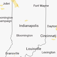
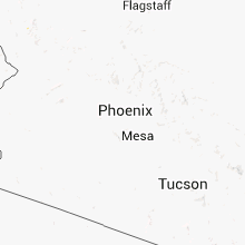
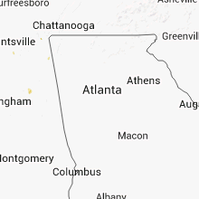
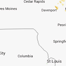
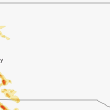
Hail Map for Friday, August 30, 2013

Number of Impacted Households on 8/30/2013
0
Impacted by 1" or Larger Hail
0
Impacted by 1.75" or Larger Hail
0
Impacted by 2.5" or Larger Hail
Square Miles of Populated Area Impacted on 8/30/2013
0
Impacted by 1" or Larger Hail
0
Impacted by 1.75" or Larger Hail
0
Impacted by 2.5" or Larger Hail


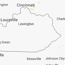


Cities Most Affected by Hail Storms of 8/30/2013
| Hail Size | Demographics of Zip Codes Affected | ||||||
|---|---|---|---|---|---|---|---|
| City | Count | Average | Largest | Pop Density | House Value | Income | Age |
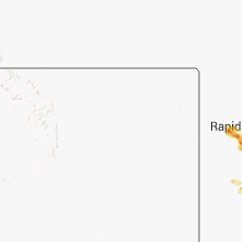
| Rapid City, SD | 6 | 2.04 | 2.75 | 170 | $98k | $40.4k | 38.8 |
| New Salem, ND | 2 | 2.50 | 3.00 | 3 | $52k | $30.0k | 46.7 |
| Mandan, ND | 2 | 2.50 | 3.00 | 38 | $83k | $39.5k | 37.6 |
| Sawyer, ND | 2 | 2.13 | 2.50 | 5 | $65k | $29.8k | 39.6 |
| Miles City, MT | 1 | 2.50 | 2.50 | 3 | $63k | $29.9k | 41.9 |
| Velva, ND | 1 | 2.50 | 2.50 | 5 | $54k | $31.7k | 42.2 |
| Glen Ullin, ND | 1 | 2.00 | 2.00 | 1 | $34k | $28.6k | 51.0 |
| Towner, ND | 1 | 1.75 | 1.75 | 1 | $31k | $28.0k | 48.1 |
| Zap, ND | 1 | 1.75 | 1.75 | 2 | $36k | $32.7k | 46.3 |
| Hay Springs, NE | 1 | 1.75 | 1.75 | 1 | $36k | $31.1k | 52.3 |
| Hermosa, SD | 1 | 1.75 | 1.75 | 3 | $127k | $35.4k | 44.4 |
| Beulah, ND | 1 | 1.75 | 1.75 | 10 | $66k | $43.3k | 45.6 |
| Douglas, ND | 1 | 1.75 | 1.75 | 1 | $34k | $31.7k | 48.0 |
| Max, ND | 1 | 1.75 | 1.75 | 2 | $32k | $29.8k | 38.1 |
Hail and Wind Damage Spotted on 8/30/2013
Filter by Report Type:Hail ReportsWind Reports
States Impacted
Michigan, South Dakota, Wisconsin, Nebraska, Illinois, North Dakota, Wyoming, Georgia, Nevada, Iowa, Indiana, Florida, Arizona, Montana, OhioMichigan
| Local Time | Report Details |
|---|---|
| 9:06 AM EDT | Quarter sized hail reported near Northport, MI, 24.9 miles N of Traverse City, MI, hail lasted just shy of 2 minutes. |
| 9:10 AM EDT | Ping Pong Ball sized hail reported near Northport, MI, 25.6 miles N of Traverse City, MI |
| 7:12 PM EDT | Powerlines reported downed in sanilac county MI, 51.6 miles ENE of Flint, MI |
| 7:12 PM EDT | Tree reported downed in sanilac county MI, 51.6 miles ENE of Flint, MI |
| 11:28 PM EDT | Powerline reported dow in wayne county MI, 58.7 miles SSE of Flint, MI |
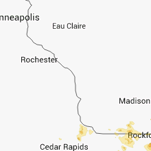
South Dakota
| Local Time | Report Details |
|---|---|
| 1:00 PM MDT | Quarter sized hail reported near Black Hawk, SD, 10.1 miles NW of Rapid City, SD |
| 1:42 PM MDT | Quarter sized hail reported near Black Hawk, SD, 6.5 miles NW of Rapid City, SD |
| 1:45 PM MDT | Baseball sized hail reported near Rapid City, SD, 6.9 miles W of Rapid City, SD, dented car and damaged shingles |
| 2:00 PM MDT | Quarter sized hail reported near Rapid City, SD, 3 miles WNW of Rapid City, SD, mostly hail with some rain. |
| 2:01 PM MDT | Ping Pong Ball sized hail reported near Rapid City, SD, 1.7 miles SSW of Rapid City, SD |
| 2:05 PM MDT | Ping Pong Ball sized hail reported near Rapid City, SD, 2.6 miles WSW of Rapid City, SD |
| 2:05 PM MDT | Ping Pong Ball sized hail reported near Rapid City, SD, 4 miles SSW of Rapid City, SD |
| 2:10 PM MDT | Ping Pong Ball sized hail reported near Rapid City, SD, 1 miles E of Rapid City, SD |
| 2:10 PM MDT | Golf Ball sized hail reported near Rapid City, SD, 2.1 miles WSW of Rapid City, SD |
| 2:10 PM MDT | Golf Ball sized hail reported near Rapid City, SD, 2.9 miles W of Rapid City, SD |
| 2:30 PM MDT | Ping Pong Ball sized hail reported near Rapid City, SD, 3.3 miles SE of Rapid City, SD |
| 2:30 PM MDT | Golf Ball sized hail reported near Rapid City, SD, 1 miles E of Rapid City, SD |
| 2:30 PM MDT | Hen Egg sized hail reported near Rapid City, SD, 2.4 miles SSE of Rapid City, SD |
| 2:33 PM MDT | Storm damage reported in pennington county SD, 4.2 miles S of Rapid City, SD |
| 2:35 PM MDT | Hen Egg sized hail reported near Rapid City, SD, 3.3 miles SE of Rapid City, SD |
| 3:10 PM MDT | Quarter sized hail reported near Hermosa, SD, 10.4 miles SE of Rapid City, SD |
| 3:35 PM MDT | Storm damage reported in custer county SD, 18.9 miles S of Rapid City, SD |
| 3:35 PM MDT | Golf Ball sized hail reported near Hermosa, SD, 21.1 miles SE of Rapid City, SD |
| 4:00 PM MDT | Quarter sized hail reported near Hermosa, SD, 28.6 miles SE of Rapid City, SD |
| 4:05 PM MDT | Quarter sized hail reported near Hermosa, SD, 33.3 miles SE of Rapid City, SD |
| 5:50 PM MDT | Storm damage reported in meade county SD, 66.7 miles NNE of Rapid City, SD |
| 6:00 PM MDT | Trees down at the hospital. time approximated from rada in shannon county SD, 81.1 miles SSE of Rapid City, SD |
| 6:00 PM MDT | Power lines down. roof damage at the wolf creek schoo in shannon county SD, 82.2 miles SSE of Rapid City, SD |
| 6:10 PM MDT | Storm damage reported in meade county SD, 66.7 miles NNE of Rapid City, SD |
Wisconsin
| Local Time | Report Details |
|---|---|
| 3:05 PM CDT | Quarter sized hail reported near Delafield, WI, 50.4 miles E of Madison, WI, via twitter |
| 3:15 PM CDT | Quarter sized hail reported near Hartland, WI, 54.7 miles E of Madison, WI |
| 3:15 PM CDT | Quarter sized hail reported near Hartland, WI, 52 miles E of Madison, WI |
| 3:15 PM CDT | Estimate wind gusts 55 to 60 mp in waukesha county WI, 49.9 miles E of Madison, WI |
| 3:16 PM CDT | Storm damage reported in waukesha county WI, 45.2 miles E of Madison, WI |
| 3:22 PM CDT | Storm damage reported in waukesha county WI, 58.2 miles E of Madison, WI |
| 3:23 PM CDT | Quarter sized hail reported near Hartland, WI, 52 miles E of Madison, WI |
| 3:24 PM CDT | 1 tree and large branches...estimated 60 mph wind gust in waukesha county WI, 51.8 miles E of Madison, WI |
| 3:36 PM CDT | Quarter sized hail reported near Hartland, WI, 54.1 miles E of Madison, WI |
| 3:46 PM CDT | Storm damage reported in walworth county WI, 55.9 miles ESE of Madison, WI |
| 4:00 PM CDT | Tree down on golf cours in waukesha county WI, 47 miles E of Madison, WI |
| 4:10 PM CDT | Multiple trees dow in walworth county WI, 53.7 miles ESE of Madison, WI |
| 4:23 PM CDT | Ping Pong Ball sized hail reported near Delavan, WI, 43 miles ESE of Madison, WI |
| 4:30 PM CDT | Damage to randall school roof allowed water to leak into building. time estimate in kenosha county WI, 55 miles NW of Chicago, IL |
| 4:40 PM CDT | Ping Pong Ball sized hail reported near Delavan, WI, 49.1 miles SE of Madison, WI |
| 4:40 PM CDT | Six inch tree across road in walworth county WI, 49.1 miles SE of Madison, WI |
| 4:45 PM CDT | Quarter sized hail reported near Delavan, WI, 49.1 miles SE of Madison, WI |
| 4:50 PM CDT | 20 ft tall large tree down in kenosha county WI, 53.1 miles NNW of Chicago, IL |
| 4:53 PM CDT | Quarter sized hail reported near Monroe, WI, 32.9 miles SSW of Madison, WI, near the airport |
Nebraska
| Local Time | Report Details |
|---|---|
| 3:22 PM MDT | Quarter sized hail reported near Bushnell, NE, 47.4 miles SSW of Scottsbluff, NE, estimated 75 mph winds as well. |
| 4:25 PM MDT | Ping Pong Ball sized hail reported near Gering, NE, 8.4 miles WSW of Scottsbluff, NE, half dollar to ping-pong ball size hail. |
| 5:00 PM MDT | Storm damage reported in dawes county NE, 72.4 miles NE of Scottsbluff, NE |
| 5:50 PM MDT | Estimated 60 mph wind gus in sheridan county NE, 75.6 miles NE of Scottsbluff, NE |
| 5:50 PM MDT | Golf Ball sized hail reported near Hay Springs, NE, 75.6 miles NE of Scottsbluff, NE, golf ball size hail lasted 15 to 20 minutes and was about 7 inches deep. windshield broken on car. |
| 6:10 PM MDT | Quarter sized hail reported near Rushville, NE, 76.7 miles NE of Scottsbluff, NE |
| 8:08 PM CDT | Quarter sized hail reported near North Platte, NE, 0.6 miles SW of North Platte, NE, quarter size hail reported by emergency manager on walker road and homestead. |
| 8:14 PM CDT | Half Dollar sized hail reported near North Platte, NE, 0.6 miles SW of North Platte, NE |
| 8:20 PM CDT | Estimated time of 820 pm cdt winds of 60 to 80 mph blew over tree in hayes county NE, 35.5 miles SSW of North Platte, NE |
| 7:55 PM MDT | Estimated wind speeds of 50 to 60 mph and big branches blown dow in hooker county NE, 43.3 miles NNW of North Platte, NE |
| 9:35 PM CDT | Storm damage reported in thomas county NE, 59.1 miles N of North Platte, NE |
Illinois
| Local Time | Report Details |
|---|---|
| 4:45 PM CDT | Quarter sized hail reported near Round Lake, IL, 42.1 miles NW of Chicago, IL |
| 4:53 PM CDT | Quarter sized hail reported near Grayslake, IL, 38.4 miles NNW of Chicago, IL, lake and washington. |
| 4:56 PM CDT | Grand ave and almond dr in lake county IL, 37.7 miles NNW of Chicago, IL |
| 4:59 PM CDT | Limbs and large trees blown down. via faceboo in boone county IL, 53 miles SE of Madison, WI |
| 5:00 PM CDT | 600 block stuart st. numerous branches dow in lake county IL, 38.4 miles NNW of Chicago, IL |
| 5:00 PM CDT | Quarter sized hail reported near Harvard, IL, 59.6 miles SE of Madison, WI |
| 5:05 PM CDT | Mutiple trees down at least 18 inches in diameter at the intersection of hammmond and seymour. report relayed by lake county em in lake county IL, 32.7 miles NW of Chicago, IL |
| 5:14 PM CDT | Mutiple trees down 12 inches in diameter at the intersection of deep lake road and route 13 in lake county IL, 43.5 miles NNW of Chicago, IL |
| 5:15 PM CDT | Power lines down. small trees down and large branches. scattered structural damag in lake county IL, 42.2 miles NNW of Chicago, IL |
| 5:20 PM CDT | Numerous trees down 20 plus near the intersection of route 45 and and w rollins road in gurne in lake county IL, 37.7 miles NNW of Chicago, IL |
| 5:21 PM CDT | Multiple trees down 12 inches in diameter plus at the intersection of route 45 and casey roa in lake county IL, 32.4 miles NNW of Chicago, IL |
| 5:26 PM CDT | A large tree fell on a ca in lake county IL, 38.4 miles NNW of Chicago, IL |
| 5:30 PM CDT | Storm damage reported in cook county IL, 20.4 miles WNW of Chicago, IL |
| 5:40 PM CDT | Two to three inch diameter tree limbs down near church and oriol in cook county IL, 13.5 miles NW of Chicago, IL |
| 5:45 PM CDT | 15inch diameter tree down on lake street east of butterfield r in lake county IL, 32.7 miles NW of Chicago, IL |
| 5:50 PM CDT | Estimated thunderstorm wind gust 60 to 70 mph. tree branches snapped. some street flooding. via faceboo in cook county IL, 10.9 miles WNW of Chicago, IL |
| 5:50 PM CDT | Three large trees down on homes in cook county IL, 12.1 miles NNW of Chicago, IL |
| 5:52 PM CDT | Storm damage reported in cook county IL, 11.8 miles NNW of Chicago, IL |
| 5:52 PM CDT | South evansto in cook county IL, 12.1 miles NNW of Chicago, IL |
| 5:56 PM CDT | Possible wall cloud northwest skokie. dempster and gross point roa in cook county IL, 12.1 miles NNW of Chicago, IL |
| 6:00 PM CDT | Large tree limbs down from from 1 inch to 8 inches in diameter down across edison park. multiple tree limbs split off from trees. some are blocking roads and have falle in cook county IL, 0.3 miles SSE of Chicago, IL |
| 6:02 PM CDT | Quarter sized hail reported near Park Ridge, IL, 13.8 miles NW of Chicago, IL, heavy rain too. |
| 6:09 PM CDT | At irving and north kostner avenue. dime sized hail. trees down and blinding rai in cook county IL, 0.3 miles SSE of Chicago, IL |
| 6:16 PM CDT | Quarter sized hail reported near Chicago, IL, 0.3 miles SSE of Chicago, IL, estimated 70 mph thunderstorm wind gust. montrose and lake shore drive. |
| 7:30 PM CDT | Extensive tree damage and cars damaged in cook county IL, 0.3 miles SSE of Chicago, IL |
| 7:32 PM CDT | Quarter sized hail reported near Freeport, IL, 55.4 miles SSW of Madison, WI |
| 7:35 PM CDT | Half Dollar sized hail reported near Freeport, IL, 55.4 miles SSW of Madison, WI, began at 734 |
| 7:36 PM CDT | Quarter sized hail reported near Freeport, IL, 55.4 miles SSW of Madison, WI, dime to quarter hail. |
| 7:44 PM CDT | Half Dollar sized hail reported near Freeport, IL, 55.4 miles SSW of Madison, WI, hail falling for 3 to 4 mintues at the time of the report. |
| 8:00 PM CDT | Quarter sized hail reported near Freeport, IL, 55.4 miles SSW of Madison, WI, hail was pea to quaater sized and began at 735 cdt. lasted for about 20 minutes. report received via espotter. |
| 9:40 PM CDT | Sheriff relayed a report from the public of damage to trees and crops near il-52 and il-23 north of ottaw in la salle county IL, 66.4 miles NE of Peoria, IL |
| 9:42 PM CDT | Trees were blown down in danville...200 people are without power...wind gusts were measured up to 51 mph on the northwest side of danvill in vermilion county IL, 60.7 miles NE of Mattoon, IL |
| 9:42 PM CDT | Trees were blown down in kickapoo state park...200 people are without power...wind gusts were measured up to 51 mp in vermilion county IL, 55.8 miles NE of Mattoon, IL |
| 9:45 PM CDT | 1 to 2 inch diameter limbs blown. rainfall 0.35 inches. time estimated from radar in whiteside county IL, 79.8 miles NNW of Peoria, IL |
| 9:45 PM CDT | 1 to 2 inch limbs blown. rainfall 0.35 inches. time estimated from radar in whiteside county IL, 79.8 miles NNW of Peoria, IL |
| 9:47 PM CDT | Trees were blown down in the leisure time estates near henning r in vermilion county IL, 58.6 miles NE of Mattoon, IL |
| 9:55 PM CDT | Storm damage reported in livingston county IL, 51.4 miles ENE of Peoria, IL |
North Dakota
| Local Time | Report Details |
|---|---|
| 4:43 PM MDT | Quarter sized hail reported near Hebron, ND, 66.7 miles WNW of Bismarck, ND |
| 6:00 PM CDT | Quarter sized hail reported near Hebron, ND, 57.3 miles W of Bismarck, ND |
| 6:30 PM CDT | Hen Egg sized hail reported near Glen Ullin, ND, 47.7 miles W of Bismarck, ND, hail lasted 20 to 25 mph. |
| 6:40 PM CDT | Half Dollar sized hail reported near Bottineau, ND, 59.2 miles NE of Minot, ND, hail lasted 20 minutes. |
| 6:40 PM CDT | Storm damage reported in bottineau county ND, 59.2 miles NE of Minot, ND |
| 7:00 PM CDT | Storm damage reported in bottineau county ND, 63.2 miles NE of Minot, ND |
| 7:10 PM CDT | Storm damage reported in bottineau county ND, 58.8 miles NE of Minot, ND |
| 7:10 PM CDT | Quarter sized hail reported near Bottineau, ND, 58.8 miles NE of Minot, ND |
| 7:10 PM CDT | Half Dollar sized hail reported near Bottineau, ND, 63.2 miles NE of Minot, ND |
| 7:12 PM CDT | Tea Cup sized hail reported near New Salem, ND, 30.1 miles W of Bismarck, ND |
| 7:15 PM CDT | Hen Egg sized hail reported near New Salem, ND, 34.3 miles WNW of Bismarck, ND, 1 to 2 inch hail. |
| 6:20 PM MDT | Golf Ball sized hail reported near Zap, ND, 62.8 miles SSW of Minot, ND, golf ball sized hail was reported. |
| 6:40 PM MDT | Golf Ball sized hail reported near Beulah, ND, 55.2 miles SSW of Minot, ND |
| 7:40 PM CDT | Late report from 8-30-13. pea to dime size hail accompanied the strong wind in rolette county ND, 70.4 miles NW of Devils Lake, ND |
| 7:45 PM CDT | Golf Ball sized hail reported near Douglas, ND, 27.7 miles SSW of Minot, ND, hail lasted 10 minutes. |
| 7:46 PM CDT | Ping Pong Ball sized hail reported near Douglas, ND, 27.7 miles SSW of Minot, ND |
| 7:52 PM CDT | Hen Egg sized hail reported near Mandan, ND, 17.2 miles W of Bismarck, ND, max hail size. average hail size was between one and two inches in diameter. |
| 8:07 PM CDT | Tea Cup sized hail reported near Mandan, ND, 13.9 miles W of Bismarck, ND |
| 8:15 PM CDT | Golf Ball sized hail reported near Max, ND, 19.1 miles S of Minot, ND, on highway 83. |
| 8:15 PM CDT | Tennis Ball sized hail reported near Sawyer, ND, 16.6 miles S of Minot, ND |
| 8:19 PM CDT | Quarter sized hail reported near Mandan, ND, 6.9 miles SW of Bismarck, ND, mandan airport. |
| 8:25 PM CDT | Golf Ball sized hail reported near Sawyer, ND, 21 miles SSE of Minot, ND |
| 8:30 PM CDT | Tennis Ball sized hail reported near Velva, ND, 18.3 miles ESE of Minot, ND, hail lasted 5 minutes. |
| 8:40 PM CDT | Half Dollar sized hail reported near Mandan, ND, 17 miles NW of Bismarck, ND, quarter to half dollar sized hail. 40 mph winds were also reported. |
| 8:40 PM CDT | Half Dollar sized hail reported near Mandan, ND, 20.2 miles NW of Bismarck, ND, quarter to half dollar sized hail. 40 mph winds were also reported. |
| 9:00 PM CDT | Quarter sized hail reported near Mandan, ND, 8.5 miles WNW of Bismarck, ND, penny to quarter sized hail with 0.33 inches of rain. hail lasted about 10 to 15 minutes. |
| 9:07 PM CDT | Half Dollar sized hail reported near Mandan, ND, 5.5 miles WNW of Bismarck, ND, near mandan highschool. |
| 9:09 PM CDT | Half Dollar sized hail reported near Mandan, ND, 7.4 miles WNW of Bismarck, ND, half dollar sized hail and 60 mph winds reported at truck stop along interstate 94 west of mandan. |
| 9:09 PM CDT | Half dollar sized hail and 60 mph winds reported at truck stop along interstate 94 west of manda in morton county ND, 7.4 miles WNW of Bismarck, ND |
| 9:10 PM CDT | Large hail accompanied the strong wind in burleigh county ND, 3.7 miles NE of Bismarck, ND |
| 9:10 PM CDT | Quarter sized hail reported near Bismarck, ND, 3.7 miles NE of Bismarck, ND |
| 9:15 PM CDT | Quarter sized hail reported near Rugby, ND, 38.6 miles E of Minot, ND |
| 9:18 PM CDT | Quarter sized hail reported near Bismarck, ND, 0.3 miles N of Bismarck, ND |
| 9:20 PM CDT | Quarter sized hail reported near Bismarck, ND, 0.3 miles N of Bismarck, ND, reported near the intersection of highway 83 and interstate 94. |
| 9:25 PM CDT | Quarter sized hail reported near Bismarck, ND, 6 miles ESE of Bismarck, ND, hail up to the size of quarters. lasted about 5 minutes. |
| 9:27 PM CDT | Quarter sized hail reported near Bismarck, ND, 8.5 miles E of Bismarck, ND, nickel to quarter sized hail. |
| 10:10 PM CDT | Ping Pong Ball sized hail reported near Towner, ND, 34.6 miles ENE of Minot, ND |
| 10:14 PM CDT | Golf Ball sized hail reported near Towner, ND, 42.2 miles ENE of Minot, ND, dime to golf ball sized hail. hail ongoing at the time of call. |
| 10:16 PM CDT | Quarter sized hail reported near Towner, ND, 42.6 miles ENE of Minot, ND, dime to quarter size hail at time of call. |
| 10:20 PM CDT | Quarter sized hail reported near Towner, ND, 41.7 miles ENE of Minot, ND, dime to quarter sized hail. lasted 5 minutes. |
Wyoming
| Local Time | Report Details |
|---|---|
| 4:53 PM MDT | Storm damage reported in sheridan county WY, 79.5 miles WNW of Gillette, WY |
Georgia
| Local Time | Report Details |
|---|---|
| 7:00 PM EDT | Multiple power lines and trees down at multiple locations. there were also power outages reporte in worth county GA, 58.5 miles W of Douglas, GA |
| 7:04 PM EDT | Tree limbs fell on power lines on mount zion roa in mitchell county GA, 54 miles N of Tallahassee, FL |
| 7:20 PM EDT | Trees down near hwy 4 in early county GA, 63.5 miles NNW of Tallahassee, FL |
| 7:20 PM EDT | Several trees reported down at the intersection of hwy 93 n and wilder r in grady county GA, 43.6 miles N of Tallahassee, FL |
| 7:30 PM EDT | One tree down near north early county line r in miller county GA, 61.5 miles NNW of Tallahassee, FL |
| 7:30 PM EDT | One tree down at intersection of u.s. hwy 19 and glasgow r in thomas county GA, 28.9 miles NE of Tallahassee, FL |
| 7:45 PM EDT | Numerous trees and power lines down across the c in miller county GA, 57 miles NNW of Tallahassee, FL |
| 9:10 PM EDT | One tree down at hwy 39 and kolomokee r in clay county GA, 73.7 miles SSE of Auburn, AL |
| 9:10 PM EDT | One tree down near kolomoki r in clay county GA, 81.9 miles NNW of Tallahassee, FL |
Nevada
| Local Time | Report Details |
|---|---|
| 4:30 PM PDT | Power was knocked in pioche due to a thunderstorm. one power pole was knocked down and fell on hous in lincoln county NV, 74 miles NW of Saint George, UT |
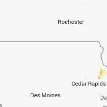
Iowa
| Local Time | Report Details |
|---|---|
| 7:00 PM CDT | Relayed a report of 5 power poles down along county highway x47. some damage to crops in the same area along with several branches dow in delaware county IA, 41.1 miles NE of Cedar Rapids, IA |
Indiana
| Local Time | Report Details |
|---|---|
| 7:04 PM CDT | Large tree dow in lake county IN, 35 miles SSE of Chicago, IL |
Florida
| Local Time | Report Details |
|---|---|
| 8:06 PM EDT | Central dispatch reported a tree down on cotton field lane in the white springs are in columbia county FL, 66 miles W of Jacksonville, FL |
| 8:45 PM EDT | Large oak tree down on route 59 and moccasin gap r in leon county FL, 10 miles NE of Tallahassee, FL |
| 9:00 PM EDT | Numerous trees and power lines down across the county. locations include but are not limited to centerville rd...killarney way...and e magnolia d in leon county FL, 0 miles ENE of Tallahassee, FL |
| 9:00 PM EDT | Tree down on foxcroft r in leon county FL, 1.9 miles NE of Tallahassee, FL |
| 9:00 PM EDT | Trees down and power outage near old saint augustine rd and apalachee pkw in leon county FL, 2.7 miles SE of Tallahassee, FL |
| 9:28 PM EDT | Tree blown down into a road near crawforville...has been removed alread in wakulla county FL, 18.7 miles SSW of Tallahassee, FL |
Arizona
| Local Time | Report Details |
|---|---|
| 5:10 PM MST | Trees down in the vicinity of priest and ray. curb to curb floodin in maricopa county AZ, 19.3 miles SE of Phoenix, AZ |
| 5:25 PM MST | Power poles down. meridian and apache trai in pinal county AZ, 30 miles E of Phoenix, AZ |
Montana
| Local Time | Report Details |
|---|---|
| 6:23 PM MDT | Quarter sized hail reported near Miles City, MT, 14.3 miles NW of Miles City, MT, spotter driving nw on highway 59 ran into 1 inch |
| 6:25 PM MDT | Quarter sized hail reported near Miles City, MT, 8.7 miles NW of Miles City, MT, 1 inch hail covering the ground along highway 59 |
| 6:32 PM MDT | Storm damage reported in custer county MT, 2.5 miles NW of Miles City, MT |
| 6:35 PM MDT | Tennis Ball sized hail reported near Miles City, MT, 3.8 miles NNW of Miles City, MT, damage to storage containers |
| 6:47 PM MDT | Quarter sized hail reported near Miles City, MT, 4.1 miles NE of Miles City, MT |
| 6:55 PM MDT | Half Dollar sized hail reported near Miles City, MT, 9.6 miles E of Miles City, MT |
| 7:27 PM MDT | Quarter sized hail reported near Miles City, MT, 28.6 miles ESE of Miles City, MT |
Ohio
| Local Time | Report Details |
|---|---|
| 1:36 AM EDT | A tree was reported down on a roa in ottawa county OH, 75.7 miles W of Cleveland, OH |
| 2:33 AM EDT | Storm damage reported in seneca county OH, 80.4 miles N of Columbus, OH |
| 2:36 AM EDT | Limbs dow in wood county OH, 88.1 miles ENE of Fort Wayne, IN |
| 7:57 AM EDT | Storm damage reported in clermont county OH, 15.9 miles E of Cincinnati, OH |
Connect with Interactive Hail Maps