

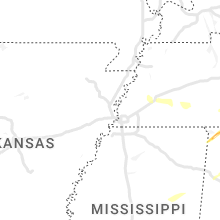
Hail Map for Thursday, January 12, 2023

Number of Impacted Households on 1/12/2023
0
Impacted by 1" or Larger Hail
0
Impacted by 1.75" or Larger Hail
0
Impacted by 2.5" or Larger Hail
Square Miles of Populated Area Impacted on 1/12/2023
0
Impacted by 1" or Larger Hail
0
Impacted by 1.75" or Larger Hail
0
Impacted by 2.5" or Larger Hail


Cities Most Affected by Hail Storms of 1/12/2023
| Hail Size | Demographics of Zip Codes Affected | ||||||
|---|---|---|---|---|---|---|---|
| City | Count | Average | Largest | Pop Density | House Value | Income | Age |
| Scooba, MS | 1 | 1.75 | 1.75 | 6 | $55k | $24.1k | 30.5 |
| Chelsea, AL | 1 | 1.75 | 1.75 | 210 | $175k | $58.7k | 36.3 |
Hail and Wind Damage Spotted on 1/12/2023
Filter by Report Type:Hail ReportsWind Reports
States Impacted
Kentucky, Mississippi, Ohio, Alabama, West Virginia, Tennessee, Georgia, North Carolina, Virginia, South Carolina, FloridaKentucky
| Local Time | Report Details |
|---|---|
| 6:30 AM CST | Damage to a few barns... a garage... grain bin... and light poles down on barren bailey roa in logan county KY, 54.7 miles N of Nashville, TN |
| 6:30 AM CST | Reports via social media of damage to a house and a grain bin destroye in logan county KY, 54.6 miles N of Nashville, TN |
| 6:44 AM CST | Quarter sized hail reported near Morgantown, KY, 68.6 miles N of Nashville, TN, estimated quarter (1.0 inch) sized hail fell at a construction company office building in sugar grove... ky. |
| 6:50 AM CST | Tree down on reedyville rd near the butler warren county line. time estimated based on radar dat in butler county KY, 68.9 miles SW of Louisville, KY |
| 6:52 AM CST | Tree down on ky-185 near the warren/butler county lin in warren county KY, 69.2 miles SSW of Louisville, KY |
| 8:12 AM EST | Tree down on old elizabethtown roa in larue county KY, 26.2 miles S of Louisville, KY |
| 7:19 AM CST | Tree down on old main st. time estimated from rada in hart county KY, 49.8 miles SSW of Louisville, KY |
| 7:25 AM CST | Tree down on boyds knob rd. time estimated based on rada in hart county KY, 49 miles S of Louisville, KY |
| 8:25 AM EST | Also trees down on st. thomas rd. and new haven rd. time estimated from rada in nelson county KY, 19.1 miles SE of Louisville, KY |
| 8:28 AM EST | Downed trees on loretto rd near willett distillery. time estimated from rada in nelson county KY, 19.7 miles SE of Louisville, KY |
| 8:30 AM EST | Trees down in raywic in marion county KY, 32.2 miles SSE of Louisville, KY |
| 8:35 AM EST | Report from k6i2 asos via nws chat of a wind gust of knot in washington county KY, 35.4 miles SE of Louisville, KY |
| 8:45 AM EST | Light poles and trees down on the intersection of williams street and main stree in henry county KY, 41.4 miles NE of Louisville, KY |
| 7:50 AM CST | Damage to a porch roof and playground occurred on atena grove church roa in green county KY, 46.2 miles S of Louisville, KY |
| 9:04 AM EST | Damage to many buildings and trees down in downtown harrodsbur in mercer county KY, 48.1 miles W of Irvine, KY |
| 9:04 AM EST | Damage to homes... barns... trees... and fences along portions of cornishville roa in mercer county KY, 47.9 miles ESE of Louisville, KY |
| 9:07 AM EST | Major damage to new garage... minor damage to barns... homes... and trees down near waterworks road outside of danvill in boyle county KY, 42 miles W of Irvine, KY |
| 9:15 AM EST | Tin roof peeled off a barn at the fairground in jessamine county KY, 33.9 miles WNW of Irvine, KY |
| 9:22 AM EST | Tree reported down across poor ridge pike near sad ln. time estimated based on rada in garrard county KY, 31.5 miles W of Irvine, KY |
| 9:23 AM EST | Roof damage to warehouse. time estimated from radar dat in grant county KY, 31.1 miles S of Cincinnati, OH |
| 9:35 AM EST | Via social media... images show a car flipped on its side... trees down along with roof and gutter damage on lakeridge drive in richmon in madison county KY, 20.4 miles WNW of Irvine, KY |
| 9:45 AM EST | Dispatcher reported a barn damaged on runyon grove rd. time estimated from rada in madison county KY, 15.3 miles WNW of Irvine, KY |
| 9:48 AM EST | Dispatcher reported several damage reports here. homes... trees... rvs. in the braemar dr... tazwell dr... and hoover circle area. time estimated based on rada in madison county KY, 15 miles WNW of Irvine, KY |
| 10:10 AM EST | Report of a tree down across ky-213 heading up furnace mt in powell county KY, 10.1 miles NE of Irvine, KY |
| 10:14 AM EST | Tree blown down during thunderstor in powell county KY, 14.5 miles NE of Irvine, KY |
| 9:30 AM CST | Quarter sized hail reported near Leitchfield, KY, 50.2 miles SW of Louisville, KY, quarter (1.0 inch) sized hail fell near a dollar general south of peonia. |
| 10:40 AM EST | Tree reported down across ky-2491 just east of campto in wolfe county KY, 25 miles E of Irvine, KY |
Mississippi
| Local Time | Report Details |
|---|---|
| 6:40 AM CST | Tree snapped. some roof and siding damage to a hospita in monroe county MS, 29 miles NNE of Starkville, MS |
| 6:45 AM CST | A vacant house was damaged near intersection of highways 45a and 25 in muldo in monroe county MS, 22.6 miles NNE of Starkville, MS |
| 6:45 AM CST | A vacant house was damaged near intersection of highways 45a and 25 in muldo in monroe county MS, 22.6 miles NNE of Starkville, MS |
| 7:27 AM CST | Trees down on robinson roa in leake county MS, 55.8 miles NE of Jackson, MS |
| 7:29 AM CST | Trees down on highway 488 near standing pin in leake county MS, 50.8 miles ENE of Jackson, MS |
| 8:15 AM CST | Corrects previous tstm wnd dmg report from 3 s preston. corrects previous tstm wnd dmg report from 3 s preston. tree down on a house on lynville road (493 in kemper county MS, 43.1 miles S of Starkville, MS |
| 8:18 AM CST | Corrects previous tstm wnd dmg report from 3 sse preston. trees down along highway 39 in kemper county MS, 43.1 miles S of Starkville, MS |
| 8:46 AM CST | Trees down along hwy 35... north of bassfiel in jefferson davis county MS, 60.6 miles SSE of Jackson, MS |
| 9:13 AM CST | Golf Ball sized hail reported near Scooba, MS, 51.5 miles SSE of Starkville, MS, golf ball size hail reported just south of scooba. |
| 10:15 AM CST | Corrects previous tstm wnd dmg report from 3 s preston. tree down on a house on lynville road (493 in kemper county MS, 43.1 miles S of Starkville, MS |
| 10:17 AM CST | Trees and powerlines down at the intersection of county road 10 and highway 1 in jasper county MS, 61.5 miles ESE of Jackson, MS |
| 10:18 AM CST | Trees down along highway 39 in kemper county MS, 43.1 miles S of Starkville, MS |
| 10:48 AM CST | Trees down along county road 6 east of highway 1 in jasper county MS, 78.8 miles ESE of Jackson, MS |
| 10:48 AM CST | Trees and powerlines down at the intersection of county road 10 and highway 1 in jasper county MS, 61.5 miles ESE of Jackson, MS |
| 10:52 AM CST | Corrects previous tstm wnd dmg report from 4 se heidelberg. trees down along county road 6 east of highway 1 in jasper county MS, 78.8 miles ESE of Jackson, MS |
| 11:05 AM CST | Tree down on a house on lynville road (493 in kemper county MS, 43.1 miles S of Starkville, MS |
Ohio
| Local Time | Report Details |
|---|---|
| 7:53 AM EST | Quarter sized hail reported near Hillsboro, OH, 59.9 miles E of Cincinnati, OH, time estimated from radar. |
Alabama
| Local Time | Report Details |
|---|---|
| 7:25 AM CST | Quarter sized hail reported near Florence, AL, 8.7 miles WNW of Florence, AL, ema reports hail in central lauderdale county near oakland and central communities. |
| 7:25 AM CST | Quarter sized hail reported near Cherokee, AL, 16.3 miles W of Florence, AL, corrects previous tstm wnd dmg report from 5 n cherokee. ping pong size hail feel north of cherokee. near the intersection of north pike road and riverton rose trail. |
| 7:25 AM CST | Ping Pong Ball sized hail reported near Cherokee, AL, 16.3 miles W of Florence, AL, corrects previous hail report from 5 n cherokee. corrects previous tstm wnd dmg report from 5 n cherokee. ping pong size hail feel north of cherokee. near the intersect |
| 7:25 AM CST | Ping pong size hail feel north of cherokee. near the intersection of north pike road and riverton rose trai in colbert county AL, 16.3 miles W of Florence, AL |
| 7:37 AM CST | Quarter sized hail reported near Florence, AL, 11.1 miles NW of Florence, AL, quarter size hail north of florence. |
| 8:02 AM CST | Social media report of tree and structural damage to a farm along cr 19 east of haleyvill in winston county AL, 39.8 miles S of Florence, AL |
| 8:10 AM CST | Structure damage southwest of moulton. possible tornad in lawrence county AL, 29.7 miles SE of Florence, AL |
| 8:14 AM CST | Damage reported near hwy 24 and cr 157. possible tornad in lawrence county AL, 31.1 miles SE of Florence, AL |
| 8:35 AM CST | Multiple reports of damage near linde rd. and al-2 in morgan county AL, 39.3 miles ESE of Florence, AL |
| 8:36 AM CST | Numerous trees down near gordon terry rd/beltline r in morgan county AL, 39.3 miles ESE of Florence, AL |
| 8:40 AM CST | Damage reported at decatur marin in limestone county AL, 42 miles ESE of Florence, AL |
| 8:44 AM CST | Kdcu reports a wind gust to 54 k in limestone county AL, 42.6 miles ESE of Florence, AL |
| 8:44 AM CST | Trees snapped near prior field in tanne in limestone county AL, 42.2 miles ESE of Florence, AL |
| 8:46 AM CST | Trees and debris in road near fennel ln/fennel r in limestone county AL, 45.3 miles ESE of Florence, AL |
| 9:05 AM CST | Trees down along the 1000 block of prospect roa in walker county AL, 44.1 miles NW of Birmingham, AL |
| 9:16 AM CST | Trees were snapped or uprooted on the 10...000 block of cr in jackson county AL, 59.9 miles WSW of Chattanooga, TN |
| 9:41 AM CST | Trees were reported down on power line in jackson county AL, 44.7 miles WSW of Chattanooga, TN |
| 9:50 AM CST | Tree down along seven bark road. time estimated via rada in blount county AL, 34.9 miles NNE of Birmingham, AL |
| 9:54 AM CST | Trees and power lines down along mesopotamia street near robert brown middle school. possible tornad in greene county AL, 67.8 miles SE of Starkville, MS |
| 9:56 AM CST | Trees were reported uprooted or snapped at this locatio in jackson county AL, 48 miles WSW of Chattanooga, TN |
| 10:02 AM CST | Trees were snapped or uprooted at this locatio in jackson county AL, 41.6 miles WSW of Chattanooga, TN |
| 10:10 AM CST | Trees were reported snapped or uprooted at intersection of cr 216 and cr 49 in jackson county AL, 27.1 miles SW of Chattanooga, TN |
| 10:14 AM CST | Quarter sized hail reported near Livingston, AL, 65.5 miles NW of Camden, AL, public report of quarter-sized hail just east of livingston. |
| 10:55 AM CST | Trees snapped along truman aldrich parkway south of west blocton high schoo in bibb county AL, 33.8 miles SSW of Birmingham, AL |
| 11:01 AM CST | Tree down near noccalula road at tuchahoe height in etowah county AL, 58.4 miles NE of Birmingham, AL |
| 11:10 AM CST | Tree down at highway 11 and keener gap roa in etowah county AL, 66.3 miles NE of Birmingham, AL |
| 11:12 AM CST | Power lines down on home along cr 105 at dekalb county line... resulting in fir in cherokee county AL, 56.8 miles SSW of Chattanooga, TN |
| 11:15 AM CST | Quarter sized hail reported near Maylene, AL, 19.6 miles S of Birmingham, AL, quarter-size hail reported at fox valley. |
| 11:16 AM CST | Report of damage along marlowe lane and highway 28 near linde in marengo county AL, 38.4 miles NW of Camden, AL |
| 11:20 AM CST | Power lines down at 12000 block of highway 27 in cherokee county AL, 56.7 miles SSW of Chattanooga, TN |
| 11:20 AM CST | Tree down across cr 336 southwest of chelsea. time estimate in shelby county AL, 16.3 miles SSE of Birmingham, AL |
| 11:20 AM CST | Tree down into power lines on valley street. radar estimated winds of 40 mp in cherokee county AL, 63.8 miles SSW of Chattanooga, TN |
| 11:21 AM CST | Quarter sized hail reported near Pelham, AL, 18.7 miles S of Birmingham, AL, multiple reports of quarter-size hail in alabaster. |
| 11:25 AM CST | Golf Ball sized hail reported near Chelsea, AL, 17.4 miles SSE of Birmingham, AL, multiple reports of golf ball-sized hail in the chelsea area. |
| 11:27 AM CST | Quarter sized hail reported near Chelsea, AL, 17 miles SSE of Birmingham, AL, public report of quarter-sized hail. |
| 11:39 AM CST | Tree down on power lines on hazelwood driv in st. clair county AL, 30.7 miles ENE of Birmingham, AL |
| 11:42 AM CST | Tree down across greensport roa in st. clair county AL, 39.2 miles ENE of Birmingham, AL |
| 12:01 PM CST | Trees down along howell cove road at glade road and along stemley bridge roa in talladega county AL, 37.6 miles E of Birmingham, AL |
| 12:04 PM CST | Trees down along highway 6 in shelby county AL, 27.9 miles SSE of Birmingham, AL |
| 12:05 PM CST | Quarter sized hail reported near Montevallo, AL, 31 miles S of Birmingham, AL, calera pd reported quarter-sized hail at the shelby/chilton county line. |
| 12:14 PM CST | Power lines down along bynum blv in calhoun county AL, 50.2 miles E of Birmingham, AL |
| 12:16 PM CST | Tree in road at intersection of state farm road and mahlep lan in calhoun county AL, 57.1 miles ENE of Birmingham, AL |
| 12:16 PM CST | Tree in roadway along bynum leatherwood road at gate 8 roa in calhoun county AL, 53.4 miles E of Birmingham, AL |
| 12:17 PM CST | Tree down on egg and butter roa in shelby county AL, 27.4 miles SSE of Birmingham, AL |
| 12:19 PM CST | Tree down along cr 77 near kingdom crossroad in shelby county AL, 29.1 miles SSE of Birmingham, AL |
| 12:22 PM CST | Corrects previous tstm wnd dmg report from 1 e anniston. tree down near structure along isabell avenu in calhoun county AL, 58 miles E of Birmingham, AL |
| 12:22 PM CST | Tree in roadway at intersection of anniston beach road and mcclellan blv in calhoun county AL, 61 miles ENE of Birmingham, AL |
| 12:23 PM CST | Tree in roadway along roy webb roa in calhoun county AL, 64.7 miles ENE of Birmingham, AL |
| 12:37 PM CST | Structural damage to a residence reported by spring garden f in cherokee county AL, 69 miles WNW of Atlanta, GA |
| 12:41 PM CST | Ping Pong Ball sized hail reported near Millry, AL, 63.4 miles WSW of Camden, AL, em shared photos of large hail measuring up to 1.5 inches. |
| 12:41 PM CST | Half Dollar sized hail reported near Sylacauga, AL, 39.9 miles ESE of Birmingham, AL, quarter to half dollar size hail reported on the north side of sylacauga. |
| 1:15 PM CST | Public reports of trees and power lines down in huxford... al (parts of hwy 21 closed). damage to sheds and a church awning was tore of in escambia county AL, 50.5 miles NE of Mobile, AL |
| 1:32 PM CST | Em reported multiple instances of trees down throughout the county with some on roadway in randolph county AL, 48.4 miles N of Auburn, AL |
| 1:36 PM CST | Quarter sized hail reported near Alexander City, AL, 35.6 miles NW of Auburn, AL, quarter-sized hail reported in alexander city. |
| 1:42 PM CST | Em reports 4 residential homes and 1 church having structural damage... and 1 large barn was destroyed on appleton rd (~1 mile off cr 6). damage could be related to pos in conecuh county AL, 48 miles SSE of Camden, AL |
| 1:45 PM CST | Reports of roof damage on sandcut rd. extent of damage unknown at this tim in conecuh county AL, 47.4 miles SSE of Camden, AL |
| 1:51 PM CST | Social media report of trees and power lines down on horseshoe bend road northeast of jacksons gap. possible tornad in tallapoosa county AL, 27.7 miles NW of Auburn, AL |
| 1:54 PM CST | Em reports widespread tree damage due to a possible tor around intersections of cr 85... cr 87... and cr 29. numerous large trees uprooted & snapped (some debarking) sh in conecuh county AL, 48.3 miles SSE of Camden, AL |
| 1:55 PM CST | Media report of minor structural damage to a plantation home on jay villa rd along with trees down on the property. time estimated based on radar - possible to in conecuh county AL, 48.4 miles SSE of Camden, AL |
| 1:56 PM CST | Em reports of trees and power lines down in between castleberry and nymp in conecuh county AL, 48.6 miles SSE of Camden, AL |
| 2:01 PM CST | Minor tree damage reporte in montgomery county AL, 47.3 miles WSW of Auburn, AL |
| 2:03 PM CST | Damage reported along hunter lane and camellia driv in montgomery county AL, 47 miles WSW of Auburn, AL |
| 2:06 PM CST | Asos report of 62 mph gust at dannelly fiel in montgomery county AL, 56.9 miles ENE of Camden, AL |
| 2:14 PM CST | Quarter sized hail reported near Roanoke, AL, 33.5 miles N of Auburn, AL, quarter-sized hail reported in the clackville community. |
| 2:18 PM CST | Em reports damage to a structure on cr 107 and on smiley street in red level area. time estimated based on rada in covington county AL, 56.7 miles SE of Camden, AL |
| 2:19 PM CST | Photo on social media of damage on crystal springs rd in red level... al next to football stadium. time estimated based on rada in covington county AL, 56.3 miles SE of Camden, AL |
| 2:30 PM CST | Reports of trees down near and around gantt lake. extent of damage unknown at this tim in covington county AL, 62.6 miles SE of Camden, AL |
| 2:35 PM CST | Em reports multiple locations in extreme south crenshaw county with fallen trees and downed power lines. one broken power pole... one location with chicken house damage in crenshaw county AL, 64.5 miles ESE of Camden, AL |
| 2:38 PM CST | Em reports trees down along straughn school rd in rose hill area. time estimated based on rada in covington county AL, 67.3 miles ESE of Camden, AL |
| 2:40 PM CST | Em reports minor damage to an abandon trailer in the rose hill area on county road 13 with trees also down in the are in covington county AL, 67.4 miles ESE of Camden, AL |
| 2:41 PM CST | Em report of downed trees and power lines resulting in numerous power outages in opelik in lee county AL, 6.6 miles ENE of Auburn, AL |
| 2:41 PM CST | Weather station at auburn university recorded gust of 67 mp in lee county AL, 0.7 miles SW of Auburn, AL |
| 3:01 PM CST | Numerous trees and powerlines down along sr-87 between jack post office and zion chapel school with road blocke in coffee county AL, 77.9 miles SSW of Auburn, AL |
| 3:15 PM CST | Numerous large trees down along us 231 and neighboring roads near the pike/coffee county line. possible tornad in pike county AL, 69.4 miles SSW of Auburn, AL |
| 3:18 PM CST | Trees down across highway 51 and county road 52 near arito in dale county AL, 74.1 miles SSW of Auburn, AL |
| 3:21 PM CST | Trees down at sr-123 and county road 120... blocking both lane in dale county AL, 71.7 miles S of Auburn, AL |
| 3:21 PM CST | River road at barbour county line is closed due to numerous trees and powerlines dow in dale county AL, 69.5 miles SSW of Auburn, AL |
| 3:33 PM CST | Trees down on cr 68 and cr 3 in dale county AL, 69.5 miles S of Auburn, AL |
| 3:37 PM CST | Corrects previous tstm wnd dmg report from 3 ne pisgah. roof or structural damage was reported at this locatio in jackson county AL, 36.7 miles SW of Chattanooga, TN |
| 3:40 PM CST | Corrects previous tstm wnd dmg report from 3 ne pisgah. corrects previous tstm wnd dmg report from 3 ne pisgah. roof or structural damage was reported at this locatio in jackson county AL, 36.7 miles SW of Chattanooga, TN |
| 3:41 PM CST | Damage reported along mavis carroll roa in barbour county AL, 64.7 miles S of Auburn, AL |
| 3:45 PM CST | Report of damage at bakerhill school road and cr 7 in barbour county AL, 58 miles S of Auburn, AL |
| 3:45 PM CST | Four to six trees down in different directions across cr 12 in jackson county AL, 35.4 miles SW of Chattanooga, TN |
| 3:50 PM CST | Numerous trees and powerlines down across the northern portion of henry county... north of abbeville. 1 home with structural damag in henry county AL, 68.4 miles S of Auburn, AL |
| 5:03 PM CST | Measured wind gust of 63 mp in henry county AL, 87.2 miles S of Auburn, AL |
| 5:27 PM CST | Tree down in coffee spring in geneva county AL, 61 miles NNE of Miramar Beach, FL |
| 5:50 PM CST | Three trees were blown down in the hartford are in geneva county AL, 63.6 miles NE of Miramar Beach, FL |
| 5:57 PM CST | A tree was blown down onto county road 4 in geneva county AL, 72.3 miles NE of Miramar Beach, FL |
| 5:57 PM CST | A tree was blown down onto county road 3 in geneva county AL, 68.6 miles NE of Miramar Beach, FL |
| 6:07 PM CST | A fallen tree resulted in a power outag in houston county AL, 74.7 miles NE of Miramar Beach, FL |
West Virginia
| Local Time | Report Details |
|---|---|
| 9:20 AM EST | Quarter sized hail reported near Mineral Wells, WV, 58.2 miles N of Charleston, WV, several facebook pictures of quarter sized hail in mineral wells. |
Tennessee
| Local Time | Report Details |
|---|---|
| 10:01 AM CST | Corrects previous tstm wnd dmg report from 5 ne griffith creek. several reports of trees down county wid in sequatchie county TN, 22.7 miles NNW of Chattanooga, TN |
| 12:09 PM EST | Trees dow in bradley county TN, 23.4 miles ENE of Chattanooga, TN |
| 12:45 PM EST | Corrects previous non-tstm wnd gst report from 2 n alcoa. asos station ktys knoxville mcghee tyso in blount county TN, 10.2 miles SSW of Knoxville, TN |
| 12:54 PM EST | Tree was blown down onto power lines and is blocking the roa in knox county TN, 4 miles ESE of Knoxville, TN |
| 12:55 PM EST | Widespread trees down across the count in union county TN, 20.4 miles NNE of Knoxville, TN |
| 1:03 PM EST | Report of trees down across blount count in blount county TN, 21.8 miles SSE of Knoxville, TN |
| 1:10 PM EST | Tree down blocking roberts road at sunrise blv in sevier county TN, 20.2 miles E of Knoxville, TN |
| 1:17 PM EST | Shingles missing from roof and one large tree blown dow in jefferson county TN, 27.7 miles E of Knoxville, TN |
| 1:20 PM EST | Multiple trees down along mobile roa in fannin county GA, 52.3 miles E of Chattanooga, TN |
| 1:20 PM EST | Near highway 9 in jefferson county TN, 27.8 miles E of Knoxville, TN |
| 12:33 PM CST | Several reports of trees down county wid in sequatchie county TN, 22.7 miles NNW of Chattanooga, TN |
| 1:54 PM EST | Shingles were blown off houses and trees knocked down in the tusculum are in greene county TN, 41.8 miles SW of Bristol, TN |
| 1:19 PM CST | Ping Pong Ball sized hail reported near Nashville, TN, 9.1 miles SSE of Nashville, TN, twitter photo showing up to ping pong ball sized hail in nippers corner. time estimated via radar. |
| 1:19 PM CST | Half Dollar sized hail reported near Nashville, TN, 9.1 miles SSE of Nashville, TN, twitter photo of half-dollar size hail at nippers corner. |
| 2:19 PM EST | Corrects previous non-tstm wnd gst report from tri-city airport. asos station ktri tri-cities airpor in sullivan county TN, 12.6 miles SW of Bristol, TN |
| 1:19 PM CST | Quarter sized hail reported near Nashville, TN, 9.1 miles SSE of Nashville, TN, quarter size hail in nippers corner. time estimated by radar. |
| 1:21 PM CST | Quarter sized hail reported near Brentwood, TN, 11.9 miles SSE of Nashville, TN, hail slightly larger than a quarter reported in the area of sweetwater drive and little stone drive in brentwood. |
| 1:22 PM CST | Quarter sized hail reported near Nashville, TN, 6.9 miles SE of Nashville, TN, quarter size hail falling at the corner of harding pike and i-24. time estimated by radar. |
| 1:53 PM CST | Quarter sized hail reported near Murfreesboro, TN, 25.8 miles ESE of Nashville, TN, quarter-sized hail reported north of walterhill. time estimated via radar. |
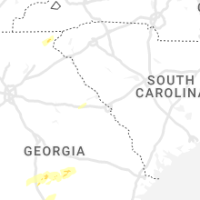
Georgia
| Local Time | Report Details |
|---|---|
| 12:44 PM EST | Report of powerlines down near intersection of state st and selman avenu in chattooga county GA, 39.1 miles S of Chattanooga, TN |
| 2:01 PM EST | Trees and powerlines downed near the intersection of pine st and w. girard av in polk county GA, 53.9 miles WNW of Atlanta, GA |
| 3:00 PM EST | Tree down just west of the intersection of skyview dr/mt vernon r in douglas county GA, 14.5 miles W of Atlanta, GA |
| 3:00 PM EST | Tree down near ivy pointe row and oak ridge r in cobb county GA, 12.2 miles W of Atlanta, GA |
| 3:20 PM EST | Tree down at oak ridge rd and thorton rd. tree on car near thorton rd and oak ridge r in douglas county GA, 12.8 miles W of Atlanta, GA |
| 3:29 PM EST | More than 3 trees down in the area of upper big springs rd and hwy18 in troup county GA, 41.6 miles NE of Auburn, AL |
| 3:31 PM EST | Tree into house at kennesaw dr. and trailwood d in cobb county GA, 13.5 miles NW of Atlanta, GA |
| 3:32 PM EST | Line down with power pole on thornton and oak ridge lin in douglas county GA, 12.8 miles W of Atlanta, GA |
| 3:33 PM EST | Tree down on nebo rd at stone cree in paulding county GA, 28 miles W of Atlanta, GA |
| 3:34 PM EST | Half Dollar sized hail reported near Tiger, GA, 47.2 miles W of Greenville, SC, trained spotter reported between quarter and half-dollar sized hail. reported roads are covered in hail. |
| 3:42 PM EST | Tree blown over onto powerlines at ann rd and jay d in cobb county GA, 10.1 miles NW of Atlanta, GA |
| 3:43 PM EST | Building collapse off oak ridge on cobb side of roa in cobb county GA, 12.9 miles WNW of Atlanta, GA |
| 3:53 PM EST | Pdk recorded a wind gust of 60mp in dekalb county GA, 10.5 miles NNE of Atlanta, GA |
| 4:03 PM EST | Lines down off of pool rd and johnston r in douglas county GA, 25.6 miles W of Atlanta, GA |
| 4:03 PM EST | Tree fallen on witcher rd near hwy 1 in coweta county GA, 34.8 miles SW of Atlanta, GA |
| 4:06 PM EST | Debris blocking hwy 16 just east of i-8 in coweta county GA, 36.2 miles SW of Atlanta, GA |
| 4:06 PM EST | Multiple trees down along and in the woods next to echo c in fayette county GA, 28.7 miles SSW of Atlanta, GA |
| 4:16 PM EST | Multiple trees down on exit 46... big springs rd... on i-185. road completely blocke in troup county GA, 41.6 miles NE of Auburn, AL |
| 4:20 PM EST | Half Dollar sized hail reported near Clayton, GA, 42.7 miles W of Greenville, SC, reports of quarter and half dollar sized hail across a good portion of rabun county. |
| 4:44 PM EST | Trees down and shingles lifted off roofs along foster sprouse roa in mcduffie county GA, 35.5 miles W of Augusta, GA |
| 4:47 PM EST | Multiple trees down on union grove rd near southern grove r in dekalb county GA, 19.2 miles E of Atlanta, GA |
| 4:49 PM EST | Power lines down on rocky creek rd in hannahs mill area of upson. (near rocky creek dr. in henry county GA, 25.7 miles SSE of Atlanta, GA |
| 5:15 PM EST | Powerlines down on reid station roa in randolph county GA, 68.9 miles SSE of Auburn, AL |
| 5:19 PM EST | Power poles broken and several tree limbs also dow in randolph county GA, 69.9 miles SE of Auburn, AL |
| 5:34 PM EST | A few trees and powerlines reported down across the count in randolph county GA, 73.7 miles SE of Auburn, AL |
| 6:30 PM EST | Tree down near the intersection of laramore road and new york roa in lee county GA, 73.4 miles WNW of Douglas, GA |
| 6:30 PM EST | Trees down on sr-266 before bethel church r in clay county GA, 73.1 miles SSE of Auburn, AL |
| 6:37 PM EST | Trees and powerlines down on acorn pond roa in worth county GA, 62.9 miles WNW of Douglas, GA |
| 7:10 PM EST | Powerlines reported down along sr-4 in early county GA, 68.3 miles NNW of Tallahassee, FL |
| 7:38 PM EST | Report of windows possibly blown out of a home in jaki in early county GA, 61.1 miles NW of Tallahassee, FL |
| 7:43 PM EST | Tree down on east main stree in miller county GA, 57.6 miles NNW of Tallahassee, FL |
| 8:00 PM EST | Around 6 trees were blown down in miller count in miller county GA, 55.6 miles NNW of Tallahassee, FL |
| 8:14 PM EST | Large oak tree partially in the roadway on highway 33. time estimated by rada in worth county GA, 58 miles W of Douglas, GA |
| 8:40 PM EST | A few trees were blown down in mitchell count in mitchell county GA, 48.7 miles N of Tallahassee, FL |
| 8:46 PM EST | Several trees were blown down across the count in irwin county GA, 24.5 miles WNW of Douglas, GA |
| 8:55 PM EST | Tree down at ellenton norman park rd. and r.l. sears rd. time estimated by rada in colquitt county GA, 51.7 miles WSW of Douglas, GA |
| 10:05 PM EST | Severe structural damage to building on bethany church rd sw near kittery pt s in gwinnett county GA, 20.2 miles ENE of Atlanta, GA |
North Carolina
| Local Time | Report Details |
|---|---|
| 2:00 PM EST | Tiny home knocked of its base off of nc-212 and multiple trees reported down across madison count in madison county NC, 49.6 miles SSW of Bristol, TN |
| 4:24 PM EST | Reports of numerous trees down and a few powerlines across rutherford count in rutherford county NC, 49.1 miles NE of Greenville, SC |
| 4:36 PM EST | 911 call center reports multiple trees down across polk county and quarter to half inch sized hai in polk county NC, 40 miles NNE of Greenville, SC |
| 5:24 PM EST | Corrects previous tstm wnd dmg report from 1 w harris. reports of numerous trees down and a few powerlines across rutherford count in rutherford county NC, 49.1 miles NE of Greenville, SC |
| 5:36 PM EST | 911 call center reports multiple trees down on goode rd and pebble r in cleveland county NC, 51.1 miles W of Charlotte, NC |
| 5:36 PM EST | *** 1 inj *** 911 call center reports a tree fell on vehicle and lead to one person being injured on the intersection of skinner rd and winter circl in cleveland county NC, 45.5 miles W of Charlotte, NC |
| 5:40 PM EST | 911 call center reports road blocked due to large tree. had to call ncdot to have it remove in cleveland county NC, 44.8 miles W of Charlotte, NC |
| 5:42 PM EST | 911 call center reports numerous trees and powerlines down across cleveland county and downtown shelb in cleveland county NC, 39.1 miles W of Charlotte, NC |
| 5:55 PM EST | Tree fell onto a swing se in gaston county NC, 32.5 miles WNW of Charlotte, NC |
| 6:00 PM EST | Reports of numerous trees and powerlines down across lincoln count in lincoln county NC, 29.3 miles NW of Charlotte, NC |
| 6:06 PM EST | 911 call center reports multiple trees down in serenity wood in gaston county NC, 27.6 miles W of Charlotte, NC |
| 6:12 PM EST | Reports of numerous tress... powerlines down... and a few blown transformers across gaston count in gaston county NC, 19.4 miles WNW of Charlotte, NC |
| 6:12 PM EST | Reports of multiple trees down at randleman and highway 27 in iron statio in lincoln county NC, 23.2 miles NW of Charlotte, NC |
| 6:13 PM EST | Power lines down in gastoni in gaston county NC, 19.5 miles W of Charlotte, NC |
| 6:15 PM EST | Shutters blown off a home in stanle in gaston county NC, 16.7 miles NW of Charlotte, NC |
| 6:25 PM EST | Report of tree down blocking highway at the intersection of moose club rd and skyuka r in iredell county NC, 35.8 miles N of Charlotte, NC |
| 6:25 PM EST | Reports of multiple trees down in southern iredell count in iredell county NC, 29.6 miles N of Charlotte, NC |
| 6:30 PM EST | Reports of multiple trees down in wintrow creek rd and shinville r in iredell county NC, 29.5 miles N of Charlotte, NC |
| 6:53 PM EST | Tree down on stokes ferry rd 4 miles southeast of salisbur in rowan county NC, 36.3 miles NE of Charlotte, NC |
| 6:55 PM EST | Emergency manager reports tree down on a house at tall oaks trai in mecklenburg county NC, 5.8 miles SSW of Charlotte, NC |
| 6:58 PM EST | Social media report of a tree down in harrisbur in cabarrus county NC, 12.6 miles ENE of Charlotte, NC |
| 7:05 PM EST | Tree down near intersection of zion church rd and flowes store r in cabarrus county NC, 17.4 miles ENE of Charlotte, NC |
| 7:06 PM EST | Social media picture of a tree down in mint hil in mecklenburg county NC, 10.7 miles ESE of Charlotte, NC |
| 7:10 PM EST | Trees down in the vicinity of miami church rd and mt pleasant r in cabarrus county NC, 23.1 miles ENE of Charlotte, NC |
| 7:21 PM EST | 1 tree down at nc-8 and dry creek lan in davidson county NC, 45.8 miles NE of Charlotte, NC |
| 7:27 PM EST | Trees down on church s in stanly county NC, 38 miles ENE of Charlotte, NC |
| 7:46 PM EST | Trees down along caudle r in randolph county NC, 65 miles W of Raleigh, NC |
| 8:15 PM EST | Trees down at clark rd and crutchfield r in alamance county NC, 42.8 miles W of Raleigh, NC |
| 8:15 PM EST | Trees down on tom stevens r in chatham county NC, 42.1 miles W of Raleigh, NC |
| 8:17 PM EST | 1 tree down on george p r in moore county NC, 55.2 miles WSW of Raleigh, NC |
| 8:23 PM EST | Trees down county wid in orange county NC, 32.7 miles NW of Raleigh, NC |
| 8:35 PM EST | Trees down county wid in orange county NC, 26 miles WNW of Raleigh, NC |
| 8:49 PM EST | Roof blown off a building near the intersection of n. lasalle street and hillsborough rd. in durha in durham county NC, 23.6 miles NW of Raleigh, NC |
| 9:40 PM EST | 1 tree down on smithfield rd at wake/johnston county lin in wake county NC, 12.8 miles ESE of Raleigh, NC |
| 1:40 AM EST | Delayed repor in carteret county NC, 59.9 miles ENE of Wilmington, NC |
Virginia
| Local Time | Report Details |
|---|---|
| 2:35 PM EST | Widespread trees down across the county via multiple different report in washington county VA, 15.2 miles ENE of Bristol, TN |
| 3:01 PM EST | Tree down on needmore roa in smyth county VA, 32.7 miles ENE of Bristol, TN |
| 3:04 PM EST | Tree down on saint claires creek roa in smyth county VA, 34.2 miles ENE of Bristol, TN |
| 3:07 PM EST | One tree down across the road on red stone road near the intersection of sugar stree in smyth county VA, 36.7 miles ENE of Bristol, TN |
| 3:07 PM EST | One tree down on shadow wood roa in smyth county VA, 35.9 miles ENE of Bristol, TN |
| 3:10 PM EST | Tree down on walkers creek roa in smyth county VA, 40.9 miles ENE of Bristol, TN |
| 3:28 PM EST | 6 trees and one power pole dow in wythe county VA, 57.2 miles ENE of Bristol, TN |
South Carolina
| Local Time | Report Details |
|---|---|
| 3:55 PM EST | Reports of quarter sized hail and trees down along highway 107 near mountain res in oconee county SC, 29.2 miles WNW of Greenville, SC |
| 5:05 PM EST | Multiple trees and powerlines down across spartanburg count in spartanburg county SC, 34.2 miles NE of Greenville, SC |
| 5:42 PM EST | 911 call center reports a large tree blocking roadway on providence creed rd and vermont driv in cherokee county SC, 46.9 miles W of Charlotte, NC |
| 5:46 PM EST | Several trees down near the intersection of hwy 25 and hwy 7 in greenville county SC, 28 miles SE of Greenville, SC |
| 6:15 PM EST | Multiple trees down on roadway on old abbeville hwy and stevenson r in abbeville county SC, 47 miles SSE of Greenville, SC |
| 6:18 PM EST | 911 call center reports multiple trees powerlines down across abbeville count in abbeville county SC, 48.3 miles NNW of Augusta, GA |
| 6:18 PM EST | Reports of trees down in hodge in greenwood county SC, 42.3 miles SSE of Greenville, SC |
| 6:24 PM EST | 911 call center reports numerous trees and powerlines down across greenwood count in greenwood county SC, 45.5 miles SSE of Greenville, SC |
| 6:25 PM EST | 911 call center reports numerous trees and powerlines down across york count in york county SC, 29.1 miles WSW of Charlotte, NC |
| 6:25 PM EST | 911 call center reports an electrical fire due to storm damage at n duncan bypas in union county SC, 55.1 miles E of Greenville, SC |
| 6:26 PM EST | Asos reports gust of 65 knots from wsw at 2326 in greenwood county SC, 48.2 miles SSE of Greenville, SC |
| 6:27 PM EST | Emergency manager reports a tree on a house near clover off briarwood driv in york county SC, 17.3 miles WSW of Charlotte, NC |
| 6:28 PM EST | Social media report of power lines down between york and clove in york county SC, 24.6 miles WSW of Charlotte, NC |
| 6:28 PM EST | 911 call center reports power pole down on salak r in greenwood county SC, 47.3 miles NNW of Augusta, GA |
| 6:42 PM EST | 911 call center reported numerous trees and powerlines down across laurens county. highlighted the most damage at hwy 72 and renno r in laurens county SC, 54.3 miles ESE of Greenville, SC |
| 6:45 PM EST | Reports of multiple trees and powerlines down across union count in union county SC, 55.4 miles SW of Charlotte, NC |
| 6:49 PM EST | Trees blocking eastbound lanes on i-26 at mile marker 63. time estimated by rada in newberry county SC, 58.4 miles ESE of Greenville, SC |
| 7:00 PM EST | Correst time of report. corrects previous tstm wnd dmg report from 7 n newberry. corrects previous tstm wnd dmg report from 7 n newberry. 911 call center reported multi in newberry county SC, 64.9 miles ESE of Greenville, SC |
| 7:27 PM EST | 911 call center reported multiple trees down. time estimated by rada in newberry county SC, 64.9 miles ESE of Greenville, SC |
| 8:05 PM EST | A medium size tree fell at 3814 brazelmans bridge rd. time estimate in newberry county SC, 67.6 miles SW of Charlotte, NC |
Florida
| Local Time | Report Details |
|---|---|
| 8:15 PM EST | Trees blown onto power lines resulted in a few power outages in northern gadsden count in gadsden county FL, 31.9 miles WNW of Tallahassee, FL |
Connect with Interactive Hail Maps