

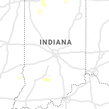
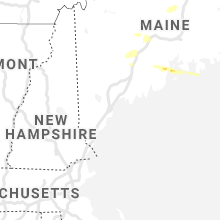
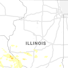
Hail Map for Saturday, June 19, 2021

Number of Impacted Households on 6/19/2021
0
Impacted by 1" or Larger Hail
0
Impacted by 1.75" or Larger Hail
0
Impacted by 2.5" or Larger Hail
Square Miles of Populated Area Impacted on 6/19/2021
0
Impacted by 1" or Larger Hail
0
Impacted by 1.75" or Larger Hail
0
Impacted by 2.5" or Larger Hail


Cities Most Affected by Hail Storms of 6/19/2021
| Hail Size | Demographics of Zip Codes Affected | ||||||
|---|---|---|---|---|---|---|---|
| City | Count | Average | Largest | Pop Density | House Value | Income | Age |
| Hudson, MI | 2 | 2.88 | 3.00 | 69 | $83k | $41.2k | 41.3 |
| Whitewood, SD | 2 | 1.75 | 1.75 | 10 | $70k | $33.8k | 44.9 |
| Pittsford, MI | 1 | 2.75 | 2.75 | 40 | $74k | $40.4k | 43.7 |
| Wall, SD | 1 | 2.00 | 2.00 | 1 | $63k | $36.2k | 43.8 |
Hail and Wind Damage Spotted on 6/19/2021
Filter by Report Type:Hail ReportsWind Reports
States Impacted
Alabama, Florida, Indiana, Illinois, Maine, Missouri, Utah, Rhode Island, Colorado, South Dakota, Pennsylvania, Nebraska, Michigan, New Mexico, KansasAlabama
| Local Time | Report Details |
|---|---|
| 7:36 AM CDT | New medias reports flomaton fire dpt dispathced to upper creek rd for large tree down blocking roa in escambia county AL, 51.7 miles ENE of Mobile, AL |
| 2:07 PM CDT | 2 trees reported down in black a in geneva county AL, 57.3 miles NE of Miramar Beach, FL |
| 2:27 PM CDT | Tree reported down in ozar in dale county AL, 79.6 miles S of Auburn, AL |
| 8:10 PM CDT | Tree down at the intersection of 605 and betty road in the rehoboth area of houston county alabam in houston county AL, 75.1 miles NE of Miramar Beach, FL |
Florida
| Local Time | Report Details |
|---|---|
| 8:05 AM CDT | Mesonet site old bethel r in okaloosa county FL, 31.9 miles NNW of Miramar Beach, FL |
| 9:02 AM CDT | 1-inch tree limbs broken; shingles blown of in bay county FL, 41.9 miles E of Miramar Beach, FL |
| 11:42 AM CDT | Large tree down blocking rd on log lake rd @ us hwy 90 in okaloosa county FL, 32.7 miles NW of Miramar Beach, FL |
| 1:00 PM CDT | Report of a power pole down near lakeview d in walton county FL, 16.8 miles ESE of Miramar Beach, FL |
| 6:18 PM CDT | 911 center reported a tree down on line road near lake cassid in holmes county FL, 35.9 miles NNE of Miramar Beach, FL |
| 7:27 PM CDT | 911 center reported a power pole down on lee valley roa in holmes county FL, 46.1 miles NE of Miramar Beach, FL |
| 8:10 PM CDT | Tree down on shiloh church loop in jackson county florid in jackson county FL, 66.2 miles NE of Miramar Beach, FL |
Indiana
| Local Time | Report Details |
|---|---|
| 9:50 AM EDT | Multiple trees down and some roads impassable in juda in lawrence county IN, 59.5 miles SSW of Indianapolis, IN |
| 9:15 PM CDT | Reports of trees and limbs down along sr 8 between n cr 100 w and n range roa in starke county IN, 61.6 miles SE of Chicago, IL |
Illinois
| Local Time | Report Details |
|---|---|
| 10:35 AM CDT | Agricultural fields severely damaged by wind and small hai in morgan county IL, 68 miles N of Saint Louis, MO |
| 3:00 PM CDT | Quarter sized hail reported near Hardin, IL, 43.2 miles NNW of Saint Louis, MO |
| 3:27 PM CDT | Several large trees blown down in the batchtown are in calhoun county IL, 37.8 miles NW of Saint Louis, MO |
| 3:38 PM CDT | Several large trees blown down to the south of batchtow in calhoun county IL, 34.9 miles NW of Saint Louis, MO |
| 5:17 PM CDT | Four foot diameter tree snapped in hal in adams county IL, 48.3 miles SSE of Kahoka, MO |
Maine
| Local Time | Report Details |
|---|---|
| 3:12 PM EDT | Half Dollar sized hail reported near Madawaska, ME, 36.2 miles NNW of Caribou, ME, via social media report. |
| 3:20 PM EDT | Quarter sized hail reported near Readfield, ME, 50.5 miles NNE of Portland, ME |
| 3:22 PM EDT | Trees and power lines dow in kennebec county ME, 49.4 miles WSW of Bangor, ME |
| 3:25 PM EDT | Numerous trees dow in kennebec county ME, 47.8 miles WSW of Bangor, ME |
| 3:27 PM EDT | Tree blocking lane in fairfield center on route 23 at tibbets place. time estimated by rada in somerset county ME, 45.7 miles WSW of Bangor, ME |
| 3:30 PM EDT | Trees down on powerlines. time estimated by rada in piscataquis county ME, 35 miles NW of Bangor, ME |
| 3:30 PM EDT | Trees dow in kennebec county ME, 43.3 miles WSW of Bangor, ME |
| 3:35 PM EDT | Trees and power lines dow in kennebec county ME, 40.6 miles WSW of Bangor, ME |
| 3:35 PM EDT | Waldo county dispatch reports numerous trees down across the county... including one in the town of burnham. time estimated from rada in waldo county ME, 33.3 miles WSW of Bangor, ME |
| 3:46 PM EDT | Waldo county dispatch reports numerous trees down across the county... including one in the town of unity that caused a fire. time estimated from rada in waldo county ME, 30.6 miles WSW of Bangor, ME |
| 3:50 PM EDT | Trees and power lines dow in waldo county ME, 43.8 miles SW of Bangor, ME |
| 3:51 PM EDT | Multiple trees down. time estimated via rada in penobscot county ME, 23.1 miles NNW of Bangor, ME |
| 4:05 PM EDT | Trees dow in waldo county ME, 18.4 miles SW of Bangor, ME |
| 4:10 PM EDT | Waldo county dispatch reports numerous trees down across the county... including one in the town of morrill. time estimated from rada in waldo county ME, 31.2 miles SW of Bangor, ME |
| 4:32 PM EDT | Waldo county dispatch reports numerous trees down across the county... including one that fell and caught fire in the town of stockton springs. time estimated from rada in waldo county ME, 22 miles SSW of Bangor, ME |
| 5:20 PM EDT | Quarter sized hail reported near Easton, ME, 15.9 miles SSE of Caribou, ME, via social media photo. |
| 5:20 PM EDT | Quarter sized hail reported near Islesboro, ME, 35.5 miles SSW of Bangor, ME |
| 5:30 PM EDT | Quarter sized hail reported near Perham, ME, 10.5 miles W of Caribou, ME, via social media photos. |
| 5:30 PM EDT | Quarter sized hail reported near Perham, ME, 9 miles W of Caribou, ME, additional report of 1 inch hail via social media photos. time estimated via radar. |
| 5:38 PM EDT | Half Dollar sized hail reported near Caribou, ME, 4.9 miles WNW of Caribou, ME, via social media photo. |
| 5:41 PM EDT | Tree down on powerline in hancock county ME, 37.7 miles S of Bangor, ME |
Missouri
| Local Time | Report Details |
|---|---|
| 2:55 PM CDT | A number of power lines blown down in the elsberry are in lincoln county MO, 49.1 miles NW of Saint Louis, MO |
| 4:33 PM CDT | Via twitter photo. tree limbs downed onto fence. time estimated from rada in st. charles county MO, 24.5 miles WNW of Saint Louis, MO |
| 4:40 PM CDT | Via facebook photo. garage door bowed inward. time estimated from rada in st. charles county MO, 25.8 miles WNW of Saint Louis, MO |
| 4:48 PM CDT | Via twitter photo. multiple tree limbs downed. time estimated from rada in st. charles county MO, 22.2 miles WNW of Saint Louis, MO |
| 5:10 PM CDT | Quarter sized hail reported near Saint Charles, MO, 20.6 miles WNW of Saint Louis, MO |
| 5:17 PM CDT | Also... very heavy rainfal in st. charles county MO, 22.5 miles WNW of Saint Louis, MO |
| 5:28 PM CDT | At spirit of st. louis airpor in st. louis county MO, 25 miles W of Saint Louis, MO |
| 5:29 PM CDT | Tree downed. time estimated from rada in st. louis county MO, 25.5 miles W of Saint Louis, MO |
| 5:30 PM CDT | Large tree around a foot and a half in diameter was blown over near chesterfield mal in st. louis county MO, 20.1 miles W of Saint Louis, MO |
| 5:30 PM CDT | Large pine tree snapped of near the ground at faust park. via twitte in st. louis county MO, 18.6 miles W of Saint Louis, MO |
| 5:34 PM CDT | Via twitter. multiple large tree limbs down at 109 and wild horse creek r in st. louis county MO, 25.5 miles W of Saint Louis, MO |
| 5:35 PM CDT | Multiple 8 inch tree limbs downe in st. charles county MO, 20.7 miles WNW of Saint Louis, MO |
| 5:38 PM CDT | Multiple trees downed. time estimated from rada in st. louis county MO, 21.3 miles W of Saint Louis, MO |
| 5:45 PM CDT | 0.8 inch tree limb downe in st. charles county MO, 29.9 miles WNW of Saint Louis, MO |
| 5:55 PM CDT | Quarter sized hail reported near Frankford, MO, 66.3 miles NE of Columbia, MO |
| 5:55 PM CDT | Three to four foot diameter tree uprooted in tow in st. louis county MO, 19.1 miles W of Saint Louis, MO |
| 6:10 PM CDT | A couple of trees down over roadways in high ridg in jefferson county MO, 21.3 miles WSW of Saint Louis, MO |
| 6:10 PM CDT | Numerous tree uprooted and downed. majority of trees on a nearby hill downe in st. louis county MO, 25.5 miles W of Saint Louis, MO |
| 6:14 PM CDT | A couple of trees down in byrnes mil in jefferson county MO, 23.4 miles WSW of Saint Louis, MO |
| 6:16 PM CDT | Part of a tree downe in marion county MO, 50.8 miles SSE of Kahoka, MO |
| 6:32 PM CDT | Relayed report. numerous trees downed. time estimated from rada in st. louis county MO, 20.6 miles W of Saint Louis, MO |
| 6:40 PM CDT | Report via dot official: downed power lines across the road. time estimated via rada in pike county MO, 64.5 miles ENE of Columbia, MO |
| 6:40 PM CDT | Quarter sized hail reported near Bowling Green, MO, 66.5 miles ENE of Columbia, MO, delayed report of 1in hail. |
| 7:40 PM CDT | Caller reported trees down in her backyard... up to 12in diamete in st. charles county MO, 38.8 miles WNW of Saint Louis, MO |
| 7:43 PM CDT | Caller reported street signs and lamp post down across the road... almost hitting her ca in st. charles county MO, 35.6 miles WNW of Saint Louis, MO |
| 8:02 PM CDT | Quarter sized hail reported near Clark, MO, 26.9 miles N of Columbia, MO, reports small hail covering much of the ground with biggest stones up to the size of quarters. |
| 8:41 PM CDT | 31 x 70 ft pole barn blown down and completely across the road. time estimated from rada in audrain county MO, 23.7 miles NE of Columbia, MO |
| 9:15 PM CDT | Large trees down blocking road near intersection of state highway e and county highway 245. 5-6 power poles down and power lines down. time based on rada in callaway county MO, 20.2 miles ENE of Columbia, MO |
| 9:16 PM CDT | Large tree limbs down southwest of auxvass in callaway county MO, 22 miles E of Columbia, MO |
| 9:27 PM CDT | Quarter sized hail reported near Moberly, MO, 32.7 miles N of Columbia, MO, spotter reports dime to quarter size hail in moberly. |
| 9:46 PM CDT | Power lines down. time estimated from rada in audrain county MO, 20.9 miles NE of Columbia, MO |
| 9:52 PM CDT | Power lines down. time estimated from rada in audrain county MO, 18.9 miles ENE of Columbia, MO |
| 12:42 AM CDT | Trees blown down over the roadway near the 700 block of east hwy route m. public reported through em/911 dispatch. time estimated from rada in boone county MO, 14 miles S of Columbia, MO |
| 12:51 AM CDT | Six inch diameter tree across roadway at warren school and old plank road. time estimated from rada in boone county MO, 7.9 miles SSW of Columbia, MO |
| 12:51 AM CDT | 12 inch diameter tree across the road at old plank rd and campus drive. time estimated from rada in boone county MO, 6.4 miles SSW of Columbia, MO |
| 12:52 AM CDT | Two large trees across the road at scott blvd and w route k... blocking the road from traffic. time estimated from rada in boone county MO, 6.7 miles SSW of Columbia, MO |
| 12:56 AM CDT | Tree across road at 590 block of east route m. time estimated from rada in boone county MO, 14 miles S of Columbia, MO |
Utah
| Local Time | Report Details |
|---|---|
| 2:00 PM MDT | Us-189 at deer creek dam in wasatch county UT, 30.6 miles SE of Salt Lake City, UT |
| 2:20 PM MDT | Sr-72 at hogan pass in sevier county UT, 34.9 miles E of Monroe, UT |
| 2:30 PM MDT | Us-89 at pole creek in utah county UT, 42.4 miles WNW of Price, UT |
Rhode Island
| Local Time | Report Details |
|---|---|
| 4:38 PM EDT | Tree branch down on wires on weaver hill roa in kent county RI, 18.2 miles SW of Providence, RI |
| 4:50 PM EDT | Tree and wires down on everglade ave in kent county RI, 8.6 miles S of Providence, RI |
| 4:56 PM EDT | Tree branch down on wires on weaver hill roa in kent county RI, 18.2 miles SW of Providence, RI |
Colorado
| Local Time | Report Details |
|---|---|
| 3:26 PM MDT | Quarter sized hail reported near Colorado Springs, CO, 46.1 miles N of Pueblo, CO, estimated size based on a video on twitter. |
| 3:34 PM MDT | Half Dollar sized hail reported near Fort Morgan, CO, 56.5 miles WSW of Yuma, CO |
| 3:36 PM MDT | Quarter sized hail reported near New Raymer, CO, 64.2 miles WNW of Yuma, CO, delayed report via twitter. photos of approximately 1 inch diameter hailstones... taken 30 minutes after hail had ended. time estimated by radar. |
| 3:53 PM MDT | Asos station klic limo in lincoln county CO, 77.3 miles SW of Yuma, CO |
| 4:18 PM MDT | Powerline down north of sterling along county road 34. time estimated by rada in logan county CO, 46.5 miles NW of Yuma, CO |
| 4:21 PM MDT | Mesonet station ew0539 hug in lincoln county CO, 78.4 miles SSW of Yuma, CO |
| 5:04 PM MDT | Station rdmcattle reported 60 mph wind gus in yuma county CO, 8.6 miles NE of Yuma, CO |
| 5:11 PM MDT | Station eckleygpcc reports 75 mph wind gus in yuma county CO, 8.7 miles ENE of Yuma, CO |
| 5:35 PM MDT | Video of large tree limbs down... estimated 4 to 6 inches. location is not exac in yuma county CO, 26.3 miles E of Yuma, CO |
| 5:35 PM MDT | Awos station k2v5 2 nw wra in yuma county CO, 25.1 miles E of Yuma, CO |
| 5:44 PM MDT | Site fixfarm reported 61mph gus in yuma county CO, 29.6 miles ESE of Yuma, CO |
| 5:55 PM MDT | Up723 reported 60mph gus in cheyenne county CO, 86.2 miles WSW of Colby, KS |
| 6:01 PM MDT | Report from mping: 1-inch tree limbs broken; shingles blown of in yuma county CO, 25.7 miles E of Yuma, CO |
| 6:12 PM MDT | Storm damage reported in otero county CO, 61.8 miles ESE of Pueblo, CO |
| 7:00 PM MDT | Corrects previous non-tstm wnd gst report from 17 nw two buttes. mesonet station gobblers kno in prowers county CO, 95.6 miles W of Garden City, KS |
| 7:17 PM MDT | Personal weather station observatio in prowers county CO, 84.3 miles W of Garden City, KS |
South Dakota
| Local Time | Report Details |
|---|---|
| 4:50 PM MDT | Quarter sized hail reported near Belle Fourche, SD, 50.1 miles NW of Rapid City, SD |
| 5:00 PM MDT | Quarter sized hail reported near Belle Fourche, SD, 50.9 miles NW of Rapid City, SD |
| 5:35 PM MDT | Golf Ball sized hail reported near Whitewood, SD, 33.1 miles NW of Rapid City, SD |
| 5:40 PM MDT | Golf Ball sized hail reported near Whitewood, SD, 31.9 miles NNW of Rapid City, SD |
| 5:45 PM MDT | Storm damage reported in lawrence county SD, 32.2 miles NW of Rapid City, SD |
| 5:55 PM MDT | Quarter sized hail reported near Piedmont, SD, 13.4 miles NNE of Rapid City, SD, mostly nickels covered the ground |
| 6:00 PM MDT | Quarter sized hail reported near Sturgis, SD, 26 miles NNW of Rapid City, SD |
| 7:08 PM MDT | Storm damage reported in pennington county SD, 8.8 miles ESE of Rapid City, SD |
| 7:50 PM MDT | Hen Egg sized hail reported near Wall, SD, 44.7 miles ESE of Rapid City, SD |
| 8:22 PM MDT | Lots of nickel-sized hail in pennington county SD, 37.7 miles ESE of Rapid City, SD |
Pennsylvania
| Local Time | Report Details |
|---|---|
| 6:55 PM EDT | A tree was blown down across powerlines along highway 6 in mercer county PA, 58.3 miles NNW of Pittsburgh, PA |
Nebraska
| Local Time | Report Details |
|---|---|
| 6:00 PM MDT | Estimated wind gusts of 60-70 mph; lost power briefl in dundy county NE, 52.8 miles ENE of Yuma, CO |
| 6:07 PM MDT | Power out as wel in chase county NE, 62.6 miles SW of North Platte, NE |
| 6:24 PM MDT | Site knebenke3 reported multiple 63 mph gust in dundy county NE, 52.2 miles NNW of Colby, KS |
| 6:26 PM MDT | Caller reported a couple 8 to 10 inch tree limbs dow in dundy county NE, 52.2 miles NNW of Colby, KS |
| 6:30 PM MDT | Power lines down in benkelman. report received at 2z. time estimated by rada in dundy county NE, 52.2 miles NNW of Colby, KS |
| 8:54 PM CDT | Site knemccoo2 in red willow county NE, 56.4 miles NNE of Colby, KS |
| 8:59 PM CDT | Asos station kmck mccook airpor in red willow county NE, 60.7 miles NNE of Colby, KS |
| 10:25 PM CDT | Multiple trees down in franklin... multiple power lines down across the county and several transformers ou in franklin county NE, 65.3 miles SSW of Grand Island, NE |
| 11:40 PM CDT | Corrects previous tstm wnd gst report from 6 ese clay center. 50 to 60 mph wind gusts reported near road t and road 31 in clay county NE, 36.1 miles SE of Grand Island, NE |
| 11:45 PM CDT | 50 to 60 mph wind gusts reported near road t and road 31 in clay county NE, 36.1 miles SE of Grand Island, NE |
| 1:12 AM CDT | 6-7 inch branch down from old tre in gage county NE, 74 miles N of Manhattan, KS |
| 2:30 AM CDT | 1-inch tree limbs broken; shingles blown of in cuming county NE, 54.6 miles NW of Omaha, NE |
Michigan
| Local Time | Report Details |
|---|---|
| 8:20 PM EDT | Numerous trees and powerlines downed all across the southern part of the count in cass county MI, 69.5 miles NW of Fort Wayne, IN |
| 10:00 PM EDT | Baseball sized hail reported near Pittsford, MI, 63 miles NNE of Fort Wayne, IN |
| 10:10 PM EDT | Tea Cup sized hail reported near Hudson, MI, 66.7 miles NE of Fort Wayne, IN, tea cup sized hail - photo submitted via twitter with ruler for reference |
| 10:14 PM EDT | Baseball sized hail reported near Hudson, MI, 68.5 miles NE of Fort Wayne, IN, baseball sized hail - photo submitted via twitter |
New Mexico
| Local Time | Report Details |
|---|---|
| 6:35 PM MDT | Likely caused by dry microburst. radar echoes depict weak rain shower activity. asos station ktc in sierra county NM, 66.4 miles ENE of Silver City, NM |
| 7:55 PM MDT | K0e0 awo in torrance county NM, 37.5 miles E of Albuquerque, NM |
Kansas
| Local Time | Report Details |
|---|---|
| 6:49 PM MDT | Site delt in wallace county KS, 50.9 miles WSW of Colby, KS |
| 8:09 PM CDT | Site sunflower aero in in rawlins county KS, 30.6 miles N of Colby, KS |
| 8:09 PM CDT | Site kkslevan in thomas county KS, 7.9 miles WNW of Colby, KS |
| 8:12 PM CDT | Site colby s in thomas county KS, 4.2 miles WSW of Colby, KS |
| 8:16 PM CDT | Personal station recorded 88mph gus in thomas county KS, 0.8 miles ENE of Colby, KS |
| 8:18 PM CDT | Site colbywx. 1 mile east of tow in thomas county KS, 4.1 miles ENE of Colby, KS |
| 8:18 PM CDT | Mesonet station ew7172 2 nw colb in thomas county KS, 2.1 miles WNW of Colby, KS |
| 8:18 PM CDT | Picture on social media of a tree dow in thomas county KS, 0.3 miles NW of Colby, KS |
| 8:23 PM CDT | Roof was blown off of a modular home while resident was present. no injuries occurred. a utility pole also snapped at that property... with power lines down. time estim in thomas county KS, 7.8 miles ENE of Colby, KS |
| 7:43 PM MDT | Storm damage reported in hamilton county KS, 62.2 miles W of Garden City, KS |
| 7:43 PM MDT | Storm damage reported in hamilton county KS, 62.3 miles W of Garden City, KS |
| 8:45 PM CDT | Multiple power outages in the town of colby. one utility pole dow in thomas county KS, 0.6 miles SSW of Colby, KS |
| 8:45 PM CDT | Public sent picture of healthy tree uprooted. estimated 80 to 90 mph winds. location is not exact... occurred in cit in sheridan county KS, 32.5 miles E of Colby, KS |
| 8:48 PM CDT | Site kkshoxie in sheridan county KS, 33.8 miles ESE of Colby, KS |
| 7:50 PM MDT | The mesonet is a kdot siit in hamilton county KS, 57.8 miles W of Garden City, KS |
| 9:09 PM CDT | Site kksmorla in graham county KS, 51.8 miles E of Colby, KS |
| 9:09 PM CDT | Site kksgovec in gove county KS, 50.7 miles SE of Colby, KS |
| 9:13 PM CDT | Site keith spraying reports 59mph wind gus in graham county KS, 48 miles NW of Hays, KS |
| 9:23 PM CDT | Site khl in graham county KS, 44.1 miles NW of Hays, KS |
| 9:24 PM CDT | Site kkshillc1 in graham county KS, 44.3 miles NW of Hays, KS |
| 9:30 PM CDT | Estimated 60 to 70 mp in trego county KS, 31.5 miles WNW of Hays, KS |
| 9:33 PM CDT | Site kksbogue in graham county KS, 40.4 miles NNW of Hays, KS |
| 9:35 PM CDT | Mesonet station k5wky 1 ssw wakeene in trego county KS, 31 miles WNW of Hays, KS |
| 9:39 PM CDT | Site knr in norton county KS, 69.1 miles ENE of Colby, KS |
| 9:45 PM CDT | Storm damage reported in phillips county KS, 56 miles NNW of Hays, KS |
| 9:55 PM CDT | Awos station knrn norto in norton county KS, 68.6 miles ENE of Colby, KS |
| 9:57 PM CDT | Rooks co. sheriffs offic in rooks county KS, 39.4 miles N of Hays, KS |
| 10:00 PM CDT | Storm damage reported in rooks county KS, 24.8 miles N of Hays, KS |
| 10:00 PM CDT | K-state mesonet 1 sw of tow in phillips county KS, 60.6 miles N of Hays, KS |
| 10:05 PM CDT | Power pole dow in phillips county KS, 67 miles N of Hays, KS |
| 10:05 PM CDT | Power line dow in phillips county KS, 65.3 miles N of Hays, KS |
| 10:05 PM CDT | Storm damage reported in ellis county KS, 1.5 miles NNE of Hays, KS |
| 10:05 PM CDT | Time estimated from rada in phillips county KS, 55.7 miles N of Hays, KS |
| 10:10 PM CDT | 8x12 shed destroyed. grain elevator leg blown dow in phillips county KS, 64.5 miles N of Hays, KS |
| 10:12 PM CDT | Storm damage reported in phillips county KS, 75.2 miles N of Hays, KS |
| 10:20 PM CDT | Power lines dow in phillips county KS, 66.3 miles N of Hays, KS |
| 10:30 PM CDT | Closed road due to power lines dow in phillips county KS, 56.6 miles NNW of Hays, KS |
| 10:31 PM CDT | Reports of large tree blown dow in phillips county KS, 61.3 miles N of Hays, KS |
| 10:35 PM CDT | Storm damage reported in smith county KS, 67.9 miles NNE of Hays, KS |
| 10:35 PM CDT | Multiple power lines dow in smith county KS, 64.1 miles NNE of Hays, KS |
| 10:40 PM CDT | Trees down across highway in smith county KS, 71.2 miles SSW of Grand Island, NE |
| 10:43 PM CDT | Storm damage reported in russell county KS, 27.6 miles E of Hays, KS |
| 11:05 PM CDT | Ks mesone in mitchell county KS, 75.5 miles ENE of Hays, KS |
| 11:50 PM CDT | Mesonet station k5cnc us-81 @ republican r. concordi in cloud county KS, 64.7 miles WNW of Manhattan, KS |
Connect with Interactive Hail Maps