

Hail Map for Sunday, June 20, 2021

Number of Impacted Households on 6/20/2021
0
Impacted by 1" or Larger Hail
0
Impacted by 1.75" or Larger Hail
0
Impacted by 2.5" or Larger Hail
Square Miles of Populated Area Impacted on 6/20/2021
0
Impacted by 1" or Larger Hail
0
Impacted by 1.75" or Larger Hail
0
Impacted by 2.5" or Larger Hail


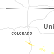


Cities Most Affected by Hail Storms of 6/20/2021
| Hail Size | Demographics of Zip Codes Affected | ||||||
|---|---|---|---|---|---|---|---|
| City | Count | Average | Largest | Pop Density | House Value | Income | Age |
| Eau Claire, MI | 1 | 2.00 | 2.00 | 83 | $89k | $41.9k | 43.2 |
| Afton, IA | 1 | 2.00 | 2.00 | 12 | $48k | $35.3k | 41.6 |
| Hartford, MI | 1 | 1.75 | 1.75 | 134 | $69k | $35.6k | 34.1 |
| Mercer, MO | 1 | 1.75 | 1.75 | 6 | $28k | $26.4k | 46.0 |
| Dowagiac, MI | 1 | 1.75 | 1.75 | 132 | $82k | $37.0k | 40.2 |
| Savannah, MO | 1 | 1.75 | 1.75 | 79 | $86k | $37.8k | 40.4 |
Hail and Wind Damage Spotted on 6/20/2021
Filter by Report Type:Hail ReportsWind Reports
States Impacted
Missouri, New York, Florida, Georgia, Ohio, New Mexico, Minnesota, Iowa, Indiana, Michigan, Pennsylvania, West Virginia, Kansas, South Carolina, IllinoisMissouri
| Local Time | Report Details |
|---|---|
| 8:23 AM CDT | Quarter sized hail reported near Trenton, MO, 81.7 miles NE of Kansas City, MO |
| 6:00 PM CDT | Quarter sized hail reported near Amazonia, MO, 59 miles NNW of Kansas City, MO, reported at 1-29 exit 60. |
| 6:35 PM CDT | Golf Ball sized hail reported near Savannah, MO, 55.4 miles N of Kansas City, MO, reporrted near hwy 169 and county road 311. |
| 6:58 PM CDT | Golf Ball sized hail reported near Mercer, MO, 74.6 miles S of Des Moines, IA |
| 7:17 PM CDT | Quarter sized hail reported near Princeton, MO, 82.1 miles S of Des Moines, IA, also estimated 60mph winds. |
| 8:20 PM CDT | Spotter estimates 60mph winds and numerous 1 inch diameter tree limbs dow in adair county MO, 53.9 miles WSW of Kahoka, MO |
| 8:30 PM CDT | Quarter sized hail reported near Kirksville, MO, 47.4 miles WSW of Kahoka, MO |
| 8:32 PM CDT | Reported from irk aso in adair county MO, 49 miles WSW of Kahoka, MO |
| 9:15 PM CDT | Via faceboo in shelby county MO, 39.9 miles SSW of Kahoka, MO |
| 9:20 PM CDT | Trees down over highway 15 south of shelbyvill in shelby county MO, 48 miles SSW of Kahoka, MO |
| 9:24 PM CDT | Six inch diameter tree limbs downed. time estimated from rada in lewis county MO, 24 miles SSW of Kahoka, MO |
| 9:44 PM CDT | Trees down in monroe cit in monroe county MO, 53.2 miles S of Kahoka, MO |
| 10:11 PM CDT | Large tree down across jackson street in central mexic in audrain county MO, 28.7 miles ENE of Columbia, MO |
| 10:22 PM CDT | Large tree (greater than two ft dia) broken into power line in audrain county MO, 42.3 miles ENE of Columbia, MO |
| 10:23 PM CDT | Downed tree blocking roadwa in boone county MO, 19.4 miles N of Columbia, MO |
| 10:24 PM CDT | Large tree into home along south trails terrac in boone county MO, 7 miles WNW of Columbia, MO |
| 10:24 PM CDT | Multiple tree blocking rt e forcing closure of roa in boone county MO, 5.3 miles NW of Columbia, MO |
| 10:26 PM CDT | Tree into power lines at amelia and mont vernon stree in boone county MO, 0.9 miles NE of Columbia, MO |
| 10:26 PM CDT | Tree into power lines at amelia and mont vernon stree in boone county MO, 0.9 miles NE of Columbia, MO |
| 10:26 PM CDT | Large tree blocking roadwa in boone county MO, 3.2 miles NE of Columbia, MO |
| 10:26 PM CDT | Large tree partially blocking roadwa in boone county MO, 2.4 miles SSW of Columbia, MO |
| 10:26 PM CDT | Tree and power lines down on hillshire cour in boone county MO, 2.5 miles SW of Columbia, MO |
| 10:27 PM CDT | Tree down over old 63 and walnu in boone county MO, 1.3 miles E of Columbia, MO |
| 10:27 PM CDT | Large tree across 8th stree in boone county MO, 0.6 miles NNE of Columbia, MO |
| 10:27 PM CDT | Large tree on home along thilly roa in boone county MO, 1.1 miles SE of Columbia, MO |
| 10:27 PM CDT | *** 1 inj *** tree fell and struck a person on the head along cook avenu in boone county MO, 1 miles WNW of Columbia, MO |
| 10:27 PM CDT | Large tree limb blocking roadway at williams and brighton s in boone county MO, 0.9 miles NE of Columbia, MO |
| 10:27 PM CDT | Large tree downed onto private parking lo in boone county MO, 1.4 miles ENE of Columbia, MO |
| 10:27 PM CDT | Trees downed onto roadwa in boone county MO, 2 miles ESE of Columbia, MO |
| 10:28 PM CDT | Tree downed onto powerline in boone county MO, 5.5 miles SE of Columbia, MO |
| 10:28 PM CDT | Powers lines down onto roadway near pannell st and business 7 in boone county MO, 0.9 miles NE of Columbia, MO |
| 10:28 PM CDT | Tree down blocking new haven roa in boone county MO, 4.1 miles SE of Columbia, MO |
| 10:29 PM CDT | Tree across roadwa in boone county MO, 4.9 miles SE of Columbia, MO |
| 10:30 PM CDT | Multiple trees down in and around boonville. highway 98 is blocked by fallen tree in cooper county MO, 21.9 miles W of Columbia, MO |
| 10:48 PM CDT | Trees down in kingdom cit in callaway county MO, 21.8 miles E of Columbia, MO |
| 10:54 PM CDT | Tree over z highwa in callaway county MO, 26.2 miles E of Columbia, MO |
| 11:03 PM CDT | Electric pole snapped in half and multiple trees down blocking roadways around count in lincoln county MO, 48.6 miles WNW of Saint Louis, MO |
| 11:04 PM CDT | 58 mph measured gust at columbia airpor in boone county MO, 11 miles SE of Columbia, MO |
| 11:53 PM CDT | Twitter video of branch down along hwy y in franklin county MO, 46.9 miles W of Saint Louis, MO |
| 1:36 AM CDT | Received additional pictures of several trees down and tree limbs down in humansvill in polk county MO, 43.1 miles NNW of Springfield, MO |
New York
| Local Time | Report Details |
|---|---|
| 11:24 AM EDT | Tree down on power line in chautauqua county NY, 57.3 miles SW of Buffalo, NY |
| 11:24 PM EDT | Corrects previous tstm wnd dmg report from 3 w chautauqua. tree down on power line in chautauqua county NY, 57.3 miles SW of Buffalo, NY |
| 11:38 PM EDT | Half Dollar sized hail reported near Ripley, NY, 64.4 miles SW of Buffalo, NY |
| 5:50 AM EDT | Trees dow in livingston county NY, 54.5 miles ESE of Buffalo, NY |
| 6:04 AM EDT | Trees dow in ontario county NY, 67.4 miles E of Buffalo, NY |
Florida
| Local Time | Report Details |
|---|---|
| 12:57 PM CDT | 911 call center reports downed power lines... transformers... and trees along martin luther king jr ave. call came in at 1:17pm. time estimated using rada in okaloosa county FL, 28.9 miles NNW of Miramar Beach, FL |
| 4:41 PM EDT | Small branches and palm fronds down. time estimated. radar suggests winds of 50 to 60 mph in the area around the time of this repor in broward county FL, 29.4 miles NNW of Miami, FL |
| 4:57 PM EDT | Photo via social media of large downed tree on the southern side of the intersection of banks road and west copans road. time estimated from rada in broward county FL, 36.7 miles N of Miami, FL |
| 4:58 PM EDT | Very large hardwood tree branches downed within the city of coral springs. video shared via social media by the city. radar estimated winds were around 50 kt / 58 mph d in broward county FL, 37.3 miles N of Miami, FL |
Georgia
| Local Time | Report Details |
|---|---|
| 2:11 PM EDT | Tree down on holland road near the intersection of strange road. time estimated by rada in candler county GA, 63.8 miles WNW of Savannah, GA |
Ohio
| Local Time | Report Details |
|---|---|
| 3:26 PM EDT | Tree down on powerlines. time estimated via rada in geauga county OH, 18.1 miles ESE of Cleveland, OH |
| 5:17 PM EDT | Several reports of trees down around johnston and fowler... including a tree down on wires on oh-193 in johnston. time estimated via rada in trumbull county OH, 53.6 miles E of Cleveland, OH |
| 8:05 PM EDT | Measured 60 mph gusts with car roof anemometer. also large branch snapped off a healthy tre in paulding county OH, 27.9 miles ENE of Fort Wayne, IN |
| 8:53 PM EDT | Wauseon fire reported there were wires down on county road 19 and co rd in fulton county OH, 57.9 miles NE of Fort Wayne, IN |
| 9:00 PM EDT | Tree downed across the roa in fulton county OH, 57.3 miles NE of Fort Wayne, IN |
| 9:20 PM EDT | Power lines downe in henry county OH, 47.8 miles ENE of Fort Wayne, IN |
| 9:27 PM EDT | Report from mping: trees uprooted or snappe in defiance county OH, 30.7 miles NE of Fort Wayne, IN |
| 9:58 PM EDT | Limbs down just east of liberty center... oh. limbs range from 3 to 5 in diameter. town is without powe in henry county OH, 63 miles ENE of Fort Wayne, IN |
| 10:00 PM EDT | Tree downed and blocking the roa in henry county OH, 58.2 miles ENE of Fort Wayne, IN |
| 10:05 PM EDT | Wires down at 14430 county road b. reported by wauseon fire dep in fulton county OH, 57.9 miles ENE of Fort Wayne, IN |
| 10:07 PM EDT | Tree downe in henry county OH, 61.7 miles ENE of Fort Wayne, IN |
| 10:10 PM EDT | Powerlines downe in henry county OH, 63.8 miles ENE of Fort Wayne, IN |
| 10:15 PM EDT | Tree down on wires at neowash rd and jeffers rd. time estimated via rada in lucas county OH, 70.5 miles ENE of Fort Wayne, IN |
| 10:19 PM EDT | Tree down and blocking road at eber rd and reed rd. time estimate in lucas county OH, 75.6 miles ENE of Fort Wayne, IN |
| 4:13 AM EDT | Tree down on wires on fremont pike. time estimated via rada in wood county OH, 86.5 miles ENE of Fort Wayne, IN |
| 4:43 AM EDT | Trees and power lines down in gibsonbur in sandusky county OH, 85 miles W of Cleveland, OH |
| 4:55 AM EDT | Trees and power lines down in fremont near the hayes presidential center. power is out in the are in sandusky county OH, 75.6 miles W of Cleveland, OH |
| 5:50 AM EDT | 65 knot wind gust at c-man station loro1 2 nnw lorai in lez145 county OH, 26 miles W of Cleveland, OH |
| 6:04 AM EDT | Report and photos of trees down in westlake relayed by wew in cuyahoga county OH, 13.3 miles WSW of Cleveland, OH |
| 6:27 AM EDT | Fire chief reported numerous trees down in town. time estimated via rada in lake county OH, 14.3 miles ENE of Cleveland, OH |
| 6:28 AM EDT | Public report of trees down in the wickliffe area. report passed onto nws from wews on twitte in lake county OH, 13.3 miles ENE of Cleveland, OH |
| 6:40 AM EDT | Chardon fire dept twitter account reports trees down in the chardon area including us route 6 at calico and us route 322 at aquill in geauga county OH, 25.2 miles E of Cleveland, OH |
New Mexico
| Local Time | Report Details |
|---|---|
| 2:59 PM MDT | Storm damage reported in torrance county NM, 46.3 miles SSE of Albuquerque, NM |
Minnesota
| Local Time | Report Details |
|---|---|
| 4:10 PM CDT | Tree uprooted and other large branches down at silver lake park. time estimate in olmsted county MN, 62.8 miles WNW of La Crosse, WI |
Iowa
| Local Time | Report Details |
|---|---|
| 4:34 PM CDT | Hen Egg sized hail reported near Afton, IA, 44.3 miles SW of Des Moines, IA |
| 5:41 PM CDT | Half Dollar sized hail reported near Grinnell, IA, 44.8 miles E of Des Moines, IA |
| 5:50 PM CDT | Grain bin reported laying the middle of us hwy 69. reported by osceola fire dept. time estimated from rada in decatur county IA, 57.7 miles S of Des Moines, IA |
| 6:43 PM CDT | Ping Pong Ball sized hail reported near Davis City, IA, 66.4 miles S of Des Moines, IA, public sent video of storm near area... with report of pea to ping pong ball sized hail. |
| 7:20 PM CDT | Branches down requiring cleanup by the cit in delaware county IA, 37.1 miles NNE of Cedar Rapids, IA |
| 8:09 PM CDT | Power lines and buildings down on mcdevitt lane. possible tornad in jackson county IA, 49.2 miles ENE of Cedar Rapids, IA |
| 8:59 PM CDT | Few downed limbs... roof off baseball clubhouse (outbuilding)... unspecified damage at the fairgrounds... power out in spots around tow in washington county IA, 46.7 miles S of Cedar Rapids, IA |
Indiana
| Local Time | Report Details |
|---|---|
| 5:14 PM CDT | Trees downs across much of western starke count in starke county IN, 61.2 miles SE of Chicago, IL |
| 5:20 PM CDT | Multiple trees down across the northern portion of the count in starke county IN, 64.6 miles ESE of Chicago, IL |
| 6:25 PM EDT | Picture of large... 12 to 18 inch diameter tree blown down onto a home. base of tree rotten. metal fence also damage by tree branc in st. joseph county IN, 66.8 miles ESE of Chicago, IL |
| 6:39 PM EDT | Quarter sized hail reported near Argos, IN, 61.1 miles W of Fort Wayne, IN, relayed by wndu through twitter. |
| 6:40 PM EDT | Healthy 8 inch diameter tree branch blown dow in st. joseph county IN, 65.4 miles NW of Fort Wayne, IN |
| 6:50 PM EDT | Storm damage reported in st. joseph county IN, 71.9 miles E of Chicago, IL |
| 6:50 PM EDT | Corrects time of previous tstm wnd dmg report from osceola. healthy 8 inch diameter tree branch blown dow in st. joseph county IN, 65.4 miles NW of Fort Wayne, IN |
| 6:55 PM EDT | Multiple trees on houses and electrical lines. sustained winds up to 6 in elkhart county IN, 64.2 miles NW of Fort Wayne, IN |
| 6:55 PM EDT | Report from mping: 3-inch tree limbs broken; power poles broke in st. joseph county IN, 66.7 miles NW of Fort Wayne, IN |
| 6:55 PM EDT | Corrects previous tstm wnd dmg report from mishawaka. multiple reports of power lines down in mishawaka as well as liberty... greene... penn and clay township in st. joseph county IN, 69.2 miles NW of Fort Wayne, IN |
| 7:00 PM EDT | Tree blown down across the roa in marshall county IN, 66.4 miles WNW of Fort Wayne, IN |
| 7:05 PM EDT | Large trees down blocking east blvd coming from lexington blocking traffic to elkhart general e in elkhart county IN, 62.3 miles NW of Fort Wayne, IN |
| 7:12 PM EDT | Multiple reports of power lines down in mishawaka as well as liberty... greene... penn and clay township in st. joseph county IN, 69.2 miles NW of Fort Wayne, IN |
| 7:13 PM EDT | Mature pine tree around 18 inches in diameter uprooted. relayed by wsbt on twitte in elkhart county IN, 61.9 miles NW of Fort Wayne, IN |
| 7:20 PM EDT | Emergency management reports numerous trees and tree limbs down across the northern part of elkhart county. unable to provide specifics at this tim in elkhart county IN, 58.2 miles NW of Fort Wayne, IN |
| 7:21 PM EDT | 2 to 3 inch diameter tree limb down... partially blocking welker rd... north of cr 1000 in huntington county IN, 14.4 miles WSW of Fort Wayne, IN |
| 7:21 PM EDT | Several tree limbs... some as large as 10 inches in diameter. all health in huntington county IN, 14.6 miles WSW of Fort Wayne, IN |
| 7:41 PM EDT | Quarter sized hail reported near Carmel, IN, 11.9 miles NNW of Indianapolis, IN, in the vicinity of 9700 shelborne road just north of i-465 north side of indy. |
| 7:57 PM EDT | Large limbs downe in allen county IN, 7.1 miles NE of Fort Wayne, IN |
| 12:05 AM CDT | Public report of tree damage in hobart. time estimated by rada in lake county IN, 30.9 miles SE of Chicago, IL |
| 12:07 AM CDT | Tree damage in camelot estates in portage. time estimated by rada in porter county IN, 31.4 miles SE of Chicago, IL |
| 12:08 AM CDT | Numerous power lines downed in portage. time estimated by rada in porter county IN, 31.9 miles SE of Chicago, IL |
| 12:10 AM CDT | Downed tree caused structure damage on eagle creek road in south haven. time estimated by rada in porter county IN, 35.2 miles SE of Chicago, IL |
| 12:18 AM CDT | Public report of tree damage in valparaiso. time estimated by rada in porter county IN, 41.5 miles SE of Chicago, IL |
| 12:35 AM CDT | Several reports of trees downed across the count in la porte county IN, 50.8 miles ESE of Chicago, IL |
| 1:55 AM EDT | Several limbs downed. size unknow in st. joseph county IN, 69.4 miles ESE of Chicago, IL |
| 1:57 AM EDT | Occurred on madison street in south bend... in. large tree blocking road... tree went through husbands back windshield. called police to report damage to area. its dark in st. joseph county IN, 72.1 miles NW of Fort Wayne, IN |
| 1:59 AM EDT | Spotty tree and power line damage across northern marshall county. us 6 is closed in spots with debris on the roa in marshall county IN, 71.4 miles ESE of Chicago, IL |
| 2:10 AM EDT | Small tree limbs broke in elkhart county IN, 64.6 miles NW of Fort Wayne, IN |
| 2:27 AM EDT | Several reports of trees downed across the county. received in the last hou in elkhart county IN, 48 miles NW of Fort Wayne, IN |
| 2:55 AM EDT | Damage to roofs and numerous trees downe in steuben county IN, 46 miles N of Fort Wayne, IN |
Michigan
| Local Time | Report Details |
|---|---|
| 6:55 PM EDT | Picture of a few broken tree branches shared by wsbt through twitte in berrien county MI, 71.4 miles E of Chicago, IL |
| 6:55 PM EDT | Quarter sized hail reported near Berrien Springs, MI, 67.3 miles E of Chicago, IL |
| 7:00 PM EDT | Quarter sized hail reported near Berrien Springs, MI, 68.8 miles E of Chicago, IL |
| 7:00 PM EDT | Ping Pong Ball sized hail reported near Berrien Springs, MI, 67.3 miles E of Chicago, IL, corrects time and size of previous hail report from 1 se berrien springs. |
| 7:05 PM EDT | Hen Egg sized hail reported near Eau Claire, MI, 69 miles E of Chicago, IL |
| 7:18 PM EDT | Golf Ball sized hail reported near Dowagiac, MI, 67.3 miles SSW of Grand Rapids, MI, relayed by wsbt. on west side of magician lake. |
| 7:20 PM EDT | Relayed by nws grr. trees and power lines down in cassopoli in cass county MI, 74.5 miles NW of Fort Wayne, IN |
| 7:25 PM EDT | Golf Ball sized hail reported near Hartford, MI, 64.4 miles SSW of Grand Rapids, MI, report posted via twitter... with pictures. |
| 7:35 PM EDT | Quarter sized hail reported near Hartford, MI, 56.2 miles SSW of Grand Rapids, MI |
| 7:45 PM EDT | Power lines reported dow in st. joseph county MI, 62.4 miles NNW of Fort Wayne, IN |
| 7:45 PM EDT | Tree down across the roa in st. joseph county MI, 63.5 miles NNW of Fort Wayne, IN |
| 7:45 PM EDT | Tree downed and blocking roa in st. joseph county MI, 53.6 miles NNW of Fort Wayne, IN |
| 7:50 PM EDT | Multiple power lines dow in st. joseph county MI, 52.7 miles NNW of Fort Wayne, IN |
| 7:54 PM EDT | 3 trees downed across se half of count in hillsdale county MI, 64.6 miles NNE of Fort Wayne, IN |
| 8:00 PM EDT | Wind gusts of 50 to 60 mph estimated. branches down. very heavy rainfall with visibility near zer in kalamazoo county MI, 57.1 miles S of Grand Rapids, MI |
| 8:15 PM EDT | Tree limbs of unknown size down along us-1 in branch county MI, 59.9 miles N of Fort Wayne, IN |
| 8:18 PM EDT | Report from mping: 1-inch tree limbs broken; shingles blown of in kalamazoo county MI, 59.8 miles SSE of Grand Rapids, MI |
| 8:22 PM EDT | Report from mping: trees uprooted or snappe in branch county MI, 64.2 miles N of Fort Wayne, IN |
| 9:05 PM EDT | Large limbs downe in hillsdale county MI, 63 miles NNE of Fort Wayne, IN |
| 9:19 PM EDT | Dispatch reports multiple trees down around morocco rd and douglas rd in monroe county MI, 80.9 miles S of Flint, MI |
| 9:23 PM EDT | Reports of multiple trees down. damage to bar in lenawee county MI, 82.5 miles S of Flint, MI |
| 9:26 PM EDT | Dispacth reports multiple trees down around albain rd and douglas rd in monroe county MI, 76.8 miles S of Flint, MI |
| 9:40 PM EDT | Dispatch reports multiple trees down around day rd and plank rd in monroe county MI, 69.9 miles S of Flint, MI |
| 9:41 PM EDT | Tree down and partially blocking right turn lane at intersection of martin luther king jr blvd and jeffries service dr. relayed via social media phot in wayne county MI, 55.1 miles SSE of Flint, MI |
| 10:00 PM EDT | Large tree snapped and fell on house. relayed via woodtv. unknown tim in branch county MI, 59.9 miles N of Fort Wayne, IN |
| 10:07 PM EDT | Report from mping: 3-inch tree limbs broken; power poles broke in branch county MI, 64.1 miles N of Fort Wayne, IN |
| 10:45 PM EDT | Several reports of trees and powerlines downed across northern hillsdale county from 1030-1100 p in hillsdale county MI, 63.2 miles NNE of Fort Wayne, IN |
| 1:15 AM EDT | Quarter sized hail reported near Hartford, MI, 58.1 miles SSW of Grand Rapids, MI, public report via local tv media of 1 inch hail in hartford around 1:15 am. |
| 1:30 AM EDT | Public report of winds estimated around 65 mph around 130 am as thunderstorm came through. 8 inch tree limb fell on a house. strong winds lasted 3-5 minutes (estimated) in van buren county MI, 55.6 miles S of Grand Rapids, MI |
| 1:30 AM EDT | Several trees downed across northern part of count in cass county MI, 70.7 miles SSW of Grand Rapids, MI |
| 2:01 AM EDT | Quarter sized hail reported near Leslie, MI, 51.9 miles SW of Flint, MI, report from mping: quarter (1.00 in.). |
| 3:15 AM EDT | Report from mping: 3-inch tree limbs broken; power poles broke in hillsdale county MI, 63.2 miles NNE of Fort Wayne, IN |
| 4:11 AM EDT | Dispatch reports multiple trees and powerlines down around stowell rd and bigelow rd in monroe county MI, 71.2 miles S of Flint, MI |
| 4:21 AM EDT | Dispatch reports multiple trees down around lasalle and reinhardt rd in monroe county MI, 73.2 miles S of Flint, MI |
| 4:22 AM EDT | Dispatch reports multiple trees down around w 5th street and smith street in monroe county MI, 77.4 miles S of Flint, MI |
Pennsylvania
| Local Time | Report Details |
|---|---|
| 7:00 PM EDT | Trees down on garfield street in venango county PA, 66.2 miles N of Pittsburgh, PA |
| 7:08 PM EDT | Trees down on colbert avenue in venango county PA, 70.2 miles NNE of Pittsburgh, PA |
| 8:20 PM EDT | Trees on wires. other reports of trees across roads reported in juniata count in juniata county PA, 32.8 miles ESE of State College, PA |
| 11:06 PM EDT | Tree down on house on w 39th st and tree down on house nearby on melrose ave. time estimated via rada in erie county PA, 82.7 miles SW of Buffalo, NY |
West Virginia
| Local Time | Report Details |
|---|---|
| 7:35 PM EDT | Tree blew down near intersection of beaver run road and tony cook roa in mineral county WV, 62 miles ENE of Elkins, WV |
| 7:50 PM EDT | Tree blew down onto wv-28 (cumberland road) near crystal valley driv in hampshire county WV, 68.6 miles ENE of Elkins, WV |
Kansas
| Local Time | Report Details |
|---|---|
| 7:00 PM CDT | Ping Pong Ball sized hail reported near Berryton, KS, 53 miles ESE of Manhattan, KS, photo on social media. |
| 8:11 PM CDT | Also had hail but size was unknow in franklin county KS, 55 miles N of Chanute, KS |
| 8:11 PM CDT | Quarter sized hail reported near Burlington, KS, 44.1 miles NNW of Chanute, KS |
| 8:32 PM CDT | Had dime sized hail to in franklin county KS, 52.8 miles N of Chanute, KS |
South Carolina
| Local Time | Report Details |
|---|---|
| 9:20 PM EDT | Observation from the weatherflow sensor at isle of palms pier in amz350 county SC, 31.5 miles SSE of Charleston, SC |
Illinois
| Local Time | Report Details |
|---|---|
| 9:10 PM CDT | 7-8 inch diameter branch down franklin and high street in carroll county IL, 70.9 miles SSW of Madison, WI |
| 9:13 PM CDT | Half Dollar sized hail reported near Lanark, IL, 69.9 miles SSW of Madison, WI, marble to 1.25 inch hail. lasted 4 minutes. |
| 10:22 PM CDT | Spotter reports tree damage along somonauk road near hinckley with some branches on the roadway. time estimated by rada in de kalb county IL, 53 miles W of Chicago, IL |
| 10:28 PM CDT | Corrects previous tstm wnd gst report from colchester. also a tree dow in mcdonough county IL, 49 miles E of Kahoka, MO |
| 10:33 PM CDT | Large tree down on highway 136 blocking the west bound lane in mcdonough county IL, 53.8 miles E of Kahoka, MO |
| 10:34 PM CDT | Wind estimate in mcdonough county IL, 54.9 miles E of Kahoka, MO |
| 10:46 PM CDT | Aurora airport observed 60 mph gus in kane county IL, 44.5 miles W of Chicago, IL |
| 10:50 PM CDT | Tree damage near canterbury road and galena boulevard. relayed by aurora pd. time estimated by rada in kane county IL, 39.4 miles WSW of Chicago, IL |
| 10:51 PM CDT | Relayed via spotternetwor in cook county IL, 24.4 miles WNW of Chicago, IL |
| 10:55 PM CDT | Tree damage near lake street and villa avenue in addison. possible tornado. relayed via spotternetwork. time estimated by rada in dupage county IL, 18.2 miles W of Chicago, IL |
| 11:00 PM CDT | Public reports possible tree damage in albanay park neighborhood of chicago. time estimated by rada in cook county IL, 6.6 miles NW of Chicago, IL |
| 11:00 PM CDT | Trained spotters report tree fire caused by downed power lines in lake holiday area. time estimated by rada in la salle county IL, 56.6 miles WSW of Chicago, IL |
| 11:04 PM CDT | *** 3 inj *** three injuries and gas leaks reported. time estimate in dupage county IL, 25.4 miles WSW of Chicago, IL |
| 11:05 PM CDT | Public reports tree damage northwest of plainfield. time estimated by rada in will county IL, 35 miles WSW of Chicago, IL |
| 11:09 PM CDT | Report on social media of multiple streets blocked due to tree damage in plainfield near center and ambo in will county IL, 34.9 miles WSW of Chicago, IL |
| 11:10 PM CDT | Public report of tree damage in bolingbroo in will county IL, 25.5 miles WSW of Chicago, IL |
| 11:10 PM CDT | Public report of possible tree damage near oak park. time estimated by rada in cook county IL, 7.7 miles W of Chicago, IL |
| 11:12 PM CDT | Multiple spotter reports of damage to trees... structures... and power lines near 75th and janes in woodridge. debris on i-355. probable tornado. time estimated by rada in dupage county IL, 23 miles WSW of Chicago, IL |
| 11:16 PM CDT | Photo shared via social media of tornado damage to a residence in darien. probable tornado. time estimated by rada in dupage county IL, 21 miles WSW of Chicago, IL |
| 12:14 AM CDT | Lemont road blocked by debris between 83rd and 75th in darien. probable tornado. time estimated by rada in dupage county IL, 21.6 miles WSW of Chicago, IL |
| 12:20 AM CDT | County line road blocked by downed power lines between 83rd and 87th in burr ridge. probable tornado. time estimated by rada in cook county IL, 17.9 miles SW of Chicago, IL |
Connect with Interactive Hail Maps