

Hail Map for Monday, September 20, 2021

Number of Impacted Households on 9/20/2021
0
Impacted by 1" or Larger Hail
0
Impacted by 1.75" or Larger Hail
0
Impacted by 2.5" or Larger Hail
Square Miles of Populated Area Impacted on 9/20/2021
0
Impacted by 1" or Larger Hail
0
Impacted by 1.75" or Larger Hail
0
Impacted by 2.5" or Larger Hail


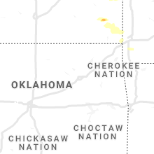


Cities Most Affected by Hail Storms of 9/20/2021
| Hail Size | Demographics of Zip Codes Affected | ||||||
|---|---|---|---|---|---|---|---|
| City | Count | Average | Largest | Pop Density | House Value | Income | Age |
| Erie, KS | 1 | 2.00 | 2.00 | 15 | $44k | $32.1k | 43.7 |
| Shawnee, KS | 1 | 1.75 | 1.75 | 3126 | $111k | $46.4k | 38.0 |
| Walnut, KS | 1 | 1.75 | 1.75 | 5 | $25k | $27.0k | 40.5 |
Hail and Wind Damage Spotted on 9/20/2021
Filter by Report Type:Hail ReportsWind Reports
Minnesota
| Local Time | Report Details |
|---|---|
| 4:05 PM CDT | Report of a tree dow in dodge county MN, 63.5 miles NNE of Mason City, IA |
| 4:05 PM CDT | Report of a tree dow in dodge county MN, 67.5 miles NNE of Mason City, IA |
Iowa
| Local Time | Report Details |
|---|---|
| 4:31 PM CDT | Winds estimated 60 to 70 at the fire statio in floyd county IA, 27.4 miles E of Mason City, IA |
| 4:31 PM CDT | 2 to 4 inch branches down with a few up to 6 inches in diamete in floyd county IA, 27.5 miles ESE of Mason City, IA |
| 4:41 PM CDT | Trees dow in chickasaw county IA, 35 miles E of Mason City, IA |
| 6:54 PM CDT | Report via twitte in clayton county IA, 65.6 miles NNE of Cedar Rapids, IA |
| 7:14 PM CDT | Amateur radio report via the nws in des moines of tree damage along highway 34 east of fairfield. time of the event estimated using rada in jefferson county IA, 40.7 miles N of Kahoka, MO |
| 7:15 PM CDT | Corrects previous tstm wnd dmg report from batavia. tree down on road and powerlines down. location of damage was near gas station on ne side of town near us 3 in jefferson county IA, 46.2 miles NNW of Kahoka, MO |
| 7:15 PM CDT | Tree down on road and powerlines dow in jefferson county IA, 45.8 miles NNW of Kahoka, MO |
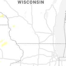
Wisconsin
| Local Time | Report Details |
|---|---|
| 5:05 PM CDT | Tree down. time estimated from rada in washburn county WI, 48.6 miles SSE of Duluth, MN |
| 5:17 PM CDT | Trees and power lines down in barnes. time estimated from rada in bayfield county WI, 41.3 miles SE of Duluth, MN |
| 5:39 PM CDT | Law enforcement reports multiple trees down along highway 2 in in in bayfield county WI, 47.2 miles ESE of Duluth, MN |
| 5:47 PM CDT | Storm damage reported in trempealeau county WI, 38.7 miles NNW of La Crosse, WI |
| 6:00 PM CDT | Semi blown over at the intersection of state highway 93 and county road v in trempealeau county WI, 44.7 miles N of La Crosse, WI |
| 6:01 PM CDT | A large pine tree was down near the spotters locatio in ashland county WI, 60.4 miles ESE of Duluth, MN |
| 6:03 PM CDT | Damage to a porch and 4 season room at a residence. pole barn also destroye in trempealeau county WI, 47.8 miles N of La Crosse, WI |
| 6:19 PM CDT | Storm damage reported in la crosse county WI, 4.7 miles N of La Crosse, WI |
| 7:16 PM CDT | Tree down on a power line and started on fir in grant county WI, 54.1 miles SSE of La Crosse, WI |
| 7:20 PM CDT | Roof blown off a she in richland county WI, 38.7 miles SE of La Crosse, WI |
| 7:40 PM CDT | Tree down blocking the road at intersection of state road 80 and hickory grove roa in iowa county WI, 48.9 miles W of Madison, WI |
| 8:10 PM CDT | Tree down. near 11th ave and edgewood ave junctio in adams county WI, 59.5 miles NNW of Madison, WI |
| 8:20 PM CDT | Tree down. near deerborn ave and 8th ave junctio in adams county WI, 64.4 miles NNW of Madison, WI |
| 9:45 PM CDT | Report of a large pole barn collapsed in town of dane. damage report came in at 10:10 pm but time still uncertai in dane county WI, 13.5 miles NNW of Madison, WI |
Kansas
| Local Time | Report Details |
|---|---|
| 5:12 PM CDT | Quarter sized hail reported near Lenexa, KS, 17.6 miles WSW of Kansas City, MO |
| 5:28 PM CDT | Quarter sized hail reported near Shawnee, KS, 10.2 miles SW of Kansas City, MO |
| 5:40 PM CDT | Golf Ball sized hail reported near Shawnee, KS, 9.3 miles SW of Kansas City, MO |
| 6:39 PM CDT | Hen Egg sized hail reported near Erie, KS, 14.8 miles SE of Chanute, KS, delayed report. |
| 6:43 PM CDT | Quarter sized hail reported near Erie, KS, 14 miles ESE of Chanute, KS |
| 6:52 PM CDT | Golf Ball sized hail reported near Walnut, KS, 18.5 miles ESE of Chanute, KS |
Missouri
| Local Time | Report Details |
|---|---|
| 6:27 PM CDT | Half Dollar sized hail reported near Liberty, MO, 13.4 miles NE of Kansas City, MO |
| 9:27 PM CDT | 12 to 18 inch tree and a few power poles down in canto in lewis county MO, 22.7 miles SSE of Kahoka, MO |
| 10:15 PM CDT | Tree/limb down in roadway at eland road and dutch elm road. time estimate in newton county MO, 69.5 miles WSW of Springfield, MO |
| 10:30 PM CDT | Large tree branch broke off and struck a roof of a home near highway 86 and goldfinch road. time estimate in newton county MO, 69.3 miles WSW of Springfield, MO |
| 10:40 PM CDT | Tree/limb down in the roadway. state highway cc and norway road. time estimate in newton county MO, 72.5 miles WSW of Springfield, MO |
| 10:45 PM CDT | Large tree snapped near sycamore and 9th street in monett. this was likely from outflow winds ahead of storms. maximum wind gust from monett awos was 36 mph. time estim in lawrence county MO, 39.7 miles WSW of Springfield, MO |
| 11:15 PM CDT | Several trees and limbs down across northern mcdonald county near and north of anderson. time estimate in mcdonald county MO, 73.1 miles WSW of Springfield, MO |
Connect with Interactive Hail Maps