

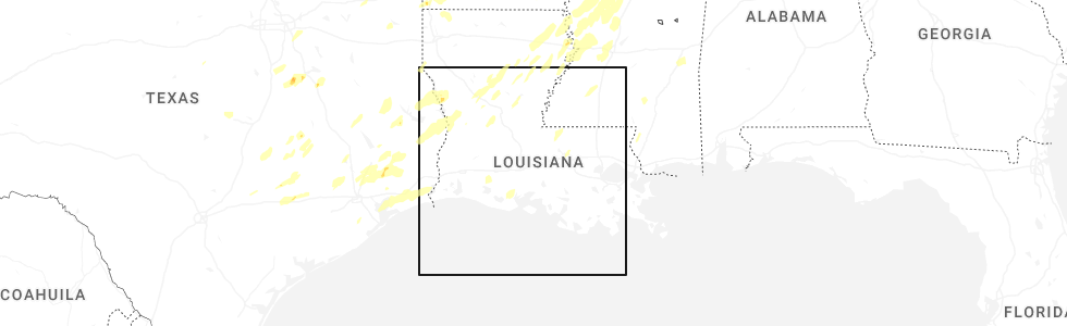
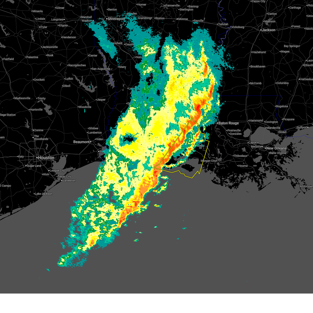
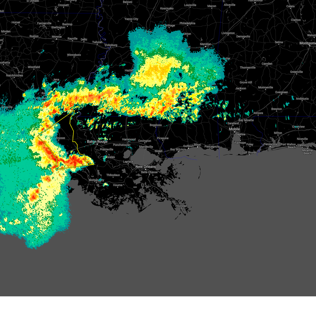
Hail Map for Abbeville, LA
The Abbeville, LA area has had 2 reports of on-the-ground hail by trained spotters, and has been under severe weather warnings 17 times during the past 12 months. Doppler radar has detected hail at or near Abbeville, LA on 48 occasions.
| Name: | Abbeville, LA |
| Where Located: | 18.1 miles SSW of Lafayette, LA |
| Map: | Google Map for Abbeville, LA |
| Population: | 12257 |
| Housing Units: | 5257 |
| More Info: | Search Google for Abbeville, LA |
0
The Top Recent Hail Date for Abbeville, LA is Saturday, December 28, 2024 (48th out of 48)
Hail and Wind Damage Spotted near Abbeville, LA
| Date / Time | Report Details |
|---|---|
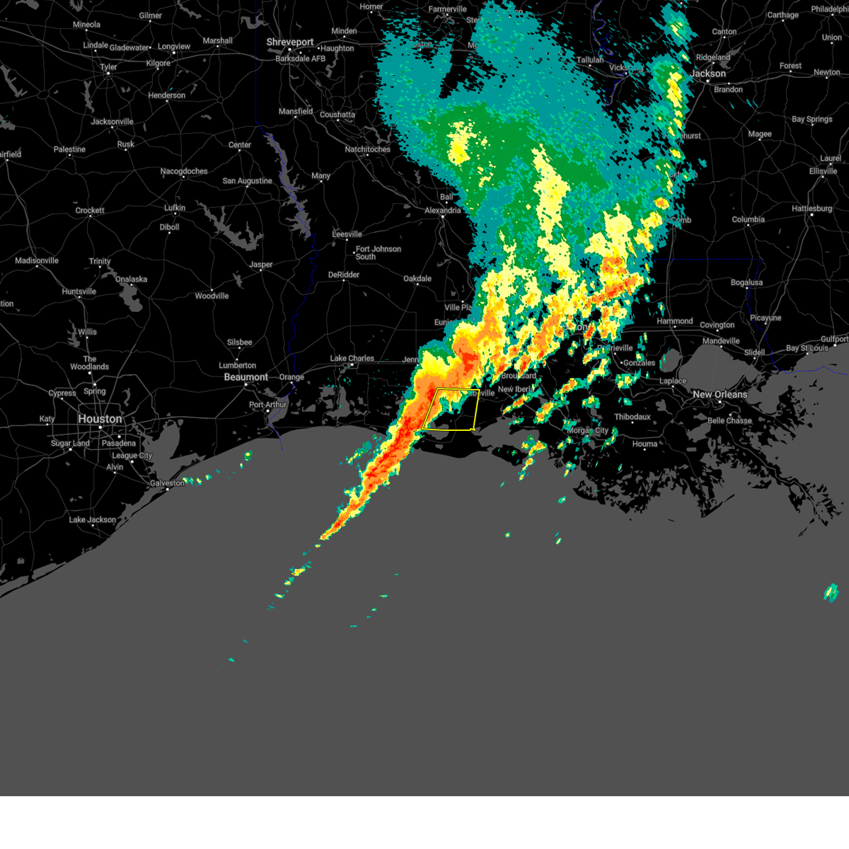
| 2/14/2026 10:53 PM CST |
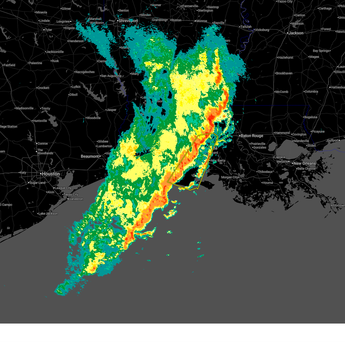
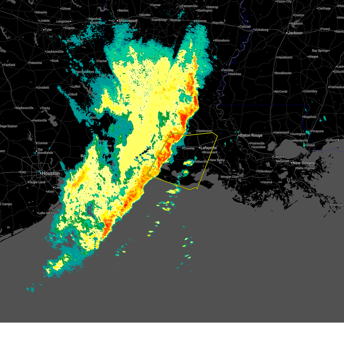
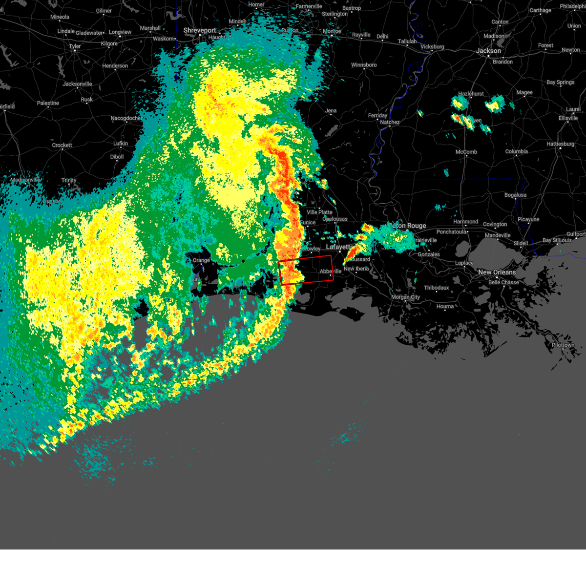
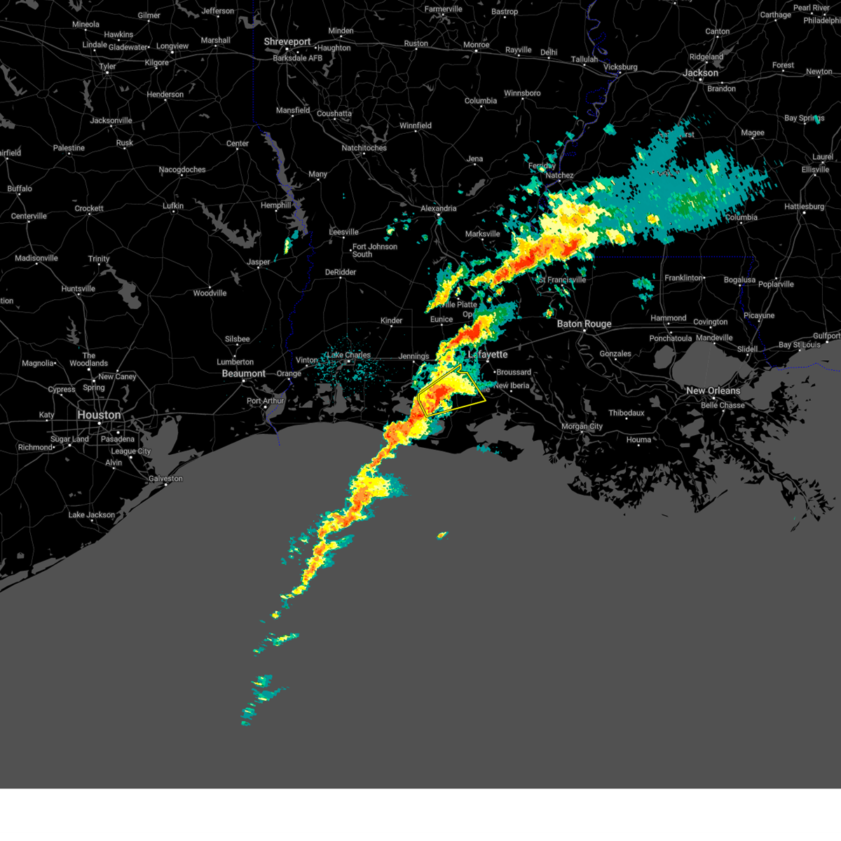
 At 1052 pm cst, severe thunderstorms capable of producing tornadoes were located along a line extending from near erath to intracoastal city, moving east at 45 mph (radar indicated rotation). Hazards include tornado. Flying debris will be dangerous to those caught without shelter. mobile homes will be damaged or destroyed. damage to roofs, windows, and vehicles will occur. tree damage is likely. these dangerous storms will be near, erath, delcambre, and jefferson island around 1100 pm cst. Avery island around 1105 pm cst. At 1052 pm cst, severe thunderstorms capable of producing tornadoes were located along a line extending from near erath to intracoastal city, moving east at 45 mph (radar indicated rotation). Hazards include tornado. Flying debris will be dangerous to those caught without shelter. mobile homes will be damaged or destroyed. damage to roofs, windows, and vehicles will occur. tree damage is likely. these dangerous storms will be near, erath, delcambre, and jefferson island around 1100 pm cst. Avery island around 1105 pm cst.
|
| 2/14/2026 10:48 PM CST |
 the severe thunderstorm warning has been cancelled and is no longer in effect the severe thunderstorm warning has been cancelled and is no longer in effect
|
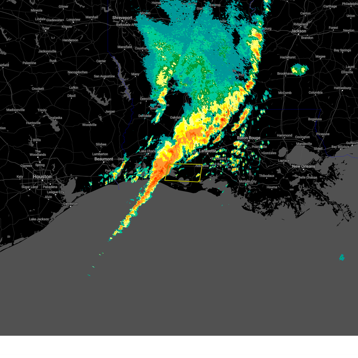
| 2/14/2026 10:48 PM CST |
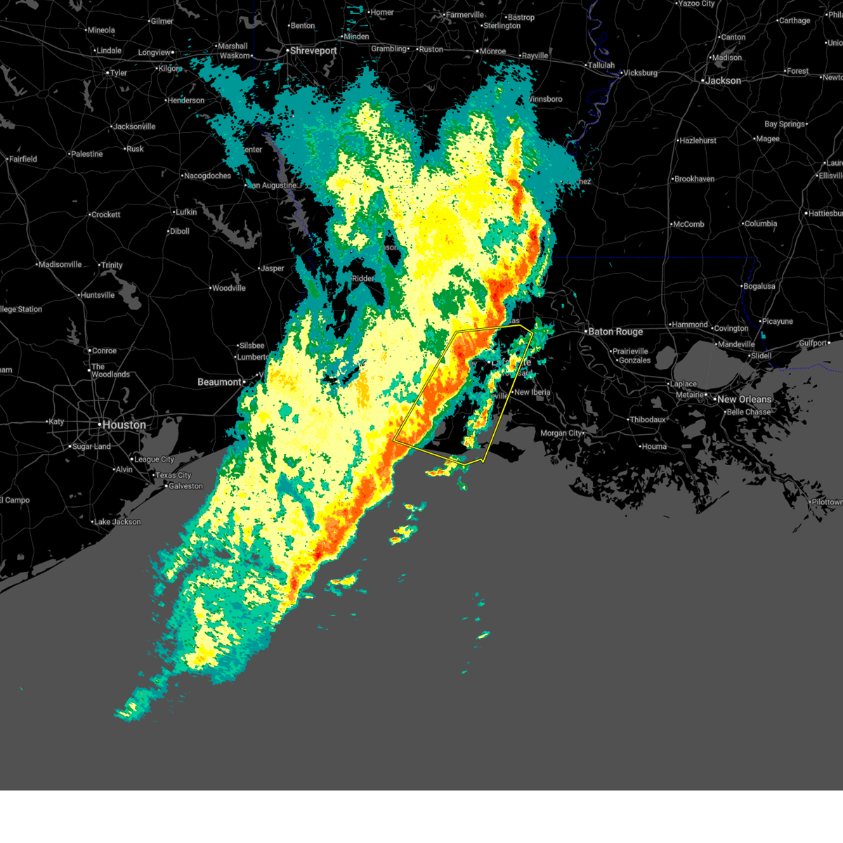
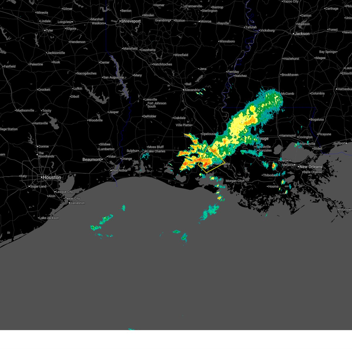
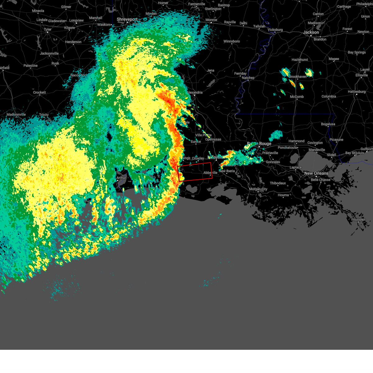
 At 1047 pm cst, severe thunderstorms were located along a line extending from near atchafalaya national wildlife refuge to near freshwater city, moving east at 45 mph (radar indicated). Hazards include 60 mph wind gusts. Expect damage to roofs, siding, and trees. locations impacted include, lafayette, new iberia, abbeville, catahoula, breaux bridge, franklin, st. Martinville, jeanerette, freshwater city, forked island, intracoastal city, cypremort point, pecan island, avery island, broussard, youngsville, baldwin, erath, delcambre, and henderson. At 1047 pm cst, severe thunderstorms were located along a line extending from near atchafalaya national wildlife refuge to near freshwater city, moving east at 45 mph (radar indicated). Hazards include 60 mph wind gusts. Expect damage to roofs, siding, and trees. locations impacted include, lafayette, new iberia, abbeville, catahoula, breaux bridge, franklin, st. Martinville, jeanerette, freshwater city, forked island, intracoastal city, cypremort point, pecan island, avery island, broussard, youngsville, baldwin, erath, delcambre, and henderson.
|
| 2/14/2026 10:42 PM CST |
 At 1042 pm cst, severe thunderstorms were located along a line extending from near atchafalaya national wildlife refuge to near freshwater city, moving east at 45 mph (radar indicated). Hazards include 60 mph wind gusts. Expect damage to roofs, siding, and trees. locations impacted include, lafayette, new iberia, abbeville, catahoula, breaux bridge, franklin, st. Martinville, jeanerette, krotz springs, freshwater city, forked island, intracoastal city, cypremort point, pecan island, avery island, broussard, youngsville, baldwin, erath, and delcambre. At 1042 pm cst, severe thunderstorms were located along a line extending from near atchafalaya national wildlife refuge to near freshwater city, moving east at 45 mph (radar indicated). Hazards include 60 mph wind gusts. Expect damage to roofs, siding, and trees. locations impacted include, lafayette, new iberia, abbeville, catahoula, breaux bridge, franklin, st. Martinville, jeanerette, krotz springs, freshwater city, forked island, intracoastal city, cypremort point, pecan island, avery island, broussard, youngsville, baldwin, erath, and delcambre.
|
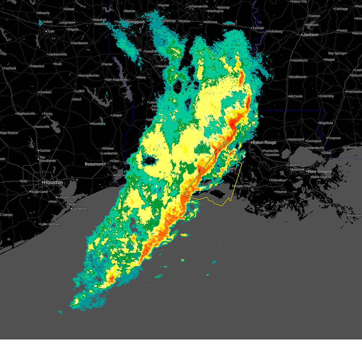
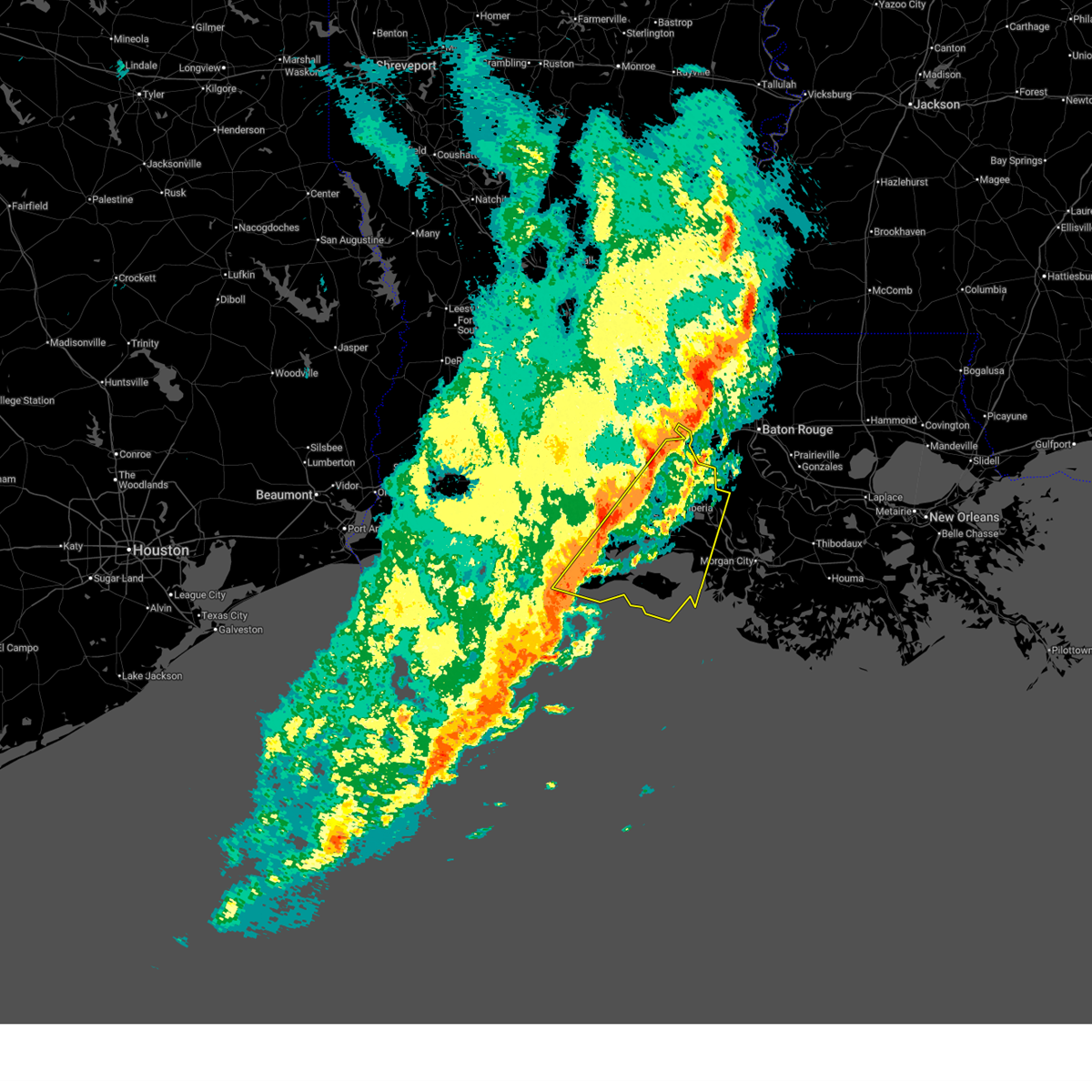
| 2/14/2026 10:40 PM CST |
 Svrlch the national weather service in lake charles has issued a * severe thunderstorm warning for, iberia parish in south central louisiana, lafayette parish in south central louisiana, northwestern st. mary parish in south central louisiana, vermilion parish in southwestern louisiana, st. martin parish in south central louisiana, southeastern st. landry parish in central louisiana, * until 1145 pm cst. * at 1040 pm cst, severe thunderstorms were located along a line extending from near atchafalaya national wildlife refuge to near freshwater city, moving east at 40 mph (radar indicated). Hazards include 60 mph wind gusts. expect damage to roofs, siding, and trees Svrlch the national weather service in lake charles has issued a * severe thunderstorm warning for, iberia parish in south central louisiana, lafayette parish in south central louisiana, northwestern st. mary parish in south central louisiana, vermilion parish in southwestern louisiana, st. martin parish in south central louisiana, southeastern st. landry parish in central louisiana, * until 1145 pm cst. * at 1040 pm cst, severe thunderstorms were located along a line extending from near atchafalaya national wildlife refuge to near freshwater city, moving east at 40 mph (radar indicated). Hazards include 60 mph wind gusts. expect damage to roofs, siding, and trees
|
| 2/14/2026 10:37 PM CST |
 the severe thunderstorm warning has been cancelled and is no longer in effect the severe thunderstorm warning has been cancelled and is no longer in effect
|
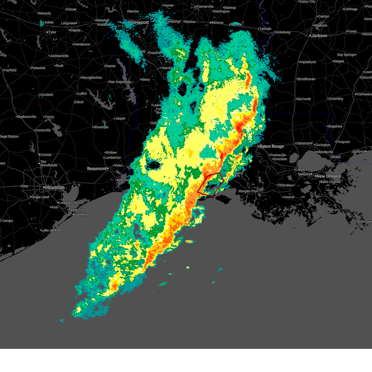
| 2/14/2026 10:37 PM CST |
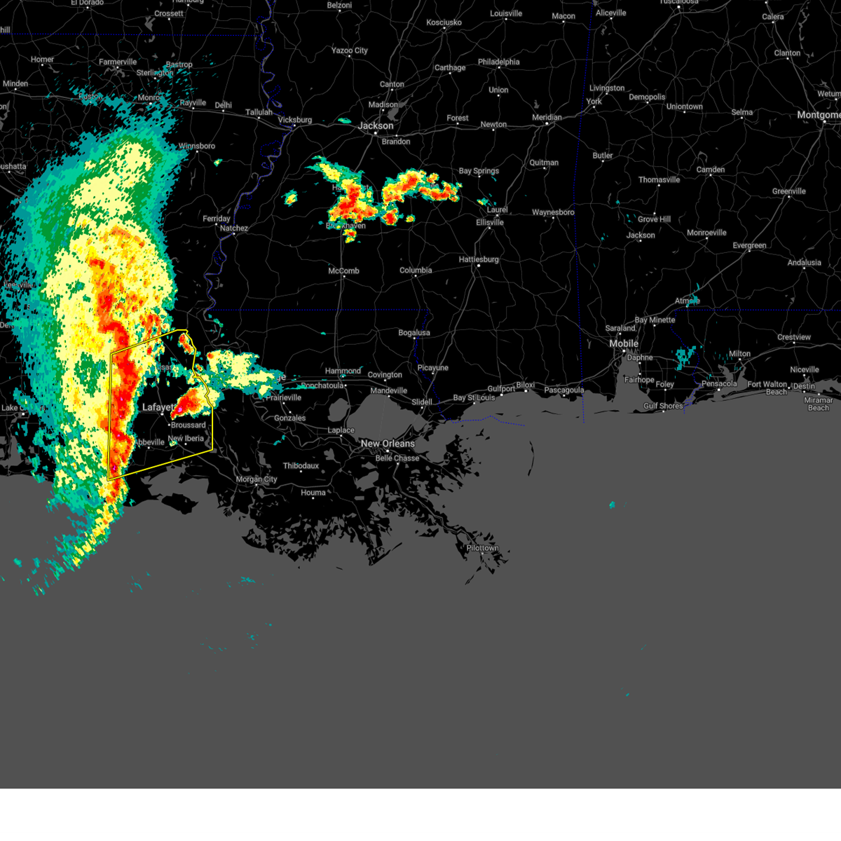
 At 1037 pm cst, severe thunderstorms were located along a line extending from atchafalaya national wildlife refuge to freshwater city, moving east at 55 mph (radar indicated). Hazards include 60 mph wind gusts. Expect damage to roofs, siding, and trees. locations impacted include, lafayette, new iberia, abbeville, scott, breaux bridge, carencro, st. Martinville, arnaudville, freshwater city, forked island, intracoastal city, pecan island, avery island, broussard, youngsville, erath, delcambre, henderson, maurice, and acadiana regional airport. At 1037 pm cst, severe thunderstorms were located along a line extending from atchafalaya national wildlife refuge to freshwater city, moving east at 55 mph (radar indicated). Hazards include 60 mph wind gusts. Expect damage to roofs, siding, and trees. locations impacted include, lafayette, new iberia, abbeville, scott, breaux bridge, carencro, st. Martinville, arnaudville, freshwater city, forked island, intracoastal city, pecan island, avery island, broussard, youngsville, erath, delcambre, henderson, maurice, and acadiana regional airport.
|
| 2/14/2026 10:31 PM CST |
 Torlch the national weather service in lake charles has issued a * tornado warning for, west central iberia parish in south central louisiana, southeastern vermilion parish in southwestern louisiana, * until 1115 pm cst. * at 1031 pm cst, severe thunderstorms capable of producing a tornado were located along a line extending from near forked island to 8 miles northeast of pecan island, moving east at 45 mph (radar indicated rotation). Hazards include tornado. Flying debris will be dangerous to those caught without shelter. mobile homes will be damaged or destroyed. damage to roofs, windows, and vehicles will occur. tree damage is likely. these dangerous storms will be near, forked island around 1035 pm cst. abbeville, intracoastal city, and esther around 1040 pm cst. henry around 1045 pm cst. erath and delcambre around 1050 pm cst. jefferson island around 1055 pm cst. Avery island around 1100 pm cst. Torlch the national weather service in lake charles has issued a * tornado warning for, west central iberia parish in south central louisiana, southeastern vermilion parish in southwestern louisiana, * until 1115 pm cst. * at 1031 pm cst, severe thunderstorms capable of producing a tornado were located along a line extending from near forked island to 8 miles northeast of pecan island, moving east at 45 mph (radar indicated rotation). Hazards include tornado. Flying debris will be dangerous to those caught without shelter. mobile homes will be damaged or destroyed. damage to roofs, windows, and vehicles will occur. tree damage is likely. these dangerous storms will be near, forked island around 1035 pm cst. abbeville, intracoastal city, and esther around 1040 pm cst. henry around 1045 pm cst. erath and delcambre around 1050 pm cst. jefferson island around 1055 pm cst. Avery island around 1100 pm cst.
|
| 2/14/2026 10:29 PM CST |
 At 1029 pm cst, severe thunderstorms were located along a line extending from 6 miles southwest of krotz springs to 6 miles south of pecan island, moving east at 55 mph (radar indicated). Hazards include 60 mph wind gusts. Expect damage to roofs, siding, and trees. locations impacted include, lafayette, new iberia, abbeville, scott, breaux bridge, carencro, st. Martinville, kaplan, leonville, arnaudville, freshwater city, forked island, intracoastal city, pecan island, avery island, broussard, youngsville, sunset, erath, and delcambre. At 1029 pm cst, severe thunderstorms were located along a line extending from 6 miles southwest of krotz springs to 6 miles south of pecan island, moving east at 55 mph (radar indicated). Hazards include 60 mph wind gusts. Expect damage to roofs, siding, and trees. locations impacted include, lafayette, new iberia, abbeville, scott, breaux bridge, carencro, st. Martinville, kaplan, leonville, arnaudville, freshwater city, forked island, intracoastal city, pecan island, avery island, broussard, youngsville, sunset, erath, and delcambre.
|
| 2/14/2026 10:17 PM CST |
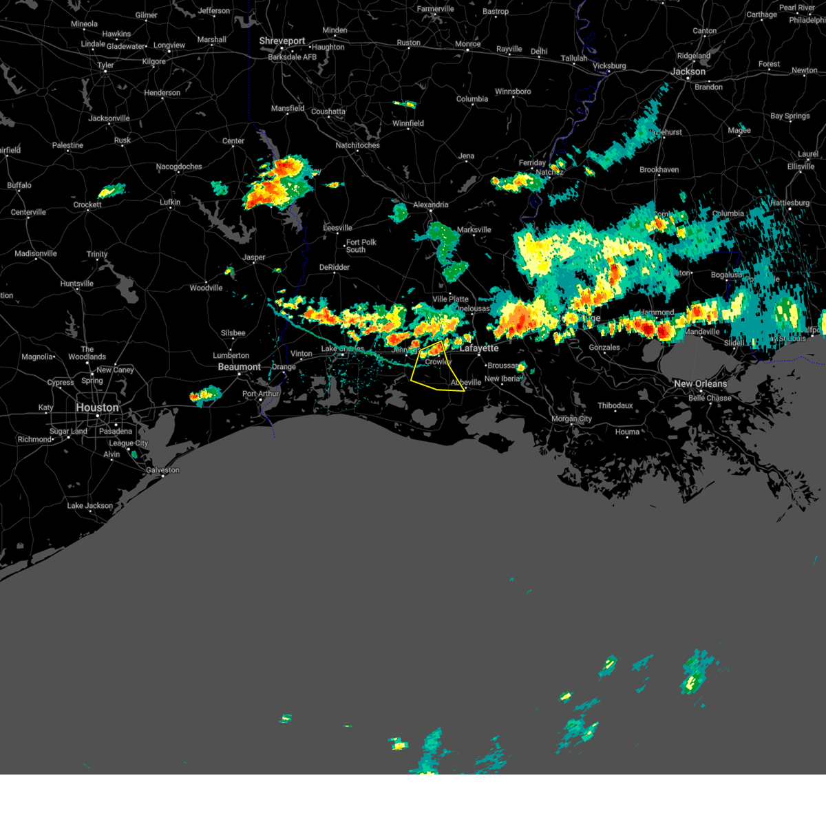
 At 1017 pm cst, severe thunderstorms were located along a line extending from leonville to 11 miles southwest of pecan island, moving east at 55 mph (radar indicated). Hazards include 60 mph wind gusts. Expect damage to roofs, siding, and trees. locations impacted include, lafayette, new iberia, crowley, abbeville, scott, breaux bridge, rayne, carencro, st. Martinville, kaplan, church point, gueydan, leonville, arnaudville, rockefeller wildlife range, freshwater city, forked island, intracoastal city, avery island, and pecan island. At 1017 pm cst, severe thunderstorms were located along a line extending from leonville to 11 miles southwest of pecan island, moving east at 55 mph (radar indicated). Hazards include 60 mph wind gusts. Expect damage to roofs, siding, and trees. locations impacted include, lafayette, new iberia, crowley, abbeville, scott, breaux bridge, rayne, carencro, st. Martinville, kaplan, church point, gueydan, leonville, arnaudville, rockefeller wildlife range, freshwater city, forked island, intracoastal city, avery island, and pecan island.
|
| 2/14/2026 10:02 PM CST |
 At 1001 pm cst, severe thunderstorms were located along a line extending from near lawtell to 8 miles southwest of rockefeller wildlife range, moving east at 55 mph (radar indicated). Hazards include 60 mph wind gusts. Expect damage to roofs, siding, and trees. locations impacted include, lafayette, new iberia, crowley, abbeville, scott, breaux bridge, rayne, carencro, st. Martinville, kaplan, church point, iota, gueydan, leonville, arnaudville, rockefeller wildlife range, freshwater city, forked island, intracoastal city, and avery island. At 1001 pm cst, severe thunderstorms were located along a line extending from near lawtell to 8 miles southwest of rockefeller wildlife range, moving east at 55 mph (radar indicated). Hazards include 60 mph wind gusts. Expect damage to roofs, siding, and trees. locations impacted include, lafayette, new iberia, crowley, abbeville, scott, breaux bridge, rayne, carencro, st. Martinville, kaplan, church point, iota, gueydan, leonville, arnaudville, rockefeller wildlife range, freshwater city, forked island, intracoastal city, and avery island.
|
| 2/14/2026 10:02 PM CST |
 the severe thunderstorm warning has been cancelled and is no longer in effect the severe thunderstorm warning has been cancelled and is no longer in effect
|
| 2/14/2026 9:42 PM CST |
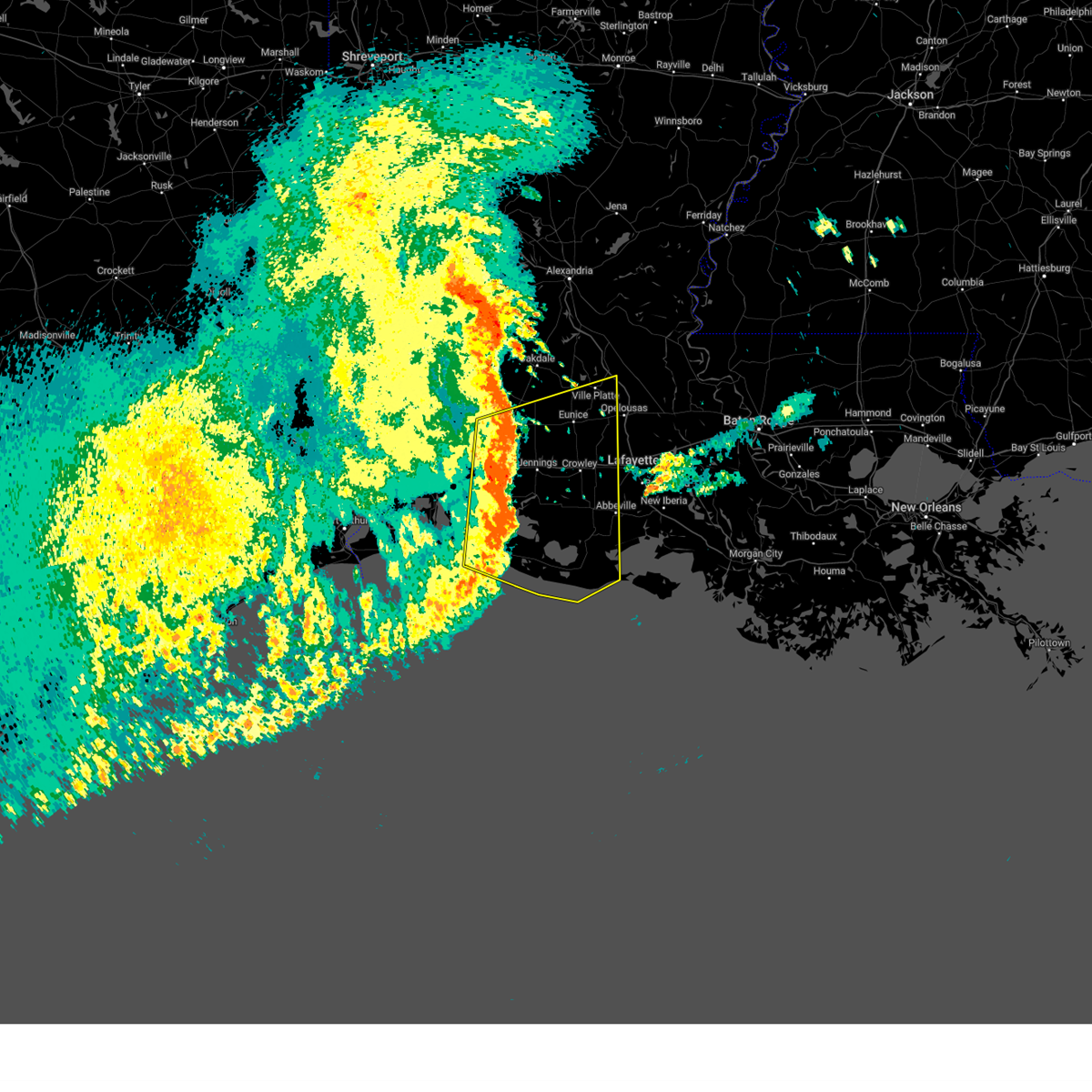
 Svrlch the national weather service in lake charles has issued a * severe thunderstorm warning for, eastern cameron parish in southwestern louisiana, northwestern iberia parish in south central louisiana, lafayette parish in south central louisiana, eastern jefferson davis parish in southwestern louisiana, acadia parish in southwestern louisiana, vermilion parish in southwestern louisiana, northwestern st. martin parish in south central louisiana, southern st. landry parish in central louisiana, * until 1045 pm cst. * at 942 pm cst, severe thunderstorms were located along a line extending from eunice to 14 miles southwest of grand chenier, moving east at 55 mph (radar indicated). Hazards include 60 mph wind gusts. expect damage to roofs, siding, and trees Svrlch the national weather service in lake charles has issued a * severe thunderstorm warning for, eastern cameron parish in southwestern louisiana, northwestern iberia parish in south central louisiana, lafayette parish in south central louisiana, eastern jefferson davis parish in southwestern louisiana, acadia parish in southwestern louisiana, vermilion parish in southwestern louisiana, northwestern st. martin parish in south central louisiana, southern st. landry parish in central louisiana, * until 1045 pm cst. * at 942 pm cst, severe thunderstorms were located along a line extending from eunice to 14 miles southwest of grand chenier, moving east at 55 mph (radar indicated). Hazards include 60 mph wind gusts. expect damage to roofs, siding, and trees
|
| 10/26/2025 2:55 AM CDT | The storm which prompted the warning has weakened below severe limits, and no longer poses an immediate threat to life or property. therefore, the warning will be allowed to expire. a tornado watch remains in effect until 600 am cdt for south central and southwestern louisiana. |
| 10/26/2025 2:32 AM CDT | At 231 am cdt, a severe thunderstorm was located near wright, or near gueydan, moving northeast at 30 mph (radar indicated). Hazards include 60 mph wind gusts. Expect damage to roofs, siding, and trees. Locations impacted include, crowley, abbeville, rayne, kaplan, gueydan, forked island, meaux, esther, wright, indian bayou, lyons point, henry, and florence landing. |
| 10/26/2025 2:32 AM CDT | the severe thunderstorm warning has been cancelled and is no longer in effect |
| 10/26/2025 2:05 AM CDT | Svrlch the national weather service in lake charles has issued a * severe thunderstorm warning for, east central cameron parish in southwestern louisiana, west central lafayette parish in south central louisiana, southeastern acadia parish in southwestern louisiana, central vermilion parish in southwestern louisiana, * until 300 am cdt. * at 205 am cdt, a severe thunderstorm was located 11 miles northeast of rockefeller wildlife range, moving northeast at 30 mph (radar indicated). Hazards include 60 mph wind gusts. expect damage to roofs, siding, and trees |
| 10/2/2025 4:54 PM CDT | Utility company reports two large powerline poles were broken in the cow island community due to thunderstorm winds. time and location estimated by rada in vermilion county LA, 13.3 miles NE of Abbeville, LA |
| 6/13/2025 3:52 AM CDT |
 Svrlch the national weather service in lake charles has issued a * severe thunderstorm warning for, northwestern iberia parish in south central louisiana, southeastern lafayette parish in south central louisiana, northeastern vermilion parish in southwestern louisiana, west central st. martin parish in south central louisiana, * until 415 am cdt. * at 352 am cdt, a severe thunderstorm was located over jefferson island, or 7 miles northwest of avery island, moving northeast at 15 mph (radar indicated). Hazards include 60 mph wind gusts and penny size hail. expect damage to roofs, siding, and trees Svrlch the national weather service in lake charles has issued a * severe thunderstorm warning for, northwestern iberia parish in south central louisiana, southeastern lafayette parish in south central louisiana, northeastern vermilion parish in southwestern louisiana, west central st. martin parish in south central louisiana, * until 415 am cdt. * at 352 am cdt, a severe thunderstorm was located over jefferson island, or 7 miles northwest of avery island, moving northeast at 15 mph (radar indicated). Hazards include 60 mph wind gusts and penny size hail. expect damage to roofs, siding, and trees
|
| 5/27/2025 4:45 AM CDT |
 Svrlch the national weather service in lake charles has issued a * severe thunderstorm warning for, northwestern iberia parish in south central louisiana, lafayette parish in south central louisiana, southeastern evangeline parish in central louisiana, acadia parish in southwestern louisiana, northeastern vermilion parish in southwestern louisiana, northwestern st. martin parish in south central louisiana, st. landry parish in central louisiana, * until 545 am cdt. * at 445 am cdt, severe thunderstorms were located along a line extending from chicot state park to near kaplan, moving northeast at 35 mph (radar indicated). Hazards include 60 mph wind gusts and penny size hail. expect damage to roofs, siding, and trees Svrlch the national weather service in lake charles has issued a * severe thunderstorm warning for, northwestern iberia parish in south central louisiana, lafayette parish in south central louisiana, southeastern evangeline parish in central louisiana, acadia parish in southwestern louisiana, northeastern vermilion parish in southwestern louisiana, northwestern st. martin parish in south central louisiana, st. landry parish in central louisiana, * until 545 am cdt. * at 445 am cdt, severe thunderstorms were located along a line extending from chicot state park to near kaplan, moving northeast at 35 mph (radar indicated). Hazards include 60 mph wind gusts and penny size hail. expect damage to roofs, siding, and trees
|
| 5/27/2025 4:40 AM CDT |
 The storm which prompted the warning has weakened below severe limits, and no longer appears capable of producing a tornado. therefore, the warning will be allowed to expire. however gusty winds are still possible with this thunderstorm. The storm which prompted the warning has weakened below severe limits, and no longer appears capable of producing a tornado. therefore, the warning will be allowed to expire. however gusty winds are still possible with this thunderstorm.
|
| 5/27/2025 4:21 AM CDT |
 Torlch the national weather service in lake charles has issued a * tornado warning for, west central lafayette parish in south central louisiana, southeastern acadia parish in southwestern louisiana, northern vermilion parish in southwestern louisiana, * until 445 am cdt. * at 421 am cdt, a severe thunderstorm capable of producing a tornado was located over gueydan, moving east at 35 mph (radar indicated rotation). Hazards include tornado. Flying debris will be dangerous to those caught without shelter. mobile homes will be damaged or destroyed. damage to roofs, windows, and vehicles will occur. tree damage is likely. This dangerous storm will be near, kaplan, wright, and lyons point around 425 am cdt. Torlch the national weather service in lake charles has issued a * tornado warning for, west central lafayette parish in south central louisiana, southeastern acadia parish in southwestern louisiana, northern vermilion parish in southwestern louisiana, * until 445 am cdt. * at 421 am cdt, a severe thunderstorm capable of producing a tornado was located over gueydan, moving east at 35 mph (radar indicated rotation). Hazards include tornado. Flying debris will be dangerous to those caught without shelter. mobile homes will be damaged or destroyed. damage to roofs, windows, and vehicles will occur. tree damage is likely. This dangerous storm will be near, kaplan, wright, and lyons point around 425 am cdt.
|
| 5/27/2025 4:20 AM CDT |
 At 420 am cdt, severe thunderstorms were located along a line extending from near richard to near forked island, moving east at 50 mph (radar indicated). Hazards include 70 mph wind gusts and penny size hail. Expect considerable tree damage. damage is likely to mobile homes, roofs, and outbuildings. Locations impacted include, crowley, abbeville, eunice, jennings, scott, rayne, ville platte, kaplan, church point, mamou, lake arthur, kinder, basile, oberlin, iota, gueydan, elton, mermentau, rockefeller wildlife range, and freshwater city. At 420 am cdt, severe thunderstorms were located along a line extending from near richard to near forked island, moving east at 50 mph (radar indicated). Hazards include 70 mph wind gusts and penny size hail. Expect considerable tree damage. damage is likely to mobile homes, roofs, and outbuildings. Locations impacted include, crowley, abbeville, eunice, jennings, scott, rayne, ville platte, kaplan, church point, mamou, lake arthur, kinder, basile, oberlin, iota, gueydan, elton, mermentau, rockefeller wildlife range, and freshwater city.
|
| 5/27/2025 4:20 AM CDT |
 the severe thunderstorm warning has been cancelled and is no longer in effect the severe thunderstorm warning has been cancelled and is no longer in effect
|
| 5/27/2025 4:15 AM CDT |
 the tornado warning has been cancelled and is no longer in effect the tornado warning has been cancelled and is no longer in effect
|
| 5/27/2025 4:00 AM CDT |
 Torlch the national weather service in lake charles has issued a * tornado warning for, northeastern cameron parish in southwestern louisiana, west central lafayette parish in south central louisiana, southeastern jefferson davis parish in southwestern louisiana, southern acadia parish in southwestern louisiana, northern vermilion parish in southwestern louisiana, * until 430 am cdt. * at 400 am cdt, a severe thunderstorm capable of producing a tornado was located over klondike, moving east at 40 mph (radar indicated rotation). Hazards include tornado. Flying debris will be dangerous to those caught without shelter. mobile homes will be damaged or destroyed. damage to roofs, windows, and vehicles will occur. tree damage is likely. this dangerous storm will be near, gueydan, morse, and riceville around 405 am cdt. wright around 410 am cdt. lyons point around 415 am cdt. kaplan around 420 am cdt. Other locations impacted by this tornadic thunderstorm include florence landing. Torlch the national weather service in lake charles has issued a * tornado warning for, northeastern cameron parish in southwestern louisiana, west central lafayette parish in south central louisiana, southeastern jefferson davis parish in southwestern louisiana, southern acadia parish in southwestern louisiana, northern vermilion parish in southwestern louisiana, * until 430 am cdt. * at 400 am cdt, a severe thunderstorm capable of producing a tornado was located over klondike, moving east at 40 mph (radar indicated rotation). Hazards include tornado. Flying debris will be dangerous to those caught without shelter. mobile homes will be damaged or destroyed. damage to roofs, windows, and vehicles will occur. tree damage is likely. this dangerous storm will be near, gueydan, morse, and riceville around 405 am cdt. wright around 410 am cdt. lyons point around 415 am cdt. kaplan around 420 am cdt. Other locations impacted by this tornadic thunderstorm include florence landing.
|
| 5/27/2025 3:45 AM CDT |
 Svrlch the national weather service in lake charles has issued a * severe thunderstorm warning for, eastern cameron parish in southwestern louisiana, northwestern lafayette parish in south central louisiana, jefferson davis parish in southwestern louisiana, southern evangeline parish in central louisiana, acadia parish in southwestern louisiana, southeastern calcasieu parish in southwestern louisiana, vermilion parish in southwestern louisiana, western st. landry parish in central louisiana, southern allen parish in southwestern louisiana, * until 445 am cdt. * at 344 am cdt, severe thunderstorms were located along a line extending from near pine island to 10 miles north of rockefeller wildlife range, moving east at 50 mph (radar indicated). Hazards include 70 mph wind gusts and penny size hail. Expect considerable tree damage. Damage is likely to mobile homes, roofs, and outbuildings. Svrlch the national weather service in lake charles has issued a * severe thunderstorm warning for, eastern cameron parish in southwestern louisiana, northwestern lafayette parish in south central louisiana, jefferson davis parish in southwestern louisiana, southern evangeline parish in central louisiana, acadia parish in southwestern louisiana, southeastern calcasieu parish in southwestern louisiana, vermilion parish in southwestern louisiana, western st. landry parish in central louisiana, southern allen parish in southwestern louisiana, * until 445 am cdt. * at 344 am cdt, severe thunderstorms were located along a line extending from near pine island to 10 miles north of rockefeller wildlife range, moving east at 50 mph (radar indicated). Hazards include 70 mph wind gusts and penny size hail. Expect considerable tree damage. Damage is likely to mobile homes, roofs, and outbuildings.
|
| 3/24/2025 6:54 AM CDT |
 The storms which prompted the warning have moved out of the area. therefore, the warning will be allowed to expire. however heavy rain is still possible with these thunderstorms. The storms which prompted the warning have moved out of the area. therefore, the warning will be allowed to expire. however heavy rain is still possible with these thunderstorms.
|
| 3/24/2025 6:28 AM CDT |
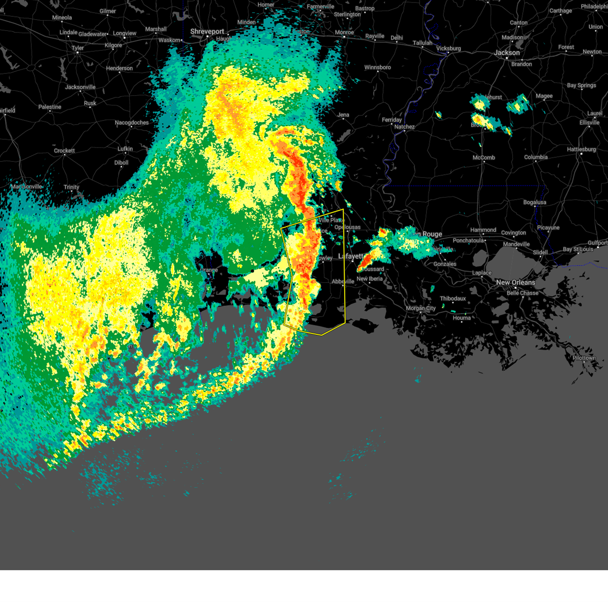
 Svrlch the national weather service in lake charles has issued a * severe thunderstorm warning for, northern iberia parish in south central louisiana, lafayette parish in south central louisiana, southern evangeline parish in central louisiana, northeastern acadia parish in southwestern louisiana, northeastern vermilion parish in southwestern louisiana, southeastern avoyelles parish in central louisiana, st. martin parish in south central louisiana, st. landry parish in central louisiana, * until 715 am cdt. * at 627 am cdt, severe thunderstorms were located along a line extending from near mamou to near church point to lafayette to near erath, moving northeast at 70 mph (radar indicated). Hazards include 70 mph wind gusts. Expect considerable tree damage. Damage is likely to mobile homes, roofs, and outbuildings. Svrlch the national weather service in lake charles has issued a * severe thunderstorm warning for, northern iberia parish in south central louisiana, lafayette parish in south central louisiana, southern evangeline parish in central louisiana, northeastern acadia parish in southwestern louisiana, northeastern vermilion parish in southwestern louisiana, southeastern avoyelles parish in central louisiana, st. martin parish in south central louisiana, st. landry parish in central louisiana, * until 715 am cdt. * at 627 am cdt, severe thunderstorms were located along a line extending from near mamou to near church point to lafayette to near erath, moving northeast at 70 mph (radar indicated). Hazards include 70 mph wind gusts. Expect considerable tree damage. Damage is likely to mobile homes, roofs, and outbuildings.
|
| 3/24/2025 6:21 AM CDT |
 At 620 am cdt, severe thunderstorms were located along a line extending from near rayne to near esther to 8 miles southwest of intracoastal city, moving east at 60 mph (radar indicated). Hazards include 70 mph wind gusts. Expect considerable tree damage. damage is likely to mobile homes, roofs, and outbuildings. Locations impacted include, youngsville, lydia, acadiana regional airport, jefferson island, forked island, delcambre, crowley, carencro, coteau, kaplan, lyons point, jeanerette, intracoastal city, henry, meaux, weeks island, esther, new iberia, loreauville, and erath. At 620 am cdt, severe thunderstorms were located along a line extending from near rayne to near esther to 8 miles southwest of intracoastal city, moving east at 60 mph (radar indicated). Hazards include 70 mph wind gusts. Expect considerable tree damage. damage is likely to mobile homes, roofs, and outbuildings. Locations impacted include, youngsville, lydia, acadiana regional airport, jefferson island, forked island, delcambre, crowley, carencro, coteau, kaplan, lyons point, jeanerette, intracoastal city, henry, meaux, weeks island, esther, new iberia, loreauville, and erath.
|
| 3/24/2025 6:21 AM CDT |
 the severe thunderstorm warning has been cancelled and is no longer in effect the severe thunderstorm warning has been cancelled and is no longer in effect
|
| 3/24/2025 5:56 AM CDT |
 Svrlch the national weather service in lake charles has issued a * severe thunderstorm warning for, eastern cameron parish in southwestern louisiana, northwestern iberia parish in south central louisiana, lafayette parish in south central louisiana, southeastern jefferson davis parish in southwestern louisiana, southern acadia parish in southwestern louisiana, vermilion parish in southwestern louisiana, * until 700 am cdt. * at 555 am cdt, severe thunderstorms were located along a line extending from near lake arthur to 14 miles northwest of pecan island to 8 miles southeast of rockefeller wildlife range, moving east at 55 mph (radar indicated). Hazards include 70 mph wind gusts. Expect considerable tree damage. Damage is likely to mobile homes, roofs, and outbuildings. Svrlch the national weather service in lake charles has issued a * severe thunderstorm warning for, eastern cameron parish in southwestern louisiana, northwestern iberia parish in south central louisiana, lafayette parish in south central louisiana, southeastern jefferson davis parish in southwestern louisiana, southern acadia parish in southwestern louisiana, vermilion parish in southwestern louisiana, * until 700 am cdt. * at 555 am cdt, severe thunderstorms were located along a line extending from near lake arthur to 14 miles northwest of pecan island to 8 miles southeast of rockefeller wildlife range, moving east at 55 mph (radar indicated). Hazards include 70 mph wind gusts. Expect considerable tree damage. Damage is likely to mobile homes, roofs, and outbuildings.
|
| 12/28/2024 6:57 PM CST |
 Svrlch the national weather service in lake charles has issued a * severe thunderstorm warning for, northwestern iberia parish in south central louisiana, vermilion parish in southwestern louisiana, * until 800 pm cst. * at 657 pm cst, a severe thunderstorm was located 9 miles west of forked island, moving east at 30 mph (radar indicated). Hazards include 60 mph wind gusts and penny size hail. expect damage to roofs, siding, and trees Svrlch the national weather service in lake charles has issued a * severe thunderstorm warning for, northwestern iberia parish in south central louisiana, vermilion parish in southwestern louisiana, * until 800 pm cst. * at 657 pm cst, a severe thunderstorm was located 9 miles west of forked island, moving east at 30 mph (radar indicated). Hazards include 60 mph wind gusts and penny size hail. expect damage to roofs, siding, and trees
|
| 12/28/2024 6:43 PM CST |
 At 643 pm cst, a severe thunderstorm was located near forked island, moving east at 40 mph (radar indicated). Hazards include 60 mph wind gusts and nickel size hail. Expect damage to roofs, siding, and trees. Locations impacted include, meaux, florence landing, esther, wright, kaplan, forked island, gueydan, and abbeville. At 643 pm cst, a severe thunderstorm was located near forked island, moving east at 40 mph (radar indicated). Hazards include 60 mph wind gusts and nickel size hail. Expect damage to roofs, siding, and trees. Locations impacted include, meaux, florence landing, esther, wright, kaplan, forked island, gueydan, and abbeville.
|
| 12/28/2024 6:43 PM CST |
 the severe thunderstorm warning has been cancelled and is no longer in effect the severe thunderstorm warning has been cancelled and is no longer in effect
|
| 12/28/2024 5:55 PM CST |
 Svrlch the national weather service in lake charles has issued a * severe thunderstorm warning for, northeastern cameron parish in southwestern louisiana, central vermilion parish in southwestern louisiana, * until 700 pm cst. * at 555 pm cst, a severe thunderstorm was located 8 miles south of lowry, or 11 miles southeast of lacassine national wildlife refuge, moving east at 35 mph (radar indicated). Hazards include 60 mph wind gusts and quarter size hail. Hail damage to vehicles is expected. Expect wind damage to roofs, siding, and trees. Svrlch the national weather service in lake charles has issued a * severe thunderstorm warning for, northeastern cameron parish in southwestern louisiana, central vermilion parish in southwestern louisiana, * until 700 pm cst. * at 555 pm cst, a severe thunderstorm was located 8 miles south of lowry, or 11 miles southeast of lacassine national wildlife refuge, moving east at 35 mph (radar indicated). Hazards include 60 mph wind gusts and quarter size hail. Hail damage to vehicles is expected. Expect wind damage to roofs, siding, and trees.
|
| 8/3/2024 5:45 PM CDT |
 Svrlch the national weather service in lake charles has issued a * severe thunderstorm warning for, northeastern cameron parish in southwestern louisiana, west central iberia parish in south central louisiana, central jefferson davis parish in southwestern louisiana, southwestern acadia parish in southwestern louisiana, northern vermilion parish in southwestern louisiana, * until 645 pm cdt. * at 544 pm cdt, severe thunderstorms were located along a line extending from near fenton to riceville to delcambre, moving west at 15 mph (radar indicated). Hazards include 60 mph wind gusts and penny size hail. expect damage to roofs, siding, and trees Svrlch the national weather service in lake charles has issued a * severe thunderstorm warning for, northeastern cameron parish in southwestern louisiana, west central iberia parish in south central louisiana, central jefferson davis parish in southwestern louisiana, southwestern acadia parish in southwestern louisiana, northern vermilion parish in southwestern louisiana, * until 645 pm cdt. * at 544 pm cdt, severe thunderstorms were located along a line extending from near fenton to riceville to delcambre, moving west at 15 mph (radar indicated). Hazards include 60 mph wind gusts and penny size hail. expect damage to roofs, siding, and trees
|
| 5/30/2024 11:06 PM CDT |
 Svrlch the national weather service in lake charles has issued a * severe thunderstorm warning for, iberia parish in south central louisiana, southeastern lafayette parish in south central louisiana, northwestern st. mary parish in south central louisiana, eastern vermilion parish in southwestern louisiana, west central st. martin parish in south central louisiana, * until midnight cdt. * at 1106 pm cdt, severe thunderstorms were located along a line extending from near breaux bridge to erath to near forked island, moving southeast at 25 mph (radar indicated). Hazards include 60 mph wind gusts and penny size hail. expect damage to roofs, siding, and trees Svrlch the national weather service in lake charles has issued a * severe thunderstorm warning for, iberia parish in south central louisiana, southeastern lafayette parish in south central louisiana, northwestern st. mary parish in south central louisiana, eastern vermilion parish in southwestern louisiana, west central st. martin parish in south central louisiana, * until midnight cdt. * at 1106 pm cdt, severe thunderstorms were located along a line extending from near breaux bridge to erath to near forked island, moving southeast at 25 mph (radar indicated). Hazards include 60 mph wind gusts and penny size hail. expect damage to roofs, siding, and trees
|
| 5/28/2024 4:19 PM CDT |
 the severe thunderstorm warning has been cancelled and is no longer in effect the severe thunderstorm warning has been cancelled and is no longer in effect
|
| 5/28/2024 3:50 PM CDT |
 Svrlch the national weather service in lake charles has issued a * severe thunderstorm warning for, northern iberia parish in south central louisiana, southeastern lafayette parish in south central louisiana, northwestern st. mary parish in south central louisiana, northeastern vermilion parish in southwestern louisiana, southern st. martin parish in south central louisiana, * until 445 pm cdt. * at 350 pm cdt, severe thunderstorms were located along a line extending from near pierre part to near cypremort point to near forked island, moving west at 5 mph (radar indicated). Hazards include 60 mph wind gusts and penny size hail. expect damage to roofs, siding, and trees Svrlch the national weather service in lake charles has issued a * severe thunderstorm warning for, northern iberia parish in south central louisiana, southeastern lafayette parish in south central louisiana, northwestern st. mary parish in south central louisiana, northeastern vermilion parish in southwestern louisiana, southern st. martin parish in south central louisiana, * until 445 pm cdt. * at 350 pm cdt, severe thunderstorms were located along a line extending from near pierre part to near cypremort point to near forked island, moving west at 5 mph (radar indicated). Hazards include 60 mph wind gusts and penny size hail. expect damage to roofs, siding, and trees
|
| 5/28/2024 3:04 PM CDT |
 Svrlch the national weather service in lake charles has issued a * severe thunderstorm warning for, southern lafayette parish in south central louisiana, northeastern vermilion parish in southwestern louisiana, * until 345 pm cdt. * at 304 pm cdt, a severe thunderstorm was located over maurice, or 7 miles north of abbeville, moving west at 10 mph (radar indicated). Hazards include 60 mph wind gusts and quarter size hail. Hail damage to vehicles is expected. Expect wind damage to roofs, siding, and trees. Svrlch the national weather service in lake charles has issued a * severe thunderstorm warning for, southern lafayette parish in south central louisiana, northeastern vermilion parish in southwestern louisiana, * until 345 pm cdt. * at 304 pm cdt, a severe thunderstorm was located over maurice, or 7 miles north of abbeville, moving west at 10 mph (radar indicated). Hazards include 60 mph wind gusts and quarter size hail. Hail damage to vehicles is expected. Expect wind damage to roofs, siding, and trees.
|
| 5/16/2024 9:50 PM CDT |
 At 949 pm cdt, a severe thunderstorm was located over coteau, or 8 miles northwest of new iberia, moving east at 60 mph. this is a destructive storm for st martinville, new iberia, loreauville, catahoula (radar indicated). Hazards include 90 mph wind gusts and nickel size hail. You are in a life-threatening situation. flying debris may be deadly to those caught without shelter. mobile homes will be heavily damaged or destroyed. homes and businesses will have substantial roof and window damage. expect extensive tree damage and power outages. locations impacted include, lafayette, new iberia, abbeville, catahoula, scott, breaux bridge, franklin, st. Martinville, jeanerette, avery island, belle river, broussard, youngsville, baldwin, erath, delcambre, duson, maurice, loreauville, and butte la rose. At 949 pm cdt, a severe thunderstorm was located over coteau, or 8 miles northwest of new iberia, moving east at 60 mph. this is a destructive storm for st martinville, new iberia, loreauville, catahoula (radar indicated). Hazards include 90 mph wind gusts and nickel size hail. You are in a life-threatening situation. flying debris may be deadly to those caught without shelter. mobile homes will be heavily damaged or destroyed. homes and businesses will have substantial roof and window damage. expect extensive tree damage and power outages. locations impacted include, lafayette, new iberia, abbeville, catahoula, scott, breaux bridge, franklin, st. Martinville, jeanerette, avery island, belle river, broussard, youngsville, baldwin, erath, delcambre, duson, maurice, loreauville, and butte la rose.
|
| 5/16/2024 9:40 PM CDT |
 Svrlch the national weather service in lake charles has issued a * severe thunderstorm warning for, iberia parish in south central louisiana, lafayette parish in south central louisiana, northwestern st. mary parish in south central louisiana, northeastern vermilion parish in southwestern louisiana, st. martin parish in south central louisiana, * until 1015 pm cdt. * at 939 pm cdt, a severe thunderstorm was located over maurice, or near abbeville, moving east at 60 mph. this is a destructive storm for youngsville, cade, new iberia, jeanerette, and st mary parish (radar indicated). Hazards include 80 mph wind gusts and nickel size hail. Flying debris will be dangerous to those caught without shelter. mobile homes will be heavily damaged. expect considerable damage to roofs, windows, and vehicles. Extensive tree damage and power outages are likely. Svrlch the national weather service in lake charles has issued a * severe thunderstorm warning for, iberia parish in south central louisiana, lafayette parish in south central louisiana, northwestern st. mary parish in south central louisiana, northeastern vermilion parish in southwestern louisiana, st. martin parish in south central louisiana, * until 1015 pm cdt. * at 939 pm cdt, a severe thunderstorm was located over maurice, or near abbeville, moving east at 60 mph. this is a destructive storm for youngsville, cade, new iberia, jeanerette, and st mary parish (radar indicated). Hazards include 80 mph wind gusts and nickel size hail. Flying debris will be dangerous to those caught without shelter. mobile homes will be heavily damaged. expect considerable damage to roofs, windows, and vehicles. Extensive tree damage and power outages are likely.
|
| 5/16/2024 9:24 PM CDT |
 the severe thunderstorm warning has been cancelled and is no longer in effect the severe thunderstorm warning has been cancelled and is no longer in effect
|
| 5/16/2024 9:24 PM CDT |
 At 924 pm cdt, severe thunderstorms were located along a line extending from mire to near meaux to 9 miles south of wright, moving southeast at 45 mph (radar indicated). Hazards include 70 mph wind gusts and penny size hail. Expect considerable tree damage. damage is likely to mobile homes, roofs, and outbuildings. Locations impacted include, lafayette, crowley, abbeville, scott, breaux bridge, rayne, carencro, kaplan, church point, gueydan, arnaudville, forked island, broussard, youngsville, sunset, erath, delcambre, duson, maurice, and grand coteau. At 924 pm cdt, severe thunderstorms were located along a line extending from mire to near meaux to 9 miles south of wright, moving southeast at 45 mph (radar indicated). Hazards include 70 mph wind gusts and penny size hail. Expect considerable tree damage. damage is likely to mobile homes, roofs, and outbuildings. Locations impacted include, lafayette, crowley, abbeville, scott, breaux bridge, rayne, carencro, kaplan, church point, gueydan, arnaudville, forked island, broussard, youngsville, sunset, erath, delcambre, duson, maurice, and grand coteau.
|
| 5/16/2024 9:13 PM CDT |
 Svrlch the national weather service in lake charles has issued a * severe thunderstorm warning for, northeastern cameron parish in southwestern louisiana, northwestern iberia parish in south central louisiana, lafayette parish in south central louisiana, southeastern jefferson davis parish in southwestern louisiana, south central evangeline parish in central louisiana, acadia parish in southwestern louisiana, northern vermilion parish in southwestern louisiana, northwestern st. martin parish in south central louisiana, southwestern st. landry parish in central louisiana, * until 1000 pm cdt. * at 913 pm cdt, severe thunderstorms were located along a line extending from near maxie to lyons point to 7 miles south of klondike, moving east at 45 mph (radar indicated). Hazards include 70 mph wind gusts and penny size hail. Expect considerable tree damage. Damage is likely to mobile homes, roofs, and outbuildings. Svrlch the national weather service in lake charles has issued a * severe thunderstorm warning for, northeastern cameron parish in southwestern louisiana, northwestern iberia parish in south central louisiana, lafayette parish in south central louisiana, southeastern jefferson davis parish in southwestern louisiana, south central evangeline parish in central louisiana, acadia parish in southwestern louisiana, northern vermilion parish in southwestern louisiana, northwestern st. martin parish in south central louisiana, southwestern st. landry parish in central louisiana, * until 1000 pm cdt. * at 913 pm cdt, severe thunderstorms were located along a line extending from near maxie to lyons point to 7 miles south of klondike, moving east at 45 mph (radar indicated). Hazards include 70 mph wind gusts and penny size hail. Expect considerable tree damage. Damage is likely to mobile homes, roofs, and outbuildings.
|
| 5/13/2024 6:21 PM CDT |
 At 620 pm cdt, severe thunderstorms were located along a line extending from near breaux bridge to cade to near delcambre, moving east at 50 mph. these are destructive storms for lafayette and saint martin (radar indicated). Hazards include 80 mph wind gusts and quarter size hail. Flying debris will be dangerous to those caught without shelter. mobile homes will be heavily damaged. expect considerable damage to roofs, windows, and vehicles. extensive tree damage and power outages are likely. locations impacted include, lafayette, new iberia, abbeville, catahoula, scott, breaux bridge, rayne, carencro, st. Martinville, jeanerette, kaplan, church point, arnaudville, avery island, broussard, youngsville, sunset, erath, delcambre, and duson. At 620 pm cdt, severe thunderstorms were located along a line extending from near breaux bridge to cade to near delcambre, moving east at 50 mph. these are destructive storms for lafayette and saint martin (radar indicated). Hazards include 80 mph wind gusts and quarter size hail. Flying debris will be dangerous to those caught without shelter. mobile homes will be heavily damaged. expect considerable damage to roofs, windows, and vehicles. extensive tree damage and power outages are likely. locations impacted include, lafayette, new iberia, abbeville, catahoula, scott, breaux bridge, rayne, carencro, st. Martinville, jeanerette, kaplan, church point, arnaudville, avery island, broussard, youngsville, sunset, erath, delcambre, and duson.
|
| 5/13/2024 6:11 PM CDT |
 At 611 pm cdt, severe thunderstorms were located along a line extending from cankton to near youngsville to near erath, moving east at 55 mph (radar indicated). Hazards include 70 mph wind gusts and quarter size hail. Hail damage to vehicles is expected. expect considerable tree damage. wind damage is also likely to mobile homes, roofs, and outbuildings. locations impacted include, lafayette, new iberia, abbeville, catahoula, scott, breaux bridge, rayne, carencro, st. Martinville, jeanerette, kaplan, church point, arnaudville, avery island, broussard, youngsville, sunset, erath, delcambre, and duson. At 611 pm cdt, severe thunderstorms were located along a line extending from cankton to near youngsville to near erath, moving east at 55 mph (radar indicated). Hazards include 70 mph wind gusts and quarter size hail. Hail damage to vehicles is expected. expect considerable tree damage. wind damage is also likely to mobile homes, roofs, and outbuildings. locations impacted include, lafayette, new iberia, abbeville, catahoula, scott, breaux bridge, rayne, carencro, st. Martinville, jeanerette, kaplan, church point, arnaudville, avery island, broussard, youngsville, sunset, erath, delcambre, and duson.
|
| 5/13/2024 5:46 PM CDT |
 Svrlch the national weather service in lake charles has issued a * severe thunderstorm warning for, northwestern iberia parish in south central louisiana, lafayette parish in south central louisiana, acadia parish in southwestern louisiana, northern vermilion parish in southwestern louisiana, northwestern st. martin parish in south central louisiana, southeastern st. landry parish in central louisiana, * until 630 pm cdt. * at 544 pm cdt, severe thunderstorms were located along a line extending from iota to near lyons point to near wright, moving east at 50 mph. these are destructive storms for southern acadia, southern lafayette, northern vermilion (radar indicated). Hazards include 80 mph wind gusts and quarter size hail. Flying debris will be dangerous to those caught without shelter. mobile homes will be heavily damaged. expect considerable damage to roofs, windows, and vehicles. Extensive tree damage and power outages are likely. Svrlch the national weather service in lake charles has issued a * severe thunderstorm warning for, northwestern iberia parish in south central louisiana, lafayette parish in south central louisiana, acadia parish in southwestern louisiana, northern vermilion parish in southwestern louisiana, northwestern st. martin parish in south central louisiana, southeastern st. landry parish in central louisiana, * until 630 pm cdt. * at 544 pm cdt, severe thunderstorms were located along a line extending from iota to near lyons point to near wright, moving east at 50 mph. these are destructive storms for southern acadia, southern lafayette, northern vermilion (radar indicated). Hazards include 80 mph wind gusts and quarter size hail. Flying debris will be dangerous to those caught without shelter. mobile homes will be heavily damaged. expect considerable damage to roofs, windows, and vehicles. Extensive tree damage and power outages are likely.
|
| 5/13/2024 5:18 PM CDT |
 Svrlch the national weather service in lake charles has issued a * severe thunderstorm warning for, northeastern cameron parish in southwestern louisiana, southwestern lafayette parish in south central louisiana, jefferson davis parish in southwestern louisiana, acadia parish in southwestern louisiana, northern vermilion parish in southwestern louisiana, * until 600 pm cdt. * at 517 pm cdt, severe thunderstorms were located along a line extending from near welsh to near thornwell to near creole, moving east at 50 mph (radar indicated). Hazards include 70 mph wind gusts and quarter size hail. Hail damage to vehicles is expected. expect considerable tree damage. Wind damage is also likely to mobile homes, roofs, and outbuildings. Svrlch the national weather service in lake charles has issued a * severe thunderstorm warning for, northeastern cameron parish in southwestern louisiana, southwestern lafayette parish in south central louisiana, jefferson davis parish in southwestern louisiana, acadia parish in southwestern louisiana, northern vermilion parish in southwestern louisiana, * until 600 pm cdt. * at 517 pm cdt, severe thunderstorms were located along a line extending from near welsh to near thornwell to near creole, moving east at 50 mph (radar indicated). Hazards include 70 mph wind gusts and quarter size hail. Hail damage to vehicles is expected. expect considerable tree damage. Wind damage is also likely to mobile homes, roofs, and outbuildings.
|
| 4/10/2024 8:14 AM CDT |
 Svrlch the national weather service in lake charles has issued a * severe thunderstorm warning for, iberia parish in south central louisiana, southern lafayette parish in south central louisiana, st. mary parish in south central louisiana, vermilion parish in southwestern louisiana, central st. martin parish in south central louisiana, * until 915 am cdt. * at 814 am cdt, severe thunderstorms were located along a line extending from broussard to 7 miles southwest of intracoastal city to freshwater city, moving east at 40 mph (radar indicated). Hazards include 60 mph wind gusts and quarter size hail. Hail damage to vehicles is expected. Expect wind damage to roofs, siding, and trees. Svrlch the national weather service in lake charles has issued a * severe thunderstorm warning for, iberia parish in south central louisiana, southern lafayette parish in south central louisiana, st. mary parish in south central louisiana, vermilion parish in southwestern louisiana, central st. martin parish in south central louisiana, * until 915 am cdt. * at 814 am cdt, severe thunderstorms were located along a line extending from broussard to 7 miles southwest of intracoastal city to freshwater city, moving east at 40 mph (radar indicated). Hazards include 60 mph wind gusts and quarter size hail. Hail damage to vehicles is expected. Expect wind damage to roofs, siding, and trees.
|
| 4/10/2024 7:51 AM CDT |
 The storms which prompted the warning have moved out of the area. therefore, the warning will be allowed to expire. a tornado watch remains in effect until 900 am cdt for central, south central and southwestern louisiana. The storms which prompted the warning have moved out of the area. therefore, the warning will be allowed to expire. a tornado watch remains in effect until 900 am cdt for central, south central and southwestern louisiana.
|
| 4/10/2024 7:49 AM CDT |
 Svrlch the national weather service in lake charles has issued a * severe thunderstorm warning for, iberia parish in south central louisiana, southern lafayette parish in south central louisiana, st. mary parish in south central louisiana, vermilion parish in southwestern louisiana, southern st. martin parish in south central louisiana, * until 845 am cdt. * at 748 am cdt, severe thunderstorms were located along a line extending from near maurice to 9 miles southwest of forked island to 6 miles southwest of pecan island, moving east at 40 mph (radar indicated). Hazards include 60 mph wind gusts. expect damage to roofs, siding, and trees Svrlch the national weather service in lake charles has issued a * severe thunderstorm warning for, iberia parish in south central louisiana, southern lafayette parish in south central louisiana, st. mary parish in south central louisiana, vermilion parish in southwestern louisiana, southern st. martin parish in south central louisiana, * until 845 am cdt. * at 748 am cdt, severe thunderstorms were located along a line extending from near maurice to 9 miles southwest of forked island to 6 miles southwest of pecan island, moving east at 40 mph (radar indicated). Hazards include 60 mph wind gusts. expect damage to roofs, siding, and trees
|
| 4/10/2024 7:02 AM CDT |
 Svrlch the national weather service in lake charles has issued a * severe thunderstorm warning for, northeastern cameron parish in southwestern louisiana, northwestern iberia parish in south central louisiana, lafayette parish in south central louisiana, eastern jefferson davis parish in southwestern louisiana, southern evangeline parish in central louisiana, acadia parish in southwestern louisiana, northern vermilion parish in southwestern louisiana, northwestern st. martin parish in south central louisiana, st. landry parish in central louisiana, * until 800 am cdt. * at 702 am cdt, severe thunderstorms were located along a line extending from near elton to near jennings to 9 miles southeast of lacassine national wildlife refuge, moving northeast at 75 mph (radar indicated). Hazards include 70 mph wind gusts and nickel size hail. Expect considerable tree damage. Damage is likely to mobile homes, roofs, and outbuildings. Svrlch the national weather service in lake charles has issued a * severe thunderstorm warning for, northeastern cameron parish in southwestern louisiana, northwestern iberia parish in south central louisiana, lafayette parish in south central louisiana, eastern jefferson davis parish in southwestern louisiana, southern evangeline parish in central louisiana, acadia parish in southwestern louisiana, northern vermilion parish in southwestern louisiana, northwestern st. martin parish in south central louisiana, st. landry parish in central louisiana, * until 800 am cdt. * at 702 am cdt, severe thunderstorms were located along a line extending from near elton to near jennings to 9 miles southeast of lacassine national wildlife refuge, moving northeast at 75 mph (radar indicated). Hazards include 70 mph wind gusts and nickel size hail. Expect considerable tree damage. Damage is likely to mobile homes, roofs, and outbuildings.
|
| 3/8/2024 1:12 PM CST |
 Svrlch the national weather service in lake charles has issued a * severe thunderstorm warning for, lafayette parish in south central louisiana, northeastern vermilion parish in southwestern louisiana, west central st. martin parish in south central louisiana, * until 145 pm cst. * at 111 pm cst, a severe thunderstorm was located over maurice, or 8 miles southwest of lafayette, moving northeast at 35 mph (radar indicated). Hazards include 60 mph wind gusts and quarter size hail. Hail damage to vehicles is expected. Expect wind damage to roofs, siding, and trees. Svrlch the national weather service in lake charles has issued a * severe thunderstorm warning for, lafayette parish in south central louisiana, northeastern vermilion parish in southwestern louisiana, west central st. martin parish in south central louisiana, * until 145 pm cst. * at 111 pm cst, a severe thunderstorm was located over maurice, or 8 miles southwest of lafayette, moving northeast at 35 mph (radar indicated). Hazards include 60 mph wind gusts and quarter size hail. Hail damage to vehicles is expected. Expect wind damage to roofs, siding, and trees.
|
| 2/4/2024 6:55 PM CST |
 At 655 pm cst, a severe thunderstorm was located near lyons point, or 7 miles southeast of crowley, moving south at 30 mph (radar indicated). Hazards include quarter size hail. damage to vehicles is expected At 655 pm cst, a severe thunderstorm was located near lyons point, or 7 miles southeast of crowley, moving south at 30 mph (radar indicated). Hazards include quarter size hail. damage to vehicles is expected
|
| 1/26/2024 11:26 PM CST |
 At 1125 pm cst, a severe thunderstorm was located over pecan island, moving northeast at 40 mph (radar indicated). Hazards include 60 mph wind gusts and quarter size hail. Hail damage to vehicles is expected. Expect wind damage to roofs, siding, and trees. At 1125 pm cst, a severe thunderstorm was located over pecan island, moving northeast at 40 mph (radar indicated). Hazards include 60 mph wind gusts and quarter size hail. Hail damage to vehicles is expected. Expect wind damage to roofs, siding, and trees.
|
| 1/25/2024 7:22 AM CST |
 The severe thunderstorm warning for northwestern iberia, lafayette, northeastern vermilion and northwestern st. martin parishes will expire at 730 am cst, the storms which prompted the warning have weakened. therefore, the warning will be allowed to expire. &&. The severe thunderstorm warning for northwestern iberia, lafayette, northeastern vermilion and northwestern st. martin parishes will expire at 730 am cst, the storms which prompted the warning have weakened. therefore, the warning will be allowed to expire. &&.
|
| 1/25/2024 6:59 AM CST |
 At 658 am cst, severe thunderstorms were located along a line extending from near mire to near esther, moving east at 45 mph (radar indicated). Hazards include 60 mph wind gusts. Expect damage to roofs, siding, and trees. locations impacted include, lafayette, new iberia, abbeville, scott, breaux bridge, carencro, st. Martinville, kaplan, forked island, avery island, broussard, youngsville, erath, delcambre, duson, henderson, maurice, loreauville, lydia, and acadiana regional airport. At 658 am cst, severe thunderstorms were located along a line extending from near mire to near esther, moving east at 45 mph (radar indicated). Hazards include 60 mph wind gusts. Expect damage to roofs, siding, and trees. locations impacted include, lafayette, new iberia, abbeville, scott, breaux bridge, carencro, st. Martinville, kaplan, forked island, avery island, broussard, youngsville, erath, delcambre, duson, henderson, maurice, loreauville, lydia, and acadiana regional airport.
|
| 1/25/2024 6:44 AM CST |
 At 644 am cst, severe thunderstorms were located along a line extending from near rayne to 6 miles northwest of forked island, moving east at 45 mph (radar indicated). Hazards include 60 mph wind gusts and quarter size hail. Hail damage to vehicles is expected. Expect wind damage to roofs, siding, and trees. At 644 am cst, severe thunderstorms were located along a line extending from near rayne to 6 miles northwest of forked island, moving east at 45 mph (radar indicated). Hazards include 60 mph wind gusts and quarter size hail. Hail damage to vehicles is expected. Expect wind damage to roofs, siding, and trees.
|
| 11/20/2023 8:55 PM CST |
 At 855 pm cst, a severe thunderstorm was located over kaplan, moving northeast at 30 mph (radar indicated). Hazards include 60 mph wind gusts. expect damage to roofs, siding, and trees At 855 pm cst, a severe thunderstorm was located over kaplan, moving northeast at 30 mph (radar indicated). Hazards include 60 mph wind gusts. expect damage to roofs, siding, and trees
|
| 11/20/2023 8:34 PM CST |
 At 833 pm cst, a severe thunderstorm was located near wright, or near gueydan, moving east at 30 mph (radar indicated). Hazards include 60 mph wind gusts. expect damage to roofs, siding, and trees At 833 pm cst, a severe thunderstorm was located near wright, or near gueydan, moving east at 30 mph (radar indicated). Hazards include 60 mph wind gusts. expect damage to roofs, siding, and trees
|
| 9/8/2023 1:54 PM CDT |
 At 153 pm cdt, severe thunderstorms were located along a line extending from lunita to near westlake to near welsh to near maurice, moving south at 35 mph (radar indicated). Hazards include 60 mph wind gusts and penny size hail. expect damage to roofs, siding, and trees At 153 pm cdt, severe thunderstorms were located along a line extending from lunita to near westlake to near welsh to near maurice, moving south at 35 mph (radar indicated). Hazards include 60 mph wind gusts and penny size hail. expect damage to roofs, siding, and trees
|
| 7/31/2023 5:53 PM CDT |
 The severe thunderstorm warning for west central iberia and northeastern vermilion parishes will expire at 600 pm cdt, the storm which prompted the warning has weakened below severe limits, and no longer poses an immediate threat to life or property. therefore, the warning will be allowed to expire. The severe thunderstorm warning for west central iberia and northeastern vermilion parishes will expire at 600 pm cdt, the storm which prompted the warning has weakened below severe limits, and no longer poses an immediate threat to life or property. therefore, the warning will be allowed to expire.
|
| 7/31/2023 5:24 PM CDT |
 At 524 pm cdt, a severe thunderstorm was located near youngsville, or near abbeville, and is nearly stationary (radar indicated). Hazards include 60 mph wind gusts and quarter size hail. Hail damage to vehicles is expected. Expect wind damage to roofs, siding, and trees. At 524 pm cdt, a severe thunderstorm was located near youngsville, or near abbeville, and is nearly stationary (radar indicated). Hazards include 60 mph wind gusts and quarter size hail. Hail damage to vehicles is expected. Expect wind damage to roofs, siding, and trees.
|
| 7/22/2023 5:22 PM CDT |
 At 521 pm cdt, a severe thunderstorm was located over crowley, moving southeast at 20 mph (radar indicated). Hazards include 60 mph wind gusts and quarter size hail. Hail damage to vehicles is expected. Expect wind damage to roofs, siding, and trees. At 521 pm cdt, a severe thunderstorm was located over crowley, moving southeast at 20 mph (radar indicated). Hazards include 60 mph wind gusts and quarter size hail. Hail damage to vehicles is expected. Expect wind damage to roofs, siding, and trees.
|
| 6/20/2023 10:26 PM CDT |
 The severe thunderstorm warning for northwestern iberia, western st. mary and east central vermilion parishes will expire at 1030 pm cdt, the storm which prompted the warning has moved out of the area. therefore, the warning will be allowed to expire. a severe thunderstorm watch remains in effect until 1100 pm cdt for south central and southwestern louisiana. The severe thunderstorm warning for northwestern iberia, western st. mary and east central vermilion parishes will expire at 1030 pm cdt, the storm which prompted the warning has moved out of the area. therefore, the warning will be allowed to expire. a severe thunderstorm watch remains in effect until 1100 pm cdt for south central and southwestern louisiana.
|
| 6/20/2023 10:02 PM CDT |
 At 1001 pm cdt, a severe thunderstorm was located near henry, or near avery island, moving south at 30 mph (radar indicated). Hazards include 60 mph wind gusts and quarter size hail. Hail damage to vehicles is expected. expect wind damage to roofs, siding, and trees. locations impacted include, new iberia, abbeville, avery island, erath, delcambre, lydia, jefferson island, henry and weeks island. hail threat, radar indicated max hail size, 1. 00 in wind threat, radar indicated max wind gust, 60 mph. At 1001 pm cdt, a severe thunderstorm was located near henry, or near avery island, moving south at 30 mph (radar indicated). Hazards include 60 mph wind gusts and quarter size hail. Hail damage to vehicles is expected. expect wind damage to roofs, siding, and trees. locations impacted include, new iberia, abbeville, avery island, erath, delcambre, lydia, jefferson island, henry and weeks island. hail threat, radar indicated max hail size, 1. 00 in wind threat, radar indicated max wind gust, 60 mph.
|
| 6/20/2023 9:40 PM CDT |
 At 939 pm cdt, a severe thunderstorm was located over coteau, or 8 miles west of new iberia, moving south at 35 mph (radar indicated). Hazards include 60 mph wind gusts and quarter size hail. Hail damage to vehicles is expected. Expect wind damage to roofs, siding, and trees. At 939 pm cdt, a severe thunderstorm was located over coteau, or 8 miles west of new iberia, moving south at 35 mph (radar indicated). Hazards include 60 mph wind gusts and quarter size hail. Hail damage to vehicles is expected. Expect wind damage to roofs, siding, and trees.
|
| 4/16/2023 12:47 AM CDT |
 At 1247 am cdt, severe thunderstorms were located along a line extending from near erath to 8 miles southeast of henry to 10 miles south of cypremort point, moving east at 25 mph (radar indicated). Hazards include 60 mph wind gusts and quarter size hail. Hail damage to vehicles is expected. Expect wind damage to roofs, siding, and trees. At 1247 am cdt, severe thunderstorms were located along a line extending from near erath to 8 miles southeast of henry to 10 miles south of cypremort point, moving east at 25 mph (radar indicated). Hazards include 60 mph wind gusts and quarter size hail. Hail damage to vehicles is expected. Expect wind damage to roofs, siding, and trees.
|
| 4/16/2023 12:10 AM CDT |
 At 1209 am cdt, severe thunderstorms were located along a line extending from gueydan to 9 miles southwest of forked island to 6 miles southeast of pecan island, moving east at 20 mph (radar indicated). Hazards include 70 mph wind gusts and nickel size hail. Expect considerable tree damage. Damage is likely to mobile homes, roofs, and outbuildings. At 1209 am cdt, severe thunderstorms were located along a line extending from gueydan to 9 miles southwest of forked island to 6 miles southeast of pecan island, moving east at 20 mph (radar indicated). Hazards include 70 mph wind gusts and nickel size hail. Expect considerable tree damage. Damage is likely to mobile homes, roofs, and outbuildings.
|
| 1/24/2023 7:19 PM CST |
 At 719 pm cst, severe thunderstorms were located along a line extending from 7 miles southeast of fort adams to near st. martinville to 8 miles south of intracoastal city, moving east at 40 mph (radar indicated). Hazards include 60 mph wind gusts and penny size hail. Expect damage to roofs, siding, and trees. locations impacted include, lafayette, new iberia, morgan city, abbeville, catahoula, breaux bridge, franklin, carencro, st. Martinville, patterson, jeanerette, berwick, arnaudville, freshwater city, belle river, intracoastal city, bayou vista, avery island, burns point and cypremort point. At 719 pm cst, severe thunderstorms were located along a line extending from 7 miles southeast of fort adams to near st. martinville to 8 miles south of intracoastal city, moving east at 40 mph (radar indicated). Hazards include 60 mph wind gusts and penny size hail. Expect damage to roofs, siding, and trees. locations impacted include, lafayette, new iberia, morgan city, abbeville, catahoula, breaux bridge, franklin, carencro, st. Martinville, patterson, jeanerette, berwick, arnaudville, freshwater city, belle river, intracoastal city, bayou vista, avery island, burns point and cypremort point.
|
| 1/24/2023 7:04 PM CST |
 At 704 pm cst, a severe thunderstorm capable of producing a tornado was located over esther, or near intracoastal city, moving northeast at 65 mph (radar indicated rotation). Hazards include tornado. Flying debris will be dangerous to those caught without shelter. mobile homes will be damaged or destroyed. damage to roofs, windows, and vehicles will occur. tree damage is likely. this dangerous storm will be near, abbeville around 710 pm cst. erath and delcambre around 715 pm cst. jefferson island around 720 pm cst. youngsville and coteau around 725 pm cst. Other locations impacted by this tornadic thunderstorm include milton. At 704 pm cst, a severe thunderstorm capable of producing a tornado was located over esther, or near intracoastal city, moving northeast at 65 mph (radar indicated rotation). Hazards include tornado. Flying debris will be dangerous to those caught without shelter. mobile homes will be damaged or destroyed. damage to roofs, windows, and vehicles will occur. tree damage is likely. this dangerous storm will be near, abbeville around 710 pm cst. erath and delcambre around 715 pm cst. jefferson island around 720 pm cst. youngsville and coteau around 725 pm cst. Other locations impacted by this tornadic thunderstorm include milton.
|
| 1/24/2023 6:59 PM CST |
 At 659 pm cst, a severe thunderstorm capable of producing a tornado was located over forked island, moving northeast at 65 mph (radar indicated rotation). Hazards include tornado. Flying debris will be dangerous to those caught without shelter. mobile homes will be damaged or destroyed. damage to roofs, windows, and vehicles will occur. tree damage is likely. this dangerous storm will be near, esther around 705 pm cst. henry around 710 pm cst. abbeville and erath around 715 pm cst. delcambre and jefferson island around 720 pm cst. youngsville and coteau around 725 pm cst. Other locations impacted by this tornadic thunderstorm include milton. At 659 pm cst, a severe thunderstorm capable of producing a tornado was located over forked island, moving northeast at 65 mph (radar indicated rotation). Hazards include tornado. Flying debris will be dangerous to those caught without shelter. mobile homes will be damaged or destroyed. damage to roofs, windows, and vehicles will occur. tree damage is likely. this dangerous storm will be near, esther around 705 pm cst. henry around 710 pm cst. abbeville and erath around 715 pm cst. delcambre and jefferson island around 720 pm cst. youngsville and coteau around 725 pm cst. Other locations impacted by this tornadic thunderstorm include milton.
|
| 1/24/2023 6:55 PM CST |
 At 655 pm cst, a severe thunderstorm capable of producing a tornado was located near forked island, moving northeast at 60 mph (radar indicated rotation). Hazards include tornado. Flying debris will be dangerous to those caught without shelter. mobile homes will be damaged or destroyed. damage to roofs, windows, and vehicles will occur. tree damage is likely. this dangerous storm will be near, intracoastal city and esther around 705 pm cst. henry around 710 pm cst. abbeville, erath, delcambre and jefferson island around 715 pm cst. Other locations impacted by this tornadic thunderstorm include milton. At 655 pm cst, a severe thunderstorm capable of producing a tornado was located near forked island, moving northeast at 60 mph (radar indicated rotation). Hazards include tornado. Flying debris will be dangerous to those caught without shelter. mobile homes will be damaged or destroyed. damage to roofs, windows, and vehicles will occur. tree damage is likely. this dangerous storm will be near, intracoastal city and esther around 705 pm cst. henry around 710 pm cst. abbeville, erath, delcambre and jefferson island around 715 pm cst. Other locations impacted by this tornadic thunderstorm include milton.
|
| 1/24/2023 6:48 PM CST |
 At 648 pm cst, a severe thunderstorm capable of producing a tornado was located near pecan island, moving northeast at 60 mph (radar indicated rotation). Hazards include tornado. Flying debris will be dangerous to those caught without shelter. mobile homes will be damaged or destroyed. damage to roofs, windows, and vehicles will occur. tree damage is likely. this dangerous storm will be near, forked island around 700 pm cst. intracoastal city and esther around 705 pm cst. henry around 710 pm cst. abbeville, erath, delcambre and jefferson island around 715 pm cst. Other locations impacted by this tornadic thunderstorm include milton. At 648 pm cst, a severe thunderstorm capable of producing a tornado was located near pecan island, moving northeast at 60 mph (radar indicated rotation). Hazards include tornado. Flying debris will be dangerous to those caught without shelter. mobile homes will be damaged or destroyed. damage to roofs, windows, and vehicles will occur. tree damage is likely. this dangerous storm will be near, forked island around 700 pm cst. intracoastal city and esther around 705 pm cst. henry around 710 pm cst. abbeville, erath, delcambre and jefferson island around 715 pm cst. Other locations impacted by this tornadic thunderstorm include milton.
|
| 1/24/2023 6:46 PM CST |
 At 645 pm cst, severe thunderstorms were located along a line extending from 6 miles south of simmesport to near maurice to 8 miles southwest of pecan island, moving east at 40 mph (radar indicated). Hazards include 60 mph wind gusts and penny size hail. expect damage to roofs, siding, and trees At 645 pm cst, severe thunderstorms were located along a line extending from 6 miles south of simmesport to near maurice to 8 miles southwest of pecan island, moving east at 40 mph (radar indicated). Hazards include 60 mph wind gusts and penny size hail. expect damage to roofs, siding, and trees
|
| 6/5/2022 6:51 PM CDT |
 At 651 pm cdt, severe thunderstorms were located along a line extending from near lafayette to broussard, moving west at 15 mph (radar indicated). Hazards include 60 mph wind gusts and half dollar size hail. Hail damage to vehicles is expected. Expect wind damage to roofs, siding, and trees. At 651 pm cdt, severe thunderstorms were located along a line extending from near lafayette to broussard, moving west at 15 mph (radar indicated). Hazards include 60 mph wind gusts and half dollar size hail. Hail damage to vehicles is expected. Expect wind damage to roofs, siding, and trees.
|
| 3/30/2022 4:18 PM CDT |
 At 418 pm cdt, severe thunderstorms were located along a line extending from near st. martinville to henry, moving east at 40 mph (radar indicated). Hazards include 60 mph wind gusts and quarter size hail. Hail damage to vehicles is expected. Expect wind damage to roofs, siding, and trees. At 418 pm cdt, severe thunderstorms were located along a line extending from near st. martinville to henry, moving east at 40 mph (radar indicated). Hazards include 60 mph wind gusts and quarter size hail. Hail damage to vehicles is expected. Expect wind damage to roofs, siding, and trees.
|
| 10/27/2021 2:55 PM CDT |
 At 255 pm cdt, severe thunderstorms were located along a line extending from near morganza to near breaux bridge to near pecan island, moving east at 10 mph (radar indicated). Hazards include 60 mph wind gusts. Expect damage to roofs, siding, and trees. locations impacted include, lafayette, new iberia, abbeville, catahoula, scott, breaux bridge, carencro, st. Martinville, kaplan, krotz springs, leonville, arnaudville, melville, freshwater city, forked island, intracoastal city, pecan island, avery island, broussard and youngsville. At 255 pm cdt, severe thunderstorms were located along a line extending from near morganza to near breaux bridge to near pecan island, moving east at 10 mph (radar indicated). Hazards include 60 mph wind gusts. Expect damage to roofs, siding, and trees. locations impacted include, lafayette, new iberia, abbeville, catahoula, scott, breaux bridge, carencro, st. Martinville, kaplan, krotz springs, leonville, arnaudville, melville, freshwater city, forked island, intracoastal city, pecan island, avery island, broussard and youngsville.
|
| 10/27/2021 2:24 PM CDT |
 At 224 pm cdt, severe thunderstorms were located along a line extending from near melville to near lafayette to near pecan island, moving east at 20 mph (radar indicated). Hazards include 60 mph wind gusts. expect damage to roofs, siding, and trees At 224 pm cdt, severe thunderstorms were located along a line extending from near melville to near lafayette to near pecan island, moving east at 20 mph (radar indicated). Hazards include 60 mph wind gusts. expect damage to roofs, siding, and trees
|
| 10/27/2021 2:15 PM CDT |
 At 214 pm cdt, severe thunderstorms were located along a line extending from palmetto to lafayette to near pecan island, moving east at 30 mph (radar indicated). Hazards include 60 mph wind gusts and quarter size hail. Hail damage to vehicles is expected. expect wind damage to roofs, siding, and trees. locations impacted include, lafayette, new iberia, opelousas, crowley, abbeville, catahoula, scott, breaux bridge, rayne, carencro, st. Martinville, jeanerette, kaplan, church point, gueydan, krotz springs, leonville, arnaudville, melville and palmetto. At 214 pm cdt, severe thunderstorms were located along a line extending from palmetto to lafayette to near pecan island, moving east at 30 mph (radar indicated). Hazards include 60 mph wind gusts and quarter size hail. Hail damage to vehicles is expected. expect wind damage to roofs, siding, and trees. locations impacted include, lafayette, new iberia, opelousas, crowley, abbeville, catahoula, scott, breaux bridge, rayne, carencro, st. Martinville, jeanerette, kaplan, church point, gueydan, krotz springs, leonville, arnaudville, melville and palmetto.
|
| 10/27/2021 1:53 PM CDT |
 At 153 pm cdt, severe thunderstorms were located along a line extending from near grand prairie to duson to near rockefeller wildlife range, moving east at 40 mph (radar indicated). Hazards include 60 mph wind gusts and quarter size hail. Hail damage to vehicles is expected. expect wind damage to roofs, siding, and trees. locations impacted include, lafayette, new iberia, opelousas, crowley, abbeville, catahoula, scott, breaux bridge, rayne, carencro, ville platte, st. Martinville, jeanerette, kaplan, church point, gueydan, krotz springs, leonville, arnaudville and melville. At 153 pm cdt, severe thunderstorms were located along a line extending from near grand prairie to duson to near rockefeller wildlife range, moving east at 40 mph (radar indicated). Hazards include 60 mph wind gusts and quarter size hail. Hail damage to vehicles is expected. expect wind damage to roofs, siding, and trees. locations impacted include, lafayette, new iberia, opelousas, crowley, abbeville, catahoula, scott, breaux bridge, rayne, carencro, ville platte, st. Martinville, jeanerette, kaplan, church point, gueydan, krotz springs, leonville, arnaudville and melville.
|
| 10/27/2021 1:30 PM CDT |
 At 130 pm cdt, severe thunderstorms were located along a line extending from near reddell to near crowley to near rockefeller wildlife range, moving east at 45 mph (radar indicated). Hazards include 60 mph wind gusts and quarter size hail. Hail damage to vehicles is expected. Expect wind damage to roofs, siding, and trees. At 130 pm cdt, severe thunderstorms were located along a line extending from near reddell to near crowley to near rockefeller wildlife range, moving east at 45 mph (radar indicated). Hazards include 60 mph wind gusts and quarter size hail. Hail damage to vehicles is expected. Expect wind damage to roofs, siding, and trees.
|
| 10/27/2021 1:00 PM CDT |
 At 100 pm cdt, severe thunderstorms were located along a line extending from near oakdale to near jennings to near grand chenier, moving east at 45 mph (radar indicated). Hazards include 60 mph wind gusts. Expect damage to roofs, siding, and trees. Locations impacted include, lafayette, opelousas, crowley, abbeville, eunice, jennings, scott, rayne, carencro, ville platte, kaplan, church point, mamou, welsh, lake arthur, kinder, basile, oberlin, iota and gueydan. At 100 pm cdt, severe thunderstorms were located along a line extending from near oakdale to near jennings to near grand chenier, moving east at 45 mph (radar indicated). Hazards include 60 mph wind gusts. Expect damage to roofs, siding, and trees. Locations impacted include, lafayette, opelousas, crowley, abbeville, eunice, jennings, scott, rayne, carencro, ville platte, kaplan, church point, mamou, welsh, lake arthur, kinder, basile, oberlin, iota and gueydan.
|
| 10/27/2021 12:54 PM CDT |
 At 1254 pm cdt, severe thunderstorms were located along a line extending from near oakdale to near welsh to grand chenier, moving east at 45 mph (radar indicated). Hazards include 70 mph wind gusts. Expect considerable tree damage. damage is likely to mobile homes, roofs, and outbuildings. Locations impacted include, lafayette, opelousas, crowley, abbeville, eunice, jennings, scott, rayne, carencro, ville platte, kaplan, church point, mamou, welsh, lake arthur, kinder, basile, oberlin, iota and gueydan. At 1254 pm cdt, severe thunderstorms were located along a line extending from near oakdale to near welsh to grand chenier, moving east at 45 mph (radar indicated). Hazards include 70 mph wind gusts. Expect considerable tree damage. damage is likely to mobile homes, roofs, and outbuildings. Locations impacted include, lafayette, opelousas, crowley, abbeville, eunice, jennings, scott, rayne, carencro, ville platte, kaplan, church point, mamou, welsh, lake arthur, kinder, basile, oberlin, iota and gueydan.
|
| 10/27/2021 12:45 PM CDT |
 At 1244 pm cdt, severe thunderstorms were located along a line extending from near pitkin to near grand chenier, moving east at 45 mph (radar indicated). Hazards include 70 mph wind gusts. Expect considerable tree damage. damage is likely to mobile homes, roofs, and outbuildings. Locations impacted include, lafayette, opelousas, crowley, abbeville, eunice, jennings, scott, rayne, carencro, ville platte, kaplan, church point, mamou, welsh, iowa, lake arthur, kinder, basile, oberlin and iota. At 1244 pm cdt, severe thunderstorms were located along a line extending from near pitkin to near grand chenier, moving east at 45 mph (radar indicated). Hazards include 70 mph wind gusts. Expect considerable tree damage. damage is likely to mobile homes, roofs, and outbuildings. Locations impacted include, lafayette, opelousas, crowley, abbeville, eunice, jennings, scott, rayne, carencro, ville platte, kaplan, church point, mamou, welsh, iowa, lake arthur, kinder, basile, oberlin and iota.
|
| 10/27/2021 12:27 PM CDT |
 At 1227 pm cdt, severe thunderstorms were located along a line extending from near cravens to near creole, moving east at 60 mph (radar indicated). Hazards include 70 mph wind gusts. Expect considerable tree damage. Damage is likely to mobile homes, roofs, and outbuildings. At 1227 pm cdt, severe thunderstorms were located along a line extending from near cravens to near creole, moving east at 60 mph (radar indicated). Hazards include 70 mph wind gusts. Expect considerable tree damage. Damage is likely to mobile homes, roofs, and outbuildings.
|
| 5/17/2021 7:46 PM CDT |
 At 746 pm cdt, a severe thunderstorm capable of producing a tornado was located over erath, or near abbeville, moving northeast at 25 mph (radar indicated rotation). Hazards include tornado. Flying debris will be dangerous to those caught without shelter. mobile homes will be damaged or destroyed. damage to roofs, windows, and vehicles will occur. tree damage is likely. this dangerous storm will be near, jefferson island around 750 pm cdt. acadiana regional airport and coteau around 805 pm cdt. New iberia around 810 pm cdt. At 746 pm cdt, a severe thunderstorm capable of producing a tornado was located over erath, or near abbeville, moving northeast at 25 mph (radar indicated rotation). Hazards include tornado. Flying debris will be dangerous to those caught without shelter. mobile homes will be damaged or destroyed. damage to roofs, windows, and vehicles will occur. tree damage is likely. this dangerous storm will be near, jefferson island around 750 pm cdt. acadiana regional airport and coteau around 805 pm cdt. New iberia around 810 pm cdt.
|
| 5/17/2021 7:30 PM CDT |
 At 730 pm cdt, a severe thunderstorm capable of producing a tornado was located over abbeville, moving northeast at 15 mph (radar indicated rotation). Hazards include tornado. Flying debris will be dangerous to those caught without shelter. mobile homes will be damaged or destroyed. damage to roofs, windows, and vehicles will occur. tree damage is likely. this dangerous storm will be near, erath around 740 pm cdt. youngsville and maurice around 800 pm cdt. Other locations impacted by this tornadic thunderstorm include milton. At 730 pm cdt, a severe thunderstorm capable of producing a tornado was located over abbeville, moving northeast at 15 mph (radar indicated rotation). Hazards include tornado. Flying debris will be dangerous to those caught without shelter. mobile homes will be damaged or destroyed. damage to roofs, windows, and vehicles will occur. tree damage is likely. this dangerous storm will be near, erath around 740 pm cdt. youngsville and maurice around 800 pm cdt. Other locations impacted by this tornadic thunderstorm include milton.
|
| 5/17/2021 7:19 PM CDT |
 At 719 pm cdt, a severe thunderstorm capable of producing a tornado was located over abbeville, moving northeast at 15 mph (radar indicated rotation). Hazards include tornado. Flying debris will be dangerous to those caught without shelter. mobile homes will be damaged or destroyed. damage to roofs, windows, and vehicles will occur. tree damage is likely. this dangerous storm will be near, abbeville and meaux around 730 pm cdt. erath around 735 pm cdt. maurice around 745 pm cdt. Other locations impacted by this tornadic thunderstorm include milton. At 719 pm cdt, a severe thunderstorm capable of producing a tornado was located over abbeville, moving northeast at 15 mph (radar indicated rotation). Hazards include tornado. Flying debris will be dangerous to those caught without shelter. mobile homes will be damaged or destroyed. damage to roofs, windows, and vehicles will occur. tree damage is likely. this dangerous storm will be near, abbeville and meaux around 730 pm cdt. erath around 735 pm cdt. maurice around 745 pm cdt. Other locations impacted by this tornadic thunderstorm include milton.
|
| 4/24/2021 2:33 AM CDT |
 At 233 am cdt, a severe thunderstorm was located over erath, or near abbeville, moving east at 65 mph (radar indicated). Hazards include 70 mph wind gusts. Expect considerable tree damage. damage is likely to mobile homes, roofs, and outbuildings. Locations impacted include, new iberia, abbeville, jeanerette, kaplan, freshwater city, forked island, intracoastal city, cypremort point, avery island, erath, delcambre, loreauville, lydia, acadiana regional airport, jefferson island, sorrel, coteau, henry, cade and meaux. At 233 am cdt, a severe thunderstorm was located over erath, or near abbeville, moving east at 65 mph (radar indicated). Hazards include 70 mph wind gusts. Expect considerable tree damage. damage is likely to mobile homes, roofs, and outbuildings. Locations impacted include, new iberia, abbeville, jeanerette, kaplan, freshwater city, forked island, intracoastal city, cypremort point, avery island, erath, delcambre, loreauville, lydia, acadiana regional airport, jefferson island, sorrel, coteau, henry, cade and meaux.
|
| 4/24/2021 2:13 AM CDT |
 At 213 am cdt, a severe thunderstorm was located near forked island, moving east at 65 mph (radar indicated). Hazards include 70 mph wind gusts. Expect considerable tree damage. damage is likely to mobile homes, roofs, and outbuildings. Locations impacted include, new iberia, abbeville, jeanerette, kaplan, freshwater city, forked island, intracoastal city, cypremort point, pecan island, avery island, erath, delcambre, loreauville, lydia, acadiana regional airport, jefferson island, sorrel, coteau, henry and cade. At 213 am cdt, a severe thunderstorm was located near forked island, moving east at 65 mph (radar indicated). Hazards include 70 mph wind gusts. Expect considerable tree damage. damage is likely to mobile homes, roofs, and outbuildings. Locations impacted include, new iberia, abbeville, jeanerette, kaplan, freshwater city, forked island, intracoastal city, cypremort point, pecan island, avery island, erath, delcambre, loreauville, lydia, acadiana regional airport, jefferson island, sorrel, coteau, henry and cade.
|
| 4/24/2021 1:59 AM CDT |
 At 158 am cdt, a severe thunderstorm was located 11 miles northeast of rockefeller wildlife range, moving east at 65 mph (radar indicated). Hazards include 70 mph wind gusts. Expect considerable tree damage. Damage is likely to mobile homes, roofs, and outbuildings. At 158 am cdt, a severe thunderstorm was located 11 miles northeast of rockefeller wildlife range, moving east at 65 mph (radar indicated). Hazards include 70 mph wind gusts. Expect considerable tree damage. Damage is likely to mobile homes, roofs, and outbuildings.
|
| 4/16/2021 5:11 AM CDT |
 At 511 am cdt, severe thunderstorms were located along a line extending from near carencro to near maurice, moving east at 55 mph (radar indicated). Hazards include 60 mph wind gusts and nickel size hail. expect damage to roofs, siding, and trees At 511 am cdt, severe thunderstorms were located along a line extending from near carencro to near maurice, moving east at 55 mph (radar indicated). Hazards include 60 mph wind gusts and nickel size hail. expect damage to roofs, siding, and trees
|
| 4/16/2021 5:00 AM CDT |
 At 500 am cdt, severe thunderstorms were located along a line extending from near cankton to near indian bayou, moving east at 60 mph (radar indicated). Hazards include 70 mph wind gusts and half dollar size hail. Hail damage to vehicles is expected. expect considerable tree damage. wind damage is also likely to mobile homes, roofs, and outbuildings. locations impacted include, lafayette, opelousas, abbeville, scott, rayne, carencro, kaplan, church point, leonville, arnaudville, broussard, youngsville, sunset, erath, delcambre, duson, maurice, grand coteau, cankton and meaux. this includes the following highways, interstate 10 in louisiana between mile markers 89 and 107. Interstate 49 between mile markers 1 and 15. At 500 am cdt, severe thunderstorms were located along a line extending from near cankton to near indian bayou, moving east at 60 mph (radar indicated). Hazards include 70 mph wind gusts and half dollar size hail. Hail damage to vehicles is expected. expect considerable tree damage. wind damage is also likely to mobile homes, roofs, and outbuildings. locations impacted include, lafayette, opelousas, abbeville, scott, rayne, carencro, kaplan, church point, leonville, arnaudville, broussard, youngsville, sunset, erath, delcambre, duson, maurice, grand coteau, cankton and meaux. this includes the following highways, interstate 10 in louisiana between mile markers 89 and 107. Interstate 49 between mile markers 1 and 15.
|
| 4/16/2021 4:55 AM CDT |
 At 455 am cdt, severe thunderstorms were located along a line extending from near richard to near lyons point, moving east at 50 mph (radar indicated). Hazards include 60 mph wind gusts and nickel size hail. Expect damage to roofs, siding, and trees. locations impacted include, lafayette, opelousas, crowley, abbeville, scott, rayne, carencro, kaplan, church point, leonville, arnaudville, broussard, youngsville, sunset, erath, delcambre, duson, maurice, grand coteau and cankton. this includes the following highways, interstate 10 in louisiana between mile markers 82 and 107. Interstate 49 between mile markers 1 and 15. At 455 am cdt, severe thunderstorms were located along a line extending from near richard to near lyons point, moving east at 50 mph (radar indicated). Hazards include 60 mph wind gusts and nickel size hail. Expect damage to roofs, siding, and trees. locations impacted include, lafayette, opelousas, crowley, abbeville, scott, rayne, carencro, kaplan, church point, leonville, arnaudville, broussard, youngsville, sunset, erath, delcambre, duson, maurice, grand coteau and cankton. this includes the following highways, interstate 10 in louisiana between mile markers 82 and 107. Interstate 49 between mile markers 1 and 15.
|
| 4/16/2021 4:48 AM CDT |
 At 447 am cdt, severe thunderstorms were located along a line extending from mowata to near morse, moving east at 45 mph (radar indicated). Hazards include 60 mph wind gusts and nickel size hail. Expect damage to roofs, siding, and trees. locations impacted include, lafayette, opelousas, crowley, abbeville, eunice, scott, rayne, carencro, kaplan, church point, iota, gueydan, leonville, arnaudville, broussard, youngsville, sunset, erath, delcambre and duson. this includes the following highways, interstate 10 in louisiana between mile markers 74 and 107. Interstate 49 between mile markers 1 and 15. At 447 am cdt, severe thunderstorms were located along a line extending from mowata to near morse, moving east at 45 mph (radar indicated). Hazards include 60 mph wind gusts and nickel size hail. Expect damage to roofs, siding, and trees. locations impacted include, lafayette, opelousas, crowley, abbeville, eunice, scott, rayne, carencro, kaplan, church point, iota, gueydan, leonville, arnaudville, broussard, youngsville, sunset, erath, delcambre and duson. this includes the following highways, interstate 10 in louisiana between mile markers 74 and 107. Interstate 49 between mile markers 1 and 15.
|
| 4/16/2021 4:33 AM CDT |
 At 433 am cdt, severe thunderstorms were located along a line extending from near basile to near mermentau, moving east at 50 mph (radar indicated). Hazards include 60 mph wind gusts and nickel size hail. expect damage to roofs, siding, and trees At 433 am cdt, severe thunderstorms were located along a line extending from near basile to near mermentau, moving east at 50 mph (radar indicated). Hazards include 60 mph wind gusts and nickel size hail. expect damage to roofs, siding, and trees
|
| 3/23/2021 9:25 AM CDT |
 At 924 am cdt, a severe thunderstorm was located over abbeville, moving northeast at 35 mph (radar indicated). Hazards include 60 mph wind gusts. expect damage to roofs, siding, and trees At 924 am cdt, a severe thunderstorm was located over abbeville, moving northeast at 35 mph (radar indicated). Hazards include 60 mph wind gusts. expect damage to roofs, siding, and trees
|
| 3/23/2021 8:53 AM CDT |
 At 853 am cdt, a severe thunderstorm capable of producing a tornado was located over wright, or near gueydan, moving east at 40 mph (radar indicated rotation). Hazards include tornado. Flying debris will be dangerous to those caught without shelter. mobile homes will be damaged or destroyed. damage to roofs, windows, and vehicles will occur. tree damage is likely. this dangerous storm will be near, lyons point around 900 am cdt. kaplan around 905 am cdt. meaux and indian bayou around 915 am cdt. abbeville and ridge around 920 am cdt. maurice around 925 am cdt. lafayette around 930 am cdt. Other locations impacted by this tornadic thunderstorm include milton. At 853 am cdt, a severe thunderstorm capable of producing a tornado was located over wright, or near gueydan, moving east at 40 mph (radar indicated rotation). Hazards include tornado. Flying debris will be dangerous to those caught without shelter. mobile homes will be damaged or destroyed. damage to roofs, windows, and vehicles will occur. tree damage is likely. this dangerous storm will be near, lyons point around 900 am cdt. kaplan around 905 am cdt. meaux and indian bayou around 915 am cdt. abbeville and ridge around 920 am cdt. maurice around 925 am cdt. lafayette around 930 am cdt. Other locations impacted by this tornadic thunderstorm include milton.
|
| 12/19/2020 4:24 PM CST |
 At 424 pm cst, a severe thunderstorm was located over wright, or near gueydan, moving east at 30 mph (radar indicated). Hazards include 60 mph wind gusts and penny size hail. expect damage to roofs, siding, and trees At 424 pm cst, a severe thunderstorm was located over wright, or near gueydan, moving east at 30 mph (radar indicated). Hazards include 60 mph wind gusts and penny size hail. expect damage to roofs, siding, and trees
|
| 9/28/2020 12:03 PM CDT |
 At 1203 pm cdt, a severe thunderstorm was located over indian bayou, or 8 miles south of rayne, moving southeast at 30 mph (radar indicated). Hazards include 60 mph wind gusts. Expect damage to roofs, siding, and trees. locations impacted include, lafayette, crowley, abbeville, scott, rayne, kaplan, broussard, youngsville, duson, maurice, meaux, indian bayou, lyons point, ridge and milton. This includes interstate 10 in louisiana between mile markers 80 and 99. At 1203 pm cdt, a severe thunderstorm was located over indian bayou, or 8 miles south of rayne, moving southeast at 30 mph (radar indicated). Hazards include 60 mph wind gusts. Expect damage to roofs, siding, and trees. locations impacted include, lafayette, crowley, abbeville, scott, rayne, kaplan, broussard, youngsville, duson, maurice, meaux, indian bayou, lyons point, ridge and milton. This includes interstate 10 in louisiana between mile markers 80 and 99.
|
| 9/28/2020 11:44 AM CDT |
 At 1144 am cdt, a severe thunderstorm was located over crowley, moving southeast at 35 mph (radar indicated). Hazards include 60 mph wind gusts. expect damage to roofs, siding, and trees At 1144 am cdt, a severe thunderstorm was located over crowley, moving southeast at 35 mph (radar indicated). Hazards include 60 mph wind gusts. expect damage to roofs, siding, and trees
|
| 8/27/2020 12:44 AM CDT |
 At 1243 am cdt, a several thunderstorms, each capable of producing tornados were centered over duson, or near rayne, moving northwest at 55 mph (radar indicated rotation). Hazards include tornado. Flying debris will be dangerous to those caught without shelter. mobile homes will be damaged or destroyed. damage to roofs, windows, and vehicles will occur. Tree damage is likely. At 1243 am cdt, a several thunderstorms, each capable of producing tornados were centered over duson, or near rayne, moving northwest at 55 mph (radar indicated rotation). Hazards include tornado. Flying debris will be dangerous to those caught without shelter. mobile homes will be damaged or destroyed. damage to roofs, windows, and vehicles will occur. Tree damage is likely.
|
| 8/27/2020 12:28 AM CDT |
 At 1228 am cdt, a severe thunderstorm capable of producing a tornado was located over mowata, or 8 miles northeast of iota, moving northwest at 60 mph (radar indicated rotation). Hazards include tornado. Flying debris will be dangerous to those caught without shelter. mobile homes will be damaged or destroyed. damage to roofs, windows, and vehicles will occur. tree damage is likely. locations impacted include, lafayette, new iberia, abbeville, scott, breaux bridge, carencro, st. martinville, jeanerette, kaplan and cypremort point. this includes the following highways, interstate 10 in louisiana between mile markers 95 and 110. Interstate 49 between mile markers 1 and 8. At 1228 am cdt, a severe thunderstorm capable of producing a tornado was located over mowata, or 8 miles northeast of iota, moving northwest at 60 mph (radar indicated rotation). Hazards include tornado. Flying debris will be dangerous to those caught without shelter. mobile homes will be damaged or destroyed. damage to roofs, windows, and vehicles will occur. tree damage is likely. locations impacted include, lafayette, new iberia, abbeville, scott, breaux bridge, carencro, st. martinville, jeanerette, kaplan and cypremort point. this includes the following highways, interstate 10 in louisiana between mile markers 95 and 110. Interstate 49 between mile markers 1 and 8.
|
| 8/27/2020 12:11 AM CDT |
 At 1211 am cdt, a severe thunderstorm capable of producing a tornado was located over ridge, or near rayne, moving northwest at 60 mph (radar indicated rotation). Hazards include tornado. Flying debris will be dangerous to those caught without shelter. mobile homes will be damaged or destroyed. damage to roofs, windows, and vehicles will occur. Tree damage is likely. At 1211 am cdt, a severe thunderstorm capable of producing a tornado was located over ridge, or near rayne, moving northwest at 60 mph (radar indicated rotation). Hazards include tornado. Flying debris will be dangerous to those caught without shelter. mobile homes will be damaged or destroyed. damage to roofs, windows, and vehicles will occur. Tree damage is likely.
|
| 8/26/2020 11:41 PM CDT |
 At 1141 pm cdt, a severe thunderstorm capable of producing a tornado was located over erath, or near abbeville, moving northwest at 60 mph (radar indicated rotation). Hazards include tornado. Flying debris will be dangerous to those caught without shelter. mobile homes will be damaged or destroyed. damage to roofs, windows, and vehicles will occur. tree damage is likely. this dangerous storm will be near, youngsville, maurice and meaux around 1150 pm cdt. lafayette, ridge and indian bayou around 1155 pm cdt. duson around 1200 am cdt. Other locations impacted by this tornadic thunderstorm include milton and weeks island. At 1141 pm cdt, a severe thunderstorm capable of producing a tornado was located over erath, or near abbeville, moving northwest at 60 mph (radar indicated rotation). Hazards include tornado. Flying debris will be dangerous to those caught without shelter. mobile homes will be damaged or destroyed. damage to roofs, windows, and vehicles will occur. tree damage is likely. this dangerous storm will be near, youngsville, maurice and meaux around 1150 pm cdt. lafayette, ridge and indian bayou around 1155 pm cdt. duson around 1200 am cdt. Other locations impacted by this tornadic thunderstorm include milton and weeks island.
|
| 8/26/2020 11:16 PM CDT |
 At 1116 pm cdt, a severe thunderstorm capable of producing a tornado was located over henry, or 7 miles northeast of intracoastal city, moving northwest at 50 mph (radar indicated rotation). Hazards include tornado. Flying debris will be dangerous to those caught without shelter. mobile homes will be damaged or destroyed. damage to roofs, windows, and vehicles will occur. tree damage is likely. this dangerous storm will be near, esther around 1120 pm cdt. erath around 1125 pm cdt. abbeville around 1130 pm cdt. meaux around 1135 pm cdt. kaplan around 1140 pm cdt. Indian bayou around 1145 pm cdt. At 1116 pm cdt, a severe thunderstorm capable of producing a tornado was located over henry, or 7 miles northeast of intracoastal city, moving northwest at 50 mph (radar indicated rotation). Hazards include tornado. Flying debris will be dangerous to those caught without shelter. mobile homes will be damaged or destroyed. damage to roofs, windows, and vehicles will occur. tree damage is likely. this dangerous storm will be near, esther around 1120 pm cdt. erath around 1125 pm cdt. abbeville around 1130 pm cdt. meaux around 1135 pm cdt. kaplan around 1140 pm cdt. Indian bayou around 1145 pm cdt.
|
| 8/26/2020 11:05 PM CDT |
 At 1104 pm cdt, a severe thunderstorm capable of producing a tornado was located near meaux, or near kaplan, moving northwest at 55 mph (radar indicated rotation). Hazards include tornado. Flying debris will be dangerous to those caught without shelter. mobile homes will be damaged or destroyed. damage to roofs, windows, and vehicles will occur. tree damage is likely. this dangerous storm will be near, indian bayou and wright around 1115 pm cdt. lyons point around 1120 pm cdt. crowley around 1125 pm cdt. other locations impacted by this tornadic thunderstorm include estherwood. This includes interstate 10 in louisiana between mile markers 77 and 86. At 1104 pm cdt, a severe thunderstorm capable of producing a tornado was located near meaux, or near kaplan, moving northwest at 55 mph (radar indicated rotation). Hazards include tornado. Flying debris will be dangerous to those caught without shelter. mobile homes will be damaged or destroyed. damage to roofs, windows, and vehicles will occur. tree damage is likely. this dangerous storm will be near, indian bayou and wright around 1115 pm cdt. lyons point around 1120 pm cdt. crowley around 1125 pm cdt. other locations impacted by this tornadic thunderstorm include estherwood. This includes interstate 10 in louisiana between mile markers 77 and 86.
|
| 4/18/2020 7:07 PM CDT |
 The severe thunderstorm warning for northeastern vermilion parish will expire at 715 pm cdt, the storm which prompted the warning has weakened below severe limits, and no longer poses an immediate threat to life or property. therefore, the warning will be allowed to expire. however small hail and gusty winds are still possible with this thunderstorm. The severe thunderstorm warning for northeastern vermilion parish will expire at 715 pm cdt, the storm which prompted the warning has weakened below severe limits, and no longer poses an immediate threat to life or property. therefore, the warning will be allowed to expire. however small hail and gusty winds are still possible with this thunderstorm.
|
| 4/18/2020 6:44 PM CDT |
 At 644 pm cdt, a severe thunderstorm was located near wright, or 7 miles southeast of gueydan, moving east at 35 mph (radar indicated). Hazards include 60 mph wind gusts and half dollar size hail. Hail damage to vehicles is expected. expect wind damage to roofs, siding, and trees. Locations impacted include, abbeville, kaplan, gueydan, forked island, erath, maurice, meaux, esther, wright and florence landing. At 644 pm cdt, a severe thunderstorm was located near wright, or 7 miles southeast of gueydan, moving east at 35 mph (radar indicated). Hazards include 60 mph wind gusts and half dollar size hail. Hail damage to vehicles is expected. expect wind damage to roofs, siding, and trees. Locations impacted include, abbeville, kaplan, gueydan, forked island, erath, maurice, meaux, esther, wright and florence landing.
|
| 4/18/2020 6:33 PM CDT |
 At 633 pm cdt, a severe thunderstorm was located near gueydan, moving east at 35 mph (radar indicated). Hazards include 60 mph wind gusts and quarter size hail. Hail damage to vehicles is expected. Expect wind damage to roofs, siding, and trees. At 633 pm cdt, a severe thunderstorm was located near gueydan, moving east at 35 mph (radar indicated). Hazards include 60 mph wind gusts and quarter size hail. Hail damage to vehicles is expected. Expect wind damage to roofs, siding, and trees.
|
| 2/5/2020 1:46 PM CST |
 At 145 pm cst, a severe thunderstorm was located near maurice, or 8 miles northeast of abbeville, moving northeast at 60 mph (radar indicated). Hazards include 60 mph wind gusts and quarter size hail. Hail damage to vehicles is expected. Expect wind damage to roofs, siding, and trees. At 145 pm cst, a severe thunderstorm was located near maurice, or 8 miles northeast of abbeville, moving northeast at 60 mph (radar indicated). Hazards include 60 mph wind gusts and quarter size hail. Hail damage to vehicles is expected. Expect wind damage to roofs, siding, and trees.
|
| 1/11/2020 5:39 AM CST |
 At 539 am cst, severe thunderstorms were located along a line extending from new era to near evergreen to near cankton to near esther, moving east at 40 mph (radar indicated). Hazards include 60 mph wind gusts. Expect damage to roofs, siding, and trees. locations impacted include, lafayette, new iberia, opelousas, abbeville, catahoula, scott, breaux bridge, rayne, carencro, ville platte, st. Martinville, marksville, kaplan, church point, bunkie, simmesport, krotz springs, leonville, arnaudville and melville. At 539 am cst, severe thunderstorms were located along a line extending from new era to near evergreen to near cankton to near esther, moving east at 40 mph (radar indicated). Hazards include 60 mph wind gusts. Expect damage to roofs, siding, and trees. locations impacted include, lafayette, new iberia, opelousas, abbeville, catahoula, scott, breaux bridge, rayne, carencro, ville platte, st. Martinville, marksville, kaplan, church point, bunkie, simmesport, krotz springs, leonville, arnaudville and melville.
|
| 1/11/2020 5:13 AM CST |
 At 513 am cst, severe thunderstorms were located along a line extending from 6 miles east of deville to near cheneyville to near branch to 6 miles northwest of forked island, moving east at 40 mph (radar indicated). Hazards include 60 mph wind gusts. expect damage to roofs, siding, and trees At 513 am cst, severe thunderstorms were located along a line extending from 6 miles east of deville to near cheneyville to near branch to 6 miles northwest of forked island, moving east at 40 mph (radar indicated). Hazards include 60 mph wind gusts. expect damage to roofs, siding, and trees
|
| 1/11/2020 4:57 AM CST |
 At 457 am cst, severe thunderstorms were located along a line extending from near esler regional airport to 14 miles northeast of rockefeller wildlife range, moving east at 40 mph (radar indicated). Hazards include 60 mph wind gusts. Expect damage to roofs, siding, and trees. Locations impacted include, lafayette, alexandria, opelousas, pineville, crowley, abbeville, eunice, jennings, scott, rayne, oakdale, carencro, ville platte, marksville, kaplan, church point, bunkie, mamou, lake arthur and basile. At 457 am cst, severe thunderstorms were located along a line extending from near esler regional airport to 14 miles northeast of rockefeller wildlife range, moving east at 40 mph (radar indicated). Hazards include 60 mph wind gusts. Expect damage to roofs, siding, and trees. Locations impacted include, lafayette, alexandria, opelousas, pineville, crowley, abbeville, eunice, jennings, scott, rayne, oakdale, carencro, ville platte, marksville, kaplan, church point, bunkie, mamou, lake arthur and basile.
|
| 1/11/2020 4:17 AM CST |
 At 416 am cst, severe thunderstorms were located along a line extending from near boyce to near grand chenier, moving east at 45 mph (radar indicated). Hazards include 60 mph wind gusts. expect damage to roofs, siding, and trees At 416 am cst, severe thunderstorms were located along a line extending from near boyce to near grand chenier, moving east at 45 mph (radar indicated). Hazards include 60 mph wind gusts. expect damage to roofs, siding, and trees
|
| 5/19/2019 7:20 AM CDT |
 At 718 am cdt, severe thunderstorms were located along a line extending from near lake pelba to coteau to near abbeville, moving east at 35 mph. a 62 mph gust was measured with this line of thunderstorms as it moved through lafayette (radar indicated). Hazards include 60 mph wind gusts. expect damage to roofs, siding, and trees At 718 am cdt, severe thunderstorms were located along a line extending from near lake pelba to coteau to near abbeville, moving east at 35 mph. a 62 mph gust was measured with this line of thunderstorms as it moved through lafayette (radar indicated). Hazards include 60 mph wind gusts. expect damage to roofs, siding, and trees
|
| 5/19/2019 7:02 AM CDT |
 At 702 am cdt, severe thunderstorms were located along a line extending from cecilia to near youngsville to near kaplan, moving east at 25 mph (radar indicated). Hazards include 60 mph wind gusts. Expect damage to roofs, siding, and trees. locations impacted include, lafayette, new iberia, abbeville, catahoula, scott, breaux bridge, carencro, st. Martinville, kaplan, broussard, youngsville, erath, delcambre, maurice, loreauville, wright, acadiana regional airport, jefferson island, coteau and henry. At 702 am cdt, severe thunderstorms were located along a line extending from cecilia to near youngsville to near kaplan, moving east at 25 mph (radar indicated). Hazards include 60 mph wind gusts. Expect damage to roofs, siding, and trees. locations impacted include, lafayette, new iberia, abbeville, catahoula, scott, breaux bridge, carencro, st. Martinville, kaplan, broussard, youngsville, erath, delcambre, maurice, loreauville, wright, acadiana regional airport, jefferson island, coteau and henry.
|
| 5/19/2019 6:32 AM CDT |
 At 631 am cdt, severe thunderstorms were located along a line extending from near arnaudville to indian bayou to gueydan, moving east at 30 mph (radar indicated). Hazards include 60 mph wind gusts. expect damage to roofs, siding, and trees At 631 am cdt, severe thunderstorms were located along a line extending from near arnaudville to indian bayou to gueydan, moving east at 30 mph (radar indicated). Hazards include 60 mph wind gusts. expect damage to roofs, siding, and trees
|
| 4/4/2019 8:42 AM CDT |
 At 842 am cdt, a severe thunderstorm was located over delcambre, or near avery island, moving northeast at 30 mph (radar indicated). Hazards include 60 mph wind gusts and penny size hail. expect damage to roofs, siding, and trees At 842 am cdt, a severe thunderstorm was located over delcambre, or near avery island, moving northeast at 30 mph (radar indicated). Hazards include 60 mph wind gusts and penny size hail. expect damage to roofs, siding, and trees
|
| 4/4/2019 8:36 AM CDT |
 At 836 am cdt, a severe thunderstorm was located over avery island, moving east at 30 mph (radar indicated). Hazards include 60 mph wind gusts and quarter size hail. Hail damage to vehicles is expected. expect wind damage to roofs, siding, and trees. Locations impacted include, new iberia, abbeville, avery island, erath, delcambre, coteau, lydia, acadiana regional airport, jefferson island, henry and weeks island. At 836 am cdt, a severe thunderstorm was located over avery island, moving east at 30 mph (radar indicated). Hazards include 60 mph wind gusts and quarter size hail. Hail damage to vehicles is expected. expect wind damage to roofs, siding, and trees. Locations impacted include, new iberia, abbeville, avery island, erath, delcambre, coteau, lydia, acadiana regional airport, jefferson island, henry and weeks island.
|
| 4/4/2019 7:55 AM CDT |
 At 755 am cdt, a severe thunderstorm was located near kaplan, moving east at 30 mph (radar indicated). Hazards include 60 mph wind gusts and quarter size hail. Hail damage to vehicles is expected. Expect wind damage to roofs, siding, and trees. At 755 am cdt, a severe thunderstorm was located near kaplan, moving east at 30 mph (radar indicated). Hazards include 60 mph wind gusts and quarter size hail. Hail damage to vehicles is expected. Expect wind damage to roofs, siding, and trees.
|
| 11/1/2018 1:08 AM CDT |
 At 108 am cdt, severe thunderstorms were located along a line extending from lowry to near grand chenier, moving east at 35 mph (radar indicated). Hazards include 60 mph wind gusts. expect damage to roofs, siding, and trees At 108 am cdt, severe thunderstorms were located along a line extending from lowry to near grand chenier, moving east at 35 mph (radar indicated). Hazards include 60 mph wind gusts. expect damage to roofs, siding, and trees
|
| 8/7/2018 4:19 PM CDT | Social media pictures of minor damage to a chicken coop and shed near the leblanc community north of erath. time estimated by rada in vermilion county LA, 7 miles WSW of Abbeville, LA |
| 4/14/2018 7:05 AM CDT |
 At 705 am cdt, severe thunderstorms were located along a line extending from near youngsville to near freshwater city, moving east at 25 mph (radar indicated). Hazards include 60 mph wind gusts and quarter size hail. Hail damage to vehicles is expected. Expect wind damage to roofs, siding, and trees. At 705 am cdt, severe thunderstorms were located along a line extending from near youngsville to near freshwater city, moving east at 25 mph (radar indicated). Hazards include 60 mph wind gusts and quarter size hail. Hail damage to vehicles is expected. Expect wind damage to roofs, siding, and trees.
|
| 8/27/2017 1:55 PM CDT |
 At 155 pm cdt, a severe thunderstorm capable of producing a tornado was located near erath, or near abbeville, moving north at 5 mph (radar indicated rotation). Hazards include tornado. Flying debris will be dangerous to those caught without shelter. mobile homes will be damaged or destroyed. damage to roofs, windows, and vehicles will occur. tree damage is likely. this dangerous storm will be near, broussard, youngsville and maurice around 230 pm cdt. Other locations impacted by this tornadic thunderstorm include milton. At 155 pm cdt, a severe thunderstorm capable of producing a tornado was located near erath, or near abbeville, moving north at 5 mph (radar indicated rotation). Hazards include tornado. Flying debris will be dangerous to those caught without shelter. mobile homes will be damaged or destroyed. damage to roofs, windows, and vehicles will occur. tree damage is likely. this dangerous storm will be near, broussard, youngsville and maurice around 230 pm cdt. Other locations impacted by this tornadic thunderstorm include milton.
|
| 8/27/2017 1:27 PM CDT |
 At 127 pm cdt, a severe thunderstorm capable of producing a tornado was located over erath, or near abbeville, moving north at 15 mph (radar indicated rotation). Hazards include tornado. Flying debris will be dangerous to those caught without shelter. mobile homes will be damaged or destroyed. damage to roofs, windows, and vehicles will occur. tree damage is likely. this dangerous storm will be near, broussard, youngsville and maurice around 200 pm cdt. Other locations impacted by this tornadic thunderstorm include milton. At 127 pm cdt, a severe thunderstorm capable of producing a tornado was located over erath, or near abbeville, moving north at 15 mph (radar indicated rotation). Hazards include tornado. Flying debris will be dangerous to those caught without shelter. mobile homes will be damaged or destroyed. damage to roofs, windows, and vehicles will occur. tree damage is likely. this dangerous storm will be near, broussard, youngsville and maurice around 200 pm cdt. Other locations impacted by this tornadic thunderstorm include milton.
|
| 8/27/2017 1:02 PM CDT |
 At 102 pm cdt, a severe thunderstorm capable of producing a tornado was located over henry, or near abbeville, moving north at 15 mph (radar indicated rotation). Hazards include tornado. Flying debris will be dangerous to those caught without shelter. mobile homes will be damaged or destroyed. damage to roofs, windows, and vehicles will occur. tree damage is likely. this dangerous storm will be near, erath and delcambre around 115 pm cdt. abbeville around 120 pm cdt. youngsville and meaux around 130 pm cdt. Other locations impacted by this tornadic thunderstorm include milton. At 102 pm cdt, a severe thunderstorm capable of producing a tornado was located over henry, or near abbeville, moving north at 15 mph (radar indicated rotation). Hazards include tornado. Flying debris will be dangerous to those caught without shelter. mobile homes will be damaged or destroyed. damage to roofs, windows, and vehicles will occur. tree damage is likely. this dangerous storm will be near, erath and delcambre around 115 pm cdt. abbeville around 120 pm cdt. youngsville and meaux around 130 pm cdt. Other locations impacted by this tornadic thunderstorm include milton.
|
| 5/3/2017 12:53 PM CDT |
 The severe thunderstorm warning for northwestern iberia, lafayette, northeastern vermilion and northwestern st. martin parishes will expire at 100 pm cdt, the storms which prompted the warning has moved out of the warned area. therefore, the warning will be allowed to expire. a tornado watch remains in effect until 500 pm cdt for south central, central and southwestern louisiana. The severe thunderstorm warning for northwestern iberia, lafayette, northeastern vermilion and northwestern st. martin parishes will expire at 100 pm cdt, the storms which prompted the warning has moved out of the warned area. therefore, the warning will be allowed to expire. a tornado watch remains in effect until 500 pm cdt for south central, central and southwestern louisiana.
|
| 5/3/2017 11:59 AM CDT |
 At 1158 am cdt, severe thunderstorms were located along a line extending from near breaux bridge to near lafayette to near youngsville to near forked island, moving east at 40 mph (radar indicated). Hazards include 60 mph wind gusts and quarter size hail. Hail damage to vehicles is expected. Expect wind damage to roofs, siding, and trees. At 1158 am cdt, severe thunderstorms were located along a line extending from near breaux bridge to near lafayette to near youngsville to near forked island, moving east at 40 mph (radar indicated). Hazards include 60 mph wind gusts and quarter size hail. Hail damage to vehicles is expected. Expect wind damage to roofs, siding, and trees.
|
| 5/3/2017 10:30 AM CDT | Golf Ball sized hail reported 13.7 miles N of Abbeville, LA, public report of golf ball sized hail. |
| 4/30/2017 7:04 AM CDT |
 At 702 am cdt, scattered severe thunderstorms were advancing over the warned area, moving northeast at 50 mph (radar indicated). Hazards include 60 mph wind gusts and half dollar size hail. Hail damage to vehicles is expected. Expect wind damage to roofs, siding, and trees. At 702 am cdt, scattered severe thunderstorms were advancing over the warned area, moving northeast at 50 mph (radar indicated). Hazards include 60 mph wind gusts and half dollar size hail. Hail damage to vehicles is expected. Expect wind damage to roofs, siding, and trees.
|
| 4/30/2017 6:35 AM CDT |
 At 634 am cdt, scattered severe thunderstorms were scattered across the warned area, moving northeast at 45 mph (radar indicated). Hazards include 60 mph wind gusts and half dollar size hail. Hail damage to vehicles is expected. Expect wind damage to roofs, siding, and trees. At 634 am cdt, scattered severe thunderstorms were scattered across the warned area, moving northeast at 45 mph (radar indicated). Hazards include 60 mph wind gusts and half dollar size hail. Hail damage to vehicles is expected. Expect wind damage to roofs, siding, and trees.
|
| 8/12/2016 8:01 PM CDT |
 At 801 pm cdt, severe thunderstorms were located along a line extending from near lowry to 9 miles south of gueydan to near abbeville to near broussard, moving south at 35 mph (radar indicated). Hazards include 60 mph wind gusts. Expect damage to roofs. siding. and trees. locations impacted include, lafayette, new iberia, abbeville, st. Martinville, jeanerette, kaplan, gueydan, forked island, intracoastal city, pecan island, avery island, klondike, broussard, youngsville, erath, delcambre, maurice, esther, coteau and acadiana regional airport. At 801 pm cdt, severe thunderstorms were located along a line extending from near lowry to 9 miles south of gueydan to near abbeville to near broussard, moving south at 35 mph (radar indicated). Hazards include 60 mph wind gusts. Expect damage to roofs. siding. and trees. locations impacted include, lafayette, new iberia, abbeville, st. Martinville, jeanerette, kaplan, gueydan, forked island, intracoastal city, pecan island, avery island, klondike, broussard, youngsville, erath, delcambre, maurice, esther, coteau and acadiana regional airport.
|
| 8/12/2016 7:45 PM CDT |
 At 744 pm cdt, severe thunderstorms were located along a line extending from near thornwell to near klondike to near maurice to near breaux bridge, moving south at 35 mph (radar indicated). Hazards include 60 mph wind gusts. Expect damage to roofs. siding. and trees. locations impacted include, lafayette, new iberia, crowley, abbeville, jennings, scott, breaux bridge, rayne, carencro, st. Martinville, jeanerette, kaplan, lake arthur, gueydan, arnaudville, mermentau, forked island, pecan island, klondike and intracoastal city. At 744 pm cdt, severe thunderstorms were located along a line extending from near thornwell to near klondike to near maurice to near breaux bridge, moving south at 35 mph (radar indicated). Hazards include 60 mph wind gusts. Expect damage to roofs. siding. and trees. locations impacted include, lafayette, new iberia, crowley, abbeville, jennings, scott, breaux bridge, rayne, carencro, st. Martinville, jeanerette, kaplan, lake arthur, gueydan, arnaudville, mermentau, forked island, pecan island, klondike and intracoastal city.
|
| 8/12/2016 7:16 PM CDT |
 At 715 pm cdt, severe thunderstorms were located along a line extending from near pine island to near jennings to near mire to leonville, moving south at 35 mph (radar indicated). Hazards include 60 mph wind gusts. Expect damage to roofs. siding. And trees. At 715 pm cdt, severe thunderstorms were located along a line extending from near pine island to near jennings to near mire to leonville, moving south at 35 mph (radar indicated). Hazards include 60 mph wind gusts. Expect damage to roofs. siding. And trees.
|
| 5/19/2016 8:28 PM CDT |
 At 826 pm cdt, severe thunderstorms were located along a line extending from cankton to avery island to 7 miles southwest of cypremort point to 12 miles east of freshwater city, moving east at 45 mph (observation. at 815 pm...an observation site over east central vermilion parish reported a wind gust of 70 mph). Hazards include 70 mph wind gusts. Expect considerable tree damage. damage is likely to mobile homes, roofs, and outbuildings. locations impacted include, lafayette, new iberia, abbeville, catahoula, scott, breaux bridge, rayne, franklin, carencro, st. Martinville, jeanerette, church point, arnaudville, cypremort point, avery island, broussard, youngsville, sunset, baldwin and erath. At 826 pm cdt, severe thunderstorms were located along a line extending from cankton to avery island to 7 miles southwest of cypremort point to 12 miles east of freshwater city, moving east at 45 mph (observation. at 815 pm...an observation site over east central vermilion parish reported a wind gust of 70 mph). Hazards include 70 mph wind gusts. Expect considerable tree damage. damage is likely to mobile homes, roofs, and outbuildings. locations impacted include, lafayette, new iberia, abbeville, catahoula, scott, breaux bridge, rayne, franklin, carencro, st. Martinville, jeanerette, church point, arnaudville, cypremort point, avery island, broussard, youngsville, sunset, baldwin and erath.
|
| 5/19/2016 8:24 PM CDT | Cwop station in abbeville measured a wind gust of 70 mp in vermilion county LA, 8.6 miles NE of Abbeville, LA |
| 4/27/2016 9:29 AM CDT |
 At 928 am cdt, severe thunderstorms were located along a line extending from kaplan to near freshwater city to 20 miles south of pecan island, moving east at 35 mph (radar indicated). Hazards include 60 mph wind gusts. Expect damage to roofs. siding. And trees. At 928 am cdt, severe thunderstorms were located along a line extending from kaplan to near freshwater city to 20 miles south of pecan island, moving east at 35 mph (radar indicated). Hazards include 60 mph wind gusts. Expect damage to roofs. siding. And trees.
|
| 4/27/2016 9:15 AM CDT |
 At 914 am cdt, severe thunderstorms were located along a line extending from wright to 6 miles southwest of pecan island, moving east at 30 mph (radar indicated). Hazards include 60 mph wind gusts and penny size hail. Expect damage to roofs. siding. and trees. Locations impacted include, lafayette, crowley, abbeville, scott, rayne, kaplan, gueydan, mermentau, forked island, intracoastal city, pecan island, freshwater city, broussard, youngsville, erath, delcambre, duson, maurice, morse and riceville. At 914 am cdt, severe thunderstorms were located along a line extending from wright to 6 miles southwest of pecan island, moving east at 30 mph (radar indicated). Hazards include 60 mph wind gusts and penny size hail. Expect damage to roofs. siding. and trees. Locations impacted include, lafayette, crowley, abbeville, scott, rayne, kaplan, gueydan, mermentau, forked island, intracoastal city, pecan island, freshwater city, broussard, youngsville, erath, delcambre, duson, maurice, morse and riceville.
|
| 4/27/2016 8:38 AM CDT |
 At 837 am cdt, severe thunderstorms were located along a line extending from lowry to 7 miles southwest of rockefeller wildlife range, moving east at 30 mph (radar indicated). Hazards include 60 mph wind gusts and penny size hail. Expect damage to roofs. siding. And trees. At 837 am cdt, severe thunderstorms were located along a line extending from lowry to 7 miles southwest of rockefeller wildlife range, moving east at 30 mph (radar indicated). Hazards include 60 mph wind gusts and penny size hail. Expect damage to roofs. siding. And trees.
|
| 5/27/2015 9:28 AM CDT | At 927 am cdt, doppler radar indicated a line of severe thunderstorms capable of producing damaging winds in excess of 60 mph. these storms were located along a line extending from near butte la rose to near freshwater city, and moving southeast at 40 mph. penny size hail may also accompany the damaging winds. |
| 5/27/2015 8:59 AM CDT | At 858 am cdt, doppler radar indicated a line of severe thunderstorms capable of producing damaging winds in excess of 60 mph. these storms were located along a line extending from near krotz springs to near forked island, moving east at 30 mph. penny size hail may also accompany the damaging winds. locations impacted include, lafayette, new iberia, opelousas, abbeville, catahoula, scott, breaux bridge, carencro, st. martinville, kaplan, krotz springs, leonville, arnaudville, melville, palmetto, forked island, pecan island, intracoastal city, avery island and freshwater city. |
| 5/27/2015 8:32 AM CDT | At 831 am cdt, doppler radar indicated a line of severe thunderstorms capable of producing damaging winds in excess of 60 mph. these storms were located along a line extending from near palmetto to near wright, and moving east at 40 mph. penny size hail may also accompany the damaging winds. |
| 4/25/2015 11:35 AM CDT | At 1135 am cdt, doppler radar indicated a line of severe thunderstorms capable of producing large hail up to ping pong ball size and destructive winds in excess of 70 mph. these storms were located along a line extending from lydia to 15 miles southwest of cypremort point to 25 miles south of freshwater city, moving east at 65 mph. locations impacted include, abbeville, franklin, jeanerette, cypremort point, forked island, avery island, intracoastal city, freshwater city, baldwin, erath, delcambre, charenton, cote blanche island, esther, henry, lydia, sorrel, glencoe and weeks island. |
| 4/25/2015 11:27 AM CDT | At 1126 am cdt, doppler radar indicated a line of severe thunderstorms capable of producing quarter size hail and damaging winds in excess of 60 mph. these storms were located along a line extending from near ramah to 7 miles northeast of lake fausse pointe to avery island, and moving east at 40 mph. |
| 4/25/2015 11:14 AM CDT | At 1114 am cdt, doppler radar indicated a line of severe thunderstorms capable of producing large hail up to ping pong ball size and destructive winds in excess of 70 mph, with the greatest threat of this from pecan island to intracoastal city. these storms were located along a line extending from near erath to near freshwater city to 24 miles southwest of pecan island, moving east at 50 mph. locations impacted include, abbeville, franklin, jeanerette, cypremort point, pecan island, forked island, avery island, intracoastal city, freshwater city, baldwin, erath, delcambre, charenton, cote blanche island, esther, henry, lydia, sorrel, glencoe and weeks island. |
| 4/25/2015 11:12 AM CDT | At 1112 am cdt, doppler radar indicated a line of severe thunderstorms capable of producing quarter size hail and damaging winds in excess of 60 mph. these storms were located along a line extending from near atchafalaya national wildlife refuge to near loreauville to erath, moving southeast at 30 mph. locations impacted include, lafayette, new iberia, abbeville, catahoula, scott, breaux bridge, carencro, st. martinville, jeanerette, kaplan, krotz springs, leonville, arnaudville, broussard, youngsville, sunset, erath, port barre, duson and henderson. |
| 4/25/2015 11:01 AM CDT | At 1100 am cdt, doppler radar indicated a line of severe thunderstorms capable of producing half dollar size hail and destructive winds in excess of 70 mph. these storms were located along a line extending from 6 miles west of forked island to near pecan island to 24 miles south of rockefeller wildlife range, and moving east at 60 mph. |
| 4/25/2015 10:42 AM CDT | At 1042 am cdt, doppler radar indicated a line of severe thunderstorms capable of producing quarter size hail and damaging winds in excess of 60 mph. these storms were located along a line extending from near grand coteau to near breaux bridge to wright, and moving east at 40 mph. |
| 4/19/2015 11:52 PM CDT | At 1149 pm cdt, doppler radar indicated a large area of strong winds of 50 to 70 mph with light to moderate rain across eastern jeff davis and northern vermilion parishes. this area will continue to move east at 40 mph, and affect the remainder of south central louisiana for the next hour and a half. |
| 4/19/2015 11:52 PM CDT | At 1149 pm cdt, doppler radar indicated a large area of strong winds of 50 to 70 mph with light to moderate rain across eastern jeff davis and northern vermilion parishes. this area will continue to move east at 40 mph, and affect the remainder of south central louisiana for the next hour and a half. |
| 4/19/2015 11:52 PM CDT | At 1149 pm cdt, doppler radar indicated a large area of strong winds of 50 to 70 mph with light to moderate rain across eastern jeff davis and northern vermilion parishes. this area will continue to move east at 40 mph, and affect the remainder of south central louisiana for the next hour and a half. |
| 12/23/2014 9:20 AM CST | Ping Pong Ball sized hail reported 0.8 miles NW of Abbeville, LA |
| 7/19/2012 11:50 PM CDT | Trees downed by suspected tstm microburst. john hardy road and e lafayette stree in vermilion county LA, 0.8 miles NW of Abbeville, LA |
| 3/21/2012 6:05 AM CDT | Public reports an estimated wind gust of 60 mph near abbevill in vermilion county LA, 0.8 miles NW of Abbeville, LA |
| 3/21/2012 6:00 AM CDT | Klfy reports powerlines down along highway 82 near perry in vermilion county LA, 2.2 miles NNE of Abbeville, LA |
| 3/21/2012 5:52 AM CDT | Debris on south henry rd near the abbeville airport. a vehicle struck a tree on the roadway. a shed was also destroye in vermilion county LA, 0.8 miles NW of Abbeville, LA |
| 3/21/2012 5:52 AM CDT | Debris and trees reported on the perry bridg in vermilion county LA, 2.2 miles NNE of Abbeville, LA |
Hail Maps for Abbeville, LA


Connect with Interactive Hail Maps