

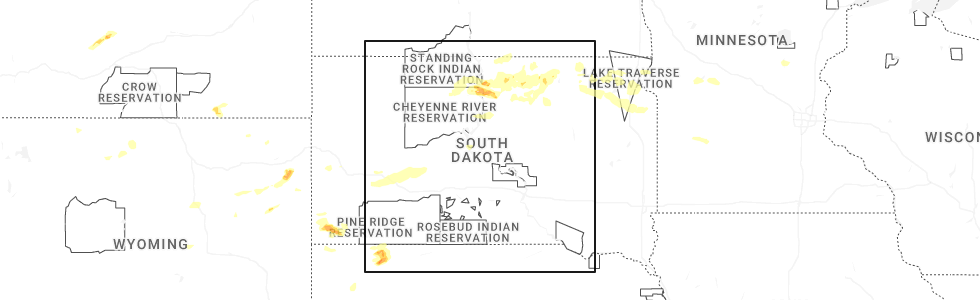
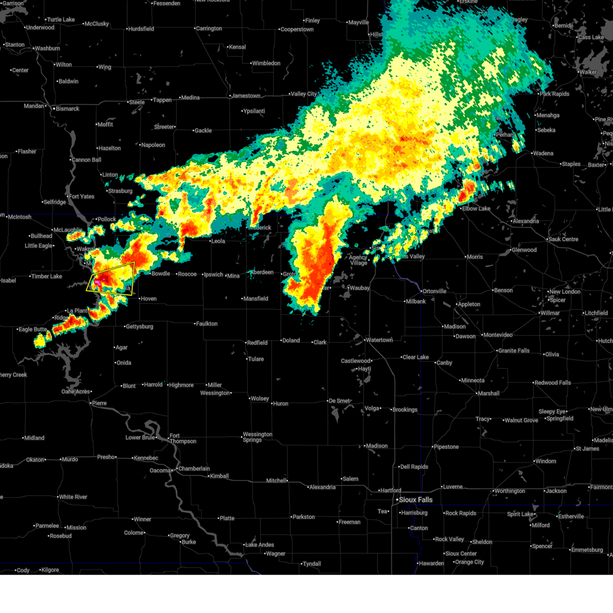
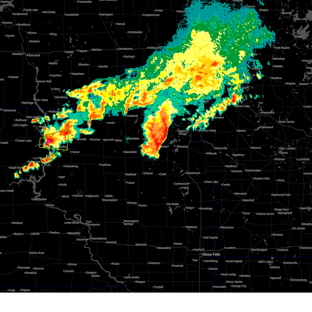
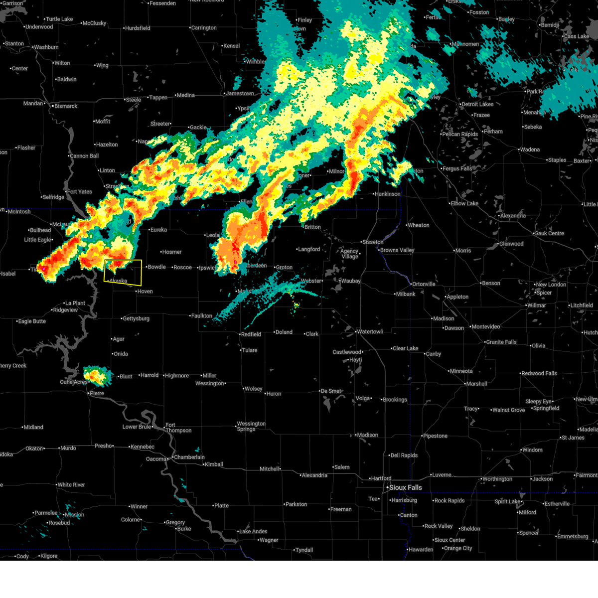
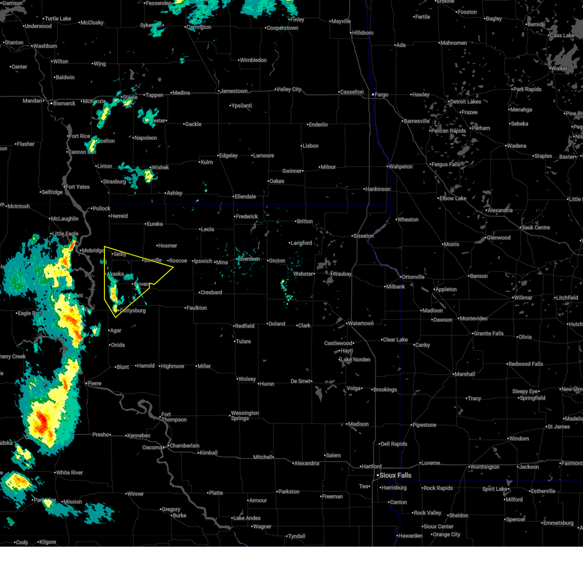
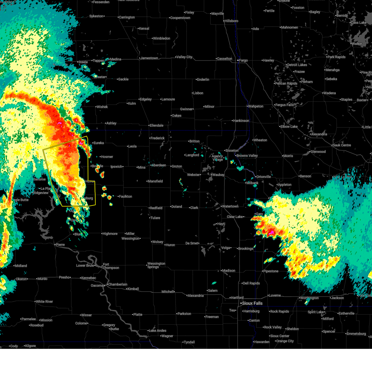
Hail Map for Akaska, SD
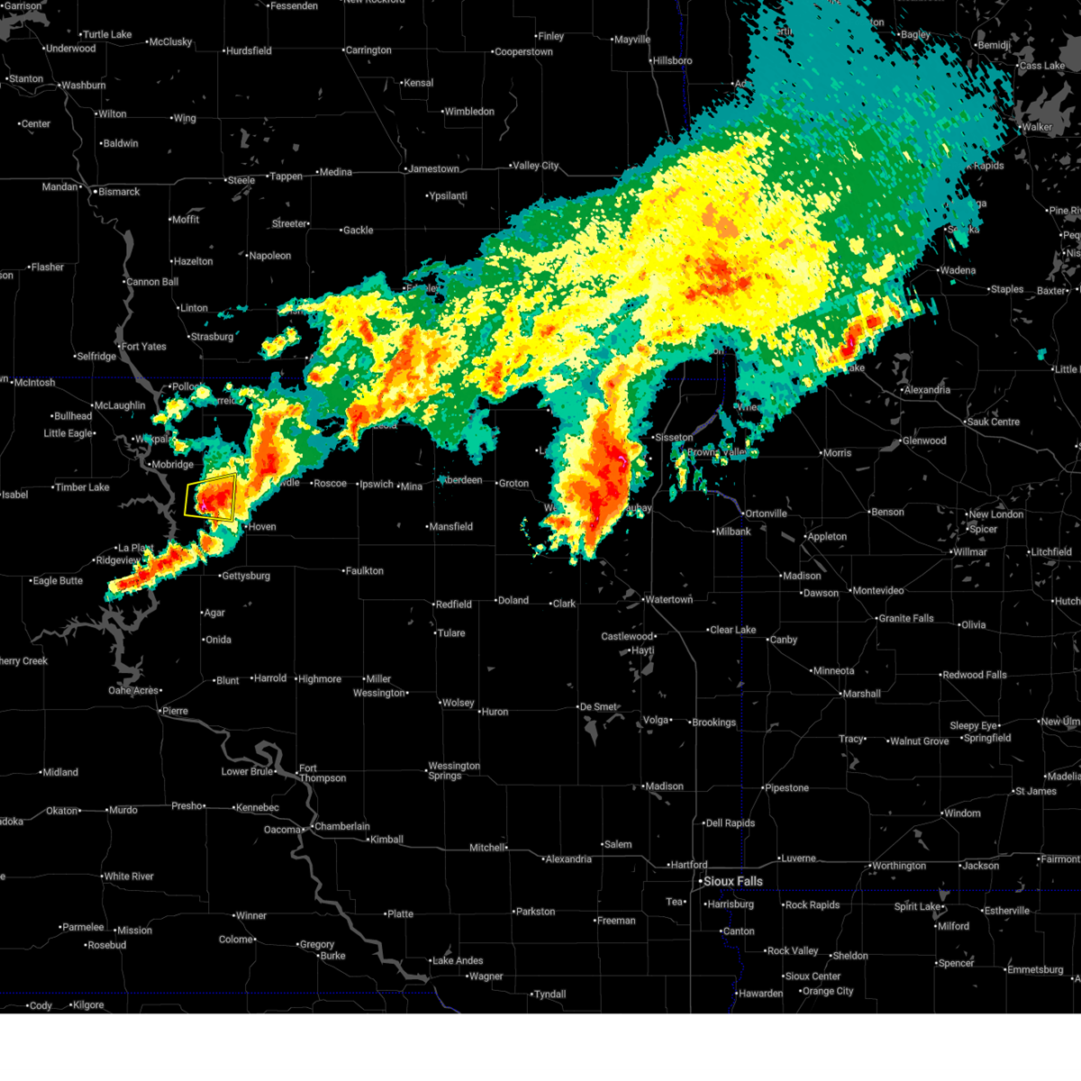
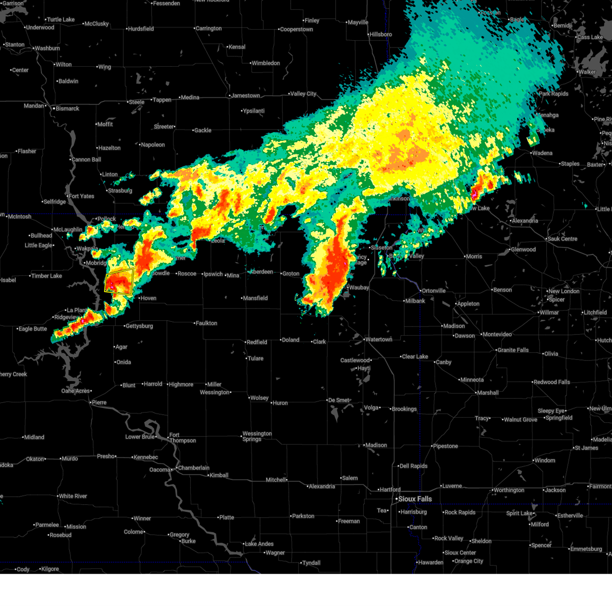
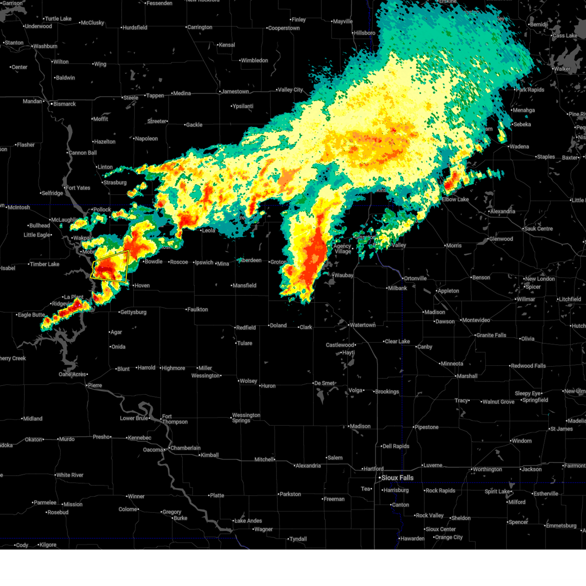
The Akaska, SD area has had 1 report of on-the-ground hail by trained spotters, and has been under severe weather warnings 39 times during the past 12 months. Doppler radar has detected hail at or near Akaska, SD on 55 occasions, including 3 occasions during the past year.
| Name: | Akaska, SD |
| Where Located: | 67.4 miles N of Pierre, SD |
| Map: | Google Map for Akaska, SD |
| Population: | 42 |
| Housing Units: | 172 |
| More Info: | Search Google for Akaska, SD |
2
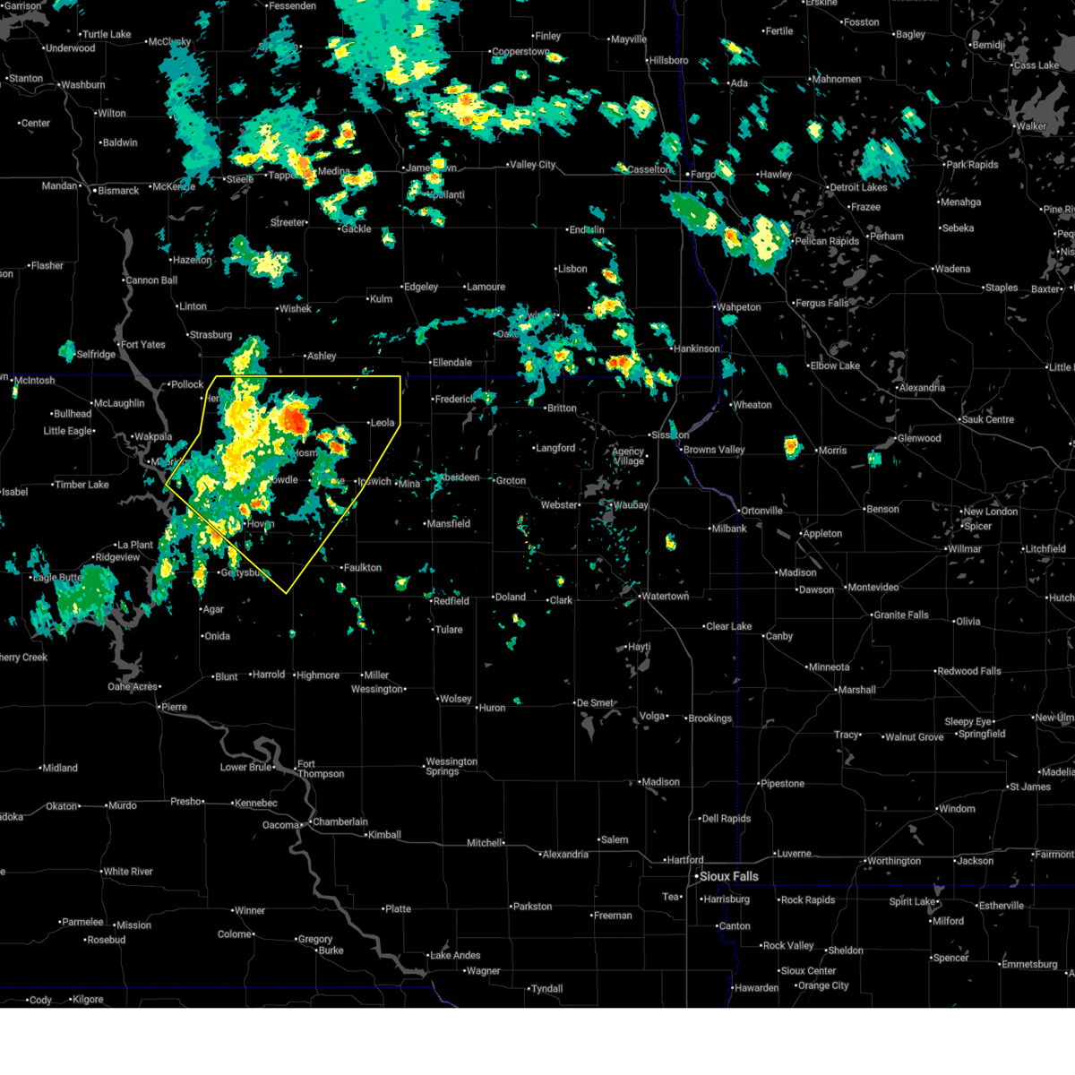
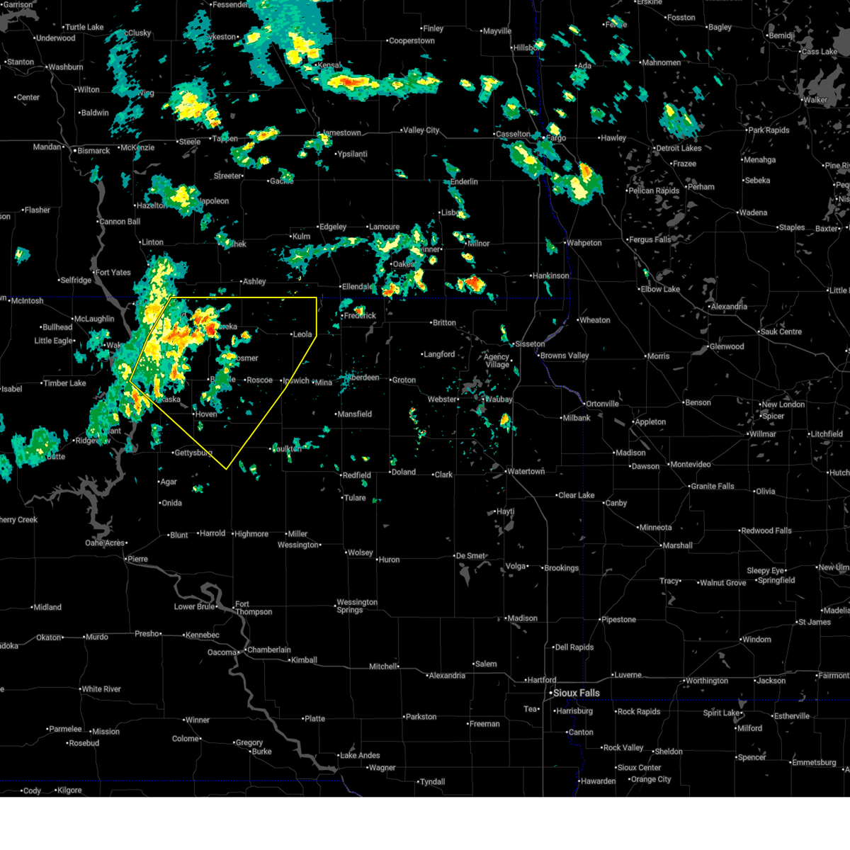
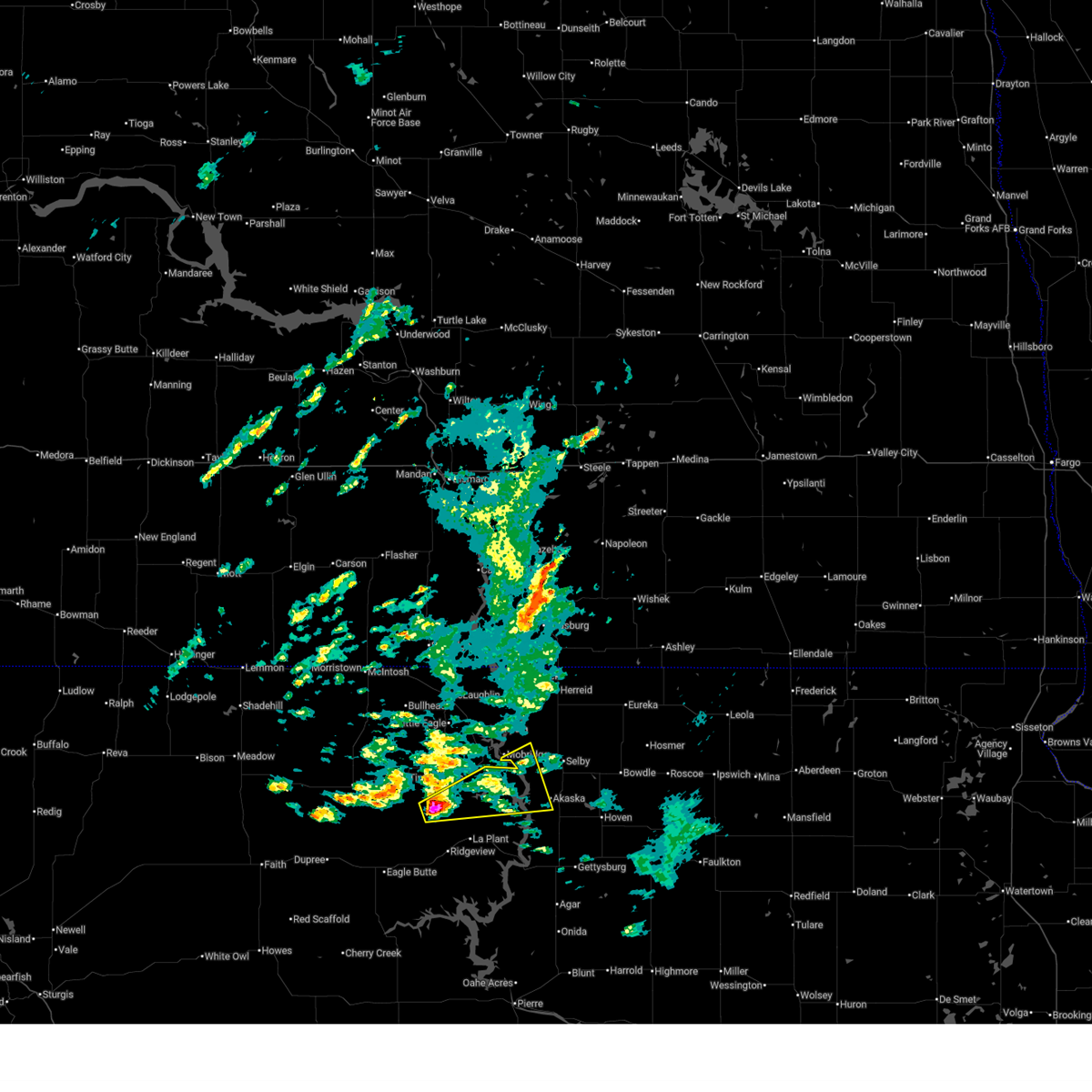
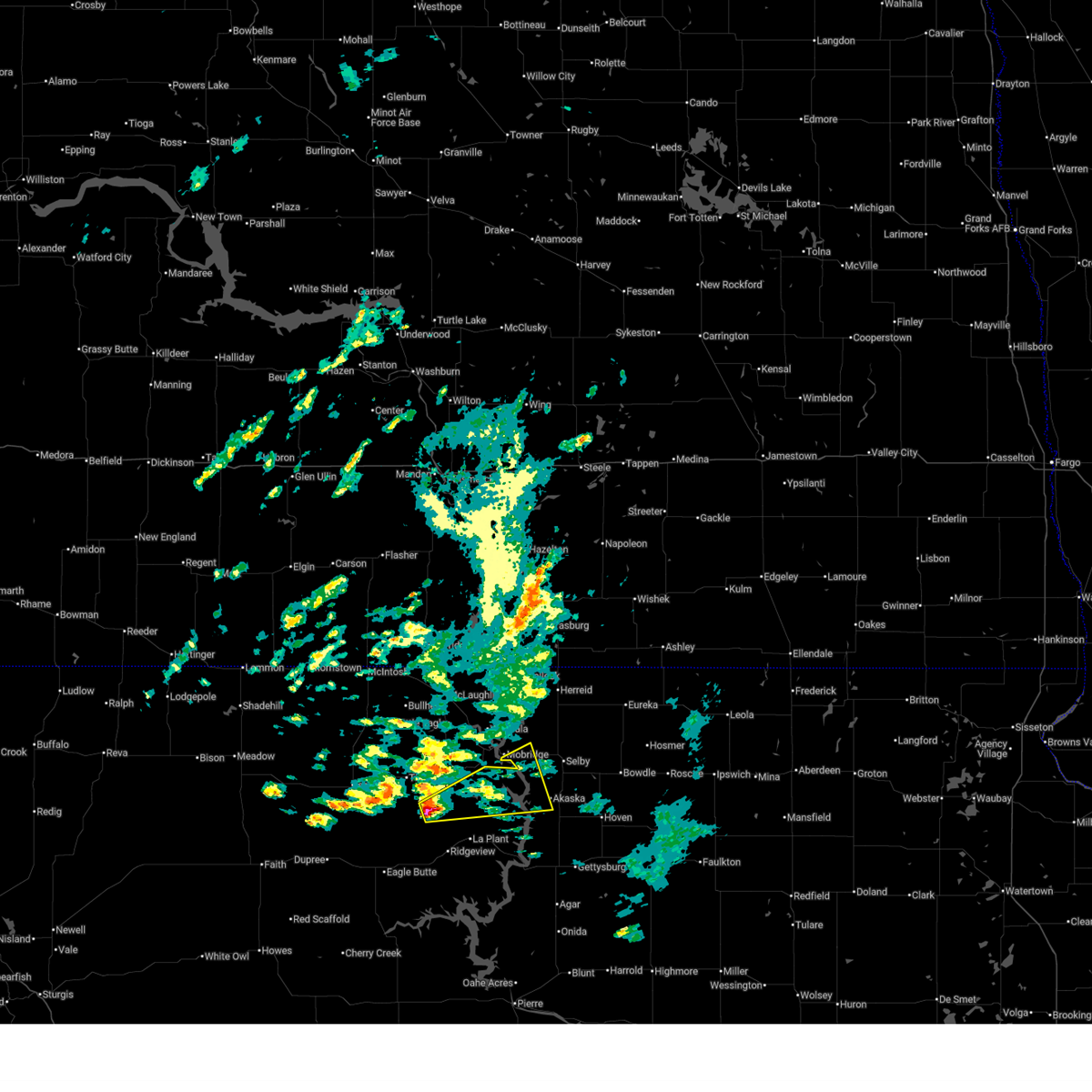
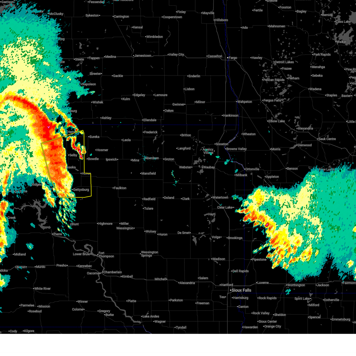
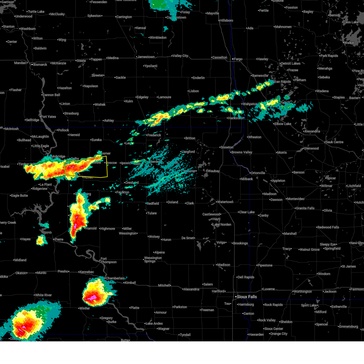
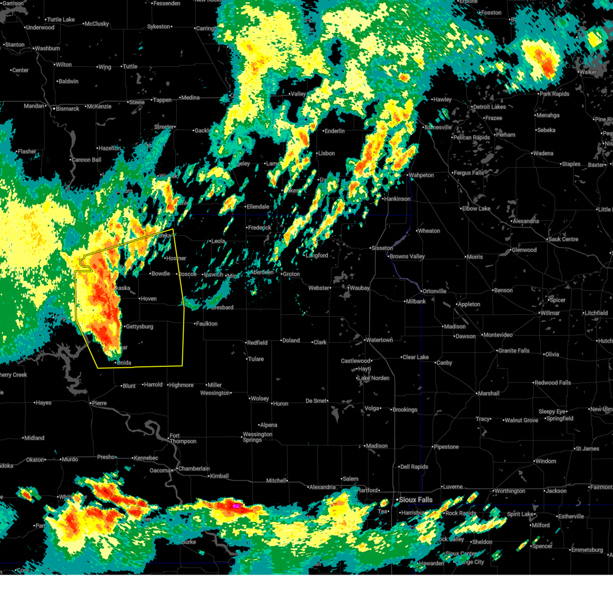
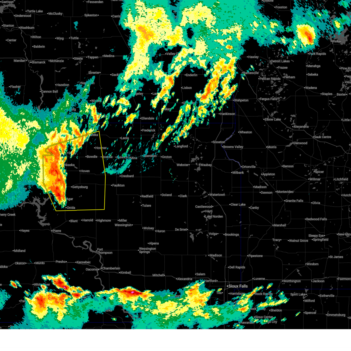
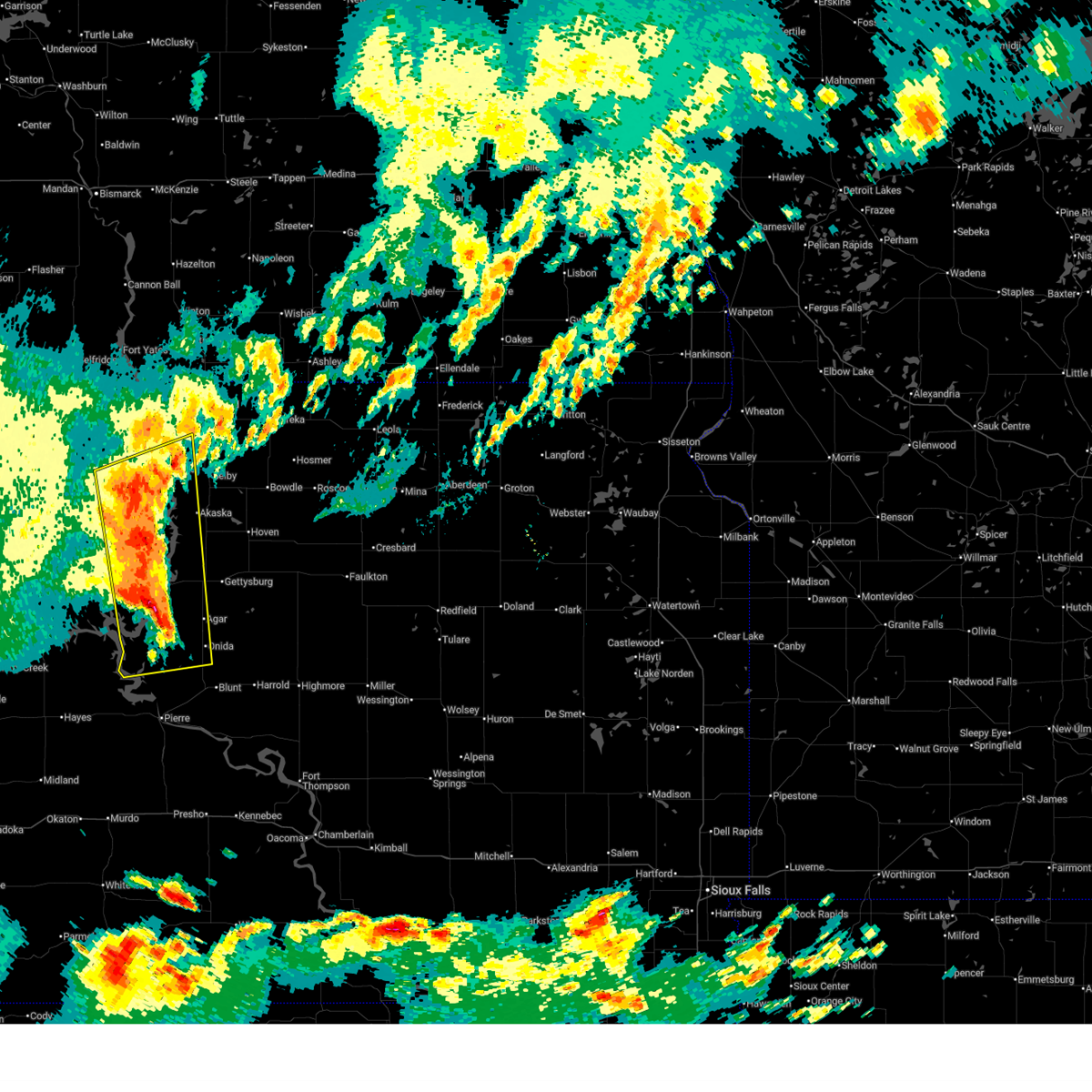
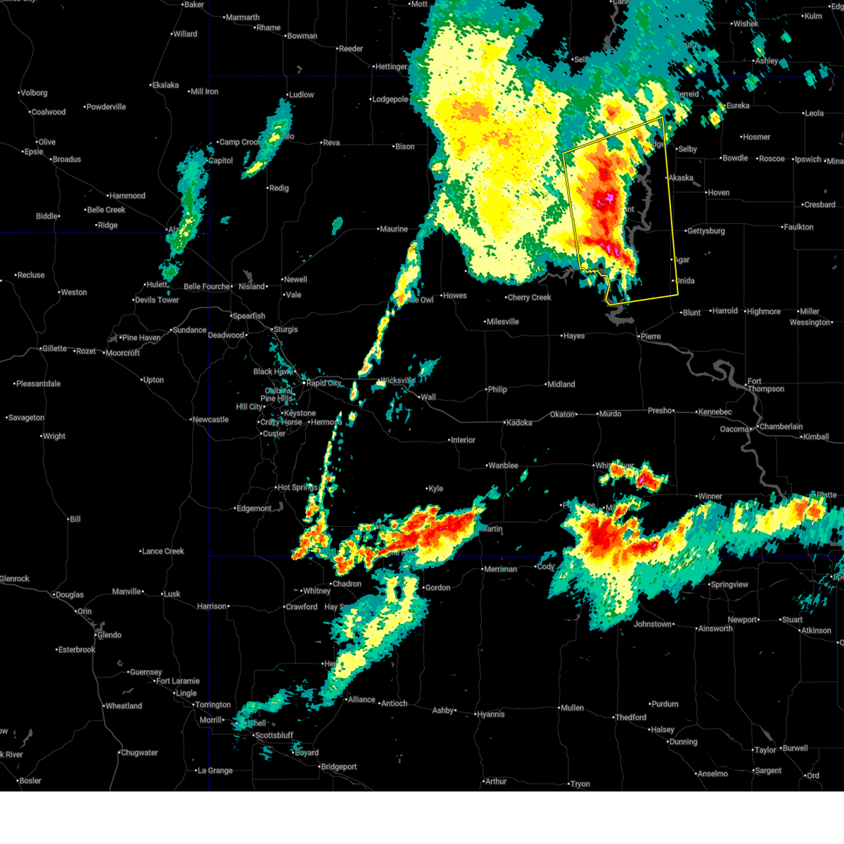
The Top Recent Hail Date for Akaska, SD is Tuesday, July 7, 2026 (18th out of 55)
Hail and Wind Damage Spotted near Akaska, SD
| Date / Time | Report Details |
|---|---|
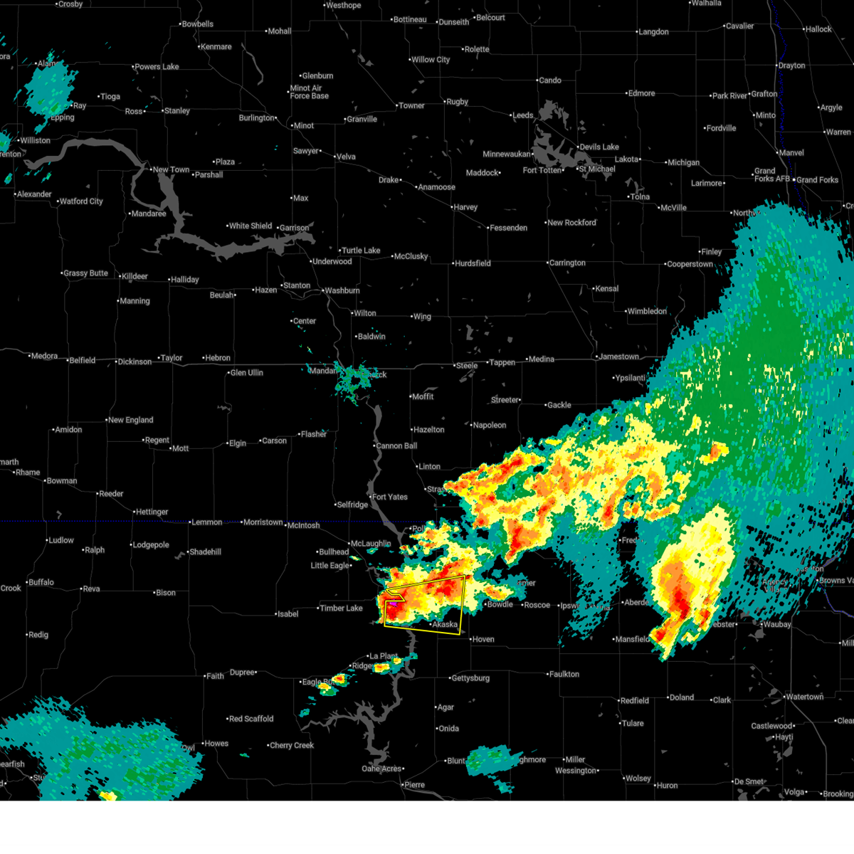
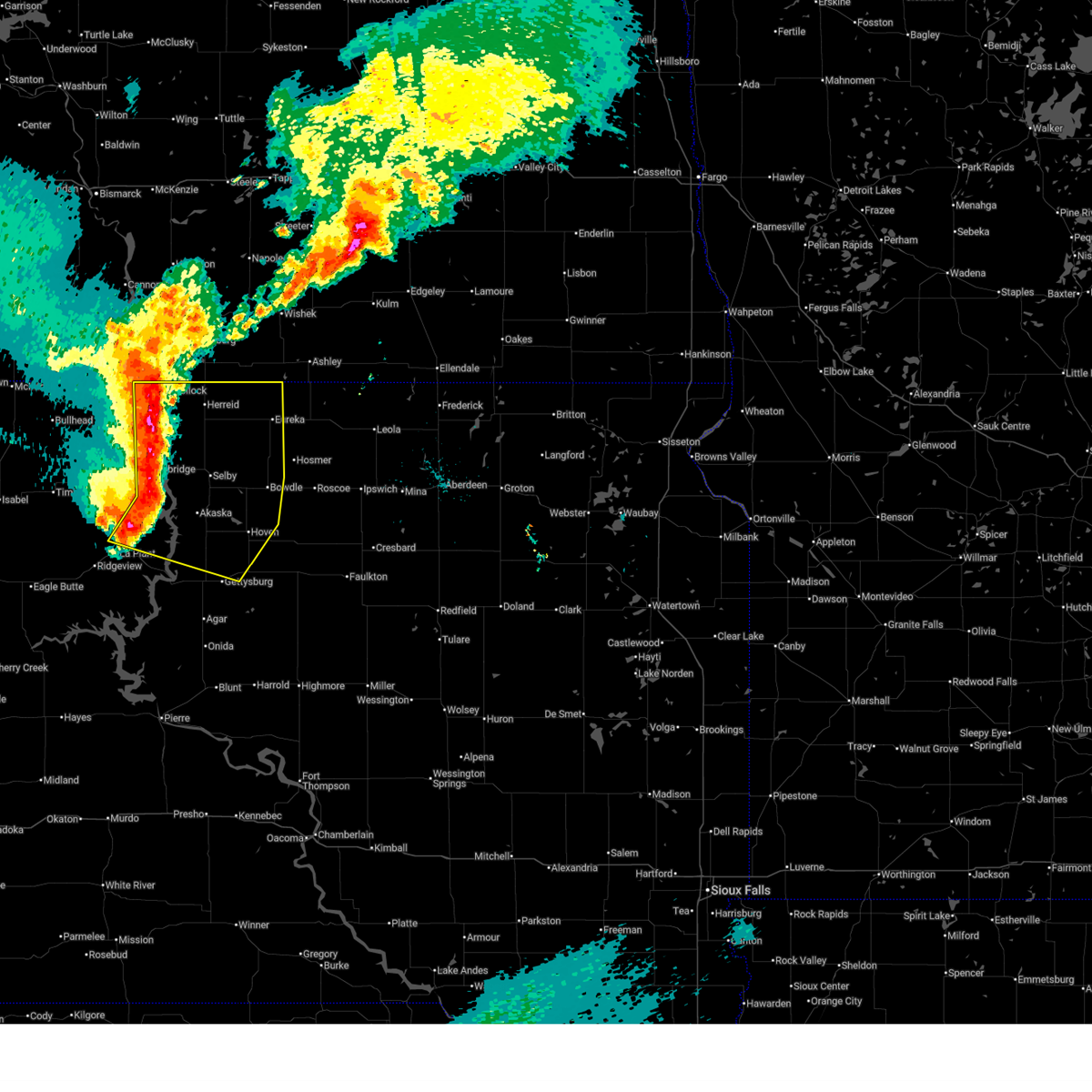
| 7/7/2026 9:43 PM CDT |
 The storm which prompted the warning has weakened below severe limits, and no longer poses an immediate threat to life or property. therefore, the warning will be allowed to expire. however, gusty winds are still possible with this thunderstorm. a severe thunderstorm watch remains in effect until midnight cdt for north central south dakota. The storm which prompted the warning has weakened below severe limits, and no longer poses an immediate threat to life or property. therefore, the warning will be allowed to expire. however, gusty winds are still possible with this thunderstorm. a severe thunderstorm watch remains in effect until midnight cdt for north central south dakota.
|
| 7/7/2026 9:34 PM CDT |
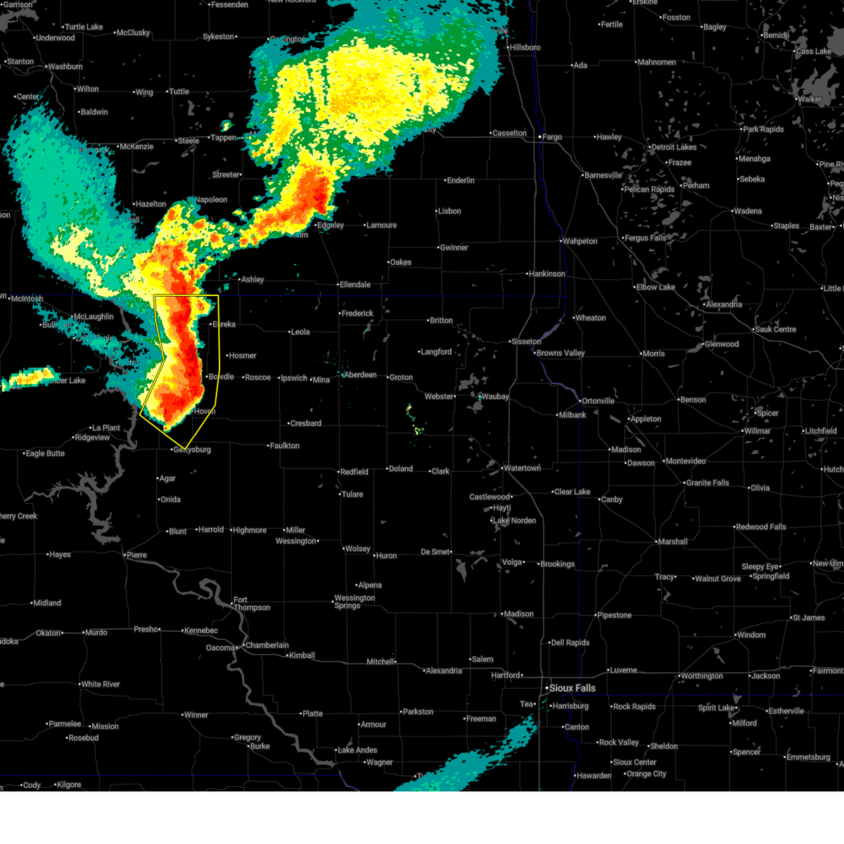
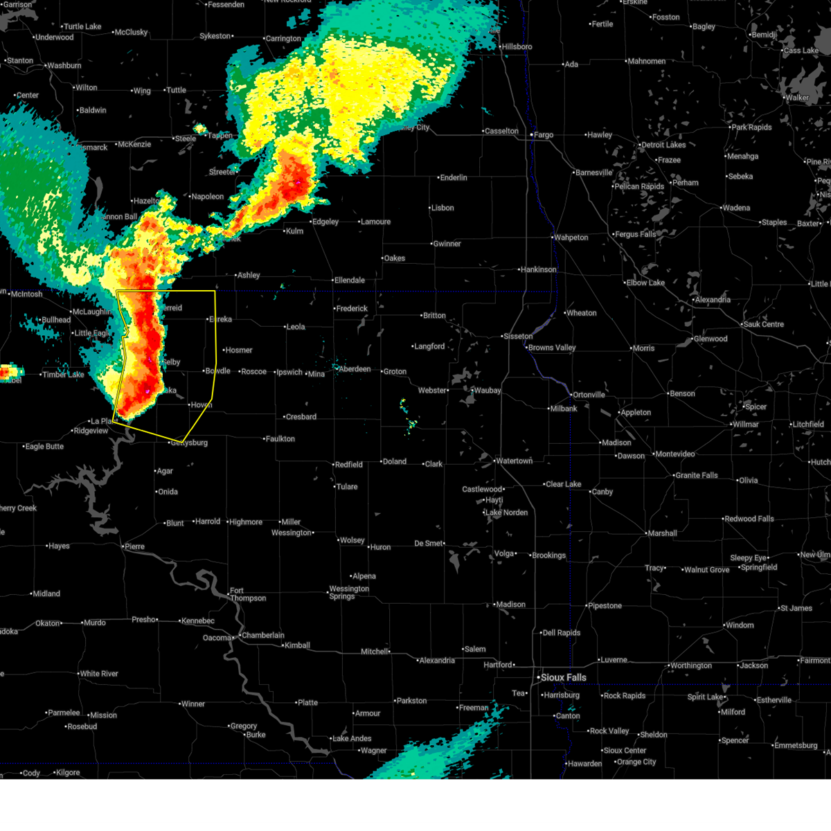
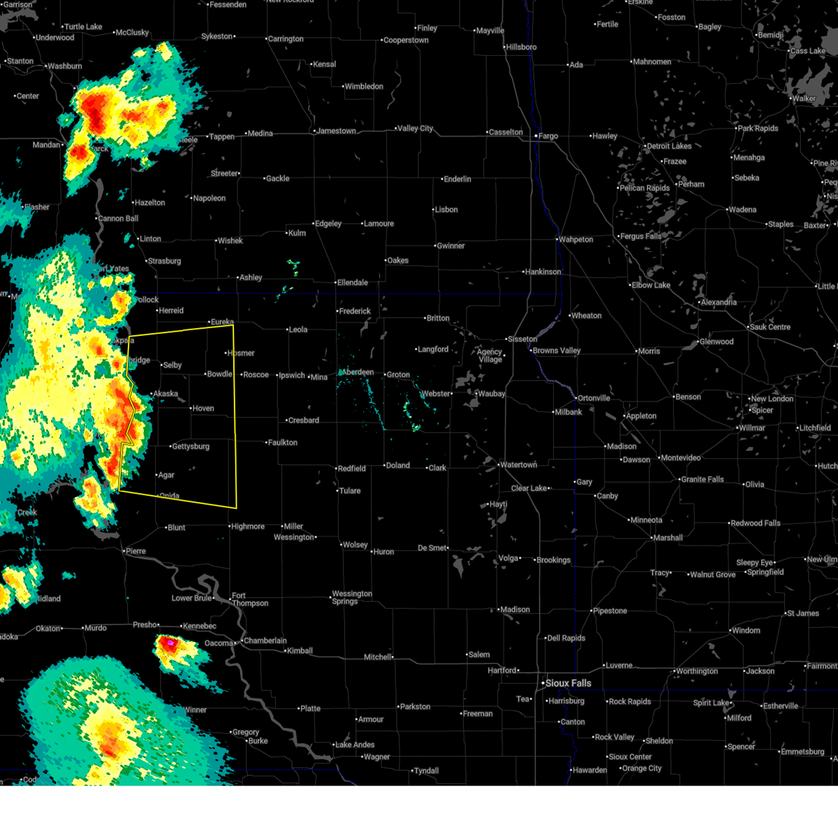
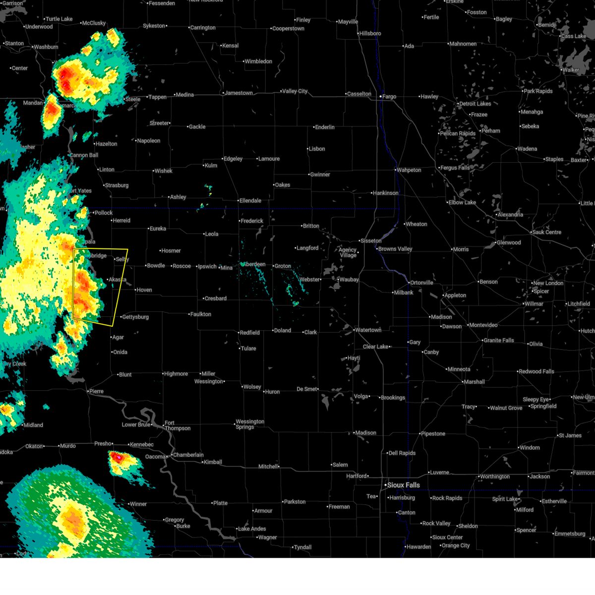
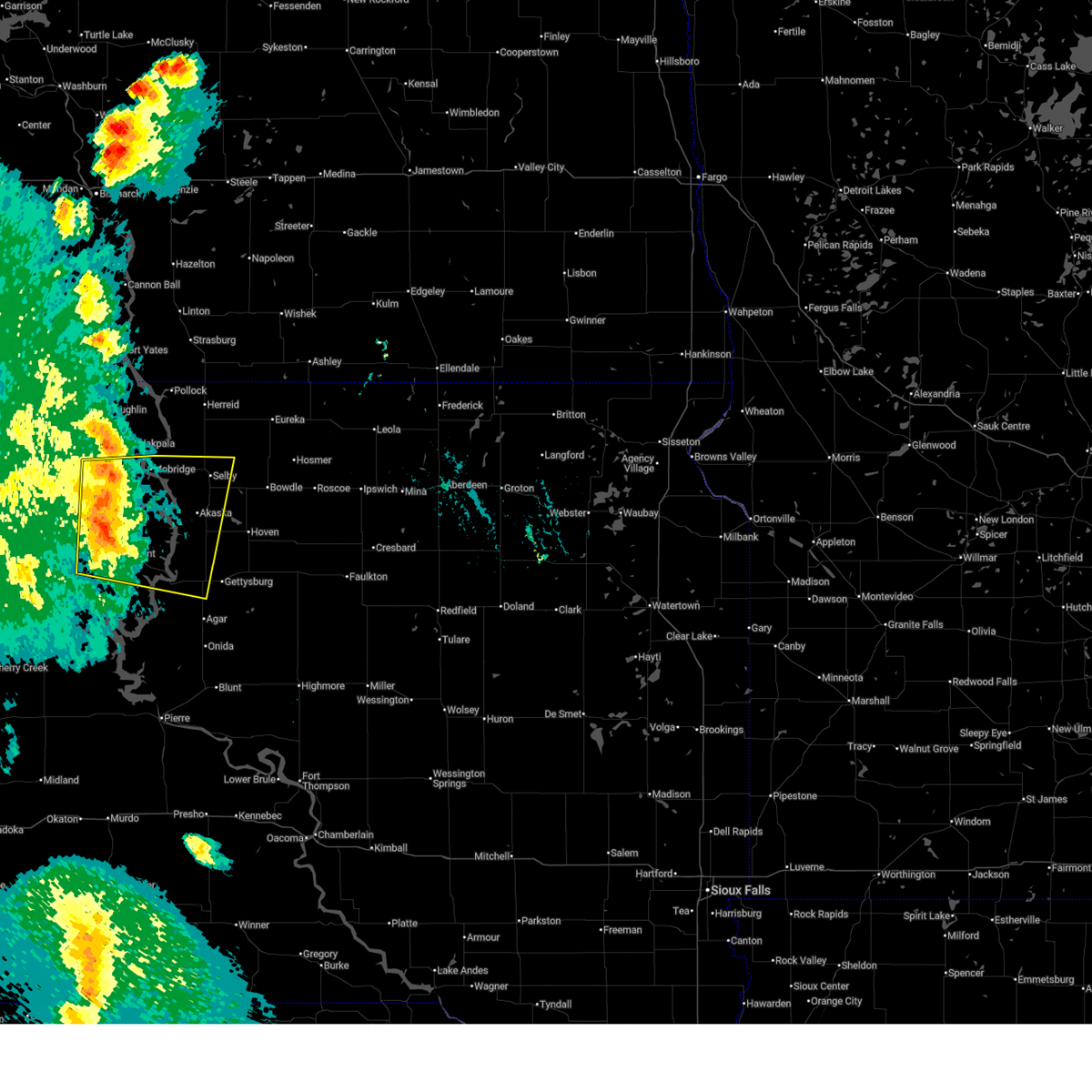
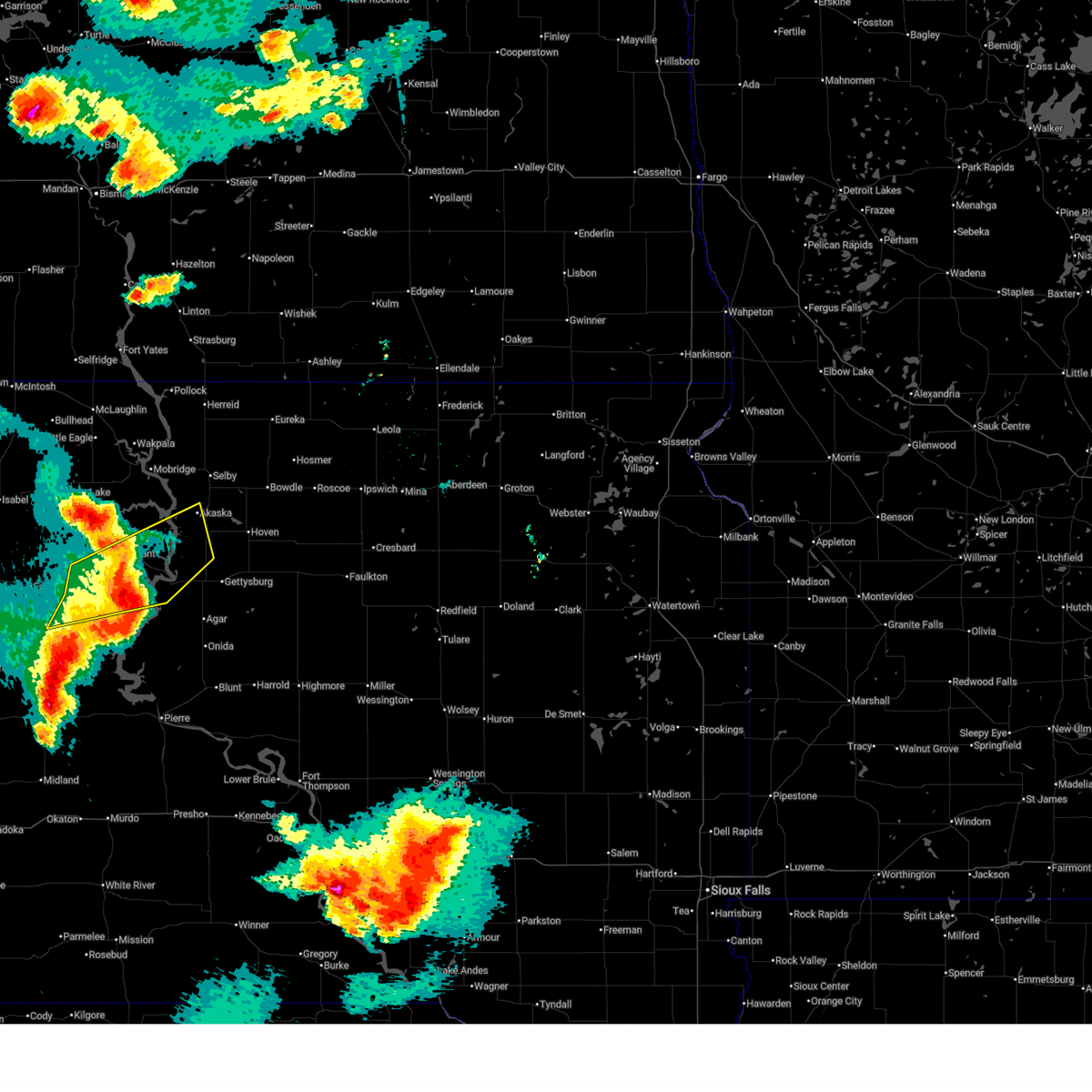
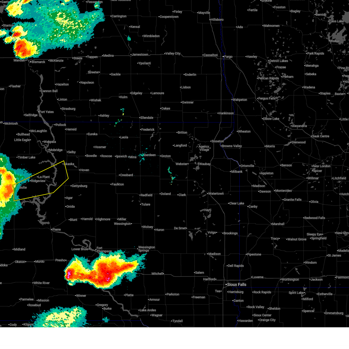
 At 933 pm cdt, a severe thunderstorm was located over akaska, or 11 miles south of selby, moving east at 25 mph (radar indicated). Hazards include 60 mph wind gusts and half dollar size hail. Hail damage to vehicles is expected. expect wind damage to roofs, siding, and trees. Locations impacted include, akaska and lowry. At 933 pm cdt, a severe thunderstorm was located over akaska, or 11 miles south of selby, moving east at 25 mph (radar indicated). Hazards include 60 mph wind gusts and half dollar size hail. Hail damage to vehicles is expected. expect wind damage to roofs, siding, and trees. Locations impacted include, akaska and lowry.
|
| 7/7/2026 9:23 PM CDT |
 At 922 pm cdt, a severe thunderstorm was located near akaska, or 9 miles southwest of selby, moving east at 30 mph (radar indicated). Hazards include ping pong ball size hail and 60 mph wind gusts. People and animals outdoors will be injured. expect hail damage to roofs, siding, windows, and vehicles. expect wind damage to roofs, siding, and trees. Locations impacted include, lowry. At 922 pm cdt, a severe thunderstorm was located near akaska, or 9 miles southwest of selby, moving east at 30 mph (radar indicated). Hazards include ping pong ball size hail and 60 mph wind gusts. People and animals outdoors will be injured. expect hail damage to roofs, siding, windows, and vehicles. expect wind damage to roofs, siding, and trees. Locations impacted include, lowry.
|
| 7/7/2026 9:14 PM CDT |
 At 914 pm cdt/814 pm mdt/, a severe thunderstorm was located near new everets resort, or 12 miles southwest of selby, moving east at 25 mph (radar indicated). Hazards include golf ball size hail and 60 mph wind gusts. People and animals outdoors will be injured. expect hail damage to roofs, siding, windows, and vehicles. expect wind damage to roofs, siding, and trees. this severe storm will be near, akaska around 920 pm cdt. Other locations in the path of this severe thunderstorm include lowry. At 914 pm cdt/814 pm mdt/, a severe thunderstorm was located near new everets resort, or 12 miles southwest of selby, moving east at 25 mph (radar indicated). Hazards include golf ball size hail and 60 mph wind gusts. People and animals outdoors will be injured. expect hail damage to roofs, siding, windows, and vehicles. expect wind damage to roofs, siding, and trees. this severe storm will be near, akaska around 920 pm cdt. Other locations in the path of this severe thunderstorm include lowry.
|
| 7/7/2026 9:05 PM CDT |
 At 904 pm cdt/804 pm mdt/, a severe thunderstorm was located over new everets resort, or 10 miles southeast of mobridge, moving east at 30 mph (radar indicated). Hazards include ping pong ball size hail and 60 mph wind gusts. People and animals outdoors will be injured. expect hail damage to roofs, siding, windows, and vehicles. expect wind damage to roofs, siding, and trees. this severe storm will be near, swan creek rec area around 910 pm cdt. Other locations in the path of this severe thunderstorm include akaska and lowry. At 904 pm cdt/804 pm mdt/, a severe thunderstorm was located over new everets resort, or 10 miles southeast of mobridge, moving east at 30 mph (radar indicated). Hazards include ping pong ball size hail and 60 mph wind gusts. People and animals outdoors will be injured. expect hail damage to roofs, siding, windows, and vehicles. expect wind damage to roofs, siding, and trees. this severe storm will be near, swan creek rec area around 910 pm cdt. Other locations in the path of this severe thunderstorm include akaska and lowry.
|
| 7/7/2026 8:54 PM CDT |
 Svrabr the national weather service in aberdeen has issued a * severe thunderstorm warning for, south central campbell county in north central south dakota, northeastern dewey county in north central south dakota, walworth county in north central south dakota, * until 945 pm cdt/845 pm mdt/. * at 854 pm cdt/754 pm mdt/, a severe thunderstorm was located near indian creek rec area, or near mobridge, moving east at 30 mph (radar indicated). Hazards include 60 mph wind gusts and half dollar size hail. Hail damage to vehicles is expected. expect wind damage to roofs, siding, and trees. this severe thunderstorm will be near, glenham and new everets resort around 900 pm cdt. Other locations in the path of this severe thunderstorm include selby. Svrabr the national weather service in aberdeen has issued a * severe thunderstorm warning for, south central campbell county in north central south dakota, northeastern dewey county in north central south dakota, walworth county in north central south dakota, * until 945 pm cdt/845 pm mdt/. * at 854 pm cdt/754 pm mdt/, a severe thunderstorm was located near indian creek rec area, or near mobridge, moving east at 30 mph (radar indicated). Hazards include 60 mph wind gusts and half dollar size hail. Hail damage to vehicles is expected. expect wind damage to roofs, siding, and trees. this severe thunderstorm will be near, glenham and new everets resort around 900 pm cdt. Other locations in the path of this severe thunderstorm include selby.
|
| 7/7/2026 8:10 PM CDT |
 Svrabr the national weather service in aberdeen has issued a * severe thunderstorm warning for, southeastern walworth county in north central south dakota, * until 845 pm cdt. * at 809 pm cdt, a severe thunderstorm was located near selby, moving east at 25 mph (radar indicated). Hazards include 60 mph wind gusts and quarter size hail. Hail damage to vehicles is expected. expect wind damage to roofs, siding, and trees. this severe thunderstorm will be near, selby around 815 pm cdt. Java around 825 pm cdt. Svrabr the national weather service in aberdeen has issued a * severe thunderstorm warning for, southeastern walworth county in north central south dakota, * until 845 pm cdt. * at 809 pm cdt, a severe thunderstorm was located near selby, moving east at 25 mph (radar indicated). Hazards include 60 mph wind gusts and quarter size hail. Hail damage to vehicles is expected. expect wind damage to roofs, siding, and trees. this severe thunderstorm will be near, selby around 815 pm cdt. Java around 825 pm cdt.
|
| 7/7/2026 8:05 PM CDT | Personal weather station recorded a 72 mile per hour gust in akask in walworth county SD, 0.1 miles NNE of Akaska, SD |
| 6/15/2026 2:29 PM CDT |
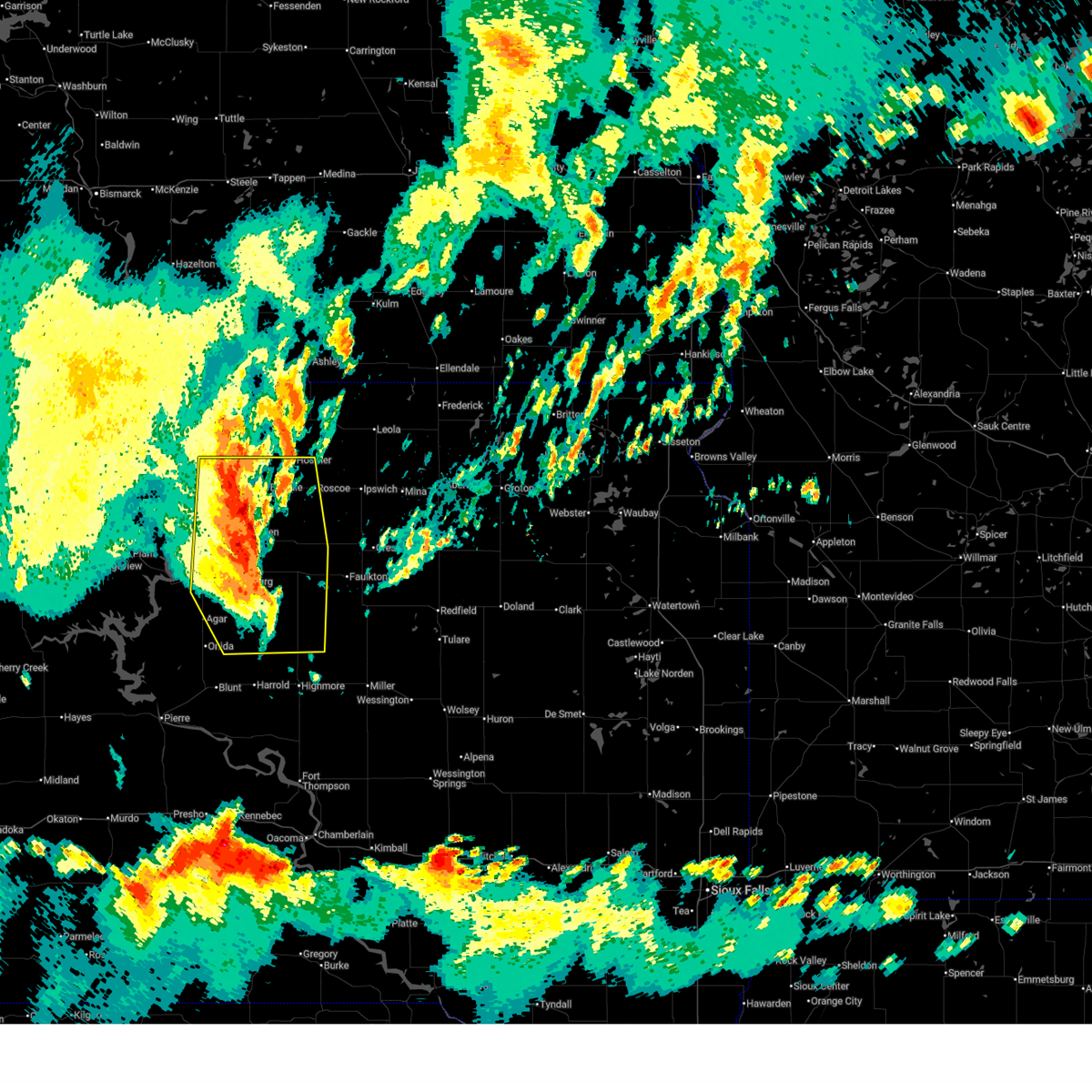
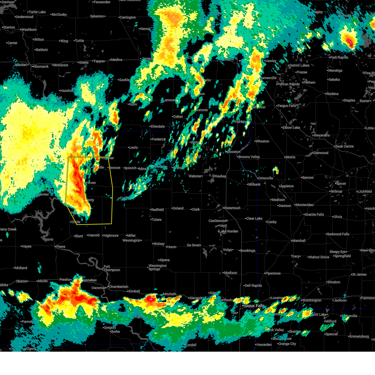
 At 229 pm cdt, severe thunderstorms were located along a line extending from near long lake to hosmer to near hoven, moving east at 40 mph (radar indicated). Hazards include 60 mph wind gusts. Expect damage to roofs, siding, and trees. Locations impacted include, roscoe, tolstoy, spring creek colony, onaka, leola, plainview colony, forbes, elm lake, loyalton, ipswich, deerfield colony, grassland colony, brentwood colony, thunderbird colony, long lake colony and blumengard colony. At 229 pm cdt, severe thunderstorms were located along a line extending from near long lake to hosmer to near hoven, moving east at 40 mph (radar indicated). Hazards include 60 mph wind gusts. Expect damage to roofs, siding, and trees. Locations impacted include, roscoe, tolstoy, spring creek colony, onaka, leola, plainview colony, forbes, elm lake, loyalton, ipswich, deerfield colony, grassland colony, brentwood colony, thunderbird colony, long lake colony and blumengard colony.
|
| 6/15/2026 2:09 PM CDT |
 Svrabr the national weather service in aberdeen has issued a * severe thunderstorm warning for, edmunds county in north central south dakota, western faulk county in north central south dakota, eastern campbell county in north central south dakota, northeastern potter county in north central south dakota, mcpherson county in north central south dakota, walworth county in north central south dakota, * until 315 pm cdt. * at 208 pm cdt, severe thunderstorms were located along a line extending from 6 miles south of ashley to 8 miles southwest of hillsview to lowry, moving east at 40 mph (radar indicated. at 150 pm 63 mph wind was reported 4 miles southwest of mound city). Hazards include 60 mph wind gusts. Expect damage to roofs, siding, and trees. severe thunderstorms will be near, bowdle, hoven, hosmer, long lake, hillsview, and new town corner around 215 pm cdt. Other locations in the path of these severe thunderstorms include tolstoy, roscoe, spring creek colony, onaka, leola, plainview colony, loyalton, elm lake, ipswich, deerfield colony, grassland colony, brentwood colony, forbes, thunderbird colony, blumengard colony and long lake colony. Svrabr the national weather service in aberdeen has issued a * severe thunderstorm warning for, edmunds county in north central south dakota, western faulk county in north central south dakota, eastern campbell county in north central south dakota, northeastern potter county in north central south dakota, mcpherson county in north central south dakota, walworth county in north central south dakota, * until 315 pm cdt. * at 208 pm cdt, severe thunderstorms were located along a line extending from 6 miles south of ashley to 8 miles southwest of hillsview to lowry, moving east at 40 mph (radar indicated. at 150 pm 63 mph wind was reported 4 miles southwest of mound city). Hazards include 60 mph wind gusts. Expect damage to roofs, siding, and trees. severe thunderstorms will be near, bowdle, hoven, hosmer, long lake, hillsview, and new town corner around 215 pm cdt. Other locations in the path of these severe thunderstorms include tolstoy, roscoe, spring creek colony, onaka, leola, plainview colony, loyalton, elm lake, ipswich, deerfield colony, grassland colony, brentwood colony, forbes, thunderbird colony, blumengard colony and long lake colony.
|
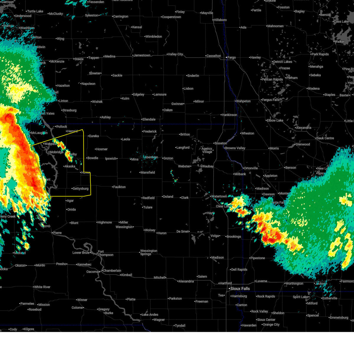
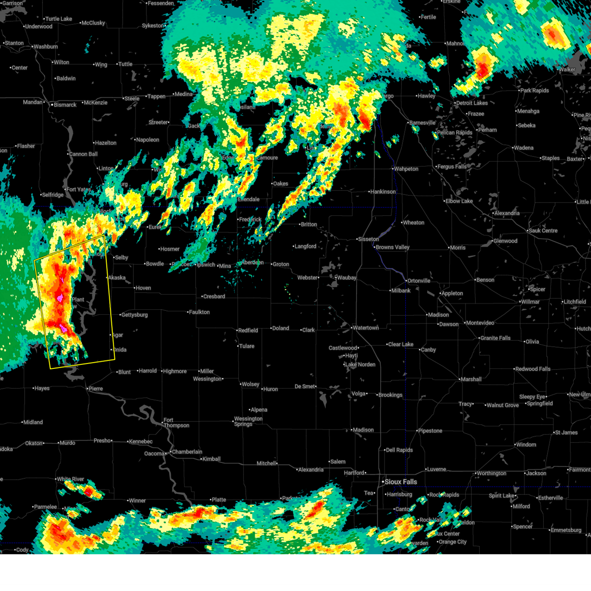
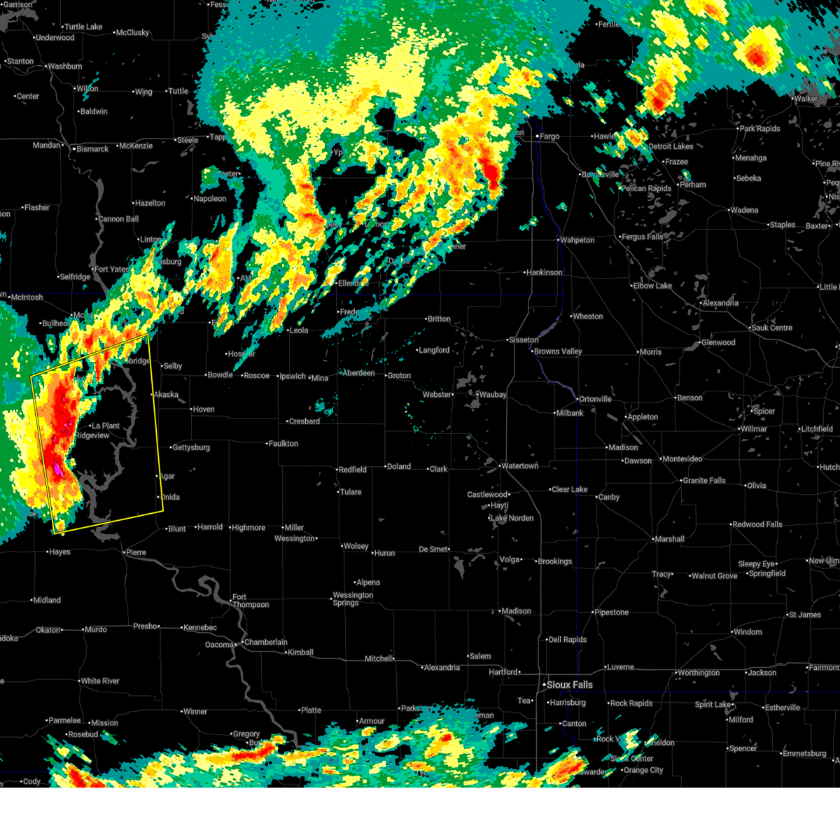
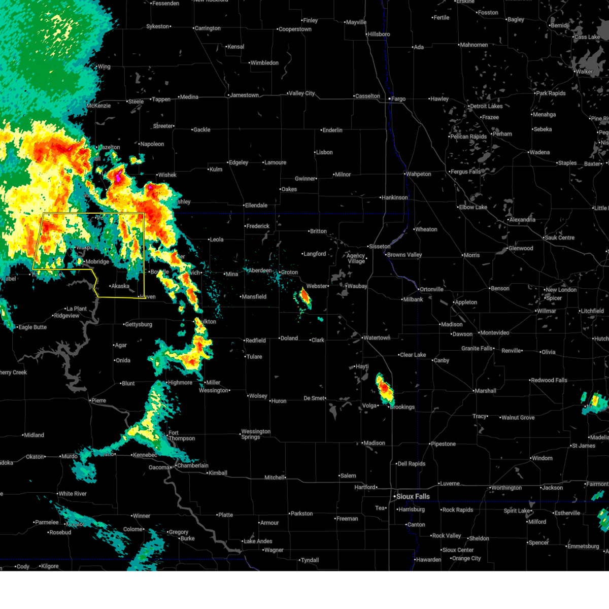
| 6/3/2026 1:02 PM MDT |
 At 201 pm cdt/101 pm mdt/, a severe thunderstorm was located near blackfoot, or 10 miles south of mobridge, moving east at 35 mph (radar indicated). Hazards include 60 mph wind gusts and nickel size hail. Expect damage to roofs, siding, and trees. Locations impacted include, glenham, akaska, new everets resort, swan creek rec area, revheim bay rec area, indian creek rec area, and blackfoot. At 201 pm cdt/101 pm mdt/, a severe thunderstorm was located near blackfoot, or 10 miles south of mobridge, moving east at 35 mph (radar indicated). Hazards include 60 mph wind gusts and nickel size hail. Expect damage to roofs, siding, and trees. Locations impacted include, glenham, akaska, new everets resort, swan creek rec area, revheim bay rec area, indian creek rec area, and blackfoot.
|
| 6/3/2026 12:41 PM MDT |
 At 140 pm cdt/1240 pm mdt/, a severe thunderstorm was located over promise, or 16 miles southwest of mobridge, moving east at 35 mph (radar indicated). Hazards include 60 mph wind gusts and half dollar size hail. Hail damage to vehicles is expected. expect wind damage to roofs, siding, and trees. Locations impacted include, blackfoot and new everets resort. At 140 pm cdt/1240 pm mdt/, a severe thunderstorm was located over promise, or 16 miles southwest of mobridge, moving east at 35 mph (radar indicated). Hazards include 60 mph wind gusts and half dollar size hail. Hail damage to vehicles is expected. expect wind damage to roofs, siding, and trees. Locations impacted include, blackfoot and new everets resort.
|
| 6/3/2026 12:27 PM MDT |
 At 127 pm cdt/1227 pm mdt/, a severe thunderstorm was located near white horse, or 16 miles southeast of timber lake, moving east at 35 mph (radar indicated). Hazards include golf ball size hail and 60 mph wind gusts. People and animals outdoors will be injured. expect hail damage to roofs, siding, windows, and vehicles. expect wind damage to roofs, siding, and trees. this severe storm will be near, promise around 1230 pm mdt. Other locations in the path of this severe thunderstorm include blackfoot and new everets resort. At 127 pm cdt/1227 pm mdt/, a severe thunderstorm was located near white horse, or 16 miles southeast of timber lake, moving east at 35 mph (radar indicated). Hazards include golf ball size hail and 60 mph wind gusts. People and animals outdoors will be injured. expect hail damage to roofs, siding, windows, and vehicles. expect wind damage to roofs, siding, and trees. this severe storm will be near, promise around 1230 pm mdt. Other locations in the path of this severe thunderstorm include blackfoot and new everets resort.
|
| 6/3/2026 12:22 PM MDT |
 Svrabr the national weather service in aberdeen has issued a * severe thunderstorm warning for, northeastern dewey county in north central south dakota, western walworth county in north central south dakota, * until 215 pm cdt/115 pm mdt/. * at 122 pm cdt/1222 pm mdt/, a severe thunderstorm was located over white horse, or 14 miles southeast of timber lake, moving east at 35 mph (radar indicated). Hazards include 60 mph wind gusts and half dollar size hail. Hail damage to vehicles is expected. expect wind damage to roofs, siding, and trees. this severe thunderstorm will be near, promise around 1230 pm mdt. Other locations in the path of this severe thunderstorm include blackfoot and new everets resort. Svrabr the national weather service in aberdeen has issued a * severe thunderstorm warning for, northeastern dewey county in north central south dakota, western walworth county in north central south dakota, * until 215 pm cdt/115 pm mdt/. * at 122 pm cdt/1222 pm mdt/, a severe thunderstorm was located over white horse, or 14 miles southeast of timber lake, moving east at 35 mph (radar indicated). Hazards include 60 mph wind gusts and half dollar size hail. Hail damage to vehicles is expected. expect wind damage to roofs, siding, and trees. this severe thunderstorm will be near, promise around 1230 pm mdt. Other locations in the path of this severe thunderstorm include blackfoot and new everets resort.
|
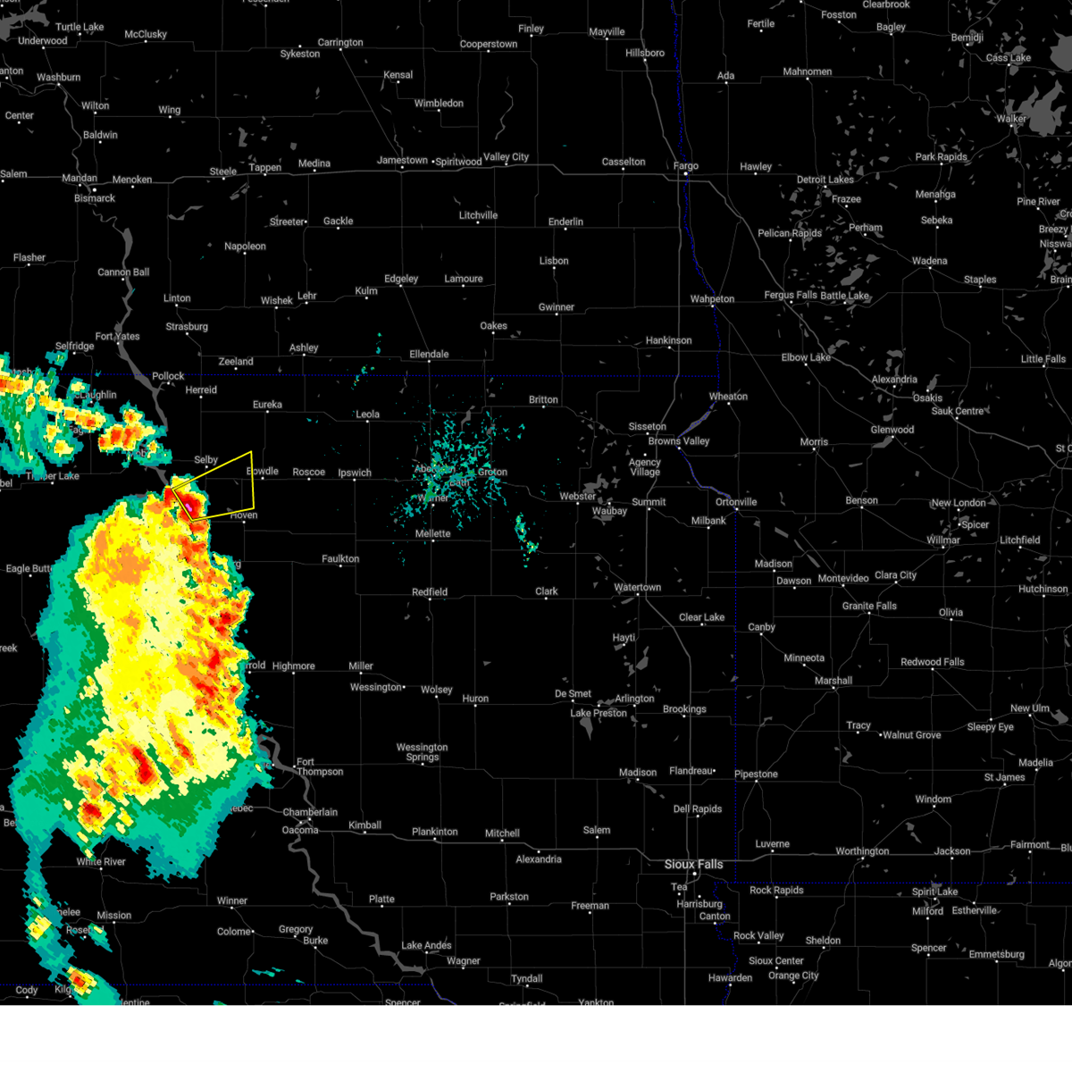
| 4/22/2026 8:58 PM CDT |
 Svrabr the national weather service in aberdeen has issued a * severe thunderstorm warning for, southwestern edmunds county in north central south dakota, eastern potter county in north central south dakota, eastern walworth county in north central south dakota, * until 945 pm cdt. * at 856 pm cdt, a severe thunderstorm was located 10 miles north of gettysburg, moving northeast at 35 mph (radar indicated. at 845 pm cdt, a 70 mph wind gust was reported 2 miles south of lowry, sd). Hazards include 70 mph wind gusts. Expect considerable tree damage. damage is likely to mobile homes, roofs, and outbuildings. this severe thunderstorm will be near, hoven around 910 pm cdt. Other locations in the path of this severe thunderstorm include bowdle. Svrabr the national weather service in aberdeen has issued a * severe thunderstorm warning for, southwestern edmunds county in north central south dakota, eastern potter county in north central south dakota, eastern walworth county in north central south dakota, * until 945 pm cdt. * at 856 pm cdt, a severe thunderstorm was located 10 miles north of gettysburg, moving northeast at 35 mph (radar indicated. at 845 pm cdt, a 70 mph wind gust was reported 2 miles south of lowry, sd). Hazards include 70 mph wind gusts. Expect considerable tree damage. damage is likely to mobile homes, roofs, and outbuildings. this severe thunderstorm will be near, hoven around 910 pm cdt. Other locations in the path of this severe thunderstorm include bowdle.
|
| 4/22/2026 8:45 PM CDT | Mesonet station 209 lowry (sddot in walworth county SD, 3.2 miles WNW of Akaska, SD |
| 8/17/2025 4:55 AM CDT |
 The storms which prompted the warning have weakened below severe limits, and have exited the warned area. therefore, the warning will be allowed to expire. however, gusty winds and heavy rain are still possible with these thunderstorms. a severe thunderstorm watch remains in effect until 700 am cdt/600 am mdt/ for north central south dakota. The storms which prompted the warning have weakened below severe limits, and have exited the warned area. therefore, the warning will be allowed to expire. however, gusty winds and heavy rain are still possible with these thunderstorms. a severe thunderstorm watch remains in effect until 700 am cdt/600 am mdt/ for north central south dakota.
|
| 8/17/2025 4:38 AM CDT |
 At 438 am cdt/338 am mdt/, severe thunderstorms were located along a line extending from near mound city to lowry to gettysburg, moving northeast at 40 mph (radar indicated). Hazards include 60 mph wind gusts. Expect damage to roofs, siding, and trees. Locations impacted include, hoven, java, mound city, lebanon, lake hiddenwood rec area and tolstoy. At 438 am cdt/338 am mdt/, severe thunderstorms were located along a line extending from near mound city to lowry to gettysburg, moving northeast at 40 mph (radar indicated). Hazards include 60 mph wind gusts. Expect damage to roofs, siding, and trees. Locations impacted include, hoven, java, mound city, lebanon, lake hiddenwood rec area and tolstoy.
|
| 8/17/2025 4:08 AM CDT |
 Svrabr the national weather service in aberdeen has issued a * severe thunderstorm warning for, southeastern corson county in north central south dakota, southern campbell county in north central south dakota, potter county in north central south dakota, northeastern dewey county in north central south dakota, walworth county in north central south dakota, * until 500 am cdt/400 am mdt/. * at 407 am cdt/307 am mdt/, severe thunderstorms were located along a line extending from near grand river casino to 7 miles north of swiftbird day school to near sutton bay rec area, moving east at 50 mph (radar indicated. at 1 miles west northwest of la plant 62 mph winds were reported). Hazards include 60 mph wind gusts. Expect damage to roofs, siding, and trees. severe thunderstorms will be near, mobridge, glenham, whitlocks bay rec area, indian creek rec area, swan creek rec area, gorman, revheim bay rec area, and new everets resort around 415 am cdt. gettysburg and akaska around 420 am cdt. lowry around 425 am cdt. Other locations in the path of these severe thunderstorms include selby, mound city, lake hiddenwood rec area, hoven, java, lebanon and tolstoy. Svrabr the national weather service in aberdeen has issued a * severe thunderstorm warning for, southeastern corson county in north central south dakota, southern campbell county in north central south dakota, potter county in north central south dakota, northeastern dewey county in north central south dakota, walworth county in north central south dakota, * until 500 am cdt/400 am mdt/. * at 407 am cdt/307 am mdt/, severe thunderstorms were located along a line extending from near grand river casino to 7 miles north of swiftbird day school to near sutton bay rec area, moving east at 50 mph (radar indicated. at 1 miles west northwest of la plant 62 mph winds were reported). Hazards include 60 mph wind gusts. Expect damage to roofs, siding, and trees. severe thunderstorms will be near, mobridge, glenham, whitlocks bay rec area, indian creek rec area, swan creek rec area, gorman, revheim bay rec area, and new everets resort around 415 am cdt. gettysburg and akaska around 420 am cdt. lowry around 425 am cdt. Other locations in the path of these severe thunderstorms include selby, mound city, lake hiddenwood rec area, hoven, java, lebanon and tolstoy.
|
| 8/8/2025 3:07 AM CDT |
 At 305 am cdt/205 am mdt/, severe thunderstorms were located along a line extending from near long lake to 8 miles south of swan creek rec area, moving east at 75 mph (radar indicated). Hazards include 60 mph wind gusts. Expect damage to roofs, siding, and trees. Locations impacted include, bowdle, hosmer, long lake, lowry, hillsview, new town corner, spring creek colony, forbes, leola, roscoe, elm lake, plainview colony, ipswich, deerfield colony, grassland colony, long lake colony, wetonka, loyalton, cravens corner, mina lake rec area, pembrook colony, blumengard colony and mina. At 305 am cdt/205 am mdt/, severe thunderstorms were located along a line extending from near long lake to 8 miles south of swan creek rec area, moving east at 75 mph (radar indicated). Hazards include 60 mph wind gusts. Expect damage to roofs, siding, and trees. Locations impacted include, bowdle, hosmer, long lake, lowry, hillsview, new town corner, spring creek colony, forbes, leola, roscoe, elm lake, plainview colony, ipswich, deerfield colony, grassland colony, long lake colony, wetonka, loyalton, cravens corner, mina lake rec area, pembrook colony, blumengard colony and mina.
|
| 8/8/2025 3:07 AM CDT |
 the severe thunderstorm warning has been cancelled and is no longer in effect the severe thunderstorm warning has been cancelled and is no longer in effect
|
| 8/8/2025 2:42 AM CDT |
 Svrabr the national weather service in aberdeen has issued a * severe thunderstorm warning for, edmunds county in north central south dakota, southeastern corson county in north central south dakota, campbell county in north central south dakota, north central potter county in north central south dakota, northeastern dewey county in north central south dakota, mcpherson county in north central south dakota, walworth county in north central south dakota, * until 345 am cdt/245 am mdt/. * at 242 am cdt/142 am mdt/, severe thunderstorms were located along a line extending from artas to near ridgeview, moving east at 65 mph (radar indicated). Hazards include 60 mph wind gusts. Expect damage to roofs, siding, and trees. severe thunderstorms will be near, selby, glenham, artas, greenway, new everets resort, and lake hiddenwood rec area around 245 am cdt. promise and blackfoot around 145 am mdt. eureka and swan creek rec area around 250 am cdt. java and akaska around 255 am cdt. hillsview around 300 am cdt. Other locations in the path of these severe thunderstorms include long lake, lowry, new town corner, bowdle, hosmer, spring creek colony, leola, roscoe, forbes and elm lake. Svrabr the national weather service in aberdeen has issued a * severe thunderstorm warning for, edmunds county in north central south dakota, southeastern corson county in north central south dakota, campbell county in north central south dakota, north central potter county in north central south dakota, northeastern dewey county in north central south dakota, mcpherson county in north central south dakota, walworth county in north central south dakota, * until 345 am cdt/245 am mdt/. * at 242 am cdt/142 am mdt/, severe thunderstorms were located along a line extending from artas to near ridgeview, moving east at 65 mph (radar indicated). Hazards include 60 mph wind gusts. Expect damage to roofs, siding, and trees. severe thunderstorms will be near, selby, glenham, artas, greenway, new everets resort, and lake hiddenwood rec area around 245 am cdt. promise and blackfoot around 145 am mdt. eureka and swan creek rec area around 250 am cdt. java and akaska around 255 am cdt. hillsview around 300 am cdt. Other locations in the path of these severe thunderstorms include long lake, lowry, new town corner, bowdle, hosmer, spring creek colony, leola, roscoe, forbes and elm lake.
|
| 7/28/2025 4:19 PM CDT |
 Svrabr the national weather service in aberdeen has issued a * severe thunderstorm warning for, western edmunds county in north central south dakota, southeastern walworth county in north central south dakota, * until 515 pm cdt. * at 419 pm cdt, a severe thunderstorm was located 8 miles southwest of bowdle, moving east at 25 mph (radar indicated). Hazards include 60 mph wind gusts and quarter size hail. Hail damage to vehicles is expected. expect wind damage to roofs, siding, and trees. this severe thunderstorm will be near, bowdle around 425 pm cdt. Other locations in the path of this severe thunderstorm include roscoe. Svrabr the national weather service in aberdeen has issued a * severe thunderstorm warning for, western edmunds county in north central south dakota, southeastern walworth county in north central south dakota, * until 515 pm cdt. * at 419 pm cdt, a severe thunderstorm was located 8 miles southwest of bowdle, moving east at 25 mph (radar indicated). Hazards include 60 mph wind gusts and quarter size hail. Hail damage to vehicles is expected. expect wind damage to roofs, siding, and trees. this severe thunderstorm will be near, bowdle around 425 pm cdt. Other locations in the path of this severe thunderstorm include roscoe.
|
| 7/23/2025 7:18 AM CDT |
 At 717 am cdt, severe thunderstorms were located along a line extending from 6 miles east of java to 7 miles southeast of stone lake, moving east at 45 mph (radar indicated. at 710 am cdt, sdsu mesonet reported wind gust of 76 miles per hour in lowry). Hazards include 70 mph wind gusts and quarter size hail. Hail damage to vehicles is expected. expect considerable tree damage. wind damage is also likely to mobile homes, roofs, and outbuildings. these severe storms will be near, bowdle, seneca, and tolstoy around 720 am cdt. onaka around 725 am cdt. hosmer and burkmere around 730 am cdt. Other locations in the path of these severe thunderstorms include roscoe, brentwood colony, thunderbird colony and loyalton. At 717 am cdt, severe thunderstorms were located along a line extending from 6 miles east of java to 7 miles southeast of stone lake, moving east at 45 mph (radar indicated. at 710 am cdt, sdsu mesonet reported wind gust of 76 miles per hour in lowry). Hazards include 70 mph wind gusts and quarter size hail. Hail damage to vehicles is expected. expect considerable tree damage. wind damage is also likely to mobile homes, roofs, and outbuildings. these severe storms will be near, bowdle, seneca, and tolstoy around 720 am cdt. onaka around 725 am cdt. hosmer and burkmere around 730 am cdt. Other locations in the path of these severe thunderstorms include roscoe, brentwood colony, thunderbird colony and loyalton.
|
| 7/23/2025 7:14 AM CDT |
 At 714 am cdt, severe thunderstorms were located along a line extending from near java to 6 miles southeast of stone lake, moving east at 40 mph (radar indicated). Hazards include 60 mph wind gusts and quarter size hail. Hail damage to vehicles is expected. expect wind damage to roofs, siding, and trees. these severe storms will be near, bowdle, seneca, and tolstoy around 720 am cdt. Other locations in the path of these severe thunderstorms include onaka, hosmer, burkmere, roscoe, brentwood colony, thunderbird colony and loyalton. At 714 am cdt, severe thunderstorms were located along a line extending from near java to 6 miles southeast of stone lake, moving east at 40 mph (radar indicated). Hazards include 60 mph wind gusts and quarter size hail. Hail damage to vehicles is expected. expect wind damage to roofs, siding, and trees. these severe storms will be near, bowdle, seneca, and tolstoy around 720 am cdt. Other locations in the path of these severe thunderstorms include onaka, hosmer, burkmere, roscoe, brentwood colony, thunderbird colony and loyalton.
|
| 7/23/2025 7:14 AM CDT |
 the severe thunderstorm warning has been cancelled and is no longer in effect the severe thunderstorm warning has been cancelled and is no longer in effect
|
| 7/23/2025 7:01 AM CDT |
 the severe thunderstorm warning has been cancelled and is no longer in effect the severe thunderstorm warning has been cancelled and is no longer in effect
|
| 7/23/2025 7:01 AM CDT |
 At 700 am cdt/600 am mdt/, severe thunderstorms were located along a line extending from near lake hiddenwood rec area to near lebanon to 7 miles south of cottonwood lake near agar, moving east at 35 mph (trained weather spotters. at 615 am cdt, 75 miles per hour wind gust was reported 9 miles east of mission ridge). Hazards include 70 mph wind gusts and quarter size hail. Hail damage to vehicles is expected. expect considerable tree damage. wind damage is also likely to mobile homes, roofs, and outbuildings. these severe storms will be near, hoven, java, lebanon, and stone lake around 705 am cdt. Other locations in the path of these severe thunderstorms include bowdle, tolstoy, seneca, onaka and hosmer. At 700 am cdt/600 am mdt/, severe thunderstorms were located along a line extending from near lake hiddenwood rec area to near lebanon to 7 miles south of cottonwood lake near agar, moving east at 35 mph (trained weather spotters. at 615 am cdt, 75 miles per hour wind gust was reported 9 miles east of mission ridge). Hazards include 70 mph wind gusts and quarter size hail. Hail damage to vehicles is expected. expect considerable tree damage. wind damage is also likely to mobile homes, roofs, and outbuildings. these severe storms will be near, hoven, java, lebanon, and stone lake around 705 am cdt. Other locations in the path of these severe thunderstorms include bowdle, tolstoy, seneca, onaka and hosmer.
|
| 7/23/2025 6:49 AM CDT |
 At 648 am cdt/548 am mdt/, severe thunderstorms were located along a line extending from 7 miles northeast of glenham to 8 miles northwest of gettysburg to near onida, moving east at 45 mph (trained weather spotters. at 615 am cdt, 75 miles per hour wind gust was reported 9 miles east of mission ridge). Hazards include 70 mph wind gusts and quarter size hail. Hail damage to vehicles is expected. expect considerable tree damage. wind damage is also likely to mobile homes, roofs, and outbuildings. these severe storms will be near, gettysburg, selby, java, lowry, lake hiddenwood rec area, and cottonwood lake near agar around 655 am cdt. hoven, lebanon, and stone lake around 700 am cdt. Other locations in the path of these severe thunderstorms include bowdle, tolstoy, seneca and onaka. At 648 am cdt/548 am mdt/, severe thunderstorms were located along a line extending from 7 miles northeast of glenham to 8 miles northwest of gettysburg to near onida, moving east at 45 mph (trained weather spotters. at 615 am cdt, 75 miles per hour wind gust was reported 9 miles east of mission ridge). Hazards include 70 mph wind gusts and quarter size hail. Hail damage to vehicles is expected. expect considerable tree damage. wind damage is also likely to mobile homes, roofs, and outbuildings. these severe storms will be near, gettysburg, selby, java, lowry, lake hiddenwood rec area, and cottonwood lake near agar around 655 am cdt. hoven, lebanon, and stone lake around 700 am cdt. Other locations in the path of these severe thunderstorms include bowdle, tolstoy, seneca and onaka.
|
| 7/23/2025 6:44 AM CDT |
 Svrabr the national weather service in aberdeen has issued a * severe thunderstorm warning for, western edmunds county in north central south dakota, northwestern hand county in central south dakota, northeastern sully county in central south dakota, northern hyde county in central south dakota, western faulk county in north central south dakota, southeastern campbell county in north central south dakota, potter county in north central south dakota, northeastern dewey county in north central south dakota, southwestern mcpherson county in north central south dakota, walworth county in north central south dakota, * until 730 am cdt/630 am mdt/. * at 644 am cdt/544 am mdt/, severe thunderstorms were located along a line extending from 6 miles northeast of glenham to 8 miles east of whitlocks bay rec area to near onida, moving east at 50 mph (trained weather spotters). Hazards include 60 mph wind gusts and quarter size hail. Hail damage to vehicles is expected. expect wind damage to roofs, siding, and trees. severe thunderstorms will be near, gettysburg, selby, lowry, lake hiddenwood rec area, and cottonwood lake near agar around 650 am cdt. hoven, java, lebanon, and stone lake around 655 am cdt. Other locations in the path of these severe thunderstorms include bowdle, tolstoy, seneca, onaka, hillsview and hosmer. Svrabr the national weather service in aberdeen has issued a * severe thunderstorm warning for, western edmunds county in north central south dakota, northwestern hand county in central south dakota, northeastern sully county in central south dakota, northern hyde county in central south dakota, western faulk county in north central south dakota, southeastern campbell county in north central south dakota, potter county in north central south dakota, northeastern dewey county in north central south dakota, southwestern mcpherson county in north central south dakota, walworth county in north central south dakota, * until 730 am cdt/630 am mdt/. * at 644 am cdt/544 am mdt/, severe thunderstorms were located along a line extending from 6 miles northeast of glenham to 8 miles east of whitlocks bay rec area to near onida, moving east at 50 mph (trained weather spotters). Hazards include 60 mph wind gusts and quarter size hail. Hail damage to vehicles is expected. expect wind damage to roofs, siding, and trees. severe thunderstorms will be near, gettysburg, selby, lowry, lake hiddenwood rec area, and cottonwood lake near agar around 650 am cdt. hoven, java, lebanon, and stone lake around 655 am cdt. Other locations in the path of these severe thunderstorms include bowdle, tolstoy, seneca, onaka, hillsview and hosmer.
|
| 7/23/2025 5:32 AM MDT |
 At 632 am cdt/532 am mdt/, severe thunderstorms were located along a line extending from indian creek rec area to near sully lake, moving east at 30 mph (trained weather spotters. at 515 am mdt, la plant sdsu mesonet gusted to 61 miles per hour). Hazards include 60 mph wind gusts and quarter size hail. Hail damage to vehicles is expected. expect wind damage to roofs, siding, and trees. Locations impacted include, mobridge, onida, swiftbird, glenham, agar, akaska, trail city, little bend rec area, gorman, laplant, tiospaye topa school, swiftbird day school, revheim bay rec area, grand river casino, new everets resort, whitlocks bay rec area, indian creek rec area, sutton bay rec area, blackfoot, and sully lake. At 632 am cdt/532 am mdt/, severe thunderstorms were located along a line extending from indian creek rec area to near sully lake, moving east at 30 mph (trained weather spotters. at 515 am mdt, la plant sdsu mesonet gusted to 61 miles per hour). Hazards include 60 mph wind gusts and quarter size hail. Hail damage to vehicles is expected. expect wind damage to roofs, siding, and trees. Locations impacted include, mobridge, onida, swiftbird, glenham, agar, akaska, trail city, little bend rec area, gorman, laplant, tiospaye topa school, swiftbird day school, revheim bay rec area, grand river casino, new everets resort, whitlocks bay rec area, indian creek rec area, sutton bay rec area, blackfoot, and sully lake.
|
| 7/23/2025 5:19 AM MDT |
 the severe thunderstorm warning has been cancelled and is no longer in effect the severe thunderstorm warning has been cancelled and is no longer in effect
|
| 7/23/2025 5:19 AM MDT |
 At 617 am cdt/517 am mdt/, severe thunderstorms were located along a line extending from near grand river casino to near bush's landing, moving east at 40 mph (trained weather spotters. at 515 am mdt, la plant sdsu mesonet gusted to 61 miles per hour). Hazards include golf ball size hail and 60 mph wind gusts. People and animals outdoors will be injured. expect hail damage to roofs, siding, windows, and vehicles. expect wind damage to roofs, siding, and trees. Locations impacted include, mobridge, onida, swiftbird, white horse, glenham, agar, akaska, trail city, little bend rec area, gorman, laplant, ridgeview, tiospaye topa school, swiftbird day school, revheim bay rec area, grand river casino, new everets resort, whitlocks bay rec area, indian creek rec area, and sutton bay rec area. At 617 am cdt/517 am mdt/, severe thunderstorms were located along a line extending from near grand river casino to near bush's landing, moving east at 40 mph (trained weather spotters. at 515 am mdt, la plant sdsu mesonet gusted to 61 miles per hour). Hazards include golf ball size hail and 60 mph wind gusts. People and animals outdoors will be injured. expect hail damage to roofs, siding, windows, and vehicles. expect wind damage to roofs, siding, and trees. Locations impacted include, mobridge, onida, swiftbird, white horse, glenham, agar, akaska, trail city, little bend rec area, gorman, laplant, ridgeview, tiospaye topa school, swiftbird day school, revheim bay rec area, grand river casino, new everets resort, whitlocks bay rec area, indian creek rec area, and sutton bay rec area.
|
| 7/23/2025 5:13 AM MDT |
 At 613 am cdt/513 am mdt/, severe thunderstorms were located along a line extending from near grand river casino to near bush's landing, moving east at 30 mph (trained weather spotters. at mesonet reported 58 mile per hour gust 14 miles south of promise). Hazards include golf ball size hail and 60 mph wind gusts. People and animals outdoors will be injured. expect hail damage to roofs, siding, windows, and vehicles. expect wind damage to roofs, siding, and trees. Locations impacted include, mobridge, indian creek rec area, sutton bay rec area, revheim bay rec area, swiftbird, indian memorial rec area, grand river casino, blackfoot, swiftbird day school, whitlocks bay rec area, swan creek rec area, new everets resort, sully lake, glenham and onida. At 613 am cdt/513 am mdt/, severe thunderstorms were located along a line extending from near grand river casino to near bush's landing, moving east at 30 mph (trained weather spotters. at mesonet reported 58 mile per hour gust 14 miles south of promise). Hazards include golf ball size hail and 60 mph wind gusts. People and animals outdoors will be injured. expect hail damage to roofs, siding, windows, and vehicles. expect wind damage to roofs, siding, and trees. Locations impacted include, mobridge, indian creek rec area, sutton bay rec area, revheim bay rec area, swiftbird, indian memorial rec area, grand river casino, blackfoot, swiftbird day school, whitlocks bay rec area, swan creek rec area, new everets resort, sully lake, glenham and onida.
|
| 7/23/2025 4:58 AM MDT |
 Svrabr the national weather service in aberdeen has issued a * severe thunderstorm warning for, western sully county in central south dakota, southeastern corson county in north central south dakota, southwestern campbell county in north central south dakota, western potter county in north central south dakota, northwestern stanley county in central south dakota, dewey county in north central south dakota, western walworth county in north central south dakota, * until 645 am cdt/545 am mdt/. * at 557 am cdt/457 am mdt/, severe thunderstorms were located along a line extending from trail city to 7 miles southeast of mission ridge, moving east at 35 mph (trained weather spotters. mesonet reported 58 mile per hour gust 14 miles south of promise). Hazards include 60 mph wind gusts and quarter size hail. Hail damage to vehicles is expected. expect wind damage to roofs, siding, and trees. severe thunderstorms will be near, okobojo point rec area, bush's landing, and little bend rec area around 605 am cdt. laplant, promise, and tiospaye topa school around 505 am mdt. mobridge and cow creek rec area around 610 am cdt. indian memorial rec area and grand river casino around 510 am mdt. indian creek rec area and revheim bay rec area around 615 am cdt. blackfoot and swiftbird day school around 515 am mdt. Other locations in the path of these severe thunderstorms include sutton bay rec area, swiftbird, glenham, whitlocks bay rec area, swan creek rec area and new everets resort. Svrabr the national weather service in aberdeen has issued a * severe thunderstorm warning for, western sully county in central south dakota, southeastern corson county in north central south dakota, southwestern campbell county in north central south dakota, western potter county in north central south dakota, northwestern stanley county in central south dakota, dewey county in north central south dakota, western walworth county in north central south dakota, * until 645 am cdt/545 am mdt/. * at 557 am cdt/457 am mdt/, severe thunderstorms were located along a line extending from trail city to 7 miles southeast of mission ridge, moving east at 35 mph (trained weather spotters. mesonet reported 58 mile per hour gust 14 miles south of promise). Hazards include 60 mph wind gusts and quarter size hail. Hail damage to vehicles is expected. expect wind damage to roofs, siding, and trees. severe thunderstorms will be near, okobojo point rec area, bush's landing, and little bend rec area around 605 am cdt. laplant, promise, and tiospaye topa school around 505 am mdt. mobridge and cow creek rec area around 610 am cdt. indian memorial rec area and grand river casino around 510 am mdt. indian creek rec area and revheim bay rec area around 615 am cdt. blackfoot and swiftbird day school around 515 am mdt. Other locations in the path of these severe thunderstorms include sutton bay rec area, swiftbird, glenham, whitlocks bay rec area, swan creek rec area and new everets resort.
|
| 7/21/2025 1:51 AM CDT |
 The storms which prompted the warning have weakened below severe limits, and no longer pose an immediate threat to life or property. therefore, the warning will be allowed to expire. however, gusty winds and heavy rain are still possible with these thunderstorms. to report severe weather, contact your nearest law enforcement agency. they will relay your report to the national weather service aberdeen. The storms which prompted the warning have weakened below severe limits, and no longer pose an immediate threat to life or property. therefore, the warning will be allowed to expire. however, gusty winds and heavy rain are still possible with these thunderstorms. to report severe weather, contact your nearest law enforcement agency. they will relay your report to the national weather service aberdeen.
|
| 7/21/2025 1:44 AM CDT |
 At 143 am cdt, severe thunderstorms were located along a line extending from near artas to 8 miles northeast of java to 8 miles southwest of bowdle to 6 miles southwest of hoven, moving east at 55 mph (radar indicated). Hazards include 60 mph wind gusts and nickel size hail. Expect damage to roofs, siding, and trees. Locations impacted include, eureka, selby, bowdle, herreid, hoven, java, mound city, akaska, artas, lowry, hillsview, lake hiddenwood rec area, and greenway. At 143 am cdt, severe thunderstorms were located along a line extending from near artas to 8 miles northeast of java to 8 miles southwest of bowdle to 6 miles southwest of hoven, moving east at 55 mph (radar indicated). Hazards include 60 mph wind gusts and nickel size hail. Expect damage to roofs, siding, and trees. Locations impacted include, eureka, selby, bowdle, herreid, hoven, java, mound city, akaska, artas, lowry, hillsview, lake hiddenwood rec area, and greenway.
|
| 7/21/2025 1:44 AM CDT |
 the severe thunderstorm warning has been cancelled and is no longer in effect the severe thunderstorm warning has been cancelled and is no longer in effect
|
| 7/21/2025 1:29 AM CDT |
 At 128 am cdt/1228 am mdt/, severe thunderstorms were located along a line extending from near herreid to 6 miles northwest of lake hiddenwood rec area to near akaska to 6 miles southeast of swan creek rec area, moving east at 50 mph (radar indicated). Hazards include 60 mph wind gusts and quarter size hail. Hail damage to vehicles is expected. expect wind damage to roofs, siding, and trees. Locations impacted include, java, lowry, lake hiddenwood rec area, hoven, artas, bowdle, eureka, hillsview and greenway. At 128 am cdt/1228 am mdt/, severe thunderstorms were located along a line extending from near herreid to 6 miles northwest of lake hiddenwood rec area to near akaska to 6 miles southeast of swan creek rec area, moving east at 50 mph (radar indicated). Hazards include 60 mph wind gusts and quarter size hail. Hail damage to vehicles is expected. expect wind damage to roofs, siding, and trees. Locations impacted include, java, lowry, lake hiddenwood rec area, hoven, artas, bowdle, eureka, hillsview and greenway.
|
| 7/21/2025 1:29 AM CDT |
 the severe thunderstorm warning has been cancelled and is no longer in effect the severe thunderstorm warning has been cancelled and is no longer in effect
|
| 7/21/2025 1:14 AM CDT |
 Svrabr the national weather service in aberdeen has issued a * severe thunderstorm warning for, western edmunds county in north central south dakota, eastern corson county in north central south dakota, campbell county in north central south dakota, northern potter county in north central south dakota, northeastern dewey county in north central south dakota, western mcpherson county in north central south dakota, walworth county in north central south dakota, * until 200 am cdt/100 am mdt/. * at 113 am cdt/1213 am mdt/, severe thunderstorms were located along a line extending from near pollock to 6 miles north of glenham to near new everets resort to 6 miles south of blackfoot, moving east at 50 mph (radar indicated). Hazards include 60 mph wind gusts and penny size hail. Expect damage to roofs, siding, and trees. severe thunderstorms will be near, selby, herreid, mound city, akaska, and swan creek rec area around 120 am cdt. lowry and lake hiddenwood rec area around 125 am cdt. java around 130 am cdt. Other locations in the path of these severe thunderstorms include artas, bowdle, hoven, eureka, hillsview and greenway. Svrabr the national weather service in aberdeen has issued a * severe thunderstorm warning for, western edmunds county in north central south dakota, eastern corson county in north central south dakota, campbell county in north central south dakota, northern potter county in north central south dakota, northeastern dewey county in north central south dakota, western mcpherson county in north central south dakota, walworth county in north central south dakota, * until 200 am cdt/100 am mdt/. * at 113 am cdt/1213 am mdt/, severe thunderstorms were located along a line extending from near pollock to 6 miles north of glenham to near new everets resort to 6 miles south of blackfoot, moving east at 50 mph (radar indicated). Hazards include 60 mph wind gusts and penny size hail. Expect damage to roofs, siding, and trees. severe thunderstorms will be near, selby, herreid, mound city, akaska, and swan creek rec area around 120 am cdt. lowry and lake hiddenwood rec area around 125 am cdt. java around 130 am cdt. Other locations in the path of these severe thunderstorms include artas, bowdle, hoven, eureka, hillsview and greenway.
|
| 7/9/2025 7:53 PM CDT |
 At 751 pm cdt, severe thunderstorms were located along a line extending from 6 miles north of lake hiddenwood rec area to near onida, moving east at 45 mph. Hazards include 70 mph wind gusts and penny size hail. ource, trained weather spotters. at 730 pm cdt 81 mph wind gusts were observed by the sddot weather station near lowry. Expect considerable tree damage. damage is likely to mobile homes, roofs, and outbuildings. Locations impacted include, gettysburg, hoven, java, lebanon, cottonwood lake near agar, stone lake, bowdle, tolstoy, hillsview, hosmer, seneca and onaka. At 751 pm cdt, severe thunderstorms were located along a line extending from 6 miles north of lake hiddenwood rec area to near onida, moving east at 45 mph. Hazards include 70 mph wind gusts and penny size hail. ource, trained weather spotters. at 730 pm cdt 81 mph wind gusts were observed by the sddot weather station near lowry. Expect considerable tree damage. damage is likely to mobile homes, roofs, and outbuildings. Locations impacted include, gettysburg, hoven, java, lebanon, cottonwood lake near agar, stone lake, bowdle, tolstoy, hillsview, hosmer, seneca and onaka.
|
| 7/9/2025 7:30 PM CDT | Mesonet station 209 lowry (sddot in walworth county SD, 3.2 miles WNW of Akaska, SD |
| 7/9/2025 7:23 PM CDT |
 Svrabr the national weather service in aberdeen has issued a * severe thunderstorm warning for, western edmunds county in north central south dakota, northeastern sully county in central south dakota, northern hyde county in central south dakota, western faulk county in north central south dakota, southeastern campbell county in north central south dakota, potter county in north central south dakota, southwestern mcpherson county in north central south dakota, walworth county in north central south dakota, * until 815 pm cdt. * at 720 pm cdt, severe thunderstorms were located along a line extending from 7 miles north of glenham to 6 miles west of sully lake, moving east at 50 mph (trained weather spotters. at 716 pm the weather station at the mobridge regional airport gusted to 61 mph). Hazards include 60 mph wind gusts. Expect damage to roofs, siding, and trees. severe thunderstorms will be near, selby, agar, akaska, whitlocks bay rec area, gorman, and sully lake around 725 pm cdt. gettysburg, onida, lowry, and lake hiddenwood rec area around 730 pm cdt. java and cottonwood lake near agar around 735 pm cdt. hoven around 740 pm cdt. Other locations in the path of these severe thunderstorms include bowdle, lebanon, stone lake, tolstoy, hosmer, hillsview, seneca and onaka. Svrabr the national weather service in aberdeen has issued a * severe thunderstorm warning for, western edmunds county in north central south dakota, northeastern sully county in central south dakota, northern hyde county in central south dakota, western faulk county in north central south dakota, southeastern campbell county in north central south dakota, potter county in north central south dakota, southwestern mcpherson county in north central south dakota, walworth county in north central south dakota, * until 815 pm cdt. * at 720 pm cdt, severe thunderstorms were located along a line extending from 7 miles north of glenham to 6 miles west of sully lake, moving east at 50 mph (trained weather spotters. at 716 pm the weather station at the mobridge regional airport gusted to 61 mph). Hazards include 60 mph wind gusts. Expect damage to roofs, siding, and trees. severe thunderstorms will be near, selby, agar, akaska, whitlocks bay rec area, gorman, and sully lake around 725 pm cdt. gettysburg, onida, lowry, and lake hiddenwood rec area around 730 pm cdt. java and cottonwood lake near agar around 735 pm cdt. hoven around 740 pm cdt. Other locations in the path of these severe thunderstorms include bowdle, lebanon, stone lake, tolstoy, hosmer, hillsview, seneca and onaka.
|
| 7/9/2025 7:16 PM CDT |
 At 716 pm cdt/616 pm mdt/, a severe thunderstorm was located near swan creek rec area, or 21 miles northwest of gettysburg, moving east at 50 mph (trained weather spotters). Hazards include 60 mph wind gusts. Expect damage to roofs, siding, and trees. This severe thunderstorm will remain over mainly rural areas of southeastern corson, western potter, northeastern dewey and walworth counties, including the following locations, lake oahe. At 716 pm cdt/616 pm mdt/, a severe thunderstorm was located near swan creek rec area, or 21 miles northwest of gettysburg, moving east at 50 mph (trained weather spotters). Hazards include 60 mph wind gusts. Expect damage to roofs, siding, and trees. This severe thunderstorm will remain over mainly rural areas of southeastern corson, western potter, northeastern dewey and walworth counties, including the following locations, lake oahe.
|
| 7/9/2025 5:53 PM MDT |
 Svrabr the national weather service in aberdeen has issued a * severe thunderstorm warning for, southeastern corson county in north central south dakota, western potter county in north central south dakota, northeastern dewey county in north central south dakota, walworth county in north central south dakota, * until 730 pm cdt/630 pm mdt/. * at 652 pm cdt/552 pm mdt/, a severe thunderstorm was located over promise, or 18 miles southwest of mobridge, moving east at 45 mph (trained weather spotters. at the dot site 4 miles west of trail city, a wind gust of 67 mph was observed at 639 pm cdt). Hazards include 60 mph wind gusts. Expect damage to roofs, siding, and trees. this severe thunderstorm will be near, promise around 555 pm mdt. blackfoot around 600 pm mdt. swan creek rec area around 710 pm cdt. Other locations in the path of this severe thunderstorm include akaska and lowry. Svrabr the national weather service in aberdeen has issued a * severe thunderstorm warning for, southeastern corson county in north central south dakota, western potter county in north central south dakota, northeastern dewey county in north central south dakota, walworth county in north central south dakota, * until 730 pm cdt/630 pm mdt/. * at 652 pm cdt/552 pm mdt/, a severe thunderstorm was located over promise, or 18 miles southwest of mobridge, moving east at 45 mph (trained weather spotters. at the dot site 4 miles west of trail city, a wind gust of 67 mph was observed at 639 pm cdt). Hazards include 60 mph wind gusts. Expect damage to roofs, siding, and trees. this severe thunderstorm will be near, promise around 555 pm mdt. blackfoot around 600 pm mdt. swan creek rec area around 710 pm cdt. Other locations in the path of this severe thunderstorm include akaska and lowry.
|
| 6/27/2025 8:24 PM MDT |
 At 924 pm cdt/824 pm mdt/, severe thunderstorms were located along a line extending from 8 miles east of tiospaye topa school to near swiftbird day school, moving east at 50 mph (radar indicated). Hazards include 60 mph wind gusts and quarter size hail. Hail damage to vehicles is expected. expect wind damage to roofs, siding, and trees. Locations impacted include, whitlocks bay rec area, swiftbird, swiftbird day school and akaska. At 924 pm cdt/824 pm mdt/, severe thunderstorms were located along a line extending from 8 miles east of tiospaye topa school to near swiftbird day school, moving east at 50 mph (radar indicated). Hazards include 60 mph wind gusts and quarter size hail. Hail damage to vehicles is expected. expect wind damage to roofs, siding, and trees. Locations impacted include, whitlocks bay rec area, swiftbird, swiftbird day school and akaska.
|
| 6/27/2025 7:43 PM MDT |
 Svrabr the national weather service in aberdeen has issued a * severe thunderstorm warning for, western potter county in north central south dakota, central dewey county in north central south dakota, south central walworth county in north central south dakota, * until 945 pm cdt/845 pm mdt/. * at 843 pm cdt/743 pm mdt/, severe thunderstorms were located along a line extending from near parade to 9 miles east of south eagle butte to near intersection of highway 63 and bia road 8, moving east at 50 mph (radar indicated). Hazards include 60 mph wind gusts and quarter size hail. Hail damage to vehicles is expected. expect wind damage to roofs, siding, and trees. severe thunderstorms will be near, ridgeview around 750 pm mdt. laplant and tiospaye topa school around 800 pm mdt. Other locations in the path of these severe thunderstorms include swiftbird day school, swiftbird and whitlocks bay rec area. Svrabr the national weather service in aberdeen has issued a * severe thunderstorm warning for, western potter county in north central south dakota, central dewey county in north central south dakota, south central walworth county in north central south dakota, * until 945 pm cdt/845 pm mdt/. * at 843 pm cdt/743 pm mdt/, severe thunderstorms were located along a line extending from near parade to 9 miles east of south eagle butte to near intersection of highway 63 and bia road 8, moving east at 50 mph (radar indicated). Hazards include 60 mph wind gusts and quarter size hail. Hail damage to vehicles is expected. expect wind damage to roofs, siding, and trees. severe thunderstorms will be near, ridgeview around 750 pm mdt. laplant and tiospaye topa school around 800 pm mdt. Other locations in the path of these severe thunderstorms include swiftbird day school, swiftbird and whitlocks bay rec area.
|
| 6/16/2025 3:01 AM CDT |
 Svrabr the national weather service in aberdeen has issued a * severe thunderstorm warning for, eastern corson county in north central south dakota, campbell county in north central south dakota, north central potter county in north central south dakota, walworth county in north central south dakota, * until 345 am cdt/245 am mdt/. * at 300 am cdt/200 am mdt/, severe thunderstorms were located along a line extending from 7 miles northeast of fort yates to trail city, moving east at 50 mph (radar indicated). Hazards include 60 mph wind gusts and penny size hail. Expect damage to roofs, siding, and trees. severe thunderstorms will be near, wakpala, kenel, indian memorial rec area, and grand river casino around 205 am mdt. mobridge, pollock, indian creek rec area, and revheim bay rec area around 310 am cdt. glenham and new everets resort around 320 am cdt. Other locations in the path of these severe thunderstorms include herreid, mound city, selby and lake hiddenwood rec area. Svrabr the national weather service in aberdeen has issued a * severe thunderstorm warning for, eastern corson county in north central south dakota, campbell county in north central south dakota, north central potter county in north central south dakota, walworth county in north central south dakota, * until 345 am cdt/245 am mdt/. * at 300 am cdt/200 am mdt/, severe thunderstorms were located along a line extending from 7 miles northeast of fort yates to trail city, moving east at 50 mph (radar indicated). Hazards include 60 mph wind gusts and penny size hail. Expect damage to roofs, siding, and trees. severe thunderstorms will be near, wakpala, kenel, indian memorial rec area, and grand river casino around 205 am mdt. mobridge, pollock, indian creek rec area, and revheim bay rec area around 310 am cdt. glenham and new everets resort around 320 am cdt. Other locations in the path of these severe thunderstorms include herreid, mound city, selby and lake hiddenwood rec area.
|
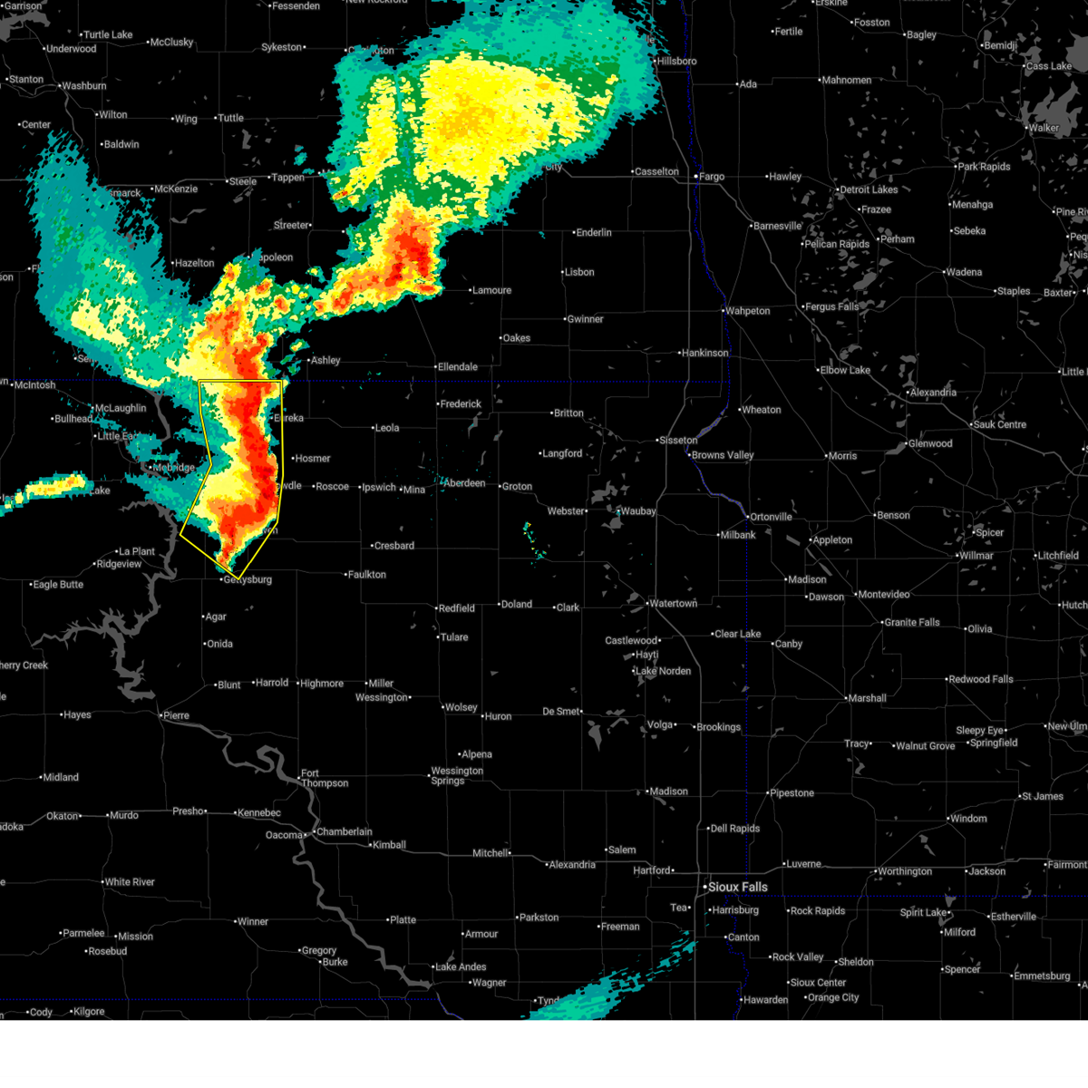
| 9/14/2024 4:34 PM CDT |
 Svrabr the national weather service in aberdeen has issued a * severe thunderstorm warning for, eastern walworth county in north central south dakota, * until 515 pm cdt. * at 434 pm cdt, a severe thunderstorm was located near akaska, or 11 miles south of selby, moving northeast at 25 mph (radar indicated). Hazards include 60 mph wind gusts and quarter size hail. Hail damage to vehicles is expected. expect wind damage to roofs, siding, and trees. This severe thunderstorm will be near, lowry around 440 pm cdt. Svrabr the national weather service in aberdeen has issued a * severe thunderstorm warning for, eastern walworth county in north central south dakota, * until 515 pm cdt. * at 434 pm cdt, a severe thunderstorm was located near akaska, or 11 miles south of selby, moving northeast at 25 mph (radar indicated). Hazards include 60 mph wind gusts and quarter size hail. Hail damage to vehicles is expected. expect wind damage to roofs, siding, and trees. This severe thunderstorm will be near, lowry around 440 pm cdt.
|
| 6/27/2024 10:14 PM MDT |
 The storms which prompted the warning have moved out of the area. therefore, the warning will be allowed to expire. however, gusty winds are still possible with these thunderstorms. a severe thunderstorm watch remains in effect until 200 am cdt/100 am mdt/ for central and north central south dakota. The storms which prompted the warning have moved out of the area. therefore, the warning will be allowed to expire. however, gusty winds are still possible with these thunderstorms. a severe thunderstorm watch remains in effect until 200 am cdt/100 am mdt/ for central and north central south dakota.
|
| 6/27/2024 10:59 PM CDT |
 Svrabr the national weather service in aberdeen has issued a * severe thunderstorm warning for, western edmunds county in north central south dakota, sully county in central south dakota, northern hyde county in central south dakota, western faulk county in north central south dakota, southeastern campbell county in north central south dakota, potter county in north central south dakota, northeastern hughes county in central south dakota, southwestern mcpherson county in north central south dakota, walworth county in north central south dakota, * until midnight cdt. * at 1059 pm cdt, severe thunderstorms were located along a line extending from near lake hiddenwood rec area to 7 miles northeast of cow creek rec area, moving east at 45 mph (radar indicated). Hazards include 60 mph wind gusts and quarter size hail. Hail damage to vehicles is expected. expect wind damage to roofs, siding, and trees. severe thunderstorms will be near, gettysburg, onida, java, agar, lowry, gorman, lake hiddenwood rec area, and sully lake around 1105 pm cdt. bowdle, hoven, and cottonwood lake near agar around 1115 pm cdt. Other locations in the path of these severe thunderstorms include blunt, lebanon, hosmer, tolstoy, stone lake, harrold, roscoe, seneca, onaka, holabird, brentwood colony, thunderbird colony, burkmere and loyalton. Svrabr the national weather service in aberdeen has issued a * severe thunderstorm warning for, western edmunds county in north central south dakota, sully county in central south dakota, northern hyde county in central south dakota, western faulk county in north central south dakota, southeastern campbell county in north central south dakota, potter county in north central south dakota, northeastern hughes county in central south dakota, southwestern mcpherson county in north central south dakota, walworth county in north central south dakota, * until midnight cdt. * at 1059 pm cdt, severe thunderstorms were located along a line extending from near lake hiddenwood rec area to 7 miles northeast of cow creek rec area, moving east at 45 mph (radar indicated). Hazards include 60 mph wind gusts and quarter size hail. Hail damage to vehicles is expected. expect wind damage to roofs, siding, and trees. severe thunderstorms will be near, gettysburg, onida, java, agar, lowry, gorman, lake hiddenwood rec area, and sully lake around 1105 pm cdt. bowdle, hoven, and cottonwood lake near agar around 1115 pm cdt. Other locations in the path of these severe thunderstorms include blunt, lebanon, hosmer, tolstoy, stone lake, harrold, roscoe, seneca, onaka, holabird, brentwood colony, thunderbird colony, burkmere and loyalton.
|
| 6/27/2024 9:45 PM MDT |
 At 1045 pm cdt/945 pm mdt/, severe thunderstorms were located along a line extending from 6 miles north of glenham to 6 miles southwest of swan creek rec area to 8 miles north of little bend rec area, moving east at 45 mph (radar indicated). Hazards include 60 mph wind gusts and quarter size hail. Hail damage to vehicles is expected. expect wind damage to roofs, siding, and trees. Locations impacted include, akaska, whitlocks bay rec area, swan creek rec area, swiftbird, swiftbird day school, selby, sutton bay rec area and lake hiddenwood rec area. At 1045 pm cdt/945 pm mdt/, severe thunderstorms were located along a line extending from 6 miles north of glenham to 6 miles southwest of swan creek rec area to 8 miles north of little bend rec area, moving east at 45 mph (radar indicated). Hazards include 60 mph wind gusts and quarter size hail. Hail damage to vehicles is expected. expect wind damage to roofs, siding, and trees. Locations impacted include, akaska, whitlocks bay rec area, swan creek rec area, swiftbird, swiftbird day school, selby, sutton bay rec area and lake hiddenwood rec area.
|
| 6/27/2024 9:08 PM MDT |
 Svrabr the national weather service in aberdeen has issued a * severe thunderstorm warning for, northwestern sully county in central south dakota, southeastern corson county in north central south dakota, southwestern campbell county in north central south dakota, western potter county in north central south dakota, dewey county in north central south dakota, central walworth county in north central south dakota, * until 1115 pm cdt/1015 pm mdt/. * at 1007 pm cdt/907 pm mdt/, severe thunderstorms were located along a line extending from 6 miles south of little eagle to near white horse to 6 miles east of intersection of highway 63 and bia road 8, moving east at 45 mph (radar indicated). Hazards include 60 mph wind gusts and quarter size hail. Hail damage to vehicles is expected. expect wind damage to roofs, siding, and trees. severe thunderstorms will be near, laplant, promise, trail city, ridgeview, and tiospaye topa school around 915 pm mdt. wakpala, grand river casino, and indian memorial rec area around 920 pm mdt. mobridge and revheim bay rec area around 1025 pm cdt. Other locations in the path of these severe thunderstorms include indian creek rec area, blackfoot, glenham, new everets resort, swiftbird day school, swan creek rec area, swiftbird, selby, akaska, whitlocks bay rec area, sutton bay rec area and lake hiddenwood rec area. Svrabr the national weather service in aberdeen has issued a * severe thunderstorm warning for, northwestern sully county in central south dakota, southeastern corson county in north central south dakota, southwestern campbell county in north central south dakota, western potter county in north central south dakota, dewey county in north central south dakota, central walworth county in north central south dakota, * until 1115 pm cdt/1015 pm mdt/. * at 1007 pm cdt/907 pm mdt/, severe thunderstorms were located along a line extending from 6 miles south of little eagle to near white horse to 6 miles east of intersection of highway 63 and bia road 8, moving east at 45 mph (radar indicated). Hazards include 60 mph wind gusts and quarter size hail. Hail damage to vehicles is expected. expect wind damage to roofs, siding, and trees. severe thunderstorms will be near, laplant, promise, trail city, ridgeview, and tiospaye topa school around 915 pm mdt. wakpala, grand river casino, and indian memorial rec area around 920 pm mdt. mobridge and revheim bay rec area around 1025 pm cdt. Other locations in the path of these severe thunderstorms include indian creek rec area, blackfoot, glenham, new everets resort, swiftbird day school, swan creek rec area, swiftbird, selby, akaska, whitlocks bay rec area, sutton bay rec area and lake hiddenwood rec area.
|
| 7/30/2023 11:00 AM CDT | Golf Ball sized hail reported 0.1 miles NNE of Akaska, SD, ping pong to golfball sized hail via facebook. |
| 7/30/2023 10:43 AM CDT |
 At 1043 am cdt/943 am mdt/, a severe thunderstorm was located near akaska, or 9 miles southwest of selby, moving southeast at 40 mph (radar indicated). Hazards include 60 mph wind gusts and quarter size hail. Hail damage to vehicles is expected. expect wind damage to roofs, siding, and trees. this severe thunderstorm will be near, akaska around 1050 am cdt. lowry around 1100 am cdt. other locations in the path of this severe thunderstorm include hoven and lebanon. hail threat, radar indicated max hail size, 1. 00 in wind threat, radar indicated max wind gust, 60 mph. At 1043 am cdt/943 am mdt/, a severe thunderstorm was located near akaska, or 9 miles southwest of selby, moving southeast at 40 mph (radar indicated). Hazards include 60 mph wind gusts and quarter size hail. Hail damage to vehicles is expected. expect wind damage to roofs, siding, and trees. this severe thunderstorm will be near, akaska around 1050 am cdt. lowry around 1100 am cdt. other locations in the path of this severe thunderstorm include hoven and lebanon. hail threat, radar indicated max hail size, 1. 00 in wind threat, radar indicated max wind gust, 60 mph.
|
| 7/30/2023 8:58 AM MDT |
 At 958 am cdt/858 am mdt/, a severe thunderstorm was located near wakpala, moving southeast at 50 mph (radar indicated). Hazards include 60 mph wind gusts and half dollar size hail. Hail damage to vehicles is expected. expect wind damage to roofs, siding, and trees. this severe thunderstorm will be near, mobridge around 1005 am cdt. revheim bay rec area and indian creek rec area around 1010 am cdt. glenham around 1015 am cdt. other locations in the path of this severe thunderstorm include new everets resort, akaska, swan creek rec area and lowry. hail threat, radar indicated max hail size, 1. 25 in wind threat, radar indicated max wind gust, 60 mph. At 958 am cdt/858 am mdt/, a severe thunderstorm was located near wakpala, moving southeast at 50 mph (radar indicated). Hazards include 60 mph wind gusts and half dollar size hail. Hail damage to vehicles is expected. expect wind damage to roofs, siding, and trees. this severe thunderstorm will be near, mobridge around 1005 am cdt. revheim bay rec area and indian creek rec area around 1010 am cdt. glenham around 1015 am cdt. other locations in the path of this severe thunderstorm include new everets resort, akaska, swan creek rec area and lowry. hail threat, radar indicated max hail size, 1. 25 in wind threat, radar indicated max wind gust, 60 mph.
|
| 7/5/2022 11:19 AM CDT |
 At 1118 am cdt/1018 am mdt/, severe thunderstorms were located along a line extending from near hoven to near gorman, moving east at 35 mph. these are destructive storms for hoven, gettysburg, and agar (trained weather spotters. at 1109 am cdt, a 71 mph wind gust was reported near whitlocks bay rec area). Hazards include 80 mph wind gusts and tennis ball size hail. Flying debris will be dangerous to those caught without shelter. mobile homes will be heavily damaged. expect considerable damage to roofs, windows, and vehicles. extensive tree damage and power outages are likely. locations impacted include, gettysburg, onida, bowdle, hoven, agar, lebanon, akaska, tolstoy, lowry, bush`s landing, swiftbird, mission ridge, cottonwood lake near agar, little bend rec area, whitlocks bay rec area, gorman, sutton bay rec area, sully lake, sansarc and okobojo point rec area. thunderstorm damage threat, destructive hail threat, radar indicated max hail size, 2. 50 in wind threat, radar indicated max wind gust, 80 mph. At 1118 am cdt/1018 am mdt/, severe thunderstorms were located along a line extending from near hoven to near gorman, moving east at 35 mph. these are destructive storms for hoven, gettysburg, and agar (trained weather spotters. at 1109 am cdt, a 71 mph wind gust was reported near whitlocks bay rec area). Hazards include 80 mph wind gusts and tennis ball size hail. Flying debris will be dangerous to those caught without shelter. mobile homes will be heavily damaged. expect considerable damage to roofs, windows, and vehicles. extensive tree damage and power outages are likely. locations impacted include, gettysburg, onida, bowdle, hoven, agar, lebanon, akaska, tolstoy, lowry, bush`s landing, swiftbird, mission ridge, cottonwood lake near agar, little bend rec area, whitlocks bay rec area, gorman, sutton bay rec area, sully lake, sansarc and okobojo point rec area. thunderstorm damage threat, destructive hail threat, radar indicated max hail size, 2. 50 in wind threat, radar indicated max wind gust, 80 mph.
|
| 7/5/2022 11:15 AM CDT |
 At 1114 am cdt/1014 am mdt/, severe thunderstorms were located along a line extending from near lowry to 6 miles east of sutton bay rec area, moving east at 35 mph. these are destructive storms for hoven, gettysburg, and agar (trained weather spotters). Hazards include 80 mph wind gusts and tennis ball size hail. Flying debris will be dangerous to those caught without shelter. mobile homes will be heavily damaged. expect considerable damage to roofs, windows, and vehicles. extensive tree damage and power outages are likely. locations impacted include, gettysburg, onida, bowdle, hoven, agar, lebanon, akaska, tolstoy, lowry, bush`s landing, swiftbird, mission ridge, cottonwood lake near agar, little bend rec area, whitlocks bay rec area, gorman, sutton bay rec area, sully lake, sansarc and okobojo point rec area. thunderstorm damage threat, destructive hail threat, radar indicated max hail size, 2. 50 in wind threat, radar indicated max wind gust, 80 mph. At 1114 am cdt/1014 am mdt/, severe thunderstorms were located along a line extending from near lowry to 6 miles east of sutton bay rec area, moving east at 35 mph. these are destructive storms for hoven, gettysburg, and agar (trained weather spotters). Hazards include 80 mph wind gusts and tennis ball size hail. Flying debris will be dangerous to those caught without shelter. mobile homes will be heavily damaged. expect considerable damage to roofs, windows, and vehicles. extensive tree damage and power outages are likely. locations impacted include, gettysburg, onida, bowdle, hoven, agar, lebanon, akaska, tolstoy, lowry, bush`s landing, swiftbird, mission ridge, cottonwood lake near agar, little bend rec area, whitlocks bay rec area, gorman, sutton bay rec area, sully lake, sansarc and okobojo point rec area. thunderstorm damage threat, destructive hail threat, radar indicated max hail size, 2. 50 in wind threat, radar indicated max wind gust, 80 mph.
|
| 7/5/2022 10:02 AM MDT |
 At 1101 am cdt/1001 am mdt/, severe thunderstorms were located along a line extending from near akaska to near sutton bay rec area, moving east at 40 mph. these are destructive storms for central lake oahe (trained weather spotters). Hazards include 80 mph wind gusts and tennis ball size hail. Flying debris will be dangerous to those caught without shelter. mobile homes will be heavily damaged. expect considerable damage to roofs, windows, and vehicles. extensive tree damage and power outages are likely. locations impacted include, akaska, lowry, hoven, gorman, agar, tolstoy and cottonwood lake near agar. thunderstorm damage threat, destructive hail threat, observed max hail size, 2. 50 in wind threat, radar indicated max wind gust, 80 mph. At 1101 am cdt/1001 am mdt/, severe thunderstorms were located along a line extending from near akaska to near sutton bay rec area, moving east at 40 mph. these are destructive storms for central lake oahe (trained weather spotters). Hazards include 80 mph wind gusts and tennis ball size hail. Flying debris will be dangerous to those caught without shelter. mobile homes will be heavily damaged. expect considerable damage to roofs, windows, and vehicles. extensive tree damage and power outages are likely. locations impacted include, akaska, lowry, hoven, gorman, agar, tolstoy and cottonwood lake near agar. thunderstorm damage threat, destructive hail threat, observed max hail size, 2. 50 in wind threat, radar indicated max wind gust, 80 mph.
|
| 7/5/2022 9:42 AM MDT |
 At 1041 am cdt/941 am mdt/, severe thunderstorms were located along a line extending from lake oahe to 6 miles south of ridgeview, moving east at 35 mph. these are destructive storms for central lake oahe (trained weather spotters. at 920 am mdt, tennis ball hail was reported near firesteel). Hazards include 80 mph wind gusts and tennis ball size hail. Flying debris will be dangerous to those caught without shelter. mobile homes will be heavily damaged. expect considerable damage to roofs, windows, and vehicles. extensive tree damage and power outages are likely. severe thunderstorms will be near, blackfoot around 945 am mdt. swan creek rec area around 1050 am cdt. akaska around 1100 am cdt. other locations in the path of these severe thunderstorms include lowry, sutton bay rec area, hoven, gorman, agar, tolstoy and cottonwood lake near agar. thunderstorm damage threat, destructive hail threat, observed max hail size, 2. 50 in wind threat, radar indicated max wind gust, 80 mph. At 1041 am cdt/941 am mdt/, severe thunderstorms were located along a line extending from lake oahe to 6 miles south of ridgeview, moving east at 35 mph. these are destructive storms for central lake oahe (trained weather spotters. at 920 am mdt, tennis ball hail was reported near firesteel). Hazards include 80 mph wind gusts and tennis ball size hail. Flying debris will be dangerous to those caught without shelter. mobile homes will be heavily damaged. expect considerable damage to roofs, windows, and vehicles. extensive tree damage and power outages are likely. severe thunderstorms will be near, blackfoot around 945 am mdt. swan creek rec area around 1050 am cdt. akaska around 1100 am cdt. other locations in the path of these severe thunderstorms include lowry, sutton bay rec area, hoven, gorman, agar, tolstoy and cottonwood lake near agar. thunderstorm damage threat, destructive hail threat, observed max hail size, 2. 50 in wind threat, radar indicated max wind gust, 80 mph.
|
| 7/5/2022 9:18 AM MDT |
 At 1017 am cdt/917 am mdt/, a severe thunderstorm was located 8 miles southwest of swan creek rec area, or 23 miles northwest of gettysburg, moving east at 40 mph (radar indicated). Hazards include 80 mph wind gusts and golf ball size hail. Flying debris will be dangerous to those caught without shelter. mobile homes will be heavily damaged. expect considerable damage to roofs, windows, and vehicles. extensive tree damage and power outages are likely. this severe thunderstorm will remain over mainly rural areas of northwestern potter, dewey and southern walworth counties, including the following locations, cheyenne river reservation. thunderstorm damage threat, destructive hail threat, radar indicated max hail size, 1. 75 in wind threat, radar indicated max wind gust, 80 mph. At 1017 am cdt/917 am mdt/, a severe thunderstorm was located 8 miles southwest of swan creek rec area, or 23 miles northwest of gettysburg, moving east at 40 mph (radar indicated). Hazards include 80 mph wind gusts and golf ball size hail. Flying debris will be dangerous to those caught without shelter. mobile homes will be heavily damaged. expect considerable damage to roofs, windows, and vehicles. extensive tree damage and power outages are likely. this severe thunderstorm will remain over mainly rural areas of northwestern potter, dewey and southern walworth counties, including the following locations, cheyenne river reservation. thunderstorm damage threat, destructive hail threat, radar indicated max hail size, 1. 75 in wind threat, radar indicated max wind gust, 80 mph.
|
| 7/5/2022 8:41 AM MDT |
 At 940 am cdt/840 am mdt/, a severe thunderstorm was located near white horse, or 24 miles southwest of mobridge, moving east at 40 mph (radar indicated). Hazards include 80 mph wind gusts and tennis ball size hail. Flying debris will be dangerous to those caught without shelter. mobile homes will be heavily damaged. expect considerable damage to roofs, windows, and vehicles. extensive tree damage and power outages are likely. this severe thunderstorm will be near, promise around 855 am mdt. thunderstorm damage threat, destructive hail threat, radar indicated max hail size, 2. 50 in wind threat, radar indicated max wind gust, 80 mph. At 940 am cdt/840 am mdt/, a severe thunderstorm was located near white horse, or 24 miles southwest of mobridge, moving east at 40 mph (radar indicated). Hazards include 80 mph wind gusts and tennis ball size hail. Flying debris will be dangerous to those caught without shelter. mobile homes will be heavily damaged. expect considerable damage to roofs, windows, and vehicles. extensive tree damage and power outages are likely. this severe thunderstorm will be near, promise around 855 am mdt. thunderstorm damage threat, destructive hail threat, radar indicated max hail size, 2. 50 in wind threat, radar indicated max wind gust, 80 mph.
|
| 6/19/2022 9:45 PM CDT |
 At 944 pm cdt/844 pm mdt/, a severe thunderstorm was located over eastern lake oahe, or 20 miles northwest of gettysburg, moving north at 45 mph (radar indicated). Hazards include 60 mph wind gusts. Expect damage to roofs, siding, and trees. this severe thunderstorm will be near, swan creek rec area around 955 pm cdt. akaska around 1000 pm cdt. other locations in the path of this severe thunderstorm include new everets resort, selby, glenham and lake hiddenwood rec area. hail threat, radar indicated max hail size, <. 75 in wind threat, radar indicated max wind gust, 60 mph. At 944 pm cdt/844 pm mdt/, a severe thunderstorm was located over eastern lake oahe, or 20 miles northwest of gettysburg, moving north at 45 mph (radar indicated). Hazards include 60 mph wind gusts. Expect damage to roofs, siding, and trees. this severe thunderstorm will be near, swan creek rec area around 955 pm cdt. akaska around 1000 pm cdt. other locations in the path of this severe thunderstorm include new everets resort, selby, glenham and lake hiddenwood rec area. hail threat, radar indicated max hail size, <. 75 in wind threat, radar indicated max wind gust, 60 mph.
|
| 6/14/2022 4:09 AM CDT |
 The severe thunderstorm warning for western edmunds, northeastern potter and southeastern walworth counties will expire at 415 am cdt, the storm which prompted the warning has moved out of the area. therefore, the warning will be allowed to expire. a severe thunderstorm watch remains in effect until 600 am cdt for north central south dakota. remember, a severe thunderstorm warning still remains in effect for portions of edmunds county. The severe thunderstorm warning for western edmunds, northeastern potter and southeastern walworth counties will expire at 415 am cdt, the storm which prompted the warning has moved out of the area. therefore, the warning will be allowed to expire. a severe thunderstorm watch remains in effect until 600 am cdt for north central south dakota. remember, a severe thunderstorm warning still remains in effect for portions of edmunds county.
|
| 6/14/2022 3:34 AM CDT |
 At 333 am cdt, a severe thunderstorm was located near hoven, or 21 miles southeast of selby, moving northeast at 40 mph. this is a destructive storm (radar indicated). Hazards include 80 mph wind gusts and golf ball size hail. Flying debris will be dangerous to those caught without shelter. mobile homes will be heavily damaged. expect considerable damage to roofs, windows, and vehicles. extensive tree damage and power outages are likely. Locations impacted include, bowdle, hoven, roscoe, hosmer, akaska, tolstoy and lowry. At 333 am cdt, a severe thunderstorm was located near hoven, or 21 miles southeast of selby, moving northeast at 40 mph. this is a destructive storm (radar indicated). Hazards include 80 mph wind gusts and golf ball size hail. Flying debris will be dangerous to those caught without shelter. mobile homes will be heavily damaged. expect considerable damage to roofs, windows, and vehicles. extensive tree damage and power outages are likely. Locations impacted include, bowdle, hoven, roscoe, hosmer, akaska, tolstoy and lowry.
|
| 6/14/2022 3:23 AM CDT |
 At 323 am cdt, a severe thunderstorm was located near lowry, or 15 miles north of gettysburg, moving northeast at 40 mph (radar indicated). Hazards include golf ball size hail and 70 mph wind gusts. People and animals outdoors will be injured. expect hail damage to roofs, siding, windows, and vehicles. expect considerable tree damage. wind damage is also likely to mobile homes, roofs, and outbuildings. locations impacted include, hoven, bowdle, roscoe and hosmer. thunderstorm damage threat, considerable hail threat, radar indicated max hail size, 1. 75 in wind threat, observed max wind gust, 70 mph. At 323 am cdt, a severe thunderstorm was located near lowry, or 15 miles north of gettysburg, moving northeast at 40 mph (radar indicated). Hazards include golf ball size hail and 70 mph wind gusts. People and animals outdoors will be injured. expect hail damage to roofs, siding, windows, and vehicles. expect considerable tree damage. wind damage is also likely to mobile homes, roofs, and outbuildings. locations impacted include, hoven, bowdle, roscoe and hosmer. thunderstorm damage threat, considerable hail threat, radar indicated max hail size, 1. 75 in wind threat, observed max wind gust, 70 mph.
|
| 6/14/2022 3:14 AM CDT |
 At 313 am cdt, a severe thunderstorm was located 10 miles south of lowry, or 12 miles north of gettysburg, moving northeast at 40 mph (radar indicated). Hazards include 60 mph wind gusts and half dollar size hail. Hail damage to vehicles is expected. expect wind damage to roofs, siding, and trees. this severe thunderstorm will be near, lowry around 325 am cdt. other locations in the path of this severe thunderstorm include hoven, bowdle, roscoe and hosmer. hail threat, radar indicated max hail size, 1. 25 in wind threat, radar indicated max wind gust, 60 mph. At 313 am cdt, a severe thunderstorm was located 10 miles south of lowry, or 12 miles north of gettysburg, moving northeast at 40 mph (radar indicated). Hazards include 60 mph wind gusts and half dollar size hail. Hail damage to vehicles is expected. expect wind damage to roofs, siding, and trees. this severe thunderstorm will be near, lowry around 325 am cdt. other locations in the path of this severe thunderstorm include hoven, bowdle, roscoe and hosmer. hail threat, radar indicated max hail size, 1. 25 in wind threat, radar indicated max wind gust, 60 mph.
|
| 6/14/2022 2:56 AM CDT |
 At 256 am cdt/156 am mdt/, a severe thunderstorm was located near whitlocks bay rec area, or 13 miles northwest of gettysburg, moving northeast at 40 mph (radar indicated). Hazards include two inch hail and 70 mph wind gusts. People and animals outdoors will be injured. expect hail damage to roofs, siding, windows, and vehicles. expect considerable tree damage. wind damage is also likely to mobile homes, roofs, and outbuildings. This severe thunderstorm will remain over mainly rural areas of central potter, east central dewey and south central walworth counties. At 256 am cdt/156 am mdt/, a severe thunderstorm was located near whitlocks bay rec area, or 13 miles northwest of gettysburg, moving northeast at 40 mph (radar indicated). Hazards include two inch hail and 70 mph wind gusts. People and animals outdoors will be injured. expect hail damage to roofs, siding, windows, and vehicles. expect considerable tree damage. wind damage is also likely to mobile homes, roofs, and outbuildings. This severe thunderstorm will remain over mainly rural areas of central potter, east central dewey and south central walworth counties.
|
| 6/14/2022 2:36 AM CDT |
 At 236 am cdt/136 am mdt/, a severe thunderstorm was located over southeastern lake oahe, or 22 miles west of gettysburg, moving northeast at 40 mph (radar indicated). Hazards include two inch hail and 70 mph wind gusts. People and animals outdoors will be injured. expect hail damage to roofs, siding, windows, and vehicles. expect considerable tree damage. wind damage is also likely to mobile homes, roofs, and outbuildings. this severe thunderstorm will be near, swiftbird and swiftbird day school around 145 am mdt. Whitlocks bay rec area around 250 am cdt. At 236 am cdt/136 am mdt/, a severe thunderstorm was located over southeastern lake oahe, or 22 miles west of gettysburg, moving northeast at 40 mph (radar indicated). Hazards include two inch hail and 70 mph wind gusts. People and animals outdoors will be injured. expect hail damage to roofs, siding, windows, and vehicles. expect considerable tree damage. wind damage is also likely to mobile homes, roofs, and outbuildings. this severe thunderstorm will be near, swiftbird and swiftbird day school around 145 am mdt. Whitlocks bay rec area around 250 am cdt.
|
| 6/13/2022 2:25 AM CDT |
 At 224 am cdt/124 am mdt/, severe thunderstorms were located along a line extending from lake oahe to swan creek rec area, moving northeast at 70 mph (radar indicated). Hazards include 60 mph wind gusts. Expect damage to roofs, siding, and trees. locations impacted include, akaska, selby, lake hiddenwood rec area, java, mound city and herreid. hail threat, radar indicated max hail size, <. 75 in wind threat, radar indicated max wind gust, 60 mph. At 224 am cdt/124 am mdt/, severe thunderstorms were located along a line extending from lake oahe to swan creek rec area, moving northeast at 70 mph (radar indicated). Hazards include 60 mph wind gusts. Expect damage to roofs, siding, and trees. locations impacted include, akaska, selby, lake hiddenwood rec area, java, mound city and herreid. hail threat, radar indicated max hail size, <. 75 in wind threat, radar indicated max wind gust, 60 mph.
|
| 8/28/2021 6:08 AM CDT |
 At 608 am cdt, a severe thunderstorm was located near lowry, or 10 miles south of selby, moving east at 35 mph (radar indicated). Hazards include 60 mph wind gusts and quarter size hail. Hail damage to vehicles is expected. Expect wind damage to roofs, siding, and trees. At 608 am cdt, a severe thunderstorm was located near lowry, or 10 miles south of selby, moving east at 35 mph (radar indicated). Hazards include 60 mph wind gusts and quarter size hail. Hail damage to vehicles is expected. Expect wind damage to roofs, siding, and trees.
|
| 8/28/2021 2:20 AM CDT |
 At 220 am cdt, a severe thunderstorm was located near akaska, or 7 miles southwest of selby, moving east at 30 mph (radar indicated). Hazards include golf ball size hail. People and animals outdoors will be injured. expect damage to roofs, siding, windows, and vehicles. locations impacted include, java and akaska. thunderstorm damage threat, considerable hail threat, radar indicated max hail size, 1. 75 in wind threat, radar indicated max wind gust, <50 mph. At 220 am cdt, a severe thunderstorm was located near akaska, or 7 miles southwest of selby, moving east at 30 mph (radar indicated). Hazards include golf ball size hail. People and animals outdoors will be injured. expect damage to roofs, siding, windows, and vehicles. locations impacted include, java and akaska. thunderstorm damage threat, considerable hail threat, radar indicated max hail size, 1. 75 in wind threat, radar indicated max wind gust, <50 mph.
|
| 8/28/2021 2:13 AM CDT |
 At 212 am cdt, a severe thunderstorm was located near akaska, or 10 miles southwest of selby, moving east at 30 mph (radar indicated). Hazards include half dollar size hail. Damage to vehicles is expected. locations impacted include, selby and java. hail threat, radar indicated max hail size, 1. 25 in wind threat, radar indicated max wind gust, <50 mph. At 212 am cdt, a severe thunderstorm was located near akaska, or 10 miles southwest of selby, moving east at 30 mph (radar indicated). Hazards include half dollar size hail. Damage to vehicles is expected. locations impacted include, selby and java. hail threat, radar indicated max hail size, 1. 25 in wind threat, radar indicated max wind gust, <50 mph.
|
| 8/28/2021 2:05 AM CDT |
 At 205 am cdt/105 am mdt/, a severe thunderstorm was located over northeastern lake oahe, or 12 miles southeast of mobridge, moving east at 30 mph (radar indicated). Hazards include quarter size hail. Damage to vehicles is expected. this severe thunderstorm will be near, akaska around 220 am cdt. other locations in the path of this severe thunderstorm include selby and java. hail threat, radar indicated max hail size, 1. 00 in wind threat, radar indicated max wind gust, <50 mph. At 205 am cdt/105 am mdt/, a severe thunderstorm was located over northeastern lake oahe, or 12 miles southeast of mobridge, moving east at 30 mph (radar indicated). Hazards include quarter size hail. Damage to vehicles is expected. this severe thunderstorm will be near, akaska around 220 am cdt. other locations in the path of this severe thunderstorm include selby and java. hail threat, radar indicated max hail size, 1. 00 in wind threat, radar indicated max wind gust, <50 mph.
|
| 8/23/2021 11:15 PM CDT |
 At 1114 pm cdt/1014 pm mdt/, a severe thunderstorm was located 8 miles south of swan creek rec area, or 18 miles northwest of gettysburg, moving east at 35 mph (radar indicated). Hazards include golf ball size hail and 60 mph wind gusts. People and animals outdoors will be injured. expect hail damage to roofs, siding, windows, and vehicles. expect wind damage to roofs, siding, and trees. Locations impacted include, lowry and hoven. At 1114 pm cdt/1014 pm mdt/, a severe thunderstorm was located 8 miles south of swan creek rec area, or 18 miles northwest of gettysburg, moving east at 35 mph (radar indicated). Hazards include golf ball size hail and 60 mph wind gusts. People and animals outdoors will be injured. expect hail damage to roofs, siding, windows, and vehicles. expect wind damage to roofs, siding, and trees. Locations impacted include, lowry and hoven.
|
| 8/23/2021 10:56 PM CDT |
 At 1056 pm cdt/956 pm mdt/, a severe thunderstorm was located 8 miles north of swiftbird day school, or 23 miles south of mobridge, moving east at 35 mph (radar indicated). Hazards include ping pong ball size hail and 60 mph wind gusts. People and animals outdoors will be injured. expect hail damage to roofs, siding, windows, and vehicles. expect wind damage to roofs, siding, and trees. this severe thunderstorm will be near, swan creek rec area around 1115 pm cdt. Other locations in the path of this severe thunderstorm include akaska, lowry and hoven. At 1056 pm cdt/956 pm mdt/, a severe thunderstorm was located 8 miles north of swiftbird day school, or 23 miles south of mobridge, moving east at 35 mph (radar indicated). Hazards include ping pong ball size hail and 60 mph wind gusts. People and animals outdoors will be injured. expect hail damage to roofs, siding, windows, and vehicles. expect wind damage to roofs, siding, and trees. this severe thunderstorm will be near, swan creek rec area around 1115 pm cdt. Other locations in the path of this severe thunderstorm include akaska, lowry and hoven.
|
| 8/23/2021 9:38 PM MDT |
 At 1037 pm cdt/937 pm mdt/, a severe thunderstorm was located over tiospaye topa school, or 26 miles south of mobridge, moving east at 50 mph (radar indicated). Hazards include 60 mph wind gusts and quarter size hail. Hail damage to vehicles is expected. expect wind damage to roofs, siding, and trees. locations impacted include, swan creek rec area and akaska. hail threat, radar indicated max hail size, 1. 00 in wind threat, radar indicated max wind gust, 60 mph. At 1037 pm cdt/937 pm mdt/, a severe thunderstorm was located over tiospaye topa school, or 26 miles south of mobridge, moving east at 50 mph (radar indicated). Hazards include 60 mph wind gusts and quarter size hail. Hail damage to vehicles is expected. expect wind damage to roofs, siding, and trees. locations impacted include, swan creek rec area and akaska. hail threat, radar indicated max hail size, 1. 00 in wind threat, radar indicated max wind gust, 60 mph.
|
| 8/23/2021 9:17 PM MDT |
 At 1017 pm cdt/917 pm mdt/, a severe thunderstorm was located near parade, or 11 miles northeast of eagle butte, moving east at 35 mph (radar indicated). Hazards include 60 mph wind gusts and quarter size hail. Hail damage to vehicles is expected. expect wind damage to roofs, siding, and trees. this severe thunderstorm will be near, ridgeview around 935 pm mdt. other locations in the path of this severe thunderstorm include tiospaye topa school, laplant and swiftbird day school. hail threat, radar indicated max hail size, 1. 00 in wind threat, radar indicated max wind gust, 60 mph. At 1017 pm cdt/917 pm mdt/, a severe thunderstorm was located near parade, or 11 miles northeast of eagle butte, moving east at 35 mph (radar indicated). Hazards include 60 mph wind gusts and quarter size hail. Hail damage to vehicles is expected. expect wind damage to roofs, siding, and trees. this severe thunderstorm will be near, ridgeview around 935 pm mdt. other locations in the path of this severe thunderstorm include tiospaye topa school, laplant and swiftbird day school. hail threat, radar indicated max hail size, 1. 00 in wind threat, radar indicated max wind gust, 60 mph.
|
| 8/14/2021 7:20 PM CDT |
 At 719 pm cdt/619 pm mdt/, a severe thunderstorm was located near blackfoot, or 16 miles south of mobridge, moving southeast at 10 mph (radar indicated). Hazards include ping pong ball size hail and 60 mph wind gusts. People and animals outdoors will be injured. expect hail damage to roofs, siding, windows, and vehicles. expect wind damage to roofs, siding, and trees. locations impacted include, akaska, swan creek rec area and blackfoot. hail threat, radar indicated max hail size, 1. 50 in wind threat, radar indicated max wind gust, 60 mph. At 719 pm cdt/619 pm mdt/, a severe thunderstorm was located near blackfoot, or 16 miles south of mobridge, moving southeast at 10 mph (radar indicated). Hazards include ping pong ball size hail and 60 mph wind gusts. People and animals outdoors will be injured. expect hail damage to roofs, siding, windows, and vehicles. expect wind damage to roofs, siding, and trees. locations impacted include, akaska, swan creek rec area and blackfoot. hail threat, radar indicated max hail size, 1. 50 in wind threat, radar indicated max wind gust, 60 mph.
|
| 8/14/2021 7:14 PM CDT |
 At 713 pm cdt/613 pm mdt/, a severe thunderstorm was located near blackfoot, or 17 miles south of mobridge, moving southeast at 15 mph (radar indicated). Hazards include 60 mph wind gusts and quarter size hail. Hail damage to vehicles is expected. expect wind damage to roofs, siding, and trees. locations impacted include, akaska, swan creek rec area and blackfoot. hail threat, radar indicated max hail size, 1. 00 in wind threat, radar indicated max wind gust, 60 mph. At 713 pm cdt/613 pm mdt/, a severe thunderstorm was located near blackfoot, or 17 miles south of mobridge, moving southeast at 15 mph (radar indicated). Hazards include 60 mph wind gusts and quarter size hail. Hail damage to vehicles is expected. expect wind damage to roofs, siding, and trees. locations impacted include, akaska, swan creek rec area and blackfoot. hail threat, radar indicated max hail size, 1. 00 in wind threat, radar indicated max wind gust, 60 mph.
|
| 8/14/2021 5:47 PM MDT |
 At 646 pm cdt/546 pm mdt/, a severe thunderstorm was located near blackfoot, or 11 miles southeast of mobridge, moving east at 20 mph (radar indicated). Hazards include 60 mph wind gusts and quarter size hail. Hail damage to vehicles is expected. expect wind damage to roofs, siding, and trees. this severe thunderstorm will be near, new everets resort around 655 pm cdt. swan creek rec area around 705 pm cdt. other locations in the path of this severe thunderstorm include akaska. hail threat, radar indicated max hail size, 1. 00 in wind threat, radar indicated max wind gust, 60 mph. At 646 pm cdt/546 pm mdt/, a severe thunderstorm was located near blackfoot, or 11 miles southeast of mobridge, moving east at 20 mph (radar indicated). Hazards include 60 mph wind gusts and quarter size hail. Hail damage to vehicles is expected. expect wind damage to roofs, siding, and trees. this severe thunderstorm will be near, new everets resort around 655 pm cdt. swan creek rec area around 705 pm cdt. other locations in the path of this severe thunderstorm include akaska. hail threat, radar indicated max hail size, 1. 00 in wind threat, radar indicated max wind gust, 60 mph.
|
| 7/23/2021 10:54 PM CDT |
 At 1053 pm cdt, severe thunderstorms were located along a line extending from near hoven to near whitlocks bay rec area, moving southeast at 55 mph (radar indicated). Hazards include 60 mph wind gusts and penny size hail. Expect damage to roofs, siding, and trees. severe thunderstorms will be near, hoven around 1100 pm cdt. gettysburg, tolstoy and gorman around 1105 pm cdt. onaka around 1110 pm cdt. Other locations in the path of these severe thunderstorms include seneca, brentwood colony, burkmere, stone lake and faulkton. At 1053 pm cdt, severe thunderstorms were located along a line extending from near hoven to near whitlocks bay rec area, moving southeast at 55 mph (radar indicated). Hazards include 60 mph wind gusts and penny size hail. Expect damage to roofs, siding, and trees. severe thunderstorms will be near, hoven around 1100 pm cdt. gettysburg, tolstoy and gorman around 1105 pm cdt. onaka around 1110 pm cdt. Other locations in the path of these severe thunderstorms include seneca, brentwood colony, burkmere, stone lake and faulkton.
|
| 8/12/2020 1:26 AM CDT |
 The severe thunderstorm warning for eastern corson, campbell, potter, northeastern dewey and walworth counties will expire at 130 am cdt/1230 am mdt/, the storms which prompted the warning have weakened below severe limits, and no longer pose an immediate threat to life or property. therefore, the warning will be allowed to expire. however gusty winds are still possible with these thunderstorms. a severe thunderstorm watch remains in effect until 300 am cdt/200 am mdt/ for north central south dakota. to report severe weather, contact your nearest law enforcement agency. they will relay your report to the national weather service aberdeen. The severe thunderstorm warning for eastern corson, campbell, potter, northeastern dewey and walworth counties will expire at 130 am cdt/1230 am mdt/, the storms which prompted the warning have weakened below severe limits, and no longer pose an immediate threat to life or property. therefore, the warning will be allowed to expire. however gusty winds are still possible with these thunderstorms. a severe thunderstorm watch remains in effect until 300 am cdt/200 am mdt/ for north central south dakota. to report severe weather, contact your nearest law enforcement agency. they will relay your report to the national weather service aberdeen.
|
| 8/12/2020 1:09 AM CDT |
 At 109 am cdt/1209 am mdt/, severe thunderstorms were located along a line extending from near pollock to 6 miles northwest of lake hiddenwood rec area to lowry to 6 miles east of whitlocks bay rec area, moving east at 45 mph (radar indicated). Hazards include 60 mph wind gusts. Expect damage to roofs, siding, and trees. Locations impacted include, mobridge, gettysburg, selby, herreid, hoven, wakpala, pollock, java, glenham, mound city, akaska, lowry, mahto, swiftbird, kenel, swiftbird day school, revheim bay rec area, grand river casino, northern lake oahe and new everets resort. At 109 am cdt/1209 am mdt/, severe thunderstorms were located along a line extending from near pollock to 6 miles northwest of lake hiddenwood rec area to lowry to 6 miles east of whitlocks bay rec area, moving east at 45 mph (radar indicated). Hazards include 60 mph wind gusts. Expect damage to roofs, siding, and trees. Locations impacted include, mobridge, gettysburg, selby, herreid, hoven, wakpala, pollock, java, glenham, mound city, akaska, lowry, mahto, swiftbird, kenel, swiftbird day school, revheim bay rec area, grand river casino, northern lake oahe and new everets resort.
|
| 8/11/2020 11:43 PM MDT |
 At 1243 am cdt/1143 pm mdt/, severe thunderstorms were located along a line extending from 7 miles south of fort yates to lake oahe to near blackfoot to near swiftbird day school, moving east at 45 mph (radar indicated). Hazards include 70 mph wind gusts. Expect considerable tree damage. Damage is likely to mobile homes, roofs, and outbuildings. At 1243 am cdt/1143 pm mdt/, severe thunderstorms were located along a line extending from 7 miles south of fort yates to lake oahe to near blackfoot to near swiftbird day school, moving east at 45 mph (radar indicated). Hazards include 70 mph wind gusts. Expect considerable tree damage. Damage is likely to mobile homes, roofs, and outbuildings.
|
| 8/11/2020 8:08 AM CDT |
 At 808 am cdt/708 am mdt/, a severe thunderstorm was located near whitlocks bay rec area, or 17 miles northwest of gettysburg, moving northeast at 55 mph (radar indicated). Hazards include 60 mph wind gusts. Expect damage to roofs, siding, and trees. Locations impacted include, gettysburg, akaska, whitlocks bay rec area, swiftbird day school, swiftbird and lake oahe. At 808 am cdt/708 am mdt/, a severe thunderstorm was located near whitlocks bay rec area, or 17 miles northwest of gettysburg, moving northeast at 55 mph (radar indicated). Hazards include 60 mph wind gusts. Expect damage to roofs, siding, and trees. Locations impacted include, gettysburg, akaska, whitlocks bay rec area, swiftbird day school, swiftbird and lake oahe.
|
| 8/11/2020 7:50 AM CDT |
 At 750 am cdt/650 am mdt/, a severe thunderstorm was located near lake oahe, or 27 miles west of gettysburg, moving northeast at 55 mph (radar indicated). Hazards include 60 mph wind gusts. expect damage to roofs, siding, and trees At 750 am cdt/650 am mdt/, a severe thunderstorm was located near lake oahe, or 27 miles west of gettysburg, moving northeast at 55 mph (radar indicated). Hazards include 60 mph wind gusts. expect damage to roofs, siding, and trees
|
| 7/31/2020 7:03 PM CDT |
 At 703 pm cdt, severe thunderstorms were located along a line extending from near onaka to 8 miles southeast of onida, moving southeast at 35 mph (radar indicated). Hazards include 60 mph wind gusts and nickel size hail. Expect damage to roofs, siding, and trees. Locations impacted include, hoven, lebanon, akaska, seneca, tolstoy, onaka, lowry and loyalton. At 703 pm cdt, severe thunderstorms were located along a line extending from near onaka to 8 miles southeast of onida, moving southeast at 35 mph (radar indicated). Hazards include 60 mph wind gusts and nickel size hail. Expect damage to roofs, siding, and trees. Locations impacted include, hoven, lebanon, akaska, seneca, tolstoy, onaka, lowry and loyalton.
|
| 7/31/2020 6:48 PM CDT |
 At 648 pm cdt, severe thunderstorms were located along a line extending from 6 miles north of tolstoy to near onida, moving southeast at 35 mph (trained weather spotters). Hazards include 60 mph wind gusts and quarter size hail. Hail damage to vehicles is expected. expect wind damage to roofs, siding, and trees. Locations impacted include, gettysburg, onida, hoven, agar, lebanon, akaska, seneca, tolstoy, onaka, lowry, loyalton, cottonwood lake near agar, stone lake, gorman and sully lake. At 648 pm cdt, severe thunderstorms were located along a line extending from 6 miles north of tolstoy to near onida, moving southeast at 35 mph (trained weather spotters). Hazards include 60 mph wind gusts and quarter size hail. Hail damage to vehicles is expected. expect wind damage to roofs, siding, and trees. Locations impacted include, gettysburg, onida, hoven, agar, lebanon, akaska, seneca, tolstoy, onaka, lowry, loyalton, cottonwood lake near agar, stone lake, gorman and sully lake.
|
| 7/31/2020 6:24 PM CDT | Mesonet station 209 lowry (sddot in walworth county SD, 3.2 miles WNW of Akaska, SD |
| 7/31/2020 6:23 PM CDT |
 At 623 pm cdt, severe thunderstorms were located along a line extending from 6 miles northeast of lowry to 7 miles northwest of sully lake, moving southeast at 35 mph (trained weather spotters). Hazards include 60 mph wind gusts. expect damage to roofs, siding, and trees At 623 pm cdt, severe thunderstorms were located along a line extending from 6 miles northeast of lowry to 7 miles northwest of sully lake, moving southeast at 35 mph (trained weather spotters). Hazards include 60 mph wind gusts. expect damage to roofs, siding, and trees
|
| 6/6/2020 10:52 PM CDT |
 At 1052 pm cdt, severe thunderstorms were located along a line extending from near new everets resort to near gettysburg to near harrold, moving northeast at 55 mph (radar indicated). Hazards include 60 mph wind gusts and penny size hail. expect damage to roofs, siding, and trees At 1052 pm cdt, severe thunderstorms were located along a line extending from near new everets resort to near gettysburg to near harrold, moving northeast at 55 mph (radar indicated). Hazards include 60 mph wind gusts and penny size hail. expect damage to roofs, siding, and trees
|
| 8/25/2019 8:21 PM CDT |
 At 820 pm cdt/720 pm mdt/, severe thunderstorms were located along a line extending from near mound city to near laplant, moving southwest at 10 mph (radar indicated). Hazards include 60 mph wind gusts and quarter size hail. Hail damage to vehicles is expected. expect wind damage to roofs, siding, and trees. Locations impacted include, mobridge, selby, glenham, akaska, new everets resort, swiftbird, laplant, indian creek rec area, blackfoot, tiospaye topa school, promise, swiftbird day school, swan creek rec area, revheim bay rec area, lake hiddenwood rec area and lake oahe. At 820 pm cdt/720 pm mdt/, severe thunderstorms were located along a line extending from near mound city to near laplant, moving southwest at 10 mph (radar indicated). Hazards include 60 mph wind gusts and quarter size hail. Hail damage to vehicles is expected. expect wind damage to roofs, siding, and trees. Locations impacted include, mobridge, selby, glenham, akaska, new everets resort, swiftbird, laplant, indian creek rec area, blackfoot, tiospaye topa school, promise, swiftbird day school, swan creek rec area, revheim bay rec area, lake hiddenwood rec area and lake oahe.
|
| 8/25/2019 6:50 PM MDT |
 At 750 pm cdt/650 pm mdt/, severe thunderstorms were located along a line extending from 10 miles west of mound city to near ridgeview, moving east at 35 mph (radar indicated). Hazards include 60 mph wind gusts and quarter size hail. Hail damage to vehicles is expected. Expect wind damage to roofs, siding, and trees. At 750 pm cdt/650 pm mdt/, severe thunderstorms were located along a line extending from 10 miles west of mound city to near ridgeview, moving east at 35 mph (radar indicated). Hazards include 60 mph wind gusts and quarter size hail. Hail damage to vehicles is expected. Expect wind damage to roofs, siding, and trees.
|
| 7/20/2019 1:43 AM MDT |
 At 243 am cdt/143 am mdt/, a severe thunderstorm was located near ridgeview, or 21 miles northeast of eagle butte, moving east at 50 mph (radar indicated). Hazards include 60 mph wind gusts and quarter size hail. Hail damage to vehicles is expected. Expect wind damage to roofs, siding, and trees. At 243 am cdt/143 am mdt/, a severe thunderstorm was located near ridgeview, or 21 miles northeast of eagle butte, moving east at 50 mph (radar indicated). Hazards include 60 mph wind gusts and quarter size hail. Hail damage to vehicles is expected. Expect wind damage to roofs, siding, and trees.
|
| 7/17/2019 11:38 PM CDT | Storm damage reported in walworth county SD, 4 miles NW of Akaska, SD |
| 7/17/2019 11:23 PM CDT | Corrects previous lsr for time of observatio in walworth county SD, 4 miles NW of Akaska, SD |
| 7/17/2019 2:01 AM CDT |
 At 201 am cdt/101 am mdt/, severe thunderstorms were located along a line extending from near lake hiddenwood rec area to 8 miles south of java to 7 miles northwest of lebanon, moving east at 55 mph (radar indicated). Hazards include 60 mph wind gusts. Expect damage to roofs, siding, and trees. Locations impacted include, selby, bowdle, hoven, java, akaska, tolstoy, lowry, lake hiddenwood rec area, swan creek rec area and new everets resort. At 201 am cdt/101 am mdt/, severe thunderstorms were located along a line extending from near lake hiddenwood rec area to 8 miles south of java to 7 miles northwest of lebanon, moving east at 55 mph (radar indicated). Hazards include 60 mph wind gusts. Expect damage to roofs, siding, and trees. Locations impacted include, selby, bowdle, hoven, java, akaska, tolstoy, lowry, lake hiddenwood rec area, swan creek rec area and new everets resort.
|
| 7/17/2019 1:36 AM CDT |
 At 135 am cdt/1235 am mdt/, a severe thunderstorm was located near new everets resort, or 13 miles southwest of selby, moving east at 55 mph (radar indicated). Hazards include 60 mph wind gusts and penny size hail. expect damage to roofs, siding, and trees At 135 am cdt/1235 am mdt/, a severe thunderstorm was located near new everets resort, or 13 miles southwest of selby, moving east at 55 mph (radar indicated). Hazards include 60 mph wind gusts and penny size hail. expect damage to roofs, siding, and trees
|
| 7/16/2019 11:30 PM CDT |
 At 1129 pm cdt, a severe thunderstorm was located over akaska, or 12 miles south of selby, moving southeast at 20 mph (radar indicated). Hazards include 60 mph wind gusts and half dollar size hail. Hail damage to vehicles is expected. Expect wind damage to roofs, siding, and trees. At 1129 pm cdt, a severe thunderstorm was located over akaska, or 12 miles south of selby, moving southeast at 20 mph (radar indicated). Hazards include 60 mph wind gusts and half dollar size hail. Hail damage to vehicles is expected. Expect wind damage to roofs, siding, and trees.
|
| 7/16/2019 11:18 PM CDT |
 At 1117 pm cdt/1017 pm mdt/, a severe thunderstorm was located over akaska, or 11 miles south of selby, moving southeast at 25 mph (radar indicated). Hazards include ping pong ball size hail and 60 mph wind gusts. People and animals outdoors will be injured. expect hail damage to roofs, siding, windows, and vehicles. expect wind damage to roofs, siding, and trees. Locations impacted include, akaska, lowry and swan creek rec area. At 1117 pm cdt/1017 pm mdt/, a severe thunderstorm was located over akaska, or 11 miles south of selby, moving southeast at 25 mph (radar indicated). Hazards include ping pong ball size hail and 60 mph wind gusts. People and animals outdoors will be injured. expect hail damage to roofs, siding, windows, and vehicles. expect wind damage to roofs, siding, and trees. Locations impacted include, akaska, lowry and swan creek rec area.
|
| 7/16/2019 11:07 PM CDT |
 At 1106 pm cdt/1006 pm mdt/, a severe thunderstorm was located near akaska, or 9 miles southwest of selby, moving southeast at 25 mph (radar indicated). Hazards include ping pong ball size hail and 60 mph wind gusts. People and animals outdoors will be injured. expect hail damage to roofs, siding, windows, and vehicles. expect wind damage to roofs, siding, and trees. Locations impacted include, mobridge, glenham, akaska, lowry, new everets resort, swan creek rec area, revheim bay rec area and indian creek rec area. At 1106 pm cdt/1006 pm mdt/, a severe thunderstorm was located near akaska, or 9 miles southwest of selby, moving southeast at 25 mph (radar indicated). Hazards include ping pong ball size hail and 60 mph wind gusts. People and animals outdoors will be injured. expect hail damage to roofs, siding, windows, and vehicles. expect wind damage to roofs, siding, and trees. Locations impacted include, mobridge, glenham, akaska, lowry, new everets resort, swan creek rec area, revheim bay rec area and indian creek rec area.
|
| 7/16/2019 10:46 PM CDT |
 At 1045 pm cdt/945 pm mdt/, a severe thunderstorm was located near glenham, or near selby, moving southeast at 35 mph (radar indicated). Hazards include ping pong ball size hail and 60 mph wind gusts. People and animals outdoors will be injured. expect hail damage to roofs, siding, windows, and vehicles. Expect wind damage to roofs, siding, and trees. At 1045 pm cdt/945 pm mdt/, a severe thunderstorm was located near glenham, or near selby, moving southeast at 35 mph (radar indicated). Hazards include ping pong ball size hail and 60 mph wind gusts. People and animals outdoors will be injured. expect hail damage to roofs, siding, windows, and vehicles. Expect wind damage to roofs, siding, and trees.
|
| 9/9/2018 10:49 PM CDT |
 At 1049 pm cdt, a severe thunderstorm was located over lowry, or 12 miles south of selby, moving southeast at 15 mph (radar indicated). Hazards include 60 mph wind gusts and quarter size hail. Hail damage to vehicles is expected. Expect wind damage to roofs, siding, and trees. At 1049 pm cdt, a severe thunderstorm was located over lowry, or 12 miles south of selby, moving southeast at 15 mph (radar indicated). Hazards include 60 mph wind gusts and quarter size hail. Hail damage to vehicles is expected. Expect wind damage to roofs, siding, and trees.
|
| 9/9/2018 10:29 PM CDT |
 At 1029 pm cdt/929 pm mdt/, a severe thunderstorm was located near swan creek rec area, or 13 miles southeast of mobridge, moving southeast at 15 mph (radar indicated). Hazards include 60 mph wind gusts and half dollar size hail. Hail damage to vehicles is expected. Expect wind damage to roofs, siding, and trees. At 1029 pm cdt/929 pm mdt/, a severe thunderstorm was located near swan creek rec area, or 13 miles southeast of mobridge, moving southeast at 15 mph (radar indicated). Hazards include 60 mph wind gusts and half dollar size hail. Hail damage to vehicles is expected. Expect wind damage to roofs, siding, and trees.
|
| 7/4/2018 2:20 AM CDT |
 At 219 am cdt/119 am mdt/, severe thunderstorms were located along a line extending from 9 miles east of wakpala to near stone lake, moving east at 50 mph. these are very dangerous storms (trained weather spotters). Hazards include 90 mph wind gusts and quarter size hail. You are in a life-threatening situation. flying debris may be deadly to those caught without shelter. mobile homes will be heavily damaged or destroyed. homes and businesses will have substantial roof and window damage. expect extensive tree damage and power outages. Locations impacted include, gettysburg, onida, selby, hoven, glenham, agar, lebanon, akaska, lowry, cottonwood lake near agar, whitlocks bay rec area, stone lake, gorman, kenel, sully lake and swan creek rec area. At 219 am cdt/119 am mdt/, severe thunderstorms were located along a line extending from 9 miles east of wakpala to near stone lake, moving east at 50 mph. these are very dangerous storms (trained weather spotters). Hazards include 90 mph wind gusts and quarter size hail. You are in a life-threatening situation. flying debris may be deadly to those caught without shelter. mobile homes will be heavily damaged or destroyed. homes and businesses will have substantial roof and window damage. expect extensive tree damage and power outages. Locations impacted include, gettysburg, onida, selby, hoven, glenham, agar, lebanon, akaska, lowry, cottonwood lake near agar, whitlocks bay rec area, stone lake, gorman, kenel, sully lake and swan creek rec area.
|
| 7/4/2018 2:10 AM CDT |
 At 210 am cdt, severe thunderstorms were located along a line extending from near pollock to near lowry to near gorman, moving northeast at 65 mph. these are very dangerous storms (trained weather spotters). Hazards include 90 mph wind gusts. You are in a life-threatening situation. flying debris may be deadly to those caught without shelter. mobile homes will be heavily damaged or destroyed. homes and businesses will have substantial roof and window damage. Expect extensive tree damage and power outages. At 210 am cdt, severe thunderstorms were located along a line extending from near pollock to near lowry to near gorman, moving northeast at 65 mph. these are very dangerous storms (trained weather spotters). Hazards include 90 mph wind gusts. You are in a life-threatening situation. flying debris may be deadly to those caught without shelter. mobile homes will be heavily damaged or destroyed. homes and businesses will have substantial roof and window damage. Expect extensive tree damage and power outages.
|
| 7/4/2018 12:42 AM MDT |
 At 141 am cdt/1241 am mdt/, severe thunderstorms were located along a line extending from near spring lake to near agar, moving east at 40 mph (public). Hazards include 70 mph wind gusts and quarter size hail. Hail damage to vehicles is expected. expect considerable tree damage. Wind damage is also likely to mobile homes, roofs, and outbuildings. At 141 am cdt/1241 am mdt/, severe thunderstorms were located along a line extending from near spring lake to near agar, moving east at 40 mph (public). Hazards include 70 mph wind gusts and quarter size hail. Hail damage to vehicles is expected. expect considerable tree damage. Wind damage is also likely to mobile homes, roofs, and outbuildings.
|
| 6/14/2018 9:49 PM MDT |
 At 1049 pm cdt/949 pm mdt/, a severe thunderstorm was located over blackfoot, or 12 miles south of mobridge, moving northeast at 45 mph (radar indicated). Hazards include 60 mph wind gusts and quarter size hail. Hail damage to vehicles is expected. Expect wind damage to roofs, siding, and trees. At 1049 pm cdt/949 pm mdt/, a severe thunderstorm was located over blackfoot, or 12 miles south of mobridge, moving northeast at 45 mph (radar indicated). Hazards include 60 mph wind gusts and quarter size hail. Hail damage to vehicles is expected. Expect wind damage to roofs, siding, and trees.
|
| 6/5/2018 11:45 PM CDT |
 At 1145 pm cdt, severe thunderstorms were located along a line extending from near lowry to near seneca, moving east at 55 mph (law enforcement). Hazards include 70 mph wind gusts. Expect considerable tree damage. damage is likely to mobile homes, roofs, and outbuildings. Locations impacted include, gettysburg, selby, bowdle, hoven, java, lebanon, akaska, seneca, tolstoy, onaka, lowry, burkmere and lake hiddenwood rec area. At 1145 pm cdt, severe thunderstorms were located along a line extending from near lowry to near seneca, moving east at 55 mph (law enforcement). Hazards include 70 mph wind gusts. Expect considerable tree damage. damage is likely to mobile homes, roofs, and outbuildings. Locations impacted include, gettysburg, selby, bowdle, hoven, java, lebanon, akaska, seneca, tolstoy, onaka, lowry, burkmere and lake hiddenwood rec area.
|
| 6/5/2018 11:30 PM CDT |
 At 1129 pm cdt/1029 pm mdt/, severe thunderstorms were located along a line extending from near swan creek rec area to near gettysburg, moving east at 45 mph (law enforcement. at 1123 pm cdt, was reported 60 to 70 mph winds were reported in gettysburg). Hazards include 70 mph wind gusts. Expect considerable tree damage. Damage is likely to mobile homes, roofs, and outbuildings. At 1129 pm cdt/1029 pm mdt/, severe thunderstorms were located along a line extending from near swan creek rec area to near gettysburg, moving east at 45 mph (law enforcement. at 1123 pm cdt, was reported 60 to 70 mph winds were reported in gettysburg). Hazards include 70 mph wind gusts. Expect considerable tree damage. Damage is likely to mobile homes, roofs, and outbuildings.
|
| 6/5/2018 10:11 PM MDT |
 At 1111 pm cdt/1011 pm mdt/, a severe thunderstorm was located over southeastern lake oahe, or 19 miles west of gettysburg, moving east at 50 mph (radar indicated). Hazards include 70 mph wind gusts and quarter size hail. Hail damage to vehicles is expected. expect considerable tree damage. wind damage is also likely to mobile homes, roofs, and outbuildings. Locations impacted include, gettysburg, akaska, tiospaye topa school, promise, new everets resort, swiftbird day school, swan creek rec area, swiftbird, whitlocks bay rec area, laplant, blackfoot and lake oahe. At 1111 pm cdt/1011 pm mdt/, a severe thunderstorm was located over southeastern lake oahe, or 19 miles west of gettysburg, moving east at 50 mph (radar indicated). Hazards include 70 mph wind gusts and quarter size hail. Hail damage to vehicles is expected. expect considerable tree damage. wind damage is also likely to mobile homes, roofs, and outbuildings. Locations impacted include, gettysburg, akaska, tiospaye topa school, promise, new everets resort, swiftbird day school, swan creek rec area, swiftbird, whitlocks bay rec area, laplant, blackfoot and lake oahe.
|
| 6/5/2018 9:54 PM MDT |
 At 1054 pm cdt/954 pm mdt/, a severe thunderstorm was located near ridgeview, or 25 miles east of eagle butte, moving east at 45 mph (radar indicated). Hazards include 70 mph wind gusts and quarter size hail. Hail damage to vehicles is expected. expect considerable tree damage. Wind damage is also likely to mobile homes, roofs, and outbuildings. At 1054 pm cdt/954 pm mdt/, a severe thunderstorm was located near ridgeview, or 25 miles east of eagle butte, moving east at 45 mph (radar indicated). Hazards include 70 mph wind gusts and quarter size hail. Hail damage to vehicles is expected. expect considerable tree damage. Wind damage is also likely to mobile homes, roofs, and outbuildings.
|
| 6/1/2018 7:29 PM CDT |
 At 723 pm cdt/623 pm mdt/, a severe thunderstorm was located over southeastern lake oahe, or 22 miles west of gettysburg, moving northeast at 40 mph (radar indicated). Hazards include 60 mph wind gusts and half dollar size hail. Hail damage to vehicles is expected. Expect wind damage to roofs, siding, and trees. At 723 pm cdt/623 pm mdt/, a severe thunderstorm was located over southeastern lake oahe, or 22 miles west of gettysburg, moving northeast at 40 mph (radar indicated). Hazards include 60 mph wind gusts and half dollar size hail. Hail damage to vehicles is expected. Expect wind damage to roofs, siding, and trees.
|
| 6/1/2018 7:23 PM CDT |
 At 723 pm cdt/623 pm mdt/, a severe thunderstorm was located over southeastern lake oahe, or 22 miles west of gettysburg, moving northeast at 40 mph (radar indicated). Hazards include 60 mph wind gusts and half dollar size hail. Hail damage to vehicles is expected. Expect wind damage to roofs, siding, and trees. At 723 pm cdt/623 pm mdt/, a severe thunderstorm was located over southeastern lake oahe, or 22 miles west of gettysburg, moving northeast at 40 mph (radar indicated). Hazards include 60 mph wind gusts and half dollar size hail. Hail damage to vehicles is expected. Expect wind damage to roofs, siding, and trees.
|
| 7/20/2017 11:07 PM CDT |
 At 1105 pm cdt/1005 pm mdt/, severe thunderstorms were located along a line extending from lake hiddenwood rec area to near lowry to lake oahe, moving east at 25 mph (trained weather spotters. at 1048 pm cdt, a 60 mph wind gust was reported in akaska). Hazards include 60 mph wind gusts and penny size hail. Expect damage to roofs, siding, and trees. Locations impacted include, gettysburg, selby, bowdle, hoven, java, akaska, tolstoy, lowry, swiftbird, whitlocks bay rec area, gorman, lake hiddenwood rec area and lake oahe. At 1105 pm cdt/1005 pm mdt/, severe thunderstorms were located along a line extending from lake hiddenwood rec area to near lowry to lake oahe, moving east at 25 mph (trained weather spotters. at 1048 pm cdt, a 60 mph wind gust was reported in akaska). Hazards include 60 mph wind gusts and penny size hail. Expect damage to roofs, siding, and trees. Locations impacted include, gettysburg, selby, bowdle, hoven, java, akaska, tolstoy, lowry, swiftbird, whitlocks bay rec area, gorman, lake hiddenwood rec area and lake oahe.
|
| 7/20/2017 10:49 PM CDT |
 At 1048 pm cdt/948 pm mdt/, severe thunderstorms were located along a line extending from near mound city to near akaska to 7 miles south of ridgeview, moving east at 25 mph (radar indicated. at 1048 pm cdt, a 60 mph wind gust was reported in akaska). Hazards include 60 mph wind gusts and penny size hail. Expect damage to roofs, siding, and trees. Locations impacted include, gettysburg, eureka, selby, bowdle, hoven, java, glenham, mound city, akaska, tolstoy, lowry, hillsview, new everets resort, swiftbird, whitlocks bay rec area, gorman, laplant, sutton bay rec area, tiospaye topa school and swan creek rec area. At 1048 pm cdt/948 pm mdt/, severe thunderstorms were located along a line extending from near mound city to near akaska to 7 miles south of ridgeview, moving east at 25 mph (radar indicated. at 1048 pm cdt, a 60 mph wind gust was reported in akaska). Hazards include 60 mph wind gusts and penny size hail. Expect damage to roofs, siding, and trees. Locations impacted include, gettysburg, eureka, selby, bowdle, hoven, java, glenham, mound city, akaska, tolstoy, lowry, hillsview, new everets resort, swiftbird, whitlocks bay rec area, gorman, laplant, sutton bay rec area, tiospaye topa school and swan creek rec area.
|
| 7/20/2017 10:48 PM CDT | Storm damage reported in walworth county SD, 0.1 miles NNE of Akaska, SD |
| 7/20/2017 10:41 PM CDT |
 At 1040 pm cdt/940 pm mdt/, severe thunderstorms were located along a line extending from 7 miles southwest of mound city to near swan creek rec area to 7 miles south of ridgeview, moving east at 25 mph (radar indicated. this storm has a history of producing 60 to 70 mph wind gusts). Hazards include 60 mph wind gusts and penny size hail. expect damage to roofs, siding, and trees At 1040 pm cdt/940 pm mdt/, severe thunderstorms were located along a line extending from 7 miles southwest of mound city to near swan creek rec area to 7 miles south of ridgeview, moving east at 25 mph (radar indicated. this storm has a history of producing 60 to 70 mph wind gusts). Hazards include 60 mph wind gusts and penny size hail. expect damage to roofs, siding, and trees
|
| 7/20/2017 9:26 PM MDT |
 At 1026 pm cdt/926 pm mdt/, severe thunderstorms were located along a line extending from 6 miles south of pollock to lake oahe to 7 miles southwest of ridgeview, moving east at 30 mph (trained weather spotters. this storm has a history of producing 60 to 70 mph wind gusts across corson and dewey counties). Hazards include 70 mph wind gusts and penny size hail. Expect considerable tree damage. damage is likely to mobile homes, roofs, and outbuildings. Locations impacted include, mobridge, selby, herreid, wakpala, pollock, java, glenham, mound city, akaska, artas, lowry, swiftbird, laplant, kenel, ridgeview, tiospaye topa school, swiftbird day school, revheim bay rec area, grand river casino and northern lake oahe. At 1026 pm cdt/926 pm mdt/, severe thunderstorms were located along a line extending from 6 miles south of pollock to lake oahe to 7 miles southwest of ridgeview, moving east at 30 mph (trained weather spotters. this storm has a history of producing 60 to 70 mph wind gusts across corson and dewey counties). Hazards include 70 mph wind gusts and penny size hail. Expect considerable tree damage. damage is likely to mobile homes, roofs, and outbuildings. Locations impacted include, mobridge, selby, herreid, wakpala, pollock, java, glenham, mound city, akaska, artas, lowry, swiftbird, laplant, kenel, ridgeview, tiospaye topa school, swiftbird day school, revheim bay rec area, grand river casino and northern lake oahe.
|
| 7/20/2017 8:55 PM MDT |
 At 954 pm cdt/854 pm mdt/, severe thunderstorms were located along a line extending from near kenel to 7 miles east of trail city to 10 miles southwest of white horse, moving east at 40 mph (trained weather spotters. at 845 pm mdt, a 63 mph gust was reported in mahto). Hazards include 70 mph wind gusts and penny size hail. Expect considerable tree damage. damage is likely to mobile homes, roofs, and outbuildings. Locations impacted include, mobridge, selby, herreid, wakpala, pollock, java, glenham, mound city, akaska, artas, lowry, trail city, swiftbird, mahto, green grass, laplant, kenel, parade, ridgeview and tiospaye topa school. At 954 pm cdt/854 pm mdt/, severe thunderstorms were located along a line extending from near kenel to 7 miles east of trail city to 10 miles southwest of white horse, moving east at 40 mph (trained weather spotters. at 845 pm mdt, a 63 mph gust was reported in mahto). Hazards include 70 mph wind gusts and penny size hail. Expect considerable tree damage. damage is likely to mobile homes, roofs, and outbuildings. Locations impacted include, mobridge, selby, herreid, wakpala, pollock, java, glenham, mound city, akaska, artas, lowry, trail city, swiftbird, mahto, green grass, laplant, kenel, parade, ridgeview and tiospaye topa school.
|
| 7/20/2017 8:45 PM MDT |
 At 944 pm cdt/844 pm mdt/, severe thunderstorms were located along a line extending from 6 miles west of kenel to near trail city to near green grass, moving east at 40 mph (radar indicated. this storm has a history of producing 60 to 70 mph wind gusts across corson and dewey counties). Hazards include 70 mph wind gusts and penny size hail. Expect considerable tree damage. Damage is likely to mobile homes, roofs, and outbuildings. At 944 pm cdt/844 pm mdt/, severe thunderstorms were located along a line extending from 6 miles west of kenel to near trail city to near green grass, moving east at 40 mph (radar indicated. this storm has a history of producing 60 to 70 mph wind gusts across corson and dewey counties). Hazards include 70 mph wind gusts and penny size hail. Expect considerable tree damage. Damage is likely to mobile homes, roofs, and outbuildings.
|
| 7/19/2017 9:53 AM CDT | Storm damage reported in walworth county SD, 0.1 miles NNE of Akaska, SD |
| 7/19/2017 9:42 AM CDT |
 At 941 am cdt, a severe thunderstorm was located 11 miles south of lowry, or 11 miles northwest of gettysburg, moving southeast at 60 mph (radar indicated). Hazards include 60 mph wind gusts and half dollar size hail. Hail damage to vehicles is expected. expect wind damage to roofs, siding, and trees. Locations impacted include, hoven, lebanon, akaska, lowry and swan creek rec area. At 941 am cdt, a severe thunderstorm was located 11 miles south of lowry, or 11 miles northwest of gettysburg, moving southeast at 60 mph (radar indicated). Hazards include 60 mph wind gusts and half dollar size hail. Hail damage to vehicles is expected. expect wind damage to roofs, siding, and trees. Locations impacted include, hoven, lebanon, akaska, lowry and swan creek rec area.
|
| 7/19/2017 9:17 AM CDT |
 At 916 am cdt/816 am mdt/, a severe thunderstorm was located near blackfoot, or 15 miles south of mobridge, moving east at 60 mph (radar indicated). Hazards include 60 mph wind gusts and half dollar size hail. Hail damage to vehicles is expected. Expect wind damage to roofs, siding, and trees. At 916 am cdt/816 am mdt/, a severe thunderstorm was located near blackfoot, or 15 miles south of mobridge, moving east at 60 mph (radar indicated). Hazards include 60 mph wind gusts and half dollar size hail. Hail damage to vehicles is expected. Expect wind damage to roofs, siding, and trees.
|
| 8/10/2016 1:38 AM CDT |
 At 137 am cdt, a severe thunderstorm was located over java, or near selby, moving east at 50 mph (radar indicated). Hazards include 70 mph wind gusts and quarter size hail. Hail damage to vehicles is expected. expect considerable tree damage. wind damage is also likely to mobile homes, roofs, and outbuildings. This severe thunderstorm will remain over mainly rural areas of southeastern campbell and eastern walworth counties. At 137 am cdt, a severe thunderstorm was located over java, or near selby, moving east at 50 mph (radar indicated). Hazards include 70 mph wind gusts and quarter size hail. Hail damage to vehicles is expected. expect considerable tree damage. wind damage is also likely to mobile homes, roofs, and outbuildings. This severe thunderstorm will remain over mainly rural areas of southeastern campbell and eastern walworth counties.
|
| 8/10/2016 1:19 AM CDT |
 At 119 am cdt/1219 am mdt/, a severe thunderstorm was located over new everets resort, or 10 miles west of selby, moving east at 35 mph (radar indicated). Hazards include 70 mph wind gusts and quarter size hail. Hail damage to vehicles is expected. expect considerable tree damage. wind damage is also likely to mobile homes, roofs, and outbuildings. this severe thunderstorm will be near, selby around 135 am cdt. lake hiddenwood rec area around 140 am cdt. Java around 150 am cdt. At 119 am cdt/1219 am mdt/, a severe thunderstorm was located over new everets resort, or 10 miles west of selby, moving east at 35 mph (radar indicated). Hazards include 70 mph wind gusts and quarter size hail. Hail damage to vehicles is expected. expect considerable tree damage. wind damage is also likely to mobile homes, roofs, and outbuildings. this severe thunderstorm will be near, selby around 135 am cdt. lake hiddenwood rec area around 140 am cdt. Java around 150 am cdt.
|
| 8/10/2016 12:32 AM CDT |
 At 1232 am cdt/1132 pm mdt/, severe thunderstorms were located along a line extending from westfield to selby to 6 miles south of akaska, moving east at 35 mph (radar indicated). Hazards include 70 mph wind gusts and quarter size hail. Hail damage to vehicles is expected. expect considerable tree damage. wind damage is also likely to mobile homes, roofs, and outbuildings. these severe storms will be near, lake hiddenwood rec area around 1235 am cdt. java around 1240 am cdt. lowry around 1245 am cdt. Bowdle around 1255 am cdt. At 1232 am cdt/1132 pm mdt/, severe thunderstorms were located along a line extending from westfield to selby to 6 miles south of akaska, moving east at 35 mph (radar indicated). Hazards include 70 mph wind gusts and quarter size hail. Hail damage to vehicles is expected. expect considerable tree damage. wind damage is also likely to mobile homes, roofs, and outbuildings. these severe storms will be near, lake hiddenwood rec area around 1235 am cdt. java around 1240 am cdt. lowry around 1245 am cdt. Bowdle around 1255 am cdt.
|
| 8/10/2016 12:17 AM CDT |
 At 1217 am cdt/1117 pm mdt/, severe thunderstorms were located along a line extending from westfield to near new everets resort to near whitlocks bay rec area, moving east at 55 mph (radar indicated). Hazards include 70 mph wind gusts and nickel size hail. Expect considerable tree damage. damage is likely to mobile homes, roofs, and outbuildings. severe thunderstorms will be near, selby and lake hiddenwood rec area around 1225 am cdt. java around 1235 am cdt. bowdle around 1245 am cdt. Tolstoy around 1250 am cdt. At 1217 am cdt/1117 pm mdt/, severe thunderstorms were located along a line extending from westfield to near new everets resort to near whitlocks bay rec area, moving east at 55 mph (radar indicated). Hazards include 70 mph wind gusts and nickel size hail. Expect considerable tree damage. damage is likely to mobile homes, roofs, and outbuildings. severe thunderstorms will be near, selby and lake hiddenwood rec area around 1225 am cdt. java around 1235 am cdt. bowdle around 1245 am cdt. Tolstoy around 1250 am cdt.
|
| 8/8/2016 11:48 PM CDT |
 At 1147 pm cdt, a severe thunderstorm was located near akaska, or 8 miles southwest of selby, moving east at 35 mph (radar indicated). Hazards include 60 mph wind gusts and half dollar size hail. Hail damage to vehicles is expected. expect wind damage to roofs, siding, and trees. This severe storm will be near, lowry around 1155 pm cdt. At 1147 pm cdt, a severe thunderstorm was located near akaska, or 8 miles southwest of selby, moving east at 35 mph (radar indicated). Hazards include 60 mph wind gusts and half dollar size hail. Hail damage to vehicles is expected. expect wind damage to roofs, siding, and trees. This severe storm will be near, lowry around 1155 pm cdt.
|
| 8/8/2016 11:33 PM CDT |
 At 1133 pm cdt/1033 pm mdt/, a severe thunderstorm was located near new everets resort, or 13 miles southeast of mobridge, moving east at 30 mph (radar indicated). Hazards include ping pong ball size hail and 60 mph wind gusts. People and animals outdoors will be injured. expect hail damage to roofs, siding, windows, and vehicles. expect wind damage to roofs, siding, and trees. this severe storm will be near, akaska around 1145 pm cdt. Selby around 1200 am cdt. At 1133 pm cdt/1033 pm mdt/, a severe thunderstorm was located near new everets resort, or 13 miles southeast of mobridge, moving east at 30 mph (radar indicated). Hazards include ping pong ball size hail and 60 mph wind gusts. People and animals outdoors will be injured. expect hail damage to roofs, siding, windows, and vehicles. expect wind damage to roofs, siding, and trees. this severe storm will be near, akaska around 1145 pm cdt. Selby around 1200 am cdt.
|
| 8/8/2016 11:22 PM CDT |
 At 1122 pm cdt/1022 pm mdt/, a severe thunderstorm was located over blackfoot, or 13 miles south of mobridge, moving east at 30 mph (radar indicated). Hazards include 60 mph wind gusts and quarter size hail. Hail damage to vehicles is expected. expect wind damage to roofs, siding, and trees. this severe thunderstorm will be near, new everets resort and swan creek rec area around 1035 pm mdt. akaska around 1150 pm cdt. Selby around 1200 am cdt. At 1122 pm cdt/1022 pm mdt/, a severe thunderstorm was located over blackfoot, or 13 miles south of mobridge, moving east at 30 mph (radar indicated). Hazards include 60 mph wind gusts and quarter size hail. Hail damage to vehicles is expected. expect wind damage to roofs, siding, and trees. this severe thunderstorm will be near, new everets resort and swan creek rec area around 1035 pm mdt. akaska around 1150 pm cdt. Selby around 1200 am cdt.
|
| 7/30/2016 7:53 PM CDT |
 At 752 pm cdt/652 pm mdt/, a severe thunderstorm was located near swan creek rec area, or 19 miles southwest of selby, moving southeast at 20 mph (radar indicated. at 752 pm cdt...quarter-size hail at swan creek rec area). Hazards include 70 mph wind gusts and ping pong ball size hail. People and animals outdoors will be injured. expect hail damage to roofs, siding, windows, and vehicles. expect considerable tree damage. wind damage is also likely to mobile homes, roofs, and outbuildings. This severe thunderstorm will remain over mainly rural areas of eastern dewey, northwestern potter and south central walworth counties. At 752 pm cdt/652 pm mdt/, a severe thunderstorm was located near swan creek rec area, or 19 miles southwest of selby, moving southeast at 20 mph (radar indicated. at 752 pm cdt...quarter-size hail at swan creek rec area). Hazards include 70 mph wind gusts and ping pong ball size hail. People and animals outdoors will be injured. expect hail damage to roofs, siding, windows, and vehicles. expect considerable tree damage. wind damage is also likely to mobile homes, roofs, and outbuildings. This severe thunderstorm will remain over mainly rural areas of eastern dewey, northwestern potter and south central walworth counties.
|
| 7/30/2016 7:40 PM CDT |
 At 739 pm cdt/639 pm mdt/, a severe thunderstorm was located over northeastern lake oahe, or 15 miles southeast of mobridge, moving southeast at 15 mph (radar indicated). Hazards include golf ball size hail and 70 mph wind gusts. People and animals outdoors will be injured. expect hail damage to roofs, siding, windows, and vehicles. expect considerable tree damage. wind damage is also likely to mobile homes, roofs, and outbuildings. this severe thunderstorm will be near, swan creek rec area around 750 pm cdt. Akaska around 800 pm cdt. At 739 pm cdt/639 pm mdt/, a severe thunderstorm was located over northeastern lake oahe, or 15 miles southeast of mobridge, moving southeast at 15 mph (radar indicated). Hazards include golf ball size hail and 70 mph wind gusts. People and animals outdoors will be injured. expect hail damage to roofs, siding, windows, and vehicles. expect considerable tree damage. wind damage is also likely to mobile homes, roofs, and outbuildings. this severe thunderstorm will be near, swan creek rec area around 750 pm cdt. Akaska around 800 pm cdt.
|
| 7/30/2016 6:57 PM CDT |
 At 656 pm cdt/556 pm mdt/, a severe thunderstorm was located 8 miles north of whitlocks bay rec area, or 18 miles northwest of gettysburg, moving southeast at 10 mph (radar indicated). Hazards include tennis ball size hail and 70 mph wind gusts. People and animals outdoors will be injured. expect hail damage to roofs, siding, windows, and vehicles. expect considerable tree damage. wind damage is also likely to mobile homes, roofs, and outbuildings. Locations impacted include, akaska and lake oahe. At 656 pm cdt/556 pm mdt/, a severe thunderstorm was located 8 miles north of whitlocks bay rec area, or 18 miles northwest of gettysburg, moving southeast at 10 mph (radar indicated). Hazards include tennis ball size hail and 70 mph wind gusts. People and animals outdoors will be injured. expect hail damage to roofs, siding, windows, and vehicles. expect considerable tree damage. wind damage is also likely to mobile homes, roofs, and outbuildings. Locations impacted include, akaska and lake oahe.
|
| 7/30/2016 6:40 PM CDT |
 At 640 pm cdt/540 pm mdt/, a severe thunderstorm was located over eastern lake oahe, or 20 miles northwest of gettysburg, moving southeast at 10 mph (radar indicated). Hazards include ping pong ball size hail and 60 mph wind gusts. People and animals outdoors will be injured. expect hail damage to roofs, siding, windows, and vehicles. expect wind damage to roofs, siding, and trees. Locations impacted include, akaska, swan creek rec area and lake oahe. At 640 pm cdt/540 pm mdt/, a severe thunderstorm was located over eastern lake oahe, or 20 miles northwest of gettysburg, moving southeast at 10 mph (radar indicated). Hazards include ping pong ball size hail and 60 mph wind gusts. People and animals outdoors will be injured. expect hail damage to roofs, siding, windows, and vehicles. expect wind damage to roofs, siding, and trees. Locations impacted include, akaska, swan creek rec area and lake oahe.
|
| 7/30/2016 6:15 PM CDT |
 At 615 pm cdt/515 pm mdt/, a severe thunderstorm was located near swan creek rec area, or 21 miles south of mobridge, moving southeast at 10 mph (radar indicated). Hazards include ping pong ball size hail and 60 mph wind gusts. People and animals outdoors will be injured. expect hail damage to roofs, siding, windows, and vehicles. expect wind damage to roofs, siding, and trees. This severe thunderstorm will remain over mainly rural areas of east central dewey, northwestern potter and southwestern walworth counties. At 615 pm cdt/515 pm mdt/, a severe thunderstorm was located near swan creek rec area, or 21 miles south of mobridge, moving southeast at 10 mph (radar indicated). Hazards include ping pong ball size hail and 60 mph wind gusts. People and animals outdoors will be injured. expect hail damage to roofs, siding, windows, and vehicles. expect wind damage to roofs, siding, and trees. This severe thunderstorm will remain over mainly rural areas of east central dewey, northwestern potter and southwestern walworth counties.
|
| 7/16/2016 10:30 PM CDT |
 At 1029 pm cdt, a severe thunderstorm was located 9 miles southeast of bowdle, or 24 miles west of ipswich, moving east at 60 mph (radar indicated). Hazards include 70 mph wind gusts. Expect considerable tree damage. damage is likely to mobile homes, roofs, and outbuildings. this severe thunderstorm will be near, ipswich and pembrook colony around 1040 pm cdt. mina and cravens corner around 1045 pm cdt. mina lake rec area and richmond lake rec area around 1050 pm cdt. Time, mot, loc 0329z 263deg 117kt 4536 9951. At 1029 pm cdt, a severe thunderstorm was located 9 miles southeast of bowdle, or 24 miles west of ipswich, moving east at 60 mph (radar indicated). Hazards include 70 mph wind gusts. Expect considerable tree damage. damage is likely to mobile homes, roofs, and outbuildings. this severe thunderstorm will be near, ipswich and pembrook colony around 1040 pm cdt. mina and cravens corner around 1045 pm cdt. mina lake rec area and richmond lake rec area around 1050 pm cdt. Time, mot, loc 0329z 263deg 117kt 4536 9951.
|
| 7/16/2016 10:05 PM CDT | . in walworth county SD, 0.1 miles NNE of Akaska, SD |
| 7/16/2016 10:01 PM CDT |
 At 1001 pm cdt/901 pm mdt/, a severe thunderstorm was located near lowry, or 10 miles southeast of selby, moving east at 60 mph (trained weather spotters). Hazards include 70 mph wind gusts and quarter size hail. Hail damage to vehicles is expected. expect considerable tree damage. wind damage is also likely to mobile homes, roofs, and outbuildings. This severe storm will be near, bowdle around 1010 pm cdt. At 1001 pm cdt/901 pm mdt/, a severe thunderstorm was located near lowry, or 10 miles southeast of selby, moving east at 60 mph (trained weather spotters). Hazards include 70 mph wind gusts and quarter size hail. Hail damage to vehicles is expected. expect considerable tree damage. wind damage is also likely to mobile homes, roofs, and outbuildings. This severe storm will be near, bowdle around 1010 pm cdt.
|
| 7/16/2016 9:50 PM CDT |
 At 950 pm cdt/850 pm mdt/, a severe thunderstorm was located near swan creek rec area, or 13 miles southwest of selby, moving east at 50 mph (radar indicated). Hazards include 70 mph wind gusts and quarter size hail. Hail damage to vehicles is expected. expect considerable tree damage. wind damage is also likely to mobile homes, roofs, and outbuildings. this severe thunderstorm will be near, lowry around 1000 pm cdt. Bowdle around 1010 pm cdt. At 950 pm cdt/850 pm mdt/, a severe thunderstorm was located near swan creek rec area, or 13 miles southwest of selby, moving east at 50 mph (radar indicated). Hazards include 70 mph wind gusts and quarter size hail. Hail damage to vehicles is expected. expect considerable tree damage. wind damage is also likely to mobile homes, roofs, and outbuildings. this severe thunderstorm will be near, lowry around 1000 pm cdt. Bowdle around 1010 pm cdt.
|
| 7/11/2016 5:54 PM CDT |
 At 553 pm cdt, severe thunderstorms were located along a line extending from near hague to 6 miles southwest of artas to akaska, moving northeast at 45 mph (radar indicated). Hazards include 60 mph wind gusts and nickel size hail. Expect damage to roofs. siding. and trees. these severe storms will be near, artas around 600 pm cdt. selby around 605 pm cdt. Java around 615 pm cdt. At 553 pm cdt, severe thunderstorms were located along a line extending from near hague to 6 miles southwest of artas to akaska, moving northeast at 45 mph (radar indicated). Hazards include 60 mph wind gusts and nickel size hail. Expect damage to roofs. siding. and trees. these severe storms will be near, artas around 600 pm cdt. selby around 605 pm cdt. Java around 615 pm cdt.
|
| 7/11/2016 5:25 PM CDT |
 At 524 pm cdt/424 pm mdt/, severe thunderstorms were located along a line extending from near pollock to 8 miles north of glenham to 8 miles northeast of tiospaye topa school, moving northeast at 45 mph (radar indicated). Hazards include 70 mph wind gusts and nickel size hail. Expect considerable tree damage. damage is likely to mobile homes, roofs, and outbuildings. severe thunderstorms will be near, pollock around 530 pm cdt. blackfoot around 535 pm cdt. mound city and swan creek rec area around 540 pm cdt. herreid around 545 pm cdt. akaska around 550 pm cdt. artas around 600 pm cdt. Java around 610 pm cdt. At 524 pm cdt/424 pm mdt/, severe thunderstorms were located along a line extending from near pollock to 8 miles north of glenham to 8 miles northeast of tiospaye topa school, moving northeast at 45 mph (radar indicated). Hazards include 70 mph wind gusts and nickel size hail. Expect considerable tree damage. damage is likely to mobile homes, roofs, and outbuildings. severe thunderstorms will be near, pollock around 530 pm cdt. blackfoot around 535 pm cdt. mound city and swan creek rec area around 540 pm cdt. herreid around 545 pm cdt. akaska around 550 pm cdt. artas around 600 pm cdt. Java around 610 pm cdt.
|
| 7/10/2016 10:38 PM CDT |
 At 1037 pm cdt/937 pm mdt/, severe thunderstorms were located along a line extending from near zeeland to near white horse, moving east at 30 mph (radar indicated). Hazards include 70 mph wind gusts. Expect considerable tree damage. damage is likely to mobile homes, roofs, and outbuildings. severe thunderstorms will be near, artas and greenway around 1045 pm cdt. Promise around 1110 pm cdt. At 1037 pm cdt/937 pm mdt/, severe thunderstorms were located along a line extending from near zeeland to near white horse, moving east at 30 mph (radar indicated). Hazards include 70 mph wind gusts. Expect considerable tree damage. damage is likely to mobile homes, roofs, and outbuildings. severe thunderstorms will be near, artas and greenway around 1045 pm cdt. Promise around 1110 pm cdt.
|
| 7/9/2016 8:15 PM MDT |
 At 914 pm cdt/814 pm mdt/, severe thunderstorms were located along a line extending from near selfridge to near ridgeview, moving east at 55 mph (radar indicated). Hazards include 60 mph wind gusts. Expect damage to roofs. siding. and trees. severe thunderstorms will be near, laplant around 825 pm mdt. tiospaye topa school around 830 pm mdt. swiftbird day school around 940 pm cdt. swiftbird around 945 pm cdt. whitlocks bay rec area around 950 pm cdt. Gettysburg around 1005 pm cdt. At 914 pm cdt/814 pm mdt/, severe thunderstorms were located along a line extending from near selfridge to near ridgeview, moving east at 55 mph (radar indicated). Hazards include 60 mph wind gusts. Expect damage to roofs. siding. and trees. severe thunderstorms will be near, laplant around 825 pm mdt. tiospaye topa school around 830 pm mdt. swiftbird day school around 940 pm cdt. swiftbird around 945 pm cdt. whitlocks bay rec area around 950 pm cdt. Gettysburg around 1005 pm cdt.
|
| 6/12/2016 6:20 AM CDT |
 At 620 am cdt, a severe thunderstorm was located near akaska, or 16 miles south of selby, moving northeast at 25 mph (radar indicated). Hazards include 60 mph wind gusts. Expect damage to roofs. siding. and trees. This severe storm will be near, lowry around 635 am cdt. At 620 am cdt, a severe thunderstorm was located near akaska, or 16 miles south of selby, moving northeast at 25 mph (radar indicated). Hazards include 60 mph wind gusts. Expect damage to roofs. siding. and trees. This severe storm will be near, lowry around 635 am cdt.
|
| 6/12/2016 6:11 AM CDT |
 At 610 am cdt, a severe thunderstorm was located near akaska, or 18 miles south of selby, moving northeast at 30 mph (radar indicated). Hazards include 60 mph wind gusts and quarter size hail. Hail damage to vehicles is expected. expect wind damage to roofs, siding, and trees. this severe storm will be near, akaska around 620 am cdt. Lowry around 630 am cdt. At 610 am cdt, a severe thunderstorm was located near akaska, or 18 miles south of selby, moving northeast at 30 mph (radar indicated). Hazards include 60 mph wind gusts and quarter size hail. Hail damage to vehicles is expected. expect wind damage to roofs, siding, and trees. this severe storm will be near, akaska around 620 am cdt. Lowry around 630 am cdt.
|
| 6/12/2016 5:55 AM CDT |
 At 555 am cdt/455 am mdt/, a severe thunderstorm was located 7 miles north of whitlocks bay rec area, or 18 miles northwest of gettysburg, moving northeast at 30 mph (radar indicated). Hazards include 70 mph wind gusts and quarter size hail. Hail damage to vehicles is expected. expect considerable tree damage. wind damage is also likely to mobile homes, roofs, and outbuildings. this severe thunderstorm will be near, swan creek rec area around 610 am cdt. akaska around 620 am cdt. Lowry around 630 am cdt. At 555 am cdt/455 am mdt/, a severe thunderstorm was located 7 miles north of whitlocks bay rec area, or 18 miles northwest of gettysburg, moving northeast at 30 mph (radar indicated). Hazards include 70 mph wind gusts and quarter size hail. Hail damage to vehicles is expected. expect considerable tree damage. wind damage is also likely to mobile homes, roofs, and outbuildings. this severe thunderstorm will be near, swan creek rec area around 610 am cdt. akaska around 620 am cdt. Lowry around 630 am cdt.
|
| 5/30/2016 7:02 PM CDT |
 At 701 pm cdt, a severe thunderstorm was located near lowry, or 9 miles southeast of selby, moving east at 30 mph (public. the public reported two inch hail 8 miles south of selby at 650 pm). Hazards include two inch hail and 60 mph wind gusts. People and animals outdoors will be injured. expect hail damage to roofs, siding, windows, and vehicles. expect wind damage to roofs, siding, and trees. This severe storm will be near, java around 710 pm cdt. At 701 pm cdt, a severe thunderstorm was located near lowry, or 9 miles southeast of selby, moving east at 30 mph (public. the public reported two inch hail 8 miles south of selby at 650 pm). Hazards include two inch hail and 60 mph wind gusts. People and animals outdoors will be injured. expect hail damage to roofs, siding, windows, and vehicles. expect wind damage to roofs, siding, and trees. This severe storm will be near, java around 710 pm cdt.
|
| 5/30/2016 6:55 PM CDT |
 At 653 pm cdt, a severe thunderstorm was located near lowry, or 8 miles south of selby, moving northeast at 30 mph (law enforcement. law enforcement reported quarter sized hail two miles south of selby at 653 pm). Hazards include 60 mph wind gusts and half dollar size hail. Hail damage to vehicles is expected. expect wind damage to roofs, siding, and trees. This severe storm will be near, java around 710 pm cdt. At 653 pm cdt, a severe thunderstorm was located near lowry, or 8 miles south of selby, moving northeast at 30 mph (law enforcement. law enforcement reported quarter sized hail two miles south of selby at 653 pm). Hazards include 60 mph wind gusts and half dollar size hail. Hail damage to vehicles is expected. expect wind damage to roofs, siding, and trees. This severe storm will be near, java around 710 pm cdt.
|
| 5/30/2016 6:50 PM CDT | 60 mph winds with pea hail. large cottonwood blown dow in walworth county SD, 0.1 miles NNE of Akaska, SD |
| 5/30/2016 6:43 PM CDT |
 At 642 pm cdt, a severe thunderstorm was located near akaska, or 10 miles south of selby, moving east at 35 mph (radar indicated). Hazards include ping pong ball size hail and 60 mph wind gusts. People and animals outdoors will be injured. expect hail damage to roofs, siding, windows, and vehicles. expect wind damage to roofs, siding, and trees. This severe thunderstorm will be near, java around 705 pm cdt. At 642 pm cdt, a severe thunderstorm was located near akaska, or 10 miles south of selby, moving east at 35 mph (radar indicated). Hazards include ping pong ball size hail and 60 mph wind gusts. People and animals outdoors will be injured. expect hail damage to roofs, siding, windows, and vehicles. expect wind damage to roofs, siding, and trees. This severe thunderstorm will be near, java around 705 pm cdt.
|
| 5/22/2016 8:07 PM CDT | The national weather service in aberdeen has issued a * severe thunderstorm warning for. northeastern dewey county in north central south dakota. northwestern potter county in north central south dakota. southwestern walworth county in north central south dakota. Until 845 pm cdt/745 pm mdt/. |
| 7/27/2015 11:02 PM CDT |
 At 1102 pm cdt /1002 pm mdt/, severe thunderstorms were located along a line extending from near strasburg to near mound city to near whitlocks bay rec area, moving northeast at 30 mph (radar indicated). Hazards include 60 mph wind gusts. Expect damage to roofs. siding and trees. These severe storms will be near, mound city around 1110 pm cdt. At 1102 pm cdt /1002 pm mdt/, severe thunderstorms were located along a line extending from near strasburg to near mound city to near whitlocks bay rec area, moving northeast at 30 mph (radar indicated). Hazards include 60 mph wind gusts. Expect damage to roofs. siding and trees. These severe storms will be near, mound city around 1110 pm cdt.
|
| 7/27/2015 9:17 PM MDT |
 At 1017 pm cdt /917 pm mdt/, severe thunderstorms were located along a line extending from 7 miles south of fort yates to near grand river casino to 9 miles southeast of ridgeview, moving northeast at 30 mph (radar indicated). Hazards include 70 mph wind gusts and penny size hail. Expect considerable tree damage. damage is likely to mobile homes, roofs and outbuildings. severe thunderstorms will be near, wakpala, grand river casino and indian memorial rec area around 925 pm mdt. mobridge, revheim bay rec area and indian creek rec area around 930 pm mdt. glenham around 1045 pm cdt. swiftbird around 1050 pm cdt. whitlocks bay rec area around 1055 pm cdt. Mound city around 1110 pm cdt. At 1017 pm cdt /917 pm mdt/, severe thunderstorms were located along a line extending from 7 miles south of fort yates to near grand river casino to 9 miles southeast of ridgeview, moving northeast at 30 mph (radar indicated). Hazards include 70 mph wind gusts and penny size hail. Expect considerable tree damage. damage is likely to mobile homes, roofs and outbuildings. severe thunderstorms will be near, wakpala, grand river casino and indian memorial rec area around 925 pm mdt. mobridge, revheim bay rec area and indian creek rec area around 930 pm mdt. glenham around 1045 pm cdt. swiftbird around 1050 pm cdt. whitlocks bay rec area around 1055 pm cdt. Mound city around 1110 pm cdt.
|
| 7/25/2015 4:18 PM CDT |
 At 417 pm cdt /317 pm mdt/, a severe thunderstorm was located over swan creek rec area, or 16 miles southwest of selby, moving east at 15 mph (radar indicated). Hazards include 60 mph wind gusts and quarter size hail. Hail damage to vehicles is expected. expect wind damage to roofs, siding and trees. this severe thunderstorm will be near, akaska around 440 pm cdt. lowry around 510 pm cdt. A tornado watch remains in effect until 1100 pm cdt/1000 pm mdt/ for north central south dakota. At 417 pm cdt /317 pm mdt/, a severe thunderstorm was located over swan creek rec area, or 16 miles southwest of selby, moving east at 15 mph (radar indicated). Hazards include 60 mph wind gusts and quarter size hail. Hail damage to vehicles is expected. expect wind damage to roofs, siding and trees. this severe thunderstorm will be near, akaska around 440 pm cdt. lowry around 510 pm cdt. A tornado watch remains in effect until 1100 pm cdt/1000 pm mdt/ for north central south dakota.
|
| 6/22/2015 12:44 AM MDT |
 At 143 am cdt /1243 am mdt/, a severe thunderstorm was located over white horse, or 24 miles northeast of eagle butte, moving east at 55 mph (radar indicated). Hazards include 60 mph wind gusts and half dollar size hail. Hail damage to vehicles is expected. expect wind damage to roofs, siding and trees. this severe thunderstorm will be near, promise, laplant and tiospaye topa school around 1255 am mdt. blackfoot around 110 am mdt. swan creek rec area around 215 am cdt. akaska around 225 am cdt. Lowry around 230 am cdt. At 143 am cdt /1243 am mdt/, a severe thunderstorm was located over white horse, or 24 miles northeast of eagle butte, moving east at 55 mph (radar indicated). Hazards include 60 mph wind gusts and half dollar size hail. Hail damage to vehicles is expected. expect wind damage to roofs, siding and trees. this severe thunderstorm will be near, promise, laplant and tiospaye topa school around 1255 am mdt. blackfoot around 110 am mdt. swan creek rec area around 215 am cdt. akaska around 225 am cdt. Lowry around 230 am cdt.
|
| 1/1/0001 12:00 AM | Dime-sized hail for appx 10 minutes as well in dewey county SD, 14.7 miles E of Akaska, SD |
Hail Maps for Akaska, SD
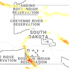


Connect with Interactive Hail Maps