

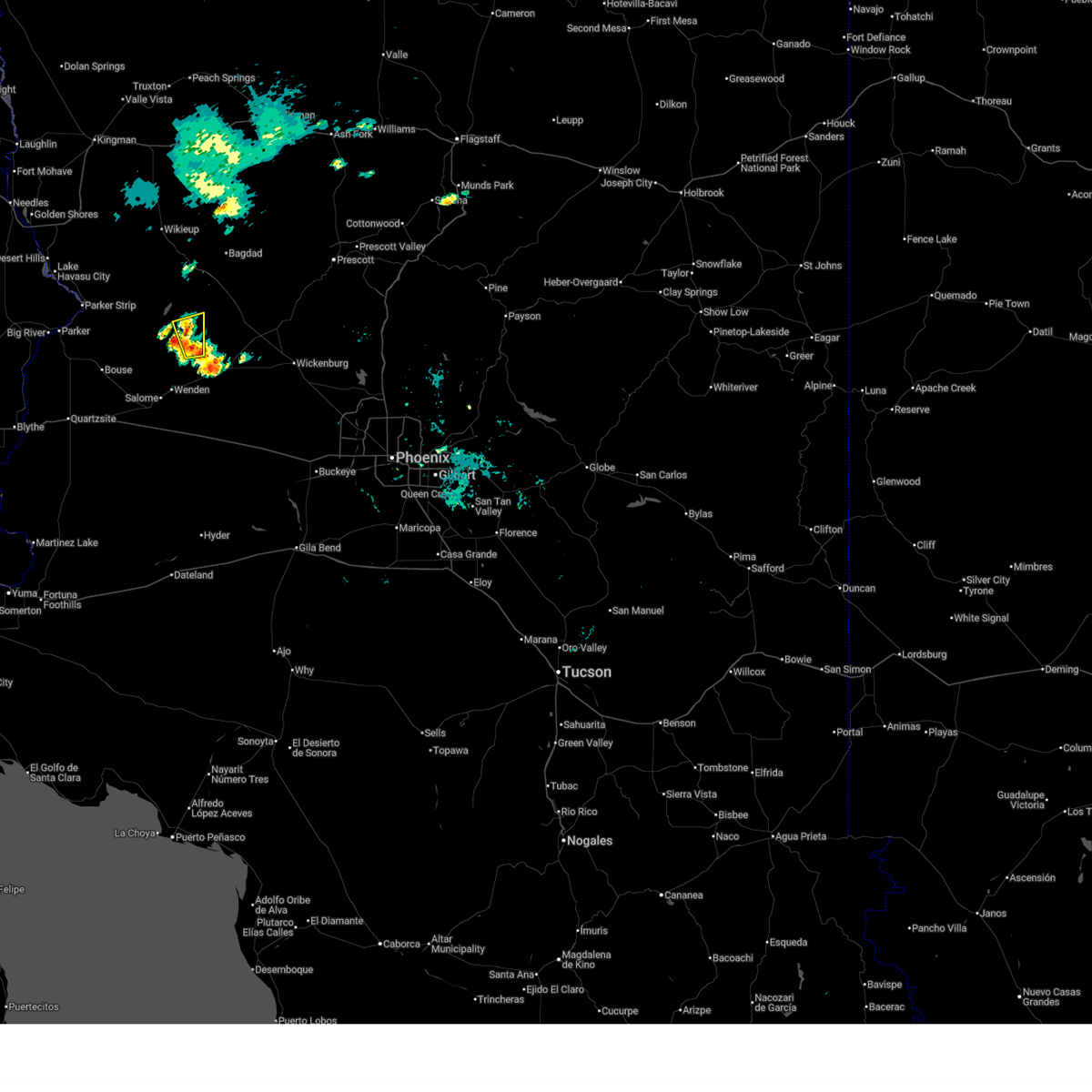
Hail Map for Alamo Lake, AZ
The Alamo Lake, AZ area has had 0 reports of on-the-ground hail by trained spotters, and has been under severe weather warnings 3 times during the past 12 months. Doppler radar has detected hail at or near Alamo Lake, AZ on 21 occasions.
| Name: | Alamo Lake, AZ |
| Where Located: | 49.9 miles ESE of Lake Havasu City, AZ |
| Map: | Google Map for Alamo Lake, AZ |
| Population: | 25 |
| Housing Units: | 31 |
| More Info: | Search Google for Alamo Lake, AZ |
5
The Top Recent Hail Date for Alamo Lake, AZ is Tuesday, August 9, 2016 (1st out of 21)

Hail and Wind Damage Spotted near Alamo Lake, AZ
| Date / Time | Report Details |
|---|---|
| 9/6/2025 7:11 AM MST |
 The storm which prompted the warning has weakened below severe limits, and has exited the warned area. therefore, the warning will be allowed to expire. however, gusty winds and heavy rain are still possible with this thunderstorm. remember, a severe thunderstorm warning still remains in effect for the southwestern corner of yavapai county. The storm which prompted the warning has weakened below severe limits, and has exited the warned area. therefore, the warning will be allowed to expire. however, gusty winds and heavy rain are still possible with this thunderstorm. remember, a severe thunderstorm warning still remains in effect for the southwestern corner of yavapai county.
|
| 9/6/2025 7:03 AM MST |
 At 703 am mst, a severe thunderstorm was located near bullard peak, or 21 miles southeast of alamo lake, moving east at 25 mph (radar indicated). Hazards include 60 mph wind gusts and penny size hail. Expect damage to roofs, siding, and trees. This severe thunderstorm will remain over mainly rural areas of northeastern la paz county. At 703 am mst, a severe thunderstorm was located near bullard peak, or 21 miles southeast of alamo lake, moving east at 25 mph (radar indicated). Hazards include 60 mph wind gusts and penny size hail. Expect damage to roofs, siding, and trees. This severe thunderstorm will remain over mainly rural areas of northeastern la paz county.
|
| 9/6/2025 6:44 AM MST |
 Svrpsr the national weather service in phoenix has issued a * severe thunderstorm warning for, northeastern la paz county in west central arizona, * until 715 am mst. * at 644 am mst, a severe thunderstorm was located near bullard peak, or 16 miles southeast of alamo lake, moving east at 25 mph (radar indicated). Hazards include 60 mph wind gusts and quarter size hail. Hail damage to vehicles is expected. expect wind damage to roofs, siding, and trees. This severe thunderstorm will remain over mainly rural areas of northeastern la paz county. Svrpsr the national weather service in phoenix has issued a * severe thunderstorm warning for, northeastern la paz county in west central arizona, * until 715 am mst. * at 644 am mst, a severe thunderstorm was located near bullard peak, or 16 miles southeast of alamo lake, moving east at 25 mph (radar indicated). Hazards include 60 mph wind gusts and quarter size hail. Hail damage to vehicles is expected. expect wind damage to roofs, siding, and trees. This severe thunderstorm will remain over mainly rural areas of northeastern la paz county.
|
| 9/2/2022 5:58 PM MST |
 At 558 pm mst, a severe thunderstorm was located 10 miles east of alamo state park, or 11 miles east of alamo lake, moving southwest at 25 mph (radar indicated). Hazards include 60 mph wind gusts and penny size hail. Expect damage to roofs, siding, and trees. locations impacted include, alamo state park. hail threat, radar indicated max hail size, 0. 75 in wind threat, radar indicated max wind gust, 60 mph. At 558 pm mst, a severe thunderstorm was located 10 miles east of alamo state park, or 11 miles east of alamo lake, moving southwest at 25 mph (radar indicated). Hazards include 60 mph wind gusts and penny size hail. Expect damage to roofs, siding, and trees. locations impacted include, alamo state park. hail threat, radar indicated max hail size, 0. 75 in wind threat, radar indicated max wind gust, 60 mph.
|
| 9/2/2022 5:46 PM MST |
 At 546 pm mst, a severe thunderstorm was located 14 miles east of alamo state park, or 15 miles east of alamo lake, moving southwest at 25 mph (radar indicated). Hazards include 60 mph wind gusts and nickel size hail. expect damage to roofs, siding, and trees At 546 pm mst, a severe thunderstorm was located 14 miles east of alamo state park, or 15 miles east of alamo lake, moving southwest at 25 mph (radar indicated). Hazards include 60 mph wind gusts and nickel size hail. expect damage to roofs, siding, and trees
|
| 8/23/2022 5:47 PM MST | At 547 pm mst, a severe thunderstorm was located 15 miles east of alamo state park, or 16 miles east of alamo lake, moving southwest at 15 mph (radar indicated). Hazards include 60 mph wind gusts and quarter size hail. Hail damage to vehicles is expected. expect wind damage to roofs, siding, and trees. this severe thunderstorm will remain over mainly rural areas of northeastern la paz county. hail threat, radar indicated max hail size, 1. 00 in wind threat, radar indicated max wind gust, 60 mph. |
| 8/21/2022 10:03 PM MST | At 1003 pm pdt/1003 pm mst/, a severe thunderstorm was located near yucca, moving south at 30 mph. this storm will approach lake havasu city through 11pm (radar indicated). Hazards include 60 mph wind gusts and quarter size hail. Hail damage to vehicles is expected. Expect wind damage to roofs and trees. |
| 8/21/2022 10:03 PM MST | At 1003 pm pdt/1003 pm mst/, a severe thunderstorm was located near yucca, moving south at 30 mph. this storm will approach lake havasu city through 11pm (radar indicated). Hazards include 60 mph wind gusts and quarter size hail. Hail damage to vehicles is expected. Expect wind damage to roofs and trees. |
| 8/21/2022 7:36 PM MST | At 734 pm mst, a severe thunderstorm was located 11 miles southeast of alamo state park, or 12 miles southeast of alamo lake, moving south at 5 mph (radar indicated). Hazards include 60 mph wind gusts and half dollar size hail. Hail damage to vehicles is expected. expect wind damage to roofs, siding, and trees. this severe thunderstorm will remain over mainly rural areas of northeastern la paz county. hail threat, radar indicated max hail size, 1. 25 in wind threat, radar indicated max wind gust, 60 mph. |
| 8/21/2022 7:25 PM MST | At 725 pm mst, a severe thunderstorm was located 10 miles southeast of alamo state park, or 11 miles southeast of alamo lake, moving south at 5 mph (radar indicated). Hazards include 60 mph wind gusts and quarter size hail. Hail damage to vehicles is expected. expect wind damage to roofs, siding, and trees. this severe thunderstorm will remain over mainly rural areas of northeastern la paz county. hail threat, radar indicated max hail size, 1. 00 in wind threat, radar indicated max wind gust, 60 mph. |
| 8/11/2022 5:59 PM MST |
 At 558 pm mst, a severe thunderstorm was located 10 miles east of alamo state park, or 10 miles east of alamo lake, and is nearly stationary (radar indicated). Hazards include 60 mph wind gusts. Expect damage to roofs, siding, and trees. this severe thunderstorm will remain over mainly rural areas of northeastern la paz county. hail threat, radar indicated max hail size, <. 75 in wind threat, radar indicated max wind gust, 60 mph. At 558 pm mst, a severe thunderstorm was located 10 miles east of alamo state park, or 10 miles east of alamo lake, and is nearly stationary (radar indicated). Hazards include 60 mph wind gusts. Expect damage to roofs, siding, and trees. this severe thunderstorm will remain over mainly rural areas of northeastern la paz county. hail threat, radar indicated max hail size, <. 75 in wind threat, radar indicated max wind gust, 60 mph.
|
| 8/11/2022 5:48 PM MST |
 At 548 pm mst, a severe thunderstorm was located 10 miles east of alamo state park, or 10 miles east of alamo lake, and is nearly stationary (radar indicated). Hazards include 60 mph wind gusts. Expect damage to roofs, siding, and trees. this severe thunderstorm will remain over mainly rural areas of northeastern la paz county. hail threat, radar indicated max hail size, <. 75 in wind threat, radar indicated max wind gust, 60 mph. At 548 pm mst, a severe thunderstorm was located 10 miles east of alamo state park, or 10 miles east of alamo lake, and is nearly stationary (radar indicated). Hazards include 60 mph wind gusts. Expect damage to roofs, siding, and trees. this severe thunderstorm will remain over mainly rural areas of northeastern la paz county. hail threat, radar indicated max hail size, <. 75 in wind threat, radar indicated max wind gust, 60 mph.
|
| 8/10/2022 1:27 PM MST |
 The severe thunderstorm warning for northeastern la paz county will expire at 130 pm mst, the storm which prompted the warning has weakened below severe limits, and no longer poses an immediate threat to life or property. therefore, the warning will be allowed to expire. however heavy rain is still possible with this thunderstorm. The severe thunderstorm warning for northeastern la paz county will expire at 130 pm mst, the storm which prompted the warning has weakened below severe limits, and no longer poses an immediate threat to life or property. therefore, the warning will be allowed to expire. however heavy rain is still possible with this thunderstorm.
|
| 8/10/2022 12:59 PM MST |
 At 1259 pm mst, a severe thunderstorm was located 8 miles south of alamo lake, and is nearly stationary (radar indicated). Hazards include 60 mph wind gusts. Expect damage to roofs, siding, and trees. this severe thunderstorm will remain over mainly rural areas of northeastern la paz county. hail threat, radar indicated max hail size, <. 75 in wind threat, radar indicated max wind gust, 60 mph. At 1259 pm mst, a severe thunderstorm was located 8 miles south of alamo lake, and is nearly stationary (radar indicated). Hazards include 60 mph wind gusts. Expect damage to roofs, siding, and trees. this severe thunderstorm will remain over mainly rural areas of northeastern la paz county. hail threat, radar indicated max hail size, <. 75 in wind threat, radar indicated max wind gust, 60 mph.
|
| 8/10/2022 12:42 PM MST |
 At 1242 pm mst, a severe thunderstorm was located 8 miles south of alamo lake, and is nearly stationary (radar indicated). Hazards include 60 mph wind gusts and penny size hail. Expect damage to roofs, siding, and trees. this severe thunderstorm will remain over mainly rural areas of northeastern la paz county. hail threat, radar indicated max hail size, 0. 75 in wind threat, radar indicated max wind gust, 60 mph. At 1242 pm mst, a severe thunderstorm was located 8 miles south of alamo lake, and is nearly stationary (radar indicated). Hazards include 60 mph wind gusts and penny size hail. Expect damage to roofs, siding, and trees. this severe thunderstorm will remain over mainly rural areas of northeastern la paz county. hail threat, radar indicated max hail size, 0. 75 in wind threat, radar indicated max wind gust, 60 mph.
|
| 7/16/2022 11:48 PM MST |
 At 1147 pm pdt/1147 pm mst/, a severe thunderstorm was located near lake havasu city, moving northwest at 45 mph (radar indicated). Hazards include 60 mph wind gusts. Expect damage to roofs and trees. locations impacted include, lake havasu city, parker dam, three dunes campground, cattail cove state park and black meadow landing campground. hail threat, radar indicated max hail size, <. 75 in wind threat, radar indicated max wind gust, 60 mph. At 1147 pm pdt/1147 pm mst/, a severe thunderstorm was located near lake havasu city, moving northwest at 45 mph (radar indicated). Hazards include 60 mph wind gusts. Expect damage to roofs and trees. locations impacted include, lake havasu city, parker dam, three dunes campground, cattail cove state park and black meadow landing campground. hail threat, radar indicated max hail size, <. 75 in wind threat, radar indicated max wind gust, 60 mph.
|
| 7/16/2022 11:16 PM MST |
 At 1113 pm pdt/1113 pm mst/, a severe thunderstorm was located 9 miles east of buckskin mountain park, or 9 miles east of parker dam, moving northwest at 45 mph (radar indicated). Hazards include 60 mph wind gusts. expect damage to roofs and trees At 1113 pm pdt/1113 pm mst/, a severe thunderstorm was located 9 miles east of buckskin mountain park, or 9 miles east of parker dam, moving northwest at 45 mph (radar indicated). Hazards include 60 mph wind gusts. expect damage to roofs and trees
|
| 8/16/2021 12:49 AM MST |
 At 1248 am mst, a severe thunderstorm was located near aguila, or 19 miles west of wickenburg, moving southwest at 40 mph (radar indicated). Hazards include 60 mph wind gusts and penny size hail. expect damage to roofs, siding, and trees At 1248 am mst, a severe thunderstorm was located near aguila, or 19 miles west of wickenburg, moving southwest at 40 mph (radar indicated). Hazards include 60 mph wind gusts and penny size hail. expect damage to roofs, siding, and trees
|
| 8/13/2021 11:34 PM MST |
 At 1133 pm mst, severe thunderstorms were located along a line extending from 6 miles east of bouse to near vicksburg junction to 13 miles south of vicksburg to 18 miles northwest of sundad, moving southwest at 50 mph (radar indicated). Hazards include 60 mph wind gusts. Expect damage to roofs, siding, and trees. locations impacted include, quartzsite, salome, aguila, brenda, vicksburg junction, wenden, kofa wildlife refuge, vicksburg, bouse, gladden, harcuvar and palm canyon. this includes the following highways, az interstate 10 between mile markers 6 and 88. us highway 60 between mile markers 31 and 85. az route 72 between mile markers 25 and 49. hail threat, radar indicated max hail size, <. 75 in wind threat, radar indicated max wind gust, 60 mph. At 1133 pm mst, severe thunderstorms were located along a line extending from 6 miles east of bouse to near vicksburg junction to 13 miles south of vicksburg to 18 miles northwest of sundad, moving southwest at 50 mph (radar indicated). Hazards include 60 mph wind gusts. Expect damage to roofs, siding, and trees. locations impacted include, quartzsite, salome, aguila, brenda, vicksburg junction, wenden, kofa wildlife refuge, vicksburg, bouse, gladden, harcuvar and palm canyon. this includes the following highways, az interstate 10 between mile markers 6 and 88. us highway 60 between mile markers 31 and 85. az route 72 between mile markers 25 and 49. hail threat, radar indicated max hail size, <. 75 in wind threat, radar indicated max wind gust, 60 mph.
|
| 8/13/2021 11:01 PM MST |
 At 1100 pm mst, severe thunderstorms were located along a line extending from 14 miles south of alamo lake state park to near wenden to 13 miles south of gladden to 11 miles northwest of tonopah, moving southwest at 60 mph (radar indicated). Hazards include 70 mph wind gusts and penny size hail. Expect considerable tree damage. Damage is likely to mobile homes, roofs, and outbuildings. At 1100 pm mst, severe thunderstorms were located along a line extending from 14 miles south of alamo lake state park to near wenden to 13 miles south of gladden to 11 miles northwest of tonopah, moving southwest at 60 mph (radar indicated). Hazards include 70 mph wind gusts and penny size hail. Expect considerable tree damage. Damage is likely to mobile homes, roofs, and outbuildings.
|
| 8/13/2021 10:24 PM MST |
 At 1023 pm mst, severe thunderstorms were located along a line extending from 18 miles east of alamo lake state park to near aguila to 9 miles east of gladden to 18 miles north of tonopah, moving southwest at 45 mph (radar indicated). Hazards include 60 mph wind gusts and penny size hail. expect damage to roofs, siding, and trees At 1023 pm mst, severe thunderstorms were located along a line extending from 18 miles east of alamo lake state park to near aguila to 9 miles east of gladden to 18 miles north of tonopah, moving southwest at 45 mph (radar indicated). Hazards include 60 mph wind gusts and penny size hail. expect damage to roofs, siding, and trees
|
| 8/10/2021 6:31 PM MST |
 At 628 pm pdt/628 pm mst/, severe thunderstorms were located along a line extending from 8 miles south of needles to 4 miles west of lake havasu city to near parker, moving southwest at 25 mph (wind speeds of 59 mph have been observed in lake havasu city). Hazards include 60 mph wind gusts and near zero visibility due to blowing dust. Expect damage to roofs and trees. locations impacted include, lake havasu city, highway 95 at mile marker 29, topock, parker dam, alamo lake, needles, three dunes campground, alamo state park, desert hills, black meadow landing campground, mohave valley, cattail cove state park, arizona village, earp, vidal junction, big river, mesquite creek, mojave ranch estates and willow valley. this includes the following highways, interstate 40 in arizona between mile markers 0 and 17. interstate 40 in california between mile markers 140 and 155. hail threat, radar indicated max hail size, <. 75 in wind threat, observed max wind gust, 60 mph. At 628 pm pdt/628 pm mst/, severe thunderstorms were located along a line extending from 8 miles south of needles to 4 miles west of lake havasu city to near parker, moving southwest at 25 mph (wind speeds of 59 mph have been observed in lake havasu city). Hazards include 60 mph wind gusts and near zero visibility due to blowing dust. Expect damage to roofs and trees. locations impacted include, lake havasu city, highway 95 at mile marker 29, topock, parker dam, alamo lake, needles, three dunes campground, alamo state park, desert hills, black meadow landing campground, mohave valley, cattail cove state park, arizona village, earp, vidal junction, big river, mesquite creek, mojave ranch estates and willow valley. this includes the following highways, interstate 40 in arizona between mile markers 0 and 17. interstate 40 in california between mile markers 140 and 155. hail threat, radar indicated max hail size, <. 75 in wind threat, observed max wind gust, 60 mph.
|
| 8/10/2021 5:59 PM MST |
 At 557 pm pdt/557 pm mst/, severe thunderstorms were located along a line extending from near arizona village to desert hills to 2 miles east of lake havasu city to near parker dam, moving southwest at 25 mph (radar indicated). Hazards include 60 mph wind gusts. Expect damage to roofs and trees. locations impacted include, lake havasu city, highway 95 at mile marker 29, topock, parker dam, alamo lake, needles, three dunes campground, alamo state park, desert hills, black meadow landing campground, mohave valley, cattail cove state park, arizona village, earp, vidal junction, big river, mesquite creek, mojave ranch estates and willow valley. this includes the following highways, interstate 40 in arizona between mile markers 0 and 17. interstate 40 in california between mile markers 140 and 155. hail threat, radar indicated max hail size, <. 75 in wind threat, radar indicated max wind gust, 60 mph. At 557 pm pdt/557 pm mst/, severe thunderstorms were located along a line extending from near arizona village to desert hills to 2 miles east of lake havasu city to near parker dam, moving southwest at 25 mph (radar indicated). Hazards include 60 mph wind gusts. Expect damage to roofs and trees. locations impacted include, lake havasu city, highway 95 at mile marker 29, topock, parker dam, alamo lake, needles, three dunes campground, alamo state park, desert hills, black meadow landing campground, mohave valley, cattail cove state park, arizona village, earp, vidal junction, big river, mesquite creek, mojave ranch estates and willow valley. this includes the following highways, interstate 40 in arizona between mile markers 0 and 17. interstate 40 in california between mile markers 140 and 155. hail threat, radar indicated max hail size, <. 75 in wind threat, radar indicated max wind gust, 60 mph.
|
| 8/10/2021 5:35 PM MST |
 At 534 pm pdt/534 pm mst/, severe thunderstorms were located along a line extending from near arizona village to 6 miles northeast of lake havasu city to 14 miles east of parker dam to 13 miles south of alamo state park, moving southwest at 30 mph (radar indicated). Hazards include 60 mph wind gusts. Expect damage to roofs and trees. locations impacted include, lake havasu city, highway 95 at mile marker 29, topock, parker dam, alamo lake, needles, three dunes campground, alamo state park, desert hills, black meadow landing campground, mohave valley, cattail cove state park, arizona village, earp, vidal junction, big river, mesquite creek, mojave ranch estates and willow valley. this includes the following highways, interstate 40 in arizona between mile markers 0 and 17. interstate 40 in california between mile markers 140 and 155. hail threat, radar indicated max hail size, <. 75 in wind threat, radar indicated max wind gust, 60 mph. At 534 pm pdt/534 pm mst/, severe thunderstorms were located along a line extending from near arizona village to 6 miles northeast of lake havasu city to 14 miles east of parker dam to 13 miles south of alamo state park, moving southwest at 30 mph (radar indicated). Hazards include 60 mph wind gusts. Expect damage to roofs and trees. locations impacted include, lake havasu city, highway 95 at mile marker 29, topock, parker dam, alamo lake, needles, three dunes campground, alamo state park, desert hills, black meadow landing campground, mohave valley, cattail cove state park, arizona village, earp, vidal junction, big river, mesquite creek, mojave ranch estates and willow valley. this includes the following highways, interstate 40 in arizona between mile markers 0 and 17. interstate 40 in california between mile markers 140 and 155. hail threat, radar indicated max hail size, <. 75 in wind threat, radar indicated max wind gust, 60 mph.
|
| 8/10/2021 5:13 PM MST |
 At 509 pm pdt/509 pm mst/, severe thunderstorms were located along a line extending from near oatman to 11 miles south of yucca to the south to the la paz county line, moving southwest at 25 mph (radar indicated). Hazards include 60 mph wind gusts. expect damage to roofs and trees At 509 pm pdt/509 pm mst/, severe thunderstorms were located along a line extending from near oatman to 11 miles south of yucca to the south to the la paz county line, moving southwest at 25 mph (radar indicated). Hazards include 60 mph wind gusts. expect damage to roofs and trees
|
| 7/30/2016 12:36 AM MST |
 At 1232 am pdt/1232 am mst/, trained spotters reported thunderstorm wind gusts creating blowing dust reducing visibility to one-quarter mile across southern mohave and southeast san bernardino counties. wind gusts to 60 mph are possible with this storm. the gust front was moving northwest at 35 mph across southeast san bernardino county. locations impacted include, lake havasu city, wikieup, alamo lake, highway 95 at mile marker 29, parker dam, three dunes campground, earp, cattail cove state park, desert hills, burro creek campground, vidal junction, black meadow landing campground and big river. At 1232 am pdt/1232 am mst/, trained spotters reported thunderstorm wind gusts creating blowing dust reducing visibility to one-quarter mile across southern mohave and southeast san bernardino counties. wind gusts to 60 mph are possible with this storm. the gust front was moving northwest at 35 mph across southeast san bernardino county. locations impacted include, lake havasu city, wikieup, alamo lake, highway 95 at mile marker 29, parker dam, three dunes campground, earp, cattail cove state park, desert hills, burro creek campground, vidal junction, black meadow landing campground and big river.
|
| 7/29/2016 11:41 PM MST |
 The national weather service in las vegas has issued a * severe thunderstorm warning for. southwestern mohave county in northwestern arizona. southeastern san bernardino county in southern california. until 115 am pdt/115 am mst/ * at 1139 pm pdt/1139 pm mst/. Doppler radar indicated severe. The national weather service in las vegas has issued a * severe thunderstorm warning for. southwestern mohave county in northwestern arizona. southeastern san bernardino county in southern california. until 115 am pdt/115 am mst/ * at 1139 pm pdt/1139 pm mst/. Doppler radar indicated severe.
|
| 7/29/2016 11:41 PM MST |
 At 1139 pm pdt/1139 pm mst/, doppler radar indicated severe thunderstorm capable of producing damaging winds in excess of 60 mph as well as blowing dust with visibility briefly below one quarter mile. the storms are located just east of lake havasu city moving northwest at 35 mph. At 1139 pm pdt/1139 pm mst/, doppler radar indicated severe thunderstorm capable of producing damaging winds in excess of 60 mph as well as blowing dust with visibility briefly below one quarter mile. the storms are located just east of lake havasu city moving northwest at 35 mph.
|
Hail Maps for Alamo Lake, AZ


Connect with Interactive Hail Maps