

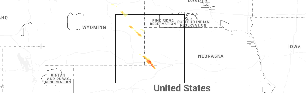
Hail Map for Albin, WY
The Albin, WY area has had 17 reports of on-the-ground hail by trained spotters, and has been under severe weather warnings 8 times during the past 12 months. Doppler radar has detected hail at or near Albin, WY on 92 occasions, including 7 occasions during the past year.
| Name: | Albin, WY |
| Where Located: | 38.2 miles SW of Scottsbluff, NE |
| Map: | Google Map for Albin, WY |
| Population: | 181 |
| Housing Units: | 71 |
| More Info: | Search Google for Albin, WY |
3
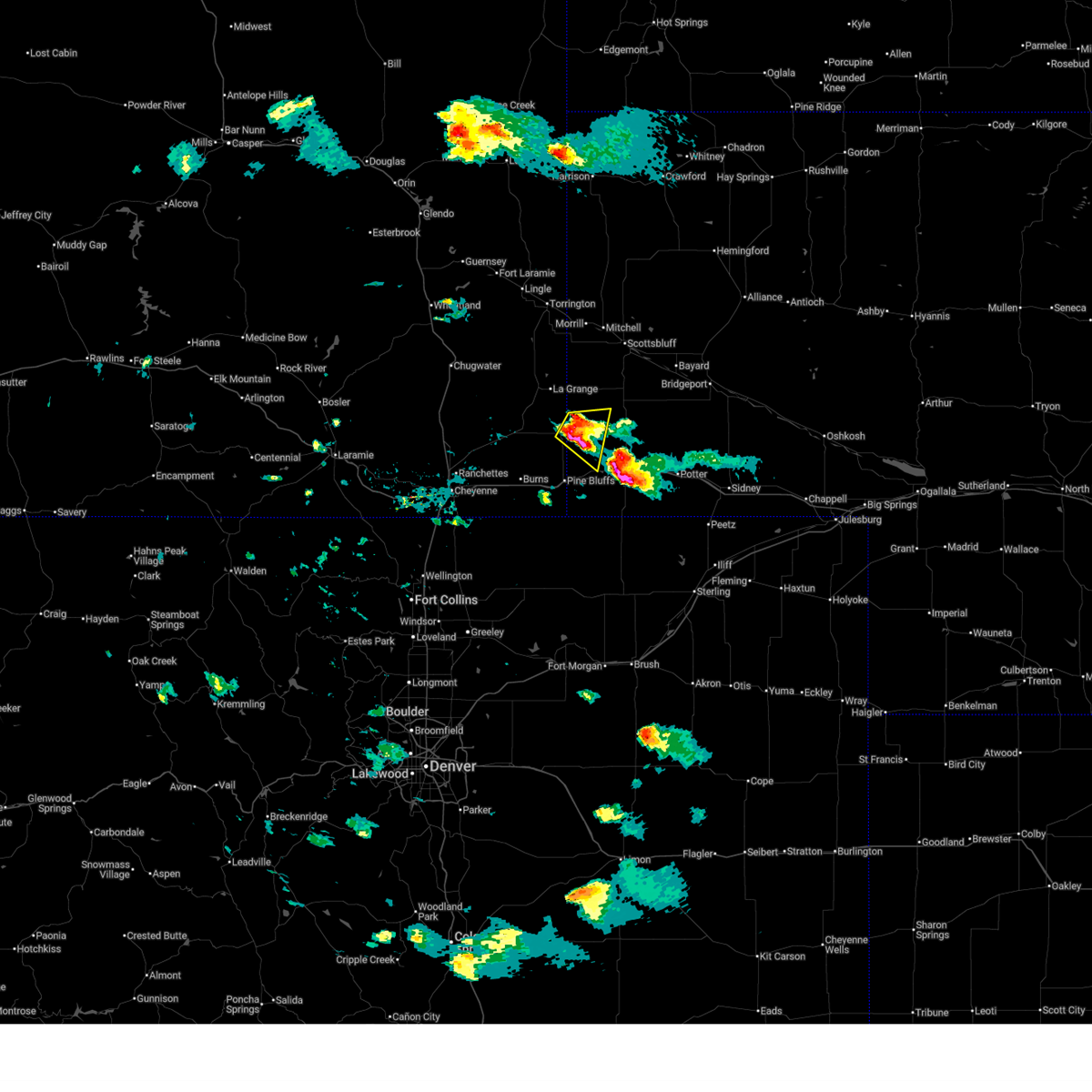
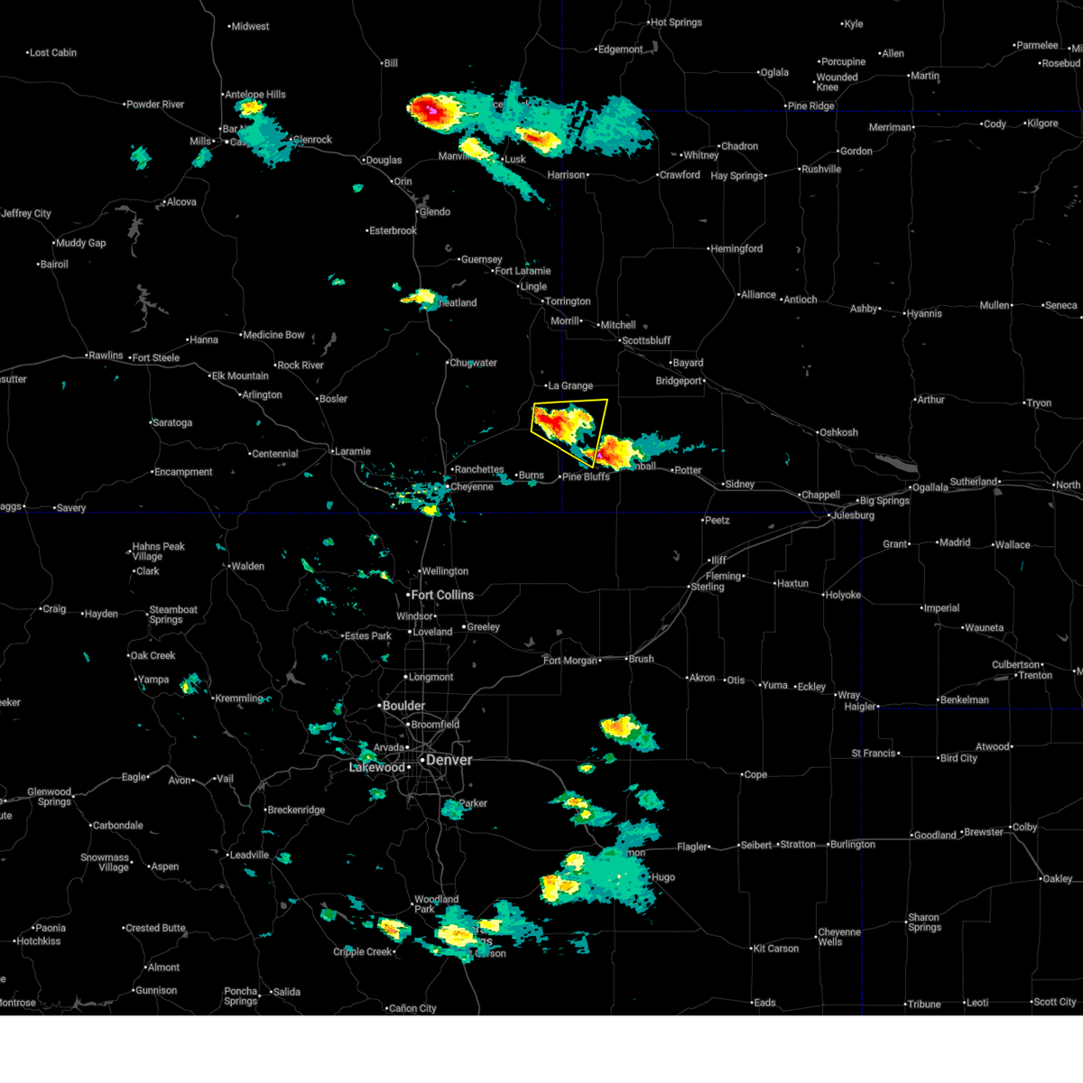
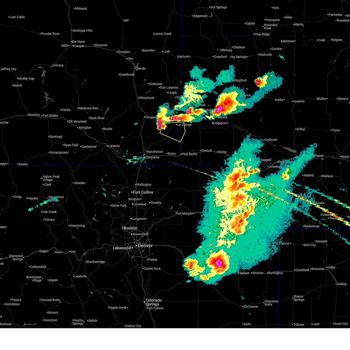
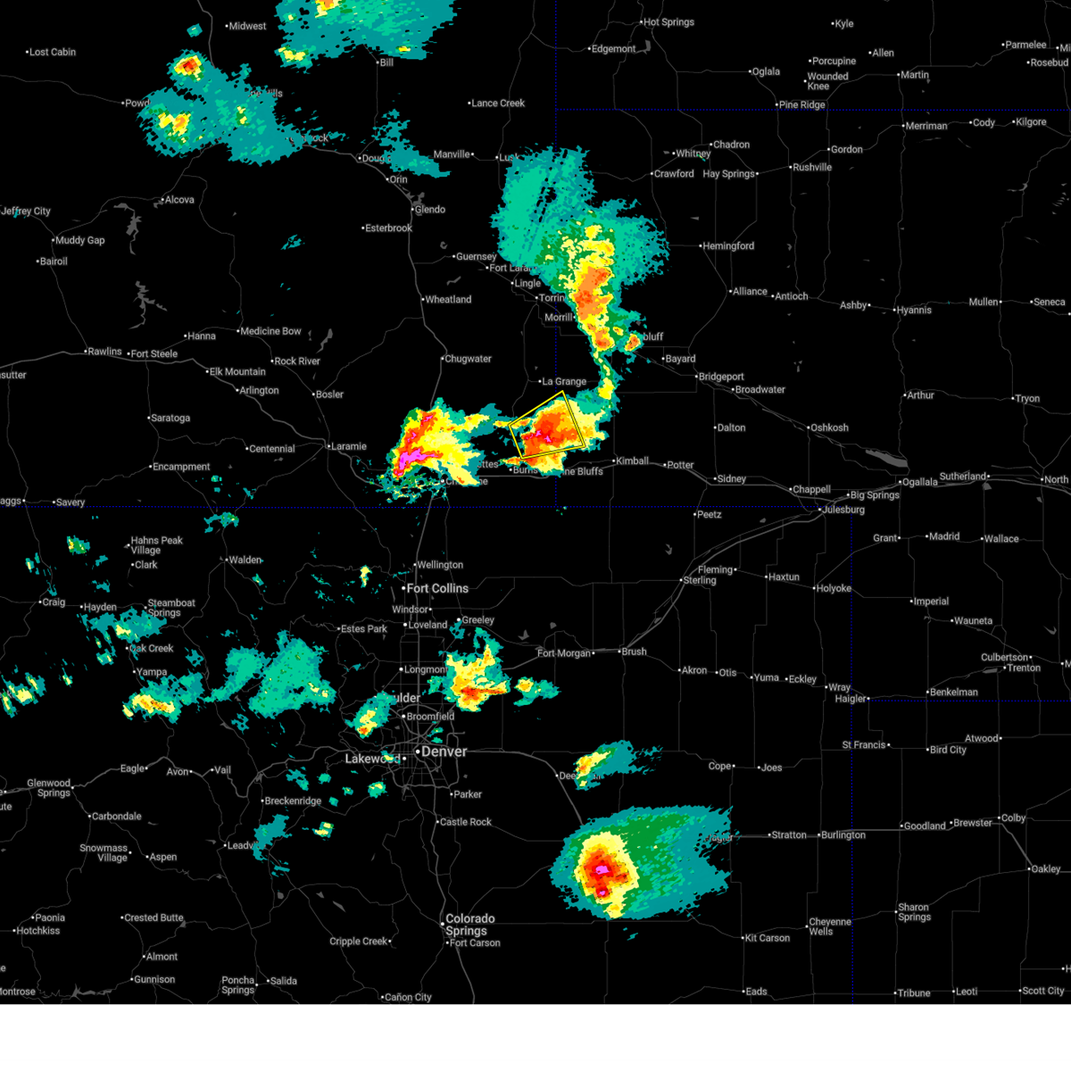
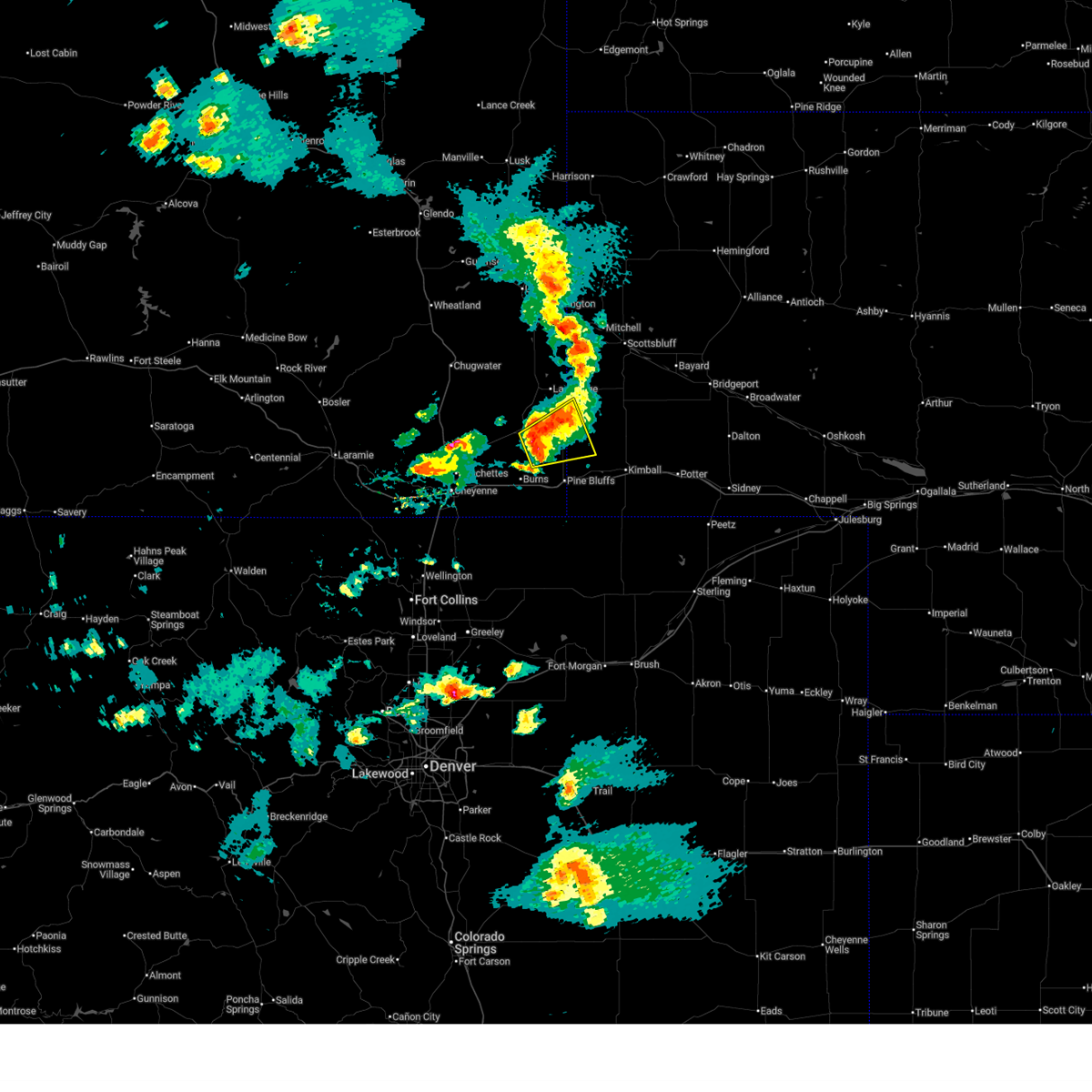
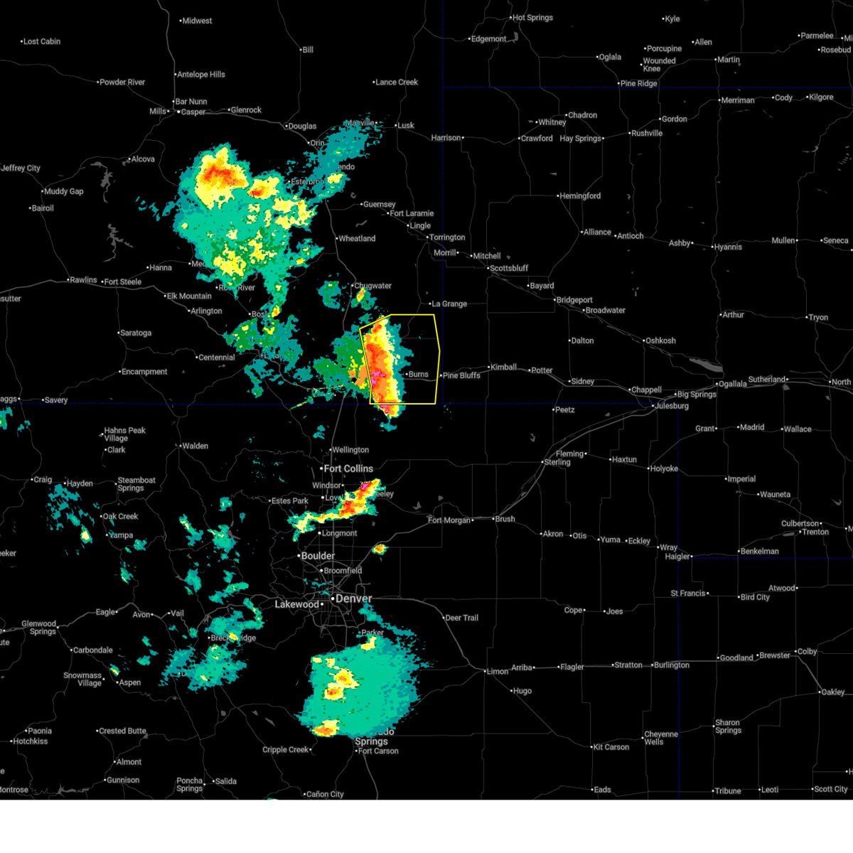
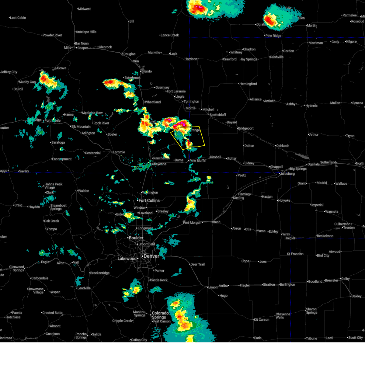
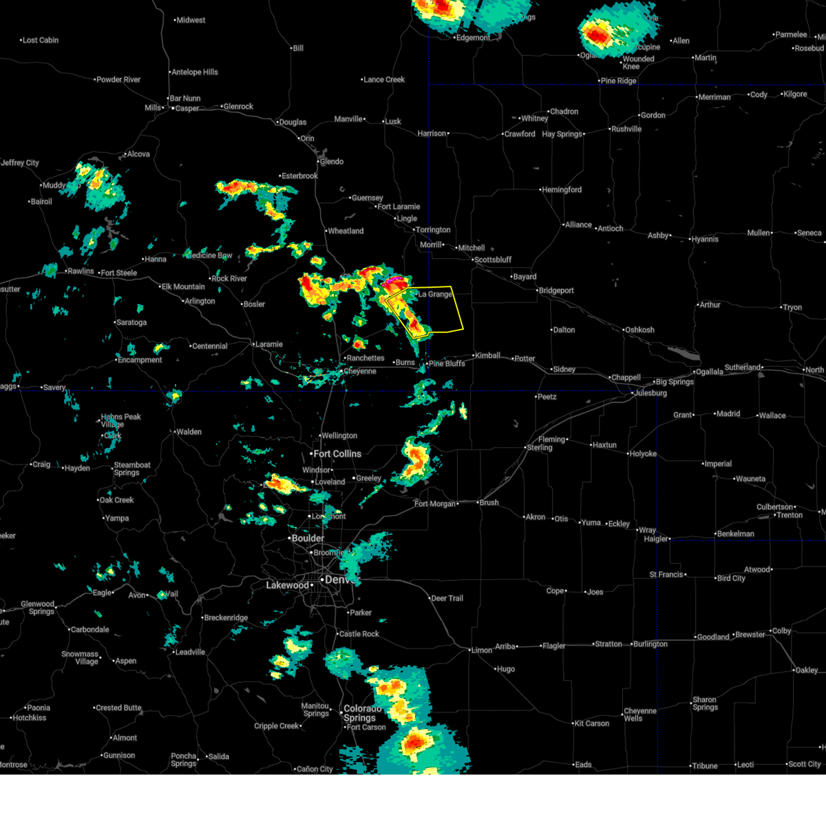
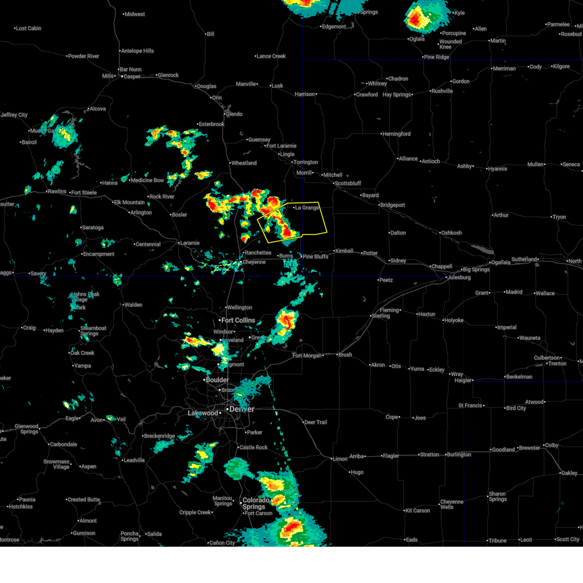
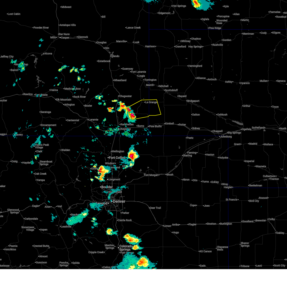
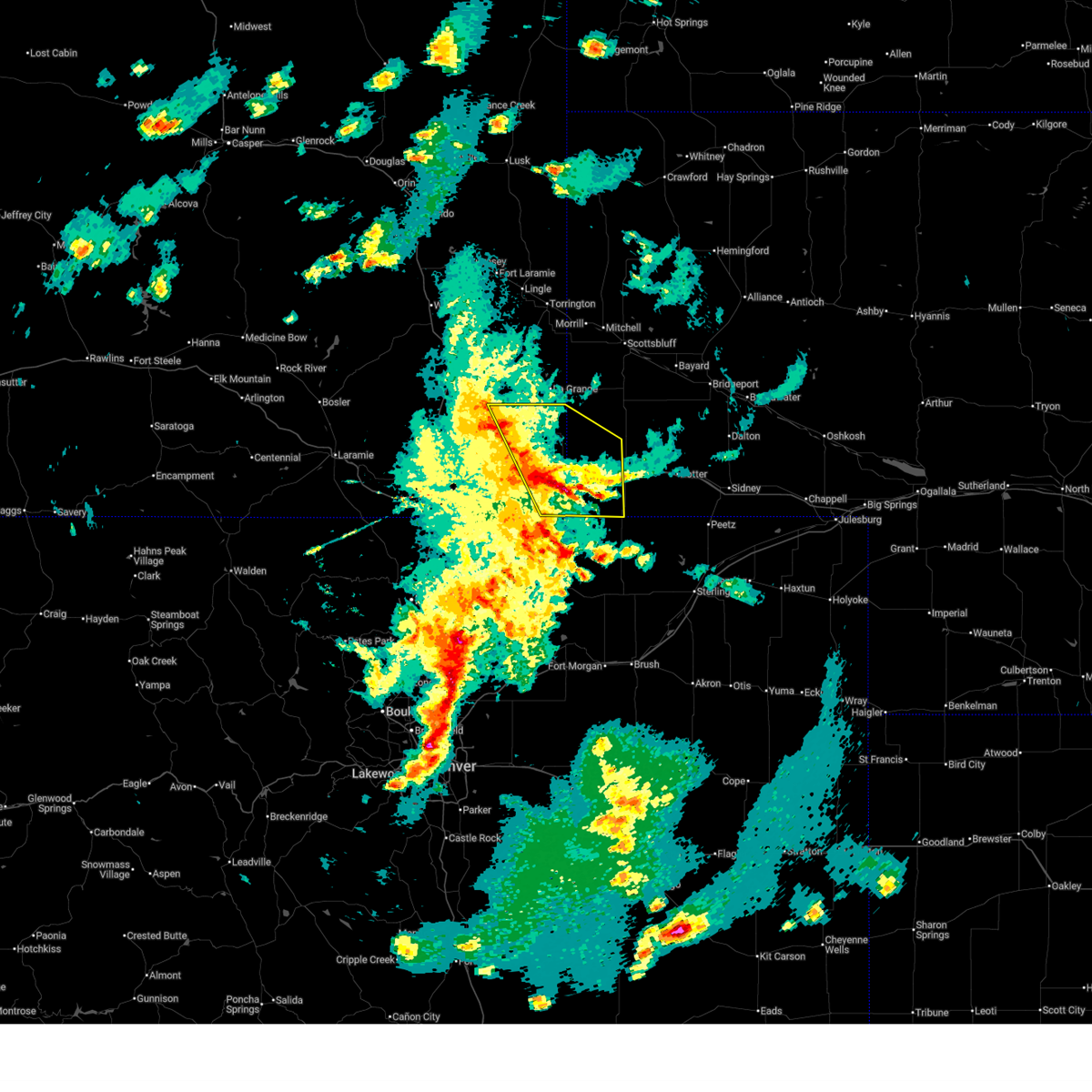
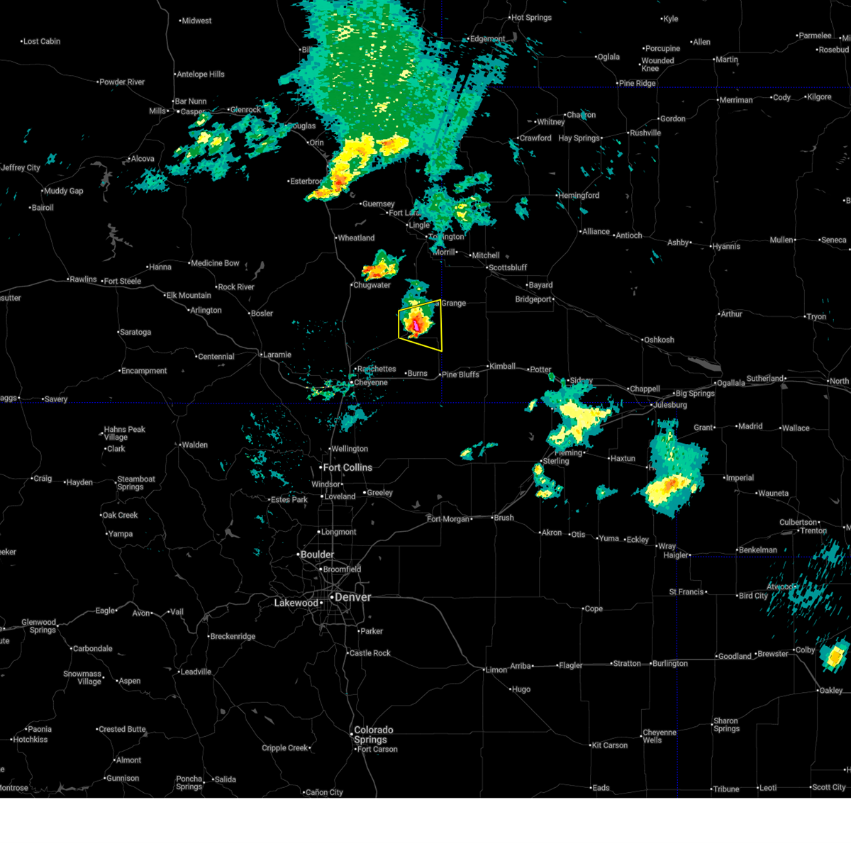
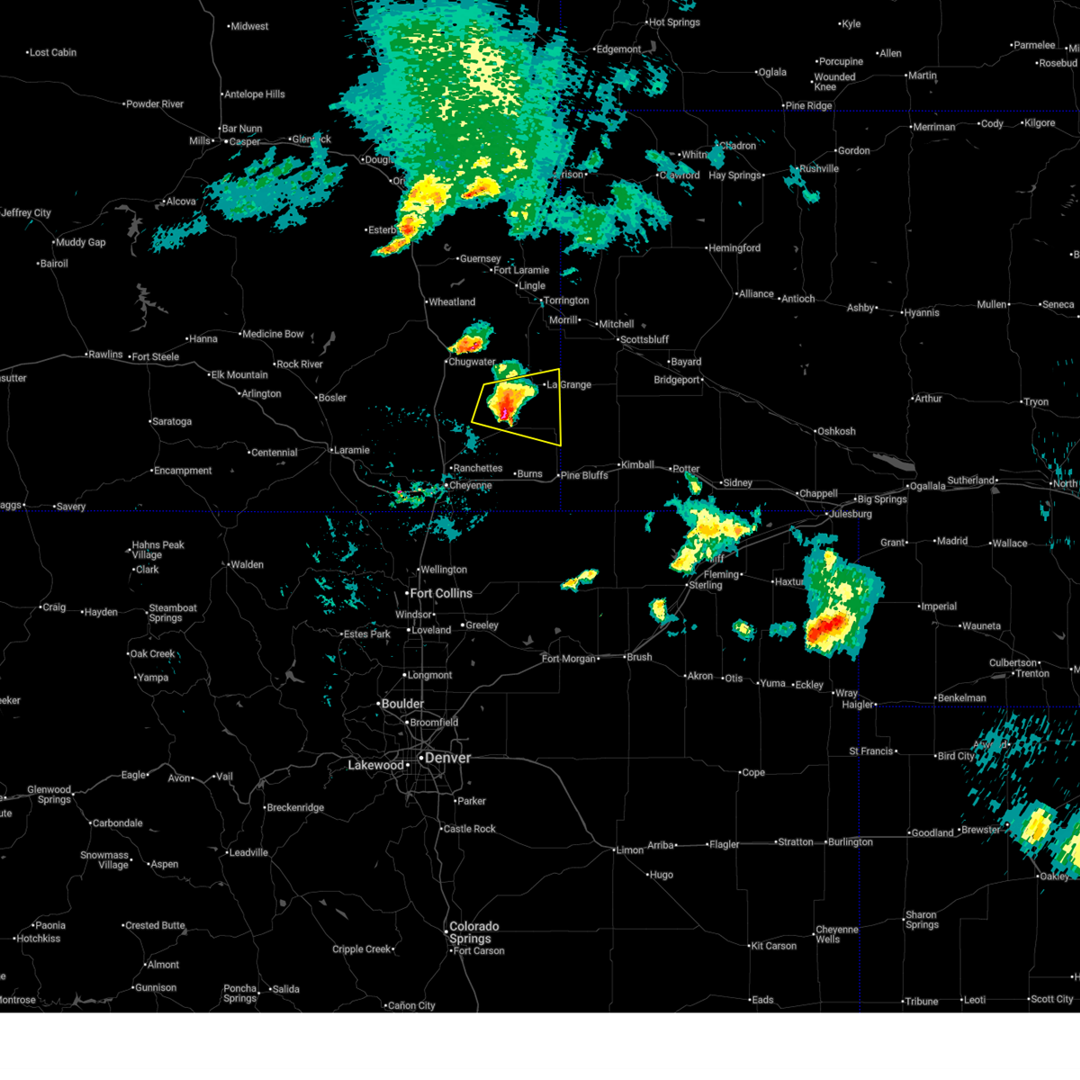
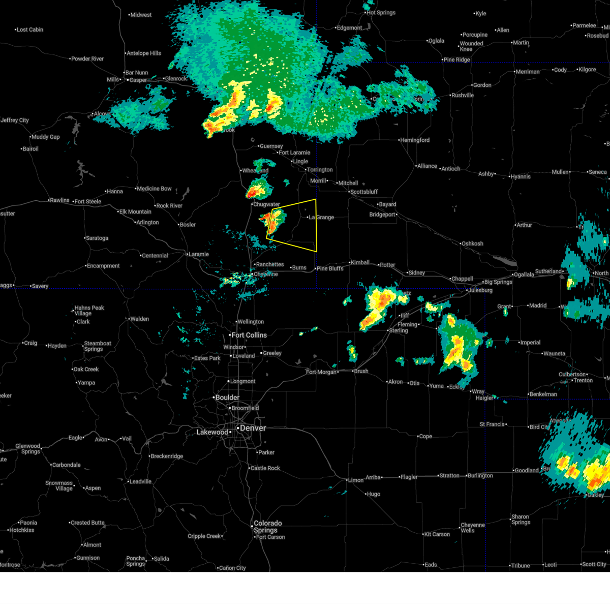
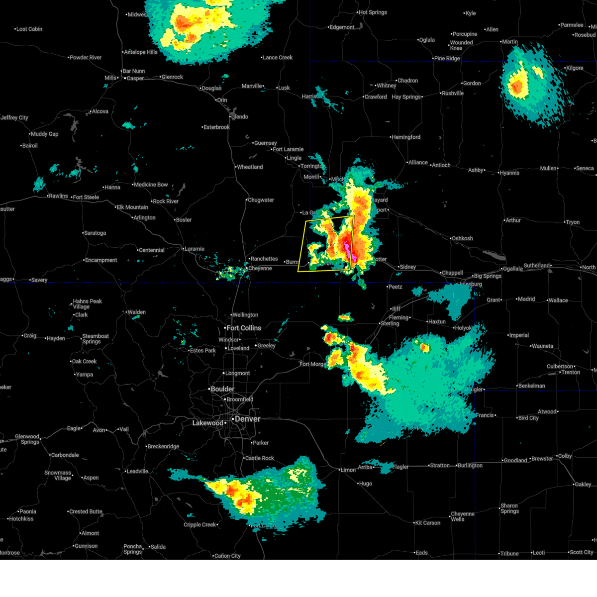
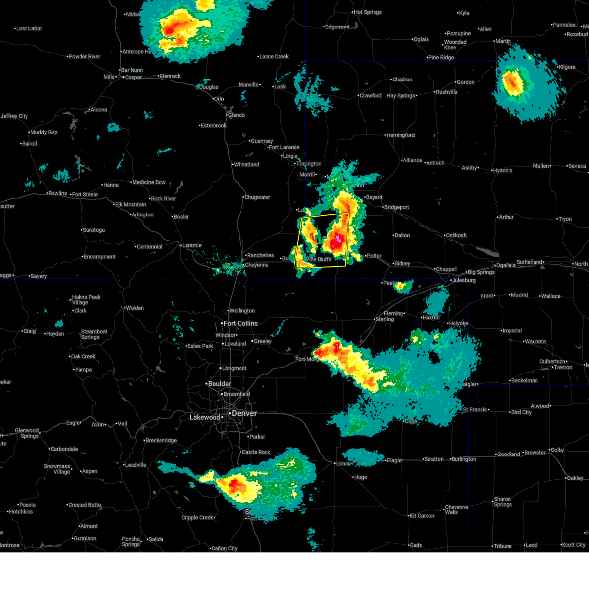
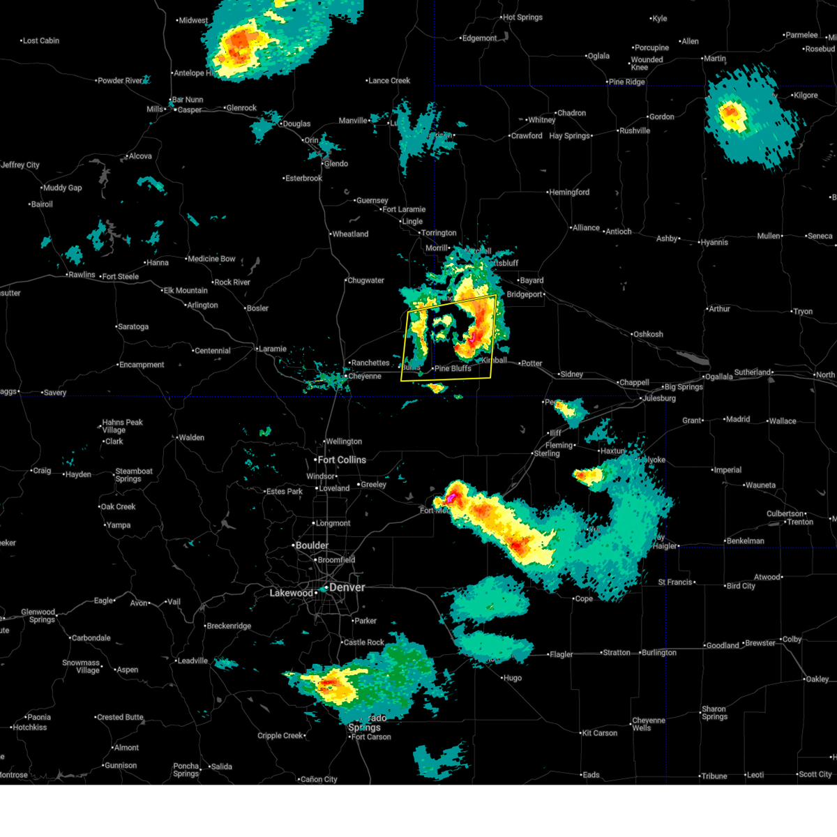
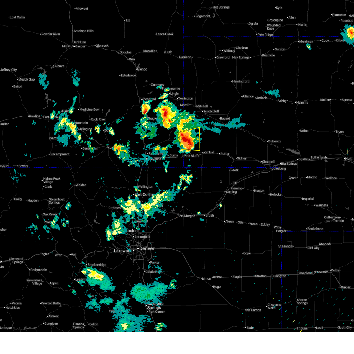
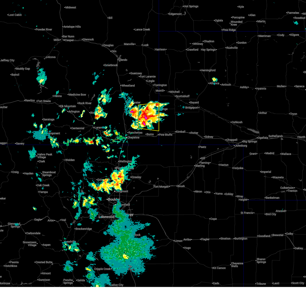
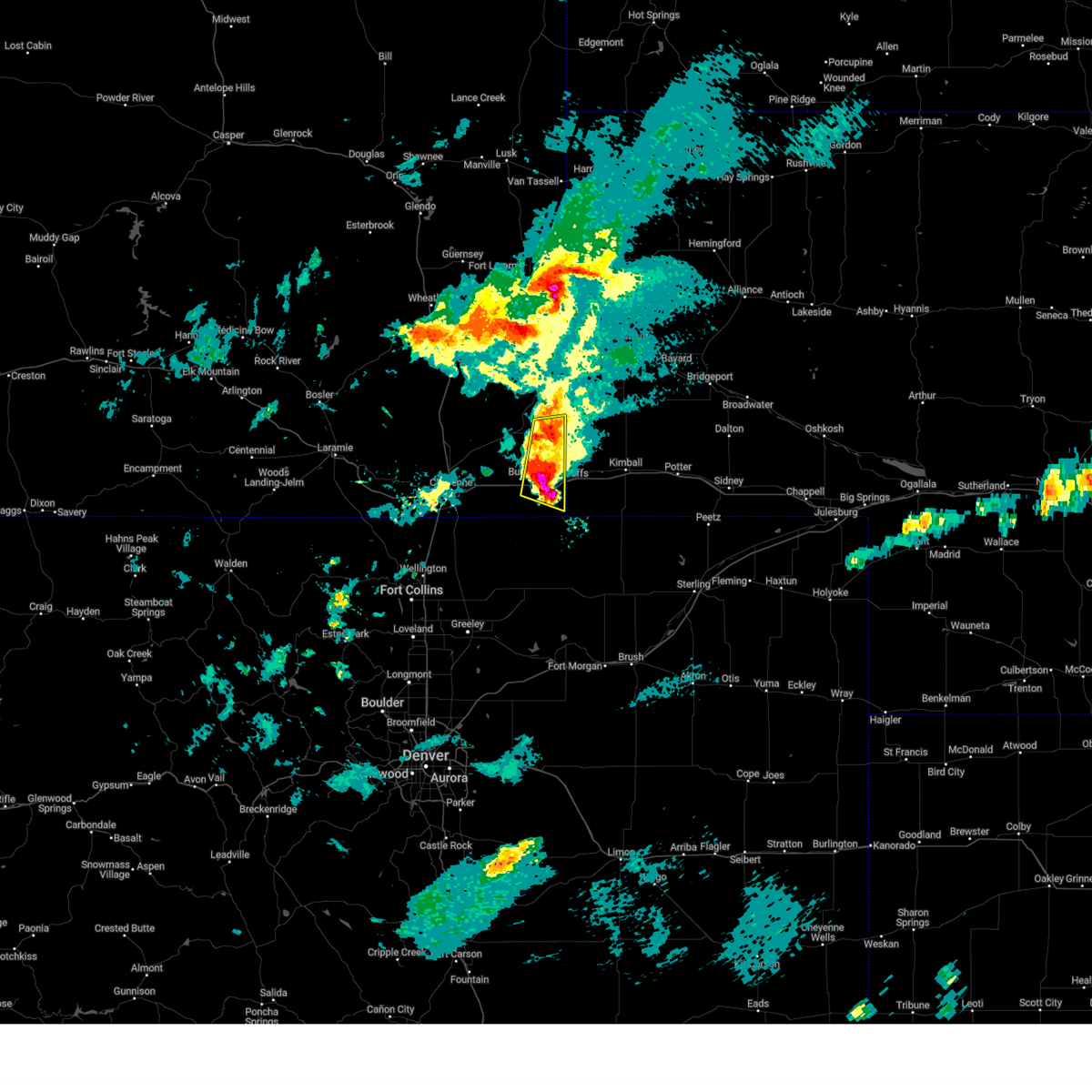
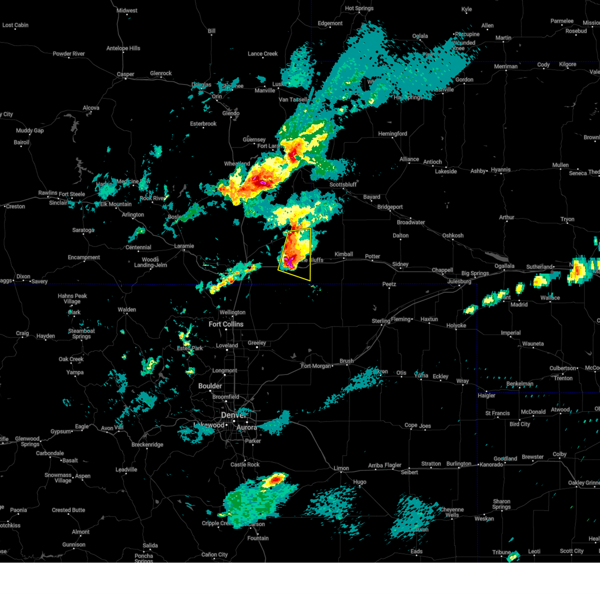
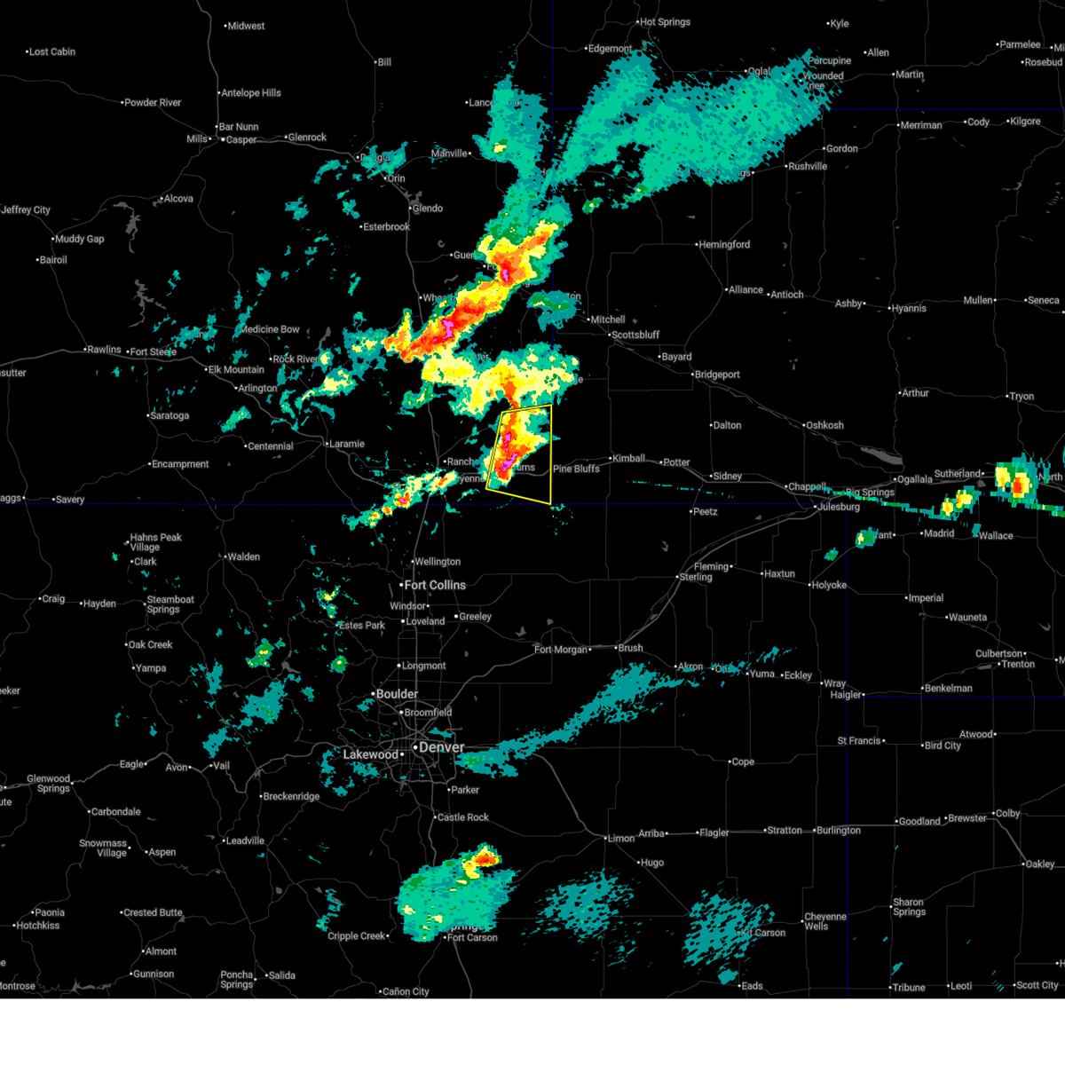
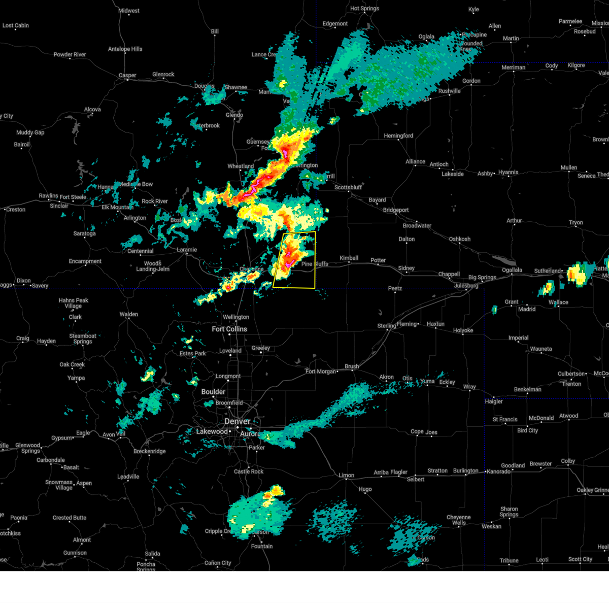
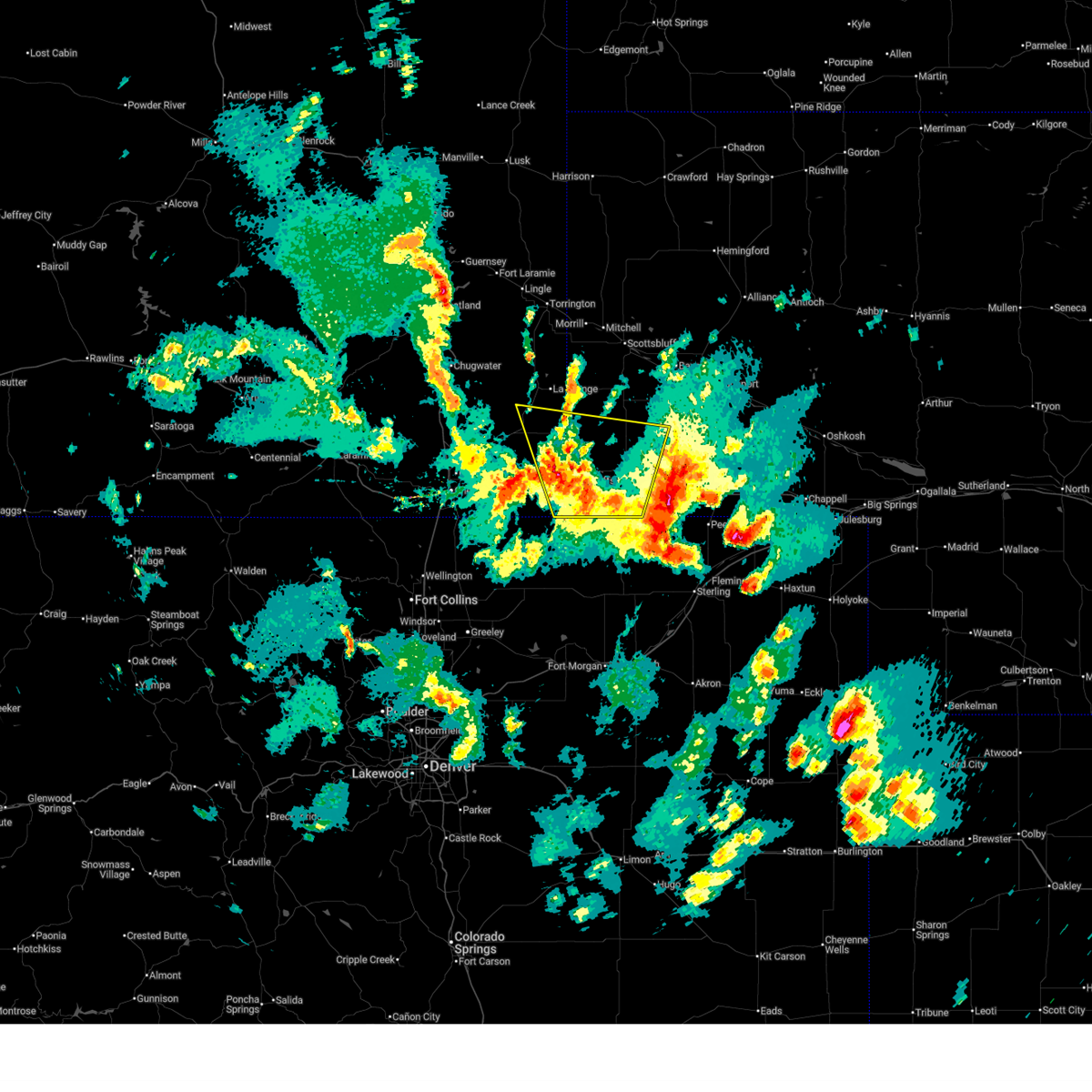
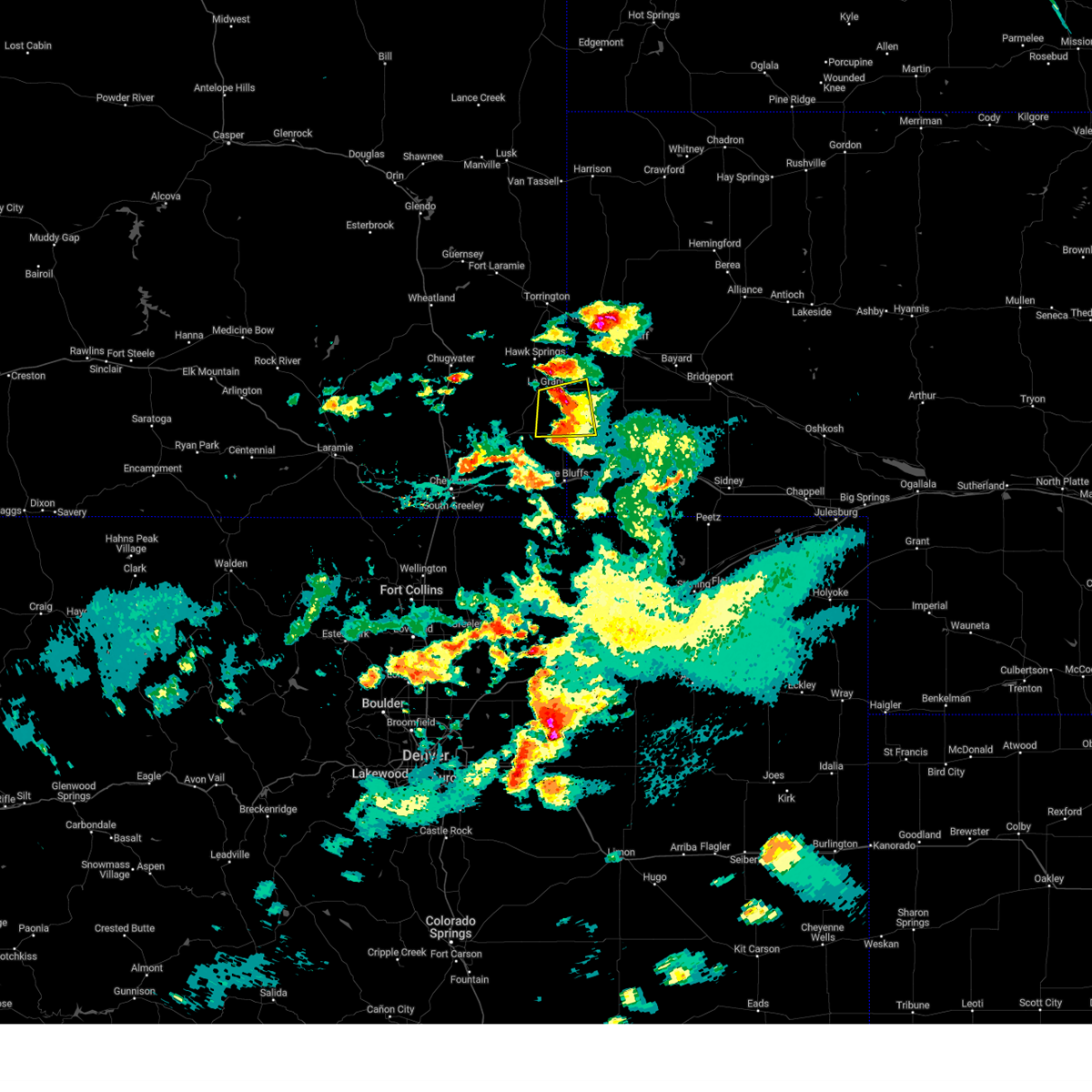
The Top Recent Hail Date for Albin, WY is Monday, June 22, 2026 (6th out of 92)
Hail and Wind Damage Spotted near Albin, WY
| Date / Time | Report Details |
|---|---|
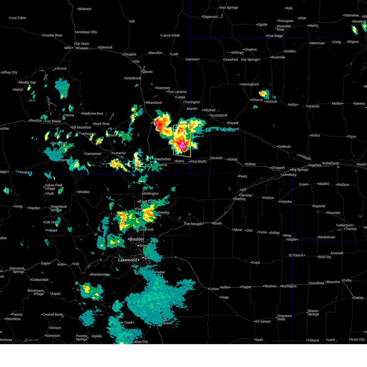
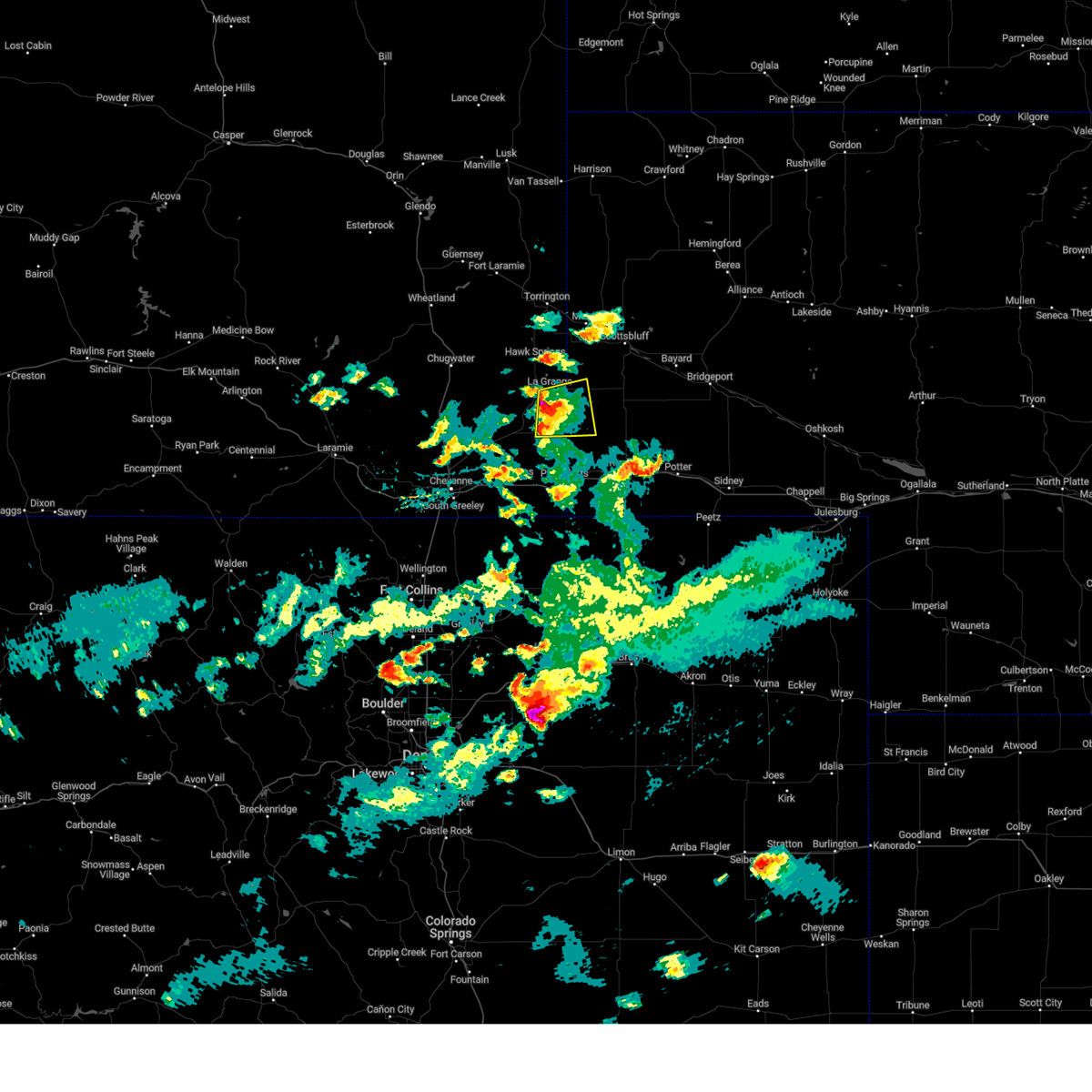
| 6/22/2026 2:54 PM MDT |
 At 253 pm mdt, a severe thunderstorm was located near albin, or 19 miles northwest of kimball, moving southeast at 20 mph (radar indicated). Hazards include ping pong ball size hail and 60 mph wind gusts. People and animals outdoors will be injured. expect hail damage to roofs, siding, windows, and vehicles. expect wind damage to roofs, siding, and trees. Locations impacted include, albin. At 253 pm mdt, a severe thunderstorm was located near albin, or 19 miles northwest of kimball, moving southeast at 20 mph (radar indicated). Hazards include ping pong ball size hail and 60 mph wind gusts. People and animals outdoors will be injured. expect hail damage to roofs, siding, windows, and vehicles. expect wind damage to roofs, siding, and trees. Locations impacted include, albin.
|
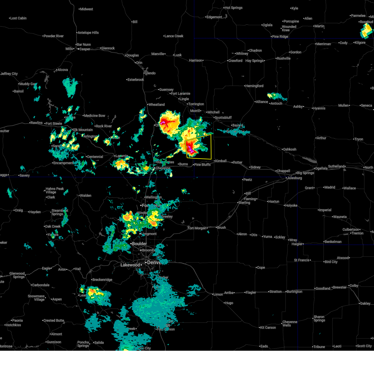
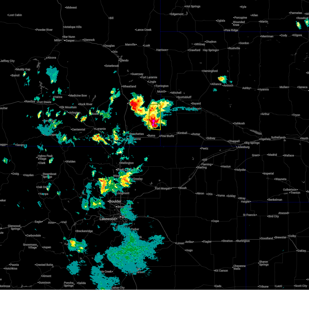
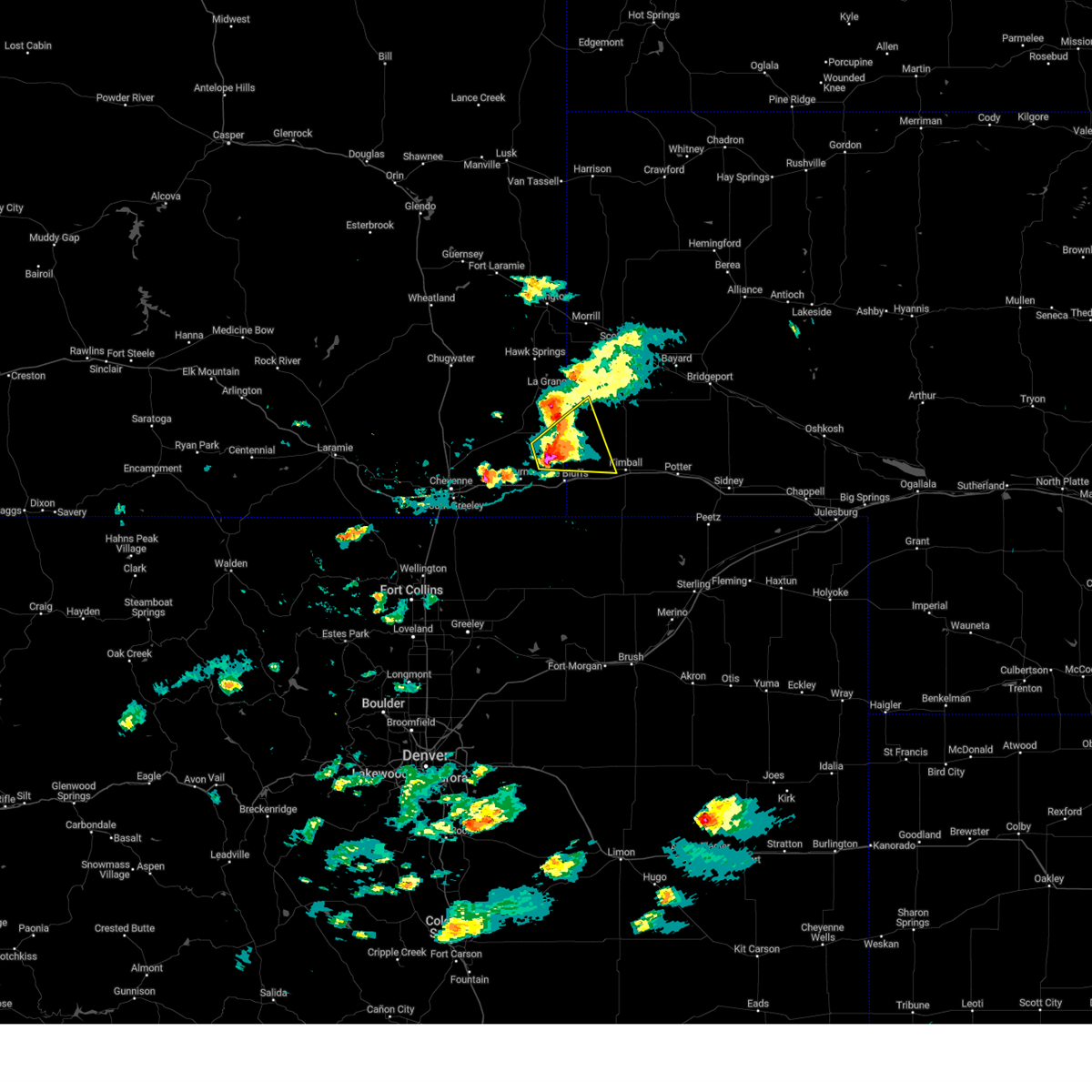
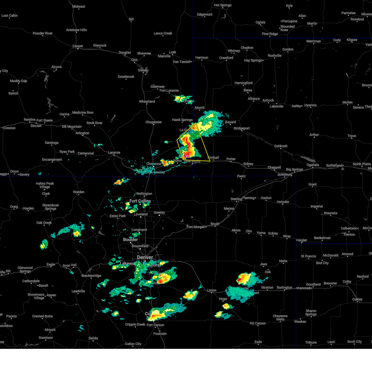
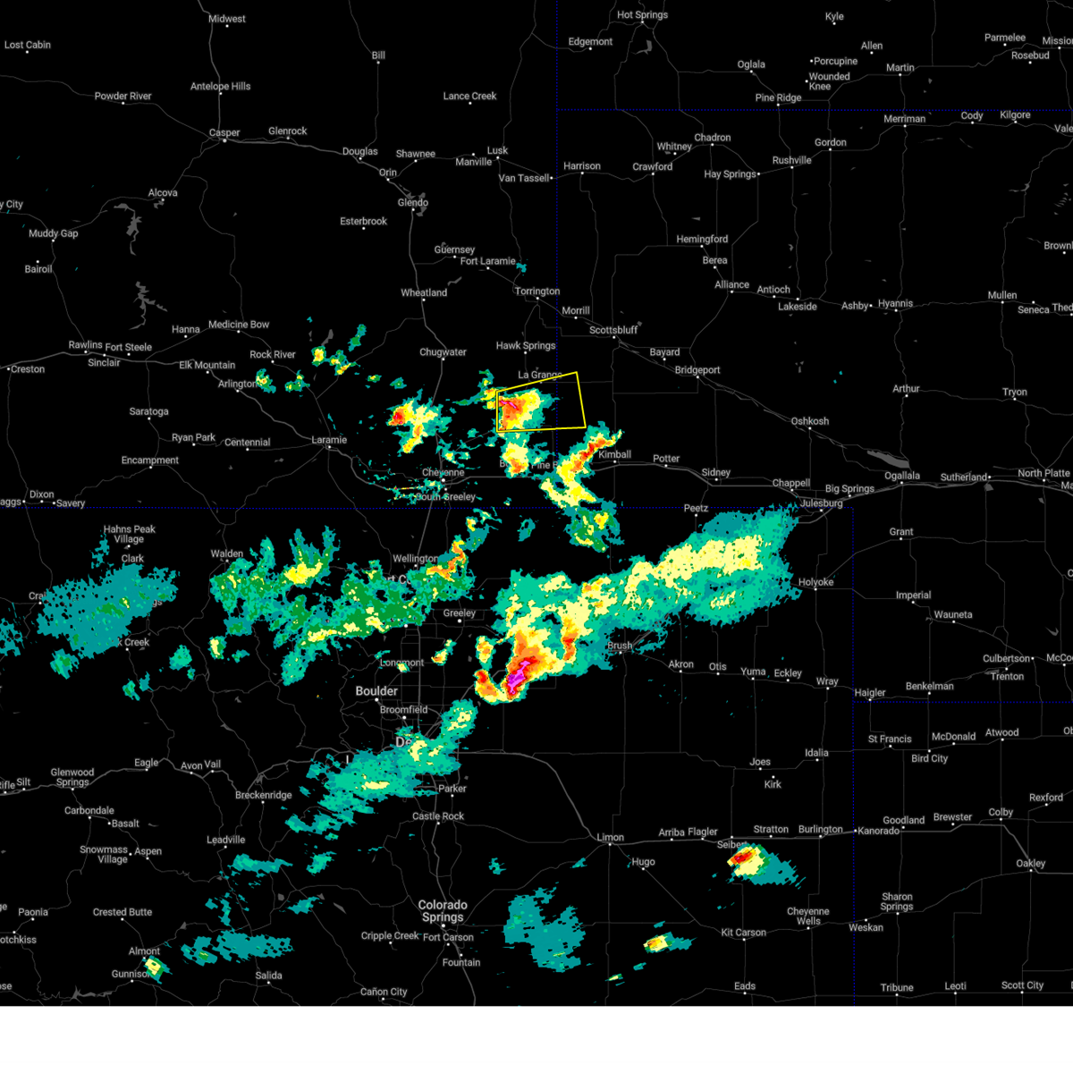
| 6/22/2026 2:30 PM MDT |
 Svrcys the national weather service in cheyenne has issued a * severe thunderstorm warning for, northwestern kimball county in the panhandle of nebraska, southwestern banner county in the panhandle of nebraska, east central laramie county in southeastern wyoming, * until 315 pm mdt. * at 230 pm mdt, a severe thunderstorm was located over albin, or 27 miles northwest of kimball, moving east at 15 mph (radar indicated). Hazards include ping pong ball size hail and 60 mph wind gusts. People and animals outdoors will be injured. expect hail damage to roofs, siding, windows, and vehicles. Expect wind damage to roofs, siding, and trees. Svrcys the national weather service in cheyenne has issued a * severe thunderstorm warning for, northwestern kimball county in the panhandle of nebraska, southwestern banner county in the panhandle of nebraska, east central laramie county in southeastern wyoming, * until 315 pm mdt. * at 230 pm mdt, a severe thunderstorm was located over albin, or 27 miles northwest of kimball, moving east at 15 mph (radar indicated). Hazards include ping pong ball size hail and 60 mph wind gusts. People and animals outdoors will be injured. expect hail damage to roofs, siding, windows, and vehicles. Expect wind damage to roofs, siding, and trees.
|
| 6/22/2026 1:39 PM MDT | Quarter sized hail reported 5.9 miles SSE of Albin, WY |
| 6/8/2026 7:03 PM MDT |
 Svrcys the national weather service in cheyenne has issued a * severe thunderstorm warning for, west central banner county in the panhandle of nebraska, southeastern goshen county in southeastern wyoming, northeastern laramie county in southeastern wyoming, * until 745 pm mdt. * at 703 pm mdt, a severe thunderstorm was located 7 miles northwest of meriden rest area, or 34 miles northeast of cheyenne, moving east at 20 mph (radar indicated). Hazards include tennis ball size hail and 70 mph wind gusts. People and animals outdoors will be injured. expect hail damage to roofs, siding, windows, and vehicles. expect considerable tree damage. Wind damage is also likely to mobile homes, roofs, and outbuildings. Svrcys the national weather service in cheyenne has issued a * severe thunderstorm warning for, west central banner county in the panhandle of nebraska, southeastern goshen county in southeastern wyoming, northeastern laramie county in southeastern wyoming, * until 745 pm mdt. * at 703 pm mdt, a severe thunderstorm was located 7 miles northwest of meriden rest area, or 34 miles northeast of cheyenne, moving east at 20 mph (radar indicated). Hazards include tennis ball size hail and 70 mph wind gusts. People and animals outdoors will be injured. expect hail damage to roofs, siding, windows, and vehicles. expect considerable tree damage. Wind damage is also likely to mobile homes, roofs, and outbuildings.
|
| 8/1/2025 5:22 PM MDT |
 The storm which prompted the warning has weakened below severe limits, and no longer poses an immediate threat to life or property. therefore, the warning will be allowed to expire. however, gusty winds and heavy rain are still possible with this thunderstorm. a tornado watch remains in effect until 1000 pm mdt for the panhandle of nebraska, and southeastern wyoming. to report severe weather, contact your nearest law enforcement agency. they will relay your report to the national weather service cheyenne. The storm which prompted the warning has weakened below severe limits, and no longer poses an immediate threat to life or property. therefore, the warning will be allowed to expire. however, gusty winds and heavy rain are still possible with this thunderstorm. a tornado watch remains in effect until 1000 pm mdt for the panhandle of nebraska, and southeastern wyoming. to report severe weather, contact your nearest law enforcement agency. they will relay your report to the national weather service cheyenne.
|
| 8/1/2025 4:52 PM MDT |
 Svrcys the national weather service in cheyenne has issued a * severe thunderstorm warning for, northwestern kimball county in the panhandle of nebraska, southwestern banner county in the panhandle of nebraska, southeastern goshen county in southeastern wyoming, east central laramie county in southeastern wyoming, * until 530 pm mdt. * at 452 pm mdt, a severe thunderstorm was located 8 miles southeast of gun barrel, or 31 miles west of kimball, moving east at 15 mph (radar indicated). Hazards include 60 mph wind gusts and quarter size hail. Hail damage to vehicles is expected. Expect wind damage to roofs, siding, and trees. Svrcys the national weather service in cheyenne has issued a * severe thunderstorm warning for, northwestern kimball county in the panhandle of nebraska, southwestern banner county in the panhandle of nebraska, southeastern goshen county in southeastern wyoming, east central laramie county in southeastern wyoming, * until 530 pm mdt. * at 452 pm mdt, a severe thunderstorm was located 8 miles southeast of gun barrel, or 31 miles west of kimball, moving east at 15 mph (radar indicated). Hazards include 60 mph wind gusts and quarter size hail. Hail damage to vehicles is expected. Expect wind damage to roofs, siding, and trees.
|
| 7/31/2025 5:26 PM MDT |
 The storms which prompted the warning have moved out of the area. therefore, the warning will be allowed to expire. however, gusty winds and heavy rain are still possible with these thunderstorms. a severe thunderstorm watch remains in effect until 900 pm mdt for southeastern wyoming. The storms which prompted the warning have moved out of the area. therefore, the warning will be allowed to expire. however, gusty winds and heavy rain are still possible with these thunderstorms. a severe thunderstorm watch remains in effect until 900 pm mdt for southeastern wyoming.
|
| 7/31/2025 5:05 PM MDT |
 At 505 pm mdt, severe thunderstorms were located along a line extending from near meriden rest area to 7 miles north of egbert to near carpenter, moving northeast at 30 mph (radar indicated). Hazards include 60 mph wind gusts and nickel size hail. Expect damage to roofs, siding, and trees. Locations impacted include, burns, albin, egbert, hillsdale, pine bluffs municipal airport, meriden rest area, gun barrel, and carpenter. At 505 pm mdt, severe thunderstorms were located along a line extending from near meriden rest area to 7 miles north of egbert to near carpenter, moving northeast at 30 mph (radar indicated). Hazards include 60 mph wind gusts and nickel size hail. Expect damage to roofs, siding, and trees. Locations impacted include, burns, albin, egbert, hillsdale, pine bluffs municipal airport, meriden rest area, gun barrel, and carpenter.
|
| 7/31/2025 4:41 PM MDT |
 Svrcys the national weather service in cheyenne has issued a * severe thunderstorm warning for, eastern laramie county in southeastern wyoming, * until 530 pm mdt. * at 440 pm mdt, severe thunderstorms were located along a line extending from 12 miles west of meriden rest area to hillsdale to 9 miles southwest of carpenter, moving northeast at 35 mph (radar indicated). Hazards include 60 mph wind gusts and nickel size hail. expect damage to roofs, siding, and trees Svrcys the national weather service in cheyenne has issued a * severe thunderstorm warning for, eastern laramie county in southeastern wyoming, * until 530 pm mdt. * at 440 pm mdt, severe thunderstorms were located along a line extending from 12 miles west of meriden rest area to hillsdale to 9 miles southwest of carpenter, moving northeast at 35 mph (radar indicated). Hazards include 60 mph wind gusts and nickel size hail. expect damage to roofs, siding, and trees
|
| 6/29/2025 5:11 PM MDT |
 The storm which prompted the warning has weakened below severe limits, and no longer poses an immediate threat to life or property. therefore, the warning will be allowed to expire. however, small hail, gusty winds and heavy rain are still possible with this thunderstorm. a severe thunderstorm watch remains in effect until 900 pm mdt for the panhandle of nebraska, and southeastern wyoming. The storm which prompted the warning has weakened below severe limits, and no longer poses an immediate threat to life or property. therefore, the warning will be allowed to expire. however, small hail, gusty winds and heavy rain are still possible with this thunderstorm. a severe thunderstorm watch remains in effect until 900 pm mdt for the panhandle of nebraska, and southeastern wyoming.
|
| 6/29/2025 5:00 PM MDT |
 At 500 pm mdt, a severe thunderstorm was located over albin, or 28 miles northwest of kimball, moving east at 25 mph (radar indicated). Hazards include 60 mph wind gusts and half dollar size hail. Hail damage to vehicles is expected. expect wind damage to roofs, siding, and trees. Locations impacted include, la grange, albin, meriden rest area, and wycross. At 500 pm mdt, a severe thunderstorm was located over albin, or 28 miles northwest of kimball, moving east at 25 mph (radar indicated). Hazards include 60 mph wind gusts and half dollar size hail. Hail damage to vehicles is expected. expect wind damage to roofs, siding, and trees. Locations impacted include, la grange, albin, meriden rest area, and wycross.
|
| 6/29/2025 4:47 PM MDT |
 At 446 pm mdt, a severe thunderstorm was located near albin, or 32 miles northwest of kimball, moving east at 20 mph (radar indicated). Hazards include ping pong ball size hail and 60 mph wind gusts. People and animals outdoors will be injured. expect hail damage to roofs, siding, windows, and vehicles. expect wind damage to roofs, siding, and trees. Locations impacted include, la grange, albin, meriden rest area, gun barrel, and wycross. At 446 pm mdt, a severe thunderstorm was located near albin, or 32 miles northwest of kimball, moving east at 20 mph (radar indicated). Hazards include ping pong ball size hail and 60 mph wind gusts. People and animals outdoors will be injured. expect hail damage to roofs, siding, windows, and vehicles. expect wind damage to roofs, siding, and trees. Locations impacted include, la grange, albin, meriden rest area, gun barrel, and wycross.
|
| 6/29/2025 4:21 PM MDT |
 Svrcys the national weather service in cheyenne has issued a * severe thunderstorm warning for, western banner county in the panhandle of nebraska, southeastern goshen county in southeastern wyoming, northeastern laramie county in southeastern wyoming, * until 515 pm mdt. * at 420 pm mdt, a severe thunderstorm was located near gun barrel, or 27 miles northeast of cheyenne, moving east at 35 mph (radar indicated). Hazards include two inch hail and 60 mph wind gusts. People and animals outdoors will be injured. expect hail damage to roofs, siding, windows, and vehicles. Expect wind damage to roofs, siding, and trees. Svrcys the national weather service in cheyenne has issued a * severe thunderstorm warning for, western banner county in the panhandle of nebraska, southeastern goshen county in southeastern wyoming, northeastern laramie county in southeastern wyoming, * until 515 pm mdt. * at 420 pm mdt, a severe thunderstorm was located near gun barrel, or 27 miles northeast of cheyenne, moving east at 35 mph (radar indicated). Hazards include two inch hail and 60 mph wind gusts. People and animals outdoors will be injured. expect hail damage to roofs, siding, windows, and vehicles. Expect wind damage to roofs, siding, and trees.
|
| 6/17/2025 2:11 PM MDT |
 Svrcys the national weather service in cheyenne has issued a * severe thunderstorm warning for, western kimball county in the panhandle of nebraska, southwestern banner county in the panhandle of nebraska, eastern laramie county in southeastern wyoming, * until 245 pm mdt. * at 211 pm mdt, severe thunderstorms were located along a line extending from near gun barrel to near pine bluffs, moving northeast at 20 mph (radar indicated). Hazards include 60 mph wind gusts and quarter size hail. Hail damage to vehicles is expected. Expect wind damage to roofs, siding, and trees. Svrcys the national weather service in cheyenne has issued a * severe thunderstorm warning for, western kimball county in the panhandle of nebraska, southwestern banner county in the panhandle of nebraska, eastern laramie county in southeastern wyoming, * until 245 pm mdt. * at 211 pm mdt, severe thunderstorms were located along a line extending from near gun barrel to near pine bluffs, moving northeast at 20 mph (radar indicated). Hazards include 60 mph wind gusts and quarter size hail. Hail damage to vehicles is expected. Expect wind damage to roofs, siding, and trees.
|
| 6/16/2025 11:35 PM MDT | Golf Ball sized hail reported 10.5 miles ESE of Albin, WY |
| 6/16/2025 11:30 PM MDT |
 At 1129 pm mdt, a severe thunderstorm was located near meriden rest area, or 36 miles northeast of cheyenne, moving east at 35 mph (radar indicated). Hazards include 60 mph wind gusts and quarter size hail. Hail damage to vehicles is expected. expect wind damage to roofs, siding, and trees. Locations impacted include, la grange, albin, meriden rest area, and gun barrel. At 1129 pm mdt, a severe thunderstorm was located near meriden rest area, or 36 miles northeast of cheyenne, moving east at 35 mph (radar indicated). Hazards include 60 mph wind gusts and quarter size hail. Hail damage to vehicles is expected. expect wind damage to roofs, siding, and trees. Locations impacted include, la grange, albin, meriden rest area, and gun barrel.
|
| 6/16/2025 11:14 PM MDT |
 At 1114 pm mdt, a severe thunderstorm was located near meriden rest area, or 31 miles northeast of cheyenne, moving east at 35 mph (radar indicated). Hazards include 60 mph wind gusts and quarter size hail. Hail damage to vehicles is expected. expect wind damage to roofs, siding, and trees. Locations impacted include, la grange, albin, meriden rest area, gun barrel, wycross, and hawk springs reservoir. At 1114 pm mdt, a severe thunderstorm was located near meriden rest area, or 31 miles northeast of cheyenne, moving east at 35 mph (radar indicated). Hazards include 60 mph wind gusts and quarter size hail. Hail damage to vehicles is expected. expect wind damage to roofs, siding, and trees. Locations impacted include, la grange, albin, meriden rest area, gun barrel, wycross, and hawk springs reservoir.
|
| 6/16/2025 11:06 PM MDT |
 Svrcys the national weather service in cheyenne has issued a * severe thunderstorm warning for, southern goshen county in southeastern wyoming, northeastern laramie county in southeastern wyoming, * until 1145 pm mdt. * at 1106 pm mdt, a severe thunderstorm was located 9 miles west of meriden rest area, or 32 miles northeast of cheyenne, moving east at 35 mph (radar indicated). Hazards include 60 mph wind gusts and quarter size hail. Hail damage to vehicles is expected. Expect wind damage to roofs, siding, and trees. Svrcys the national weather service in cheyenne has issued a * severe thunderstorm warning for, southern goshen county in southeastern wyoming, northeastern laramie county in southeastern wyoming, * until 1145 pm mdt. * at 1106 pm mdt, a severe thunderstorm was located 9 miles west of meriden rest area, or 32 miles northeast of cheyenne, moving east at 35 mph (radar indicated). Hazards include 60 mph wind gusts and quarter size hail. Hail damage to vehicles is expected. Expect wind damage to roofs, siding, and trees.
|
| 6/15/2025 6:07 PM MDT |
 The storm which prompted the warning has moved out of east laramie county. severe thunderstorm warning still active for banner and kimball county. a severe thunderstorm watch remains in effect until 1100 pm mdt for the panhandle of nebraska. to report severe weather, contact your nearest law enforcement agency. they will relay your report to the national weather service cheyenne. The storm which prompted the warning has moved out of east laramie county. severe thunderstorm warning still active for banner and kimball county. a severe thunderstorm watch remains in effect until 1100 pm mdt for the panhandle of nebraska. to report severe weather, contact your nearest law enforcement agency. they will relay your report to the national weather service cheyenne.
|
| 6/15/2025 5:44 PM MDT |
 the severe thunderstorm warning has been cancelled and is no longer in effect the severe thunderstorm warning has been cancelled and is no longer in effect
|
| 6/15/2025 5:44 PM MDT |
 At 543 pm mdt, a severe thunderstorm was located 7 miles northeast of albin, or 23 miles northwest of kimball, moving east at 45 mph (radar indicated). Hazards include 60 mph wind gusts and half dollar size hail. Hail damage to vehicles is expected. expect wind damage to roofs, siding, and trees. Locations impacted include, kimball, pine bluffs, albin, bushnell, oliver reservoir, pine bluffs municipal airport, harrisburg, kimball municipal airport, oliver reservoir campground, and kimball county fairgrounds. At 543 pm mdt, a severe thunderstorm was located 7 miles northeast of albin, or 23 miles northwest of kimball, moving east at 45 mph (radar indicated). Hazards include 60 mph wind gusts and half dollar size hail. Hail damage to vehicles is expected. expect wind damage to roofs, siding, and trees. Locations impacted include, kimball, pine bluffs, albin, bushnell, oliver reservoir, pine bluffs municipal airport, harrisburg, kimball municipal airport, oliver reservoir campground, and kimball county fairgrounds.
|
| 6/15/2025 5:32 PM MDT |
 Svrcys the national weather service in cheyenne has issued a * severe thunderstorm warning for, northwestern kimball county in the panhandle of nebraska, banner county in the panhandle of nebraska, southeastern goshen county in southeastern wyoming, eastern laramie county in southeastern wyoming, * until 615 pm mdt. * at 532 pm mdt, a severe thunderstorm was located near albin, or 29 miles northwest of kimball, moving east at 40 mph (radar indicated). Hazards include 60 mph wind gusts. expect damage to roofs, siding, and trees Svrcys the national weather service in cheyenne has issued a * severe thunderstorm warning for, northwestern kimball county in the panhandle of nebraska, banner county in the panhandle of nebraska, southeastern goshen county in southeastern wyoming, eastern laramie county in southeastern wyoming, * until 615 pm mdt. * at 532 pm mdt, a severe thunderstorm was located near albin, or 29 miles northwest of kimball, moving east at 40 mph (radar indicated). Hazards include 60 mph wind gusts. expect damage to roofs, siding, and trees
|
| 6/12/2025 4:32 PM MDT |
 At 431 pm mdt, a severe thunderstorm was located 8 miles east of albin, or 19 miles northwest of kimball, moving east at 20 mph (radar indicated). Hazards include 60 mph wind gusts and quarter size hail. Hail damage to vehicles is expected. expect wind damage to roofs, siding, and trees. Locations impacted include, albin and harrisburg. At 431 pm mdt, a severe thunderstorm was located 8 miles east of albin, or 19 miles northwest of kimball, moving east at 20 mph (radar indicated). Hazards include 60 mph wind gusts and quarter size hail. Hail damage to vehicles is expected. expect wind damage to roofs, siding, and trees. Locations impacted include, albin and harrisburg.
|
| 6/12/2025 4:14 PM MDT | Trained spotter estimated 60mph winds in albi in laramie county WY, 0.2 miles SSW of Albin, WY |
| 6/12/2025 4:12 PM MDT |
 Svrcys the national weather service in cheyenne has issued a * severe thunderstorm warning for, northwestern kimball county in the panhandle of nebraska, southwestern banner county in the panhandle of nebraska, east central laramie county in southeastern wyoming, * until 500 pm mdt. * at 412 pm mdt, a severe thunderstorm was located over albin, or 25 miles northwest of kimball, moving east at 20 mph (radar indicated). Hazards include 60 mph wind gusts and quarter size hail. Hail damage to vehicles is expected. Expect wind damage to roofs, siding, and trees. Svrcys the national weather service in cheyenne has issued a * severe thunderstorm warning for, northwestern kimball county in the panhandle of nebraska, southwestern banner county in the panhandle of nebraska, east central laramie county in southeastern wyoming, * until 500 pm mdt. * at 412 pm mdt, a severe thunderstorm was located over albin, or 25 miles northwest of kimball, moving east at 20 mph (radar indicated). Hazards include 60 mph wind gusts and quarter size hail. Hail damage to vehicles is expected. Expect wind damage to roofs, siding, and trees.
|
| 6/12/2025 4:04 PM MDT |
 At 403 pm mdt, a severe thunderstorm was located over albin, or 29 miles northwest of kimball, moving east at 25 mph (radar indicated). Hazards include 60 mph wind gusts and half dollar size hail. Hail damage to vehicles is expected. expect wind damage to roofs, siding, and trees. Locations impacted include, la grange, albin, hawk springs reservoir, hawk springs state recreation area, wycross, and hawk springs campground. At 403 pm mdt, a severe thunderstorm was located over albin, or 29 miles northwest of kimball, moving east at 25 mph (radar indicated). Hazards include 60 mph wind gusts and half dollar size hail. Hail damage to vehicles is expected. expect wind damage to roofs, siding, and trees. Locations impacted include, la grange, albin, hawk springs reservoir, hawk springs state recreation area, wycross, and hawk springs campground.
|
| 6/12/2025 3:53 PM MDT |
 At 353 pm mdt, a severe thunderstorm was located near meriden rest area, or 35 miles northeast of cheyenne, moving east at 10 mph (radar indicated). Hazards include 60 mph wind gusts and half dollar size hail. Hail damage to vehicles is expected. expect wind damage to roofs, siding, and trees. Locations impacted include, la grange, albin, hawk springs reservoir, meriden rest area, gun barrel, hawk springs state recreation area, wycross, and hawk springs campground. At 353 pm mdt, a severe thunderstorm was located near meriden rest area, or 35 miles northeast of cheyenne, moving east at 10 mph (radar indicated). Hazards include 60 mph wind gusts and half dollar size hail. Hail damage to vehicles is expected. expect wind damage to roofs, siding, and trees. Locations impacted include, la grange, albin, hawk springs reservoir, meriden rest area, gun barrel, hawk springs state recreation area, wycross, and hawk springs campground.
|
| 6/12/2025 3:31 PM MDT |
 Svrcys the national weather service in cheyenne has issued a * severe thunderstorm warning for, southwestern scotts bluff county in the panhandle of nebraska, northwestern kimball county in the panhandle of nebraska, western banner county in the panhandle of nebraska, southeastern goshen county in southeastern wyoming, northeastern laramie county in southeastern wyoming, * until 415 pm mdt. * at 331 pm mdt, a severe thunderstorm was located near meriden rest area, or 32 miles northeast of cheyenne, moving east at 10 mph (radar indicated). Hazards include 60 mph wind gusts and half dollar size hail. Hail damage to vehicles is expected. Expect wind damage to roofs, siding, and trees. Svrcys the national weather service in cheyenne has issued a * severe thunderstorm warning for, southwestern scotts bluff county in the panhandle of nebraska, northwestern kimball county in the panhandle of nebraska, western banner county in the panhandle of nebraska, southeastern goshen county in southeastern wyoming, northeastern laramie county in southeastern wyoming, * until 415 pm mdt. * at 331 pm mdt, a severe thunderstorm was located near meriden rest area, or 32 miles northeast of cheyenne, moving east at 10 mph (radar indicated). Hazards include 60 mph wind gusts and half dollar size hail. Hail damage to vehicles is expected. Expect wind damage to roofs, siding, and trees.
|
| 6/2/2025 5:11 PM MDT |
 At 511 pm mdt, severe thunderstorms were located along a line extending from near albin to 6 miles southwest of pine bluffs municipal airport, moving east at 20 mph (radar indicated). Hazards include golf ball size hail and 60 mph wind gusts. People and animals outdoors will be injured. expect hail damage to roofs, siding, windows, and vehicles. expect wind damage to roofs, siding, and trees. Locations impacted include, pine bluffs, burns, albin, egbert, and pine bluffs municipal airport. At 511 pm mdt, severe thunderstorms were located along a line extending from near albin to 6 miles southwest of pine bluffs municipal airport, moving east at 20 mph (radar indicated). Hazards include golf ball size hail and 60 mph wind gusts. People and animals outdoors will be injured. expect hail damage to roofs, siding, windows, and vehicles. expect wind damage to roofs, siding, and trees. Locations impacted include, pine bluffs, burns, albin, egbert, and pine bluffs municipal airport.
|
| 6/2/2025 4:59 PM MDT |
 At 459 pm mdt, severe thunderstorms were located along a line extending from near albin to near carpenter, moving east at 25 mph (radar indicated). Hazards include golf ball size hail and 60 mph wind gusts. People and animals outdoors will be injured. expect hail damage to roofs, siding, windows, and vehicles. expect wind damage to roofs, siding, and trees. Locations impacted include, pine bluffs, burns, albin, egbert, and pine bluffs municipal airport. At 459 pm mdt, severe thunderstorms were located along a line extending from near albin to near carpenter, moving east at 25 mph (radar indicated). Hazards include golf ball size hail and 60 mph wind gusts. People and animals outdoors will be injured. expect hail damage to roofs, siding, windows, and vehicles. expect wind damage to roofs, siding, and trees. Locations impacted include, pine bluffs, burns, albin, egbert, and pine bluffs municipal airport.
|
| 6/2/2025 4:45 PM MDT |
 At 444 pm mdt, severe thunderstorms were located along a line extending from gun barrel to near carpenter, moving east at 25 mph (radar indicated). Hazards include golf ball size hail and 60 mph wind gusts. People and animals outdoors will be injured. expect hail damage to roofs, siding, windows, and vehicles. expect wind damage to roofs, siding, and trees. Locations impacted include, pine bluffs, burns, albin, egbert, pine bluffs municipal airport, gun barrel, and hillsdale. At 444 pm mdt, severe thunderstorms were located along a line extending from gun barrel to near carpenter, moving east at 25 mph (radar indicated). Hazards include golf ball size hail and 60 mph wind gusts. People and animals outdoors will be injured. expect hail damage to roofs, siding, windows, and vehicles. expect wind damage to roofs, siding, and trees. Locations impacted include, pine bluffs, burns, albin, egbert, pine bluffs municipal airport, gun barrel, and hillsdale.
|
| 6/2/2025 4:38 PM MDT |
 Svrcys the national weather service in cheyenne has issued a * severe thunderstorm warning for, southeastern laramie county in southeastern wyoming, * until 530 pm mdt. * at 438 pm mdt, severe thunderstorms were located along a line extending from gun barrel to near carpenter, moving east at 20 mph (radar indicated). Hazards include ping pong ball size hail and 60 mph wind gusts. People and animals outdoors will be injured. expect hail damage to roofs, siding, windows, and vehicles. Expect wind damage to roofs, siding, and trees. Svrcys the national weather service in cheyenne has issued a * severe thunderstorm warning for, southeastern laramie county in southeastern wyoming, * until 530 pm mdt. * at 438 pm mdt, severe thunderstorms were located along a line extending from gun barrel to near carpenter, moving east at 20 mph (radar indicated). Hazards include ping pong ball size hail and 60 mph wind gusts. People and animals outdoors will be injured. expect hail damage to roofs, siding, windows, and vehicles. Expect wind damage to roofs, siding, and trees.
|
| 5/18/2025 4:45 PM MDT |
 the severe thunderstorm warning has been cancelled and is no longer in effect the severe thunderstorm warning has been cancelled and is no longer in effect
|
| 5/18/2025 4:30 PM MDT |
 At 429 pm mdt, severe thunderstorms were located along a line extending from near albin to 7 miles northwest of kimball, moving north at 65 mph (radar indicated). Hazards include 70 mph wind gusts and half dollar size hail. Hail damage to vehicles is expected. expect considerable tree damage. wind damage is also likely to mobile homes, roofs, and outbuildings. Locations impacted include, kimball, pine bluffs, albin, bushnell, oliver reservoir, pine bluffs municipal airport, meriden rest area, kimball municipal airport, oliver reservoir campground, and kimball county fairgrounds. At 429 pm mdt, severe thunderstorms were located along a line extending from near albin to 7 miles northwest of kimball, moving north at 65 mph (radar indicated). Hazards include 70 mph wind gusts and half dollar size hail. Hail damage to vehicles is expected. expect considerable tree damage. wind damage is also likely to mobile homes, roofs, and outbuildings. Locations impacted include, kimball, pine bluffs, albin, bushnell, oliver reservoir, pine bluffs municipal airport, meriden rest area, kimball municipal airport, oliver reservoir campground, and kimball county fairgrounds.
|
| 5/18/2025 4:21 PM MDT |
 At 421 pm mdt, severe thunderstorms were located along a line extending from 6 miles northwest of pine bluffs to 7 miles southeast of kimball municipal airport, moving north at 40 mph (radar indicated). Hazards include 70 mph wind gusts and half dollar size hail. Hail damage to vehicles is expected. expect considerable tree damage. wind damage is also likely to mobile homes, roofs, and outbuildings. Locations impacted include, kimball, pine bluffs, albin, bushnell, oliver reservoir, pine bluffs municipal airport, meriden rest area, kimball municipal airport, panorama point, oliver reservoir campground, and kimball county fairgrounds. At 421 pm mdt, severe thunderstorms were located along a line extending from 6 miles northwest of pine bluffs to 7 miles southeast of kimball municipal airport, moving north at 40 mph (radar indicated). Hazards include 70 mph wind gusts and half dollar size hail. Hail damage to vehicles is expected. expect considerable tree damage. wind damage is also likely to mobile homes, roofs, and outbuildings. Locations impacted include, kimball, pine bluffs, albin, bushnell, oliver reservoir, pine bluffs municipal airport, meriden rest area, kimball municipal airport, panorama point, oliver reservoir campground, and kimball county fairgrounds.
|
| 5/18/2025 4:20 PM MDT |
 At 419 pm mdt, severe thunderstorms were located along a line extending from 6 miles northwest of pine bluffs to 8 miles southeast of kimball municipal airport, moving north at 40 mph (radar indicated). Hazards include 60 mph wind gusts and half dollar size hail. Hail damage to vehicles is expected. expect wind damage to roofs, siding, and trees. Locations impacted include, kimball, pine bluffs, albin, bushnell, oliver reservoir, pine bluffs municipal airport, meriden rest area, kimball municipal airport, panorama point, oliver reservoir campground, and kimball county fairgrounds. At 419 pm mdt, severe thunderstorms were located along a line extending from 6 miles northwest of pine bluffs to 8 miles southeast of kimball municipal airport, moving north at 40 mph (radar indicated). Hazards include 60 mph wind gusts and half dollar size hail. Hail damage to vehicles is expected. expect wind damage to roofs, siding, and trees. Locations impacted include, kimball, pine bluffs, albin, bushnell, oliver reservoir, pine bluffs municipal airport, meriden rest area, kimball municipal airport, panorama point, oliver reservoir campground, and kimball county fairgrounds.
|
| 5/18/2025 4:08 PM MDT |
 Svrcys the national weather service in cheyenne has issued a * severe thunderstorm warning for, kimball county in the panhandle of nebraska, southern banner county in the panhandle of nebraska, eastern laramie county in southeastern wyoming, * until 500 pm mdt. * at 408 pm mdt, severe thunderstorms were located along a line extending from near pine bluffs municipal airport to 11 miles northwest of westplains, moving north at 40 mph (radar indicated). Hazards include 60 mph wind gusts and nickel size hail. expect damage to roofs, siding, and trees Svrcys the national weather service in cheyenne has issued a * severe thunderstorm warning for, kimball county in the panhandle of nebraska, southern banner county in the panhandle of nebraska, eastern laramie county in southeastern wyoming, * until 500 pm mdt. * at 408 pm mdt, severe thunderstorms were located along a line extending from near pine bluffs municipal airport to 11 miles northwest of westplains, moving north at 40 mph (radar indicated). Hazards include 60 mph wind gusts and nickel size hail. expect damage to roofs, siding, and trees
|
| 8/12/2024 3:18 PM MDT |
 the severe thunderstorm warning has been cancelled and is no longer in effect the severe thunderstorm warning has been cancelled and is no longer in effect
|
| 8/12/2024 3:18 PM MDT |
 At 317 pm mdt, a severe thunderstorm was located near albin, or 25 miles northwest of kimball, moving northeast at 30 mph (radar indicated). Hazards include tennis ball size hail and 60 mph wind gusts. People and animals outdoors will be injured. expect hail damage to roofs, siding, windows, and vehicles. expect wind damage to roofs, siding, and trees. Locations impacted include, albin, bushnell, oliver reservoir, and oliver reservoir campground. At 317 pm mdt, a severe thunderstorm was located near albin, or 25 miles northwest of kimball, moving northeast at 30 mph (radar indicated). Hazards include tennis ball size hail and 60 mph wind gusts. People and animals outdoors will be injured. expect hail damage to roofs, siding, windows, and vehicles. expect wind damage to roofs, siding, and trees. Locations impacted include, albin, bushnell, oliver reservoir, and oliver reservoir campground.
|
| 8/12/2024 3:14 PM MDT |
 At 313 pm mdt, a severe thunderstorm was located near albin, or 26 miles northwest of kimball, moving northeast at 30 mph (radar indicated). Hazards include ping pong ball size hail and 60 mph wind gusts. People and animals outdoors will be injured. expect hail damage to roofs, siding, windows, and vehicles. expect wind damage to roofs, siding, and trees. Locations impacted include, la grange, albin, bushnell, meriden rest area, oliver reservoir, and oliver reservoir campground. At 313 pm mdt, a severe thunderstorm was located near albin, or 26 miles northwest of kimball, moving northeast at 30 mph (radar indicated). Hazards include ping pong ball size hail and 60 mph wind gusts. People and animals outdoors will be injured. expect hail damage to roofs, siding, windows, and vehicles. expect wind damage to roofs, siding, and trees. Locations impacted include, la grange, albin, bushnell, meriden rest area, oliver reservoir, and oliver reservoir campground.
|
| 8/12/2024 3:08 PM MDT |
 Svrcys the national weather service in cheyenne has issued a * severe thunderstorm warning for, southwestern scotts bluff county in the panhandle of nebraska, northwestern kimball county in the panhandle of nebraska, western banner county in the panhandle of nebraska, southeastern goshen county in southeastern wyoming, northeastern laramie county in southeastern wyoming, * until 345 pm mdt. * at 307 pm mdt, a severe thunderstorm was located over albin, or 28 miles northwest of kimball, moving northeast at 25 mph (radar indicated). Hazards include 60 mph wind gusts and quarter size hail. Hail damage to vehicles is expected. Expect wind damage to roofs, siding, and trees. Svrcys the national weather service in cheyenne has issued a * severe thunderstorm warning for, southwestern scotts bluff county in the panhandle of nebraska, northwestern kimball county in the panhandle of nebraska, western banner county in the panhandle of nebraska, southeastern goshen county in southeastern wyoming, northeastern laramie county in southeastern wyoming, * until 345 pm mdt. * at 307 pm mdt, a severe thunderstorm was located over albin, or 28 miles northwest of kimball, moving northeast at 25 mph (radar indicated). Hazards include 60 mph wind gusts and quarter size hail. Hail damage to vehicles is expected. Expect wind damage to roofs, siding, and trees.
|
| 8/7/2024 5:01 PM MDT |
 The storm which prompted the warning has weakened below severe limits, and no longer poses an immediate threat to life or property. therefore, the warning has been allowed to expire. a severe thunderstorm watch remains in effect until 1000 pm mdt for the panhandle of nebraska, and southeastern wyoming. The storm which prompted the warning has weakened below severe limits, and no longer poses an immediate threat to life or property. therefore, the warning has been allowed to expire. a severe thunderstorm watch remains in effect until 1000 pm mdt for the panhandle of nebraska, and southeastern wyoming.
|
| 8/7/2024 4:46 PM MDT |
 At 445 pm mdt, a severe thunderstorm was located 7 miles southeast of la grange, or 29 miles southwest of scottsbluff, moving east at 30 mph (radar indicated). Hazards include 60 mph wind gusts and quarter size hail. Hail damage to vehicles is expected. expect wind damage to roofs, siding, and trees. Locations impacted include, la grange and albin. At 445 pm mdt, a severe thunderstorm was located 7 miles southeast of la grange, or 29 miles southwest of scottsbluff, moving east at 30 mph (radar indicated). Hazards include 60 mph wind gusts and quarter size hail. Hail damage to vehicles is expected. expect wind damage to roofs, siding, and trees. Locations impacted include, la grange and albin.
|
| 8/7/2024 4:21 PM MDT |
 Svrcys the national weather service in cheyenne has issued a * severe thunderstorm warning for, western banner county in the panhandle of nebraska, southeastern goshen county in southeastern wyoming, northeastern laramie county in southeastern wyoming, * until 500 pm mdt. * at 421 pm mdt, a severe thunderstorm was located over meriden rest area, or 36 miles south of torrington, moving east at 35 mph (radar indicated). Hazards include 60 mph wind gusts and quarter size hail. Hail damage to vehicles is expected. Expect wind damage to roofs, siding, and trees. Svrcys the national weather service in cheyenne has issued a * severe thunderstorm warning for, western banner county in the panhandle of nebraska, southeastern goshen county in southeastern wyoming, northeastern laramie county in southeastern wyoming, * until 500 pm mdt. * at 421 pm mdt, a severe thunderstorm was located over meriden rest area, or 36 miles south of torrington, moving east at 35 mph (radar indicated). Hazards include 60 mph wind gusts and quarter size hail. Hail damage to vehicles is expected. Expect wind damage to roofs, siding, and trees.
|
| 7/20/2024 5:10 PM MDT |
 At 510 pm mdt, a severe thunderstorm was located near gun barrel, or 29 miles northeast of cheyenne, moving south at 35 mph (radar indicated). Hazards include golf ball size hail and 60 mph wind gusts. People and animals outdoors will be injured. expect hail damage to roofs, siding, windows, and vehicles. expect wind damage to roofs, siding, and trees. Locations impacted include, albin, gun barrel, and meriden rest area. At 510 pm mdt, a severe thunderstorm was located near gun barrel, or 29 miles northeast of cheyenne, moving south at 35 mph (radar indicated). Hazards include golf ball size hail and 60 mph wind gusts. People and animals outdoors will be injured. expect hail damage to roofs, siding, windows, and vehicles. expect wind damage to roofs, siding, and trees. Locations impacted include, albin, gun barrel, and meriden rest area.
|
| 7/20/2024 5:01 PM MDT |
 At 500 pm mdt, a severe thunderstorm was located near meriden rest area, or 33 miles northeast of cheyenne, moving south at 35 mph (radar indicated). Hazards include 60 mph wind gusts and half dollar size hail. Hail damage to vehicles is expected. expect wind damage to roofs, siding, and trees. Locations impacted include, albin, gun barrel, and meriden rest area. At 500 pm mdt, a severe thunderstorm was located near meriden rest area, or 33 miles northeast of cheyenne, moving south at 35 mph (radar indicated). Hazards include 60 mph wind gusts and half dollar size hail. Hail damage to vehicles is expected. expect wind damage to roofs, siding, and trees. Locations impacted include, albin, gun barrel, and meriden rest area.
|
| 7/20/2024 4:45 PM MDT |
 Svrcys the national weather service in cheyenne has issued a * severe thunderstorm warning for, northwestern kimball county in the panhandle of nebraska, southwestern goshen county in southeastern wyoming, northeastern laramie county in southeastern wyoming, * until 530 pm mdt. * at 445 pm mdt, a severe thunderstorm was located 12 miles northwest of meriden rest area, or 30 miles southwest of torrington, moving south at 35 mph (radar indicated). Hazards include 60 mph wind gusts and quarter size hail. Hail damage to vehicles is expected. Expect wind damage to roofs, siding, and trees. Svrcys the national weather service in cheyenne has issued a * severe thunderstorm warning for, northwestern kimball county in the panhandle of nebraska, southwestern goshen county in southeastern wyoming, northeastern laramie county in southeastern wyoming, * until 530 pm mdt. * at 445 pm mdt, a severe thunderstorm was located 12 miles northwest of meriden rest area, or 30 miles southwest of torrington, moving south at 35 mph (radar indicated). Hazards include 60 mph wind gusts and quarter size hail. Hail damage to vehicles is expected. Expect wind damage to roofs, siding, and trees.
|
| 7/18/2024 6:42 PM MDT |
 The storm which prompted the warning has weakened below severe limits, and no longer poses an immediate threat to life or property. therefore, the warning will be allowed to expire. however, small hail and gusty winds up to 50 mph are still possible with this thunderstorm until 700 pm. The storm which prompted the warning has weakened below severe limits, and no longer poses an immediate threat to life or property. therefore, the warning will be allowed to expire. however, small hail and gusty winds up to 50 mph are still possible with this thunderstorm until 700 pm.
|
| 7/18/2024 6:26 PM MDT |
 At 626 pm mdt, a severe thunderstorm was located near la grange, or 34 miles south of torrington, moving east at 20 mph (radar indicated). Hazards include ping pong ball size hail and 60 mph wind gusts. People and animals outdoors will be injured. expect hail damage to roofs, siding, windows, and vehicles. expect wind damage to roofs, siding, and trees. Locations impacted include, la grange and albin. At 626 pm mdt, a severe thunderstorm was located near la grange, or 34 miles south of torrington, moving east at 20 mph (radar indicated). Hazards include ping pong ball size hail and 60 mph wind gusts. People and animals outdoors will be injured. expect hail damage to roofs, siding, windows, and vehicles. expect wind damage to roofs, siding, and trees. Locations impacted include, la grange and albin.
|
| 7/18/2024 6:10 PM MDT |
 Svrcys the national weather service in cheyenne has issued a * severe thunderstorm warning for, northwestern kimball county in the panhandle of nebraska, western banner county in the panhandle of nebraska, southeastern goshen county in southeastern wyoming, northeastern laramie county in southeastern wyoming, * until 645 pm mdt. * at 610 pm mdt, a severe thunderstorm was located over meriden rest area, or 34 miles south of torrington, moving east at 20 mph (radar indicated). Hazards include ping pong ball size hail and 60 mph wind gusts. People and animals outdoors will be injured. expect hail damage to roofs, siding, windows, and vehicles. Expect wind damage to roofs, siding, and trees. Svrcys the national weather service in cheyenne has issued a * severe thunderstorm warning for, northwestern kimball county in the panhandle of nebraska, western banner county in the panhandle of nebraska, southeastern goshen county in southeastern wyoming, northeastern laramie county in southeastern wyoming, * until 645 pm mdt. * at 610 pm mdt, a severe thunderstorm was located over meriden rest area, or 34 miles south of torrington, moving east at 20 mph (radar indicated). Hazards include ping pong ball size hail and 60 mph wind gusts. People and animals outdoors will be injured. expect hail damage to roofs, siding, windows, and vehicles. Expect wind damage to roofs, siding, and trees.
|
| 6/1/2024 4:12 PM MDT |
 At 412 pm mdt, a severe thunderstorm was located near gun barrel, or 33 miles northeast of cheyenne, moving northeast at 20 mph (radar indicated). Hazards include 60 mph wind gusts and quarter size hail. Hail damage to vehicles is expected. expect wind damage to roofs, siding, and trees. Locations impacted include, la grange, albin, meriden rest area, and gun barrel. At 412 pm mdt, a severe thunderstorm was located near gun barrel, or 33 miles northeast of cheyenne, moving northeast at 20 mph (radar indicated). Hazards include 60 mph wind gusts and quarter size hail. Hail damage to vehicles is expected. expect wind damage to roofs, siding, and trees. Locations impacted include, la grange, albin, meriden rest area, and gun barrel.
|
| 6/1/2024 3:50 PM MDT |
 Svrcys the national weather service in cheyenne has issued a * severe thunderstorm warning for, southeastern goshen county in southeastern wyoming, northeastern laramie county in southeastern wyoming, * until 430 pm mdt. * at 350 pm mdt, a severe thunderstorm was located near gun barrel, or 26 miles northeast of cheyenne, moving east at 20 mph (radar indicated). Hazards include 60 mph wind gusts and quarter size hail. Hail damage to vehicles is expected. Expect wind damage to roofs, siding, and trees. Svrcys the national weather service in cheyenne has issued a * severe thunderstorm warning for, southeastern goshen county in southeastern wyoming, northeastern laramie county in southeastern wyoming, * until 430 pm mdt. * at 350 pm mdt, a severe thunderstorm was located near gun barrel, or 26 miles northeast of cheyenne, moving east at 20 mph (radar indicated). Hazards include 60 mph wind gusts and quarter size hail. Hail damage to vehicles is expected. Expect wind damage to roofs, siding, and trees.
|
| 5/20/2024 7:50 PM MDT | Trained spotter estimates wind gusts of 50 to 60 mph with lots of leaves and some small branches dow in laramie county WY, 12 miles E of Albin, WY |
| 8/7/2023 4:47 PM MDT |
 At 446 pm mdt, a severe thunderstorm was located 10 miles northeast of albin, or 27 miles northwest of kimball, moving east at 45 mph (radar indicated). Hazards include golf ball size hail and 60 mph wind gusts. People and animals outdoors will be injured. expect hail damage to roofs, siding, windows, and vehicles. expect wind damage to roofs, siding, and trees. locations impacted include, la grange, albin and harrisburg. thunderstorm damage threat, considerable hail threat, radar indicated max hail size, 1. 75 in wind threat, radar indicated max wind gust, 60 mph. At 446 pm mdt, a severe thunderstorm was located 10 miles northeast of albin, or 27 miles northwest of kimball, moving east at 45 mph (radar indicated). Hazards include golf ball size hail and 60 mph wind gusts. People and animals outdoors will be injured. expect hail damage to roofs, siding, windows, and vehicles. expect wind damage to roofs, siding, and trees. locations impacted include, la grange, albin and harrisburg. thunderstorm damage threat, considerable hail threat, radar indicated max hail size, 1. 75 in wind threat, radar indicated max wind gust, 60 mph.
|
| 8/7/2023 4:31 PM MDT |
 At 430 pm mdt, a severe thunderstorm was located over la grange, or 30 miles southwest of scottsbluff, moving east at 50 mph (radar indicated). Hazards include golf ball size hail and 60 mph wind gusts. People and animals outdoors will be injured. expect hail damage to roofs, siding, windows, and vehicles. Expect wind damage to roofs, siding, and trees. At 430 pm mdt, a severe thunderstorm was located over la grange, or 30 miles southwest of scottsbluff, moving east at 50 mph (radar indicated). Hazards include golf ball size hail and 60 mph wind gusts. People and animals outdoors will be injured. expect hail damage to roofs, siding, windows, and vehicles. Expect wind damage to roofs, siding, and trees.
|
| 8/7/2023 2:32 PM MDT |
 At 231 pm mdt, a severe thunderstorm was located near albin, or 32 miles northwest of kimball, moving east at 35 mph (radar indicated). Hazards include 60 mph wind gusts and half dollar size hail. Hail damage to vehicles is expected. Expect wind damage to roofs, siding, and trees. At 231 pm mdt, a severe thunderstorm was located near albin, or 32 miles northwest of kimball, moving east at 35 mph (radar indicated). Hazards include 60 mph wind gusts and half dollar size hail. Hail damage to vehicles is expected. Expect wind damage to roofs, siding, and trees.
|
| 8/1/2023 2:40 PM MDT |
 The severe thunderstorm warning for northwestern kimball, southeastern goshen and eastern laramie counties will expire at 245 pm mdt, the storms which prompted the warning have weakened below severe limits, and have exited the warned area. therefore, the warning will be allowed to expire. however gusty winds and heavy rain are still possible with these thunderstorms. The severe thunderstorm warning for northwestern kimball, southeastern goshen and eastern laramie counties will expire at 245 pm mdt, the storms which prompted the warning have weakened below severe limits, and have exited the warned area. therefore, the warning will be allowed to expire. however gusty winds and heavy rain are still possible with these thunderstorms.
|
| 8/1/2023 2:34 PM MDT |
 At 233 pm mdt, severe thunderstorms were located along a line extending from near la grange to 6 miles southwest of albin to near burns to 6 miles east of cheyenne, moving east at 15 mph (public reported quarter sized hail in cheyenne. a 63 mph wind gust was observed near gun barrel). Hazards include 60 mph wind gusts and quarter size hail. Hail damage to vehicles is expected. expect wind damage to roofs, siding, and trees. locations impacted include, cheyenne, la grange, burns, albin, south greeley, hillsdale, fox farm-college and south greeley high. this includes interstate 80 in wyoming between mile markers 362 and 396. hail threat, observed max hail size, 1. 00 in wind threat, observed max wind gust, 60 mph. At 233 pm mdt, severe thunderstorms were located along a line extending from near la grange to 6 miles southwest of albin to near burns to 6 miles east of cheyenne, moving east at 15 mph (public reported quarter sized hail in cheyenne. a 63 mph wind gust was observed near gun barrel). Hazards include 60 mph wind gusts and quarter size hail. Hail damage to vehicles is expected. expect wind damage to roofs, siding, and trees. locations impacted include, cheyenne, la grange, burns, albin, south greeley, hillsdale, fox farm-college and south greeley high. this includes interstate 80 in wyoming between mile markers 362 and 396. hail threat, observed max hail size, 1. 00 in wind threat, observed max wind gust, 60 mph.
|
| 8/1/2023 2:22 PM MDT |
 At 221 pm mdt, severe thunderstorms were located along a line extending from near la grange to 8 miles southeast of gun barrel to near burns to near south greeley, moving east at 15 mph (public reported quarter sized hail in cheyenne. a 63 mph wind gust was observed near gun barrel). Hazards include 60 mph wind gusts and quarter size hail. Hail damage to vehicles is expected. expect wind damage to roofs, siding, and trees. locations impacted include, cheyenne, la grange, burns, albin, south greeley, hillsdale, warren afb, frontier park, warren af base, meriden rest area, gun barrel, ranchettes, fox farm-college and south greeley high. this includes the following highways, interstate 25 in wyoming between mile markers 8 and 14. interstate 80 in wyoming between mile markers 358 and 396. hail threat, observed max hail size, 1. 00 in wind threat, observed max wind gust, 60 mph. At 221 pm mdt, severe thunderstorms were located along a line extending from near la grange to 8 miles southeast of gun barrel to near burns to near south greeley, moving east at 15 mph (public reported quarter sized hail in cheyenne. a 63 mph wind gust was observed near gun barrel). Hazards include 60 mph wind gusts and quarter size hail. Hail damage to vehicles is expected. expect wind damage to roofs, siding, and trees. locations impacted include, cheyenne, la grange, burns, albin, south greeley, hillsdale, warren afb, frontier park, warren af base, meriden rest area, gun barrel, ranchettes, fox farm-college and south greeley high. this includes the following highways, interstate 25 in wyoming between mile markers 8 and 14. interstate 80 in wyoming between mile markers 358 and 396. hail threat, observed max hail size, 1. 00 in wind threat, observed max wind gust, 60 mph.
|
| 8/1/2023 2:06 PM MDT |
 At 205 pm mdt, severe thunderstorms were located along a line extending from near meriden rest area to 6 miles south of gun barrel to hillsdale to south greeley, moving east at 20 mph (radar indicated). Hazards include 60 mph wind gusts and quarter size hail. Hail damage to vehicles is expected. Expect wind damage to roofs, siding, and trees. At 205 pm mdt, severe thunderstorms were located along a line extending from near meriden rest area to 6 miles south of gun barrel to hillsdale to south greeley, moving east at 20 mph (radar indicated). Hazards include 60 mph wind gusts and quarter size hail. Hail damage to vehicles is expected. Expect wind damage to roofs, siding, and trees.
|
| 8/1/2023 2:02 PM MDT | Mesonet station kgun gun barrel (wydot in laramie county WY, 12.5 miles E of Albin, WY |
| 6/29/2023 5:28 PM MDT |
 At 527 pm mdt, a severe thunderstorm was located 9 miles east of la grange, or 25 miles southwest of scottsbluff, moving east at 20 mph (radar indicated). Hazards include 60 mph wind gusts and quarter size hail. Hail damage to vehicles is expected. expect wind damage to roofs, siding, and trees. this severe storm will be near, harrisburg around 610 pm mdt. other locations impacted by this severe thunderstorm include mcgrew and melbeta. hail threat, radar indicated max hail size, 1. 00 in wind threat, radar indicated max wind gust, 60 mph. At 527 pm mdt, a severe thunderstorm was located 9 miles east of la grange, or 25 miles southwest of scottsbluff, moving east at 20 mph (radar indicated). Hazards include 60 mph wind gusts and quarter size hail. Hail damage to vehicles is expected. expect wind damage to roofs, siding, and trees. this severe storm will be near, harrisburg around 610 pm mdt. other locations impacted by this severe thunderstorm include mcgrew and melbeta. hail threat, radar indicated max hail size, 1. 00 in wind threat, radar indicated max wind gust, 60 mph.
|
| 6/29/2023 5:06 PM MDT |
 At 505 pm mdt, a severe thunderstorm was located over hawk springs recreation area, or 25 miles south of torrington, moving east at 35 mph (radar indicated). Hazards include ping pong ball size hail and 60 mph wind gusts. People and animals outdoors will be injured. expect hail damage to roofs, siding, windows, and vehicles. expect wind damage to roofs, siding, and trees. this severe thunderstorm will remain over mainly rural areas of southeastern goshen and northeastern laramie counties. hail threat, radar indicated max hail size, 1. 50 in wind threat, radar indicated max wind gust, 60 mph. At 505 pm mdt, a severe thunderstorm was located over hawk springs recreation area, or 25 miles south of torrington, moving east at 35 mph (radar indicated). Hazards include ping pong ball size hail and 60 mph wind gusts. People and animals outdoors will be injured. expect hail damage to roofs, siding, windows, and vehicles. expect wind damage to roofs, siding, and trees. this severe thunderstorm will remain over mainly rural areas of southeastern goshen and northeastern laramie counties. hail threat, radar indicated max hail size, 1. 50 in wind threat, radar indicated max wind gust, 60 mph.
|
| 6/29/2023 5:04 PM MDT |
 At 503 pm mdt, a severe thunderstorm was located near la grange, or 32 miles southwest of scottsbluff, moving east at 35 mph (radar indicated). Hazards include ping pong ball size hail and 60 mph wind gusts. People and animals outdoors will be injured. expect hail damage to roofs, siding, windows, and vehicles. expect wind damage to roofs, siding, and trees. this severe thunderstorm will be near, harrisburg around 545 pm mdt. wildcat hills state recreation area and wildcat hills campground around 550 pm mdt. other locations impacted by this severe thunderstorm include mcgrew and melbeta. hail threat, radar indicated max hail size, 1. 50 in wind threat, radar indicated max wind gust, 60 mph. At 503 pm mdt, a severe thunderstorm was located near la grange, or 32 miles southwest of scottsbluff, moving east at 35 mph (radar indicated). Hazards include ping pong ball size hail and 60 mph wind gusts. People and animals outdoors will be injured. expect hail damage to roofs, siding, windows, and vehicles. expect wind damage to roofs, siding, and trees. this severe thunderstorm will be near, harrisburg around 545 pm mdt. wildcat hills state recreation area and wildcat hills campground around 550 pm mdt. other locations impacted by this severe thunderstorm include mcgrew and melbeta. hail threat, radar indicated max hail size, 1. 50 in wind threat, radar indicated max wind gust, 60 mph.
|
| 6/29/2023 4:42 PM MDT |
 At 442 pm mdt, a severe thunderstorm was located 9 miles northwest of meriden rest area, or 32 miles southwest of torrington, moving northeast at 25 mph (radar indicated). Hazards include golf ball size hail and 60 mph wind gusts. People and animals outdoors will be injured. expect hail damage to roofs, siding, windows, and vehicles. expect wind damage to roofs, siding, and trees. this severe storm will be near, la grange around 510 pm mdt. Hawk springs recreation area, hawk springs campground and hawk springs around 515 pm mdt. At 442 pm mdt, a severe thunderstorm was located 9 miles northwest of meriden rest area, or 32 miles southwest of torrington, moving northeast at 25 mph (radar indicated). Hazards include golf ball size hail and 60 mph wind gusts. People and animals outdoors will be injured. expect hail damage to roofs, siding, windows, and vehicles. expect wind damage to roofs, siding, and trees. this severe storm will be near, la grange around 510 pm mdt. Hawk springs recreation area, hawk springs campground and hawk springs around 515 pm mdt.
|
| 6/29/2023 4:22 PM MDT |
 At 421 pm mdt, a severe thunderstorm was located 14 miles southeast of chugwater, or 32 miles north of cheyenne, moving east at 30 mph (radar indicated). Hazards include two inch hail and 60 mph wind gusts. People and animals outdoors will be injured. expect hail damage to roofs, siding, windows, and vehicles. expect wind damage to roofs, siding, and trees. this severe storm will be near, meriden rest area around 455 pm mdt. hawk springs campground and hawk springs recreation area around 505 pm mdt. la grange around 510 pm mdt. This includes interstate 25 in wyoming between mile markers 29 and 58. At 421 pm mdt, a severe thunderstorm was located 14 miles southeast of chugwater, or 32 miles north of cheyenne, moving east at 30 mph (radar indicated). Hazards include two inch hail and 60 mph wind gusts. People and animals outdoors will be injured. expect hail damage to roofs, siding, windows, and vehicles. expect wind damage to roofs, siding, and trees. this severe storm will be near, meriden rest area around 455 pm mdt. hawk springs campground and hawk springs recreation area around 505 pm mdt. la grange around 510 pm mdt. This includes interstate 25 in wyoming between mile markers 29 and 58.
|
| 6/29/2023 4:01 PM MDT |
 At 401 pm mdt, a severe thunderstorm was located 9 miles south of chugwater, or 31 miles south of wheatland, moving northeast at 30 mph (radar indicated). Hazards include two inch hail and 60 mph wind gusts. People and animals outdoors will be injured. expect hail damage to roofs, siding, windows, and vehicles. Expect wind damage to roofs, siding, and trees. At 401 pm mdt, a severe thunderstorm was located 9 miles south of chugwater, or 31 miles south of wheatland, moving northeast at 30 mph (radar indicated). Hazards include two inch hail and 60 mph wind gusts. People and animals outdoors will be injured. expect hail damage to roofs, siding, windows, and vehicles. Expect wind damage to roofs, siding, and trees.
|
| 6/28/2023 6:52 PM MDT |
 The severe thunderstorm warning for northwestern kimball, southwestern banner and east central laramie counties will expire at 700 pm mdt, the storm which prompted the warning has moved out of the area. therefore, the warning will be allowed to expire. a severe thunderstorm watch remains in effect until 900 pm mdt for the panhandle of nebraska, and southeastern wyoming. remember, a new severe thunderstorm warning still remains in effect for west central cheyenne county, kimball county and east central laramie county until 745 pm mdt. The severe thunderstorm warning for northwestern kimball, southwestern banner and east central laramie counties will expire at 700 pm mdt, the storm which prompted the warning has moved out of the area. therefore, the warning will be allowed to expire. a severe thunderstorm watch remains in effect until 900 pm mdt for the panhandle of nebraska, and southeastern wyoming. remember, a new severe thunderstorm warning still remains in effect for west central cheyenne county, kimball county and east central laramie county until 745 pm mdt.
|
| 6/28/2023 6:42 PM MDT |
 At 641 pm mdt, a severe thunderstorm was located near pine bluffs, or 22 miles west of kimball, moving east at 40 mph (radar indicated). Hazards include 60 mph wind gusts and half dollar size hail. Hail damage to vehicles is expected. expect wind damage to roofs, siding, and trees. this severe thunderstorm will remain over mainly rural areas of northwestern kimball, southwestern banner and east central laramie counties. hail threat, radar indicated max hail size, 1. 25 in wind threat, radar indicated max wind gust, 60 mph. At 641 pm mdt, a severe thunderstorm was located near pine bluffs, or 22 miles west of kimball, moving east at 40 mph (radar indicated). Hazards include 60 mph wind gusts and half dollar size hail. Hail damage to vehicles is expected. expect wind damage to roofs, siding, and trees. this severe thunderstorm will remain over mainly rural areas of northwestern kimball, southwestern banner and east central laramie counties. hail threat, radar indicated max hail size, 1. 25 in wind threat, radar indicated max wind gust, 60 mph.
|
| 6/28/2023 6:20 PM MDT |
 At 620 pm mdt, a severe thunderstorm was located 7 miles northeast of burns, or 28 miles east of cheyenne, moving east at 30 mph (radar indicated). Hazards include 60 mph wind gusts and half dollar size hail. Hail damage to vehicles is expected. Expect wind damage to roofs, siding, and trees. At 620 pm mdt, a severe thunderstorm was located 7 miles northeast of burns, or 28 miles east of cheyenne, moving east at 30 mph (radar indicated). Hazards include 60 mph wind gusts and half dollar size hail. Hail damage to vehicles is expected. Expect wind damage to roofs, siding, and trees.
|
| 6/28/2023 5:39 PM MDT |
 At 537 pm mdt, a severe thunderstorm was located 9 miles south of albin, wy, oliver campground, or 15 miles northwest of kimball, moving southeast at 25 mph. this is a destructive storm for areas near albin, bushnell, and kimball (trained spotters reported up to baseball sized hail 6 miles south of albin, wy). Hazards include baseball size hail and 60 mph wind gusts. People and animals outdoors will be severely injured. expect shattered windows, extensive damage to roofs, siding, and vehicles. locations impacted include, kimball, pine bluffs, albin, oliver campground, oliver reservoir, kimball airport and bushnell. this includes the following highways, interstate 80 in wyoming between mile markers 401 and 402. Interstate 80 in nebraska between mile markers 1 and 24. At 537 pm mdt, a severe thunderstorm was located 9 miles south of albin, wy, oliver campground, or 15 miles northwest of kimball, moving southeast at 25 mph. this is a destructive storm for areas near albin, bushnell, and kimball (trained spotters reported up to baseball sized hail 6 miles south of albin, wy). Hazards include baseball size hail and 60 mph wind gusts. People and animals outdoors will be severely injured. expect shattered windows, extensive damage to roofs, siding, and vehicles. locations impacted include, kimball, pine bluffs, albin, oliver campground, oliver reservoir, kimball airport and bushnell. this includes the following highways, interstate 80 in wyoming between mile markers 401 and 402. Interstate 80 in nebraska between mile markers 1 and 24.
|
| 6/28/2023 5:28 PM MDT |
 At 527 pm mdt, a severe thunderstorm was located over albin, or 25 miles northwest of kimball, moving east at 20 mph. this is a destructive storm for areas in an near albin (trained weather spotters report tennis ball to baseball sized hail). Hazards include baseball size hail and 60 mph wind gusts. People and animals outdoors will be severely injured. expect shattered windows, extensive damage to roofs, siding, and vehicles. Locations impacted include, albin and gun barrel. At 527 pm mdt, a severe thunderstorm was located over albin, or 25 miles northwest of kimball, moving east at 20 mph. this is a destructive storm for areas in an near albin (trained weather spotters report tennis ball to baseball sized hail). Hazards include baseball size hail and 60 mph wind gusts. People and animals outdoors will be severely injured. expect shattered windows, extensive damage to roofs, siding, and vehicles. Locations impacted include, albin and gun barrel.
|
| 6/28/2023 5:18 PM MDT |
 At 517 pm mdt, a severe thunderstorm was located over albin, or 23 miles northwest of kimball, moving southeast at 25 mph (radar indicated). Hazards include two inch hail and 60 mph wind gusts. People and animals outdoors will be injured. expect hail damage to roofs, siding, windows, and vehicles. Expect wind damage to roofs, siding, and trees. At 517 pm mdt, a severe thunderstorm was located over albin, or 23 miles northwest of kimball, moving southeast at 25 mph (radar indicated). Hazards include two inch hail and 60 mph wind gusts. People and animals outdoors will be injured. expect hail damage to roofs, siding, windows, and vehicles. Expect wind damage to roofs, siding, and trees.
|
| 6/28/2023 5:13 PM MDT | Tennis Ball sized hail reported 5.1 miles E of Albin, WY, trained storm spotter reports upwards of lime to tennis ball size hail west of albin. |
| 6/28/2023 5:00 PM MDT | Ping Pong Ball sized hail reported 5.6 miles E of Albin, WY, report from mping: ping pong ball (1.50 in.). |
| 6/28/2023 4:51 PM MDT |
 At 451 pm mdt, a severe thunderstorm was located over gun barrel, or 31 miles northeast of cheyenne, moving east at 20 mph. this is a destructive storm for gun barrel and albin (off duty nws employees estimates 60-70mph winds on hwy 85). Hazards include baseball size hail and 70 mph wind gusts. People and animals outdoors will be severely injured. expect shattered windows, extensive damage to roofs, siding, and vehicles. Locations impacted include, albin, gun barrel and meriden rest area. At 451 pm mdt, a severe thunderstorm was located over gun barrel, or 31 miles northeast of cheyenne, moving east at 20 mph. this is a destructive storm for gun barrel and albin (off duty nws employees estimates 60-70mph winds on hwy 85). Hazards include baseball size hail and 70 mph wind gusts. People and animals outdoors will be severely injured. expect shattered windows, extensive damage to roofs, siding, and vehicles. Locations impacted include, albin, gun barrel and meriden rest area.
|
| 6/28/2023 4:45 PM MDT | Storm damage reported in laramie county WY, 12.5 miles E of Albin, WY |
| 6/28/2023 4:39 PM MDT |
 At 438 pm mdt, a severe thunderstorm was located near gun barrel, or 29 miles northeast of cheyenne, moving east at 20 mph. this is a destructive storm for gun barrel and albin (radar indicated). Hazards include three inch hail and 60 mph wind gusts. People and animals outdoors will be severely injured. Expect shattered windows, extensive damage to roofs, siding, and vehicles. At 438 pm mdt, a severe thunderstorm was located near gun barrel, or 29 miles northeast of cheyenne, moving east at 20 mph. this is a destructive storm for gun barrel and albin (radar indicated). Hazards include three inch hail and 60 mph wind gusts. People and animals outdoors will be severely injured. Expect shattered windows, extensive damage to roofs, siding, and vehicles.
|
| 6/26/2023 8:00 PM MDT | Flipped pivot with 90 mph wind in laramie county WY, 11.4 miles E of Albin, WY |
| 6/26/2023 7:22 PM MDT |
 At 722 pm mdt, a severe thunderstorm was located over albin, or 25 miles northwest of kimball, moving east at 35 mph (radar indicated). Hazards include 70 mph wind gusts and ping pong ball size hail. People and animals outdoors will be injured. expect hail damage to roofs, siding, windows, and vehicles. expect considerable tree damage. Wind damage is also likely to mobile homes, roofs, and outbuildings. At 722 pm mdt, a severe thunderstorm was located over albin, or 25 miles northwest of kimball, moving east at 35 mph (radar indicated). Hazards include 70 mph wind gusts and ping pong ball size hail. People and animals outdoors will be injured. expect hail damage to roofs, siding, windows, and vehicles. expect considerable tree damage. Wind damage is also likely to mobile homes, roofs, and outbuildings.
|
| 6/26/2023 6:54 PM MDT | Wydot sensor reports wind gust of 63 mph in gun barrel... w in laramie county WY, 12.5 miles E of Albin, WY |
| 6/26/2023 6:49 PM MDT | Tennis Ball sized hail reported 12.4 miles E of Albin, WY |
| 6/22/2023 10:31 PM MDT |
 At 1031 pm mdt, a severe thunderstorm was located near albin, or 24 miles west of kimball, moving northeast at 20 mph (radar indicated). Hazards include 60 mph wind gusts and quarter size hail. Hail damage to vehicles is expected. expect wind damage to roofs, siding, and trees. Locations impacted include, albin. At 1031 pm mdt, a severe thunderstorm was located near albin, or 24 miles west of kimball, moving northeast at 20 mph (radar indicated). Hazards include 60 mph wind gusts and quarter size hail. Hail damage to vehicles is expected. expect wind damage to roofs, siding, and trees. Locations impacted include, albin.
|
| 6/22/2023 10:14 PM MDT |
 At 1014 pm mdt, a severe thunderstorm was located 9 miles southwest of albin, or 27 miles west of kimball, moving northeast at 20 mph (radar indicated). Hazards include ping pong ball size hail and 60 mph wind gusts. People and animals outdoors will be injured. expect hail damage to roofs, siding, windows, and vehicles. Expect wind damage to roofs, siding, and trees. At 1014 pm mdt, a severe thunderstorm was located 9 miles southwest of albin, or 27 miles west of kimball, moving northeast at 20 mph (radar indicated). Hazards include ping pong ball size hail and 60 mph wind gusts. People and animals outdoors will be injured. expect hail damage to roofs, siding, windows, and vehicles. Expect wind damage to roofs, siding, and trees.
|
| 6/21/2023 3:39 PM MDT |
 At 338 pm mdt, severe thunderstorms were located along a line extending from 8 miles east of albin to 9 miles south of oliver campground to near panorama point, moving northeast at 20 mph (trained weather spotters). Hazards include 60 mph wind gusts and quarter size hail. Hail damage to vehicles is expected. Expect wind damage to roofs, siding, and trees. At 338 pm mdt, severe thunderstorms were located along a line extending from 8 miles east of albin to 9 miles south of oliver campground to near panorama point, moving northeast at 20 mph (trained weather spotters). Hazards include 60 mph wind gusts and quarter size hail. Hail damage to vehicles is expected. Expect wind damage to roofs, siding, and trees.
|
| 5/27/2023 6:15 PM MDT |
 At 615 pm mdt, severe thunderstorms were located along a line extending from 6 miles northeast of veteran to 9 miles east of albin to 8 miles east of panorama point, moving northeast at 35 mph (radar indicated). Hazards include 60 mph wind gusts and half dollar size hail. Hail damage to vehicles is expected. Expect wind damage to roofs, siding, and trees. At 615 pm mdt, severe thunderstorms were located along a line extending from 6 miles northeast of veteran to 9 miles east of albin to 8 miles east of panorama point, moving northeast at 35 mph (radar indicated). Hazards include 60 mph wind gusts and half dollar size hail. Hail damage to vehicles is expected. Expect wind damage to roofs, siding, and trees.
|
| 5/27/2023 6:02 PM MDT |
 At 602 pm mdt, severe thunderstorms capable of producing a tornado were located along a line extending from 6 miles north of albin to near pine bluffs, moving northeast at 40 mph (radar indicated rotation). Hazards include tornado. Flying debris will be dangerous to those caught without shelter. mobile homes will be damaged or destroyed. damage to roofs, windows, and vehicles will occur. tree damage is likely. these dangerous storms will be near, oliver campground and oliver reservoir around 615 pm mdt. this includes the following highways, interstate 80 in wyoming between mile markers 401 and 402. Interstate 80 in nebraska between mile markers 1 and 17. At 602 pm mdt, severe thunderstorms capable of producing a tornado were located along a line extending from 6 miles north of albin to near pine bluffs, moving northeast at 40 mph (radar indicated rotation). Hazards include tornado. Flying debris will be dangerous to those caught without shelter. mobile homes will be damaged or destroyed. damage to roofs, windows, and vehicles will occur. tree damage is likely. these dangerous storms will be near, oliver campground and oliver reservoir around 615 pm mdt. this includes the following highways, interstate 80 in wyoming between mile markers 401 and 402. Interstate 80 in nebraska between mile markers 1 and 17.
|
| 5/27/2023 5:38 PM MDT |
 At 538 pm mdt, a severe thunderstorm was located over meriden rest area, or 35 miles south of torrington, moving northeast at 25 mph (radar indicated). Hazards include 60 mph wind gusts and half dollar size hail. Hail damage to vehicles is expected. Expect wind damage to roofs, siding, and trees. At 538 pm mdt, a severe thunderstorm was located over meriden rest area, or 35 miles south of torrington, moving northeast at 25 mph (radar indicated). Hazards include 60 mph wind gusts and half dollar size hail. Hail damage to vehicles is expected. Expect wind damage to roofs, siding, and trees.
|
| 5/9/2023 7:42 PM MDT |
 At 742 pm mdt, a severe thunderstorm was located near albin, or 21 miles northwest of kimball, moving east at 30 mph (public). Hazards include 60 mph wind gusts and quarter size hail. Hail damage to vehicles is expected. expect wind damage to roofs, siding, and trees. Locations impacted include, albin. At 742 pm mdt, a severe thunderstorm was located near albin, or 21 miles northwest of kimball, moving east at 30 mph (public). Hazards include 60 mph wind gusts and quarter size hail. Hail damage to vehicles is expected. expect wind damage to roofs, siding, and trees. Locations impacted include, albin.
|
| 5/9/2023 7:23 PM MDT |
 At 723 pm mdt, a severe thunderstorm was located near albin, or 27 miles west of kimball, moving east at 25 mph (radar indicated). Hazards include 60 mph wind gusts and quarter size hail. Hail damage to vehicles is expected. Expect wind damage to roofs, siding, and trees. At 723 pm mdt, a severe thunderstorm was located near albin, or 27 miles west of kimball, moving east at 25 mph (radar indicated). Hazards include 60 mph wind gusts and quarter size hail. Hail damage to vehicles is expected. Expect wind damage to roofs, siding, and trees.
|
| 5/9/2023 4:05 PM MDT |
 At 405 pm mdt, severe thunderstorms were located along a line extending from 6 miles southeast of torrington to near meriden rest area, moving northeast at 35 mph (radar indicated). Hazards include 60 mph wind gusts and nickel size hail. Expect damage to roofs, siding, and trees. locations impacted include, la grange and albin. hail threat, radar indicated max hail size, 0. 88 in wind threat, radar indicated max wind gust, 60 mph. At 405 pm mdt, severe thunderstorms were located along a line extending from 6 miles southeast of torrington to near meriden rest area, moving northeast at 35 mph (radar indicated). Hazards include 60 mph wind gusts and nickel size hail. Expect damage to roofs, siding, and trees. locations impacted include, la grange and albin. hail threat, radar indicated max hail size, 0. 88 in wind threat, radar indicated max wind gust, 60 mph.
|
| 5/9/2023 3:54 PM MDT |
 At 354 pm mdt, a severe thunderstorm was located 7 miles northeast of albin, or 25 miles northwest of kimball, moving east at 35 mph (radar indicated). Hazards include 70 mph wind gusts and quarter size hail. Hail damage to vehicles is expected. expect considerable tree damage. Wind damage is also likely to mobile homes, roofs, and outbuildings. At 354 pm mdt, a severe thunderstorm was located 7 miles northeast of albin, or 25 miles northwest of kimball, moving east at 35 mph (radar indicated). Hazards include 70 mph wind gusts and quarter size hail. Hail damage to vehicles is expected. expect considerable tree damage. Wind damage is also likely to mobile homes, roofs, and outbuildings.
|
| 5/9/2023 3:27 PM MDT |
 At 326 pm mdt, severe thunderstorms were located along a line extending from near hawk springs recreation area to 6 miles northeast of hillsdale, moving east at 30 mph (radar indicated). Hazards include ping pong ball size hail and 60 mph wind gusts. People and animals outdoors will be injured. expect hail damage to roofs, siding, windows, and vehicles. Expect wind damage to roofs, siding, and trees. At 326 pm mdt, severe thunderstorms were located along a line extending from near hawk springs recreation area to 6 miles northeast of hillsdale, moving east at 30 mph (radar indicated). Hazards include ping pong ball size hail and 60 mph wind gusts. People and animals outdoors will be injured. expect hail damage to roofs, siding, windows, and vehicles. Expect wind damage to roofs, siding, and trees.
|
| 8/2/2022 3:38 PM MDT |
 At 336 pm mdt, a severe thunderstorm was located near albin, or 29 miles northwest of kimball, moving east at 30 mph. at 312 pm an observed gust of 60 mph was measured at the gun barrel mesonet site (radar indicated). Hazards include 60 mph wind gusts and penny size hail. Expect damage to roofs, siding, and trees. locations impacted include, la grange and albin. hail threat, radar indicated max hail size, 0. 75 in wind threat, radar indicated max wind gust, 60 mph. At 336 pm mdt, a severe thunderstorm was located near albin, or 29 miles northwest of kimball, moving east at 30 mph. at 312 pm an observed gust of 60 mph was measured at the gun barrel mesonet site (radar indicated). Hazards include 60 mph wind gusts and penny size hail. Expect damage to roofs, siding, and trees. locations impacted include, la grange and albin. hail threat, radar indicated max hail size, 0. 75 in wind threat, radar indicated max wind gust, 60 mph.
|
| 8/2/2022 3:22 PM MDT |
 At 321 pm mdt, a severe thunderstorm was located near meriden rest area, or 34 miles northwest of kimball, moving east at 30 mph (radar indicated). Hazards include 60 mph wind gusts and penny size hail. expect damage to roofs, siding, and trees At 321 pm mdt, a severe thunderstorm was located near meriden rest area, or 34 miles northwest of kimball, moving east at 30 mph (radar indicated). Hazards include 60 mph wind gusts and penny size hail. expect damage to roofs, siding, and trees
|
| 8/2/2022 3:16 PM MDT | Wydot mesonet station gun barrell (kgun) measured wind gust along us highway 8 in laramie county WY, 12.5 miles E of Albin, WY |
| 6/12/2022 4:08 PM MDT |
 At 407 pm mdt, a severe thunderstorm was located over pine bluffs, or 24 miles west of kimball, moving east at 20 mph (radar indicated). Hazards include ping pong ball size hail and 60 mph wind gusts. People and animals outdoors will be injured. expect hail damage to roofs, siding, windows, and vehicles. Expect wind damage to roofs, siding, and trees. At 407 pm mdt, a severe thunderstorm was located over pine bluffs, or 24 miles west of kimball, moving east at 20 mph (radar indicated). Hazards include ping pong ball size hail and 60 mph wind gusts. People and animals outdoors will be injured. expect hail damage to roofs, siding, windows, and vehicles. Expect wind damage to roofs, siding, and trees.
|
| 7/9/2021 2:51 PM MDT |
 At 251 pm mdt, a severe thunderstorm was located near albin, or 29 miles west of kimball, moving southeast at 25 mph (radar indicated). Hazards include 60 mph wind gusts and half dollar size hail. Hail damage to vehicles is expected. Expect wind damage to roofs, siding, and trees. At 251 pm mdt, a severe thunderstorm was located near albin, or 29 miles west of kimball, moving southeast at 25 mph (radar indicated). Hazards include 60 mph wind gusts and half dollar size hail. Hail damage to vehicles is expected. Expect wind damage to roofs, siding, and trees.
|
| 6/18/2021 8:30 PM MDT |
 At 830 pm mdt, a severe thunderstorm was located near albin, or 23 miles west of kimball, moving east at 25 mph (radar indicated). Hazards include 60 mph wind gusts and quarter size hail. Hail damage to vehicles is expected. expect wind damage to roofs, siding, and trees. Locations impacted include, albin. At 830 pm mdt, a severe thunderstorm was located near albin, or 23 miles west of kimball, moving east at 25 mph (radar indicated). Hazards include 60 mph wind gusts and quarter size hail. Hail damage to vehicles is expected. expect wind damage to roofs, siding, and trees. Locations impacted include, albin.
|
| 6/18/2021 8:13 PM MDT |
 At 813 pm mdt, a severe thunderstorm was located 8 miles southwest of albin, or 30 miles west of kimball, moving east at 20 mph (radar indicated). Hazards include 60 mph wind gusts and quarter size hail. Hail damage to vehicles is expected. Expect wind damage to roofs, siding, and trees. At 813 pm mdt, a severe thunderstorm was located 8 miles southwest of albin, or 30 miles west of kimball, moving east at 20 mph (radar indicated). Hazards include 60 mph wind gusts and quarter size hail. Hail damage to vehicles is expected. Expect wind damage to roofs, siding, and trees.
|
| 6/13/2021 5:18 PM MDT |
 At 517 pm mdt, a severe thunderstorm was located near gun barrel, or 32 miles northeast of cheyenne, moving southeast at 15 mph (trained weather spotters. quarter sized hail was reported 4 miles east southeast of gun barrel with this storm). Hazards include golf ball size hail. People and animals outdoors will be injured. expect damage to roofs, siding, windows, and vehicles. Locations impacted include, albin. At 517 pm mdt, a severe thunderstorm was located near gun barrel, or 32 miles northeast of cheyenne, moving southeast at 15 mph (trained weather spotters. quarter sized hail was reported 4 miles east southeast of gun barrel with this storm). Hazards include golf ball size hail. People and animals outdoors will be injured. expect damage to roofs, siding, windows, and vehicles. Locations impacted include, albin.
|
| 6/13/2021 5:14 PM MDT | Quarter sized hail reported 8.8 miles E of Albin, WY |
| 6/13/2021 4:58 PM MDT |
 At 457 pm mdt, a severe thunderstorm was located over gun barrel, or 32 miles northeast of cheyenne, moving southeast at 20 mph (radar indicated). Hazards include golf ball size hail and 60 mph wind gusts. People and animals outdoors will be injured. expect hail damage to roofs, siding, windows, and vehicles. Expect wind damage to roofs, siding, and trees. At 457 pm mdt, a severe thunderstorm was located over gun barrel, or 32 miles northeast of cheyenne, moving southeast at 20 mph (radar indicated). Hazards include golf ball size hail and 60 mph wind gusts. People and animals outdoors will be injured. expect hail damage to roofs, siding, windows, and vehicles. Expect wind damage to roofs, siding, and trees.
|
| 6/8/2021 9:03 PM MDT |
 At 903 pm mdt, severe thunderstorms were located along a line extending from 6 miles southeast of la grange to 6 miles southeast of albin to pine bluffs, moving east at 30 mph (radar indicated). Hazards include 70 mph wind gusts and penny size hail. Expect considerable tree damage. Damage is likely to mobile homes, roofs, and outbuildings. At 903 pm mdt, severe thunderstorms were located along a line extending from 6 miles southeast of la grange to 6 miles southeast of albin to pine bluffs, moving east at 30 mph (radar indicated). Hazards include 70 mph wind gusts and penny size hail. Expect considerable tree damage. Damage is likely to mobile homes, roofs, and outbuildings.
|
| 5/26/2021 5:49 PM MDT |
 At 549 pm mdt, a severe thunderstorm was located near albin, or 26 miles northwest of kimball, moving east at 15 mph (radar indicated). Hazards include 60 mph wind gusts and half dollar size hail. Hail damage to vehicles is expected. expect wind damage to roofs, siding, and trees. This severe thunderstorm will remain over mainly rural areas of southwestern banner and northeastern laramie counties. At 549 pm mdt, a severe thunderstorm was located near albin, or 26 miles northwest of kimball, moving east at 15 mph (radar indicated). Hazards include 60 mph wind gusts and half dollar size hail. Hail damage to vehicles is expected. expect wind damage to roofs, siding, and trees. This severe thunderstorm will remain over mainly rural areas of southwestern banner and northeastern laramie counties.
|
| 5/26/2021 5:30 PM MDT |
 At 530 pm mdt, a severe thunderstorm was located near albin, or 31 miles northwest of kimball, moving east at 15 mph (radar indicated). Hazards include ping pong ball size hail and 60 mph wind gusts. People and animals outdoors will be injured. expect hail damage to roofs, siding, windows, and vehicles. expect wind damage to roofs, siding, and trees. This severe thunderstorm will be near, albin around 545 pm mdt. At 530 pm mdt, a severe thunderstorm was located near albin, or 31 miles northwest of kimball, moving east at 15 mph (radar indicated). Hazards include ping pong ball size hail and 60 mph wind gusts. People and animals outdoors will be injured. expect hail damage to roofs, siding, windows, and vehicles. expect wind damage to roofs, siding, and trees. This severe thunderstorm will be near, albin around 545 pm mdt.
|
| 6/6/2020 5:16 PM MDT | Corrects previous tstm wnd gst report from gun barrel. mesonet station kgun gun barrel (wydot in laramie county WY, 12.5 miles E of Albin, WY |
| 6/6/2020 4:56 PM MDT |
 At 455 pm mdt, severe thunderstorms were located along a line extending from near meriden rest area to near grover, moving northeast at 60 mph (radar indicated). Hazards include 70 mph wind gusts. Expect considerable tree damage. Damage is likely to mobile homes, roofs, and outbuildings. At 455 pm mdt, severe thunderstorms were located along a line extending from near meriden rest area to near grover, moving northeast at 60 mph (radar indicated). Hazards include 70 mph wind gusts. Expect considerable tree damage. Damage is likely to mobile homes, roofs, and outbuildings.
|
| 6/6/2020 4:52 PM MDT | Mesonet station kgun gun barrel (wydot in laramie county WY, 12.5 miles E of Albin, WY |
| 6/6/2020 4:30 PM MDT |
 At 429 pm mdt, a severe thunderstorm was located 8 miles northwest of hillsdale, or 16 miles northeast of cheyenne, moving northeast at 60 mph (radar indicated). Hazards include 70 mph wind gusts. Expect considerable tree damage. damage is likely to mobile homes, roofs, and outbuildings. locations impacted include, pine bluffs, la grange, albin, hawk springs campground, hawk springs recreation area, meriden rest area, gun barrel and carpenter. This includes interstate 80 in wyoming between mile markers 388 and 402. At 429 pm mdt, a severe thunderstorm was located 8 miles northwest of hillsdale, or 16 miles northeast of cheyenne, moving northeast at 60 mph (radar indicated). Hazards include 70 mph wind gusts. Expect considerable tree damage. damage is likely to mobile homes, roofs, and outbuildings. locations impacted include, pine bluffs, la grange, albin, hawk springs campground, hawk springs recreation area, meriden rest area, gun barrel and carpenter. This includes interstate 80 in wyoming between mile markers 388 and 402.
|
| 6/6/2020 4:23 PM MDT |
 At 422 pm mdt, a severe thunderstorm was located 7 miles east of ranchettes, or 8 miles northeast of cheyenne, moving northeast at 60 mph (radar indicated). Hazards include 60 mph wind gusts. expect damage to roofs, siding, and trees At 422 pm mdt, a severe thunderstorm was located 7 miles east of ranchettes, or 8 miles northeast of cheyenne, moving northeast at 60 mph (radar indicated). Hazards include 60 mph wind gusts. expect damage to roofs, siding, and trees
|
| 6/6/2020 4:16 PM MDT | Mesonet station kgun gun barrel (wydot in laramie county WY, 12.5 miles E of Albin, WY |
| 5/23/2020 3:54 PM MDT |
 The severe thunderstorm warning for east central laramie county will expire at 400 pm mdt, the storm which prompted the warning has weakened below severe limits, and no longer poses an immediate threat to life or property. therefore, the warning will be allowed to expire. however small hail is still possible with this thunderstorm. a severe thunderstorm watch remains in effect until 800 pm mdt for the panhandle of nebraska, and southeastern wyoming. to report severe weather, contact your nearest law enforcement agency. they will relay your report to the national weather service cheyenne. The severe thunderstorm warning for east central laramie county will expire at 400 pm mdt, the storm which prompted the warning has weakened below severe limits, and no longer poses an immediate threat to life or property. therefore, the warning will be allowed to expire. however small hail is still possible with this thunderstorm. a severe thunderstorm watch remains in effect until 800 pm mdt for the panhandle of nebraska, and southeastern wyoming. to report severe weather, contact your nearest law enforcement agency. they will relay your report to the national weather service cheyenne.
|
| 5/23/2020 3:38 PM MDT |
 At 338 pm mdt, a severe thunderstorm was located near albin, or 27 miles west of kimball, moving east at 15 mph (radar indicated). Hazards include ping pong ball size hail and 60 mph wind gusts. People and animals outdoors will be injured. expect hail damage to roofs, siding, windows, and vehicles. expect wind damage to roofs, siding, and trees. Locations impacted include, albin. At 338 pm mdt, a severe thunderstorm was located near albin, or 27 miles west of kimball, moving east at 15 mph (radar indicated). Hazards include ping pong ball size hail and 60 mph wind gusts. People and animals outdoors will be injured. expect hail damage to roofs, siding, windows, and vehicles. expect wind damage to roofs, siding, and trees. Locations impacted include, albin.
|
| 5/23/2020 3:15 PM MDT |
 At 314 pm mdt, a severe thunderstorm was located 9 miles southeast of gun barrel, or 29 miles northeast of cheyenne, moving east at 15 mph (radar indicated). Hazards include ping pong ball size hail and 60 mph wind gusts. People and animals outdoors will be injured. expect hail damage to roofs, siding, windows, and vehicles. Expect wind damage to roofs, siding, and trees. At 314 pm mdt, a severe thunderstorm was located 9 miles southeast of gun barrel, or 29 miles northeast of cheyenne, moving east at 15 mph (radar indicated). Hazards include ping pong ball size hail and 60 mph wind gusts. People and animals outdoors will be injured. expect hail damage to roofs, siding, windows, and vehicles. Expect wind damage to roofs, siding, and trees.
|
| 8/20/2019 11:22 PM MDT |
 At 1121 pm mdt, severe thunderstorms were located along a line extending from near box butte dam to near hillsdale, moving east at 15 mph. a meteorologist at kneb reports large trees down in scotts bluff county. one tree had a diameter of 3 feet (trained weather spotters). Hazards include 70 mph wind gusts and half dollar size hail. Hail damage to vehicles is expected. expect considerable tree damage. wind damage is also likely to mobile homes, roofs, and outbuildings. locations impacted include, alliance, kimball, bridgeport, bayard, pine bluffs, minatare, hemingford, dix, albin, oliver campground, northport, angora, oliver reservoir, court house and jail rocks, harrisburg, berea, wild horse butte, chimney rock state park, bridgeport state recreation area and kilpatrick lake. this includes the following highways, interstate 80 in wyoming between mile markers 390 and 402. Interstate 80 in nebraska between mile markers 1 and 33. At 1121 pm mdt, severe thunderstorms were located along a line extending from near box butte dam to near hillsdale, moving east at 15 mph. a meteorologist at kneb reports large trees down in scotts bluff county. one tree had a diameter of 3 feet (trained weather spotters). Hazards include 70 mph wind gusts and half dollar size hail. Hail damage to vehicles is expected. expect considerable tree damage. wind damage is also likely to mobile homes, roofs, and outbuildings. locations impacted include, alliance, kimball, bridgeport, bayard, pine bluffs, minatare, hemingford, dix, albin, oliver campground, northport, angora, oliver reservoir, court house and jail rocks, harrisburg, berea, wild horse butte, chimney rock state park, bridgeport state recreation area and kilpatrick lake. this includes the following highways, interstate 80 in wyoming between mile markers 390 and 402. Interstate 80 in nebraska between mile markers 1 and 33.
|
| 8/20/2019 11:09 PM MDT |
 At 1108 pm mdt, severe thunderstorms were located along a line extending from near box butte dam to 6 miles west of hillsdale, moving south at 15 mph. at 11 pm mdt, a trained spotter reported half dollar size hail in albin (trained weather spotters). Hazards include 70 mph wind gusts and half dollar size hail. Hail damage to vehicles is expected. expect considerable tree damage. wind damage is also likely to mobile homes, roofs, and outbuildings. locations impacted include, scottsbluff, alliance, kimball, gering, bridgeport, bayard, terrytown, pine bluffs, minatare, hemingford, burns, dix, albin, oliver campground, wildcat hills state recreation area, northport, angora, wildcat hills campground, box butte dam and oliver reservoir. this includes the following highways, interstate 80 in wyoming between mile markers 388 and 402. Interstate 80 in nebraska between mile markers 1 and 33. At 1108 pm mdt, severe thunderstorms were located along a line extending from near box butte dam to 6 miles west of hillsdale, moving south at 15 mph. at 11 pm mdt, a trained spotter reported half dollar size hail in albin (trained weather spotters). Hazards include 70 mph wind gusts and half dollar size hail. Hail damage to vehicles is expected. expect considerable tree damage. wind damage is also likely to mobile homes, roofs, and outbuildings. locations impacted include, scottsbluff, alliance, kimball, gering, bridgeport, bayard, terrytown, pine bluffs, minatare, hemingford, burns, dix, albin, oliver campground, wildcat hills state recreation area, northport, angora, wildcat hills campground, box butte dam and oliver reservoir. this includes the following highways, interstate 80 in wyoming between mile markers 388 and 402. Interstate 80 in nebraska between mile markers 1 and 33.
|
| 8/20/2019 11:00 PM MDT | Half Dollar sized hail reported 0.2 miles SSW of Albin, WY, report on facebook of half dollar sized hail in albin. |
| 8/20/2019 11:00 PM MDT |
 At 1050 pm mdt, severe thunderstorms were located along a line extending from 7 miles north of box butte campground to 8 miles northwest of hillsdale, moving south at 15 mph (radar indicated). Hazards include 70 mph wind gusts and quarter size hail. Hail damage to vehicles is expected. expect considerable tree damage. Wind damage is also likely to mobile homes, roofs, and outbuildings. At 1050 pm mdt, severe thunderstorms were located along a line extending from 7 miles north of box butte campground to 8 miles northwest of hillsdale, moving south at 15 mph (radar indicated). Hazards include 70 mph wind gusts and quarter size hail. Hail damage to vehicles is expected. expect considerable tree damage. Wind damage is also likely to mobile homes, roofs, and outbuildings.
|
| 8/20/2019 11:00 PM MDT |
 At 1059 pm mdt, severe thunderstorms were located along a line extending from 6 miles north of box butte campground to 7 miles west of hillsdale, moving south at 15 mph. at 1044 pm mdt, the scottsbluff airport asos measured a gust to 73 mph (radar indicated). Hazards include 70 mph wind gusts and quarter size hail. Hail damage to vehicles is expected. expect considerable tree damage. wind damage is also likely to mobile homes, roofs, and outbuildings. locations impacted include, scottsbluff, alliance, kimball, gering, mitchell, bridgeport, bayard, terrytown, pine bluffs, minatare, hemingford, la grange, burns, dix, albin, oliver campground, wildcat hills state recreation area, northport, angora and wildcat hills campground. this includes the following highways, interstate 80 in wyoming between mile markers 387 and 402. Interstate 80 in nebraska between mile markers 1 and 33. At 1059 pm mdt, severe thunderstorms were located along a line extending from 6 miles north of box butte campground to 7 miles west of hillsdale, moving south at 15 mph. at 1044 pm mdt, the scottsbluff airport asos measured a gust to 73 mph (radar indicated). Hazards include 70 mph wind gusts and quarter size hail. Hail damage to vehicles is expected. expect considerable tree damage. wind damage is also likely to mobile homes, roofs, and outbuildings. locations impacted include, scottsbluff, alliance, kimball, gering, mitchell, bridgeport, bayard, terrytown, pine bluffs, minatare, hemingford, la grange, burns, dix, albin, oliver campground, wildcat hills state recreation area, northport, angora and wildcat hills campground. this includes the following highways, interstate 80 in wyoming between mile markers 387 and 402. Interstate 80 in nebraska between mile markers 1 and 33.
|
| 8/20/2019 10:50 PM MDT |
 The national weather service in cheyenne has issued a * severe thunderstorm warning for. box butte county in the panhandle of nebraska. scotts bluff county in the panhandle of nebraska. northwestern cheyenne county in the panhandle of nebraska. Kimball county in the panhandle of nebraska. The national weather service in cheyenne has issued a * severe thunderstorm warning for. box butte county in the panhandle of nebraska. scotts bluff county in the panhandle of nebraska. northwestern cheyenne county in the panhandle of nebraska. Kimball county in the panhandle of nebraska.
|
| 7/6/2019 10:22 PM MDT |
 A severe thunderstorm warning remains in effect until 1045 pm mdt for kimball. southern banner and southeastern laramie counties. at 1022 pm mdt, severe thunderstorms were located along a line extending from 6 miles southwest of harrisburg to 7 miles northeast of panorama point, moving east at 35 mph. hazard. 70 mph wind gusts. A severe thunderstorm warning remains in effect until 1045 pm mdt for kimball. southern banner and southeastern laramie counties. at 1022 pm mdt, severe thunderstorms were located along a line extending from 6 miles southwest of harrisburg to 7 miles northeast of panorama point, moving east at 35 mph. hazard. 70 mph wind gusts.
|
| 7/6/2019 9:58 PM MDT |
 At 958 pm mdt, severe thunderstorms were located along a line extending from near albin to 7 miles west of panorama point, moving east at 35 mph (radar indicated). Hazards include 70 mph wind gusts. Expect considerable tree damage. Damage is likely to mobile homes, roofs, and outbuildings. At 958 pm mdt, severe thunderstorms were located along a line extending from near albin to 7 miles west of panorama point, moving east at 35 mph (radar indicated). Hazards include 70 mph wind gusts. Expect considerable tree damage. Damage is likely to mobile homes, roofs, and outbuildings.
|
| 7/6/2019 9:47 PM MDT |
 At 946 pm mdt, a severe thunderstorm was located 8 miles south of albin, or 26 miles west of kimball, moving east at 25 mph (trained weather spotters). Hazards include 70 mph wind gusts. Expect considerable tree damage. damage is likely to mobile homes, roofs, and outbuildings. locations impacted include, pine bluffs and albin. this includes the following highways, interstate 80 in wyoming near mile marker 402. Interstate 80 in nebraska between mile markers 1 and 3. At 946 pm mdt, a severe thunderstorm was located 8 miles south of albin, or 26 miles west of kimball, moving east at 25 mph (trained weather spotters). Hazards include 70 mph wind gusts. Expect considerable tree damage. damage is likely to mobile homes, roofs, and outbuildings. locations impacted include, pine bluffs and albin. this includes the following highways, interstate 80 in wyoming near mile marker 402. Interstate 80 in nebraska between mile markers 1 and 3.
|
| 7/6/2019 9:28 PM MDT |
 At 928 pm mdt, a severe thunderstorm was located 8 miles north of burns, or 27 miles northeast of cheyenne, moving east at 25 mph (trained weather spotters). Hazards include 60 mph wind gusts. expect damage to roofs, siding, and trees At 928 pm mdt, a severe thunderstorm was located 8 miles north of burns, or 27 miles northeast of cheyenne, moving east at 25 mph (trained weather spotters). Hazards include 60 mph wind gusts. expect damage to roofs, siding, and trees
|
| 7/6/2019 9:19 PM MDT |
 At 918 pm mdt, severe thunderstorms were located along a line extending from scottsbluff to near wildcat hills campground to near harrisburg to 8 miles northwest of oliver campground, moving east at 35 mph (trained weather spotters. wind gusts in excess of 60 mph have been observed along this line). Hazards include 60 mph wind gusts and penny size hail. Expect damage to roofs, siding, and trees. locations impacted include, scottsbluff, gering, terrytown, minatare, albin, oliver campground, wildcat hills state recreation area, lake minatare campground, wildcat hills campground, scotts bluff national monument, oliver reservoir, hubbard hill, harrisburg, scottsbluff airport, lake minatare, bushnell and melbeta. This includes interstate 80 in nebraska between mile markers 9 and 12. At 918 pm mdt, severe thunderstorms were located along a line extending from scottsbluff to near wildcat hills campground to near harrisburg to 8 miles northwest of oliver campground, moving east at 35 mph (trained weather spotters. wind gusts in excess of 60 mph have been observed along this line). Hazards include 60 mph wind gusts and penny size hail. Expect damage to roofs, siding, and trees. locations impacted include, scottsbluff, gering, terrytown, minatare, albin, oliver campground, wildcat hills state recreation area, lake minatare campground, wildcat hills campground, scotts bluff national monument, oliver reservoir, hubbard hill, harrisburg, scottsbluff airport, lake minatare, bushnell and melbeta. This includes interstate 80 in nebraska between mile markers 9 and 12.
|
| 7/6/2019 9:11 PM MDT |
 At 909 pm mdt, severe thunderstorms were located along a line extending from near scotts bluff national monument to near wildcat hills campground to near harrisburg to 8 miles north of pine bluffs, moving east at 35 mph (trained weather spotters. damaging). Hazards include 60 mph wind gusts and penny size hail. Expect damage to roofs, siding, and trees. locations impacted include, scottsbluff, gering, terrytown, minatare, lyman, albin, oliver campground, wildcat hills state recreation area, lake minatare campground, stegall, wildcat hills campground, scotts bluff national monument, oliver reservoir, hubbard hill, harrisburg, gun barrel, scottsbluff airport, lake minatare, bushnell and melbeta. This includes interstate 80 in nebraska between mile markers 9 and 12. At 909 pm mdt, severe thunderstorms were located along a line extending from near scotts bluff national monument to near wildcat hills campground to near harrisburg to 8 miles north of pine bluffs, moving east at 35 mph (trained weather spotters. damaging). Hazards include 60 mph wind gusts and penny size hail. Expect damage to roofs, siding, and trees. locations impacted include, scottsbluff, gering, terrytown, minatare, lyman, albin, oliver campground, wildcat hills state recreation area, lake minatare campground, stegall, wildcat hills campground, scotts bluff national monument, oliver reservoir, hubbard hill, harrisburg, gun barrel, scottsbluff airport, lake minatare, bushnell and melbeta. This includes interstate 80 in nebraska between mile markers 9 and 12.
|
| 7/6/2019 9:11 PM MDT |
 At 911 pm mdt, severe thunderstorms were located along a line extending from near scotts bluff national monument to near wildcat hills campground to near harrisburg to 8 miles north of pine bluffs, moving east at 35 mph (trained weather spotters. damaging winds up to 60 mph have been reported with this line of storms). Hazards include 60 mph wind gusts and penny size hail. Expect damage to roofs, siding, and trees. locations impacted include, scottsbluff, gering, terrytown, minatare, lyman, albin, oliver campground, wildcat hills state recreation area, lake minatare campground, stegall, wildcat hills campground, scotts bluff national monument, oliver reservoir, hubbard hill, harrisburg, gun barrel, scottsbluff airport, lake minatare, bushnell and melbeta. This includes interstate 80 in nebraska between mile markers 9 and 12. At 911 pm mdt, severe thunderstorms were located along a line extending from near scotts bluff national monument to near wildcat hills campground to near harrisburg to 8 miles north of pine bluffs, moving east at 35 mph (trained weather spotters. damaging winds up to 60 mph have been reported with this line of storms). Hazards include 60 mph wind gusts and penny size hail. Expect damage to roofs, siding, and trees. locations impacted include, scottsbluff, gering, terrytown, minatare, lyman, albin, oliver campground, wildcat hills state recreation area, lake minatare campground, stegall, wildcat hills campground, scotts bluff national monument, oliver reservoir, hubbard hill, harrisburg, gun barrel, scottsbluff airport, lake minatare, bushnell and melbeta. This includes interstate 80 in nebraska between mile markers 9 and 12.
|
| 7/6/2019 9:10 PM MDT |
 At 909 pm mdt, severe thunderstorms were located along a line extending from near scotts bluff national monument to near wildcat hills campground to near harrisburg to 8 miles north of pine bluffs, moving east at 35 mph (trained weather spotters. damaging). Hazards include 60 mph wind gusts and penny size hail. Expect damage to roofs, siding, and trees. locations impacted include, scottsbluff, gering, terrytown, minatare, lyman, albin, oliver campground, wildcat hills state recreation area, lake minatare campground, stegall, wildcat hills campground, scotts bluff national monument, oliver reservoir, hubbard hill, harrisburg, gun barrel, scottsbluff airport, lake minatare, bushnell and melbeta. This includes interstate 80 in nebraska between mile markers 9 and 12. At 909 pm mdt, severe thunderstorms were located along a line extending from near scotts bluff national monument to near wildcat hills campground to near harrisburg to 8 miles north of pine bluffs, moving east at 35 mph (trained weather spotters. damaging). Hazards include 60 mph wind gusts and penny size hail. Expect damage to roofs, siding, and trees. locations impacted include, scottsbluff, gering, terrytown, minatare, lyman, albin, oliver campground, wildcat hills state recreation area, lake minatare campground, stegall, wildcat hills campground, scotts bluff national monument, oliver reservoir, hubbard hill, harrisburg, gun barrel, scottsbluff airport, lake minatare, bushnell and melbeta. This includes interstate 80 in nebraska between mile markers 9 and 12.
|
| 7/6/2019 9:04 PM MDT | Storm damage reported in laramie county WY, 0.2 miles SSW of Albin, WY |
| 7/6/2019 9:00 PM MDT |
 At 844 pm mdt, severe thunderstorms were located along a line extending from near stegall to 8 miles east of la grange to 7 miles north of albin to 7 miles south of gun barrel, moving east at 35 mph (radar indicated). Hazards include ping pong ball size hail and 60 mph wind gusts. People and animals outdoors will be injured. expect hail damage to roofs, siding, windows, and vehicles. expect wind damage to roofs, siding, and trees. locations impacted include, scottsbluff, gering, terrytown, minatare, la grange, lyman, albin, oliver campground, wildcat hills state recreation area, stegall, wildcat hills campground, hawk springs campground, oliver reservoir, hubbard hill, harrisburg, gun barrel, lake minatare, lake minatare campground, scotts bluff national monument and hawk springs recreation area. This includes interstate 80 in nebraska between mile markers 9 and 12. At 844 pm mdt, severe thunderstorms were located along a line extending from near stegall to 8 miles east of la grange to 7 miles north of albin to 7 miles south of gun barrel, moving east at 35 mph (radar indicated). Hazards include ping pong ball size hail and 60 mph wind gusts. People and animals outdoors will be injured. expect hail damage to roofs, siding, windows, and vehicles. expect wind damage to roofs, siding, and trees. locations impacted include, scottsbluff, gering, terrytown, minatare, la grange, lyman, albin, oliver campground, wildcat hills state recreation area, stegall, wildcat hills campground, hawk springs campground, oliver reservoir, hubbard hill, harrisburg, gun barrel, lake minatare, lake minatare campground, scotts bluff national monument and hawk springs recreation area. This includes interstate 80 in nebraska between mile markers 9 and 12.
|
| 7/6/2019 9:00 PM MDT |
 At 900 pm mdt, severe thunderstorms were located along a line extending from near hubbard hill to 7 miles northwest of harrisburg to 17 miles southwest of wildcat hills campground to 7 miles south of albin, moving east at 35 mph (radar indicated). Hazards include 60 mph wind gusts and quarter size hail. Hail damage to vehicles is expected. expect wind damage to roofs, siding, and trees. locations impacted include, scottsbluff, gering, terrytown, minatare, lyman, albin, oliver campground, wildcat hills state recreation area, lake minatare campground, stegall, wildcat hills campground, scotts bluff national monument, oliver reservoir, hubbard hill, harrisburg, gun barrel, scottsbluff airport, lake minatare, huntley and bushnell. This includes interstate 80 in nebraska between mile markers 9 and 12. At 900 pm mdt, severe thunderstorms were located along a line extending from near hubbard hill to 7 miles northwest of harrisburg to 17 miles southwest of wildcat hills campground to 7 miles south of albin, moving east at 35 mph (radar indicated). Hazards include 60 mph wind gusts and quarter size hail. Hail damage to vehicles is expected. expect wind damage to roofs, siding, and trees. locations impacted include, scottsbluff, gering, terrytown, minatare, lyman, albin, oliver campground, wildcat hills state recreation area, lake minatare campground, stegall, wildcat hills campground, scotts bluff national monument, oliver reservoir, hubbard hill, harrisburg, gun barrel, scottsbluff airport, lake minatare, huntley and bushnell. This includes interstate 80 in nebraska between mile markers 9 and 12.
|
| 7/6/2019 8:44 PM MDT |
 At 844 pm mdt, severe thunderstorms were located along a line extending from near stegall to 8 miles east of la grange to 7 miles north of albin to 7 miles south of gun barrel, moving east at 35 mph (radar indicated). Hazards include ping pong ball size hail and 60 mph wind gusts. People and animals outdoors will be injured. expect hail damage to roofs, siding, windows, and vehicles. expect wind damage to roofs, siding, and trees. locations impacted include, scottsbluff, gering, terrytown, minatare, la grange, lyman, albin, oliver campground, wildcat hills state recreation area, stegall, wildcat hills campground, hawk springs campground, oliver reservoir, hubbard hill, harrisburg, gun barrel, lake minatare, lake minatare campground, scotts bluff national monument and hawk springs recreation area. This includes interstate 80 in nebraska between mile markers 9 and 12. At 844 pm mdt, severe thunderstorms were located along a line extending from near stegall to 8 miles east of la grange to 7 miles north of albin to 7 miles south of gun barrel, moving east at 35 mph (radar indicated). Hazards include ping pong ball size hail and 60 mph wind gusts. People and animals outdoors will be injured. expect hail damage to roofs, siding, windows, and vehicles. expect wind damage to roofs, siding, and trees. locations impacted include, scottsbluff, gering, terrytown, minatare, la grange, lyman, albin, oliver campground, wildcat hills state recreation area, stegall, wildcat hills campground, hawk springs campground, oliver reservoir, hubbard hill, harrisburg, gun barrel, lake minatare, lake minatare campground, scotts bluff national monument and hawk springs recreation area. This includes interstate 80 in nebraska between mile markers 9 and 12.
|
| 7/6/2019 8:44 PM MDT |
 At 828 pm mdt, severe thunderstorms were located along a line extending from near hawk springs to hawk springs campground to near meriden rest area to 8 miles southwest of gun barrel, moving east at 35 mph (radar indicated). Hazards include ping pong ball size hail and 60 mph wind gusts. People and animals outdoors will be injured. expect hail damage to roofs, siding, windows, and vehicles. Expect wind damage to roofs, siding, and trees. At 828 pm mdt, severe thunderstorms were located along a line extending from near hawk springs to hawk springs campground to near meriden rest area to 8 miles southwest of gun barrel, moving east at 35 mph (radar indicated). Hazards include ping pong ball size hail and 60 mph wind gusts. People and animals outdoors will be injured. expect hail damage to roofs, siding, windows, and vehicles. Expect wind damage to roofs, siding, and trees.
|
| 7/6/2019 8:28 PM MDT |
 At 828 pm mdt, severe thunderstorms were located along a line extending from near hawk springs to hawk springs campground to near meriden rest area to 8 miles southwest of gun barrel, moving east at 35 mph (radar indicated). Hazards include ping pong ball size hail and 60 mph wind gusts. People and animals outdoors will be injured. expect hail damage to roofs, siding, windows, and vehicles. Expect wind damage to roofs, siding, and trees. At 828 pm mdt, severe thunderstorms were located along a line extending from near hawk springs to hawk springs campground to near meriden rest area to 8 miles southwest of gun barrel, moving east at 35 mph (radar indicated). Hazards include ping pong ball size hail and 60 mph wind gusts. People and animals outdoors will be injured. expect hail damage to roofs, siding, windows, and vehicles. Expect wind damage to roofs, siding, and trees.
|
| 7/6/2019 8:23 PM MDT |
 At 823 pm mdt, severe thunderstorms were located along a line extending from 8 miles southwest of yoder to near hawk springs recreation area to near meriden rest area to near gun barrel, moving east at 35 mph (radar indicated). Hazards include 60 mph wind gusts and quarter size hail. Hail damage to vehicles is expected. expect wind damage to roofs, siding, and trees. Locations impacted include, la grange, albin, hawk springs campground, hawk springs recreation area, meriden rest area, gun barrel and hawk springs. At 823 pm mdt, severe thunderstorms were located along a line extending from 8 miles southwest of yoder to near hawk springs recreation area to near meriden rest area to near gun barrel, moving east at 35 mph (radar indicated). Hazards include 60 mph wind gusts and quarter size hail. Hail damage to vehicles is expected. expect wind damage to roofs, siding, and trees. Locations impacted include, la grange, albin, hawk springs campground, hawk springs recreation area, meriden rest area, gun barrel and hawk springs.
|
| 7/6/2019 8:06 PM MDT |
 At 806 pm mdt, severe thunderstorms were located along a line extending from 10 miles east of slater to 13 miles southwest of hawk springs to 10 miles west of meriden rest area to 13 miles east of whitaker, moving east at 35 mph (radar indicated). Hazards include 60 mph wind gusts and quarter size hail. Hail damage to vehicles is expected. Expect wind damage to roofs, siding, and trees. At 806 pm mdt, severe thunderstorms were located along a line extending from 10 miles east of slater to 13 miles southwest of hawk springs to 10 miles west of meriden rest area to 13 miles east of whitaker, moving east at 35 mph (radar indicated). Hazards include 60 mph wind gusts and quarter size hail. Hail damage to vehicles is expected. Expect wind damage to roofs, siding, and trees.
|
| 5/27/2019 4:56 PM MDT |
 The severe thunderstorm warning for northeastern laramie county will expire at 500 pm mdt, the storm which prompted the warning has weakened below severe limits, and has exited the warned area. therefore, the warning will be allowed to expire. however small hail and gusty winds are still possible with this thunderstorm. a tornado watch remains in effect until 900 pm mdt for the panhandle of nebraska, and southeastern wyoming. The severe thunderstorm warning for northeastern laramie county will expire at 500 pm mdt, the storm which prompted the warning has weakened below severe limits, and has exited the warned area. therefore, the warning will be allowed to expire. however small hail and gusty winds are still possible with this thunderstorm. a tornado watch remains in effect until 900 pm mdt for the panhandle of nebraska, and southeastern wyoming.
|
| 5/27/2019 4:35 PM MDT |
 At 435 pm mdt, a severe thunderstorm was located over albin, or 29 miles northwest of kimball, moving northeast at 30 mph (radar indicated). Hazards include ping pong ball size hail and 60 mph wind gusts. People and animals outdoors will be injured. expect hail damage to roofs, siding, windows, and vehicles. expect wind damage to roofs, siding, and trees. Locations impacted include, albin. At 435 pm mdt, a severe thunderstorm was located over albin, or 29 miles northwest of kimball, moving northeast at 30 mph (radar indicated). Hazards include ping pong ball size hail and 60 mph wind gusts. People and animals outdoors will be injured. expect hail damage to roofs, siding, windows, and vehicles. expect wind damage to roofs, siding, and trees. Locations impacted include, albin.
|
| 5/27/2019 4:11 PM MDT |
 At 410 pm mdt, a severe thunderstorm was located near gun barrel, or 26 miles northeast of cheyenne, moving northeast at 30 mph (radar indicated). Hazards include ping pong ball size hail and 60 mph wind gusts. People and animals outdoors will be injured. expect hail damage to roofs, siding, windows, and vehicles. Expect wind damage to roofs, siding, and trees. At 410 pm mdt, a severe thunderstorm was located near gun barrel, or 26 miles northeast of cheyenne, moving northeast at 30 mph (radar indicated). Hazards include ping pong ball size hail and 60 mph wind gusts. People and animals outdoors will be injured. expect hail damage to roofs, siding, windows, and vehicles. Expect wind damage to roofs, siding, and trees.
|
| 5/26/2019 2:43 AM MDT |
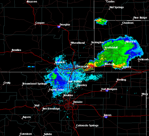 At 240 am mdt, a severe thunderstorm was located near pine bluffs, or 25 miles west of kimball, moving northeast at 25 mph. this storm has a history of producing a large amount of hail as it moved northeast through the burns area (radar indicated). Hazards include half dollar size hail. damage to vehicles is possible At 240 am mdt, a severe thunderstorm was located near pine bluffs, or 25 miles west of kimball, moving northeast at 25 mph. this storm has a history of producing a large amount of hail as it moved northeast through the burns area (radar indicated). Hazards include half dollar size hail. damage to vehicles is possible
|
| 8/7/2018 9:41 PM MDT |
 At 941 pm mdt, a severe thunderstorm was located 7 miles southeast of albin, or 18 miles northwest of kimball, moving southeast at 50 mph (radar indicated). Hazards include 60 mph wind gusts and quarter size hail. Hail damage to vehicles is expected. Expect wind damage to roofs, siding, and trees. At 941 pm mdt, a severe thunderstorm was located 7 miles southeast of albin, or 18 miles northwest of kimball, moving southeast at 50 mph (radar indicated). Hazards include 60 mph wind gusts and quarter size hail. Hail damage to vehicles is expected. Expect wind damage to roofs, siding, and trees.
|
| 8/7/2018 9:26 PM MDT |
 At 926 pm mdt, a severe thunderstorm was located over albin, or 26 miles northwest of kimball, moving southeast at 40 mph (radar indicated). Hazards include golf ball size hail and 60 mph wind gusts. People and animals outdoors will be injured. expect hail damage to roofs, siding, windows, and vehicles. expect wind damage to roofs, siding, and trees. Locations impacted include, albin. At 926 pm mdt, a severe thunderstorm was located over albin, or 26 miles northwest of kimball, moving southeast at 40 mph (radar indicated). Hazards include golf ball size hail and 60 mph wind gusts. People and animals outdoors will be injured. expect hail damage to roofs, siding, windows, and vehicles. expect wind damage to roofs, siding, and trees. Locations impacted include, albin.
|
| 8/7/2018 9:14 PM MDT |
 At 913 pm mdt, a severe thunderstorm was located near gun barrel, or 34 miles northwest of kimball, moving southeast at 40 mph (radar indicated). Hazards include golf ball size hail and 60 mph wind gusts. People and animals outdoors will be injured. expect hail damage to roofs, siding, windows, and vehicles. Expect wind damage to roofs, siding, and trees. At 913 pm mdt, a severe thunderstorm was located near gun barrel, or 34 miles northwest of kimball, moving southeast at 40 mph (radar indicated). Hazards include golf ball size hail and 60 mph wind gusts. People and animals outdoors will be injured. expect hail damage to roofs, siding, windows, and vehicles. Expect wind damage to roofs, siding, and trees.
|
| 8/7/2018 8:45 PM MDT |
 At 844 pm mdt, a severe thunderstorm was located 8 miles northwest of meriden rest area, or 35 miles southwest of torrington, moving southeast at 35 mph (radar indicated). Hazards include ping pong ball size hail and 60 mph wind gusts. People and animals outdoors will be injured. expect hail damage to roofs, siding, windows, and vehicles. Expect wind damage to roofs, siding, and trees. At 844 pm mdt, a severe thunderstorm was located 8 miles northwest of meriden rest area, or 35 miles southwest of torrington, moving southeast at 35 mph (radar indicated). Hazards include ping pong ball size hail and 60 mph wind gusts. People and animals outdoors will be injured. expect hail damage to roofs, siding, windows, and vehicles. Expect wind damage to roofs, siding, and trees.
|
| 7/29/2018 4:55 PM MDT |
 The national weather service in cheyenne has issued a * severe thunderstorm warning for. eastern laramie county in southeastern wyoming. until 545 pm mdt. At 454 pm mdt, a severe thunderstorm was located 7 miles west of gun barrel, or 27 miles northeast of cheyenne, moving southeast at. The national weather service in cheyenne has issued a * severe thunderstorm warning for. eastern laramie county in southeastern wyoming. until 545 pm mdt. At 454 pm mdt, a severe thunderstorm was located 7 miles west of gun barrel, or 27 miles northeast of cheyenne, moving southeast at.
|
| 7/29/2018 2:05 PM MDT | Golf Ball sized hail reported 0.2 miles SSW of Albin, WY, mile marker 6-7 on hwy 16 |
| 7/29/2018 1:50 PM MDT | Quarter sized hail reported 0.2 miles SSW of Albin, WY, mile post 50 on hwy 85 |
| 7/28/2018 7:36 PM MDT |
 The severe thunderstorm warning for northwestern kimball, southwestern banner and northeastern laramie counties will expire at 745 pm mdt, the storm which prompted the warning has weakened below severe limits, and has exited the warned area. therefore, the warning will be allowed to expire. however small hail is still possible with this thunderstorm. a tornado watch remains in effect until 1000 pm mdt for the panhandle of nebraska, and southeastern wyoming. The severe thunderstorm warning for northwestern kimball, southwestern banner and northeastern laramie counties will expire at 745 pm mdt, the storm which prompted the warning has weakened below severe limits, and has exited the warned area. therefore, the warning will be allowed to expire. however small hail is still possible with this thunderstorm. a tornado watch remains in effect until 1000 pm mdt for the panhandle of nebraska, and southeastern wyoming.
|
| 7/28/2018 7:19 PM MDT |
 At 719 pm mdt, a severe thunderstorm was located over albin, or 27 miles northwest of kimball, moving southeast at 35 mph (radar indicated). Hazards include 60 mph wind gusts and quarter size hail. Hail damage to vehicles is expected. expect wind damage to roofs, siding, and trees. locations impacted include, albin. A tornado watch remains in effect until 1000 pm mdt for the panhandle of nebraska, and southeastern wyoming. At 719 pm mdt, a severe thunderstorm was located over albin, or 27 miles northwest of kimball, moving southeast at 35 mph (radar indicated). Hazards include 60 mph wind gusts and quarter size hail. Hail damage to vehicles is expected. expect wind damage to roofs, siding, and trees. locations impacted include, albin. A tornado watch remains in effect until 1000 pm mdt for the panhandle of nebraska, and southeastern wyoming.
|
| 7/28/2018 7:05 PM MDT |
 At 705 pm mdt, a severe thunderstorm was located near meriden rest area, or 35 miles northwest of kimball, moving southeast at 35 mph (radar indicated). Hazards include 60 mph wind gusts and quarter size hail. Hail damage to vehicles is expected. Expect wind damage to roofs, siding, and trees. At 705 pm mdt, a severe thunderstorm was located near meriden rest area, or 35 miles northwest of kimball, moving southeast at 35 mph (radar indicated). Hazards include 60 mph wind gusts and quarter size hail. Hail damage to vehicles is expected. Expect wind damage to roofs, siding, and trees.
|
| 7/28/2018 4:29 PM MDT |
 At 429 pm mdt, severe thunderstorms were located along a line extending from near meriden rest area to near harrisburg, moving southeast at 20 mph (radar indicated). Hazards include 60 mph wind gusts and quarter size hail. Hail damage to vehicles is expected. Expect wind damage to roofs, siding, and trees. At 429 pm mdt, severe thunderstorms were located along a line extending from near meriden rest area to near harrisburg, moving southeast at 20 mph (radar indicated). Hazards include 60 mph wind gusts and quarter size hail. Hail damage to vehicles is expected. Expect wind damage to roofs, siding, and trees.
|
| 6/22/2018 6:57 PM MDT |
 At 656 pm mdt, a severe thunderstorm was located near albin, or 28 miles northwest of kimball, moving southeast at 35 mph (radar indicated. previous report have come in with quarter size hail about nine west of albin, wyoming). Hazards include 60 mph wind gusts and half dollar size hail. Hail damage to vehicles is expected. Expect wind damage to roofs, siding, and trees. At 656 pm mdt, a severe thunderstorm was located near albin, or 28 miles northwest of kimball, moving southeast at 35 mph (radar indicated. previous report have come in with quarter size hail about nine west of albin, wyoming). Hazards include 60 mph wind gusts and half dollar size hail. Hail damage to vehicles is expected. Expect wind damage to roofs, siding, and trees.
|
| 6/22/2018 6:43 PM MDT |
 A severe thunderstorm warning remains in effect until 700 pm mdt for northeastern laramie county. at 643 pm mdt, a severe thunderstorm was located near gun barrel, or 32 miles northeast of cheyenne, moving southeast at 35 mph. hazard. 60 mph wind gusts and half dollar size hail. source. Radar indicated. A severe thunderstorm warning remains in effect until 700 pm mdt for northeastern laramie county. at 643 pm mdt, a severe thunderstorm was located near gun barrel, or 32 miles northeast of cheyenne, moving southeast at 35 mph. hazard. 60 mph wind gusts and half dollar size hail. source. Radar indicated.
|
| 6/22/2018 6:42 PM MDT | Half Dollar sized hail reported 8.8 miles E of Albin, WY, mostly nickel to quarter sized... but some bigger. strong winds and hail has damaged corn and wheat fields. |
| 6/22/2018 6:36 PM MDT |
 At 636 pm mdt, a severe thunderstorm was located over gun barrel, or 32 miles northeast of cheyenne, moving southeast at 35 mph (radar indicated). Hazards include 60 mph wind gusts and half dollar size hail. Hail damage to vehicles is expected. Expect wind damage to roofs, siding, and trees. At 636 pm mdt, a severe thunderstorm was located over gun barrel, or 32 miles northeast of cheyenne, moving southeast at 35 mph (radar indicated). Hazards include 60 mph wind gusts and half dollar size hail. Hail damage to vehicles is expected. Expect wind damage to roofs, siding, and trees.
|
| 6/21/2018 6:56 PM MDT |
 At 656 pm mdt, a severe thunderstorm was located near albin, or 29 miles northwest of kimball, moving east at 30 mph (radar indicated). Hazards include 60 mph wind gusts and quarter size hail. Hail damage to vehicles is expected. Expect wind damage to roofs, siding, and trees. At 656 pm mdt, a severe thunderstorm was located near albin, or 29 miles northwest of kimball, moving east at 30 mph (radar indicated). Hazards include 60 mph wind gusts and quarter size hail. Hail damage to vehicles is expected. Expect wind damage to roofs, siding, and trees.
|
| 6/21/2018 6:51 PM MDT |
 At 651 pm mdt, a severe thunderstorm was located near albin, or 29 miles northwest of kimball, moving east at 45 mph (radar indicated). Hazards include 60 mph wind gusts and quarter size hail. Hail damage to vehicles is expected. expect wind damage to roofs, siding, and trees. Locations impacted include, albin. At 651 pm mdt, a severe thunderstorm was located near albin, or 29 miles northwest of kimball, moving east at 45 mph (radar indicated). Hazards include 60 mph wind gusts and quarter size hail. Hail damage to vehicles is expected. expect wind damage to roofs, siding, and trees. Locations impacted include, albin.
|
| 6/21/2018 6:41 PM MDT |
 At 641 pm mdt, a severe thunderstorm was located near gun barrel, or 30 miles northeast of cheyenne, moving east at 40 mph (radar indicated). Hazards include 60 mph wind gusts and quarter size hail. Hail damage to vehicles is expected. expect wind damage to roofs, siding, and trees. Locations impacted include, albin and gun barrel. At 641 pm mdt, a severe thunderstorm was located near gun barrel, or 30 miles northeast of cheyenne, moving east at 40 mph (radar indicated). Hazards include 60 mph wind gusts and quarter size hail. Hail damage to vehicles is expected. expect wind damage to roofs, siding, and trees. Locations impacted include, albin and gun barrel.
|
| 6/21/2018 6:32 PM MDT |
 At 631 pm mdt, a severe thunderstorm was located near gun barrel, or 26 miles northeast of cheyenne, moving east at 40 mph (radar indicated). Hazards include ping pong ball size hail and 60 mph wind gusts. People and animals outdoors will be injured. expect hail damage to roofs, siding, windows, and vehicles. expect wind damage to roofs, siding, and trees. Locations impacted include, albin and gun barrel. At 631 pm mdt, a severe thunderstorm was located near gun barrel, or 26 miles northeast of cheyenne, moving east at 40 mph (radar indicated). Hazards include ping pong ball size hail and 60 mph wind gusts. People and animals outdoors will be injured. expect hail damage to roofs, siding, windows, and vehicles. expect wind damage to roofs, siding, and trees. Locations impacted include, albin and gun barrel.
|
| 6/21/2018 6:22 PM MDT |
 At 621 pm mdt, a severe thunderstorm was located 10 miles southwest of gun barrel, or 20 miles northeast of cheyenne, moving east at 45 mph (radar indicated). Hazards include 60 mph wind gusts and half dollar size hail. Hail damage to vehicles is expected. Expect wind damage to roofs, siding, and trees. At 621 pm mdt, a severe thunderstorm was located 10 miles southwest of gun barrel, or 20 miles northeast of cheyenne, moving east at 45 mph (radar indicated). Hazards include 60 mph wind gusts and half dollar size hail. Hail damage to vehicles is expected. Expect wind damage to roofs, siding, and trees.
|
| 6/19/2018 4:38 PM MDT |
 At 438 pm mdt, severe thunderstorms were located along a line extending from near albin to 10 miles northeast of burns to 7 miles northwest of pine bluffs to 6 miles west of carpenter, moving east at 25 mph (radar indicated). Hazards include 60 mph wind gusts and half dollar size hail. Hail damage to vehicles is expected. Expect wind damage to roofs, siding, and trees. At 438 pm mdt, severe thunderstorms were located along a line extending from near albin to 10 miles northeast of burns to 7 miles northwest of pine bluffs to 6 miles west of carpenter, moving east at 25 mph (radar indicated). Hazards include 60 mph wind gusts and half dollar size hail. Hail damage to vehicles is expected. Expect wind damage to roofs, siding, and trees.
|
| 6/19/2018 4:32 PM MDT |
 At 432 pm mdt, severe thunderstorms were located along a line extending from 10 miles south of la grange to near albin to 6 miles north of burns to near hillsdale to 7 miles east of cheyenne, moving east at 20 mph (radar indicated). Hazards include ping pong ball size hail and 60 mph wind gusts. People and animals outdoors will be injured. expect hail damage to roofs, siding, windows, and vehicles. expect wind damage to roofs, siding, and trees. locations impacted include, burns, albin and hillsdale. This includes interstate 80 in wyoming between mile markers 374 and 388. At 432 pm mdt, severe thunderstorms were located along a line extending from 10 miles south of la grange to near albin to 6 miles north of burns to near hillsdale to 7 miles east of cheyenne, moving east at 20 mph (radar indicated). Hazards include ping pong ball size hail and 60 mph wind gusts. People and animals outdoors will be injured. expect hail damage to roofs, siding, windows, and vehicles. expect wind damage to roofs, siding, and trees. locations impacted include, burns, albin and hillsdale. This includes interstate 80 in wyoming between mile markers 374 and 388.
|
| 6/19/2018 4:19 PM MDT |
 At 418 pm mdt, severe thunderstorms were located along a line extending from 6 miles east of meriden rest area to 6 miles east of gun barrel to 6 miles northeast of hillsdale to 8 miles east of ranchettes to near cheyenne, moving east at 20 mph (radar indicated). Hazards include golf ball size hail mainly between burns and gun barrel and 60 mph wind gusts. People and animals outdoors will be injured. expect hail damage to roofs, siding, windows, and vehicles. expect wind damage to roofs, siding, and trees. locations impacted include, cheyenne, burns, albin, hillsdale, gun barrel and ranchettes. This includes interstate 80 in wyoming between mile markers 366 and 389. At 418 pm mdt, severe thunderstorms were located along a line extending from 6 miles east of meriden rest area to 6 miles east of gun barrel to 6 miles northeast of hillsdale to 8 miles east of ranchettes to near cheyenne, moving east at 20 mph (radar indicated). Hazards include golf ball size hail mainly between burns and gun barrel and 60 mph wind gusts. People and animals outdoors will be injured. expect hail damage to roofs, siding, windows, and vehicles. expect wind damage to roofs, siding, and trees. locations impacted include, cheyenne, burns, albin, hillsdale, gun barrel and ranchettes. This includes interstate 80 in wyoming between mile markers 366 and 389.
|
| 6/19/2018 4:07 PM MDT |
 At 406 pm mdt, severe thunderstorms were located along a line extending from near meriden rest area to near gun barrel to 6 miles north of hillsdale to 6 miles east of ranchettes to cheyenne, moving east at 20 mph (radar indicated). Hazards include up to golf ball size hail and 60 mph wind gusts. People and animals outdoors will be injured. expect hail damage to roofs, siding, windows, and vehicles. Expect wind damage to roofs, siding, and trees. At 406 pm mdt, severe thunderstorms were located along a line extending from near meriden rest area to near gun barrel to 6 miles north of hillsdale to 6 miles east of ranchettes to cheyenne, moving east at 20 mph (radar indicated). Hazards include up to golf ball size hail and 60 mph wind gusts. People and animals outdoors will be injured. expect hail damage to roofs, siding, windows, and vehicles. Expect wind damage to roofs, siding, and trees.
|
| 6/16/2018 5:40 PM MDT |
 At 540 pm mdt, a severe thunderstorm was located near pine bluffs, or 22 miles west of kimball, moving northeast at 15 mph (radar indicated). Hazards include 60 mph wind gusts and quarter size hail. Hail damage to vehicles is expected. Expect wind damage to roofs, siding, and trees. At 540 pm mdt, a severe thunderstorm was located near pine bluffs, or 22 miles west of kimball, moving northeast at 15 mph (radar indicated). Hazards include 60 mph wind gusts and quarter size hail. Hail damage to vehicles is expected. Expect wind damage to roofs, siding, and trees.
|
| 5/28/2018 6:26 PM MDT |
 At 626 pm mdt, a severe thunderstorm was located near albin, or 28 miles west of kimball, moving north at 35 mph (radar indicated). Hazards include 60 mph wind gusts and quarter size hail. Hail damage to vehicles is expected. Expect wind damage to roofs, siding, and trees. At 626 pm mdt, a severe thunderstorm was located near albin, or 28 miles west of kimball, moving north at 35 mph (radar indicated). Hazards include 60 mph wind gusts and quarter size hail. Hail damage to vehicles is expected. Expect wind damage to roofs, siding, and trees.
|
| 6/27/2017 12:21 PM MDT |
 At 619 pm mdt, a severe thunderstorm was located 8 miles north of whitaker, or 26 miles north of cheyenne, moving northeast at 35 mph (radar indicated). Hazards include 60 mph wind gusts. Expect damage to roofs, siding, and trees. this severe thunderstorm will remain over mainly rural areas of southern goshen, laramie and southeastern platte counties, including the following locations: fox farm-college and south greeley high. the outflow boundary producing wind gusts up to 60 mph will pass through gun barrel at 620 pm, through albin at 635 pm. through burns at 625 pm. through pine bluffs at 635 pm. this includes the following highways, interstate 25 in wyoming between mile markers 1 and 59. Interstate 80 in wyoming between mile markers 349 and 401. At 619 pm mdt, a severe thunderstorm was located 8 miles north of whitaker, or 26 miles north of cheyenne, moving northeast at 35 mph (radar indicated). Hazards include 60 mph wind gusts. Expect damage to roofs, siding, and trees. this severe thunderstorm will remain over mainly rural areas of southern goshen, laramie and southeastern platte counties, including the following locations: fox farm-college and south greeley high. the outflow boundary producing wind gusts up to 60 mph will pass through gun barrel at 620 pm, through albin at 635 pm. through burns at 625 pm. through pine bluffs at 635 pm. this includes the following highways, interstate 25 in wyoming between mile markers 1 and 59. Interstate 80 in wyoming between mile markers 349 and 401.
|
| 6/27/2017 12:04 PM MDT |
 At 603 pm mdt, a severe thunderstorm was located near whitaker, or 20 miles north of cheyenne, moving east at 40 mph (radar indicated. at 602 pm mdt...a 60 mph wind gust was reported at the cheyenne airport). Hazards include 60 mph wind gusts. Expect damage to roofs, siding, and trees. this severe thunderstorm will be near, gun barrel around 650 pm mdt. meriden rest area around 655 pm mdt. other locations impacted by this severe thunderstorm include fox farm-college and south greeley high. this includes the following highways, interstate 25 in wyoming between mile markers 1 and 59. Interstate 80 in wyoming between mile markers 349 and 401. At 603 pm mdt, a severe thunderstorm was located near whitaker, or 20 miles north of cheyenne, moving east at 40 mph (radar indicated. at 602 pm mdt...a 60 mph wind gust was reported at the cheyenne airport). Hazards include 60 mph wind gusts. Expect damage to roofs, siding, and trees. this severe thunderstorm will be near, gun barrel around 650 pm mdt. meriden rest area around 655 pm mdt. other locations impacted by this severe thunderstorm include fox farm-college and south greeley high. this includes the following highways, interstate 25 in wyoming between mile markers 1 and 59. Interstate 80 in wyoming between mile markers 349 and 401.
|
| 6/12/2017 6:12 PM MDT |
 At 611 pm mdt, a confirmed tornado was located 10 miles southwest of harrisburg, or 15 miles northwest of kimball, moving northeast at 20 mph. several other small areas of rotation were located along the kimball and banner county line south of harrisburg, and could also be producing tornadoes (weather spotters confirmed tornado). Hazards include damaging tornado and three inch hail. Flying debris will be dangerous to those caught without shelter. mobile homes will be damaged or destroyed. damage to roofs, windows, and vehicles will occur. tree damage is likely. This tornado will be near, harrisburg around 630 pm mdt. At 611 pm mdt, a confirmed tornado was located 10 miles southwest of harrisburg, or 15 miles northwest of kimball, moving northeast at 20 mph. several other small areas of rotation were located along the kimball and banner county line south of harrisburg, and could also be producing tornadoes (weather spotters confirmed tornado). Hazards include damaging tornado and three inch hail. Flying debris will be dangerous to those caught without shelter. mobile homes will be damaged or destroyed. damage to roofs, windows, and vehicles will occur. tree damage is likely. This tornado will be near, harrisburg around 630 pm mdt.
|
| 6/12/2017 6:00 PM MDT |
 At 558 pm mdt, a confirmed tornado was located 9 miles north of oliver campground, or 13 miles northwest of kimball, moving northeast at 30 mph (weather spotters confirmed intermittent tornado touchdowns north of bushnell). Hazards include damaging tornado and three inch hail. Flying debris will be dangerous to those caught without shelter. mobile homes will be damaged or destroyed. damage to roofs, windows, and vehicles will occur. tree damage is likely. This tornado will be near, harrisburg around 630 pm mdt. At 558 pm mdt, a confirmed tornado was located 9 miles north of oliver campground, or 13 miles northwest of kimball, moving northeast at 30 mph (weather spotters confirmed intermittent tornado touchdowns north of bushnell). Hazards include damaging tornado and three inch hail. Flying debris will be dangerous to those caught without shelter. mobile homes will be damaged or destroyed. damage to roofs, windows, and vehicles will occur. tree damage is likely. This tornado will be near, harrisburg around 630 pm mdt.
|
| 6/12/2017 6:00 PM MDT |
 At 551 pm mdt, a severe thunderstorm capable of producing a tornado was located near oliver campground, or 12 miles northwest of kimball, moving northeast at 35 mph. a second area of rotation was located about 10 miles northwest of pine bluffs, also moving northeast (radar indicated rotation). Hazards include developing tornado and hail up to three inches in diameter. Flying debris will be dangerous to those caught without shelter. mobile homes will be damaged or destroyed. damage to roofs, windows, and vehicles will occur. tree damage is likely. this dangerous storm will be near, harrisburg around 625 pm mdt. other locations impacted by this tornadic thunderstorm include bushnell. This includes interstate 80 in nebraska near mile marker 12. At 551 pm mdt, a severe thunderstorm capable of producing a tornado was located near oliver campground, or 12 miles northwest of kimball, moving northeast at 35 mph. a second area of rotation was located about 10 miles northwest of pine bluffs, also moving northeast (radar indicated rotation). Hazards include developing tornado and hail up to three inches in diameter. Flying debris will be dangerous to those caught without shelter. mobile homes will be damaged or destroyed. damage to roofs, windows, and vehicles will occur. tree damage is likely. this dangerous storm will be near, harrisburg around 625 pm mdt. other locations impacted by this tornadic thunderstorm include bushnell. This includes interstate 80 in nebraska near mile marker 12.
|
| 6/12/2017 5:52 PM MDT |
 At 551 pm mdt, a severe thunderstorm capable of producing a tornado was located near oliver campground, or 12 miles northwest of kimball, moving northeast at 35 mph. a second area of rotation was located about 10 miles northwest of pine bluffs, also moving northeast (radar indicated rotation). Hazards include developing tornado and hail up to three inches in diameter. Flying debris will be dangerous to those caught without shelter. mobile homes will be damaged or destroyed. damage to roofs, windows, and vehicles will occur. tree damage is likely. this dangerous storm will be near, harrisburg around 625 pm mdt. other locations impacted by this tornadic thunderstorm include bushnell. This includes interstate 80 in nebraska near mile marker 12. At 551 pm mdt, a severe thunderstorm capable of producing a tornado was located near oliver campground, or 12 miles northwest of kimball, moving northeast at 35 mph. a second area of rotation was located about 10 miles northwest of pine bluffs, also moving northeast (radar indicated rotation). Hazards include developing tornado and hail up to three inches in diameter. Flying debris will be dangerous to those caught without shelter. mobile homes will be damaged or destroyed. damage to roofs, windows, and vehicles will occur. tree damage is likely. this dangerous storm will be near, harrisburg around 625 pm mdt. other locations impacted by this tornadic thunderstorm include bushnell. This includes interstate 80 in nebraska near mile marker 12.
|
| 6/12/2017 5:43 PM MDT |
 At 542 pm mdt, a severe thunderstorm capable of producing a tornado was located near oliver campground, or 12 miles west of kimball, moving northeast at 25 mph (radar indicated rotation). Hazards include tornado and three inch hail. Flying debris will be dangerous to those caught without shelter. mobile homes will be damaged or destroyed. damage to roofs, windows, and vehicles will occur. tree damage is likely. this tornadic thunderstorm will remain over mainly rural areas of northwestern kimball, southwestern banner and east central laramie counties, including the following locations: bushnell. This includes interstate 80 in nebraska between mile markers 3 and 13. At 542 pm mdt, a severe thunderstorm capable of producing a tornado was located near oliver campground, or 12 miles west of kimball, moving northeast at 25 mph (radar indicated rotation). Hazards include tornado and three inch hail. Flying debris will be dangerous to those caught without shelter. mobile homes will be damaged or destroyed. damage to roofs, windows, and vehicles will occur. tree damage is likely. this tornadic thunderstorm will remain over mainly rural areas of northwestern kimball, southwestern banner and east central laramie counties, including the following locations: bushnell. This includes interstate 80 in nebraska between mile markers 3 and 13.
|
| 6/12/2017 5:27 PM MDT |
 At 526 pm mdt, a confirmed tornado was located near pine bluffs, or 18 miles west of kimball, moving northeast at 25 mph (weather spotters confirmed tornado. those in bushnell should seek shelter immediately!). Hazards include damaging tornado and baseball size hail. Flying debris will be dangerous to those caught without shelter. mobile homes will be damaged or destroyed. damage to roofs, windows, and vehicles will occur. tree damage is likely. this tornado will be near, oliver campground and oliver reservoir around 545 pm mdt. other locations impacted by this tornadic thunderstorm include bushnell. this includes the following highways, interstate 80 in wyoming between mile markers 389 and 402. Interstate 80 in nebraska between mile markers 1 and 17. At 526 pm mdt, a confirmed tornado was located near pine bluffs, or 18 miles west of kimball, moving northeast at 25 mph (weather spotters confirmed tornado. those in bushnell should seek shelter immediately!). Hazards include damaging tornado and baseball size hail. Flying debris will be dangerous to those caught without shelter. mobile homes will be damaged or destroyed. damage to roofs, windows, and vehicles will occur. tree damage is likely. this tornado will be near, oliver campground and oliver reservoir around 545 pm mdt. other locations impacted by this tornadic thunderstorm include bushnell. this includes the following highways, interstate 80 in wyoming between mile markers 389 and 402. Interstate 80 in nebraska between mile markers 1 and 17.
|
| 6/12/2017 5:21 PM MDT |
 At 520 pm mdt, a severe thunderstorm capable of producing a tornado was located near pine bluffs, or 20 miles west of kimball, moving northeast at 25 mph (radar indicated rotation). Hazards include tornado and baseball size hail. Flying debris will be dangerous to those caught without shelter. mobile homes will be damaged or destroyed. damage to roofs, windows, and vehicles will occur. tree damage is likely. this dangerous storm will be near, pine bluffs around 530 pm mdt. oliver campground and oliver reservoir around 550 pm mdt. other locations impacted by this tornadic thunderstorm include bushnell. this includes the following highways, interstate 80 in wyoming between mile markers 389 and 402. Interstate 80 in nebraska between mile markers 1 and 17. At 520 pm mdt, a severe thunderstorm capable of producing a tornado was located near pine bluffs, or 20 miles west of kimball, moving northeast at 25 mph (radar indicated rotation). Hazards include tornado and baseball size hail. Flying debris will be dangerous to those caught without shelter. mobile homes will be damaged or destroyed. damage to roofs, windows, and vehicles will occur. tree damage is likely. this dangerous storm will be near, pine bluffs around 530 pm mdt. oliver campground and oliver reservoir around 550 pm mdt. other locations impacted by this tornadic thunderstorm include bushnell. this includes the following highways, interstate 80 in wyoming between mile markers 389 and 402. Interstate 80 in nebraska between mile markers 1 and 17.
|
| 5/26/2017 7:06 PM MDT |
 The tornado warning for northwestern kimball, southwestern banner and east central laramie counties will expire at 715 pm mdt, the storm which prompted the warning has weakened below severe limits, and no longer appears capable of producing a tornado. therefore the warning will be allowed to expire. however small hail, gusty winds and heavy rain are still possible with this thunderstorm. a severe thunderstorm watch remains in effect until 1000 pm mdt for the panhandle of nebraska, and southeastern wyoming. The tornado warning for northwestern kimball, southwestern banner and east central laramie counties will expire at 715 pm mdt, the storm which prompted the warning has weakened below severe limits, and no longer appears capable of producing a tornado. therefore the warning will be allowed to expire. however small hail, gusty winds and heavy rain are still possible with this thunderstorm. a severe thunderstorm watch remains in effect until 1000 pm mdt for the panhandle of nebraska, and southeastern wyoming.
|
| 5/26/2017 6:54 PM MDT |
 At 654 pm mdt, a severe thunderstorm capable of producing a tornado was located near albin, or 24 miles northwest of kimball, moving east at 40 mph (radar indicated rotation). Hazards include tornado and ping pong ball size hail. Flying debris will be dangerous to those caught without shelter. mobile homes will be damaged or destroyed. damage to roofs, windows, and vehicles will occur. tree damage is likely. This tornadic thunderstorm will remain over mainly rural areas of northwestern kimball, southwestern banner and east central laramie counties. At 654 pm mdt, a severe thunderstorm capable of producing a tornado was located near albin, or 24 miles northwest of kimball, moving east at 40 mph (radar indicated rotation). Hazards include tornado and ping pong ball size hail. Flying debris will be dangerous to those caught without shelter. mobile homes will be damaged or destroyed. damage to roofs, windows, and vehicles will occur. tree damage is likely. This tornadic thunderstorm will remain over mainly rural areas of northwestern kimball, southwestern banner and east central laramie counties.
|
| 5/26/2017 6:38 PM MDT |
 At 637 pm mdt, a severe thunderstorm capable of producing a tornado was located 8 miles southeast of gun barrel, or 31 miles west of kimball, moving east at 35 mph (radar indicated rotation). Hazards include tornado and ping pong ball size hail. Flying debris will be dangerous to those caught without shelter. mobile homes will be damaged or destroyed. damage to roofs, windows, and vehicles will occur. tree damage is likely. This dangerous storm will be near, albin around 650 pm mdt. At 637 pm mdt, a severe thunderstorm capable of producing a tornado was located 8 miles southeast of gun barrel, or 31 miles west of kimball, moving east at 35 mph (radar indicated rotation). Hazards include tornado and ping pong ball size hail. Flying debris will be dangerous to those caught without shelter. mobile homes will be damaged or destroyed. damage to roofs, windows, and vehicles will occur. tree damage is likely. This dangerous storm will be near, albin around 650 pm mdt.
|
| 7/29/2016 3:38 PM MDT |
 At 338 pm mdt, a severe thunderstorm was located 8 miles northeast of albin, or 27 miles northwest of kimball, moving east at 30 mph (radar indicated). Hazards include two inch hail and 60 mph wind gusts. People and animals outdoors will be injured. expect hail damage to roofs, siding, windows, and vehicles. expect wind damage to roofs, siding, and trees. Locations impacted include, albin. At 338 pm mdt, a severe thunderstorm was located 8 miles northeast of albin, or 27 miles northwest of kimball, moving east at 30 mph (radar indicated). Hazards include two inch hail and 60 mph wind gusts. People and animals outdoors will be injured. expect hail damage to roofs, siding, windows, and vehicles. expect wind damage to roofs, siding, and trees. Locations impacted include, albin.
|
| 7/29/2016 3:33 PM MDT |
 At 333 pm mdt, a severe thunderstorm was located near albin, or 28 miles northwest of kimball, moving east at 30 mph (radar indicated). Hazards include ping pong ball size hail and 60 mph wind gusts. People and animals outdoors will be injured. expect hail damage to roofs, siding, windows, and vehicles. Expect wind damage to roofs, siding, and trees. At 333 pm mdt, a severe thunderstorm was located near albin, or 28 miles northwest of kimball, moving east at 30 mph (radar indicated). Hazards include ping pong ball size hail and 60 mph wind gusts. People and animals outdoors will be injured. expect hail damage to roofs, siding, windows, and vehicles. Expect wind damage to roofs, siding, and trees.
|
| 7/27/2016 10:15 PM MDT |
 At 1015 pm mdt, a severe thunderstorm was located over la grange, or 27 miles south of torrington, moving south at 40 mph (radar indicated). Hazards include golf ball size hail and 70 mph wind gusts. People and animals outdoors will be injured. expect hail damage to roofs, siding, windows, and vehicles. expect considerable tree damage. Wind damage is also likely to mobile homes, roofs, and outbuildings. At 1015 pm mdt, a severe thunderstorm was located over la grange, or 27 miles south of torrington, moving south at 40 mph (radar indicated). Hazards include golf ball size hail and 70 mph wind gusts. People and animals outdoors will be injured. expect hail damage to roofs, siding, windows, and vehicles. expect considerable tree damage. Wind damage is also likely to mobile homes, roofs, and outbuildings.
|
| 7/26/2016 4:08 PM MDT |
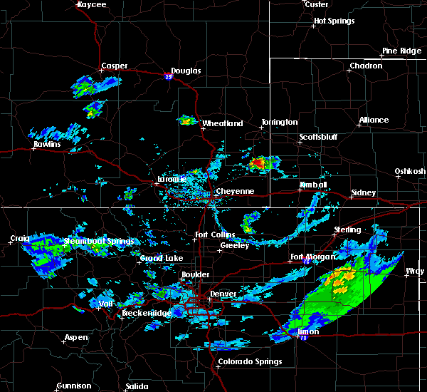 At 408 pm mdt, a severe thunderstorm was located near la grange, or 33 miles southwest of scottsbluff, moving east at 25 mph (radar indicated). Hazards include 60 mph wind gusts and quarter size hail. Hail damage to vehicles is expected. Expect wind damage to roofs, siding, and trees. At 408 pm mdt, a severe thunderstorm was located near la grange, or 33 miles southwest of scottsbluff, moving east at 25 mph (radar indicated). Hazards include 60 mph wind gusts and quarter size hail. Hail damage to vehicles is expected. Expect wind damage to roofs, siding, and trees.
|
| 5/7/2016 4:52 PM MDT |
 At 452 pm mdt, a severe thunderstorm was located over burns, or 24 miles east of cheyenne, moving north at 40 mph (radar indicated). Hazards include 60 mph wind gusts and quarter size hail. Hail damage to vehicles is expected. expect wind damage to roofs, siding, and trees. this severe storm will be near, gun barrel around 515 pm mdt. This includes interstate 80 in wyoming between mile markers 375 and 402. At 452 pm mdt, a severe thunderstorm was located over burns, or 24 miles east of cheyenne, moving north at 40 mph (radar indicated). Hazards include 60 mph wind gusts and quarter size hail. Hail damage to vehicles is expected. expect wind damage to roofs, siding, and trees. this severe storm will be near, gun barrel around 515 pm mdt. This includes interstate 80 in wyoming between mile markers 375 and 402.
|
| 5/7/2016 4:33 PM MDT |
 At 433 pm mdt, a severe thunderstorm was located over carpenter, or 26 miles east of cheyenne, moving north at 30 mph (radar indicated). Hazards include 60 mph wind gusts and quarter size hail. Hail damage to vehicles is expected. expect wind damage to roofs, siding, and trees. this severe storm will be near, burns and hillsdale around 500 pm mdt. This includes interstate 80 in wyoming between mile markers 375 and 402. At 433 pm mdt, a severe thunderstorm was located over carpenter, or 26 miles east of cheyenne, moving north at 30 mph (radar indicated). Hazards include 60 mph wind gusts and quarter size hail. Hail damage to vehicles is expected. expect wind damage to roofs, siding, and trees. this severe storm will be near, burns and hillsdale around 500 pm mdt. This includes interstate 80 in wyoming between mile markers 375 and 402.
|
| 5/7/2016 4:16 PM MDT |
 At 416 pm mdt, a severe thunderstorm was located near hereford, or 30 miles southeast of cheyenne, moving north at 40 mph (radar indicated). Hazards include 60 mph wind gusts and quarter size hail. Hail damage to vehicles is expected. expect wind damage to roofs, siding, and trees. this severe thunderstorm will be near, carpenter around 430 pm mdt. burns around 445 pm mdt. hillsdale around 450 pm mdt. gun barrel around 510 pm mdt. This includes interstate 80 in wyoming between mile markers 375 and 402. At 416 pm mdt, a severe thunderstorm was located near hereford, or 30 miles southeast of cheyenne, moving north at 40 mph (radar indicated). Hazards include 60 mph wind gusts and quarter size hail. Hail damage to vehicles is expected. expect wind damage to roofs, siding, and trees. this severe thunderstorm will be near, carpenter around 430 pm mdt. burns around 445 pm mdt. hillsdale around 450 pm mdt. gun barrel around 510 pm mdt. This includes interstate 80 in wyoming between mile markers 375 and 402.
|
| 6/30/2015 9:05 PM MDT | Duration 5 minute in laramie county WY, 13 miles E of Albin, WY |
| 7/9/2014 3:42 PM MDT | Quarter sized hail reported 11.9 miles E of Albin, WY |
| 6/24/2014 5:48 PM MDT | Quarter sized hail reported 13.9 miles E of Albin, WY |
| 6/24/2014 5:48 PM MDT | Quarter sized hail reported 8.8 miles E of Albin, WY |
| 6/24/2014 5:38 PM MDT | Golf Ball sized hail reported 13.9 miles E of Albin, WY |
| 5/19/2014 6:19 PM MDT | Quarter sized hail reported 0.2 miles SSW of Albin, WY |
| 1/1/0001 12:00 AM | Pea to marbel size hai in laramie county WY, 8.8 miles E of Albin, WY |
| 1/1/0001 12:00 AM | Quarter sized hail reported 0.2 miles SSW of Albin, WY |
| 1/1/0001 12:00 AM | Quarter sized hail reported 0.2 miles SSW of Albin, WY |
Hail Maps for Albin, WY
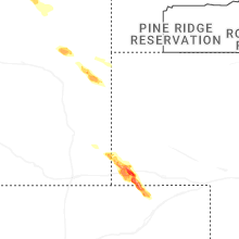
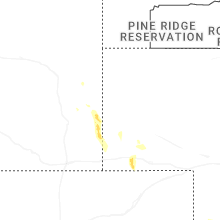
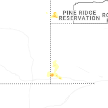
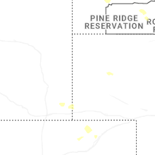
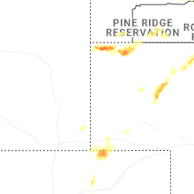
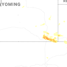
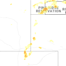
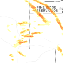
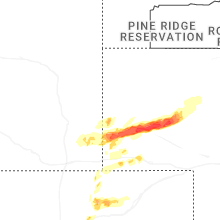
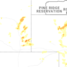

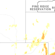


Connect with Interactive Hail Maps